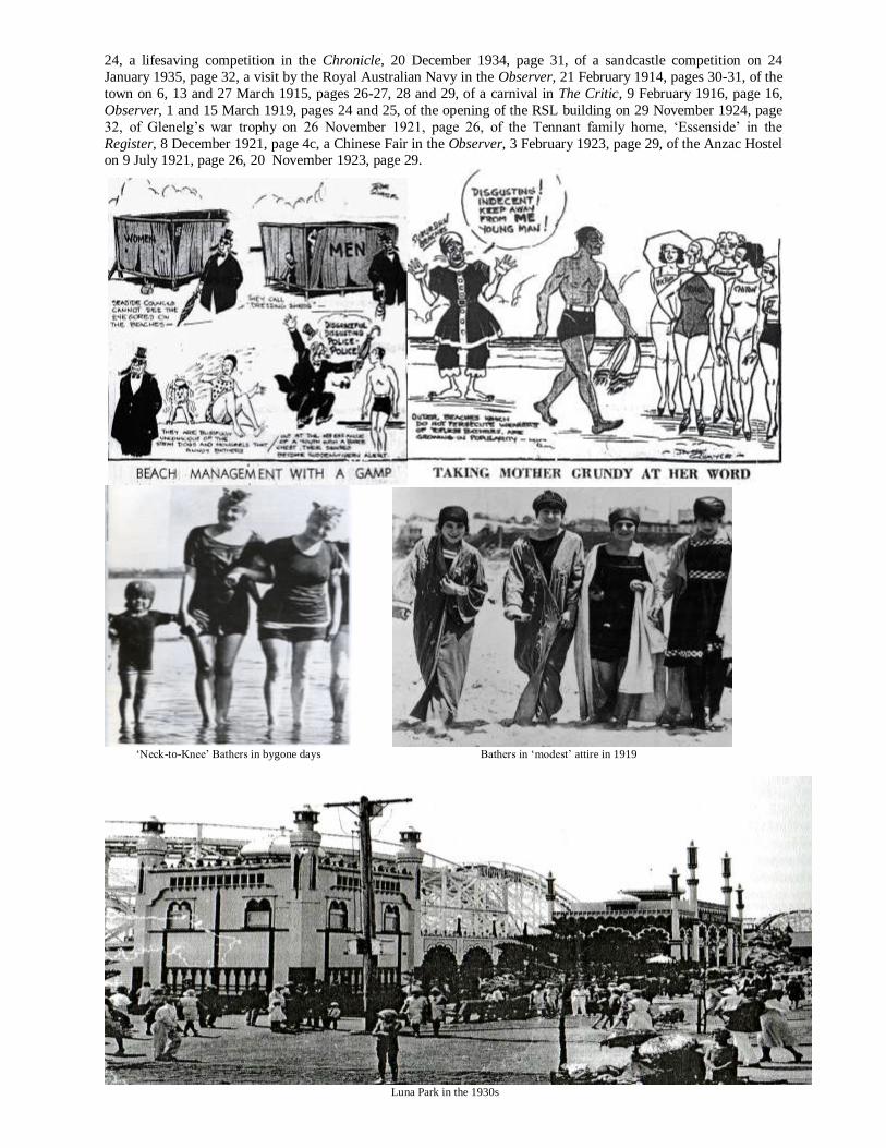
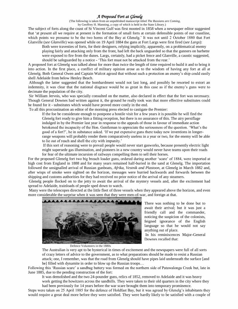
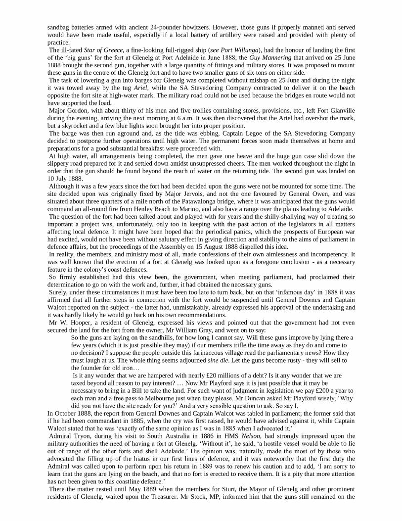
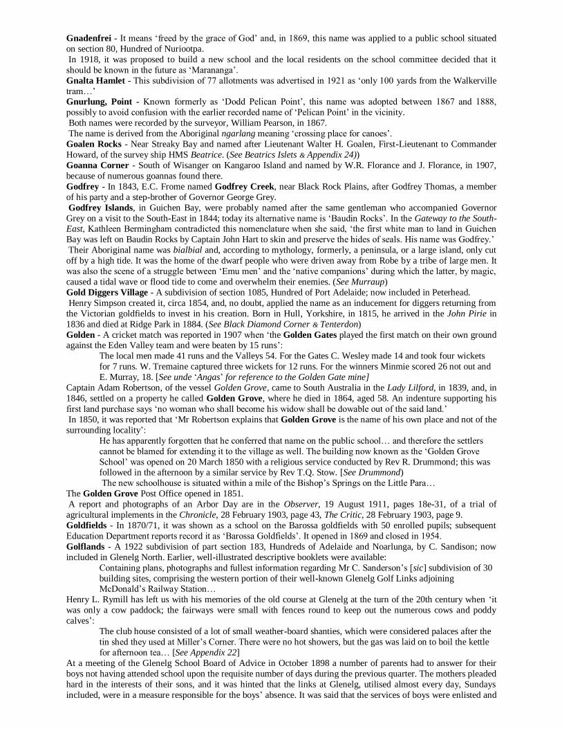
G Would it be too much to ask of the namers, that any district having already a suitable native name should be allowed to keep it…? (Register, 3 August 1868, page 3c) Gairdner, Lake - Discovered by Stephen Hack and, simultaneously, by P. E. Warburton and Samuel Davenport in August 1857, it was named by Governor MacDonnell in October 1857 after Gordon Gairdner, CMG, Chief Clerk of the Australian Department in the Colonial Office: [His] long and faithful service in the Australian Department of the Colonial Service entitles him to such tribute of remembrance from here. In a despatch to the colonial office the Governor said that ‘its size and remarkable cliffs projecting into a vast expanse of dazzling salt, here and there studded with islands, render it one of the most striking objects hitherto met with in Australian scenery…’ In 1858, it was reported that it was ‘very strange that successive explorers see the same country with impressions so irreconcilable’: We are quite aware of the immense difference of appearance which a tract of land will exhibit at different seasons of the year. But an Australian explorer should be able at any time to affirm, with tolerable certainty, what aspect a country will present at all other times… The tract of country described by Mr Hack as comprising four or five thousand square miles of excellent pastoral land, Major Warburton calculates will sustain sheep at the rate of about one to the square mile. We cannot presume to say which is the more accurate estimate… Galga - The town, in the Hundred of Bandon, 32 km South -East of Swan Reach, was proclaimed on 10 February 1916 and is an Aboriginal word meaning ‘hungry’; it was intended by the railway commissioner , who named it, that the railway station would be a place where refreshments be provided. Land in the immediate vicinity was taken up first by William Selby Douglas in 1868. A photograph of a football team is in the Chronicle, 11 October 1934, page 49. Gallagher Dam - North-East of Morgan and named after the Gallagher family who held the lease of Quondong Vale Station from circa 1888 (lease no. 851). (See Quondong) Gallipoli Gardens - A name proposed for a suburb that became ‘Allenby Gardens’ in May 1922. Gall Park - Near Kingston, SE, was named after John Gall (1830-1907). He arrived in the Baboo in 1840 with his parents, the reason for emigration being that his father, Charles Gall, had, ‘in his youth in Scotland, developed a fondness for firearms and it was his passion for shooting which eventually landed him in the antipodes ’: Seeing at a distance what he took to be a rabbit he fired his gun and, to his consternation, discovered that he had killed a hare. In those days it was a crime to slaughter without authority a hare on another person’s property and a second offence involved the monstrous penalty of transportation. This was his second offence… to save further trouble his father thought it wise to send him out to South Australia, where Mrs Gall had a brother [James Coutts], who was sheep farming on Yorke Peninsula. From 1851, and for the next twenty-five years or more, he held pastoral leases in the district, including nos. 226B&C, 493, 778, 1014, 1095, 1283 and 1298. He lived at Cantara Station, 38 miles from Kingston, S.E., was president of the local council for many years and connected with the local School Board of Advice and the Lacepede Bay Institute. To the school children he was ‘a practical friend; the institute possesses many valuable books through his generosity and the showground is a standing monument of his liberal gift…’ Gallwey - A town in the South-East corner of the Hundred of Oladdie, 19 km North-East of Orroroo, proclaimed on 2 December 1880, was named by Governor Jervois who may have had in mind Thomas Lionel John Gallwey, a Lieutenant-General in the Royal Engineers and Governor-General of Bermuda, (1882-1888); he, no doubt, was an associate of Governor Jervois. The town was closed in 1944. (See Cunliffe, Elliston, Owen & Wilson) Galway - A 1916 subdivision of part section 249, Hundred of Adelaide, and named by the South Australian Company after Sir Henry Galway, a former Governor of SA; now included in Netherby. Planner Charles C. Reade designed this garden suburb based on those established by British town planners. In a change from the normal grid layout Reade’s design had winding tree-lined streets, irregularly shaped blocks and central reserves. Evidence of the original Reade layout can still be found in the Peake Gardens recreation grounds, and the winding streets, Major Avenue and Anstey Crescent. Galway Gardens - 1923 Galway Gardens was a 1921 subdivision of part section 50, Hundred of Adelaide, by the State Bank of SA; now included in Marleston. In the same year, trouble arose with the construction of some of the houses being built for returned soldiers ‘because several faulty foundations which had been put down were condemned by the inspector of the State Bank…’ (See Kurralta)
Transcript
G
Would it be too much to ask of the namers, that any district having already a suitable native name should be allowed to keep it…? (Register, 3 August 1868, page 3c)
Gairdner, Lake - Discovered by Stephen Hack and, simultaneously, by P. E. Warburton and Samuel Davenport in
August 1857, it was named by Governor MacDonnell in October 1857 after Gordon Gairdner, CMG, Chief Clerk of
the Australian Department in the Colonial Office:
[His] long and faithful service in the Australian Department of the Colonial Service entitles him to such
tribute of remembrance from here.
In a despatch to the colonial office the Governor said that ‘its size and remarkable cliffs projecting into a vast
expanse of dazzling salt, here and there studded with islands, render it one of the most striking objects hitherto met
with in Australian scenery…’
In 1858, it was reported that it was ‘very strange that successive explorers see the same country with impressions so
irreconcilable’:
We are quite aware of the immense difference of appearance which a tract of land will exhibit at different
seasons of the year. But an Australian explorer should be able at any time to affirm, with tolerable certainty, what aspect a country will present at all other times…
The tract of country described by Mr Hack as comprising four or five thousand square miles of excellent
pastoral land, Major Warburton calculates will sustain sheep at the rate of about one to the square mile. We
cannot presume to say which is the more accurate estimate…
Galga - The town, in the Hundred of Bandon, 32 km South-East of Swan Reach, was proclaimed on 10 February
1916 and is an Aboriginal word meaning ‘hungry’; it was intended by the railway commissioner , who named it, that
the railway station would be a place where refreshments be provided.
Land in the immediate vicinity was taken up first by William Selby Douglas in 1868.
A photograph of a football team is in the Chronicle, 11 October 1934, page 49.
Gallagher Dam - North-East of Morgan and named after the Gallagher family who held the lease of Quondong
Vale Station from circa 1888 (lease no. 851). (See Quondong) Gallipoli Gardens - A name proposed for a suburb that became ‘Allenby Gardens’ in May 1922.
Gall Park - Near Kingston, SE, was named after John Gall (1830-1907). He arrived in the Baboo in 1840 with his
parents, the reason for emigration being that his father, Charles Gall, had, ‘in his youth in Scotland, developed a
fondness for firearms and it was his passion for shooting which eventually landed him in the antipodes’:
Seeing at a distance what he took to be a rabbit he fired his gun and, to his consternation, discovered that he
had killed a hare. In those days it was a crime to slaughter without authority a hare on another person’s
property and a second offence involved the monstrous penalty of transportation.
This was his second offence… to save further trouble his father thought it wise to send him out to South
Australia, where Mrs Gall had a brother [James Coutts], who was sheep farming on Yorke Peninsula.
From 1851, and for the next twenty-five years or more, he held pastoral leases in the district, including nos.
226B&C, 493, 778, 1014, 1095, 1283 and 1298. He lived at Cantara Station, 38 miles from Kingston, S.E., was president of the local council for many years and connected with the local School Board of Advice and the Lacepede
Bay Institute. To the school children he was ‘a practical friend; the institute possesses many valuable books through
his generosity and the showground is a standing monument of his liberal gift…’
Gallwey - A town in the South-East corner of the Hundred of Oladdie, 19 km North-East of Orroroo, proclaimed on
2 December 1880, was named by Governor Jervois who may have had in mind Thomas Lionel John Gallwey, a
Lieutenant-General in the Royal Engineers and Governor-General of Bermuda, (1882-1888); he, no doubt, was an
associate of Governor Jervois. The town was closed in 1944. (See Cunliffe, Elliston, Owen & Wilson)
Galway - A 1916 subdivision of part section 249, Hundred of Adelaide, and named by the South Australian
Company after Sir Henry Galway, a former Governor of SA; now included in Netherby.
Planner Charles C. Reade designed this garden suburb based on those established by British town planners.
In a change from the normal grid layout Reade’s design had winding tree-lined streets, irregularly shaped
blocks and central reserves. Evidence of the original Reade layout can still be found in the Peake Gardens recreation grounds, and the winding streets, Major Avenue and Anstey Crescent.
Galway Gardens - 1923
Galway Gardens was a 1921 subdivision of part section 50, Hundred of Adelaide, by the State
Bank of SA; now included in Marleston. In the
same year, trouble arose with the construction of
some of the houses being built for returned
soldiers ‘because several faulty foundations
which had been put down were condemned by the
inspector of the State Bank…’ (See Kurralta)
Gambier - Lieutenant James Grant named the physical feature of Mount Gambier on 3 December 1800, while
Matthew Flinders named Gambier Isles, in Spencer Gulf, on 24 February 1802. Both names honour Lord Gambier,
who had a seat in Admiralty when the Investigator was fitted out; later, in 1807, he commanded the British fleet at
the second battle of Copenhagen. Lt. Grant was promoted to the rank of Commander, in 1805, with a pension for
gallantry in a spirited naval action off Holland, when he was badly wounded; he died in 1833, aged 61.
Freycinet’s charts show them as Is. Berthier. The ‘Gambier Island Run’ was established by P. Levi in 1872. Penola historian, Peter Rymill, records that, in December 1845, E.P.S. Sturt advised Charles Bonney in Adelaide
that, ‘through Mr Hunter, I succeeded in purchasing Mr [Stephen?] Henty’s interest in Mount Gambier, which I
now occupy…’ and continued [See under ‘Source Notes’ under ‘Kalangadoo’]:
Given [this fact], Stephen Henty’s later claim in a letter to Governor Latrobe that ‘we were subsequently
deprived by the chicanery of some unprincipled individuals’ is curious. Furthermore, Edward Henty, from
Muntham, seems to have been the brother most involved in the Mt Gambier district (or perhaps the most
prolific correspondent).
There is no mention of Stephen from the time of his initial 1839 reconnoitre until his sheep are taken to
Lalee in 1849… [See Appendix 17]
The first sale of freehold land in the vicinity of Mount Gambier took place in 1847 when sections 1100 to 1103,
inclusive, were granted to Mr Evelyn P.S. Sturt at £80.1s. each and he remained in occupation until the mid-1850s
when he left to take up the position of Chief Inspector of Police in Melbourne. In the interim period he laid out the town of Gambierton; at the outset three allotments were leased upon which a
public house, a store and a blacksmith’s shop were erected, circa 1847, by the respective lessees.
Today, Evelyn, Sturt and Compton Streets commemorate his association with the district - the ‘Sturt Street’ on
Evelyn Sturt’s original plan is, today, ‘Commercial Street’.
According to Alfred Hayes, who came to the district in 1846, the hotel was opened by John Byng on Saint Patrick’s
Day 1847 and, to celebrate the occasion, a few ‘races’ were arranged by the locals at which ‘there was plenty of
fighting; in fact there was hardly a man who did not have a fight that day. These were the days when men came in
with their cheques and did not stop drinking until the whole was gone.’
John Byng was a huge man tipping the scales at about 18 stone and, boasting of biceps in excess of 17 inches, he
built an Inn, composed of slabs with a bark roof, on land occupied today by Jens’ Hotel:
There the modern coloured Falstaff, assisted by a white wife and a family of several children, used to take his portly ease or dispense liquors to surrounding settlers and stockmen,
while a complaint was levelled against the ‘new publican’ when a correspondent to the Adelaide press said:
Selling six glasses of liquor and a cigar for seven shillings is what we should call a rather good percentage.
We would advise the publicans not to show themselves so greedy of gain; as, at their future appeals to the
Magistrates and the public, their exorbitant charges, or what our correspondent calls a downright robbery,
may prove far more disadvantageous to themselves than they may imagine.
In October 1854, Hastings Cunningham purchased the four sections from Mr Sturt for £1,500 and, no doubt,
received all the appropriate legal documentation, including the obligatory plan of the first township that
encompassed the leases executed previously by Sturt.
Two years later, Mr Cunningham donated land in Sturt Street for a new school, opened in 1858 with James Smith in
charge, the husband of Christina Smith who was the missionary teacher of the indigenous Booandik people; it closed
when a new public school opened in Wehl Street in 1878 and at which the author of this history attended from 1936-
1938.
He was ‘one of the first to interest himself in the export of frozen mutton to England and, in conjunction with
Messrs Freebairn and Armitage, shipped a cargo by the steamer Strathleven in 1871.’
He died at St. Kilda, Melbourne, on 21 September 1908 in his eighty-third year.
The following comments by Mr Cunningham are taken from Minnie – Memoirs of a Squatter’s Daughter, by Mary
E.S. Brewer:
I bought from E.P.S. Sturt - ‘Compton’ - with cattle and sheep… a beautiful piece of country. Afterwards I
bought four 80-acre blocks on which the township of Mount Gambier now stands from Captain Sturt [sic]
(through his brother Shirley). I gave him £1,500 for these blocks, held them for little more than a year,
made some £800 by surveying a township and selling a few blocks then sold the remainder for [the] same
money I paid to Sturt. It was thought I did a clever thing. If only I had waited a few years and held on to these blocks I should
have required nothing more. Gambiertown is now the second town in South Australia.
[ Author’s comment - Mr Cunningham’s recall of events is blatantly false - the second survey of township
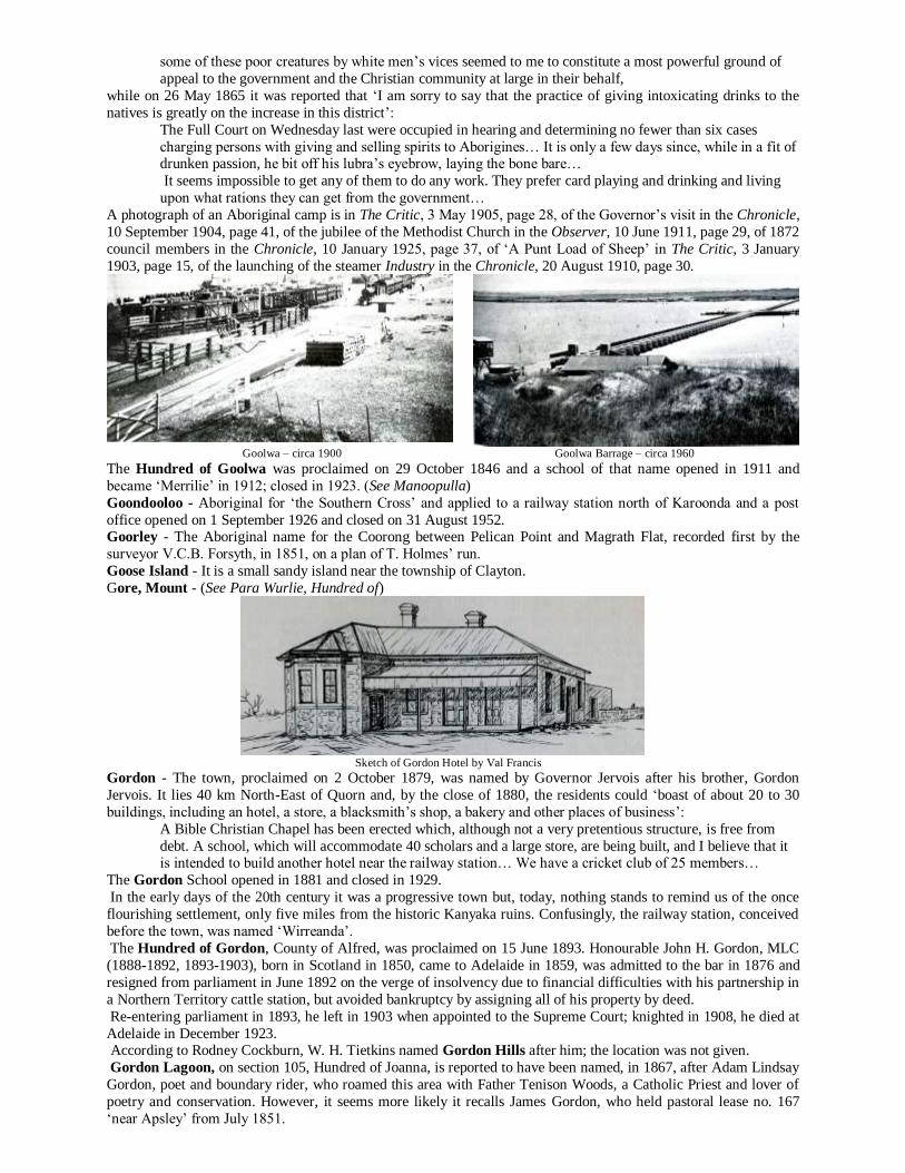
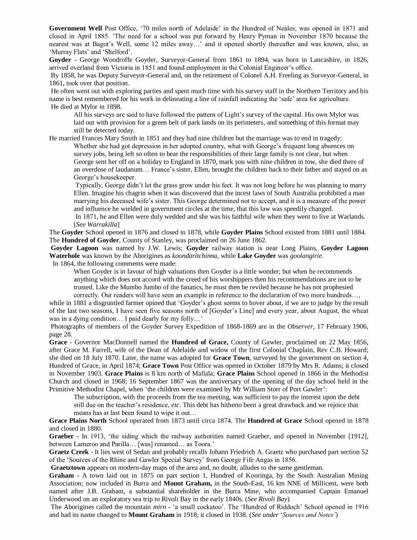
allotments in ‘Mount Gambier’ was undertaken by Alexander Mitchell in 1860 following the sale by Mr
Cunningham for £2,500 of the four sections purchased from Sturt excluding, of course, previously sold
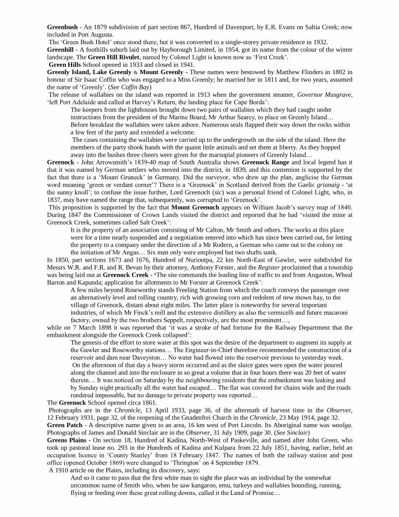
allotments in Sturt’s creation.]
It was not until Mr Hastings Cunningham began selling allotments in Sturt’s ‘village’ that people in search of
employment began to flock to the site and it was then that two or three stores were opened and the ‘adventurous
blacksmiths erected their anvils.’
In the 1850s the town was a mere hamlet - a bush village - where shepherds came to ‘knock down’ an entire year’s
wages in a week and where a man who had gone to ‘melt his cheque’ invited all passers-by to drink with him.
Then there were the ‘larks’ on week days, horse racing on Sundays and, occasionally, a stout, wild, barbarous fight,
in which men battered and bruised one another:
A prize-fight took place in the neighbourhood of Mount Gambier for a purse of £20 between ‘man of
colour’ named Young Sambo and an Irishman named Ned McMahon. At the end of the 43rd round and
after an hour and twenty minutes Maloney [sic] was beat.
A traveller at this time described it as containing about 100 inhabitants and ‘throughout this oasis, for ten miles round, a number of farmers raised their crops and fed their cattle’:
Most of them were Germans or Scots, the former from the Adelaide side and the latter from Portland, away
in Victoria. The latter place was the nearest market over a fearful road through the sandy waste for 60
miles; thence their produce was shipped off to the colonial capitals.
In 1861, the town’s main street was all but an impassable bog, without drainage or regulations for the removal of the
foul unsanitary nuisances that ‘choked the very doors’:
Though the men may knock through the mud, the women are imprisoned at home; we have scarcely any
social life and until something is done all of us might as well be clothed in bear skins and imagine
ourselves the denizens of that doleful region, of which as Dante, the Italian poet, sings, there is inscribed on
the portals - ‘All hope abandon ye who enter here.’
As a consequence, the streets were condemned, frequently, in the winter and, to avoid the mud hazards, the citizens
resorted to riding their horses on the footpaths thus ‘driving men, women and children inside the paddock fence and causing them to trespass on ploughed ground where the crop [was] just rising above the soil.’
The remedy for this state of affairs was addressed when, in 1863, a district council was formed when its first
meeting was held in the old Telegraph Station.
In June 1862, the Editor of the Border Watch said: ‘enough for the present, we have started our locality as Mount
Gambier, and Mount Gambier it shall be, to the end of the chapter’:
Our thriving town is not to suffer under a misnomer because of the hallucinations of an interloping
Victorian barrister and tho‘ the Post Office officials may, under the effects of circumlocution fever or red
tape delirium, adhere for a time to this stupid term [Gambierton] we have little doubt, but ere long, they
will return to the proper designation of this place as announced by the Sheriff on 19 December and
recognised by the Act of the South Australian parliament, dated 29th November 1861, viz., Mount
Gambier. Two mills and two doctors stand up on the Mount, And also nine stores, if right I can count, Five shoemakers, too, who say, nothing’s like leather, For keeping you dry in the wettest of weather; Wheelwrights and a watchmaker, who don’t go upon wheels, And able any day to put tips on your heels, A blacksmith, strong, rather weak in the brains Á baker who sells all the bread that remains, A tailor who dines on his cabbage and goose, A cobbler who lives in a hole like a mouse, A carpenter man that ne’er lifted a hammer, And a learned schoolmaster that studies his grammar, A dandified clerk that knows nothing but figures, Men that walk out on Sundays with guns that have triggers, Little boys and girls all chattering like monkeys, And overgrown lads as heavy as donkeys. A very great bank to cash all your cheques, And plenty of doors that shut only with ‘snecks’. A barber, with a razor keen, who, as you may well suppose, Can take your beard off very clean, while he holds you by the nose. A chemist, too, the only one, I think, who is upon the town, And if you want a dose of salts, go ask for Mister Brown, Three public houses, and three churches, too, Stand out distinct and patent to your view, Whereas I heard a teetotaller say, (Shouting aloud from the other side of the way): ’Wherever God erects a House of Prayer, The Devil always builds a chapel there!’ (Border Watch, 25 April 1862)
In 1860, the subdivision of Mount Gambier was laid out by Alexander Mitchell on section 1101 purchased from
Hastings Cunningham; this was followed by the government creation of Gambier Town that was offered for sale on
17 October 1861 and changed to Gambiertown on 5 April 1979. (See Appendix 17)
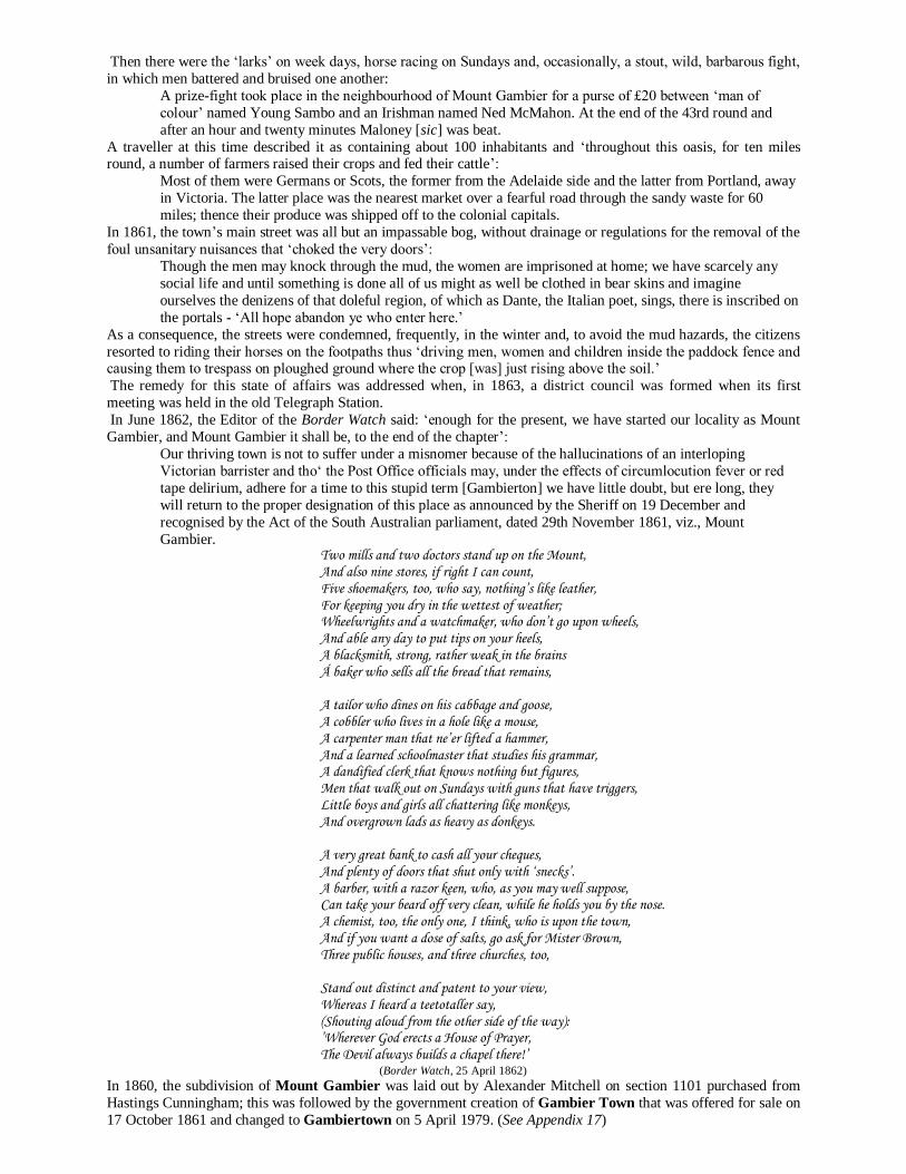
The home of Mr & Mrs Smith, built in 1855
Some large capitalists, however, by buying off competitors, and other diverse means, were able to secure an
immense quantity at a little over the upset price.
Many persons, however, could not afford to purchase outright and went to the capitalist, who was ready to
accommodate them with inferior land at high rental which crippled their energies and blasted their
prospects. Year by year they struggled on until insolvency reduced them to the ranks of the labouring class,
bringing down in their fall some of those tradesmen who had too eagerly supplied them with credit.
The Aboriginal name for the district was nerebalam meaning ‘eagle’s nest’. In Booandik mythology the struggle for mastery between the eagle and crow was a dominant theme. The eagle’s enemy had his nest in the great crater of the
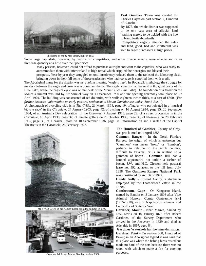
Blue Lake, while the eagle’s eyrie was on the peak of the Mount. (See Blue Lake) The foundation of a tower on the
Mount’s summit was laid by Sir Samuel Way on 3 December 1900 and the opening ceremony took place on 27
April 1904. The building was constructed of red dolomite, with walls eighteen inches thick, at a cost of £500. (For
further historical information on early pastoral settlement at Mount Gambier see under ‘South-East’.)
A photograph of a cycling club is in The Critic, 26 March 1898, page 19, of ladies who participated in a ‘musical
bicycle race’ in the Chronicle, 24 January 1903, page 42, of cycling on 16 August 1934, page 35, 20 September
1934, of an Australia Day celebration in the Observer, 7 August 1915, page 29, of a street procession is in the
Chronicle, 10 April 1930, page 37, of female golfers on 26 October 1933, page 38, of lifesavers on 28 February
1935, page 38, of a baseball team on 10 September 1936, page 38. Information on and a sketch of the Capitol
Theatre is in the Chronicle, 26 February 1927.
Mr Vivian Lewis in his Napier motor car at the summit in 1909
Commercial Street, Mount Gambier – circa 1960
East Gambier Town was created by
Charles Hayes on part section 7, Hundred
of Blanche.
By 1875, the whole district was supposed
to be one vast area of alluvial land
‘waiting merely to be tickled with the hoe to bring forth abundantly.’
Competitors eagerly attended the sales
and land, good, bad and indifferent was
sold to eager purchasers at high prices.
The Hundred of Gambier, County of Grey,
was proclaimed on 1 April 1858.
Gammon Ranges - In the North Flinders
Ranges, the origin of which is unknown but
‘Gammon’ can mean ‘hoax’ or ‘humbug’,
perhaps in relation to the scrub country, difficult to traverse, or is in relation to a
gammon of bacon - Gammon Hill has a
banded appearance not unlike a rasher of
bacon. J.W. and H.C. Gleeson held pastoral
lease no. 592 adjacent to the hill from July
1858. The Gammon Ranges National Park
was constituted by Act 56 of 1972.
Gandy Gully - Edward Gandy, a stockman
employed by the Featherstone estate in the
1870s.
Gantheaume, Cape - On Kangaroo Island,
named by Baudin on 3 January 1803 after Vice Admiral Honore, Comte Ganteaume [sic]
(1755-1818), one of Napoleon’s advisers and
Councillor of State for War.
Gardiner, Mount - Near Marree, named by
J.W. Lewis on 16 January 1875 after Robert
Gardiner, of the Survey Department who
arrived in the Recovery in 1839 and died at
Adelaide in 1897, aged 84.
Gardiner Waterhole has the same derivation.
Gardner, Point - On section 508, Hundred of
Baker; in an Aboriginal legend it was said that this place was where the fishing birds rested but
made no haul of the nets because there was no
wood with which to make a fire for cooking
purposes.
Garfield - In 1882, a meeting of residents of Hilton and neighbourhood was called by the directors of the Adelaide,
Hilton and Garfield Tramway Company Limited to ‘test the feeling of the residents and property owners as to the
advisability of laying the rails in the centre or on the side of the roads traversed; also a proposed extension of the
line to the sea beach…’ Twelve days later, section 99, Hundred of Adelaide, was declared to be ‘only two miles
from Adelaide adjacent to Hilton and Cowandilla… close to West Adelaide and Brooklyn Park… close to the
northern boundary runs the Adelaide, Hindmarsh and Henley Beach Tramway… a tramway will shortly be constructed from Adelaide through the centre of Garfield…’
The subdividers, no doubt, had in mind James A. Garfield, a former President of the USA, who was assassinated on
2 July 1881 and died on 19 September 1881. (A portrait of the President with the Union Jack and Stars and Stripes
was displayed in the advertisements.)
It was proposed that a horse tramway from Adelaide via Hilton would be extended through the subdivision to a
depot within the suburb extending from East Terrace (Marion Road) to West Terrace (section boundary - now part
of the Airport) Lipsett Terrace to the section boundary in the south. Street names were Garfield Parade (an extension
of Cowandilla Road), Collins, Buik, Jervois, Marion and MacGeorge streets.
Later, it became known as ‘Weeroopa’ and is now part of Brooklyn Park.
The name Garfield was applied, also, to a school near Port Broughton in 1901; it closed in 1942.
Garra Lands - South-East of Peake, derived from either kara - ‘red gum trees’ or garra - ‘clay ground’.
Alan Baker held the ‘Garra Run’ with his head station, 10 km SSE of the modern-day town of Parrakie; see Pastoral Lease no. 2097:
Garra is situated 32 miles North-East of Coonalpyn and about four miles south of the middle boundary of
the Hundred of Cotton. The homestead is situated on a fairly grassed flat, nicely timbered with pines and
bull oaks… The improvements consist of a roughly built stone house of eight rooms and a few
outbuildings, including a woolshed…
Garrick Bore - A post office opened in 1928, 19 km North-East of Karoonda; there is a ‘Garrick’ in Lincolnshire,
England, derived from an Old English personal name ‘Gara’ and the Old Scandinavian vik - ‘a bay’.
Garrie Swamp - On section 18, Hundred of Naracoorte and named after George Garrie who, with H. Ward, held
pastoral lease no. 164 in 1851; he had the land under occupation licence from 20 January 1848. (See Messemurray)
In 1877, it was reported that ‘Mr. Alex McKenzie, a boundary rider for Mr William Robertson, of Moy Hall, while
engaged in driving stray sheep from the Moy Hall to the Messemurray Run, saw some bones in Garey’s [sic] Swamp, which is distant about five miles from Naraccorte [sic]… The remains have evidently lain in the swamp for
some years … The action of fire on them is apparent…’ (See Bool Lagoon)
Local historian, Ms Judy Murdoch, informed the author that it was known to be a place where corroborees were
held: ‘An old resident recalled several in her childhood. She told us people came from all around, not just the local
Aborigines…’
Gaskmore Park - In 1854, ‘a public meeting of the inhabitants of the townships of Newton, Shipley [sic],
Campbelltown, Athelston [sic], Paradise Bridge and Gaskmore Park was held on 12 May 1854 to devise the means
of erecting a church… At present there was no means of public service, except that… commenced by the Rev E.K.
Miller.’ A Mr M. Gaskmore arrived in Adelaide in 1846.
Gascoigne Bay - In Streaky Bay, recalls Edward P. Gascoigne, MP (1858-1860).
Gason, Mount - On the Birdsville track out of Marree, it was named after Trooper Samuel Gason who was
appointed to the Police Force on 2 February 1865 and employed first in the Lake Hope area with the task of trying to keep the peace between the Aborigines and the pastoralists.
He resigned in 1876 and, late in 1877, took over as licensee of the Beltana Hotel.
Mr Gason was an esteemed member of the police force and the experience he gained in the interior enabled him to
write an interesting book on the Aborigines of South Australia
There is a tombstone within sight of Gibson’s Camp which bears the inscription: ‘In memory of Samuel Gason who
died April 11, 1897, aged 52. Erected by friends and admirers.’
Crossing a dune on the Birdsville track in 1964
Gassington - The name of an agricultural settlement near Mount Barker.
Gawler - On his arrival in the colony in October 1838, Governor Gawler found many settlers in a state of destitution
and, to relieve this problem, he commenced a number of government works; a road was constructed between
Adelaide and Port Adelaide, where wharves, customs house and warehouses were built. He spent much of his own money in paying the unemployed’s wages and his summary dismissal from office was
anything but creditable to the British Government. He was recalled in 1841 and died at Southsea on 7 May 1869. It
is probably not known to many persons in South Australia that Colonel Gawler owed the appointment as governor
‘These isolated burial places are of common
occurrence and the headstones show up
distinctly a long way off and supply a striking
illustration of the lines’: No spot on earth but has supplied a grave, And human skulls the spacious oceans pave.
A sketch of ‘Gason’s Tree’ is in the Pictorial
Australian, February 1884.
of this State to a letter written by Lord Raglan (then Lord Fitzroy-Somerset) and addressed to Colonel Torrens of
the SA Commissioners - ‘I have the honour… and great satisfaction in acquainting you that his Lordship entertains a
very high opinion of Lieutenant Colonel Gawler who, during the course of military service, has conducted himself in
every situation in which he has been placed with great credit to himself and advantage to the public, and has
rendered himself conspicuous by his zeal, judgement and intelligence.
‘Lord Hill has therefore no hesitation in recommending [him] to the Colonisation Commissioners for SA as an officer in every respect qualified for the high and responsible appointment which he is desirous of obtaining through
their kind offices.’
Governor George Gawler’s name is commemorated by Gawler Ranges, discovered by E.J. Eyre on 18 September
1839.
The squatters for some time past have been looking in different directions in search of runs adapted to their
requirements and as the Gawler Ranges seemed to offer some advantages, several runs have been taken out.
Parties who visited these ranges from time to time reported an abundance of grassy country well adapted
for sheep, could water be procured in the hot seasons of the year.
A few months ago [in 1860] Mr Miller took out 2,000 sheep but having unsuccessfully sunk for water had
to decamp to Streaky Bay…
In October 1911, Captain and Mrs S.A. White returned from a search for the night parrot:
He explored the Flinders Ranges but was disappointed he could not go into the Gawler Ranges because the country was extremely dry. Old settlers had informed him that the green parrot still existed there.
Gawler Reach is in the Port River.
On 18 January 1855 at Port Gawler, ‘a meeting was held at Holly Park, the residence of James McCord, for the
purpose of determining upon the erection of a school house in the district. Mr Carson offered to grant an acre of
ground and the following were appointed as trustees - Messrs. J.McCord, J. Carson, W. Horner, S. Cassidy and D.
McAvoy’, while, on 16 May 1862, it was reported that ‘in October 1861 Mr Christopher Temby received some
cotton seeds from Dr John Browne, who had received them from California’:
He planted them between rows of vines in his garden and in six or eight weeks four plants made their
appearance… The pods began to burst in the following March and continued opening from time to time…
A wharf was erected there in 1868 and, between December 1874 and November 1875, 295 vessels were loaded; a
large portion of it was destroyed by fire in 1920. A photograph of a war memorial is in the Observer, 19 November 1921, page 24.
The County of Gawler was proclaimed on 2 June 1842 and the Hundred of Port Gawler on 7 August 1851.
In his diary of 12 December 1837 Colonel Light said, ‘we arrived… at the Mete Watte River…’, and John A.
Lienert, of the Lyndoch and District Historical Society, makes the following explanatory statement:
The Mete Watte as discovered by Light is made up of two rivers, the Gawler and South Para. The point
where Light first saw the river is undoubtedly what is now called the Gawler River; where he crossed it
some 3 miles upstream is now the South Para River.
Apparently, it was named by T.B. Strangways and S. Blunden in November 1838 and, no doubt, they did so with a
view to currying favour with Governor Gawler who arrived in the colony in the previous month:.
We rejoice to inform our readers that another fresh water river, within a distance of forty-five miles from
Adelaide has been discovered [sic] by Mr T. Bewes Strangways and Mr S. Blunden… The stream [has]
three times the body of water of the Torrens and runs through a country of… beauty and fertility… (See Carclew & Flaxman)
Photographs of a swimming hole are in the Chronicle, 11 February 1932, page 31, of a cricket team on
22 March 1934, page 37.
Calton’s ‘Old Spot’ Hotel at Gawler
In 1839, the Gawler Special Survey of 4,000 acres was conveyed to Messrs Dunstan, Murray, Reid and King and
afterwards divided into eleven portions among twelve proprietors, viz., Messrs Murray, Reid, Fotheringham, Stubbs,
Johnston, Patterson, Sutton, R. Todd, Porter, Rev. Howard, King and J. Todd. These proprietors set aside 240 acres
Mount Gawler, on Eyre
Peninsula, was dis-
covered by Robert Tod
and party on 23 March
1840.
It was so named: To mark our gratitude
for the manner in
which Your
Excellency has
conducted the affairs
of the province.
Another Mount Gawler
is on section 255,
Hundred of Para Wirra.
at the junction of the Para Rivers for a township. The plan was drawn up by Colonel Light and surveyed by William
Jacob of Moorooroo in 1839 and named Gawler. The Town Council adopted his coat of arms as its insignia crest.
Gawler Tennis Club - 1890
The address referred to the gratuitous education given by Mr Riggs to a large number of young men of the
town and neighbourhood; to his labours so often freely and generously given on behalf of the public
institutions as well as to deserving charity cases.
David Thomson’s Eagle Foundry at Gawler Sketches of the town are in Frearson’s Weekly, 14 September 1878, pages 229-230, photographs are in the Chronicle, 2 January 1904, page 42, 16 June 1932, page 32 (includes an 1843 sketch), Observer, 19 October 1907,
page 29, of the railway yards and a bridge over the South Para River on 20 May 1911, pages 28-29, of the St
George’s Church in the Register, 8 May 1909, page 31. A sketch of a school is in the Pictorial Australian in
November 1878, a photograph of the school band in the Observer, 11 April 1908, page 30. Sketches of James
Martin’s engineering works are in Frearson’s Weekly, 27 July 1878, page 164.
A display of farming implements on John Riggs’ property at Gawler Plains – circa 1875 A photograph of the Show Hall is in the Chronicle, 24 September 1904, page 27, of jubilee celebrations on 19
October 1907, page 30, of Jubilee Cottage Homes on 14 December 1907, page 30, of a cricket team in The Critic, 21
April 1920, page 16. the opening of a bowling green in the Chronicle, 22 February 1908, page 29, of a whippet race
in the Observer, 1 April 1911, page 30, of a ladies’ hockey team on 8 September 1917, page 23, of motor cycle races
on 3 November 1923, page 28, Chronicle, 10 April 1926, page 40, of bowling club members on 5 November 1936,
page 33, of the opening of a bowling green on 22 February 1908, page 29, of a whippet race in the Observer, 1 April
1911, page 30, of a ladies’ hockey team on 8 September 1917, page 23, of motor cycle races on 3 November 1923,
page 28, Chronicle, 10 April 1926, page 40, of bowling club members on 5 November 1936, page 33.
In 1887, one of the largest concert audiences that have been gathered together for a long time
assembled at the Gawler Institute on June 16 to do
honour to Mr W. Riggs:
Mr W. Riggs’s string band with Mrs Wainwright
as pianist played three overtures and Misses
Fotheringham and Mary Alexander rendered
piano solos… During the evening His Worship
the Mayor, Hon J. Martin, MLC, presented a
beautifully illuminated and framed address to Mr
Riggs and a parcel of sovereigns…
Gawler West was laid out by Walter Duffield on Part Block 2 and Gawler Town South by Luke Michael Cullen
and Matthew Smith. For New Gawler see under ‘Gulf View’.
In January 1850, a new school room was opened on Gawler Plains ‘by an address from the Rev George Pinkstone’:
All the respectable settlers of the district attended on this interesting occasion. The friends were invited to
take tea at Mr. J. Smith’s at whose sole expense the building has been erected. Mr. and Mrs McKinnon are
engaged as teachers. Gaza - So named to commemorate a victory of Australian Light Horse brigades against the Turks at Gaza, Palestine,
in 1917. Prior to 1918 it was known as ‘Klemzig’ which was restored to the map in 1935.
Gebhardt - North of Cadell, near the old Koomooloo Station, are Gebhardt Hills which were renamed ‘Polygon
Ridge’ in 1918, thus commemorating a 1914-1918 battlefield.
The Nomenclature Committee suggested ‘Tertamalgo Hills’, Aboriginal for ‘hills’, but it was not approved by the
government. Gebhardt Hills was restored on the map on 13 November 1986.
Gebhardt Lagoon, north of Cadell, was named after Gustav Gebhardt, who held six pastoral leases north of the
River Murray from 1876. He was born at Hanover, Germany, in 1833, and arrived in the Ohio in 1858. He died on
16 March 1900 and is buried at Brighton. The name escaped the notice of the Nomenclature Committee, in 1916,
when it was given the task of recommending names to replace those of Germanic origin on the map of South
Australia. (See Markaranka, Hundred of)
Gedville Estate - A 1912 subdivision of section 729, Hundred of Port Adelaide, by George Le Messurier Gretton; now included in Taperoo.
Gee, Mount - Near Copley and named after. Lionel C.E. Gee (1855-1936), a mining warden.
Geegeela, Hundred of - In the County of Macdonnell, proclaimed on 28 October 1907 as the ‘Hundred of Pflaum’,
which was erased from the map in 1918. It is derived from the Aboriginal tjitjila - ‘wallaby’.
The name ‘Geegeela Paddock’ appears on early pastoral lease maps and G. Smith applied the name to his lease no.
5009 in 1880. Rodney Cockburn says that the original occupier of the land was Henry Jones.
Geharty, Mount - This feature, north of Cowell, was reported to be named after J.W. Geharty (sic), a mounted
policeman, who served in the settled districts of Eyre Peninsula in the early days; it is believed to be a corruption.
James William Gerharty, born in Ireland, in 1816, arrived in the Pestonjee Bomanjee in 1838 when he became a
policeman. In later years he held pastoral country near Venus Bay, his first venture being at Lake Newland from 8
September 1856 (lease no. 507) (See Venus Bay) He died at Marryatville in December 1897 when it was said that ‘Mr Geharty [sic] came to South Australia in the
employ of Mr Winter [see Winter Hill], a surveyor, and was engaged in the earliest survey of Port Lincoln and
remained in that district for many years, doing duty as a police officer there and at Venus Bay’:
After his retirement from the force he continued to live on the west coast until a few years ago when he
removed to Adelaide. In his prime he was a conspicuous person. His tall, handsome figure, his long, curling
iron-grey hair, his active masterful manner, his wit and repartee, his good nature and wonderful knowledge
of bush life, combined to make him not only a valuable police trooper amongst the natives, who at the time
were numerous, wild and treacherous, but also an excellent companion in bush travels. His smart and genial
character and his general kindness will ever be his passport to kindly remembrance.
Gelland - A 1920 subdivision of part section 387, Hundred of Yatala, by the State Bank of SA and named after a
board member, H.D. Gell; now included in West Croydon:
The soldiers who have their homes at Gelland are discovering to their sorrow what damaging pest white ants are. Where is Gelland? Well, if it were not for the depredations of these mischievous ‘miners’ few
people would know anything about it. It is a little soldiers’ village, comprising 70 houses, situated in the
district of Kilkenny…
An inspection by Mr Bates, honorary architect of the Returned Soldiers’ Association revealed much
shoddy construction work - ‘Respecting white ants the floors I have seen are in a shocking state and so thin
that it is dangerous to walk in places for fear of going through. Some responsible person must have known
that at one time cowsheds and pigsties were crumbling to pieces on the block where the ants are in
evidence…’ [See Challa Gardens]
Gellerton - In 1879, James Gellert cut up part sections 444 and 446, Hundred of Melville, suburban to Edithburgh.
Born, circa 1832, he was the first school teacher in that town and died at North Adelaide on 22 January 1882.
Geltwood Beach - The first account of the disaster surrounding the loss of the Geltwood states that ‘the wreck lies on a reef about 10 miles south of Rivoli Bay’:
The Geltwood, beyond doubt, was wrecked on the night of 14 June 1876 when such a storm as rarely or
never has occurred in South Australia, swept through the country, uprooting thousands of trees… All the
way from the Coorong to miles beyond the border are these effects of the hurricane visible. At Robe roofs
were torn off houses, sheets of iron, planks, buckets and even tables were carried through the air…
It was in this awful tempest that the ill-fated Geltwood, a vessel on her first voyage, found herself upon the
shore and, after signalling in vain for aid, was driven upon the rocks in the wildest and most exposed
portion of our coast…
Later, the position was given as ‘fourteen miles from Millicent and four miles from Coonunda Station’; ‘the wreck
seems caught in a reef as the hull can be seen rising up and down’; whilst another witness stated: ‘The wreck… had
quite disappeared, the spars being just visible.’ A subsequent report stated:
The scene of the wreck is bleak and forbidding. There is a considerable current inshore and the waves break
upon the beach with great fury, even in fine weather. The beach is sandy, but where the vessel lies there is
believed to be a bed of sunken rocks, over which the rollers come in such manner as to forbid any hope that
a boat, if launched, could live in them.
Two days later the site of the wreck was given as ‘near Carpenter’s Reef about twelve miles from Rivoli Bay’ and,
to confuse the matter further, another report said that it was ‘distant about fourteen miles from Mount Gambier and about ten miles south of Rivoli Bay’:
After climbing over the steep sand hummocks running along the coast there, and looking down on the
smooth sandy beach, a terrible scene of wreck and confusion presents itself (spars, planking, casks, etc
scattered on the beach)… Little can be seen of the ship… no part of the hull is visible, but about 1,000
yards from the shore… can be seen a portion of what appears to be the bowsprit… Heavy breakers roll on
to the beach… even in calm weather…
The ship was wrecked on 13 or 14 June 1876 in a fierce gale that swept along the southern coast. All hands perished
and considerable quantities of cargo washed ashore were stolen, followed by arrests and convictions.
In July 1876 Corporal Field, accompanied by Troopers Shiels and Morris and Constable Mack, arrested
Louis Spehr and Frederick Barrien, well-to-do farmers, on a charge of stealing portion of the cargo of the
ship Geltwood… A plant of £700 of goods was discovered…
In Spehr’s tan pit a block of tobacco was found and, on searching Barrien’s, they found a lady’s woollen dress, two pairs of boots, four pairs of women’s hose, farrier’s box, cabin mat and a piece of rope…
[Subsequently] Mr Spehr was fined £100 and the horse used for carrying the goods [was] confiscated. [He]
enjoyed but brief freedom as P.T. Shiels rearrested him… under the Customs Act.
Barrien got off on a small fine of £10 but was rearrested and, together with his son, an alleged accomplice, lodged in
the Mount Gambier gaol in October 1876:
P.T. Shiels proceeded to Barrien’s farm… [and] probed with a thin iron bar and, striking a piece of wood,
called Mack who drove his crowbar right through what afterwards proved to be a sliding door from a
hatchway… They discovered a pit or trench crammed full of all sorts of merchandise … consisting of china
ornaments, cases of tobacco, brushware, a large roll of splendid blue cloth similar to what ladies’ riding
habits are made from, some 30 pieces of fine linen, a large quantity of hosiery, spoons, pencils, a sailor’s
chest chock full of all sorts of articles… making all together about a ton in weight. Much regret was expressed when Mr T.C. Ellis, of Benaira (sic), was arrested on a charge of complicity in the theft
of goods from the Geltwood. The case was heard at Mount Gambier where he was found ‘not guilty’ to which
verdict the crowd in the court gave three hearty cheers. (See Benara)
Gemmell - A railway station 11 km north of Strathalbyn named after Thomas Gemmell, who took up an occupation
licence of the area in 1842 following his arrival in the India in 1840; he died in 1897, aged 76.
Gemmell Hill is in the vicinity
George, Lake - About 2 km north of Beachport, takes its name from Governor George Grey who, in 1844, led an
exploration party to the South East. Prior to the constitution of the Hundred of Lake George on 20 July 1871 the
only recorded occupation was under two leases allotted to Alexander Cameron of Limestone Ridge from 1 July
1851, namely, PL 357 & 358 which comprised 73 and 54 square miles, respectively.
Mount George - (See Bridgewater) Georges Knob - In the Elder Range near Wilpena, named by the surveyor, Frederick Sinnett in 1851 after George Elder (1816-1897). (See Aleck, Mount & Elder Range)
Georgetown - The town, 11 km south of Gladstone, surveyed in 1869 by Conrad Wornum, was offered for sale on
15 September 1870 as George Town; it received its present designation on 5 April 1979. Its derivation is uncertain
but, probably, it was named after Sir George Kingston, a member for the district in about 1870 when he won an
election against Charles Mann. GeorgeTown School opened in 1877.
Rodney Cockburn suggests it was named in memory of George Fisher who, with his brother Charles, once held the
Bundaleer station, while in 1936 it was said the name ‘was bestowed as a mark of loyalty to the reigning house of
Great Britain and her dominions.’ Of some significance is that three of the town’s streets were named Fisher, Hurtle
and Pitts – ‘Hurtle’ remind us of Sir J. Hurtle Fisher while E.W. Pitts was C.B. Fisher’s manager.
A newspaper report said this about the infant town:
In the abstract [it] is a wretched place - it is guiltless of anything like useful ornament. No trees grow there - they know better… In summer it is… very hot and you swallow the dust in slices. In winter your boots
have a small farm attached to each. Georgetown is celebrated for its fleas… it is said that they actually
pulled a shearer out of bed one night…
On 4 August 1875, a deputation waited upon the Commissioner of Public Works when attention was drawn to the
fact that the whole of the business of the post office, telegraph and court house was ‘carried on in two very small
rooms… The police trooper had to reside at the hotel and, for the want of police cells, prisoners had to be chained up
in a stable…’ Photographs are in the Chronicle, 20 October 1932, pages 33 and 42. of a horse race meeting on 13
April 1933, page 38, of school students in the Chronicle, 15 June 1933, page 32, of a football team in the Observer,
28 September 1912, page 31, 25 September 1926, page 34, of members of the Smyth family riding to school on
horseback in the Chronicle, 20 March 1926, page 39, of four generations of the Murrie family in the Observer, 30
August 1913, page 31.
Gepps Cross - The name recalls Isaac Gepp (ca.1811-1891), the owner of the local hotel, who arrived in the Fairlie
in 1840. In 1848, he fell foul of the law when Alexander Tolmer, Inspector of Police, reported that he had ‘made
some seizures of illicit spirits and sought directions to prefer information against Isaac Gepp.’
Originally, the area was laid out into farmlets in 1842 and called ‘Montague Farm’, after Sir Montague Lowther
Chapman, who obtained the land grant on 14 June 1842. (See Dry Creek, Grove Hill & Pooraka)
In 1894, sports in connection with the North Field Athletic Club were held on Christmas afternoon ‘on Mr L. Conrad’s paddock. It was the first attempt at anything of the sort in the district and the committee deserve credit for
their energy… A concert was held in the evening in the club’s assembly rooms. A dance followed.’
Gerard - (See Silver Vale)
Geranium - The town, 32 km west of Lameroo, proclaimed on 24 March 1910, took its name from the native plant,
Pelargonium australe once growing profusely in the district; it is rarely seen today due to the cultivation of the land.
‘Children of the day called it “knives and forks” because of its unusual seed pod which was three inches long and
very pointed.’ The Geranium School opened in 1913.
A photograph of field trials is in the Observer, 14 October 1911, page 31, of the opening of a hall in the Chronicle,
21 October 1922, page 29.
Geranium Plains Post Office, near Robertstown, was opened in 1894. In 1916, the Nomenclature Committee
recommended the name be changed to ‘Iperta’, an Aboriginal word for ‘geranium’, so as to avoid confusion with the
government town of ‘Geranium’. German - The name of German Creek, in the Hundred of Benara, was changed to ‘Benara Creek’ in 1918 - the
replacement name suggested by the Nomenclature Committee was ‘Wodliparri Creek’, Aboriginal for the ‘Milky
Way’, which, in legend, was believed to be a ‘river in the sky with reeds and waterholes in which lived water
monsters’.
The name was restored on 13 November 1986. (See Benara, Hundred of & Mitchells) Walter Mitchell held the lease
of the ‘German Creek Run’ (no. 189 of 1851) until 1860 when it came into the hands of Messrs W.J. and J.H.
Browne and the Register, 15 December 1923, says it was so named because a ‘German was shepherding there’.
Earlier, the Border Watch, 13 June 1862, carried an advertisement inserted by ‘German Jack’ of Benaira [sic]
stating that he wished to correct an erroneous report that he had killed 16 kangaroos in one shot, but said that he did
kill ‘on Monday last about sunrise 16 kangaroos at nine shots, distance 300 to 850 yards, and challenged the district,
for £50, to produce a man that will do the same, Samuel Leate, not excepted.’ A few months later, Mr Leate met with a serious accident while ‘partially intoxicated’ and galloping a horse along
Commercial Road, in Mount Gambier, when he fell off striking his head violently on the ground. Apparently, he
recovered, for a few months later he brought in to the office of the Border Watch an enormous specimen of ‘those
ferocious animals known as the tiger cat’ which he had killed in the stringy bark country on the Benaira (sic) run.
In 1865, it was reported that ‘a preliminary kangaroo hunt was held on the German Creek station, the property of
W.J. Browne, Esq., on Tuesday last’:
A large yard had been made of wire, so closely arranged and tightly drawn that a man’s fist could scarcely
be thrust though it, and it was deemed impossible for any but the smallest kangaroo to force its way out of
it.
Two large wings of brush fencing extended for some distance leading into the yard and it was hoped on
starting that a good haul would reward the efforts which had been made.
The party out consisted of eighteen, and so well arranged was everything that about 1,000 kangaroos were enclosed in the cordon made by them. However, before the kangaroos were got into the race nearly one half
escaped on account of the numerical weakness of the party; the rest were successfully driven up and
yarded.
No sooner were they in the yard when, to the astonishment of everyone, they commenced leaping through
the wire just as if it had been so much paper and out of the 500 enclosed only about 70 were killed…
The German Flat School, in the Hundred of Mingbool, was conducted by James Harris in 1872, with 22 enrolled
pupils; opened in 1871, it was changed to ‘Benara Flat’ in 1918 and closed in 1959.
German Pass was between Nuriootpa and Angaston and since 1918 has been known as ‘Tappa Pass’ (Aboriginal
for ‘a path’). (See Angaston)
German Town was an unofficial name given to a place, about 3 km from Redbanks, where, in the 1880s, several
families of Germans settled ‘but after many years when a town did not develop, it became known as Germantown Road…’ This quotation was taken from Life Around the Light. (See under ‘Sichem Well’ for a variation in respect of
the date of its christening and location.) (See Hahndorf)
Germantown Hill, in the Mount Lofty Ranges near Hahndorf, has been known as ‘Vimy Ridge’ (a battlefield in
World War I) since 1918, the government having overruled the suggestion of ‘Yarluke Hill’ (Aboriginal for ‘a
track’). (See Vimy Ridge)
Early on Saturday morning a number of gentlemen set out from Adelaide to visit the Balhannah Mine. All
went smoothly until in descending the long incline known as German Hill, leading to the junction of the
Mount Barker and Woodside roads, an accident occurred which cast a gloom on the day’s proceedings.
Shortly after commencing the descent of the hill Mr J.P. Stow, who was driving a light four-wheeled
buggy obtained from the Globe Hotel stables, noticed the block of the drag had broken away and,
consequently, there was no brake upon the wheel.
The horses finding there was nothing to check them except the reins, to which they refused to answer,
broke into a gallop and raced at full speed down the hill… The buggy turned completely over, throwing its
inmate to the side of the road. In the trap at the time were Dr Phillips and Messrs Robert Stuckey, J.P. Stow
and J.H. Finlayson…
Germein - On Freycinet’s charts Port Germein is shown as Baie Turenne. The Aborigines knew it as madlawi -
‘bitter spring’, while Germein Gorge was bekalibari - ‘lizard river’. The town of Port Germein, surveyed by August Poeppel, was proclaimed on 5 December 1878, and honours John Germein (1812-1879) who, in 1840,
discovered the site while taking stores to Edward J. Eyre at the head of Spencer Gulf .
Rodney Cockburn cites another source that suggests the port was discovered by Samuel Germein (1818-1886),
brother of John Germein. (See Benjamin Hill, Samuel Creek & ‘Source Notes’)
Land in the vicinity was held first under pastoral lease no. 1120 issued to John Morphett on 1 April 1863,
comprising eleven square miles.
In 1881, the private town of Germein was laid out on sections 211 and 213, Hundred of Telowie, by Frederick
Wright and T.F. Sabine. (See Telowie, Hundred of)
A seafaring tragedy was reported when the Bellona, 1,123 tons, Captain Ben Warren, cleared on 14 January 1884
and ‘an hour afterwards the pilot left her outside the eastern shoal’: ‘The captain’s only daughter, aged 16, was
playing with a dog and a ball on the deckhouse and, when jumping in the passage between the deckhouse and the
ship’s rail, fell into the sea. Her father saw her fall but could do nothing for her for he saw two sharks seize her as soon as she fell in the water… The girl was never seen again…’
Port Germein – circa 1900 It appears that this tragedy referred to a youth named Barnard who disappeared there whilst swimming and a
newspaper reference at this time merely stated that the body ‘had not been discovered’.
A photograph of council members is in the Chronicle, 5 November 1904, page 30, of a bridge over Baroota Creek
on 17 July 1909, page 32, of wheat stacks in the Observer, 3 March 1906, page 30, of the committee of the
Combined Schools’ Picnic Society in the Chronicle, 17 October 1908, page 32.
Gerty Creek - East of Lake Eyre South, named by J.W. Lewis on 13 February 1878.
Gerumgerum - A pipeclay lake east of Salt Creek, in the Coorong, with several small islands. It was sacred to the
Kongolindjeri clanspeople who placed bodies of their dead there. The ancestral crow-being played dirty tricks at this
lake and practised, also, boomerang throwing.
Ghost Gully - In the Mount Compass district where a prisoner was handcuffed to a tree overnight while three other
prisoners were taken to Willunga by police escort. Upon returning to the area the escort could not find the prisoner who, a few days later, was found dead.
Gibbon - James. H. Gibbon (1836-1925), was senior nautical warden of the Marine Board and one-time commander
of the Cathay that was wrecked in Torres Strait in 1866.
The farmers’ chute at Port Gibbon – Now demolished Cutting through a cliff leading to the Port Gibbon jetty Point Gibbon, South-West of Franklin Harbor, was known formerly as Point Price.
Prior to the jetty being built two wheat merchants used to shoot [sic] their grain down the cliff into an open
boat and then lighter it to vessels anchored further out. Hundreds of thousands of bags of wheat were
This, we believe, was the second account of a shark attack in South Australia, the first having occurred in
1862 when the Register reported that ‘in perusing the
account of the late melancholy event at [Glenelg] and
the apparent loss of the body, our attention is naturally
called to the danger arising from sharks and other
ravenous fish’:
It behoves us to guard against this for the future and
I would suggest that two paddocks, one for males
and one for females, of closely netted wire netting
wire fencing at once be erected at the Bay… the
same as is done in sister colonies…
shipped from the port in this manner without any trouble from the elements. Years previously the mail used
to be landed at the spot where the Lily Hawkins came to her end. Captain Gibbon was [her] master and Port
Gibbon was named in his honour… [See Point Price]
The jetty was opened by the Minister of Marine, Mr R.P. Blundell, on 5 November 1915 and the town of Port
Gibbon proclaimed on 23 March 1916.
Photographs of a sports day are in the Chronicle, 5 January 1933, page 31. Gibb(s) Waterhole - On section 5, Hundred of Wells, probably recalls Samuel Gibbs, an early settler who, with
Messrs T. McCallum and J.B. Makin helped to clear and exterminate wild dogs from the surrounding district. (See
McCallum, Hundred of)
Gibraltar Rocks - North-West of Lake Gairdner, named by Messrs MacFarlane and J.B. Bull, circa 1865.
The ‘Gibraltar Run’ was established by A.L. Har(r)old in 1877.
Gibson - A former coaching station, 56 miles North-West of Port Augusta, at the junction of the roads to the Far
North-West and Whittata South was known as Gibson Camp, so named after Thomas McTurk Gibson who at one
time held the lease of the country:
There is an hotel - the only one west of Lake Torrens - and here we stopped to feed our horses and refresh
the inner man… There are two wells here - a government one 80 feet deep and yielding fresh water, the
other a private one, sunk by the lessee of the square held under miscellaneous lease on which the hotel
stands… The hotel is a substantial structure of 14 rooms and has been licensed for three years… An amusing story about the hotel-keeper’s pet cockatoo was told in 1906: ‘[It] knows as well as anyone in the
district at what time [the mailman] is due, for it regularly flies out to meet him and comes home perched on his
shoulder.’ (See Gason, Mount)
A photograph of voting day is in the Observer, 24 June 1905, page 28.
In respect of Gibson Peninsula, a search of land records shows it as a small body of land from Point Gibson to the
area of mangroves on the main body of land and known, locally, as ‘The Spit’ and Gibson Peninsula is shown thus
from 1882. The first survey of the area by Stephen King, in 1885, shows, specially, the smaller peninsula as
‘Gibson’s Peninsula’ and refers, continually, to the larger body of land simply as ‘peninsula’.
At a meeting of the Geographical Names Board, on 19 March 1981, it was recommended that the name Gibson
Peninsula should apply ‘to the whole of that peninsula situate to the west and North-West of the town of Streaky
Bay in the Hundred of Ripon.’ The name honours Thomas McTurk Gibson (1829-1879) who took up pastoral lease no. 568 on 30 June 1857 ‘S-W
of Parla’ in the Streaky Bay district and its formation was the beginning of the township of Streaky Bay. Mr Gibson
was connected, also, with the Cooeyanna (sic) lease South-East of Streaky Bay.
The body of land north of Streaky Bay was locally, albeit incorrectly, known as ‘Gibson Peninsula’ but Gibson
never held a lease of this land, its first leaseholder being James Thompson (lease no. 927 from 27 August 1859), the
land transferring to Anton Schlink in 1864 (lease no. 1716), after whom ‘Schlink Landing’ is named.
In 1858, in the course of his exploration on Eyre Peninsula, John McD. Stuart said: ‘Sunday, 22nd August, on the
shore at Streaky Bay - Started at 11 a.m. to make Mr Gibson’s station.
‘The horses did not arrive until 10.30 as they had gone back on their tracks of yesterday. During the time Forster
was after them I managed to shoot a crow and cook him in the ashes. We had him for breakfast - the first food we
have had for the last three days.
‘It was very agreeable to taste and stomach, for we were beginning to feel the cravings of nature rather severely. I hope Mr Gibson will be at the depot. It will be a fine trouble if he is not and we have to travel 240 miles on the
chance of shooting something. [Reached] Mr Gibson’s station… where we were received and treated with great
kindness, and for which we were very thankful. We enjoyed a good supper which, after three days fasting, as may be
readily imagined, was quite a treat.’ (See Cooyeana Well & Maryvale)
Giddieowie - In the Hanson District; derived from the Aboriginal kitjawi - ‘salty water’.
Gidgealpa - In 1967, an officer of the Delhi Australian Petroleum Limited stated that he chose the name, taking it
from the name of a waterhole near the field, meaning ‘woman standing under a grey rain cloud’. Mr Graham Pretty,
Curator of Archaeology, disputed this explanation and said that the original name given to the waterhole was
kilyalpa, meaning ‘to stand in the shade of a grey rain cloud’ and is bound up in the mythology of the Jandruwanta
tribe.
It seems that Kilyapani, one of the mythical women who created the land, once prayed for rain and decorated herself for a ceremonial song. While doing this a grey cloud appeared and stopped directly above her so that she
stood in the shade. Probably, Gidgealpa is a corruption of kilyalpa and a confusion of kilja with gidgi, the stink
wattle of South Australia.
Gifford Hill - On section 1182, Hundred of Mobilong, North-West of Tailem Bend, honours John Gifford, who held
an occupation licence in the area from 15 August 1844.
Another Gifford Hill is near section 492, Hundred of Mount Benson, named after the same gentleman who held
occupation licence no. 120 and pastoral lease no. 196 of 1851 at Mount Benson. (See Blackford Drain)
Gilbert - Thomas Gilbert, who arrived in South Australia in the Cygnet on 11 September 1836, was Colonial
Storekeeper until 31 December 1854, when he retired on a pension of £200 per annum.
He died on 30 May 1873, aged eighty-six, and is remembered by Hundred of Gilbert, County of Light, proclaimed
on 7 August 1851.
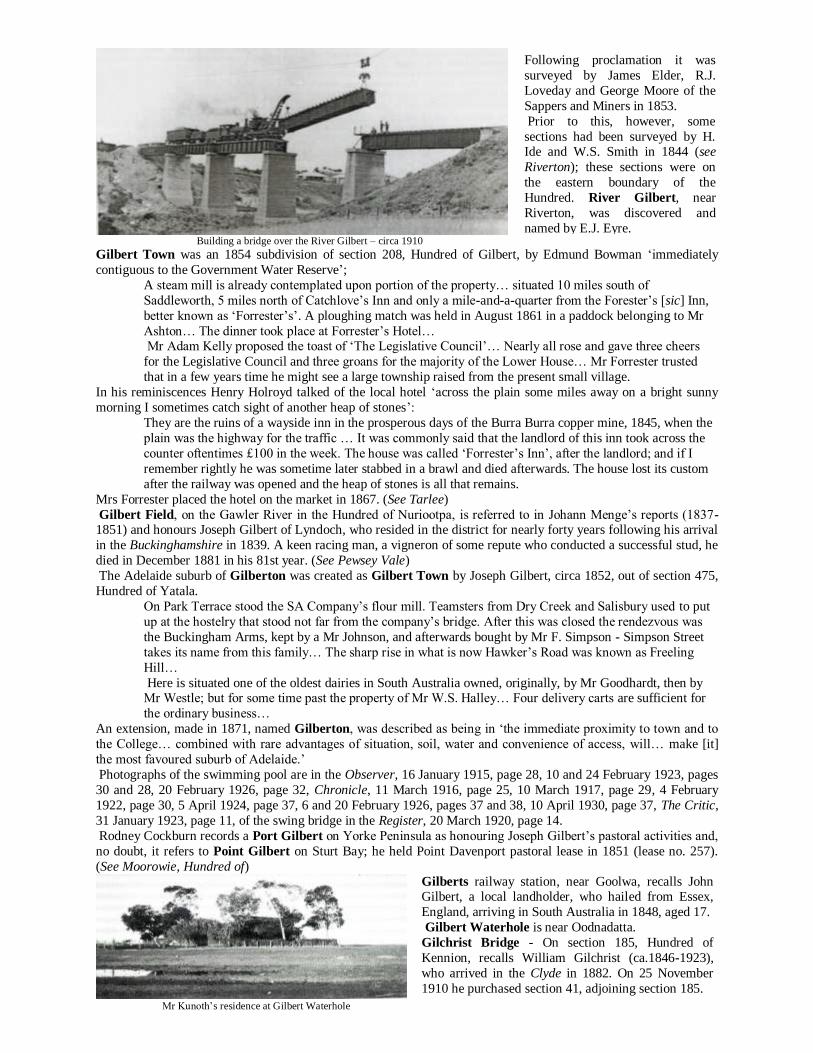
Building a bridge over the River Gilbert – circa 1910
Gilbert Town was an 1854 subdivision of section 208, Hundred of Gilbert, by Edmund Bowman ‘immediately
contiguous to the Government Water Reserve’;
A steam mill is already contemplated upon portion of the property… situated 10 miles south of
Saddleworth, 5 miles north of Catchlove’s Inn and only a mile-and-a-quarter from the Forester’s [sic] Inn,
better known as ‘Forrester’s’. A ploughing match was held in August 1861 in a paddock belonging to Mr
Ashton… The dinner took place at Forrester’s Hotel… Mr Adam Kelly proposed the toast of ‘The Legislative Council’… Nearly all rose and gave three cheers
for the Legislative Council and three groans for the majority of the Lower House… Mr Forrester trusted
that in a few years time he might see a large township raised from the present small village.
In his reminiscences Henry Holroyd talked of the local hotel ‘across the plain some miles away on a bright sunny
morning I sometimes catch sight of another heap of stones’:
They are the ruins of a wayside inn in the prosperous days of the Burra Burra copper mine, 1845, when the
plain was the highway for the traffic … It was commonly said that the landlord of this inn took across the
counter oftentimes £100 in the week. The house was called ‘Forrester’s Inn’, after the landlord; and if I
remember rightly he was sometime later stabbed in a brawl and died afterwards. The house lost its custom
after the railway was opened and the heap of stones is all that remains.
Mrs Forrester placed the hotel on the market in 1867. (See Tarlee)
Gilbert Field, on the Gawler River in the Hundred of Nuriootpa, is referred to in Johann Menge’s reports (1837-
1851) and honours Joseph Gilbert of Lyndoch, who resided in the district for nearly forty years following his arrival
in the Buckinghamshire in 1839. A keen racing man, a vigneron of some repute who conducted a successful stud, he
died in December 1881 in his 81st year. (See Pewsey Vale)
The Adelaide suburb of Gilberton was created as Gilbert Town by Joseph Gilbert, circa 1852, out of section 475,
Hundred of Yatala.
On Park Terrace stood the SA Company’s flour mill. Teamsters from Dry Creek and Salisbury used to put
up at the hostelry that stood not far from the company’s bridge. After this was closed the rendezvous was
the Buckingham Arms, kept by a Mr Johnson, and afterwards bought by Mr F. Simpson - Simpson Street
takes its name from this family… The sharp rise in what is now Hawker’s Road was known as Freeling
Hill…
Here is situated one of the oldest dairies in South Australia owned, originally, by Mr Goodhardt, then by Mr Westle; but for some time past the property of Mr W.S. Halley… Four delivery carts are sufficient for
the ordinary business…
An extension, made in 1871, named Gilberton, was described as being in ‘the immediate proximity to town and to
the College… combined with rare advantages of situation, soil, water and convenience of access, will… make [it]
the most favoured suburb of Adelaide.’
Photographs of the swimming pool are in the Observer, 16 January 1915, page 28, 10 and 24 February 1923, pages
30 and 28, 20 February 1926, page 32, Chronicle, 11 March 1916, page 25, 10 March 1917, page 29, 4 February
1922, page 30, 5 April 1924, page 37, 6 and 20 February 1926, pages 37 and 38, 10 April 1930, page 37, The Critic,
31 January 1923, page 11, of the swing bridge in the Register, 20 March 1920, page 14.
Rodney Cockburn records a Port Gilbert on Yorke Peninsula as honouring Joseph Gilbert’s pastoral activities and,
no doubt, it refers to Point Gilbert on Sturt Bay; he held Point Davenport pastoral lease in 1851 (lease no. 257).
(See Moorowie, Hundred of)
Mr Kunoth’s residence at Gilbert Waterhole
Following proclamation it was
surveyed by James Elder, R.J.
Loveday and George Moore of the
Sappers and Miners in 1853.
Prior to this, however, some
sections had been surveyed by H. Ide and W.S. Smith in 1844 (see
Riverton); these sections were on
the eastern boundary of the
Hundred. River Gilbert, near
Riverton, was discovered and
named by E.J. Eyre.
Gilberts railway station, near Goolwa, recalls John Gilbert, a local landholder, who hailed from Essex,
England, arriving in South Australia in 1848, aged 17.
Gilbert Waterhole is near Oodnadatta.
Gilchrist Bridge - On section 185, Hundred of
Kennion, recalls William Gilchrist (ca.1846-1923),
who arrived in the Clyde in 1882. On 25 November
1910 he purchased section 41, adjoining section 185.
Giles - Thomas Giles owned land in the Hundred of Gilbert and Giles Corner, on section 96, 8 km NNW of Tarlee,
is a reminder of his presence. Born in 1820, the son of William Giles who succeeded John McLaren as manager of
the SA Company, he arrived with his parents in the Hartley in 1837 and, with George Anstey, took up surrounding
land under occupation licence in 1845 and named the property ‘Marocara’ with Thomas Giles being the managing
partner. Later, Mr Giles held the freehold of much of the land and sold out to James Kelly in 1878.
In 1866, the Wesleyans at Anstey and Giles’s Corner ‘who for some time past have been holding Divine service in a private house, have felt the necessity for a new and more commodious place of worship, and intend erecting a
chapel…’
The post office at ‘Navan’ was moved to Giles Corner in January 1889 and retained that name until January 1890.
Giles Flat School, in the Hundred of Kondoparinga, ‘west of Strathalbyn’, was opened by Henry P. Ashton in
1863. (See below)
Giles Hill and Giles Creek, near Sandergrove, recall William Giles, who held an occupation licence in the area
from 18 February 1847.
The first Hundred of Giles, proclaimed on 19 April 1860 within the County of Albert, was declared to cease to
exist on 30 June 1870. Probably, it honoured William Giles who, in 1841, was appointed manager of the South
Australian Company. In 1851, he was returned as the member for Yatala and ‘was instrumental in framing the new
Constitution Act, by the passing of which universal suffrage and other benefits were conferred on society.’
He died at Beaumont in 1862, aged 71. The existing Hundred of Giles, County of Kintore, proclaimed on 23 October 1890, honours Clement Giles, MP
(1887-1902) who was born in Adelaide in 1844, the son of the afore-mentioned William Giles. At age 15, he went to
the South-East to learn sheep and cattle droving and, in 1864, ‘rode along for 800 km to manage Yanyarrie Station,
north of Melrose’. In parliament, ‘he successfully opposed free education for the rich beyond the compulsory
standard, but failed to secure grants for private schools.’
He died in 1926 and, in 1943, one of his sons was Mayor of Westminster, London.
Port Giles was named after Thomas Giles, a partner with George Anstey in the Penton Vale sheep station. In 1967,
construction of a deep sea jetty commenced there and was opened by the Premier, Hon. Steele Hall, on 23 May
1970. Point Giles, in the Hundred of Melville, is north of Edithburgh.
Gill - A former Conservator of Forests is remembered by Gill Island off West Bay, Kangaroo Island.
Rodney Cockburn says that, in respect of Lake Gill, ‘if priority of discovery count for anything, Lake Dutton (christened by J.A. Horrocks it in September 1846) should be Lake Gill. This was the scene of the accident which
cost poor Horrocks his life …’
In 1858, ‘Thomas and Walter Gill were the first to explore, since Mr Eyre’s journey of discovery, the country north
of Mount Serle’ and, in the same year, B.H. Babbage named the lake in their honour. (See Dutton)
Mount Gill is situated East of Beltana and honours W. and J. Gill who, with J. Taylor, held pastoral lease no. 527
‘near Mount Rose’ from 17 September 1856.
Rodney Cockburn describes Gill Soak as being west of Fowlers Bay and named after Thomas Gill, an Under-
Treasurer of South Australia.
Gillap Corner - Near Millicent, is a corruption of an Aboriginal word meaning ‘deep’ and has a reference to local
swamps. The ‘Gillap Run’ was established by J. Grice in 1880 (lease no. 5029).
The land was held first by Alexander Cameron (see PL 356a) and transferred to Thomas McKellar in 1859.
The name Gillap was given to the Reedy Creek Post Office in 1877; it closed in 1878. Gillen - Peter P. Gillen, MP (1889-1896), born at Golden Grove on 7 July 1858, was ‘an active debater and land
reformer’; although never a shearer he helped form the local branch of the Amalgamated Shearers’ Union of
Australasia while ‘in parliament his aggressive, excitable nature, rapid speech and uncompromising attitude drew
criticism.’ In 1892, he was Minister of Crown Lands and Immigration and held the same portfolio in C.C.
Kingston’s ministry in the following year.
The Hundred of Gillen, in the County of Manchester, was proclaimed on 26 January 1893 and the Gillen Village
Settlement founded on the River Murray in the 1890s with the idea that public funds should be made available to
men with little capital to take up land and work it cooperatively.
Mr Gillen was a prime mover in the establishment of the villages; ‘at the time of his death in September 1896 he
was working on a major revision of pastoral legislation…’
The application for 10,000 acres on behalf of the Gillen Village Settlement is part of the old Markaranka station, being pastoral lease no. 2137, situated between 20 and 30 miles by water from Morgan and 15
miles by road… During Thursday the members were busy packing up their baggage and… at 9.30 they left
for Morgan by special train… [See Markaranka, Hundred of]
In 1902, it was said that ‘it was an example of communism in its worst phase, and the experiment at Gillen resulted
in a dead loss to the State of £3,580.’ The Gillen Village School opened in 1895 and closed in 1896; Gillen East
School opened in 1900 and closed circa 1923. (See New Residence & Ramco) Gillentown was described as lying 5
km south of Clare and probably commemorates Thomas Philip Gillen who took up land in the ‘Hutt River Survey’.
Gilles - Osmond Gilles, born in 1797, became the first Colonial Treasurer, a position he held for two years after
which he retired into private life. He invested a large amount of capital in the colony, introduced Saxony and Merino
sheep to South Australia and was associated with Rev. C.B. Howard in the erection of Trinity Church and paid off
most of the construction costs. He died at Glen Osmond on 24 September 1876 and his name is commemorated by
Lake Gilles on northern Eyre Peninsula, discovered and named by E.J. Eyre on 26 September 1839; the ‘Lake
Gilles Run’ was established by J. and G.S. Williams in 1873, (lease no. 2332).
The name Gilles Plains, was applied to an ‘official’ Adelaide suburb in 1958; in 1919, an earlier subdivision was
advertised when one-acre blocks were put on the market at eight shillings (80 cents) per foot: ‘The soil throughout
the estate is… rich loam, specially suited for the production of potatoes and onions and all other root crops…’
The Gilles Plains School opened in 1901 and became ‘Hillcrest’ in 1953. The district, popularly known as Gilles Plains, is almost entirely devoted to the growth of hay… In this
locality is the property of Mr J.W.A. Sudholz, the largest hay farm in South Australia… Mr Sudholz was
born in Germany on 17 May 1821 and arrived at Port Adelaide in the Patel in 1846.
In 1849, he married Miss Gehlke and settled at Gilles Plains where, for years, he was the most successful
[farmer] in the neighbourhood of Adelaide. He was the first to grow wheat for fodder, binding it in sheaves
when green, and then cutting it into chaff. He was one of the founders of the Flinders Street Lutheran
Church; in fact its erection was due…to his efforts and liberality…
In 1858, it was said that Gilles Flat was to the ‘east of Bull’s Creek.’
Gilleston - This 1858 subdivision of section 4014, Hundred of Onkaparinga, was created by Osmond Gilles
contiguous to Balhannah:
Hitherto, only one want has been felt to mark this spot as one eminently suited for centralising a population
to supply the wants of a large agricultural district… That want is now supplied by the Gilleston Bridge, a very handsome stone structure that has been thrown across the Onkaparinga on section 4014… Gilleston
affords an opening for every trade and calling… [See Glen Osmond]
Gillman - A subdivision of section 1137, Hundred of Port Adelaide, named after a former General Traffic Manager
of the South Australian Railways when Rosewater Extension Limited laid it out in 1950.
Gilpin Hill - Near Milang, recalls Bernard Gilpin, who came to South Australia in the Lady Emma in 1837; by
1842, he was a partner of W. Anthony in an occupation licence of land in the vicinity.
Gina - A railway station on the Tarcoola-Alice Springs line received its name from a nearby pastoral station.
Gip Gip Rocks - An army trig station of section 86, Hundred of Peacock, corrupted from the Aboriginal djipidjipi,
the name of granite rocks used as a burial cave on the north east corner of the Hundred. (See Djipidjipi)
Gladstone - The name honours the William E. Gladstone (1809-1898), Prime Minister of England.
As an orator he was greatly admired. He spoke with fluency and great fervour. Large hearted, generous, with high ideals, honourable, he was of the best type of an English gentleman and a man in whom the
nation rejoiced.
Originally, it comprised of two townships - the private one lying east of the railway line created by Matthew
Moorhouse as Gladstone on part section 31 in October 1872, while to the west the government town was
proclaimed as ‘Booyoolie’ on 4 March 1875.
Gladstone railway yards
In 1885, the Gladstone corporation had ‘for some time past made itself notorious by the performance of various
questionable acts, besides endeavouring to harass the ratepayers and inflicting upon them penalties which the
residents in no other municipality would put up with’:
If a poor widow sells half a pint of milk, or makes a pound of butter, she is pounced on by a zealous officer
and has to pay ten shillings for a yearly licence. A private residence cannot light a fire in any other place than the one set apart by the builder of his house, or he is hauled before the town clerk and this officer takes
action immediately. Much of the persecution has been unwarrantable… It is rumoured that the councillors
intend resigning on Wednesday next.
‘Sunday Golf at Gladstone’ was the subject of censure in July 1926:
A meeting of the golf club was held to consider the question of Sunday golf… The issue was raised by Rev
G.W. Kendrew… All shades of religious opinion were represented in the club and therefore they could not,
as a body, prohibit Sunday play…
The former was declared to be ‘the future inland
terminus of the Port Pirie
and Gladstone railway and
the centre of a large
agricultural district [and]
cannot fail to become the
leading township of the
North.’ In 1940, for the sake
of uniformity, the name of
Gladstone was adopted.
(See Moytown) The Gladstone School
opened in 1874; information
on education in the district
was reported in 1877.
A history of the town and photographs are in the Observer, 15 June 1907, page 31, Chronicle, 27 October 1932,
pages 31 and 42, of students in the Observer, 15 June 1907, page 31, of students of the High and Primary schools
and St Joseph’s in the Chronicle, 29 June 1933, page 32, of flooding on 17 September 1910, page 29, of the railway
station on 12 October 1907, page 31, of the laying of the foundation stone of the St Alban’s Church Parish Hall on 8
August 1908, page 29, of a memorial fountain in the Observer, 7 February 1925, page 31, of a football team on 7
June 1913, page 32, of four generations of the Lines family on 20 September 1913, of the flooding of the road to Canowie in the Chronicle, 14 December 1933, page 34.
Justice Parsons unveiling a bust of W.E. Gladstone
Glandore - The name comes from County Cork, Ireland, and was given to a subdivision of section 53, Hundred of
Adelaide, by John Lewis, Joseph H. Morgan, Benjamin Morgan, John O’Dea, William L. Cumming and Mary Fox
in 1883.
The O’Dea family arrived from Ireland in the Birman in 1840 and the Irish town ‘sits on the eastern side of
Glandore Harbour… is extremely picturesque and is remarkable as having formed the subject of a Latin poem by
Dean Swift.’
Glandore West occupied portion of section 53, Hundred of Adelaide, and included Edward Street (now Ruthven
Avenue) to Albion Avenue and Railway Terrace (now Glengyle Terrace) Stanley Street (now Barclay Street) to
Albion Avenue, Beckman Street and Anzac Highway.
Glandore West Extension is on section 53, Hundred of Adelaide, and included Wellington Street, Albion Avenue,
Edward Avenue (now Ruthven Avenue) and Anzac Highway.
One of the imposing family mansions of early South Australia, it was constructed of stone brought from near Port
Vincent on Yorke Peninsula across Saint Vincent Gulf by flat bottomed sailing barges that were sailed across the
tidal flats at Ethelton at high tide, the stone unloaded onto drays on the ebb and carted to the site of the mansion.
It was built by Mr Gowling on a large area of land then known as ‘Buck’s Flat’; it consisted of fourteen spacious
rooms in the main building with a coach house and gatekeeper’s lodge; a billiard room and tower were added in
1865. (See Buck Flat)
The first subdivision in the area was in 1859 when part sections 908-9 were cut up into the ‘Township of
Portbridge’ by the owners, Messrs Alfred Watts and Philip Levi.
John Hart laid out Glanville on section 910 in 1865 and in 1872, ‘what had been a swamp at high water spring tides
was reclaimed by embankments, and is now a cottage township…’
Glanville - John Hart, born in Devonshire in 1809, went to sea at an
early age and, in 1835, established a
whaling station at Encounter Bay.
After the colony was founded in
1836 he engaged in coastal and inter-
colonial trade, retiring from the sea
in 1845, following his marriage to
Margaret Todd in Dublin, Ireland.
In 1856, he returned to South
Australia and built a home on land he
owned on Lefevre Peninsula, calling it ‘Glanville Hall’, after his mother,
whose maiden name was Mary
Glanville.
’
Glanville Hall
The Glanville School opened in 1873 and became ‘Ethelton’ in 1919.
By 1873, ‘whole streets had arisen’ and the sand and seaweed which once ‘owned the ground’ had given way to
houses and shops. ‘Buck’s Flat, where the races used to be held, [was] approached by a well-made embankment,
forming a thoroughfare for [the villagers].’ However, northwards and opposite North Parade the area ‘appears
literally cursed by sand… At one time the thick scrub to a great extent prevented the drift but of late years the timber
has been cut down and scrub destroyed to such an extent that the whole place resembles a sandy desert…’
A photograph of a railway accident is in the Chronicle, 13 August 1910, page 32, of the unveiling of a war memorial on 25 October 1919, page 27, of a water-colour of the ‘Old Glanville Bridge’ in The News, 25 October
1932, page 6f.
In 1884, the necessity for police interference with the ‘keepers of houses of ill-fame [was] becoming more and more
apparent and the attention of the Supreme Court was occupied by the case against a middle-aged woman and two
girls under twenty who had been keeping a brothel at Glanville’:
For five years past the people of the neighbourhood have been subjected to the annoyance of bad characters
congregating about their doors, using filthy language and… making their way into decent houses by
mistake…
An Early Social Experiment (Written in 1991)
One of the residents of Glanville in the 1880s was Mr F.R. Burton, Clerk of the Court at Port Adelaide, who had
studied the subject of treating truant and uncontrollable children. He contended that a large number of those
committed for serious offences would never have reached the gaol stage if a more judicious mode of treatment had
been available at the commencement of their ‘career’.
He was firmly of the opinion that instead of sending first offenders to the reformatory hulk, Fitzjames, where they would mix with those convicted of grave offences, the community would be best served if they were confined to a
truant school where they ‘could be diligently employed’.
Accordingly, in 1887 he drafted and submitted a scheme to Government in which he intimated that he would
conduct the scheme at his own expense (once operating the school cost Mr Burton ₤200 per annum). Not
surprisingly, those in power readily agreed to the proposal and the ‘Home’ was duly established near the Port River
‘where the boys bathe daily’.
Apart from the dwelling house there were two cottages, one used as a school and the other as sleeping quarters; a
vegetable garden was also maintained by the inmates.
In 1889, a reporter eulogised the establishment:
The undeniable fact is that the majority of those lads who have been under Mr Burton’s management are
now either attending school regularly and obedient to their parents or are earning their daily bread at honest labour. The Magistrate at Port Adelaide instead of committing boys to the hulk or gaol now hands them
over to Mr Burton - he is much pleased at the progress.
Sub-Inspector Doyle, of the Police Department, says that wonderful changes have been effected and
several boys, previously uncontrollable and truant, and fast developing into the larrikin type, were now well
behaved… Mr Burton is reclaiming boys who otherwise were on ‘the high road to ruin’.
In June 1890, another reporter visited the institution and was full of praise with what he saw; he concluded that
juvenile delinquency was ‘a serious question for young Australia - one that needs to be tackled and not shirked.’
In the year of our Lord 1991 we might be excused for uttering the present-day colloquialism - ‘What’s New’ - when
it is realised what the aftermath of the abuse of drugs and lack of employment has inflicted upon our ‘enlightened’
society.
It is apparent that Mr Burton encountered some government interference for in June 1891 it was reported:
When a man feels that he has a work to do for which he seeks neither money nor renown, and proves that he can perform it, it is a scandal to civilisation that he should be hampered in carrying out his work…
However, by December 1891 the troubles were behind him when it was reported that:
The inmates are not confined as prisoners, but they learn to take an interest in their new home and after a
few months most of them are prepared to return to their parents with the resolve to avoid evil ways. During
the time Mr Burton has been engaged in the work 68 boys have passed under his care… An extra allotment
of land, 150 feet by 50 feet, has been acquired and laid out as a vegetable garden, providing employment
for the young inmates.
Early in 1893, further storm clouds gathered when the State Children’s Council proclaimed that it considered Mr
Burton’s work was ‘an unnecessary expenditure of time and labour on his part’ and that it preferred ‘the
establishment of a probationary institution for the treatment of uncontrollable boys…’
This unperceptive and unwarranted proclamation was too much for Mr Burton’s sensitive nature and, early in February 1893, ‘aggrieved at such bureaucratic treatment’, he closed the establishment, to which a number of ‘old
boys’ expressed their disappointment that such a ‘step had been necessary’. *************************************
A History of Fort Glanville The following is taken from an unpublished manuscript titled The Russians are Coming,
by Geoffrey H. Manning, a copy of which is held in the State Library of South Australia.
The construction of Fort Glanville was undertaken by Mr J. Robb at a cost of about £9,000 and work commenced in
October 1878. A railway was laid down to join the Semaphore line with the site of the works and used for the
purpose of carrying the greater part of the required materials, all of which, excepting only the lime, was conveyed to
the scene of the operation, while water was laid on from Semaphore. By March of 1879 about 450,000 Victorian bricks lay on the sandhills near the temporary railway, besides a large
quantity of stone and gravel intended to be used in the manufacture of concrete.
The sand used was brought from the River Torrens and the lime from Gawler, while two on-site running mortar
mills were employed for the purpose of grinding the lime and making concrete and mortar. The foundations were of
concrete, while a ditch in front of the escarpment was 15 feet wide at the bottom, sloping up on both sides.
An underground passage, 20 feet wide, afforded means of communication with the caponier (covered passage) and
a similar approach was provided for the magazine, the entrance to each passage being inside the walls of the fort.
The laboratory, where carriages were manufactured, was placed at the southern corner of the fort. About 50 men
were employed on the site during the construction period, while the works occupied an area of ground measuring
300 by 299 feet.
One serious difficulty to be contended with was the sand drift and everyone acquainted with the coastline was able
to appreciate how troublesome it could become. This was overcome by following a suggestion from Dr Schomburgk, Director of the Botanic Gardens.
The drift was covered with seaweed under which seeds and cuttings were planted from plants indigenous to the
area. This scheme had already been tried at Glenelg where a fine reserve was made out of a formerly shifting
sandhill. The shape of the fort was that of a segment of a circle, the guns forming the sector and a low-lying building
forming the base. In this building resided the Master Gunner, Sergeant-Major Hanson, and his assistant-foreman, Mr
Lawley, whose business was to look after the fort.
The opening ceremony took place on Saturday, 2 October 1880, although the fort had been ready some three weeks
before; the delay being on account of a difficulty attending the mooring of a target in the form of a quarter-cask,
with a flag attached. The practice firing was carried out by four guns, while the target was some 3,500 yards distant.
The shells were brought from the magazine hard by and put on a truck which ran on rails to a position beneath the
muzzle of the cannon as it ran back on its platform to a position, bringing the gun’s muzzle inside the parapet. A small derrick was used to lift the ponderous projectiles into the mouth for ramming home. The great guns worked
relentlessly, recoiling back on their platforms and being well checked by three hydraulic buffers at each explosion
and then running easily up again under the power of the artillerymen.
Mr A.T. Saunders, an eye-witness to the opening ceremony, and a long time resident of the district, reflected in
1919:
On Saturday, 1 [sic] October 1880, the first guns were fired. I lived near the fort and signed a written
protest against the guns having fired, as we thought our windows would be all broken; but we were wrong -
no harm was done then or thereafter. There were two guns, each 22 tons and two 64-pounder guns, the
latter made in 1878; the big guns had been recently made. Sixteen shots were fired, but one of the big guns
misfired once; so its mate had an extra shot. Sergeants Oswald, Marshall, Bridgeman and Bombardier Dyke
were each in charge of a gun. The target was a floating cask, only 3,500 yards distant, and the shooting was wretched, although a man was on the sea end of the Semaphore jetty and signalled where each shot fell.
When Fort Glanville was first built there was at the front and sides an elaborate ditch protected by a
caponiere [sic]; but the back of the fort was open (a loop-holed stockade of wood was put up after) and
from the adjacent high sandhills the guns, which were on a barbette, were exposed to attack by riflemen.
A friend of mine (a German, who had served through the Franco-Prussian war) caustically said: ‘This fort
should have a notice board saying that it must not be attacked in the rear.’
The two original 64-pounders from Fort Glanville are now in Brougham Place Park.
At subsequent shooting exercises much amusement was afforded by the behaviour of a ‘regimental dog’, owned by
Mr Turner, Special Magistrate. It took an extraordinary interest in the fort and whenever it saw the men marching to
it, he started off to the scene of the operations, went in and, after carefully watched the loading, ran outside to watch
the shot, generally stationing himself almost in the line of fire.
He watched the course of the ball with as much interest as the men and as soon as a shell exploded rushed around into the fort to superintend the next loading. He was an immense favourite with officers and men.
The defence authorities, ever anxious to oversee and control its new installations, sent out regular inspection parties
and, in 1882, Sergeant Astles led one that traversed the recent fortifications along the seaboard and reported as
follows:
The track from Jervois Bridge to Fort Glanville abounds in holes big enough for rifle pits, but it is called a
road, nevertheless - the people of Glanville have such poetic imaginations. The first halt - official, not
compulsory, for the horses halted unofficially 20 times - was made at Fort Glanville, where very necessary and well-devised improvements have been made. The sandhills at the rear and flanks of the fort have been
levelled so as to prevent an enemy, who might have landed, commanding the interior of the fort with their
fire, as they would have done with the high sandhills formerly in the vicinity.
Now, the guns from the fort have a wider lateral range north and south, while from the stockades on the
land side a sweeping fire of musketry could be brought to bear… Fort Glanville is now garrisoned by
permanent artillerymen, who have joined for five years, and appear to be fine strapping fellows, already
acquiring that peculiar ‘setting-up’ brought about by soldiers’ drill. They seem full of enthusiasm, like their
quarters, enjoy their drill, and altogether promise to be good, reliable gunners.
There are 13 of them at present; one young man is a Majuba Hill hero and was with General Kitchener in
the memorable march from Kandahar to Cabul [sic] … A steady young soldier who has seen active service
is an acquisition in a garrison of greenhorns, because he carries a certain amount of prestige, and can keep
up the enthusiasm of the men by tales of ‘moving incidents by flood and field’, besides showing the example of discipline and drill.
After a look around the fort which is kept in beautiful order by Master Gunner Hanson, the party took to
the perilous passage of the road again … reached the first gun emplacement not far from the fort. This
consists of a breastwork of sand bricks with a kind of concrete platform and a gun track leading thereto.
By the way, round the region of Fort Glanville the commandant has had planted a quantity of cacti, prickly
pears and other hardy plants, to bind the sand as well as act as an obstruction to an assaulting party. We did
not traverse the whole length of the military road because some of it passes through private property and
wire fences prevent traffic. These can be removed when the road is needed, but at present serve to keep
unnecessary traffic off the road and protect it.
Landward of the military road there is excellent cover for infantry and the sandhills, which for several
miles nearer Glenelg run in a double line, form fine defences, for they could be lined with sharpshooters, if only we had sufficient, who ought to be able to do great execution…
The next gun emplacement was near the Grange… We came across an encampment of Afghans looking
very wild and picturesque, in the desolate swamp, with a tangled growth of scrub for a background… The
next voluntary stoppage was at Henley Beach where a third platform is situated, but it would require a keen
eye to detect it, for the line of sand ridge seems unbroken from seaward and the narrow gun track affords
only a slight clue… Number 5 has a range nearer Glenelg and a particularly substantial bridge built across
the Patawalonga gives communication with the road.
Here the larrikins have left more of their mischievous propensities, several of the stones forming the
breastwork having been wantonly pulled down. No. 6, nearer Glenelg, has a good range, north and west,
but southward is stopped by the Baths, therefore it will be necessary to have another emplacement the other
side of the town…
Fort Glanville
The day to day to day duties of the men were not onerous but, it must be said, appeared to be more than
monotonous. There was an early parade at 7.15 am when the men ‘performed’ setting-up drill for half an hour. Then
there was drill again from 9 to 11, consisting of gun, carbine, sword and repository drill, shifting guns and a variety
of other work ‘tending to call forth the quality of smartness.’ In the afternoon there was a further installment of drill,
elementary exercises, etc., while spare time was filled up with study for annual examinations; there was school,
twice a week, while Saturday mornings were devoted to general cleaning up. The fort was open to visitors on Sundays and the officers in charge were only too happy to show them and their
friends through, explaining the various departments. On 23 October 1887, a serious accident occurred when
Sergeant-Major Slane, one of the principal officers of the fort, was taking five male civilians through Fort Glanville.
He was with them in the artillery room, situated beneath the ‘ordinary’ ground, adjoining a kitchen.
In the store were shelves and a counter upon which were lodged ammunition, magazine lamps and candles, primers
and small gear belonging to the artillery service.
The Sergeant-Major was showing the visitors a friction tube which was a hollow tube of copper with meal powder,
pierced with a conical hole, and ‘carrying the flash.’ The top was supplied with a detonating substance and a friction
bar was attached. The Sergeant-Major placed his foot on the tube, pulled it and by some means, when an explosion
occurred and the flash from the tube ignited some sections of the fuses, etc., lying nearby.
The Sergeant-Major staggered through the kitchen and headed for the ground above, his clothes all ablaze, when
another officer got hold of him, put him in an adjoining wash house, and drenched him with water. Many of the visitors were also burning and they were got through the windows as soon as possible; while this was in progress the
skin of their hands was dragged off. There was no time to lose and a chain of men with buckets of water was formed
from barrack square to the store below. A large number of magazine candles were burning furiously and fuses
alight. The fire was at last extinguished and the scene presented afterwards was a total wreckage of almost
everything, except the walls.
Aftermath of the explosion
In 1885, when the Volunteer Military Force was denied the satisfaction of ‘sweltering under a Soudan sun and
showing El Mahdi what they were made of’, Major-General Downes, their commandant, determined to give them a
stiff night’s work over a waste of sand well calculated to test their powers and patience. A more dismal, sandy
waste, with swamp to vary it, than the stretch of district between Grange and Semaphore could hardly be found here
for fighting over. It was ground broken into sand ridges, hollows, occasional levels, a winding creek, a ford or two and a bridge, with
here and there clumps of trees affording excellent cover for skirmishers, besides being bounded by a high range of
sand hills barring it from the sea beach. Altogether it afforded plenty of scope for the exercise of intelligence and
judgment, not to say endurance on the part of the commanding officers as well as the men they directed.
Another facet of this exercise was an assault against the fort itself. On reaching Glanville the attacking force was
observed and the guns of the fort were opened upon them. They were then marching in columns of fours, and if a
shell had fallen amongst them there would have been some serious casualties to report. On the land side of the fort
there was an open plain and Major-General Downes extended his men in a semi-circle across this preparatory to the
attack. M Company, under Captain Stutley, was ordered to creep through the trees to the right. From the loopholes
and ramparts of the fort a heavy fire was poured into the ranks of the men and in actual warfare, had they attempted
any such exploit as this without artillery, all must have been annihilated.
They advanced, lay down and opened fire, but against the thick walls of the fort the bullets from their rifles crushed harmlessly against the ramparts. The cavalry had got under the wall of the fort without being seen and pressed the
attack on that side. The scene was a ‘grand and a picturesque one’, and unattended as it was by the horrors of
warfare, it would have raised the enthusiasm of any Quaker able to appreciate spectacular effects.
It was impossible with such a force to capture the stronghold and, beaten off, the commanding officer caused his
men to cease firing and brought the proceedings of the day to a close. The men were admitted to the fort, water
supplied to them and they were refreshed. Later, the march home commenced.
One man from the fort rode hastily up to Mr Ward’s chemist shop at Semaphore ‘without
a hat!’ and ‘eagerly asked for a doctor or a
chemist.’ Finding no one there he rode on to
Port Adelaide intimating to a few bystanders
that there had been an explosion at the fort.
The news spread and rumours gained
currency. The messenger reached Dr Toll,
who at once proceeded to the fort where he
treated the men who were suffering from
burns about the face, neck, hands and arms.
Apart from the Sergeant-Major the other victims were, J. Turner, butcher, of Exeter;
J.G. Stevenson of Angaston; T. Heddle,
landlord of the Lord Exmouth Hotel; J. Irvine
of Truro and J. Kurbines of Kapunda.
Portion of the land between Grange and Semaphore South, known as ‘The Pinery’ was the site of stirring clashes
between rival defence forces in training exercises aimed at repelling any invasion by the Russians which, as related
in earlier chapters, was considered to be imminent throughout the latter half of the 19th century. To ward off the ‘red
peril’ two forts were built and ‘another planned for the Grange area’, hence the name ‘Fort Street’ that still applies
today in local nomenclature.
In September 1894, inhabitants of Grange and ‘especially a few residents near that dismal swamp region of sand, swamp and teatree’, that comprise part of the modern day Grange Golf Club, were surprised by ‘the sudden sounds
of seeming strife that disturbed the serenity of those solitudes of Saturday night.’
The rattle of rifle fire and the heavy boom of 68-pounders from Fort Glanville, coupled with men shouting, and the
‘indications of a sharp struggle going on between two opposing forces contending for the possession of the ford and
bridge across the Port River at Grange, made not a bad imitation of real conflict…, but the good folk of the seaboard
are getting accustomed to such alarms, all ending in smoke and glory.’
The soldiers had a long march through miles of mud and stretches of water, sometimes knee deep, from their
assembly point at Fort Glanville. The general idea was that the enemy had captured Grange and was preparing to
march to Adelaide by way of the ford at Grange. Major Fiveash led his men along Military Road which was ‘about
as unmilitary as any foeman could wish to hamper the land forces’, for some miles until they reached the river. A
short distance from the ford a halt was made and a reconnoitering party went out sometime later ‘decorated up to the
knees with elaborate samples of swamp mud.’ A fierce attack was made through the creeks and lagoons within ‘The Pinery’, the only casualty being a private who
‘scorched his eyes owing to his rifle going off by accident as he held the muzzle upwards.’ Finally, the enemy was
brought to heel in the vicinity of Hindmarsh, whence both the victors and the vanquished departed to their respective
hearths where they lived to fight again another day. (See Glenelg & Largs)
Sketches are in Frearson’s Weekly, 28 August 1880, page 388, 4 September 1880, page 304, Pictorial Australian in
May 1880.
Glass Well & Glass Hut - In the Parachilna district and named after George Glass (ca.1830-1918), who was
involved with the construction and maintenance of roads in the area where Glass Gorge is a tourist attraction North-
West of Blinman. Today, the ruins of his home are to be found in the gorge.
They were shown first on maps between 1898 and 1904. A George Glass conducted the Hookina Hotel that closed
in March 1897, while Jane Glass (ca.1831-1916) of Hookina, the second wife of George Glass, obtained the land grant of sections 124-126 and 132-134, Hundred of Wonoka, on 7 March 1898.
Glebe - A 1912 subdivision of part section 2300A, Hundred of Yatala, was part of Glebe (church) lands cut up by
the Trustees of the Church of England; now included in Alberton.
The land was known as ‘Green’s Paddocks’ and adjoined the rectory of St Paul’s Church.
Gleeson Creek & Gleeson Well - North of Mount Serle remind us of John William Gleeson (?-1895) and Hampton
Carroll Gleeson (1830-1907), lessees of the ‘Illiwortina Run’ from 21 May 1857 (lease no. 556).
Gleeson Hill, near Blyth, recalls Edward Burton Gleeson, the founder of Clare. (See Clare)
Gleeville - The name of a property owned by E.B. Gleeson near Beaumont. (See Gleeson Hill)
The name was never applied to a subdivision but is shown on the original plan of the ‘Village of Beaumont’.
An ‘outrage’ by Aborigines at Gleeville was reported in 1841 when ‘a Coolie of Mr Gleeson’s was speared on
Tuesday morning by a Native at Gleeville’:
[He] was engaged cutting wood near the dwelling house when two Natives asked him for food or money. He said he had none when one of them thrust a spear into his neck, close under the root of the tongue. The
Coolie managed to crawl to an out house where he was discovered and the alarm given… The Natives are
allowed to retain their spears in town and to have as many dogs as they please…
We think that the Protector might employ his time more usefully by looking after the Natives out of doors,
than by helping the German missionaries to teach them their own or the English alphabet… [See
Beaumont]
A photograph of the residence built by Mr Gleeson is in the Observer, 7 March 1903, page 23.
Glenalta - In 1961, Sherwood Estates Limited gave the name to a subdivision of part section 874, Hundred of
Adelaide; it translates as ‘a valley near a hill’.
Glenbank - A 1929 subdivision of part sections 186-87, Hundred of Adelaide, by Frank Smith, F.W.W. Ellis, J.T.
Brown, H. Naylor and Isabel Roberts; now part of Adelaide Airport and Glenelg North.
Glen Boree - The name was taken from a local homestead and given to a post office on section 6A, Hundred of
Nash, 16 km North-East of Fowlers Bay, and a school opened in 1895 by Emily Cameron in 1900; it closed in 1930.
Glenbrook - (See Porter Hill)
Glenburn - The Aboriginal name for the area was bullaparinga - ‘near the dark river’, while the Scottish name
Glenburn means ‘valley stream’. Glenburn Post Office opened in 1862 and closed in 1875; known formerly as
‘The Stockyards’, Rodney Cockburn says the alteration was effected at the behest of the Reverend Dr Burgess.
Recalling a coach trip to the district a roving reporter said, ‘up and down you jolt through Finniss Vale and Second
Valley and a few more miles brings you to a dead-and-alive place called Glenburn.’
By 1866, there were ‘more than 20 houses within a short distance from the post office and we have at Glenburn a
doctor, schoolmaster, two butchers (the only ones in Rapid Bay), a saddler, bootmaker, blacksmith, stonemason and
a store, wine store, a nice chapel and a new school house building…’ (See Delamere & Stockyards, The)
Glenburnie - In 1866, a school was mooted 6 km east of Mount Gambier and, by 1872, ‘Mr Turner, SM, applied for
a grant in aid of the cost of building a new schoolhouse… on land given by Mr Jacob’; it was opened in January
1873 by J.N. Goymour. A ‘Back to School’ photograph is in the Chronicle, 4 April 1935, page 32.
The Glenburnie Post Office on section 378, Hundred of Gambier, opened on 10 November 1928 and closed on 29
March 1985. (Australia Post records show a post office of the same name opening at an unknown location in the
district in 1868; it closed in 1904.) The name was imported from Scotland and applied, also, to a subdivision of sections 2474 and 1140, Hundred of
Adelaide, ‘opposite Torrens Park and Scotch College and within two minutes of Blythewood railway station’; now
included in Torrens Park. Robert A. Ford created it in 1920.
Glencoe - The name of a property taken up under an occupation licence, 24 km North-West of Mount Gambier, by
Edward and Robert Leake from 6 March 1844. John McIntyre, who managed the property, hailed from Glencoe in
Scotland, derived from the Gaelic gleann-comhann - ‘narrow glen’. The Aboriginal name for the district was kilap -
‘deep water’. A sketch of the lease is in Romance of Place Names of South Australia.
The scene of his encampment was the margin of a placid lake of wide extent encircled by rising ground
forming the rim of an extinct crater. At that time there area was densely wooded but, strangely, Mr Leake
never took kindly to his homestead but always had a hankering for his first love, the lake that perpetuated
his name.
Among his valuables he had an old cannon and, when arranging to lease Glencoe, he made it a stipulation that the venerable piece of ordnance should be preserved carefully. His successors, who knew more about
sheep than artillery, thought it a fair thing to use the old gun in giving eclat to some holiday festivities.
Accordingly, they half-filled it with powder, on the top of which they rammed down a copious amount of
earth. Having no fuse, a foolhardy youth prepared to apply a match to the touchhole but was dissuaded
from doing so by a comrade, of more knowledge and less recklessness, who managed to improvise a fuse.
The explosion that followed was heard 15 miles away and when the smoke cleared it was apparent that the
cannon had disappeared. Fragments of it were gathered later in the neighbourhood and one chunk of iron
was found embedded in the gable of the station’s house where it remained, clamped to the wall, as a
memorial to the notable event. [See Peter Rymill, George Riddoch of Koorine]
The following is taken from Minnie - Memoirs of a Squatter’s Daughter by Mary E.S. Brewer:
Edward John Leake (1812-1867), part owner of Glencoe station was one of the earliest and wealthiest of the South-Eastern squatters. He was certainly a big man and is said to have weighed twenty stone… After
his marriage in the 1850s to a beautiful Irish girl named Letitia, widow of a local bullock driver, the couple
left Glencoe station to live in a house Edward built at Nelson [in Victoria]; today, it is the Nelson Hotel.
When Robert, his elder brother died in 1860, Edward, and his wife, daughter and son, returned to live at
Glencoe Station homestead, Frontier House. By the time Edward died in 1867 he and Robert had
freeholded 53,000 acres of Glencoe and their properties carried 53,000 sheep, 3,000 cattle and 500 horses.
During 1851, an ‘express arrived from Mr Leake’s station at the police barracks, to the effect that ‘two bushrangers
had perpetrated several depredations on the out-stations’:
These scoundrels bailed up the hut keeper of one station and carried off a bridle and saddle, very politely
enquiring at the same time whether he could inform them where they might be accommodated with a horse
- one of them already being mounted. They then proceeded to three other stations, robbing these huts of
rations and various other articles, and ultimately succeeding in stealing one of Mr Leak’s horses… Other exploits consisted in robbing two huts of guns, pistols, powder and lead and taking, destroying the
rations… The men are in custody at the police barracks at Mount Gambier…
The Glencoe School opened in 1869 and closed in 1972. (See McIntyre, Mount)
Photographs of the railway are in The Critic, 31 August 1904, page 10, Observer, 18 April 1908, page 29, of the
post office on 3 September 1904, page 25, of milk being delivered to the cheese and butter factory in the Chronicle,
22 May 1926, page 40, of a football team on 28 November 1935, page 36, 19 November 1936, page 38.
In 1949, Glencoe West was a subdivision of part section 2295, Hundred of Hindmarsh, by Malcolm M. Martin and
Martha Cameron. (See Tarqua Lagoon)
A photograph of a basketball team is in the Chronicle, 22 November 1934, page 32, 12 December 1935, page 32, of
a cricket team on 28 November 1935, page 36, 15 July 1937, page 38.
As regards Glencoe East it was reported that it had ‘possessed a public hall for several years, the old men’s hut, a large building having been granted for the purpose, but Glencoe West was not so fortunate’:
A few months ago… A central site was purchased, money collected and tenders called for the erection of
the hall… To mark the… laying of the foundation stone a short programme of sports was arranged…
In 1900, the name Glencoe was applied, also, to a subdivision of section 12, Hundred of Pirie, by John Whitelaw;
now included in Port Pirie West. His father was born in Midlothian, Scotland, in 1834.
Glencope - (See Copeville)
Glendambo - The town, near Kingoonya, was proclaimed on 13 May 1982 and took its name from the Glendambo
homestead, now within the limits of the town.
Glendore - An 1860 subdivision of section 2031, Hundred of Stanley, by Joseph Williams. The opening of
‘schoolroom and cause’ was reported in May 1863 ‘as a branch of “God’s one [sic - own?] manifested Christian
Church” in connection with the Baptist Congregational Church’:
The children of the day school were regaled with tea and cake and afterwards furnished much amusement
to their parents and friends in racing and scrambling for nuts and lollies. After tea a public service was held
and a collection made…
In 1874, it was conducted by Mary A. Keightley with 26 enrolled pupils when the settlement was described as ‘one
mile south of Black Springs and consists of a few scattered houses, a store, a chapel and a scattered population of
about 70 persons.’ Glendower - Information on this place near Burra was reported in 1866 when ‘one of the most successful and
numerously attended public meetings for the advocacy of total abstinence principles was held in the Primitive
Methodist Chapel on 19 May.’
Gleneagles - A subdivision of section 432, Hundred of Yatala; now included in Seaton:
[It was] placed on the market on 18 April 1925… immediately opposite the main entrance of the Seaton
Park Golf Links… It may be further stated that on week days there are 26 trains each way between Seaton
Park and Adelaide… At the railway station there are several modern well-stocked stores as well as post
office, telephone, savings bank agency, church and other conveniences. The Education Department have
acquired two acres of land for a school in the subdivision…
During the 1920s, it was named by Gleneagles Limited, a company holding sections 430-32, where the climate was
‘ideal at all times - mild in winter and enjoying the uninterrupted benefit of the invigorating sea breezes in the
summer time. The western aspect looking out across the golf links is very delightful…’ The name derives from the Gaelic gleann-n’eaglaise - ‘glen of the church’.
Picnic party on a bank of the Patawalonga near Glenelg Glenelg - The Aborigines called the area patawilya - ‘swampy green place’ and kaunenna-dla - ‘place of waters’. (See Patawalonga & Cowandilla ) The name honours Lord Glenelg whose baptismal name was Charles Grant; born
in Bengal, India, in 1778, he went to England in 1790 and at the time of the founding of South Australia was
Secretary of State for the Colonies; he died in 1866. The name may derive from a man called Eilg - ‘the noble’.
An old colonist’s thoughts in 1836 were recorded in 1877:
The situation of this place as a settlement will never do unless immense expense be incurred by draining…
The four families who had fixed their residences here were planted pleasantly under the gum-tree, when lo!
the place of their rest was surrounded in the night by a torrent of four or five feet deep… On the right is a
swamp… which swarms with mosquitoes and bullfrogs that keep up their music day and night.
John Woodforde, a surgeon to Colonel Light’s survey party, wrote in his journal on 23 January 1837: ‘We anchored
in Holdfast Bay at 1 o’clock this afternoon, had a hasty dinner and went ashore. The settlement is named Glenelg.’
The actual location of this early settlement in relation to the subdivisions two years later in 1839 is not known. (See
Old Gum Tree & Appendix 47)) On 5 July 1898, Mrs John Chambers recalled that ‘we did not waste much time when we landed, but pitched our
camp somewhere near the Patawalonga and built a rush hut - that kind of architecture was simple and not luxurious’:
Most of our household duties had to be performed in the open air… Oh, yes, we were happy and contented
enough mixed together and did not make silly society distinctions… The country was dry when we arrived
in December, but the wild flowers and green trees gave the country a park like aspect. The evenings were
very pleasant.
We used to knit and chat and sing. I remember Mary Hindmarsh had a beautiful voice and she and Mr
Stephens would sing during the evenings on the bank of the river, and I would sit listening with delight…
Most of the settlers had vague ideas of Australia and thought as like as not the hills and forests were full of
lions and tigers, but our menfolk were real pioneers and we were not very much afraid…
In 1839, the South Australian Government called tenders for the purchase of 65 acres of land at Glenelg for one pound per acre. More than 1,000 tenders were submitted and subsequently drawn by ballot. One barrel contained
many blanks and one paper bearing the name ‘Glenelg’ and they were drawn out by the Colonial Chaplain, while a
second barrel contained the names of the applicants drawn by Mr (later Sir) John Morphett. William Finke was the
holder of the lucky paper and one of a syndicate of six that comprised - Osmond Gilles (the Colonial Treasurer),
Miss E. Blunden (Mr Gilles’s ward), J. Oakden (Mr Gilles’s nephew), H.R. Wigley SM, Matthew Smith, solicitor
and Mr Finke who was the Chief Clerk in the Treasury.
The land grant was issued to W. Finke on 23 March 1839. This land was north of today’s Jetty Road and, in alienating the Glenelg section, care was taken to reserve an acre for a Custom House for government purposes and,
on the day that Finke’s tender was accepted, formally (9 February 1839), the contract for the building of the Custom
House was secured by Messrs East and Breeze who, by November 1839, were reported to have practically
completed the work - the contract price was £340.
Close to the Custom House was a flagstaff serving as a Signal Station for the announcement of the arrival of ships.
John Anthony, Customs Officer, had to hoist a flag whenever a vessel was sighted coming up the Gulf, and he had
instructions that at the same time he was to fire one or two guns. One gun signified the arrival of a ship from one of
the other colonies, and two guns a vessel from England.
On 22 January 1855, a plan certified by R.B. Colley, Henry R. Wigley, Osmond Gilles and Matthew Smith, as being
a correct plan of the Township of Glenelg, was deposited in the General Registry Office, showing the allotments and
covering the same area as Light’s plan - Another plan is held in the Lands Department showing the ‘Township of
Glenelg’ as designed and surveyed by Messrs Light and Finniss and Co. in 1839 and approved by Governor Gawler; however, this plan only shows the road pattern and not the allotments and it covers the land granted to Mr Finke.
In September 1849, it was reported that the invalids of Adelaide were taking advantage of the ‘salubrious air of this
delightful marine township’, while shooting, fishing, bathing, boating, drives and strolls, ‘enabled one to pass away
the time most agreeably.’
The township, extended during the preceding year, had been embellished with several most substantial edifices.
Further, it boasted of a chapel, boarding school, three small stores and two large inns. By 1851, the town consisted
of sixty houses and more than 200 inhabitants, while a new township called New Glenelg was laid out to the south
of the existing one.
Within ten years the mere township of former days had become a corporate town and the ‘splendid pier erected at
the public expense being the point of arrival and departure for the English small stores, mails and of passengers to
and from the ocean steamships.’ (See Appendix 26) Visitors to the Bay in March 1857 would have observed a huge machine opposite Government Cottage and a
quantity of heavy timber lying adjacent thereto. It was driving piles for a bridge to lead over the creek at St
Leonards, while the telegraph line from Adelaide was ‘quietly opened’ on 3 September 1859, when messages were
exchanged between the Governor and Mayor of Glenelg. William Jewell became the resident superintendent and
conducted telegraph services continuously, except between 10 p.m. on Saturday and 2 a.m. on Sunday.
There were ‘three good hotels and numerous lodging houses, with board and supplies of all kinds’:
Several capacious and handsome omnibuses ply throughout the day and fares being only a shilling up or
down… While for those who dislike locomotion, the telegraph presents the requisite facilities for rapid
communication with distant parts of the province and the neighbouring colonies… Glenelg offers many
inducements…
In 1858, the extensive plain that stretched away from the sandhills (see Tomkinson) was dotted over with neat and
comfortable homesteads, long lines of hedgerows and regular fencing, with green patches of fruit trees, vines and grass, indicating an order of things that, 22 years before, would not have been imagined:
The wurleys of the nomadic Aboriginal had given way to the settled home of the white man and pretty
cottages and elegant mansions were to be seen at frequent intervals for the entire distance between the
Glenelg creek and the rocks below Brighton, affording promise that the dry and sandy beach would become
one long site of several flourishing villages.
However, by 1908, there was, at least, one resident who resented the intrusion of tourism upon Holdfast Bay and,
especially, the development of the town as a seaside resort:
Sitting on the beach one can conjure up thoughts of the fierce tribal fights and corroborees, the feasts that
followed victories. Where are the victors now? Swept away by the march of civilisation. The battlefield has
given way to palatial seaside residences and the poor native with untutored mind who went underground to
the accompaniment of a crack from a stout waddy, will marvel when judgment day comes along, to see the trains pouring their hundreds and thousands of holiday makers to the beach.
We want this town for ourselves - a quiet, clean, orderly residential place; not a hurdy-gurdy pleasure
resort for every Tom, Dick and Harry. There are plenty of places along the gulf for the holiday crowd. Let
us keep the place for ourselves. [See Moseley, Old Gum Tree & Appendices 20-26]
A photograph of a combined churches outdoor service is in the Observer, 10 December 1921, page 25, of Our Lady
of Victories Church on 26 November 1927, page 35, of Mrs Hillier's ‘old school’ on 14 August 1926, page 33, of
Yoothamurra School on 25 August 1906, page 30, of the Woodlands Girls’ School in the Chronicle, 20 April 1933,
page 31 of an on-shore pavilion in the Observer, 4 May 1907, page 28, of storm damage in The Critic, 9 January
1904, page 5, Observer, 22 May 1915, page 27, of the aftermath of a storm in the Chronicle, 9 January 1904, page
42, 22 May 1915, Observer, 22 May 1915, page 27, 20 October 1923, page 27, 13 October 1928, page 35, of F.
Turner’s shop in The Critic, 14 September 1901, page 33, a fancy dress ball in the Observer, 13 August 1904, page
24, a lifesaving competition in the Chronicle, 20 December 1934, page 31, of a sandcastle competition on 24
January 1935, page 32, a visit by the Royal Australian Navy in the Observer, 21 February 1914, pages 30-31, of the
town on 6, 13 and 27 March 1915, pages 26-27, 28 and 29, of a carnival in The Critic, 9 February 1916, page 16,
Observer, 1 and 15 March 1919, pages 24 and 25, of the opening of the RSL building on 29 November 1924, page
32, of Glenelg’s war trophy on 26 November 1921, page 26, of the Tennant family home, ‘Essenside’ in the
Register, 8 December 1921, page 4c, a Chinese Fair in the Observer, 3 February 1923, page 29, of the Anzac Hostel on 9 July 1921, page 26, 20 November 1923, page 29.
‘Neck-to-Knee’ Bathers in bygone days Bathers in ‘modest’ attire in 1919
Luna Park in the 1930s
A Proposed Fort at Glenelg (The following is taken from an unpublished manuscript titled The Russians are Coming,
by Geoffrey H. Manning, a copy of which is held in the State Library.)
The subject of forts along the coast of St Vincent Gulf was first mooted in 1858 when a newspaper editor suggested
that ‘at present all we require at present is the formation of small forts at certain defensible points of our coastline,
which points we presume to be the two horns of the Bay at Glenelg.’ It was not until 2 October 1880 that Fort
Glanville (see Glanville) was opened while on 19 April 1884 the guns at Fort Largs were first fired (see Largs): Both were travesties of forts, for their designers, relying implicitly, apparently, on a problematical enemy
playing fairly and attacking only from the front, had left the back unguarded so that the gunners on barbette
were exposed to fire from the dunes. Largs, certainly, had a picket fence and Glanville, a caustic suggested,
should be safeguarded by a notice - ‘This fort must not be attacked from the rear.’
A proposed fort at Glenelg was talked about for more than twice the length of time required to build it and to bring it
into action. In the first place, a conflict of military opinion arose as to the wisdom of having any fort at all at
Glenelg. Both General Owen and Captain Walcot agreed that without such a protection an enemy’s ship could easily
shell Adelaide from below Henley Beach.
Although the latter suggested that the bombardment would not last long, and possibly be resorted to extort an
indemnity, it was clear that the national disgrace would be as great in this case as if the enemy’s guns were to
decimate the population of the city. Sir William Jervois, who was specially consulted on the matter, also declared in effect that the fort was necessary.
Though General Downes had written against it, the ground he really took was that more effective substitutes could
be found for it - substitutes which would have proved more costly in the end.
To all this procrastination an editor of the morning press elected to castigate the Premier:
If the foe be considerate enough to postpone a hostile visit for a few years it is possible he will find the
Glenelg fort ready to give him a fitting reception, but there is no assurance of this. The airy persiflage
indulged in by the Premier last year in response to the appeals of those in favour of immediate action
betokened the incapacity of the Hon. Gentleman to appreciate the seriousness of the question. ‘What’s the
good of a fort?’, he in substance asked. ‘If we put expensive guns there today new inventions in longer-
range weapons will probably render them comparatively useless in a year or two, for the enemy will be able
to lie out of reach and shell the city with impunity.’ If this sort of reasoning were to prevail people would never start gasworks, because presently electric light
might supersede gas illumination, and pioneers in a new country would never have teams upon their roads
for fear of the ultimate incursion of railways compelling them to sell their horses.
For the proposed Glenelg fort two big breach loader guns, ordered during another ‘scare’ of 1884, were imported at
high cost from England in 1888 and for many years remained half-buried in the sand at Glenelg. The importation
followed the unsignalled arrival of Russian gunboats, Afrika, Vestnik and Plastoon, at Glenelg in March 1882 and,
after wisps of smoke were sighted on the horizon, messages were hurried backwards and forwards between the
shipping and customs authorities for they had received no prior notice of the arrival of any steamers.
Glenelg people flocked on to the jetty to await the arrival of the mystery vessels and, after the excitement had
spread to Adelaide, trainloads of people sped down to watch.
Many were the telescopes directed at the little fleet of three vessels when they appeared above the horizon, and even
more considerable the surprise when it was seen that they were men-of-war, and foreign at that.
Defence Volunteers in the 1880s
The Australian is very apt to be hysterical in times of excitement and the newspapers were full of all sorts
of crazy letters of advice to the government, as to what preparations should be made to resist a Russian
attack; one, I remember, was that the road from Glenelg should have pipes laid underneath the surface [and
be] filled with dynamite in order to blow up the Russian troops…
Following this ‘Russian scare’ a sandbag battery was formed on the northern side of Patawalonga Creek but, late in June 1885, due to the pending construction of the fort:
It was demolished and the two 24-pounder guns, relics of 1852, removed to Adelaide and it was heavy
work getting the howitzers across the sandhills. They were taken to their old quarters in the city where they
had been previously for 14 years before the war scare brought them into temporary prominence.
Steps were taken on 25 April 1885 for the defence of Holdfast Bay, but it was agreed by Glenelg’s inhabitants they
would require a great deal more before they were satisfied. They were hardly likely to be satisfied with a couple of
There was nothing to be done but to
await their arrival; but it was just a
friendly call and the commander,
noticing the suspicion of the colonists,
feigned ignorance of the English language so that he would not say
anything out of place.
In his reminiscences Major-General
Downes recalled that:
sandbag batteries armed with ancient 24-pounder howitzers. However, those guns if properly manned and served
would have been made useful, especially if a local battery of artillery were raised and provided with plenty of
practice.
The ill-fated Star of Greece, a fine-looking full-rigged ship (see Port Willunga), had the honour of landing the first
of the ‘big guns’ for the fort at Glenelg at Port Adelaide in June 1888; the Guy Mannering that arrived on 25 June
1888 brought the second gun, together with a large quantity of fittings and military stores. It was proposed to mount these guns in the centre of the Glenelg fort and to have two smaller guns of six tons on either side.
The task of lowering a gun into barges for Glenelg was completed without mishap on 25 June and during the night
it was towed away by the tug Ariel, while the SA Stevedoring Company contracted to deliver it on the beach
opposite the fort site at high-water mark. The military road could not be used because the bridges en route would not
have supported the load.
Major Gordon, with about thirty of his men and five trollies containing stores, provisions, etc., left Fort Glanville
during the evening, arriving the next morning at 6 a.m. It was then discovered that the Ariel had overshot the mark,
but a skyrocket and a few blue lights soon brought her into proper position.
The barge was then run aground and, as the tide was ebbing, Captain Legoe of the SA Stevedoring Company
decided to postpone further operations until high water. The permanent forces soon made themselves at home and
preparations for a good substantial breakfast were proceeded with.
At high water, all arrangements being completed, the men gave one heave and the huge gun case slid down the slippery road prepared for it and settled down amidst unsuppressed cheers. The men worked throughout the night in
order that the gun should be found beyond the reach of water on the returning tide. The second gun was landed on
10 July 1888.
Although it was a few years since the fort had been decided upon the guns were not be mounted for some time. The
site decided upon was originally fixed by Major Jervois, and not the one favoured by General Owen, and was
situated about three quarters of a mile north of the Patawalonga bridge, where it was anticipated that the guns would
command an all-round fire from Henley Beach to Marino, and also have a range over the plains leading to Adelaide.
The question of the fort had been talked about and played with for years and the shilly-shallying way of treating so
important a project was, unfortunately, only too in keeping with the past action of the legislators in all matters
affecting local defence. It might have been hoped that the periodical panics, which the prospects of European war
had excited, would not have been without salutary effect in giving direction and stability to the aims of parliament in defence affairs, but the proceedings of the Assembly on 15 August 1888 dispelled this idea.
In reality, the members, and ministry most of all, made confessions of their own aimlessness and incompetency. It
was well known that the erection of a fort at Glenelg was looked upon as a foregone conclusion - as a necessary
feature in the colony’s coast defences.
So firmly established had this view been, the government, when meeting parliament, had proclaimed their
determination to go on with the work and, further, it had obtained the necessary guns.
Surely, under these circumstances it must have been too late to turn back, but on that ‘infamous day’ in 1888 it was
affirmed that all further steps in connection with the fort would be suspended until General Downes and Captain
Walcot reported on the subject - the latter had, unmistakably, already expressed his approval of the undertaking and
it was hardly likely he would go back on his own recommendations.
Mr W. Hooper, a resident of Glenelg, expressed his views and pointed out that the government had not even
secured the land for the fort from the owner, Mr William Gray, and went on to say: So the guns are laying on the sandhills, for how long I cannot say. Will these guns improve by lying there a
few years (which it is just possible they may) if our members trifle the time away as they do and come to
no decision? I suppose the people outside this farinaceous village read the parliamentary news? How they
must laugh at us. The whole thing seems adjourned sine die. Let the guns become rusty - they will sell to
the founder for old iron…
Is it any wonder that we are hampered with nearly £20 millions of a debt? Is it any wonder that we are
taxed beyond all reason to pay interest? … Now Mr Playford says it is just possible that it may be
necessary to bring in a Bill to take the land. For such want of judgment in legislation we pay £200 a year to
each man and a free pass to Melbourne just when they please. Mr Duncan asked Mr Playford wisely, ‘Why
did you not have the site ready for you?’ And a very sensible question to ask. So say I.
In October 1888, the report from General Downes and Captain Walcot was tabled in parliament; the former said that if he had been commandant in 1885, when the cry was first raised, he would have advised against it, while Captain
Walcot stated that he was ‘exactly of the same opinion as I was in 1885 when I advocated it.’
Admiral Tryon, during his visit to South Australia in 1886 in HMS Nelson, had strongly impressed upon the
military authorities the need of having a fort at Glenelg. ‘Without it’, he said, ‘a hostile vessel would be able to lie
out of range of the other forts and shell Adelaide.’ His opinion was, naturally, made the most of by those who
advocated the filling up of the hiatus in our first lines of defence, and it was noteworthy that the first duty the
Admiral was called upon to perform upon his return in 1889 was to renew his caution and to add, ‘I am sorry to
learn that the guns are lying on the beach, and that no fort is erected to receive them. It is a pity that more attention
has not been given to this coastline defence.’
There the matter rested until May 1889 when the members for Sturt, the Mayor of Glenelg and other prominent
residents of Glenelg, waited upon the Treasurer. Mr Stock, MP, informed him that the guns still remained on the
sandhills ‘far from the world’s ignoble strife’ and, accordingly, said the delegation wished to know the
government’s intentions. Thomas Playford informed them that a sum had been put in the Estimates to provide for
the fort’s foundations, place the guns in position and build a magazine.
However, in respect of the land on which it was to be built, the Government Valuator had valued it at £750, but the
owner declined and asked for £3,500. A counter offer of £1,400 was made together with an intimation if it was not
accepted the government would have to act and compulsory acquire it. This offer was refused and Mr Gray, through his solicitors, asked for £2,000 and as a consequence the government
proceeded to draft ‘a Bill to acquire the land at a fair rate.’
A few days later Mr Gray’s solicitors proclaimed in the morning press that they had had the land valued at £3,500
and took exception to the apparent underhand tactics and irresponsible statements of the minister:
[Mr Gray’s] offer was subject to modification if the government would exclude the spring (the only surface
water on his land to the west side of the Military road), at which 600 sheep can water daily without
shepherding… Moreover, Mr Gray has voluntarily offered, if the site of the fort is slightly altered, to give
over an acre of land for a road through to the sea, there being no available means of access by made road to
the north shore, either for guns in the event of a threatened landing, or for the less important purpose of
access by private individuals for the purpose of driving along the shore towards Henley Beach…
If the government will take the whole section at their own valuation our client will be happy to sell, but if
they want a picked frontage of 12 acres, in all fairness they must pay a proportionately higher price and must also pay a reasonable sum for the severance and great depreciation to adjacent land caused by the
erection of this fort…
When the treasurer seeks to throw the odium of the delay and obstructiveness on a private individual, he
should take care to properly refresh his memory of the facts and fully and accurately…
On 27 August 1889, the Assembly, including the representatives for Sturt, complacently acquiesced in the
abandonment of the idea of erecting a fort at Glenelg and the Editor of the Register was far from pleased. He
conceded that the reasons advanced by General Edwards against its construction were unanswerable, but asserted
that the public had some rights in the matter and should have been acquainted with the grounds upon which such a
sudden change of front had been determined upon. He believed that in reversing the policy, deliberately resolved
upon years ago, the Assembly had passed an unqualified verdict of condemnation upon itself and should have made
an attempt to ‘put itself right with the public.’ Further, he demanded that General Edward’s report be made public.
In the aftermath of the government’s procrastination the Glenelg people, realising the apparent helplessness of their
town, asked that the Protector be stationed there, but Captain Walcot advised that ‘the vessel would cruise at the
entrance to Investigator Strait with a view to guard against possible surprise from that quarter.’
In a conciliatory move Mr Castine, MP, suggested that the ‘Imperial government and the other colonies should join
with South Australia in mounting the discarded piece of ordnance at Port Darwin’, which could have been an
improvement upon the idea of simply selling the guns without any special regard as to its destination.
The irate Editor concluded:
It is playing with the public for the Assembly one day to be hot and strong in favour of a certain policy in
so important an affair as our defences, and the next day, at the instance of a distinguished military visitor
whose opinion is casually asked, not only to turn its back upon that policy, but also to consider seriously
how best and most promptly to obliterate all traces of it. The irony of the whole furtive affair was that, but for Mr Gray’s obstinacy, the guns would have been mounted!
There were others who, in their satisfaction at the idea that Mr Gray had overreached himself in fighting for what
was in some quarters considered to be an excessive price for his land, were more than content with the decision of
allowing him to keep it, and others looked upon that gentleman as, in a sense, a public benefactor, because but for
him an unnecessary expenditure would have been incurred.
In 1892, the Assembly, at the instance of Major Castine, decided to sell the two breech-loading guns that had lain in
the sand at Glenelg since 1888. During the discussions the opinion was expressed by the Major that the guns would
fetch from £15,000 to £20,000 but all the government was able to obtain was an offer of £11,500 from the English
firm headed by Sir William Armstrong. This was accepted and ‘as soon as possible [the guns will] be placed f.o.b. at
Port Adelaide.’ They had cost over £20,000, while interest and the cost of removal from Glenelg made the charge to
the colony in excess of £25,000. (See Castine, Hundred of) Glenelg, River - It was discovered by Major Thomas Mitchell in July 1836 and named after the same gentleman as
mentioned above under ‘Glenelg’. An article written by B.S. Roach in 1937 prompted three letters in reply claiming
it was discovered by ‘Dinnie’ MacDonald, who was in the region before Major Mitchell.
In 1879, it was described as ‘a stream some hundred yards in width, with a depth of about 40 feet’:
A well kept punt conveyed us to the opposite bank… About a mile away the blue waters of the open sea
stretched to the horizon… About the mouth of the river were sandy dunes and long lines of driftwood and
sandspits covered with chattering sea birds… Wild duck, teal and black swans were plentiful and fish to be
had in abundance… The sportsman fond of quiet might visit many a worse place…
Sketches are in the Pictorial Australian in March 1883, page 83, Frearson’s Weekly, 28 April 1883, page 136.
Photographs are in the Chronicle, 29 October 1904, page 28, 17 February 1906, page 29, 21 December1907, page 9
(supp.), Observer, 14 January 1922, pages 24-25.
River Glenelg at Nelson, Victoria – circa 1930 Glen Ewin - In the Tea Tree Gully district and known to the Aborigines as kingurlie - ‘war paint’ for ‘they found a
peculiar excrescence of various colours in the trees which supplied them with the only colouring they cared to carry
in war.’ In 1867, it was reported that ‘the Glen Ewin Quarry was discovered by Mr English about the time the
Roman Catholic Cathedral was commenced and has been in active operation for the last ten years; they lie on the
left side of the Gumeracha road… The quarries appear to be practically inexhaustible and we shall be surprised if the
stone they contain does not richly contribute to the ornamentation of the city’.
Later, in 1876, it was said that ‘Messrs G. McEwin & Son have made an important addition to their jam manufactory in the shape of a large reservoir which has been constructed of a sufficient capacity to supply their
whole business and domestic establishments with water…’
Glengowan Estate - This subdivision of 76 allotments, now included in Brooklyn Park, was advertised in 1920 as
being ‘opposite the site of the proposed Memorial Hall at Lockleys… When the new bridge at Mile End is
completed the distance from town will be considerably reduced.’ Lewis Street, Lipsett Terrace, Glengowan Avenue
(perpetuating the former name) and Henley Beach Road were the boundaries. .
Glengowrie - A subdivision of part section 153, Hundred of Noarlunga, is a combination of ‘Glenelg’ and ‘Gowrie’;
Lord Gowrie, formerly Sir Alexander Hore Ruthven, was Governor of South Australia in the 1930s.
The first sale of land in the suburb was held on 23 January 1937 and sold by direction of the trustees of the estate of
the late R.M. Hawker.
Glengrove - An 1865 subdivision of section 955, Hundred of Kuitpo, by John Carr (1819-1913) of Dashwood
Gully, who named it after the home he erected in 1862 off Cut Hill Road, Kangarilla. It was not successful due to the steep gradients on the section. Apparently, the subdivision was mooted at an earlier date because it was
advertised to be sold at the Royal Oak Hotel, Clarendon on 30 April 1862 when ‘refreshments would be provided.’
Glen Iris Estate - In 1919, it was advertised as 14 allotments ‘…situated on the highest levels of Glen Osmond
[fronting] Portrush Road and Day Avenue.’
Glen Lossie - This Scottish name, given to a 1925 subdivision of section 162 and others, Hundred of Burdett, 5 km
north of Murray Bridge, by Elizabeth Johnston Cowan, was taken from a property owned by John Cowan:
For some time Mr J. Cowan of Glenlossie [sic] Station has occasionally found sheep torn to pieces on the
run, but it was not until lately that much loss was occasioned. In one night about three weeks ago 15 sheep
were killed. It was then decided to scour the paddocks (which are dogproof) for the destroyers which were
supposed to be wild dogs… There efforts were not in vain for a fox was shot …
Later, on going through some scrub, three of the hunters sighted a wild dog and with a whoop the sport commenced in earnest. Unfortunately, most of the hunters missed the dog and rode straight on… Catching
up to the dog it was dealt a heavy blow on the head…
A photograph of the property is in the Observer, 11 March 1916, page 25.
Rodney Cockburn, while not giving its location, attributes the nomenclature of Glen Lossie to J.H. McH. Clarke
‘who named it after the Lossie River in Scotland.’
Glenloth - The name applied to a goldfield, in 1893, 32 km south of Kingoonya, and said to be ‘handicapped by a
water difficulty which could be easily overcome’:
Kingoonya Well is so polluted with dead rabbits that horses will not drink the water… Little Yerda Well,
the only standby is also polluted with rabbits… The Glenloth Well, from which the field is being supplied
at present, contains good flood water, but when this is exhausted the supply becomes too salty and bitter to
drink. The Surveyor-General gave instructions that the fans should be replaced in the windmill…
Glenloth Battery Post Office opened on 1 August 1935 and closed in December 1956.
Rodney Cockburn claims it was named after the winner of the
1887 Melbourne Cup but, in that year, ‘Dunlop’ was first past the post, being bred at Morphettville by Sir Thomas Elder and owned
by a Mr Donovan; Glenloth won in 1892. ‘One of the principal
claims on the Glenloth field [was] the Glenmarkie - the name of
Glenloth’s sire - while the Sweet Nell mine was pegged out on
the day that a horse of that designation won the Caulfield Cup.’
Glenora Falls - Near Wilpena Pound; Aboriginal for ‘eagle’.
Glenorchy - Colin Campbell and family arrived in the Superb in 1839 and settled in the Melrose district where a
son Alexander (‘Sandy’) Campbell (1820-1866), built a house for his parents and named it after his birthplace in
Scotland; its literal translation is ‘gloomy glen’. Rodney Cockburn records that Murdoch (sic) Campbell, an early
settler in the district, was the Duke of Argyll’s factor on his property ‘Glenorchy’ in Scotland - biographical records
show him be a brother to Alexander. (See Bangor & Willowie) Glen Osmond - This subdivision was laid out on part section 270, Hundred of Adelaide, by Osmond Gilles, circa
1857. (See Gilles & Woodley)
In 1844, John Hill, of the Miners’ Arms, advertised that he could accommodate himself to ‘the requirements of
those ladies and gentlemen who, as the summer advanced, might prefer picnic arrangements’:
Visitors to the Glen Osmond, Wheal Gawler and Wheal Watkin Mines, adjoining the village, could make a
pleasant home at his snug little establishment while those who may be tempted by the salubrity of the air
could be accommodated with weekly board and lodging upon strictly economical terms…
He concluded by proclaiming that Glen Osmond was a singularly beautiful site…
At about the same time it was reported that ‘Midsummer Day has long been one of mirthful commemoration’:
It was not to be expected that that the genuine descendants of the ancient Panmonii, who now enliven the
picturesque but hitherto silent glades of Glen Osmond, would forego the celebration of the day, especially
with the prospect of regular and remunerative employment afforded by the valuable mines in the neighbourhood.
On joyous purpose bent, the miners hoisted on the respective mines at noon the summer poles, surmounted
by flags of gay and unique description, saluting them with all the artillery of their voices and hearty wishes
on behalf of the proprietors. Later the ‘Health and success to the Honourable Charles Sturt and his gallant
associates’ was proposed and the wish expressed that ‘they find a real lake and a future Mexico in our vast
interior hitherto unexplored by civilized man.’
Osmond Gilles was ‘strongly attached to the Germans, in whose country he had so long resided… The members of
the German Rifle Club [held] their annual meetings on his grounds at Glen Osmond and at the close of the shooting
[serenaded] him with national songs…’
In an article in The Lasting Hills the author, Patricia Sumerling, says:
At the base of the Mount Barker Road the Glen Osmond Inn was established in 1840 in a prefabricated timber residence which had been imported from Singapore. When the Glen Osmond silver and lead mine,
the Wheal Gawler, was established in 1841, the pub became Australia’s first mining pub when it catered for
the workers at the nearby mine. But the wooden hotel only traded in this building until early 1844, when
the licence was transferred to a more substantial stone building that was 75 feet to the south. However,
reflecting its association to the nearby mine, it changed its name to become the Miners’ Arms.
With the surveying, realigning and building of the Mount Barker Road built after 1841 from Glen Osmond
where the Toll House was, it seemed worth the risk of establishing another hotel at the bottom of the hill as
the Mountain Hut in 1845.
The Miners’ Arms was most likely not suitable for the respectable travelling public, so the picturesque
Mountain Hut, which is now a popular boarding kennels, was established and traded between 1845 and
1909. It lost its licence at a Local Option Poll along with more than 20 other hotels in the eastern
metropolitan district.
Toll House, built in 1842 – photographed in the 1880s Toll House – circa 1940
A photograph of the Toll House is in the Observer, 16 December 1916, page 10 (supp.), a sketch of the Vine Inn in the Pictorial Australian in June 1884, page 87, photographs of a quarry in the Chronicle, 25 July 1903, page 43, of a
tennis team in The Critic, 14 February 1906, page 21, of the opening of the cyclist clubs’ rifle range in the Observer,
16 May 1908, page 30, of a Soldiers’ Memorial on 24 December 1921, page 26, of St Paul’s Retreat on 16 October
1920, page 25.
Mount Barker Road in the 1970s at Glen Osmond Glen Roy - Governor Fergusson named the Hundred of Glen Roy, in the County of MacDonnell, north of
Naracoorte, which was proclaimed on 4 May 1871; it was surveyed by James Elder in 1870, the balance being
carried out by A. B. Scandrett in 1883/4.
Apparently, the name was taken from a wild highland glen near Fort William in the Shire of Inverness, through
which the River Roy courses for its entire length into the Speam. (See Lochaber - this Hundred was the home of
Ewen Cameron (Lake Roy), north-west of Naracoorte, and D. J. & W. Cameron at neighbouring ‘Morambro’.)
Of further interest is the fact that Duncan Cameron was at Glenroy Station (Estate) in the Hundred of Comaum,
near Penola and, before coming to South Australia, acquired a 16,000 acre property in Melbourne that he called
‘Glenroy’; his mother, Christina, was born at that place in Scotland, while he arrived into this world in January 1800
at Inveroy, Scotland, that is where the River Roy flows out of the glen. He died at Glenorchy, near Horsham in January 1860. Earlier, in 1859, Ronald McDonald acquired this lease and,
to complicate matters, he was born at Fort William. (See Inverness)
The Penola historian, Peter Rymill, says that:
Dickson’s [of Maaoope Run] relationship with his eastern neighbour, Duncan Cameron of the Glenroy run,
was less volatile, perhaps because the latter had well established boundaries, having been granted an
occupation license a year earlier in June 1845. Cameron had also obtained an isolated 16 square-mile
stockyard run on the plains, just south of Bool Lagoon, but as he wanted to have all his country in one
block, he negotiated with Dickson to take the stockyards in exchange for some land running along their
common north-south boundary,
and advised, further that the said Duncan Cameron, the nephew of the founder of Penola, ‘named another Glen Roy
in Southland, NZ, when he went there with a mob of sheep in 1859.’ In 1849, Duncan Cameron sold 25 square miles of the southern portion of his run that finally came into the hands of
John Riddoch who utilised it when he founded the Coonawarra Fruit Colony in 1890.
To add to the confusion there were three Scots with the name of Ewen Cameron, all of whom were pastoralists in
the same district one of whom took up a run at ‘Lake Roy’ to the south of what was to be the Hundred of Lochaber;
he removed to the ‘Krongart Run’, circa 1856,
The name Glenroy was given to a railway station, 19 km north of Penola; Glenroy Estate - (See Beulah Glen) In 1879, the Glenroy Flat Reserve, ‘with few exceptions, has indigenous trees only fit for firewood and the
planting of a superior class of timber trees is necessary in order for it to be profitably occupied…’
Glens Gums - (See Leigh Creek)
Glenside - Originally, the name was given to a private subdivision of section 273, Hundred of Adelaide; its
suburban boundaries were established in 1941 following consensus between the Nomenclature Committee, the City
of Burnside and other government agencies. Formerly, portion of it was known as Knoxville. A meeting of the Glenside Cricket Club was held on 7 May 1877 at Dittmar’s Coffee Rooms, Freeman Street, when
it was reported that ‘rapid progress had been made for it had been in existence for only one year’:
It had played 18 matches and winning 10 of them. Mr E.K. Miller secured both the bat and ball offered by
the club with a batting average of 13.11 and bowling at three runs per wicket. Mr J.A. Austin came in
second in batting with an average of 11.7 and H.M. Mudie in the bowling at five runs per wicket.
Glen Taggart - A post office near Echunga opened and closed in April 1893. In February 1893, a gold discovery
was reported on land near Kangarilla belonging to a Mr McTaggart and it became known as the ‘Kangarilla Mine’
or Glen Taggart. Mr McTaggart held section 2 of 700 acres at Kangarilla for many years and, in 1892, it was
proclaimed as an alluvial goldfield and, by February 1893, over 100 men had applied for mining rights.
This was the third occasion on which fields were proclaimed under Section 17 of the Mining on Private Property
Act. The first was when Mr Price Maurice’s land at Forest Range was thrown open to the public a few years before
and the second when Mr Hough’s section at Echunga was dealt with, similarly, in 1892. Within a few weeks a
number of men were leaving the field and ‘this being a rent day the diggers are so dissatisfied with the prospects that
there was a general exodus. A bush fire was burning and a shower of rain that came by failed to put it out. Within a
week prospects were a little brighter when several small runs were discovered while on the field itself three stores, including the post office, remained to attend to the diggers’ wants.’
By 1893, it had been proved that ‘gold lies hidden here’:
Mr McTaggart has held the section for many years as a grazing block and the proclamation of the field will
doubtless come as a windfall to him, because in addition of receiving half the licence fees, which is £1 per
man, he will be paid the whole of the rents of two shillings a week per claim, less 2½ per cent retained by
the government…
Glenthorne Estate - A 1912 subdivision of part sections 456, 474 and 465, Hundred of Noarlunga, by Harold
Charles Drew, grazier; now included in O’Halloran Hill. (See O’Halloran Hill)
In 1910, it was reported that ‘in view of the sale of Glenthorne, Mr Norman Brookman’s property at O’Halloran
Hill, it is interesting to recall that the estate was owned, originally, by the late Mr O’Halloran’:
Mr T.J. O’Halloran followed his father as owner and disposed of it in 1876 to the late Mr T.B.S. Porter and
about six years ago Mr Broken purchased it… Glenunga - An 1856 article under the heading ‘Slug in Wheat’ says, ‘Mr D. Ferguson of Glenunga on the eastern
plains, informs us that one of his fields has been much injured…’
The old Glenunga Homestead on the rising slopes of Glen Osmond has long been recognised as one of the
most beautiful and picturesque sites around Adelaide, hence buyers in search of building blocks in a select
locality… will be pleased to learn that the remaining portion of the estate is to come under the hammer…
A photograph of ‘Old Glenunga House built by D. Ferguson in 1847’ is in the Register, 1 May 1919, page 5d.
The first subdivision to bear name was Glenunga Park, laid out by Selmar Conrad, architect, on part sections 272-
73, Hundred of Adelaide; in 1913.
Rodney Cockburn said it was a combination of ‘Glen’, because of its proximity to Glen Osmond, and the
Aboriginal unga, meaning ‘near to’.
Glen View - The name given to a property of 500 acres in the Kuitpo area by Benjamin Wickham (1791-1875) in 1839. The property is now called ‘Clear Hills’.
On 24 March 1981 the District Council of Meadows named a district road ‘Glenview’.
In 1913, Glenview was laid out by R.S. Bell on part section 76, Hundred of Mobilong; now included in Murray
Bridge.
Glen Warwick - (See Eukaby & Stephens Creek)
Glory Crossing - In the North-West Bend (Morgan) area and applied to a property owned by Frederick Williams of
Morgan; it had a doleful history of failure and when he took possession the previous owner had left a plaintive
poem, written in utter despair and disillusion, nailed to the door of a cottage - ‘squatter’s glory, farmer’s hell, land of
buggery, fare thee well!’ For many years farmers tried to grow wheat in the district but, eventually, the land reverted
to sheep-runs and the failure of the wheat farmers is evidenced by abandoned houses dotted over the countryside.
Glossop - The town, 6 km east of Berri, proclaimed on 25 August 1921, was named after Captain Glossop,
commander of HMAS Sydney that sank the German raider vessel Emden during World War I. The Glossop School opened in 1920.
Gloucester - The English city was commemorated by a subdivision of section 157, Hundred of Willunga, by
Nicholas Browning (ca.1818-1853) in 1850; now included in McLaren Vale.
He advertised it as ‘being one of the healthiest parts of South Australia, part having already been sold for the site of
a flour mill, blacksmith’s shop and other branches of business.’
In 1877, Gloucester was, also, a subdivision of sections 441 and 444, Hundred of Belalie, by Edmund Humphries
who said ‘it possesses the advantages of being contiguous to a never-failing creek… safe from any flood… best
building sites in or near Jamestown.’ The name derives from the Welsh gloiu - ‘bright, splendid place’.
Glue Pot - The name of a road running from the Port Wakefield road to Salisbury, where the locality is low lying,
swampy and saline affected and, invariably, difficulty was experienced in traversing it after winter rains.
In the 1950s, State grants enabled the local council to seal it and it is known now as ‘Philip Highway’. Gluyas - A railway station, 6 km north of Wanbi, named after a variety of wheat. Henry Inglis Gluyas (1863-1936);
born at Tothill’s Creek, was the breeder of the ‘Early Gluyas’ rust-resistant wheat, developed on the family farm at
section 27, Hundred of Telowie. The first of its type grown in Australia and used extensively until the 1950s, it was
finally replaced by improved varieties. (See Cunyarie, Hundred of)
Glyde, Hundred of - In the County of Cardwell, proclaimed on 3 November 1864. Lavington Glyde, MP (1857-
1875), born in Devon, in 1823, came to South Australia in the John Bartlett in 1847. At a dinner given in his honour
in September 1875 he said that ‘he felt quite confident of the future of South Australia if properly governed’:
We were pretty certain to go up, while Victoria was pretty certain to go down or stand still. When in
Victoria he was struck with the modest way in which they spoke of themselves to what they did two or
three years ago. They were beginning to see that they had made mistakes and to think more of South
Australia.
Two or three years ago we were sneered at and snubbed as coming from the farinaceous village but now
they were beginning to think that this was an important place… He had tried since he had been in office to
be a statesman - which was very different to being a politician - and to do his best for the country generally
while doing something for the district he represented…
He was elected to parliament as the member for East Torrens. G.F. Loyau described him as ‘a clever, caustic writer.’
The following satirical poem by ‘Geoffrey Crabthorn’ appeared in 1871: You are cross, Father Glyde, our young Mann cried, And your hopes must be fading away, You are caustic and love to be snarling at me, Now tell me the reason, I pray. I am caustic, young Mann, Father Glyde said again, Let the cause not provoke you to rage, In my youth I consistently stuck to my friends, And I don’t fear reproach in my age.
You are wise, Father Glyde, your Geoffrey observes, And the House you’re entitled to sway, If you wish to succeed when your turn comes again, Now listen to my counsel, I pray. Human nature is weak, Father Glyde, I’ll allow, It is mingled of good and of ill, But search out the good, don’t ill motives impute, And the members you’ll guide at your will.
Glynde - By 1837, Edward Castres Gwynne, whose father was the Rector of Glynde, in Sussex, was a lawyer of
some ten years standing in England, when Sir John Jeffcott invited him to become the first Clerk of Court in South
Australia at £50 a year. Later, it was found that Jeffcott had no right of such patronage and so he decided to take his
chance in the new Colony and sailed in the Lord Goderich in 1838 as Superintendent of Emigrants.
Conditions were so bad that the cabin passengers mutinied and Gwynne was relieved of his post by the British
Consul in Brazil, to where the ship was forced to sail.
Glynde House and garden in 1905
Are the public aware that within a few miles of the metropolis is one of the largest orangeries in the world… having for its owner His Honour, Mr Justice Gwynne…? The estate is situated to the southward of
the road leading to the Glynde Hotel and is approached by an extensive carriage drive, hedged in by a row
of native gums which form a complete avenue… The orangery covers fully eight acres…
A photograph of the start of a cycling race in front of the hotel is in the Observer, 18 August 1923, page 29.
In 1165 the name was recorded in England as glinda - ‘enclosure, fence’.
Glynn - Patrick McM. Glynn, MP (1887-1901), born in Galway, Ireland, in 1855, graduated as a Bachelor of Arts
from Trinity College, Dublin, in 1878, studied in London and, on 4 September 1880, sailed for Melbourne where he
obtained temporary admission to the Victorian Bar: ‘Trying to get business here as a stranger is like attacking the
Devil with an icicle’, he confided to his brother.
In 1883, he came to South Australia, bought a practice at Kapunda, shifting to Adelaide in 1888 and, in 1897, was
elected as one of the ten representatives to the Federal Convention when Alfred Deakin remarked that, ‘if [he was]
not the best read man at the convention, certainly carried more English prose and poetry in his memory than any three or four of his associates.’
He was described, also, as ‘a person of extraordinary integrity and industry, his oratorical powers, humour and
learning made him a consistently popular speaker’:
In forensic eloquence he stands alone in interpreting Constitutional law, in memory he has few equals - a
set of circumstances which have produced what may be termed a philosophic mind… Mr Glynn has never
been a leader in politics. He is too fair.
The goal he sees ahead has a foreground of philosophic doubt banked up against it and, unlike Kingston,
he would probably be swayed from his track a little by respecting opinions of others instead of using men
as a means to an end. Leadership never admits doubt; it sweeps everything before it.
In Mr Glynn’s case, weight of learning has evolved a wonderful capacity of seeing things as they are - an
attribute… that has made him famous. It is in this connection that the little grey-haired man of the lawyer’s den exerts such a profound influence over Australia…
He died in 1931 and is buried in the West Terrace cemetery. The Hundred of Glynn, County of Jervois, was
proclaimed on 12 December 1895. The Glynn Post Office, north of Franklin Harbor, opened in June 1903.
Eventually, he reached Adelaide, was admitted to practice on 16 November 1838
and, between 1851 and 1854, became a
nominated non-official member of the
Legislative Council where he distinguished
himself by advocating State aid for religion.
After the granting of responsible government
in 1857 he was returned as a member of the
first South Australian Parliament and, later,
became Attorney-General.
He purchased land and built a cottage at
Payneham, calling it ‘Glynde Place’, following which he laid out the village of
Glynde, circa 1856.
Later, a question was posed:
Gnadenfrei - It means ‘freed by the grace of God’ and, in 1869, this name was applied to a public school situated
on section 80, Hundred of Nuriootpa.
In 1918, it was proposed to build a new school and the local residents on the school committee decided that it
should be known in the future as ‘Marananga’.
Gnalta Hamlet - This subdivision of 77 allotments was advertised in 1921 as ‘only 100 yards from the Walkerville
tram…’ Gnurlung, Point - Known formerly as ‘Dodd Pelican Point’, this name was adopted between 1867 and 1888,
possibly to avoid confusion with the earlier recorded name of ‘Pelican Point’ in the vicinity.
Both names were recorded by the surveyor, William Pearson, in 1867.
The name is derived from the Aboriginal ngarlang meaning ‘crossing place for canoes’.
Goalen Rocks - Near Streaky Bay and named after Lieutenant Walter H. Goalen, First-Lieutenant to Commander
Howard, of the survey ship HMS Beatrice. (See Beatrics Islets & Appendix 24))
Goanna Corner - South of Wisanger on Kangaroo Island and named by W.R. Florance and J. Florance, in 1907,
because of numerous goannas found there.
Godfrey - In 1843, E.C. Frome named Godfrey Creek, near Black Rock Plains, after Godfrey Thomas, a member
of his party and a step-brother of Governor George Grey.
Godfrey Islands, in Guichen Bay, were probably named after the same gentleman who accompanied Governor
Grey on a visit to the South-East in 1844; today its alternative name is ‘Baudin Rocks’. In the Gateway to the South-East, Kathleen Bermingham contradicted this nomenclature when she said, ‘the first white man to land in Guichen
Bay was left on Baudin Rocks by Captain John Hart to skin and preserve the hides of seals. His name was Godfrey.’
Their Aboriginal name was bialbial and, according to mythology, formerly, a peninsula, or a large island, only cut
off by a high tide. It was the home of the dwarf people who were driven away from Robe by a tribe of large men. It
was also the scene of a struggle between ‘Emu men’ and the ‘native companions’ during which the latter, by magic,
caused a tidal wave or flood tide to come and overwhelm their enemies. (See Murraup)
Gold Diggers Village - A subdivision of section 1085, Hundred of Port Adelaide; now included in Peterhead.
Henry Simpson created it, circa 1854, and, no doubt, applied the name as an inducement for diggers returning from
the Victorian goldfields to invest in his creation. Born in Hull, Yorkshire, in 1815, he arrived in the John Pirie in
1836 and died at Ridge Park in 1884. (See Black Diamond Corner & Tenterdon)
Golden - A cricket match was reported in 1907 when ‘the Golden Gates played the first match on their own ground against the Eden Valley team and were beaten by 15 runs’:
The local men made 41 runs and the Valleys 54. For the Gates C. Wesley made 14 and took four wickets
for 7 runs. W. Tremaine captured three wickets for 12 runs. For the winners Minmie scored 26 not out and
E. Murray, 18. [See unde ‘Angas’ for reference to the Golden Gate mine]
Captain Adam Robertson, of the vessel Golden Grove, came to South Australia in the Lady Lilford, in 1839, and, in
1846, settled on a property he called Golden Grove, where he died in 1864, aged 58. An indenture supporting his
first land purchase says ‘no woman who shall become his widow shall be dowable out of the said land.’
In 1850, it was reported that ‘Mr Robertson explains that Golden Grove is the name of his own place and not of the
surrounding locality’:
He has apparently forgotten that he conferred that name on the public school… and therefore the settlers
cannot be blamed for extending it to the village as well. The building now known as the ‘Golden Grove
School’ was opened on 20 March 1850 with a religious service conducted by Rev R. Drummond; this was followed in the afternoon by a similar service by Rev T.Q. Stow. [See Drummond)
The new schoolhouse is situated within a mile of the Bishop’s Springs on the Little Para…
The Golden Grove Post Office opened in 1851.
A report and photographs of an Arbor Day are in the Observer, 19 August 1911, pages 18e-31, of a trial of
agricultural implements in the Chronicle, 28 February 1903, page 43, The Critic, 28 February 1903, page 9.
Goldfields - In 1870/71, it was shown as a school on the Barossa goldfields with 50 enrolled pupils; subsequent
Education Department reports record it as ‘Barossa Goldfields’. It opened in 1869 and closed in 1954.
Golflands - A 1922 subdivision of part section 183, Hundreds of Adelaide and Noarlunga, by C. Sandison; now
included in Glenelg North. Earlier, well-illustrated descriptive booklets were available:
Containing plans, photographs and fullest information regarding Mr C. Sanderson’s [sic] subdivision of 30
building sites, comprising the western portion of their well-known Glenelg Golf Links adjoining McDonald’s Railway Station…
Henry L. Rymill has left us with his memories of the old course at Glenelg at the turn of the 20th century when ‘it
was only a cow paddock; the fairways were small with fences round to keep out the numerous cows and poddy
calves’:
The club house consisted of a lot of small weather-board shanties, which were considered palaces after the
tin shed they used at Miller’s Corner. There were no hot showers, but the gas was laid on to boil the kettle
for afternoon tea… [See Appendix 22]
At a meeting of the Glenelg School Board of Advice in October 1898 a number of parents had to answer for their
boys not having attended school upon the requisite number of days during the previous quarter. The mothers pleaded
hard in the interests of their sons, and it was hinted that the links at Glenelg, utilised almost every day, Sundays
included, were in a measure responsible for the boys’ absence. It was said that the services of boys were enlisted and
rewarded pecuniarily as caddies and the Chairman, Mr J. Downing, said it was a serious matter and, moreover, the
boys would have to make up for lost time during the next quarter, otherwise the parents would be prosecuted.
In his reminiscences held in the State Library, Llewellyn Fowler, who was born at Glenelg and spent his childhood
there, said ‘one of my first efforts to earn a little money was as a caddy at the Glenelg golf links’:
My first try was at nine years of age [when] I carried for Miss Law-Smith for the whole round, for which
she gave me sixpence. Though rather young, I did hope she did not have to walk home. But no, the wealthy folk came to their clubs, etc., by horse-drawn cabs… The next time I went to get a caddy job I did not
succeed. I had ‘wagged’ it from school… I was too small and did not seem fitted to the job. Perhaps my
luck was in again. Every new boy who turned up looking for a job at the links was thrown into a nearby
dam, the watering place for Sanderson’s [sic] cows. I escaped this…
Gomersal - Six kilometres WSW of Tanunda, it was known as ‘New Mecklenburg’ until 1918 when the
Nomenclature Committee suggested ‘Putpayerta’ (the Aboriginal name for the district) as the replacement, but the
government of the day had other ideas. ‘Gomersal’ in Yorkshire, England, was the birthplace of the Premier’s (A.H.
Peake) father. It derives from Godmaer’s hach - ‘the cave of Godmaer’. (See Dimchurch)
Gooch - On section 561, Hundred of Caroline, South-East of Mount Gambier and named after Harry Gooch who
took out an agreement to purchase the section in 1904.
Goode - Charles H. Goode, MP (1865-1866), born in Herefordshire in May 1827, came to Adelaide in 1849, when
he opened a shop at North Adelaide and peddled goods around the district. He was a founder of the mercantile firm of Goode and Durrant, a well-known philanthropist and prominent in the founding of the Royal Institution for the
Blind, in 1884, of which he was the sole President until his death on 5 February 1922.
His long and prosperous career has been crowned with useful works. He conceives it the duty of every man
when his own needs have been satisfied to think of his less fortunate fellows and the suffering world that
calls for practical sympathy. Hardly any great charity board is complete without the name of Charles Goode
upon it. The public eight years ago showed respect for the veteran merchant by presenting him with his
portrait in oils to be hung in the National Gallery as a token of acknowledgment of the general indebtedness
to one who in so many ways had ‘wrought his people lasting good’.
The Hundred of Goode, County of Way, was proclaimed on 18 May 1893, the Hundred of Goode School opened
in 1911 and closed in 1950, while the Hundred of Goode West School opened in 1919 and closed in 1936; a
photograph of an Arbor Day is in the Chronicle, 19 July 1934, page 33. The Goode Post Office, 32 km North-East of Ceduna, opened in November 1904.
Goodiar Creek - In the Far North, named by John McD. Stuart on 6 June 1860, probably having in mind a fellow
surveyor, James R. Goodiar, who arrived in the Prince Regent in 1839.
Goodnight - On the River Murray. The captain of a river steamer heard a voice calling out ‘goodnight’ from the
bank.
Goodville - The school, opened as ‘Hundred of Wudinna’ in 1924, became ‘Goodville’ in the same year and was
changed to ‘Wudinna East’ in 1926; it closed in 1938.
Goodwood - In May 1838, sections 222 and 223, Hundred of Adelaide, were granted to Thomas Hardy, who, in
May 1841, sold the land to his son, Arthur Hardy, who, in October 1842, leased it to Messrs Richard E. Borrow and
James Goodiar (sic); they called it Goodwood Farm. This contention, as to the suburb’s nomenclature, has been
supported by Mr J.M. Borrow who said that the name was bestowed, initially, by his father at the behest of his
partner, John R. Goodiar who, ‘being a Chichester man, greatly revered the name.’ However, on 12 February 1839, section 221 of ‘Survey A’, fronting the South Parklands, was granted to the South
Australian Company and documentation in the General Registry Office shows it as Goodwood, while the 1840
census mentions the village of Goodwood on section 221 with a population of 100, but the first contract of sale of
an allotment was not registered until 1846. In 1913, Samuel Mills, junior, made the comment that ‘Hardy’s section
was the first to be cut up into small blocks and sold’; he omitted any comment on the SA Company’s creation.
An 1841 letter from W. Blyth re a dinner at the village of Goodwood given by Messrs Borrow and Goodiar to ‘the
numerous workmen in their employ’ reads:
I have seldom been more gratified than by a visit on Thursday last to the village of Goodwood on the
occasion of an entertainment given by Messrs Borrow & Goodier [sic] to the numerous workmen in their
employ… The scene was enlivened by a well-appointed band provided by the workmen and the party broke
up with hearts warmed by right feelings, no doubt stimulated by good cheer, but with a regard to temperance which might well afford a useful lesson to more refined meetings…
In 1849, Arthur Hardy cut his land up into several four acre blocks, calling it Goodwood Park and, by 1853, it was
said that ‘this little suburban village is in a very disorderly state’:
[It] is beyond the limits of the Metropolitan Police, but it might be useful if any of the Mounted Police
travelling on the Southern road could occasionally take it in their way, so as to hold the more disorderly
spirits in a little check…
The name comes from Sussex, England, where it was given to the seat of the Duke of Richmond near Chichester; in
1225 it was written as godivewod - ‘Godgifu’s (a woman) wood’. (See Millswood)
In 1888, the Catholic Church purchased a property from the estate of the late W.D. Hewer. The existing residence
was improved and, at the rear, buildings were provided for the reception of orphan children. In all 13 acres were
purchased and it included beautiful gardens, through which flowed the Brownhill Creek.
In the main residence a chapel was erected in which there is a tablet in the memory of Mr J.F. McBride and his
wife, Mary Ann, who contributed over two thousand pounds towards the purchase price of £3,500.
Racehorses were once quartered upon the spot and, when the church took over, the stables were made to
lend themselves to the new and noble purpose and in the healthy environment of open fields grew up
children deprived of parental care, but not of loving and sympathetic attention.
A photograph of the school band is in the Observer, 31 January 1903, page 24, of students in The Critic, 24 January 1917, page 13, of a school committee on 12 March 1919, page 9, of the unveiling of a German gun at the school in
The Critic, 28 June 1922, page 18, of the Sisters of St Joseph Orphanage in the Chronicle, 9 January 1904, page 41,
of a proposed recreation ground in The Critic, 29 May 1918, page 16, of a Goodwood United football team on 1
November 1922, page 12.
Goold, River - In 1834, it was said that, ‘Goold River’ was shown on Yorke Peninsula, while a Captain Goold was
reported to have landed about twenty miles south of Point Riley and went five miles inland, ‘where his progress was
impeded by a river about fifty yards wide and eight feet deep’.
We look in vain for this wonderful river for the creek bed, at present, would not take that quantity of water; unless
several feet of erosion have occurred since Goold’s day, no such stream could have existed there.
Captain Goold made two voyages from Sydney in 1827-28 in connection with seal hunting.
Goolwa - It was said that the name derives from an Aboriginal word meaning ‘the elbow’, that is the shape of the
River Murray on the banks of which the town was laid out. Opposing this, a 1904 report said, inter alia: The name means ‘brackish [water]’- as distinguished from moonearie [mungkuli?], higher up the river,
meaning ‘fresh water’. So I was informed by an Aboriginal native of the south district some years ago. I
[am] not quite satisfied with the usual translation of Goolwa as ‘the elbow’. A few months ago I met a
native and asked him if it was correct. He… put it thus - ‘Goolawa - the short turn’. That translation
seemed to fit in with the bend on the river at Goolwa quite expressively.
The explanation of the nomenclature of Goolwa as referring to ‘water’ is confirmed in the Tindale papers in the SA
Museum where there is an entry under the heading of ‘Mungkuli’ saying: ‘[It means] “fresh water”, especially that
of the Murray River applied to Lake Alexandrina… in contrast to goolwa - “brackish” and kurank [Coorong] - “salt
water”.’ Early records spell it as ‘Goolawa’, ‘Goolawarra-Kore’ and ‘Yoorloowarra’ and, following European
occupation, it was known first as ‘Port Pullen’.
In January 1840, a party of Royal Sappers and Miners under the directions of Sergeant Forrest subdivided sections 2202-3 and part 2201 of the ‘Currency Creek Special Survey’ as the Town on the Goolwa. The sections in this
survey were allotted by ballot to holders of land orders of ninety acres comprised of eighty acres country lands, eight
acres in the town of Currency Creek and two acres in Town on the Goolwa. The first grants for allotments were
issued in accordance with the ballot in 1841, while the town of Goolwa was surveyed by Richard Brooking and
proclaimed in March 1853, when twenty allotments were offered at public auction at an upset price of £20 per lot.
At this time Governor Young proclaimed that: ‘from its natural advantages [it will] progress as the Crescent City of
the Australian Mississippi.’ Upper Goolwa was laid out by Charles Davis.
War Memorial at Goolwa Map of Goolwa - 1878
The proposal for a railway to Goolwa was decried in August 1851:
There is great difficulty in characterising Sir Henry Young’s job ‘in terms polite’. The Goolwa Railway, in
the nostrils of the colonists, is odorous of assafoetida [sic], and there are in their mouths, in common use,
epithets reflecting upon his Excellency far more offensive than have ever yet appeared in print…
Where are the produce, the population, the traffic of the Murray crowding the banks, and suffering for
want of an outlet to a market?
Why, a single bullock dray once a month will suffice to bring to Adelaide all its exportable produce for the
next five years… The suffering of Aborigines in their encampment was described in 1858:
The number of adults in the wurleys was 76. Of these 15 were old and infirm, quite unfit for any kind of
work and 20 suffering from various forms of disease… One practice still retained among the natives is the
smoking of bodies of the dead on a stage raised above their wurleys… The terrible sufferings entailed on
some of these poor creatures by white men’s vices seemed to me to constitute a most powerful ground of
appeal to the government and the Christian community at large in their behalf,
while on 26 May 1865 it was reported that ‘I am sorry to say that the practice of giving intoxicating drinks to the
natives is greatly on the increase in this district’:
The Full Court on Wednesday last were occupied in hearing and determining no fewer than six cases
charging persons with giving and selling spirits to Aborigines… It is only a few days since, while in a fit of drunken passion, he bit off his lubra’s eyebrow, laying the bone bare…
It seems impossible to get any of them to do any work. They prefer card playing and drinking and living
upon what rations they can get from the government…
A photograph of an Aboriginal camp is in The Critic, 3 May 1905, page 28, of the Governor’s visit in the Chronicle,
10 September 1904, page 41, of the jubilee of the Methodist Church in the Observer, 10 June 1911, page 29, of 1872
council members in the Chronicle, 10 January 1925, page 37, of ‘A Punt Load of Sheep’ in The Critic, 3 January
1903, page 15, of the launching of the steamer Industry in the Chronicle, 20 August 1910, page 30.
Goolwa – circa 1900 Goolwa Barrage – circa 1960
The Hundred of Goolwa was proclaimed on 29 October 1846 and a school of that name opened in 1911 and
became ‘Merrilie’ in 1912; closed in 1923. (See Manoopulla)
Goondooloo - Aboriginal for ‘the Southern Cross’ and applied to a railway station north of Karoonda and a post
office opened on 1 September 1926 and closed on 31 August 1952. Goorley - The Aboriginal name for the Coorong between Pelican Point and Magrath Flat, recorded first by the
surveyor V.C.B. Forsyth, in 1851, on a plan of T. Holmes’ run.
Goose Island - It is a small sandy island near the township of Clayton.
Gore, Mount - (See Para Wurlie, Hundred of)
Sketch of Gordon Hotel by Val Francis Gordon - The town, proclaimed on 2 October 1879, was named by Governor Jervois after his brother, Gordon
Jervois. It lies 40 km North-East of Quorn and, by the close of 1880, the residents could ‘boast of about 20 to 30
buildings, including an hotel, a store, a blacksmith’s shop, a bakery and other places of business’:
A Bible Christian Chapel has been erected which, although not a very pretentious structure, is free from
debt. A school, which will accommodate 40 scholars and a large store, are being built, and I believe that it is intended to build another hotel near the railway station… We have a cricket club of 25 members…
The Gordon School opened in 1881 and closed in 1929.
In the early days of the 20th century it was a progressive town but, today, nothing stands to remind us of the once
flourishing settlement, only five miles from the historic Kanyaka ruins. Confusingly, the railway station, conceived
before the town, was named ‘Wirreanda’.
The Hundred of Gordon, County of Alfred, was proclaimed on 15 June 1893. Honourable John H. Gordon, MLC
(1888-1892, 1893-1903), born in Scotland in 1850, came to Adelaide in 1859, was admitted to the bar in 1876 and
resigned from parliament in June 1892 on the verge of insolvency due to financial difficulties with his partnership in
a Northern Territory cattle station, but avoided bankruptcy by assigning all of his property by deed.
Re-entering parliament in 1893, he left in 1903 when appointed to the Supreme Court; knighted in 1908, he died at
Adelaide in December 1923. According to Rodney Cockburn, W. H. Tietkins named Gordon Hills after him; the location was not given.
Gordon Lagoon, on section 105, Hundred of Joanna, is reported to have been named, in 1867, after Adam Lindsay
Gordon, poet and boundary rider, who roamed this area with Father Tenison Woods, a Catholic Priest and lover of
poetry and conservation. However, it seems more likely it recalls James Gordon, who held pastoral lease no. 167
‘near Apsley’ from July 1851.
Gordon Springs Creek, near Copley, was named by W.B. Greenwood, circa 1905, after his son, Gordon Arthur
(‘Smiler’) Greenwood (1889-1979).
Gorey Corner - Michael Gorey arrived in the Victoria Regia, in 1855 and the family lived in an isolated house at
the junction of eight roads, west of Owen. The following is taken from a letter written by Keith Gorey (1916-1989)
to Mrs Maureen Leadbeater of West Beach; his father, Albert Ernest Gorey, and uncle, Edward Neri Gorey, were
sons of Michael Gorey who had farmed at Erith: [Albert and Edward] had their wheat farm there [and] the homestead [was] at the ‘Seven Stars corner’, but
it was known then as Gorey’s Corner. A feature of the place was the large sheepyards on the property.
After attending local stock sales at Mallala or Owen sheep would often be ‘droved’ in mixed mobs to that
corner, the new owners of the stock joining together in droving, and enjoying some social contact on the
road thus far. On arrival at the road junction, the sheep would be yarded in Gorey’s yards, drafted into their
separate flocks and go their separate ways from there.
Gosden - Charles T. and James G. Gosden obtained the land grant of section 34, Hundred of Peake on 23 October
1911 and Gosden Bore lies on it.
Gosden Reserve is a water reserve 2 km north of Steinfeld, and honours H. Gosden, an early landholder.
Gosse - William Christie Gosse, explorer and Deputy Surveyor-General (1875-1881) is remembered by Gosse
Range, near Kingoonya. He was ‘one of the sons of Dr Gosse who came to South Australia in 1850 and joined the
Survey Department in 1859, aged 17, and almost at once was engaged in a trigonometrical survey of the Far North’: In 1878, he was the leader of a party that explored the country 800 miles southward of Central Mount
Stuart with the ultimate object of pushing over to Western Australia. He discovered and named Ayers Rock
and died prematurely in 1881. There was a ceremony, year after year on the anniversary of his death, when
officers of the department foregathered to drink a silent toast. The spokesman would give the sign with the
words ‘To his memory!’ And so he bore, without abuse, the grand old name of gentleman.
The Hundred of Gosse, County of Carnarvon, was proclaimed on 25 June 1931 and named after the same
gentleman. Born in 1842, he died in 1881 and was buried in the North Road Cemetery.
Gosse Hill, in the Hundred of Archibald, was named after David Grant Gosse, who held an adjoining lease in the
1860s. He died in 1880, aged 39 and was a brother of William Christie Grosse, mentioned above.
The soldier settlement town of Gosse on Kangaroo Island, 67 km South-West of Kingscote, proclaimed on 14
September 1961, was named after Sir James Way Gosse, who was interested in the conservation of native flora and fauna.
Gottlieb Well - It lies south of Terowie and has been known as ‘Parnggi Well’ since 1918; ‘Gottlieb’, a Christian
name of German derivation, means ‘love God’. Land in the area was taken up first by James Logan in July 1851
under pastoral lease no. 26 containing 93 square miles. (See Terowie)
Gould - John Gould, an ornithologist, is recalled by Gould Creek, Mount Gould and Gould Range, near
Kersbrook.
Gould Creek, in the Hundred of Munno Para, honours Joseph Gould, an early landholder, who arrived in the
Prince Regent in 1839. He died on 25 February 1870 after a long illness at Joy Villa, Nailsworth.
Formerly of Low Hand, Somersetshire, his remains were buried at Gould’s Creek… He showed in his
career practical common sense and by shrewd business habits and industrious application to farming
pursuits acquired considerable property and in the early years assisted in opening up some of our finest…
property. Government - A post office at Government Dam, near Port Pirie, opened in March 1876, was renamed ‘Napperby’
in November 1876 and, in the 1870s, the location was described as ‘7 miles from Port Pirie on the railway’.
This settlement grew up during the construction of the Gladstone-Port Pirie railway and boasted of a hotel called
‘The Reservoir’, a little west of modern-day ‘Warnertown’.
In 1877, a complaint was made by a resident in respect of naming the settlement ‘Napperby’ when ‘much
indignation was felt here at the name of our place being taken away and given to a township eight miles away. When
the post office here was first opened it was called Government Dam, but at a public meeting… a resolution was
passed to alter it to Napperby…’ (See Warnertown)
A proposal for the construction of a telegraph station at Government Gums was discussed in 1876:
Now that the present government have taken the first step to recognise this long neglected district by
placing a police trooper at the Government Gums, it is hoped they will attend to a few other matters… namely, having a post office established at the Government Gums with a weekly mail from Beltana to the
Northwest…
I am glad that several good wells have been completed… If any person wants to see an instance of the
results of perseverance and pluck he will be repaid by paying a visit to J. Ragless and Sons’ station, 16
miles from the Government Gums. He will see there steam engines at work, pumping water and performing
other useful operations…
If a township was surveyed and sold at the Government Gums there would be a store and other trade
started there… In October 1876 a deputation asked that a telegraph station should be opened at the
Government Gums and that a portion of the district be allotted as a township so that a post office might be
erected there… At the Government Gums there were two important waterholes which required
improvement such as fencing in… [See Farina & Nor-West, Mount]
Government Well Post Office, ‘70 miles north of Adelaide’ in the Hundred of Neales; was opened in 1871 and
closed in April 1885. ‘The need for a school was put forward by Henry Pyman in November 1870 because the
nearest was at Bagot’s Well, some 12 miles away…’ and it opened shortly thereafter and was known, also, as
‘Murray Flats’ and ‘Shelford’.
Goyder - George Woodroffe Goyder, Surveyor-General from 1861 to 1894, was born in Lancashire, in 1826,
arrived overland from Victoria in 1851 and found employment in the Colonial Engineer’s office. By 1858, he was Deputy Surveyor-General and, on the retirement of Colonel A.H. Freeling as Surveyor-General, in
1861, took over that position.
He often went out with exploring parties and spent much time with his survey staff in the Northern Territory and his
name is best remembered for his work in delineating a line of rainfall indicating the ‘safe’ area for agriculture.
He died at Mylor in 1898.
All his surveys are said to have followed the pattern of Light’s survey of the capital. His own Mylor was
laid out with provision for a green belt of park lands on its perimeters, and something of this format may
still be detected today.
He married Frances Mary Smith in 1851 and they had nine children but the marriage was to end in tragedy:
Whether she had got depression in her adopted country, what with George’s frequent long absences on
survey jobs, being left so often to bear the responsibilities of their large family is not clear, but when
George sent her off on a holiday to England in 1870, mark you with nine children in tow, she died there of an overdose of laudanum… France’s sister, Ellen, brought the children back to their father and stayed on as
George’s housekeeper.
Typically, George didn’t let the grass grow under his feet. It was not long before he was planning to marry
Ellen. Imagine his chagrin when it was discovered that the incest laws of South Australia prohibited a man
marrying his deceased wife’s sister. This George determined not to accept, and it is a measure of the power
and influence he wielded in government circles at the time, that this law was speedily changed.
In 1871, he and Ellen were duly wedded and she was his faithful wife when they went to live at Warlands.
[See Warrakilla]
The Goyder School opened in 1876 and closed in 1878, while Goyder Plains School existed from 1881 until 1884.
The Hundred of Goyder, County of Stanley, was proclaimed on 26 June 1862.
Goyder Lagoon was named by J.W. Lewis; Goyder railway station is near Long Plains, Goyder Lagoon
Waterhole was known by the Aborigines as koondaritchinna, while Lake Goyder was goolangirie.
In 1864, the following comments were made:
When Goyder is in favour of high valuations then Goyder is a little wonder; but when he recommends
anything which does not accord with the creed of his worshippers then his recommendations are not to be
trusted. Like the Mumbo Jumbo of the fanatics, he must then be reviled because he has not prophesied
correctly. Our readers will have seen an example in reference to the declaration of two more hundreds…,
while in 1881 a disgruntled farmer opined that ‘Goyder’s ghost seems to hover about, if we are to judge by the result
of the last two seasons, I have seen five seasons north of [Goyder’s Line] and every year, about August, the wheat
was in a dying condition… I paid dearly for my folly…’
Photographs of members of the Goyder Survey Expedition of 1868-1869 are in the Observer, 17 February 1906,
page 28.
Grace - Governor MacDonnell named the Hundred of Grace, County of Gawler, proclaimed on 22 May 1856, after Grace M. Farrell, wife of the Dean of Adelaide and widow of the first Colonial Chaplain, Rev C.B. Howard;
she died on 18 July 1870. Later, the name was adopted for Grace Town, surveyed by the government on section 4,
Hundred of Grace, in April 1874; Grace Town Post Office was opened in October 1879 by Mrs R. Adams; it closed
in November 1903. Grace Plains is 8 km north of Mallala; Grace Plains School opened in 1866 in the Methodist
Church and closed in 1968; 16 September 1867 was the anniversary of the opening of the day school held in the
Primitive Methodist Chapel, when ‘the children were examined by Mr William Storr of Port Gawler’:
The subscription, with the proceeds from the tea meeting, was sufficient to pay the interest upon the debt
still due on the teacher’s residence, etc. This debt has hitherto been a great drawback and we rejoice that
means has at last been found to wipe it out…
Grace Plains North School operated from 1873 until circa 1874. The Hundred of Grace School opened in 1878
and closed in 1880. Graeber - In 1913, ‘the siding which the railway authorities named Graeber, and opened in November [1912],
between Lameroo and Parilla… [was] renamed… as Toora.’
Graetz Creek - It lies west of Sedan and probably recalls Johann Friedrich A. Graetz who purchased part section 52
of the ‘Sources of the Rhine and Gawler Special Survey’ from George Fife Angas in 1856.
Graetztown appears on modern-day maps of the area and, no doubt, alludes to the same gentleman.
Graham - A town laid out in 1875 on part section 1, Hundred of Kooringa, by the South Australian Mining
Association; now included in Burra and Mount Graham, in the South-East, 16 km NNE of Millicent, were both
named after J.B. Graham, a substantial shareholder in the Burra Mine, who accompanied Captain Emanuel
Underwood on an exploratory sea trip to Rivoli Bay in the early 1840s. (See Rivoli Bay)
The Aborigines called the mountain mirn - ‘a small cockatoo’. The ‘Hundred of Riddoch’ School opened in 1916
and had its name changed to Mount Graham in 1918; it closed in 1938. (See under ‘Sources and Notes’)
Grand Junction - A post office near Wingfield operating from 1858 to April 1883. In 1861, there is a record of a
Grand Junction School where 26 pupils were being taught by Thomas Sweetman; it opened in 1855.
A proposal for a canal between Adelaide and the North Arm was discussed in 1851 when ‘some of our plodding
citizens were yesterday startled by the private exhibition of “A Bird’s Eye View of the Country between Adelaide
and the North Arm”, showing the proposed Grand Junction Canal’:
The artist is Mr Edward Snell and, although he has drawn freely upon his imagination in portraying possible improvements and prospective traffic, there is a decided truthfulness in his deductions of those
natural features which so frequently render the harbour of Port Adelaide the object of eulogistic description
or warm discussion. The design is most spirited, but the cost, we suspect, will not be trifling, although the
nature of the country is favourable for the canalisation and the railway system proposed to be introduced.
A newspaper report of the late 1860s said, ‘has it ever been your misfortune to travel over the Grand Junction
Road. If so, you will have a lively recollection of a struggle through… deep sand within a mile of the Port…’ (See
Ashby)
Grainger, Mount - Near Nectar Brook and named after John Grainger who, with A.L. Elder, sailed on the Yatala in
1852 to the head of Spencer Gulf. (See Augusta, Port)
A gold mine at Mount Grainger, near Oodlawirra, was described in 1895 and 1900.
Grange - An eighty acre section was presented to Charles Sturt by the Province and records show he purchased 564
acres between 1840 and 1853, when he paid John Gardiner £80 and £90, respectively, for sections 900 and 901 of ‘Survey B’, each being eighty acres.
Probably, this was about 1839, as he arrived in Adelaide with his wife and two children from Sydney aboard the
John Pirie on 2 April 1839. Information on the first subdivision and sale of allotments appeared in 1878; originally,
the subdivision was named The Grange after Captain Sturt’s cottage, built prior to September 1841; he mortgaged
the property at that time and the relevant memorial states: ‘Together with dwelling house, erected, built and
standing.’ In England granges were farms at a distance from the Abbeys to which they belonged. The French word
grange means ‘a barn’.
The Grange was promoted by Messrs Murray, Spence and Harvey when they formed the Grange Land and
Investment Company in 1878, with financial assistance from Mr Frederick Estcourt Bucknall, as a corollary to an
abortive canal and wharf scheme. (See Southend)
Sections 900, 901, 1006 and 453 were purchased from the trustees of Charles Sturt’s estate in May 1878 and, while the village scheme was a bold one, it was unfortunate that ‘one of its primary features was the removal of several
thousands of pounds from the pockets of the community for the benefit of the [promoters]’ who, in a parliamentary
debate, were subjected to criticism when it was suggested that ‘the house was asked to [repeat] a fraud upon the
community’, but wiser heads prevailed and voted against the speculators.
At the same time the morning press accused them of a ‘barefaced endeavour to divert public funds’ and that they
were ‘part of a conspiracy to get money from the State coffers…’
While the machinations of devious financial speculation took their tenuous course, the subdividers set about selling
allotments and the first purchaser to register his title was James Miller Anderson, a well-known name in the
commercial world of Adelaide for over a century. (See Waverley)
The Grange School opened in 1880.
Sturt’s cottage is now maintained by the Sturt Historical Trust Inc, following its acquisition in 1960. (See Sturt)
In 1898, a Grange corroboree ‘was not [performed] without a great deal of persuasion’: Four men and four women were induced to quit their luxurious habitations and corroboree on the beach. It
was only then effected by the final efforts of a well-known and highly respected local resident, Mr J.T.
McLean, who caused much merriment amongst the blacks, and enthusiastic applause from the assembled
crowd, by very gravely escorting a bewitching black damsel of not less than 50 summers (hanging heavily
on his arm) from her dressing room door (wurley) to the scene of festivities.
Her attendant cavalier, however, refrained from soliciting the honour of the first dance with her. ‘Mary’
was therefore doomed as a wallflower. No war paint or other decorations were indulged in, apparently from
laziness on the part of the blacks, although the necessary materials had been supplied to them, the
performance otherwise was creditable. Several difficult and graceful dances were gone through.
In 1901, a hitch occurred in connection with the proposal of the Eastern Extension Telegraph Company to have a
receiving station at Grange and it is was suggested that the cable should be brought right on to Adelaide: In either case, however, the line will land at the Grange. The company was granted a reserve on the spot for
the purpose of erecting buildings and spent £1,000 in preparing the ground for structures.
Plans were sent to England but they did not meet with the approval of the board of directors and fresh
designs were prepared and sent home. Information has since been received that the directors are
considering whether the receiving station should be at the Grange or at the General Post Office. In the latter
case a landing house will be put up in the sandhills…
In the same area, Grangeville was laid out on section 434 by Port Adelaide & Woodville Land and Investment Co.
Ltd; now included in Seaton. The directors of the company said that they ‘intended running a train from the Grange
to meet every train on the Port line so that the future residents of Grangeville will have the very best locomotive
accommodation with Adelaide’. In 1882, ‘a number of shareholders in the Port Adelaide and Woodville Land
Investment Company met by invitation at a luncheon… in honour of the first sale of the property of the Company at
Grangeville… The Grange Railway Company intended to have a station on the property and trains were to be run to
meet those dispatched on the Port line…’ (See Seaton)
The Grange Township was created when section 1006 was subdivided in 1882 by The Grange Railway and
Investment Co Ltd which, previously, commissioned the erection of a jetty that was completed in September1878 by
the contractor, Mr F. George. (See Pinery) (For information on the ‘City of Sturt’ see under ‘Sturt’.)
Captain Sturt’s residence ‘The Grange’ Grange cricket grounds, off Beach Street – 1887
Photographs of a school’s sand castle-building contest in the Observer, 25 December 1930, page 27, of a school
concert in the Chronicle, 11 July 1935, page 38 of the golf club’s committee on 2 June 1928, page 25; also see
Observer, 2 June 1928, page 36, 14 August 1930, page 33 (female members), of fishing in the Port Creek in the Observer, 27 March 1926, page 34, of the opening of the bowls’ season on 29 October 1927, page 38.
Camping in the Sandhills at Grange – circa 1930
Granite - Granite Downs - (See Mintabie & O’Donoghue Hill)
Harbour Master’s residence on Granite Island
Grant - The first white man to squat in the in the Clarendon district has his name remembered by Grant Gully,
while Alexander W.T. Grant, who arrived from Scotland in 1837, is probably recalled by Grant Hill, near
Balaklava; with P. Butler he held contiguous land under occupation licence from January 1846. (See Mallala &
Templeton, Mount)
The Grant Hill School was opened in 1884 by Annette J. Talbot and closed in 1941.
In June 1885 a deputation waited upon the Minister of Education and requested that better school
accommodation be provided. It was said that the present provisional school, established 18 months before,
was attended regularly by over 20 scholars, while at times as many as 34 had been packed into it… The site
of the present school was objected to on the ground that it was situated in a farm yard.
It was suggested that as the travelling track was to be surveyed a block might be reserved opposite section 195 for school purposes…
Photographs of a carnival are in the Observer, 1 January 1916, page 30, of the bowling green and
clubhouse in the Chronicle, 28 October 1916, page 30,
of Mr L.F. Bawden, a maker of violins, in the
Observer, 6 March 1920, page 26. Photographs and
information on the Pinery enquiry are in the Observer,
28 July 1917, page 23, 15 September 1917, page 19a,
of the opening of Northcote Home in the Chronicle,
16 June 1928, page 36, of a sandcastle competition in
the Observer, 25 December 1930, page 32, Chronicle,
6 February 1936, page 33.
Granite Island is a descriptive name applied to
an island in Encounter Bay (section 374,
Hundred of Encounter Bay) and appears to
have been named by Captain Charles Sturt.
Its Aboriginal name was nulcoowarra. A
photograph is in the Chronicle, 13 January 1906, page 29.
Granite Rocks - (See Harper Range)
Grantham Island - Near Port Lincoln and named by Matthew Flinders on 26 February 1802 after a town in
Lincolnshire.
Granville, County of - Proclaimed on 22 June 1876 and named after the second Earl of Granville (1815-1891),
Secretary of State for the Colonies who entered Parliament in 1836 and, in 1868, became Colonial Secretary in
Gladstone’s first ministry. ‘He spoke French like a Parisian and was essentially a diplomat; but he has no place in
history as a constructive statesman.’ Grasslands - A railway station on the Pinnaroo line, 32 km east of Tailem Bend, so named at the suggestion of the
Sherlock Farming Company because of the green crops that were present when the station was opened.
Grassmere - An 1899 subdivision of part sections 52-53, Hundred of Adelaide, by William Francis Everard (1855-
1915); now included in Kurralta Park.
It was a subdivision of ‘Marshfield Estate’ into blocks of from one to ten acres and possibly corrupted from the
Grasmere district of Westmoreland, England, derived from the Œ groves - ‘grass’ and mere - ‘lake’.
A 1923 subdivision was made by ‘direction of the Executor Trustee and Agency Co. Ltd in the Everard Grassmere
Trust’. Boundaries were Daly Street, Cross Street, Basnett Street, South Road, Anzac Highway and Grassmere
Street (a later street name perpetuating the old nomenclature). Station Street, referring to the nearby Kurralta Park
railway station on the North Terrace to Glenelg line, has become McArthur Street.
Grassy Flat - Memorials in the General Registry Office show ‘Robert Norton of Grassy Flat’ purchasing section
1111 in February 1851 and selling a small portion, near the northern boundary, in May 1855, for Baptist church purposes - this land lies on the eastern side and adjacent to what is now known as Norton Summit.
Mrs Robert Norton (1804-1881), who had been a governess in England, volunteered to start a school at Grassy Flat
in the chapel. In June 1869, the East Torrens District Council obtained land on the south corner of section 1111 and,
in September of that year, a school house and master’s residence were completed.
A contentious report of a meeting re the school was reported in the 1868 and, in 1870: ‘out of 14 applicants for the
Mastership of [the school] Mr Thomas Peirce, late of the Barossa Goldfields, has been chosen…’ (See Norton
Summit) Its name was changed to ‘Norton Summit’ in 1941.
Graveyard Cave - On the Nullarbor Plain, so named because of its tombstone like arrangement of stalagmites. It
was changed to ‘Ivy Cave’ at the request of Captain J. Maitland Thompson who was a master mariner and a pioneer
explorer of the Nullarbor Plain, having conducted nine explorations between 1930 and 1960. (See Diprose Caves)
Graymore - A 1926 subdivision of part section 185, Hundred of Noarlunga, now included in Glenelg North, and described as ‘that fine level rich-soiled paddock… [lots] at bedrock prices fronting Adelphi Terrace, Osmond Street
and New Avenues within easy reach of the new terminal railway station now in course of construction on the
Wigley Reserve.’ The land was owned by W.H. Gray and the name obtained from the surname ‘Gray’ and
‘Frogmore’, Mr Gray’s home near Fulham. (See Franklin & Graytown)
Graytown - An 1898 subdivision of part section 699, Hundred of Port Adelaide, by the executors of William Henry
Gray (1808-1896); now included in Port Adelaide.
Great Australian Bight - In 1802, Matthew Flinders referred to it as ‘The Great Bight or Gulph of New Holland’.
The term ‘bight’ is a nautical expression for a loop of rope. The SA Geographical Journal - Vol. 99 of 2000 – says
this was the ‘first place name to incorporate the name “Australia”.’
A survey party in the Great Victoria Desert in the 1990s
He held the property until 23 January 1868 when he sold to Christian Modra, a farmer of Yatala.
On the decease of the latter owner, in 1880, the property passed into the hands of Elizabeth Notzke, of Gilles Plains,
from whom Mr Mueller purchased it in 1896.
He has devoted his energies to hay growing which he has found to be a very remunerative business… The
surveyors have had the subdivision of Greenacres estate for some weeks past and have now laid out the
whole area into 110 acre blocks, intersected by several roads…
Green Gap - On section 346, Hundred of Everard, named after the lessee of the land that comprised portion of
20,000 acres included in sixteen Hundreds granted by the Crown to the ‘Council of Education’ that leased it,
retaining rentals for education purposes; the majority of it was resumed, but small holdings were still subject to lease in 1986. (See University Blocks)
Great Victoria Desert - Located north of the
Nullarbor Plain, it was named by Ernest
Giles on 26 September 1875 after Queen
Victoria.
Greenacres - A descriptive name applied to
a subdivision of section 488, Hundred of Yatala, by the owner, Christoph Samuel
Mueller in April 1919, ‘suitable for root
crops, lucerne growing, pig and poultry
raising…’ This section, containing 136 acres,
3 roods and 15 perches, ‘situated in a very
elevated position on the North-East Road’
was granted, originally, to Duncan Dunbar
under the hand of Governor Gawler.
Greenbush - An 1879 subdivision of part section 867, Hundred of Davenport, by E.R. Evans on Saltia Creek; now
included in Port Augusta.
The ‘Green Bush Hotel’ once stood there, but it was converted to a single-storey private residence in 1932.
Greenhill - A foothills suburb laid out by Hayborough Limited, in 1954, got its name from the colour of the winter
landscape. The Green Hill Rivulet, named by Colonel Light is known now as ‘First Creek’.
Green Hills School opened in 1933 and closed in 1941. Greenly Island, Lake Greenly & Mount Greenly - These names were bestowed by Matthew Flinders in 1802 in
honour of Sir Isaac Coffin who was engaged to a Miss Greenly; he married her in 1811 and, for two years, assumed
the name of ‘Greenly’. (See Coffin Bay)
The release of wallabies on the island was reported in 1913 when the government steamer, Governor Musgrave,
‘left Port Adelaide and called at Harvey’s Return, the landing place for Cape Borda’:
The keepers from the lighthouses brought down two pairs of wallabies which they had caught under
instructions from the president of the Marine Board, Mr Arthur Searcy, to place on Greenly Island…
Before breakfast the wallabies were taken ashore. Numerous seals flapped their way down the rocks within
a few feet of the party and extended a welcome.
The cases containing the wallabies were carried up to the undergrowth on the side of the island. Here the
members of the party shook hands with the quaint little animals and set them at liberty. As they hopped
away into the bushes three cheers were given for the marsupial pioneers of Greenly Island… Greenock - John Arrowsmith’s 1839-40 map of South Australia shows Greenock Range and local legend has it
that it was named by German settlers who moved into the district, in 1839, and this contention is supported by the
fact that there is a ‘Mount Gruneck’ in Germany. Did the surveyor, who drew up the plan, anglicise the German
word meaning ‘green or verdant corner’? There is a ‘Greenock’ in Scotland derived from the Gaelic grianaig - ‘at
the sunny knoll’; to confuse the issue further, Lord Greenoch (sic) was a personal friend of Colonel Light, who, in
1837, may have named the range that, subsequently, was corrupted to ‘Greenock’.
This proposition is supported by the fact that Mount Greenoch appears on William Jacob’s survey map of 1840.
During 1847 the Commissioner of Crown Lands visited the district and reported that he had ‘visited the mine at
Greenock Creek, sometimes called Salt Creek’:
It is the property of an association consisting of Mr Calton, Mr Smith and others. The works at this place
were for a time nearly suspended and a negotiation entered into which has since been carried out, for letting the property to a company under the direction of a Mr Rodern, a German who came out to the colony on
the initiation of Mr Angas… Six men only were employed but two shafts sunk.
In 1850, part sections 1673 and 1676, Hundred of Nuriootpa, 22 km North-East of Gawler, were subdivided for
Messrs W.R. and F.R. and R. Bevan by their attorney, Anthony Forster, and the Register proclaimed that a township
was being laid out at Greenock Creek - ‘The site commands the leading line of traffic to and from Angaston, Wheal
Barton and Kapunda; application for allotments to Mr Forster at Greenock Creek’:
A few miles beyond Roseworthy stands Freeling Station from which the coach conveys the passenger over
an alternatively level and rolling country, rich with growing corn and redolent of new mown hay, to the
village of Greenock, distant about eight miles. The latter place is noteworthy for several important
industries, of which Mr Finck’s mill and the extensive distillery as also the vermicelli and future macaroni
factory, owned by the two brothers Seppelt, respectively, are the most prominent…,
while on 7 March 1898 it was reported that ‘it was a stroke of bad fortune for the Railway Department that the embankment alongside the Greenock Creek collapsed’:
The genesis of the effort to store water at this spot was the desire of the department to augment its supply at
the Gawler and Roseworthy stations… The Engineer-in-Chief therefore recommended the construction of a
reservoir and dam near Daveyston… No water had flowed into the reservoir previous to yesterday week.
On the afternoon of that day a heavy storm occurred and as the sluice gates were open the water poured
along the channel and into the enclosure in so great a volume that in four hours there was 20 feet of water
therein… It was noticed on Saturday by the neighbouring residents that the embankment was leaking and
by Sunday night practically all the water had escaped… The flat was covered for chains wide and the roads
rendered impassable, but no damage to private property was reported…
The Greenock School opened circa 1861.
Photographs are in the Chronicle, 13 April 1933, page 36, of the aftermath of harvest time in the Observer, 12 February 1931, page 32, of the reopening of the Gnadenfrei Church in the Chronicle, 23 May 1914, page 32.
Green Patch - A descriptive name given to an area, 16 km west of Port Lincoln. Its Aboriginal name was woolga.
Photographs of James and Donald Sinclair are in the Observer, 31 July 1909, page 30. (See Sinclair)
Greens Plains - On section 18, Hundred of Kadina, North-West of Paskeville, and named after John Green, who
took up pastoral lease no. 293 in the Hundreds of Kadina and Kulpara from 22 July 1851, having, earlier, held an
occupation licence in ‘County Stanley’ from 18 February 1847. The names of both the railway station and post
office (opened October 1869) were changed to ‘Thrington’ on 4 September 1879.
A 1910 article on the Plains, including its discovery, says:
And so it came to pass that the first white man to sight the place was an individual by the somewhat
uncommon name of Smith who, when he saw kangaroo, emu, turkeys and wallabies bounding, running,
flying or feeding over these great rolling downs, called it the Land of Promise…
But before he could peg out his claim a band of unpainted heathens came on the scene and ran him
violently down a steep place into the scrub and his after fate remains a mystery to this day, for, although he
left footprints on the sands of time, they were mostly about 15 feet apart and heading for the interior. Thus
it fell to the lot of the hitherto unknown but now illustrious John Green to make the final discovery…
These great plains are today dotted over with prosperous farms… [local farmers were] the first to introduce ploughs
and ploughing matches to the peninsula and the first and only peninsula plains to have a railway, horse racing and agricultural shows. Here was invented and perfected the capstan grubbing machine… and from here or hereabouts
came that priceless boon to mankind, the stump-jumping plough… [See under ’Allen’ for reference to the ‘Green
Plains correspondent’.]
The Greens Plains East School opened in 1873 and became ‘Paskeville, in 1886; the Greens Plains West School
opened in 1873 and became ‘Thrington’ in 1942.
In 1874, a school was conducted in a chapel by Shapland Groves with 32 enrolled pupils. (See Paskeville)
An account of an earthquake was reported, in 1911, when ‘doors and windows shook and rattled as if under the
influence of a strong wind and crockery jumped about in a most cheerful and musical manner. Some roosters were
shaken off their perch and crowed wildly for daylight…’
Greens Paddocks - (See Glebe)
Greenways - A town in the Hundred of Smith, 32 km ESE of Robe, proclaimed on 2 August 1956.
Greenwich - A subdivision of part section 1109, Hundred of Port Adelaide, made prior to October 1853 by Alexander McGeorge, draper; now included in Exeter.
It has its origin in London, England, and derives from the Œ grenewic - ‘green, grassy town or dwelling’.
Greenwich Gardens was a subdivision of part section 1419, Hundred of Noarlunga; changed to ‘Dunleath
Gardens’ on 17 March 1925 and now included in Glengowrie.
Greenwith - Thomas Roberts worked at the Greenwith Mine in Cornwall and emigrated in the Sir Charles Forbes
in 1839 and purchased section 2147, Hundred of Yatala, calling it ‘Greenwith Farm’.
A church was built opposite his property in which a school was conducted by E.K. Grimes from circa 1863 until
1869; its alternative name was ‘Upper Dry Creek’ School.
The opening services of the Primitive Methodist Chapel were conducted on 15 and 22 November 1863, when the
public meeting was addressed by the Reverends T. Braithwaite, J.S. Weyland and Wilson and Messrs George
Robinson, C. Watson and others. The minutes of the first meeting of the Church are held in the Mortlock Library. Greenwood Hill - This place is on Arkaroola and was named by Sir Douglas Mawson, circa 1939, after an early
pastoral lessee, W.B. Greenwood. (See Arkaroola & Mawson)
Gregory - On 9 November 1858, P. E. Warburton named Gregory Creek, near Lake Eyre South, after Augustus
Charles Gregory (ca.1819-1905). The Hundred of Gregory, County of Frome, proclaimed on 12 August 1858; the
Hundred of Gregory School opened in 1925 and closed in 1946.
When naming it Governor MacDonnell gave no reason for its derivation but, probably, it honours the same
gentleman who, in 1858, disproved the ‘horseshoe’ configuration of Lake Torrens. Lake Gregory, North-West of
Lake Blanche, was discovered by A.C. Gregory of the Leichhardt relief expedition in 1858.
B.H. Babbage claimed he named it:
Mr Gregory’s presence in our neighbourhood [indicates] that he has long ago abandoned his search [for
Leichhardt]. What circumstance may have induced him to turn his steps southward we have yet to learn? It
is not improbable that, finding water in the Victoria, he was led to follow the course of that stream until, having reached Kennedy’s furthest point, he was tempted to verify the accuracy of the expressed opinion
that the Victoria was identical with Cooper’s Creek of Captain Sturt.
This probability Mr Gregory has now established as a fact, and he has also added to our previous
information this further fact, that Cooper’s Creek empties itself into Lake Torrens [sic]… From other
sources we learn that Mr Gregory crossed Lake Torrens by a firm and well-defined isthmus about five
miles broad, in a North-Easterly direction from Mount Hopeless… [See Callabonna, Lake & Eyre]
Greig Peak - In the Wilpena Pound Range, recalls W. Greig Evans who surveyed the Hundred of Moralana in 1895.
Grey - In 1863, W.J. Sayers, the owner of section 2030, Hundred of Adelaide, sold one acre to E.M. Bagot and
others ‘for the purposes of a Jockey Club’ - this was the site of the racecourse at Thebarton, the remainder of the
land comprising the course being held on a long term lease. According to contemporary reports the course, left-
handed with well-rounded corners was one mile, three furlongs and 187 yards in length; the stand, with a refreshment room beneath, accommodated 400 patrons and was situated in the South-West corner of the section.
It occupied the ‘U’ formed by Henley Beach Road, South Road (formerly Fisher Terrace) and Burbridge Road on
the western side of South Road and part of the track on the northern side followed what is now Henley Beach Road.
For many years the Adelaide Cup was decided there, while Adam Lindsay Gordon, the ill-fated poet, took part in
many a steeplechase and won the 1866 event on Mr C.B. Fisher’s ‘Cadger’.
‘The Old Thebarton Racecourse’ was reported upon in 1882:
Our colonists will readily recall memories of many a well-fought battle… and that comical finale to the big
steeplechase, when Booyoolee got hung on the mud wall…
Today, many street names bear witness to past events - Ebor (‘Robe’ backwards) and Falcon Avenues, Roebuck and
Norma Streets were named after race winners on the old course; Cowra Street honours a grey mare, owned by Mr
C.M. Bagot, which twice won the Adelaide Cup; Fisher Terrace after Mr C.B. Fisher, the owner of a racing stud and
Tarragon Street commemorating a famous horse imported from New South Wales by a Mr Holland. (See Appendix
32) A newspaper report compared the race meetings with a Donnybrook fair:
Scattered around the grounds were merry-go-rounds and cockshies together with an itinerant circus where
tumblers in spangled tights gyrated on strips of matting; there were refreshment bars, raucous ‘hot dog’
vendors, oyster and fruit booths, skittles and boxing tents, in fact anything from ‘pitch-and-toss to
manslaughter.’ The publicans took up strategic positions between the saddling paddock and grandstand and, with the only
water on the course being available from a well in its North-West corner, they enjoyed a steady and
rewarding trade in beer, gin, rum and accompanying soft drinks. They were doubly pleased when the
thermometer crept up to and exceeded 100 degrees Fahrenheit!
A favourite rallying point was the water jump and racing enthusiasts never wearied in telling the story of
‘Bagot’s Ditch’, ‘a fearsome mound of sodded wall with a stretch of water back and front.’ It was used only
on one occasion when the field charged the obstacle, pulled up abruptly and deposited the riders into the
awaiting ditch.
In 1914, the owner of the section, Alexander Poynton, gave the name Grey to a subdivision; it was situated in what
became West Hilton and now Mile End and fronted Hounslow Ave. and Rankine Road; Grey Street perpetuates the
subdivision’s former name.
In May 1841, Governor Grey arrived and his predecessor took his departure from these shores carrying with him the respect and esteem of all, not excepting those who had not cared to disguise their disapproval of his remedial
economic measures.
At the commencement of 1842 the colony was characterised by extreme monetary depression, trade of every kind
was stagnant, and confidence between man and man nearly destroyed, as evinced by the quantity of property that
was sacrificed daily for less than one fourth its value, by such as were compelled with the demands of some grasping
creditor.
Employment was all but impossible to obtain but, of course, this was no novel matter in the early days; good men
wandered about seeking employment and finding none. But indomitable perseverance told in the long run and when
a family friend felled a tree, in what is now Victoria Square, ‘we all wondered what he would do with it.’
It was a grand old gum tree of solid wood and, as such, easily worked and turned into plumbers’ mallets or
rolling pins, or in fact anything of that kind; and so it was fabricated into shapes to meet the growing emergencies of the colony and subsistence for our friend by their sale.
When the demand for rolling pins, etc., slackened he turned to the manufacture of horse water troughs. To
do this from a solid lump of gum tree made for hard labour for those unaccustomed to it, but when done by
a young man fresh from England the labour was doubly hard.
Hundreds of holes to bore with a two-inch auger and then thousands of chops as adze and hatchet cleared
the internal wood and made a fair square acceptable for the water.
Such was the disastrous state of the colony at the time that nothing short of the indomitable perseverance of the
settlers, aided by the kindness and forbearance of British capitalists, could have enabled the colonists to struggle
through the difficulties that surrounded them.
At that time there were 1,700 emigrants, including women and children, out of employment and depending on
government for their support, and the population appeared to be reduced to a state of utter despondency.
Public meetings were held, at which it was announced that the banks and other commercial bodies had determined to set the example of forbearance.
Captain Grey came here when the colony was in a state of bankruptcy, public and private; he found the ship
among rocks and shoals with a mutinous crew who wanted him to cast anchor, but in spite of them all he
steered her into deep water and placed her in a right position to catch a prosperous breeze.
His reward was to be baited and badgered, to be threatened by one party, denounced by another who
petitioned for his recall.
Debts to an enormous extent had accumulated and his instructions were to reduce public expenditure to the limits of
the revenue. On all hands he was beset by persons clamorous for money; the labourers said they could not live on
five shillings a day and threatened personal violence. Governor Grey was impervious to all representations from the
perturbed colonists and one of them was so incensed he urged the populace to go to Government House, ‘Seize the
Governor, put a rope around his neck and drag him to the Port.’ The governor was lampooned by the press and in April 1843 the SA Register came out with this plea to Queen Victoria:
Governed by an imbecile, Ease us from this tyrant’s will,
Royal lady we entreat you, Your subjects’ prayers e’er greet you.
Governor Grey’s only son was born in March 1841 in Western Australia and died at Government House, Adelaide,
on 25 July of the same year. ‘The silent man became even more reserved; he suffered acutely, but sought relief
where strong natures rarely fail to find it.’
Following his death his papers revealed a stray sheet initialled ‘GG’ at the end of a few lines, containing a reflection
on this particular experience:
The voice within me said - Cease grieving for the child, weep not for the dead, but rather weep for those
who live or are to live. Arouse thee! Rise up and struggle to ease the suffering of countless millions of thy
countrymen who are now here, or are to come - to endure the miseries which foolish men have prepared for
them in life.
When, in later years, ‘the great pro-consul revisited South Australia, he refused all public functions until he had
visited his child’s grave.’
The years 1842 and 1843 were distinguished by wholesome retrenchments in colonial expenditure and matter of
fact measures of finance in Cabinet; a firm and dogged application to the business of agricultural production on the part of the resident land holders, and a somewhat slow and forced relinquishment of all dependence upon the
government's charitable support of the labouring population.
All the necessaries of life were produced within the colony whose income and expenditure balanced themselves
and, being in want of little extraneous assistance, unnecessary imports were discouraged and commercial
encouragement was accorded to the growers and exporters of native produce.
Slowly, but surely, confidence was again in a great measure restored; the people aroused themselves from their
lethargy and healthy economic conditions prevailed.
By the close of 1843, Adelaide could boast of a Savings Bank, Mechanics’ Institute and other establishments for
the benefit of its inhabitants, who then numbered 8,000 souls, more than half the population of the colony.
By mid-1844, with the economic scene being a little brighter, the South Australian proclaimed:
Gross were the drains upon the public purse,
Economy was banished from the land, Only a few approved the healing course,
Required by one who showed the master hand,
Governed by him we must commend his plan,
Each action proves him still the wiser man.
Great was the conflict yet he braved it all,
Resolved to carry what he had begun,
E’en his enemies now his acts extol-
Years will add lustre to the name he’s won.
By 31 December1844, the population had reached 16,000 of whom 4,300 were tilling the land. In 1840, only 2,500
acres had been broken up whereas, by late 1844, 30,000 were under cultivation. In retrospect, it was well for South
Australia that the crisis did come, that government works were stopped and people driven to the country.
Everybody took, simultaneously, to farming and gardening; flocks and herds increased in number - faster
than the consumers of beef and mutton - and the result was a time of almost fabulous cheapness and an extraordinary scarcity of money.
There was little difference in the actual circumstances of the different classes - some had property and some had
none; but property was unsaleable for money, and barter only exchanged one unsaleable article for another. Thus,
gradually the financial position of the colony improved by means of the well-directed industry of the settlers.
Governor Grey filled the position of Governor until October 1845, when he was appointed Governor of New
Zealand. Prudent, firm and decisive, on taking office in South Australia he introduced a policy of retrenchments and
was the complete opposite of his predecessor, Colonel Gawler.
Under his guidance, land cultivation increased and, with the fortuitous discovery of copper at Kapunda and Burra,
the basis of prosperity was founded.
His name is perpetuated by County of Grey, proclaimed on 23 July 1846 and the Hundred of Grey on 1 April
1858.
An 1866 census indicated that the population of the County of Grey had doubled within the previous five years and a reference to agricultural returns showed that, while in 1861 the extent of land under wheat was
but about 4,000 acres; by 1866 it had been raised to 13,571 acres. The great landowners in the district were
W.J.T. Clark, E.J. Leake, J. Ellis and W.J. Browne, each owning upwards of 50,000 acres each.
Point Grey, at the entrance of the Port River, was named by Governor Hindmarsh on 3 June 1837.
Grey Town, surveyed in 1846 by direction of Governor Robe was changed to Grey in 1912 and has been ‘South
End’ since 21 October 1971.
Remnants of Captain French’s jetty at Grey Town (Southend) In 1876, a correspondent under the pseudonym of ‘Nauticus’ complained on behalf of the residents of Greytown
that they had been unjustly accused of being involved in the pillaging of the Wave Queen in 1874 and, in reply,
‘Geoffrey Crabthorn’of the Adelaide newspaper, Observer, responded that ‘it would be manifestly unfair to throw
this in the teeth of the township where public opinion is absolutely unanimous in favour of law and order.
‘As for the Greytown protesters I must protest in turn against their assumption that the Rivoli Bay district does not
extend beyond the limit of their eight homesteads… I not only cheerfully record my regret that any such
misunderstanding should have arisen, but by way of making ample amends for the mistake I herewith issue,
enshrined with appropriate comments in the immortality of verse’: Geoffrey’s Own Greytown Directory Now, who are the people of Greytown?
And what are their numbers all told, Just name the inhabitants singly, Leaving none of them out in the cold! Say what are the varied vocations In which they indulge day by day, And pray have they any connection With the wreckers of Rivoli Bay. Messrs French & Co next I must mention, And they, it behoves me to tell, Like their neighbour of foreign extraction, Are keen shipping agents as well. They are men, I believe, of high standing, So therefore take notice, I pray, That the firm is in no way connected With the wreckers of Rivoli Bay. Two lightermen, careful of cargo, Come next, Messrs Foster and Fry, And at lightering vessels at anchor No doubt they are remarkably spry. But these honest lads, I warrant, More used to barge than to dray, And cannot have any connection With the wreckers of Rivoli Bay. A carpenter, one Samuel Willson, Must now with brief notice be passed; And a labourer, hight John Davoren, Then follows, the eighth and the last. No doubt they are hard-working worthies, Each good in his own special way, And they haven’t the slightest connection With the wreckers of Rivoli Bay.
The first is one F. Bevilaqua; A smart shipping agent is he, And doing a snug little business In this township away by the sea. He’s a highly respectable person, And I hasten with pleasure to say That he hasn’t the slightest connection With the wreckers of Rivoli Bay. Aaron Lane follows next on the record, The jolly and generous host Of the only hotel that at present This coy little township can boast. But dealing out drinks and good dinners ’Tis seldom from home he can stray, And he’s not, I assure you, connected With the wreckers of Rivoli Bay. Then follows C. Harris, a captain - Though whether of brig or of barque, Of steamer, or schooner, or lighter, I’m utterly left in the dark. However, he’s plainly a sailor, Nor long on the shore will he stay And he hasn’t the slightest connection With the wreckers of Rivoli Bay. Now these are the eight people of Greytown, And eight is their number all told; I’ve recited the whole population; No one is left out in the cold; Oh now I beseech you remember - Or there’ll soon be the devil to pay - That these are in no way connected With the wreckers of Rivoli Bay.
The Aboriginal name for the bay was weirintjam, a place where whales went to sleep - weiring - ‘whale’ and wilitj -
‘sleep’. On 7 October 1865 it was diminished, only to be extended on 17 July 1869.
The town of 128 allotments was resurveyed by C.H. Harris in 1873, together with land suburban to the town.
Its post office was opened as ‘Rivoli Bay South’ in 1875 and closed as ‘Greytown’ in June 1879.
It is true that Grey Town was once a place of some note it being the first bay used on the South-Eastern coast before Guichen Bay was opened. Even Mr Brown of Avenue Range had to send all the way to Rivoli
Bay for his goods. Yes; Rivoli Bay was the first bay opened. But it is untrue that MacDonnell Bay caused
the fall of Grey. Grey Town fell and was deserted years before MacDonnell Bay was thought of. It died a
natural death as soon as Guichen Bay was opened. Guichen Bay secured the whole trade of Mount Gambier
until the opening of MacDonnell Bay… [See Bevilaqua Ford, Rivoli Bay & South End]
A body blow to Grey Town was delivered, in 1871, when Captain Howard furnished a report to the government
stating that the south end of the bay at Grey Town was little better than an open roadstead from which vessels would
have to escape or stand a chance of going ashore when heavy gales prevailed from the westward.
However, the northern end was considered to be a perfectly safe anchorage but only able to accommodate a limited
number of vessels drawing not more than 15 feet. The great question to be answered was how it compared with
Lacepede Bay? An advocate of that place was only too happy to oblige with a considered opinion:
I thought that after the division of the district all dissension would cease but I see that such is not the case by the debates on the Rivoli Bay railroad question and the improper remarks made about lighterage at
Lacepede Bay being enormous… I am informed that any ship from 100 to 3,000 tons can be loaded there at
less expense than Port Adelaide…
The south end of Rivoli Bay has been tried twice in the last 20 years…
Three lines of railway or roads surveyed and marked on the public maps and now about to be given up to
the north end which has never been practically tested and never can be a seaport for large ships…
Port Grey, in Rivoli Bay, was proclaimed on 24 October 1867.
Grid Iron Corner - This place on Kangaroo Island was where road workers camped and, at all times, had a grid
iron hanging on a tree.
Grindal Island - North-East of Memory Cove and named by Matthew Flinders in 1802 after a crew member
drowned at Cape Catastrophe. Today, it is part of the Lincoln National Park and a sheep loading race, yards and a
concrete jetty are to be found in a bay on the western shore.
Grindell Hut - John Grindell took up a pastoral lease near Arkaroola in 1909 and became notorious in 1918 when
he murdered George Snell, his son-in-law, who held Yankaninna Station. An adjacent spring is called Ipaumbunha
by the Aborigines, meaning ‘Ipa’s urine’; Ipa was a small spirit rather like murri, a spirit child, who caught people and made them laugh by tickling them until they died. Ipa lived in the banks of creeks or in the hills and,
accordingly, the urngi (doctors) always said not to go near the bank of the creek or on the edge of the hill.
Griselda Hill - Named by Mr R.C. Sprigg, in 1968, to honour his wife, Griselda, upon jointly selecting and
occupying the first building on the site where ‘Arkaroola Village’ stands. The hill overlooks the village.
Grindell’s Hut Griselda Sprigg in 1950 ready to depart to the Yunta picnic race meeting
Lake Griselda, in the Far North, honours the same lady, for she was the first white woman to cross the Simpson
Desert in both directions in 1963. It was named, officially, in 1977.
Grosvenor Park - The name comes from Camberwell, England and, in 1923, was applied to a subdivision of part
section 2033, Hundred of Adelaide, by John Murdoch who said:
The park-like appearance of the district with the magnificent gums and other trees, the choice nursery
gardens nearby and the beautiful views to be obtained of the Mount Lofty Ranges and Plains are constantly
subjects for remark. Cheap, clean, comfortable train travelling costs only… four pence per day and travel as
often as you wish. It included Murdoch Ave, Dudley Avenue, Edward Street, Birdwood Terrace and fronted Martin Avenue (now
Marion Road). A further sale occurred on 19 March 1927 when 44 sites were auctioned. The suburb name did not
survive into the 1940s and is now included in North Plympton.
Rodney Cockburn records that the name appeared following a competition adjudicated by Sir Lewis Cohen.
Grotegut - This place near Templers was mentioned in 1864:
A preliminary meeting of gentlemen residing in and north of Gawler was held at Grotegut’s, Gawler Belt,
in 1864 for taking steps to replace the line of road between Gawler and Forrester’s (Gilberton) … In the
absence of Mr. Peter Ferguson, whose magisterial duties at Gawler prevented his attendance, Mr. William
Delaney was called upon to preside, Mr. Grundy acting as s secretary.
Grote Hill - In the Hundred of Brinkley, recalls Francis Grote who took up an occupation licence near the northern
tip of Lake Alexandrina on 18 June 1846. He was the brother of George Grote, historian and politician, and came to South Australia in the Java in 1840. He ended his own life by taking laudanum, at Magill, on 23 December 1867.
Grove Hill - At Third Creek, was the name of Messrs Giles and Pascoe’s Nursery ‘about three miles beyond
Magill.’ (See Eagle-on-the-Hill, Morialta & Third Creek)
Grove Hill – circa 1880
Charles Giles reminisced on prize-winning at the Agricultural and Horticultural shows in 1856:
It appears to me the reward is not for the man who goes to the greatest expense and trouble to produce the
best articles, but those that are linked up with the committee that takes it from the enterprising man. I
exhibited two collections of vegetables.
All present acknowledged them to be the best, but because one collection was awarded Mr Burford’s prize,
the Judges would not award it any other prize, considering that the same party should not get but one prize
in the same class. Why do not the Society make rules and abide by them?
Last year I lost five prizes through my articles not being named, yet they gave the prizes to other parties
whose articles were not named any more than mine…
In the early 1850s, Isaac Gepp, ‘of Gepp’s Cross fame’ ‘saw an opportunity for the establishment of a hotel halfway up Third Creek on the track (now known as Old Norton Summit Road) that zig-zagged to the newish township’:
In 1854, Gepp bought A.W. Bannier’s long stone house with a shingle roof tucked into the side of a hill and
called it the ‘Rock Tavern’. The premises were first licensed in March 1857. (See Third Creek)
The hotel was largely rebuilt in 1882 when it was taken over by brewers, Syme & Sison, but it ceased
trading when the new Norton Summit road opened in 1889. The hotel also had competition from the
Sanitorium Hotel for six years which was virtually across the road and traded between 1869 and 1875. The
Scenic Hotel was established at the top of the hill in 1873 and went from strength to strength…
Grovene - Formerly known as ‘Morphettville Park’, it was a 1913 subdivision of section 153, Hundred of
Noarlunga, by John Miller; now included in Glenelg East.
The name is a corruption of ‘Grove’. When ‘station’ names were given to tram stops, in 1929, the name Grovene
was bestowed on Stop 12. The Helmsdale railway station was nearby. (See Helmsdale)
Gruenberg - Near Angaston, has a namesake in Silesia, Germany, and translates as ‘green hill’. In 1918, the name was changed to ‘Karalta’ (Aboriginal for ‘green’) and, in April 1975, reinstated as Gruenberg.
The name Grunberg (sic) was applied to a church and school standing on part section 103, Hundred of Moorooroo
(10 acres), sold to the Church Trustees by Samuel Bartsch in November 1863.
Today, its church and cemetery are to be found at the intersection of Gruenberg and Lindsay Park Roads.
An examination at Mr D.H. Linke’s school took place in October 1872 when Rev Mr Rechner presided and the Rev
Appelt of Dutton with ‘about 35 parents and other visitors, attended’:
C. Altmann, L. Kukejei and B. Walter were presented with books… The writing was very good especially
that of C. Altmann which was executed in ornamental lettering. The neat writing in German of B. Roberts
was also noted.
Grund Bore - In the Hundred of Kelly where Ferdinand L.M. Grund, leased adjoining land; he arrived in the
Herschell in 1877, aged 28, and died at Cowell on 3 November 1928. Grundy, Mount - In the Far North-West and named by John McD. Stuart on 11 February 1861 after E.L. Grundy
MP (1860-1875); he entered Parliament as the member for Barossa and, following his death in January 1875, the
Gawler Bunyip described him as ‘a man full of kind courtesy, always accessible and ready to aid by help and
advocacy the widow, the wronged and oppressed of every grade; he was blessed with a keen perception of affairs as
is seldom found. He conducted the Bunyip with great ability and the paper enjoyed a high reputation.’
Grunthal - Carl A.H. Storch (1802-1880) came to South Australia in the Princess Louise in 1849 and, in 1875, laid
out the town on section 3816, Hundred of Onkaparinga; it is a German word meaning ‘green valley’.
The Grunthal School opened in 1882 and became ‘Verdun’ in 1918; closed in 1970.
In 1918, the Nomenclature Committee suggested it be renamed ‘Tumbeela’, meaning ‘evergreen’, but Cabinet
decided on ‘Verdun’, a World War I battleground.
In her book Sunny South Australia at page 156, May Vivienne says that is was known also as ‘Stanley Bridge’.
(See Stanley Bridge) A disgruntled traveller recalled that ‘a few months ago I had occasion to visit Grunthal and procured a return ticket
printed “Adelaide to Grunthal”’:
I naturally expected to see ‘Grunthal’ the signboard at the next station to Bridgewater but found a
signboard ‘Windermere’, not mentioned in the time table, which on enquiry I proved to be identical with
Grunthal. On my return journey I joined the train at Balhannah Station and asked for a ticket to Grunthal,
but received one printed ‘Balhannah to Windermere’…
Guichen Bay - Baudin named it Ance des Albatros (Albatross Cove) and on Freycinet’s charts it is B. de Guichen.
Admiral de Guichen (1712-1790) of the French Navy possessed high scientific ability and this attribute served him
in good stead in action against the English; he had the reputation of an accomplished and high-minded gentleman.
In 1860, a resident of the South East said that ‘my object is not to dispute the importance of Lacepede Bay as a
shipping place, or destroy the illusion of the Mount Gambier visionary, but simply to state a few facts in connection with Port Robe, i.e., Guichen Bay, which will show that, however important other ports in the South-Eastern district
may become’:
Guichen Bay is at present the entrepot and outlet; in fact, the only port we possess where our wool can be
safely shipped, and from which all our supplies have hitherto been drawn… Many may not be aware that
this harbour has given secure anchorage to as many as seven large vessels at once during a severe gale; and
that, during the influx of the Chinese en route to Victoria, a varying in tonnage from 800 to 2,000 tons,
entered this port… (number I have been credibly informed no less than 50)…
The abolition of ad valorem duties to those in business here must be a boon; they can now better compete
with Portland settlers and those itinerant vendors - the hawkers - whose carts I have frequently seen in front
of shops in Robe Town full of goods brought overland from Victoria, temptingly displayed to attract ladies,
and take the cash from the more legitimate trader - the Customs authorities complacently viewing this
legalised smuggling… I have been informed that the good folks of Guichen Bay are about to have the
services of Rev Mr Reid as their spiritual adviser. A very pretty little church has some time been ready, but
no resident minister to use it… [See Robe]
Guildford Park - Laid out in 1911 on part section 1149, Hundred of Port Adelaide, by Norman King and J.E.
White; now included in Ottoway.
The name comes from Surrey, England, and means ‘ford with a toll’; (Œ zield - ‘payment’ or ‘tribute’). Guilford - A 1912 subdivision of section 1076, Hundred of Port Adelaide, by Gilbert Beasley; now included in
Largs Bay. It has its origin in Ireland.
Gulf View - This descriptive name was applied to two subdivisions north of Adelaide; part section 6, Hundred of
Nuriootpa, created by Robert Paterson, in 1876, and part section 3075, Hundred of Barossa, cut up by P. Coffey, in
1924, on the Lyndoch Road ‘close to the North Gawler railway station’; now included in Gawler.
The name of ‘New Gawler’ for this subdivision was refused by the Nomenclature Committee.
Gullet, Mount - Near Melrose; the ‘Mount Gullet Run’ was established by Daniel Cudmore in 1851 (lease no. 110).
Its post office operated from 1924 until the name was changed to ‘Mambray Creek’ in 1939; it was opened as ‘Old
Baroota’ in 1879. On early pastoral lease survey maps Mount Gullet Creek is shown; this watercourse does not
empty into the sea but virtually disappears into a swamp - hence the suggestion that its name may have been applied
by an early pastoralist because the swamp was, in effect, the resting place (gullet) of the creek’s residual waste
matter! Some contemporary maps show it as Mount Gullett. A photograph of boring for water on Mr H.E. Baker’s property is in the Chronicle, 23 July 1927, page 37.
Gulnare - In 1846, John A. Horrocks discovered and named the Gulnare Plains after his dog ‘Gulnare’ that ‘caught
seven emus in five days on these plains’; a tablet erected by the District Council of Georgetown to commemorate his
expedition was unveiled on 22 September 1946 at the junction of Main North and Crystal Brook Roads.
It is of interest to note that Colonel William Light sailed on the Mediterranean Sea in 1830 in the ship Gulnare, a
word of Moorish origin meaning ‘flower of the pomegranate’ and Lord Byron’s poem The Corsair contains two
lines that say: ‘Brief time had Conrad now to greet Gulnare, For words to reassure the trembling Fair.’
The town of Gulnare, 13 km south of Georgetown, was laid out on part section 102, Hundred of Bundaleer, by
Amelia Pomery (sic) in 1874, in which year Gulnare School was conducted by Hannah Pomeroy (sic) with 31
enrolled pupils; it opened in 1873. The Gulnare North School opened in 1874 and closed in 1875. Gulnare South
School opened as ‘Gulnare’ in 1873 becoming ‘Gulnare South’ in 1874 and ‘Gulnare’ in 1911. People who resided in the district for any length of time knew ‘how precious fresh water was in summer and the
extreme desirability of a supply being provided before the next hot weather came’:
The residents in a town had not the same facilities for storing surplus rain water as the farmers possessed,
for they were confined to a small extent of land. Beside, water was needed in Narridy for teamsters, as it
was a place much used as a camping ground, and the water would be a great acquisition to farmers’ teams
when wheat carting and particularly valuable to teams from Gulnare South…
Gum - At Iron Mine, Gum Creek, the opening sermons of a new Primitive Methodist Chapel were preached, on 1
October 1871, by the Rev H.J. Pope who ‘dealt with the lessons of the late war’:
Prussian work he regarded as defensive and aggressive - illustrative of the labour of the Church. There
were, as characteristic of Germany, he believed, universality and unity of effort, great promptitude, large
expenditure and much prayer was offered for victory, This, he held, was the way the Church should carry
on her warfare… Records in the Department of Education show the Gum Creek School opening in 1898 and closing in 1957.
However, there is a report of a school being opened by Mr Rogers, in a chapel, in the Chronicle on 11 July 1874.
The name Gum Creek was given to a post office on section 121, Hundred of Hanson, 16 km South-West of Burra;
opened on 13 March 1925 it took its name from an adjacent property, viz, Gum Creek Estate, a subdivision of
sections 553-583, 586-7 and 590-98, Hundred of Hanson, by John James Duncan in 1912, who purchased the land
from the estate of Walter Watson Hughes, in 1888. (See Bundey, Hundred of)
Gum Flat Post Office opened in 1876 and closed circa 1896. (See Minlaton & Mount Rat)
In an essay in Views from the Hills, Tom Dyster says:
In the 1880s while mining [at Biggs Flat] was in full swing [there was] a Gum Flat School in the locality
introduced by the education-conscious David Murray. A primitive oval with a cricket pitch was carved out
on Section 1459 and the settlement came to be known generally as Rockford. The opening service of a new church at Gum Gully, near Mount Barker, took place on Sunday, 20 September 1885:
On the following day there was a well patronised tea presided over by Rev W.R. Stephenson and addressed
by Mr W.R. Bayly and Rev W. Cooke. Mr C.C. Thomas of Truro and Mr H. Hair of Kanmantoo each gave
a recitation in a very creditable manner; while the choir, with Miss Hobbs presiding at the organ, rendered
good service. The building is 30 feet long, 18 feet wide and the walls are 14 feet high in the clear… Mr
James Williams of Port Adelaide was the architect and builder.
Gum Vale School in the ‘YP and Lower-North district’ opened in 1924 and closed in 1941.
Gumbowie - An Aboriginal word meaning ‘waterhole with a spring’. The Hundred of Gumbowie, County of
Kimberley, was proclaimed on 18 January 1877; the Gumbowie Post Office opened in December 1883, 13 km
South-East of Peterborough; the Gumbowie School opened in 1877 and closed in 1927.
About 100 people from surrounding districts gathered to participate in the opening of the new school building in
September 1913 when ‘a splendid programme’ was submitted, as follows:
Recitations, Mrs R.C. Anderson, Misses Madge Anderson and Anna Crowhurst and Messrs L.W. Waltke,
H. Walkington; Songs, Misses Vera Walkington, Amy Fitts and Mr L.W. Waltke; Misses Greta Crowhurst
and Minna Durick danced the Highland schottische…
The schoolroom which is prettily situated about a mile from the railway station is a fine substantial stone building, 20 feet long by 15 feet wide, and is very lofty. A good shelter shed has also been erected…
Gumeracha - In 1894, H.C. Talbot said that ‘Captain Randell, MP, informed me that his father went to live at
‘Umeracha’, as it was then called, in 1839, and he built a home close to a fine waterhole in the Torrens which the
Aborigines called umeracha.’
A report in the Observer on 12 February 1859 on page 3 says that ‘Gumeracha was originally named from the
spring in Mr Randell’s garden’. An informative article by Mr N.A. Webb in 1921 links the town’s nomenclature
with the mythical being Wano (sometimes recorded as Moanana) of the Kaurna people and whose ‘brains in his
head would be in the hills towards Gumeracha. The native name for brain is ngarrumuka.’(See Nuriootpa, Piccadilly
& Uraidla for further evidence of the mythical creature.)
William Beavis Randell (1799-1876), who arrived in the Hartley in 1837, laid the town out in 1853. His son,
Captain W.R. Randell (1824-1911), was a joint pioneer of steam navigation on the River Murray. In 1852, the
Gumeracha Farmers’ Society awarded prizes for ‘the best managed farms and a survey of crops, etc., took place upon the ground. Upon the present occasion the various kinds of produce were exhibited in the ordinary manner.
The booth was a large and lofty shed at the back of the Robert Burns Inn…’
A proposed school at North Gumeracha is discussed in the Observer on 29 July 1876.
In March 1885, a gold rush commenced to Dead Horse Gully, near Gumeracha, which was a little less than two
miles long and thickly wooded with honeysuckle. At the outset, 50 claims were worked:
Cabs, carts, drays, wagons and vehicles of all descriptions are on the ground. There are a number of tents
for men to sleep but others are content to lie under trees or sleep in carts. There are men of all occupations
amongst those present - old miners, clerks, cabmen, labourers, sailors and several boys… Provisions for
the camp are brought from Gumeracha, but a store in a galvanized iron structure of about 12 feet by nine is
to be opened by Saturday.
An early general store at Gumeracha
Gumville - A school of this name was conducted on the North-West corner of section 8, Hundred of Peebinga, 11
km east of Karte, from 1935 to 1942, on two acres of land ceded by Mr C.W. Gum. The only evidence to be seen
today is sugar gums planted by students on Arbor Days.
The name was applied, also, to a telephone exchange on section 11 on 28 August 1961. Gun Barrel Highway - Between Mount Davies and Amata, named by a surveyor L. Beadell employed by the
Commonwealth Government during rocket and atomic bomb tests at Woomera and Maralinga. He was awarded the
British Empire Medal in 1958 and the Order of Australia in 1998; he died in 1995.
Gundry Hill Lookout - It was the site of a Cobb & Co. coaching station on section 1480, Hundred of Kapunda, and
named after John Gundry, of Helston, who purchased the section on 4 December 1850.
Hidden away on Gundery (sic) Hill, at the back of Kapunda, is the old yard where the mail coaches had
their home. Here, where the hillside has been quarried out and the coachhouse and stables had living rock
for their walls, are still to be found relics of those days when Kapunda marked the limit of the railway line
and the passengers bound further out and the mailbags were conveyed further outback by the swaying
coaches of Cobb & Co…
In the coachhouse on Gundery Hill is the last of the old Cobb coaches, worn and dilapidated in many of its fittings. Despoiled of all that is portable, it still is a noble relic of the days of yore…
Gunn Waterhole - On section 327, Hundred of Tungkillo, was named after William Gunn, a former shepherd on
Terlinga Station, owned by John Baker.
Gunns Serpent - A stone wall erected on section 161, Hundred of Kiana, by William Gunn, a pastoralist, who
arrived from Scotland, in 1864, in the Utopia.
Gunpowder Creek - GRO Memorial Book 8/268 mentions ‘James Logan, of Gunpowder Creek’. It is thought it ran
through sections 11 and 13, Hundred of Apoinga, and is known today as ‘Logan Creek’. (See Logan)
A photograph of the monument
erected in memory of Trooper John
Hartley is in the Chronicle, 14 May
1904, page 44, of cutting redgum on
26 February 1910, page 30, of the
Memorial Hospital on 29 July 1922, page 27, Observer, 29 July 1922, page
25, of the unveiling of a memorial
arch in the Chronicle, 13 February
1930, page 36.
Gums Waterhole - (See Farina)
Mount Gunson Mine Gunson, Mount - Near Pernatty Lagoon North-West of Port Augusta, named by H. Brooks, a surveyor, in 1875.
Mount Gunson School opened in 1974 and closed in 1984.
It recalls Dr John Michael Gunson MRCS, who arrived in South Australia, in 1852, in the Grasmere, and became a
member of the Senate of the Adelaide University and President of the Catholic Young Men’s’ Society.
By his unassuming ways and charitable acts [he] endeared himself to a large number of the poor - when
any public charity required assistance, he was always to the fore…
On 28 June 1905, the ceremony of the laying of the foundation stone of the smelter was performed by Miss Gertrude
Young, daughter of one of the directors of the mine:
The party assembled at the site indicated by a Union Jack floating in the breeze… The stone, a fine block of freestone quarried on the mine property, was placed in position by Mr Renfrey of Wallaroo, the mason who
had charge of the work… A large amount of money had been expended in proving and locating the ore by
shafts, pits and systematic boring over the property. Waiting and hoping that the Kalgoorlie to Port Augusta
railway might be within measurable distance, they had now determined to erect a reverberatory furnace…
A photograph of a motor tractor is in the Chronicle, 9 December 1911, page 31.
Gurrai - Aboriginal for ‘food’. Gurrai railway station is 25 km North East of Lameroo. In 1928, the name was
applied, also, to a telephone office on section 91, Hundred of Parilla.
Gurrai School opened in 1939 and closed in 1968.
Guthrie - Robert S. Guthrie, MLC (1891-1903), born near Glasgow, Scotland, in 1857, settled in South Australia
following fifteen years of seafaring life. A staunch Labor supporter he left the party in 1917 following expulsion
from the Seamen’s Union over the conscription issue. His most notable contribution as a politician was as a member of a Royal Commission into navigation and the resulting Act of Parliament was known as the ‘Guthrie Act’, while
he was tagged with the nickname ‘The Australian Plimsoll.’
His close friend, W.M. (‘Billy’) Hughes, described him as ‘a shell-back, a real sailor’, who still, ‘woke at 4 a.m. and
rolled heavily in his gait’; he always wore a square pilot coat and billowing pants and it was said of him, ‘he was
true to his mates, and he had many of them.’ On 19 January 1921, he was knocked down by a tram in Melbourne
and died the next day. He is buried at the Cheltenham Cemetery.
The Hundred of Guthrie, County of Way, was proclaimed on 18 May 1893; the Hundred of Guthrie School
opened in 1933 and closed in the same year. The Guthrie Post Office closed in 1910.
Gwannap Vale - (See Gwennap Vale).
Gwendale Estate - This subdivision of allotments at the corner of Grange and Crittenden Roads was advertised for
sale in 1922.
Gwennap Vale - Near Fourth Creek. The name Gwannap (sic) Vale is mentioned in a General Registry Office memorial.
Gypsum Mound - In the Lyndhurst region; Samuel Parry’s journal says, inter alia, ‘the men shall return this way
and they shall build a gypsum column on the mound for the guidance of water seekers and the elevation shall be