Page 1
SHARE - Sustainable Hydropower in Alpine Rivers Ecosystems
http://www.sharealpinerivers.eu
Project reference number: 5-2-3-IT
Priority 3 – Environment and Risk Prevention
Project duration: 36 months – 1/08/2009 – 31/07/2012
WP 7.2 Pilot Case Study Monograph
HP Kirchbichl River Inn
9/11/2010 version 2.00
Author(s) Leopold FÜREDER, Martin BALDES, Gunter KRAUS
Member number and name PP7-UNI INNSBRUCK
Page 2
Pilot Case Study Monograph River Inn
March 2011
www.share-alpinerivers.eu 2 / 27
Summary
SHORT DESCRIPTION This document intends to describe the basin characteristic of the river Inn and especial the pilot
study area.
Document Control Project SHARE - Sustainable Hydropower in Alpine Rivers Ecosystems (ref. 5-2-3-IT)
Action WP7 – action 7.2
Deliverable WP7-19
Due date Project Month 18 (January 2011)
Delivery date 22/03/2011
Dissemination Restricted to SHARE partners
Origin PP7 – UNI INNSBRUCK
Author
Leopold FÜREDER – [email protected]
Martin BALDES – [email protected] Gunter KRAUS – [email protected]
VERSION DATE AUTHOR AUTHOR’S
ORGANIZATION DESCRIPTION/CHANGES
v01.00 1st version
v02.00 2nd version
Current version
The information contained in this report is subject to change without notice and should not be construed as a commitment by any
members of the Share Consortium. The Share Consortium assumes no responsibility for the use or inability to use any procedure, protocol,
software or algorithms which might be described in this report. The information is provided without any warranty of any kind and the
Share Consortium expressly disclaims all implied warranties, including but not limited to the implied warranties of merchantability and
fitness for a particular use.
The responsibility for the content of this publication lies with the authors; it does not necessarily reflect the opinion of the European
Community. The European Regional Development Fund is not responsible for any use that may be made of the information contained
herein. The information contained is given for information purposes only and does not legally bind any of the parties involved.
Page 3
Pilot Case Study Monograph River Inn
March 2011
www.share-alpinerivers.eu 3 / 27
1. Table of contents
1. Table of contents ............................................................................................................ 3
2. Introduction .................................................................................................................... 4
3. Basin characteristics ....................................................................................................... 4
4. Geolithological and land cover characterization ........................................................... 6
4.1 Geolithological characterization ........................................................................................ 6
Land cover characterization ........................................................................................................ 6
5. Hydrological characterization ........................................................................................ 8
6. Short description of the pilot study area, Inn meander at Kirchbichl ........................... 8
7. River quality .................................................................................................................. 12
WFD quality elements ............................................................................................................... 12
Biological elements .................................................................................................................... 12
Hydro-morphological elements ................................................................................................. 14
Chemical and physical-chemical elements ................................................................................ 16
8. River typology ............................................................................................................... 19
9. Water uses .................................................................................................................... 20
Hydropower exploitation in Tyrol .............................................................................................. 20
Hydropower exploitation HP Kirchbichl and Langkampfen ....................................................... 22
10. Pressures and impacts related to water uses ......................................................... 26
11. Literature ................................................................................................................. 27
Page 4
Pilot Case Study Monograph River Inn
March 2011
www.share-alpinerivers.eu 4 / 27
2. Introduction
The Inn is the largest alpine river in the international river basin district of the Danube River. In
Tyrol, Austria, it is a mountain river with glacial impact, which typically shows low discharge during
winter and a distinct flow peak in summer. However, the natural flowing regime is disturbed due to
the impact of several hydropower plants (HP) all along its range.
The significant meander (app. 3.5 km length) between Wörgl and Oberlangkampfen is the SHARE
pilot study area of PP7, where heavy effects of the diversion-type HP plant Kirchbichl on the
ecological integrity are obvious. The HP plant near Kirchbichl is one of the biggest diversion-type HP
in Tyrol. The total water discharge between October and May is used for the operation of the
hydropower plant. Because there´s no water dotation set up for the meander it is subjected to
draught from autumn till spring and to a high variability in the discharge in the summer months due
to hydro-peaking or floods. The lack of water discharge has several negative ecological impacts. For
the implementation of the WFD and in order to reach (maintain) the status of a “good ecological
potential” for heavily modified water bodies, several pilot investigations are planned.
3. Basin characteristics
The river Inn originates from Lake Lunghino (2.484 m) at the Maloja pass located in the Swiss
Bergell region and flows through Switzerland, Austria and Germany where it enters the Danube after
510 km at Passau. The Inn’s whole catchment area accounts for 26.000 km² and is influenced by
many glaciers. The highest point of its drainage is Piz Bernina at 4049 m. It is the third largest
tributary of the whole Danube by water discharge and the largest within Central Europe´s tributaries.
Occasionally it carries even more water than the river Danube. The Inn on his part collects the rivers
Ötztaler Ache, Sill, Ziller, Alz and Salzach, its largest tributary, coming from right, and the rivers
Sanna, Mangfall, Attel and Rott coming from left.
From its source in upper and lower Engadin it crosses north-eastwards the Austrian border
through the canyon at Finstermünz. In Tyrol the Inn river basin is embedded between the Tyrolese
´Limestone Alps´ in the north and the Central Alps in the south. From Innsbruck on the lower Inn
valley runs more diagonal to the main chain of the Alps until Kufstein (figure 1). The next kilometers
the Inn forms the natural border to Germany while crossing the Kaisergebirge northwards and
entering the Bavarian plateau. It runs northwards through Rosenheim and Wasserburg and makes a
curve east again, passing Mühldorf, until the Salzach enters. From here it forms again the German-
Austrian border and finally has its end into the Danube further north.
Page 5
Pilot Case Study Monograph River Inn
March 2011
www.share-alpinerivers.eu 5 / 27
Figure 1: Map of Tyrol (North Tyrol and East Tyrol).
The slope of the river shows only variations in the upper Inn valley reaching from 11 ‰ to 2 ‰
due to the narrow and canyon like courses till Landeck. Downstream Telfs the slope decreases
moderately from 2 ‰ to 1 ‰ at Kufstein (SPINDLER et al. 2002). The river morphology is characterized
by heavy regulation measures. In urban areas the Inn is canalized and sheeted. Except of small
courses in the upper Inn valley the river banks are far away from a natural status. Only a few
remaining bands of alluvial forests and flood plains exist today on the river’s shoreline, while most of
the valley is covered by agricultural areas and urban settlements. Erosion from the Brixen valley into
the Inn valley due to the retreat of the glacier created the significant meander at Kirchbichl (SPINDLER
et al. 2002), which will be regarded in the pilot study.
Page 6
Pilot Case Study Monograph River Inn
March 2011
www.share-alpinerivers.eu 6 / 27
4. Geolithological and land cover characterization
4.1 Geolithological characterization
The geology of the project area is characterized by quaternary alluvial deposits in the lower part
of the valley. The sedimentary rocks were built up by limestone and dolomite in the north and marl
and sandstone in the southern part of the surrounding hills (SCHÖNLAUB & TENTSCHERT 1996). Figure 2
show the general map and an overview of the Tyrolean geological formations.
Figure 2: Map of the geology of the Tyrolean Alps. Description of the map: blue - northern limestone; violent -
other limestone; red - crystalline (granite, gneiss); gray - greywacke; brown - quartz phyllite; green - schist;
olive-green - tertiary sediment. Source: Tiris and wep page (www.tirolmultimedial.at/tmm/themen/0102.html).
Land cover characterization
Figure 3 and the table 1 show the land cover characteristic of North Tyrol. This map includes the
river basin of the Inn River. The lower and middle altitudinal belts of North Tyrol are predominantly
characterized by coniferous forest (4416 km², dark green) and mixed forest (1682 km², bright green).
The high alpine areas are mainly characterized by natural grassland (2031 km²) and sparsely
vegetated (1385 km²) areas together with bare rocks (1988 km²) and glaciated areas (335 km²).
Page 7
Pilot Case Study Monograph River Inn
March 2011
www.share-alpinerivers.eu 7 / 27
Figure 3: Land cover characteristic of North Tyrol (CORINE land cover 2000).
Table 1: The cumulative areas of the land cover categories in North Tyrol.
Land cover categories Area (km2)
Bare rocks 1988
Broad-leaved forest 35
Complex cultivation patterns 47
Coniferous forest 4416
Continuous urban fabric 4
Discontinuous urban fabric 199
Glaciers and perpetual snow 335
Agriculture with natural vegetation 24
Mixed forest 1682
Moors and heathland 508
Natural grasslands 2031
Pastures 925
Sparsely vegetated areas 1385
Water bodies 25
Water courses 22
Page 8
Pilot Case Study Monograph River Inn
March 2011
www.share-alpinerivers.eu 8 / 27
5. Hydrological characterization
Until Kufstein the river Inn drainages 9.500 km² that completely lie in the mountains with a share
of 5 % glaciated area. The catchment area is asymmetric in its distribution with only 20 % in the
precipitation-rich northern ´Limestone Alps and´ 80 % in the dry southern Central Alps (SPINDLER et al.
2002). The flowing condition is deeply influenced by this high alpine catchment area. The river can be
described a mountain river with glacial impact, showing low discharges during winter and a distinct
flow peak in summer. However, the flowing regime is heavily influenced by the operation of reservoir
power stations in the upper Inn region and severely changed from natural conditions. In the whole
more than 20 power plants are installed from its source to its estuary in river Danube.
The discharge at the gauge Innsbruck counts 50 m³/s in the mean from December to March and
can increase up to 400 m³/s in June. Additionally the daily water level fluctuates to 140 cm because
of hydro-peaking. At Finstermünz the catchment area counts 1.943 km² and a mean discharge of
50 m³/s per annum were calculated from 1951 to 2000 (BMLFUW, Ist-Bestandsanalyse 2004). At
Innsbruck and Schärding the mean values of the annual discharges on a 10 year basis (1991 – 2000)
are 172 m³/s and 742 m³/s, respectively (BMLFUW, 2007). Near the border behind Kufstein the
catchment area already increased to 9.750 km² and the mean annual discharge values 300 m³/s
(BMLFUW, Ist-Bestandsanalyse 2004).
6. Short description of the pilot study area, Inn meander at Kirchbichl
The meander can be divided into four sections. The first section reaches from down the weir to
the first groin (figure 4 and 5). Significant is a large plain of gravel fallen dry (especially in winter).
Only just at the weir water can be found. The dominating substrate is microlithal. The left bank is a
natural stone wall jointed with concrete with bushy stocks of Salix sp. and Rubus sp. The opposite
bank is a loose riprap with herbaceous vegetation.
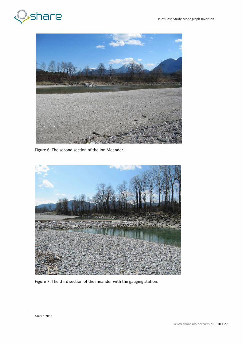
The second section (figure 6) has four groins on the right side to lead the flow. On the left side just
at the beginning a discharge for run-of water is installed, which normally doesn’t have water at low
water levels. On both sides the shore line is secured with riprap with the continued vegetation type
on each side. A large plain of sand and substrate is fallen dry on the left side of the riverbed. As river
substrate grain sizes from psammal to mesolithal can be found.
The Section three (figure 7) starts with the water gauge control-point from the TIWAG (Tyrolean
Hydropower Corporation). The control point is an artificial vertical drop which slope is flattened with
a loose block ramp. The bank is completely sheeted with riprap on the left side and partially sheeted
on the right side. The banks are mainly inhabited by shrubs as riparian vegetation. The predominant
grain sizes are akal, microlithal, and mesolithal. The soil is pointly sheeted.
The last section (figure 8) of the meander is already influenced from the backwater of the HP-
plant Langkampfen. Shrubs are the predominant both-sided riparian vegetation. The left bank is
secured with riprap. The right side of the river bed forms an expended gravel plain.
Page 9
Pilot Case Study Monograph River Inn
March 2011
www.share-alpinerivers.eu 9 / 27
Figure 4: The weir at the upper side of the meander
Figure 5: The first section of the meander.
Page 10
Pilot Case Study Monograph River Inn
March 2011
www.share-alpinerivers.eu 10 / 27
Figure 6: The second section of the Inn Meander.
Figure 7: The third section of the meander with the gauging station.
Page 11
Pilot Case Study Monograph River Inn
March 2011
www.share-alpinerivers.eu 11 / 27
Figure 8: The last section of the meander
Page 12
Pilot Case Study Monograph River Inn
March 2011
www.share-alpinerivers.eu 12 / 27
7. River quality
WFD quality elements
In 2005 the record of the assessed present status of surface waters according to the WFD was
published (BMLFUW 2005). While in Austria several measures undertaken in the last decade to purify
the water quality of surface waters show good results, the main risks for not achieving the WFD
objective of the good ecological status of Austrian surface water bodies are mainly caused by hydro-
morphological disturbances.
Biological elements
Aquatic flora
In the year 2007 the Federal Ministry of Agriculture, Forestry, Environment and Water
Management investigate the phytobenthos and the ecological status of the Inn River in the course of
the assessment and monitoring of surface waters (GZÜV 2007). They investigate two sections
between Innsbruck and the boarder to germany. The first investigation area at Mils is approximately
10 km eastern Innsbruck and the second investigation area is in Erl near to the border to Germany.
The River Inn at the investigation area near Mils belongs to the bioregion ´Limestone High Alps` and
´Non-Glacial Central Alps´ with the saprobic ground status of I-IIB. Through this process they
determinate 46 phytobenthos taxa within 44 species. This water section maintains the good
ecological status according to the quality objectives (QZV Ökologie OG).
The second investigation area at Erl at the border to Germany is dominated by an impoundment.
This area belongs to the bioregion ´Limestone High Alps´, ´Limestone foothills` and ´Non-Glacial
Central Alps´ with a saprobic ground status of I-IIB. In this assessment process they determinate 44
phytobenthos taxa with 37 species. This river section maintains the moderate ecological status
according to the quality objectives (QZV Ökologie OG).
Benthic invertebrate fauna
In the year 2007 the saprobic index and the macroinvertebrates was also investigated in the
impoundment near Erl and a river section at Mils (see above). The saprobic index (ZELINKA & MARVAN)
in the impoundment near Erl reaches the value 2.65 (moderate). The ecological state in this section
according the WFD is poor. At the investigation area near Mils reached the saprobic index (ZELINKA &
MARVAN) a value of 1.71, and the ecological status according the WFD reached the moderate status.
Fish fauna
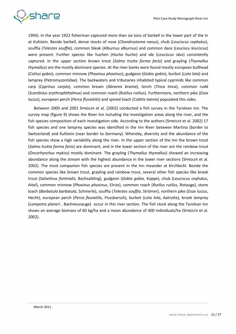
A little historical overview is given in STEINER (1994). In the early years of the 20th century the fish
fauna of the middle and lower course of the River Inn was composed at least of 24 species (STEINER
Page 13
Pilot Case Study Monograph River Inn
March 2011
www.share-alpinerivers.eu 13 / 27
1994). In the year 1922 fisherman captured more than six tons of barbell in the lower part of the In
at Kufstein. Beside barbell, dense stocks of nose (Chondrostoma nasus), chub (Leuciscus cephalus),
souffia (Telestes souffia), common bleak (Alburnus alburnus) and common dace (Leuciscu leuciscus)
were present. Further species like huchen (Hucho hucho) and ide (Leuciscus idus) consistently
captured. In the upper section brown trout (Salmo trutta forma fario) and grayling (Thymallus
thymallus) are the mostly dominant species. At the river banks were found mostly european bullhead
(Cottus gobio), common minnow (Phoxinus phoxinus), gudgeon (Gobio gobio), burbot (Lota lota) and
lamprey (Petromyzontidae). The backwaters and tributaries inhabited typical cyprinids like common
carp (Cyprinus carpio), common bream (Abramis brama), tench (Tinca tinca), common rudd
(Scardinius erythrophthalmus) and common roach (Rutilus rutilus). Furthermore, northern pike (Esox
lucius), european perch (Perca fluviatilis) and spined loach (Cobitis taenia) populated this sides.
Between 2000 and 2001 SPINDLER et al. (2002) conducted a fish survey in the Tyrolean Inn. The
survey map (figure 9) shows the River Inn including the investigation areas along the river, and the
fish species composition of each investigation side. According to the authors (SPINDLER et al. 2002) 17
fish species and one lamprey species was identified in the Inn River between Martina (border to
Switzerland) and Kufstein (near border to Germany). Whereby, diversity and the abundance of the
fish species show a high variability along the river. In the upper section of the Inn the brown trout
(Salmo trutta forma fario) are dominant, and in the lower section of the river are the rainbow trout
(Oncorhynchus mykiss) mostly dominant. The grayling (Thymallus thymallus) showed an increasing
abundance along the stream with the highest abundance in the lower river sections (SPINDLER et al.
2002). The most companion fish species are present in the Inn meander at Kirchbichl. Beside the
common species like brown trout, grayling and rainbow trout, several other fish species like brook
trout (Salvelinus fontinalis, Bachsaibling), gudgeon (Gobio gobio, Koppe), chub (Leuciscus cephalus,
Aitel), common minnow (Phoxinus phoxinus, Elrize), common roach (Rutilus rutilus, Rotauge), stone
loach (Barbatula barbatula, Schmerle), souffia (Telestes souffia, Strömer), northern pike (Esox lucius,
Hecht), european perch (Perca fluviatilis, Flussbarsch), burbot (Lota lota, Aalrutte), brook lamprey
(Lampetra planeri , Bachneunauge) occur in this river section. The fish stock along the Tyrolean Inn
shows an average biomass of 60 kg/ha and a mean abundance of 400 individuals/ha (SPINDLER et al.
2002).
Page 14
Pilot Case Study Monograph River Inn
March 2011
www.share-alpinerivers.eu 14 / 27
Figure 9: The 34 sample sides along the Inn River and the occurrence of fish species on each sample side
(SPINDLER et al. 2002)
Hydro-morphological elements
Hydrological regime
The hydrological regime of river Inn is subjected to hydro-peaking conditions and impoundments
almost for all its lengths. The ratio of sunk/swell has not been identified in the status assessment.
The weir with its water diversion of HP plant Imst is located in Prutz and impounds the river
upstream and causing a residual flow downstream with unknown data of discharge. Upstream the
Austrian border an impoundment section reaches until the entry of the Brixenthaler Ache caused by
the four HP plants Nußdorf (Germany) Oberaudorf/Ebbs (Austria/Germany), Langkampfen and
Kirchbichl (BMLFUW 2005).
The average water discharge (data from 1971-2005, table 2) at the water gauge Bichlwang, not far
downstream of Kirchbichl, has been calculated to be 300 m³/sec (Hydrographisches Jahrbuch 2005).
The averages of the lowest daily discharge are NQT = 77.9 m³/sec and the highest discharge was HQ =
2454 m³/sec in the year 2005 (time period between 1971 and 2005, Hydrologisches Jahrbuch 2005).
Page 15
Pilot Case Study Monograph River Inn
March 2011
www.share-alpinerivers.eu 15 / 27
Table 2: Average monthly means of discharges at Bichlwang, time series 1971-2005. NQ = lowest values in the
observed time period, NQT = lowest daily mean in the observed time period, MNQT = mean daily low water in
the observed time period, NMQ = lowest monthly mean values in the observed time period, MQ = mean values
in the observed time period, HMQ = highest monthly mean values in the observed time period, MHQ = mean of
the highest values in the observed time period, HQ = highest values in the observed time period
(Hydrographisches Jahrbuch 2005).
Average monthly means (series 1971 – 2005)
Jan. Feb. Mar. April May June July Aug. Sep. Oct. Nov. Dec.
NQ 47.2 43.7 8.31 4.87 100 126 226 115 65.0 63.2 14.6 34.5
NQT 87.0 91.2 77.9 112 122 243 283 221 131 127 105 80.9
MNQT 89.2 90.2 95.0 120 212 326 340 261 182 139 115 92.6
NMQ 117 122 123 135 207 405 390 306 198 175 135 112
MQ 118 121 140 178 354 488 468 373 260 195 153 127
HMQ 180 176 236 363 758 802 885 647 388 371 303 210
MHQ 197 203 247 321 628 815 833 775 468 368 261 230
HQ 411 603 644 696 1418 1767 1855 2454 1076 862 742 701
River continuity
The river continuity of river Inn in Austria is disrupted for up- and downstream migrations of fish
due to the weirs of two diversion-type HP plants at Kirchbichl and at Prutz (HP plant Imst) (BMLFUW
2005).
Morphological conditions
The morphological conditions of the river Inn remain quite equal along its range in Austria
showing not many variations in depth and width. The natural structure of the riverbed is almost
totally lost because of straightening and banks fixation with riprap. The predominantly substrate is
gravel.
Page 16
Pilot Case Study Monograph River Inn
March 2011
www.share-alpinerivers.eu 16 / 27
Chemical and physical-chemical elements
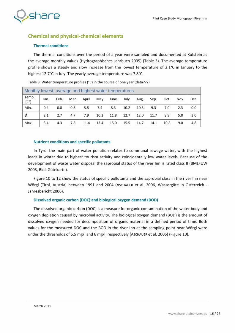
Thermal conditions
The thermal conditions over the period of a year were sampled and documented at Kufstein as
the average monthly values (Hydrographisches Jahrbuch 2005) (Table 3). The average temperature
profile shows a steady and slow increase from the lowest temperature of 2.1°C in January to the
highest 12.7°C in July. The yearly average temperature was 7.8°C.
Table 3: Water temperature profiles (°C) in the course of one year (data???)
Monthly lowest, average and highest water temperatures Temp.
[C°] Jan. Feb. Mar. April May June July Aug. Sep. Oct. Nov. Dec.
Min. 0.4 0.8 0.8 5.8 7.4 8.3 10.2 10.3 9.3 7.0 2.3 0.0
Ø 2.1 2.7 4.7 7.9 10.2 11.8 12.7 12.0 11.7 8.9 5.8 3.0
Max. 3.4 4.3 7.8 11.4 13.4 15.0 15.5 14.7 14.1 10.8 9.0 4.8
Nutrient conditions and specific pollutants
In Tyrol the main part of water pollution relates to communal sewage water, with the highest
loads in winter due to highest tourism activity and coincidentally low water levels. Because of the
development of waste water disposal the saprobial status of the river Inn is rated class II (BMLFUW
2005, Biol. Gütekarte).
Figure 10 to 12 show the status of specific pollutants and the saprobial class in the river Inn near
Wörgl (Tirol, Austria) between 1991 and 2004 (ASCHAUER et al. 2006, Wassergüte in Österreich -
Jahresbericht 2006).
Dissolved organic carbon (DOC) and biological oxygen demand (BOD)
The dissolved organic carbon (DOC) is a measure for organic contamination of the water body and
oxygen depletion caused by microbial activity. The biological oxygen demand (BOD) is the amount of
dissolved oxygen needed for decomposition of organic material in a defined period of time. Both
values for the measured DOC and the BOD in the river Inn at the sampling point near Wörgl were
under the thresholds of 5.5 mg/l and 6 mg/l, respectively (ASCHAUER et al. 2006) (Figure 10).
Page 17
Pilot Case Study Monograph River Inn
March 2011
www.share-alpinerivers.eu 17 / 27
Figure 10: Dissolved organic carbon (DOC, 90%-percentile, mg/l) and biological oxygen demand (BSB=BOD,
90%-percentile, mg/l) measured over the time period between 1991 and 2004 in the river Inn near Wörgl (Tirol,
Austria). (ASCHAUER et al. 2006)
Nitrate-Nitrogen (NO3-N) and Orthophosphate-Phosphorous (PO4-P)
Nitrogen and phosphorus are the essential nutrients in riverine ecosystems. Austrian rivers are
generally limited in phosphorus, while the limitations in nitrogen load of the water are of crucial
importance especially on a long-distance effect. The evaluation of the phosphorus load of a water
body is based on the dissolved orthophosphate content. The evaluation is further determined by the
type of water body, which is defined by the bioregion and the initial trophical status.
Figure 11 shows the profiles of Nitrate-Nitrogen (NO3-N) and Orthophosphate-Phosphorous (PO4-
P) in the time period between 1991 and 2004 of the river Inn near Wörgl. The values for the Nitrate-
Nitrogen (NO3-N) and the Orthophosphate-Phosphorous (PO4-P) were below the thresholds of 5.5
mg/l (PO4-P) and 0,15mg/l (NO3-N), respectively (Wassergüte in Österreich - Jahresbericht 2006)
(ASCHAUER et al. 2006).
Page 18
Pilot Case Study Monograph River Inn
March 2011
www.share-alpinerivers.eu 18 / 27
Figure 11: Nitrate-Nitrogen (NO3-N, 90%-percentile, mg/l) and Orthophosphate-Phosphorous (PO4-P, 90%-
percentile, mg/l) measured over the time period between 1991 and 2004 in the river Inn near Wörgl (Tirol,
Austria). (ASCHAUER et al. 2006)
Adsorbable organic bonded Halogens (AOX) and Ammonium Nitrogen (NH4-N)
The composite parameter of adsorbable organic bonded Halogens (AOX) is the total amount of
Halogens in organic compounds. In general, all organic bonded Halogens are toxic pollutants in
riverine ecosystems. The Ammonium Nitrogen (NH4-N) is also an indicator of water quality. This
pollutant comes especially from purification plants and is very toxic to aquatic organisms (ASCHAUER
et al. 2006).
Figure 12 shows the pollution of absorbable organic bonded Halogen and ammonium nitrogen
over a time period between 1991 and 2004 at the river in near Wörgl. The values of and adsorbable
organic bonded Halogens (AOX, threshold value 50 µg/l) and Ammonium Nitrogen (NH4-N, threshold
value 0.5 mg/l) are below the thresholds values (Wassergüte in Österreich - Jahresbericht 2006).
Page 19
Pilot Case Study Monograph River Inn
March 2011
www.share-alpinerivers.eu 19 / 27
Figure 12: Adsorbable organic bonded Halogens (AOX, mean value, µg/l) and Ammonium Nitrogen (NH4-N,
mean value, mg/l) measured over the time period between 1991 and 2004 in the river Inn near Wörgl (Tirol,
Austria). (ASCHAUER et al. 2006)
8. River typology
Austria shares in six ecoregions according to the WFD that conform to the classification of ILLIES
(1978): 4 = Alps, 5 = Dinaric Western Balkan, 10 = Carpathians, 11 = Hungarian Lowland, 9 = Central
Low Mountain Range, 30 = Italy. River Inn is situated in ecoregion 4 = Alps. For a proper classification
of the type specific biocoenosis the ecoregions are too large in space. Therefore the detailed
structure of Austrian landscapes, water types and biocoenoses needed further classifications to river
macrochore regions and river type regions which resulted in the designation of 15 bioregions (figure
13). According to WIMMER & CHOVANEC (2000) and MOOG et al. (2001) the river Inn belongs to the
special category of ´Large Rivers` due to its catchment area > 2500km², stream order ≥ 7 and a
average discharge > 50 m³/s.
The Inn in Austria separates the bioregions ‘Limestone High-Alps’ in the north from the ‘Non-
glacial Central Alps’ in the south until it breaks thru the ‘Limestone Pre-Alps’ and ‘Bavarian-Austrian
Pre-Alps’ in north-eastern Tyrol.
According to the fish zonation concept (THIENEMANN, 1925) and the biocoenotic region concept
(ILLIES & BOTOSANEANU, 1963), fish regions are classified and named after the dominating key-species,
which are associated with other specific species of that region. In these terms the Inn in Tyrol
belongs to the barbell region or the epi-potamal.
Page 20
Pilot Case Study Monograph River Inn
March 2011
www.share-alpinerivers.eu 20 / 27
Figure 13: The 15 aquatic bioregions of Austria (MOOG et al. 2001)
9. Water uses
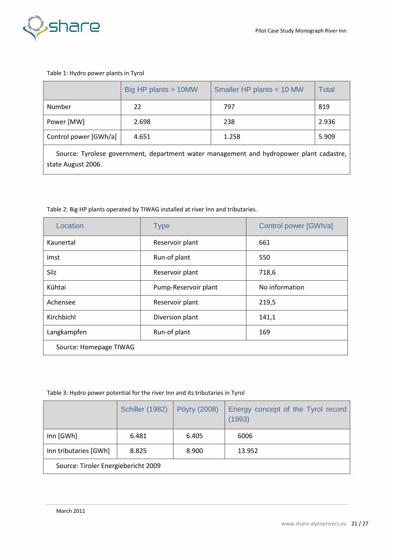
Hydropower exploitation in Tyrol
On the whole course of the river Inn 22 HP plants are in use from its source to end. Four of them
are located in the Inn valley in Tyrol and are under operation by the TIWAG and the Grenzkraftwerke
GmbH. They are located at Imst (river-km 341) with the water abstraction near Prutz, at Kirchbichl
(river-km 231 km), at Langkampfen (river-km 220) and at Oberaudorf/Ebbs (river-km 211). Several
more big and mid-size HP (> 10 MW) and a large number of smaller HP plants (< 10 MW) lie within
the river’s catchment area. Hydro power takes the major part (75 % in 2004) in the generation of
electric energy in Tyrol (Tiroler Energiestrategie). The annual control power capacity of all HP plants
in Tyrol sums up to be about 5900 GWh/a (± 10 %). Table 4 and table 5 provide information on the
importance of hydropower in Tyrol and the operations on river Inn. The theoretical potential of
hydropower in Tyrol (table 6) was assessed in studies of SCHILLER (1982), the Tyrolese government
(1993) and lately PÖYRY (2008) considering precipitation, surface run-off and topography. The
technical and economical potential still developable can be estimated another 5.000 GWh/a.
Page 21
Pilot Case Study Monograph River Inn
March 2011
www.share-alpinerivers.eu 21 / 27
Table 1: Hydro power plants in Tyrol
Big HP plants > 10MW Smaller HP plants < 10 MW Total
Number 22 797 819
Power [MW] 2.698 238 2.936
Control power [GWh/a] 4.651 1.258 5.909
Source: Tyrolese government, department water management and hydropower plant cadastre,
state August 2006.
Table 2: Big HP plants operated by TIWAG installed at river Inn and tributaries.
Location Type Control power [GWh/a]
Kaunertal Reservoir plant 661
Imst Run-of plant 550
Silz Reservoir plant 718,6
Kühtai Pump-Reservoir plant No information
Achensee Reservoir plant 219,5
Kirchbichl Diversion plant 141,1
Langkampfen Run-of plant 169
Source: Homepage TIWAG
Table 3: Hydro power potential for the river Inn and its tributaries in Tyrol
Schiller (1982) Pöyry (2008) Energy concept of the Tyrol record (1993)
Inn [GWh] 6.481 6.405 6006
Inn tributaries [GWh] 8.825 8.900 13.952
Source: Tiroler Energiebericht 2009
Page 22
Pilot Case Study Monograph River Inn
March 2011
www.share-alpinerivers.eu 22 / 27
Hydropower exploitation HP Kirchbichl and Langkampfen
In the study area at Kirchbichl and Langkampfen (figure 14) two HP plants with direct impact on
the meander are in operation by the TIWAG. The HP plant Kirchbichl was constructed from 1938 to
1941 as a diversion-type HP plant and it uses the natural drop of the sinuosity (river-km 232) and
additionally dams the river at the beginning of the meander for app. 6 m in height. Thus the effective
height counts from 7.5-9.7 m respective to the water level. Located on the downstream side of the
meander is the powerhouse equipped with three Kaplan-turbines, the electrical facilities and the
transformation station. The three Kaplan-turbines use 250 m³/s. The hydroelectric station has a
capacity of up to 24 MW and an energy production of 141 GWh/a. The catchment area of the
hydropower-plant includes 9,313 km² (Table 7).
The run-of HP plant Langkampfen at river-km 223 is in use since 1998. To use a vertical drop of
8.3 m the river basin had been lowered from the weir downstream to the bridge at Kufstein. It has a
capacity of 31.5 MW and an energy production of 168 GWh/a (Table 7). It is located at the head of
the backwater from HP Oberaudorf/Ebbs and thus the whole course from there into the meander is
now influenced by backwater.
Table 4: Details on energy-management of the HP plants Kirchbichl and Langkampfen
Kirchbichl diversion-type HP plant
Catchment area [km2] 9.313
Discharge [m3/sec] 250
Vertical drop [m] 9,7
Capacity [GWh/a] 141,1
Pressures on meander Residual water scarcity, impoundment
Langkampfen run-off HP plant Catchment area [km2] 9.367
Discharge [m3/sec] 250
Vertical drop [m] 8.3/8.0
Capacity [GWh/a] 169
Pressures on meander Impoundment
Source: Homepage TIWAG
Page 23
Pilot Case Study Monograph River Inn
March 2011
www.share-alpinerivers.eu 23 / 27
Figure 14: Aerial view of the pilot study area with the two HP plants Kirchbichl and Langkampfen (source:
Google Earth).
HP Kirchbichl
HP Langkampfen
Page 24
Pilot Case Study Monograph River Inn
March 2011
www.share-alpinerivers.eu 24 / 27
Figure 15: The weir and the bypass channel of the HP Kirchbichl.
Figure 16: The weir seen from the downstream side of the meander (winter situation).
Page 25
Pilot Case Study Monograph River Inn
March 2011
www.share-alpinerivers.eu 25 / 27
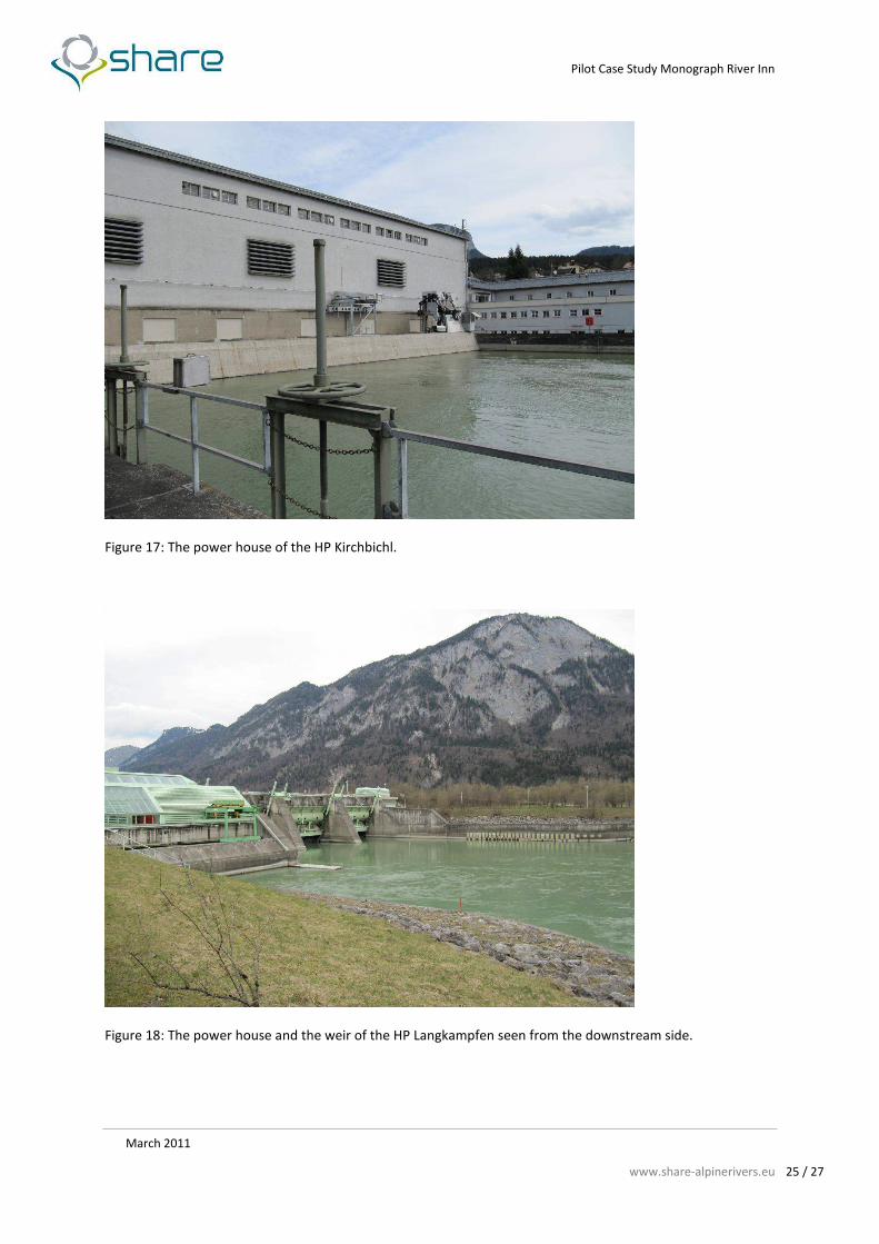
Figure 17: The power house of the HP Kirchbichl.
Figure 18: The power house and the weir of the HP Langkampfen seen from the downstream side.
Page 26
Pilot Case Study Monograph River Inn
March 2011
www.share-alpinerivers.eu 26 / 27
10. Pressures and impacts related to water uses
The type of hydropower plant is characterized by a diversion of water and a lack of water
downstream the plants while the headwater is dammed by a weir. The section of the residual-water
is mainly characterized by:
Reduction of discharge
Equalization of water flow velocity
Reduction of water depth and a decrease of the ground-water level
Deficit of microhabitat diversity
Shift of the physico-chemical parameters
Deficits in the aquatic flora, macro invertebrate and fish fauna
These impacted hydrological conditions of the residual-water affect the macroinvertebrate
communities downstream, resulting in a disappearance of the usual rheotypical variety of
makroinvertebrate species. The lack of water and the low near-bed water velocity have reduced the
habitat diversity of the river bed and further riverbed clogging. Furthermore dams and weirs
interrupt the river connectivity and prohibit the distribution of different fish species. Particular the
migration of Cyprinids and Salmonids are interrupted.
Page 27
Pilot Case Study Monograph River Inn
March 2011
www.share-alpinerivers.eu 27 / 27
11. Literature
ACHAUER, A., ZIERITZ, I., WIMMER, R., DEUTSCH, K., CHOVANEC, A. (2006): WGEV Datenband Fließgewässer. BMLFUW,
Referat VII/1a. Wien.
BMLFUW – Bundesministerium für Land und Forstwirtschaft (2007): Hydrographisches Jahrbuch von
Österreich 2004, 112. Band, Wien.
HAUNSCHMID, R., WOLFRAM, G., SPINDLER, T., HONSIG-ERLENBURG, W., WIMMER, R., JAGSCH, A., KAINZ, E., HEHENWARTER,
K., WAGNER, B., KONECNY, R., RIEDMÜLLER, R., IBEL, G., SASANO, B., SCHOTZKO, N. (2006): Erstellung einer
Fischbasierten Typologie Österreichischer Fließgewässer sowie einer Bewertungsmethode des
fischökologischen Zustandes gemäß EU-Wasserrahmenrichtlinien. Institut für Gewässerökologie,
Fischereibiologie und Seekunde. Schriftreihe des Bundesamtes für Wasserwirtschaft. Band 23. 105 S.
HUET, M. (1949): Apercu des relations entre la pente et les populations piscicoles des eaux courantes. Schweiz
Z. Hydrol. 11: 333-351
Hydrographisches Jahrbuch 2005 (2008): Hydrographischer Dienst in Österreich. Bundesministerium für Land
und Forstwirtschaft, Umwelt und Wasserwirtschaft, Abteilung VII 3 – Wasserhaushalt. 113. Band Wien 2008
ILLIES, J. & BOTOSANEANU, L. (1963): Problèmes et methodes de la classification et de la zonation ecologique des
eaux courantes, considerées surtout du point de vue faunistique. Internationale Vereinigung für theoretische
und angewandte Limnologie 12: 1-57.
ILLIES, J. (1978): Limnofauna Europaea. Fischer, Stuttgart, New York; Swets & Zeitlinger, Amsterdam.
IST-Bestandsanalyse 2004: Österreichischer Bericht der IST-Bestandsaufnahme. Bundesministerium für Land-
und Forstwirtschaft, Umwelt und Wasserwirtschaft.
MOOG, O., SCHMIDT-KLOIBER, A., OFENBÖCK, T., GERRITSEN, J. (2001): Aquatische Ökoregionen und Fließgewässer-
Bioregionen Österreichs – eine Gliederung nach geoökologischen milieufaktoren und Makrozoobenthos-
Zönosen. Bundesministerium für Land- und Forstwirtschaft, Umwelt und Wasserwirtschaft,
Wasserwirtschaftskataster. Wien 106 S.
PÖYRY ENERGY GMBH (2008): Wasserkraftpotenzialstudie Österreich. - Endbericht. Wien. 119 S.
QZV Ökologie OG (2010): Qualitätszielverordnung Ökologie Oberflächengewässer BGBl. II Nr. 99/2010,
Bundesgesetzblatt für die Republik Österreich, Verordnung des Bundesministers für Land- und Forstwirtschaft,
Umwelt und Wasserwirtschaft. Wien.
SCHILLER, G. (1982): Die Wasserkraftnutzung in Österreich - Wasserkraftpotential Stand. Verbundgesellschaft,
Wien.
SCHÖNLAUB, H. & TENTSCHERT, E. (1996): Erkundung und Modellierung im Grundwasserfeld Langkampfen (Tirol).
SPINDLER, T., WINTERSBERGER, H., MEDGYESY, N., MARK, W. (2002): INN 2000. Die Gewässer- und Fischökologie des
Inn und seine Seitengewässer. Band I - Inn. Auftraggeber: Tiroler Fischereiverband. 126 S
THIENEMANN, A. (1925): Die Binnengewässer Mitteleuropas. Verlag Schweizerbart, Stuttgart 255 S.
Tiroler Energiebericht (2009): Amt der Tiroler Landesregierung. Büro für Energieangelegenheiten. 88 S
Tiroler Energiestrategie: Tiroler Energiestrategie 2020 Grundlage für die Tiroler Energiepolitik. Amt der Tiroler
Landesregierung, Abteilung Wasser- Forst- und Energierecht
Wassergüte in Österreich - Jahresbericht 2006: 15 Jahre Umsetzung der Wassergüte-Erhebungsverordnung.
Erhebung der Wassergüte gemäß Hydrographiegesetz (BGBl.-Nr. 58/1979, i.d.g.F.). Herausgegeben vom
Bundesministerium für Land- und Forstwirtschaft, Umwelt und Wasserwirtschaft / Sektion VII / Nationale
Wasserwirtschaft in Zusammenarbeit mit dem Umweltbundesamt, Wien
ZELINKA, M. & MARVAN , P. (1961): Zur Präzisierung der biologischen Klassifikation der Reinheit fließender
Gewässer. Arch. Hydrobiol. 57: 389-407