International Civil Aviation Organization WP22 BIS Agenda Item 11: Adoption of Amendment 36 to ICAO Annex 15 and Amendment 56 to Annex 4 and its implications to the AFI Region as per the AIS-AIM Transition Roadmap ADOPTION OF AMENDMENT 36 TO ANNEX 15 (Presented by the Secretariat) SUMMARY This paper presents the adoption of Amendment 36 to Annex 15 — Aeronautical Information Services. The adopted amendment introduces provisions relating to the use of the public Internet, the reporting of volcanic ash position, quality management systems (QMS), the use of automation enabling digital data exchange, electronic aeronautical information publications (e-AIP), the NOTAM Format and electronic terrain and obstacle data (e-TOD). Having examined the technical circumstances associated with the implementation of the amendment, the Air Navigation Commission considered that the proposed applicability date of 18 November 2010 would suitable, except for proposed paragraphs 10.1.4 and 10.1.5 related to e-TOD for which applicability would be 12 November 2015. Action noted : The ICAO Council: a) adopted, as Amendment 36 to Annex 15, the amendment to definitions and to the Standards and Recommended Practices as contained in Appendix A to the State letter; b) approved, as part of the said amendment, the amendment to Notes as contained in Appendix A to the State letter ; c) approved the Resolution of Adoption in Appendix B to State letter; and d) approved as part of the said amendment, the amendment to the Foreword of Annex 15 as contained in Appendix C to the State letter. This working paper relates to Strategic Objectives A and D as the various proposals will improve safety and efficiency of the air navigation system. Financial implicatio ns: States and industry: No substantial new cost except for the recommended implementation o automation enabling digital data exchange. The costs associated with the implementation of e-TOD ar significant; however, the amendment substantially reduces costs in comparison with existing provisions. Othe parts of the amendment could also lead to cost reductions.
Transcript
International Civil Aviation Organization
WP22 BIS
Agenda Item 11: Adoption of Amendment 36 to ICAO Annex 15 and Amendment 56 to Annex 4 and its implications to the AFI Region as per the AIS-AIM Transition Roadmap
ADOPTION OF AMENDMENT 36 TO ANNEX 15
(Presented by the Secretariat)
SUMMARY
This paper presents the adopt ion of Amendment 36 to Annex 15 —
Aeronautical Information Services. The adopted amendment introduces provisions relating to the use of the public Internet, the
reporting of volcanic ash position, quality management systems (QMS), the use of automation enabling digital data
exchange, electronic aeronautical information publications (e-AIP), the NOTAM Format and electronic terrain and
obstacle data (e-TOD). Having examined the technical circumstances associated with the implementation
of the amendment, the Air Navigation Commission considered that the proposed applicability date of 18 November 2010 would
suitable, except for proposed paragraphs 10.1.4 and 10.1.5 related to e-TOD for which applicability would be 12 November
2015. Action noted : The ICAO Council:
a) adopted, as Amendment 36 to Annex 15, the amendment to definitions and to the Standards and
Recommended Practices as contained in Appendix A to the State letter; b) approved, as part of the said amendment, the amendment to Notes as contained in Appendix A to the State letter;
c) approved the Resolution of Adoption in Appendix B to State letter; and
d) approved as part of the said amendment, the amendment to the Foreword of Annex 15 as contained
in Appendix C to the State letter.
This working paper relates to Strategic Objectives A and D as the various proposals will improve safety and
efficiency of the air navigation system.
Financial implicatio
ns:
States and industry: No substantial new cost except for the recommended implementation ofautomation enabling digital data exchange. The costs associated with the implementation of e-TOD aresignificant; however, the amendment substantially reduces costs in comparison with existing provisions. Otherparts of the amendment could also lead to cost reductions.
- 2 -
1. INTRODUCTION
1.1 This paper deals with the adoption by the ICAO Council for the amendment of
Annex 15 arising from the following sources:
a) The Secretariat, with the assistance of the Aviation Use of the Public Internet Study
Group (AUPISG), to introduce new provisions relating to the operational use of the
public Internet;
b) the Secretariat, with the assistance of the Aeronautical Information Services-
Aeronautical Information Management Study Group (AIS-AIMSG) to update
provisions related to quality management systems (QMS), the use of automation
enabling digital data exchange, electronic aeronautical information publications
(e-AIP), the NOTAM Format and electronic terrain and obstacle data (e-TOD); and
c) Editorial changes proposed by the Secretariat aimed at eliminating some
inconsistencies.
2. BACKGROUND
2.1 The development and review of the proposed amendments have followed the established
process, as shown in the table below:
Amendment concerning Preliminary
review by
ANC and WP
no.
State letter
and date
Final review by the
ANC and WP no.
No. of replies at final review1
Operational use of the public Internet2
30 November
2006 (ANC 173-
12) AN-WP/8162
AN 7/11.15,
AN 10/1-
07/3 19 January 2007
30 October
2007 (ANC
176-5) AN-WP/8260
53 Contracting States
(21) 3 int. orgs Total: 56 replies
Amendment concerning Preliminary
review by
ANC and WP
no.
State letter
and date
Final review by the
ANC and WP no.
No. of replies at final review1
Quality management
systems
(QMS), the use of automation enabling digital data exchange, electronic aeronautical information publications
(e-AIP), the NOTAM Format and electronic terrain and obstacle data (e-TOD)
12 March 2009
AN-WP/8375
(ANC 180-
11)
AN 2/2.2-09/13
23 April 2009
28 January
2010 (ANC
183-5) AN-
WP/8442 19 January 2010 (ANC 183-3) 12 January 2010 (ANC 183-1) 19 November 2009 (ANC 182-11)
57 Contracting States
(19)
3 int. orgs Total: 60
- 3 -
2.2 The amendment listed in the table above was presented to
the Council for inclusion in Amendment 36 to Annex 15 and thus t h e Council took action as stated in the
executive summary.
3. RATIONAL, IMPLEMENTATION ISSUES AND COST IMPACT
3.1 Rational
3.1.1 The purpose of the amendment related to the operational use of the public Internet for
exchange of non-time critical messages is to enhance efficiency by permitting the use of the Internet
where and when the provision or retention of aeronautical fixed service (AFS) facilities are not practical
or cost effective. The proposals contain references to the Guidelines on the Use of the Public Internet for
Aeronautical Applications (Doc 9855) which provide relevant guidance material.
3.1.2 The amendment will contribute to the safety and efficiency of international air navigation
by supporting the progressive transition from a manual, paper-product environment to a digital
environment that would contribute to the provision of timely, high-quality digital information and
improve the efficiency and cost-effectiveness of aeronautical information services (AIS). The capability to
provide digital information will provide the basis for the transition to aeronautical information
management (AIM), and this allow for the establishment of new services that directly support current
and future air traffic management (ATM) service requirements.
- 4 -
3.1.3 With regard to the amendment related to e-TOD, it should be noted that
Amendment 33 to Annex 15 (adopted in 2004) introduced requirements for States to provide e-TOD data
over four areas. These requirements became applicable in 2008 as far as the “entire territory of a State”
and “Category II and III operations area” are concerned (i.e. Area 1 and Area 4, respectively) and would
become applicable in 2010 as far as the “terminal control area” and “aerodrome/heliport area” are
concerned (i.e. Area 2 and Area 3, respectively). In reply to State letter AN 2/2.1-09/13 and the associated
questionnaire States have indicated that the requirements related especially to Area 2 will be difficult and
costly to implement and were not considered justified. This would have led to widespread non-
compliance. This issue has been addressed by the proposal through a revision of associated provisions
which are expected to substantially reduce implementation difficulties and costs.
3.2 Implementation issues
3.2.1 No significant implementation issues are foreseen for the amendment, except
for the amendments related to automation enabling digital data exchange and e-TOD which involve
longer- term implementation planning and effort.
3.3 Cost impact
3.3.1 The amendment on the operational use of the public Internet will not impose a financial
burden to States and may result in savings for the airline industry through the use of more cost-effective
means for the dissemination of aeronautical information. 3.3.2
The amendment related to the QMS refines existing provisions and could have
moderate cost impact to States. Costs associated with the recommended use of automation enabling digital data
exchange may be substantial, especially for States with little or no automation capabilities.
Automation could be introduced in a progressive manner and in the long term should lead to efficiencies.
The recommended implementation of the e-AIP is expected to reduce production and distribution costs
compared to the paper product; however, the proposal would have cost implications for States that
currently produce e-AIPs which are not harmonized with Annex 15, Appendix 1. The proposed changes to
the NOTAM Format could imply moderate costs associated with software changes.
3.3.3 The amendment related to electronic terrain and obstacle data will substantially
reduce implementation costs in comparison to existing Annex 15 provisions; nevertheless, implementation
could have significant cost implications especially for States where existing obstacle data is not of the
required quality. The extended applicability date supports a phased implementation which may reduce
costs by taking into account normal aerodrome obstacle data re-surveys.
WP 22 bis
Appendix A
APPENDIX A
PROPOSED AMENDMENT TO
INTERNATIONAL STANDARDS
AND RECOMMENDED PRACTICES
AERONAUTICAL INFORMATION SERVICES
ANNEX 15
TO THE CONVENTION ON INTERNATIONAL CIVIL AVIATION
NOTES ON THE PRESENTATION OF THE PROPOSED AMENDMENT
1. The text of the amendment is arranged to show deleted text with a line through it and new text
highlighted with grey shading, as shown below:
1. Text to be deleted is shown with a line through it. text to be deleted
2. New text to be inserted is highlighted with grey shading. new text to be inserted
3. Text to be deleted is shown with a line through it followed by
the replacement text which is highlighted with grey shading. new text to replace existing
text
2. The sources of the proposed amendments have been indicated as follows:
Source Annotation
Secretariat, with the assistance of AIS-AIMSG/1 Source A
Consequential amendment concerning the operational use of the
public Internet Source B
IAVWOPSG/4 Source C
Editorial amendments arising from the Secretariat Source D
WP 22 bis Appendix A A-2
Source A
. . .
CHAPTER2. DEFINITIONS
When the following terms are used in the Standards and Recommended Practices for aeronautical information services, they have the following meanings:
. . .
Aerodrome. A defined area on land or water (including any buildings, installations and equipment) intended to be used either wholly or in part for the arrival, departure and surface movement of
aircraft.
. . .
Heliport. An aerodrome or a defined area on a structure intended to be used wholly or in part for the
arrival, departure and surface movement of helicopters.
. . .
CHAPTER 3. GENERAL
. . .
Sources A & D
3.2 Quality management system
3.2.1 Each Contracting State shall take all necessary measures to introduce a properly organized
quality system containing procedures, processes and resources necessary to implement quality
Management at each function stage. Quality management systems shall be implemented and maintained
encompassing all functions of an aeronautical information service, as outlined in 3.1.7 above. The
execution of such quality management systems shall be made demonstrable for each function stage, when
required.
3.2.2 Recommendation. — Quality management should be applicable to the whole
aeronautical information data chain from data origination to distribution to the next intended user, taking
into consideration the intended use of data.
Note1. — Quality management may be provided by a single quality management system or serial
quality management systems.
3
Note2. — Letters of agreement concerning data quality between originator and distributor and between distributor and next intended user may be used to manage the aeronautical information data
chain.
3.2.2 3.2.3 Recommendation.— The quality management system established in accordance
with 3.2.1 should be in conformity with follow the International Organization for Standardization (ISO)
9000 series of quality assurance standards, and be certified by an approved organization.
Note1. — An ISO 9000 certificate issued by an accredited certification body would be considered
an acceptable means of compliance.
Note2. — International Organization for Standardization (ISO) 9000 series of quality assurance
standards provide a basic framework for the development of a quality assurance programme and define
the term “accredited certification body”. The details of a successful programme are to be formulated by each
State and in most cases are unique to the State organization.
Note 3.— Supporting material in respect of the processing of aeronautical data is contained in
RTCA Document DO-200A and European Organization for Civil Aviation Equipment (EUROCAE)
Document ED-76 — Standards for Processing Aeronautical Data. These standards support the
development and application of aeronautical databases.
3.2.3 3.2.4 Within the context of a the established quality management system, the skills and
knowledge required for each function shall be identified, and personnel assigned to perform those
functions shall be appropriately trained. States shall ensure that personnel possess the skills and
competencies required to perform specific assigned functions, and appropriate records shall be maintained so that the qualifications of personnel can be confirmed. Initial and periodic assessments shall be
established that require personnel to demonstrate the required skills and competencies. Periodic
assessments of personnel shall be used as a means to detect and correct shortfalls.
3.2.4 3.2.5 States shall ensure that established procedures exist in order that aeronautical data at
any moment is traceable to its origin Each quality management system shall include the necessary
policies, processes and procedures, including those for the use of metadata, to ensure and verify that
aeronautical data is traceable throughout the aeronautical information data chain so as to allow any data anomalies or errors, detected in use to be identified by root cause, corrected and communicated to
affected users. during the production/maintenance phases or in operational use, to be corrected.
3.2.5 3.2.6 The established quality management system shall provide users with the necessary
assurance and confidence that distributed aeronautical information/data satisfy stated requirements for data quality the aeronautical data quality requirements (for accuracy, resolution and integrity) and for data
traceability by the use of appropriate procedures in every stage of data production or data modification
process as specified in Appendix 7, and the data traceability requirements through the provision of
appropriate metadata as specified in 3.8.1. The system shall also provide assurance of the applicability
period of intended use of aeronautical data as well as that the agreed distribution dates will be met.
3.2.7 All necessary measures shall be taken to monitor compliance with the quality
management system in place.
WP 22 bis Appendix A A-4
3.2.6 3.2.8 The order of accuracy for aeronautical data, based upon a 95 per cent confidence
level, shall be as specified in Annex 11, Chapter 2, and Annex 14, Volumes I and II, Chapter 2. In that
respect, three types of positional data shall be identified: surveyed points (runway thresholds, navigation
aid positions, etc.), calculated points (mathematical calculations from the known surveyed points of points
in space/fixes) and declared points (e.g. flight information region boundary points).
3.2.7 3.2.9 States shall ensure that theThe order of publication resolution of aeronautical data
shall be that as specified in Appendices 1 and 7.
3.2.8 3.2.10 Contracting States shall ensure that the The integrity of aeronautical data isshall be
maintained throughout the data process from survey/origin to distribution to the next intended user (the
entity that receives the aeronautical information from the aeronautical information service provider).
Aeronautical data integrity requirements shall be based upon the potential risk resulting from the
corruption of data and upon the use to which the data item is put. Consequently, the following
classifications and data integrity levels shall apply:
a) critical data, integrity level 1 × 10⁻⁸
: there is a high probability when using corrupted critical
data that the continued safe flight and landing of an aircraft would be severely at risk with the
potential for catastrophe;
b) essential data, integrity level 1 × 10⁻⁵: there is a low probability when using corrupted
essential data that the continued safe flight and landing of an aircraft would be severely at
risk with the potential for catastrophe; and
c) routine data, integrity level 1 × 10⁻³
: there is a very low probability when using corrupted
routine data that the continued safe flight and landing of an aircraft would be severely at risk
with the potential for catastrophe.
Note 1.— Distribution to the next intended user will differ in the delivery method applied which
may either be:
Physical distribution. The means by which aeronautical information/data distribution is achieved
through the delivery of a physical package, such as postal services.
or
Direct electronic distribution. The means by which aeronautical information/data distribution is achieved automatically through the use of a direct electronic connection between the AIS and
the next intended user.
Note 2.— Different delivery methods and data media may require different procedures to ensure
the required data quality.
3.2.9 3.2.11 Aeronautical data quality requirements related to classification and data integrity
shall be as provided in Tables A7-1 to A7-5 of Appendix 7.
3.2.10 3.2.12 Protection of electronic Electronic aeronautical data sets while stored or in transit
shall be totally monitored protected by the inclusion in the data sets of the a 32-bit cyclic redundancy
check (CRC) implemented by the application dealing with the data sets. This shall apply to the protection
5
of all integrity levels of data sets as specified in 3.2.10. To achieve protection of the integrity level of critical and essential aeronautical data as classified in 3.2.8, a 32- or 24-bit CRC algorithm shall apply
respectively.
Note 1 .— This requirement does not apply to the communications systems used for the transfer of
data sets.
Note 2. — Guidance material on the use of a 32-bit CRC algorithm to implement a protection of
electronic aeronautical data sets is contained in the Aeronautical Information Services Manual (Doc 8126).
3.2.11 Recommendation.— To achieve protection of the integrity level of routine aeronautical data
as classified in 3.2.8, a 16-bit CRC algorithm should apply.
3.2.12 3.2.13 Material to be issued as part of the Integrated Aeronautical Information Package
shall be thoroughly checked and coordinated with the services responsible services before it is submitted
to the aeronautical information service, in order to make certain that all necessary information has been
included and that it is correct in detail prior to distribution. Validation and verification procedures shall be
established which ensure that quality requirements (accuracy, resolution, integrity) and traceability of
aeronautical data are met.
Note.— Guidance material on the liaison with other related services is contained in the
Aeronautical Information Services Manual (Doc 8126).
3.2.13 3.2.14 Demonstration of compliance of the quality management system applied shall be
by audit. If nonconformity is identified, initiating action to correct its cause shall be determined and
taken. All audit observations and remedial actions shall be evidenced and properly documented.
. . .
. . . 3.6 General specifications
3.6.5 Use of automation
Recommendation.— Automation in AIS enabling digital data exchange should be introduced
with the objective of improving the speed, accuracy, quality, efficiency and cost-effectiveness of
aeronautical information services.
Note.— Guidance material on an aeronautical conceptual and data exchange model for the
development of databases and the establishment of data exchange services is contained in Doc 8126.
. . .
3.6.7 Human Factors considerations
3.6.7.1 The organization of the aeronautical information services as well as the design, contents,
processing and distribution of aeronautical information/data shall take into consideration Human Factors
principles which facilitate their optimum utilization.
WP 22 bis Appendix A A-6
3.6.7.2 Due consideration shall be given to the integrity of information where human interaction
is required and mitigating steps taken where risks are identified.
Note.— This may be accomplished through the design of systems, through operating procedures
or through improvements in the operating environment.
. . .
3.8 Metadata
3.8.1 Metadata shall be collected for aeronautical data processes and exchange points. This
metadata collection shall be applied throughout the aeronautical information data chain, from
survey / origin to distribution to the next intended user.
3.8.2 The metadata to be collected shall include, as a minimum:
a) the name of the organization or entity performing the function;
b) the function performed; and
c) the date and time of operation.
Note.— The function performed indicates any action of originating, transmitting or manipulating
4.6.1 Recommendation.— The AIP, AIP Amendment, AIP Supplement and AIC should also be
published in a format that allows for displaying on a computer screen and printing on paper.
Note 1.— This composite electronic document is named “Electronic AIP” (e-AIP) and may be
based on a format that allows for digital data exchange.
Note 2.— Guidance material for the production and provision of the e-AIP is contained in
Doc 8126.
4.6.2 When provided, the information content of the e-AIP and the structure of chapters, sections
and sub-sections shall follow the content and structure of the paper AIP. The e-AIP shall include files that
allow for printing a paper AIP.
4.6.3 Recommendation.— When provided, the e-AIP should be available on a physical
distribution medium (CD, DVD, etc.) and/or online on the Internet.
Note.— Guidance material on the use of the Internet is contained in Guidelines on the Use of the
Public Internet for Aeronautical Applications (Doc 9855).
Sources C & D
CHAPTER 5. NOTAM
5.1 Origination
. . .
5.1.1.1 A NOTAM shall be originated and issued concerning the following information:
a) establishment, closure or significant changes in operation of aerodrome(s)/heliport(s) or
runways;
b) establishment, withdrawal and significant changes in operation of aeronautical services
(AGA, AIS, ATS, COMCNS, MET, SAR, etc.);
. . .
q) Significant changes in the level of protection normally available at an aerodrome/heliport for
rescue and firefighting purposes. NOTAM shall be originated only when a change of
WP 22 bis Appendix A A-8
category is involved and such change of category shall be clearly stated (see Annex 14,
Volume I, Chapter 9, and Attachment A, Section 17);
r) Presence or removal of, or significant changes in, hazardous conditions due to snow, slush,
Ice, radioactive material, toxic chemicals, volcanic ash deposition or water on the movement
area;
. . .
Source A
5.1.1.6 When an AIP Amendment or an AIP Supplement is published in accordance with AIRAC procedures, a NOTAM shall be originated giving a brief description of the contents, the effective
date and time, and the reference number to of the amendment or supplement. This NOTAM shall come into force on the same effective date and time as the amendment or supplement and shall remain valid in the
pre-flight information bulletin for a period of fourteen days.
. . .
. . . 5.2 General specifications
5.2.2 Text of NOTAM shall be composed of the significations/uniform abbreviated phraseology
assigned to the ICAO NOTAM Code complemented by ICAO abbreviations, indicators, identifiers,
designators, call signs, frequencies, figures and plain language.
Note. — Detailed guidance material covering NOTAM, SNOWTAM, ASHTAM and PIB
production is contained in Doc 8126.
. . .
5.2.6 When errors occur in a NOTAM, a NOTAM with a new number to replace the erroneous
NOTAM shall be issued or the erroneous NOTAM shall be cancelled and a new NOTAM issued.
. . .
5.2.13 A checklist of valid NOTAM shall be issued as a NOTAM over the Aeronautical Fixed
Service (AFS) at intervals of not more than one month using the NOTAM Format specified in
Appendix 6. One NOTAM shall be issued for each series.
Note. — Omitting a NOTAM from the checklist does not serve to cancel a NOTAM.
. . .
9
CHAPTER 6. AERONAUTICAL INFORMATION
REGULATION AND CONTROL (AIRAC)
6.1 General specifications
6.1.1 Information concerning the circumstances listed in Appendix 4, Part 1, shall be distributed
under the regulated system (AIRAC), i.e. basing establishment, withdrawal or significant changes upon a
series of common effective dates at intervals of 28 days, including 29 January 199814 January 2010. The
information notified therein shall not be changed further for at least another 28 days after the effective
date, unless the circumstance notified is of a temporary nature and would not persist for the full period.
. . .
. . . 6.2 Provision of information in paper copy form
6.2.2 Recommendation.— Whenever major changes are planned and where advance notice is
desirable and practicable, information published in paper copy form should be distributed by the AIS unit
at least 56 days in advance of the effective date. This should be applied to the establishment of, and
premeditated major changes in, the circumstances listed in Appendix 4, Part 3, and other major changes
if deemed necessary.
. . .
6.3 Provision of information in electronic form
. . .
6.3.3 Recommendation.— Whenever major changes are planned and where advance notice is
desirable and practicable, information provided in electronic form should be distributed/made available
at least 56 days in advance of the effective date. This should be applied to the establishment of, and premeditated major changes in, the circumstances listed in Appendix 4, Part 3, and other major changes
if deemed necessary.
. . .
CHAPTER 8. PRE-FLIGHT AND POST-FLIGHT INFORMATION/DATA
. . .
8.2 Automated aeronautical information systems
8.2.1 Where the The civil aviation authority or the agency to which the authority to provide
service has been delegated in accordance with 3.1.1 c) uses shall use automated pre-flight information
systems to make aeronautical information/data available to operations personnel including flight crew
members for self-briefing, flight planning and flight information service purposes., the The
information/data made available shall comply with the provisions of 8.1.2 and 8.1.3.
WP 22 bis Appendix A A-10
8.2.4 8.2.2 Self-briefing facilities of an automated pre-flight information system shall provide
for access by to operations personnel, including flight crew members and other aeronautical personnel
concerned, to for consultation as necessary with the aeronautical information service by telephone or
other suitable telecommunications means. The human/machine interface of such facilities shall ensure
easy access in a guided manner to all relevant information/data.
8.2.58.2.3 Recommendation.— Automated pre-flight information systems for the supply of
aeronautical information/data for self-briefing, flight planning and flight information service should shall:
a) provide for continuous and timely updating of the system database and monitoring of the
validity and quality of the aeronautical information data stored;
. . .
8.2.28.2.4 Recommendation. — Automated pre-flight information systems providing a
harmonized, common point of access by operations personnel, including flight crew members and other
aeronautical personnel concerned, to aeronautical information in accordance with 8.2.1 and
meteorological information in accordance with 9.5.1 of Annex 3 — Meteorological Service for
International Air Navigation, should be established by an agreement between the civil aviation authority
or the agency to which the authority to provide service has been delegated in accordance with 3.1.1 c)
and the relevant meteorological authority.
8.2.38.2.5 Where automated pre-flight information systems are used to provide the harmonized,
common point of access by operations personnel, including flight crew members and other aeronautical
personnel concerned, to aeronautical information/ data and meteorological information, the civil aviation
authority or the agency to which the authority to provide service has been delegated in accordance with
3.1.1 c) shall remain responsible for the quality and timeliness of the aeronautical information/ data
provided by means of such a system.
Note.— The meteorological authority concerned remains responsible for the quality of the
meteorological information provided by means of such a system in accordance with 9.5.1 of Annex 3.
CHAPTER 9. TELECOMMUNICATION REQUIREMENTS
Source B
9.3 Recommendation. — Subject to availability, satisfactory operation and bilateral/multilateral and/or regional air navigation agreements, the use of public Internet should be
permitted for exchange of non-time critical types of aeronautical information.
11
Note.— Guidance material on non-time critical types of aeronautical information and relevant
aspects of the public Internet is provided in the Guidelines on the Use of the Public Internet for Aeronautical Applications (Doc 9855).
Source A
CHAPTER 10. ELECTRONIC TERRAIN AND OBSTACLE DATA
10.1 Function
Sets of electronic terrain and obstacle data used in combination with aeronautical data, as appropriate,
shall satisfy user requirements necessary to support the following air navigation applications:
Note.— Electronic terrain and obstacle data is intended to be used in the following air navigation
applications:
a) ground proximity warning system with forward looking terrain avoidance function and minimum
safe altitude warning (MSAW) system;
b) determination of contingency procedures for use in the event of an emergency during a missed
e) determination of en-route “drift-down” procedure and en-route emergency landing location;
f) advanced surface movement guidance and control system (A-SMGCS); and
g) aeronautical chart production and on-board databases;.
h) flight simulator;
i) synthetic vision; and
j) aerodrome/heliport obstacle restriction and removal.
The data may also be used in other applications such as flight simulator and synthetic vision systems,
and may assist in determining the height restriction or removal of obstacles that pose a hazard to air navigation.
WP 22 bis Appendix A A-12
10.210.1 Coverage areas and requirements for
data provision terrain and obstacle data
numerical requirements
10.2.110.1.1 To satisfy requirements necessary to accommodate air navigation systems or functions
specified in 10.1, sets The coverage areas for sets of electronic terrain and obstacle data shall be specified
as:collected and recorded in databases in accordance with the following coverage areas:
— Area 1: the entire territory of a State;
— Area 2: terminal control area; within the vicinity of an aerodrome, sub-divided as follows;
— Area 2a: a rectangular area around a runway that comprises the runway strip plus any clearway
that exists.
Note.— See Annex 14, Volume I, Chapter 3 for dimensions for runway strip.
— Area 2b: an area extending from the ends of Area 2a in the direction of departure, with a length of
10 km and a splay of 15% to each side;
— Area 2c: an area extending outside Area 2a and Area 2b at a distance of not more than 10 km
from the boundary of Area 2a; and
— Area 2d: an area outside the Areas 2a, 2b and 2c up to a distance of 45 km from the aerodrome
reference point, or to an existing TMA boundary, whichever is nearest;
— Area 3: aerodrome/heliport area; and the area bordering an aerodrome movement area that
extends horizontally from the edge of a runway to 90 m from the runway centre line and 50 m
from the edge of all other parts of the aerodrome movement area.
— Area 4: Category II or III operations approach areas. The area extending 900 m prior to the
runway threshold and 60 m each side of the extended runway centre line in the direction of the
approach on a precision approach runway, Category II or III.
Note .— See Appendix 8 for descriptions and graphical illustrations of the defined coverage areas.
10.1.2 Recommendation. — Where the terrain at a distance greater than 900 m (3 000 ft) from the
runway threshold is mountainous or otherwise significant, the length of Area 4 should be extended to a
distance not exceeding 2 000 m (6 500 ft) from the runway threshold.
10.2.2 Area 1 shall cover the entire territory of a State, including aerodromes/heliports. Area 2 shall
be the terminal control area as published in a State’s aeronautical information publication (AIP) or limited
to a 45-km radius from the aerodrome/heliport reference point (whichever is smaller). At IFR
aerodromes/heliports where a terminal control area has not been established, Area 2 shall be the area
within a 45-km radius of the aerodrome/heliport reference point.
10.2.3 At IFR aerodromes/heliports, Area 3 shall cover the area that extends from the edge(s) of the
runway(s) to 90 m from the runway centre line(s) and for all other parts of aerodrome/heliport movement
area(s), 50 m from the edge(s) of the defined area(s).
13
10.2.4 Area 4 shall be restricted to those runways where precision approach Category II or III operations have been established and where detailed terrain information is required by operators to enable
them to assess, by use of radio altimeters, the effect of terrain on decision height determination. The width
of the area shall be 60 m on either side of the extended runway centre line while the length shall be 900 m
from the runway threshold measured along the extended runway centre line.
10.2.5 According to the air navigation applications listed in 10.1 and areas of coverage, sets of
electronic terrain data shall satisfy the numerical requirements specified in Appendix 8, Table A8-1 while
obstacle data shall satisfy the numerical requirements specified in Appendix 8, Table A8-2.
Note 1. — Numerical terrain and obstacle data requirements for Area 2 provided in Appendix 8,
Table A8-1 and Table A8-2, respectively, are defined on the basis of the most stringent application
requirement (application listed under 10.1 b)).
Note 2.— It is recognized that some applications listed in 10.1 could be adequately accommodated
with terrain and obstacle data sets that are of lower requirements than those specified in Appendix 8, Table A8-1 and Table A8-2, respectively. Consequently, careful evaluation of available data sets by data
users is necessary in order to determine if the products are fit for their intended use.
10.1.3 Electronic terrain data shall be provided for Area 1. The obstacle data shall be provided for
obstacles in Area 1 higher than 100 m above ground.
10.1.4 From 12 November 2015, at aerodromes regularly used by international civil aviation,
electronic obstacle data shall be provided for all obstacles within Area 2 that are assessed as being a
hazard to air navigation.
10.1.5 From 12 November 2015, at aerodromes regularly used by international civil aviation
electronic terrain and obstacle data shall be provided for:
a) Area 2a , for those obstacles that penetrate the relevant obstacle data collection surface specified
in Appendix 8;
b) penetrations of the take-off flight path area obstacle identification surfaces; and
c) penetrations of the aerodrome obstacle limitation surfaces.
Note.— Take-off flight path area obstacle identification surfaces are specified in Annex 4, 3.8.2.1.
Aerodrome obstacle limitation surfaces are specified in Annex 14, Volume 1, Chapter 4.
10.1.6 Recommendation.— At aerodromes regularly used by international civil aviation, electronic
terrain and obstacle data should be provided for Areas 2b, 2c and 2d for obstacles and terrain that
penetrate the relevant obstacle data collection surface specified in Appendix 8.
10.1.7 Recommendation.— At aerodromes regularly used by international civil aviation,
electronic terrain and obstacle data should be provided for Area 3 for terrain and obstacles that
penetrate the relevant obstacle data collection surface specified in Appendix 8.
WP 22 bis Appendix A A-14
10.1.8 At aerodromes regularly used by international civil aviation, electronic terrain and obstacle
data shall be provided for Area 4 for terrain and obstacles that penetrate the relevant obstacle data
collection surface specified in Appendix 8, for all runways where precision approach Category II or III
operations have been established and where detailed terrain information is required by operators to enable
them to assess, the effect of terrain on decision height determination by use of radio altimeters.
Note.— Area 4 terrain data and Area 2 obstacle data are normally sufficient to support the
production of the Precision Approach Terrain Chart — ICAO. When more detailed obstacle data is
required for Area 4, this may be provided in accordance with the Area 4 obstacle data requirements
specified in Appendix 8, Table A8-2. Guidance on appropriate obstacles for this chart is given in the
Aeronautical Chart Manual (Doc 8697).
10.1.9 Recommendation.— Where additional electronic obstacle or terrain data is collected to
meet other aeronautical requirements, the obstacle and terrain data sets should be expanded to include
these additional data.
10.1.10 Recommendation.— Arrangements should be made for the coordination of providing Area 2
electronic terrain and obstacle data for adjacent aerodromes where their respective coverage Areas
overlap to assure that the data for the same obstacle or terrain is correct.
10.1.11 Recommendation.— At those aerodromes located near territorial boundaries, arrangements
should be made among States concerned to share Area 2 electronic terrain and obstacle data.
10.3 10.2 Terrain database data set — content, numerical specification and structure
10.3.1 10.2.1 A terrain database data set shall contain digital sets of data representing terrain surface
in the form of continuous elevation values at all intersections (points) of a defined grid, referenced to
common datum. A terrain grid shall be angular or linear and shall be of regular or irregular shape.
Note.— In regions of higher latitudes, latitude grid spacing may be adjusted to maintain a constant
linear density of measurement points.
10.3.2 10.2.2 Sets of electronic terrain data shall include spatial (position and elevation), thematic
and temporal aspects for the surface of the Earth containing naturally occurring features such as
mountains, hills, ridges, valleys, bodies of water, permanent ice and snow, and excluding obstacles. In
practical terms, depending on the acquisition method used, this shall represent the continuous surface that
exists at the bare Earth, the top of the canopy or something in-between, also known as “first reflective
surface”.
10.3.3 10.2.3 Terrain data shall be collected according to the areas specified in 10.2, terrain data
collection surfaces and criteria specified in Appendix 8, Figure A8-1, and in accordance with the terrain
data numerical requirements provided in Table A8-1 of Appendix 8. In terrain databases, only one feature
type, i.e. terrain, shall be recorded. Feature attributes describing terrain shall be those listed in Appendix
8, Table A8-3. In terrain data sets, only one feature type, i.e. terrain, shall be provided. Feature attributes describing terrain shall be those listed in Table A8-3. The terrain feature attributes listed in Table A8-3
represent the minimum set of terrain attributes, and those annotated as mandatory shall be recorded in the
terrain database data set.
15
10.2.4 Electronic terrain data for each area shall conform to the applicable numerical requirements
in Appendix 8, Table 8A-1.
10.4 10.3 Obstacle database data set — content, numerical specification and structure
10.4.1 10.3.1 One obstacle database shall contain a digital set of obstacle data and shall include
those features having vertical significance in relation to adjacent and surrounding features that are
considered hazardous to air navigation. Obstacle data shall comprise the digital representation of the
vertical and horizontal extent of man-made objects the obstacle. Obstacles shall not be included in terrain
databases data sets. Obstacle data elements are features that shall be represented in the databases data sets
by points, lines or polygons.
10.4.2 10.3.2 Obstacles, which in accordance with the definition, can be fixed (permanent or
temporary) or mobile shall be identified within the areas defined in 10.2, on the basis of the obstacle data
collection surfaces and criteria specified in Appendix 8, Figure A8-2, and collected in accordance with
obstacle data numerical requirements provided in Table A8-2 of Appendix 8. In an obstacle database data set, all defined obstacle feature types shall be recorded provided and each of them shall be described
according to the list of mandatory attributes provided in Table A8-4 of Appendix 8, Table A8-4.
Note.— By definition, obstacles can be fixed (permanent or temporary) or mobile. Specific attributes
associated with mobile (feature operations) and temporary types of obstacles are annotated in Appendix
8, Table A8-4, as optional attributes. If these types of obstacles are to be recorded provided in the
database data set, appropriate attributes describing such obstacles are also required.
10.3.3 Electronic obstacle data for each area shall conform to the applicable numerical requirements
in Appendix 8, Table 8A-2.
10.510.4 Terrain and obstacle data product specifications
Description of available automated services for the provision of meteorological information (e.g.
automated pre-flight information service accessible by telephone and/or computer modem) including:
. . .
4) telephone, telex and telefax number(s), e-mail address, and, if available, website address.
GEN 3.6 Search and rescue
GEN 3.6.1 Responsible service(s)
Brief description of service(s) responsible for the provision of search and rescue (SAR), including:
. . .
5) telex numbere-mail address;
6) AFS address; and
7) website address, if available; and
7)8) a statement concerning the ICAO documents on which the service is based and a reference to the
AIP location where differences, if any, are listed.
. . .
. . . PART 3 — AERODROMES (AD)
AD 2. AERODROMES
Note.— **** is to be replaced by the
relevant ICAO location indicator.
. . .
**** AD 2.2 Aerodrome geographical and
administrative data
The requirement is for aerodrome geographical and administrative data including:
. . .
6) name of aerodrome administrationoperator, address, telephone, telefax, e-mail address and telex
numbers and AFS address and, if available, website address;
21
. . .
Source D
**** AD 2.3 Operational hours
Detailed description of the hours of operation of services at the aerodrome, including:
1) aerodrome administration operator;
. . .
Source A
**** AD 2.10 Aerodrome obstacles
Detailed description of obstacles, including:
1) obstacles in Area 2:
. . .
g) NIL indication, if appropriate.
Note 1.— Chapter 10, 10.2.2 10.1.1, provides a description of Area 2 while Appendix 8, Figure A8-2,
contains graphical illustrations of obstacle data collection surfaces and criteria used to identify obstacles
in Area 2.
. . .
2) the absence of an Area 2 data set for the aerodrome is to be clearly stated and obstacle data are to be
provided for:
a) obstacles that penetrate the obstacle limitation surfaces;
b) obstacles that penetrate the take-off flight path area obstacle identification surface; and
c) other obstacles assessed as being hazardous to air navigation.
23) indication that information on obstacles in Area 3 is not provided, or if provided:
. . .
g) NIL indication, if appropriate.
WP 22 bis Appendix A A-22
Note 1.— Chapter 10, 10.2.3 10.1.1, provides a description of Area 3 while Appendix 8, Figure A8-3, contains graphical illustrations of obstacle data collection surfaces and criteria used to identify obstacles
in Area 3.
Note 2.— Specifications governing the determination and reporting (accuracy of field work and data
integrity) of positions (latitude and longitude) and elevations for obstacles in Area 3 are given in
Annex 14, Volume I, Appendix 5, Tables A5-1 and A5- 2, respectively.
. . .
**** AD 2.12 Runway physical characteristics
Detailed description of runway physical characteristics, for each runway, including:
. . .
5) geographical coordinates in degrees, minutes, seconds and hundredths of seconds for each threshold
and runway end, and geoid undulation to the nearest one-half metre or foot for each threshold;of:
— thresholds of a non-precision approach runway to the nearest metre or foot; and
— thresholds of a precision approach runway to the nearest tenth of a metre or tenth of a foot;
6) elevations of:
— thresholds of a non-precision approach runway to the nearest metre or foot; and
— thresholds and the highest elevation of the touchdown zone of a precision approach runway to
the nearest one-halftenth of a metre or tenth of afoot;
. . .
**** AD 2.16 Helicopter landing area
Detailed description of helicopter landing area provided at the aerodrome, including:
1) geographical coordinates in degrees, minutes, seconds and hundredths of seconds and geoid
undulation to the nearest one-half metre or foot of the geometric centre of touch-down and lift-off
(TLOF) or of each threshold of final approach and take-off (FATO) area (where appropriate);:
— for non-precision approaches, to the nearest metre or foot; and
— for precision approaches, to the nearest tenth of a metre or tenth of a foot;
2) TLOF and/or FATO area elevation:
— for non-precision approaches, to the nearest metre or foot; and
23
— for precision approaches, to the nearest one-half tenth of a metre or tenth of afoot;
. . .
AD 3. HELIPORTS
. . .
Note.— **** is to be replaced by the
relevant ICAO location indicator.
. . .
**** AD 3.2 Heliport geographical and administrative data
The requirement is for heliport geographical and administrative data, including:
. . .
6) name of heliport administration operator, address, telephone, telefax, e-mail address, and telex
numbers and AFS address and, if available, website address;
. . .
Source D
**** AD 3.3 Operational hours
Detailed description of the hours of operation of services at the aerodrome, including:
1) aerodrome administration operator;
. . .
Source A
**** AD 3.10 Heliport obstacles
Detailed description of obstacles, including:
1) obstacles in Area 2:
a) obstacle identification or designation;
WP 22 bis Appendix A A-24
b) type of obstacle;
c) obstacle position, represented by geographical coordinates in degrees, minutes, seconds and
tenths of seconds;
d) obstacle elevation and height to the nearest metre or foot;
e) obstacle marking, and type and colour of obstacle lighting (if any);
f) if appropriate, an indication that the list of obstacles is available in electronic form, and a
reference to GEN 3.1.6; and
g) NIL indication, if appropriate.
Note 1.— Chapter 10, 10.2.2, provides a description of Area 2 while Appendix 8, Figure A8-2,
contains graphical illustrations of obstacle data collection surfaces and criteria used to identify obstacles
in Area 2.
Note 2.— Specifications governing the determination and reporting (accuracy of field work and data
integrity) of positions (latitude and longitude) and elevations for obstacles in Area 2 are given in Annex
11, Appendix 5, Tables 1 and 2, and in Annex 14, Volume II, Appendix 1, Tables 1 and 2, respectively.
2) obstacles in Area 3:
a) obstacle identification or designation;
b) type of obstacle;
c) obstacle position, represented by geographical coordinates in degrees, minutes, seconds and
tenths of seconds;
d) obstacle elevation and height to the nearest metre or foot;
e) obstacle marking, and type and colour of obstacle lighting (if any);
f) if appropriate, an indication that the list of obstacles is available in electronic form, and a
reference to GEN 3.1.6; and
g) NIL indication, if appropriate.
Note 1.— Chapter 10, 10.2.3, provides a description of Area 3 while Appendix 8, Figure A8-3,
contains graphical illustrations of obstacle data collection surfaces and criteria used to identify obstacles
in Area 3.
Note 2.— Specifications governing the determination and reporting (accuracy of field work and data
integrity) of positions (latitude and longitude) and elevations for obstacles in Area 3 are given in
Annex 14, Volume II, Appendix 1, Tables 1 and 2, respectively.
25
. . .
**** AD 3.12 Heliport data
Detailed description of heliport dimensions and related information, including:
. . .
6) geographical coordinates in degrees, minutes, seconds and hundredths of seconds and geoid
undulation to the nearest one-half metre or foot of the geometric centre of TLOF or of each
threshold of FATO (where appropriate);:
— for non-precision approaches, to the nearest metre or foot; and
— for precision approaches, to the nearest tenth of a metre or tenth of a foot;
7) TLOF and/or FATO slope and elevation:
— for non-precision approaches, to the nearest metre or foot; and
— for precision approaches, to the nearest one-halftenth of a metre or tenth of afoot;
. . .
APPENDIX 4. INFORMATION TO BE NOTIFIED BY AIRAC
(see Chapter 6, 6.1.1)
PART 1
1. The establishment, and withdrawal of, and premeditated significant changes (including
operational trials) to:
1.1 Limits (horizontal and vertical), regulations and procedures applicable to:
. . .
1.2 Positions, frequencies, call signs, identifiers, known irregularities and maintenance periods
of radio navigation aids, and communication and surveillance facilities.
1.3 Holding and approach procedures, arrival and departure procedures, noise abatement
procedures and any other pertinent ATS procedures.
1.4 Transition levels, transition altitudes and minimum sector altitudes.
1.4 1.5 Meteorological facilities (including broadcasts) and procedures.
1.10 Aerodrome operating minima if published by a State.
PART 2
2. The establishment and withdrawal of, and premeditated significant changes to:
2.1 Position, height and lighting of navigational obstacles.
2.2 Taxiways and aprons.
2.3 2.2 Hours of service: of aerodromes, facilities and services.
2.4 2.3 Customs, immigration and health services.
2.5 2.4 Temporary danger, prohibited and restricted areas and navigational hazards, military
exercises and mass movements of aircraft.
exists. 2.6 2.5 Temporary areas or routes or portions thereof where the possibility of interception
PART 3
3. The establishment of, and premeditated major changes to:
3.1 New aerodromes for international IFR operations.
3.2 New runways for IFR operations at international aerodromes.
3.3 Design and structure of the air traffic services route network.
3.4 Design and structure of a set of terminal procedures (including change of procedure bearings due to magnetic variation change).
3.5 Circumstances listed in Part 1 if the entire State or any significant portion thereof is affected or if cross-border coordination is required.
. . .
27
APPENDIX 6. NOTAM FORMAT
(see Chapter 5, 5.2.1)
. . .
INSTRUCTIONS FOR THE COMPLETION OF THE NOTAM FORMAT
. . .
2. NOTAM numbering
Each NOTAM shall be allocated a series identified by a letter and a four-digit number followed by a
stroke and a two-digit number for the year (e.g. A0023/03). Each series shall start on 1 January with number 0001.
3. Qualifiers (Item Q)
Item Q) is divided in eight fields, each separated by a stroke. An entry shall be made in each field. If no entry is to be made in a field, it is not necessary to transmit blanks between the strokes. Examples of how
fields are to be filled are shown in the Aeronautical Information Services Manual (Doc 8126). The
definition of the field is as follows:
1) FIR
a) If the subject of the information is located geographically within one FIR, the ICAO location
indicator shall be that of the affected FIR concerned. When an aerodrome is situated within
the overlying FIR of another State, the first field of Item Q) shall contain the code for that
overlying FIR (e.g. Q) LFRR/…A) EGJJ);
or,
if the subject of the information is located geographically within more than one FIR within a State, the FIR field shall be composed of first two letters of the ICAO location indicator
nationality letters of a the State originating the NOTAM plus followed by “XX”. (The location indicator of the overlying UIR shall not be used). The ICAO location indicators of
the FIRs concerned shall then be listed in Item A) or indicator of State or non-governmental
agency which is responsible for provision of a navigation service in more than one State.
. . .
2) NOTAM CODE
All NOTAM Code groups contain a total of five letters and the first letter is always the letter Q. The second and third letters identify the subject, and the fourth and fifth letters denote the status or condition
of the subject reported upon. The two-letter codes for subjects and conditions are those contained in the
PANS-ABC (Doc 8400). For combinations of second and third, and fourth and fifth letters, insert the ICAO NOTAM codes listed in the PANS-ABC (Doc 8400) or in refer to the NOTAM Selection Criteria
contained in the Aeronautical Information Services Manual (Doc 8126) or insert one of the following
combinations, as appropriate:
WP 22 bis Appendix A A-28
Guidance concerning the combination of TRAFFIC qualifiers with subject and conditions in accordance with the NOTAM Selection Criteria is
contained
. . .
Source D
c) When a NOTAM containing operationally significant information is issued in accordance with Appendix 4 and Chapter 6 and when it is used to announce the existence of AIRAC AIP
Amendments or Supplements, insert “TT” as the fourth and fifth letters of the NOTAM Code;
. . .
Source A
e) The following fourth and fifth letters of the NOTAM Code shall be used in NOTAM cancellations:
AK: RESUMED NORMAL OPERATION
AL: OPERATIVE (OR RE-OPERATIVE) SUBJECT TO PREVIOUSLY PUBLISHED
LIMITATIONS/CONDITIONS
AO: OPERATIONAL
CC: COMPLETED
CN: CANCELLED
HV: WORK COMPLETED
XX: PLAIN LANGUAGE
3) TRAFFIC
I = IFR
V = VFR
K = NOTAM is a checklist
Note.— Depending on the NOTAM subject and content, the qualifier field TRAFFIC may contain
combined qualifiers. For possible combinations refer to
in the Aeronautical Information Services Manual (Doc 8126).
4) PURPOSE
N = NOTAM selected for the immediate attention of aircraft operators
B = NOTAM selected for PIB entry
O = NOTAM concerning flight operations
M = Miscellaneous NOTAM; not subject for a briefing, but it is available on request K = NOTAM is a checklist
29
Guidance concerning the combination of SCOPE qualifiers with subject and conditions in accordance with the NOTAM Selection Criteria is contained
Note.— Depending on the NOTAM subject and content, the qualifier field PURPOSE may
contain the combined qualifiers BO or NBO. For possible combinations refer to Guidance concerning the
combination of PURPOSE qualifiers with subject and conditions in accordance with the NOTAM
Selection Criteria is contained in the Aeronautical Information Services Manual (Doc 8126).
5) SCOPE
A = Aerodrome
E = En-route
W = Nav Warning
K = NOTAM is a checklist
Note.— Depending on the NOTAM subject and content, the qualifier field SCOPE may contain
combined qualifiers. For possible combinations refer to
in
the Aeronautical Information Services Manual (Doc 8126). If the subject is qualified AE, the aerodrome
location indicator must be reported in Item A).
6) and 7) LOWER/UPPER
LOWER and UPPER limits shall always be filled and shall only be expressed in flight levels (FL) and shall express the actual vertical limits of the area of influence without the addition of buffers. In the case
of navigation warnings and airspace restrictions, values entered shall be consistent with those provided
under Items F) and G).
. . .
5. Item B)
For date-time group use a ten-figure group, giving year, month, day, hours and minutes in UTC. This
entry is the date-time at which the NOTAMN, NOTAMR OR NOTAMC comes into force. In the cases of
NOTAMR and NOTAMC, the date-time group is the actual date and time of the NOTAM origination.
The start of a day shall be indicated by “0000”.
6. Item C)
With the exception of NOTAMC, a date-time group (a ten-figure group giving year, month, day, hours and
minutes in UTC) indicating duration of information shall be used unless the information is of a
permanent nature in which case the abbreviation “PERM” is inserted instead. The end of a day shall be indicated by “2359” (i.e. do not use “2400”). If the information on timing is uncertain, the approximate
duration shall be indicated using a date-time group followed by the abbreviation “EST”. Any NOTAM
which includes an “EST” shall be cancelled or replaced before the date- time specified in Item C).
. . .
9. Items F) and G)
These items are normally applicable to navigation warnings or airspace restrictions and are usually part of the PIB entry. Insert both lower and upper height limits of activities or restrictions, clearly indicating only
WP 22 bis Appendix A A-30
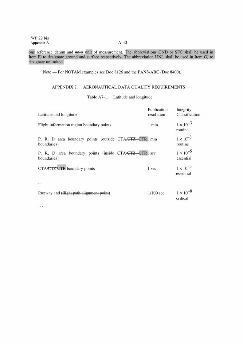
one reference datum and units unit of measurement. The abbreviations GND or SFC shall be used in Item F) to designate ground and surface respectively. The abbreviation UNL shall be used in Item G) to
designate unlimited.
Note.— For NOTAM examples see Doc 8126 and the PANS-ABC (Doc 8400).
APPENDIX 7. AERONAUTICAL DATA QUALITY REQUIREMENTS
Table A7-1. Latitude and longitude
Latitude and longitude Publication
resolution Integrity
Classification
Flight information region boundary points 1 min 1 × 10⁻³
routine
P, R, D area boundary points (outside CTA/CTZ CTR1 min 1 × 10⁻³
boundaries) routine
P, R, D area boundary points (inside CTA/CTZ CTR1 sec 1 × 10⁻⁵
APPENDIX 8. TERRAIN AND OBSTACLE DATA REQUIREMENTS
AREA 1
AREA 2 (TMA or 45 km)
ARP
Flight operations prohibited
TMA
Terrain data collection surface
120 m
120 m
A
RP
Terrain data collected with Area 1 numerical requirements
Terrain data collected with Area 2 numerical requirements
Figure A8-1. Terrain data collection surfaces — Area 1 and Area 2
1. Within the area covered by a 10-km radius from the ARP, terrain data shall be collected and
recorded in accordance comply with the Area 2 numerical requirements.
2. In the area between 10 km and the TMA boundary or 45-km radius (whichever is smaller), data
on terrain that penetrates the horizontal plane 120 m above the lowest runway elevation shall be collected
and recorded in accordance comply with the Area 2 numerical requirements.
3. In the area between 10 km and the TMA boundary or 45-km radius (whichever is smaller), data
on terrain that does not penetrate the horizontal plane 120 m above the lowest runway elevation shall be
collected and recorded in accordance comply with the Area 1 numerical requirements.
4. In those portions of Area 2 where flight operations are prohibited due to very high terrain or other
local restrictions and/or regulations, terrain data shall only be collected and recorded in accordance
comply with the Area 1 numerical requirements.
Note.— Terrain data numerical requirements for Areas 1 and 2 are specified in Table A8-1.
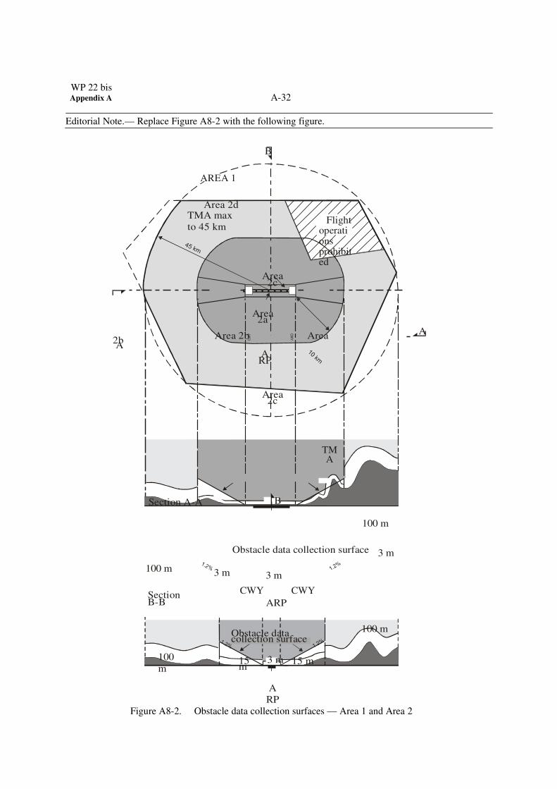
WP 22 bis Appendix A A-32
CW
Y C
WY
Editorial Note.— Replace Figure A8-2 with the following figure.
B
AREA 1
Area 2d TMA max
to 45 km
Flight
operations prohibited
Area 2c
Area 2a
A� Area 2b Area
2b A
ARP
Area 2c
TMA
Section A-A� B�
100 m
100 m
Section B-B�
Obstacle data collection surface 3 m 3 m 3 m
CWY CWY
ARP
Obstacle data collection surface
100 m
100
m
15 m
3 m 15 m
A
RP
Figure A8-2. Obstacle data collection surfaces — Area 1 and Area 2
33
1. Obstacle data shall be collected and recorded in accordance with the Area 2 numerical requirements
specified in Table A8-2:
a) Area 2a: a rectangular area around a runway that comprises the runway strip plus any clearway
that exists. The Area 2a obstacle collection surface shall have height of 3 m above any obstacle that penetrates the conical surface whose origin is at the edges of the 180-m wide rectangular area
and at the nearest runway elevation measured along the runway centre line, extending at 1.2 per
cent slope until it reaches 120 m above the lowest runway elevation of all operational runways at
the aerodrome (1.2 per cent slope reaches 120 m at 10 km); in the remainder of Area 2 (between
10 km and the TMA boundary or 45-km radius, whichever is smaller), the horizontal surface 120
m above the lowest runway elevation; and and for those portions related to a clearway, if one
exists, at the elevation of the nearest runway end;
b) Area 2b: an area extending from the ends of Area 2a in the direction of departure, with a length of
10 km and a splay of 15% to each side. The Area 2b collection surface has a 1.2% slope
extending from the ends of Area 2a at the elevation of the runway end in the direction of
departure, with a length of 10 km and a splay of 15% to each side;
c) Area 2c: an area extending outside Area 2a and Area 2b at a distance of not more than 10 km
from the boundary of Area 2a. The Area 2c collection surface has a 1.2% slope extending outside
Area 2a and Area 2b at a distance of not more than 10 km from the boundary of Area 2a. The
initial elevation of Area 2c shall be the elevation of the point of Area 2a at which it commences;
and
d) Area 2d: an area outside the Areas 2a, 2b and 2c up to a distance of 45 km from the aerodrome
reference point, or to an existing TMA boundary, whichever is nearest. The Area 2d obstacle
collection surface has a height of 100 m above ground.
b) 2) iIn those portions of Area 2 where flight operations are prohibited due to very high terrain or
other local restrictions and/or regulations, obstacle data shall be collected and recorded in
accordance with the Area 1 requirements.
23) Data on every obstacle within Area 1 whose height above the ground is 100 m or higher shall be
collected and recorded in the database in accordance with the Area 1 numerical requirements
specified in Table A8-2.
WP 22 bis Appendix A A-34
Figure A8-3. Terrain and obstacle data collection surface — Area 3
1. Data on The data collection surface for terrain and obstacles that extends more than a half-metre
(0.5 m) above the horizontal plane passing through the nearest point on the aerodrome/heliport
movement area shall be collected and recorded.
2. Terrain and obstacle data in Area 3 shall be collected and recorded in accordance comply with the
numerical requirements specified in Table A8-1 and Table A8-2, respectively.
35
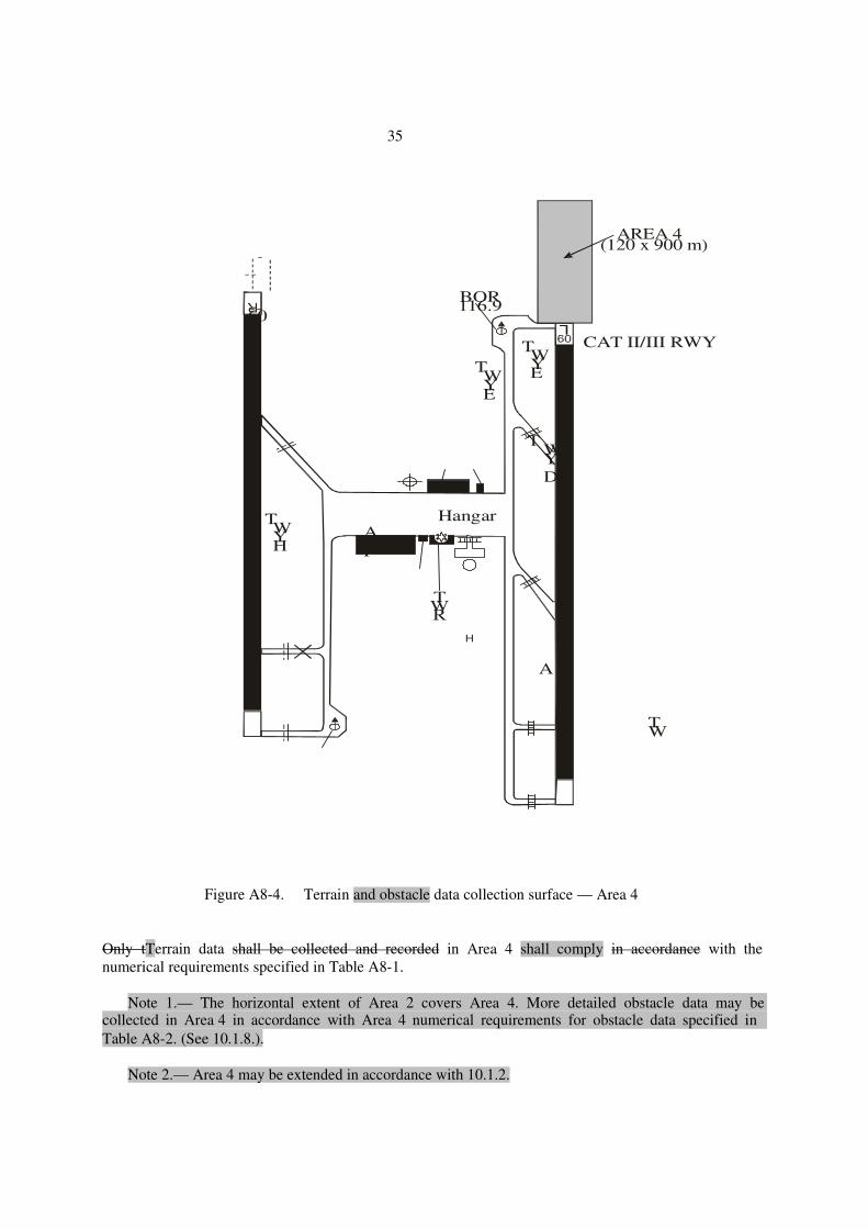
H
AREA 4 (120 x 900 m)
BOR 116.9
60
TWY E
TWY E
CAT II/III RWY
TWY D
TWY H
ARP
Hangar
TWR
TW
A R
Figure A8-4. Terrain and obstacle data collection surface — Area 4 Only tTerrain data shall be collected and recorded in Area 4 shall comply in accordance with the
numerical requirements specified in Table A8-1.
Note 1.— The horizontal extent of Area 2 covers Area 4. More detailed obstacle data may be
collected in Area 4 in accordance with Area 4 numerical requirements for obstacle data specified in
Table A8-2. (See 10.1.8.).
Note 2.— Area 4 may be extended in accordance with 10.1.2.
WP 22 bis Appendix A A-36
. . .
Table A8-1. Terrain data numerical requirements
Area 1 Area 2 Area 3 Area 4
Post spacing 3 arc seconds 1 arc second 0.6 arc seconds 0.3 arc seconds
(approx. 90 m) (approx. 30 m) (approx. 20 m) (approx. 9 m)
Vertical accuracy 30 m 3 m 0.5 m 1 m
Vertical resolution 1 m 0.1 m 0.01 m 0.1 m
Horizontal accuracy 50 m 5 m 0.5 m 2.5 m
Confidence level (1�) 90% 90% 90% 90%
Data classification routine essential essential essential
Integrity level 1 × 10⁻³
1 × 10⁻⁵
1 × 10⁻⁵
1 × 10⁻⁵
Maintenance period as required as required as required as required
Table A8-2. Obstacle data numerical requirements
Area 1 Area 2 Area 3 Area 4
Vertical accuracy 30 m 3 m 0.5 m 1 m
Vertical resolution 1 m 0.1 m 0.01m 0.1 m
Horizontal accuracy 50 m 5 m 0.5 m 2.5 m
Confidence level (1�) 90% 90% 90% 90%
Data classification
Integrity level
routine
1 × 10–
3
essential
1 × 10–
5
essential
1 × 10–
5
Essential
1 × 10⁻⁵
Maintenance period as required as required as required as required
37
Table A8-3. Terrain attributes
Terrain attribute Mandatory/Optional
. . .
Vertical confidence level Mandatory
Surface type Mandatory Optional
Recorded surface Mandatory
. . .
Table A8-4. Obstacle attributes
. . .
Obstacle attribute Mandatory/Optional
Elevation Mandatory
Height Optional
Vertical accuracy Mandatory
. . .
Add the following at the end of Table A:
Amendment
Source(s)
Subject
Adopted/Approved
Effective Applicable
36
The Secretariat with the
assistance of the Aviation Use of
the Public Internet Study Group
(AUPISG) and the Aeronautical
Information Services-
Aeronautical Information
Management Study Group (AIS-
AIMSG); recommendations of the fourth meeting of the
International Airways Volcano
Watch Operations Group
(IAVWOPSG/4);
New provisions relating to the
operational use of the public
Internet; the reporting of
volcanic ash deposition; quality
management systems; the use
of automation enabling digital
data exchange; electronic
aeronautical information
publications; the NOTAM
Format; and electronic terrain
and obstacle data.
D
* 18 November 2010
12 November 2015
(for paragraphs
10.1.4 and 10.1.5)
— — — — — — — —
WP 22 bis Appendix A A-38
Action Required
The ATS/AIS/SAR SG-11 Meeting is invited to note the
following :
That the adopted amendment introduces new or revised provisions relating to the use of the
public Internet, the reporting of volcanic ash deposition, quality management systems (QMS), the
use of automation enabling digital data exchange, electronic aeronautical information publications
(eAIP), the NOTAM Format and an extended applicability date and reduced requirements for
electronic terrain and obstacle data (eTOD).
In conformity with the Resolution of Adoption, the meeting is invited to note the following:
a) that before 12 July 2010 States should inform ICAO if there is any part of the
adopted Standards and Recommended Practices (SARPs) amendments in
Amendment 36 concerning which States wishes to register disapproval, using the
form in Attachment B for this purpose. Please note that only statements of
disapproval need be registered and if States do not reply it will be assumed that
States do not disapprove of the amendment;
b) that before 18 October 20101
States inform ICAO of the following, using the
form in Attachment C:
1) any differences that will exist on 18 November 20102
between the
national regulations or practices of a State and the provisions of the whole
of Annex 15, as amended by all amendments up to and including Amendment
36, and thereafter of any further differences that may arise;
2) the date or dates by which a State will have complied with the provisions
of the whole of Annex 15 as amended by all amendments up to and
including Amendment 36.
39
ADOPTION OF AMENDMENT 56 TO ANNEX 4
(Presented by the Secretariat)
EXECUTIVE SUMMARY
This paper presents the Council adoption of Amendment 56 to Annex 4 — Aeronautical Charts. The
amendment concerns consequential amendments related to the requirement for cyclic redundancy check
(CRC) and the provision of the Aerodrome Terrain and Obstacle Chart — ICAO (Electronic) as a
consequence of Amendment 36 to Annex 15 — Aeronautical Information Services. Having examined
the technical circumstances associated with the implementation of the amendment, the Air Navigation
Commission considers that the proposed applicability date of 18 November 2010 would be suitable,
except for paragraph 5.2.1 related to the availability of the Aerodrome Terrain and Obstacle Chart —
ICAO (Electronic) for which applicability should be 12 November 2015.
Action noted : The ICAO Council:
a) adopted, as Amendment 56 to Annex 4, the amendment to definitions and to the Standards and
Recommended Practices as contained in Appendix A to this paper;
b) approved, as part of the said amendment, the amendment to Notes as contained in Appendix A to
this paper;
c) approved the Resolution of Adoption in Appendix B to this paper; and
d) approved, as part of the said amendment, the amendment to the Foreword of Annex 4 as contained
in Appendix C to this paper.
Strategic
Objectives:
This working paper relates to Strategic Objectives A and D as the various proposals will
improve safety and efficiency of the air navigation system.
Financial
implications:
States and industry: no substantial costs.
WP 22 bis Appendix A A-40
1. INTRODUCTION
1.1 This report deals with a ICAO Council adoption of the amendment of Annex 4
arising from the following sources:
a) consequential amendments related to the requirement for cyclic redundancy check
(CRC) and the provision of the Aerodrome Terrain and Obstacle Chart — ICAO
(Electronic) as a consequence of Amendment 36 to Annex 15; and
b) editorial changes proposed by the Secretariat to align definitions in Annex 4 with
definitions in Annex 14 as amended by Amendment 10 to Volume I and Amendment 4
to Volume II, and the alignment of terminology with proposed Amendment 36 to Annex
15..
2. BACKGROUND
2.1 The development and review of the adopted amendments have followed the
established process, as show in the table below:
Amendment concerning
Preliminary
review by ANC
and WP no.
State letter
and date
Final review by
the ANC and WP no.
No. of replies at
final review1
Consequential amendments
related to the requirement
for cyclic redundancy
check (CRC) and the
provision of the Aerodrome
Terrain and Obstacle Chart
—ICAO (Electronic) as a
consequence of
Amendment 36 to Annex
152
12 March 2009
AN-WP/8375
(ANC 180-11)
AN 2/2.2-09/13
23 April 2009
28 January 2010
(ANC 183-5)
AN-WP/8442
19 January 2010
(ANC 183-3)
12 January 2010
(ANC 183-1)
19 November 2009
(ANC 182-11)
AN-WP/8416,
Add. No. 1,
DP Nos. 1, 2 and 3
57 Contracting
States (19)
3 int. orgs
Total: 60
1 Number in parentheses is the number of Council Member States who have replied.
41
Proposal also includes amendments to Annex 11 — Air Traffic Services, Annex 14 — Aerodromes, Volume
I — Aerodrome Design and Operations and Volume II — Heliports, Annex 15 and the Procedures for Air
Navigation Services — ICAO Abbreviations and Codes (PANS-ABC, Doc 8400).
2.2 The amendment listed in the table above were presented to the Council for
inclusion in Amendment 56 to Annex 4 and thus the Council took action as stated in the official State letter.
3. RATIONALE, IMPLEMENTATION ISSUES AND COST
IMPACT
3.1 Rationale
3.1.1 The adopted amendment will contribute to the efficiency of international air
navigation by introducing a requirement for only one cyclic redundancy check (CRC) algorithm (instead of
three) for all integrity classifications in the interests of harmonization. The amendment will also increase the
consistency of terminology in ICAO documentation. As the Aerodrome Terrain and Obstacle Chart —
ICAO (Electronic) is based on the electronic terrain and obstacle data specified in Annex 15, Chapter 10, the
applicability date for that chart has been extended as a consequence of Amendment 36 to Annex 15.
3.2 Implementation issues
3.2.1 No significant implementation issues are foreseen for the amendment proposals.
3.3 Cost impact
3.3.1 There is no significant cost impact associated with the amendment proposal.
WP 22 bis Appendix A A-42
Appendix A
APPENDIX A
PROPOSED AMENDMENT TO
INTERNATIONAL STANDARDS
AND RECOMMENDED PRACTICES
AERONAUTICAL INFORMATION SERVICES
ANNEX 4
TO THE CONVENTION ON INTERNATIONAL CIVIL AVIATION
NOTES ON THE PRESENTATION OF THE PROPOSED AMENDMENT
1. The text of the amendment is arranged to show deleted text with a line through it and new text highlighted with grey shading, as shown below:
1. Text to be deleted is shown with a line through it. text to be deleted
2. New text to be inserted is highlighted with grey shading. new text to be inserted
3. Text to be deleted is shown with a line through it followed by
the replacement text which is highlighted with grey shading.
new text to replace existing
text
2. The sources of the proposed amendments have been indicated as follows:
Source Annotation
43
Secretariat, with the assistance of AIS-AIMSG/1
Source A
Editorial amendments arising from the Secretariat
Source B
WP 22 bis Appendix A A-44
A-2
. . .
CHAPTER 1. DEFINITIONS, APPLICABILITY AND AVAILABILITY
1.1 Definitions
. . .
Source B
Air taxiway. A defined path on the surface established for the air taxiing of helicopters.
. . .
Air transit route. A defined path on the surface established route for the air transitting transiting of
helicopters.
. . .
Helicopter stand. An aircraft stand which provides for parking a helicopter and, where air taxiing ground
taxi operations are contemplate, completed or where the helicopter touchdown touches down and lift-
off lifts off for air taxi operations.
. . .
45
Taxi-route. A defined path established for the movement of helicopters from one part of a heliport to
another. A taxi-route includes a helicopter air or ground taxiway which is centred on the taxi-route.
. . .
CHAPTER 2. GENERAL SPECIFICATIONS
2.17 Aeronautical data
Source A
2.17.5 Protection of electronic Electronic aeronautical data sets, while stored or in transit shall be
totally monitored protected by the inclusion in the data sets of a 32-bit Cyclic Redundancy Check cyclic
redundancy check (CRC) implemented by the application dealing with the data sets. This shall apply to
the protection of all integrity levels of data sets as specified in 2.17.3. To achieve protection of the integrity level of critical and essential aeronautical data as classified in 2.17.3, a 32- or 24-bit CRC algorithm shall apply, respectively.
WP 22 bis Appendix A A-46
A-
3
2.17.6 Recommendation.—To achieve protection of the integrity level of routine aeronautical data
as classified in 2.17.3, a 16-bit CRC algorithm should apply.
. . .
CHAPTER 5. AERODROME TERRAIN
AND OBSTACLE CHART — ICAO (ELECTRONIC)
. . .
5.2 Availability
5.2.1 From 18 November 2010 12 November 2015, Aerodrome Terrain and Obstacle Charts —
ICAO (Electronic) shall be made available in the manner prescribed in 1.3.2 for all aerodromes regularly used by international civil aviation.
. . .
APPENDIX 6. AERONAUTICAL DATA QUALITY REQUIREMENTS
. . .
Sources A & B
47
Table 1. Latitude and longitude
Latitude and longitude Chart resolution
Integrity / Classification
48
. . .
P, R, D area boundary points (outside CTA/CTZCTR boundaries).. as plotted 1 × 10⁻³
/ routine
P, R, D area boundary points (inside CTA/CTZCTR boundaries).... as plotted 1 × 10⁻⁵
/ essential
CTA/CTZCTR boundary points........................................................ as plotted 1 × 10⁻⁵
essential
Runway end (flight path alignment point)……………………………….
1 sec
1 × 10⁻⁸
/ critical
Add the following at the end of Table A:
Adopted/Approved
Effective
56
The Secretariat, with
assistance of the
Aeronautical Information
Services-Aeronautical
Information Management
Study Group (AIS-AIMSG)
Definitions and new provisions
relating to cyclic redundancy
check (CRC) and the provision
of the Aerodrome Terrain and
Obstacle Chart — ICAO
(Electronic).
D
*
18 November 2010
12 November 2015
(paragraph 5.2.1)
Action Required
The ATS/AIS/SAR SG-11 Meeting is invited to note the following :
That this amendment proposal introduces revised positions related to the requirement for
cyclic redundancy check (CRC) and an extended applicability date for the provision of the Aerodrome
Terrain and Obstacle Chart — ICAO (Electronic) as a consequence of Amendment 36 to Annex 15.
In conformity with the Resolution of Adoption, the meeting is invited to note the following:
a) that before 12 July 2010 States should inform ICAO if there is any part of the adopted
Standards and Recommended Practices (SARPs) amendments in Amendment 56
concerning which a State wishes to register disapproval, using the form in
Attachment B to the State letter for this purpose. Please note that only statements of
disapproval need be registered and if States do not reply it will be assumed that States do
not disapprove of the amendment;
b) that before 18 October 20101
States inform ICAO of the following, using the form in
Attachment C of the State letter for this purpose:
1) any differences that will exist on 18 November 20102
between the national
regulations or practices of a State and the provisions of the whole of Annex 4, as
amended by all amendments up to and including Amendment 56, and thereafter of
any further differences that may arise;
2) the date or dates by which a State has complied with the provisions of the
whole of Annex 4 as amended by all amendments up to and including Amendment