Page 1
WWF SPAIN CRITERIA FOR ENSURING THE LEGAL USE OF
WATER IN AGRICULTURE
(Summary document based on the Spanish guide elaborated by WWF Spain “Guía
de WWF para verificar el uso legal del agua en agricultura”)
Copyright Credit © Copyright owner / WWF-España
MAY 2021
Page 2
Authors
Felipe Fuentelsaz, Juanjo Carmona and Rafael Seiz, (WWF Spain), and Raúl Ahijón
Collaborators
Alberto Fernández-Lop, Teresa Gil, Celsa Peiteado and Enrique Segovia, WWF Spain. Manuel Bea (Icatalist), Guido Schmidt
(FreshThoughts), Ana Bernal and Manuel Francisco Badillo
Editing and coordination
Nylva Hiruelas and Amaya Asiain Translation coordination: Diana García, Asociación AAACOA
Translation: AEIOU Traductores
Maps
Ana Bernal Interior photos
Felipe Fuentelsaz/WWF Spain
This translated document is based on the Spanish document "Guía de WWF para verificar el uso legal del agua en la agricultura", published by WWF Spain in 2021 as part of the Mission Possible: Guadalquivir challenge, which is being undertaken by WWF Spain with funding from The Coca-Cola Foundation. Its translation into several languages has been made possible thanks to funding from the MAVA Foundation and the support of Tour de Valat.
WWF Spain
Gran Vía de San Francisco,8-D. 28005 Madrid
Printed by Artes Gráficas Palermo in Cocoon Offset FSC®
You can download this document in pdf format at wwf.es/misionposible
The WWF® and World Wide Fund for Nature® trademarks and the ©1986 Panda Logo are the property of WWF-World Wide Fund For Nature
(formerly World Wildlife Fund).
All rights reserved
Page 3
INDEX:
1. LEGAL USE OF LAND .................................................................................................................................... 8
2. MAP OF WATER POINTS ON THE FARM .............................................................................................. 8
3. LEGAL USE OF WATER ........................................................................................................................ 10
4. FIELD VISIT OR ON-SITE INSPECTION ............................................................................................... 10
5. CONTROL OF WATER USE ...................................................................................................................... 11
6. IRRIGATION WATER ACCUMULATION OR REGULATION ELEMENTS ......................................... 11
WELLS OR ABSTRACTION POINTS ........................................................................................................... 12
WATER INLETS ON LAND IRRIGATED BY IRRIGATION COMMUNITIES ......................................... 13
REGULATING PONDS .................................................................................................................................. 14
STREAMS OR BOUNDARIES ....................................................................................................................... 14
POWER LINES ............................................................................................................................................... 14
REMOTE SENSING ....................................................................................................................................... 15
SPATIAL DATA INFRASTRUCTURE (SDI) ................................................................................................ 15
USE OF GIS AND OFFICIAL CARTOGRAPHIC LAYERS .......................................................................... 16
WWF WATER RISK FILTER ........................................................................................................................ 16
Page 4
3
INTRODUCTION
Water is one of the most valuable natural resources, essential for sustaining human life and biodiversity on the planet.
It is thanks to this element that rivers, lakes, wetlands and aquifers provide valuable ecosystem services. However, the
excessive and intensive use of water in many economic activities is leading to overexploitation of these water supplies,
preventing the ecological flows necessary for sustaining aquatic ecosystems.
A large proportion of this overexploitation is due to illegal abstractions. These involve water being extracted without a
firm permit from the relevant authorities, including those that are in the process of a final decision, be that positive or
negative.
In many cases, the spread of illegal water use is greater than the capacity of water agencies to control this, even in
socially and politically favourable situations, due to the great impunity enjoyed by the abstracters. This problem is
particularly acute in cases of groundwater abstraction due to the infinite number of possible abstraction points
(boreholes). Unplanned agricultural development subsidies have been the main instigators of overexploitation.
WWF Spain believes that economic activity based on conservation and respect for this scarce natural resource is the
only way to ensure the good state of conservation of aquatic ecosystems, so that they continue to offer an ideal place
for biodiversity to be preserved. In short, it is up to all of us to ensure that the good health of rivers, streams, lagoons,
estuaries and aquifers is linked to the sustainable use of water.
WWF Spain is deeply concerned about the problem of illegal water use, especially in dry climates. This is why, in the
various field projects it runs on agricultural land, the participating farmers have to demonstrate the legal use of irrigation
water on their estates through an audit and subsequent report by external auditors. However, experience shows that it
is sometimes not easy for the auditors to interpret the information provided as proof of legality. That is why, in 2021,
WWF edited the “Guía de WWF para verificar el uso legal del agua en la agricultura” (WWF Guide to verifying
the legal use of water in agriculture) focused on Spain, in the framework of the project "Mission Possible:
Desafio Guadalquivir".
This document is an adaptation of that guide, to facilitate its translation into different languages and its
dissemination. To do this, we received funding from the MAVA Foundation and the collaboration of the
Mediterranean Wetlands Research Institute of Tour de Valat (France), with a view to distributing the guide in
other Mediterranean countries. Although this document provides a preview of general aspects, fully adapting
this Guide to the conditions in each country will require a detailed study in each context, to be carried out by
experts in the field of water, the authorities, and local NGOs in each country.
Ensuring the legality of water and soil use on farms not only helps conserve natural resources, but also supports legal
farmers, adversely affected by overexploitation, and avoids tarnishing the image of the irrigation and agricultural sector.
Page 5
4
PURPOSE OF THE GUIDE AND TARGET AUDIENCE
To verify that in its different field projects it only works with legal farmers, WWF Spain carries out prior reports on soil
and water legality.
These internal reports should not be confused with certifications as they are carried out by external agri-food auditors,
who have received prior training from WWF Spain, experts in water legality, and representatives of the competent water
authorities.
In this respect, WWF Spain has been raising awareness of the legal use of water for more than a decade, by organising
training sessions for certifying companies, auditors, and technicians on how to verify, in the field, the legal use of water
in the region, in addition to working with the main production standards and regulations with the aim of improving their
environmental and legal criteria. Many agricultural product quality standards already incorporate the verification of legal
water use, as in the case of Global G.A.P. (fruits and vegetables) and its SPRING water module, the integrated farming
regulations in some Spanish regions, and private organic production regulations such as Naturland in Germany, and
Biosuisse in Switzerland.
It is important to know how to audit and access local expertise, as well as contact the respective water authorities, so
that these can provide the best training on the regulatory and documentary aspects of assessing legal water use.
Furthermore, an inspection visit to the farm is essential to corroborate the validity of the documentation provided.
The purpose of this guide is to provide auditors and inspectors from agricultural product certification companies, as well
as technicians and farmers who require it, with a useful tool to enable them to tackle the complex task of auditing legal
water use.
Certification is key to guaranteeing consumers a sustainable and environmentally friendly product and is also the only
way to avoid unfair competition, prioritising legal farmers who use the resource correctly.
WHO AUTHORISES WATER USE?
After several years on the ground, WWF has observed that farmers sometimes present documents from particular official
bodies to prove that they are using water legally, but that these documents have not been issued by the competent
water authority.
In each country, the authority responsible for managing water and the conditions set out in the regulations
must be analysed beforehand.
In Spain, for example, the central government assumes responsibility for water through the River Basin Authorities
(Confederaciones Hidrográficas) that run through the various regions and the Regional Authorities (Comunidades
Autónomas) preside over internal basins.
The basic state legislation on water establishes that any private use of water must either be acquired by legal provision
or requires an administrative concession, which is granted by the water authorities.
Additionally, in water concessions for irrigation purposes, the water use permit establishes the area it applies to, including
irrigation rights and the irrigable area in hectares (where irrigation rights rotate), the municipalities and provinces where
this is situated, the maximum volume of water to be used per hectare per year, and the maximum monthly abstraction
volume that is employed to typify the maximum instantaneous flow.
In each basin authority there will be a single water registry in which official concessions and other rights to water use,
as well as authorised changes in ownership or characteristics (physical and technical), are recorded.
Page 6
5
In Spain, the water registry is public, and allows the issuance of registration certificates. These certificates, which
include the essential characteristics of the right to use the water, are the means of accrediting this right, guaranteeing
the legal use of the water from the moment they are issued. In addition, Article 196 of the Public Hydraulic Domain
Regulations establishes that basin authorities shall maintain a catalogue of private waters, in which these are registered
under the 1879 Water Law, and where the owners opted to maintain them under this regime within the legal terms
established prior to 27 October, 2001.
Occasionally, we find concessions for water allocations that are several centuries old, linked to traditional irrigation
systems, such as irrigation ditches. In this sense, each case must be assessed in its particular context. Finally, and more
and more frequently, we come across the case of irrigation communities. These user communities have the status of
public law corporations (corporaciones de derecho público) attached to the basin authorities, which ensure compliance
with their statutes or by-laws and the proper management of water use.
Illegal water use affects not only the environment, but also legal users and, in the case of agriculture, causes
disproportionate unfair competition. It simultaneously damages the image of the agricultural sector because, in some
cases of overexploitation in the media, no distinction is made between legal and illegal producers. In certain areas, the
illegal use of water to irrigate crops has caused supply problems for human use, having a direct impact on society.
On the other hand, and although it is not formally recognised as an externality (an environmental cost), illegal water use
seriously impacts the conservation status of rivers, wetlands, and aquifers, as well as their associated biodiversity.
Rectifying this also affects society as a whole, through taxation.
WHAT IS MEANT BY “ILLEGAL WATER USE”?
Although the list is really much longer, the main examples of illegal water use are the following:
Groundwater abstraction wells and surface water abstractions that are exploited in the absence of a permit or
concession from the corresponding basin authority. This situation tends to occur particularly in areas where water
resources are overexploited, exceeding the maximum levels contemplated in the hydrological plan, but it does also occur
in areas where these are not overexploited. In these cases, the basin authority cannot grant new concessions due to a
lack of resources or because the sustainability of the affected aquatic ecosystems is compromised. Other cases occur
in conjunction with unauthorised land use (illegal clearing of forest or protected areas for irrigated crops, land declared
as rain-fed, etc.), in groundwater abstractions within delimited protection perimeters to guarantee supply to the
population, or closer than the minimum authorised distance to other previously legalised abstractions.
Exploitations that use volumes greater than those permitted. The most water that rights holders are allowed to use
is the maximum annual volume allocated to them by the basin authority. However, some users abstract volumes beyond
this limit. These cases include:
• Farms with crops that have a high demand for water, but with low concessional allocations.
• Cases where permits are requested for domestic-use wells, but the intention is to irrigate large areas of land
which, in practice, means a greater annual use than that authorised.
• Expansion of irrigated areas where there is not enough water allocated to meet the demand of the crop over
the entire area.
Coexistence of legalised abstractions with other non-permitted extraction on the same farm. Sometimes, part of
the farm has regularised water abstractions while the rest of the farm is irrigated by illegally extracted water.
Exploitations in the process of being authorised by the authorities. At times, water authorities are slow in
processing applications for new concessions, and many applicants begin to abstract water illegally, without having
received an official response to their request.
Page 7
6
Although it is recognised that it is unfeasible to obtain a water permit under certain conditions, such as in areas with
overexploited aquifers or aquifers with fossil water, there are cases in which the offender tries to defend the legality by
making an initial application for a concession, but without going through the entire process that leads to a definitive
concession.
It is important to note that sometimes unauthorised abstraction is linked to other illegal practices, such as the
unauthorised clearing of protected or forest areas for irrigated crops. In this sense, it is helpful to carry out a legal land
use analysis (field visits, aerial and space satellite images) to verify that the irrigated farm is, for example, agricultural
(and not forestry), or irrigated land (and not rain-fed).
As a summary, Table 1 lists the documents that accredit (or not) the legal use of water on agricultural properties.
Table 1. Summary of examples of valid and invalid documents for proving the legality of water use.
Valid documentation Invalid documentation
• Certificate from the water registry of the competent water
authority.
• Certificate from the secretary of officially constituted
irrigation communities.
• Documents accrediting only the opening of a file or procedure,
but not a definitive concession.
• Certificates from other non-competent authorities (town
councils, agricultural bodies, etc.).
• Certificates from farmers' associations.
• A water concession issued by the water authority that has
been modified, expired or terminated at a later date.
Source: developed in-house for Spanish case, WWF Spain
THE ILLEGAL USE OF WATER: A GLOBAL PROBLEM
Illegal water use is widespread and depends on the rules of use in each country or region. Overall, as shown in Figure
1, there is evidence of illegal water use in virtually all semi-arid countries in the Americas, Europe11 , Africa, Asia and
Australia (De Stefano et al., 2020).
In the European part of the Mediterranean, it is estimated that half of the existing water abstraction wells are unregistered
or illegal (EASAC, 2010), although this is based on limited data, and official documents generally avoid any explicit
mention of the problem. There is evidence of illegal use in Portugal, Spain, Italy, Malta, Greece and Cyprus (OECD,
2020); (Dworak et al., 2010).
Figure 1. Map of countries with evidence of illegal water use (Astroinstitute.org white map, 2017).
Further information: How to tackle illegal water abstractions. Edited by the Botín Foundation, 2020
Page 8
7
LEGAL WATER USE IN AGRICULTURAL PRODUCTION
STANDARDS
Agricultural production standards or regulations have moved forward in recent years, incorporating increasingly more
criteria related to the legal use of water. Some of them have passed from having mere recommendations to minor, major
and even mandatory points. Generally speaking, almost no current certification system ensures that an agricultural
product comes from farms that use water legally. Although some standards now have mandatory requirements for legal
water use, there are insufficient guarantees that the documentation has been properly checked. This is partly due to the
lack of training and education of auditors and owners in terms of the norms or standards, or even in the case of the
public authorities. Furthermore, the complex concept of legal water use needs to be adapted to each particular
geographical context with the appropriate documentation.
The document “Practical application of agricultural standards. Case study Fruits and Vegetables in Spain. Water, soil,
Biodiversity and Climate in Agricultural Production Standards (2020)", developed by WWF Spain, analyses the main
standards used in fruit and vegetable production. The results relating to legal water use are detailed in the following
table: red means that the standard makes no reference to the criterion, orange is a minor reference or simply a
recommendation, yellow means that the standard addresses the criterion but obtaining the certificate is not a mandatory
requirement, and green means that the standard is a mandatory and indispensable requirement for obtaining the specific
standard.
In general, the most widespread certificates in the agricultural world in Spain, such as Integrated Farming, Organic
Production, and GLOBALG.A.P., do not guarantee that farm production uses legal water.
On the other hand, some regulations such as Integrated Farming, the SPRING water module (additional GLOBALG.A.P.
module), the AWS sustainable water use certificate, and private standards such as Naturland and Biosuisse, do include
the mandatory requirement to legally use water. However, it is important to note that there is no clear training on how to
assess the criteria for legal water use, so that sometimes erroneous certificates have been issued.
Another significant case is the European Regulation on Organic Production 834/2007 and its amendment 889/2008,
which does not clearly include the control of legal water use.
Table 2. Criteria related to the legal use of water in agricultural standards.
Criteria to be evaluated.
WWF Report
GLOBAL
G.A.P.
SPRING
AWS
LEAF
IF Spanish Standard
IF Strawberries
Andalusia
IF Citrus Valencia EU
Organic Agriculture
Biosuisse
Naturland
Demeter
1. Legality of land use 1 3 0 2 0 3 0 1 2 0 1
2. Legality of water use 2 3 3 1 0 3 0 1 3 3 1
3. Respect of cultivation allocation
assigned by the river basin authorities
2
3
3
1
0
0
3
0
2
2
0
Source: WWF Spain, 2020
Page 9
8
CRITERIA FOR ENSURING THE LEGAL USE OF
WATER
WWF Spain has developed this checklist of criteria to help auditors and technicians gather the necessary information
to demonstrate that a farm is legal in terms of both water and land use. It should be noted that there is no clear
procedure for analysing the legal use of water. Moreover, field auditors cannot take on the role of policemen or river
bailiffs, as only the water authorities or a judge can formally determine whether or not a farm complies with water and
soil legality.
The full list of criteria established by WWF Spain can be found in Annex I of this document. It is a checklist to help
prepare a report on the documentary evidence and to support the field visit in relation to the legal use of water. The
following are the checkpoints, in brief:
1. LEGAL USE OF LAND
The only farms that can be irrigated are those that are officially considered irrigated farms. In this sense, forest or rain-
fed agricultural land cannot be legally used for irrigated crops.
Legality compliance criterion
The farm has a legal document (title deed, lease contract, administrative concession, etc.) stating that the land is used
for agricultural purposes and not for forestry or other activities. Similarly, other documentation is attached to corroborate
its use, for instance a historical sequence of orthophotos based on Google Earth, showing that there have been no
changes in land use over recent years. If the property is located within the scope of a land use plan, a plan showing the
type of land use pursuant to that plan must also be submitted.
Documentation to verify in the office prior to the field visit
• Copy of the title deed, lease contract or administrative concession verifying the agricultural use of the farm.
• Change of land use authorisation, in the event that the land has been converted from forestry to agricultural use.
• Document certifying the agricultural use of the land in the case that:
- the farm falls within the scope of a land-use plan and/or
- the farm is located within a protected natural area. In this case, it is necessary to check whether the land use
is compatible with any existing management plans.
2. MAP OF WATER POINTS ON THE FARM Legality compliance criterion
The farm has an updated map or sketch showing all the abstractions (wells, reservoir, etc.) reflected in the certificates
provided, as well as the water regulation elements on the property. This map must also show the farm and the irrigated
area according to the available water rights (e.g., Figure 3).
Page 10
9
Figure 2. Detail of land use change in a forest estate. Source: WWF Spain on orthophotos from 2002 and 2009
Documentation to verify in the office prior to the field visit
Sketch or map of the farm with the abstractions to facilitate the auditor's visit. All abstractions must be located on this map, as
shown in Figure 3.
Figure 3. Map of the farm showing the location of the water abstraction points. Source: WWF Spain on a Google Earth image
Page 11
10
3. LEGAL USE OF WATER
Legality compliance criterion
The farm has a certificate from the water authority or the entities affiliated to this authority (legally constituted irrigation
community) defining the characteristics of the water rights for the property, indicating their purpose, their term, the
maximum instantaneous flow, the maximum annual volume and, where applicable, the maximum monthly volume whose
use is granted, indicating the period of use when this occurs on restricted days.
The document evidencing the right must also identify the municipal district and province where the abstraction is located,
as well as the cartographic references of the water abstractions and the places where they are to be used. At property
level, it is necessary to indicate the surface area with irrigation rights and the irrigable area in hectares, the municipalities
and provinces where it is located, the maximum volume of water to be used per hectare and year, and the maximum
monthly abstraction volume that is employed to typify the maximum instantaneous flow, as well as references to the type
of water (groundwater, surface, wastewater reuse, desalination, etc.).
Documentation to verify in the office prior to the field visit
• Copy of the water legality certificate to give to the auditor to be included in the report (copy of the irrigation community
certificate with the irrigation area and flow/ha and resolution of the constitution of the irrigation community, a copy of
the certificate from the private water catalogue or the public water registry).
Notes of interest:
It is important to ensure that the party that has signed the water legality document is the competent water authority.
It is necessary to ensure that irrigation communities are officially constituted, and to demand the water registry certificate
confirming the right to use water, as some user communities are either not officially constituted or simply farmers'
associations that do not have the power/ authority/competence to issue valid certificates in terms of water legality.
In the event of a doubt or the need to tackle the documentation in greater depth, this guide includes a section on
innovative tools and other ways for obtaining information on the legal use of water.
4. FIELD VISIT OR ON-SITE INSPECTION Legality compliance criterion
Through the auditor's visit to the farm, a comparison of the documentary information provided, and by following the
updated map or sketch, it is verified that the existing abstraction points on the farm do indeed coincide with those shown
on the map and in the documents. The entire property must be visited and special attention paid to possible abstractions
other than those indicated in the documentation and on the map or sketch. If any are present, information on these
should be incorporated into the report along with a photograph, location references and evidence as to whether they are
in use or disused.
Documentation to verify/bring to the field visit
• Sketch or map of the farm with the abstractions to facilitate the auditor's visit.
• Photographs of the abstractions marked on the map to show that they exist. If any are not referenced on the map,
these should be indicated in the report.
Notes of interest:
In addition to the points marked on the sketch it is important to visit other areas to ensure that there is no evidence of
other abstraction points. It is advisable to visit streams or watercourses, close to and on the boundaries of the farm, and
to pay attention to power lines.
Please also see "field evidence" in the following section.
Page 12
11
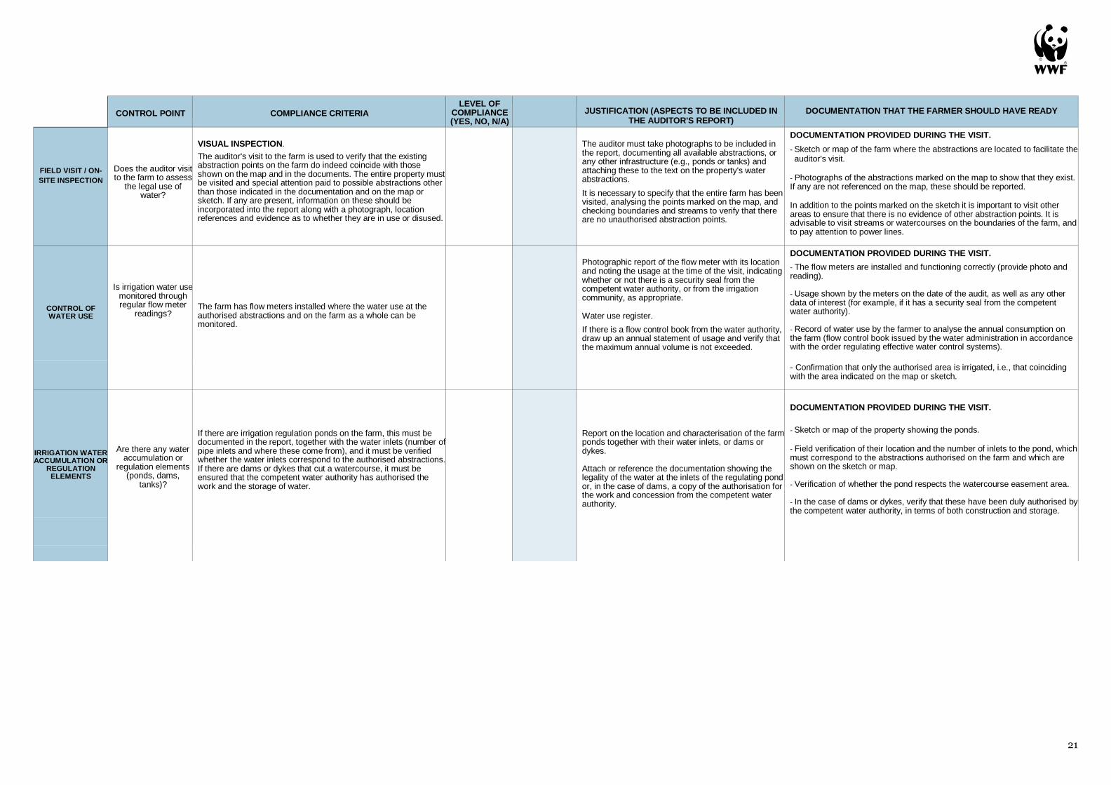
5. CONTROL OF WATER USE Compliance criteria
The farm has flow meters installed where the water use at the authorised abstractions and on the farm as a whole can
be monitored.
Documentation to verify/bring to the field visit
• The flowmeters are installed and functioning correctly (provide photo and reading).
• Usage shown by the meters on the date of the audit, as well as any other data of interest (for example, if it has a
security seal from the competent water authority).
• Record of water use by the farmer to analyse the annual consumption on the farm (flow control book issued by
the water administration in accordance with the order regulating effective water control systems).
• Confirmation that only the authorised area is irrigated, i.e., that coinciding with the area indicated on the map or
sketch.
6. IRRIGATION WATER ACCUMULATION OR REGULATION
ELEMENTS Compliance criteria
If there are irrigation regulation ponds/reservoirs on the farm, these must be documented in the report, together with the
water inlets (number of pipe inlets and where these come from), and it must be verified whether the water inlets
correspond to the authorised abstractions. If there are dams or dykes that cut a watercourse, it must be ensured that
the competent water authority has authorised the work and the storage of water.
Documentation to verify/bring to the field visit
• Sketch or map of the property showing the ponds.
• Field verification of their location and the number of inlets to the pond, which must correspond to the abstractions
authorised on the farm and which are shown on the sketch or map.
• Verification of whether the pond respects the watercourse easement area.
• In the case of dams or dykes, it must be verified that these have been duly authorised by the
competent water authority, both in terms of the work and for storage.
Page 13
12
FIELD EVIDENCE
A fundamental aspect when filling in and verifying the documentation presented by the farmer in a field inspection is the
visual on site identification of the irrigation-related infrastructures.
As a preliminary step, it is necessary to have a map or sketch indicating the abstraction points (wells, dams, river
outlets, irrigation community inlets), the regulation elements, if any (ponds), and the irrigated surface area on the
property. This means that on the day of the field inspection, the auditor can locate these infrastructures on the map and
then check them on the ground.
The on-site inspection is one of the most important activities in water (and soil) legality reports/audits on agricultural
land, as it is the place where the information provided in the various previously provided official documents can be
verified. During this visit, the farmer can show all their abstraction points.
Although we must always rely on the data provided by the farmer, it is important to check some points on the farm and
to be aware of possible anomalies. In this case, a number of important points to check are:
WELLS OR ABSTRACTION POINTS
Check if these correspond to the geographical coordinates indicated in the authorisation and on the available sketch or
map. Another aspect that usually helps in the legal verification is when the abstraction has a flow meter, a requirement
that in many countries is compulsory for abstraction points involving water rights, and which may even have a control
seal.
Detail of abstraction from a watercourse.
Page 14
13
Detail of a well on a farm boundary.
WATER INLETS ON LAND IRRIGATED BY IRRIGATION COMMUNITIES
Farms irrigated using water from irrigation communities have a single water inlet to the farm, which in turn comes from
the water abstraction shed of the aforementioned community of users.
These are usually located on the boundary or in the vicinity of the farm, as this installation can cover several properties.
If the property has another water inlet, this must also be justified with documentation.
Detail of flowmeter and water authority seal.
Page 15
14
Detail of an irrigation community shed.
REGULATING PONDS
On many agricultural properties it is common for there to be a water regulating pond where water from other abstractions
accumulates. This is typical on irrigated farms within irrigation communities where supply problems may occur
throughout the irrigation period and water is only supplied occasionally, so the farmer has to accumulate it; or on farms
where there are several abstraction points and agronomically it is decided to accumulate everything in a pond in order
to pump it homogeneously to the whole farm later on.
The important thing is to check whether the number of water inlets to the regulating pond coincides with the number of
authorised abstractions on the farm, otherwise there may be some unauthorised abstraction.
Detail of water inlets to the regulation pond.
STREAMS OR BOUNDARIES
If the farm has a stream or boundary, it is important to check along this to verify certain aspects, such as any pipes that
may enter from outside the farm or if there are any signs of possible abstraction from the watercourses, as shown in the
photographs on the following page.
POWER LINES If the farm has a power line that ends at a specific point on the farm, this may correspond to some kind of infrastructure.
It is necessary to check whether this is actually an abstraction point and analyse its legality.
Page 16
15
DIGITAL TOOLS FOR VERIFYING LEGAL/ILLEGAL
WATER USE
REMOTE SENSING
Remote sensing data allows an analysis of the evolution of land use and agricultural practices on a farm over time. In
recent years, the availability of free satellite imagery, the possibility of accessing other platforms (aircraft, drones) and
access to free software for processing and analysing this type of data have increased dramatically.
The European Space Agency's SENTINEL mission is currently the reference data source, providing infrared satellite
images every 5 days at a spatial resolution of 10 metres. From this data it is possible to identify and map the crops
present on a farm, as well as to make estimates of the water consumption.
To complement this, it is possible to access other sources of data with higher resolution (less than 1 metre), such as
aerial orthophotographs produced as part of the PNOA (Spanish National Aerial Orthophotography Plan) or systems
such as Google Earth. This data provides a more precise view of the agricultural practices and elements of a farm,
although it does deliver images that are from a specific point in time.
If it is necessary to monitor farms in one area and at a specific time, drones can be used. Nowadays, these observation
platforms make it possible to include different sensors (visible, infrared, thermal) and acquire detailed images over large
areas at a reasonable price.
In general, remote sensing makes it possible to complement field work and monitor legal water use in agriculture based
on previous desk and field inspection work.
SPATIAL DATA INFRASTRUCTURE (SDI)
New technologies are increasingly being used by water authorities. A clear example of this is the Spatial Data
Infrastructure (SDI) or Geoportal of the Guadalquivir River Basin Authority (CHG), as a case in point in Spain, where
information on the basin is available to the general public. This information highlights the authorised abstraction points
(in SHAPE format available for GIS and in Kmz for Google Earth), and a map viewer where, by zooming in on the farms
under study in the basin, information can be analysed on whether or not there are irrigation rights, how much surface
area it covers, the name of the farm, and the file number.
Figure 4. Detail of the webpage: SDI/Geoportal Guadalquivir River Basin Authority, Spain
Page 17
16
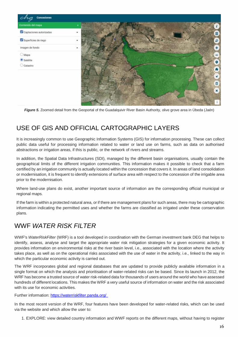
Figure 5. Zoomed detail from the Geoportal of the Guadalquivir River Basin Authority, olive grove area in Úbeda (Jaén)
USE OF GIS AND OFFICIAL CARTOGRAPHIC LAYERS
It is increasingly common to use Geographic Information Systems (GIS) for information processing. These can collect
public data useful for processing information related to water or land use on farms, such as data on authorised
abstractions or irrigation areas, if this is public, or the network of rivers and streams.
In addition, the Spatial Data Infrastructures (SDI), managed by the different basin organisations, usually contain the
geographical limits of the different irrigation communities. This information makes it possible to check that a farm
certified by an irrigation community is actually located within the concession that covers it. In areas of land consolidation
or modernisation, it is frequent to identify extensions of surface area with respect to the concession of the irrigable area
prior to the modernisation.
Where land-use plans do exist, another important source of information are the corresponding official municipal or
regional maps.
If the farm is within a protected natural area, or if there are management plans for such areas, there may be cartographic
information indicating the permitted uses and whether the farms are classified as irrigated under these conservation
plans.
WWF WATER RISK FILTER
WWF's WaterRiskFilter (WRF) is a tool developed in coordination with the German investment bank DEG that helps to
identify, assess, analyse and target the appropriate water risk mitigation strategies for a given economic activity. It
provides information on environmental risks at the river basin level, i.e., associated with the location where the activity
takes place, as well as on the operational risks associated with the use of water in the activity, i.e., linked to the way in
which the particular economic activity is carried out.
The WRF incorporates global and regional databases that are updated to provide publicly available information in a
single format on which the analysis and prioritisation of water-related risks can be based. Since its launch in 2012, the
WRF has become a trusted source of water risk-related data for thousands of users around the world who have assessed
hundreds of different locations. This makes the WRF a very useful source of information on water and the risk associated
with its use for economic activities.
Further information: https://waterriskfilter.panda.org/
In the most recent version of the WRF, four features have been developed for water-related risks, which can be used
via the website and which allow the user to:
1. EXPLORE: view detailed country information and WWF reports on the different maps, without having to register
Page 18
17
to access all the content.
2. EVALUATE: analyse the water-related risks of a particular activity, both at the river basin level and for specific
operations.
3. VALUE: establish the economic value of the water-related risks to understand what they mean for that particular
economic activity.
4. RESPOND: analyse possible responses to tackle the water-related risks of the particular activity and see what
others have done to address similar risks.
Considering the focus of this guide, an interesting exercise is to analyse the water-related risks in the particular case of
farms or irrigation activities in certain areas. Thanks to the WRF, an initial approximation can be made through the
"explore" section, with more in-depth analysis and answers made possible using the other functionalities.
OTHER WAYS TO OBTAIN INFORMATION
For more specific work, or studies that require a detailed analysis to ascertain the legality of water use, there are other
sources of information:
Newspaper library or news search engine. The name of the farm or site, or of the company that operates it, can be
used to search the Internet to see if this name is linked to any media reports. In this sense, it is important to corroborate
any information: being reported in the press does not mean that it is illegal, although in the majority of cases such reports
are made because there are sanctioning proceedings in this respect.
Search engine for court rulings. Another tool available for checking whether a company may have a problem with
water use is the search engine for court rulings in the countries where this is available. For example, in Spain you could
use this link: www.poderjudicial.es/cgpj/es/Servicios/Jurisprudencia/
Customer service office at the competent water authority. Thanks to publicly available information and, of course,
data protection for the landowner's personal data, the law in some countries allows any citizen to officially ask, by writing
to the water commissioner of each competent authority, whether or not a farm has a permitted water abstraction point.
Page 19
18
CHALLENGES FOR THE FUTURE
For WWF Spain, ensuring the legal use of water is key to guaranteeing the conservation of this scarce natural resource
and defending legal farmers and consumers who demand eco-friendly products.
To this end, WWF Spain is calling for:
A training and capacity-building plan on legal water and soil use, together with the owners of
agricultural production standards and norms, aimed principally at certifiers and auditors, as well as technical
advisors and farmers.
The inclusion of legal water and soil use as a mandatory requirement in production standards and
agricultural regulations.
Greater coordination between public authorities, including actions such as the incorporation of legal water
use as a requirement in the application of public funds such as the common agricultural policy (CAP). To achieve
this, there must be better coordination between the authorities responsible for agriculture and water.
Improved governance related to water use, by calling on the competent water authorities to address the
problem of illegal water use, and improving transparency in terms of the information available on authorised
abstractions on the corresponding digital platforms. Systematic monitoring and sanctioning campaigns should
also be implemented, applying the best techniques available. Finally, there should be increased investment in
the control and measurement of water use.
The guide on the legal use of water in agriculture should be adapted to country-specific conditions,
including relevant regulations and examples or case studies of interest, similar to that in the WWF Spain
document "WWF Guide to verifying the legal use of water in agriculture".
Page 20
19
REFERENCES
De Stefano, L.; Carmody, E.; Schmidt, G. et al. (2020). How to tackle illegal water abstractions? Taking stock of
experience and lessons learned. Botín Foundation.
Dworak, T.; Schmidt, G.; De Stefano, L. et al. (2010, September). Background Paper for the conference: Application of
EU Water- related Policies at Farm Level. 28-29. Louvain-la-Neuve (Belgium). https://bit.ly/2U0Kab2
EASAC (European Academies Science Advisory Council). (2010). Groundwater in the southern member states of the
European Union. EASAC Policy Report 12. EASAC Publishing, Halle. https:// bit.ly/3mYx0aH
MAP. (2019). Informe de condicionalidad 2019. Ministerio de Agricultura, Pesca y Alimentación. Secretaría General
Técnica. Publications Centre. https://bit.ly/3evj59j
OECD. (2020). Financing Water Supply, Sanitation and Flood Protection: Challenges in EU Member States and Policy
Options. OECD Studies on Water, OECD Publishing, Paris. https://doi. org/10.1787/6893cdac-en
European Union. (2012, November). Implementation of the Water Framework Directive (2000/60/EC). River Basin
Management Plans. Recovered from https://eur-lex.europa.eu
WWF Spain. (2006, May). Uso ilegal del agua en España. Causas, efectos y soluciones. Retrieved from
https://www.wwf.es
WWF Spain. (2020, June). Practical application of agricultural standards. Case study Fruits and Vegetables in Spain.
Water, soil, biodiversity and climate in agricultural production standards. (Unpublished).
WWF Spain. (2020, December). Guía de WWF para verificar el uso legal del agua en la agricultura
https://www.wwf.es/?56520/Guia-uso-legal-del-agua-en-agricultura
Page 21
20
ANNEX I COMPLIANCE POINTS FOR WATER LEGALITY REPORTS IN WWF SPAIN AGRICULTURAL PROJECTS (December 2020)
The various field projects carried out by WWF Spain require a prior report on water and soil use legality. These reports are prepared by certifying companies (external auditors) previously trained by the organisation and by other experts in issues of legality,
with the collaboration of the competent water authorities. It should also be remembered that these are reports (and not certifications). They reflect the documentation provided and the evidence gathered on the ground to verify water and soil legality, and in
no case can they be considered an official document confirming the legal use of water on a property, as this is the role of the competent water authority, or of the courts in the case of legal proceedings.
CONTROL POINT
COMPLIANCE CRITERIA
LEVEL OF COMPLIANCE (YES, NO,
N/A)
JUSTIFICATION (ASPECTS TO BE INCLUDED IN THE AUDITOR'S REPORT)
DOCUMENTATION THAT THE FARMER SHOULD HAVE READY
LEGALITY
OF SOIL
Does the farm have a documented permit for
legal land use?
DOCUMENT INSPECTION
The farm has a legal document (title deed, lease contract, administrative concession, etc.) stating that the land is used for agricultural purposes and not for forestry or other activities.
Other corroborating documentation is attached. A historical sequence of orthophotos based on Google Earth, for example, showing that there have been no changes in land use in recent years, is recommendable.
If the property falls within the scope of a land use plan, a map showing the land use according to the land use plan must also be submitted.
Land use summary report, which must be attached:
- Name of the property, municipal area, and cadastral (land register) references.
- Ownership or rental contract references for the farm. - Sequence of historical orthophotos, etc. (to be prepared by the auditor in the office), indicating that it is agricultural land and that there have been no detectable changes in land use since the implementation of the forestry law. If there has been a change of land use, particularly from forest to agricultural land, reference must be made to the land use change file processed by the authority competent in environmental matters.
DOCUMENTATION PROVIDED PRIOR TO THE VISIT.
- Cadastral (land register) references.
- Copy of the title deed, lease contract or administrative concession verifying the agricultural use of the farm.
- Authorisation for change of land use, in the event that it has been converted from forestry to agricultural use.
- Document certifying the agricultural use of the land in the case that: • the farm falls within the scope of a land-use planning scheme and/or • the property is located within a protected natural area.
MAP OF
WATER POINTS
ON THE FARM
Does the farm have a map or sketch of the
abstraction and regulation points?
DOCUMENT INSPECTION.
The farm has an updated map or sketch showing all the abstraction points (wells, inlets, etc.) reflected in the certificates provided, as well as the water regulation elements on the farm. It must also show the farm itself and the area that is irrigated according to the rights granted.
The map or sketch made by the farmer must be attached to the report. If any serious incidents are detected (a further, unauthorised abstraction, for example), these must be indicated in the report.
DOCUMENTATION PROVIDED PRIOR TO THE VISIT.
Sketch or map of the farm where the abstractions are located to facilitate the auditor's visit. All abstractions must be located on this map.
WATER LEGALITY
Does the farm have an irrigation water
permit/concession?
DOCUMENT INSPECTION.
The farm has a certificate from the water authority or the entities affiliated to this authority (legally constituted irrigation community) defining the characteristics of the water rights for the property, indicating their purpose, their term, the maximum instantaneous flow, the maximum annual volume and, where applicable, the maximum monthly volume whose use is granted, indicating the period of use when this occurs on restricted days.
Report prepared (section of the report) by the auditor with the origin and legal status of the water, referring to and attaching a copy of the water legality certificate.
DOCUMENTATION PROVIDED PRIOR TO THE VISIT.
- Copy of the water legality certificate to give to the auditor to be included in the report (copy of the irrigation community certificate with the irrigation area and flow/ha and resolution of the constitution of the irrigation community issued by the water authority in communities with more than twenty members), a copy of the certificate from the private water catalogue or the public water registry, issued by the water authority.
It must also identify the municipal district and province, as well as the cartographic references of the water abstractions and the places where they are to be used. At property level, it is necessary to indicate the surface area with irrigation rights and the irrigable area in hectares, the municipalities and provinces where it is located (zone, plot and surface area), the maximum volume of water to be used per hectare and year, and the maximum monthly abstraction volume that is employed to typify the maximum instantaneous flow, as well as references to the type of water (groundwater, surface, wastewater reuse, desalination, etc.).
It is important to ensure that the party that has signed the water legality document is competent to do so. It is necessary to ensure that irrigation communities are officially constituted, as some user communities are either not officially constituted or simply farmers' associations that do not have the power/ authority/competence to issue valid certificates in terms of water legality.
Page 22
21
CONTROL POINT
COMPLIANCE CRITERIA
LEVEL OF COMPLIANCE (YES, NO, N/A)
JUSTIFICATION (ASPECTS TO BE INCLUDED IN
THE AUDITOR'S REPORT)
DOCUMENTATION THAT THE FARMER SHOULD HAVE READY
FIELD VISIT / ON-
SITE INSPECTION
Does the auditor visit to the farm to assess
the legal use of water?
VISUAL INSPECTION.
The auditor's visit to the farm is used to verify that the existing abstraction points on the farm do indeed coincide with those shown on the map and in the documents. The entire property must be visited and special attention paid to possible abstractions other than those indicated in the documentation and on the map or sketch. If any are present, information on these should be incorporated into the report along with a photograph, location references and evidence as to whether they are in use or disused.
The auditor must take photographs to be included in the report, documenting all available abstractions, or any other infrastructure (e.g., ponds or tanks) and attaching these to the text on the property's water abstractions.
It is necessary to specify that the entire farm has been visited, analysing the points marked on the map, and checking boundaries and streams to verify that there are no unauthorised abstraction points.
DOCUMENTATION PROVIDED DURING THE VISIT.
- Sketch or map of the farm where the abstractions are located to facilitate the auditor's visit.
- Photographs of the abstractions marked on the map to show that they exist. If any are not referenced on the map, these should be reported.
In addition to the points marked on the sketch it is important to visit other areas to ensure that there is no evidence of other abstraction points. It is advisable to visit streams or watercourses on the boundaries of the farm, and to pay attention to power lines.
CONTROL OF WATER USE
Is irrigation water use monitored through regular flow meter
readings?
The farm has flow meters installed where the water use at the authorised abstractions and on the farm as a whole can be monitored.
Photographic report of the flow meter with its location and noting the usage at the time of the visit, indicating whether or not there is a security seal from the competent water authority, or from the irrigation community, as appropriate. Water use register.
If there is a flow control book from the water authority, draw up an annual statement of usage and verify that the maximum annual volume is not exceeded.
DOCUMENTATION PROVIDED DURING THE VISIT.
- The flow meters are installed and functioning correctly (provide photo and reading). - Usage shown by the meters on the date of the audit, as well as any other data of interest (for example, if it has a security seal from the competent water authority). - Record of water use by the farmer to analyse the annual consumption on the farm (flow control book issued by the water administration in accordance with the order regulating effective water control systems).
- Confirmation that only the authorised area is irrigated, i.e., that coinciding with the area indicated on the map or sketch.
IRRIGATION WATER ACCUMULATION OR
REGULATION ELEMENTS
Are there any water accumulation or
regulation elements (ponds, dams,
tanks)?
If there are irrigation regulation ponds on the farm, this must be documented in the report, together with the water inlets (number of pipe inlets and where these come from), and it must be verified whether the water inlets correspond to the authorised abstractions. If there are dams or dykes that cut a watercourse, it must be ensured that the competent water authority has authorised the work and the storage of water.
Report on the location and characterisation of the farm ponds together with their water inlets, or dams or dykes. Attach or reference the documentation showing the legality of the water at the inlets of the regulating pond or, in the case of dams, a copy of the authorisation for the work and concession from the competent water authority.
DOCUMENTATION PROVIDED DURING THE VISIT.
- Sketch or map of the property showing the ponds.
- Field verification of their location and the number of inlets to the pond, which must correspond to the abstractions authorised on the farm and which are shown on the sketch or map. - Verification of whether the pond respects the watercourse easement area. - In the case of dams or dykes, verify that these have been duly authorised by the competent water authority, in terms of both construction and storage.
Page 23
DFSDSAD
© 1986 WWF-World Wide Fund for Nature Panda logo (Originally World Wildlife Fund). ® "WWF" is a registered trademark of WWF. WWF España, Gran Vía de San Francisco 8-D, 28005 Madrid. Tel.: 91 354 0578. Email: [email protected] For further information visit wwf.es
For further information
WWF España
[email protected]
Felipe Fuentelsalz
Agricultural Project Coordinator in Doñana
[email protected]
WEBPAGES OF INTEREST
Guadalquivir River Basin Authority: www.chguadalquivir.es
MITECO, General Directorate for Water: https://www.miteco.gob.es/es/agua/temas/default.aspx
Mission Possible Project: Guadalquivir challenge:
https://www.wwf.es/colabora/empresas_por_el_planeta/grandes_proyectos_con_empresas/mision_posible_desafio_guadalquivir/
Water Risk Filter https://waterriskfilter.panda.org/
WWF Spain: www.wwf.es