UNITED STATES POWER SQUADRONS REGION 12 WEATHER GUIDE Mississippi River Basin Waterways 1 Introduction to Weather for Boaters, using examples from the upper Mississippi Valley Migratory Systems The Atmosphere The atmosphere is a gaseous envelope that surrounds the earth. It is the air that we breathe, and it reaches to an altitude of roughly 70 miles (113km). The atmosphere is defined by temperature increases or decreases making up a series of layers as it extends outward from the surface of the earth. The band of most concern to us is within the troposphere where most of the weather action takes place. See table in Fig. 3-1. The layers from the surface outward are: Layer Name Average Depth Average Distance from the earth’s surface Troposphere 9 miles [14 km] To 9 miles [14 km] Stratosphere 20 miles [32 km] To 30 miles [48 km] Mesosphere 25 miles [40 km] To 50 miles [80km] Thermosphere Greater than 20 miles [32 km] Minimum 70 miles [113km] Fig. 3-1 Winds In the Mississippi River Basin the winds are predominately from the west and are part of the prevailing westerlies. However, there are many times that the winds come from other directions as they flow around high and low pressure systems. The alert boater can determine by the wind direction where a center of low-pressure (or high-pressure) is located and thereby determine what near future weather can be expected. See Chapter 4 for a more extensive discussion on winds on the river and their patterns. Winds are associated with individual cloud systems such as thunderstorms, high and low- pressure systems, and cold and warm frontal systems. Each system type will affect boating conditions. The thunderstorm winds are gusty and variable in intensity and direction, making boating difficult. The winds with pressure systems are the steadiest winds. They blow for a time from the same direction with minimum variations in intensity. Generally, the boater can handle these winds. Winds with frontal systems can be reasonable until the front starts to pass. Then the winds can change direction drastically with major increases in speed, or in some cases, decreases in speed to almost calm conditions. Air Masses Weather is global. and within the global weather system, there are a number of regional systems. The Mississippi River Basin region is influenced by well-defined migratory high- pressure systems called air masses. Air masses move into each other which results in an interaction that creates the weather patters we see. There are four air masses that act on the Mississippi River Basin. They are: continental polar, continental tropical, maritime tropical and to a lesser degree the marine polar. A brief description of each follows:
Transcript
UNITED STATES POWER SQUADRONS REGION 12 WEATHER GUIDE Mississippi River Basin Waterways
1
Introduction to Weather for Boaters, using examples from the upper Mississippi Valley
Migratory Systems The Atmosphere The atmosphere is a gaseous envelope that surrounds the earth. It is the air that we breathe, and it reaches to an altitude of roughly 70 miles (113km). The atmosphere is defined by temperature increases or decreases making up a series of layers as it extends outward from the surface of the earth. The band of most concern to us is within the troposphere where most of the weather action takes place. See table in Fig. 3-1. The layers from the surface outward are:
Layer Name Average Depth Average Distance from the earth’s surface
Troposphere 9 miles [14 km] To 9 miles [14 km] Stratosphere 20 miles [32 km] To 30 miles [48 km] Mesosphere 25 miles [40 km] To 50 miles [80km] Thermosphere Greater than 20 miles
[32 km] Minimum 70 miles [113km]
Fig. 3-1 Winds In the Mississippi River Basin the winds are predominately from the west and are part of the prevailing westerlies. However, there are many times that the winds come from other directions as they flow around high and low pressure systems. The alert boater can determine by the wind direction where a center of low-pressure (or high-pressure) is located and thereby determine what near future weather can be expected. See Chapter 4 for a more extensive discussion on winds on the river and their patterns. Winds are associated with individual cloud systems such as thunderstorms, high and low-pressure systems, and cold and warm frontal systems. Each system type will affect boating conditions. The thunderstorm winds are gusty and variable in intensity and direction, making boating difficult. The winds with pressure systems are the steadiest winds. They blow for a time from the same direction with minimum variations in intensity. Generally, the boater can handle these winds. Winds with frontal systems can be reasonable until the front starts to pass. Then the winds can change direction drastically with major increases in speed, or in some cases, decreases in speed to almost calm conditions. Air Masses Weather is global. and within the global weather system, there are a number of regional systems. The Mississippi River Basin region is influenced by well-defined migratory high-pressure systems called air masses. Air masses move into each other which results in an interaction that creates the weather patters we see. There are four air masses that act on the Mississippi River Basin. They are: continental polar, continental tropical, maritime tropical and to a lesser degree the marine polar. A brief description of each follows:
UNITED STATES POWER SQUADRONS REGION 12 WEATHER GUIDE Mississippi River Basin Waterways
2
1. Continental polar. Continental polar air masses originate on the plains of Canada and the northern United States, including the upper Mississippi River Basin. In the summer and fall, low night time temperatures, warm day time temperatures and low humidity characterize this air mass. In winter and spring, low temperatures, humidity and clear skies are its characteristics. Often it is the dominant air mass that is over the entire river basin.
2. Continental tropical. Continental tropical air masses originate over the desert southwest and Mexico. High temperatures and low humidity characterize them. They occur occasionally in the summertime in the southwest part of the Upper Mississippi Valley.
3. Maritime tropical. Maritime tropical air masses originate over the Gulf of Mexico. Moderately high temperatures and humidity characterize them. They can occur across the entire basin in the summer and can be present in the southern region during the non-summer months.
3. Maritime polar. Maritime polar air masses originate over the Pacific Ocean. They are characterized by moderate temperatures and high relative humidity in the winter but are warmed and dried by their paths over the Rockies as they approach Upper Mississippi Valley. They are welcomed by those who live in the Northern Sub-region.
Where Does Weather Come From? Weather is the state of the atmosphere as it applies to human activities. It is considered to include temperature, humidity, precipitation, clouds, visibility, and wind. These elements are strongly changed when air masses collide with each other. The leading edge of air masses is called a front. This is where the weather changes from good to bad or bad to good. There are also various weather effects found within each air mass itself. Strong thunderstorms can occur along the frontal edges of an air mass and weaker thunderstorms can occur within an air mass if the right conditions are present. Interaction of Air Masses Any system involving interaction between air masses can be a good or bad system. Seasonal timing is key to categorizing any interaction. A warm front is the leading edge of a moist, warm air mass interacting with a cold, dry air mass that usually results in steady precipitation over a large area.. By contrast, a cold front will form when a cold air mass overtakes a warm air mass thereby creating some exciting weather moments in the form of rain showers and thunderstorms. This is generally followed by several days of cooler, drier and sunny days. Throughout all of the Mississippi Valley, thunderstorms with lightning, hail and tornadoes are a threat. Again, prompted by warm, moist air, they can develop with just a few minutes warning to those living in their paths. Generally the greater the contrast between air mass characteristics, the more violent will be the interaction. Low-pressure systems are found along the edges of the colliding air masses. In general, this is where the weather is at its worst and the boater has to be careful as not to become endangered by this situation. Chapter 4, Weather and Boating on the River, discusses more of “Where does weather come from?”
UNITED STATES POWER SQUADRONS REGION 12 WEATHER GUIDE Mississippi River Basin Waterways
3
What Systems Bring Good and/or Bad Weather? Each system or air mass that moves over the continental United States brings with it unique characteristics of temperature and humidity from the earth’s surface over which it forms. Areas confined entirely within the permanent boundaries of either the polar or tropical air masses will experience more or less uniform weather conditions. Areas outside the source regions will undergo continual changes resulting both from the passage of warm and cold air masses and from the effects of the meeting of polar and tropical air. As a result of their motion, the air mass properties are often strongly modified; the nature of the modification depends on the underlying surface conditions and the speed of the air passing over this surface. Any one of the air masses can bring either good or bad weather to a region depending on the season of the year. A good example is the continental polar air mass. In the winter, it is likely to bring clear skies but at the same time bring cold temperatures and wind replacing an air mass like maritime tropical whose temperature was relatively moderate. In this case the continental polar air mass is mostly bad weather. In the summer, this same situation is likely to bring the same clear skies but may replace an air mass that was very hot and humid with a more moderate temperature and more comfortably lower humidity. In this case the continental polar air mass is mostly good weather. Considerations just as important are the makeup of two adjacent air masses and their interaction. Often, the interaction produces bad weather far worse than what may take place within the air mass itself. Highs and Lows There is constant movement of air over the earth’s surface. This results in a series of high pressure and low-pressure areas. In the northern hemisphere, high-pressure areas have a clockwise wind rotation and slightly outward from the center and low-pressure areas have a counterclockwise wind rotation and slightly inward. See Fig. 3-2. Good weather dominates high-pressure areas, with sunny skies and little chance of rain. Unsettled, wet weather is the norm in low-pressure areas.
UNITED STATES POWER SQUADRONS REGION 12 WEATHER GUIDE Mississippi River Basin Waterways
4
Graphic courtesy of USPS and USA Today
Fig. 3-2 Fronts When two air masses with differing temperatures meet in the course of air movement, a sharp transition in conditions of temperature, humidity, barometric pressure and wind can occur across their boundaries, known as a line of discontinuity, or commonly called a “front.” Specifically, fronts are the boundaries or separation areas of air masses. It must be noted that air masses are three dimensional, having great height as well as length and width. The entire vertical surface separating adjacent air masses is called the “frontal surface.” There are two basic fronts of interest to the pleasure boater, the cold front and the warm front. See Fig. 3-3. The weather activity can vary greatly in the frontal regions, from very gentle transitions to violent ones depending on the speed and the degree of contrast in the characteristics of the air masses involved. A cold air mass is colder than a warm air mass but the temperature differences is for relative comparison. Obviously, a cold front passage in the summer doesn’t bring snow and freezing temperatures. Neither does a warm front in winter promise that it is going to be warm enough for boating.
UNITED STATES POWER SQUADRONS REGION 12 WEATHER GUIDE Mississippi River Basin Waterways
5
Graphic from the University of Illinois ww2010 Project .
Fig. 3-3 Cold Front A cold front exists when a cold air mass dominates and replaces warm air. The cold frontal surface is steep as it approaches the ground. In fact, the leading part of the frontal surface is likely to be mostly vertical as shown in the above graphic. The steepness of the front will depend on its horizontal speed. A slow moving cold front will create a gentle slope similar to that of a warm front. Conversely, a fast moving front will possess a steep slope, causing a rapid rise of the warm air at the front and possibly creating strong updraft to the air motion resulting in thunderstorms. See Fig. 3-3. Weather in a passing cold front can be somewhat benign or quite violent. In the summer, an approaching cold front can be seen as a line of cumulonimbus clouds rising above others having a distinctive white anvil shaped top blowing out in front of the cloud body. The boater can expect strong, gusty winds and heavy showers as the front passes overhead. Lightning and hail can also be present. Small boats are advised to get off lakes, bays and other open water until the front has passed and precipitation has ended and the wind has settled into a steady pattern. A wind shift from the south or southwest to the northwest should be expected. Wind speed often remains high for half a day or more. The temperature can be expected to drop from just a few degrees following the passage of a weak cold front to as much as 20 degrees Fahrenheit following a very strong one. Then you can plan on several days of dry, sunny weather with light-to-moderate wind. You may observe that often the sky will clear rather quickly immediately behind the passing cold front, but within a few hours cumulus or
UNITED STATES POWER SQUADRONS REGION 12 WEATHER GUIDE Mississippi River Basin Waterways
6
stratocumulus clouds will appear for up to six or eight hours, after which the clouds will dissipate and the clear sky will reappear as high-pressure from the air mass moves in. Warm Front The dynamics of a warm front are that the dominating warm air mass will push against the cold air mass. The warm air is lighter than the cold air and will slide up over the cold air very gradually. A transition zone exists between a warm and cold air in which there is some mixing of the differing air masses. The more contrast between temperatures and humidity’s of the interacting air masses, the thinner the transition layer, but it can range from several hundred to several thousand feet thick. As the warm air slides up the face of the cold air mass, its warm air-cools thereby creating clouds of several types and ultimately, precipitation. As a warm front approaches, the first clouds noted are high cirrus, which will precede the warm front passage by 24 to 36 hours. The cirrus clouds are followed by lower altostratus, then lower, thicker stratus, and finally nimbostratus from which precipitation will fall. A more comprehensive discussion of clouds is in Chapter 4, section G. Rain associated with a warm front can be of the all-day steady type. As the warm air replaces the cold air, the precipitation ends and the sky clears. The warm air mass might have its origin over the Gulf of Mexico. The warmer air will contain more moisture, resulting in higher humidity than that in the retreating cold air. Wind direction prior to the warm front passage will generally be from the east or southeast, shifting to the south following the frontal passage. Violent weather is the exception rather than the rule as a warm front passes. You can resume boating activities as soon as you feel comfortable following the end of the precipitation. See Fig. 3-3 for frontal types, Appendix D, Cloud Pictures and Chapter 4 for the “30-30 rule.”) Hurricanes The Upper Mississippi Valley escapes the most direct blast from hurricanes, although after one has come ashore, it can travel some distance before its violent punch is diminished and winds drop below 50 miles per hour. Local flooding is common as a hurricane moves over the land bringing torrential rains and possibly spawning tornadoes before dissipating or moving out of the region. The Southern parts of the Mississippi Valley are the only areas that are subjected to the near-full fury of hurricane’s rain and wind. In most cases, there is a warning several days before a hurricane hits the coast. It is to the boater’s advantage to have a plan in place and be able to execute the plan to secure one’s boat and gear before safety measures are necessary. Hurricanes that make landfall south of Upper Mississippi Valley’s Southern Sub-region and migrate up the Mississippi River Valley can form anywhere in the Gulf of Mexico or in the southern portion of the North Atlantic Ocean. Hurricanes are low-pressure systems that are not associated with air masses or frontal systems. They must have a wind speed of 74 MPH or greater. Their development is in a progression from a tropical depression (winds under 39 MPH); to a tropical storm (winds between 39-74 MPH), and then to hurricane status of winds 74 MPH or greater. They are seasonal storms active from June to December with the most active time being in the late summer months.
UNITED STATES POWER SQUADRONS REGION 12 WEATHER GUIDE Mississippi River Basin Waterways
7
TORNADOES The most significant weather events in the Mississippi Valley are the seasonal severe thunderstorms. The ordinary thunderstorm develops when warm, moist surface air rises, cools and form water droplets or ice crystals that, when they get heavy, fall as precipitation, thus, supporting both updrafts and downdrafts. You can identify a tornado by its tightly spiraled rotating cloud dropping out of a thunderstorm cloud. This rotating cloud is called a funnel cloud before it reaches the ground and a tornado when it touches the ground. .Although it is relatively small in diameter, commonly between 50 and 1,500 feet, and whose path on the ground is rarely over ten miles long, its incredible speed can destroy frame buildings, uproot trees, toss cars and even railroad cars, and send debris flying for miles. The flying debris alone creates considerable damage. The U.S. Corp of Engineers has had their dredges hit by tornadoes several times. Each time it has put the dredge out of commission for a significant period of time. Keep your VHF marine radio tuned to the weather channel in your area if strong thunderstorms are present or imminent. Also, if tornadoes are spotted, their position will be broadcast over channel 16 by the U.S, Coast Guard. Use your radio for listening and keep talking to a minimum when it this situation. If you can absolutely verify the sighting of a hurricane, call some authority such as the U.S. Coast Guard to inform them of the tornadoe’s position and size. Supercells and Microbursts The supercell has a more complex wind interaction than the ordinary tornado. It creates a rotating motion within the cloud, setting up the potential for tornadoes. Microbursts are blasts of air with speeds that can exceed 200 m.p.h. These winds rush down the leading and trailing edges of the supercell allowing the rising air to flow upward in the center of the cloud, maintaining its size and strength for several hours while it travels several hundred miles. Microbursts may be either dry or wet, depending on the moisture content of the rising air at ground level. Microbursts can be very devastating and may be mistaken for a tornado. The risks for boaters are similar. It is the responsibility of you, the boat operator, to exercise good seamanship practices at all times. Know when it is prudent to stay ashore of get off the water for your own and your crew’s comfort and safety. Weather is an inexact science. Build in a margin of safety whenever possible. Know your personal and your boat’s capabilities and act accordingly.
UNITED STATES POWER SQUADRONS REGION 12 WEATHER GUIDE Mississippi River Basin Waterways
8
Weather and Boating on the River
Winds If you have occasion to look at a good weather map, you will note the series of round or oval shaped lines over the map. See Fig. 4-1. These are called isobars, which are lines of equal pressure. At the center of the high and low-pressure, there will be a small area with no isobars. These are places where the atmospheric pressure either reaches its highest or lowest value. See Fig. 4-2.
Weather Map, courtesy of USPS Weather Course.
Fig. 4-1
UNITED STATES POWER SQUADRONS REGION 12 WEATHER GUIDE Mississippi River Basin Waterways
9
The graphic, “Pressure Gradient on Weather Map”, Fig. 4-2, shows the whole continent of the United States with a mound representing the high-pressure area in the west and a valley representing the low-pressure area in the east.
Graphics, courtesy of USA Today and the USPS Weather Course
Fig. 4-2 The above graphic is viewed in two parts. The upper part is a cross section of what a multiple pressure pattern across the United States might look like if a slice (taken from A to A’ in the lower part) was cut through it in the vertical. The lower part is what a horizontal weather map might look like that represented the vertical pattern. Relating the lower part to the upper part, the “H’ stands for high pressure and is represented by the mound of air (shown in the upper part of the graphic) over the western portion of the United States. The unit of measure is in hectopascals (hPa), formerly millibars (mb). An instrument called a barometer measures the pressure. hPa can be converted to inches of mercury. The standard atmospheric pressure is 1013.25 hPa, 29.92 inches of mercury or 14 66 psi. One inch of mercury = 33.86 hPa or 33 86 mb. The blue dashed lines connect the upper and lower parts of the graphic. Note that the lines from the inner part of the “H” are drawn to reflect 1020 millibars (hPa) of pressure. The second line represents 1016 millibars/hPa. The pressure increments are 4 hPa (4 mb).
UNITED STATES POWER SQUADRONS REGION 12 WEATHER GUIDE Mississippi River Basin Waterways
10
Following this pressure pattern the center of the low-pressure system (L) is drawn below 996 hPa (mb). The pressure gradient is noted by the steepness of the slope of the line in the vertical. Lines that are close together on the flat weather map represent the steepness of the vertical line. The closer the lines, the faster the wind will blow. These pressure lines on the flat surface weather map are called isobars and they represent lines of equal pressure. Every point on a single line has exactly the same pressure. Hence, a mound of air representing high pressure is shown as a series of lines drawn as concentric circles. The graphic, Fig. 4-3, shows the air in a high-pressure system flowing clockwise and outward. Conversely, the air in the low-pressure system flows counterclockwise and inward. The outward and inward flow is approximately 20° to 30o from a true circular path. Identifying the location of a low-pressure center, plus the knowledge of its movement is important to avoid the full fury of associated bad weather.
Graphics, courtesy of USA Today and the USPS Weather Course
Fig. 4-3 This graphic illustrates the wind circulation pattern around low and high-pressure systems. Note that the wind tends to blow into the low-pressure system and out from the high-pressure system. The strongest winds are found near the center of the “low” but are calm in the exact center. There is also calm wind at the center of the “high.” The general direction of flow is for the wind to blow from high to low pressure. Once again, the circular patterned solid lines are the isobars or lines of equal pressure. The dashed lines represent the pressure gradients showing the direction of the slope of the
UNITED STATES POWER SQUADRONS REGION 12 WEATHER GUIDE Mississippi River Basin Waterways
11
atmosphere in the vertical. The slope is always away from the center of the high-pressure system. One can determine the location of the “lows” and “highs” by applying the following maneuver: Stand with your back to the prevailing wind. Hold your left arm out to your side. Move it forward about 30o. That is the direction toward the current center of the low-pressure area. Knowing that and the direction of movement, one can determine possible changes in the weather and/or alter course to move away from the moving low. This method of determining the position of the low is called Buys Ballot’s law. At or near the center of a high-pressure area, winds will be light and variable. The wind will increase in speed as the center of the high moves away from you (noted by falling pressure on a barometer.) Viewing a surface weather map will show roughly what wind speed and direction to expect for your course. One can experience valley, downslope, or drainage winds when boating on the river. In the daytime, the sun warms the land adjacent to the water causing the air to rise above. In the evening the land cools, cooling the air above causing the air to flow down the slopes to the river causing an evening breeze or wind in the river valley. In a narrow river, this phenomenon, at times, can generate a significant breeze. However, most of the time the wind is light. The wind might flow for several hours after sunset. In late August and September this wind can be a catalyst to setting off radiation fog on the river. A veering wind is a change in wind direction in a clockwise manner. In the Northern Hemisphere, the winds can veer with a frontal passage or the passing of a low-pressure center to the north of the observer. A backing wind is a change in wind direction in a counterclockwise manner. In the Northern Hemisphere, the wind can back with the passage of a low-pressure center to the south of the observer. Mountains or high hills can affect weather patterns. When winds blow up the windward side of mountains such as the Rocky Mountains, the moist air cools, condenses and forms clouds and precipitation. When the wind moves down the leeward side it creates a downslope wind condition, which becomes drier and warmer than when it started up the western side. This is called a Chinook Wind. This will modify the cool, humid characteristics of the typical maritime air mass that moves ashore from the Pacific Ocean to a warm, dry air mass tending toward characteristics of a continental. This air mass can bring welcome relief from the bitter cold winter air coming into the river basin from Canada. The map, Fig. 4-4, is a classical map of a low-pressure system. It shows the low-pressure center (L) with a warm front in red, and cold front in blue, wind directions (arrows), direction of movement, the warm sector and the cloud band. You can note the different wind direction at various places around the low. Note how the wind makes a rather abrupt turn as it crosses both the warm and cold front. This diagram is particularly useful is visualizing the makeup of a low-pressure system. As the low passes, the winds within this system will be veering or backing depending on where you are located.
UNITED STATES POWER SQUADRONS REGION 12 WEATHER GUIDE Mississippi River Basin Waterways
12
.
(Graphic, courtesy of USA Today and the USPS Weather course)
Fig. 4-4
The gray area represents where the precipitation would be found with this system. Note that the precipitation is generally found on the north sides of the fronts. Between the fronts on the southern side is usually found partly cloudy skies with medium to high humidity. This is good boating weather. The dominant weather system movement is from west to east. The classical rotation of counter clockwise or clockwise wind patterns is often altered by local topography. For example, in the Mississippi River Basin, winds will often follow along the bends of the river if there are bluffs near the river and the actual wind is following the natural terrain. Four cases follow that illustrate this point. The illustrations presented below are for the Mississippi River Basin between St. Louis and Minneapolis – St. Paul. The concepts advanced herein can be used in the other river basins across the country. It is left up to the reader who boats on these other rivers to apply the concept to their areas of concern.
UNITED STATES POWER SQUADRONS REGION 12 WEATHER GUIDE Mississippi River Basin Waterways
13
Winds from East to South
Fig. 4-5
In general, pressure systems across the Upper Mississippi River Basin move from west to east. This causes the winds at a specific location to change directions over time. A basic wind pattern can be at first from the southeast, and then rotate to the southwest, and then to the northwest, and sometimes to the northeast. The following discussion addresses potential weather events as these cases take place. Note from the map, Fig. 4-5, that a southeasterly wind direction will be running parallel to the river for the most part and against the current. At low wind speed this condition isn’t bothersome but as the wind speed increases the wave conditions on the river will also increase. For recreational boaters, wind and current are the main boat-handling problem on the river. If there is an increasing wind with a southeast fetch there might be no place to take shelter in case the situation becomes serious. Likewise, boating on portions of the river that flows from the northeast to the southwest, the boater might not even feel the wind or realize that it is increasing in speed. If the wind does increase, boating on the leeward side of the river, getting as close to the bluffs as possible, can give shelter.
UNITED STATES POWER SQUADRONS REGION 12 WEATHER GUIDE Mississippi River Basin Waterways
14
When in a southeast wind flow, stay aware of the intensity of the wind speed. Other things to be aware are: is the temperature and the humidity increasing? Is there an overcast cloud cover? If so, are the cloud bases lowering? Is it raining? If you can say yes to most of these questions then you can expect a change of weather within 6 to 12 hours. That change will be for the rain, if any, to stop, and the sky will clear of the clouds becoming partly cloudy. The wind will become less intense and take on a more southerly direction, swinging towards the southwest.
Fig. 4-6
Fig. 4-6 depicts the wind pattern that can occur over the river where the bluffs are high on the easterly side of the river. Here the strong wind is flowing high over the river whereas weaker winds are making their way to the river surface. By watching the wind pattern on the water the boater can determine where on the river boating might be desirable. The waters exposed to the winds will be on the side of the river furthest from the bluffs, whereas the protected waters will be close into the bluffs. Winds from South to West As the winds swing towards the southwest, keep an eye on the western horizon. This is difficult because the western bluffs shield the boater from most of the horizon. The map, Fig. 4-7 illustrates the river as associated with a southwest wind. The protected waters, in this case, will be along the west shore of the river, which flows from the northwest to the southeast. The unprotected waters are where the flow is from the northeast to the southwest. Once again, the wind is blowing against the current in the unprotected waters giving a possible choppy wave condition causing potential boat-handling problems. With the southwest wind the cloud condition can be from clear to partly cloudy with scattered puffy clouds. After a time, a cloud pattern can occur which will appear to be a middle level cloud (above 6000 feet.) It is possible that this cloud pattern is giving a warning
UNITED STATES POWER SQUADRONS REGION 12 WEATHER GUIDE Mississippi River Basin Waterways
15
that thunderstorms are coming from a westerly direction. The warning can be up to 12 hours in front of the thunderstorms, but usually, by the time the clouds are noticed, the thunderstorms are within a few hours of the river. Since the storms cannot be seen in their entirety due to the missing western horizon, look for the cloud tops. Do you see towers of clouds? Do you see anvil shaped clouds? Is the wind starting to become gusty? If so, it is time to take shelter. If shelter is not close by, make sure that everything onboard is secured. Many times on the river there are places to pull onto shore where the boat can be secured with several anchors and wait out the storm. Stopping and securing the boat is a better strategy than trying to out run thunderstorms, which is an impossible situation. Springtime thunderstorms can travel between 30 to 60 miles per hour whereas summer and fall storms move at 20 to 30 miles per hour. This speed is much faster than that of the average boat. With the thunderstorm comes high wind, intense rain, lightning, and sometimes hail and tornadoes. No marine vessel on the river welcomes these conditions.
Fig. 4-7
Winds from West to North
UNITED STATES POWER SQUADRONS REGION 12 WEATHER GUIDE Mississippi River Basin Waterways
16
Winds from the west through the north are cooling winds as shown in Fig. 4-8. They can blow from that direction for several days. The first day of occurrence usually has strong and gusty winds. This presents a tough boat-handling problem in unprotected waters. After a point in time, usually a day, the wind speed lightens and although cool to cold temperatures abound, the weather is O.K. At first, the clouds can have showers associated with them, but after the first day or so, they are replaced with relatively low puffy clouds called fair weather cumulus. The showers are gone. After the second day of the northwesterly winds the winds can go to calm with clear skies and warming to occur.
Fig. 4-8
Boating in this wind condition is O.K. The wind is going with the water flow and there isn’t a problem with a high choppy wave condition. Since the current and the wind are flowing in the same direction a boater can make good time going downstream. However, this is working against the boater going upstream. Therefore, this has to be taken into consideration when traversing the river. Again, in this case, the protected water should be along the western bank of the river. There are parts of rivers where there is considerable open water, especially just above locks and dams. When a strong wind is blowing, waves will build up to several feet, creating
UNITED STATES POWER SQUADRONS REGION 12 WEATHER GUIDE Mississippi River Basin Waterways
17
potentially dangerous conditions. This increase in wave buildup is called “fetch.” (See “Fetch” in the glossary.) Notable is when the wind is blowing down-river against the lock. A wind shadow will develop in the upper end of the lock and boats may experience wind turbulence and reversal of the wind direction as it comes over the upper gate. Extra effort will be required to keep your boat from moving too far forward and hitting the gate or another boat ahead of yours. Down-river wind and wave action may also increase when the lock gate is opened.
UNITED STATES POWER SQUADRONS REGION 12 WEATHER GUIDE Mississippi River Basin Waterways
18
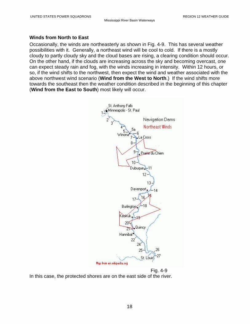
Winds from North to East Occasionally, the winds are northeasterly as shown in Fig. 4-9. This has several weather possibilities with it. Generally, a northeast wind will be cool to cold. If there is a mostly cloudy to partly cloudy sky and the cloud bases are rising, a clearing condition should occur. On the other hand, if the clouds are increasing across the sky and becoming overcast, one can expect steady rain and fog, with the winds increasing in intensity. Within 12 hours, or so, if the wind shifts to the northwest, then expect the wind and weather associated with the above northwest wind scenario (Wind from the West to North.) If the wind shifts more towards the southeast then the weather condition described in the beginning of this chapter (Wind from the East to South) most likely will occur.
Fig. 4-9
In this case, the protected shores are on the east side of the river.
UNITED STATES POWER SQUADRONS REGION 12 WEATHER GUIDE Mississippi River Basin Waterways
19
Islands To complicate the wind and weather process even more, islands in the river and along the shore of the river can have a strong effect on the river boater. Figure 4-10 illustrates how the wind currents will change in direction around an island.
Fig. 4-10
Illustrated is a northwest wind blowing from the land over the river. However, there is an island in the way. The wind will do several things. First, in the horizontal, it will blow around both ends of the island (see red lines and arrows.) Notice that in one case the wind will head up towards the wind that is blowing around the island from the other direction. These winds will tend to cancel each other out so that there will be an area of relative calm on the leeward side of the island called a wind shadow. This is a protected area. Some of the wind will go up over the island and come down vertically into the wind shadow supporting the calm wind conditions found there. However, if the boater leaves the wind shadow then a strong wind will be found that is blowing from the northwest that is stronger than the original northwest wind over the land. The boater is urged to become familiar with the islands in his or her favorite boating area as they can help or hinder the boating experience. Where one river flows into another is called a confluence. See Fig. 4-11. Here a boater must pay special attention for weather that occurred on a tributary but not on the main river of passage. A wind blowing down the tributary into the Mississippi River can cause accelerated current and wind conditions on the tributary affecting the river confluence area. Also, there might have been strong thunderstorms several miles upstream on the tributary causing flooding downstream into the confluence. This faster current can pull downed tree branches and the like, out into the river to make for a hazardous boating area in a relatively narrow area on the river.
UNITED STATES POWER SQUADRONS REGION 12 WEATHER GUIDE Mississippi River Basin Waterways
20
Fig. 4-11
In some cases the tributary waters can actually be higher than the Mississippi River as the storm water flows into it. The boater must be very watchful for what is floating in or immediately under the water. Hence, the confluences of rivers are potential danger zones, due to past weather on one or all of the rivers making up the confluence. Storm Tracks There are areas along the Mississippi River and its tributaries that have stronger and more frequent storms than other areas. These are known as storm tracks. Large metropolitan areas, such as Minneapolis – St. Paul and St. Louis, given their locations to the river effect the storm track positions and pattern. Due to the length of the Mississippi River only a few of these places have been documented herein. However, with the following awareness of a few of these areas boaters can record the storm frequency and intensity in their favorite boating areas. The below graphic illustrates two of the many areas on the Mississippi River and two different types of tracks. The northerly tracks are in a west-to-east pattern each track paralleling another. Although they look close together on the graphic they are actually many miles apart. The boater can determine where exposure to storms will be the greatest if they were to happen.
UNITED STATES POWER SQUADRONS REGION 12 WEATHER GUIDE Mississippi River Basin Waterways
21
Storm tracks can be found at approximate miles of: 780, north of Frontenac Park; 773, Lake City; and 760, Wabasha. See Fig. 4-12. Generally, communities that have a high western bluff are fairly well protected from thunderstorms most intense fury. Therefore, these communities and nearby waters are good areas to seek out for safety. The Navigation Dams map, below, summarizes known storm tracks on the upper part of the Mississippi River.
Fig. 4-12 The southerly track around St. Louis shows a crisscross pattern. The storms in this area change direction of motion with the change of the seasons. Their track is from the southwest to northeast in the spring of the year, changing to almost lateral in late spring and early summer and then to a northwest to southeast track in late summer and fall, but always crossing around the St. Louis area. See Fig. 4-12. A major storm track is at Mile 812 – 813 on the Mississippi. The storms intensify as they come across central Minnesota reaching a maximum over Hastings, MN going into Prescott, WI. Affected areas are L&D #2, Kings Cove Marina, the southern portion of the St. Croix River and the eastern shoreline of the St. Croix and Mississippi River. See Fig. 4-13.
UNITED STATES POWER SQUADRONS REGION 12 WEATHER GUIDE Mississippi River Basin Waterways
22
(Major storm tracks on the Mississippi tributary, the St. Croix River, are at Hudson, WI and Kinnickinnic State Park.)
Fig. 4-13 The shaded areas within the map, Fig. 4-14, illustrates where frequent thunderstorm activities are during the summer months. Each area contains storm tracks that can be identified similarly to that shown and discussed above for the upper Mississippi River. It is left up to the boaters to determine if the storm track area applies to their particular boating location. Examining the map shows that some of the shaded areas are very close together which can be interpreted as being connected, meaning that if you are boating between two shaded areas there is no guarantee that you are outside of a storm track and in a protected area.
UNITED STATES POWER SQUADRONS REGION 12 WEATHER GUIDE Mississippi River Basin Waterways
23
This map is presented as a suggested guide to storm track potential and not to be used for formal boat trip planning purposes.
Fig. 4-14
Precipitation Precipitation refers to the falling of rain, hail and/or snow from the clouds to the earth surface. Although snow, as a subject, might catch an early or late boating season
UNITED STATES POWER SQUADRONS REGION 12 WEATHER GUIDE Mississippi River Basin Waterways
24
enthusiast it will not be addressed in this document other than that it is precipitation and it can happen. There are many reasons why precipitation occurs. This document addresses the most common reason in the Mississippi River Basin and that is the migration of the low-pressure system through the basin. See Fig. 4-4 in the Low-Pressure System, in A. Winds. It can be reassured that precipitation comes from clouds; therefore the boater can stay aware of the cloud situation. Serious cloudiness such as mostly cloudy to overcast are found on the northerly side of the warm and cold fronts. There also is a possible band of clouds on the warm air (southerly-side) of the cold front. Where the boater is located in relationship to these fronts will determine what type of precipitation that is possible. Precipitation associated with a warm front is usually a warm steady rain. This rain can last for several hours and can be associated with precipitation fog described, below. Although wet, in general, the boater can easily boat in this type of weather. If with this steady rain the winds increase in intensity then the storm is strong and the boater can experience a dangerous condition of having thunderstorms present and imbedded in the overcast clouds, giving the boater a strong blow and surges of rain. The cold front precipitation is short in duration, but intense. In front of the cold front, squall lines can form supporting strong winds, rain bursts and surges, hail, lightning and sometimes tornadoes. The winds are gusty from any direction, but at first from the direction of the on-coming thunderstorm cloud. Wind strengths can be measured easily at 25 to 35 mph and many times greater than that. Getting caught boating in a squall line should be avoided if at all possible. However, if caught, plan on having the storm lasting for less than an hour. See photos in Fig. 4-15.
Thunderstorm pictures courtesy of NOAA Photo Library
Fig. 4-15 There can be a second or possibly a third occurrence of a line of thunderstorms, each of shorter duration and less intense than the first line. When the wind shifts to the northwest the front has passed-by and cooler, dry air will be experienced. Hail can be a very damaging form of precipitation to the boat and the boater. Fiberglass and sunbrella cloth don’t hold up well in a hailstorm. Hailstones fall from thousands of feet up in the thunderstorm. The force of a hailstorm depends on the size of the hailstone, which
UNITED STATES POWER SQUADRONS REGION 12 WEATHER GUIDE Mississippi River Basin Waterways
25
is frequently between pea-size to golf ball size. The record hailstone was 19 inches in circumference as shown in Fig. 4-16.
Hailstone and Lightning Pictures Courtesy of NOAA Photo Librar
Fig. 4-16 E. Lightning Lightning and thunder go hand-in-hand. In a multi-sensory presentation, lightning provides the visual and the thunder provides the audio. Lightning safety is an important awareness to all boaters. The February 2003 Bulletin of the American Meteorological Society states: “If you are planning to be outside, Identify and stay within traveling range of a proper shelter. Employ the “30-30 rule” to know when to seek a safer location. The ’30-30 rule’ states that when you see lightning, count the time until you hear thunder. If this time is 30 seconds or less, go immediately to a safer place. If you can’t see the lightning, just hearing the thunder means lightning is likely within striking range. After the storm has apparently dissipated or moves on, wait 30 minutes or more after hearing the last thunder before leaving the safer location.” “The ‘30-30 rule’ is best suited for existing thunderstorms moving into the area. However, it can’t protect against the first lightning strike. Be alert to changes in sky conditions portending thunderstorm development directly overhead. Larger outdoor activities, with longer evacuation times, may require a longer lead-time than implied by the ’30-30 rule’ “ The “30-30 rule” can be expanded to approximate the distance the lightning is from your location. Count the seconds from when your see the lightning strike to when you hear the thunder clap. Divide the seconds by five to approximate the distance in statute miles from you to the actual lightning strike. If the storm is moving in your direction, you can determine how soon the lightning will be over you. (Note: lightning can strike up to 10 miles away from a thunderstorm. The 30 second warning equates to lightning being within 6 miles or less. A lightning bolt can come from any part of the thunderstorm cloud, not just the base; therefore, it doesn’t have to be overhead to strike.) Ex.: You timed the interval between the lightning and the thunder at ten seconds. Dividing by five, the distance is two miles. (10/5=2) At this rate, the cloud in which the lightning is generated and moving at 30 mph could be over you in four minutes. When you invoke the “30-30 rule” on board your boat, turn off all electronics and don’t touch any metal.
UNITED STATES POWER SQUADRONS REGION 12 WEATHER GUIDE Mississippi River Basin Waterways
26
F. Visibility Precipitation of any form can quickly reduce visibility, however, other phenomena such as fog, smoke, and pollution can restrict one’s ability to see well enough to make safe passage. The rule of thumb is that your boat speed should be such that you can stop your boat in half the visible distance. This assumes other boaters follow the same rule. Fog can develop when the relative humidity is measured upwards from 95% to 100%. This is a saturated atmosphere, and if there is a catalyst to set it off it can form rapidly and reduce visibility to zero. Fog can be a boater’s nightmare. The very best navigation tool in dense fog on the river is a good RADAR. Remember the rule: Set your speed so you can stop in half the distance of your visibility. Then hope an oncoming boater observes the same rule. The best option for the boater is to stop, tie up somewhere and wait it out. It is very dangerous to boat during a fog event. The following is a description of different types of fog found in the river basin. They are: Radiation Fog Advection Fog Precipitation Fog Upslope Fog Radiation Fog Radiation fog can form rapidly and can reduce visibility to zero. It is formed with clear skies and little wind. It is caused by heat radiating away from the ground, cooling the ground and the air just above. The fog forms as air-cools to its temperature that causes condensation. This can occur anytime of the day, but most occurrences are late afternoon and evening. To dissipate the fog, the sun needs to heat the air to the point where the fog evaporates or “burns off.” A hygrometer on-board the boat will give indications of fog forming or dissipating. Fog needs a minimum relative humidity greater than 95% to exist. Advection Fog Advection means air moving horizontally. Advection fog occurs when warm moist air blows over cold ground. The air cools until condensation takes place and fog forms. This fog type exists as long as the wind comes from the direction that creates the fog. The wind needs to change direction to eliminate the fog. The visibility, although reduced, usually stays above ¼ of a mile so a boater can carefully make way to a safe harbor. Precipitation Fog This fog type is associated with warm fronts and it occurs when warm rain falls into cool air, saturating the lower atmosphere, thereby causing fog to develop. The fog dissipates when the precipitation stops. Upslope Fog The wind can blow humid air up hills and slopes. As the air rises, it can cool until condensation occurs thereby causing a cloud to form. Because this cloud is on the slope
UNITED STATES POWER SQUADRONS REGION 12 WEATHER GUIDE Mississippi River Basin Waterways
27
surface, it is called fog. In the Mississippi River Basin this fog can be seen along the upper reaches of the river bluffs or nearby hills.
G. Clouds Clouds have been arbitrarily defined into type and related to levels in the atmosphere where they appear. Please see the Appendix for Cloud Pictures from the National Weather Service. There are basically two types: layered clouds and clouds with vertical development. Each type is associated with a different kind of weather. Note the different cloud shapes in Fig. 4-17. The layered clouds are defined as low, middle and high level clouds. If the bases of the layered clouds are smooth, these are called stratus clouds, if there is a roll or vertical development the word cumulus is associated with them. The name stratus is associated with the low level layered clouds. There are two types, stratus for the smooth looking clouds and stratocumulus for clouds with a roll or vertical development to them. These are found from the surface to about 6000 feet in altitude and are liquid in content. The middle layer clouds are found between 6000 and 20,000 feet. The names are altostratus, for the smooth looking clouds, and altocumulus for the clouds with a roll or vertical development. The middle layer clouds are also liquid in content. The precipitation clouds originate in the middle layer clouds. Steady precipitation starts falling from the altostratus cloud. This rain-producing cloud causes a thickening and lowering of the altostratus cloud. The resultant cloud is now called nimbostratus. Nimbo or nimbus means rain or precipitation, and steady precipitation comes from this type of cloud. Nimbostratus becomes progressively lower and thicker with the base of the nimbostratus lowering to about 1,000 feet. The highest clouds are cirrus clouds and are found above 20,000 feet. They can be cirrus stratus, and cirrocumulus. The high clouds are mostly ice in content. An approaching warm front can be determined by studying the cloud sequence. A warm front observation begins with a high cirrus cloud whose base is over 20,000 feet. This is followed by cirrostratus, then altostratus, and stratus. At this time you usually have steady precipitation to verify that the warm front is nearby. The vertically developed clouds are called cumulus. Cumulus clouds start out as puffy clouds with bases 2000 to 4000 feet above the surface. Over a brief period of time a cumulus cloud can develop into a thunderstorm. The life span of a “single cell” thunderstorm is about 45 minutes so there is a lot going on in a short period of time. Larger complexes of cells have life spans measured in hours. The complexes are the most damaging storms. The cloud formation associated with a cold front begins with the prevailing clouds in the warm sector, generally altocumulus and/or stratocumulus. As the front approaches, taller cumulus clouds appear. The cumulus clouds can grow into cumulonimbus, rising to as much as 50,000 feet, depending on the temperature and moisture contrast between the
UNITED STATES POWER SQUADRONS REGION 12 WEATHER GUIDE Mississippi River Basin Waterways
28
warm air and the advancing cold air. Heavy rain, strong gusty wind, lightning and even hail can develop. If you are boating when a cold front is approaching, it is wise to keep a sharp weather eye so you have time to move to safety if necessary. Shortly after a cold front passes, the sky usually becomes dotted with small white cumulus fair weather clouds. This is your clue that good weather will prevail for several days. Within a warm sector, a variety of cloud types may appear. High cirrus, cirrocumulus and various stratus clouds may be present. The Graphic, below, portrays the various cloud types and levels where they are found.
Picture, Courtesy of the USPS
Fig. 4-17 H. Seas We normally think of seas as ocean surface conditions. In the river system, we also experience wind-generated waves. Where the river widens to several miles and the fetch is a mile or more, a wind opposing the river current can kick up significant waves that can and do threaten small boats. In the narrow confines of the rivers, the waves are mostly modest and except for some large lakes and reservoirs, sea conditions are of little concern. I. Currents We normally think of currents ad being generated by daily tides. The rivers have their own down-stream currents generated by the rivers’ flow to the oceans. The current speed is influenced by the river’s rate of drop, the effect of man-made dams controlling the pools
UNITED STATES POWER SQUADRONS REGION 12 WEATHER GUIDE Mississippi River Basin Waterways
29
behind them, the amount of spring snow runoff as it makes its way to the Gulf of Mexico and the amount of rain runoff during the boating season. Comparing the speed over-the-ground going down- and up-stream, a two mph current, not uncommon, will make a 4 mph difference in over-the-ground boat speed at the same engine rpm. When planning your river cruise, this should be factored into you estimated daily travel distance. If you must anchor in the river, practice good seamanship by heading into the current with a slight drift down stream while you lower your anchor and lay it out on the bottom. J. Tides Inland waters are not affected by daily tides. K. Boat Deck Weather Forecasting The purpose of the information in this book is to assist you in making your own local forecasts. The most important part of making your own forecast is to GET OUT ON DECK AND LOOK AROUND! Your own observation should be the most accurate one available. In a short time, you will develop a “SEAMAN’S EYE”, which is that sense of continuously reading the sea, sky, and wind, and updating your forecast in your mind. Keeping a weather log (See Appendix G.) provides the basics for identifying weather trends. What entries have changed in comparing your current log entries to those of 3 to 6 hours ago? Log entries should address the following conditions.
• Has the wind direction changed? Is it veering? Backing? No change? • Has the wind speed changed? Is it increasing? Decreasing? No change? • Has the sea state (water surface) changed? Refer to the Beaufort Wind Scale.
Refer to the Appendix-B. • Applying the Buys Ballot’s Law, has the direction of low pressure changed? What is
the current direction? • Has the cloud pattern changed? What is the current cloud type? Refer to the
Appendix-C, Cloud Chart. • Has the barometric pressure changed? Is it rising? Falling? No change? • Has the temperature changed? Is it rising? Falling? No change? (Allow for daily
heating and cooling.) • Has the humidity changed? Is it increasing? Is it decreasing?
The above weather log components contribute to forecasting the movement and modification of weather systems. It is important to note that local influences can alter these components and disturb the progress of a weather system. Local influences may be the size of the body of water, the temperature contrast between the land and water at different times of the day and night, the physical makeup of the land near the water (plowed fields, forests, grasslands, etc.) and the topography of the land. Most notable will be alteration of the wind speed and direction in a fairly well defined river valley or gorge due to drainage or downslope winds created on warm, sunny summer days and nights. What weather information you can’t readily see, you can often get from the NOAA marine weather broadcasts on your marine VHF-FM radio, from regular weather reports on your AM band radio or real time weather radar via the internet. Of particular importance is the approach of weather fronts, especially, cold fronts. Using the available information, you will
UNITED STATES POWER SQUADRONS REGION 12 WEATHER GUIDE Mississippi River Basin Waterways
30
be able to make reasonably accurate forecasts for up to six hours with a 12 hour trend, and possibly longer. This information is more than adequate for predicting the weather for your day cruise. Cruises of longer duration need to have the above procedure performed on a daily bases. Each complete observation, including log entries, can be done in less than ten minutes. Refer to the Appendix for a copy of the Weather Log. REMEMBER: YOU ARE AT THE WEATHER OBSERVATION SITE!
UNITED STATES POWER SQUADRONS REGION 12 WEATHER GUIDE Mississippi River Basin Waterways
31
APPENDIX PAGE
A. Glossary of Terms 32
B. Geographical Boundaries 37
C. Beaufort Table and Scale 38
D. Cloud Pictures 39
E. Harbors of Refuge 40
F. Weather and VHF Radio Weather Information 41
G. Sample Weather Log 42
H. Graphics and Credits 44
UNITED STATES POWER SQUADRONS REGION 12 WEATHER GUIDE Mississippi River Basin Waterways
32
A. Glossary of Terms A. Advection fog A type of fog that is formed by warm moist air
flowing horizontally (advection) over a cold surface, thereby causing the moist air to condense into a low cloud called fog. This fog type needs a wind condition. Dissipation comes when the wind changes direction.
Air mass A widespread body of air that is mostly homogeneous in its horizontal extent, especially in temperature and moisture variation.
AM Radio The common radio that receives stations between 530 kilohertz and 1600 kilohertz.
Arctic air mass Related to the polar regions of the earth. Arctic air is noticed in the wintertime in Region 12 as an extremely low temperature.
Atmosphere What we call air. It is the gas that envelopes the earth in layers from the surface to very upper regions above the earth (approximately 70 miles.)
B. Backing wind A change in wind direction in a counterclockwise sense. (North to northwest to west.)
Beaufort Scale A system of estimating wind speed by observing surface water conditions and/or trees, smoke from stacks, etc.
Buy’s Ballot law Buy’s Ballot was a Dutch meteorologist that developed a technique that rapidly determines the location of a low-pressure center via using the horizontal wind direction.
C. Clouds A visible cluster of minute water droplets or ice particles suspended in the atmosphere.
Cold front The leading edge of a cold-air air mass that replaces warm air.
Condensation The physical process by which water vapor becomes a liquid or solid.
Confluence Where one or more rivers meet. Continental polar air
An air mass that develops over a land area in Canada or the upper plains states. Usually is cool to cold with a low moisture content.
Continental tropical An air mass that developed over the southwest desert or Mexico. Usually warm and very dry.
Cumulus A cloud type that develops vertically appearing as rising mounds, domes or towers, the upper
UNITED STATES POWER SQUADRONS REGION 12 WEATHER GUIDE Mississippi River Basin Waterways
33
parts often resemble a cauliflower. Cumulonimbus The thunderstorm. A dense vertically
developed cloud. Associated weather includes lightning, thunder, rain shafts, hail, strong gusty wind and tornadoes.
Cyclone A term associated with a low-pressure area. The winds blow around the cyclone in a counterclockwise direction.
D. Dewpoint Temperature The temperature in which dew forms. Downslope wind Wind directed down a slope. If associated with
a large-scale event downslope winds have warming, drying, and clearing if clouds are present.
Drainage wind Cold air runoff winds that are in contact with the surface and run downslope or down valley.
E. Equatorial Associated with a source region on and around the equator.
F. Fetch A relatively uniform water area where waves are generated by a wind having a constant direction and speed. The upwind distance to the receptor site limits the fetch.
Front The interfacing edge between two different air masses.
Funnel cloud A funnel-shaped cloud usually protruding from the base of a thunderstorm but not touching the ground.
H. Harbors of refuge On the river these are marinas, or coves off the main river or backwaters that give the boater protection from the weather in process. Such as heavy winds and gusts, and somewhat from a driving rain.
High An area in the atmosphere that has high barometer readings. Associated with clearing skies and reduced wind speed.
Hurricane A tropical cyclone (intense low pressure area) which has winds of 74 miles per hour or greater. Found north of the equator in the western hemisphere in both the Atlantic and Pacific Oceans.
L. Land breeze An ocean term for the wind moving from the land to the sea.
Latitude Distance between the equator (zero degrees) and the pole (90 degrees) expressed in degrees and fractions thereof.
Line of Thunderstorms Thunderstorms preceding an advancing cold front a frequently in a continuous line preceding the front. See Squall line.
UNITED STATES POWER SQUADRONS REGION 12 WEATHER GUIDE Mississippi River Basin Waterways
34
Longitude The distance around the equator measured in degrees or fractions thereof. Zero (0) degrees is defined as the line that runs through Greenwich, England and 180 degrees is defined as the International Dateline.
Low A term associated where the barometric pressure is lower than that found in the surrounding area. The wind blows counterclockwise around a low-pressure area.
M. Marine radio A radio designed for marine assigned frequencies the boating public plus the U.S. Coats Guard and others. It transmits and receives over VHF-FM radio frequencies.
Maritime polar air mass An air mass that has developed over the Pacific Ocean. Usually, mild in temperature, and in the winter can have high humidity and low humidity in the summer.
Maritime tropical air mass
An air mass that has developed over the Gulf of Mexico. It is usually warm with high humidity.
Mesosphere A very high level layer of atmosphere where ultraviolet radian from the sun is absorbed.
Migratory systems Pressure systems imbedded in the westerlies and, therefore, moving in a general west to east direction.
N. NOAA National Oceanic and Atmosphere Administration. A government agency that is responsible for the National Weather Service and other environmental activities.
O. Overcast A cloud layer that covers 95% or more of the sky.
P. Polar air A type of air mass that is developed in the higher latitudes. Associated with cooler or cold temperatures.
Precipitation Liquid or solid particles that are created in the clouds in the atmosphere and fall to the earth.
Pressure gradient Magnitude of the gradient of the pressure field. Q. Quimby’s Cruising
Guide A river boater’s best guide to boating on the Mississippi River and tributaries. Contains maps, mile markers, and important information about river stages, currents, marinas, available fuel types and supply and maintenance stores on the river and many other helpful hints that make boating more enjoyable. Authored and published by Waterways Journal, Inc.
R. Radiation fog A fog that forms when the winds are light and the skies are clear and there is very moist air just above the surface. Can be very dense
UNITED STATES POWER SQUADRONS REGION 12 WEATHER GUIDE Mississippi River Basin Waterways
35
reducing visibility to zero. Dissipation is when the sun heats up the atmosphere around the fog for it to evaporate.
Region 12 The USPS definition of the United States that contains the Mississippi River and its tributaries.
River current A relatively narrow width of water moving in homogeneously in the same direction.
S. Sea breeze An ocean term for the wind blowing from the sea onto the land.
Sea state The condition of the water surface at any time and place.
Seas On the ocean it is the same as the ocean. On the river it is sea state.
Squall A sudden wind that has a speed of 17 mph or greater and is sustained for at least 2 minutes.
Squall line A line of active thunderstorms. Storm tracks Generally refers to the path that storms take
over an area. Due to the relationship between storms and their modifiers of terrain, and cities, and other factors, storms have a tendency to miss certain areas or to take the same track and intensify over other areas as they move across the land.
Stratosphere The layer of atmosphere above the troposphere where the temperature warms with increasing altitude.
T. Thermosphere The outer most layer of the atmosphere that reaches from the mesosphere to outer space.
Thunderstorm Sometimes called an electrical storm. A local storm produced by a cumulonimbus cloud and always accompanied by lightning and thunder, usually with strong gusty winds, heavy rain and sometimes hail.
Tornado A violent column of air with one end in contact with the ground and the other end imbedded in the base of a thunderstorm.
Tropical Associated with the warm equatorial regions of the earth. Applies to storms and air mass temperatures and high humidity along the equator.
Tropopause A stable layer of the atmosphere that is between the troposphere, see below, and the stratosphere, see above. Temperature increases or is constant with increasing altitude.
Troposphere The lowest layer of atmosphere. This is where we live. It goes up 6 to 12 miles and is capped by the Tropopause. The troposphere is high at
UNITED STATES POWER SQUADRONS REGION 12 WEATHER GUIDE Mississippi River Basin Waterways
36
the equator and low over the poles. Temperature, in the vertical, decreases with increasing height.
U. Upslope fog A type of fog that forms when moist air flows up a rising terrain.
USACE United States Army Corp of Engineers. USPS United States Power Squadrons. V. Valley wind A wind that ascends a valley during the day. Veering wind A change of wind direction in a clockwise
direction. (North to northeast to east.) VHF Very high frequency. Associated with a radio
type that is called a marine radio. There is numerous weather reporting channels on this radio that are constantly being updated by the National Weather Service. This is the boater’s best continuous link to information about current and future weather.
Visibility The greatest distance in any direction that a person can see and identify objects.
W. Warm front Associated with the leading edge of air in which warm air replaces cold air.
Weather Weather is the state of the atmosphere as it applies to human activities. It is considered to include temperature, humidity, precipitation, clouds, visibility, and wind.
Weather log A written summary of weather observation made throughout a given period of time and performed in an established time step, such as every three (3) hours.
Wind Air in motion relative to the surface of the earth. Mostly assumed to be the speed of the horizontal wind measured by an anemometer or wind gauge with direction measured by a wind vane.
Reference: Glossary of Meteorology, Second Edition, American Meteorology Society, Boston, Massachusetts, U.S.A., 2000.
UNITED STATES POWER SQUADRONS REGION 12 WEATHER GUIDE Mississippi River Basin Waterways
37
B. Geographical Boundaries The states that are found within Region 12 are listed below by sub-region. Some states are only partially within the region.
Northern Sub-Region: Wisconsin – North: 45o 05’ N
South: Illinois border East: 90o 00’ W
West: St. Croix & Mississippi R. Minnesota - North: 45o05’ N South: Iowa border
East: St. Croix & Mississippi Rivers West: South Dakota border
Large branches of trees in motion; whistling heard in wires.
7 32 - 38 Moderate gale Sea heaps up; white foam from breaking waves begins to be blown in streaks.
Whole trees in motion; resistance felt in walking against the wind.
8 39 - 46 Fresh gale Moderately high waves of greater length; foam is blown in well marked streaks.
Twigs and small branches are broken off trees.
9 47 - 54 Strong gale High waves, sea begins to roll; dense streaks of foam; spray may reduce visibility.
Slight structural damage occurs; slate blown from roofs.
10 55 - 63 Whole gale Very high waves with overhanging crests; sea takes white appearance; visibility reduced.
Seldom experienced on land; trees broken; structural damage occurs.
11 64 - 72 Storm Exceptionally high waves; sea covered with white foam patches.
Very rarely experienced on land; usually with widespread damage.
12 73 or higher
Hurricane force
Air filled with foam; sea completely white with driving spray; visibility greatly reduced.
Violence and destruction.
UNITED STATES POWER SQUADRONS REGION 12 WEATHER GUIDE Mississippi River Basin Waterways
39
D. CLOUD PICTURES
UNITED STATES POWER SQUADRONS REGION 12 WEATHER GUIDE Mississippi River Basin Waterways
40
E. Harbors of Refuge “Forewarned is forearmed” is always good advise. Having a list of shelters with you can take some of the anxiety out of boating. Harbors of Refuge are common on the Great Lakes and along the coasts of the United States. They are rare on the inland waterways. Current issues of various waterway guidebooks contain a wealth of information about anchorages, marinas and safety tips for boaters. The Army Corps of Engineers river charts are valuable for their comprehensive river coverage. Quimby’s Cruising Guide lists location of marinas, locks, and other pertinent information helpful to the river boater. The United States Power Squadrons located in the Mississippi River Basin offer boating courses that address river boating challenges and opportunities to the boater. Those boaters that are interested can additionally join the local Power Squadron and take advanced courses, which are designed to give greater insight to the river they are boating on. Usually, these squadrons update their river charts yearly to keep up with the ever-changing conditions found on and along the river.
UNITED STATES POWER SQUADRONS REGION 12 WEATHER GUIDE Mississippi River Basin Waterways
41
F. Weather and VHF-FM Radio Information E. Weather and VHF Radio Information United States Power Squadrons Weather Course –Wx 101 & Wx 102 The Weather Book Jack Williams, USA Today, Second Edition: May 1997 NOAA Weather Radio (VHF) Frequency Channel 162.400 Mhz Wx5 162.425 Mhz Wx2 162.450 Mhz Wx4 162.475 Mhz Wx3 162.500 Mhz Wx6 162.525 Mhz Wx7 162.550 Mhz Wx1 Some VHF radios have NOAA Weather Alert interrupt signals. Many local AM and FM radio stations have frequent weather reports. Weather channels for selected Mississippi River Basin communities: Site Name Channel Call Sign Site Name Channel Call SignMinnesota Missouri Minneapolis/St. Paul Wx1 KEC65 Springfield Wx2 KXI35 Rochester Wx3 WXK41 St. Louis Wx2 KDO89 Winona Wx2 KGG95 Kansas City Wx1 KID77 Cape Girardeau Wx1 KXI93 Wisconsin La Crosse Wx1 WXJ86 Tennessee Menomonie Wx2 WXJ88 Dyersburg Wx6 WWH30 Prairie Du Chien Wx5 WWG86
Memphis Wx5 WXK49
Iowa Arkansas Maquoketa Wx2 KZZ83 Little Rock Wx1 WXJ55 Burlington Wx7 WXN83 Fort Smith Wx1 WXJ50 Illinois Kansas Rock Island Wx1 WXJ73 Wichita Wx1 KEC59 Galesburg Wx2 KZZ66 Alton Wx6 KXI35 Indiana Chester Wx4 KXI42 Evansville Wx1 KIG76 Peoria Wx5 WXJ71 Springfield Wx2 WXJ75 Mississippi Jackson Wx2 KIH35
UNITED STATES POWER SQUADRONS REGION 12 WEATHER GUIDE Mississippi River Basin Waterways
42
G . Sample Weather Log The next page is a sample of a Weather Log that can be used for day sailing adventures or for multiple day cruises. The Log has an example line at the bottom that emphasizes a personal short cut notation that is meaningful and yet stays within the columns. Selected definitions of terms used in this Log are:
DIR. Direction BARO. Barometric pressure value from an on-board barometer.* TEND. Tendency of the pressure over the last 3 hours. Rising, falling, steady and by
how much. TEMP Air temperature outside of the boat cabin. HUM. Relative humidity outside of the boat cabin. Measured with a hygrometer. AM’T Amount of sky covered with clouds. Estimated in tenths of the sky being
covered that can be seen from the deck of the boat. Using the above definitions and the Whether Log found on the next page, a boater filled out a Sample Weather Log with information gathered while boating on the river. Shown immediately below is a time frame from 1100 (11:00 A.M. local time) to 2000 (8 P.M. local time.) There were four observations with only one made while under way. You are encouraged to make copies of the Weather Log and record your day on the river to add to your boating experience.
* Your barometer should be adjusted to sea level pressure for uniformity with all reporting stations. The proper reading is in hectopascals (hPa), the international standard for sea level pressure. Common usage in the U.S. is to publish sea level pressure in inches of mercury for consumption by the public. The observation example above is in inches of mercury.
UNITED STATES POWER SQUADRONS UPPER MISSISSIPPI VALLEY REGIONAL WEATHER GUIDE
43
UNITED STATES POWER SQUADRONS UPPER MISSISSIPPI VALLEY REGIONAL WEATHER GUIDE
44
GRAPHICS & CREDITS
Wikipedia.org (Wikipedia: The Free Encyclopedia) Chapter 1: Fig. 1-1, 1-2, 1-4 Chapter 4: Fig. 4-5, 4-7, 4-8, 4-9, 4-12 United States Army Corps of Engineers (USACE) (www.usace.army.mil) Chapter 1: Fig. 1-3 Chapter 4: Fig. 4-13 University of Illinois at Urbana-Champaign WW 2010 Project Chapter 3: Fig. 3-3 Nationalatlas.gov Chapter 2: Fig. 2-1, 2-2, 2-4 Chapter 4: Fig., 4-14 U.S.P.S Weather Course and USA Today Chapter 3: Fig. 3-2 Chapter 4: Fig. 4-2, 4-3, 4-4 USPS: (www.usps.org) Chapter 4: Fig. 4-1, 4-17 National Oceanic & Atmospheric Administration (NOAA) Photo Library Chapter 4: Fig. 4-15, 4-16 NOAA – National Weather Service Appendix: D Bruce Thompson, collaborator Chapter 4: Fig. 4-6, 4-10, 4-11 Temperature Graphs Chapter 2: Fig. 2-3 Atmosphere Chapter 3: Fig. 3-1