ENBE | Final Project | Part A – Report | The Better Livable Town Better Livable Town Hakuna Matata JOYCE WEE YI QIN |0319602 FNBE APR 2014 | Taylor’s University JOYCE WEE YI QIN| 0319602 | PN HAS | FNBE APR 2014 | Taylor’s University 1
Transcript
ENBE | Final Project | Part A – Report | The Better Livable Town
Better Livable Town
Hakuna Matata JOYCE WEE YI QIN |0319602
FNBE APR 2014 | Taylor’s University
JOYCE WEE YI QIN| 0319602 | PN HAS | FNBE APR 2014 | Taylor’s University1
ENBE | Final Project | Part A – Report | The Better Livable Town
Content:1. Introduction (P3)
2. A Town (P4-5)
3. Investigation & Data Collection: Ancient and old cities/town (P6-7)
4. Investigation & Data Collection: The present towns/cities(P8-11)
5. Investigation & Data Collection: The future and better township(P12-16)
6. The New “X” Town (P17-24)
7. The Conclusion (P25)
8. References list (P26-27)
JOYCE WEE YI QIN| 0319602 | PN HAS | FNBE APR 2014 | Taylor’s University2
ENBE | Final Project | Part A – Report | The Better Livable Town
1.Introduction
For this project, I will have to be the mayor of The ‘X’ Town. The people in ‘X’ Town require a new town because the previous town is too crowded. As a mayor, I will need to propose a new layout for the new ‘X’ town in a short period of time.
The town will be small with an area of 30km2 or smaller with a population in between 80,000- 200,000. The town is to be planned for a group of Malaysians and the town is in Malaysia. When planning the town, there’s a lot to be considered including the structure and zoning of the town. The planning should also include sustainable living initiatives.
I am required to make thorough research on ancient, present and future towns before the planning of the ‘X’ Town. The reason being it is important to learn from the past to not make mistakes. Also, researches on future towns can bring in new ideas and technologies on the new town.
Through this project, I am
1. To expose the elements of the natural and built environment in their basic unit, form and function
2. To show symbiotic relationship of the elements of the natural and built environment
3. To question, analyze and articulate the impact between natural and built environment
JOYCE WEE YI QIN| 0319602 | PN HAS | FNBE APR 2014 | Taylor’s University3
ENBE | Final Project | Part A – Report | The Better Livable Town
2.The TownThe Town Definition
A town is an urban area that has a name, defined boundaries, and local government, and that is generally larger than a village and smaller than a city. Unlike cities, towns tend not to incorporate surrounding areas. Towns are ruled by municipalities with a chairman as the head of municipality instead of a mayor.
What is the brief history?
A town is not just an overgrown village. It has its own economy. Goods are made and traded there. So a good site might be on a bend in a navigable river, or beside a river crossing. The development of towns is generally complex. In those of our historic towns not too mangled by Blitz or boom, you can trace the growth from medieval core through belts of Georgian, Victorian and modern buildings, almost like tree rings.
What makes a town?
A town is made up of a certain amount of population, government area, educational area, residential area, commercial area, religion and culture, parks, public services and supported by law, equipped by transportation, facilities and ports
What makes a good town/ township?
A better livable town should include:
- Organized zoning
- Complete and proper planning of infrastructure
- A landmark (or a few)
- Fixed transits should be used widely to keep the streets busy
- Less dependency on fossil fueled automobiles
- Less carbon emission
JOYCE WEE YI QIN| 0319602 | PN HAS | FNBE APR 2014 | Taylor’s University4
ENBE | Final Project | Part A – Report | The Better Livable Town
- Green spaces to reduce the heat island effect
- Wise use of natural and/or renewable resources to decrease the level of pollution
- Practicing 3R
- Connectivity between citizens
- Transparency between the municipal and citizens
- Advanced technology in terms of health and medical knowledge
- Low crime rate
- Free trade zone
JOYCE WEE YI QIN| 0319602 | PN HAS | FNBE APR 2014 | Taylor’s University5
ENBE | Final Project | Part A – Report | The Better Livable Town
What is a future town?
A future town is basically a smart and sustainable town socially and environmentally. A future town aims to reduce or eliminate fossil-fuel use, adopt sustainable building practices, promote "green space" and clean air quality, implement energy-efficient and widely available public transportation, create walk able city designs and develop well-organized mixed-use neighborhoods that combine living, working and shopping. These qualities add up to sustainable urbanism.
JOYCE WEE YI QIN| 0319602 | PN HAS | FNBE APR 2014 | Taylor’s University6
ENBE | Final Project | Part A – Report | The Better Livable Town
3.Investigation & Data Collection:
Ancient Cities / towns
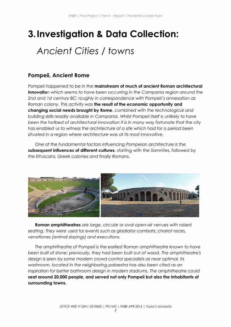
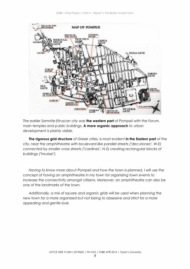
Pompeii, Ancient Rome
Pompeii happened to be in the mainstream of much of ancient Roman architectural innovation which seems to have been occurring in the Campania region around the 2nd and 1st century BC: roughly in correspondence with Pompeii’s annexation as Roman colony. This activity was the result of the economic opportunity and changing social needs brought by Rome, combined with the technological and building skills readily available in Campania. Whilst Pompeii itself is unlikely to have been the hotbed of architectural innovation it is in many way fortunate that the city has enabled us to witness the architecture of a site which had for a period been situated in a region where architecture was at its most innovative.
One of the fundamental factors influencing Pompeian architecture is the subsequent influences of different cultures, starting with the Samnites, followed by the Etruscans, Greek colonies and finally Romans.
Roman amphitheatres are large, circular or oval open-air venues with raised seating. They were used for events such as gladiator combats, chariot races, venationes (animal slayings) and executions.
The amphitheatre of Pompeii is the earliest Roman amphitheatre known to have been built of stone; previously, they had been built out of wood. The amphitheatre's design is seen by some modern crowd control specialists as near optimal. Its washroom, located in the neighboring palaestra has also been cited as an inspiration for better bathroom design in modern stadiums. The amphitheatre could seat around 20,000 people, and served not only Pompeii but also the inhabitants of surrounding towns.
JOYCE WEE YI QIN| 0319602 | PN HAS | FNBE APR 2014 | Taylor’s University7
ENBE | Final Project | Part A – Report | The Better Livable Town
The earlier Samnite-Etruscan city was the western part of Pompeii with the Forum, main temples and public buildings. A more organic approach to urban development is plainly visible.
The rigorous grid structure of Greek cities, is most evident in the Eastern part of the city, near the amphitheatre with boulevard-like parallel streets ("decuriones", W-E) connected by smaller cross streets ("cardines", N-S) creating rectangular blocks of buildings ("insulae").
Having to know more about Pompeii and how the town is planned, I will use the concept of having an amphitheatre in my town for organizing town events to increase the connectivity amongst citizens. Moreover, an amphitheatre can also be one of the landmarks of the town.
Additionally, a mix of square and organic grids will be used when planning the new town for a more organized but not being to obsessive and strict for a more appealing and gentle look.
JOYCE WEE YI QIN| 0319602 | PN HAS | FNBE APR 2014 | Taylor’s University8
ENBE | Final Project | Part A – Report | The Better Livable Town
4.Investigation & Data Collection:
Present Towns / township
City of London
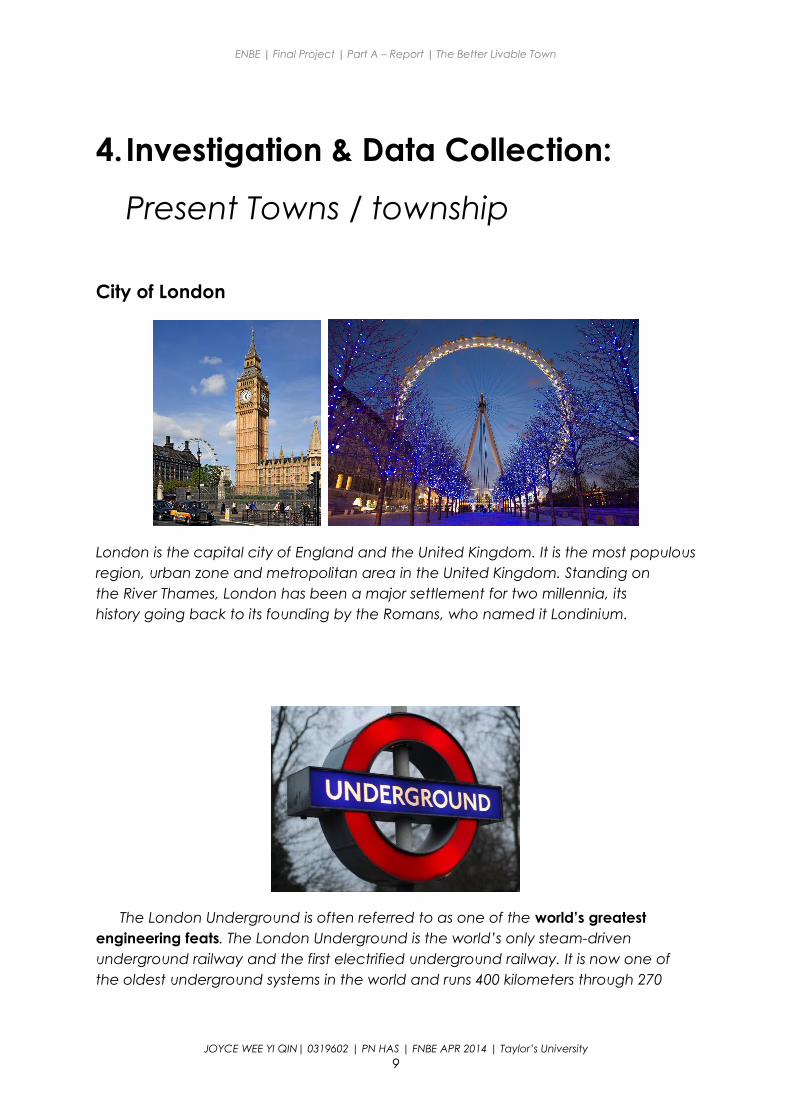
London is the capital city of England and the United Kingdom. It is the most populous region, urban zone and metropolitan area in the United Kingdom. Standing on the River Thames, London has been a major settlement for two millennia, its history going back to its founding by the Romans, who named it Londinium.
The London Underground is often referred to as one of the world’s greatest engineering feats. The London Underground is the world’s only steam-driven underground railway and the first electrified underground railway. It is now one of the oldest underground systems in the world and runs 400 kilometers through 270
JOYCE WEE YI QIN| 0319602 | PN HAS | FNBE APR 2014 | Taylor’s University9
ENBE | Final Project | Part A – Report | The Better Livable Town
stations. With over one billion passengers, the Tube is one of the most travelled transport systems in the world.
The system's first tunnels were built just below the surface using the cut and cover method. Later, circular tunnels – which give rise to its nickname the Tube – were dug through the London Clay at a deeper level.
As of 2012, 91 per cent of operational expenditure is covered by passenger fares. Today in official publicity and in general, the term 'Tube' embraces the whole Underground system, not just the lines that run in deep-level tunnels. The schematic Tube map, designed by Harry Beck in 1931, was voted a national design icon in 2006
Amsterdam, Netherlands
JOYCE WEE YI QIN| 0319602 | PN HAS | FNBE APR 2014 | Taylor’s University10
ENBE | Final Project | Part A – Report | The Better Livable Town
Amsterdam is the capital city of The Netherlands and the most populous within the Kingdom of the Netherlands. The city is located in the province of North Holland (Noord Holland) in the west of the country. It comprises much of the northern part of the Randstad, one of the larger conurbations in Europe, with a population of approximately 7 million.
Amsterdam is the most bicycle-friendly capital city in the world. In Amsterdam, over 60% of trips are made by bike in the inner city and 38% of trips are made by bike overall in the greater city area.
As is common in Dutch cities, Amsterdam has a wide net of traffic-calmed streets and world-class facilities for cyclists. All around are bike paths and bike racks, and several guarded bicycle parking stations (Fietsenstalling) which can be used for a nominal fee. In 2006, there were about 1,000,000 bicycles in Amsterdam.[4]
Bicycles are used by all socio-economic groups because of they are quick from A to B, their convenience, Amsterdam's small size, the 400 km of bike paths,[5] the flat terrain, and the arguable inconvenience of driving an automobile: driving a car is discouraged, parking fees are expensive, and many streets are closed to cars or are one-way.[6] Amsterdam's bike paths (Fietspad) are coloured brown, in order to differentiate it from a footpath.
JOYCE WEE YI QIN| 0319602 | PN HAS | FNBE APR 2014 | Taylor’s University11
ENBE | Final Project | Part A – Report | The Better Livable Town
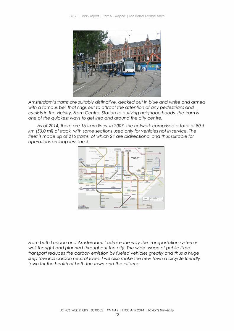
Amsterdam’s trams are suitably distinctive, decked out in blue and white and armed with a famous bell that rings out to attract the attention of any pedestrians and cyclists in the vicinity. From Central Station to outlying neighbourhoods, the tram is one of the quickest ways to get into and around the city centre.
As of 2014, there are 16 tram lines. In 2007, the network comprised a total of 80.5 km (50.0 mi) of track, with some sections used only for vehicles not in service. The fleet is made up of 216 trams, of which 24 are bidirectional and thus suitable for operations on loop-less line 5.
From both London and Amsterdam, I admire the way the transportation system is well thought and planned throughout the city. The wide usage of public fixed transport reduces the carbon emission by fueled vehicles greatly and thus a huge step towards carbon neutral town. I will also make the new town a bicycle friendly town for the health of both the town and the citizens
JOYCE WEE YI QIN| 0319602 | PN HAS | FNBE APR 2014 | Taylor’s University12
ENBE | Final Project | Part A – Report | The Better Livable Town
5.Investigation & Data Collection:
The future of towns and Better Towns
Dockside Green, Victoria, British Columbia
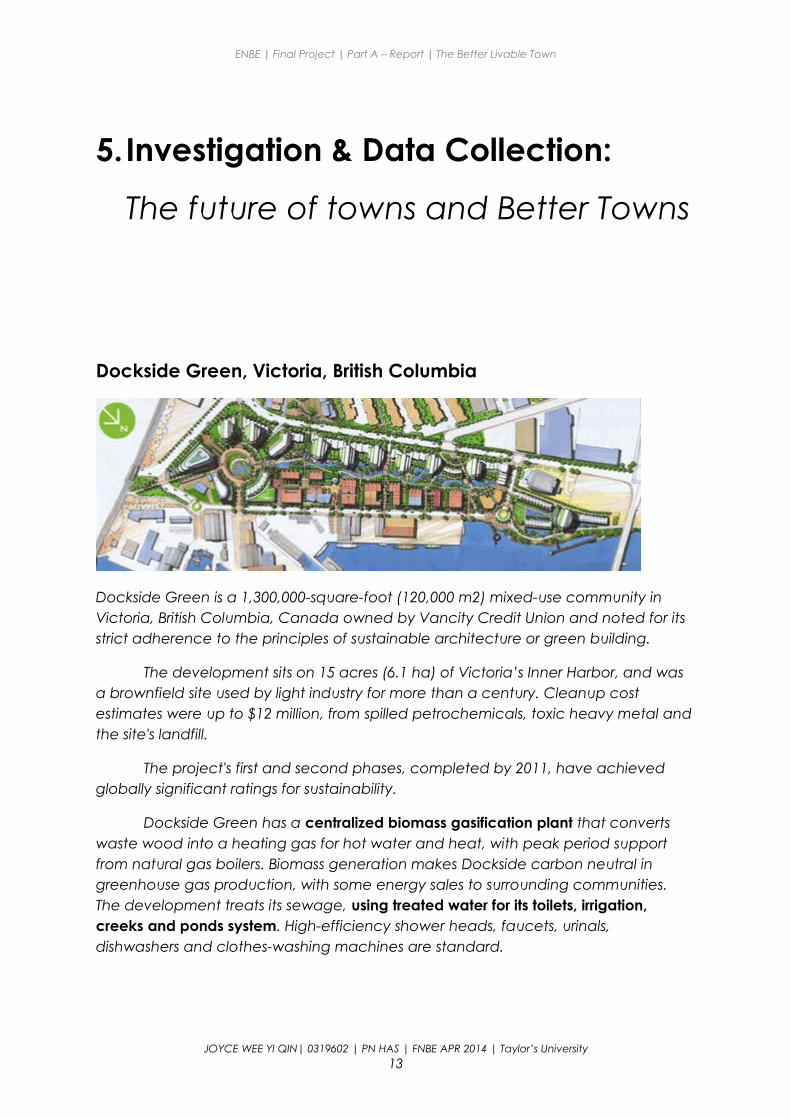
Dockside Green is a 1,300,000-square-foot (120,000 m2) mixed-use community in Victoria, British Columbia, Canada owned by Vancity Credit Union and noted for its strict adherence to the principles of sustainable architecture or green building.
The development sits on 15 acres (6.1 ha) of Victoria’s Inner Harbor, and was a brownfield site used by light industry for more than a century. Cleanup cost estimates were up to $12 million, from spilled petrochemicals, toxic heavy metal and the site's landfill.
The project's first and second phases, completed by 2011, have achieved globally significant ratings for sustainability.
Dockside Green has a centralized biomass gasification plant that converts waste wood into a heating gas for hot water and heat, with peak period support from natural gas boilers. Biomass generation makes Dockside carbon neutral in greenhouse gas production, with some energy sales to surrounding communities. The development treats its sewage, using treated water for its toilets, irrigation, creeks and ponds system. High-efficiency shower heads, faucets, urinals, dishwashers and clothes-washing machines are standard.
JOYCE WEE YI QIN| 0319602 | PN HAS | FNBE APR 2014 | Taylor’s University13
ENBE | Final Project | Part A – Report | The Better Livable Town
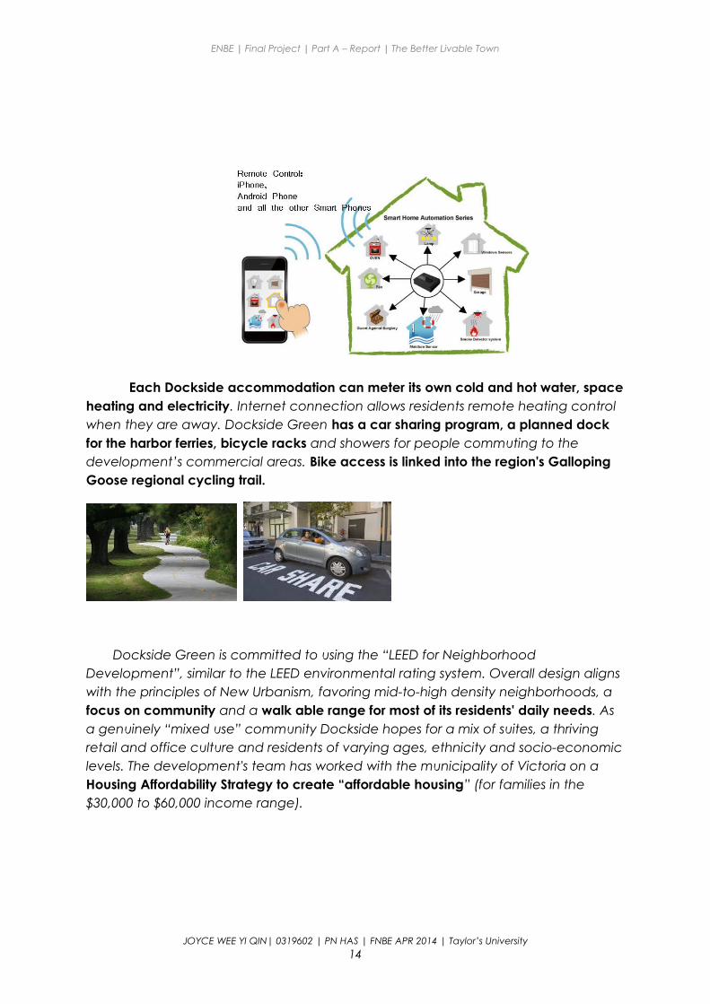
Each Dockside accommodation can meter its own cold and hot water, space heating and electricity. Internet connection allows residents remote heating control when they are away. Dockside Green has a car sharing program, a planned dock for the harbor ferries, bicycle racks and showers for people commuting to the development’s commercial areas. Bike access is linked into the region's Galloping Goose regional cycling trail.
Dockside Green is committed to using the “LEED for Neighborhood Development”, similar to the LEED environmental rating system. Overall design aligns with the principles of New Urbanism, favoring mid-to-high density neighborhoods, a focus on community and a walk able range for most of its residents' daily needs. As a genuinely “mixed use” community Dockside hopes for a mix of suites, a thriving retail and office culture and residents of varying ages, ethnicity and socio-economic levels. The development's team has worked with the municipality of Victoria on a Housing Affordability Strategy to create “affordable housing” (for families in the $30,000 to $60,000 income range).
JOYCE WEE YI QIN| 0319602 | PN HAS | FNBE APR 2014 | Taylor’s University14
ENBE | Final Project | Part A – Report | The Better Livable Town
Masdar City, Abu Dhabi
Architecture
Masdar is a sustainable mixed-use development designed to be very friendly to pedestrians and cyclists.
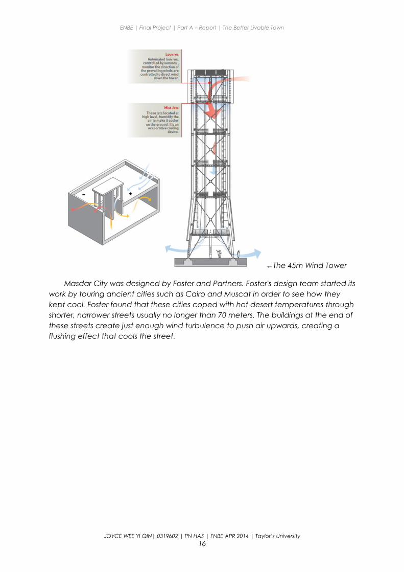
Masdar City has terracotta walls decorated with arabesque patterns. From a distance, Masdar City looks like a cube. The temperature on Masdar's streets is generally 15 to 20°C cooler than the surrounding desert. The temperature difference is due to Masdar's unique construction. A 45-meter high wind tower modeled on traditional Arab designs sucks air from above and pushes a cooling breeze through Masdar's streets. The site is raised above the surrounding land in order to create a slight cooling effect. Buildings are clustered close together in order to create streets and walkways shielded from the sun.
JOYCE WEE YI QIN| 0319602 | PN HAS | FNBE APR 2014 | Taylor’s University15
ENBE | Final Project | Part A – Report | The Better Livable Town
←The 45m Wind Tower
Masdar City was designed by Foster and Partners. Foster's design team started its work by touring ancient cities such as Cairo and Muscat in order to see how they kept cool. Foster found that these cities coped with hot desert temperatures through shorter, narrower streets usually no longer than 70 meters. The buildings at the end of these streets create just enough wind turbulence to push air upwards, creating a flushing effect that cools the street.
JOYCE WEE YI QIN| 0319602 | PN HAS | FNBE APR 2014 | Taylor’s University16
ENBE | Final Project | Part A – Report | The Better Livable Town
Transport system
The initial design banned automobiles, as travel will be accomplished via public mass transit and personal rapid transit (PRT) systems, with existing road and railways connecting to other locations outside the city. The absence of motor vehicles coupled with Masdar's perimeter wall, designed to keep out the hot desert winds, allows for narrow and shaded streets that help funnel cooler breezes across the city. In October 2010 it was announced the PRT would not expand beyond the pilot scheme due to the cost of creating the undercroft to segregate the system from pedestrian traffic. Subsequently, a test fleet of 10 Mitsubishi i-MiEV electric cars was deployed in 2011 as part of a one-year pilot to test a point-to-point transportation solution for the city as a complement to the PRT and the freight rapid transit (FRT), both of which consist of automated electric-powered vehicles.
JOYCE WEE YI QIN| 0319602 | PN HAS | FNBE APR 2014 | Taylor’s University17
ENBE | Final Project | Part A – Report | The Better Livable Town
←PodCar (PRT)
←Electric car
Under a revised design, public transport within the city will rely on methods other than the PRTs. Masdar will instead use a mix of electric vehicles and other clean-energy vehicles for mass transit inside the city. The majority of private vehicles will be restricted to parking lots along the city's perimeter. Abu Dhabi's existing light rail and metro line will connect Masdar City's centre with the greater metropolitan area.
Energy management
Masdar is powered by a 22-hectare field of 87,777 solar panels with additional panels on roofs. There are no light switches or water taps in the city; Movement sensors control lighting and water in order to cut electricity and water consumption by 51 and 55 percent respectively. Gerard Evenden, the lead architect, says that the original plan for Masdar City called for powering the entire city through on-site methods such as rooftop solar panels.
Water management
Water management has been planned in an environmentally sound manner as well. Approximately 80 percent of the water used will be recycled and waste water will be reused "as many times as possible", with this greywater being used for crop irrigation and other purposes,
JOYCE WEE YI QIN| 0319602 | PN HAS | FNBE APR 2014 | Taylor’s University18
ENBE | Final Project | Part A – Report | The Better Livable Town
6.The New “X” City / The New NAME?
Hakuna Matata No worries for the rest of your days.
Reports on the world coming to an end are bringing the world towards the country as it might be the last piece of living land on earth. Within weeks, the country’s population had increased greatly.
The huge amounts of immigrants have deprived the privileges of the fellow Malaysians that previously lived with ease, peace and space. Green spaces and forests are destroyed to build new buildings for the extra load of inhabitants causing the air condition to worsen, making it hard to breathe.
Thus, a humble man (me) took up the responsibility to bring back the good life the fellow Malaysians once had by building a new town with the financial aid from the residents-to-be.
As a river is essential to life and is the beginning to all human civilization, the town is proposed to be built with a river flowing through. The town will also be shield with a web like membrane for an ever optimal temperature in town. Also, there will be an abundance of green spaces and community areas for citizens to mingle around
As the mayor of Hakuna Matata, several sustainable elements will be taken into account in planning the new town such as using public transport, implementing 3R lifestyle and also growing crops the organic way to create a carbon neutral city.
JOYCE WEE YI QIN| 0319602 | PN HAS | FNBE APR 2014 | Taylor’s University19
ENBE | Final Project | Part A – Report | The Better Livable Town
Elements in Hakuna Matata
1. Fixed transit routes
Fixed transit routes are planned for trams and a new personal rapid transit network, The Pod throughout the new town.
Fixed transit helps to guide development and keep the streets busy. When development happens around fixed-transit, it is easy to get around on foot because everything is closer together. On the contrary, when transit isn't fixed, as with a diesel bus route, or it is designed around the auto, transit becomes impractical because everything is further apart.
2. Bicycle friendly town
Multistory automatic bicycle parking stations are located around the business district for working cyclists to park their vehicles while they’re working. Special carriages on trams are planned for cyclists to board with their bicycles. Bicycle lanes are paved and are closed from other mobile vehicles to ensure the safety of cyclists.
3. Green spaces and public squares
Green spaces can be found in every nick and corner of the town for a calming mood and also as a natural air-conditioner. Green spaces can also be used as community parks for citizens to mingle around.
We need to have places like public squares where we can be people together, whether we talk to one another or not, where we can pass among each other on our way to our daily chores, acknowledging our common humanity with a glance or a nod or a word.
4. Mixed use neighbourhood
By intermingling commercial, residential, and civic functions in the same neighborhoods, you reduce dependence on automotive transport, since destination facilities are always close at hand: one can walk to the market, the salon, the library, the bar, school or university, administrative offices, what have you. This means denser development is possible without reducing living spaces (you reduce space dedicated to the automobile, instead); it also means more tax money collected for more amenities and social programs, since streets don't pay taxes and parking lots don't pay much tax, but homes and businesses do.
JOYCE WEE YI QIN| 0319602 | PN HAS | FNBE APR 2014 | Taylor’s University20
ENBE | Final Project | Part A – Report | The Better Livable Town
Overall plan of Hakuna Matata:
JOYCE WEE YI QIN| 0319602 | PN HAS | FNBE APR 2014 | Taylor’s University21
ENBE | Final Project | Part A – Report | The Better Livable Town
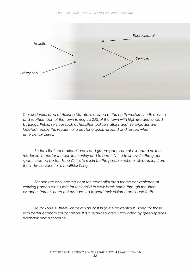
The residential area of Hakuna Matata is located at the north-western, north eastern and southern part of the town taking up 25% of the town with high rise and landed buildings. Public services such as hospitals, police stations and fire brigades are located nearby the residential areas for a quick respond and rescue when emergency arises.
Besides that, recreational areas and green spaces are also located next to residential areas for the public to enjoy and to beautify the town. As for the green space located beside Zone C, it is to minimize the possible noise or air pollution from the industrial zone for a healthier living.
Schools are also located near the residential area for the convenience of working parents as it is safe for their child to walk back home through the short distance. Parents need not rush around to send their children back and forth.
As for Zone A, there will be a high cost high rise residential building for those with better economical condition. It is a secluded area surrounded by green spaces, riverbank and a shoreline.
JOYCE WEE YI QIN| 0319602 | PN HAS | FNBE APR 2014 | Taylor’s University22
Hospital
Education
Recreational
Services
ENBE | Final Project | Part A – Report | The Better Livable Town
The council building is located at the heart of the town to keep an eye of the development of the town. The council building is a 6-storey building with the important offices underwater safeguarded 24 hours 7 days a week.
Business area is located near the commercial areas as both of them are connected in a way that both rely on each other for the economy of Hakuna Matata.
JOYCE WEE YI QIN| 0319602 | PN HAS | FNBE APR 2014 | Taylor’s University23
Council Building
Commercial
Central Business District
← The Council Building
ENBE | Final Project | Part A – Report | The Better Livable Town
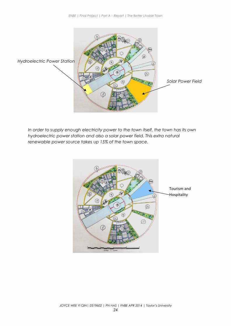
In order to supply enough electricity power to the town itself, the town has its own hydroelectric power station and also a solar power field. This extra natural renewable power source takes up 15% of the town space.
JOYCE WEE YI QIN| 0319602 | PN HAS | FNBE APR 2014 | Taylor’s University24
Hydroelectric Power Station
Solar Power Field
Tourism and Hospitality
ENBE | Final Project | Part A – Report | The Better Livable Town
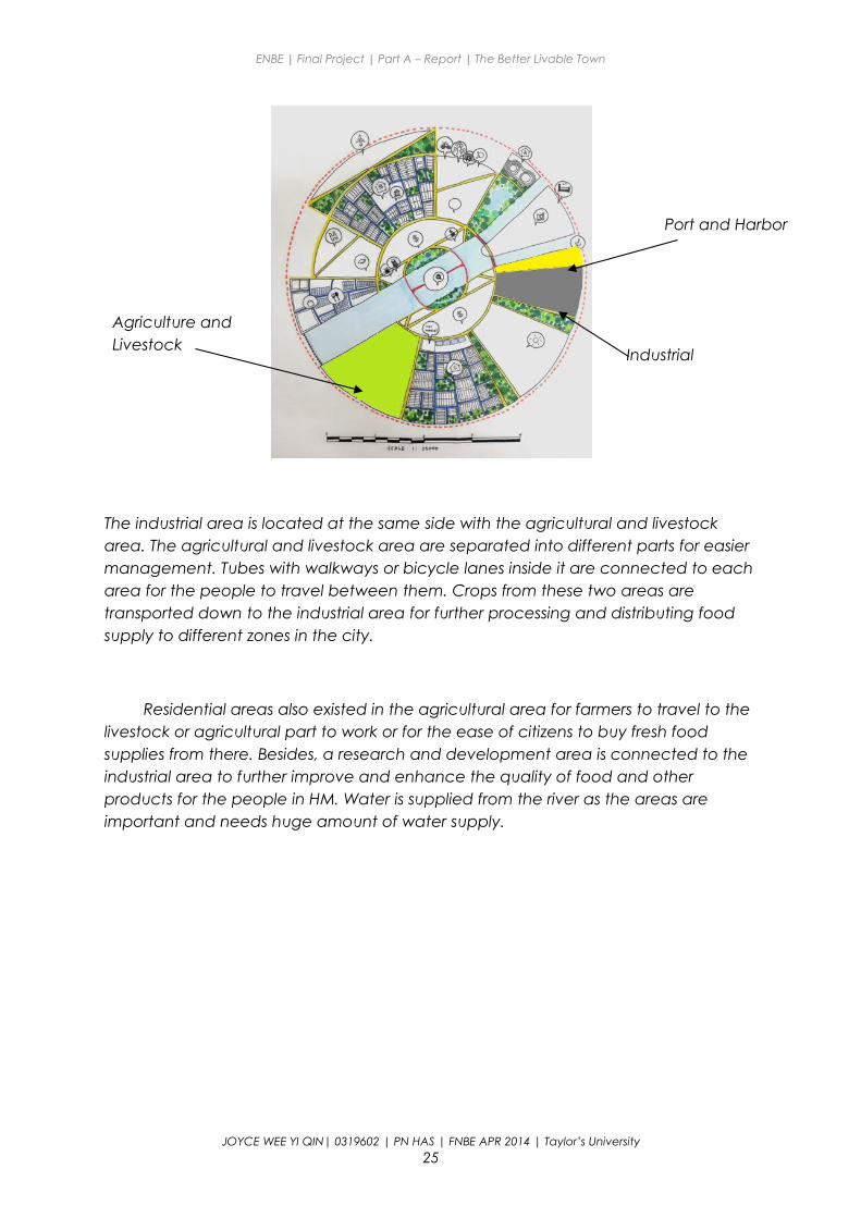
The industrial area is located at the same side with the agricultural and livestock area. The agricultural and livestock area are separated into different parts for easier management. Tubes with walkways or bicycle lanes inside it are connected to each area for the people to travel between them. Crops from these two areas are transported down to the industrial area for further processing and distributing food supply to different zones in the city.
Residential areas also existed in the agricultural area for farmers to travel to the livestock or agricultural part to work or for the ease of citizens to buy fresh food supplies from there. Besides, a research and development area is connected to the industrial area to further improve and enhance the quality of food and other products for the people in HM. Water is supplied from the river as the areas are important and needs huge amount of water supply.
JOYCE WEE YI QIN| 0319602 | PN HAS | FNBE APR 2014 | Taylor’s University25
Agriculture and Livestock
Industrial
Port and Harbor
ENBE | Final Project | Part A – Report | The Better Livable Town
Transportation system
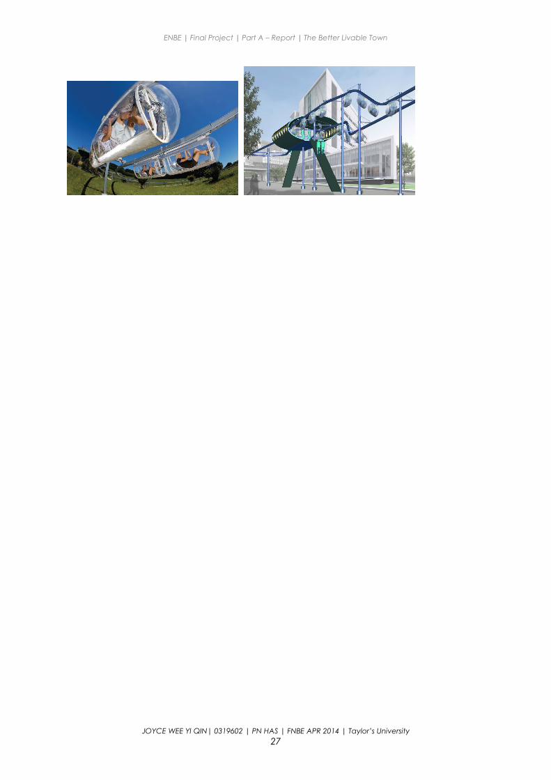
The Pod
The pod is a Personal rapid transit network based on human-powered monorail cars. The track is built in folded galvanized steel. Its external height is 220mm x width 200 mm. Support piles are also in galvanized steel. Pods are covered with transparent plastic sheets, with ventilation holes. Front and rear long dampers limit the impact acceleration in case of pods collide and to ease the association of pods to build 'pod trains' which could significantly improve overall aerodynamic efficiency.
JOYCE WEE YI QIN| 0319602 | PN HAS | FNBE APR 2014 | Taylor’s University26
The Pod
Electric Vehicle
Tram routes
Bicycle lanes
ENBE | Final Project | Part A – Report | The Better Livable Town
JOYCE WEE YI QIN| 0319602 | PN HAS | FNBE APR 2014 | Taylor’s University27
ENBE | Final Project | Part A – Report | The Better Livable Town
7. Conclusion
The design process of a new town is not as easy as it seems. From the structure of the town to the town planning stratergies and the features to make it sustainable, every slightest detail needs to be taken into account to create an organized town.
The idea generation of the town structure started hard as they are hard to fulfill other aspects as zonings of the town needs to be considered. In the end I’ve changed the structure of my future town several times.
Through all the research about the cities above, I’ve learned that priority of citizens is placed before everything. Other than that, to achieve a future town, green town planning must also be taken into account. I’ve known more about sustainability and ways to make a town sustainable.
This project is a good experience for me to experience the scope of work as an urban planner and how town planning works and sustainability of a town can create a better living for the years to come.
JOYCE WEE YI QIN| 0319602 | PN HAS | FNBE APR 2014 | Taylor’s University28
ENBE | Final Project | Part A – Report | The Better Livable Town
Reference Links
Difference Between City and Town | Difference Between | City vs Town http://www.differencebetween.net/miscellaneous/politics/difference-between-city-and-town/#ixzz37GW45xqv
Sustainable City News: Top Ten Characteristics of a Healthy City http://www.newcolonist.com/topten2.html