You are in the Cache Creek Watershed The Watershed and Creek The Cache Creek Watershed is 1,129 square miles (2,950 km) and spans the Coast Ranges, Capay Hills, and Capay Valley. Cache Creek is 87 miles (140 km) long and flows from Clear Lake into the Cache Creek Settling Basin north of Woodland. The creek has two main tributaries: the North Fork of Cache Creek and Bear Creek. 31 miles of upper Cache Creek is designated as a National Wild and Scenic River. As the creek flows through Capay Valley, a portion is diverted for agriculture. Yolo County Flood Control & Water Conservation District manages creek water flows. Where did the water go? Cache Creek is different from many creeks; it goes underground in some places and doesn’t usually flow all year. Native fish are adapted to low summer flows. The Cache Creek Watershed The Cache Creek watershed is located on the eastern flank of the California Coast Ranges, approximately 125 km (80 mi) north/ northeast of San Francisco. Geology Exposed mountainsides in the upper canyon show folds and faults in the rock. The Capay Hills consist of layers of sand, sediment, and shale which eroded to form the fertile agricultural soils of Capay Valley. YOU ARE HERE ESPARTO WOODLAND g CACHE CREEK SETTLING BASIN g CAPAY GUINDA RUMSEY CLEAR LAKE INDIAN VALLEY RESERVOIR C A C H E C R E E K R O B I N S O N CR E E K
Transcript
You are in the Cache Creek Watershed The Watershed and Creek
The Cache Creek Watershed is 1,129 square miles (2,950 km) and spans the Coast Ranges, Capay Hills, and Capay Valley.
Cache Creek is 87 miles (140 km) long and flows from Clear Lake into the Cache Creek Settling Basin north of Woodland.
The creek has two main tributaries: the North Fork of Cache Creek and Bear Creek. 31 miles of upper Cache Creek is designated as a National Wild and Scenic River. As the creek flows through Capay Valley, a portion is diverted for agriculture.
Yolo County Flood Control & Water Conservation District manages creek water flows.
Where did the water go?Cache Creek is different from many creeks; it goes underground in some places and doesn’t usually flow all year. Native fish are adapted to low summer flows.
The Cache Creek WatershedThe Cache Creek watershed is located on the eastern flank of the California Coast Ranges, approximately 125 km (80 mi) north/northeast of San Francisco.
Geology Exposed mountainsides in the upper canyon show folds and faults in the rock. The Capay Hills consist of layers of sand, sediment, and shale which eroded to form the fertile agricultural soils of Capay Valley.
YOU ARE HERE
ESPARTO
WOODLAND g
CACHE CREEK SETTLING BASIN g
CAPAY
GUINDA
RUMSEY
CLEAR LAKE
INDIAN VALLEY
RESERVOIR
CA
C H E C R EE
K
RO
BI N
SO
N
CR
EE
K
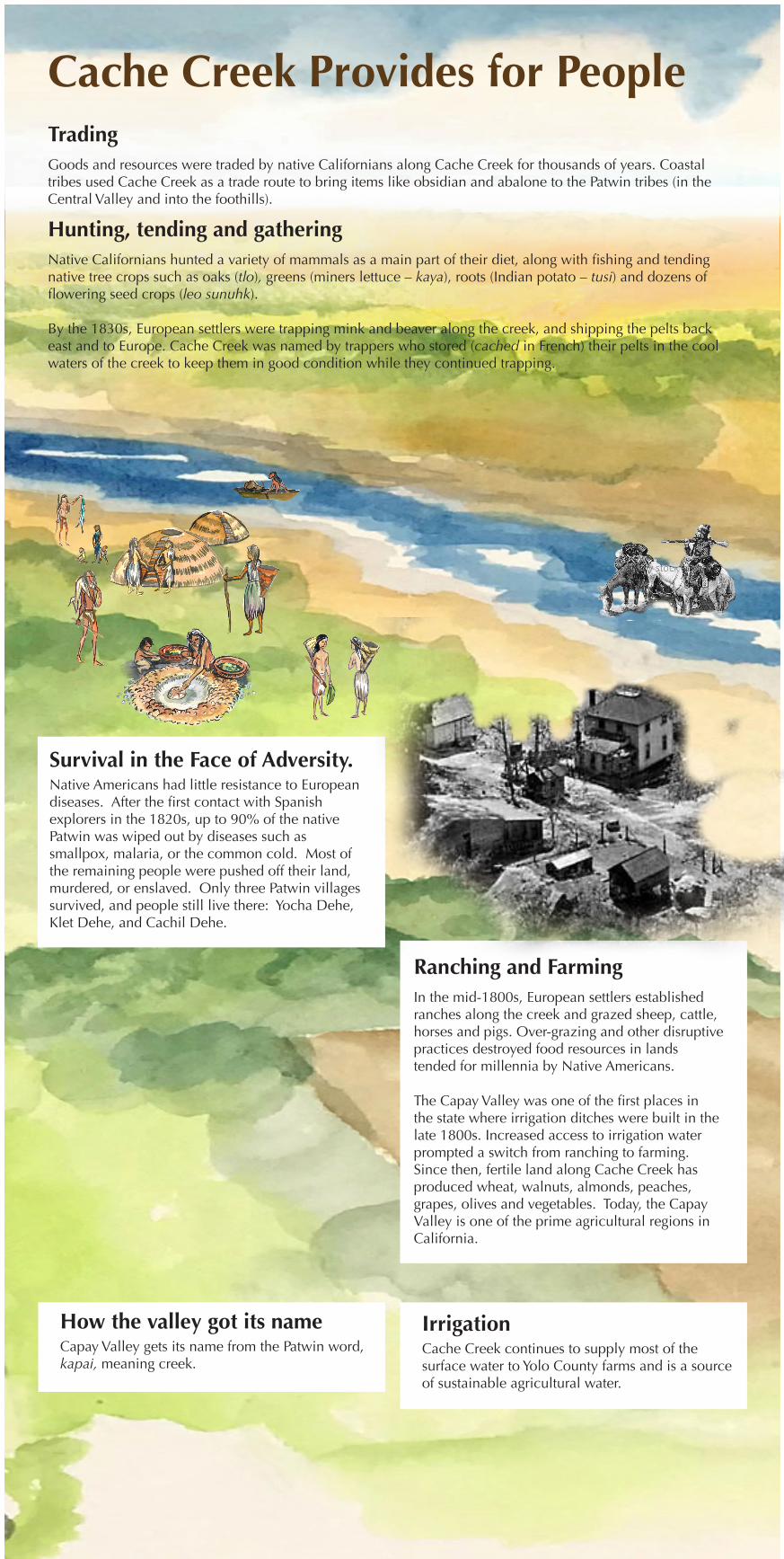
Cache Creek Provides for People
IrrigationCache Creek continues to supply most of the surface water to Yolo County farms and is a source of sustainable agricultural water.
How the valley got its nameCapay Valley gets its name from the Patwin word, kapai, meaning creek.
Survival in the Face of Adversity.Native Americans had little resistance to European diseases. After the first contact with Spanish explorers in the 1820s, up to 90% of the native Patwin was wiped out by diseases such as smallpox, malaria, or the common cold. Most of the remaining people were pushed off their land, murdered, or enslaved. Only three Patwin villages survived, and people still live there: Yocha Dehe, Klet Dehe, and Cachil Dehe.
Ranching and FarmingIn the mid-1800s, European settlers established ranches along the creek and grazed sheep, cattle, horses and pigs. Over-grazing and other disruptive practices destroyed food resources in lands tended for millennia by Native Americans.
The Capay Valley was one of the first places in the state where irrigation ditches were built in the late 1800s. Increased access to irrigation water prompted a switch from ranching to farming. Since then, fertile land along Cache Creek has produced wheat, walnuts, almonds, peaches, grapes, olives and vegetables. Today, the Capay Valley is one of the prime agricultural regions in California.
TradingGoods and resources were traded by native Californians along Cache Creek for thousands of years. Coastal tribes used Cache Creek as a trade route to bring items like obsidian and abalone to the Patwin tribes (in the Central Valley and into the foothills).
Hunting, tending and gathering Native Californians hunted a variety of mammals as a main part of their diet, along with fishing and tending native tree crops such as oaks (tlo), greens (miners lettuce – kaya), roots (Indian potato – tusi) and dozens of flowering seed crops (leo sunuhk).
By the 1830s, European settlers were trapping mink and beaver along the creek, and shipping the pelts back east and to Europe. Cache Creek was named by trappers who stored (cached in French) their pelts in the cool waters of the creek to keep them in good condition while they continued trapping.
Mining Along the CreekCache Creek is a source of high quality aggregate
Where it goesStarting as early as the 1870s, thousands of train loads of Cache Creek gravel were extracted to build railroad lines to ship fruit to market from the Capay Valley and Winters. The California Pacific Railroad in 1879 was one of the earliest major projects to use Cache Creek gravel. Since then, it has also been used to make concrete to rebuild after the 1906 San Francisco earthquake, for bridge pilings in the San Francisco Bay, and in building the Monticello Dam above Winters.
• Concrete for buildings
• Bedrock for highways - Hwy 16, Hwy 5, Hwy 113 in Davis and Nights Landing, Hwy 505
• Landscaping
• Water filtration
• Roofing tiles
• Yolo County Courthouse building
Reclamation of Gravel Mine SitesUnder agreement with the County, aggregate companies restore mining sites to a specified level once those sites are retired. This park is an example of that restoration.
MercuryMercury is a naturally occurring and highly toxic element found in the Coast Ranges. Discovery of California mercury in the 1840’s lead to its commercial mining and facilitated the 1849 Gold Rush. Mercury reacts with gold particles to form a blend (that can be easily collected). When the mercury is burned off, it leaves behind gold. During the height of the Gold Rush, there were more than 300 mercury mines in the Coast Range.
Rocks and Soil in and around the creekNine types of soil and many types of rock border Cache Creek in the Capay Valley and its foothills. Some are highly fertile and some are not.
Cache Creek streambanks are made up of everything from bedrock, boulders and cobbles to gravel, sand, silt and clay. Most of the streambank tends to erode during annual winter water flows.
Uses of Aggregate Today
SandstoneShale
Cinnabar
Serpentinite
Chert
Where it comes fromOver the past several million years, forces of nature would break off pieces of the Coast Range mountains into Cache Creek. As the rock rolled off the mountains and down the creek, it would break up into smaller pieces. As rock tumbles downstream, it becomes smooth and polished, resulting in high quality rock mined for many uses. Collectively, the variety of rock mined is called “aggregate.”
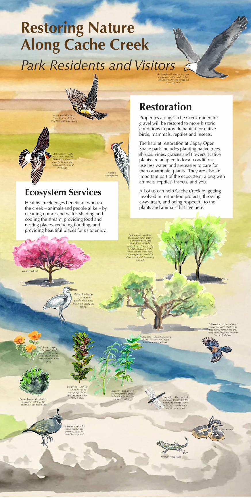
Restoring Nature Along Cache Creek
RestorationProperties along Cache Creek mined for gravel will be restored to more historic conditions to provide habitat for native birds, mammals, reptiles and insects.
The habitat restoration at Capay Open Space park includes planting native trees, shrubs, vines, grasses and flowers. Native plants are adapted to local conditions, use less water, and are easier to care for than ornamental plants. They are also an important part of the ecosystem, along with animals, reptiles, insects, and you.
All of us can help Cache Creek by getting involved in restoration projects, throwing away trash, and being respectful to the plants and animals that live here.
Ecosystem ServicesHealthy creek edges benefit all who use the creek – animals and people alike – by cleaning our air and water, shading and cooling the stream, providing food and nesting places, reducing flooding, and providing beautiful places for us to enjoy.
Park Residents and Visitors
Cliff swallow – Walk down to the creek in the spring and watch them build their mud nests along the side of
the bridge.
Mugwort – Can be seen flowering by the creek in the summer. Used as
insect repellant.
Cottonwood – Look for its cotton-like fluff among
its branches or floating through the air in the
spring. Its seeds, carried by the fluff, land on recently
winter-flooded creek edges to re-propagate. The fluff is
also used by birds for nesting material.
Valley oaks – Drop their acorns in the fall which are a food source for many animals.
Western fence lizard
Western meadowlark – Listen for its melodious
song throughout the spring
Dragonfly – They spend 1 to 2 years as a larva in the water and emerge to live only 1 to 2 weeks in the
summer as an adult.
California quail – Are the loudest in the summer. Listen for
their Chi-ca-go call.
Milkweed – Look for its pink flowers in late-spring. Native
Americans used it to make a fiber.
California poppy – The iconic bright orange color of our state flower can be
seen blooming in the spring.
Western redbud
Rattlesnake
California scrub jay – One of nature’s oak tree planters, as they store acorns in the dirt,
many times forgetting to come back to find them.
Great blue heron – Can be seen
quietly waiting for their meal along the
creek.
Coyote brush – Great winter pollinator; listen for the
buzzing of the bees inside
Bald eagle – During winter, they congregate in the north end of the Capay Valley and forage out