57
Ythan Fishery Management Plan 2011-2015 1 st Edition April 2011

Ythan Fishery Management Plan
2011-2015
1st Edition
April 2011
2
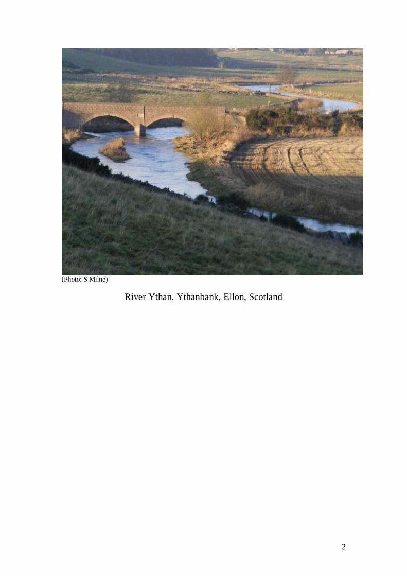
(Photo: S Milne)
River Ythan, Ythanbank, Ellon, Scotland

3
TABLE OF CONTENTS
Section One .............................................................................................................. 6 1 INTRODUCTION ................................................................................................ 7
2 STRATEGY AND DURATION OF MANAGEMENT PLAN ........................... 8 2.1 Phase 1 Strategy .............................................................................................. 8
2.2 Plan Duration ................................................................................................... 9
3 YTHAN SALMON FISHERY DISTRICT ......................................................... 9 3.1 Geology ......................................................................................................... 11 3.2 Hydrology ..................................................................................................... 11
3.3 Land Use ....................................................................................................... 12 3.3.1 Agriculture ......................................................................................... 13
3.3.2 Forestry .............................................................................................. 13 3.3.3 Natural Heritage ................................................................................. 14
4 HISTORICAL CONTEXT OF YTHAN SALMON FISHERY DISTRICT .... 15 4.1 Commercial Netting....................................................................................... 15
4.2 Angling ......................................................................................................... 17 4.3 Angling Statistics ........................................................................................... 17
4.4 Aquaculture, Still Water Fisheries and Lochs ................................................. 20
5 PRESENT STATUS OF FISH & FISHERIES ................................................. 21 5.1 Fish species present within the Ythan Salmon Fishery District ....................... 21
Table 2 Native or long established fish species known to be within the Ythan
district ............................................................................................................. 21 Table 3 Fish species known to be within the Water of Cruden ......................... 22
Table 4 Non-native species known to be within the Ythan district ................... 22 5.2 Ythan Stock Components............................................................................... 22
5.3 Present Exploitation of Fish Stocks ................................................................ 22 5.4 Management Activities .................................................................................. 23
5.4.1 Stocking...................................................................................................... 23 5.4.2 Predation Control .................................................................................... 23
5.4.3 Habitat Enhancement & Obstacle Removal ............................................. 24 5.4.4 Illegal Fishing ......................................................................................... 24
5.4.5 Stock Monitoring .................................................................................... 24 5.4.6 Education and Public Participation .......................................................... 24
6 ASSESSMENT OF FACTORS LIMITING JUVENILE PRODUCTION AND
FISHERY PERFORMANCE ............................................................................... 25 6.1 Habitat ........................................................................................................... 25
6.1.1 Agriculture .............................................................................................. 25
6.2 Fish Access .................................................................................................... 26 6.3 Angling and Netting Exploitation .................................................................. 27
6.4 Water Quality ................................................................................................ 27 6.5 Predation ....................................................................................................... 28
6.6 Non-Native Invasive Species ......................................................................... 28 6.6.1 Non-Native Fish Species ......................................................................... 28
6.6.2 American Mink ....................................................................................... 29 6.6.3 North American Signal Crayfish ............................................................. 30
6.6.4 Invasive Non-Native Plants ..................................................................... 30 6.7 Illegal Fishing ................................................................................................ 31
6.8 Red Vent Syndrome ....................................................................................... 31 6.9 Marine Mortality ........................................................................................... 31

4
7 INSUFFICIENT DATA ..................................................................................... 32 7.1 Genetic Status of Local Salmon, Sea trout and Brown trout Stocks. ............... 32
7.2 Numbers of Returning Adult Salmon and Sea trout ........................................ 32 7.3 Status & Distribution of Salmon, Sea trout and Brown trout Stocks ............... 32
7.4 Exploitation Rates of Salmon and Sea trout Stocks ........................................ 33
8 DEFORESTATION AND CULTURAL OLIGOTROPHICATION ............... 33
9 CLIMATE CHANGE ......................................................................................... 33 Section Two............................................................................................................ 36
10 YTHAN SALMON FISHERY DISTRICT ACTION PLAN AND
OBJECTIVES ....................................................................................................... 37 10.1 Objective I – Habitat Survey ........................................................................ 37
10.1.1 Survey Method ...................................................................................... 38
10.1.2 Habitat Survey – Outcomes ................................................................... 39 10.1.3 Future Work .......................................................................................... 39
10.2 Objective II – Biosecurity Plan .................................................................... 40 10.3 Objective III – Electro-fishing Survey .......................................................... 41
10.3.1 Survey Method ...................................................................................... 41 10.3.2 Electro-fishing Survey – Outcomes ....................................................... 41
10.3.3 Future Work .......................................................................................... 42 10.4 Objective IV – Structure of Ythan Fish Stocks ............................................. 42
10.4.1 Genetics ................................................................................................ 42 10.4.2 Genetics Survey Method ....................................................................... 42
10.4.3 Future Genetic Work ............................................................................. 43 10.4.4 Catch Returns and Scale Analysis ......................................................... 43
10.4.4.1 Survey Purpose .................................................................................. 43 10.4.4.2 Survey Method ................................................................................... 43
10.4.4.3 Structure Analysis – Outcomes ........................................................... 43 10.5 Objective V – Evaluate Current Restocking Programme .............................. 44
10.5.1 Survey Method ...................................................................................... 44 10.5.2 Habitat Units and Carrying Capacities ................................................... 44
10.5.3 Electro-fishing and Juvenile Densities ................................................... 44 10.5.4 Genetic Analysis ................................................................................... 45
10.5.5 Future Work .......................................................................................... 45 10.5.6 Retocking Evaluation – Outcomes......................................................... 45
10.6 Objective VI- Review the survey data gathered to understand the factors
affecting the fish populations and prioritise remedies against the detrimental
impacts ................................................................................................................ 45 10.7 Objective VII - Commence restoration of the district and continue to refine
knowledge through continued research ................................................................ 46 10.8 Objective VIII - Review success of initial restoration schemes and prioritise
works for the next five year period ...................................................................... 46 Figure 2.0 Proposed Timescale for Projects ......................................................... 47
10.9 Continued Management by YDSFB ............................................................. 48 10.9.1 Bailiffing .............................................................................................. 48
10.9.2 Biosecurity ............................................................................................ 48 10.9.3 Statutory Consultee ............................................................................... 48
11. REVIEW OF THE FISHERY MANAGEMENT PLAN .............................. 48 12. REFERENCES ................................................................................................ 50
13. ACKNOWLEDGEMENTS ............................................................................. 52 14. GLOSSARY ..................................................................................................... 53

5
15. APPENDICES ................................................................................................. 54 Appendix 1- YTHAN VOLUNTARY CODE 2011 SEASON ............................. 54
Appendix 2 - DATA EXTRACTED FROM THE YTHAN PROJECT ................ 55

6
Section One

7
1 INTRODUCTION
To help provide direction for the future management of the Ythan Salmon Fishery
District (YSFD) and to help manage the local fisheries in a more broad and structured
manner, the River Ythan Trust (SC041269)* commissioned the Deveron Bogie and
Isla Rivers Charitable Trust (SC032131) to write an Ythan Fishery Management
Plan (YFMP). The plan has been formulated in consultation with the Ythan District
Salmon Fishery Board (YDSFB)**, Rivers and Fisheries Trusts of Scotland
(RAFTS)*** and other stakeholders.
The YFMP has been composed using existing information held in the River Ythan
Trust data inventory, such as the 1996 Survey of Atlantic Salmon and Brown Trout
Populations of Selected Tributaries within the River Ythan Catchment (Isla Martin &
The Scottish Conservation Projects Trust), “Ythan Project” (LIFE00
ENV/UK/000894) and other sources, of which this document is a summary.
(*The River Ythan Trust is a Registered Scottish Charity, approved in February 2010 (Registration number: SC041269) which works in tandem with the YDSFB on the
management of the Ythan Fisheries District.
The Trust’s mission statement:
The River Ythan Trust will promote effective management to protect and enhance the fish,
fishery, aquatic and riparian habitat, indigenous wildlife, and the natural environment of the River Ythan Catchment area.
The Trust's objectives are:
· To advance for charitable purposes and public benefit, environmental protection and
improvement, by conserving and enhancing all species of freshwater fish and their environments, primarily, but not limited to the inland and coastal waters of the River Ythan
Catchment area.
· To advance for charitable purposes and public benefit, the education of the public and any association, company, local authority, administrative or governmental agency or public body
or representative body in:-
The understanding of aquatic ecosystems, including their fauna, flora and economic
or social activity, and river Catchment management.
The need for, and benefits of, protection, conservation, rehabilitation and
improvement of aquatic and riparian environments.
(**Currently Scotland has 49 constituted District Salmon Fishery Boards (DSFBs), the River
Ythan District Salmon Fishery Board (YDSFB) is one of these. Our adjacent Boards are the
Deveron, Ugie and Don. . The YDSFB is a statutory body originated by the Salmon Fisheries
Act of the 19th century and has management responsibility within the area encompassed within the boundary shown on Fig. 1.1 and the coastal area, between Newtyle in the south
and and Longhaven in the north.)
(*** Rivers and Fisheries Trust of Scotland (RAFTS) is the Association of Scottish
River &Fishery Management Trusts. It is an Unincorporated Association registered as
8
a Scottish Charity. It operates for the benefit of its membership. A primary function of
RAFTS is to fundraise on behalf of its members.)
Monitoring and protection of the natural environment in Scotland is driven
legislatively by the Water Framework Directive (WFD)
http://www.sepa.org.uk/water/water_publications/water_framework_directive.aspx
The Scottish Environment Protection Agency (SEPA) is the charged with
implementing the requirements and regulations associated with the WFD. The YFMP
will fit into this process by feeding information on the YSFD into the River Basin
Management Plan (RBMP) http://www.sepa.org.uk/water/river_basin_planning.aspx
and North East Scotland Area Management Plan via the Area Advisory Group, co-
ordinated by SEPA.
http://www.sepa.org.uk/water/river_basin_planning/area_advisory_groups/north_east
_scotland.aspx
2 STRATEGY AND DURATION OF MANAGEMENT PLAN
2.1 Phase 1 Strategy
„To systematically collect data on all fish species and their habitats to establish the
current status of the fisheries in the Ythan Salmon Fishery District
The survey programme will systematically collect data, determining:
• The nature and quality of instream and riparian habitat present in the district.
• Which fish species are currently present in the district.
• Their distributions across the catchments.
• The numbers in which they are present.
• The population structure: are there bottlenecks during production reducing the
number of adult fish available? Are there sub-species using different parts of the
catchment?
• The factors which are impacting upon the fish and fisheries.
• Measures which can be taken to redress these impacts.
• The effect of the rod and net fisheries on the numbers of adults of each stock
escaping to spawn.
• The quality and quantity of juvenile salmonid habitat
As a consequence of the survey programme, management decisions will be taken
based upon current information and restoration measures prioritised according to
urgency and benefit.
Data collected regarding habitat and obstructions will be reported to SEPA, to be
included in the North East Scotland Area Management Plan and River Basin
Management Plan.

9
2.2 Plan Duration
The YFMP is for the period 2011-2015 and initially sets out a survey programme. As
data is gathered and management decisions taken the second phase of the plan will be
developed. The YFMP is designed to link together with other existing management
plans previously mentioned, the North East Scotland Local Biodiversity Action Plan,
as well as species specific conservation projects such as the North East Scotland
Water vole Project, with the aim to address issues involving all stakeholders and
prioritise actions to reduce adverse impacts.
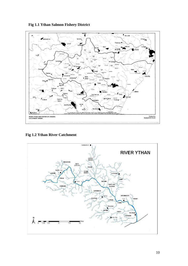
3 YTHAN SALMON FISHERY DISTRICT
The River Ythan is a long established angling river and particularly so for its prized
sea trout (Salmo trutta). The fisheries in the YSFD (Fig 1.1) comprises the river
Ythan and its tributaries, Ythan estuary and all other watercourses which discharge
into the North Sea on Aberdeenshire's north east coast, between Newtyle and
Longhaven. The main coastal river is namely the Water of Cruden. There are also
four main lochs in the district namely, Meikle loch, Little loch, Cotehill loch and Sand
loch, all are designated parts of the “Sands of Forvie, Ythan Estuary and Meikle Loch
Special Protection Area”. (SPA)
The river Ythan (Fig 1.2) rises in the Wells of Ythan (280m), flowing east to
Bruckhills then north east to Towie, through Fyvie and continues south to the North
Sea via Ellon, exiting at Newburgh Bar which is 20 kilometres north of Aberdeen.
The river is 64 kilometers long, of which approximately 9 kilometers are tidal, with a
catchment area of 680 Km² most of which is agricultural land. The Water of Cruden
flows through Hatton and enters the North Sea at Cruden bay.
In 1979 the Ythan Estuary was incorporated into Forvie National Nature Reserve
(created in 1959). The Estuary area comprises some 976 hectares of sand dunes (the
5th largest system in Britain), tidal mud flats and water. Habitats for large numbers of
birds (225 species) including: Ducks, waders, sea birds and geese as well as numerous
plant species, butterflies, moths and spiders and marine life. The Estuary is designated
a Special Protection Area, Special Area of Conservation, Biogenic reserve, Ramsar
site, National Nature Reserve, Nature Conservation Review site, Geological
Conservation Review site, Site of Interest to Natural Science and Site of Special
Scientific Interest.
10
Fig 1.1 Ythan Salmon Fishery District
Fig 1.2 Ythan River Catchment

11
3.1 Geology
The geological structure of the Ythan catchment consists of the Lower Dalradian
metamorphic rock, which is penetrated by both acid and basic igneous intrusions and,
in one area, overlain by sedimentary rock.
The Dalradian rock was laid down as sediments in a shallow sea or ocean shelf and is
divided into bands running in a north-south direction. The most easterly is gneiss, a
banded rock of fine grain material. Moving westwards the next band is quartzite.
Under the pressures of regional metamorphism, grains of sand have been
recrystallised to form a rock with no trace of cementation. Schists tend to have a
coarser grain structure than phylites, which form the fourth and final metamorphic
band within the catchment.
This metamorphic basement has been penetrated in many places in north-east
Scotland by granite plutons and some of these underlie Pitmedden, Birness and other
areas within the catchment. The Buchan district has also been intruded by several sill-
like masses of basic gabbros. Some of these are of considerable size but the Schivas
mass is the largest one in the catchment and a good exposure is visible at Wood of
Schivas. Gabbro magmas were slow to cool and therefore formed coarse grained
versions of volcanic basalts, being low in silica and high in magnesium and calcium.
From Aberdour in the north a large area of old sandstone overlies the metamorphic
assemblages and is mostly in the form of conglomerate. The lower section of this
intrudes into the catchment as far as Fyvie and is bounded on its western edge by a
series of minor faults.
Following the retreat of the glaciers, the whole of the north east of Scotland was
covered by boulder clay and moranic drift. In the flatter coastal regions this can reach
great depths. The clays give a poorly draining soil and the number of boulders present
is indicated by the massive stone dykes around the fields. From Methlick down to
Ythanbank and North West of Newburgh are areas of sand and gravel of fluvoglacial
origin, which offer better drainage characteristics. Alluviums are deposited along the
river channels (NERPB, 1994).
3.2 Hydrology
Much of the bedrock underlying the Ythan catchment is impermeable and, as a
consequence, the area is generally lacking in exploitable groundwater resources.
However, the aquifer formed by Old Red Sandstone deposits lying to the east of
Turriff extends into the Ythan catchment as far south as Auchterless and Fyvie. This
represents a potential source of supply as yet untapped in the Ythan catchment. A
borehole in this same aquifer at Delgaty in the Deveron catchment yields 1Ml/d
(million litres per day) for public supply (NERPB, 1994).
12
Virtually the whole of the Ythan catchment is overlain with glacial material deposited
during and after the last ice age. A matrix of sand, silt and clay has been left by the
ice sheet itself whilst glacial melt-water has produced large deposits of sand and
gravel. Groundwater exists in these superficial deposits in useful but limited
quantities. Many households throughout the catchment depend on local springs and
wells for their domestic water supply. Due to the general shallow nature of the
groundwater, these supplies may diminish in periods of prolonged drought. Also,
because this groundwater is recharged by direct infiltration, it is highly susceptible to
contamination both from diffuse pollution, such as fertilisers and slurry from
agricultural land, and from point source pollution caused by nearby septic tanks and
silage pits.
Groundwater in the Ythan catchment makes an important contribution to stream flow.
The proportion of the river or stream flow derived from stored groundwater is called
the Base Flow Index and can be calculated from stream flow records. For the River
Ythan at Ellon, the Base Flow Index for the ten years 1984-1993 is 0.74. This is the
highest value for any gauging station in the area and one of the highest in Scotland. It
indicates that, on average, just over 25% of the flow in the River Ythan is derived
from direct surface runoff (NERPB, 1994).
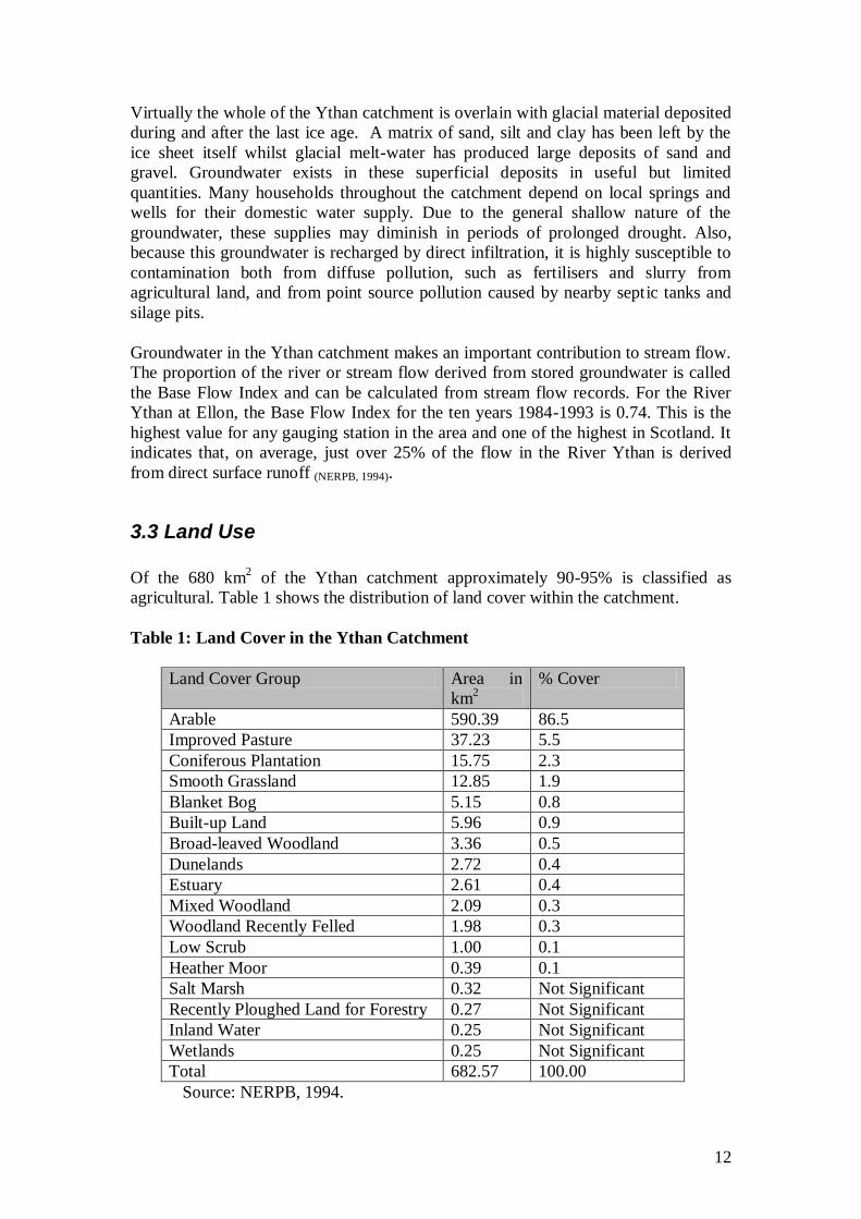
3.3 Land Use
Of the 680 km2 of the Ythan catchment approximately 90-95% is classified as
agricultural. Table 1 shows the distribution of land cover within the catchment.
Table 1: Land Cover in the Ythan Catchment
Land Cover Group Area in
km2
% Cover
Arable 590.39 86.5
Improved Pasture 37.23 5.5
Coniferous Plantation 15.75 2.3
Smooth Grassland 12.85 1.9
Blanket Bog 5.15 0.8
Built-up Land 5.96 0.9
Broad-leaved Woodland 3.36 0.5
Dunelands 2.72 0.4
Estuary 2.61 0.4
Mixed Woodland 2.09 0.3
Woodland Recently Felled 1.98 0.3
Low Scrub 1.00 0.1
Heather Moor 0.39 0.1
Salt Marsh 0.32 Not Significant
Recently Ploughed Land for Forestry 0.27 Not Significant
Inland Water 0.25 Not Significant
Wetlands 0.25 Not Significant
Total 682.57 100.00
Source: NERPB, 1994.
13
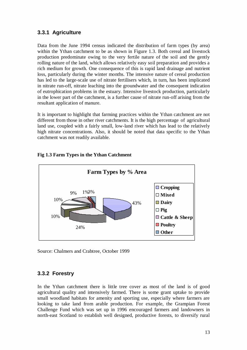
3.3.1 Agriculture
Data from the June 1994 census indicated the distribution of farm types (by area)
within the Ythan catchment to be as shown in Figure 1.3. Both cereal and livestock
production predominate owing to the very fertile nature of the soil and the gently
rolling nature of the land, which allows relatively easy soil preparation and provides a
rich medium for growth. One consequence of this is rapid land drainage and nutrient
loss, particularly during the winter months. The intensive nature of cereal production
has led to the large-scale use of nitrate fertilisers which, in turn, has been implicated
in nitrate run-off, nitrate leaching into the groundwater and the consequent indication
of eutrophication problems in the estuary. Intensive livestock production, particularly
in the lower part of the catchment, is a further cause of nitrate run-off arising from the
resultant application of manure.
It is important to highlight that farming practices within the Ythan catchment are not
different from those in other river catchments. It is the high percentage of agricultural
land use, coupled with a fairly small, low-land river which has lead to the relatively
high nitrate concentrations. Also, it should be noted that data specific to the Ythan
catchment was not readily available.
Fig 1.3 Farm Types in the Ythan Catchment
Source: Chalmers and Crabtree, October 1999
3.3.2 Forestry
In the Ythan catchment there is little tree cover as most of the land is of good
agricultural quality and intensively farmed. There is some grant uptake to provide
small woodland habitats for amenity and sporting use, especially where farmers are
looking to take land from arable production. For example, the Grampian Forest
Challenge Fund which was set up in 1996 encouraged farmers and landowners in
north-east Scotland to establish well designed, productive forests, to diversify rural
Farm Types by % Area
43%
24%
10%
10%
9% 1%3%Cropping
Mixed
Dairy
Pig
Cattle & Sheep
Poultry
Other

14
land use and to increase timber supplies. In the first two years, 2,000 hectares of new
forest were allocated funding in the north east corner of Grampian region including
the Ythan catchment. (The Grampian Forest Newsletter, February 1999)
The main areas of woodland plantation in the catchment are associated with the
estates of Fyvie Castle, Haddo, Pitmedden, Tillycorthie, Esslemont and Auchmacoy.
Elsewhere there are strips of semi-natural woodland on steeper slopes leading down to
the River Ythan at Woodhead of Fyvie, downstream to Braes of Gight and Methlick.
Similar slopes at Foss Braes near Tifty and adjacent to the Fordoun Burn below
Rothienorman are also of lower agricultural importance and support tree cover.
3.3.3 Natural Heritage
The Ythan catchment is largely agricultural and the landscape has been heavily
influenced by the activities of humans. The area does, however, support a wide range
of diverse habitats and species, some of which are national or internationally scarce.
Forvie National Nature Reserve on the Ythan Estuary, which is also a Site of Special
Scientific Interest (SSSI), is the fifth largest and least disturbed sand dune system in
Britain with exceptional examples of mobile dunes and coastal heath land. A wide
range of habitats is found within the Reserve and these support an equally diverse
range of flora and fauna which are protected by a number of national and international
designations. Other habitats of importance within the catchment have also been
designated as SSSIs and include: Wartle Moss, one of the largest and least disturbed
basin mires in north east Scotland; Red Moss Oldtown, a small mesotrophic basin fen,
a rare habitat in north east Scotland; Meikle Loch and Kippet Hills, a eutrophic loch,
which is one of the major roost sites for greylag and pinkfooted geese; and Gight
Woods, one of the largest native woodlands in the Grampian lowlands. Sites of
Interest to Natural Science include Gight Gorge, (entomology, ornithology, and
botany) Logie Buchan Area, (entomology, reed beds and characteristic fauna) and
Haddo Lakes (winter goose roost.) A number of Ythan tributaries carry a healthy
population of Water vole (Arvicola amphibious.)
The North East Scotland Biological Records Centre has water vole information at
http://www.nesbrec.org.uk/ Information on the North East Local Biodiversity Plan
can be viewed at
http://www.nesbiodiversity.org.uk/worddocs/RiversBurnsHAPFINAL_Aug04.doc
15
4 HISTORICAL CONTEXT OF YTHAN SALMON FISHERY DISTRICT
River Ythan and Ythan estuary fish stocks have been targeted by commercial fisheries
for many years. This is highlighted below in extracts from Grimble (1899) and
Calderwood (1909).
“The Ythan is a famous netting river, and from 3000 to 5000 sea trout, besides salmon
and grilse, are usually captured, the chief run of fish being in August and September,
though the sea nets begin to get fish from the 1st March. In the tidal water at
Newburgh there are about four miles attached to the Udny Arms Hotel, where at times
good sport from a boat may be had with sea trout and whitling, upwards of a hundred
having once been got in a day by two rods. “
“In 1889 the Fishery Board Report states that the sea nets took 5620 salmon and grilse
against thirty-seven got by the whole of the river rods; this, however, was a season of
great drought, which accounts for the huge disproportion.”
Augustus Grimble, The Salmon Rivers of Scotland (1899)
“With regard to netting in the estuary, this has somewhat lessened in recent years.
Practically only one net is fished for about two hours daily. This suits the rod fishers
of the tidal waters, the fishing of which is leased in part to the Udny Arms Hotel at
Newburgh. The Ythan is an excellent sea-trout river, and as this salmonid favours an
estuarial habit much more than the salmon proper, the long tidal reach of the estuary
forms a good rod fishery for both adult trout and finnocks. The fishing is carried on
from boats, and from July to September inclusive the sea-trout are in best condition.
They vary in weight from 4 ounces to about 2 Ib. and larger. Salmon are seldom
fished for in the estuary, but a basket of 10 Ib. of sea-trout is considered satisfactory
by those who know how to do well there”.
W. L. Calderwood, The Salmon River and lochs of Scotland (1909)
4.1 Commercial Netting
The practice of commercial netting within the YSFD has declined greatly and since
1997 has continued on a much smaller scale. Fig 1.4 below shows the commercial
netting data from 1952-2009
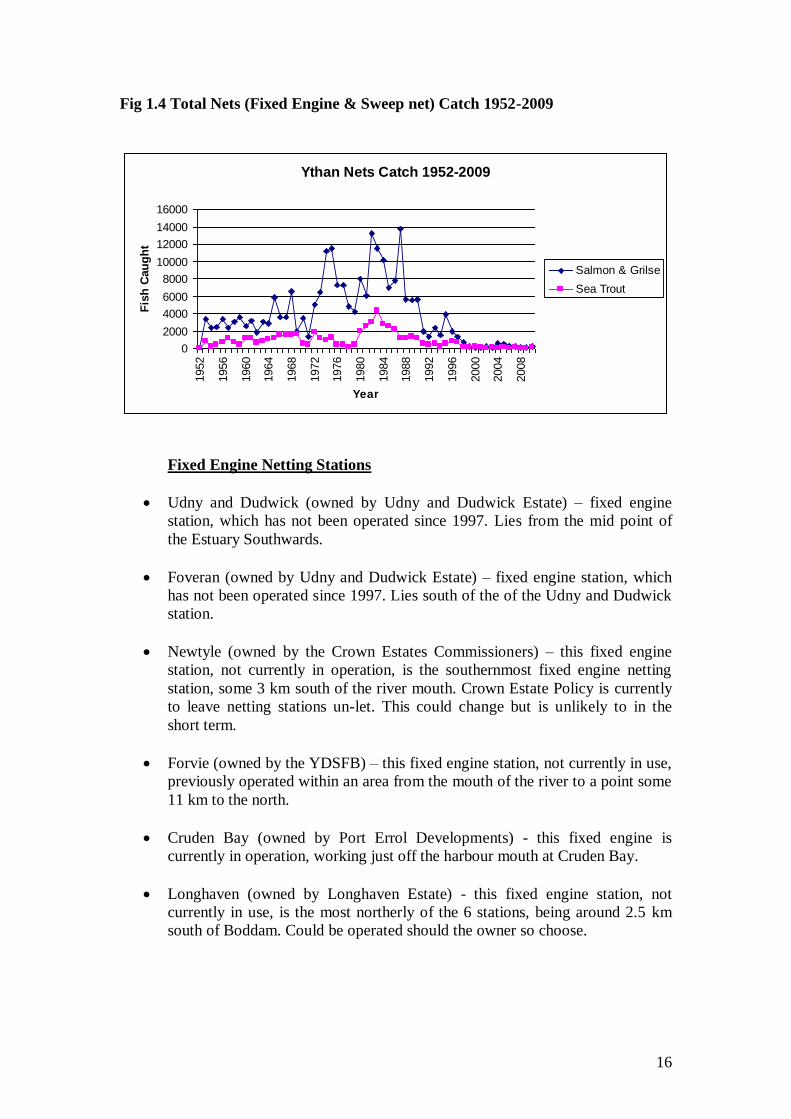
16
Fig 1.4 Total Nets (Fixed Engine & Sweep net) Catch 1952-2009
Ythan Nets Catch 1952-2009
0
2000
4000
6000
8000
10000
12000
14000
160001952
1956
1960
1964
1968
1972
1976
1980
1984
1988
1992
1996
2000
2004
2008
Year
Fis
h C
au
gh
t
Salmon & Grilse
Sea Trout
Fixed Engine Netting Stations
Udny and Dudwick (owned by Udny and Dudwick Estate) – fixed engine
station, which has not been operated since 1997. Lies from the mid point of
the Estuary Southwards.
Foveran (owned by Udny and Dudwick Estate) – fixed engine station, which
has not been operated since 1997. Lies south of the of the Udny and Dudwick
station.
Newtyle (owned by the Crown Estates Commissioners) – this fixed engine
station, not currently in operation, is the southernmost fixed engine netting
station, some 3 km south of the river mouth. Crown Estate Policy is currently
to leave netting stations un-let. This could change but is unlikely to in the
short term.
Forvie (owned by the YDSFB) – this fixed engine station, not currently in use,
previously operated within an area from the mouth of the river to a point some
11 km to the north.
Cruden Bay (owned by Port Errol Developments) - this fixed engine is
currently in operation, working just off the harbour mouth at Cruden Bay.
Longhaven (owned by Longhaven Estate) - this fixed engine station, not
currently in use, is the most northerly of the 6 stations, being around 2.5 km
south of Boddam. Could be operated should the owner so choose.

17
Sweep Netting
River Ythan Estuary (owned by Udny and Dudwick Estate) – Sweep netting
has been carried out in the past, but not in recent years.
Forvie Confluence, River Ythan Estuary (owned by Auchmacoy Estate) –
Sweep netting is carried out on one or two occasions per year by proprietor,
not a commercial fishery.
Ellon Castle – Not commercially operated at present.
4.2 Angling
The legal fishings on the Ythan extend to 28 miles and support approximately 750
anglers (NERPB, 1994). The salmon and sea trout season on the River Ythan for rod and
line runs from the 11th
February to 31st October and for the nets from 24
th February to
9th
September. The catch species vary from finnock and spring salmon in early
season, to sea trout in midseason, and salmon in late season. There are also some
brown trout in the river although these are not significant in terms of the commercial
or recreational fishery.
It is very difficult to estimate an accurate figure for the value of fish in a river such as
the Ythan. As a general rule, the price anglers are prepared to pay for fishing on the
Ythan tends to be lower than that in other renowned Scottish rivers. In studies
undertaken in the past, the annual value of rod and line fishing has been put at
between £321 and £821 per fish. This allows an enormous variation but would fairly
place the annual value of rod and line fishing to the local economy at least £250 000
(NERPB, 1994). A more recent study of the economic impact of angling to the Kyle of
Sutherland catchment was conducted by Glasgow University. The study showed the
value of angling to the Kyle catchment at £3.75million per year, furthermore
providing 13% of local employment. The commercial netting of salmon and sea trout
with the Ythan district has not been included in the above figures as it no longer
makes a very significant contribution to the local economy.
There are 5 main angling bodies within the YSFD that fish the river Ythan Fyvie
Angling Association, Aberdeen and District Angling Asociation, Haddo House
Angling Club, Newburgh Angling Club, Ythanbank Angling Club and 17 individual
beat proprietors.
Although some angling may take place on the Water of Cruden, it is insignificant-
there are no sections of this river or its tributaries included in the valuation roll.
4.3 Angling Statistics
Information on adult salmon and sea trout catches is available in the form of rod catch
data which is compiled by Marine Scotland. The annual collection of salmon and sea
trout catch data has occurred since 1952 to record the progress of fisheries throughout

18
Scotland. The data is now collected by statute under the Salmon and Freshwater
Fisheries (Consolidation) (Scotland) Act 2003. Data of fish caught and returned are
published in summary form in the statistical Bulletin, Fisheries Series, Marine
Scotland on behalf of the Scottish Government. The total number of rod-caught
salmon, grilse and sea trout (retained & released) from the Ythan district between
1952 and 2009 are shown in Fig 1.5, 1.6 and 1.7 below. Catch returns are affected by
factors other than the availability of fish stocks, such as weather patterns, false
recording of catches, timing of returning adults and fishing effort; but they may be
used, in conjunction with other information, as an indication of fish abundance.
Fig 1.5 Total rod and line (retained & released) salmon & grilse catch for the Ythan 1952-2009
Ythan Salmon & Grilse Data 1952-2009
0
200
400
600
800
1000
1200
1952
1956
1960
1964
1968
1972
1976
1980
1984
1988
1992
1996
2000
2004
2008
Year
Salm
on
& G
rils
e
Total Annual Rod & Line
Catch
The data above suggests a period of fluctuating catches with an overall downward
trend between 1958 and 1975, which includes the outbreak period of Ulcerative
Dermal Necrosis (UDN) during 1966-67, which had a destructive effect on fish stocks
survival. It has been suggested that UDN was observed on sea trout from the rivers
Deveron and Spey two weeks prior to it being observed on the same salmon stocks,
thus suggesting that sea trout may have contributed to spreading the disease as these
fish move between estuary to estuary. 1975 was followed thereafter by a period of
relatively good catches with annual fluctuations until 1987. The Ythan generally relies
on increases in water flows from late August onwards to draw salmon up the river – in
low flow years catches are generally poor as was the case in 2003.

19
Fig 1.6 Total rod and line (retained & released) spring salmon catch for the
Ythan 1952-2009
Ythan Spring Salmon (Feb-Apr)
0
20
40
60
80
100
120
140
160
180
1952
1957
1962
1967
1972
1977
1982
1987
1992
1997
2002
2007
Year
Sp
rin
g S
alm
on
Rod-Caught Spring Salmon
(Feb-Apr)
Fig 1.6 above shows the catches of early running salmon entering the Ythan system
has unfortunately declined. The decline of early running salmon has been prevalent
throughout most of Scotland. The upturn shown in 1987 is thought to be a data error.
Fig 1.7 Total rod and line (retained & released) sea trout catch for the Ythan
1952-2009
Ythan Sea Trout Data 1952-2009
0
1000
2000
3000
4000
5000
6000
7000
8000
1952
1956
1960
1964
1968
1972
1976
1980
1984
1988
1992
1996
2000
2004
2008
Year
Sea t
rou
t
Total Annual Rod & Line
Catch
The data in Fig1.7 above includes sea trout caught both within the river Ythan and its
estuarine fishery. Thus the data could potentially include sea trout that were destined
for other north east rivers. The estuarine fishery is hugely influential with regards to
the total sea trout catch of the district, with the estuary often accounting for over 60%
of the total annual catch. The data in Fig1.7 suggests an increase in sea-trout catches

20
from 1952 to a peak in 1957 of 7510 fish. This was followed by a crash in numbers
from 1958 to 1961. An increase in catches is shown from 1962 to 1966, but this is
again followed by a crash in numbers. The reason for the decline in numbers is not
known and has also been experienced in the Dee, Don and Deveron. Although not
shown on the chart above, the catches on all these rivers have improved significantly
for 2010.
Until more recently the Scottish Government has historically asked for sea trout
numbers to be classified under one main heading not taking into account their
complex life histories. Sea trout which are largely female and are the migratory form
of brown trout are more varied than salmon and thus its more difficult to classify their
catch data. Juvenile salmon smolts around 120-160mm, after heading to sea, go far to
the north Atlantic and return as adults to breed. It is thought that sea trout forage
more closely inshore and many „visit‟ estuaries and fresh water before finally
returning to the riverine habitat to breed. When these „visits‟ take place within months
of migrating to sea as smolts, these fish are called finnock. Such fish can and have
been caught in considerable numbers within the Ythan estuary. It appears from the
aggregate mass of the sea trout in the Marine Scotland catch data that finnock have
been arbitrarily included or not in the official returns.
For example the 7,500 sea trout caught in 1957 with an average mass of 0.5Kg must
have included several finnock, but it is thought that the 6,500 sea trout caught in 1966
which averaged just less than 1Kg must have been mostly sea trout (Pirie J. 2011, Personal
Communication).
4.4 Aquaculture, Still Water Fisheries and Lochs
The YSFD currently contains one rainbow trout fish farm and approximately four
commercial trout ponds. Over the past 5 years there have also been privately owned
trout ponds created by farmers through environmental schemes, some of which are
believed to be stocked with rainbow trout but are not commercial and therefore we
have no supplementary information. Anecdotal evidence shows that there may also be
non-commercial water bodies in the district which contain coarse fish.
These are listed below:
Mill of Elrick Fish Farm and Fishery, Auchnagatt. Ellon NJ935408 – fully
operational fish farm and fishery adjacent to the Ebrie Burn. Specialises in the raising
and stocking of rainbow trout. (Oncorhynchus mykiss.)
Ythan Valley Fishery, Ardlethen. Ellon. NJ920323 – Not operational at present
following an outbreak of argulus. This body of water is situated very close to the
Ythan mainstem, 3 miles west of Ellon. Fish species not known.
Ythanbank Fishery, Ythanbank. Ellon NJ905336 – Not operational at present.
There have been problems regarding water retention on-site since its conversion from
a gravel pit several years ago. Located approximately 200 metres from the Ythan.
Fish species not known.

21
Haddo Trout Fishery, Keithfield. near Methlick. NJ853335 -This fishery is active
and is located close to the Keithfield Burn.. Stocked mainly with rainbow,, blue and
brown trout, also in the past with arctic char, brook trout and tiger trout.
Inverythan Fishery – NJ754415 situated at the roadside between Turriff and Fyvie.
Fish species not known.
Mains of Aquharney – NK022368- Pond stocked with Grass Carp not a public
fishery.
Meikle Loch (Slains) – NK029308 This loch is owned by the RSPB and is known to
hold Pike – some angling takes place, but not encouraged by RSPB. Other fish species
not known.
Little Loch (Slains) – NK025311 – Fish species not known.
Cotehill Loch (Collieston) – NJ027293 Shallow Loch with a maximum reported
water depth of 0.25m in 1990. Known to contain three-spined stickleback and perch.
Sand Loch (Collieston) – NJ034284 A report on perch in Sand Loch (Treasurer,
JW, 1992. Perch in Sand Loch [Collieston, Aberdeenshire]. Unpublished report to
SNH) describes finding perch, three-spined stickleback and stocked brown and
rainbow trout during surveys of this loch which took place in 1975. It cites that Sand
Loch was last stocked with brown and rainbow trout in 1971 and that there are no
natural spawning beds in the loch. No pike were detected in this survey. Anecdotal
evidence suggests pike have since been introduced to the loch.
5 PRESENT STATUS OF FISH & FISHERIES
5.1 Fish species present within the Ythan Salmon Fishery District
Table 2 Native or long established fish species known to be within the Ythan district
Common Name Scientific Name
Atlantic salmon Salmo salar
Trout (Resident / Migratory) Salmo trutta
European eel Anguilla anguilla
Brook lamprey Lampetra planeri
Three-spined stickleback Gasterosteus aculeatus
Atlantic flounder Platichthys flesus
European perch Perca fluviatillis
Northern Pike Esox lucius
Sand Goby Bobius minutus
22
NB: The Ythan historically contained a healthy population of Freshwater Pearl
Mussel (Margaritifera margaritifera) and was once a renowned pearl mussel fishery.
The Ythan was intensively surveyed by ecologists from the University of Aberdeen
and Germany between July 1996 and 1997. The findings showed a small population
of old individuals but no sign of juvenile recruitment. On a historical note: In
1621, the Kelly (or Kellie) pearl, found in a tributary, is believed to be the largest
found in Scotland, was presented by the Lord Provost of Aberdeen to King James VI,
and is now part of the Scottish crown among other pearls, diamonds and rubies.
Table 3 Fish species known to be within the Water of Cruden
Common Name Scientific Name
Atlantic salmon Salmo salar
Trout (Resident / Migratory) Salmo trutta
Table 4 Non-native species known to be within the Ythan district
Common Name Scientific Name
Rainbow Trout Oncorhynchus mykiss
Grass Carp Ctenopharyngodon idella
5.2 Ythan Stock Components
The Ythan system and the Water of Cruden have a diverse and complex make up of
fish stock components and run-timings e.g. spring, summer and autumn salmon.
Throughout the catchment there are separate and distinctive stocks of salmon, sea
trout and brown trout which need to be preserved at all cost. It is this diversity of
stock which gives the Ythan its 9 month long angling season. Understanding of the
structuring of Atlantic salmon, sea trout and brown trout stocks within rivers is
essential for focusing local management and stock assessment on breeding
populations, the fundamental biological units which underpin recruitment and their
character. River Ythan Trust and YDSFB understand the importance of researching
and preserving distinct local populations.
5.3 Present Exploitation of Fish Stocks
The angling season currently runs from the 11th February to the 31st October
inclusive, the netting season from 24th
February to 9th September inclusive. The
YDSFB operate a voluntary angling conservation code which is reviewed before the
beginning of each new angling season. A copy of the updated voluntary code can be
found in Appendix 1. The exploitation of salmon and sea trout by rod and line occurs
mainly on the Ythan mainstem and estuary. Some brown trout fishing is practiced on
the upper reaches of the Ythan.

23
There are still two netting operations in use within the Ythan district. Cruden Bay
(fixed engine) netting station is currently in operation, working just off the harbour
mouth at Cruden Bay and Forvie Confluence (sweep netting station, Ythan Estuary) is
operated one or two occasions per year, but not commercially.
5.4 Management Activities
5.4.1 Stocking
The YDSFB operate a modest juvenile restocking programme. Both salmon and trout
of known migratory parent origin have been stocked into the Ythan system
intermittently and also the Water of Cruden was stocked with trout fry in 2006 due to
a pollution incident. Stocking of juveniles has been carried out mainly to mitigate
against serious pollution incidents which have adversely damaged salmonid
stocks and their habitats. The YDSFB do not own their own hatchery facility and
subsequently buy in fed fry / parr / smolts from outside commercial units. The most
recent year that salmon has been stocked into the Ythan system was 2003. These fry
were of Ythan parentage and were reared at a local fish farm. Trout fry and smolts for
stocking purposes have been sourced from outside the district.
5.4.2 Predation Control
Predation of salmon and trout stocks is a natural occurrence with other fish species,
piscivorous birds and mammals having co-existed in ecological balance over
millennia. Juvenile salmonids are eaten by a number of different predators including
eel, kingfisher, sawbill ducks, cormorant, and mink. Adult and salmonid smolts are
also preyed upon by species such as otter and seals. The predation of early life stages
of salmonids may not have a huge effect as the populations can in most cases
compensate for losses. However, when salmonids reach the parr and smolt stages, the
population loses some of its ability to compensate for loss. During smolt migration,
salmon and sea trout are particularly vulnerable to predation due to high densities and
mass downstream migration. Predation can exert a significant effect upon smolt
numbers. The effect of avian predation on fish stocks within the Ythan catchment is
unknown, but during the smolt run and in times of low water may be significant.
Recent research has shown that, across Scotland smolt survival rates have been
declining. There is no formal management of piscivorous birds at present, however
the YDSFB have for several years been discouraging these birds by use of non –
lethal techniques (sound scaring) which they regard as having been reasonably
successful. Anglers have expressed concern about the steadily increasing numbers of
particularly grey seals in recent years and the possible predation on salmon and sea
trout smolts and adults. The lethal control of grey and common seals is not permitted
within the Ythan estuary or main river channel up to Logie Buchan Bridge. Scottish
Natural Heritage who manage the National Nature Reserve (including the estuary)
gave an official response to the Scottish Government when an application to control
seals was made “The control of seals within the estuary is considered inappropriate by
SNH who manage the NNR, due to lack of evidence of damage to the fishery and that
a key attribute of the reserve is primacy of nature and promoting public awareness and
enjoyment”. The YDSFB have controlled seals in the appropriate season and with
the aid of the required licence in the closed season, from Logie Buchan Bridge to
Methlick. Seals present in this section can be clearly identified as chasing migratory
24
salmonids. The YDSFB have recently applied for the appropriate licence to enable
this practice to continue in the future. The control of American mink is currently
undertaken by the North East Scotland Water vole Conservation Project, the Ythan
Project Volunteers and the YDSFB superintendent. Mink numbers had been
controlled by the YDSFD for many years prior to the introduction of the Watervole
Conservation Project and undoubtedly contributed significantly to the survival of a
water vole population in the catchment.
5.4.3 Habitat Enhancement & Obstacle Removal
Habitat works within the district have mostly been carried out as part of “The Ythan
Project” (LIFE00 ENV/UK/000894), which studied a wide range of environmental
matters in the catchment during the period 2000-2005 and put subsequent remedial
actions in place. Some of these actions included the provision of buffer strips, fish
pass construction, coniferous tree removal, removal of Japanese Knotweed, habitat
surveys and the creation of sea trout spawning beds. Other work has also been
undertaken by the river superintendent such as debris removal from spawning burns.
5.4.4 Illegal Fishing
The control of illegal fishing or „poaching‟ as it is referred to is under the control of
the YDSFB. Coastal patrols are undertaken and the YDSFB also carry out river
patrols for illegal activity, such as netting and fishing without permission, through the
remit of the river superintendent.
5.4.5 Stock Monitoring
The YDSFB has carried out an annual programme of electro fishing since 2002 to
monitor juvenile stock abundance and distribution. The River Ythan Trust will expand
this monitoring programme and provide advice to assist the YDSFB in managing the
fisheries district in a more comprehensive and efficient way, for example, direct
obstruction removal works, habitat evaluation and possibly stocking.. A number of
juvenile surveys were also completed in 1996 by the Scottish Conservation Projects
Trust on behalf of the YDSFB.
5.4.6 Education and Public Participation
Education programmes to date have mostly been carried out as part of “The Ythan
Project” (LIFE00 ENV/UK/000894). Close to 47 separate work packages were
carried out as part of the project such as river information sessions completed with
various local primary schools and nutrient budgeting workshops for the agricultural
community. The YDSFB have also involved some local schools when stocking out
fish from the hatchery programme.
It is the intention of the trust (funds permitting) to develop an education project such
as “Salmon in Trout in the Classroom” similar to those that have been implemented
by other rivers trusts, for primary schools in the YSFD – some preliminary research
has been done in establishing the contact names, e-mail details and addresses of likely
schools. A number of interested anglers have offered their unpaid assistance for river

25
works. Similarly a number of anglers have undertaken instruction in the collection of
scale samples for examination and record purposes.
6 ASSESSMENT OF FACTORS LIMITING JUVENILE PRODUCTION AND FISHERY PERFORMANCE
6.1 Habitat
6.1.1 Agriculture
Over 90% of the Ythan river catchment is agricultural land. Watercourses within the
fisheries district, devoid of livestock fencing, have suffered from resulting areas of
bank collapse, which has in turn increased in stream silt loading, resulting in riverine
habitat becoming degraded. Rivers with soft, alluvial soil banks are prone to chronic
collapse where stock fencing is absent. A survey was completed of watercourses
within the Ythan in 2004, assessing the impact of stock on bank sides. No current
habitat data exists for The Water of Cruden. In 1991 the Ministry of Agriculture,
Fisheries and Food looked at agricultural practices and drainage as an impact on
salmon smolt production as part of a Salmon Advisory Committee report. The main
findings are shown below. „Drainage of land for arable production and improved
grazing has been extensively practised by providing underground pipes („land drains‟)
and drainage ditches, and by the dredging of main channels to lower the water table.
This has the effect of increasing the speed of run-off so that the peak flows are greater
and the base-flow reduced. Both these extremes are potentially damaging for juvenile
production. Input of suspended solids as a result of farm practices can render gravel
unsuitable for spawning and incubation. The post-war intensification of arable
farming practices has tended to increase the likelihood of serious soil erosion. For
example, modern crop patterns often leave land vulnerable to erosion during the
autumn and winter, when peak rainfall occurs. This results in increased soil erosion to
watercourses, particularly where the land gradient is steep or where low-lying land is
prone to flooding during this period.
Access to the stream bank by grazing livestock can cause damage by destruction of
bankside vegetation and breakdown of banks, allowing a considerable input of soil
material into the water. In severe cases the banks may be destroyed, leading to
considerable channel widening and shallowing and a very high input of suspended
solids. Channelisation for land drainage and flood alleviation generally involves
straightening and deepening the channel. This results in removal of much of the
habitat diversity and in particular shallow areas important for salmon parr and much
spawning gravel. Considerable damage has been done in the past, from which
recovery has been slow. Publication of the „Rivers and wildlife handbook‟ by the
RSPB and RSNC in 1984 was of major assistance. Bankside cover can be important
to juvenile salmon in small shallow streams. Clearing of such cover, either
intentionally or by allowing intensive grazing, can significantly reduce the carrying
capacity. On the other hand, domination of the banks by coniferous plantations can
reduce light penetration and thus primary productivity, reducing fish production. It

26
also greatly restricts the more valuable community of bankside vegetation. New
drainage schemes are now less numerous and it is likely that some existing schemes,
particularly in rural and upland areas, will slowly deteriorate. It is however important
that the criteria for the maintenance of such capital schemes should now be
reconsidered. Natural recovery from unsympathetic channelisation is slow but does
occur, but improved awareness by river and estate managers should ensure that less
damage is done in the future. Input of silt from arable farming can be controlled by
leaving uncultivated areas (ideally several metres wide) alongside the stream and any
feeder tributaries. This also satisfies the requirement for bankside cover. Further,
avoiding access by cattle in intensively grazed areas (except for limited drink areas)
can prevent damage to bankside vegetation and to banks themselves.‟ The adverse
affects of cattle access to the water bodies could possibly be further reduced by the
provision of water troughs.
The Water Environment (Controlled Activities) (Scotland) Regulations 2011 came
into force on 31st March 2011, these being an updated version of similar earlier
documents. The document can be seen and downloaded from the SEPA website
http://www.sepa.org.uk/water/water_regulation.aspx. Diffuse pollution is a significant
factor in preventing the improvement of water quality in the YSFD. Some of the
General Binding Rules (GBRs) contained within the regulations are designed to
minimise this problem.
GBR 18 The storage and application of fertiliser.
GBR 19 Keeping of livestock – forbids poaching by cattle within a 5 metre
distance from surface water, plus other measures.
GBR 20 Cultivation of land - forbids cultivation of land within 2 metres of
surface water, plus other measures.
GBR 23 Application of pesticides.
GBR 24 Operating sheep dipping facilities.
6.2 Fish Access
Current migratory fish access within the Ythan district is thought to be reasonably
unimpeded. Habitat surveys carried out as part of “The Ythan Project” (LIFE00
ENV/UK/000894) noted several possible obstructions to migratory fish in the form of
bridge aprons, culverts or old weirs. A number of these obstructions have been
modified by the YDSFB under or following the aforementioned project, which appear
to have been successful. All other possible obstructions highlighted within the habitat
surveys and outlined in appendix 2, will require to be re-visited to assess their current
state. All obstructions to migratory fish tend to be historical, as any new
developments must consult with the YDSFB & SEPA regarding fisheries interests.
In-stream works have to be carried out in compliance with the requirements of
SEPA‟s “The Water Environment (Controlled Activities) (Scotland) Regulations
2005.” http://www.sepa.org.uk/water/water_regulation.aspx A potential source of
funding to deal with obstructions exists through SEPA‟s Water Environment
Restoration Fund. www.sepa.org.uk/water/restoration_fund.aspx
27
6.3 Angling and Netting Exploitation
Throughout the angling and netting season, potential spawning salmon, sea trout and
brown trout are inevitably caught and retained. This in turn reduces the number of
adults available to fully utilise their spawning habitats and produce the next
generations. During the 2008 fishing season, anglers released 45% of salmon/grilse
and 30% of sea trout caught within the district and netting activity recorded 127
salmon & grilse and 18 sea trout caught. During the 2009 season anglers released
51% of salmon/grilse and 38% of sea trout caught and netting activity recorded 204
salmon and grilse and 53 sea trout. Currently there is insufficient information
available to determine the effects of angling and retention of salmon and sea trout on
the stocks within the catchment. However all angling bodies on the Ythan, over a
period of years have reduced the numbers of fish that may be retained, and more
recently have adopted the policy of returning a greater proportion of fish caught.
Netting activities are not thought currently to be having a significant effect on salmon
and sea trout stocks within the catchment – the only operating fixed engine (Cruden
Bay) is a mixed stock fishery which will probably exploit fish originating from
several east coast rivers – the operating sweep netting station in the Ythan takes only
a few fish and is owned by an organisation with valuable angling interests in the Ellon
area.
6.4 Water Quality
To survive and flourish, fish stocks, especially juvenile salmonids, require well
oxygenated water of neutral acidity, free of toxic and organic pollution. Invertebrates
living within rivers, the base of the aquatic food chain, providing food for salmonids,
also require high quality clean water and are similarly very sensitive, even to minor
changes. A number of key river shingle invertebrate species are found within the
district, all of which are listed as „Priority‟ species in the UK Biodiversity Action
Plan. These species are covered by a UK Grouped Action Plan which identifies a
number of issues facing these species, such as agricultural pollution, removal of
sediment, deepening of watercourses and water abstraction. It is clear many of these
issues are relevant in the river Ythan catchment context.
SEPA operates a river classification scheme to establish and monitor the status of
surface water bodies. The key reasons for water bodies being at less than good status
are diffuse source pollution and alterations to beds and banks (morphology).
The Ythan catchment contains 11 surface water bodies, and only one (the Burn of
Sessnie {Cessnie Burn} achieved good ecological status in the River Basin
Management Plan (2009) more detail can be viewed on the SEPA interactive map.
http://gis.sepa.org.uk/rbmp/
Unfortunately the river Ythan has some of the highest nitrate concentrations in
Scotland. Several water bodies within the catchment fail to achieve what is referred to
as „good ecological status‟ under the EU Water Framework Directive. The Ythan
catchment and the Ythan estuary were designated as a Nitrate Vulnerable Zone (NVZ)
in May 2000, based on high nitrate concentrations and extensive growths of green
algae in the estuary. The area now forms part of an NVZ designated in 2002, which
includes parts of Aberdeenshire, Banff, Buchan and Moray. The highest
concentrations of nitrate found within the Ythan are within its groundwater. A review

28
completed by the Scottish Environment Protection Agency (SEPA) showed that
agriculture is the main source of nitrogen in the catchment with some 91% of nitrogen
loading being attributed to agricultural fertilizers and manure. In 2009 the Ythan was
designated by SEPA as a diffuse pollution priority catchment. A „diffuse pollution
priority catchment‟ is a catchment containing water bodies that don‟t meet
environmental quality standards and requires a catchment-wide approach to reduce
diffuse pollution risks. Further information on current status and ongoing monitoring
view www.sepa.org.uk/water/diffuse_pollution/monitored_catchments.aspx
Catastrophic pollution incidents occurred on some of the tributaries in the 1990s in
relation to silage effluent and slurry. Similar serious incidents have not re-occurred
recently, however the potential for such events have not vanished. Since 2000, and up
to the current time, there have been numerous incidents involving oil, silage, slurry
and silt.
6.5 Predation
The numbers of piscivirous birds such as goosanders and mergansers appear to be
increasingly more common within the district and along with other species such as
cormorant are probably predating on juvenile salmonids at vital life stages. The
abundance of American mink which also prey on juvenile salmonids should continue
to decline with a catchment wide control programme now in place. Currently there is
no hard scientific evidence regarding the level of predation by seals on salmon and
sea trout smolts and adults and whether they have a serious impact on Ythan stocks or
the sea trout stocks of adjacent rivers. . There appears to be little doubt that the
numbers of grey seals are, at times within the estuary, greater than in the past – the
grey seal count on 22nd
April 2010 was recorded as 369. In an attempt to lessen the
impact on estuary anglers and adult fish stocks, a seal scarer was obtained, mounted
on a boat and operated by Udny and Dudwick Estate, Oceanlab (University of
Aberdeen), Bennex, and Newburgh Anglers. Initial trials have been positive with
estuary anglers being undisturbed by seals when the scarer was in operation. This
experiment is to continue during the 2011 angling season.
6.6 Non-Native Invasive Species
The Trust will be developing a Biosecurity Plan to address the issue of the non-native
species shown below and any other similar species, in line with The Invasive Non-
Native Species Framework Strategy for Great Britain
http://www.nonnativespecies.org
6.6.1 Non-Native Fish Species
The abundance of Rainbow trout (Oncorhynchus.mykiss) caught from the Ythan
catchment has increased in recent years. The presence of a rainbow trout fish farm
within the district provides a potential source of escapee rainbow trout. Anglers have
on occasions reported the presence of different life stages of rainbow trout in the
river. As rainbow trout and salmonids have similar life histories, there is potential for
interactions between these species. For example, rainbow trout are hatchery reared
and have been conditioned to feed within the water column in a similar way to
salmon.

29
A number of rainbow trout fisheries, both commercial and recreational, also exist.
The presence of connections between still waters and the Ythan catchment allows a
potential avenue by which non-native fish species, in the absence of a sluice or grid
on the water‟s outflow, may enter the river catchment. During flood conditions, even
those ponds with sluices or grids are likely to be ineffective and non-native fish may
enter the main river system. There should be further investigation into the status of all
screens present on outflows of fishery ponds which have an outflow to the main river..
The spread of viral and bacterial diseases affecting salmonids is often facilitated by
high density rearing environments such as those encountered in fish farm enterprises.
Farmed fish are a potential route by which disease can enter wild fish populations. In
the UK, the potential for disease transfer from out with the UK is minimal due to the
British trout industry not sourcing fish from the EU mainland or Norway.
The Aquaculture and Freshwater Fisheries (Scotland) Act 2007 makes it an offence
for any person to intentionally introduce any live fish or spawn of any fish into inland
waters, or possess such with the intention of introduction without previous written
agreement of the appropriate authority.
http://www.scotland.gov.uk/Topics/marine/Licensing/fishintros
6.6.2 American Mink
The non-native American mink (Mustela vison) is first thought to have reached
Britain in 1929. It is not known when they first reached the Ythan system. The main
threat they pose to fishery performance is the reduction in juvenile production through
predation. The Ythan also has a breeding population of water voles (Xavier Lambin et
al, 1996 and subsequent works), to which the presence of mink also pose a threat.
Figure 1.8 American Mink Distribution Data (Scotland)
From Figure 1 above it can be seen that the North East region is at the northern
boundary for mink distribution in Scotland. Collaboration between SNH, District
Fishery Boards, Trusts, North East Water Vole Conservation Project and landowners
is required to contain the spread and increase of mink.
30
6.6.3 North American Signal Crayfish
Signal crayfish (Pasifastacus leniusculus) have been present in Britain since they
were first imported from Sweden during the 1970s. Subsequent escapes from farms
and deliberate illegal releases have resulted in the establishment of new feral signal
crayfish populations over large areas of England and Wales. Several records exist of
signal crayfish introductions to Scotland during the 1980s and there is some anecdotal
evidence to suggest that crayfish were translocated to a variety of locations at that
time. They were first formally recorded in Scotland during 1995, since when a total of
15 populations have been identified. These extend from the Kirkcudbrightshire Dee in
Galloway and the River Clyde in Lanarkshire to the River Nairn near Inverness.
Populations have also been recorded in the catchments of some of Scotland‟s most
valuable river systems, such as the Tay, Tweed and North Esk. New populations are
now being reported at a frequency of two or three per year. Signal Crayfish are not in
the Ythan fisheries district at present. Everything possible must be done to ensure they
are stopped from entering. Signal crayfish have a significantly adverse impact on
native freshwater flora and fauna in running and standing waters. They can do this by
consuming large quantities of plants and invertebrates, and by either predating or
displacing amphibians and fish. Signal crayfish can also modify aquatic
environments, by burrowing into the banks of rivers and ponds. In ponds, this
behaviour can undermine the littoral zone and result in increased turbidity. In running
waters, extensive burrows may destabilize the riparian zone, leading to increased rates
of bank erosion, the shallowing of streams and the compaction of salmonid and
lamprey spawning grounds. The species‟ impact on freshwater pearl mussel is
unknown but is likely to be significant. The potential for signal crayfish to act as a
vector for transmission of diseases within or between catchments cannot be
discounted.
6.6.4 Invasive Non-Native Plants
Japanese knotweed
The invasive-species, Japanese knotweed (Fallopia japonica) is present within the
district. It is not currently a major concern but if allowed to establish further, it poses
the threat of shading out native plants by producing a dense canopy of leaves early in
the growing season which can accelerate bank erosion. Knotweed also offers a poor
habitat for native insects, birds and mammals. Any existing populations should be
treated immediately before spreading further.
Giant hogweed
The non-native species Giant hogweed (Heracleum mantegazzianum) is also present
within the district but not on a large scale. Giant hogweed dominates vegetation in
marginal habitats and along rivers, thus crowding out native plants and leaving river
banks open to erosion. Sap from the plant also poses a threat to human health. It is
important that the present abundance of this species is surveyed and updated to allow
control work to be undertaken as soon as possible.

31
Himalayan balsam
Himalayan balsam (Impatiens glanulifera) has been reported within the district
(Water of Cruden only). Himalayan balsam shades out native grasses and leaves
banks prone to erosion. Similar to many invasive species it is important to control the
spread as soon as possible.
Himalayan knotweed
Himalayan knotweed (Percicaria wallichi) has also been found within the district.
Himalayan knotweed again shades out native grasses and leaves river banks prone to
erosion. Similar to many invasive species it is important to control the spread as soon
as possible.
6.7 Illegal Fishing
Salmon „poaching‟ is not a serious problem within the YDSFB management area but
does sporadically occur. Episodic occurrences of illegal activity such as netting or
fishing without permission potentially reduce the numbers of spawners available.
6.8 Red Vent Syndrome
The issue of RVS is an emerging one. RVS has been present with Ythan salmon
stocks with recent years. Parasitological investigations carried out by Marine Scotland
have discovered the presence of nematode worms (Anisakis sp. and Hysterothylacium
sp.) in the region of the vent of all fish examined that showed signs of RVS. These
parasites can occur naturally in wild fish and are a contributory factor, or may be the
primary cause of RVS, but this is still under investigation. At present the two main
threats that RVS pose are, the possible hindrance of adult salmon spawning and the
threat to human health if guidelines are not followed when preparing wild salmon.
6.9 Marine Mortality
The increasing quandary of marine mortality in post-smolts is out-with the scope of
this management plan. It is arguably the most significant current problem affecting
adult production and fishery performance today. The marine survival of post-smolts
leaving Scottish rivers has declined in recent years. Monitoring undertaken in the past
by Fisheries Research Services (FRS) suggests that the marine survival of smolts
leaving the River North Esk declined from an average of 15% in the 1980s to 8% in
the 1990s. This is largely due to climatic changes in the North Atlantic (Anon., 2001).
This has resulted in fewer adults returning to the Ythan. The spring-running stock of
older sea-age fish has been worst affected. The activities of the former FRS are now
undertaken by Marine Scotland Science. (MSS)

32
7 INSUFFICIENT DATA
At present there are subjects that the YDSFB and River Ythan Trust have insufficient
data to aid in making more detailed and informed decisions in the management of the
local fisheries. The areas that require further data collection are summarised below.
7.1 Genetic Status of Local Salmon, Sea trout and Brown trout Stocks.
The YDSFB hold no genetic data at present. A full mapping programme to determine
the genetically distinct salmon populations of the system is desirable. The use of
genetic analysis as a management tool could significantly help the effectiveness of
local management actions, by for example allowing the categorisation of juvenile
electro-fishing data into spring, summer and autumn juveniles and/or by helping to
steer and assess the effectiveness of the restocking programme, along with many other
possibilities.
7.2 Numbers of Returning Adult Salmon and Sea trout
At present the YDSFB have no existing adult fish counting facilities. To bring
together the planned research on stock component distribution (genetic sampling) and
age structure analysis (scale sampling), the River Ythan Trust plan to research into
whether there are enough adult fish of each stock component escaping the pressures
on them to fully seed their nursery habitats. This research would determine if
spawning targets or predicted „Conservation Limits‟ are being met., The installation
of fish-counters could greatly assist in this research, ideally done on a stock by stock
basis i.e. if genetic /scale analysis concludes that a significant proportion of spring
salmon utilise the upper Ythan, a counter would be installed at an appropriate place in
this location. The three main counters most commonly used for counting adult salmon
are resistivity, optical and hydro acoustic. Both resistivity and optical counters are
most commonly sited in fish ladders or on in-river structures like weirs. Hydro
acoustic counters do not require a permanent structure which would initially make
them more appealing. Unfortunately recent research has shown that if hydro-acoustic
counters are not sited correctly, their counting capability is severely compromised.
7.3 Status & Distribution of Salmon, Sea trout and Brown trout Stocks
Data collection by the YDSFB has historically concentrated on salmon and trout
stocks. The main method deployed to gain juvenile information has been electro-
fishing, and for adults, analysis of catch records. At present because there is not an
adequate sampling technique available for juvenile salmon, contained in larger
watercourses the data we hold in these areas are minimal. This is particularly
significant in the case of the main Ythan Channel which has a low number of
spawning tributaries, which would normally be targeted for electro-fishing
monitoring. The YDSFB holds no spawning location data for individual stock
components for example summer sea trout or spring salmon. First and foremost for

33
future research is to establish spawning locations of all components. Through the aid
of genetic analysis this could be achieved.
7.4 Exploitation Rates of Salmon and Sea trout Stocks
Currently there is no existing data on exploitation rates of returning adult salmonids.
To assess the pressure of the rod and line fishery on sub-components such as autumn
salmon or sea trout requires a tagging and recapture programme to be developed. The
planned programme would require adult salmon to be captured as close to the Ythan
estuary as possible, thus allowing for them to be tagged and released back into the
river system. The number of tagged fish later recaptured by anglers would then be
monitored to establish an exploitation rate.
8 DEFORESTATION AND CULTURAL OLIGOTROPHICATION The loss of riparian woodland is a characteristic of the upper catchments of many
rivers in the region. The Ythan district has not been affected to the same level as
neighbouring districts but deforestation has occurred to a lesser degree. This was
largely caused by the clearance of native woodland for grazing in the 19th century and
has been maintained by grazing pressure by deer and sheep since. The consequences
of this loss of riparian woodland have been;
· A loss of biodiversity within and at the margins of waterways.
· Increased erosion of river banks leading to siltation and degradation of rivers
· A loss of buffer habitat which filtered and slowed down water flow from
surrounding land. This increases pollution and flood risk.
· Increase in summer water temperatures because of lack of shading.
· Reduction in nutrient status of rivers because of lack of leaves and
invertebrates from the riparian zone.
· Fragmentation of habitat and the loss of the natural corridor which connected
habitats and species.
It should be noted that around 2250 trees have been planted on the banks of the Ythan
and tributaries between 2002 and 2004 which is a higher rate of riparian woodland
creation than would happen naturally.
9 CLIMATE CHANGE A Scotland and Northern Ireland Forum for Environmental Research (SNIFFER)
2006 publication „A Handbook of Climate Trends across Scotland‟ examined climate
trends in the last century. These trends predict impacts on the freshwater environment
which are summarised in the SNIFFER report and are shown below. The predicted
changes outlined would inevitably have consequences for the Ythan fisheries district.
There is likely to be more variation in marine survival, run timing and condition of
salmon / sea trout. There are likely to be more frequent and damaging extremes of
flow and temperature. Changing conditions may also favour some non salmonid
species. A safe and stable hatchery incubation environment and stocking policy may
provide some mitigation for winter flooding and redd washout. It may be necessary to

34
develop more sustainable land use practices and revert to a more naturalised
environment.
(Extract below taken from: Scotland and Northern Ireland Forum for Environmental
Research. 2006. Handbook of Climate Trends across Scotland.)

35

36
Section Two
37
10 YTHAN SALMON FISHERY DISTRICT ACTION PLAN AND OBJECTIVES
The principal strategy of this management plan is to establish a framework to
systematically collect data on all fish species and their habitats to establish the current
status of the fisheries within the Ythan Salmon Fishery District. (YSFD) In order to
achieve this, a number of objectives have been set out below;
Objective I
Establish a comprehensive habitat survey of the YSFD.
Objective II
Establish a biosecurity plan for the YSFD.
Objective III
Complete baseline electro fishing surveys of the YSFD.
Objective IV
Research the current structure of fish stocks in the YSFD.
Objective V
Evaluate current restocking programme.
Objective VI
Review the survey data gathered to understand the factors affecting the fish populations
and prioritise remedies against the detrimental impacts.
Objective VII
Commence restoration of the fisheries within the YSFD and continue to refine
knowledge through continued research.
Objective VIII
Review success of initial restoration schemes and prioritise works for the next five
year period.
10.1 Objective I – Habitat Survey
A comprehensive habitat survey is an important first step to understanding the YSFD
and its localised problems. Previous habitat surveys carried out as part of “The Ythan
Project” (LIFE00 ENV/UK/000894) during 2002-2004 were extremely beneficial to
the YDSFB in determining e.g. possible obstructions to migratory fish.
Mapping the location, quality and suitability of the habitat for juvenile fish production
and then comparing it with the actual usage, from electro-fishing surveys, will
highlight good areas being under-utilised as well as areas where poor quality habitat is
restricting fish production.
38
Data collected in the habitat survey will feed into many of the other avenues of
investigation on the catchment and so its completion should be priority. It can be
expected from the analysis of diffuse pollution already carried out on the Ythan as
part of the Water Framework Directive (SEPA, 2008) that there are likely to be
watercourses which would benefit from measures to reduce the impact of agricultural
pressures. By carrying out a catchment-wide habitat survey the options for habitat
improvements, for example reducing in stream siltation, can be prioritised to where
they will be of most benefit.
10.1.1 Survey Method
Initial efforts will be directed at habitat suitability for salmonids, as they form the
main Ythan fishery. Habitat features significant to other species will be noted at
the same time, for example suitable nursery areas for lamprey or gravel areas
where freshwater pearl mussels may be present, and targeted for specific study
projects at a later date. The Ythan catchment should be covered primarily and the
Water of Cruden catchment thereafter. To cover the Ythan catchment efficiently the
walkover survey method of Hendry and Cragg-Hine (1997) described in the SFCC‟s
Habitat Surveys Training Manual (2007) is recommended. This is targeted towards
salmonids and provides a means of recording on a map the location of instream
habitat types suitable for different ages of fish and features of significance about the
surrounding riparian zone, for example the condition of the banks, presence of
pollution sources and obstructions to migration. It is suggested that the
aforementioned survey work be carried out in the months of May to September. . The
survey methodology recommends a team of two surveyors which cover the river in a
leapfrog manner surveying alternate stretches and moving transportation forward to a
prearranged site each time a stretch is completed, thereby, whenever road access
allows, avoiding the need to double back at the end of the day to return to the vehicle.
In addition to covering the ground most efficiently, this team coverage can also be
used to record suitable locations for the later electro-fishing survey.
Ideally the survey should be completed within one season, however, due to limited
resources the River Ythan Trust expects that this exercise is likely to span two
seasons. Plant species will be considered, including invasive species such as Giant
hogweed and Japanese knotweed etc. which have been noted previously. Since it is
not expected that the habitat surveys can be completed in a single year, electro-fishing
surveys should generally be postponed until they are. Electric fishing carried out in
the first year should be restricted to the possible collection of some genetic samples
and impact assessments of known or suspected obstructions.
The data produced can be analysed internally by the River Ythan Trust and also can
be incorporated into a Geographical Information System (GIS) to aid interpretation
with other data sources across the catchment by other bodies if required. Data
gathered as part of the earlier habitat survey can be compared with current data to
determine if areas have further deteriorated or even improved.
39
10.1.2 Habitat Survey – Outcomes
Location and extent of obstructions to migratory fish
Presence of invasive plants
Presence of degraded riparian habitat
Location, extent and quality of salmonid spawning grounds
Location, extent and quality of salmonid nursery grounds
Location of pollution sources
Location of likely habitat for possible future lamprey and freshwater pearl
mussel studies.
10.1.3 Future Work
Areas of the catchment identified for improvement works, whether instream works, such
as rubble mat addition, or riparian works, such as fencing and buffer strip creation or tree
planting, can be prioritised when the habitat survey has been considered in conjunction
with electric fishing and other data. This should be based on factors such as those
considered in the River Dee Trust‟s 2008 report “Prioritisation of Habitat Restoration
based upon the 1999 River Dee Habitat Survey and Subsequent Updates”:
Feasibility of the restoration work
Severity of the impact
Potential increase in fish production following restoration
Impact on vulnerable components of the fish stock e.g. spring salmon
Cost of implementing restoration work.
Once work has been prioritised detailed surveys of the tributaries in question can
be carried out to produce project plans fully costed to the type of improvements
required.
SEPA‟s Water Environment Restoration Fund may be a source of funding for
habitat restoration work. http://www.sepa.org.uk/water/restoration_fund.aspx
Application can be made to the Scotland Rural Development Programme for
assistance, and consultation with the local landowners, to ensure their needs are
met.
Future revisions of the Fishery Management Plan for the river will encompass
these plans and the subsequent monitoring, to quantify their success.
40
10.2 Objective II – Biosecurity Plan
To develop a Biosecurity Plan to address the issue of non-native species and any other
similar species, in line with the Invasive Non-Native Species Framework Strategy for
Great Britain. http://www.nonnativespecies.org
This plan will describe the biosecurity issues of the YSFD and present the actions that
will be agreed with relevant stakeholders for the prevention, early detection, control
and mitigation of the introduction and spread of selected invasive non-native species
(INNS), fish diseases and parasites.
The vision of the plan will be:
„To establish a sustainable framework this will prevent, detect, control and eradicate
invasive non-native species within the YSFD through appropriate management, data
collection, liaison and education‟
The vision will be achieved through the realisation of three objectives:
Prevent the introduction and spread of INN species within the YSFD.
Develop optimum detection and surveillance of, and rapid response to, new
INN species.
Develop effective control and eradication programmes for INN species which
are operational and sustainable.
The above are in accordance with established protocols for fish diseases and with the
three key elements of the Invasive Non-Native Species Framework Strategy for Great
Britain: Prevention, early detection, surveillance, monitoring and rapid response,
mitigation, control and eradication.

41
10.3 Objective III – Electro-fishing Survey
A juvenile salmonid survey was completed in 1996 by the Scottish Conservation Projects
Trust on behalf of the YDSFB where 59 sites were surveyed, and in the period 2002-
2008, the YDSFB also carried out a number of juvenile salmonid surveys. Future
widespread electric fishing is required to establish baseline data as to which species are
currently present, their abundance and extent across the YSFD. Due to the importance
of the salmonid fisheries, electric fishing will primarily be aimed at these species. Other
fish species encountered shall be recorded in full detail in order that future investigations
can be targeted, perhaps using additional methods. Targeted data collection on species
of conservation importance, such as eels or lampreys may be possible through
collaborations with SNH.
10.3.1 Survey Method
Electric fishing will be carried out in accordance with the training and methods of the
Scottish Fisheries Co-ordination Centre (SFCC). It is recommended that the Time
Delineated Method be used in order that.
• The greater part of the catchments can be surveyed, including selected areas of wide
main stem waters.
• Overall trends in relative fish abundance, rather than exact fish numbers, can be
determined.
This will allow the greatest amount of information to be gathered from across the entire
catchment in the limited survey season. The habitat survey will provide more detail on
how many minor burns are of a size worth electric fishing, areas of the main stem Ythan
and which are unwadeable and should be excluded, and the frequency of sites on the main
stem. The findings of the habitat survey will also be employed to ensure that the full
range of habitat types found in the catchments are surveyed, including sub-optimal
habitat types which may provide an early indication if fish numbers and habitat
occupancy falls.
To establish robust baseline data selected sites should be revisited in each of the
subsequent years of this plan following completion of the habitat surveys.
10.3.2 Electro-fishing Survey – Outcomes
Fish species present
Numbers and sizes of fish
Age class determination
DNA samples
% habitat utilisation
42
10.3.3 Future Work
After a three-year period of gathering baseline data on the fish populations the
information can be used to establish an annual monitoring programme using a smaller,
but statistically robust, number of quantitative electric fishing sites which will be able to
detect any statistically significant changes in the salmonid fish populations.
10.4 Objective IV – Structure of Ythan Fish Stocks
The Ythan system and the Water of Cruden have a diverse and complex make up of
fish stock components and run-timings e.g. spring, summer and autumn salmon.
Throughout the catchment there are separate and distinctive stocks of salmon, sea
trout and brown trout which need to be preserved at all cost. It is this diversity of
stock which gives the Ythan its 9 month long angling season. Understanding of the
structuring of Atlantic salmon, sea trout and brown trout stocks within rivers is
essential for focusing local management and stock assessment on breeding
populations, the fundamental biological units which underpin recruitment and their
character.
10.4.1 Genetics
Genetic research shows that in all but the smallest rivers the run of salmon consists of a
number of discrete breeding populations which are reproductively and genetically
distinct. Understanding the population structure is essential for effective stock
management and will allow the conservation of vulnerable components. Samples taken
from live fish can be used to identify different breeding populations of salmon living
within the Ythan catchment and establish, for instance, whether salmon in the main stem
are distinct from those in a particular tributary and should be managed separately.
10.4.2 Genetics Survey Method
Fin clips can be removed from live juvenile salmon during the course of routine electro-
fishing surveys or from adult salmon captured by rod & line, following the guidelines
produced co-operatively between RAFTS and Marine Scotland Science (MSS). Data
from the habitat survey will help to determine where the spawning grounds are present as
discrete stretches on the main stem and therefore likely to be used by distinct populations
of salmon. Distinct populations may also occur on tributaries where there is access to
more than a few kilometres of available habitat; branching in a river system often leads to
distinct salmon populations. Exact locations of genetics sampling of juvenile fish will
only be determined after completion of the habitat survey.
Currently sample analysis is provided centrally to RAFTS members, and is supported
with funding from the Scottish Government. However analysis is costly and it is not
known if funding from the Scottish Government is to continue for 2011 and onwards.
The earliest sites for analysis should include a broad coverage of the catchments and
target areas thought to contribute greatest to the overall stock of salmon, i.e. where
salmon are abundant. The sampling programme can be ongoing over a number of years
and samples can be stored for analysis when funds allow.

43
10.4.3 Future Genetic Work
Planned sampling can be revised in conjunction with the guidance from RAFTS and MSS
following completion of the habitat survey. Combining information from the habitat
survey and the genetic sampling will help to identify which parts of the river should be
considered separately for the management of salmon. Future work may involve
identifying separate breeding populations of sea trout for management purposes.
10.4.4 Catch Returns and Scale Analysis
10.4.4.1 Survey Purpose
Catch returns for salmon and sea trout submitted annually to the Scottish Government
(Marine Scotland) are made publicly available in a summarised form covering the whole
of the YSFD and divided into catches January to April and May to December. Since
January 2007 the YDSFB have had the statutory authority to request catch information
from owners and occupiers of salmon and sea trout fisheries within the YSFD. More
information could be gleaned about the adult fish being caught if the individual fisheries
in the YSFD were prepared to make their detailed catches available to the River Ythan
Trust for examination or if they provided monthly catch figures and fish weights. This
would allow changing trends to be assessed such as in the time of year when fish are
being caught and in the average weights. There is no legal requirement to submit catches
of brown trout and other freshwater fish to the Scottish Government. Establishing a scale
sampling programme would allow information to be gathered on growth rates in
freshwater, smolt ages and sizes, confirm whether salmon are grilse or multi-sea winter
fish, i.e. how long they have spent at sea, the age at maturity for brown and sea trout and
the incidence of repeat spawning.
10.4.4.2 Survey Method
As a minimum, the YDSFB can ask to receive a monthly breakdown of all the catches
which have been submitted to the Scottish Government since 1952, which would provide
some indication of how the timing of salmon and sea trout runs for the river as a whole
has changed over that period. To allow different parts of the river to be compared
permission will need to be sought from proprietors and angling clubs from a number of
representative fisheries on the river to access their fishing records. From these sources the
numbers of fish of each species caught and their weights can be examined by month for
each year and changing trends noted for the whole river and for sub-catchments. It is
unlikely that changes in the fishing effort can be fully quantified. If possible the records
of the coastal netting stations should be examined for changes in the time of year salmon
and sea trout are entering the river. Scale sample packets and training shall be provided
for interested anglers and proprietors, in order that salmon, sea trout and brown trout
samples can be collected safely and effectively. These scales could then be read by an
outside contractor if no in-house personnel were available.
10.4.4.3 Structure Analysis – Outcomes
Genetic characteristics of Ythan salmon stocks
Species, numbers and weights of fish caught by month
Age structure and size of fish at all life stages

44
10.5 Objective V – Evaluate Current Restocking Programme
Currently the YDSFB operate a modest restocking programme within the district . Both
salmon and trout of known migratory parent origin have been stocked into the Ythan
system intermittently and also the Water of Cruden, due to a pollution incident. Stocking
of juveniles has been carried out mainly to mitigate against serious pollution incidents
which have adversely damaged salmonid stocks and their habitats. The YDSFB do not
own their own hatchery facility and subsequently buy in fed fry / parr / smolts from
outside commercial units. The most recent year that salmon has been stocked into the
Ythan system was 2003. These fry were of Ythan parentage and were reared at a local
fish farm. Trout fry and smolts for stocking purposes have been sourced from outside the
district. It is the view of Marine Scotland, Scottish Environment Protection
Agency, Scottish Natural Heritage and ASFB/RAFTS (Policy Paper 2008) that
fish sourced from outside the district for stocking purposes is not recommended,
and brood stock should be collected from the immediate area into which the
progeny is to be stocked. A formal evaluation of the current stocking programme is
urgently required. The evaluation should lay out the objectives of the stocking
programme and determine if they are being met. It should take into account the costs incurred and any detrimental impact on the naturally breeding population, and weigh
these against any quantifiable benefit arising from the stocking procedure, e.g. increase in
juvenile density compared to non-stocked areas. Further considerations are reviewed by
Youngson A (2007).
10.5.1 Survey Method
The restocking evaluation will involve information gathered from a number of the other
surveys on the catchment, in particular the habitat, electric fishing and genetic sampling
surveys. Three approaches can be taken:
10.5.2 Habitat Units and Carrying Capacities
From the habitat survey the catchment can be divided into units, for instance individual
tributaries, and from the areas of fry habitat and juvenile habitat recorded estimates of the
salmon carrying capacity can be made. Comparing the estimates with the actual numbers
recorded by electric fishing will establish if any tributaries are supporting significantly
less than their carrying capacity and these areas can be considered for continued stocking
or for other appropriate improvement measures.
10.5.3 Electro-fishing and Juvenile Densities
Following on from the first step, the electric fishing data can be examined to
determine if there is a particular stage at which fish production is failing. For instance,
if adequate fry numbers are being produced for the available habitat but parr numbers
are poor, stocking will not increase fish production but other measures such as
increasing the number of refuges for parr through boulder addition may be more
appropriate. Where fry numbers are poor, for example through poor quality spawning

45
grounds, fully costed comparisons can be made between the restocking operations and
instream improvements to determine the most appropriate method.
10.5.4 Genetic Analysis
Particular groups of fish are genetically suited to particular locations within catchments
and so natural genetic population structuring should therefore be conserved (Youngson,
2007). The juvenile sea trout sourced from outside the district may be more naturally
suited to their river of origin and if they are instead stocked somewhere less appropriate
or familiar, survival may be greatly reduced. Comparing the genetic make-up of juvenile
populations within different tributaries in the upper catchment will help to establish if the
populations are distinct and should be conserved as such.
10.5.5 Future Work
A revision of the stocking procedure in light of best practice, (FRS, 2003; Youngson,
2007) and the evaluation may be necessary. Any stocking which is carried out should be
monitored to ensure it is beneficial, e.g. results in increased numbers of juvenile salmon.
10.5.6 Retocking Evaluation – Outcomes
Establish if stocking is beneficial
If so, establish where stocking would be most beneficial geographically
Determine if stocking is the most cost-effective approach
10.6 Objective VI - Review the survey data gathered to understand the factors affecting the fish populations and prioritise remedies against the detrimental impacts
At the end of 2013 a review of the work carried out so far will be necessary. This will
review the survey work carried out in the first three-year phase, evaluate the findings
and any shortcomings, and prioritise improvement works and research programmes
for the next three years. The management targets to achieve in the first three-year
period are therefore:
• Complete a habitat survey of the entire catchment
• Conduct a minimum of two years of initial electric fishing surveys
• Relate these surveys to the stocking programme and ongoing genetic results
• Establish a robust programme of scale and catch data collation
• Identify impacting problems on the catchment and prioritise solutions
46
10.7 Objective VII - Commence restoration of the district and continue to refine knowledge through continued research
Small-scale habitat improvements, such as the removal of fallen trees preventing adult
fish access to spawning burns which have already been identified during the course of
the YDSFB‟s work, can be carried out as and when the current work programme
allows. Major habitat restoration works, prioritised at the end of 2013, will be planned
in detail and fully costed with a view to beginning improvement works the following
year. This will include detailed surveys to calculate the full extent of work required,
such as the length and location of fencing, and site specific requirements, for example
cattle watering points, in conjunction with the landowner. Funding sources such as the
Scotland Rural Development Programme will be approached for financial support.
Pre- and post-improvement monitoring of the sites and their surroundings will be
builtinto the survey programme. Baseline information on the fish species at the
improvement sites before work commences will be compared with data collected
from the same sites for the two years following the works. Distinct from the
monitoring surveys, the research programme will be refined to include a statistically
robust series of electric fishing sites to measure changes in the juvenile salmonid
population.
10.8 Objective VIII - Review success of initial restoration schemes and prioritise works for the next five year period
By the end of 2015 the data from the monitoring programme will be reviewed to
determine the success, or otherwise, of the restoration works carried out to date.
Knowledge and experience gathered will be incorporated into future rounds of
improvements. At this stage the next Fishery Management Plan, prioritising work in
the catchments for the next five years, from 2015 to the end of 2020, will be prepared
and consulted upon.

47
Figure 2.0 Proposed Timescale for Projects
Operational Objective 2011 2012 2013 Lead
Partner
Partners Possible
Funding
Sources
Habitat survey of the Ythan Salmon Fishery
District
May-Sept
May-Sept
River Ythan Trust
YDSFB,
SEPA
SNH ,
RAFTS
(Sco Gov.),
SEPA,
LEADER
Biosecurity Plan Production Jul - Dec RiverYthan Trust YDSFB RAFTS
Electro fishing Surveys Jul-Sep Jul - Sep Jul-Sep River Ythan Trust YDSFB,
SEPA
RAFTS,
SEPA,
BP
Research structure of Ythan fish stocks
i) Genetic Sampling
ii) Catch Returns
iii) Scale Collection & Analysis
i) Jul - Sep
iii) Apr - Oct
i) Jul - Sep
ii Jan – Feb
iii Apr - Oct
i) Jul - Sep
ii Jan – Feb
iii Apr - Oct
RiverYthanTrust
YDSFB
RAFTS
(Sco Gov.),
Atlantic
Salmon
Trust,
Wild Trout
Trust
Evaluate current restocking programme Feb-Mar RiverYthan Trust YDSFB YDSFB,
RAFTS
Obstruction Removal Programme – Haddo
Country Park Lake (Outfall)
June - Aug River Ythan Trust SEPA,
YDSFB
SEPA
Review and publish data gathered from
surveys and plan next two years programme of
works.
Oct-Dec
RiverYthanTrust
YDSFB

48
10.9 Continued Management by YDSFB
Briefly, the general powers and duties of the YDSFB are to carry out such acts,
execute such works and incur such expenses as may appear to them expedient for:
The protection or improvement of the fisheries (salmon and sea trout) within
their district.
The increase of salmon (including sea trout).
The stocking of the waters of the district with salmon (including sea trout).
10.9.1 Bailiffing
The YDSFB is responsible for carrying out the statutory duties regarding protection of
the fishery by policing the river and currently this is undertaken by the superintendent.
10.9.2 Biosecurity
The YDSFB will continue its statutory duties regarding protection of the fishery by
raising awareness of Gyrodactylus salaris and the potential for it being introduced to
Scotland on fishing tackle and equipment that has been used abroad. Also it will be
closely involved in the development of the proposed biosecurity plan and its future
implementation.
10.9.3 Statutory Consultee
The YDSFB is a statutory consultee in connection with developments in the district
on or adjacent to rivers and streams that may impact on fish populations, for example,
renewable energy generation projects.
11. REVIEW OF THE FISHERY MANAGEMENT PLAN
This Fishery Management Plan has a duration of five years covering the initial data
gathering phase and the subsequent priority works.
11.1 Annual Review
An annual appraisal of the progress made in implementing the plan will be made in
December of each year. This will include achievements and the rationale for any
deviation from the plan.

49
11.2 Three-Year Review
A major review of the plan will be conducted in December 2013 to examine the
progress of the plan in relation to the targets laid out in section figure 2.0. This will
provide an opportunity to examine the findings to date, to produce the prioritised and
budgeted remediation programme, and to lay out research priorities for the next two
years.
11.3 Five-Year Review
The accomplishments and areas of weakness in implementing the plan will be
reviewed in early 2015. This will help to shape future iterations of the plan.

50
12. REFERENCES
Alexander, Leaper, Francis and Tulloch (1997) ‘Biodiversity in North-East Scotland:
a preliminary audit of habitats and species.’ North-east Scotland Action Plan Steering
Group.
Bilsby, H. (2008). River Don Fishery Management Plan 2009-2011
Calderwood, W.L. (1909). The salmon rivers and lochs of Scotland. Edward Arnold,
London.
Carter, T.J., Pierce, G.J., Hislop, J.R.G, Houseman, J.A. and Boyle, P.R. (2001).
Predation by seals on salmonids in two Scottish estuaries. Fisheries Management and
Ecology; 8; 207-225.
Chalmers and Crabtree (October 1999) ‘Modelling Impacts on Nitrate Leaching and
Farm Incomes in the Ythan.’ Macauley Land Use Research Institute.
Director of Environmental Health, Gordon District Council (1994) ‘Nitrates in
Drinking Water – Ellon Area.’ Gordon District Council
Donnelly J (February, 1999) Grampian Forest Newsletter
E.C. Environment Council (1991) E.C. ‘Nitrates Directive (91/676/EEC)’
Fisheries Research Services. 2001. Scottish Salmon and Sea Trout Catches, 2000:
Statistical Bulletin.Fisheries Series, No. FIS/2001/1. Scottish Executive Environment and
Rural Affairs Department.
Fisheries Research Services, 2002. Scottish Salmon and Sea Trout Catches, 2001:
Statistical Bulletin.Fisheries Series, No. FIS/2002/1. Scottish Executive Environment
and Rural Affairs Department.
Fisheries Research Services, 2003. Scottish Salmon and Sea Trout Catches, 2002:
Statistical Bulletin.Fisheries Series, No. FIS/2003/1. Scottish Executive Environment
and Rural Affairs Department.
Fisheries Research Services, 2004. Scottish Salmon and Sea Trout Catches, 2003:
Statistical Bulletin.Fisheries Series, No. FIS/2004/1. Scottish Executive Environment
and Rural Affairs Department.
Fisheries Research Services, 2005. Scottish Salmon and Sea Trout Catches, 2004:
Statistical Bulletin.Fisheries Series, No. FIS/2005/1. Scottish Executive Environment
and Rural Affairs Department
Fisheries Research Services, 2006. Scottish Salmon and Sea Trout Catches, 2005:
Statistical Bulletin.Fisheries Series, No. FIS/2006/1. Scottish Executive Environment
and Rural Affairs Department.
51
Fisheries Research Services, 2007. Scottish Salmon and Sea Trout Catches, 2006:
Statistical Bulletin.Fisheries Series, No. FIS/2007/1. Scottish Executive Environment
and Rural Affairs Department.
Fisheries Research Services, 2008. Scottish Salmon and Sea Trout Catches, 2007:
Statistical Bulletin.Fisheries Series, No. FIS/2008/1. Scottish Government.
Fisheries Research Services, 2009. Scottish Salmon and Sea Trout Catches, 2008:
Statistical Bulletin.Fisheries Series, No. FIS/2009/1. Scottish Government.
Fisheries Research Services, 2010. Scottish Salmon and Sea Trout Catches, 2009:
Statistical Bulletin.Fisheries Series, No. FIS/2009/1. Scottish Government.
Fisheries Research Services (2003) To stock or not? Scottish Fisheries Information
Pamphlet No 22. 2003.
Forestry Commission. 2003. Forests and Water Guidelines (4th Edition). Forestry
Commission.Edinburgh, pp. 1-66.
Grimble, A. (1899) The Salmon Rivers of Scotland.
Hendry, K. & Cragg-Hine, D. (1997). Restoration of Riverine Salmon Habitats: A
Guidance Manual.R&D Technical Report W44. Environment Agency, Bristol. Pdf
available from publications catalogue http://publications.environment-agency.gov.uk/
Institute of Hydrology (March 1997) ‘River Flow Measuring Station Information
Sheet.’ National River Flow Archive Data Retrieval Service.
North East River Purification Board (1994); ‘River Ythan; Catchment Review 1994.’
North East River Purification Board.
Salmon Assessment in Scotland: Bringing Information Resources into Line with
Recent Research on Methods. Scottish Fisheries Research Report, No. 68, 24pp.
Scotland and Northern Ireland Forum for Environmental Research. 2006. Handbook
of Climate Trends Across Scotland.
Scottish Environment Protection Agency (January 2010), Personal Communication,
Scottish Executive (November 1999) ‘Designation of Nitrate Vulnerable Zones: The
River Ythan Catchment and Estuary.’ Scottish Executive Rural Affairs Department.
Scottish Fisheries Co-ordination Centre (2007). Habitat Surveys. Training Course
Manual. SFCC, Pitlochry, Perthshire. 64pp.
Scottish Natural Heritage (1995) ‘Forvie National Nature Reserve Management
Plan.’ Scottish Natural Heritage.
Youngson A (2007) hatchery work in support of salmon fisheries, Scottish fisheries
Research Report No 65
Ythan District Salmon Fishery Board (2010), Personal Communication
52
Ythan District Salmon Fishery Board Survey of Atlantic Salmon and Trout
Populations of Selected Tributaries within the River Ythan Catchment by Isla Martin
and the Scottish Conservation Projects Trust (1996).
Ythan Project (2000) Bringing Communities Together.
Ythan Project Final Report (2005) LIFE00 ENV/UK/000894 (Project beneficiary-
AC, project partners - FP, FE, {now FC} MLURI, RRC, SNH, SEPA and YDSFB)
AC Aberdeenshire Council
FP Formartine Partnership
FE Forest Enterprise – now known as Forestry Commission Scotland
MLURI Macaulay Land Use Research Institute
RRC River Restoration Centre
SNH Scottish Natural Heritage
SEPA Scottish Environment Protection Agency
YDSFB Ythan District Salmon Fishery Board
13. ACKNOWLEDGEMENTS
The preparation of this fishery management plan has been supported by grant funding
from the Scottish Government as part of a national programme of fishery management
planning. The programme coordination and management is by the Rivers and
Fisheries Trusts of Scotland. (RAFTS)
The Ythan District Salmon Fishery Board and their River Superintendent, Mr Sandy
Milne, have provided a large amount of information which is much appreciated. We
would finally like to thank Aberdeenshire Council kindly whom gave access to, and
permission to use information contained within the reports and archives of the Ythan
Project. (LIFE00 ENV/UK/000894)
The River Ythan Trust also acknowledges the useful comments given during the
consultation process by Aberdeenshire Council, Marine Scotland, Scottish
Environment Protection Agency, Scottish Natural Heritage and others.

53
14. GLOSSARY
AC - Aberdeenshire Council
ASFB – Association of Salmon Fishery Boards
AST- Atlantic Salmon Trust
BP – British Petroleum
DBIT – Deveron, Bogie and Isla Rivers Charitable Trust
FC – Forestry Commission Scotland
FMP – Fishery Management Plan
FP – Formartine Partnership
FRS – Fisheries Research Services (now part of Marine Scotland)
GBR – General Binding Rule
GIS – Geographic Information Systems
INNS – Invasive Non- Native Species
LEADER – Liaisons Entre Actions de Developement de L'Economie Rurale
(Links between actions for the development of the rural community)
MLURI- Macaulay Land use Research Institute
MS – Marine Scotland (part of Scottish Government)
MSS – Marine Scotland Science
NERPB – North East River Purification Board
NNR – National Nature Reserve
NVZ – Nitrate Vulnerable Zone
RAFTS – Rivers & Fisheries Trusts of Scotland
Ramsar – Ramsar Convention (The Convention on Wetlands of International
Importance, especially as Wildfowl Habitat)
RBMP – River Basin Management Plan
RSNC – Royal Society for Nature Conservation
RRC – River Restoration Centre
RSPB – Royal Society of Protection of Birds
RVS – Red Vent Syndrome
RYT – River Ythan Trust
SEPA – Scottish Environment Protection Agency
SFCC – Scottish Fisheries Coordination Centre
SNIFFER – Scotland and Northern Ireland Forum for Environmental Research
SNH – Scottish Natural Heritage
SRDP – Scottish Rural Development Programme
SSSI – Site of Special Scientific Interest
YDSFB – Ythan District Salmon Fishery Board
YFMP – Ythan Fishery Management Plan
YSFD – Ythan Salmon Fishery District
YPV – Ythan Project Volunteers

54
15. APPENDICES
Appendix 1- YTHAN VOLUNTARY CODE 2011 SEASON General Rules.
All kelts, coloured fish, salmon and sea trout parr, smolts, and brown trout under 10 ins. to be returned carefully to the water.
All salmon caught before the 31st
May to be returned carefully to the water.
All sea trout caught after 30th
September to be returned carefully to the water.
All finnock (immature sea trout) to be returned carefully to the water.
All foul hooked fish (hooked behind the head) to be returned carefully to the water.
No rod caught fish to be sold. (It is illegal in Scotland to sell rod caught salmon or sea trout.)
Bag Limits (Fish killed) Over the Entire River by Any One Angler.
Bag limits are not targets; anglers should only retain fish they will use.
Anglers are encouraged to return fish. (Especially hen fish.)
Annual bag limit for salmon and grilse (combined total) shall be 4 fish.
Daily bag limit for salmon and grilse (combined total) shall be 1 fish.
Annual bag limit for sea trout shall be 6 fish.
Daily bag limit for sea trout shall be 2 fish. Baits and Lures.
No live or deadbait (other than worms) to be used.
Barbless or de-barbed hooks are recommended.
Only one treble hook per lure is recommended. Fish Landing Equipment.
The use of gaffs and tailors are not permitted.
Only knotless landing nets are permitted. Handling and Returning Fish
Treat fish with care and respect.
Fish should not be lifted, otherwise unsupported, by the wrist of the tail, or damage to the spine may result. Similarly holding up fish by the gill covers may well inflict mortal injury.
If fish are to be kept, dispatch them quickly with a forceful blow from a suitably hefty instrument.
Fish to be returned should be held firmly and unhooked quickly, using forceps.
Fish to be returned to the water should be carefully supported, head to the current, and held until recovered sufficiently to swim free. (This may take several minutes.)

55
Appendix 2 - DATA EXTRACTED FROM THE YTHAN PROJECT
Site Ref River / burn Mid site grid
ref Location Description Invasive
plants Other
Comments Water depth
YP0 Bronie NJ924301 Due north of Littlemill of Esslemont Weir (1) Maj Sluice (1) Maj
150mm
YP1 Ythan NJ822392 U/s of Gight Castle Br (1) Min 250mm
YP2 Youlie NJ875314 D/s of Sonach Croft Br (2) Maj Outfall (1) Maj
100mm
YP3 Ythan NJ947304 Meiklemill, Ellon Br (1) Maj Outfall (1) Maj
450mm
YP4 Ythan NJ964304 The Meadows, Ellon 750mm
YP5 Ythan NJ927307 Esslemont, Ellon Weir (1) Maj 500mm
YP6 Ythan NJ863367 Gurge Pot, Methlick 600mm
YP7 Ythan NJ922319 Ardlethen Quarry, Ellon Himalayan Kw
750mm
YP8 Ythan NJ906333 Quarrybrae, Auchedly, Ythanbank Weirs (2) Maj 1000mm
YP9 Ythan NJ899349 Schivas, Ythanbank 1000mm
YP10 Ythan NJ885361 Tangland, Methlick 750mm
YP11 Ythan NJ848384 Methlick Woods, Methlick 550mm
YP12 Ythan NJ834394 Crook a Peel, Gight, Methlick 1300mm
YP13 Ythan NJ806385 Fetterletter, Woodhead, Fyvie 400mm
YP14 Ythan NJ793376 Minnonie, Woodhead, Fyvie Weirs (3) Int 500mm
YP15 Ythan NJ787366 Brewers Pot, d/s of Newbigging. Fyvie
750mm
YP16 Ythan NJ771374 Mill of Crichie, d/s of Fyvie 700mm
YP17 Ythan NJ761385 Maitland’s Bridge, u/s of Fyvie Br (1) Min 200mm
YP18 Ythan NJ762403 Home Farm u/s of Fyvie Br (1) Maj 150mm
YP19 Ythan NJ753418 Reimshill, Inverythan 500mm
YP20 Ythan NJ746346 Towie Barclay Giant Hw Br (1) Int 400mm
YP21 Ythan NJ734431 Wester Milltown 300mm
YP22 Ythan NJ719420 Kirkton of Auchterless 150mm
YP23 Ythan NJ706405 Mains of Templand Br (1) Int 150mm
YP24 Ythan NJ697389 Badenscoth Cul (1) Maj 200mm
YP25 Ythan NJ687379 Haughs Br (1) Min 600mm
YP26 Ythan NJ668384 Logie Aulton Br (1) Min 200mm
YP031 Foveran NJ985243 Downstream of Foveran Church Weir (!) Maj 350mm
YP032 Foveran NJ970239 Upstream of Foveran School Jap Kw Weir (!) Maj 300mm
YP033 Foveran NJ953243 Due south of Mill of Fiddes Br (2) 100mm
YP034 Foveran NJ933236 Due south of Hill of Fiddes Weirs (2) Min C W (2)
250mm
YP035 Foveran NJ919224 North of Auchloon Farm Cul (1) Maj Weir (1) Min Br
(2) Min
250mm
YP036 Foveran NJ904220 North east of Hillbrae Farm Cul (2) Maj Br (1) Min
100mm
YP037 Lt Water NJ841395 Upstream of Chapelhaugh BR (1) Int Br (2) Min
250mm
YP038 Lt Water NJ842410 Burnend Br (1) IntWeirs (2) Min
220mm

56
Site Ref River / burn Mid site grid ref
Location Description Invasive plants
Other Comments
Water depth
YP039 Lt Water NJ849431 Downstream of Newmill Weirs (2) Min 150mm
YP0310 Lt Water NJ843442 Cairnbanno House Br (1) Int Br (1) Min C W (2)
Pond
200mm
YP0311 Lt Water NJ838463 Upperton of Cairbanno Ford Maj C W (1)
100mm
YP0312 Lt Water NJ836483 Upstream of Allathan House 150mm
YP0313 Lt Water NJ831500 Greens of Middlehill Cul (1) Maj CW (2)
50mm
YP0314 Keithfield (Kelly)
NJ881350 Downstream of Haddo Lake Weir (1) Min WF (2)
Br (1) Min
100mm
YP0315 Modley NJ950304 In Ellon Cul (2) Maj Weirs (2) Min
Br (3) Min
200mm
YP0316 Ythan NJ763394 Fyvie Castle Jap Kw Rhod Br (1) Int (Weir does not
exist)
300mm
YP0317 Youlie NJ873309 Upstream of Sonach Croft Br (2) Int Weir (1) Min
200mm
YP0318 Youlie NJ875314 Downstream of Sonach Croft Weirs (2) Min 70mm
YP041 Wedder NJ898338 Mill of Auchedly, Ythanbank Ford (1) Min 150mm
YP041A Youlie NJ875314 Downstream of Sonach Croft Br (1) Min 50mm
YP042 Wedder NJ894335 South of Northseat Cul (1) Maj 100mm
YP042A Keithfield (Kelly)
NJ880347 Haddo Lake Br (1) Min 100mm
YP043 Wedder NJ887336 South of Little Meldrum Giant Hw Cul (3) Maj 50mm
YP045 Youlie NJ854291 Upstream of Braeside / Craigies Br (1) Min Weir (1) Min CW (2)
200mm
YP046 Youlie NJ849289 Downstream of East Cattie Cul (2) Maj Br (1) Min “In
Burn” dam 200 -300m long
100mm
YP047 Youlie NJ846288 East Cattie Cul (1) Maj 300m long
Weir metal+rubble
no buffer zone
100mm
YP048 Youlie NJ842285 Downstream of Kilblean 50mm
YP049 Youlie NJ837281 Upstream of Kilbean Br (2) Min CW (1) Poaching
Ochreous water
50mm
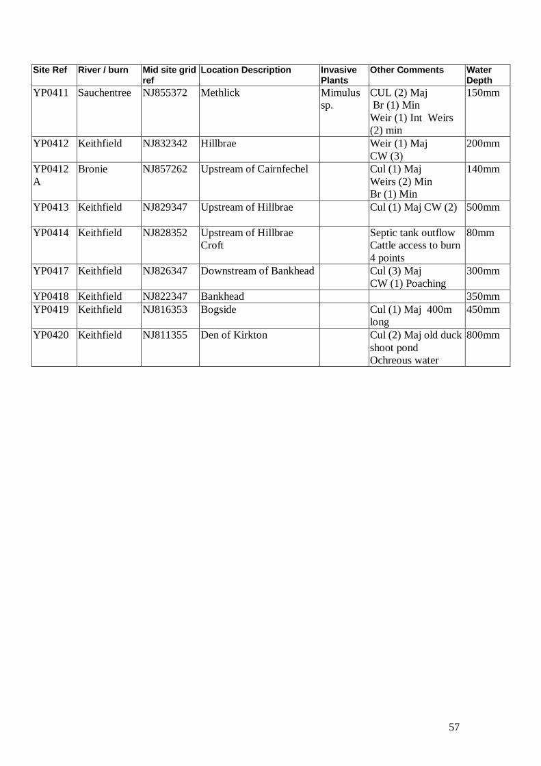
57
Site Ref River / burn Mid site grid ref
Location Description Invasive Plants
Other Comments Water Depth
YP0411 Sauchentree NJ855372 Methlick Mimulus
sp.
CUL (2) Maj
Br (1) Min
Weir (1) Int Weirs
(2) min
150mm
YP0412 Keithfield NJ832342 Hillbrae Weir (1) Maj
CW (3)
200mm
YP0412
A
Bronie NJ857262 Upstream of Cairnfechel Cul (1) Maj
Weirs (2) Min
Br (1) Min
140mm
YP0413 Keithfield NJ829347 Upstream of Hillbrae Cul (1) Maj CW (2)
500mm
YP0414 Keithfield NJ828352 Upstream of Hillbrae
Croft
Septic tank outflow
Cattle access to burn
4 points
80mm
YP0417 Keithfield NJ826347 Downstream of Bankhead Cul (3) Maj
CW (1) Poaching
300mm
YP0418 Keithfield NJ822347 Bankhead 350mm
YP0419 Keithfield NJ816353 Bogside Cul (1) Maj 400m
long
450mm
YP0420 Keithfield NJ811355 Den of Kirkton Cul (2) Maj old duck
shoot pond
Ochreous water
800mm


