Certified Recommendation Raleigh Planning Commission CR# 11385 Case Information - Z-16-10/ Wade Avenue Location Wade Avenue, north side, at its intersection with Faircloth Street Size 0.9 acre Request Rezone property from Residential-4 to Shopping Center Conditional Use District Comprehensive Plan Consistency Future Land Use Designation Low Density Residential Applicable Policy Statements Policy LU 1.3 - Conditional Use District Consistency Policy T 2.9 - Curb Cuts Policy UD 3.7 - Parking Lot Placement Consistent Inconsistent Summary of Conditions Submitted Conditions 1. Permitted uses: All uses permitted in R-4, plus surface parking lot (but not parking decks), access drives and associated features (sidewalks, curb & gutter, utility lines, related improvements). 2. All pole-mounted lighting to be of full cutoff design; maximum 0.4 footcandle at residential property lines. 3. Trash receptacle capacities limited to maximum size of 20 gallons. 4. Sidewalk a minimum of 5 feet wide required from Wade Avenue to shopping center property. 5. Transitional Protective Yard vegetation adjacent to properties fronting Redbud Lane to be of larger size upon planting than required by Code; multi-stem trees limited to 30% of total and no crape myrtles permitted. 6. Access to property from Wade Avenue limited to single curb cut. 7. Maximum building height to be the same as that permitted for R-4. 8. Dwelling units to be limited to a maximum of four per acre (i.e., R-4). 9. Closed fence 6’ tall to be installed within 5’ of property lines shared with parcels fronting Redbud Lane. Issues and Impacts Outstanding Issues 1. Inconsistency with Future Land Use Map in permitting a primary use (surface parking) associated with zoning other than the prescribed Low Density Residential designation. 2. Potential inconsistency with Policy UD 3.7 - Parking Lot Placement. 3. Recommendations of staff regarding content and wording of respective Conditions (see attachment). Impacts Identified None.
Location Wade Avenue, north side, at its intersection with Faircloth Street Size 0.9 acre
Request Rezone property from Residential-4 to Shopping Center Conditional Use District
Comprehensive Plan Consistency Future Land Use
Designation Low Density Residential
Applicable Policy Statements
Policy LU 1.3 - Conditional Use District Consistency Policy T 2.9 - Curb Cuts Policy UD 3.7 - Parking Lot Placement
Consistent Inconsistent
Summary of Conditions Submitted
Conditions 1. Permitted uses: All uses permitted in R-4, plus surface parking lot (but
not parking decks), access drives and associated features (sidewalks, curb & gutter, utility lines, related improvements).
2. All pole-mounted lighting to be of full cutoff design; maximum 0.4 footcandle at residential property lines.
3. Trash receptacle capacities limited to maximum size of 20 gallons. 4. Sidewalk a minimum of 5 feet wide required from Wade Avenue to
shopping center property. 5. Transitional Protective Yard vegetation adjacent to properties fronting
Redbud Lane to be of larger size upon planting than required by Code; multi-stem trees limited to 30% of total and no crape myrtles permitted.
6. Access to property from Wade Avenue limited to single curb cut. 7. Maximum building height to be the same as that permitted for R-4. 8. Dwelling units to be limited to a maximum of four per acre (i.e., R-4). 9. Closed fence 6’ tall to be installed within 5’ of property lines shared with
parcels fronting Redbud Lane.
Issues and Impacts Outstanding
Issues 1. Inconsistency with Future Land Use Map in permitting a primary use
(surface parking) associated with zoning other than the prescribed Low Density Residential designation.
2. Potential inconsistency with Policy UD 3.7 - Parking Lot Placement. 3. Recommendations of staff regarding content and wording of respective
Conditions (see attachment). Impacts
Identified None.
Suggested Conditions and Proposed Mitigation Suggested Conditions
1. The applicant may wish to provide a condition that describes how the subject property will be accessed from Wade Avenue and Faircloth Street.
Proposed Mitigation
None.
Public Meetings Neighborhood
Meeting Public
Hearing Committee of the Whole Planning Commission 6-2-10 7-20-10 8-3-10 Recommended approval 8-10-10 (Action)
Valid Statutory Protest Petition
Attachments 1. Staff report 2. Existing Zoning/Location Map 3. Future Land Use Map 4. Additional Staff Comments on case conditions
Planning Commission Recommendation
Recommendation The Planning Commission finds that this request is inconsistent with the Comprehensive Plan. However, based on the findings and reasons stated herein, the commission recommends that the request be approved in accordance with zoning conditions dated August 4, 2010.
Findings & Reasons (1) The request is inconsistent with the Comprehensive Plan. The Future Land Use Map designates the site for Low Density Residential (1 to 6 dwelling units per acre). However, the proposed rezoning would retain maximum density at the existing R-4 level, and limit additional uses solely to parking lot.
(2) The proposal could increase on-site safety by allowing a reconfiguration of access to the adjoining shopping center consistent with accepted transportation design practices.
(3) The proposal is conditioned to mitigate visual impacts from parking lot installation above Code requirements.
(4) The request is reasonable and in the public interest. Rezoning could provide additional parking for the existing shopping center, while ensuring pedestrian access.
Motion and Vote Motion: Harris Edmisten Second: Anderson In Favor: Anderson, Bartholomew, Batchelor, Butler, Fleming, Harris Edmisten, Haq, Mullins, Smith, Sterling
This document is a true and accurate statement of the findings and recommendations of the Planning Commission. Approval of this document incorporates all of the findings of the attached Staff Report. ________________________________ ______________________________8/10/10__ Planning Director Date Planning Commission Chairperson Date Staff Coordinator: Doug Hill [email protected]
Zoning Staff Report – Z-16-10 Conditional Use District
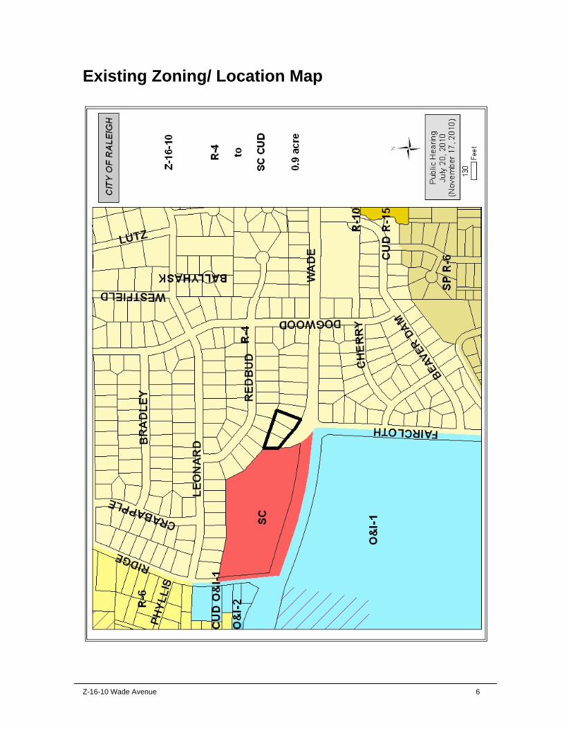
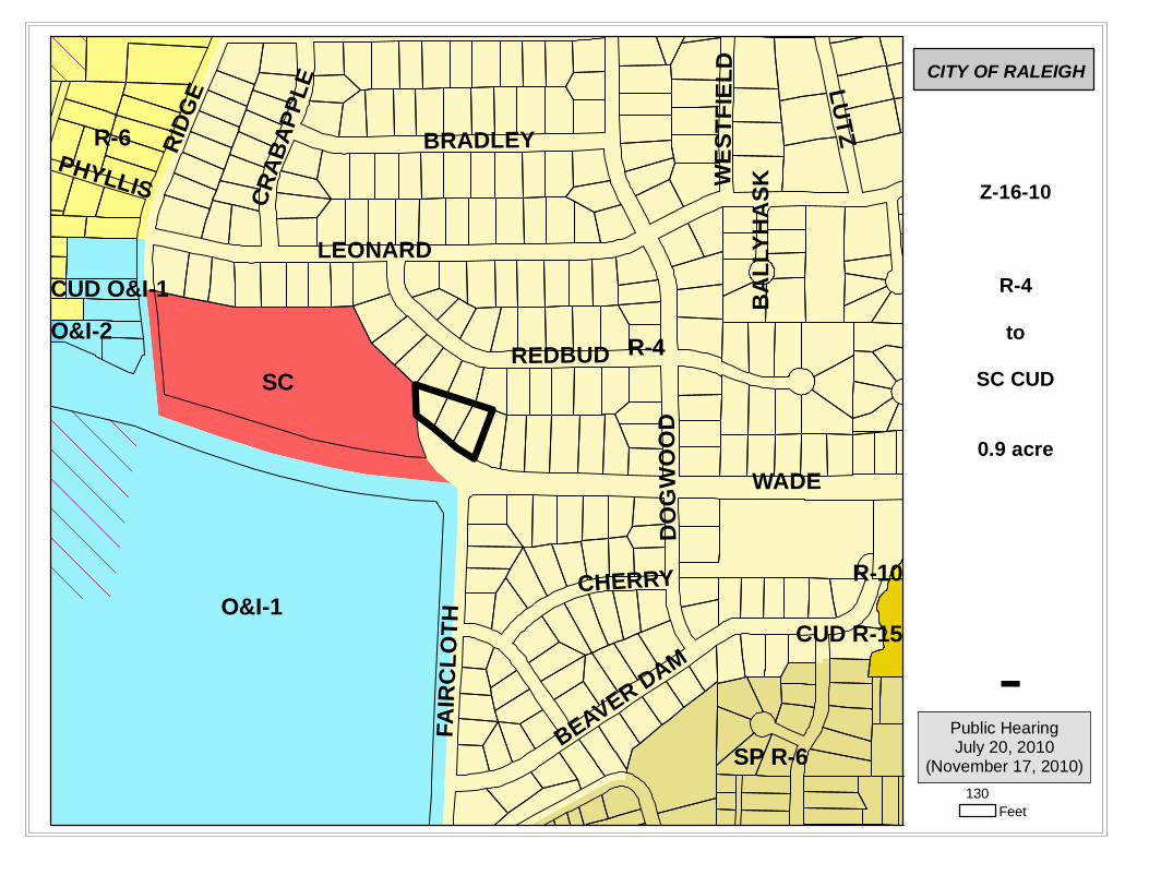
Request Location Wade Avenue, north side, at its intersection with Faircloth Street Request Rezone property from Residential-4 to Shopping Center Conditional
Use District Area of Request 0.9 acre Property Owner Country Club Homes. Inc.
PC Recommendation Deadline
November 17, 2010
Subject Property Current Proposed
Zoning Residential-4 Shopping Center CUD Additional Overlay n/a n/a
Land Use Low Density Residential (not provided) Residential Density 4 units per acre (3 maximum) Conditioned to 4 units per acre
(3 maximum)
Surrounding Area North South East West
Zoning R-4 R-4; O&I-1 R-4 SC Future Land
Use Low Density Residential
Low Density Residential; Institutional
Low Density Residential
Neighborhood Mixed Use
Current Land Use
Low Density Residential
Low Density Residential; College campus
Low Density Residential
Retail, Offices
Comprehensive Plan Guidance Future Land Use Low Density Residential
Area Plan n/a Applicable Policies Policy LU 1.3 - Conditional Use District Consistency
Policy T 2.9 - Curb Cuts Policy UD 3.7 - Parking Lot Placement
Overview The proposal seeks to rezone three single-family residential properties to Shopping Center. The existing zoning on the property is R-4. The submitted conditions would restrict future uses to those currently permitted in R-4 and surface parking. The Future Land Use Map designates the properties for continued low-density residential use. The properties are adjacent to the Ridgewood Shopping Center. Access is currently provided by a flared portion of Wade Avenue which also serves as an access drive to the adjacent shopping center.
Exhibit C & D Analysis Staff examines consistency with the Comprehensive Plan, compatibility with the surrounding area, public benefits and detriments of the proposal, and summarizes any associated impacts of the proposal.
1. Consistency of the proposed rezoning with the Comprehensive Plan and any applicable City-adopted plan(s)
1.1 Future Land Use
The Future Land Use Map designates the property for Low Density Residential development (one to six dwelling units per acre). The current zoning is consistent with this designation. The proposed zoning, while capped at a maximum of four units per acre, would permit surface parking lots—a use only permitted in non-residential districts. The proposal is thus inconsistent.
1.2 Policy Guidance The following policy guidance is applicable with this request.
Policy LU 1.3 - Conditional Use District Consistency All conditions proposed as part of a conditional use district (CUD) should be consistent with the Comprehensive Plan.
The conditioned uses are inconsistent with the Comprehensive Plan, in permitting surface parking as a primary use.
Policy T 2.9 - Curb Cuts The development of curb cuts along public streets—particularly on thoroughfares and arterials—should be minimized to reduce vehicular conflicts, increase pedestrian safety, and improve roadway capacity. The proposal conditions access to Wade Avenue to a single curb cut. This would be an improvement over existing conditions. There are currently three separate driveways to serve the three properties. Given the geometry and limited sight distances involved, a consolidation of access points could be beneficial. Policy UD 3.7 - Parking Lot Placement New parking lots on designated Urban or Multi-modal corridors on the Growth Framework Map should be generally located at the side or rear of buildings. Where feasible, existing parking lots on such corridors should be landscaped to create a pedestrian-friendly streetscape with business visibility.
Z-16-10 Wade Avenue 3
The site is located on a part of Wade Avenue designated as an Urban Corridor on the Growth Framework Map. The proposal as conditioned would permit surface parking as a primary use, without note of parking lot placement or landscaping.
1.3 Area Plan Guidance
This site is not located within a part of the City subject to an Area Plan.
2. Compatibility of the proposed rezoning with the property and surrounding area Properties abutting the site on the north and east, and located diagonally southeast across Wade Avenue, are zoned Residential-4 and developed with single-family detached dwellings. The property to the southwest across Wade Avenue is the northwest corner of the Meredith College campus, which, while zoned O&I-1, is characterized by dense woods for much of the Wade Avenue corridor. Rezoning the subject site would not disallow future redevelopment at the current density, but use of the site as a surface parking lot represents a departure from existing residential form and use.
3. Public benefits of the proposed rezoning
Redevelopment could result in improved ingress/ egress to the adjacent shopping center complex, as well as potentially relieve parking pressures for shopping center patrons. The proposal lists “additional service-related non-residential uses within walking distance and with improved connectivity” and “additional retail options through expansion of the existing shopping center” as being among the possible public benefits attendant to rezoning. The conditioned non-residential uses of the site, however, are limited to surface parking and access drives. Additionally, aside from the conditioned sidewalk connection, no conditions are provided regarding pedestrian-oriented development.
4. Detriments of the proposed rezoning No conditions are provided regarding building orientation, placement, or design (other than height), nor any as to parking placement, site signage, or other features potentially impacting neighborhood character. Topographically, the three parcels decline nearly 20 feet west to east across the boundaries shared with residences to the north (which front Redbud Lane); grading for access drive improvements and/ or parking areas could necessitate retaining walls, potentially reducing the benefits of transition yard plantings. Additionally, should the access drive be repositioned closer to the neighborhood, noise and light impacts (i.e., car headlights) could proportionately increase. Two large oak trees on Wade Avenue, near the southwest corner of the site, contribute significantly to the character of the adjacent area; the effect of future site redevelopment on the two trees is not addressed.
5. The impact on public services, facilities, infrastructure, fire and safety, parks and recreation, etc.
5.1 Transportation
Wade Avenue is classified as secondary arterial (2007 ADT 32,000 vpd) and exists as a 4-lane curb and gutter section roadway with sidewalks on both sides within a 90-foot right-of-way. City standards call for Wade Avenue to be constructed as a 6-lane roadway within a minimum 110-foot right-of-way. Faircloth Street is classified as a minor thoroughfare (2007 ADT 11,000 vpd) and is constructed as 2-lane curb and gutter section roadway with sidewalk on one side. City standards call for sidewalk to be constructed on both sides of Faircloth Street.
Z-16-10 Wade Avenue 4
By the year 2030 traffic volumes along Wade Avenue near the subject property are forecasted to increase to 43,616 vehicles per day, an increase of 36% over current traffic volume. The City currently has a project to add sidewalk along the north side and a multi-use path along the south side Wade Avenue from Ridge Road to Faircloth Street. The subject property is provided access within the right-of-way of Wade Avenue. The proposed rezoning eliminates the need for this right-of-way and as such should be included with development of the subject property. The petitioner may wish to describe how the subject property will be accessed from Wade Avenue and Faircloth Street.
Impact Identified: The City’s transportation services are expected to be able to accommodate any changes in traffic due to the proposed rezoning.
5.2 Transit
This area is currently served by Route 4 Rex Hospital Monday through Saturday during the daytime and by Route 37 Blue Ridge during the evenings and on Sunday. The closest stop westbound is on Wade just east of the shopping center. With the installation of a multipurpose path it is anticipated that this stop would be moved west of the shopping center entrance. Eastbound, the closest stop is at the back entrance to Meredith College. The proposed sidewalk will benefit the stop and it is not anticipated that it would be changed. Impact Identified: No impacts on the City’s transit services are expected due to the proposed rezoning.
5.3 Hydrology
Impact Identified: There are no additional requirements beyond meeting Part 10, Chapter 9 Stormwater Regulations.
5.4 Public Utilities
Maximum Demand (current) Maximum Demand (proposed) Water 1,800 gpd 4,050 gpd
Waste Water 1,800 gpd 4,050 gpd Site redevelopment, if permitted at densities of the proposed base district (SC), would add approximately 2250 gpd to the wastewater collection and water distribution systems of the City of Raleigh. There is an existing eight (8”) inch sanitary sewer main and an existing eight (8”) inch water main in Wade Avenue that the proposed development could use to connect to the City’s utilities. Impact Identified: The City’s utility infrastructure is expected to accommodate increased demands resulting from this proposal.
Floodplain No Drainage Basin Beaver Creek
Stormwater Management Subject to Part 10, Chapter 9 Overlay District No
Z-16-10 Wade Avenue 5
5.5 Parks and Recreation This property is not adjacent to any greenway corridors. Impact Identified: This rezoning will not impact the recreation level of service of the area.
5.6 Urban Forestry As the site is less than 2 acres, the proposed rezoning will not impact Tree Conservation. However, the proposed landscape plan requirements should meet or exceed requirements outlined in City code. Impact Identified: No impacts to the City’s urban forest are expected from this proposal.
5.7 Wake County Public Schools The proposed amended uses would result in the same or fewer students being added to the number possible under the current zoning conditions. Impact Identified: There is no negative impact identified related to Wake County Schools. Certain allowed uses could decrease the school age population on this property, lessening demand for public schools in the area.
5.8 Designated Historic Resources No historic resources are located on the site, or within 100 feet of the site. Impact Identified: No impacts to the City’s historic resources are expected from this proposal.
5.9 Impacts Summary None.
5.10 Mitigation of Impacts N/A
6. Appearance Commission This proposal is not subject to Appearance Commission review.
7. Conclusions The proposal is inconsistent with the Future Land Use Map in permitting a primary use (surface parking) associated with zoning other than the prescribed Low Density Residential designation. Additionally, the proposed condition could permit development inconsistent with Comprehensive Plan policies regarding parking placement on Urban Corridors, and the need to encourage pedestrian-oriented uses. The petitioner may wish to provide a condition that describes how the subject property will be accessed from Wade Avenue and Faircloth Street.
Z-16-10 Wade Avenue 6
Existing Zoning/ Location Map
Z-16-10 Wade Avenue 7
Future Land Use Map
Z-16-10 Wade Avenue 8
Additional Staff Comments Z-16-10 Conditions Condition (b) Rather than referring to “all uses permitted in the Residential-4 district,” specify the exact uses to be permitted. Also, remove the reference to “associated features” (curb, gutter, walk, etc.), as these are not uses.
Condition (e) Specify where the sidewalk will be located (this Property? the adjacent shopping center tract?). At minimum, include such wording as: “with the final location of the sidewalk connections to be determined in coordination with City of Raleigh staff.” Condition (h) Specify the maximum number of building stories and feet, including the phrase “as measured by City Code Section 10-2076(b),” instead of referring to “the Residential-4 district.” List the minimum setbacks in feet.
Condition (j) Add the sentence: ”This fence shall not be applied toward any reduction in the width of the required Transitional Protective Yard (as might be otherwise permitted under Code Sec. 10-2082.9(g)(3)).”