1 Z-17-36 AN ORDINANCE BY ZONING COMMITTEE AS SUBSTITUTED BY ZONING COMMITTEE AN ORDINANCE TO AMEND THE 1982 ATLANTA ZONING ORDINANCE OF THE CITY OF ATLANTA BY REPLACING CHAPTER 18P. SPI 16 MIDTOWN SPECIAL PUBLIC INTEREST DISTRICT WITH A NEW CHAPTER ENTITLED CHAPTER 18P. SPI 16 MIDTOWN SPECIAL PUBLIC INTEREST DISTRICT; AND FOR OTHER PURPOSES. Whereas, the SPI-16 Midtown Special Public Interest District (“SPI-16 District”) Regulations (“SPI-16 Regulations”), adopted in 2001 and amended from time to time thereafter, are codified as Chapter 18P of the 1982 Zoning Ordinance of the City of Atlanta, as amended; and Whereas, after administering the SPI-16 Regulations throughout the last 15 years of intense growth and development, the City’s Office of Zoning and Development has collaborated with Midtown Alliance and other interested parties to identify key revisions to regulate the orderly future growth and development on the SPI-16 District; and Whereas, the proposed revisions will simplify the SPI-16 District Regulations, enhance clarity and consistency with other SPI districts, reduce the number of variations requested, and reinforce Midtown’s inherent strengths: walkability, access to transit, open space and a balanced mix of uses to support a high quality of life; and Whereas, the proposed revisions to the SPI-16 District Regulations will facilitate continued growth and high caliber development, prioritize solutions that simplify the regulations, and increase uniformity and reduce ambiguity; in short provide for a more user-friendly ordinance; and Whereas, this ordinance does not change the SPI-16 District (including sub-areas) boundary, which boundary is set forth on the Official Zoning Map. Rather, this ordinance only adopts new regulations for the SPI-16 District. This ordinance adopts map attachments referenced in the new regulations. NOW THEREFORE, THE CITY COUNCIL OF THE CITY OF ATLANTA, GEORGIA HEREBY ORDAINS: Section 1: The 1982 Zoning Ordinance of the City of Atlanta is hereby amended by replacing Chapter 18P. SPI-16 Midtown Special Public Interest District Regulations with a new Chapter 18P. entitled SPI-16 Midtown Special Public Interest District Regulations which new Chapter shall read as shown on the attached Exhibit “1” which is incorporated herein. Section 2: The SPI-16 Midtown Special Public Interest District Regulations set forth on the attached Exhibit “1” include the following attachments: A: “SPI-16 Zoning Boundaries” B: “Conventional Streets and Pedestrian Ways”; C: “Street Typology”; and D: “Midtown Bonus Incentives”. These attachments are referenced in the SPI-16 Midtown Special Interest District
Transcript
1
Z-17-36
AN ORDINANCE
BY ZONING COMMITTEE
AS SUBSTITUTED BY ZONING COMMITTEE
AN ORDINANCE TO AMEND THE 1982 ATLANTA ZONING
ORDINANCE OF THE CITY OF ATLANTA BY REPLACING CHAPTER
18P. SPI 16 MIDTOWN SPECIAL PUBLIC INTEREST DISTRICT WITH
A NEW CHAPTER ENTITLED CHAPTER 18P. SPI 16 MIDTOWN
SPECIAL PUBLIC INTEREST DISTRICT; AND FOR OTHER
PURPOSES.
Whereas, the SPI-16 Midtown Special Public Interest District (“SPI-16 District”) Regulations
(“SPI-16 Regulations”), adopted in 2001 and amended from time to time thereafter, are codified
as Chapter 18P of the 1982 Zoning Ordinance of the City of Atlanta, as amended; and
Whereas, after administering the SPI-16 Regulations throughout the last 15 years of intense
growth and development, the City’s Office of Zoning and Development has collaborated with
Midtown Alliance and other interested parties to identify key revisions to regulate the orderly
future growth and development on the SPI-16 District; and
Whereas, the proposed revisions will simplify the SPI-16 District Regulations, enhance clarity
and consistency with other SPI districts, reduce the number of variations requested, and reinforce
Midtown’s inherent strengths: walkability, access to transit, open space and a balanced mix of uses
to support a high quality of life; and
Whereas, the proposed revisions to the SPI-16 District Regulations will facilitate continued
growth and high caliber development, prioritize solutions that simplify the regulations, and
increase uniformity and reduce ambiguity; in short provide for a more user-friendly ordinance; and
Whereas, this ordinance does not change the SPI-16 District (including sub-areas) boundary,
which boundary is set forth on the Official Zoning Map. Rather, this ordinance only adopts new
regulations for the SPI-16 District. This ordinance adopts map attachments referenced in the new
regulations.
NOW THEREFORE, THE CITY COUNCIL OF THE CITY OF ATLANTA, GEORGIA
HEREBY ORDAINS:
Section 1: The 1982 Zoning Ordinance of the City of Atlanta is hereby amended by replacing
Chapter 18P. SPI-16 Midtown Special Public Interest District Regulations with a new Chapter
18P. entitled SPI-16 Midtown Special Public Interest District Regulations which new Chapter shall
read as shown on the attached Exhibit “1” which is incorporated herein.
Section 2: The SPI-16 Midtown Special Public Interest District Regulations set forth on the
attached Exhibit “1” include the following attachments: A: “SPI-16 Zoning Boundaries” B:
“Conventional Streets and Pedestrian Ways”; C: “Street Typology”; and D: “Midtown Bonus
Incentives”. These attachments are referenced in the SPI-16 Midtown Special Interest District
2
Regulations and are a part thereof and shall be incorporated herein, with said attachments defining
the areas in which the SPI-16 Midtown Special Interest District Regulations shall be effective.
Section 3: Should any section or provision of this ordinance, including attachments hereto, or the
application thereof to any person or circumstance, be declared by a court of competent jurisdiction
to be invalid, such decision shall not affect the validity of the ordinance, including attachments
hereto, as a whole or any section thereof other than the section or provision, or application thereof,
specifically declared to be invalid.
Section 4: This ordinance shall become effective when signed by the Mayor or as otherwise
provided by law.
3
Exhibit 1
CHAPTER 16-18P. - SPI-16 MIDTOWN SPECIAL PUBLIC INTEREST DISTRICT REGULATIONS
Sec. 16-18P.001. - Scope of provisions.
The regulations set forth in this chapter, or set forth elsewhere in this part when referred to in this chapter, are the regulations for the SPI-16 Midtown Special Public Interest (SPI) District. These regulations shall supplant existing districts or portions of existing districts as shown on the attached map referenced in Section 16-18P.003, except as provided herein.
All attachments referenced in these regulations are attached to the ordinance
adopting these regulations. Said ordinance, including all exhibits and attachments, is a public record available for public inspection in the office of the Atlanta Municipal Clerk. The ordinance is also available for public inspection on “final action legislation” link on the City Council’s website.
All existing categories of historic protection designated pursuant to chapter 20 of Part
16 shall continue in full force and effect and said existing historic protection regulations shall be overlaid upon, and shall be imposed in addition to, the regulations set forth in this chapter. Whenever the following regulations are at variance with said existing historic protection regulations, the historic protection regulations shall apply. Whenever the following regulations conflict with provisions of Part 16 other than historic protection regulations, the more stringent regulation shall apply.
Sec. 16-18P.002. - Statement of intent.
The intent of the council in establishing and updating the SPI-16 Midtown Special Public Interest District is as follows:
1. Implement provisions of the Comprehensive Development Plan incorporating certain recommendations contained in studies of this area, including the initial comprehensive study known as Blueprint Midtown;
2. Implement provisions of subsequent supplemental plans and studies of this area including Blueprint Midtown II, Greenprint Midtown, I-75/85 Connector Transformation Study, Parking Study and Action Plan, Midtown Transportation Plan and Blueprint Midtown 3.0;
3. Create an urban environment where people can live, work, meet and play; 4. Encourage a compatible mixture of residential, commercial, cultural and
recreational uses; 5. Improve the aesthetics of the built environment; 6. Facilitate safe, pleasant and convenient pedestrian circulation and minimize
conflict between pedestrians and vehicles; 7. Maximize opportunities for pedestrian amenities, including public art, safe
accessible parks, plazas, and greenways for active and passive enjoyment; 8. Provide appropriately scaled, continuous pedestrian oriented uses and activities
adjacent to sidewalks along streets with identified pedestrian needs;
4
9. Provide a range of housing types and prices to meet different housing needs; 10. Preserve and protect Midtown’s historic buildings and sites; 11. Encourage infill and rehabilitation development within traditionally commercial
areas that include proportionately significant residential uses; 12. Provide for development compatible with existing surrounding residential areas
and provide for appropriate transitions between new development toward residential neighborhoods;
13. Encourage the use of MARTA through the location of mixed-use development around MARTA rail stations;
14. Minimize the amount of vehicular parking provided by encouraging shared parking and access along with alternative modes of transportation, while continuing to provide sufficient parking in an unobtrusive manner;
15. Encourage the increased use of alternative modes of transportation and mobility such as walking, biking, and public transportation;
16. Encourage opportunities for economic development where there is a planned relationship between transportation systems and development.
Sec. 16-18P.003. - Boundaries of district established.
The boundaries of the SPI-16 Midtown Special Public Interest District are shown on Attachment A: SPI-16 Boundaries Map which by this reference is incorporated into and made a part of this chapter. The Midtown Special Public Interest District is divided into three (3) subareas as shown on said Attachment A: SPI-16 Boundaries Map. The subareas are described as follows:
1. A Special Administrative Permit (SAP) application and a specified number of copies each of a site plan, landscape plan, and elevation drawings of each exterior façade shall be submitted, as applicable, and approved by the Office of Zoning and Development prior to filing for a building permit. All exterior demolition, new construction (including additions to existing buildings), new or expanded outdoor dining, or work which results in increased lot coverage, modification of the building footprint, or modification of building facades that would reduce the configuration of street facing openings, shall be subject to said SAP approval. All applications for a SAP shall be processed in accordance with the standards and procedures applicable to said SAP applications contained in Chapter 25 of Part 16 except as otherwise modified by this Chapter 18P. No SAP shall be issued until after such time any other required Special Use Permit or Board of Zoning Adjustment action has been obtained.
2. Administrative variations: As part of general action when plans require approval of an SAP, the Office of Zoning and Development may authorize variations from regulations generally applying based on written findings, to be filed as a public record, that either:
5
a. A plan proposed by an applicant, while not strictly in accordance with regulations applying generally within the district, satisfies the public purposes and intent of such regulations, and provides public protection to an equivalent or greater degree than strict enforcement of such regulations would provide; or
b. In the particular circumstances of the case, strict application of a particular regulation or regulations is not necessary for the accomplishment of public purposes or the provision of public protection, at that time or in the future.
c. Notwithstanding any provision in this chapter or part to the contrary, no administrative variation shall be authorized for those listed in Sec. 16-18P.005(4) for the Board of Zoning Adjustments.
3. The Office of Zoning and Development may exempt certain classes of applications for SAPs from detailed review requirements as set forth upon written findings that generally within these districts, the actions proposed are of such a character or scale as to make detailed reviews and approval unnecessary. Where applications for special administrative permits are determined by reference to such findings to be thus exempted, the permit shall be issued if otherwise lawful.
4. For the purposes of this chapter, a unified development plan approved under a single SAP and meeting all floor area ratio requirements, open space requirements, and off-street parking requirements, may be subdivided, even if the resultant parcels do not otherwise meet these requirements. Any changes from the approved SAP shall require a new or amended SAP, which shall be based on the geographic extent of the original SAP and shall meet floor area ratio requirements, open space requirements, and off-street parking requirements of such; and shall indicate built or planned improvements on the original parcel(s). Where a single property owner no longer owns all parcels, the applicant shall obtain authorization from all property owners prior to permit submittal.
Sec. 16-18P.005. - Permitted principal uses and structures.
1. The permitted principal uses and special permit uses set forth in Table 1: SPI-16 Midtown Table of Uses shall be permitted only as listed within each subarea within said Table of Uses and only in the manner so listed.
2. Permitted Principal Uses: A building or premises shall be used only for the principal uses indicated with a "P" in Table 1: SPI-16 Midtown Table of Uses.
3. Special Use Permits: Special use permits shall be required as indicated with "SUP" in Table 1: SPI-16 Midtown Table of Uses. These uses are permissible subject to limitations and requirements set forth elsewhere in this chapter and in Section 16-25.001, et seq. a. Eating and drinking establishments:
Location Size requiring Special Use Permit (SUP)
East side of Peachtree St. 10,000 or more square feet Both fronting along the west side of Juniper St. & south of 10th St.
5,000 or more square feet
Both east of Juniper St. & north of 10th St. 5,000 or more square feet Both east of Juniper St. & south of 10th St. 2,000 or more square feet
6
b. Transfer of development rights: Transfer of development rights is permissible provided meeting the following criteria in addition to those in Section 16-28.023.
i. Both the sending and receiving properties must be located within SPI-16 whereas for purposes of Section 16-28.023, properties shall be deemed to be closely proximate if both lie within this SPI-16 District;
ii. The sending property must either be considered as new public parking per the table in Section 16-18P.010 or new public park space per Section 16-18P.010(3)(d) or designated under the city's historic preservation ordinance;
iii. Whenever the transfer of development rights regulations of this district are at variance with transfer of development rights provisions established in Sec. 16-28.023 the regulations of this district shall apply.
4. Board of Zoning Adjustments: The following are permissible only when approved by the Board of Zoning Adjustments through variance or special exception, as applicable: a. Accessory outdoor amplified music. b. Alterations in transitional height planes or transitional yards. c. Reduction or transfer of parking requirements for parcels east of Juniper Street
whereas parking requirements may be reduced or transferred off-site. 5. Prohibited Uses and Structures:
a. All uses marked with an “X” in Table 1: SPI-16 Table of Uses shall be prohibited in the subarea(s) identified. All other uses not listed in said Table 1: SPI-16 Table of Uses shall be considered prohibited in all district subareas.
b. Pedestrian bridges and/or tunnels. c. Pedestrian colonnades and/or arcades oriented parallel to the closest street.
6. Use Enclosure Requirements: a. Unenclosed outdoor displays of merchandise are prohibited in street furniture
zones or clear zones. b. When located within a supplemental zone, unenclosed outdoor displays of
merchandise must at the end of each business day be removed and placed inside a fully-enclosed structure.
7. Exclusions: No use or manner of operation shall be permitted which is obnoxious or offensive by reason of odor, smoke, noise, glare, fumes, gas, vibration, unusual danger of fire or explosion, emission of particulate matter, or interference with radio or television communication, or is otherwise incompatible with the character of the district.
Table 1: SPI-16 Table of Uses Permitted Uses and Structures
P=Permitted Principal Uses & Structures SUP=Special Use Permit X=Not Permitted
Subarea 1: Midtown
Commercial
Subarea 2: Midtown
Residential
Subarea 3: Juniper
East
Banks/Financial Institutions P X X Barber Shops and Beauty Shops P P P Broadcast Telecommunication Towers P P P Business/Commercial Schools P X P Childcare Centers P P P
7
Permitted Uses and Structures P=Permitted Principal Uses & Structures SUP=Special Use Permit X=Not Permitted
Subarea 1: Midtown
Commercial
Subarea 2: Midtown
Residential
Subarea 3: Juniper
East
Churches/Religious Facilities P SUP P
Clubs/Lodges 5,000 s.f. or less P SUP P > 5,000 s.f. P X P
Commercial Recreation P P P Dormitories/Fraternities/Sororities P X X Eating and Drinking Establishments (per size limitations in Sec. 16-18P.005(3.a)) other than Nightclub or Lounge
P/SUP P/SUP P/SUP
Defined as a Nightclub or Lounge in Chapter 10 (Alcoholic Beverages) (6,000 s.f. limit)
SUP SUP SUP
Exterior drive-through and drive-in facilities X X X Farmers Markets P P P Fuel service stations (certain locations only) P2/X X X Helicopter Landing Facilities SUP SUP SUP Hotels & Motels Lodging (*SA-3 less than 100 rooms) P X P* Institutions of Higher Learning P X X Laundry/Dry Cleaning (*2,500 s.f. limit) P* P* P* Market Gardens P P P Mortuary/Funeral Homes (certain locations only) P1 / X X X Museums/Galleries/Libraries P SUP SUP Nursing Homes/ Personal Care Homes / Assisted Living Facilities/ Rehabilitation Centers
SUP SUP SUP
Offices (other than Medical/Dental Office) P P P Medical/Dental Office P P P Outdoor amusement enterprises, entertainment, music venues, meetings or sales areas
90 days duration or less SAP SAP SAP
90 days duration or more SUP SUP SUP
Park-for-hire surface parking lots X X X Park-for hire parking structures SUP SUP SUP Printing P P P Residential dwelling(s) P P P Retail Establishments P P P Professional/Personal Services P P P Public and Private Schools P X P Sales and Repair Establishments P P P Service Stations- including fuel (certain locations only) P2,3/ X X P3 / X Shelters SUP X X Structures/Uses for MARTA P P P Supportive Housing P P P Telecommunication Switchboards/Etc. P X X Urban Gardens P P P
1 West of W. Peachtree St only. 2 West of Spring St only. 3 Along Ponce de Leon only.
8
Sec. 16-18P.006. - Permitted accessory uses and structures.
Accessory uses and structures permitted within this district shall include those customarily accessory and clearly incidental to permitted principal uses and structures and specifically include clubhouses, pools (and other recreation amenities) pet amenities, bike parking and repair, auto parking to serve authorized uses, outdoor dining, exhibits and displays (without commercial sales transactions) and electric vehicle charging stations equipped with Level 1, Level 2, and/or DC Fast Charge EVSE. Sec. 16-18P.007. - Subdivision including zero-lot-line development.
In addition to the requirements of Section 16-28.007, zero-lot-line subdivision is permitted for residential uses provided a minimum of 1,000 square feet in lot area is provided. Other subdivisions shall be allowed but shall not modify the determination of requirements found in Section 16-18P.014.
Sec. 16-18P.008. - Redevelopment requirements.
Property shall be redeveloped in accordance with the requirements of this chapter when 60 percent or greater of the principal building on the property is removed or destroyed by any means. This shall be construed as follows:
1. Any paving or other accessory structural elements within any required transitional yard shall be removed and buffers provided as required herein, notwithstanding any other provisions in Part 16 to the contrary.
2. If no development is proposed concurrent with proposed demolition, all adjacent rights-of ways shall be repaired to provide ADA accessible public sidewalks within 180 days of completion of demolition. Further, within 18 months of the issuance of an SAP for such demolition, full streetscaping in accordance with Section 16-18P.012 (including sidewalks and street trees) shall be installed.
Sec. 16-18P.009. - Transitional height planes, yards, fences and walls.
1. Transitional height planes: Where this district adjoins an R district, PD-H district or SPI-17 (Subarea 4) district without an intervening street, height within this district shall be limited as follows: No portion of any structure shall protrude through a height limiting plane beginning 35 feet above the buildable area boundary nearest to such district boundary extending inward over this district at an angle of 45 degrees.
2. Transitional yards and screening: a. Yards: Where this district adjoins an R district, PD-H district, or SPI-17
(subarea 4) district without an intervening street, a minimum 20 foot transitional yard is required which shall not be used for the purpose of parking, loading, servicing or any other activity with the exception of private alleys or drives a maximum of ten (10) feet in width. Such yards shall be planted as approved by the city arborist and maintained as a landscaped strip.
b. Screening: Permanent opaque walls six (6) feet in height shall be provided within the transitional yard and shall be maintained in good condition.
9
3. Fences and walls located between the primary building and a side or rear lot line up to six feet in height may be erected. Barbed wire, razor wire, uncoated chain link fence or similar materials shall be prohibited.
Sec. 16-18P.010. - Development controls.
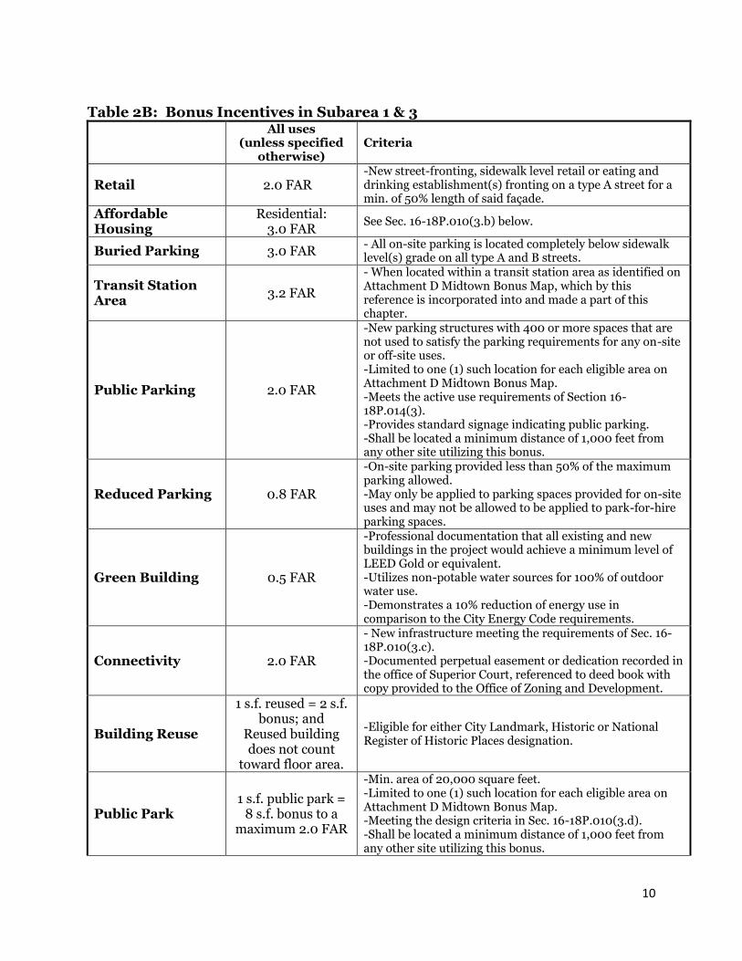
Development shall comply with Table 2A entitled “SPI-16 Development Controls Table” and with subsections 1 through 7. Development within sub-areas 1 & 3 shall be eligible for incentive(s) upon meeting the corresponding criteria set forth in Table 2B entitled “Bonus Incentives in Sub-area 1 & 3”.
Table 2A:
SPI-16
Development
Control
Table
Midtown Mixed Use (SA #1) Midtown Residential
(SA #2) Juniper East (SA #3)
FAR
(by
right)
Max FAR
Bonus(es)
See below
Max FAR
(with
Bonus(es)1
Juniper St. Transition Area
Non-Juniper St. Transition Area
FAR
(by right)
Max
FAR Bonus
Max. FAR (with Bonus)
Non-
Residential
FAR (times
gross lot area)
5.0 5.2 10.2
On street level & street frontage
On street level & street frontage 2,500 sf, max 5% residential floor area
2.0 0 2.0
Residential
FAR (times
gross lot area)
3.2 7.0 10.2 6.4 3.2 3.2 3.8 7.0
Max FAR 8.2 10.2 6.4 3.2 5.2 7.0
Minimum
Façade Height 24' 24’ 24’
Maximum
Height
None, except for transitional height plane2 adjacent to R
districts, PH-D or SPI 17-SA 4
250' (400' in Juniper St. Transition Area)
100' (60' East of Piedmont Ave.)
Side Yard
Setback (Alleys
permitted to 10'
wide)
None3, except min. 10' for on-site residential uses with windows
facing the side yard.
15' (of which 5' shall be landscaped)
None2, except 20' with windows adj. to
residential
Rear Yard
Setback (Alleys
permitted to 10'
wide)
None3, except min. 10' for on-site residential uses with windows
facing the rear yard
15’ 20’
1 The only exceptions to the Max FAR is via the provision of certain bonuses described below for either: ‘Affordable Housing’; ‘Buried Parking’; or ‘Public Park’; or via a special use permit for the transfer of development rights per Sec. 16-18P.005(3.b). 2 Transitional height plane begins 35' above the buildable area boundary and extends at a 45 degree angle away. See Section 16-18P.009(1). 3 Subject to building code requirements.
10
Table 2B: Bonus Incentives in Subarea 1 & 3
All uses
(unless specified otherwise)
Criteria
Retail 2.0 FAR -New street-fronting, sidewalk level retail or eating and drinking establishment(s) fronting on a type A street for a min. of 50% length of said façade.
Affordable Housing
Residential: 3.0 FAR
See Sec. 16-18P.010(3.b) below.
Buried Parking 3.0 FAR - All on-site parking is located completely below sidewalk level(s) grade on all type A and B streets.
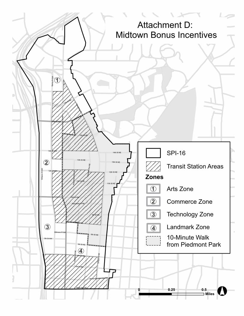
Transit Station Area
3.2 FAR
- When located within a transit station area as identified on Attachment D Midtown Bonus Map, which by this reference is incorporated into and made a part of this chapter.
Public Parking 2.0 FAR
-New parking structures with 400 or more spaces that are not used to satisfy the parking requirements for any on-site or off-site uses. -Limited to one (1) such location for each eligible area on Attachment D Midtown Bonus Map. -Meets the active use requirements of Section 16-18P.014(3). -Provides standard signage indicating public parking. -Shall be located a minimum distance of 1,000 feet from any other site utilizing this bonus.
Reduced Parking 0.8 FAR
-On-site parking provided less than 50% of the maximum parking allowed. -May only be applied to parking spaces provided for on-site uses and may not be allowed to be applied to park-for-hire parking spaces.
Green Building 0.5 FAR
-Professional documentation that all existing and new buildings in the project would achieve a minimum level of LEED Gold or equivalent. -Utilizes non-potable water sources for 100% of outdoor water use. -Demonstrates a 10% reduction of energy use in comparison to the City Energy Code requirements.
Connectivity 2.0 FAR
- New infrastructure meeting the requirements of Sec. 16-18P.010(3.c). -Documented perpetual easement or dedication recorded in the office of Superior Court, referenced to deed book with copy provided to the Office of Zoning and Development.
Building Reuse
1 s.f. reused = 2 s.f. bonus; and
Reused building does not count
toward floor area.
-Eligible for either City Landmark, Historic or National Register of Historic Places designation.
Public Park 1 s.f. public park =
8 s.f. bonus to a maximum 2.0 FAR
-Min. area of 20,000 square feet. -Limited to one (1) such location for each eligible area on Attachment D Midtown Bonus Map. -Meeting the design criteria in Sec. 16-18P.010(3.d). -Shall be located a minimum distance of 1,000 feet from any other site utilizing this bonus.
11
1. Residential uses with more than 50 dwelling units shall provide a minimum of 5% of such total dwelling units as units having three (3) or more bedrooms.
2. Attachment B Conventional Streets and Pedestrian Ways shall govern the following: a. New conventional streets and new pedestrian ways shall be constructed as
shown in Attachment B in order to create pedestrian and vehicular connectivity.
b. New conventional streets created per Sec. 16-18P.010(2.a) above, shall meet the requirements of Sec. 16-18P.010(3.c) below.
c. All other regulations within this district applicable to streets and street frontages shall be applied to the new conventional streets and new pedestrian ways required in Attachment B.
d. The area of any such new conventional streets or new pedestrian ways shall be allowed to be included in the net or gross area calculation for density purposes and shall be afforded a density bonus as specified in Sec. 16-18P.010(3.c) below.
3. Density Bonus Opportunities: a. Whenever the affordable housing provisions of this district are in conflict with
affordable housing established in Sec. 19-1006, the regulations of this district shall apply.
b. Affordable housing (new sales housing units or rental housing units) for the purposes of this chapter shall mean residential units that are solely and actually provided to individuals and/or families as specified by the following measures:
i. A minimum of 10% of the total number of units provided at or below 60% percent of area median income (AMI); or
ii. A minimum of 15% of the total number of units provided at or below 80% percent of area median income (AMI).
In addition to the above each of the following criteria shall be met: iii. Affordable requirements shall be in place for a minimum of 30 years
from the date of issuance of the occupancy permit and shall include deed restrictions governing the resale value or rental rate placed on the affordable units.
iv. Parking for all such affordable dwelling units shall be leased or sold separately from the rental or purchase price for such units for the life of the unit such that the renter or purchaser has an option to have the unit priced lower than if the price of the unit and parking space were combined.
v. No certificate of occupancy shall be issued until such time as a recorded land use restrictive covenant is provided to the City establishing that the affordable housing requirements are met.
c. Connectivity: Shall only be established via new conventional streets, shared streets, mid-block passages, or alleys, and shall be designed to meet the following criteria:
i. For new public or private conventional streets: A minimum 40’ width without gates or similar barriers including a minimum of two (2) travel lanes and along both sides of the street: granite curbing, sidewalk street
12
furniture zones at a minimum width of three (3) feet and sidewalk clear zones at a minimum width of five (5) feet.
ii. For new public or private shared streets: A minimum 20-foot width paved surface for pedestrians and/or vehicles without gates or similar barriers.
iii. For new public or private pedestrian ways: A minimum 20-foot width including a minimum 10-foot wide pedestrian-only pathway.
iv. For new public or private service streets: A minimum 20-foot width utilized for vehicles only.
d. Public Park Space: Shall be designed to meet the following criteria: i. Shall provide active and/or passive recreational amenities visible and
accessible from any point along 90 percent of any adjacent sidewalk. ii. Shall permit and encourage pedestrians to walk on a minimum of 80
percent of the surface of the parcel excluding fountains, pedestrian furniture, public art and similar elements.
iii. Shall be designed in accordance with the requirements for supplemental zones in Section 16-18P.013.
iv. Shall be open to the public during all daylight hours. v. Shall be continuously well maintained by a designated agent for such
maintenance. 4. Public Façade Materials: Exterior Insulation Finishing System (EIFS) shall not be
allowed on any street facing façade. 5. Roofing: All building and structural roofs shall be constructed of a heat-reflective
material to achieve a minimum initial Solar SRI of 78 for a low-sloped roof (less than or equal to 2:12) and a minimum initial SRI of 29 for a steep-sloped roof (more than 2:12) except for those portions of roofing designated for vegetation.
6. Bridges and Tunnels Prohibition: Pedestrian bridges and tunnels are prohibited when located above public streets or private streets which function as public streets.
7. Above Ground Utility Location. All above ground utilities, except for any existing high-voltage high-tension wires, located within a sidewalk or supplemental zone of a type A and B streets as shown on Attachment B, shall be located below ground.
Sec. 16-18P.011. - Open Space Requirements.
1. Required open space: The minimum required open space, as defined in Section 16-18P.011(2), shall be a percentage of the gross lot area (GLA) and as set forth in Table 3: SPI-16 Open Space Table below. In the case of a mixed-use development the required open space shall be the greatest square footage of open space applicable to that particular component so that any lesser square footage of open space of any other component does not apply.
2. For the purposes of this chapter, open space shall be defined as set forth in Section 16-28.010(5.a) except that balconies for residential units above sidewalk-level shall not count toward open space. Any of the following may count as open space: a. Any supplemental zone area(s) which meet Section 16-18P.013; b. Any new streets, new pedestrian paths or shared vehicular access which meet
the criteria of Section 16-18P.010(3.c);
13
c. Any sidewalk level public park space per the criteria of Section 16-18P.010(3.d); d. Any portion of a low-sloped roof (less than or equal to 2:12) designed for
vegetation; e. Any new on-street parking if on-street parking currently does not exist in the
public right-of-way adjacent to the project area for which credit is sought and the new on-street parking is located where there is no existing street lane.
3. Open Space Incentives: a. Public Art: Sidewalk level public art shall be eligible for an open space bonus
in the amount of ten (10) square feet for every square foot of the public art area, up to a maximum of 10,000 square feet, provided that the public art is:
i. A minimum of 100 square feet in size and provides a level surface (less than a 1% slope) that is visible and accessible from any adjacent sidewalk or public park; and
ii. Programmed to provide for daily 3-D public art in coordination with the City’s Office of Cultural Affairs.
b. Public Park Space: Sidewalk level public park space with a minimum size of 5,000 square feet and otherwise meeting the criteria of Section 16-18P.010(3.d) shall be eligible for an open space bonus in the amount of four (4) square feet toward meeting the open space requirement for every square foot of public park space provided.
Sec. 16-18P.012. - Sidewalks.
Public sidewalks shall consist of two zones: a street furniture zone and a clear zone. Each zone shall be located along all public streets as set forth in Table 4: SPI-16 Sidewalk Table and is subject to the following:
1. Street furniture zone requirements: Said zone shall be continuously located immediately adjacent to granite curbing and shall meet tree planting requirements of Section 16-18P.012(2). The area between such tree planting areas shall either be planted with evergreen ground cover such as mondo grass or a liriope species or shall be constructed in accordance with the Midtown Streetscape Plan. In addition, this zone may be used for street furniture specified by the Office of Zoning and Development in coordination with the Department of Public Works and accordance with the Midtown Streetscape Plan. This furniture may include trash receptacles, traffic signs, bus shelters, bicycle racks, benches, tree fencing, and utility poles (where allowed) or similar elements in accordance with uniform design standards utilized for the placement of such objects in the public right-of-way in a manner that does not obstruct pedestrian access or motorist visibility.
Table 3: SPI-16 Open Space Table Subarea 1: Midtown
2. Street tree requirements: Street trees are required to be planted within the street furniture zone spaced equidistant between street lights as specified in the Table 4: SPI-16 Sidewalk Table above and in accordance with the Midtown Streetscape Plan. All newly planted trees shall be a minimum of three (3) inches in caliper measured 36 inches above ground, at a minimum of 12 feet in height and limbed up to a minimum height of seven (7) feet. Trees shall have a minimum planting area of 40 square feet planted with evergreen ground cover such as mondo grass or a liriope species. All plantings, planting replacement and planting removal shall be approved by the city arborist. Tree grates are prohibited and tree fences shall only be allowed along Peachtree Street.
3. Street light requirements: Street lights that meet a standard Atlanta type as approved by the Office of Zoning and Development are required to be installed within the street furniture zone spaced equidistant between required street trees as specified in the Table 4: SPI-16 Sidewalk Table above and in accordance with the Midtown Streetscape Plan.
4. Clear zone requirements: Said zone shall be continuous standard concrete hardscape located immediately contiguous to the street furniture zone at widths specified in the Table 4: SPI-16 Sidewalk Table above. Said zone shall be unobstructed by any permanent or non-permanent element to a minimum height of ten feet. No awning or canopy shall encroach beyond the clear zone into the street furniture zone. Where property within this district abuts another district without an intervening street, the sidewalk shall taper as necessary to provide a smooth transition to the abutting district sidewalk. If the abutting district has no existing sidewalk, the sidewalk shall taper to a width of six (6) feet.
5. Nothing shall be erected, placed, planted or allowed to grow in such a manner as to impede visibility within visibility triangles at street intersections between the heights of two and one-half (2 ½) feet and eight (8) feet above grade. See also Section 16-28.009: Visibility at Intersections.
6. Outdoor dining within the street furniture and clear zones: Buildings existing prior to 2001 with sidewalks not meeting the requirements of this chapter may have new outdoor dining encroaching into such zones provided the following criteria are met: a. Peachtree Street shall have a minimum nine (9) feet of unobstructed sidewalk
area adjacent to the curb. All other streets shall have a minimum six (6) feet of unobstructed sidewalk area adjacent to the curb;
b. No permanent structure or ornamentation shall be located within the encroachment area and no element shall be attached to the sidewalk in any way; and
c. At such time as the outdoor dining use is discontinued, sidewalks shall comply with all requirements of this chapter.
15
Table 4: SPI-16 Sidewalk Table
Peachtree Street
Cypress Street,
Peachtree Walk
All Other
Streets in SA-1
& 3
All Other
Streets in SA-2
Min. Street Furniture Zone Width 5’ Varies (5’-20’)
5’ 5’
- Street Tree Planting Standards
40’ on-center Varies 30’ on-center
30’ on-center
- Street Lighting 40’ on-center Varies 60’ on-center
60’ on-center
Min. Clear Zone Width 15’ Varies
(10’-15’) 10’ 10’
Min. Setback (from street curbing) 50’ north of 14th St. 25’ south of 14th St.
20’ 15’ 15’
Min. Supplemental Zone width 30’ north of 14th St./
5’ south of 14th St. 5’/0’ 1 5’/0’ 1 5’
Max Street Facing Setback (from curb) - except for public parks and public art areas per Sec. 16-18P.011(3).
70’ north of 14th St./ 50’ south of 14th St.
40’ 30’ 30’
1 5’ min. supplemental zones for either 1) streets classified as an ‘A’ street in Attachment C Street Typology, which by this reference is incorporated into and made a part of this chapter; or 2) having street fronting, sidewalk level residential units; otherwise no supplemental zone is required.
Sec. 16-18P.013. - Supplemental zone.
For purposes of these regulations, the area between a sidewalk and in line with any building façade, or parking lot when no intervening building exists, shall be defined as the supplemental zone. Supplemental zones shall meet the widths as specified in the Table 4: SPI-16 Sidewalk Table above and the following requirements:
1. When sidewalk level residential units are provided the supplemental zone shall be landscaped with the exception of terraces, porches, stoops, stairs and walkways;
2. The supplemental zone shall be no more than 30 inches above finished-grade unless existing topographic considerations render this requirement unreasonable;
3. Walls, as defined in Section 16-29.001(25), shall not be allowed between the street and any building except for retaining walls which shall be no more than three (3) feet in height unless existing topography requires retaining walls of greater height;
4. Fencing and similar barriers, as defined in Section 16-29.001(25), shall only be permitted up to 42 inches in height (including any plant material) in a supplemental zone only for either sidewalk level residential uses or to separate authorized outdoor dining. Such outdoor dining may only be separated by non-fixed fencing (or similar barriers or movable planters). Other fencing is otherwise prohibited when located between the street and any building;
5. Within Midtown Residential Subarea 2: Supplemental zone(s) shall be planted with tree(s) having a minimum mature height of 40 feet spaced at maximum 60 linear feet of street fronting property line(s) as approved by the city arborist.
Sec. 16-18P.014. - Relationship of building to street.
16
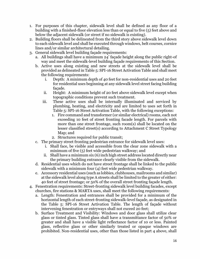
1. For purposes of this chapter, sidewalk level shall be defined as any floor of a building with a finished-floor elevation less than or equal to five (5) feet above and below the adjacent sidewalk (or street if no sidewalk is existing).
2. Building floors shall be delineated from the third story above sidewalk level down to each sidewalk level and shall be executed through windows, belt courses, cornice lines and/or similar architectural detailing.
3. General sidewalk level building façade requirements: a. All buildings shall have a minimum 24’ façade height along the public right-of
way and meet the sidewalk-level building façade requirements of this Section. b. Active uses along existing and new streets at the sidewalk level shall be
provided as delineated in Table 5: SPI-16 Street Activation Table and shall meet the following requirements:
i. Depth: A minimum depth of 40 feet for non-residential uses and 20 feet for residential uses beginning at any sidewalk level street facing building façade.
ii. Height: A minimum height of 20 feet above sidewalk level except when topographic conditions prevent such treatment.
iii. These active uses shall be internally illuminated and serviced by plumbing, heating, and electricity and are limited to uses set forth in Table 5: SPI-16 Street Activation Table, with the following exceptions:
1. Fire command and transformer (or similar electrical) rooms, each not exceeding 10 feet of street fronting facade length. For parcels with more than one street frontage, such room(s) shall be located on the lesser classified street(s) according to Attachment C Street Typology Map; and
2. Structures required for public transit; c. The primary street fronting pedestrian entrance for sidewalk level uses:
i. Shall face, be visible and accessible from the clear zone sidewalk with a minimum of five (5) feet wide pedestrian walkway; and
ii. Shall have a minimum six (6) inch high street address located directly near the primary building entrance clearly visible from the sidewalk.
d. Residential uses which do not have street frontage shall be linked to the public sidewalk with a minimum four (4) feet wide pedestrian walkway.
e. Accessory residential uses (such as lobbies, clubhouses, mailrooms and similar) at the sidewalk level along type A streets shall be limited to the greater of either: 40 feet of street frontage; or 50% of the overall street fronting façade length.
4. Fenestration requirements: Street-fronting sidewalk level building facades, except churches, fire stations & MARTA uses, shall meet the following requirements: a. Length: Fenestration and entrances shall be provided for a minimum of the
horizontal length of each street-fronting sidewalk-level façade, as designated in the Table 5: SPI-16 Street Activation Table. The length of façade without intervening fenestration or entryways shall not exceed 20 feet;
b. Surface Treatment and Visibility: Windows and door glass shall utilize clear glass or tinted glass. Tinted glass shall have a transmittance factor of 50% or greater and shall have a visible light reflectance factor of 10 or less. Painted glass, reflective glass or other similarly treated or opaque windows are prohibited. Non-residential uses, other than those listed in part 4 above, shall
17
have visibility into the building for a minimum depth of ten (10) feet as measured from the interior windowpane.
c. Non-residential uses: Fenestration and entrances shall be measured beginning at a point not more than 36 inches above the required sidewalk to a height at least 10 feet above said sidewalk unless:
i. When the finished floor elevation is 36 or more inches above the sidewalk: Beginning at the finished floor elevation to a height at least 10 feet above the finished floor elevation; or
ii. When the finished floor elevation is below said sidewalk: Beginning at a point not higher than six (6) inches above the adjacent sidewalk to a height at least 10 feet above the finished floor elevation.
d. Residential uses: Fenestration and entrances shall have windows at a minimum of four (4) feet in height.
Table 5: SPI-16 Street Activation Table
Street Typology
Location Permitted Active Uses (as
further regulated in Table 1: SPI-16 Table of Uses)
of Higher Learning, Laundry/Dry Cleaning, Professional/ Personal
Services, Public & Private Schools, Sales & Repair Establishments
65% of all uses
B1 Street Juniper St from 13th St to 14th St and Juniper St from North Ave to 10th St
All uses allowed on type A Streets, Dormitories/Fraternities/Sororities,
Nightclub/Lounge, Fuel Service Stations, Mortuary/Funeral Homes,
Nursing Homes/ Personal Care Homes/Assisted Living
Facilities/Rehabilitation Centers, Printing, Service Stations, Shelters,
Supportive Housing
50% for non-residential uses,
30% for residential uses B2 Street
Ponce De Leon Ave, 3rd St, Biltmore Pl, 6th St, 7th St, Peachtree Pl, 12th St from Juniper St to Piedmont Ave, 14th St from
Juniper to Piedmont Ave, 15th St from Spring St to Peachtree Cir,
Spring St from 17th to Peachtree St, West Peachtree St from 17th St to Peachtree
St, Beverly Rd to Inwood Cir, Peachtree Walk from 10th St to 13th St, Cypress St from 3rd St to Peachtree Pl, Piedmont Ave from Ponce de Leon Ave to 3rd St
C Street Other existing streets not listed above;
and all alleys Active Uses not required 30% for all uses
1 Limited 40 feet of street frontage for each use, provided that the sum of all such uses shall not exceed 50% of the overall street fronting façade length along a type A1 street.
18
Sec. 16-18P.015. - Signage. Refer to Section 16-28A: Sign Ordinance.
Sec. 16-18P.016. - Lighting and storefront illumination.
1. All lighting, including all parking decks, surface parking lots and lit canopies shall reduce light spillage onto adjacent properties by providing cutoff luminaries which have a maximum 90-degree illumination. See also Section 16-18P.020(6).
2. All lighting that up-lights trees, buildings or other elements shall be located a minimum height of eight feet above an adjacent sidewalk level when not located within completely landscaped areas.
Sec. 16-18P.017. - Off-street loading requirements.
Off-street loading spaces shall be provided according to Table 6: SPI-16 Loading Table. All loading berths shall provide vertical clearance of 14 feet and shall not be located within any required sidewalk. See Section 16-18P.018 for screening requirements.
Table 6: SPI-16 Loading Table
Unit of Measure
Required 12’ x 35’ Loading Spaces
Required 12’ x 55’ Loading Spaces
Residential Dwellings & Lodgings < 100 Units None None
100 or > Units 1 None
All Other Uses
< 10,000 s.f. None None 10,000 s.f. to
40,000 s.f. 1 None
40,001 s.f. to 100,000 s.f.
2 None
100,000 s.f. to 250,000 s.f.
2 1
> 250,000 s.f. 2 2
Sec. 16-18P.018. – Dumpster and loading areas, loading dock entrances and building mechanical and accessory features.
1. Dumpsters and trash areas: Dumpsters and trash areas shall be screened so as not to be visible from any public plaza, outdoor dining area, public sidewalk or public right-of-way and if otherwise visible shall be enclosed with opaque walls six (6) feet in height.
2. Loading areas: a. Loading areas shall be screened so as not to be visible from any public plaza,
outdoor dining area, public sidewalk or public right-of-way with the exception of hotel uses. Hotel uses may utilize on-street loading if orientated predominately parallel to the adjacent right-of-way and located fully outside any existing public driving lane and at least partially on private property at a maximum length of 60 feet as permitted by the Department of Public Works.
b. Loading dock entrances shall be screened so that loading docks and related activity are not visible from the public right-of-way when not in use.
19
3. Building mechanical and accessory features: Shall be in the location of least visibility from the public right-of-way. If located to the side or rear of the principal structure, screening with plant or fence materials shall be required. When located on rooftops, said features shall be incorporated in the design of the building and/or screened with building materials similar to those of the building.
Sec. 16-18P.019. - Curb cuts and parking structures.
1. Sidewalks at curbcuts and driveways: All sidewalk paving materials shall be continued across any intervening driveway. On each side of such continuous sidewalk a band of textured concrete shall be provided located both in-line with and equal in width to the street furniture zone and in-line with the supplemental zone or building façade at a minimum five (5) feet width.
2. Curbcut restrictions: No vehicular entrances to properties with frontage on the east side of Peachtree Street shall be located on other public streets which connect Peachtree Street to the Ansley Park neighborhood. Otherwise, except for hotel uses, curb cuts shall be allowed only as follows: a. For a parcel with only one street frontage: maximum one (1) curbcut. b. For a parcel with two or more street frontages: maximum two (2) curbcuts, both
located on the lesser classified street(s) according to Attachment C Street Typology Map. If the two streets have the same classification such curbcut(s) may be on either street.
3. Curbcut widths: Curb cuts shall be limited in width at the sidewalk to 12 feet for one-way entrances and 24 feet for two-way entrances, unless a greater width is approved by the Department of Public Works upon its finding of necessity of such a greater width.
4. Driveway and vehicular services configuration: a. Driveways shall be predominately perpendicular to any adjacent street, except
for hotel uses which may have circular drives for the purpose of drop-off and pick-up. Driveways parallel to the street are prohibited between the street and a building.
b. Gasoline fuel dispenser structures and associated vehicular services such as air pumps and car washes shall not be located between a building and the street.
c. Drive-through and drive-in facilities shall be prohibited. 5. Drop-off lanes: No drop-off lanes shall be permitted along public streets except for
hotel uses as approved by the Department of Public Works. 6. Parking orientation: Entrances to garages and carports that serve one (1) or more
contiguous sidewalk-level residential units only shall share one (1) common drive with any garages and carports facing rear or side yards having no street frontage.
7. Parking structure public screening: In addition to Section 16-28.028, parking structures shall have the following additional requirements: a. At a height of 20 feet or less above finished grade which faces any public or
private street shall meet Section 16-18P.014(3.b) to provide an intervening building having conditioned habitable space along the length of such parking structure;
b. At a height of 20 feet or more above finished grade which faces any public or private street shall provide either:
20
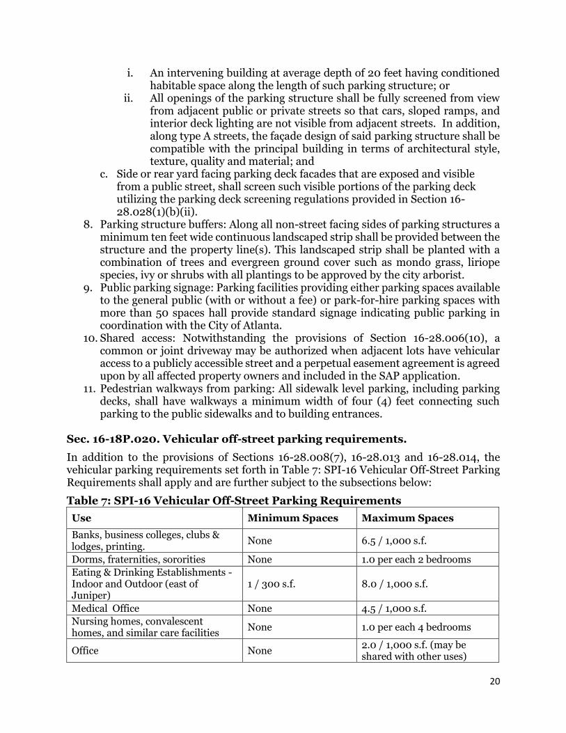
i. An intervening building at average depth of 20 feet having conditioned habitable space along the length of such parking structure; or
ii. All openings of the parking structure shall be fully screened from view from adjacent public or private streets so that cars, sloped ramps, and interior deck lighting are not visible from adjacent streets. In addition, along type A streets, the façade design of said parking structure shall be compatible with the principal building in terms of architectural style, texture, quality and material; and
c. Side or rear yard facing parking deck facades that are exposed and visible from a public street, shall screen such visible portions of the parking deck utilizing the parking deck screening regulations provided in Section 16-28.028(1)(b)(ii).
8. Parking structure buffers: Along all non-street facing sides of parking structures a minimum ten feet wide continuous landscaped strip shall be provided between the structure and the property line(s). This landscaped strip shall be planted with a combination of trees and evergreen ground cover such as mondo grass, liriope species, ivy or shrubs with all plantings to be approved by the city arborist.
9. Public parking signage: Parking facilities providing either parking spaces available to the general public (with or without a fee) or park-for-hire parking spaces with more than 50 spaces hall provide standard signage indicating public parking in coordination with the City of Atlanta.
10. Shared access: Notwithstanding the provisions of Section 16-28.006(10), a common or joint driveway may be authorized when adjacent lots have vehicular access to a publicly accessible street and a perpetual easement agreement is agreed upon by all affected property owners and included in the SAP application.
11. Pedestrian walkways from parking: All sidewalk level parking, including parking decks, shall have walkways a minimum width of four (4) feet connecting such parking to the public sidewalks and to building entrances.
Sec. 16-18P.020. Vehicular off-street parking requirements.
In addition to the provisions of Sections 16-28.008(7), 16-28.013 and 16-28.014, the vehicular parking requirements set forth in Table 7: SPI-16 Vehicular Off-Street Parking Requirements shall apply and are further subject to the subsections below:
Shelter 1 per each on-duty staff member, plus 1.0 / 2,000 s.f.
1 each for first 2 bedrooms, plus 0.5 for each of 3 or more bedrooms plus 1/3 for each dwelling unit
Other non-residential uses except as specified in part 5 below.
None 3.5 / 1,000 s.f.
All non-residential greater than 25,000 sf
Must provide a transportation management plan (TMP) including commitment of TMA support.
Note: All zero emission, car share or carpool/vanpool (or similar) spaces shall not count toward the above parking criteria.
1. Off-street surface parking: a. Shall not be located closer to a street than any on-site building façade and shall
not occupy more than 50% of any street frontage parcel length; b. Shall be prohibited from being located within 30 feet of the back of the public
sidewalk located along an “A” classified street. c. Shall be accessory to a permitted principal use only, provided that parking
spaces serving another principal permitted use may use such facility for shared parking.
d. Park-for-hire surface parking lots are prohibited. 2. Parking structures: Parking spaces provided in excess of the parking requirements
of this Section 16-18P.020 shall only be allowed as park-for-hire spaces located within a parking structure. Said excess spaces shall be considered a principal use and shall first require a special use permit as authorized in Section 16-18P.005. Otherwise, when the number of parking spaces does not exceed the requirements of this Section, said spaces shall be permitted to be used as a park-for-hire parking deck without a special use permit.
3. Electric vehicle charging stations: All parking facilities shall include electric vehicle charging stations, or similar alternative fuel facilities, in a ratio of at least one (1) station for every 100 automobile parking spaces but shall not be required to exceed 12 stations.
4. Residential Unbundling: Parking for all residential dwelling units may be leased or sold separately from the rental or purchase price for such units for the life of the unit such that the renter or purchaser has an option to have the unit priced lower than if the price of the unit and parking space were combined.
5. For specific non-residential uses: a. Child care centers, day care centers, pre-kindergartens, play and other special
schools or day care centers for young children: Such establishments shall provide safe and convenient facilities for loading and unloading children, as approved by the Department of Public Works.
b. Schools, colleges, churches, recreation or community centers and other places of assembly. A minimum of one space for each six fixed seats with 18 inches if bench length counted as one seat or one space for each 50 square feet of
22
enclosed floor area for the accommodation of movable seats in the largest assembly room, whichever is greater, plus the following maximums:
i. Public or private elementary or middle school: Two (2) spaces for each classroom.
ii. High school. Four (4) spaces for each classroom. iii. Colleges and universities: Eight (8) spaces for each classroom.
6. Parking, lighting, security, landscaping and maintenance: All surface parking lots and structures, whether a nonconforming principle use or accessory use, shall meet the following requirements: a. Lighting shall be provided throughout all parking facilities to equal a minimum
of one-half (1/2) footcandle of light. For parking structures at points of ingress and egress such lighting shall be a minimum of (1) footcandle of light. Where applicable, public street and other ambient lighting may be utilized to either partially or totally fulfill these lighting requirements; however if removed it shall be required to independently provide these required levels of illumination.
b. Surface parking lots: The requirements of City of Atlanta Chapter 158 Vegetation, article II Tree Protection, Section 30 Parking lot requirements shall apply to this district regardless of the size of the lot.
c. Parking facilities shall be maintained in a clean, safe and sanitary condition with parking spaces and driving lanes clearly defined and maintained. See also Section 16-28.014 for additional requirements.
Sec. 16-18P.021. - Minimum bicycle parking requirements.
Bicycle parking requirements of Section 16-28.014(6) shall apply in conjunction with Table 8: SPI-16 Bicycle Parking Table and subject to the two (2) subsections below:
Table 8: SPI-16 Bike Parking Table
Minimum Maximum
Residential Uses The greater of either: 2 spaces or 1 space for every 5 residential units
No more than 50 spaces required
Non-Residential Uses The greater of either: 2 spaces or 1
space for every 4,000 sq. ft. No more than 50 spaces required
1. Anchors: All spaces provided shall include a metal anchor sufficient to secure the bicycle/moped frame when used in conjunction with a user-supplied lock.
2. Location: Bicycle parking shall be located within the street furniture or supplemental zone or within an accessory parking structure as close to a building entrance as the closest covered automobile parking space with such spaces also covered from weather.
Sec. 16-18P.022. - Office Uses Additional Requirements.
1. Showering facilities: All office buildings containing over 25,000 square feet of gross office space shall provide showering facilities including showers and lockers, in a ratio of at least one (1) showering facility for every 25,000 square feet of gross office space, available to all building tenants and their employees, provided that no building shall be required to exceed a maximum of eight (8) showering facilities.
23
2. Transportation Management Plan: The Office of Buildings shall not issue building permits for office components with more than 25,000 square feet of total gross leasable floor area until such time the developer or leasing agent for each office component has submitted to the Office of Zoning and Development either: a statement committing to support and participate in a transportation management association (TMA) and its funding; or a transportation management plan (TMP). This TMP shall contain strategies to reduce single occupancy vehicle trips generated by the project by a minimum of 25% percent during a five-year period from the initial date of occupancy and be based on an annual commute mode survey based on a continuous (5) five-day workweek for all employees arriving between 6:00 a.m. and 10:00 a.m. Based upon the survey information, the employer shall develop a TMP which shall include but not be limited to: a. An estimate of the number of employees and visitors per hour that are expected
to use rail and bus transit throughout the day. b. A description of how information regarding the new or existing transit stops
and building access to such stops will be displayed in indoor or outdoor on the property.
c. A program to promote and maintain employee participation in carpooling, vanpooling, and use of mass transit, including a method of monitoring the number of ride sharers and their travel patterns.