SG/lj 11/07/2019 # Z-25 ORDINANCE CASE NO. Z-2019-10700240 ~1 -9 - 1 1 - 0 7 - 0 9 4 7 AMENDING THE OFFICIAL ZONING MAP OF THE CITY OF SAN ANTONIO BY AMENDING CHAPTER 35, UNIFIED DEVELOPMENT CODE, SECTION 35-304, OF THE CITY CODE OF SAN ANTONIO, TEXAS BY CHANGING THE ZONING DISTRICT BOUNDARY OF CERTAIN PROPERTY. * * * * * WHEREAS, a public hearing was held after notice and publication regarding this amendment to the Official Zoning Map at which time parties in interest and citizens were given an opportunity to be heard; and WHEREAS, the Zoning Commission has submitted a final report to the City Council regarding this amendment to the Official Zoning Map of the City of San Antonio; NOW THEREFORE, BE IT ORDAINED BY THE CITY COUNCIL OF THE CITY OF SAN ANTONIO: SECTION 1. Chapter 35, Unified Development Code, Section 35-304, Official Zoning Map, of the City Code of San Antonio, Texas is amended by changing the zoning district boundary of 7.101 acres out of NCB 34732 from "PUD MF-25 GC-1 MLOD-1 MLR-1" Planned Unit Development Low Density Multi- Family Hill Country Gateway Corridor Camp Bullis Military Lighting Overlay Military Lighting Region 1 District and "PUD MF-25 MLOD-1 MLR-1" Planned Unit Development Low Density Multi-Family Camp Bullis Military Lighting Overlay Military Lighting Region 1 District to "MF-33 GC-1 MLOD-1 MLR-1" Multi-Family Hill Country Gateway Corridor Camp Bullis Military Lighting Overlay District Military Lighting Region I and "MF-33 MLOD-1 MLR-1" Multi-Family Camp Bullis Military Lighting Overlay Military Lighting Region I District. SECTION 2. A description of the property is attached as Exhibit "A" and made a part hereof and incorporated herein for all purposes. SECTION 3. All other provisions of Chapter 35 except those expressly amended by this ordinance shall remain in full force and effect including the penalties for violations as made and provided for in Section 35-491. SECTION 4. The Director of Development Services shall change the zoning records and maps in accordance with this ordinance and the same shall be available and open to the public for inspection. SECTIONS. This ordinance shall become effective November 17 , 2019. PASSED AND APPROVED thi s 7 th day of November, 2019. Ron Nirenberg APPROVED AS TO FORM: ~ ndrew Segovia, City Attorney
Transcript
SG/lj 11/07/2019 # Z-25
ORDINANCE
CASE NO. Z-2019-10700240
~1-9 - 1 1 - 0 7 - 0 9 4 7 AMENDING THE OFFICIAL ZONING MAP OF THE CITY OF SAN ANTONIO BY AMENDING CHAPTER 35, UNIFIED DEVELOPMENT CODE, SECTION 35-304, OF THE CITY CODE OF SAN ANTONIO, TEXAS BY CHANGING THE ZONING DISTRICT BOUNDARY OF CERTAIN PROPERTY.
* * * * * WHEREAS, a public hearing was held after notice and publication regarding this amendment to the Official Zoning Map at which time parties in interest and citizens were given an opportunity to be heard; and
WHEREAS, the Zoning Commission has submitted a final report to the City Council regarding this amendment to the Official Zoning Map of the City of San Antonio; NOW THEREFORE,
BE IT ORDAINED BY THE CITY COUNCIL OF THE CITY OF SAN ANTONIO:
SECTION 1. Chapter 35, Unified Development Code, Section 35-304, Official Zoning Map, of the City Code of San Antonio, Texas is amended by changing the zoning district boundary of 7.101 acres out of NCB 34732 from "PUD MF-25 GC-1 MLOD-1 MLR-1" Planned Unit Development Low Density MultiFamily Hill Country Gateway Corridor Camp Bullis Military Lighting Overlay Military Lighting Region 1 District and "PUD MF-25 MLOD-1 MLR-1" Planned Unit Development Low Density Multi-Family Camp Bullis Military Lighting Overlay Military Lighting Region 1 District to "MF-33 GC-1 MLOD-1 MLR-1" Multi-Family Hill Country Gateway Corridor Camp Bullis Military Lighting Overlay District Military Lighting Region I and "MF-33 MLOD-1 MLR-1" Multi-Family Camp Bullis Military Lighting Overlay Military Lighting Region I District.
SECTION 2. A description of the property is attached as Exhibit "A" and made a part hereof and incorporated herein for all purposes.
SECTION 3. All other provisions of Chapter 35 except those expressly amended by thi s ordinance shall remain in full force and effect including the penalties for violations as made and provided for in Section 35-491.
SECTION 4. The Director of Development Services shall change the zoning records and maps in accordance with this ordinance and the same shall be available and open to the public for inspection.
SECTIONS. This ordinance shall become effective November 17, 2019.
PASSED AND APPROVED thi s 7th day of November, 2019.
Description: ZONING CASE Z-201 9-1 0700240 (Council District 8) : Ordinance amending the Zoning District Boundary from "PUD MF-25 GC- 1 MLOD- 1 MLR-1 " Planned Unit Development Low Density Multi-Family Hill Country Gateway Corridor Camp Bullis Military Lighting Overlay Military Lighting Region I District and "PUD MF-25 MLOD-1 MLR-1 " Planned Uni t Development Low Density Multi-Family Camp Bullis Military Lighting Overlay Military Lighting Region I District to "MF-33 GC-1 MLOD- 1 MLR-1" Multi-Family Hill Country Gateway Corridor Camp Bullis Military Lighting Overlay Military Lighting Region I District and "MF-33 MLOD-1 MLR-1 " Multi-Family Camp Bullis Military Lighting Overlay Military Lighting Region I District on 7. IO 1 acres out of NCB 34732, generally located southwest of the intersection of Aue Road and 1-10 West Access Road. Staff and Zoning Commission recommend Approval.
Result: Passed
Voter Group Not
Yea Nay Abstain Motion Second Present
Ron Nirenberg Mayor X
Roberto C. Trevino District I X
Jada Andrews-Sullivan District 2 X
Rebecca Viagran District 3 X
Adriana Rocha Garcia District 4 X
Shirley Gonzales District 5 X
Melissa Cabello Havrda District 6 X
Ana E. Sandoval District 7 X
Manny Pelaez District 8 X X
John Courage District 9 X X
Clayton H. Perry District I 0 X
SG/lj 11/07/2019 # Z-25
EXHIBIT ''A''
_I PAPE-DAWSON I'll ENGINEERS z-2019-10700240
LAND DEVELOPMENT ENVIRONMENTAL TRANSPORTATION WATER RESOURCES SURVEYING
FIELD NOTES FOR
ZONfNG A 7.101 acre, or 309,326 square feet more or less, tract of land out of a 39.287 acre tract conveyed to GKH Developments, Ltd. in Special Warranty Deed recorded in Volume 15322, Pages 1783-1799 of the Official Public Records of Bexar County, Texas, out of the John W. Smith Survey No. 27, Abstract 708, County Block 4732, now in New City Block (N.C.B.) 34732 of the City of San Antonio, Bexar County, Texas. Said 7.101 acre tract being more fully described as follows, with bearings based on the North American Datum of 1983 (CORS 1996), from the Texas Coordinate System established for the South Central Zone:
BEGINNING:
THENCE:
THENCE:
At a found ½11 iron rod with a cap stamped "C-RAS3976" at the west end of a non-tangent curve to the right at the intersection of the east right-of-way line of Aue Road (60' right-of-way) with the south line of Lot 2, Block 16, New City Block 16386, a private street known as Dominion Drive as shown on the subdivision plat of The Dominion Phase 4A (PUD), Replat recorded in Volume 9573, Page 159 of the Deed and Plat Records of Bexar County, Texas;
Along the south line of said Lot 2, Block 16, New City Block 16386 and said curve to the right having a radial bearing of S 50°58' 1411 E, a radius of 18.00 feet, a central angle of 94°32'56", a chord bearing and distance of N 86°18'15" E, 26.45 feet, for an arc length of 29. 70 feet to a found ½" iron rod with a yellow cap stamped "Pape-Dawson" at the point of curvature of a non-tangent curve to the right;
Continuing along said south line of Lot 2, Block 16, New City Block 16386, the following bearings and distances:
Along said non-tangent curve to the right having a radial bearing of S 41°51'42 11 W, a radius of 200.00 feet, a central angle of 21°45'33 11
, a chord bearing and distance ofS 37°15'32" E, 75.50 feet, for an arc length of 75.95 feet to a found ½" iron rod with a red cap stamped "C-RAS3976" at the point of curvature of a non-tangent curve to the left;
Along said non-tangent curve to the left having a radial bearing ofN 63°37'01 11 E, a radius of 200.07 feet, a central angle of 21 °45'05 11
, a chord bearing and distance of S 37°15'32 11 E, 75.50 feet, for an arc length of75.95 feet to a found½" iron rod with a yellow cap stamped "Pape-Dawson";
S 48°08'18" E, 63.28 feet to a found ½" iron rod with a yellow cap stamped "Pape-Dawson" at the point of curvature of a curve to the left;
Page I of2 Exhibil "A"
SAN ANTONIO / AUSTIN / HOUSTON 555 East Ramsey San Antonio, Texas 7 8 216
P 210.375 . 9000 F 210 . 375.9010 www . pape-dawson.com
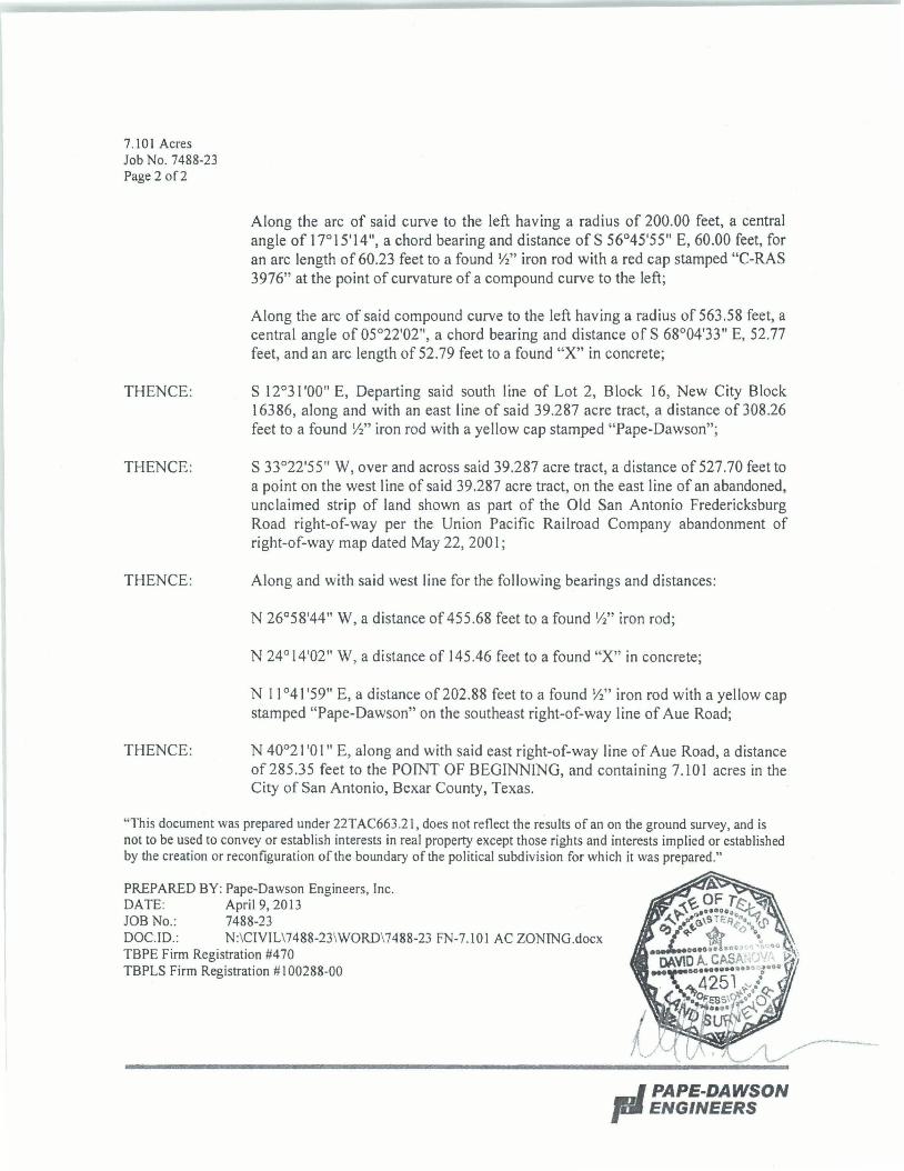
7.101 Acres Job No. 7488-23 Page 2 of2
THENCE:
THENCE:
THENCE:
THENCE:
Along the arc of said curve to the left having a radius of 200.00 feet, a central angle of 17°15'14", a chord bearing and distance of S 56°45'55" E, 60.00 feet, for an arc length of 60.23 feet to a found ½" iron rod with a red cap stamped "C-RAS 3976" at the point of curvature of a compound curve to the left;
Along the arc of said compound curve to the left having a radius of 563.58 feet, a central angle of 05°22'02", a chord bearing and distance of S 68°04'33" E, 52.77 feet, and an arc length of 52.79 feet to a found "X" in concrete;
S 12°31 '00" E, Departing said south line of Lot 2, Block 16, New City Block 16386, along and with an east line of said 39.287 acre tract, a distance of 308.26 feet to a found ½" iron rod with a yellow cap stamped "Pape-Dawson";
S 33°22'55" W, over and across said 39.287 acre tract, a distance of 527.70 feet to a point on the west I ine of said 39 .287 acre tract, on the east line of an abandoned, unclaimed strip of land shown as part of the Old San Antonio Fredericksburg Road right-of-way per the Union Pacific Railroad Company abandonment of right-of-way map dated May 22, 200 I;
Along and with said west line for the following bearings and distances:
N 26°58'44" W, a distance of 455.68 feet to a found½" iron rod;
N 24°14'02" W, a distance of 145.46 feet to a found "X" in concrete;
N 11 °41 '59" E, a distance of 202.88 feet to a found ½" iron rod with a yellow cap stamped "Pape-Dawson" on the southeast right-of-way line of Aue Road;
N 40°21 '0 l" E, along and with said east right-of-way line of Aue Road, a distance of285.35 feet to the POINT OF BEGINNING, and containing 7.101 acres in the City of San Antonio, Bexar County, Texas.
"This document was prepared under 22TAC663.2 l, does not reflect the results of an on the ground survey, and is not to be used to convey or establish interests in real property except those rights and interests implied or established by the creation or reconfiguration of the boundary of the political subdivision for which it was prepared."
PREPARED BY: Pape-Dawson Engineers, Inc. DATE: April9,2013 JOB No.: 7488-23 DOC.ID.: N:\CIVIL\7488-23\WORD\7488-23 FN-7.101 AC ZONING.docx TBPE Firm Registration #470 TBPLS Firm Registration # I 00288-00
... I PAPE-DAWSON pa ENGINEERS
"' • ... ti a:
~ :u !~ J:0 =-~ 96 ~.., :,"<
I
d ----N::l ~, '"''.::-~i ~9-<( :z: ! • &!!!
LOCATION MAP NOT-10-SCAlf
LEGEND: DR DEED RECORDS OF BEXAR COUNTY.
TEXAS OPR OFFICIAL PUBLIC RECORDS OF
BEXAR COUNTY. TEXAS DPR DEED AND PLAT RECORDS OF BEXAR
COUNTY. TEXAS FIR FOUND 1 /2" IRON ROD
NOTES: ~ PROFESSIONAL SERVICES PROVIDED
HEREWITH INCLUDE THE PREPARATION OF A FIELD NOTE DESCRIPTION.
2. THE BEARINGS ARE BASED ON THE NORTH AMERICAN DATUM OF 1983 (CORS 1996) , FROM THE TEXAS COORDINATE SYSTEM ESTABLISHED FOR THE SOUTH CENTRAL ZONE.
LINE TABLE
LINE BEARING LENGTH
L1 N11"41 '59"E 202 .88'
L2 S48"08°18°0
E 63.28'
L3 N24"14'02"W 145.46'
CURVE TABLE
CURVE RADIUS DELTA CHORD BEARING
C1 18.00' 94·32'55• N86"18'15"E
C2 200.00' 21·45'33" S37"15'32"E
C3 200.07' 21·45'05" S37"15°3200
£
C4 200.00· 17"15'14" 555·45'55"[
C5 563.58' 5·22·02" S68"04'33"E
"PAPE-DAWSON ENGINEERS
'55 CAST IWIStl' I SIi" NfflJNIO 1DAS 1a:z1• I ~;::i1:;g JPU 1CW10 o, ~ ~ ,_, ~l'IDH I •N
rDA5 IQUtO Of IWCf!S'Sl0NII. LNC1 ~ ,,., -=sTIIIJUf / 1'11Z11m-OD
CHORD LENGTH
26.45' 29 .70'
75.50' 75.95'
75.50' 75.95'
60.00' 60.23'
52.77' 52.79'
Z-2019- 10700240
SCALE: 1"= 200'
200' O'
~-~ -
EXHIBIT FOR
ZONING
100· 200·
1 I -~
A 7.101 ACRE, OR 309,326 SQUARE FEET MORE OR LESS, TRACT OF LAND OUT OF A 39.287 ACRE TRACT CONVEYED TO GKH DEVELOPMENTS, LTD. IN SPECIAL WARRANTY DEED RECORDED IN VOLUME 15322, PAGES 1783-1799 OF THE OFFICIAL PUBLIC RECORDS OF BEXAR COUNTY, TEXAS, OUT OF THE JOHN W. SMITH SURVEY NO. 27, ABSTRACT 708, COUNTY BLOCK 4732, NOW IN NEW CITY BLOCK (N.C.B.) 34732 OF THE CITY OF SAN ANTONIO, BEXAR COUNTY, TEXAS.