82
ZONING AND BUILDING ORDINANCE March 14, 2017 Office of the Selectmen 93 Main Street Sutton Mills, NH 03221 (603) 927-2403 1

ZONING AND BUILDING ORDINANCE
March 14, 2017
Office of the Selectmen 93 Main Street
Sutton Mills, NH 03221 (603) 927-2403
1

ZONING ORDINANCE DISCLAIMER
The contents of this booklet include information up to and including Town Meeting March 14, 2017. An applicant should check with the Selectmen's Office or the town board for any possible changes after that date.
Table of Contents ORIGINAL ZONING ORDINANCE ADOPTED .................................................................................................................... 4
ARTICLE I - PREAMBLE .................................................................................................................................................... 5
ARTICLE II - DISTRICTS ..................................................................................................................................................... 5
ARTICLE III - GENERAL PROVISIONS ................................................................................................................................ 5
ARTICLE IV - RESIDENTIAL DISTRICT .............................................................................................................................. 10
ARTICLE V – RURAL/AGRICULTURAL DISTRICT ................................................................................................................ 13
ARTICLE VI - SPECIAL EXCEPTIONS AND VARIANCES ....................................................................................................... 15
ARTICLE VII - NONCONFORMING USES ......................................................................................................................... 17
ARTICLE VIII - LAND APPLICATION OF SEWAGE SLUDGE ................................................................................................ 19
ARTICLE IX - CLUSTER DEVELOPMENT .......................................................................................................................... 24
ARTICLE X - WETLANDS OVERLAY DISTRICT ................................................................................................................... 32
Wetland Buffers ....................................................................................................................................................... 35
ARTICLE XI - STEEP SLOPE OVERLAY DISTRICT ............................................................................................................. 38
ARTICLE XII – PERSONAL WIRELESS FACILTIES (PWSFs) ............................................................................................... 39
ARTICLE XIII - SMALL WIND ENERGY SYSTEMS ORDINANCE ......................................................................................... 49
ARTICLE XIV - SUTTON FLOODPLAIN DEVELOPMENT ORDINANCE ................................................................................. 54
ARTICLE XV - DEFINITIONS ............................................................................................................................................ 64
ARTICLE XVI - ENFORCEMENT ........................................................................................................................................ 73
ARTICLE XVII - ZONING BOARD OF ADJUSTMENT ........................................................................................................ 73
ARTICLE XVIII - WHEN EFFECTIVE ................................................................................................................................. 73
ARTICLE XIX - AMENDMENTS ....................................................................................................................................... 73
ARTICLE XX - RENUMBERING ......................................................................................................................................... 74
ARTICLE XXI - SAVING CLAUSE ...................................................................................................................................... 74
APPENDIX 1: CHART OF ZONING CHANGES .................................................................................................................. 75
2
APPENDIX 2: ZONING DISTRICTS MAP ..................................................................................................................... 76
SUTTON BUILDING ORDINANCE ....................................................................................................................................... 77
ARTICLE I ....................................................................................................................................................................... 78
ARTICLE II ...................................................................................................................................................................... 78
ARTICLE III ..................................................................................................................................................................... 81
ARTICLE IV ..................................................................................................................................................................... 81
ARTICLE V ...................................................................................................................................................................... 81
ARTICLE VI ..................................................................................................................................................................... 81
ARTICLE VII .................................................................................................................................................................... 81
ARTICLE VIII ................................................................................................................................................................... 81
ARTICLE IX ..................................................................................................................................................................... 82
END OF TABLE OF CONTENTS
3

ORIGINAL ZONING ORDINANCE ADOPTED
MARCH 8, 1966
Amended: March 11, 1969; July 13, 1971; March 6, 1973; March 11, 1980; March 10, 1981; March 9, 1982; March 8, 1983; March 13, 1984; March 11, 1987; March 9, 1988; March 15, 1989; March 14, 1990; March 11, 1991; March 9, 1993; March 8, 1994; March 12, 1996; March 11, 1997; March 14, 2000; March 13, 2001; March 12, 2002; March 9, 2005; March 14, 2006; March 13, 2007; March 12, 2008; March 10, 2010; March 12, 2011; March 11, 2014; March 8, 2016 and March 14, 2017.
4

ARTICLE I - PREAMBLE Pursuant to the Authority conferred by Chapter 31, Sections 60-89: now codified as RSA 672-677, New Hampshire Revised Statutes Annotated, and for the purposes of promoting the health, safety and welfare of the inhabitants, and preserving the values and charm, now attached to the town, the following ordinance is hereby adopted by the Town of Sutton, NH, in Town Meeting convened, as amended, in conformity with a comprehensive plan.
ARTICLE II - DISTRICTS For the purposes of this ordinance, the Town of Sutton is divided into two districts, as shown on the official zoning map, filed with the Town Clerk and dated February 18, 1966, together with any amendments thereto: 1. Residential District; 2. Rural/Agricultural District.
ARTICLE III - GENERAL PROVISIONS
The following provisions shall apply to all districts:
A. No owner of land in any district shall permit fire destruction or other ruins to be left, but within one year shall remove or refill the same to clear ground level, or shall repair, replace or rebuild the structure.
B. Excavation and/or removal of sand, gravel, rock, soil or construction aggregate, either for
private use or for sale (“excavation”), is subject to New Hampshire Revised Statutes Annotated and the Town of Sutton Excavation Regulations, under the following conditions:
1. All excavations shall be subject to inspection by the Select Board and/or Code Enforcement
Officer to insure the health, welfare, and safety of the Town, compliance with a permit issued, and that no irrevocable damage or hazard is being created;
2. No excavation shall occur until and unless an Excavation Permit is approved by the Select Board.
3. Every person, persons, firm, or corporation violating any of the provisions of this ordinance 5
shall be subject to a fine of up to $275 for each day such violation may exist pursuant to RSA 155-E:10.
C. All dwellings and sanitary systems shall be constructed and maintained in accordance with the standards established by the State of New Hampshire, including, but not limited to the State Building Code, the State Life Safety Code, and regulations relating to the design and operation of septic systems. All new or redesigned sanitary systems shall have designs approved by the New Hampshire Department of Environmental Services, Subsurface Systems Division.
D. Signs.
1. General Requirements: Signs shall be permitted as designated below, but all signs shall be subject to the following requirements:
a. Official town, state or federal signs shall be exempt from these requirements. Additionally, flags are exempt from these requirements so long as they do not include commercial logo or otherwise advertise a business or commercial enterprise;
b. No sign shall be placed in a manner that will endanger traffic by obscuring the view, by confusion with official signs, by glare or by any other means;
c. No sign shall be constructed within any right-of-way;
d. The maximum height of any free-standing sign, including it structural supports, shall not exceed 5 feet;
e. Illuminated signs shall be lit by steady, white light through the use of shielded fixtures and top- down lighting, and such lighting shall not exceed 40 watts or its equivalent (per side, for two- faced signs). Lights for externally illuminated signs shall not be ground-mounted. Sign illumination shall be turned off when the business or facility associated with the sign is closed or not later than 10 p.m., whichever is the earlier. Internally illuminated signs are not permitted;
2. Size: A sign of three square feet or less in area is permitted, so long as it conforms to the General Requirements above. Signs greater than three square feet in area that conform to the General Requirements above are permitted only if approved by the Zoning Board of Adjustment as a Special Exception. Measurement of Signs: Two-faced signs shall be considered as a single unit, and only one surface shall be considered in determining the area. Sign area is to be calculated by measuring the area of the smallest rectangle or circle within which the entire sign can fit; excluding structural supports which do not contribute
6

through shape, color, or otherwise to the sign's message.
3. Off-Premises Signs: Off-premises signs are not permitted.
4. Temporary Signs: Temporary signs, such as barn and yard sales, political signs, For Sale signs, and auction signs are permitted so long as they are: the same size and number as permanent signs, not advertising business or commercial services regularly conducted on site; not illuminated; less than three square feet in size; and posted for a period not exceeding 120 days in any consecutive 365-day time period.
E. No land in any district shall be used for storage or disposal of junk as described in the New Hampshire Revised Statutes Annotated or any corollary State administrative regulations; nor shall land be used for the storage of trash or refuse, old bottles, other solid textile waste, unfinished cloth or other textile mill yarns, old paper products, old rubber products, old plastic products, and other second hand or waste articles, the accumulation of which is detrimental or injurious to the neighborhood.
F. Construction of new streets, drainage facilities, sidewalks and curbs must be done under the supervision of, or with the approval of, the Road Agent and the Board of Selectmen of the Town of Sutton.
G. Nuisance provision: Any use that may be obnoxious or injurious by reason of production, emission of odor, dust, smoke, refuse matter, fumes, noise, vibration or similar conditions, or that is dangerous to the comfort, peace, health or safety of this community or tending to its disturbance or annoyance is prohibited.
H. Temporary Use of Construction Trailers and Travel Trailer:
1. Occupied: Any property owner or lessee may reside in or occupy one travel trailer of his/her own or one of a non-paying guest for a single period of not more than 90 days in any one period of 12 consecutive months. Said 90 days shall begin upon the installation of the construction trailer or travel trailer as the case may be.
2. Unoccupied: An unoccupied travel trailer registered for use on the highways of this State may be parked or stored on land owned by the owner of the travel trailer provided that the location or condition of such travel trailer is not detrimental to the neighborhood or to the properties in the vicinity.
3. The Select Board may approve the temporary use of a travel trailer or construction trailer to 7

be maintained as living quarters by a person employed in construction work on the same lot, or for whom a residence is being built on the same lot, or as an office, storeroom, or shop in connection with construction work on the same lot, provided that such use is shown to be a temporary. Such use will conform to sanitary protection requirements and all other applicable state and local health and safety laws and regulations. Such a use is permitted for the duration of one year from when construction commences, and may be renewed for a period not to exceed an additional year upon written application to and approval of the Select Board.
4. For any of the above uses to apply, the placement of the travel trailer or construction trailer, regardless of zoning district, shall conform to all "Set Back Building Lines" of the Rural- Agricultural District as set forth in Article V.C.4, and shall be more than 50 feet from any body of water or wetland. The use of an occupied or unoccupied travel trailer set forth in paragraph 1 is permitted only as an accessory unit to a residence existing on the property.
I. No more than one principal building shall be allowed on a single lot.
J. Uses specifically prohibited in all Districts:
1. Facilities for the burial, disposal, storage, transfer or reprocessing of all types of waste material.
2. All uses accessory to the operation of the above.
3. Exceptions to these prohibited uses are as follows:
a. Operation of solid waste disposal and resource recovery facilities owned and operated by the Town of Sutton;
b. Agricultural waste originating on, or for use on the property on which it is deposited or stored;
c. The temporary storage on premises of waste products incidental to the operation of a business such as a gasoline station, motor vehicle repair shop, or manufacturing facility, subject to the applicable rules and regulations of the New Hampshire Bureau of Solid Waste Management, the New Hampshire Division of Public Health Services, and the United States Environmental Protection Agency;
d. The burial or other disposal of stumps and land clearing debris on private property
8

subject to applicable State permits.
4. Unless otherwise specified, the words and terms used in this article shall be defined by reference to the same words or terms in appropriate state statutes and regulations.
K. Height Regulation.
In all districts structures shall not exceed 35 feet in height above average ground level unless a variance is approved by the Zoning Board of Adjustment. In the case of structures exceeding 35 feet in height, the Zoning Board of Adjustment may grant a Special Exception for a flagpole, water tank, chimney, church steeple, clock tower, belfry, silo, windmill, amateur radio service mast, wireless telecommunication facility, or a mechanical equipment enclosure when erected upon and as an integral part of a building.
L. Driveways.
1. An Application for a driveway that exceeds the maximum slope allowed for roads does not meet the Permitted Design requirements noted below (III.L.2) or that lies within the Steep Slope Overlay District shall include a request for a Conditional Use Permit from the Planning Board (see Sutton Subdivision and Site Plan Regulations, Article VI.B and Article VII, for road and driveway standards.):
2. Permitted Design: Driveways which do not cross the Wetlands Overlay and/or the Steep Slope Overlay Districts still require a Standard Driveway Permit but are allowed if they meet the following standards:
a. The driveway grade does not exceed 15% for any 100-foot segment;
b. If the total length of the driveway exceeds 800 feet, the width shall allow emergency vehicles to pass at a maximum of 800-foot interval;
c. Where a reasonable alternative exists, driveways shall not be constructed in the side or rear setbacks; when a driveway must be built within the setbacks, there shall be suitable area for snow storage;
d. A Driveway Access Permit must be obtained from the Town (see Sutton Driveway Regulations) or the State prior to receiving either a Standard Driveway Permit or a Conditional Use Driveway Permit;
9

e. The grade within driveway switchbacks does not exceed 5%.
ARTICLE IV - RESIDENTIAL DISTRICT
The following provisions shall apply to the Residential District:
A. The following uses shall be deemed Residential uses and shall be permitted in the Residential District:
1. Single-family dwellings and buildings accessory thereto.
2. Rooming or boarding houses for not over four guests.
3. A manufactured home on a single lot that is in compliance with all requirements for residences in this zoning district.
4. Customary home occupations and farm stands by a person residing in the premises, such as the practice of medicine, dentistry or other learned professions, insurance or real estate sales; a workshop or studio of an interior decorator, seamstress, artist, or arts and crafts specialist; or a similar office, studio, or workshop accommodating an occupation customarily conducted in a dwelling or building accessory thereto, provided that:
a. Such use is clearly incidental and secondary to the use of the premises for residential purposes and does not involve modification of such dwelling so as to alter its outward appearance;
b. The number of persons employed at any such location shall be no more than two permanent on-site employees in addition to the owner or tenant;
c. Off-street parking for employees and customers/clients shall be provided; any customer/patient/client parking shall require site plan review by the Planning Board. Home occupations which do not generate traffic shall be exempt from site plan review;
d. No offensive noise, vibration, smoke, dust, odors, heat, glare, or unsightliness is produced;
10
e. There is no exterior accumulation, display or storage of material or equipment and, except for a sign, no indication of such use or variation from the residential character of the premises.
B. The following uses in the Residential District may be granted by a Special Exception by the Zoning Board of Adjustment after a public hearing:
1. Two-family dwellings. 2. Attached accessory dwelling units (ADU).
3. Detached accessory dwelling units (DADU).
4. Nursing homes, private clubs, kindergartens and day care centers, hospitals.
5. Churches or other religious institutions, public libraries, publicly owned municipal
buildings, parks or playgrounds, public museums, educational institutions.
6. Cluster development in accordance with Article IX of the Zoning Ordinance.
C. Frontage and yard requirements:
1. Minimum lot area not less than 2 acres and conforming to frontage and yard requirements listed below.
a. No single-family dwelling shall be erected, or building altered to accommodate one family as a residence on less than 2 acres of lot area, unless such lot was a conforming lot of record at the time of its creation.
2. Minimum Lot Area for subdivision:
a. In computing lot areas, no more than one-half of the road or street right-of- way may be included if the lot owner holds title to the same.
b. Upon subdivision, any portion of a lot that is in the Wetlands Overlay District shall not be included in the minimum lot area requirement.
c. Upon subdivision, any portion of a lot that is in the Steep Slope Overlay District shall not include more than 80% of that area within the minimum lot area requirement.
11

3. Minimum Lot Width:
No dwelling shall be erected in such a district on a lot having frontage of less than 250 feet on a public or private right-of-way unless such lot was a conforming lot of record at the time of its creation.
4. Set Back Building Lines:
No building or structure or any portion thereof, except steps and uncovered porches less than 10 feet in width, and fences, except solid fences more than 4 feet high, shall be erected within 46.5 feet of the center line of the traveled way of any 2 rod street or private right-of-way or within 55 feet of the center line of the traveled way of any State or Town road 3 rods wide or within 63 feet of the center line of the traveled way of any State or Town road 4 rods wide. No such structure shall be located nearer than 15 feet from an abutter's property line.
D. Shoreland Requirements.
1. In addition to the above requirements for the Residential District, no building or structure shall be erected on a lakefront lot having lake frontage of less than 150 feet, as measured along the reference line, unless such lot was designated on a recorded plat or separately owned at the time this resolution took effect and cannot practicably be enlarged to comply with this requirement.
2. All permanent, temporary or portable buildings and structures shall meet the requirements of the Wetlands Overlay District (Article X). Accessory structures of less than 150 square feet in area may be granted by Special Exception.
3. Septic tanks and leaching portions of septic systems for all new construction shall be set back 50 feet and 75 feet, respectively, from any soils defined by the National Cooperative Soil Survey as poorly or very poorly drained. If, adjacent lakes, ponds, streams and rivers which flow year- round, as shown on the most current version of the US Geological Survey 7 1/2 minute topographic maps, setbacks shall be as follows:
a. Where the receiving soil down gradient of the leaching portions is material with a percolation rate faster than 2 minutes per inch, the setback shall be at least 125 feet from the reference line (as defined in RSA 483-B4, Paragraphs XVI(c) and XVII).
b. For soils with restrictive layers within 18 inches of the natural soil surface, the setback shall be at least 100 feet from the reference line.
c. For all other soil conditions, the setback shall be at least 75 feet from the reference line. 12

ARTICLE V – RURAL/AGRICULTURAL DISTRICT
The following provisions shall apply to the Rural/Agricultural District.
A. Uses permitted:
1. Any use permitted in the Residential District including farm stands.
2. It shall be a district of farming, agricultural uses, and residential uses.
3. Home produce may be bought and sold and exposed for sale.
4. Forestry, including noncommercial personal sawmills.
5. Accessory buildings.
6. A manufactured home on a single lot that is in compliance with all requirements for residences in this zoning district.
B. Uses permitted as a Special Exception subject to the approval of the Zoning Board of Adjustment after a public hearing:
1. Any Special Exception permitted to be granted in the Residential District.
2. Essential service.
3. Sawmill (Commercial).
4. Automobile repair garage, golf course and country club.
5. Riding stables or dog kennels.
6. The establishment of any industrial, commercial or agricultural use, subject to the Zoning Board of Adjustment approval after a public hearing.
13

C. Frontage and Yard Requirements:
1. Minimum lot area not less than 2 acres and conforming to frontage and yard requirements listed below.
a. No single-family dwelling shall be erected, or building altered to accommodate one family as a residence on less than 2 acres of lot area, unless such lot was a conforming lot of record at the time of its creation.
2. Minimum Lot Area for subdivision.
a. In computing lot areas, no more than one-half of the road or street right-of-way may be included if the lot owner holds title to the same.
b. Upon subdivision, any portion of a lot that is in the Wetlands Overlay District shall not be included in the minimum lot area requirement.
c. Upon subdivision, any portion of a lot that is in the Steep Slope Overlay District shall not include more than 80% of that area within the minimum lot area requirement.
3. Minimum Lot Width.
No dwelling shall be erected in such a district on a lot having frontage of less than 200 feet on a public or private right-of-way unless such lot was a conforming lot of record at the time of its creation and the owner does not own contiguous frontage, in which case such frontage shall be combined with said lot to create a conforming or less nonconforming lot.
4. Set Back Building Lines
No building or structure or any portion thereof, except steps and uncovered porches less than or equal to 10 feet in width, and fences, except solid fences more than 4 feet high, shall be erected within 66.5 feet of the center line of the traveled way of any 2 rod street or private right- of-way or within 75 feet of the center line of the traveled way of any State or Town road 3 rods wide or within 83 feet of the center line of the traveled way of any State or Town road 4 rods wide. No such structure shall be located nearer than 25 feet from an abutter's property line.
14

D. Shoreland Requirements
1. In addition to the above requirements for the Rural-agricultural District, no building or structure shall be erected on a lakefront lot having lake frontage of less than 150 feet, as measured along the reference line, unless such lot was designated on a recorded plat or separately owned at the time this resolution took effect and cannot practicably be enlarged to comply with this requirement.
2. All permanent, temporary or portable buildings and structures shall meet the requirements of the Wetlands Overlay District (Article X). Accessory structures of less than 150 square feet in area may be granted by Special Exception.
3. Septic tanks and leaching portions of septic systems for all new construction shall be set back 50 feet and 75 feet, respectively, from any soils defined by the National Cooperative Soil Survey as poorly or very poorly drained. If, adjacent lakes, ponds, streams and rivers which flow year-round, as shown on the most current version of the US Geological Survey 7 1/2 minute topographic maps, setbacks shall be as follows:
a. Where the receiving soil down gradient of the leaching portions is material with a
percolation rate faster than 2 minutes per inch, the setback shall be at least 125 feet from the reference line (as defined in RSA 483-B4, Paragraphs XVI(c) and XVII).
b. For soils with restrictive layers within 18 inches of the natural soil surface, the setback shall be at least 100 feet from the reference line.
c. For all other soil conditions, the setback shall be at least 75 feet from the reference line.
ARTICLE VI - SPECIAL EXCEPTIONS AND VARIANCES
The following factors governing the consideration of applications for Special Exceptions and Variances shall apply:
A. Conditions and Safeguards.
1. Where the strict and literal application of the provision of the Zoning Ordinance would in fact involve practical difficulties or would cause undue hardship in the use of the property, the Zoning Board of Adjustment may consider and authorize a variance from such literal
15

application, so as to relieve such difficulties and hardship in harmony with the spirit and purpose of the Zoning Ordinance. In approving a Variance or Special Exception, the Zoning Board of Adjustment may attach thereto such conditions as may be necessary to carry out the spirit and purpose of the Zoning Ordinance.
2. No special exception from the requirements of the Zoning Ordinance shall be authorized by the Zoning Board of Adjustment unless it finds that the following facts and conditions exist:
a. The site is an appropriate location for the use or structure.
b. The use will not be detrimental, injurious, noxious or offensive to the neighborhood.
c. There will be no undue nuisance or serious hazard to vehicular or pedestrian traffic.
d. Adequate and appropriate facilities are provided to ensure the proper operation of the proposed use or structure.
e. The proposed use or structure is consistent with the spirit of this ordinance.
3. In approving a special exception, the Zoning Board of Adjustment may impose conditions deemed by it to be reasonably appropriate to safeguard the neighborhood or otherwise serve the purpose of this ordinance, including but not limited to the following:
a. Regulation of number and location of driveways, access ways, or other traffic features.
b. Off-street parking or loading provisions.
c. Height limitations.
d. Modification of exterior appearance of the structure.
e. Limitation upon size, number of occupants, method of operation, or extent of facilities.
f. Screening, buffers or planting strips, fences or walls.
4. No variance from the requirements of the Zoning Ordinance shall be authorized by the Zoning Board of Adjustment unless the applicant demonstrates that all of the following
16

five requirements are met:
a. The Variance will not be contrary to the public interest;
b. The spirit of the ordinance is observed;
c. Substantial justice is done;
d. The values of surrounding properties are not diminished; and,
e. Literal enforcement of the provisions of the ordinance would result in an unnecessary hardship, if:
i. Owing to special conditions of the property that distinguish it from other properties in the area, the property cannot be reasonably used in strict conformance with the ordinance, and ii. A variance is therefore necessary to enable a reasonable use of it.
5. Any authorized Variance or Special Exception shall become void after if not exercised within two years from the date of final approval. The applicant may apply to the Zoning Board of Adjustment for an extension of time provided the application is filed prior to the end of the two-year time period. The Zoning Board of Adjustment shall hold a public hearing for the requested extension, with notice to be paid by the applicant.
6. An applicant may be required to submit a site plan approved by the Planning Board as a precondition for the granting of a variance or special exception when the use involved is non-residential or multi- family as defined in RSA 674:43, when, in the discretion of the Zoning Board of Adjustment, the site plan would be helpful in determining whether or not the standards for a Special Exception or Variance have been met.
ARTICLE VII - NONCONFORMING USES
A. Any nonconforming use may be continued indefinitely subject to the following
limitations:
1. Resumption after Discontinuance: When a nonconforming use has been discontinued for one
year, with evidence of intent to abandon the nonconforming use, the use thereafter shall be in conformity with this Ordinance.
17

2. Change or Expansion: Any existing nonconforming use shall not be changed to another nonconforming use or expanded without approval by the Zoning Board of Adjustment followed by a Site Plan Review by the Planning Board.
3. Replaced by a Conforming Use: If a nonconforming use is changed to or replaced by a conforming use, then it shall thereafter conform to the use regulations of this Ordinance, and the nonconforming use may not thereafter be resumed.
4. Restoration and/or Replacement: A nonconforming use may not be restored to or replaced by other than a conforming use after damage from any cause, unless the nonconforming use is resumed within one year of such damage.
B. Nonconforming Buildings on Conforming Lots: Any nonconforming building on a conforming lot may be continued indefinitely and may be repaired or remodeled subject to the following limitations.
1. Alterations or Expansions: Any nonconforming building on a conforming lot may be altered or expanded, provided that such alteration or expansion does not violate the Ordinance.
2. Restoration, Reconstruction and/or Replacement: Nothing herein shall prevent the restoration, reconstruction, and/or replacement within one year of a nonconforming building damaged in whole or in part by any cause so long as this activity does not further violate the Ordinance.
C. Any building or structure on a lot that is not contiguous to another lot owned by the same party and that has less than the prescribed minimum area or frontage may be enlarged, altered or extended provided that all other regulations of this Ordinance are met and the lot, before the adoption of the requirements which have made it nonconforming, was:
1. Lawfully laid out by plan or deed duly recorded in the Merrimack County Registry of Deeds; or
2. Shown on an approved subdivision recorded in the Merrimack County Registry of Deeds; or
3. Otherwise exempt from such regulations by the provisions of statute, and provided that such lot conforms to the area and frontage requirements of the Zoning Ordinance applicable at the time of said recording or approval.
18

D. Conforming to Nonconforming Lot Changes with Annexation
Except as authorized by the Planning Board, any reduction in one or more preexisting conforming or nonconforming lot(s) to less than conforming area and/or frontage for purpose of subdivision with annexation to a preexisting adjoining lot shall be approved by the Zoning Board of Adjustment if the following conditions are satisfied and no new setback violation occurs:
1. Any lot reduced in area shall obtain State subdivision approval for septic and water supply, if required;
2. That the newly annexed portion shall become a permanent deeded part of the adjoined lot; and
3. That the Rules of Special Exception shall apply.
ARTICLE VIII - LAND APPLICATION OF SEWAGE SLUDGE
A. Land application of EPA Class B sewage sludge may be permitted only in the Rural-Agricultural district of the Town subject to the approval of a Special Exception by the Zoning Board of Adjustment only after Site Plan Review and Approval by the Planning Board. The applicant for such Special Exception and Site Plan Review shall submit the following as part of the application materials at least 90 days in advance of taking receipt of the sewage sludge:
1. A complete copy of an Application for Approval of Suitability of Municipal Sludge for Land Application approved by the New Hampshire Bureau of Solid Waste Management, Division of Public Health Services, Department of Public Health.
2. A written report containing:
a. The name, address, telephone number and permit number of the sludge generating facility.
b. The name, address, telephone number and permit number of any and all sewage sludge treatment facilities, if different from the generating facility.
c. The name, address, telephone number and permit number of the sewage sludge hauler.
19

d. The name, address, telephone number of the person(s) treating and/or applying the sewage sludge.
e. Laboratory reports of all test results.
f. The planned delivery date or dates.
g. A description of any planned treatment.
h. A narrative description of the treatment method used to meet Class B sewage sludge requirements.
i. The total surface area of the planned application(s).
j. The total sludge volume to be applied.
k. Previous land application data, including the cumulative site loading to date and the site loading from the previous 2 years.
l. The number of land applications that can be performed without exceeding the cumulative
pollutant loading rate set forth in Table 2 of 40CFR503.13 (“40CFR” refers to the EPA Title 40 Code of Federal Regulations).
m. Evidence in writing that the landowner consents to the application of sewage sludge to their land.
3. A site map drawn at a scale appropriate to show all required information and illustrating the following with respect to any area in which sludge is to be applied to land:
a. A locus map showing the site in relation to abutting tax map parcels and surrounding land use within 1000 feet of the property.
b. The entire property parcel showing all property lines as determined by certified boundary survey.
c. Public roads, structures whether on or off the property, and any easements or rights-of-way which exist on the property.
20

d. Topography with contours not to exceed 5 foot intervals for the entire site and 100 feet beyond property boundaries.
e. The most current soils delineation available from the Natural Resource Conservation Service.
f. All available aquifer mapping on and near the site with well yield designations.
g. All wetland areas, streams, and surface water within 250 feet of the land application area.
h. All adjacent wells, including well locations of all abutters within 500 feet.
i. The location and limits of the land application area and any stockpile site.
j. All previous land application sites on the property.
k. All points of access and on-site haul roads.
l. All buffer zones.
4. A minimum of one comprehensive soil test shall be conducted for each soil type on the land application site. Soil testing shall determine the following parameters: pH; organic matter content of the A horizon; nitrogen, phosphorous, potassium, calcium, and magnesium availability; presence and amounts of heavy metals, including zinc, copper, nickel, cadmium, cobalt, chromium, lead, arsenic, mercury, selenium, and molybdenum. Additional soil tests and testing parameters may not be requested by the Planning Board and the Zoning Board of Adjustment after a review of initial test results and site conditions by the Boards or their designated agent.
5. A scan shall be conducted for the 125 priority pollutants as designated by the Federal EPA, 40CFR122, Appendix D, Tables II and III, and the results furnished to the Planning Board as a precondition of Site Plan Reviews. The priority pollutant scan shall not be more than 3 months old from the date the results are submitted to the Planning Board and Zoning Board of Adjustment. These tests shall be conducted for each source of sewage sludge. For land application projects of three months or longer in duration (starting from the date of Site Plan application acceptance by the Planning Board) scans for the 125 priority pollutants shall be updated every three months. Additional testing parameters may be requested by the Planning Board and the Zoning Board of Adjustment after a review of initial test results by the Boards or its designated agent, including but not limited to:
21

a. Polychlorinated biphenyls (PCBs).
b. Chlorinated pesticides: DDT, dieldrin, aldrin, endrin, chlordane, heptachlor, lindane, mirex, kepone, 245-T, 24D.
c. Chlorinated compounds including dioxin.
d. Polynuclear aromatic hydrocarbons.
e. Volatile organic compounds.
f. Asbestos.
B. In addition to the Special Exception criteria contained in Article VI, a Special Exception to all the land application of sewage sludge shall be granted only with the following conditions, which shall be the minimum conditions applicable to such use:
1. Class B sewage sludge suitable for land application shall be limited to sewage sludge from municipal secondary or advanced wastewater facilities meeting at a minimum both Class B pathogen reduction requirements of 40 CFR 503.32a and the vector control requirements of 40 CFR 503.33a1 before transportation into the Town. Under no circumstances will sewage sludge, grit or screenings from incineration or industrial facilities be deemed suitable for land application, nor sewage sludge containing hazardous waste.
2. Sludge may be spread only on slopes < 8% gradient.
3. Sludge may be spread only within the active growing season, generally, May 15th to October 1st and only from 7:00 AM to 5 PM EDST.
4. Sludge may not be spread on frozen or snow-covered ground, on saturated soils, or during excessively wet periods. Soils must be unsaturated to a depth of at least two feet prior to land application.
5. Sludge may not be spread on poorly drained or very poorly drained (hydric) soils.
6. Sludge may not be spread on aquifers or within primary and secondary aquifer recharge
22

zones.
7. Sludge must be lime-stabilized prior to transportation into the Town. The pH of the receiving layer of soil must be raised to 6.0 or greater by lime application prior to spreading of sludge, and increased to 6.5 In the second year after land application. Thereafter the pH of the receiving layer of soil must be maintained at or above 6.5 ph. in perpetuity.
8. Sludge may not be stockpiled on site or anywhere in the Town for longer than 24 hours. Sludge may be stockpiled only if it is properly contained and covered to prevent airborne dispersal of sludge from the pile, storm water transport and infiltration, and nuisance odors of-site.
9. Sludge must be completely incorporated into the soil within 32 hours of arrival at the site.
10. The following buffer setbacks shall apply at all land application sites:
a. 33 feet to all intermittent streams;
b. 100 feet from all surface waters, public roads, or property boundaries;
c. 125 feet to any jurisdictional wetland as determined by a professional wetland scientist;
d. 500 feet to any on-or off-site dwelling, any well, or any surface drinking water supply.
11. A long-term site monitoring and management plan shall be filed with the Planning Board and the Board of Selectmen documenting the scope of the land application project. Soil tests at sites to be determined by the Planning Board shall be filed annually with the Board of Selectmen documenting the pH, organic matter (%) and the cation exchange capacity (meq/100g) of soils. Periodic water quality testing of onsite and adjacent surface waters may also be required by the Planning Board.
C. Penalties: Any person who violates the provisions of this ordinance regarding the land application of sewage sludge shall be subject to a civil fine of not more than $100 for each day that such violation is found by a court to continue after the conviction date or after the date on which the violator receives written notice from the municipality of said violation, whichever is earlier.
23

ARTICLE IX - CLUSTER DEVELOPMENT
A. Purpose and Intent: The purpose of this cluster provision is to encourage the preservation of open space, to promote more efficient use of land in harmony with its natural features and limitations, and to for flexibility and variety in residential development within prescribed limits so as to enhance and protect the health, s a f e t y, convenience, and general welfare of the inhabitants of the Town of Sutton. This Article is intended to promote the arrangement of dwellings to enhance privacy for residents; safety for children, pedestrians, and bicyclists; and to enhance aesthetic enjoyment through interrelating open spaces with residential areas, providing views of natural features, and through provision of recreational amenity.
B. Special Permit and Requirements.
1. Special Exception Permit - A cluster development shall be subject to the granting of a Special
Exception by the Zoning Board of Adjustment and approval of the subdivision plan by the Planning Board.
a. An applicant shall submit two copies of plans for the proposed development to the Zoning Board of Adjustment. Before reaching a decision on an application, one copy of the plans shall be transmitted by the Zoning Board of Adjustment to the Planning Board for review and comment.
b. The Zoning Board of Adjustment shall review the plans as provided in Article VI. If the applicant satisfies the requirements of the Zoning Board of Adjustment, a Special Exception from the lot area and frontage requirements may be issued.
c. Upon the granting of a Special Exception by the Zoning Board of Adjustment, the applicant shall apply to the Planning Board which shall review the application for conformity with pertinent portions of the subdivision regulations, as modified herein.
2. Requirements.
a. Where Permitted: A cluster development may be permitted in both the Residential and Rural- Agricultural district.
b. Minimum Area or Minimum Number of Dwellings: The total acreage of land included in the cluster development shall be 10 acres or more. Public roads shall not be deemed to divide acreage for this purpose.
24

3. Permitted Uses.
a. Attached and detached single-residence dwelling units. No structure shall contain more
than 6 attached dwelling units. Accessory uses and structures such as are allowed in the applicable zoning district. Buildings, structures, and facilities incidental to the use of common land for conservation of land, preservation of natural features, or for recreation open to at least the owners and occupants of the lots in the cluster development.
b. The cluster development may contain up to 500 square feet, or .2% (two- tenths of 1%) of the total floor area of the development, whichever is larger, for retail sales of convenience goods including the sale of food, drugs, gifts and stationery, and for services, including barber shop, beauty shop, and self-service laundromats provided that such uses.
c. Are incidental to the residential use.
d. Are designed to serve the residents of the cluster development and not the community at large.
e. Have only one indirectly lighted sign not to exceed 2 square feet in area for each commercial use.
f. Provide off-street parking of no more than one space per 200 square feet of gross floor area.
g. Are architecturally compatible with the other structures in the cluster development.
h. Conform to all other pertinent requirements of the Zoning Ordinance affecting commercial uses.
4. Common Land - Open Space.
a. The amount of land in the common cluster development shall be the amount saved by reduction in sizes of residential lots; except that at least 25 % of the cluster development shall be common open space, e xc l us iv e of land set aside for road rights-of-way and common parking areas.
b. The configuration, shape, and character of the common land shall conform to the requirements of Section D of this Ordinance.
25

5. Number of Lots - Overall Density.
a. Dwelling units permissible shall be the same number as for a conventional subdivision of the tract. The Planning Board may require the applicant to produce a conventional subdivision plan to determine maximum number of permissible lots for an alternative cluster subdivision.
6. Minimum Lot Size.
a. There shall be no minimum lot size or frontage requirements specified for structures erected in the cluster development other than as specified in Section B.9 of this Ordinance.
b. However, no building shall be closer than its height to any other building or to the street. No building shall be closer than 10 feet to a perimeter buffer land strip along the boundary of a cluster development.
7. Maximum Height of Structures. The maximum height limit within the zone or the zoning districts in which the cluster is located.
8. Exits. All dwelling-units, whether attached or detached, shall have 2 easily accessible exits. There shall be no interior space common to 2 or more dwelling-units.
9. Yard Requirements. All dwelling units shall have an outdoor space of at least 15 feet wide and 25 feet long for a private yard or patio, adjacent to and immediately accessible from the interior of the dwelling-unit.
10. There shall be at least 2 off-street parking spaces for each dwelling-unit.
C. Public Ways.
1. Access to Existing Roads - At least one road of 50 feet right-of-way shall be provided from a cluster development to an existing public road of at least 3 rods of right-of-way. If two or more accesses are provided from a cluster development to an existing public road, then the distance between the public accesses and their other design features shall conform to the
26

design and sight-line standards set forth for State highways in "Policy and Procedures for Driveway and Other Access to the State Highway System," New Hampshire Department of Public Works and Highways, June 1972, or its updates.
2. Internal Roads - Internal roads may be reduced in width by the Planning Board to 40 feet; and width of traveled routes may be a minimum of 20 feet at a distance of 50 feet from an intersection with an existing public road within the external boundaries of the cluster development, however, consistent with providing access for police, firefighting, snow removal, sanitation, and road maintenance equipment. Internal roads are to be encouraged to be laid out to maximize preservation of natural features, aesthetic views, and privacy for property owners and safety for children, pedestrians and bicyclists.
3. Cul-de-sac Roads - In a cluster development, the length of permanent cul-de-sac roads may be permitted by the Planning Board to be longer than specified in the Subdivision Regulations, but shall not be longer than 1,000 feet and may be subject to one or more turn-around between the origin and end points.
4. Dead-end Roads - If, in the judgment of the Planning Board, continuation of one principal internal road in a cluster development is necessary to maintain access to an adjacent property that would otherwise be permanently denied the possibility for any other normal means of surface access, and when such continuation is necessary to maintain the possibility for future convenient movement of traffic, effective police, emergency and firefighting access, efficient provision of utilities, and where such continuation is in accord with the Town's Master Plan and/or Official Map, then the Planning Board may require the applicant to design and construct said principal road - or dedicate a right-of- way to the boundary of the cluster development to the adjacent property. A notation to this effect shall be shown upon the plan, and referenced to each abutting lot, and be included as part of the plan submitted to the Zoning Board of Adjustment and signed by the Planning Board and recorded at the Merrimack County Registry of Deeds. When the Planning Board makes such a decision, it shall be made in light of maintaining the purposes and intent of the cluster development.
D. Common Land - Open Space.
1. Configuration, Shape, and Character - The cluster development shall be adapted to the site so as to preserve and reflect the topography, vegetation, and other natural features of the land.
a. Steep slopes and narrow ridge lines shall be left undeveloped. Unique or outstanding natural features shall be retained. Streams, drainage swales, wetlands and ponds shall be preserved. In combination, steep slopes, narrow ridge lines, unique and outstanding land features, streams, drainage swales, wetland and ponds and pond shoreland shall constitute no more space in a cluster than 50 percent of the common open development.
27
b. Within the total common open space, land in a flood hazard area determined pursuant to the National Flood Insurance Program or in wetlands, shall be regarded as non-buildable land, and shall not be used to satisfy minimum common land requirements in a cluster development.
c. Any facility or land area open to the general public, and for use of which a charge is made, shall not be considered part of the common open space.
2. Perimeter Buffer Land - Around the perimeter of the cluster development there shall be a strip of common open space at least 25 feet wide which shall be free of structures except for existing stone or other walls, new walls or fences approved by the Zoning Board of Adjustment; and which shall be retained or planted as a vegetative screen or buffer.
3. Common Land for Recreation - A minimum of 20 percent of the total common open space shall be suitable for active outdoor recreation such as commons, playgrounds, swimming pool or field sports and shall be set aside for such purposes. Parking areas, vehicle access facilities, utility service areas, and perimeter buffer strips shall not be considered a part of the common land for recreation.
4. Permitted Uses - In the event the cluster development contains a common open space area of one acre or more, regardless of the form of ownership of the dwelling units, the following provisions shall apply:
a. In addition to any applicable provisions of RSA 479A:1-20 inclusive, common open space area shall mean a parcel of land or area of water, or combination thereof, designed and intended for at least the benefit and enjoyment of the residents of the cluster development.
b. Areas devoted to street rights-of-way and vehicle parking shall not be considered as common open space. Utility easements may be included in common open space subject to the provisions of this Ordinance and approved by the Planning Board, excepting that no utility easement shall be permitted on or under common land for active recreation.
c. Common open space areas must be used for amenity or recreational purposes and must be suitably landscaped except that areas containing natural features worthy of preservation may be kept unimproved. Common open space areas may contain accessory structures and improvements necessary and appropriate for educational, recreational, cultural or social uses. Structures on common land may be limited to 15 feet in height. Facilities devoted to such uses may be operated on a membership basis whereby membership is open only to residents of the cluster.
28

5. Access - Common open spaces shall be distributed so as to provide immediate access to all residential sections of the cluster development. The visibility of common open space is intended to be maximized for residential lots. Common open space may provide separate pedestrian/bicyclist access apart from roadways to interconnect all the residential and other significant portions of the cluster development. Pedestrian/bicyclist pathways shall be at least 8 feet wide.
6. Ownership - Common open space shall be preserved in perpetuity by restrictive covenant which shall be enforceable by any citizen of Sutton or by the Town of Sutton and such common space shall be owned by one of the following: a. The developer.
b. A private non-profit corporation, association or other non-profit legal entity established by the applicant for the benefit and enjoyment of the residents of the cluster development, and over which the residents of the cluster development have control; for example: a condominium agreement or a homeowners' association.
c. A public body which shall maintain some or all the common land as open space for the benefit of the general public; for example: the Town of Sutton.
d. A private non-profit organization which has as a purpose the preservation of open space through ownership and control provided however, that the residents of the cluster development have access to the common open space for appropriate recreational and amenity uses; for example: the NH Audubon Society.
7. Responsibilities of Owner - The owner of the common open space shall maintain it in such a manner as to protect the health, safety, and general welfare of users; to preserve the aesthetic features of the common open space; and to protect the community from disturbances dangerous to the comfort, peace, health, or safety of the community.
E. Other Requirements.
1. Performance Bond and Plot Plan - All pertinent portions of the Subdivision Regulations shall be complied with, including, but not limited to, the filing of a performance bond for improvements and landscaping, and the filing of the preliminary and final plats. In the event that the cluster development is designed in such a fashion that individual structures and the land upon which they are sited could be sold separately, a plot plan shall be drawn up demonstrating a logical method of doing so which would provide the yards and setbacks of structures as required herein, in addition to reasonable access to a road or to a 40 foot right-of-way used as a road, no portion of which shall lie in a required yard.
29

2. General Improvements - Improvements serving more than one dwelling unit, whether or not dedication to the Town is intended, shall be constructed to this Ordinance's specifications, or to Town specifications. Such improvements include, but are not limited to, streets, sidewalks and storm drainage systems.
3. Electrical and Telephone Lines - All electrical and telephone transmission lines shall be located underground except with prior approval of Planning Board.
4. Water Supply - Water supply shall be provided with a minimum pressure of 40 pounds per square inch at all times, with a sustained yield of at least three gallons per minute per dwelling unit. If central water is supplied, hydrants must be installed. If individual wells are used and there is no natural water source available, accessible at all times and reliable for fire protection in the judgment of the Planning Board in consultation with the Town Fire Department, then a fire pond shall be supplied. The minimum size of the fire pond must be 35,000 gallons in the fall season per each dwelling structure existing and approved to be constructed. For purposes of this Ordinance a dwelling structure shall be defined as: one detached single- family house, one attached row of dwelling-units with six or less individual dwelling-units, one apartment building with six or less individual dwelling- units.
5. Sewage Disposal - Sewage disposal plans must have been approved by the New Hampshire Department of Environmental Services (DES) Subsurface Systems Bureau. Such approval notwithstanding, the Planning Board, on the advice of a sanitary system engineer of its own choice, may approve or disapprove, or approve with modifications, such plans if it deems such State approved plans insufficient, and may make additional requirements. In no case will discharge of pollutants into surface water or wetlands be permitted, nor will any system which utilizes mechanical or powered devices be permitted unless a copy of a service contract, prepaid at least 12 months in advance, giving the Town or any citizen thereof the power to call for repairs, or in bond in lieu thereof, shall be submitted to the Planning Board, and after approval such contract or bond shall be renewed annually. It shall be understood that failure to renew, and/or non- repaired failure of such sewage system, shall be grounds for eviction of residents of such cluster development whether owners or tenants, unless and until the system is rendered functional.
6. Erosion Controls - The recommendations of the district representative of the Natural Resource Conservation Service (NRCS) shall be complied with, including but not limited to the provision of impoundment basins, i.e. for a fire pond, grass or ground cover, diversions, riprap channels, storm sewers, culverts and other erosion and sediment-control devices during and after construction.
30

F. Exhibits.
Exhibits shall include all those required by the Subdivision Regulations and Zoning Ordinance as applicable; in addition, the preliminary and final plats for all proposed structures and improvements shall show:
1. Number, type, location, size and elevations of all buildings;
2. Number and type of dwelling units;
3. Number, type, location and size of structures designed for other permitted uses and all elevations thereof;
4. Location and number of off-street parking spaces;
5. Location of common open spaces; unimproved natural areas; perimeter buffer strips; improved natural areas such as beach of boat launch; common land for active recreation; pedestrian/bicycle pathways;
6. Existing and proposed landscaping and vegetation.
7. The appropriate agreements shall be presented if ownership is to be of the cooperative-condominium or other similar legal form and/or if there is to be common open space of one acre or more. Such legal agreements shall be reviewed by the Town Counsel, who shall determine that the documents are acceptable before a cluster development approval is given.
G. Modification – Abandonment. Plans for a cluster development may be modified in accord with the requirements for initial approval. Failure to diligently pursue construction of the cluster development or a portion thereof for a period exceeding three years shall constitute abandonment of the plan or pertinent portion thereof and shall render all permits issued for that portion null and void.
31

ARTICLE X - WETLANDS OVERLAY DISTRICT
A. Purpose and Intent. The purpose of this article is to protect the public health, safety and general welfare by controlling and guiding the use of land areas which have been found to be saturated or subjected to high water table for extended periods of time; including established and seasonal wetlands. Wetlands are extremely important to the Town as they provide for flood storage, wildlife habitat, maintenance of water quality, and groundwater recharge. It is intended that this Article shall:
1. Protect unique and unusual natural areas;
2. Protect wildlife habitats, maintain ecological balances and enhance ecological values such as those cited in RSA 483-A:1-b;
3. Protect potential water supplies and existing aquifers (water bearing stratum) and aquifer recharge areas;
4. Encourage those low-intensity uses that can be harmoniously, appropriately and safely located in wetlands;
5. Prevent the development of structures and land uses on naturally occurring wetlands which will contribute to pollution of surface and ground water by sewage or toxic substances or sedimentation;
6. Prevent the destruction of, or significant changes to, natural wetlands which provide flood protection, provide filtration of water flowing into ponds and streams, augment stream flow during dry periods, and are closely connected to the ground or surface water supply; and
7. Prevent unnecessary or excessive expense to the Town for the purpose of providing and or maintaining essential services and utilities which might be required as a result of misuse or abuse of wetlands.
B. Overlay District Boundaries. The Wetland Overlay District is an overlay district which places additional land use controls to those existing underlying Zone Districts. The boundaries of the Wetlands Overlay District include all Wetlands and Wetland buffer areas described as follows:
32

1. Wetlands as defined herein, which include, but are not limited to, swamps, marshes and bogs.
2. Wetland buffers as specified in Section D and Table D.1.
The Wetland boundary shall be determined (delineated) by a NH Certified Wetlands Scientist. The Wetland delineation and any necessary soil testing procedures shall be conducted at the expense of the landowner or applicant. Any costs incurred through such appeals shall be borne by the landowner or applicant. The wetland shall be classified by the applicant in accordance with the United States Fish and Wildlife Service Manual FWS/OBS- 79/31, “Classification of Wetlands and Deep Water Habitat of the United States”.
C. Definitions.
STREAM: a. perennial: Water course which flows throughout the year in most years and is capable of supporting aquatic organisms (e.g. fish). b. Intermittent drainage: a water course which ceases to flow in most years.
WATERSHED: The area lying within the drainage basins of public water bodies.
WETLANDS: Areas that are inundated or saturated by surface or ground water at a sufficient frequency and duration to support a prevalence of vegetation typically adapted for life in saturated soil conditions. They include, but are not limited to, swamps, bogs, and marshes. Wetlands shall be defined in accordance with the most current definition of U.S. Army Corps of Engineers, as jurisdictional wetlands.
WETLAND BUFFER: A naturally vegetated upland area adjacent to a wetland or surface water. If the area is disturbed, it must be stabilized with a minimum herbaceous layer.
WETLAND BUFFER ADJACENT TO VERNAL POOLS: A naturally vegetated upland area adjacent to a vernal pool that shall not be disturbed.
WETLAND SCIENTIST: A person who is currently certified by the State of New Hampshire qualified to identify, delineate, classify and evaluate wetlands.
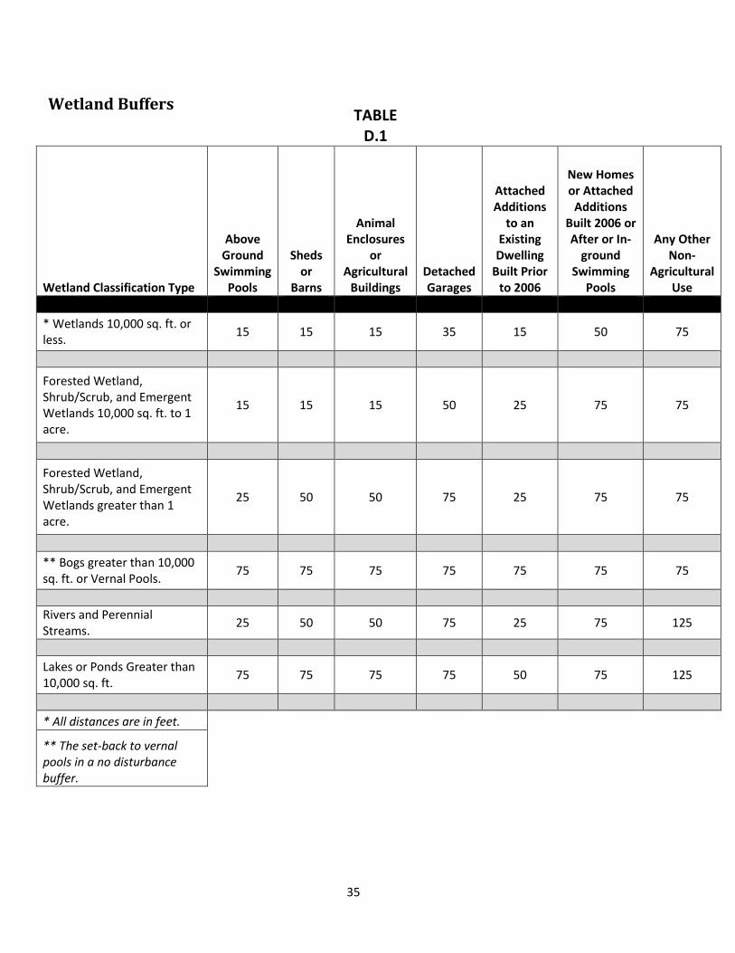
D. Establishment of Buffer Areas.
A naturally vegetated buffer provides a protective barrier that helps maintain the beneficial functions of a wetland such as: sediment collection, erosion control, pollution filtration, flood control and wildlife habitat protection.
1. A naturally vegetated Buffer Area shall be retained within specified distances of any wetland in accordance with Table D.1.
33

2. Existing buildings within the buffer area may be repaired or rebuilt, provided that the repaired or rebuilt structure conforms to the dimensions of the former structure and does not extend any further into the wetlands or buffer area than the original foundation, and furthermore, appropriate erosion and sediment control measures shall be used.
3. In cases of public water bodies, as defined by the Comprehensive Shoreland Protection Act, those buffers and setbacks required by RSA 483-B shall apply, except as stated in Table D.1. These currently include: Blaisdell Lake, Billings Pond, Kezar Lake, Gile Pond, Loch Lyndon (Newbury) Reservoir, and Russell Pond.
34
Wetland Buffers
TABLE D.1
Wetland Classification Type
Above Ground
Swimming Pools
Sheds or
Barns
Animal Enclosures
or Agricultural
Buildings Detached Garages
Attached Additions
to an Existing Dwelling
Built Prior to 2006
New Homes or Attached
Additions Built 2006 or After or In-
ground Swimming
Pools
Any Other Non-
Agricultural Use
* Wetlands 10,000 sq. ft. or less. 15 15 15 35 15 50 75
Forested Wetland, Shrub/Scrub, and Emergent Wetlands 10,000 sq. ft. to 1 acre.
15 15 15 50 25 75 75
Forested Wetland, Shrub/Scrub, and Emergent Wetlands greater than 1 acre.
25 50 50 75 25 75 75
** Bogs greater than 10,000 sq. ft. or Vernal Pools. 75 75 75 75 75 75 75
Rivers and Perennial Streams. 25 50 50 75 25 75 125
Lakes or Ponds Greater than 10,000 sq. ft. 75 75 75 75 50 75 125
* All distances are in feet.
** The set-back to vernal pools in a no disturbance buffer.
35
4. Buffers shall not be required if the wetland or surface water is one of the following types:
a. A man-made vegetated swale or roadside, or driveway ditch;
b. A sedimentation/detention basin;
c. A man-made agricultural, irrigation pond, recreational pond, or fire pond;
d. A septage lagoon.
E. Uses Permitted in Wetland and Buffer Areas. 1. Any use otherwise permitted by ordinances of the Town of Sutton and State and Federal laws
that does not involve the erection of a structure or that does not alter the surface configuration of the land by the addition of fill or by dredging.
2. Agriculture, including grazing, hay production, truck gardening and silage production provided that such shall not cause an increase in surface or ground water contamination by pesticides or other toxic or hazardous substances and that such use will not cause or contribute to soil erosion. Refer to Best Management Wetland Practices for Agriculture, New Hampshire Department of Agriculture.
3. Forestry and tree farming to include the construction of access roads for said purposes, provided that said roads do not obstruct the natural flow of water, and the necessary required permits are obtained. Refer to Best Management Practices for Erosion Control on Timber Harvest Operations in NH, New Hampshire Department of Resources and Economic Development, Division of Forests and Lands.
4. Wildlife habitat development and management.
5. Recreational uses consistent with the purpose and intent of this Ordinance.
6. Conservation areas and nature trails. Refer to Best Management Practices for Erosion Control During Trail Maintenance and Construction, New Hampshire Department of Resources and Economic Development, Trail Bureau.
36

7. Water impoundment and the construction of well water supplies.
8. Drainage-ways to include streams, creeks, or other paths of normal runoff water and common agricultural land drainage.
9. Septic systems; leach fields; and other waste disposal facilities shall be permitted only in accordance with the New Hampshire Department of Environmental Services (DES) requirements.
F. Filled Lands and Pre-existing Uses.
Lands which may have been wetlands but were filled under properly issued state and town permits, or pre-existing conditions prior to 1976, granted prior to the adoption of this ordinance shall be judged according to the soils existing at the site at the time the application for building permit or subdivision is made.
G. Conditional Uses.
A Conditional Use Permit may be granted by the Planning Board (RSA 674:21 II) for the construction of roads and other access ways, and for pipelines, power lines, and other transmissions lines, provided that all of the following conditions are met:
1. The proposed construction is essential to the productive use of land, and not part of the
Wetlands Areas. 2. Design, construction and maintenance methods will be such as to minimize detrimental
impact upon the wetland and will include restoration of the site as nearly as possible to its original grade and condition.
3. No alternative route which does not cross a wetland or which has less detrimental impact on the wetland is feasible.
4. Cost of the proposed construction compared to alternatives shall not be a consideration in granting or denying the permit.
5. The Conservation Commission has had the opportunity to review and comment.
H. Other Provisions.
37

1. The Board of Selectmen shall not issue any permit for construction within the wetlands and wetland buffer (see Section E) unless such activity conforms to the provisions of this Ordinance. The Board of Selectmen shall have the power to enforce this Ordinance, and violations may be punishable by fines as provided by RSA 676:17.
2. Any wetlands altered in violation of this Ordinance shall be restored at the expense of the violator(s) as provided by New Hampshire Department of Environmental Services regulations.
ARTICLE XI - STEEP SLOPE OVERLAY DISTRICT
A. The Purpose and Intent.
The primary objective of the Steep Slopes Overlay District is to limit the nature and intensity of development of steep slopes to those uses which can be harmoniously, appropriately, and safely located on steep slopes and thereby serve the additional objectives to prevent soil erosion; protect surface waters from sedimentation, turbidity, runoff of storm water and effluent from sewage disposal systems; preserve tree cover and other vegetative cover; protect wildlife habitat; preserve scenic views; protect natural areas; and maintain ecological balance.
B. Steep Slope Overlay District Boundaries.
1. The Steep Slopes Overlay District is hereby defined as comprising all areas within which there is an elevation change of 20 feet or more and the slope is 20% or greater. Any area which meets the foregoing criteria lies within the Steep Slopes Overlay District even though it may be part of a larger area which has a slope of less than 20%.
2. This Article incorporates the map of slope grades in Sutton on which steep slopes are delineated. The Steep Slopes Map may be used in order to determine what portion of lots fall under the rules and regulations for development within the Steep Slopes Overlay District and are found in Article III.L of this Ordinance and in the Sutton Subdivision and Site Plan Review Regulations. Applicants may also use the services o f a New Hampshire certified Engineer or certified Surveyor to show that different or smaller configuration of Steep Slopes is applicable.
C. Steep Slope Conditional Use.
A Conditional Use Permit may be granted by the Planning Board (RSA 674:21 II) for the construction of roads, driveways, and other access ways, and for pipelines, power lines, and other transmissions lines, provided that all of the following conditions are met: 1. The proposed driveway is essential to the productive use of land, and does not result
in undo danger or hazard to the public, to emergency personnel and vehicles, or to
38

adjacent property.
2. Design, construction and maintenance methods will be such as to minimize detrimental impact upon down-slope roads and properties.
3. No alternative design and location is feasible.
4. Cost of the proposed construction compared to alternatives shall not be a consideration in granting or denying the permit.
ARTICLE XII – PERSONAL WIRELESS FACILTIES (PWSFs)
A. Purpose and Intent
1. It is the express purpose of this Article to permit carriers to locate PWSFs in the Town of Sutton consistent with appropriate land use regulations that will ensure compatibility with the visual and environmental features of the Town.
2. Collocation is encouraged for PWSF applications and in most cases requires only application for a building permit.
B. Definitions.
For the purpose of this Article, the following terms shall have the meanings given herein: ANTENNA: The equipment from which wireless radio signals are sent and received by a PWSF. ANTENNA ARRAY: A collection of antennas attached to a mount to send and receive radio signals.
CAMOUFLAGED: A personal wireless service facility which is a disguised, or hidden, part of an existing or proposed structure, or placed within an existing or proposed structure. CARRIER: A person or company that provides personal wireless services also sometimes referred to as a provider.
COLLOCATION: The placement or installation of new PWSFs on existing towers or mounts, including electrical transmission towers and water towers, as well as existing buildings and other structures capable of structurally supporting the attachment of PWSFs in compliance with applicable codes. “Collocation” does not include a “substantial modification.”
39

ENVIRONMENTAL ASSESSMENT (EA): An EA is a document required by the Federal Communications Commission (FCC) and the National Environmental Policy Act (NEPA) when a PWSF is placed in certain designated areas.
EQUIPMENT SHELTER: An enclosed structure, cabinet, shed, vault, or box near the base of the mount within which are housed equipment for a PWSF such as batteries and electrical equipment. Equipment shelters are sometimes referred to as base transceiver stations.
FACILITY: See Personal Wireless Service Facility.
FALL ZONE: The area on the ground from the base of a ground-mounted PWSF that forms a circle with a radius equal to 125 percent of the height of the facility, including antennas or other appurtenances. The fall zone is the area within which there is a potential hazard from falling debris (such as ice) or collapsing material.
GUYED TOWER: A monopole or lattice tower secured to the ground or other surface by diagonal cables for lateral support.
HEIGHT: The above ground level (AGL) from the natural grade of a site to the highest point of a structure.
HISTORIC BUILDINGS: Buildings such as those described in “Sutton Homes and Buildings” and other volumes published by the Sutton Historical Society and in the Sutton Master Plan.
LATTICE TOWER: A type of mount with multiple legs and structural cross bracing between the legs that is se1f-supporting and freestanding.
MAST: A thin pole which resembles a street light standard, telephone pole or flagpole. A dual-polarized antenna is typically deployed on the interior of the mast. There is no exterior antenna. It is also called a brown stick or three-sectored Susan.
MODIFICATION: The replacement or alteration of an existing PWSF within a previously approved equipment compound or upon a previously approved mount. Routine maintenance of an approved PWSF shall not be considered a modification.
MODIFICATION APPLICATION: A request submitted by an applicant to a Sutton Board for modification of a PWSF.
MONOPOLE: A thicker type of mount than a mast that is self-supporting with a single shaft of 40

wood, steel, concrete, or other material that is designed for the placement of antennas and arrays along the exterior of the shaft.
MOUNT: The structure or surface upon which antennas are mounted, including the following four types of mounts:
1. Roof-mounted: Mounted on the roof of a building;
2. Side-mounted: Mounted on the side of a building;
3. Ground-mounted: Mounted on the ground; and
4. Structure-mounted: Mounted on a structure other than a building.
PERSONAL WIRELESS SERVICE FACILITY (PWSF): A facility for the provision of personal wireless services, as defined by the Telecommunications Act of 1996, as amended. A PWSF includes a mount, antenna, equipment shelter, and other related equipment.
PERSONAL WIRELESS SERVICE: The three types of services regulated by this Ordinance: Commercial mobile radio services, unlicensed wireless services, and common carrier wireless exchange access services as described in the Telecommunications Act of 1996, as amended.
RADIO FREQUENCY (RF) ENGINEER: An engineer specializing in electrical or microwave engineering, especially the study of radio frequencies. RADIO FREQUENCY RADIATION (RFR): The emissions from a PWSF.
SECURITY BARRIER: A wall, fence, or berm that restricts an area from unauthorized entry or trespass. SEPARATION: The distance between one carrier's array of antennas and another carrier's array.
SUBSTANTIAL MODIFICATION: Means the mounting of a proposed PWSF on a tower or mount which, as a result of single or successive modification applications:
1. Increases or results in the increase of the permitted vertical height of a tower, or the existing vertical height of a mount, by either more than 10 percent or the height of one additional antenna array with separation from the nearest existing antenna not to exceed 20 feet, whichever is greater; or
41

2. Involves adding an appurtenance to the body of a tower or mount that protrudes horizontally from the edge of the tower or mount more than 20 feet, or more than the width of the tower or mount at the level of the appurtenance, whichever is greater, except where necessary to shelter the antenna from inclement weather or to connect the antenna to the tower or mount via cable; or
3. Increases or results in the increase of the permitted square footage of the existing equipment compound by more than 2,500 square feet; or
4. Adds to or modifies a camouflaged PWSF in a way that would defeat the effect of the
camouflage.
UTILITY POLE: Means a structure owned and/or operated by a public utility, municipality, electric membership corporation, or rural electric cooperative that is designed specifically for and used to carry lines, cables, or wires for telephony, cable television, or electricity, or to provide lighting.
WATER TANK: Means a water storage tank, or a standpipe or an elevated tank situated on a support structure, originally constructed for use as a reservoir or facility to store or deliver water.
C. Applicability.
1. The terms of this Article and the Site Plan Review Regulations shall apply to new or substantially modified existing PWSFs proposed to be located on all property in the Town of Sutton regardless of ownership.
2. The Board of Adjustment shall specify the form, content and timing of application materials to be submitted by the applicant requiring a Special Exception. The following items shall be included in a complete application:
a. A topographic map showing the location of all PWSFs within a 10- mile radius of proposed facility.
b. A summary of all other ground-mounted sites considered for this application, and justification for selecting the proposed site over these other sites.
c. An explanation of why the proposed design has been selected.
d. For new ground-mounted facilities the application must include: 42
i. Site overview. ii. Site plan and antenna location. iii. Access road plan and profile. iv. Tree location plan. v. Tree information table including average tree height. vi. Elevation views with trees.
e. At least one letter of intent from a service provider. The applicant may redact any information that the applicant in good faith believes is proprietary.
D. Location Requirements.
1. Zoning Districts: PWSFs shall be permitted in all zoning districts as a Special Exception provided conformance with these standards and the other provisions of the Sutton Zoning Ordinance can be met and approved by the Zoning Board of Adjustment.
2. Existing Structures: PWSFs may be located on existing structures, including but not limited to buildings, water towers, existing telecommunications facilities, utility poles or towers, and related facilities, provided that such installation preserves the character and integrity of those structures, except that PWSFs may always be located on utility poles. Where co-location on a proposed existing cell tower involves Substantial Modification or a new PWSF, Site Plan Review approval by the Sutton Planning Board is required before a building permit is issued.
3. New Ground-Mounted Facilities: PWSFs shall be designed so as to be camouflaged to the greatest extent possible, including but not limited to: use of compatible building materials and colors, screening, landscaping, and placement within trees. New Ground-Mounted Personal Wireless Facilities require application to and approval by both the Zoning Board of Adjustment (Special Exception) and the Planning Board (Site Plan Review).
E. Use Regulations.
1. A PWSF shall require a building permit in all cases and may be permitted as follows:
a. Facilities added to Existing Tower Structures: Carriers may locate a PWSF on any guyed tower, lattice tower, mast, or monopole in existence prior to the adoption of this Article so long as the co- location complies with the approved site plan and the installation will not involve Substantial Modification or a new PWSF as defined in this Article. If installation involves Substantial Modification or a new PWSF; then, Planning Board approval of a full site plan review is required before the issuance of a Building Permit.
43

b. Reconstruction of Existing Tower Structures: A full Site Plan Review by the Planning Board is required. Any existing guyed tower, lattice tower, monopole, or mast in existence prior to the adoption of this Article may be reconstructed with a 20-foot increase in height so as to maximize co-location so long as the standards of this Article are met and this a 20-foot increase in height does not cause the facility to exceed 100 feet in height. The height of existing towers greater than 100 feet in height shall not be increased. The mount may be replaced with a similar mount or a mount that significantly decreases the visual impact on the community.
c. Facilities Added to Other Existing Structures: A full Site Plan Review by the Planning Board is required. A carrier may locate a PWSF on an existing structure, building, utility tower or pole, or water tower subject to the provisions of this Article.
d. New Ground-Mounted Facility: A PWSF involving construction on a new ground mount greater than 35 feet in height shall require a special exception in conformance with the provisions of this Article and if approved by the Zoning Board of Adjustment, shall further require a full Site Plan Review by the Planning Board.
F. Dimensional Requirements: applicable to new or substantially modified existing PWSF.
1. PWSFs shall comply with the following requirements:
a. Height, Existing Structures and Utility Poles: Carriers that locate new PWSFs on water towers, electric transmission and distribution towers, utility poles, guyed towers, lattice towers, masts, monopoles and other existing structures may be permitted to increase the height of those structures no more than 20 feet provided the additional height will not exceed 100 feet or materially impair the visual impacts of the site. This increase in height shall only be permitted once for each structure.
b. Height, New Ground-Mounted Facilities: New ground-mounted PWSF shall not project
higher than 20 feet above the top height of the main canopy of trees within 200 feet of the proposed tower location. The top height of the main canopy of trees must be certified by a professional forester licensed by the State of New Hampshire. The professional forester shall prepare and stamp a report attesting to the height of the main canopy of trees within the said 200 foot area. In preparing his or her report, the professional forester shall provide the heights of a fair and representative sampling of the dominant and co- dominant trees which contribute to or make up the top of the tree canopy, but shall not need to measure every tree within the said 200 foot area.
c. Setbacks: All PWSFs and their equipment shelters shall comply with the building setback
provisions of the zoning district in which the facility is located. New ground-mounted 44

PWSFs shall be set back from any property line at least 125% of the facility’s height.
d. Fall Zone for Ground Mounts: In order to ensure public safety, the minimum distance from the base of any ground-mount of a PWSF to any property line, public road, habitable dwelling, business or institutional use, or public recreational area shall be, at a minimum, the distance equal to the fall zone, as defined in this Article.
e. Fall Zone for Ground Mounts: In order to ensure public safety, the minimum distance from
the base of any ground-mount of a PWSF to any property line, public road, habitable dwelling, business or institutional use, or public recreational area shall be, at a minimum, the distance equal to the fall zone, as defined in this Article. Fall Zone for Non-Ground Mounts: In the event that an existing structure is proposed as a mount for a PWSF, a fall zone shall not be required, but the setback provisions of the zoning district shall apply. In the case of pre- existing nonconforming structures, PWSF and their equipment shelters shall not increase any nonconformity.
G. Performance and design standards: applicable to new or substantially modified existing PWSF.
1. Visibility: The proposed PWSF shall have no unreasonable adverse impact upon scenic
resources within the Town of Sutton.
a. Unreasonable adverse impacts are measured on the basis of: i. Change in community scale, as exhibited in relative height, mass or proportion of the
PWSF within its proposed surroundings. ii. New visible elements proposed on a contrasting background. iii. Different colors and textures proposed against a contrasting background. iv. Use of materials that are not compatible to its proposed surroundings.
b. Camouflage for Facilities on Existing Buildings or Structures – Roof Mounts: When a PWSF extends above the roof height of a building on which it is mounted, every effort shall be made to conceal or camouflage the facility within or behind existing or new architectural features to limit its visibility from public ways. Facilities mounted on a roof shall be stepped back from the front facade in order to limit their impact on the building's silhouette.
c. Camouflage for Facilities on Existing Buildings or Structures – Side Mounts: PWSFs which are side mounted shall blend with the existing building's architecture and, if individual antenna panels are over 5 square feet, the panels shall be painted or shielded with material consistent with the design features and materials of the building.
d. Camouflage for Ground-Mounted Facilities: All ground-mounted PWSFs shall be surrounded by a buffer of dense tree growth that extends continuously for a minimum distance of 200 feet from the mount, security barrier, or designated clear area for access
45

to equipment, whichever is greatest. The facility shall be screened from view in all directions by the dense buffer of trees. These trees must exist on the subject property, be planted on site, or be within a landscape easement on an adjoining site. The Planning Board shall have the authority to decrease, relocate, or alter the required buffer based on the site conditions. The 200-foot vegetative buffer area shall be protected by a landscape easement or be within the area of the carrier's lease. The easement or lease shall specify that the trees within the buffer shall not be removed or topped, unless the trees are dead or dying and present a hazard to persons or property.
2. Color: To the extent that any PWSF extend above the height of the vegetation immediately surrounding it, they shall be of a color which blends with background or surroundings, and be of a non-reflective nature.
3. Equipment Shelters: Equipment shelters for PWSFs shall be designed consistent with one of the following design standards:
a. Equipment shelters shall be located in underground vaults; or
b. Equipment shelters shall be designed so that the shelters are architecturally consistent, with respect to the materials and appearance of the buildings in the area of the PWSF; or
c. Equipment Shelters shall be camouflaged behind an effective year round landscape buffer, equal to the height of the proposed building and/or a wooden fence. The Planning Board shall determine the fencing and/or landscape buffer that is compatible with the neighborhood; or
d. If mounted on a roof top, the equipment shelter shall be concealed or camouflaged so that the shelter either is not visible at grade or appears to be a part of the original structure.
4. Lighting, Signage, and Security:
a. Lighting: The mounts of PWSFs shall be lighted only if required by the Federal Aviation Administration (FAA). Lighting of equipment structures and any other facilities on site shall be shielded from abutting properties.
b. Signage: Signs shall be limited to those needed to identify the property and the owner, and warn of any danger. All signs shall comply with the requirements of the Town of Sutton Sign Ordinance.
46

c. Security Barrier: The Planning Board shall have final authority regarding the need for the installation of a security barrier surrounding a ground-mounted PWSF.
5. Historic Buildings.
a. Any PWSF located on or within a historic building or structure shall not alter the character, defining features, distinctive construction methods, or original historic material of the building.
b. Any alteration made to a historic building or structure to accommodate a PWSF shall be fully reversible.
c. A PWSF authorized by this subsection shall be concealed within or behind existing architectural features, or shall be located so that they are not visible from public roads and viewing areas.
6. Scenic Landscapes and Vistas: Ground-mounted facilities shall not be located so as to be clearly visible from abutting properties or public conservation areas. All ground-mounted PWSFs shall be surrounded by a buffer of dense tree growth as per section 7.1 (F)
7. Driveways: If available, existing entrances and driveways shall be utilized to serve a PWSF, unless the applicant can demonstrate that a new entrance and driveway will result in less visual, traffic, and environmental impact. New driveways to serve a PWSF shall not exceed 12 feet in width. A gravel or crushed stone surface is encouraged.
8. Antenna Types: Any antenna array placed upon an existing or proposed mount, utility pole, or transmission line mount shall have a diameter of no more than 4 feet, exclusive of the diameter of the mount.
9. Ground and Roof Mounts: All ground mounts shall be of a mast type mount.
10. Hazardous Waste: No hazardous waste shall be discharged on site of any PWSF. If any
hazardous materials are to be used on site, there shall be provisions for full containment of such materials. An enclosed containment area shall be provided with a sealed floor, designated to contain a least 110 percent of the volume of the hazardous materials stored or used on the site. The Sutton Volunteer Fire Department shall be notified of any hazardous materials stored on the site.
11. Radio Frequency Radiation (RFR) Standards: All equipment proposed for a PWSF shall be fully compliant with the FCC Guidelines for Evaluating the Environmental Effects of Radio
47

Frequency Radiation (FCC Guidelines), under Report and Order, FCC 96-326 published on August 1, 1996, and all subsequent amendments.
H. MONITORING AND MAINTENACE: applicable to new or substantially modified existing PWSF.
1. Maintenance: The owner of the facility shall maintain the PWSF in good condition. Such maintenance shall include but shall not be limited to, painting, structural integrity of the mount and security barrier, and maintenance of the buffer areas and landscaping.
2. Monitoring: As part of the issuance of the site plan approval building permit, the property
owner shall agree that the Town of Sutton may enter the subject property to obtain RFR measurements and noise. Measurements are at the expense of the carrier. The town shall provide reasonable written notice to carrier and landowner and provide them the opportunity to accompany the Town representatives when the measurements are conducted.
3. Security for Removal: Recognizing the hazardous situation presented by abandoned and unmonitored PWSFs, the Planning Board shall set the form and amount of security that represents the cost for removal and disposal of abandoned facilities in the event that a facility is abandoned and the facility owner is unwilling or unable to remove the facility in accordance with section 9.2. The amount of the security shall be based upon the removal cost plus 25 percent, as provided by the applicant and certified by a professional structural engineer licensed in New Hampshire. The owner of the facility shall provide the Planning Board with a revised removal cost estimate and structural evaluation prepared by a professional structural engineer licensed in New Hampshire every 5 years from the date of the Planning Board's approval of the site plan. If the cost has increased more than 25% then the owner of the facility shall provide additional security in the amount of the increase.
I. ABANDONMENT OR DISCONTINUATION OF USE
1. Notification: At such time that a carrier plans to abandon or discontinue operation of a PWSF such carrier will notify the Town by Certified US Mail of the proposed date of abandonment or discontinuation of operations. Such notice shall be given not less than 30 days prior to abandonment or discontinuation of operations.
2. Removal: Upon abandonment or discontinuation of use, the owner of the facility shall physically remove the PWSF within 90 days from the date of abandonment or discontinuation of use. "Physically Remove" shall include, but not be limited to:
a. Removal of antennas, mount, equipment shelters and security barriers from the subject property.
48

b. Proper disposal of the waste materials from the site in accordance with local and state solid waste disposal regulations.
c. Restoring the location to its natural condition.
3. Failure to Remove: If the owner of the facility does not remove the facility then the Board of Selectmen shall, after holding a public hearing with notice to the owner and abutters, issue a declaration of abandonment. The owner of the facility shall then dismantle and remove the facility within 90 days of receipt of the declaration of abandonment by the Board of Selectmen. If the abandoned facility is not removed within 90 days; the Town may execute the security to pay for this action.
ARTICLE XIII - SMALL WIND ENERGY SYSTEMS ORDINANCE
A. Purpose.
This small wind energy systems ordinance is enacted in accordance with RSA 674:62-66, and the purposes outlined in RSA 672:1-III-a. The purpose of this ordinance is to accommodate small wind energy systems in appropriate locations, while protecting the public’s health, safety and welfare. In addition, this ordinance provides a permitting process for small wind energy systems to ensure compliance with the provisions of the requirements and standards established herein.
B. Definitions.
METEOROLOGICAL TOWER (met tower): Includes the tower, base plate, anchors, guy wires hardware, anemometers (wind speed indicators), wind direction vanes, booms to equipment for anemometers and vanes, data loggers, instrument wiring, and any devices that are used to monitor or transmit wind speed and wind flow characteristics over period of time for either instantaneous wind information or to characterize the resource at a given location. For the purpose of this ordinance, met towers shall refer only to those whose purpose are to analyze the environmental factors needed to assess the potential to install, construct or erect a small wind energy system.
MODIFICATION: Any change to the small wind energy system that materially alters the size, type or location of the small wind energy system. Like-kind replacements shall not be construed to be a modification. NET METERING: The difference between the electricity supplied to a customer over electric distribution system and the electricity generated by the customer’s small energy system that is fed back into the electric distribution system over a billing period.
49

POWER GRID: The transmission system, created to balance the supply and demand of electricity for consumers in New England.
SHADOW FLICKER: The visible flicker-effect when rotating blades of the wind generator shadows on the ground and nearby structures causing a repeating pattern of light and shadow.
SMALL WIND ENERGY SYSTEM: A wind energy conversion system consisting of a generator, a tower, and associated control or conversion electronics, which has a capacity of 100 kilowatts or less and will be used primarily onsite.
SYSTEM HEIGHT: The vertical distance from ground level to the tip of the wind generator blade when it is at its highest point. TOWER HEIGHT: The vertical distance from ground level to the top of the fixed tower, excluding the wind generator.
WIND TOWER: The monopole, guyed monopole or lattice structure that supports a wind generator.
WIND GENERATOR: The blades and associated mechanical and electrical conversion components mounted on top of the tower.
C. Procedure for Review.
1. Building Permit: Small wind energy systems and met towers are an accessory use permitted in all zoning districts where structures of any sort are allowed. No small wind energy system shall be erected, constructed, or installed without first receiving a building permit pursuant to Article II.A of the Building Ordinance. A building permit shall be required for any physical modification to an existing small wind energy system. Met towers that receive a building permit shall be allowed on a temporary basis which is not to exceed three years from the date that the building permit was issued.
2. Application: Applications submitted to the Board of Selectmen, or its designee, shall contain the following information:
a. Property lines and physical dimensions of the applicant’s property;
50

b. Location, dimensions, and types of all existing structures on the property;
c. Location of the proposed small wind energy system, foundations, guy anchors and associated equipment;
d. Wind tower foundation blueprints or drawings;
e. Wind tower blueprints or drawings;
f. Setback requirements as outlined in this ordinance;
g. Any right-of-way that is contiguous with the property;
h. Any overhead utility lines;
i. Certification by the manufacturer or New Hampshire licensed engineer of the required Small Wind Energy System specifications, including manufacturer, model, rotor diameter, wind tower height, wind tower type, nameplate generation capacity;
j. Small wind energy systems that will be connected to the power grid shall include a copy of the application for interconnection with their electric utility provider;
k. Systems that will be connected to the power grid shall include a copy of the application for interconnection with their electric utility provider;
l. Sound level analysis prepared by the wind generator manufacturer or qualified engineer;
m. Electrical components in sufficient detail to allow for a determination that the manner of installation conforms to the requirements of the electrical utility provider;
p. Evidence of compliance or non-applicability with Federal Aviation Administration
requirements; and
q. List of abutters to the applicant’s property.
D. Abutter and Regional Notification: In accordance with RSA 674:66, Board of Selectmen, or its 51

designee, shall notify all abutters by certified mail at the applicant’s expense upon application for a building permit to construct a small wind energy system. The public will be afforded 30 days to submit comments to the Board of Selectmen prior to the issuance of the building permit. The Board of Selectmen or its designee shall review the application for regional impacts per RSA 36:55. If the proposal is determined to have potential regional impacts, the procedures set forth in RSA 36:57, IV shall be followed by the Board of Selectmen or its designee.
E. Standards: The Board of Selectmen, or its designee, shall evaluate the application for compliance with the following standards:
1. Setbacks: The setback shall be calculated by multiplying the minimum setback requirement number (see table below) by the system height and measured from the center of the wind tower base to property line, public roads, or nearest point on the foundation of an occupied building.
Minimum Setback Requirements
Occupied Buildings on Participating Landowner Property
Occupied Buildings on Abutting Property
Property Lines of Abutting Property and Utility Lines
Public Roads
0 1.5 1 1.5
Small wind energy systems must meet all setbacks for principal structures for the zoning district in which the system is located. Guy wires used to support the tower are exempt from the small wind energy system setback requirements;
2. Wind Tower Height: The maximum wind tower height shall be the minimum height necessary
for the system to function at its rated capacity over the estimated lifespan of the device, as certified by either the Small Wind Energy System manufacturer or, if hired, an engineer licensed in the state of New Hampshire. In no situation shall the tower height exceed 100 feet;
3. Sound Level: The small wind energy system shall not exceed 50 decibels using the A scale (dba),
as measured at the site property line, except during short-term events such as severe wind storms and utility outages;
4. Shadow Flicker: Small wind energy systems shall be sited in a manner that does not result in
significant shadow flicker impacts. Significant shadow flicker is defined as more than 30 hours per year on abutting occupied buildings. The applicant has the burden of proving that the shadow flicker will not have significant adverse impact on neighboring or adjacent uses. Potential shadow flicker will be addressed either through siting or mitigation measures;
52

5. Signs: All signs including flags streamers and decorative items, both temporary and permanent, are prohibited on the small wind energy system, except for manufacturer identification or appropriate warning signs one square foot or smaller in size and having no advertising material;
6. Aviation: The small wind energy system shall be built to comply with all applicable Federal Aviation Administration regulations including but not limited to 14 C.F.R. part 77, subpart B regarding installations close to airports, and the New Hampshire Aviation regulations, including but not limited to RSA 422-b and RSA 424;
7. Visual Impacts: It is inherent that small wind energy systems may pose some visual impacts due to the wind tower height needed to access wind resources. The purpose of this section is to reduce the visual impacts, without restricting the owner’s access to the optimal wind resources on the property.
8. The applicant shall demonstrate through project site planning and proposed mitigation that the small wind energy system’s visual impacts will be minimized regarding site selection, skyline silhouette, w i n d generator design or appearance, buffering, and screening of ground-mounted electrical and control equipment. All electrical conduits shall be underground.
9. The color of the small wind energy system shall either be the stock color from the manufacturer or painted with a non-reflective, unobtrusive color that blends in with the surrounding environment. Approved colors include but are not limited to white, off-white or gray.
10. A small wind energy system shall not be artificially lit unless such lighting is required by the Federal Aviation Administration (FAA). If lighting is required, the applicant shall provide the Board of Selectmen a copy of the FAA determination to establish the required markings and/or lights for the small wind energy system.
11. Approved Wind Generators: The manufacturer and model of the wind generator to be used in the proposed small wind energy system must have been approved by the California Energy Commission or the New York State Energy Research and Development Authority, or a similar list approved by the State of New Hampshire, if available.
12. Utility Connection: If the proposed small wind energy system is to be connected to the power grid through net metering, it shall adhere to RSA 362-A.9.
13. Access: The wind tower shall be designed and installed so as to preclude step bolts or a ladder readily accessible to the public for a minimum height of 8 feet above the ground. All ground-mounted electrical and control equipment shall be labeled and secured to prevent unauthorized access.
53

14. Clearing: Clearing of natural vegetation shall be limited to that which is necessary for the construction, operation and maintenance of the small wind energy system and as otherwise prescribed by applicable laws, regulations, and ordinances.
15. Abandonment: At such time as a small wind energy system is scheduled to be abandoned, the applicant must follow the provisions of RSA 674:65.
ARTICLE XIV - SUTTON FLOODPLAIN DEVELOPMENT ORDINANCE
As Voted and Passed at Town Meeting, March 1988; Amended March 8, 1994, March 10, 1998, March 11, 2008, December 14, 2009, March 9,2010 and March 12, 2013.
This ordinance, adopted pursuant to the authority of RSA 674:16 shall be known as the Town of Sutton Floodplain Development Ordinance. The regulations in this ordinance shall overlay and supplement the regulations in the Town of Sutton Zoning Ordinance, and shall be considered part of the Zoning Ordinance for purposes of administration and appeals under state law. If any provision of this ordinance differs or appears to conflict with any provision of the Zoning Ordinance or other ordinance or regulation, the provision imposing the greater restriction or more stringent standard shall be controlling.
A. PURPOSE.
Certain areas of the Town of Sutton, New Hampshire are subject to periodic flooding, causing serious damages to properties within these areas. Relief is available in the form of flood insurance as authorized by the National Flood Insurance Act of 1968. Therefore, the Town of Sutton, New Hampshire has chosen to become a participating community in the National Flood Insurance Program, and agrees to comply with the requirements of the National Flood Insurance Act of 1968 (P.L. 90-488, as amended) as detailed in this Floodplain Management Ordinance.
B. ESTABLISHMENT.
The following regulations in this ordinance shall apply to all lands designated as special flood hazard areas by the Federal Emergency Management Agency (FEMA) in its "Flood Insurance Study for the County of Merrimack, NH dated April 19, 2010 or as amended, together with the associated Flood Insurance Rate Maps, dated April 19, 2010 or as amended, which are declared to be a part of this Ordinance and hereby incorporated by reference.
C. DEFINITION OF TERMS which are specific to the Floodplain Development Ordinance 100-YEAR FLOOD see "base flood". AREA OF SPECIAL FLOOD HAZARD: is the land in the flood plain within
54

the Town of Sutton subject to a one percent or greater chance of flooding in any given year. The area is designated on the FIRM as Zones A and AE.
BASE FLOOD: The flood having a one percent chance of being equaled or exceeded in any given year. BASEMENT: Any area of the building having its floor subgrade (below ground level) on all sides.
BUILDING: see "structure".
DEVELOPMENT: Any man-made change to improved or unimproved real estate, including, but not limited to, buildings or other structures, mining, dredging, filling, grading, paving, excavating or drilling operations or storage of equipment or materials.
FEMA: The Federal Emergency Management Agency.
FLOOD or FLOODING: A general and temporary condition of partial or complete inundation of normally dry land areas from:
1. The overflow of inland or tidal waters; and
2. The unusual and rapid accumulation or runoff of surface waters from any source.
FLOOD INSURANCE RATE MAP (FIRM): An official map incorporated with this Ordinance, on which the Federal Emergency Management Agency has delineated both the special hazard areas and the risk premium zones applicable to the Town of Sutton.
FLOOD INSURANCE STUDY (FIS): An examination, evaluation and determination of flood hazards and, if appropriate, corresponding water surface elevations, or an examination, evaluation and determination of mudslide (i.e. mudflow) and/or flood- related erosion hazards.
FLOODPLAIN or FLOOD-PRONE AREA: Any land area susceptible to being inundated by water from any source.
FLOOD PROOFING: Any combination of structural and non-structural additions, changes, or adjustments to structures which reduce or eliminate flood damage to real estate; or improved real property; water; and sanitary facilities; structures and their contents.
FLOODWAY - see "regulatory floodway". 55
FUNCTIONALLY DEPENDENT USE: A use which cannot perform its intended purpose unless it is located or carried out in close proximity to water. The term includes only docking and port facilities that are necessary for the loading/unloading of cargo or passengers, and ship building/repair facilities but does not include long-term storage or related manufacturing facilities.
HIGHEST ADJACENT GRADE: The highest natural elevation of the ground surface prior to construction next to the proposed walls of a structure.
HISTORIC STRUCTURE: Any structure that is:
1. Listed individually in the National Register of Historic Places (a listing maintained by the Department of Interior) or preliminarily determined by the Secretary of Interior as meeting the requirements for individual listing on the National Register;
2. Certified or preliminarily determined by the Secretary of the Interior as contributing to the historical significance of a registered historic district or a district preliminarily determined by the Secretary to qualify as a registered historic district;
3. Individually listed on a state inventory of historic places in states with historic preservation programs which have been approved by the Secretary of the Interior; or
4. Individually listed on a local inventory of historic places in communities with historic preservation programs that have been certified either:
a. By an approved state program as determined by the Secretary of the Interior, or
b. Directly by the Secretary of the Interior in states without approved programs.
LOWEST FLOOR: The lowest floor of the lowest enclosed area (including basement). An unfinished or flood resistant enclosure, usable solely for parking of vehicles, building access or storage in an area other than a basement area is not considered a building's lowest floor; provided that such enclosure is not built so as to render the structure in violation of the applicable non-elevation design requirements of this ordinance.
MEAN SEA LEVEL: For purposes of the National Flood Insurance Program, the National Geodetic Vertical Datum (NGVD) of 1929 or other datum, to which base flood elevations shown on a community's Flood Insurance Rate Map are referenced.
56

MANUFACTURED HOME: A structure, transportable in one or more sections, which is built on a permanent chassis and is designed for use with or without a permanent foundation when connected to the required utilities. For floodplain management purposes the term "manufactured home" also includes park trailers, travel trailers, and other similar vehicles placed on a site for greater than 180 consecutive days. This includes manufactured homes located in a manufactured home park or subdivision.
MANUFACTURED HOME PARK or SUBDIVISION: A parcel of land (or contiguous parcels) of land divided into two or more manufactured home lots for rent or sale.
NEW CONSTRUCTION: For the purposes of determining insurance rates, structures for which the “start of construction” commenced on or after the effective date of an initial FIRM or after December 31, 1974, whichever is later, and includes any subsequent improvements to such structures. For floodplain management purposes, new construction means structures for which the start of construction commenced on or after the effective date of a floodplain management regulation adopted by a community and includes any subsequent improvements to such structures.
RECREATION VEHICLE: means a vehicle which is
1. Built on a single chassis
2. 400 square feet or less when measured at the largest horizontal projection, designed to be self - propelled or permanently towable by a light duty truck, and designed primarily not for use as a permanent dwelling but as temporary living quarters for recreational, camping, travel or seasonal use.
REGULATORY FLOODWAY: The channel of a river or other watercourse and the adjacent land areas that must be reserved in order to discharge the base flood without cumulatively increasing the water surface elevation more than a designated height.
SPECIAL FLOOD HAZARD AREA: see “Area of Special Flood Hazard”.
START OF CONSTRUCTION: The date on which the building permit was issued, provided the actual start of construction, repair, reconstruction, placement, or other improvement was within 180 days of the permit date and includes substantial construction. The actual start means either the first placement of permanent construction of a structure on a site, such as the pouring of slab or footings, the installation of piles, the construction of columns, or any work beyond the stage of excavation; or the placement of a manufactured home on a foundation. Permanent construction does not include land preparation, such as clearing, grading and filling; nor does it include the
57

installation of streets and/or walkways; nor does it include excavation for a basement, footings, piers, or foundations or the erection of temporary forms; nor does it include the installation on the property of accessory buildings, such a s garages or sheds not occupied as dwelling units or not part of the main structure.
STRUCTURE: For floodplain management purposes, a walled and roofed building, including a gas or liquid storage tank that is principally above ground, as well as a manufactured home.
SUBSTANTIAL DAMAGE: Damage of any origin sustained by a structure whereby the cost of restoring the structure to its before-damaged condition would equal or exceed 50 percent of the market value of the structure before the damage occurred.
SUBSTANTIAL IMPROVEMENT: Any combination of repairs, reconstruction, alteration, or improvements to a structure in which the cumulative cost equals or exceeds fifty percent of the market value of the structure. The market value of the structure should equal:
1. The appraised value prior to the start of the initial repair or improvement, or.
2. In the case of damage, the value of the structure prior to the damage occurring. For the purposes of this definition, "substantial improvement" is considered to occur when the first alteration of any wall, ceiling, floor, or other structural part of the building commences, whether or not that alteration affects the external dimensions of the structure. This term includes structures that have incurred substantial damage, regardless of actual repair work performed. The term does not, however, include any project for improvement of a structure required to comply with existing health, sanitary, or safety code specifications which are solely necessary to assure safe living conditions or any alteration of a “historic structure”, provided that the alteration will not preclude the structure’s continued designation as a “historic structure”.
VIOLATION: Failure of a structure or other development to be fully compliant with the community’s flood plain management regulations. A structure or other development, without the elevation certificate; other certifications; or other evidence of compliance, are presumed to be in violation until such time as that documentation is provided (see requirements under Section G, Section I .2.b., or Section K.3. 4 of this ordinance).
WATER SURFACE ELEVATION: means the height, in relation to the National Geodetic Vertical Datum (NGVD) of 1929, North American Vertical Datum (NAVD), or other datum, where specified, of floods of various magnitudes and frequencies in the flood plains.
D. PERMITS.
All proposed development in any special flood hazard area shall require a permit. 58

E. CONSTRUCTION REQUIREMENTS. The Board of Selectmen shall review all building permit applications for new construction or substantial improvements to determine whether proposed building sites will be reasonably safe from flooding. If a proposed building site is in a flood- prone area, the applicant will present certification from a licensed professional engineer that all new construction and substantial improvements shall:
1. Be designed (or modified) and adequately anchored to prevent flotation, collapse, or lateral movement of the structure resulting from hydrodynamic and hydrostatic loads, including the effects of buoyancy;
2. Be constructed with materials resistant to flood damage;
3. Be constructed by methods and practices that minimize flood damages; and
4. Be constructed with electrical, heating, ventilation, plumbing, and air conditioning equipment and other service facilities that are designed and/or located so as to prevent water from entering or accumulating within the components during conditions of flooding.
F. WATER AND SEWER.
Where new and replacement water and sewer systems (including on-site systems) are proposed in a special flood hazard area, the applicant shall provide the New Hampshire Department of Environmental Services and the Board of Selectmen with assurance that new and replacement sanitary sewage systems will be designed to minimize or eliminate infiltration of flood waters into the systems and discharges from the systems into flood waters, and on-site waste disposal systems will be located to avoid impairment to them or contamination from them during periods of flooding. No building permits will be approved without an Approval for Construction from the NH Department of Environmental Services.
G. CERTIFICATION.
For all new or substantially improved structures located in Zones A and AE, the applicant shall furnish the following information to the Board of Selectmen: any certification of flood-proofing; the as built elevation (in relation to mean sea level) of the lowest floor(including basement) of all new or substantially improved structures, and include whether or not such structures contain a basement; and if the structure has been flood proofed, the as built elevation (in relation to mean sea level) to which the structure was flood proofed. The Board of Selectmen shall maintain the
59

aforementioned information for public inspection, and shall furnish such information upon request.
H. OTHER PERMITS.
The Building Inspector shall review proposed developments to assure that all necessary permits have been received from those governmental agencies from which approval is required by Federal or State law, including Section 404 of the Federal Water Pollution Control Act Amendments of 1972, 33 U.S.C. 1334. Prior to issuance of a building permit, it shall be the responsibility of the applicant to certify to the Board of Selectmen that all necessary governmental agency approvals have been received.
I. WATERCOURSES.
1. In riverine situations, prior to the alteration or relocation of a watercourse the applicant for such authorization shall notify the Wetlands Bureau of the New Hampshire Environmental Services Department and submit copies of such notification to the Board of Selectmen, in addition to the copies required by RSA 482-A:3. Further, the applicant shall be required to submit copies of said notification to those adjacent communities as determined by the Building Inspector, including notice of all scheduled hearings before the Wetlands Bureau.
2. The applicant shall submit to the Building Inspector, certification provided by a registered professional engineer, assuring that the flood carrying capacity of an altered or relocated watercourse can and will be maintained.
3. Along watercourses with a designated Regulatory Floodway no encroachments, including fill, new construction, substantial improvements, and other development are allowed within the floodway unless it has been demonstrated through hydrologic and hydraulic analyses performed in accordance with standard engineering practices that the proposed encroachment would not result in any increase in flood levels within the community during the base flood discharge.
4. Until a Regulatory Floodway is designated along watercourses, no new construction, substantial improvements, or other development (including fill) shall be permitted within Zone(s) AE on the FIRM, unless it is demonstrated by the applicant that the cumulative effect of the proposed development, when combined with all existing and anticipated development, will not increase the water surface elevation of the base flood more than one foot at any point within the community.
5. The Building Inspector shall obtain, review, and reasonably utilize any floodway data available from Federal, State, or other sources as criteria for requiring that all development located Zone A meet the following floodway requirement: “No encroachments, including fill, new
60

construction, substantial improvements, and other development are allowed within the floodway that would result in any increase in flood levels within the community during the base flood discharge.”
J. FEES.
The Building Inspector may establish from time to time reasonable fees to compensate the Town for the costs of consulting fees incurred. The fees will cover the costs of consultants hired by the Building Inspector to provide expertise on technical aspects of an application.
K. SPECIAL FLOOD AREAS.
1. In special flood hazard areas the Town shall determine the 100 year flood elevation in the following order of precedence according to the data available:
a. In Zones AE, refer to the elevation provided in the community’s Flood Insurance Study and accompanying FIRM.
b. In Zone A the Town shall obtain, review, and reasonably utilize any 100 year flood elevation data available from Federal, State, or other source including data submitted for development proposals submitted to the community (example subdivisions, site approvals, etc.).
2. The Town's 100-year flood elevation determination will be used as criteria for requiring in Zones AE, and A that:
a. All new construction and substantial improvements of residential structures have the lowest floor (including basement) elevated to or above the 100 year flood level.
b. That all new construction and substantial improvements of non- residential structures have the lowest floor (including basement) elevated to or above the 100-year flood level; or together with attendant utility and sanitary facilities, shall: i. Be flood proofed so that below the 100-year flood elevation the structure is watertight with walls substantially impermeable to the passage of water; ii. Have structural components capable of resisting hydrostatic and hydrodynamic loads and the effects of buoyancy; and iii. Be certified by a registered professional engineer or architect that the design and methods of construction are in accordance with accepted standards of practice for meeting the provisions of this section. iv. All manufactured homes to be placed or substantially improved within special
61

flood hazard areas shall be elevated on permanent foundation such that the lowest floor of the manufactured home is at or above the base flood level; and be securely anchored to resist flotation, collapse, or lateral movement. Methods of anchoring may include, but are not limited to, use of over-the-top or frame ties to ground anchors. This requirement is in addition to applicable state and local anchoring requirements for resisting wind forces.
3. Recreational vehicles placed on sites within Zones A and AE shall be either:
a. On the site for fewer than 120 consecutive days,
b. Fully licensed and ready for highway use, or
c. Meets all standards or Section 60.3 (b) (1) of the National Flood Insurance Program Regulations and the elevation and anchoring requirements for "Manufactured Homes" in paragraph (c) (6) of Section 60.3.
d. A recreational vehicle is ready for highway use if it is on its wheels or jacking system, is attached to the site only by quick disconnect type utilities and security devices, and has no permanently attached additions.
4. For all new construction and substantial improvements, fully enclosed areas below the lowest floor that are subject to flooding are permitted providing the enclosed areas meet the following requirements:
a. The enclosed area is unfinished or flood resistant, useable solely for parking of vehicles, building access or storage;
b. The area is not a basement;
c. The area shall be designed to automatically equalize hydrostatic flood forces on exterior walls by allowing for the entry and exit of floodwaters. Designs for meeting this requirement must be certified by a registered professional engineer or architect or must meet or exceed the following minimum criteria: A minimum of two openings having a total net area of not less than one square inch for every square foot of enclosed area subject to flooding shall be provided. The bottom of all openings shall be no higher than one foot above grade. Openings may be equipped with screens, louvers, or other coverings or devices provided that they permit the automatic entry and exit of floodwater.
L. Variances and Appeals. 62

1. Any order, requirement, decision or determination of the Building Inspector made under this ordinance may be appealed to the Zoning Board of Adjustment as set forth in RSA 676:5.
2. If the applicant, upon appeal, requests a variance as authorized by RSA 674:33, I (b), the applicant shall have the burden of showing in addition to the usual variance standards under state law:
a. That the variance will not result in increased flood heights, additional threats to public safety, or extraordinary public expense;
b. That if the required variance is for activity within a designated regulatory floodway, no increase in flood levels during the base flood discharge will result; and
c. That the variance is the minimum necessary, considering the flood hazard, to afford relief.
3. The Zoning Board of Adjustment shall notify the applicant in writing that:
a. The issuance of a variance to construct below the base flood level will result in increased premium rates for flood insurance up to amounts as high as $25 for $100 of insurance coverage; and
b. Such construction below the base flood level increases risks to life and property. Such notification shall be maintained with a record of all variance actions.
4. The community shall: a. Maintain a record of all variance actions, including their justification for their issuance; and
b. Report such variances issued in its annual or biennial report submitted to FEMA’s Federal Insurance Administrator.
63

ARTICLE XV - DEFINITIONS
For the purpose of this ordinance certain terms and words shall have the following meanings. Words used in the present tense include the future; the singular number includes the plural, the plural the singular; the words "used" or "occupied" include the words "designed," "arranged," "intended," or "offered," to be used or occupied; the words "building," "structure," "lot," "land" or "premises" shall be construed as though followed by the words "or any portion thereof" and the word "shall" is always mandatory and not merely directory. Terms and words not defined herein but defined in the Sutton Building Code or Subdivision Regulations shall have the meanings given therein unless a contrary intention clearly appears. Words not defined in either place shall have the meaning given in Webster's Unabridged Dictionary, Third Edition. ABANDONMENT: The visible or otherwise apparent intention of an owner to discontinue a nonconforming use of a building or premises; or the removal of the characteristic equipment or furnishing used in the performance of the nonconforming use, without its replacement by similar equipment or furnishings; or the replacement of the nonconforming use or building by a conforming use or building. ADMINISTRATIVE OFFICER: The Building Inspector, Town of Sutton, New Hampshire. ALTERATION: Any construction, reconstruction or other action resulting in a change in the structural parts or height, number of stories or exits, size, use or location of a building or other structure. ANTENNA: The device and/or wire which transmits or receives electromagnetic radiation, but not the supporting structure of the device. AQUIFER: A surficial and/or bedrock geologic formation that is sufficiently permeable to store and transmit significant quantities of ground water, including but not limited to stratified drift aquifers mapped by the U.S. Geologic Survey. AQUIFER RECHARGE ZONE: Land areas over or adjacent to aquifers which allow precipitation or snowmelt to infiltrate directly into an aquifer formation. Such areas are characterized primarily by moderately-to-highly-permeable overlying soils and relatively flat terrain over or higher than the aquifer. BASEMENT: A portion of a building, partly below grade, which has more than one-half of its height, measured from finished floor to finished ceiling, below the average finished grade of the ground adjoining the building. A basement is not considered a story unless its ceiling is six feet or more above the finished grade. BOARD OF SELECTMEN: Board of Selectmen of the Town of Sutton, New Hampshire. BUILDING: A structure built to shelter persons, animals or property which has a roof and is enclosed within exterior walls or firewalls. It may be made of a combination of any materials, whether portable or fixed. For the purposes of this definition "roof" shall include an awning or any similar covering, whether or not permanent in nature.
64

BUILDING ACCESSORY: A detached building, the use of which is customarily incidental and subordinate to that of the principal building and which is located on the same lot as that occupied by the principal building. BUILDING AREA: The aggregate of the maximum horizontal cross section area of all buildings on a lot exclusive of cornices, eaves, gutters, chimneys, unenclosed porches, bay windows, balconies and terraces, expressed as a percentage of total lot area.
BUILDING, ATTACHED: Structurally attached buildings that may or may not have a common wall between living areas. (Note: This definition does not apply when both adjoining buildings are to be used as dwelling units. See definition for DWELLING UNIT, ACCESSORY (ATTACHED) below.)
BUILDING, DETACHED: A building having open space on all sides. BUILDING, PRINCIPAL: A building in which is conducted the principal use of the lot on which it is located. CELLAR: A portion of a building, partly or entirely below grade, which has more than one- half of its height measured from finished floor to finished ceiling, below the average established finished grade of the ground adjoining the building. A cellar is not deemed a story. CERTIFICATE OF OCCUPANCY: A statement signed by the Building Inspector setting forth either that a building or structure complies with the Zoning Ordinance or that a building, structure or parcel of land may lawfully be employed for specified uses, or both. COMMUNITY FACILITIES: Premises owned and operated by a governmental or chartered nonprofit organization, but not including fraternal, sports, or similar membership organization. CLUSTER DEVELOPMENT - CLUSTER SUBDIVISION: A primarily residential subdivision where, instead of the entire tract being subdivided into residential lots of conventional size, a number of dwelling units on lots of reduced dimensions are scattered or clustered around and interrelated to open space. COMMERCIAL: A land use or other activity involving the sale or provision of goods or services. COMMON LAND - OPEN SPACE: The land in a cluster development that is combined and saved by reducing individual building lot sizes, to which access is provided for the residents of the subdivision and may also be for the citizens of the Town or public at large, and is owned by a developer, a homeowners' association, or municipal body or private nonprofit agency for the purpose of preserving the open space. CONDITIONAL USE PERMIT: In this ordinance, the term “Conditional Use Permit” is synonymous with the term “Special Use Permit,” as used in the New Hampshire Revised Statutes Annotated 674:21. A conditional use permit is an exception to the Sutton Zoning Ordinance which allows the property owner use of his land in a way not otherwise permitted within the particular zoning district. Conditional Use Permits are obtained from the Planning Board.
65

CONSTRUCTION TRAILER: A trailer or shed for construction activities or purposes sited on the property on which such construction is occurring. COURT: An unoccupied open space, other than a yard, on the same lot with a building, which is bounded on two or more sides by the walls of such building. DISTRICT: A zoning district as established by this Ordinance. DRIVEWAY: An open space, located on a lot, which is built for access to a garage, or off street parking or loading space. DWELLING: A privately or publicly owned, permanently fixed structure containing a dwelling unit or dwelling units. The terms "one family," "two -family," or "multi-family" dwelling shall not include hotel, lodging house, hospital, membership club, trailer or dormitory. DWELLING UNIT: One or more living or sleeping rooms arranged for the use of one or more individuals living as a single housekeeping unit, with cooking, living, sanitary and sleeping facilities. DWELLING, MULTI-FAMILY: A building containing three or more dwelling units. DWELLING, TWO-FAMILY: A building containing two dwelling units constructed on a single lot. DWELLING UNIT, ACCESSORY (ATTACHED): A residential living unit that is within or attached to a single-family dwelling unit by a common wall between living areas, and (a) is subordinate to the primary dwelling unit in size, (b) provides independent living facilities for one or more persons, including provisions for sleeping, eating, cooking, and sanitation on the same parcel of land as the principal dwelling unit it accompanies, (c) contains an interior door between the principal dwelling unit and the accessory dwelling unit, (d) contains no more than 750 square feet, (e) has no more than two bedrooms, and (f) in which the owner occupies either the principal dwelling unit or the accessory dwelling unit. Only one (1) ADU shall be permitted for each single-family dwelling and/or lot.
DWELLING UNIT, ACCESSORY (DETACHED): A residential living unit that is neither within nor attached to a single-family dwelling, and (a) is subordinate to the primary dwelling unit in size, (b) provides independent living facilities for one or more persons, including provisions for sleeping, eating, cooking, and sanitation on the same parcel of land as the principal dwelling unit it accompanies, (c) contains no more than 750 square feet or forty percent (40%) of the square footage of the principal dwelling unit, whichever is less, (d) has no more than two bedrooms, and (e) in which the owner occupies either the principal dwelling unit or the accessory dwelling unit.
DWELLING, TWO FAMILY – A building constructed on a single lot, containing two nearly equivalent dwelling units, both of which may be used as rental units and not requiring owner occupancy.
66

ESSENTIAL SERVICES: Services provided by public utility or governmental agencies through erection, construction, alteration, or maintenance of underground or overhead gas, electrical, steam or water transmission and distribution systems; and collection, communication, supply, or disposal systems. Facilities necessary for the provision of essential services include poles, wires, mains, drains, sewers, pipes, conduits, cables, fire alarm boxes, police call boxes, traffic signals, hydrants and other similar equipment and accessories in connection therewith. Specifically excluded from this definition are buildings necessary for the furnishing of adequate service by such public utility or governmental agencies for the public health, safety or general welfare. EXCEPTION: A use of a structure or lot or any action upon a premises which may be permitted under this Ordinance only upon application to and the approval of the Board. FAMILY: One or more persons, including domestic employees, occupying a dwelling unit and living as a single, nonprofit housekeeping unit. FLOOD LINE: The limits of flooding from a particular body of water caused by a storm whose frequency of occurrence is once in five years as determined and certified by a registered professional engineer qualified in drainage. FLOOR AREA, GROSS: The sum of the areas of the several floors of a building measured from the exterior faces of the walls. It does not include cellars, unenclosed porches or attics not used for human occupancy or any floor space in accessory buildings or in the main building intended and designed for the parking of motor vehicles in order to meet the parking requirements of this Ordinance, or any such floor space intended and designed for accessory heating and ventilating equipment. HEIGHT: The vertical distance from the adjacent average finished grade of the adjacent to the top of the structure of the highest roof beams of a flat roof, or the mean level of the highest gable, or top of the slope of a hip roof. HOME OCCUPATION: An accessory use which by custom has been carried on entirely within a dwelling unit, as is incidental and subordinate to the dwelling use. HOSPITAL: A building providing 24-hour inpatient services for the diagnosis, treatment or other care of human ailments including a sanitarium, sanatorium, clinic, rest home, nursing home, and convalescent home. HOTEL: A building or any part of a building containing rooming units without individual cooking facilities for transient occupancy and having a common entrance or entrances including an inn, motel, motor inn and tourist court, but not including a boarding house, lodging house or rooming house. LAND APPLICATION: An application and/or incorporation of sewage or sludge made directly to the surface soil. LODGING HOUSE: One or more rooms for the use of one or more individuals who are not living as a single housekeeping unit and do not have cooking facilities. A "Lodging House" shall include rooms in boarding houses, tourist houses, or rooming houses.
67

LOT: An area or parcel of land or any part thereof, not including water area, in common ownership, designated on a plan filed with the administrator of this Ordinance by its owner or owners as a separate lot. For purposes of this Ordinance, a lot may or may not have boundaries identical with those recorded in the Merrimack County Courthouse. LOT, CORNER: A lot at the point of intersection of and abutting on two or more intersecting streets, the interior angle of intersection of the street lot lines, or in case of a curved street, extended lot lines, being not more than 135 degrees separation. LOT DEPTH: The mean horizontal distance between the front lot line and the rear lot line. LOT FRONTAGE: The horizontal distance measured along the front lot line between the points of intersection of the side lot lines with the front lot line. LOT LINE, FRONT: The property line dividing a lot from a street (right of way). On a corner lot the owner shall designate one street line as the front lot line.
LOT LINE, REAR: The lot line opposite from the front lot line. LOT LINE, SIDE: Any lot-line not a front or rear lot line.
LOT, NONCONFORMING: A lot lawfully existing at the effective date of this Ordinance, or any subsequent amendment thereto, which that is not in accordance with all provisions of this Ordinance. LOT, THROUGH: An interior lot, the front and rear lot lines of which abut streets, or a corner lot, two opposite lines of which abut streets. LOT WIDTH: The horizontal distance between the side lot lines measured at the minimum front yard depth and parallel to the street required by this Ordinance. MANUFACTURED HOUSING: Pursuant to RSA 674:31, shall mean any structure, transportable in one or more sections, which in the traveling mode, is eight body feet or more in width and 40 body feet or more in length, or when erected on site, is 320 square feet or more, and which is built on a permanent chassis and designed to be used as a dwelling with or without a permanent foundation when connected to required utilities, which include plumbing, heating and electrical systems contained therein. Manufactured housing as defined in this section shall not include pre-site built housing. MEMBERSHIP CLUB: A social, sports or fraternal association or organization which is used exclusively by members and their guests which may contain bar facilities. OCCUPIED TRAVEL TRAILER: A travel trailer is used as a dwelling or a recreational living unit. Use may be continuous or intermittent or occasional. OWNER: The duly authorized agent, attorney, purchaser, devisee, trustee, lessee or any person having vested or equitable interest in the use, structure or lot in question.
68

OPEN SPACE: The space on a lot unoccupied by buildings, unobstructed to the sky, not devoted to streets, driveways, or off street parking and expressed as a percentage of total lot area. PARKING SPACE: An off street space having an area of 200 square feet, more or less, plus 100 square feet, more or less, of access and maneuvering space, whether inside or outside a structure for exclusive use as a parking stall for one motor vehicle, and further being surfaced with durable pavement. PERSONAL NON-COMMERCIAL SAWMILL: One whose use is limited to lumber from the owner's property and for the personal use of the owner. PLANNED DEVELOPMENT: Is a development involving the construction of two or more principal buildings on the same lot for any permitted use.
PLANNING BOARD: The Planning Board of the Town of Sutton.
PRE-SITE BUILT HOUSING: Any structure designed primarily for residential occupancy which is wholly or in substantial part made, fabricated, formed or assembled in off-site manufacturing facilities in conformance with the United States Department of Housing and Urban Development minimum property standards and local building codes, for installation, or assembly and installation, on the building site. For the purposes of this subdivision, pre-site built housing shall not include manufactured housing, as defined in RSA 674:31. PRIMARY RECHARGE ZONE: A recharge zone directly over an aquifer formation. PRIORITY POLLUTANT SCAN: An analysis performed in accordance with test method 8240 of “Test Methods for Evaluating Solid Waste”, Volume IB, Laboratory Manual, and Physical/Chemical Methods, identified as EPA SW846, dated November 1986. QUARRYING: The business or occupation of extracting stone from an open excavation. Quarrying includes the excavation and removal of sand and gravel. REFERENCE LINE:
1. For all lakes, ponds, and artificial impoundments greater than 10 acres in size, the surface elevation as listed in the Consolidated List of Water Bodies subject to the Shoreland Water Quality Protection Act as maintained by the Department of Environmental Services.
2. For rivers, the ordinary high water mark as maintained by the Department of Environmental Services.
RIGHT-OF-WAY: All present and proposed private, Town, State, and Federal streets, roads, or highways, and the land on either side of same as covered by statutes or agreements to determine the widths of rights of way.
69

SECONDARY RECHARGE ZONE: A recharge zone characterized by permeable soils up gradient from an aquifer formation.
SELECT BOARD: See Board of Selectmen.
SEPTAGE: Material removed from septic tanks, cesspools, holding tanks, or other sewage treatment storage units, excluding sewage sludge from wastewater treatment works and industrial waste.
SEWAGE SLUDGE: Solid, semi-solid, or liquid residue generated during the treatment of municipal sewage in a treatment works. Sewage sludge includes, but is not limited to; scum or solids removed in primary, secondary, or advanced wastewater treatment processes.
SIGN: Any device, fixture, placard, or structure that uses color, form, graphic, illumination, symbol, or writing to advertise, announce the purpose of, or identify the purpose of a person or entity, or to communicate information of any kind to the public.
SIGN, BUSINESS: A sign used to direct attention to a service, product sold or other activity performed on the same premises upon which the sign is located.
SIGN, FREE STANDING: A sign that is not affixed to a building, such as a residence, barn, accessory building, or building in which a business is located.
SIGN, IDENTIFICATION: A sign used simply to identify the name, address, and title of an individual family or firm occupying the premises upon which the sign is located.
SIGN, INTERNALLY ILLUMINATED: A sign that is lighted by a source concealed behind a translucent sign panel.
SIGN, SURFACE AREA OF: For a sign, either freestanding or attached, the area shall be considered to include all lettering, working, and accompanying designs and symbol, together with the background, whether open or enclosed, on which they are displayed, but not including any support framework and bracing which are incidental to the display itself. For a sign consisting of individual letters, designs, and symbols attached to or painted on a surface, building, wall or window, the area shall be considered to be that of the smallest quadrangle which encompasses all of the letters, designs, and symbols.
STORY: That part of a building comprised between a floor and the floor or roof next above. If a mezzanine floor area exceeds one-third of the area of the floor immediately below, it shall be deemed a story. A basement shall be classified as a story when its ceiling is six or more feet above the finished grade.
70

STREET: A way which has over 20 feet in right-of-way width which is dedicated or devoted to public use by legal mapping or by any other lawful procedure. STRUCTURE: Any object constructed or installed for the support, shelter or enclosure of persons, animals, goods, or property of any kind, as well as anything constructed or erected with a fixed location on or in the ground, such as a building, bridge, trestle, tower, framework, sign, flagpole, or the like, excluding any underground system (septic systems, wells, etc.).
STRUCTURE, NONCONFORMING: A structure lawfully existing at the effective date of this ordinance or any subsequent amendment thereto, which that does not conform to one or more provisions of this Ordinance.
TRAVELED WAY: Is the traveled path or portion of a road way used for public travel and within the limits of the road right of way. The traveled way might not be centered within the road right of way. The center line of the traveled way is the midpoint between the traveled way edges.
TRAVEL TRAILER: A vehicle home designed to be used for temporary occupancy for travel, recreational, or vacation use, including not only towable vehicles but also non-towed motorized vehicles used for the same purpose. This shall include all recreational vehicles such as: a) Motor home or van, which is a portable, temporary dwelling to be used for travel, recreation and vacation, constructed as an integral part of a self- propelled vehicle. b) Pickup camper, which is a structure designed to be mounted on a truck chassis for use as a temporary dwelling for travel, recreation, and vacation. c) Recreational trailer, which is a vehicular, portable structure built on a single chassis, 400 square feet or less when measured at the largest horizontal projection, self- propelled or permanently towable by a light duty truck and designed primarily not for use as a permanent dwelling but as temporary dwelling for recreational, camping, travel or seasonal use. d) Tent trailer, which is a canvas or synthetic fiber folding structure, mounted on wheels and designed for travel, recreation and vacation purposes.
USE: The purpose for which a structure or lot is arranged, designed, or intended to be used, occupied or maintained. USE, ACCESSORY: A use incidental and subordinate to the principal use of a structure or lot, or a use, not the principal use, which is located on the same lot as the principal structure. Accessory use by area shall be interpreted not to exceed 40% of that area of the total use of the structure and/or lot on which it is located.
USE, NONCONFORMING: A use lawfully existing at the time of adoption of this Ordinance or any subsequent amendment thereto which that does not conform to one or more provisions of this Ordinance.
71

USE, PRINCIPAL: The main or primary purpose for which a structure or lot is designed, arranged, or intended, or for which it may be used, occupied or maintained under this Ordinance. Any other use within the main structure or the use of any other structure or land on the same lot and incidental or supplementary to the principal use and permitted under this Ordinance shall be considered an accessory use.
USE, SUBSTANTIALLY DIFFERENT: A use which by reason of its normal operation would cause readily observable differences in patronage, service, appearance, noise, employment, or similar characteristics than from the use to which it is being compared. It is a use which, by reason of its normal operation, would cause readily observable differences in patronage, service, appearance; noise, employment, or similar characteristics from the use to which it is being compared.
VARIANCE: Such departure from the terms of this Ordinance as the Board, upon appeal in specific cases, is empowered to authorize.
WIRELESS TELECOMMUNICATION FACILITY: Any privately-owned combination of antenna, supporting structure and enclosed building designed to transmit and/or receive electromagnetic signals for commercial communication purposes.
YARD: A portion of a lot upon which the principal building is situated, unobstructed artificially from the ground to the sky, except as otherwise provided herein. A court shall not be considered to be a yard or any part thereof. YARD, FRONT: A yard extending for the full width of the lot between the front line of the nearest building wall structure and the front lot line.
YARD, REAR: A yard, except by an accessory structure or accessory use as herein permitted, extending for the full width of the lot between the rear line of the building wall structure and the rear lot line.
YARD, SIDE: Yard extending for the full length of a building between the nearest building wall structure and the side lot line.
ZONING BOARD OF ADJUSTMENT: The Zoning Board of Adjustment of the Town of Sutton.
72

ARTICLE XVI - ENFORCEMENT
A. It shall be the duty of the Board of Selectmen to enforce the provisions of this ordinance. The Selectmen are hereby authorized to appoint the Town Building Inspector or other agent to perform such duty. Such duly authorized agent is hereby given the power and authority to enforce the provisions of this ordinance.
B. Penalties: Any person who fails to comply with any provision of this ordinance or a building permit issued pursuant to this ordinance, or any conditions of approval issued under this ordinance, shall be subject to enforcement and penalties as allowed by New Hampshire Revised Statutes Annotated Chapter 676:15-17 or such other relief or enforcement as allowed by law.
ARTICLE XVII - ZONING BOARD OF ADJUSTMENT
A. Within 30 days after the adoption of this ordinance and thereafter as terms expire or vacancies occur, the Board of Selectmen shall make appointments to a Zoning Board of Adjustment of five members, of whom one may be a member of the Planning Board, conforming in duties to the provisions of Chapter 31 of New Hampshire Revised Statutes Annotated.
1. The Board shall adopt rules to govern its proceedings pursuant to the State Statutes.
2. The Board shall have those powers granted under the State Statutes.
3. Appeals to the Zoning Board of Adjustment shall be taken in accordance with the rules of the Zoning Board of Adjustment and the State Statues.
4. The Zoning Board of Adjustment may, before acting on any matter, refer it to the Planning Board for review and recommendation.
ARTICLE XVIII - WHEN EFFECTIVE
This ordinance shall take effect upon its passage.
ARTICLE XIX - AMENDMENTS
This ordinance may be amended according to the procedures set forth in the New Hampshire Revised Statutes Annotated.
73

ARTICLE XX - RENUMBERING After amendments are adopted, the Zoning Board of Adjustment shall have the authority to renumber the sections consecutively.
ARTICLE XXI - SAVING CLAUSE
The invalidity of any provision of this ordinance shall not in any way affect the validity of any other provision.
74

APPENDIX 1: CHART OF ZONING CHANGES Changes in Zoning Ordinance Setbacks, Lot Size, Frontage, etc. 3/8/66 5/6/73 3/11/87 3/14/90 3/12/13
FRONTAGE Residential
100’
150’
250’
*
no change
* See note regarding use of construction trailers & travel trailers
Rural-Agricultural 150’ 200’ no change no change no change Note: Lake Shore parcels also require 150’ on the water
SETBACK, SIDE Residential Note: Buildings shall be setback 75’ from normal high water mark, wetlands. .
Abutter’s 15’ no change no change no change no change
Right of Way 30’ no change no change no change no change
Rural-Agricultural Note: Buildings shall be setback 75’ from normal high water mark, wetlands. . .
Abutter’s 15’ 25’ no change no change no change
Right of Way 30’ 50’ no change no change no change
LOT SIZE
Residential 20,000 1 acre 2 acres no change no change
Rural-Agricultural 40,000 2 acres no change no change no change
SET BACK, ROAD BUILDING LINES Residential 46.5’ from Center Line of any street or right-of-way 2 rods wide 55’ from Center Line of any Town or State road 3 rods wide 63’ from Center Line of any Town or State road 4 rods wide Rural-Agricultural 66.5’ from Center Line of any street or right-of-way 2 rods wide 75’ from Center Line of any State or Town road 3 rods wide 83’ from Center Line of any State or Town road 4 rods wide Residential and Rural-Agricultural For Wetlands setbacks refer to Wetlands Overlay District – Article X for Minimum Lot Area refer to Article IV.C.2 and Article V.C.2
*Temporary use of construction trailers & travel trailers: subject to set-back building lines of Rural-Agricultural- District (Article III.I of the Zoning Ordinance) and required to be at least 50’ from water. Refer to Wetlands Overlay District for Wetlands Setbacks.
75

APPENDIX 2: ZONING DISTRICTS MAP
76

SUTTON BUILDING ORDINANCE
Office of the Selectmen 93 Main Street
Sutton Mills, NH 03221 (603) 927-2403
77

BUILDING ORDINANCE FOR THE TOWN OF SUTTON As Voted and Passed at Town Meeting, March 9, 1965, and Amended at Town Meeting, March 6, 1973; March 11, 1980; March 11, 1987; March 9, 1988; March 14, 2000 and March 8, 2016.
For the Protection and Direction of the Location and Construction of Buildings and Structures in the Town of Sutton New Hampshire
ARTICLE I
This ordinance is established and governed by the laws of the State of New Hampshire, Chapter 31, Sections 60-89, New Hampshire Revised Statutes Annotated, and Chapter 156, Sections 1-5, New Hampshire Revised Statutes Annotated, and RSA 156-A.
ARTICLE II
A. Before construction, changing the use of, or altering any building, including accessory buildings or changing the use of any premises, application shall be made to the Board of Selectmen or Building Inspector for a building permit. The application shall indicate the exact location of the proposed construction, alteration or change of use and shall include a plot plan, showing the proposed location and dimensions, height of the building and the proposed use. Within ten (10) days after receipt of the application, the Town shall issue a building permit if the application complies with the requirements of this resolution and the application is accompanied by the proper fee.
B. No building to be used as a dwelling for commercial purposes shall hereafter
be constructed, moved, or altered except in conformity with the regulations specified for the zone in which such property is situated. Nor shall any outside construction be done without a permit issued by the Board of Selectmen or by the Building Inspector. Normal exterior and interior repairs, restoration or improvements which do not alter the principal use of a building, and have an estimated value of not over one thousand dollars ($1,000), shall not be deemed to require a building permit.
78

C. Building permits are required for upgrades of siding, such as from wood to vinyl or metal clapboards, for metal roofing replacing asphalt roofing or shingles, for upgrades to electrical service, for upgrades or changes to heating systems, for installation of air conditioning systems, for docks, storage sheds, gazebos, in-ground and above-ground pools, hot tubs and the like.
1. After issuance of the building permit, construction must be commenced within six months and the exterior completed within two years, except that said Board may extend the time upon application. A duly enacted change in the zoning applicable to said dwelling, the effect of which is to prohibit the proposed use, shall automatically terminate the effectiveness of said building permit and void said permit unless substantial construction has already commenced.
D. No permit shall be granted unless the builder will meet the following requirements:
1. Every dwelling shall have a minimum of two easily accessible exits, windows excluded. Any building to be erected or altered for use as rented apartments shall have a minimum of two readily accessible exits, windows excluded, from each apartment. One of the exits may be a balcony or uncovered porch not more than 20 feet above ground level.
2. Chimneys shall be constructed of stone, brick cement, or cinder blocks from the ground upward, and shall be internally lined with tile. Any other chimney construction that is approved by the Board of Underwriters shall be permitted.
3. Thimbles: No wall paper or other combustible material shall be laid over any thimble or thimble hole in any chimney.
4. No building of wood or other combustible material shall be erected without providing fire stops in every combustible wall or partition, at every floor and between floor joists at every partition.
5. Dwellings shall be framed according to good building practices and outside walls shall be covered with permanent materials customarily used, such as wood or fire- resistant shingles, sidings, clapboards, brick, stucco, concrete, or cinder blocks. Materials customarily painted shall be painted or otherwise finished.
79

6. All sanitary systems shall be constructed and maintained in accordance with New Hampshire Water Supply and Pollution Control Commission.
7. Every primary dwelling or residence shall have a first-floor space designed and used for living quarters of not less than 320 s qua r e f e et p e r f a m i l y unit exclusive of basements, utility rooms, porches, garage, breezeways, terraces, attics, or partial stories.
8. All electrical wiring shall conform to approved methods and practices for safety to life and property. Compliance with the National Electric Code as published by the National Board of Underwriters or other code designated by the Building Inspector shall be prima facie evidence of such approved methods and practices.
9. Foundations: All structures shall be set on solid foundations of brick, stone, cement or other acceptable materials.
10. All buildings must comply with the New Hampshire Energy Code as set forth in the New Hampshire Revised Statutes Annotated.
11. If a site plan approval is r e q u i r e d , a p p r o v a l m u s t b e o b t a i n e d f r o m the Planning Board before the permit will be issued.
12. All construction requiring a permit must comply with the current National Fire Code.
E. Driveway Permit:
1. A Driveway Permit issued by the Road Agent or, alternatively, a Conditional Use Permit issued by the Planning Board, is required prior to issuance of a Building Permit by the Selectmen, or whenever a driveway, permanent or temporary, is constructed or altered.
F. House Numbering:
1. All residents will be numbered effective six months after approval by Town meeting. Minimum size to be 3”x5” numbers and clearly visible from the roadway. Subject to a $25 fine for non-compliance.
80

ARTICLE III
The Board of Selectmen shall appoint a Building Code Board of Appeals to be comprised of the membership of the appointed Zoning Board of Adjustment. Said Building Code Board of Appeals is to serve without compensation.
ARTICLE IV
This ordinance may be amended as provided by the New Hampshire Revised Statutes Annotated.
ARTICLE V
This ordinance does not affect in any way, any dwellings, buildings, trailers, or recorded lots that are existing or under construction at the time of its passage.
ARTICLE VI
Every person, persons, firm or corporation violating any of the provisions of this ordinance, shall be fined not more than twenty-five ($25.00) dollars upon conviction, for each day such violation may exist. Upon any well-founded information that this ordinance is being violated, the Selectmen shall, upon their own initiative, take immediate steps to enforce the provisions of this ordinance.
ARTICLE VII
The invalidity of any provision of this ordinance shall not affect the validity of any other provision.
ARTICLE VIII
This ordinance shall take effect immediately upon its passage.
81

ARTICLE IX
A. Any building constructed by the authority of a Building Permit issued after November 27, 1987, shall require a Certificate of Occupancy before it can be used as a dwelling, school or commercial establishment. The Certificate of Occupancy shall be issued by the Building Inspector only when the following minimum requirements have been met: 1. A New Hampshire State approved Septic System has been installed and
approved by the New Hampshire Department of Environmental Services or, if the building has no running water, a State Approved Privy has been installed and approved by the Health Officer.
2. Two easily accessible exits have been provided in accordance with Section C-l of this ordinance.
3. If electricity is connected to the building, all wiring shall be in accordance with Section C-8 of this ordinance.
4. Smoke detectors shall be installed, tested and working. Battery type may be used only when public utility electricity is not connected to the building.
5. If a chimney is required, it shall be in accordance with Section C-2 of this ordinance.
6. The roof shall be complete and watertight.
7. No insulation shall be exposed in the living or working areas of the building.
8. Any special safety requirements of the New Hampshire Fire Marshall's Officer and/or the Fire Department shall be approved by the Fire Chief.
B. The Board of Selectmen will approve the form to be used as a Certificate of Occupancy.
82


![INDEX [chesterfield.nh.gov] · Pat Porter 2019 Cornelia Jenness 2019 Jon McKeon, selectmen's rep PARKS & RECREATION Joanne Condosta 2017 COMMISSION Dewey Auger 2017 Don LaFontaine](https://static.documents.pub/doc/80x56/5f08bb0c7e708231d42371ee/index-pat-porter-2019-cornelia-jenness-2019-jon-mckeon-selectmens-rep-parks.jpg)


