172
ZONING REGULATIONS OF THE TOWN OF NORTH BRANFORD CONNECTICUT NORTH BRANFORD PLANNING & ZONING COMMISSION
ZONING REGULATIONSOF THE
TOWN OF NORTH BRANFORDCONNECTICUT
NORTH BRANFORD PLANNING & ZONING COMMISSION

ZONING REGULATIONS
OF THE
TOWN OF NORTH BRANFORD, CONNECTICUT
ADOPTED EFFECTIVE: September 2, 1977 AMENDED: 1/5/78 EFFECTIVE TO: 10/4/79 3/11/04 2/1/80 10/15/04 3/30/80 12/8/04 5/1/80 10/8/05 8/1/80 11/14/05 11/1/80 12/3/80 4/27/81 6/15/81 12/15/81 5/3/82 1/1/83 2/28/83 9/19/84 8/31/85 2/18/86 7/11/86 1/26/87 3/6/87 8/15/87 7/1/88 6/6/91 6/5/92 12/3/93 12/16/94 1/20/95 2/16/96 9/3/98 1/22/99 1/11/01 7/1/01 1/1/02 3/1/02 3/27/02 3/28/02
PLANNING AND ZONING COMMISSION
APRIL 2, 1977
REVISED AUGUST 18, 1977
NORTH BRANFORD PLANNING AND ZONING COMMISSION
Joseph Faughnan, Chairman
Harry Dulak, Vice Chairman
Frances Lescovich, Secretary
Charles Gunn, Regular Member
John Landolfi, Sr., Regular Member
Dennis Hrabchak, Alternate Member
STAFF
Carol A. Zebb, Town Planner/Administrator, Acting Zoning Enforcement Officer
Joseph DiNatale, Deputy Zoning Enforcement Officer
November 14, 2005

AMENDMENT TO THE ZONING REGULATIONSOF THE
TOWN OF NORTH BRANFORDCONNECTICUT
At its Regular Meeting on December 6, 2001, the North Branford Planning and ZoningCommission took the following action:
Voted: That the North Branford Planning and Zoning Commission approve P&ZApplication #2001/02-17, Petition of the North Branford Planning and ZoningCommission to amend the Zoning Regulations of the Town of North Branford asfollows:
“No special permit application with accompanying preliminary or final site plan, asrequired by Section 42B – Special Use Permits: Multiple Dwelling ClusterDevelopments & Planned Adult Residential Cluster Developments of the ZoningRegulations of the Town of North Branford, will be received, considered, or actedupon in any Residence R-40 and Residence R-80 zone before April 1, 2002.
This amendment is intended to suspend as aforesaid new residential clusterdevelopments and new planned adult residential cluster developments from theeffective date of this amendment until April 1, 2002, in order: to review the existingSection 42B of the local zoning regulations, to draft proposed zoning regulations toSection 42B or to other Sections as may be appropriate for consideration by theTown and regional agencies, and otherwise to allow for the orderly amendment ofthe Zoning Regulations of the Town of North Branford prior to the expiration ofthis moratorium.
The effective date of this amendment is January 1, 2002.”
Effective 1-01-02
AMENDMENT TO THE ZONING REGULATIONSOF THE
TOWN OF NORTH BRANFORDCONNECTICUT
At its Regular Meeting on June 21, 2001, the North Branford Planning and ZoningCommission took the following action:
Voted: That the North Branford Planning and Zoning Commission approve P&ZApplication #2000/01-27, Petition of the North Branford Planning and ZoningCommission to amend the Zoning Regulations of the Town of North Branford asfollows:
“No special permit application with accompanying preliminary or final site plan, asrequired by Section 42B – Special Use Permits: Multiple Dwelling ClusterDevelopments & Planned Adult Residential Cluster Developments of the ZoningRegulations of the Town of North Branford, will be received, considered, or actedupon in any Residence R-40 and Residence R-80 zone before January 1, 2002.
This amendment is intended to suspend as aforesaid new residential clusterdevelopments and new planned adult residential cluster developments from theeffective date of this amendment until January 1, 2002, in order: to review theexisting Section 42B of the local zoning regulations, to draft proposed zoningregulations to Section 42B or to other Sections as may be appropriate forconsideration by the Town and regional agencies, and otherwise to allow for theorderly amendment of the Zoning Regulations of the Town of North Branford priorto the expiration of this moratorium.
The effective date of this amendment is July 1, 2001.”
This amendment is approved based upon the following findings and reasons:
1. This amendment would be consistent with the Town Plan of Development, datedJanuary 21, 1991.
2. This proposed amendment is supported by the recommendation of the SouthCentral Regional Council of Government Regional Planning Commission in itsReferral Report dated June 18, 2001 Re: Zone Regulation Change Section 42B Special Use Permits: Multiple Dwelling Cluster Developments and Planned AdultResidential Cluster Developments, Date Received May 21, 2001.
3. Because of the potential for major residential cluster development and plannedadult residential cluster development on large tracts of land during the subjectperiod, the Commission believes that it is in the best interest of the Town toconsider the suspension of new residential cluster developments and planned adultresidential cluster developments during such limited period so that Section 42B ofthe local zoning regulations can be reviewed to consider environmental and land

use impacts and to address those concerns with revised zoning standards throughthe enactment of zoning amendments for that section of the local zoningregulations.
4. The enactment of zoning amendments to Section 42B of the local zoningregulations will not be enacted prior to the expiration of the existing moratoriumon new residential cluster developments and new planned adult residential clusterdevelopments approved by the Planning and Zoning Commission on January 4,2001 effective January 11, 2001 until July 1, 2001. This additional moratoriumperiod from the effective date of this amendment on July 1, 2001 until January 1,2002 will allow additional time to review, consider, and revise zoning standardsthrough the enactment of zoning amendments to that section of the local zoningregulations.
Effective 7-01-01

AMENDMENT TO THE ZONING REGULATIONS OF THE
TOWN OF NORTH BRANFORDCONNECTICUT
At its Regular Meeting on January 4, 2001 the North Branford Planning and ZoningCommission took the following action:
Voted : That the North Branford Planning and Zoning Commission approve P&ZApplication #2000/01-12, Petition of the North Branford Planning and ZoningCommission to amend the Zoning Regulations of the Town of North Branford toestablish a moratorium as follows:
“No special permit application with accompanying preliminary or final site plan, asrequired by Section 42B – Special Use Permits: Multiple Dwelling ClusterDevelopments & Planned Adult Residential Cluster Developments of the ZoningRegulations of the Town of North Branford, will be received, considered, or actedupon in any Residence R-40 and Residence R-80 zone before July 1, 2001.
This amendment is intended to suspend as aforesaid new residential clusterdevelopments and new planned adult residential cluster developments from theeffective date of this amendment until July 1, 2001, in order: to review the existingSection 42B of the local zoning regulations, to draft proposed zoning regulationamendments to Section 42B as may be appropriate for consideration by the Townand regional agencies, and otherwise to allow for the orderly amendment of theZoning Regulations of the Town of North Branford prior to the expiration of thismoratorium.
The effective date of this amendment is January 11, 2001.”
This amendment is approved based upon the following findings and reasons:
1. This amendment would be consistent with the Town Plan of Development, datedJanuary 21, 1991, and the South Central Regional Council of Governments and itsletter dated October 18, 2000.
2. There are issues regarding the density and the need for proper review from theRegional Water Authority for clarification purposes.
3. It will allow the Planning and Zoning Commission time to collect and reviewcomments and the regulations.
Effective 1-11-01
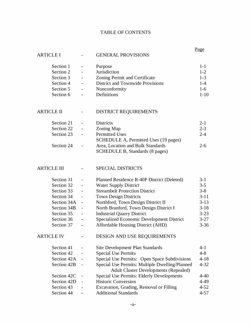
TABLE OF CONTENTS
PageARTICLE I - GENERAL PROVISIONS
Section 1 - Purpose 1-1Section 2 - Jurisdiction 1-2Section 3 - Zoning Permit and Certificate 1-3Section 4 - District and Townwide Provisions 1-4Section 5 - Nonconformity 1-6Section 6 - Definitions 1-10
ARTICLE II - DISTRICT REQUIREMENTS
Section 21 - Districts 2-1Section 22 - Zoning Map 2-3Section 23 - Permitted Uses 2-4 SCHEDULE A, Permitted Uses (19 pages)Section 24 - Area, Location and Bulk Standards 2-6 SCHEDULE B, Standards (8 pages)
ARTICLE III - SPECIAL DISTRICTS
Section 31 - Planned Residence R-40P District (Deleted) 3-1Section 32 - Water Supply District 3-5Section 33 - Streambelt Protection District 3-8Section 34 - Town Design Districts 3-11Section 34A - Northford, Town Design District II 3-13Section 34B - North Branford, Town Design District I 3-18Section 35 - Industrial Quarry District 3-23Section 36 - Specialized Economic Development District 3-27Section 37 - Affordable Housing District (AHD) 3-36
ARTICLE IV - DESIGN AND USE REQUIREMENTS
Section 41 - Site Development Plan Standards 4-1Section 42 - Special Use Permits 4-8Section 42A - Special Use Permits: Open Space Subdivisions 4-18Section 42B - Special Use Permits: Multiple Dwelling/Planned 4-32 Adult Cluster Developments (Repealed)Section 42C - Special Use Permits: Elderly Developments 4-40Section 42D - Historic Conversion 4-49Section 43 - Excavation, Grading, Removal or Filling 4-52Section 44 - Additional Standards 4-57
-a-

ARTICLE V - TOWNWIDE REQUIREMENTS
Section 51 - Performance Standards 5-1Section 52 - Signs 5-3Section 53 - Parking and Loading 5-8Section 54 - Alcoholic Beverages 5-14
ARTICLE VI - ADMINISTRATION AND ENFORCEMENT
Section 61 - Zoning Board of Appeals 6-1Section 62 - Administration 6-5Section 63 - Amendments 6-17Section 64 - Penalties and Remedies 6-18Section 65 - Validity 6-18Section 66 - Effective Date and Repeal 6-18APPENDIXES- INDEX
- Sketch 1 through 7
-b-
A R T I C L E I - G E N E R A L P R O V I S I O N S
SECTION 1 - PURPOSE
SECTION 2 - JURISDICTION
SECTION 3 - ZONING PERMIT AND CERTIFICATE
SECTION 4 - DISTRICT AND TOWNWIDE PROVISIONS
SECTION 5 - NONCONFORMITY
SECTION 6 - DEFINITIONS
1

SECTION 1 - PURPOSE
1.1 Purpose: In accordance with the provisions of Chapter 124 of the ConnecticutGeneral Statutes, the Zoning Regulations of the Town of North Branford,Connecticut are made in accordance with a comprehensive plan and are designed forthe following purposes:
1.1.1 to lessen congestion in the streets;
1.1.2 to secure safety from fire, panic, flood and other dangers;
1.1.3 to promote health and the general welfare;
1.1.4 to provide adequate light and air;
1.1.5 to prevent the overcrowding of land;
1.1.6 to avoid undue concentration of population;
1.1.7 to facilitate the adequate provision for transportation, water, sewerage,schools, parks and other public requirements; and
1.1.8 to conserve the value of buildings and encourage the most appropriate use ofthe land throughout the Town, with reasonable consideration as to thecharacter of each district and its peculiar suitability for particular uses.
1.2 Regulation: For the purposes set forth in Par. 1.1, theses regulations a) divide thetown into districts, b) regulate the erection, construction, reconstruction, alternationand use of buildings and structures and the use of land and c) establish restrictionsconcerning the following:
1.2.1 the height, number of stories and size of buildings and other structures;
1.2.2 the percentage of the area of the lot that may be occupied;
1.2.3 the size of yards, courts and other open spaces;
1.2.4 the density of population;
1.2.5 the location and use of buildings, structures and land for trade, industry,residence or other purposes; and
1.2.6 the height, size and location of advertising signs and billboards.
1-1

SECTION 2 JURISDICTION
2.1 Jurisdiction: Within the town of North Branford, land, buildings and otherstructures may be used and buildings and other structures may be constructed,reconstructed, enlarged, extended, moved or structurally altered only inaccordance with these Regulations. Any lot or land may be subdivided, sold,encumbered or conveyed only in accordance with these Regulations and shall notbe so subdivided, sold, encumbered or conveyed in any manner as to 1) made saidlot or land nonconforming or more nonconforming to these Regulations, 2) makeany use, building or other structure nonconforming or more nonconforming, 3)reduce any setback, yard, open space or off-street parking and loading spaces toless than is required by these Regulations or 4) make any nonconforming setback,yard, open space or off-street parking and loading spaces more nonconforming.
2.2 Other Laws: The provisions of these Regulations are the minimum requirementsnecessary for the purposes set forth in Section 1 and shall not be deemed torepeal, abrogate or lessen the effect of any other laws, regulations or ordinancesor any covenants or agreements between parties provided, however, that, wherethese Regulations impose a greater restriction, the provisions of these Regulationsshall prevail.
2.3 Nonconformity: Any use, building or other structure or any lot which existedlawfully, by variance or otherwise, on the date of these Regulations or anyamendment hereto became effective, and fails to conform to one or more of theprovisions of these Regulations or such amendment hereto, may be continuedsubject to the provisions and limitations of Section 5.
1-2

SECTION 3 ZONING PERMIT AND CERTIFICATE
3.1 Zoning Permit: A ZONING PERMIT is the document authorizingcommencement of building construction and site development under theseRegulations. Building and other structures, or parts thereof, may be constructed,reconstructed, enlarged, extended, moved or structurally altered only after anAPPLICATION for a ZONING PERMIT has been submitted to ZoningEnforcement Officer and a ZONING PERMIT therefore has been issued. Off-street parking and loading areas, outside storage areas and other siteimprovements that area subject to these Regulations may be constructed,reconstructed, enlarged, extended or moved only after an APPLICATION for aZONING PERMIT has been submitted to the Zoning Enforcement Officer and aZONING PERMIT therefore has been issued. ALL APPPLICATIONS shall besubmitted and ZONING PERMITS issued in accordance with the provisions ofSection 62.
3.2 Certificate of Zoning Compliance: A CERTIFICATE OF ZONINGCOMPLIANCE is the document authorizing use or occupancy of a premise aftercompletion of building construction and site development under theseRegulations. Land, buildings and other structures, or parts of thereof, may beused or occupied, or changed in use, only after a CERTIFICATE OF ZONINGCOMPLIANCE therefore has been issued by the Zoning Enforcement Officercertifying conformity with these Regulations. ALL CERTIFICATES OFZONING COMPLIANCE shall be issued in accordance with the provisions ofSection 62.
3.3 Farms and Forestry: No ZONING PERMIT and no CERTIFICATE OF ZONINGCOMPLIANCE is required for a farm, forestry, nursery or truck garden use, otherthan buildings or other structures that may be established in connection therewith.
3.4 Conflict with Amendments: No APPLICATION for a ZONING PERMIT shall beapproved by the Zoning Enforcement Officer and no ZONING PERMIT shall beissued by him authorizing a proposed use of land, building or other structure orproposed construction, reconstruction, enlargement, extension, moving orstructural alteration of a building or other structure which does not conform to anyproposed amendment of these Regulations, including the Zoning Map, if the firstnotice of a public hearing to consider such amendment has been published in anewspaper as required by the Connecticut General Statutes. If however, suchhearing is not held or the proposed amendment has not been adopted by theCommission and made effective within 65 days after the date of the hearing,approval of the APPLICATION and issuance of a ZONING PERMIT by theZoning Enforcement Officer shall not be withheld by reason of conflict with theproposed amendment.
1-3

SECTION 4 - DISTRICT AND TOWNWIDE PROVISIONS
4.1 Districts: As provided in Section 21 the Town of North Branford is divided intoclasses of districts. Such districts are established on the Zoning Map specified inSection 22. The particular uses permitted and prohibited in each district arespecified in Section 23, and the area, location and bulk standards peculiar to eachdistrict are specified in Section 24.
4.2 Excavation, Removal and Filling: There shall be no excavation, grading, orfilling of land, or removal of sod, loam, clay, sand, gravel or stone from any lotexcept in accordance with the provisions of Section 35 or 43.
4.3 Performance Standards: The use of land, buildings and other structures, whereverlocated, shall be established and conducted so as to conform to the performancestandards specified in Section 51 and Section 35.
4.4 Signs: All signs shall be established in accordance with the requirements ofSection 52.
4.5 Parking and Loading: Parking and loading spaces shall be provided off the streetfor the use of land, building and other structures as specified in Section 53.
4.6 Flood Protection: * The use and location of all structures shall be in conformancewith Chapter 13B of the Code of the town of North Branford entitled: FloodDamage Control and all amendments thereto.
4.7 Temporary Emergency Structures: ** In order to allow for the temporaryreplacement of structures damaged or destroyed by fire or other casualty, thePlanning and Zoning Administrator may issue temporary permits involving no feefor the use of structures for temporary occupancy, including necessary accessoryappurtenances, subject to the following conditions:(1) The Building Official shall have found that the damaged structure is
unusable or uninhabitable as a result of the casualty.(2) Said permit shall be issued for a period of six months and may be renewed
by the Commission for a period of up to six additional months, providedthat a building permit to reconstruct the destroyed or damaged structurehas been issued during the first six month period.
(3) In order to allow for proper connection to utilities and to prevent fire andsafety hazards, the general location of structures on lots shall be approvedby the Building Official.
Nothing in these Regulations shall prevent the Town Manager from acting,pursuant to any Federal, State, or local authority, to approve the use of suchtemporary structures without further action by the Planning and ZoningAdministrator when health and safety considerations require immediate action.
* Amended: 2/1/80** Amended: 3/30/80
1-4
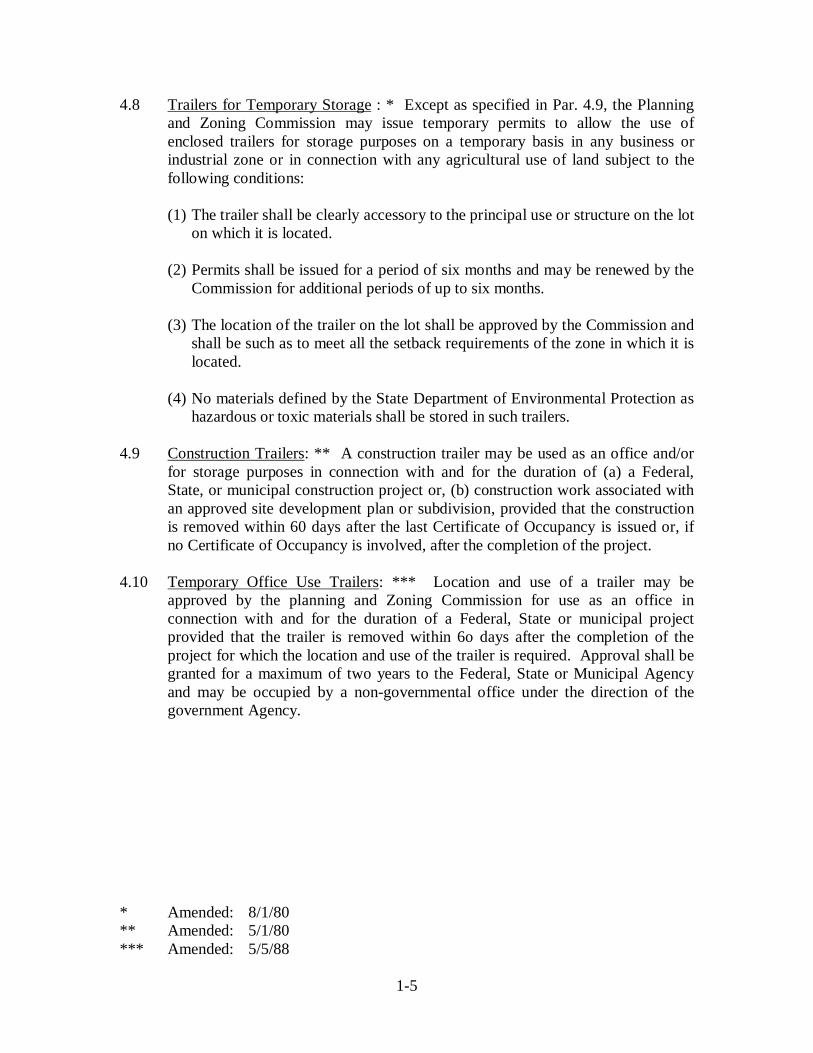
4.8 Trailers for Temporary Storage : * Except as specified in Par. 4.9, the Planningand Zoning Commission may issue temporary permits to allow the use ofenclosed trailers for storage purposes on a temporary basis in any business orindustrial zone or in connection with any agricultural use of land subject to thefollowing conditions:
(1) The trailer shall be clearly accessory to the principal use or structure on the loton which it is located.
(2) Permits shall be issued for a period of six months and may be renewed by theCommission for additional periods of up to six months.
(3) The location of the trailer on the lot shall be approved by the Commission andshall be such as to meet all the setback requirements of the zone in which it islocated.
(4) No materials defined by the State Department of Environmental Protection ashazardous or toxic materials shall be stored in such trailers.
4.9 Construction Trailers: ** A construction trailer may be used as an office and/orfor storage purposes in connection with and for the duration of (a) a Federal,State, or municipal construction project or, (b) construction work associated withan approved site development plan or subdivision, provided that the constructionis removed within 60 days after the last Certificate of Occupancy is issued or, ifno Certificate of Occupancy is involved, after the completion of the project.
4.10 Temporary Office Use Trailers: *** Location and use of a trailer may be approved by the planning and Zoning Commission for use as an office in connection with and for the duration of a Federal, State or municipal project provided that the trailer is removed within 6o days after the completion of the project for which the location and use of the trailer is required. Approval shall be granted for a maximum of two years to the Federal, State or Municipal Agency and may be occupied by a non-governmental office under the direction of the government Agency.
* Amended: 8/1/80** Amended: 5/1/80*** Amended: 5/5/88
1-5

SECTION 5 NONCONFORMITY
5.1 Intent: It is the intent of these Regulations that nonconformities are not to beexpanded contrary to the comprehensive plan of zoning, that the nonconforminguse of land, buildings and other structures should be changed to conformity asquickly as the fair interest of the owners permit and that the existence of anynonconformity shall not of itself be considered grounds for the approval of avariance for any other property.
5.2 Definitions: A nonconforming use, building or other structure, or lot, is onewhich existed lawfully, whether by a variance or otherwise, on the date of theseRegulations or any amendment hereto became effective, and which fails toconform to one or more of the provisions of these Regulations or such amendmenthereto. No nonconforming use, building or other structure, or lot shall be deemedto have existed on the effective date of these Regulations unless 1) it was actuallyin being on a continuous basis on such date and, 2) if such nonconformity is a use,such use had not been discontinued within the meaning of Par. 5.6.4.
5.3 Approved Applications and Certificates: Unless otherwise specifically providedin these Regulations, nothing in these Regulations shall require any change in theuse of any land, building or other structure, or part thereof, or in the area, location,bulk or construction of any building or other structure for which anAPPLICATION for a ZONING PERMIT shall have been lawfully approved andany required CERTIFICATE OF ZONING COMPLIANCE shall have beenlawfully issued even though such use, building or structure does not conform toone or more provisions of these Regulations or any amendment hereto.
5.4 Change in Plans: Subject to the time limitations of Par. 62.8.2, nothing in theseRegulations shall be deemed to require any change in the proposed use of anyland, building or other structure or the area, location, bulk or construction of anybuilding or other structure for which an APPLICATION for a ZONING PERMIThas been lawfully approved and any required Building Permit and SanitationPermit shall have been lawfully issued even though such proposed use, buildingor other structure does not conform to one or more provisions of theseRegulations or any amendment hereto.
5.5 Casualty: If any nonconforming building or structure or any building or structurecontaining a nonconforming use shall be damaged or destroyed by fire or othercasualty, such building or structure may be restored and any such nonconforminguse resumed to the extent that such building, structure or use existed at the time ofthe casualty, provided that such restoration is started within a period of one (1)year from such casualty and is diligently prosecuted to completion. In the eventof failure to start such restoration within the one (1) year period and to completethe same within 24 months thereafter, or within such additional periods, notexceeding six (6) months, as the Commission may grant upon written applicationmade to it, the right under this Paragraph to restoration of such building or otherstructure and the right to resume any such nonconforming use shall be lost andterminated.
1-6

5.6 Nonconformity Use: The following provisions and limitations shall apply to anonconforming use of land, building or other structure:
5.6.1 Enlargement: No nonconforming use of land shall be enlarged, extendedor altered, and no building or other structure or part thereof devoted to anonconforming use shall be enlarged, extended, reconstructed orstructurally altered, except where the result of such changes is to reduce oreliminate the nonconformity. No nonconforming use of a building orother structure shall be extended to occupy land outside such building orother structure or space in another building or other structure.
5.6.2 Change: No nonconforming use of land, buildings or other structure shallbe changed to any use which is substantially different in nature andpurpose from the former nonconforming use except to such uses that arepermitted uses in the district in which the use is located. Nononconforming use of land, buildings or other structure if once changed toconform or to more nearly conform to these Regulations shall thereafter bechanged so as to be less conforming again.
5.6.3 Moving: No nonconforming use of land shall be moved to another part ofa lot or outside the lot, and no nonconforming use of a building or otherstructure shall be moved or extended to any part of the building or otherstructure not manifestly arranged and designed for such use at the time theuse became nonconforming, and no building or other structure containinga nonconforming use shall be moved, unless the result of any such move isto end the nonconformity.
5.6.4 Discontinuance: No nonconforming use of land, buildings or otherstructures which shall have been discontinued with intent to abandon saiduse shall thereafter be resumed or replaced by any other nonconforminguse. No nonconforming use of buildings or other structures which shallhave been discontinued for a continuous period of one (1) year shallthereafter be resumed or replace by any other nonconforming use.
5.6.5 Performance Standards: Any use of land, buildings or other structurewhich does not conform to one or more of the performance standards ofSection 51 shall not be changed to increase such nonconformity but maybe changed to decrease or eliminate such nonconformity. Any suchnonconformity so reduced or eliminated shall not be resumed.
5.7 Nonconformity Improvements: The following provisions and limitations shallapply to nonconforming buildings, other structures and improvements:
5.7.1 Enlargement: No nonconforming building, other structure orimprovement shall be enlarged, extended, reconstructed or structurallyaltered unless the enlargement or extension is conforming.
1-7

5.7.2 Change: No nonconforming building, other structure or improvement ifonce changed to conform or to more nearly conform to these Regulationsshall thereafter be changed so as to be nonconforming or less conformingagain.
5.7.3 Moving: No nonconforming building, other structure or improvementshall be moved unless the result of such moving is to reduce or eliminatethe nonconformity.
5.7.4 Signs: Signs of a size or type not permitted in the district in which theyare situated, or which are improperly located or illuminated, or which arenonconforming in any other way, shall be considered nonconformingstructures under this Section, and any increase in size, illumination orflashing of such signs shall be deemed to be an enlargement or extensionconstituting an increase in nonconformity. No nonconforming sign, ifonce removed in whole or in part, shall thereafter be replaced by anothernonconforming sign. Nonconforming signs shall be made conforming nolater than three (3) years after the effective date of this Paragraph.
5.7.5 Off-Street Parking and Loading: Any lot, use, building or other structurewhich does not conform to one or more of the parking and loadingprovisions of Section 53 shall continue to conform to such provisions tothe extent that it conforms on the effective date of such Section. Any useof land, buildings or other structures which does not conform to one ormore of the provisions of Section 53 shall not be changed to a use whichwould need additional off-street parking or loading spaces to comply withthe provisions of Section 53 unless such spaces are provided as requiredfor the new use under Section 53. Parking and loading spaces which donot conform to one or more of the provisions of Section 53 shall be madeconforming no later than three (3) years after the effective date of thisParagraph.
5.7.6 Site Development and Landscaping: Site development, includinglandscaping, which fails to conform to the requirements of theseRegulations under Section 41 shall be deemed a nonconformity. No usefor which such site development and landscaping are required shall beenlarged, extended, changed or moved and no building or other structurefor which such site development and landscaping are required shall beenlarged, extended, moved or reconstructed unless such nonconformity iseliminated, unless the Commission authorizes continuation or reduction ofthe nonconformity. Any use of land, building or other structure existingon the date of adoption of Section 41 shall not be deemed nonconformingsolely for the reason that a SITE DEVELOPMENT PLAN therefore hasnot been approved under these Regulations. Site development, includinglandscaping and drainage, which fails to conform to one or more of theprovisions of Section 41 shall be made conforming no later than three (3)years after the effective date of this Paragraph.
1-8

5.8 Nonconforming Lots: A lot which fails to meet the area, shape or frontage orany other applicable requirements of these Regulations pertaining to lots, may beused as a lot, and a building or other structure may be constructed, reconstructed,enlarged, extended, moved or structurally altered thereon, providing that all of thefollowing requirements are met:
5.8.1 The use, building or other structure shall conform to all other requirementsof these Regulations;
5.8.2 If used for a dwelling, the lot shall contain an area of not less than 10,000square feet if served by public water supply and sanitary sewers or 20,000square feet if not so served; and
5.8.3 If the lot fails to meet the area requirements of these Regulations, theowner of the lot shall not also be the owner of a contiguous lot, lots orland which in combination with such lot that fails to conform would makea lot that conforms or more nearly conforms to the area requirements ofthese Regulations pertaining to lots.
5.9 Title: No change of title, possession or right of possession shall be deemed toaffect right to continue a nonconforming use, building or other structure.
5.10 Repair: Nothing in this Section shall be deemed to prohibit work on anynonconforming building or other structure when required by law to protect thepublic health or safety, provided that such work does not increase thenonconformity. Nothing in this Section shall be deemed to prohibit work onordinary repair and maintenance of a nonconforming building or other structureor, except in the case of nonconforming signs, replacement of existing materialswith similar materials.
5.11 Certificate of Nonconformity: The owner of any nonconforming lot, or any lotcontaining a nonconforming use, building, other structure or improvements, isentitled to a CERTIFICATE OF ZONING COMPLIANCE certifying the validityof such nonconformity and the extent thereof.
5.12 Corner Visibility: The Zoning Enforcement Officer may order in writing theremoval of any fence, wall or planting which fails to conform to the provisions ofPar.44.7.
1-9

SECTION 6 DEFINITIONS
6.1 General: The paragraphs which follow define and explain certain words used inthese Regulations. Other words used in these Regulations shall have the meaningcommonly attributed to them. When a question arises as to the precise meaning of aword, the Commission shall be the resolution to determine the meaning of the word,given due consideration to the expressed purpose and intent of these Regulations.
6.2 Accessory Building, Structure or Use:**** A detached building, structure, oruse on the same lot with, and of a nature customarily incidental and subordinate to theprincipal building, structure, or use.
6.3 Accessory Dwelling Unit:* An accessory dwelling unit is an additionaldwelling unit, accessory and subordinate to the primary, detached dwelling (excludingcondominium units, apartment units, quest houses, group homes, boarding house and mixuses), which is attached to or located within a single family dwelling containing a floorarea not exceeding one-fourth (1/4) of the gross floor area of the principal unit or 6000square feet, whichever is less, equipped with its own kitchen, including stove, bath andbedroom* (s). Either the single family dwelling or the accessory dwelling unit shall bepermanently occupied by the owner(s) of the premises.
( Adult Day Care Center:***** See Par. 6.46 )
6.4 Amusement Center (Indoor):** The term indoor amusement center shallinclude any establishment which houses four (4) or more mechanical and/or electronicamusement device for use by the general public.
6.4.1 Mechanical and/or Electronic Amusement Devices:** Any machine or devisewhich, upon the insertion of a coin, token or upon payment of a charge, is operated toregister a score or tally of any kind, or permits a certain amount of play forentertainment or score and which shall include but not be strictly limited to such devicesas pin-ball machines, shuffleboard devices, billiard tables, video and TV-like devices andelectronic games.
6.5 Biomedical Waste:*** Means a solid waste generated during the administrationof medical care or the performance of medical research involving humans or animals andwhich, because of its quantity, character or composition, has been determined by theD.E.P. Commissioner to require special handling, including infectious waste,pathological waste and chemotherapy waste, but excluding any solid waste which hasbeen classified by the D.E.P. as a hazardous waste or is a radioactive material regulated.
* Effective: 10/1/90** Effective: 5/17/91*** Effective: 1/17/92**** Effective: 12/3/93***** Effective: 10/15/04 1-10

6.5.1 Biomedical Waste Treatment Facility: Means a solid waste facility capable ofstoring, treating or disposing of an amount of biomedical waste, excluding any facilitywhere the only biomedical waste treated, stored or disposed of its biomedical wastegenerated at the site.
6.6 Building: Any structure having a roof supported by columns or walls andintended for the shelter, housing or enclosure of any individual, animal, process,equipment, goods or materials of any kind or nature.
6.7 Child Day Care Center:* A program of supplementary care to more than twelverelated or unrelated children outside their own homes on a regular basis for a part of thetwenty-four hours in one or more days in a week.
6.8 Commission: The term Commission shall mean the North Branford Planningand Zoning Commission.
6.9 Commercial Recreational Facility:*** Any facility where a fee is paid inexchange for activities, events, or programs related to athletics, physical conditioning andaccessory activities conducted indoors and/or outdoors. Such activities may include butare not limited to: softball, batting cages, golf driving range, miniature golf, beachvolleyball, horseshoes, playgrounds, bocci, ice skating, basketball, soccer, tennis, rollerblade hockey, aerobics, weight-training, racquetball, flag football, whiffle ball,swimming, juvenile camp activities, and general passive recreational uses such apicnicking, biking and fishing.
Other related activities may include stores and other buildings and structures where goodsare sold or services are rendered at retail when accessory and subordinate to an approvedprincipal use on the same lot. Typical accessory uses may include child day care, retailpro shops, locker rooms, bathrooms, offices, concessions, arcades and game rooms.
( Disability Glare:**** See Par. 6.47 )
6.10 Dwelling Unit: A dwelling unit is a building or a part of a building designedfor occupancy, and so occupied, by one (1) family . Accommodations occupied fortransient lodging in a hotel or motel shall not be considered to be a dwelling unit .
6.11 Family: A family is a person or a group of related persons, plus guests anddomestic servants thereof, or a group of not more than five (5) persons who need not beso related, who are living as a single housekeeping unit maintaining a commonhousehold. A roomer or boarder to whom rooms are let as permitted by theseRegulations shall not be considered a member of a family for the purpose of thisdefinition.
* Effective: 6/21/91** Effective: 1/17/92*** Effective: 9/20/95**** Effective: 12/08/04 1-11

6.12 Family Day Care Home:* A private family homing caring for not more than sixchildren, including the provider s own children not in school full time, where the childrenare cared for not less than three nor more than twelve hours during a twenty-four hourperiod and where care is given on a regularly recurring basis. During the regular schoolyear, a maximum of three additional children who are in school full time, including theprovider s own children, shall be permitted, except that if the provider has more thanthree children who are in school full time, all of the provider s children shall bepermitted.
6.13 Farm***: The term farm shall mean any lot or other tract of land of 160,000square feet or more used for growing crops, harvesting the vegetative products of the landand/or the keeping and feeding of livestock or poultry.
6.14 Flea Market:** Sales activity held where an individual or group of individualsellers offer good, new and used, for sale to the general public. It does not includeprivate garage sales, annual fund raising events for nonprofit organizations having nomore than two (2) such events per calendar year.
6.15 Floor Area Dwelling and Dwelling Unit : In determining compliance withminimum floor area requirements for dwellings and dwelling units and compliancewith maximum floor area requirements for a professional or business office or a homeoccupation in a dwelling unit , only finished livable floor area having a ceiling height ofat least seven and one half (7½) feet shall be counted and shall excluded garages,terraces, outside vestibules, bay widows, any basement rooms except a basement storyas defined in Par. 6.41, utility rooms for heating apparatus, attics, open porches, enclosedporches not heated by a central heating system for the dwelling and hallways and otherspace designed for common use by occupants of two (2) or more dwelling units .Measurements of floor area for any dwelling or dwelling unit shall be taken from thefloor area. Any floor other than a ground floor must have access thereto by a permanentinside stairway to be included in computing floor area.
6.16 Floor Area: In computing total floor area of buildings and other structures forthe purpose of determining building bulk and coverage, measurements shall be taken tothe outside surfaces of exterior walls enclosing the floor area.
(Foot Candle:**** See Par. 6.48)
6.17 Frontage: Frontage is defined as a continuous property line that is also astreet line .
( Full Cut-Off Type Fixture:**** See Par. 6.49 )
* Effective: 6/21/91** Effective: 12/3/93*** Effective: 12/16/94**** Effective: 12/08/04 1-12

6.18 Greenway:** Any corridor of open space that protects natural resources and/orprovides recreation. Greenways can be located along a waterway or other definingfeature, such as a ridge line, or along a man-made corridor, such as an abandoned right-of-way, abandoned town road, a woods road, or a barge canal. It can be a green spacealong a highway or around a village. Greenways can provide the vital missing link toconnect existing protected areas, and to give people convenient access to the outdoors. Agreenway can be as wide as a river valley or as narrow as an abandoned rail bed.
Greenways serve many purposes. Rural greenways preserve natural habitat and wildlifemigration routes, encourage restoration of environmentally valuable landscapes, andprovide opportunities for recreation and education. In the cities and suburbs, greenwayscan encompass natural or manmade features and can provide resource conservation,recreation and transportation.
6.19 Group Day Care Home:*** A program of supplementary care to not less thanseven or more than twelve related or unrelated children outside their own homes on aregular basis for a part of the twenty-four hours in one or more days in the week.
6.20 Height: Height is to be measured from the finished grade adjacent to theexterior walls of the building, vertically to the highest point of the building, including topof parapet, roof ridge and roof top mechanicals.
( Horizontal Illuminance:**** See Par. 6.50 )
6.21 Intermediate Processing Facility:* Means facility where glass, metals, paperproducts, batteries, household hazardous waste, fertilizers and other items are removedfrom the waste stream for recycling or reuse.
6.22 Licensed: A licensed surveyor, engineer, architect or landscape architect is aperson licensed to practice as such by the State of Connecticut.
( Light trespass:**** See Par. 6.51 )
6.23 Loading Space: See Par. 53.2 of Section 53.
6.24 Lot: A lot is defined as a parcel of land which is either 1) owned separatelyfrom any contiguous parcel as evidenced by fee conveyance recorded in the Office of theNorth Branford Town Clerk or 2) is a building lot shown on a subdivision, approved bythe Commission and filed in the Office of the North Branford Town Clerk.
* Effective: 1-17-92** Effective: 9-20-95*** Effective: 6-21-96**** Effective: 12-08-04
1-13

6.25 Lot Area and Shape:* In determining compliance with minimum lot area andshape requirements of these Regulations, land subject to easements for drainage facilitiesand underground public utilities may be included, but not street or highway, easement ofvehicular access, private right-of-way for vehicles or easement for above-ground publicutility transmission lines may be included. Area consisting of wetlands and water coursesas defined in Par. 6.53 shall not be used for compliance with more than 25% of theminimum lot area requirement. Land in two or more Zoning Districts may be used tosatisfy a minimum lot area requirement provided that the requirement of the Districtrequiring the largest lot area is met, but no land in a Residence District shall be used tosatisfy a lot area requirement in any District.
6.26 Multiple Dwelling: A multiple dwelling is a dwelling containing two (2) ormore dwelling units.
6.27 Nonconformity: See Par. 5.2. of Section 5.
6.28 Outside Storage: See Par.41.2.10 of Section 41.
6.29 Parking Spaces: See Par. 53.2 of Section 53.
6.30 Personal Service Establishment:*** Establishments primarily engaged inproviding services involving the care of a person or his or her apparel, such as a: BarberShop, Beauty Parlor, Tailoring or Dressmaking Shop, Dry Cleaning Establishments,Laundromats, Shoe Repair Shop, Optician, Reducing Salon, Health Club, and othersimilar services.
6.31 Recycling:** Means the processing of solid waste to reclaim material therefrom.
6.31.1 Recycling Facility or Recycling Center:** Means land and appurtenancesthereon and structures where recycling ids conducted, including but not limited to, andintermediate processing center.
6.32 Restaurant, Indoor: Indoor restaurants and other food and beverage serviceestablishments shall be established where customers are served only when seated attables or counters and at least 75% of the customer seats are located within an enclosedbuilding. Such establishments may include a food take-out service incidental to theprimary permitted use but shall not include establishments where customers are served inmotor vehicles or served primarily at food take-out counters.
6.33 Signs: See Par. 52.2 of Section 52.
* Effective: 4/27/81** Effective: 1/17/92*** Effective: 12/03/93
1-14

6.34 Solid Waste:* Means solid, liquid, semisolid or contained gaseous material thatis unwanted or discarded, including, but not limited to, demolition debris, material burnedor processed at a resources recovery facility or incinerator, material processed at arecycling facility and sludge or other residue from a water pollution abatement facility,water supply treatment plant or air pollution control facility.
6.34.1 Solid Waste Disposal Area:* Means land and appurtenances thereon andstructures, including a landfill or other land disposal site, used for the disposal of morethan ten cubic yards of solid waste.
6.34.2 Solid Waste Facility:* Means any solid waste disposal area, volume reductionplant, transfer station, wood-burning facility or biomedical waste treatment facility.
6.35 Story: A story is that portion of a building between the roof surface or anyfloor and the surface of the floor, ceiling or roof next above. Stories are counted one overthe other. Attics not used for human occupancy shall not be considered a story. Whenthe ceiling of a basement is four (4) feet or more above the average ground level within10 feet of the building, the basement shall be considered a story .
6.36 Street: A street shall mean any Town street or State Highway, except limitedaccess State Highway, or any street shown on a subdivision map approved by theCommission and filed in the Office of the North Branford Town Clerk.
6.37 Street, Width: The width of a street shall mean the distance between thestreet lines .
6.38 Street Line: The term street line shall mean the right-of-way, easement ortaking line of any street or of any easement of vehicular access or private right-of-way25 feet or more in width.
6.39 Structural Alteration: The term structural alteration shall mean any change inor addition to the structure of supporting members of a building, such as walls, columns,beams or girders.
6.40 Structure:** A combination of materials to form a construction for use,occupancy, or ornamentation whether installed on, above, or below the surface of land orwater. All buildings are structures; however, not all structures are buildings. SeeBUILDING .
6.41 Swimming Pool, Private: A private swimming pool means any constructedpool, including portable and demountable above ground pools, which is used or intendedto be used as a swimming pool in connection with a single detached dwelling for one (1)family and which is available for use only by the occupancy of the dwelling and theirprivate guests.
* Effective: 1/17/92** Effective: 9/20/95
1-15

6.42 Swimming Pool, Public or Semi-Public: A public or semi-private swimmingpool means any swimming pool other than a private swimming pool .
6.43 Trailer, Mobile Home, Recreational Vehicle:* 6.43.1 Mobile Home:* Any vehicle or enclosure which is used designed, orintended to be used for human habitation as sleeping or living quarters and which is, maye, or ever was built on a chassis and designed to be mounted on wheels or propelledeither by its own power or by another power-driven vehicle to which it may be attachedor by which it may be carried, and whether or not attached to a permanent foundation. Arecreational vehicle is not considered a mobile home.
6.43.2 Recreational Vehicle:* A vehicular, portable structure built on achassis and designed to be used as a temporary dwelling for travel and recreationalpurposes. For the purposes of these Regulations, recreational shall include campers butshall not include mobile homes.
6.43.3 Trailer:* Any rubber-tired vehicle without motive power drawn orpropelled by a motor vehicle. For the purposes of these Regulations, trailers shall notinclude mobile homes or recreational vehicles.
6.44 Transfer Station:*** Means land and appurtenances thereon and structureswhere more than ten cubic yards of solid waste, generated elsewhere, may be stored fortransfer and transferred form vehicles and placed in other transportation units.
( Uplighting:**** See Section 6.52 )
( U.Ration:**** See Section 6.53 )
6.45 Watercourses and Wetlands: The term watercourses and wetlands aredefined in Public Act #155 of 1972 and Public Act #73-571 respectively of theConnecticut General Assembly as follows:
6.45.1 Water Courses:** Means rivers, streams, brooks, waterways, lakes, ponds,marshes, swamps, bogs and all other bodies of water, natural or artificial, public orprivate, which are contained within, flow through or border upon this state or any portionthereof, not regulated pursuant to Section 22a 28 to 22a 35, inclusive, of the 1958**Revisions of** the Connecticut General Statutes, as amended.
6.45.2 Wetlands: means land, including submerged land, not regulated pursuant toSections 22a 28 to 22a 35, inclusive, of the 1958 Supplement to the ConnecticutGeneral Statutes, as amended, which consists of any of the soil types designated as poorlydrains, very poorly drained, alluvial and flood plain by the National Cooperative SoilsSurvey as may be amended from time to time, of the Soil Conservation Service of theUnited States Department of Agriculture.
* Effective: 5-01-80** Effective: 5/05/88*** Effective: 1/17/92**** Effective: 12/08/04 1-16

6.46 Adult Day Care Center:* A center for a program of supplementary care foradults outside of their homes on a regular basis for a part of one or more days in theweek.
6.47 Disability Glare:** The eye s line-of-sight contact with a direct light source,which causes a partial blindness.
6.48 Foot Candle:** A unit of measure for illuminance. A unit of illuminance on asurface that is everywhere one foot from a uniform point source of light of one candleand equal to one lumen per square foot.
6.49 Full Cut-Off Type Fixture:** A luminaire or light fixture that by design ofthe housing, does not allow any light dispersion or direct glare to shine above a 90degree, horizontal plane base of the fixture. Full cut-off fixtures must be installed in ahorizontal position as designed, or the purpose of the design is defeated, and disabilityglare will result. (See Par. 41.2.11.b of Section 41)
6.50 Horizontal Illuminance:** The measurement of brightness from a light source,usually measured in foot candles or lumens, which is taken through a light meter s sensorat a horizontal position.
6.51 Light trespass:** Light from an artificial light source that is intruding into anarea where it is not wanted or does not belong. (See Par. 41.2.11.c of Section 41 )
6.52 Uplighting:** Any light source that distributes illumination above a 90 degreehorizontal plane.
6.53 U.Ration:** Uniformity ratio, describing the average level of illumination inrelation to the lowest level of illumination for a given area. Example: U.ratio = 4:1 forthe given area, the lowest of illumination (1) should be no less than ¼ or 4 times lessthan the average (4) level of illumination.
* Effective: 10/15/04** Effective: 12/08/04
1-17

A R T I C L E II D I S T R I C T R E Q U I R E M E N T S
SECTION 21 - DISTRICTS
SECTION 22 - ZONING MAP
SECTION 23 - PERMITTED USES
SECTION 24 - AREA, LOCATION AND BULK STANDARDS
2
SECTION 21 - DISTRICTS
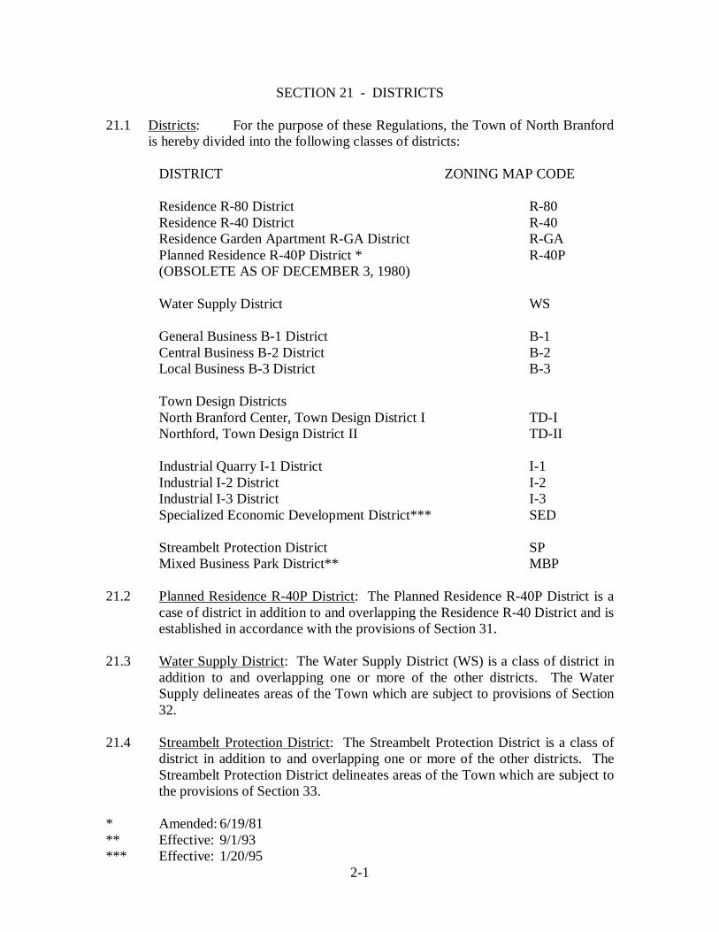
21.1 Districts: For the purpose of these Regulations, the Town of North Branfordis hereby divided into the following classes of districts:
DISTRICT ZONING MAP CODE
Residence R-80 District R-80 Residence R-40 District R-40 Residence Garden Apartment R-GA District R-GA Planned Residence R-40P District * R-40P (OBSOLETE AS OF DECEMBER 3, 1980)
Water Supply District WS
General Business B-1 District B-1 Central Business B-2 District B-2 Local Business B-3 District B-3
Town Design Districts North Branford Center, Town Design District I TD-I Northford, Town Design District II TD-II
Industrial Quarry I-1 District I-1 Industrial I-2 District I-2 Industrial I-3 District I-3 Specialized Economic Development District*** SED
Streambelt Protection District SP Mixed Business Park District** MBP
21.2 Planned Residence R-40P District: The Planned Residence R-40P District is acase of district in addition to and overlapping the Residence R-40 District and isestablished in accordance with the provisions of Section 31.
21.3 Water Supply District: The Water Supply District (WS) is a class of district inaddition to and overlapping one or more of the other districts. The WaterSupply delineates areas of the Town which are subject to provisions of Section32.
21.4 Streambelt Protection District: The Streambelt Protection District is a class ofdistrict in addition to and overlapping one or more of the other districts. TheStreambelt Protection District delineates areas of the Town which are subject tothe provisions of Section 33.
* Amended: 6/19/81** Effective: 9/1/93*** Effective: 1/20/95
2-1

21.5 Town Design Districts: Town Design Districts are classes of districts in additionto and overlapping one or more of the other districts. Town Design Districtsdelineate areas of the Town which are subject to the provisions of Section 34.
21.6 Industrial Quarry I-1 District: The Industrial Quarry I-1 District is a class ofdistrict that delineates areas of the Town which are subject to the provisions ofSection 35.
21.7* Mixed Business Park District: The Mixed Business Park District is a class ofdistrict that delineates areas of the Town which are subject to the provisions ofSection 42. All properties in a Mixed Business Park District shall have frontageon and primary access to a State Highway. Business and restricted residentialuses will be treated as special uses subject to special standards to assure, wheredesirable, preservation of historical structures and other site features, and to allownew development which is compatible and harmonious with the surroundingneighborhood.
21.8** Specialized Economic Development District: The Specialized EconomicDevelopment District (SED) is a class of district that delineates areas of the Townwhich are subject to the provisions of Section 36. The minimum permitted sitearea for a SED is 800,000 square feet.
* Effective: 9/1/93** Effective: 1/20/95
2-2

SECTION 22 - ZONING MAP
22.1 Map: The boundaries of the districts specified in Section 21 are herebyestablished as shown on a map entitled Zoning Map of the Town of NorthBranford, Connecticut , dated June 1, 1976, revised August 18, 1977, andadopted effective September 2, 1977, including any special maps and boundarydescriptions supplementary thereto and any amendments thereof, which map ishereby declared to be a part of these Regulations and is herein referred to asZoning Map .
22.2 Interpretation of Map: Where a question arises as to exact boundaries of a districtshown on the Zoning Map, the Commission shall be resolution determine thelocation of the boundary, giving due consideration, among other factors, to theindicated location of the boundary on the Zoning Map, the scale of the ZoningMap and the expressed intent and purpose of these Regulations.
22.3 Extension of Use: Where the boundary of a district divides a lot, the existence ofwhich lot is evidenced by deed or deeds recorded in the land records of the Townof North Branford on the effective date of these Regulations or on the effectivedate of any amendment of these Regulations establishing such boundary, theCommission may grant a SPECIAL USE PERMIT to authorize a use of land,buildings and other structures permitted in one district to be extended into theother district for a distance of not more than 50 feet in accordance with theprovisions of Section 42.
2-3
SECTION 23 - PERMITTED USES
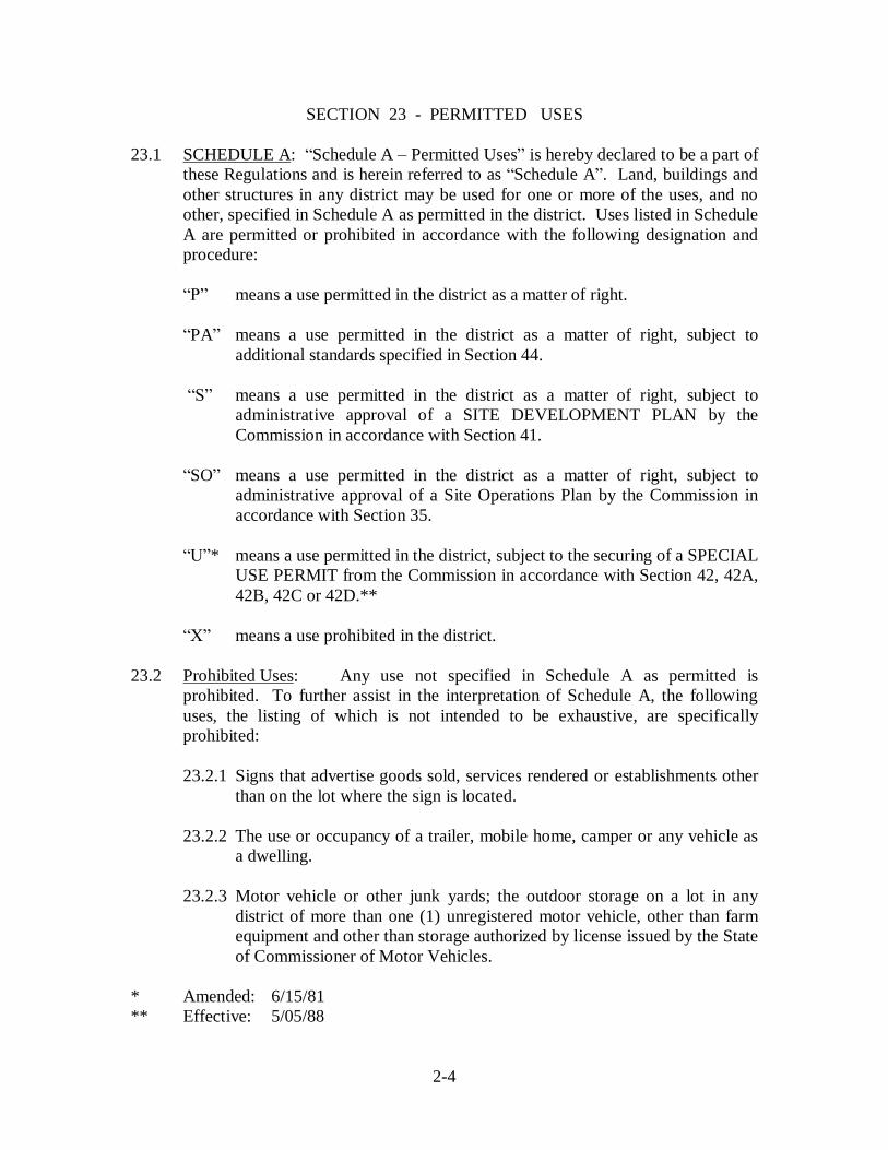
23.1 SCHEDULE A: Schedule A Permitted Uses is hereby declared to be a part ofthese Regulations and is herein referred to as Schedule A . Land, buildings andother structures in any district may be used for one or more of the uses, and noother, specified in Schedule A as permitted in the district. Uses listed in ScheduleA are permitted or prohibited in accordance with the following designation andprocedure:
means a use permitted in the district as a matter of right.
PA means a use permitted in the district as a matter of right, subject toadditional standards specified in Section 44.
means a use permitted in the district as a matter of right, subject toadministrative approval of a SITE DEVELOPMENT PLAN by theCommission in accordance with Section 41.
SO means a use permitted in the district as a matter of right, subject toadministrative approval of a Site Operations Plan by the Commission inaccordance with Section 35.
* means a use permitted in the district, subject to the securing of a SPECIALUSE PERMIT from the Commission in accordance with Section 42, 42A,42B, 42C or 42D.**
means a use prohibited in the district.
23.2 Prohibited Uses: Any use not specified in Schedule A as permitted isprohibited. To further assist in the interpretation of Schedule A, the followinguses, the listing of which is not intended to be exhaustive, are specificallyprohibited:
23.2.1 Signs that advertise goods sold, services rendered or establishments otherthan on the lot where the sign is located.
23.2.2 The use or occupancy of a trailer, mobile home, camper or any vehicle asa dwelling.
23.2.3 Motor vehicle or other junk yards; the outdoor storage on a lot in anydistrict of more than one (1) unregistered motor vehicle, other than farmequipment and other than storage authorized by license issued by the Stateof Commissioner of Motor Vehicles.
* Amended: 6/15/81** Effective: 5/05/88
2-4
23.2.4 Race tracks, drive-in theaters, golf driving ranges and other outdoor recreationbusinesses, except carousels and other amusement devices when sponsored by alocal charitable organization and then for a period not to exceed 10 days and whena ZONING PERMIT therefore has been issued.
23.2.5 * The outdoor accumulation, dumping, storage or incineration of refuse, garbage,septic tank waste, biomedical waste or radioactive or other dangerous materialsand biomedical waste treatment facilities.
23.2.6 Bulk storage of cement and petroleum products; public utility company electricpower plants, generating facilities and gas storage.
* Effective: 1/17/92
2-5

SECTION 24 - AREA, LOCATION AND BULK STANDARDS
24.1 Schedule B: Schedule B - Standards is hereby declared to be a part of theseRegulations and is herein referred to as Schedule B . The area, location andbulk standards applicable in each district are as hereinafter specified and as listedin Schedule B.
24.2 Lot Area, Shape and Frontage: Each lot shall have at least the minimum area asspecified in Schedule B. Each lot to be used for a dwelling containing multipledwellings shall have at least the minimum area per dwelling unit specified inSchedule B. Each lot shall be of such shape that a square with the minimumdimension specified in Schedule B will fit on the lot and, in Residence Districts,shall also have the minimum width along the building line specified in ScheduleB. Each lot, except interior lots in R-40 Districts permitted under Par. 24.2.2,shall have the minimum frontage on a street specified in Schedule B.
24.2.1 * Exceptions: The requirements of Par. 24.2 shall not be construed toprohibit condominium ownership of a building or buildings meeting therequirements of such Paragraph; the requirements of Par. 24.2 shall not beconstrued to prohibit other forms of ownership of a portion of a buildingand its related lot provided that a SPECIAL USE PERMIT therefore hasbeen granted by the Commission in accordance with Section 42, 42A, or42B and a subdivision map therefore has been approved by suchCommission in accordance with the standards of the Land SubdivisionRegulations of the Town of North Branford and recorded in the landrecords of the Town of North Branford.
24.2.2 **/*** Interior Lots, R-40: Interior lots may be permitted in theResidence R-40 District, subject to approval of the Planning and ZoningCommission. All interior lots shall comply with the provisions of Section24 and other applicable municipal ordinances and regulations. Interiorlots shall be subject to the following additional requirements:
a. In a proposed subdivision of five (5) or more lots, the number ofinterior lots shall not exceed one (1) interior lot for every three (3)front lots or one (1) interior lot for every 400 feet of road frontage;
b. The lot shall either contain a strip of land which is everywhere notless than 25 feet in width connecting to a street or shall have afrontage of 25 feet or more on an easement of access or private right-of-way which is everywhere not less than 25 feet in width connectingto a street provided that no more than two (2) lots may, for soleaccess, rely upon such an easement or right-of-way.
* Amended: 6/15/81** Amended: 7/11/86*** Effective: 6/05/92
2-6

c. The strip of land, easement of access, or private right-of-way shallconsist of an improved gravel base travel path which is everywherenot less than 18 feet in width;
d. There shall be no more than two (2) strips of land, easements ofaccess or private right-of-way, existing side by side at any onelocation and shall not exceed a length of 700 feet;
e. Such easement of access, private right-of-way or fee strip shall beexcluded from the minimum lot area requirement;
f. The lot shall have an area of not less than 60,000 square feet;
g. Street address numbers shall be affixed to a permanent support at thestreet line. Such street address numbers shall be three inches inheight and shall be consistent with the street numbering system of theTown of North Branford;
h. There shall be a setback line of ten (10) feet from each side of eachrear lot property line that is parallel to or concentric with the streetline on which trees 3 inches in caliper and not less than 6 feet inheight shall be planted. Such plantings shall be of mixed variety, noless than 50% of which being evergreens and planted no more than15 feet from one another measured from the center of the tree. Suchsetback requirements will create a rear lot, landscaped buffer by theowner of the property. To ensure such permanent preservation ofsaid buffer area, its provisions shall be specified on the final map tobe filed and recorded on the land records. The applicant shall alsorecord on the land records a notice of affirmation covenant whichshall specify the restrictions imposed, and identify the propertiesaffected. Said notice shall also specify that the covenant runs withthe land and binds all subsequent grantees, their heirs and assignsforever and shall be in a form acceptable to the Town Attorney;
i. A one (1) year landscaping maintenance bond shall be submitted inan amount determined by the Town Engineer with form and suretyapproved by the Town Attorney;
*** Effective: 6/05/92*** Amended: 6/05/92
2-7

j. Interior lots are permitted in subdivisions containing less than five(5) lots and each lot shall either contain a strip of land which iseverywhere not less than 25 feet in width connecting to a street orshall have a frontage of 25 feet or more on an easement of access orprivate right-of-way which is everywhere not less than 25 feet inwidth connecting to a street, provided that no more than two (2) lotsmay, for sole access, rely upon such an easement or right-of-wayprovided all other requirements in this section are adhered to whereapplicable;
k. The Commission, due to topographic features, existing vegetationcover and other unique physical land features and conditions maymodify the regulations of Section 24.2.2 (h);
l. *** On any interior lot, no building or other structure, exceptpermitted accessory buildings or structures, shall extend within forty(40) feet from any property line, easement of access, private right-of-way or fee strip.
24.3 Height: No building or other structure shall exceed the number of stories and//orthe maximum height, whichever is less, as specified in Schedule B. Thislimitation, however, shall not apply to the following when not used for humanoccupancy: spires, cupolas and towers that are solely ornamental in function andchimneys, flagpoles and silos as well as such features plus tanks and elevator,heating, ventilating, air conditioning and similar equipment that are located on theroof of a building and do not occupy more than 20 % of the area of the roof. Inaddition, detached communications towers in Industrial Districts may have agreater height than specified in Schedule B provided that a) such height doe notexceed 100 feet, b) a SITE DEVELOPMENT PLAN for the tower is submitted tothe Commission for approval under Par. 62.6 and Section 41, c) the applicantsubstantiates to the commission that both the tower and the additional height areessential to the requirements of these Regulations are met including but notlimited to Par. 41.2.2.
24.4 Setbacks: No building or other structure shall extend within less than theminimum distances of any street line, rear property line, other property line orResidence District boundary line as specified in Schedule B, subject to thefollowing exceptions and additional limitations:
24.4.1 Signs: Certain permitted signs, as specifies in Section 52 may extendwithin lesser distances of a property or street line.
*** Effective: 6/05/92
2-8
24.4.2 Accessory Buildings: In R-80 and R-40 Districts accessory buildings mayextend to the lesser minimum distance of a rear property line as specifiedin Schedule B.
24.4.3 Projections: Pilasters, belt courses, sills, cornices, marquees, canopies,awnings, eaves and similar architectural features and open fire escapesmay project into the area requires for setback from street line, propertyline or Residence District boundary line for the distance specified inSchedule B.
24.4.4 *Form of Ownership: The requirements of Par. 24.4 shall not beconstrued to prohibit condominium ownership of a building or buildingsmeeting the requirements of such Paragraph; the requirements of Par. 24.4shall not be construed to prohibit other forms of ownership of a portion ofa building and its related lot provided that a SPECIAL USE PERMITtherefore has been granted by the Commission in accordance with Section42, 42A or 42B and a subdivision map therefore has been approved by theCommission in accordance with the standards of the Land SubdivisionRegulations of the Town of North Branford and recorded in the landrecords of the Town of North Branford.
24.4.5 Fences, Walls and Terraces: The required setback distances shall notapply to fences or walls six (6) feet or less in height nor to necessaryretaining walls or to unroofed terraces, but no fence, wall or terrace shallbe located within the right-of-way of any street.
24.4.6 Railroads: In Business and Industrial Districts no setback is required fromthe right-of-way line of a railroad.
24.4.7 Narrow Streets: In the event that the street where the lot has frontage hasa width of right-of-way of less then 60 feet in the case of a streetdesignated as a Town Major Street or Town Collector Street on anyplan of development adopted by the Commission under Chapter 126 of theConnecticut General Statutes or less than 50 feet in the case of all otherstreets, the required setback from a street line shall be measured from thecenterline of right-of-way and shall be as follows:
a. 30 feet plus the setback specified in Schedule B, in the case of TownMajor Streets and Town Collector Streets ; and
b. 25 feet plus the setback specified in Schedule B, in the case of allother streets.
* Amended: 6/15/81
2-9

24.4.8 Building Line: No building or other structure shall extend nearer to anystreet line than the building line as defined in Section 6 and specified inSchedule B.
24.4.9 *** Side Setbacks for Non-conforming Lot Frontage: On all lawfullyexisting, non-conforming lot in the Residence R-40 District having lessthan the required minimum lot frontage set forth in Schedule B, eachrequired minimum setback from a side line shall not be less than tenpercent (10%) of the lot frontage, but in no case less than ten (10) feet.
24.4.10 **** Street Line Setbacks for Non-conforming Historic BuildingConversions: Shall be allowed to be modified in accordance with Section42D.4.1.b.
24.5 Coverage and Bulk: The aggregate lot coverage by all buildings and otherstructures on any lot shall not exceed the percentage of the lot area specified inSchedule B, and the aggregate lot coverage by all accessory buildings on any lotin a Residence District shall not exceed the percentage of the lot area as specifiedin Schedule B. The total floor area of all buildings and other structures on any lot,excluding basements, shall not exceed the percentage of the lot are as specified inSchedule B. The aggregate lot coverage by all buildings and other structures,outside storage areas where permitted and paving for parking, loading anddriveways shall not exceed the percentage of the lot area as specified in ScheduleB.
24.5.1 * Exception: The requirements of Par. 24.5 shall not be construed toprohibit condominium ownership of a building or buildings meeting therequirements of such Paragraph; the requirements of Par. 24.5 shall not beconstrued to prohibit other forms of ownership of a portion of a buildingand its related lot provided that a SPECIAL USE PERMIT therefore hasbeen granted by the Commission in accordance with Section 42, 42A or42B and a subdivision map therefore has been approved by suchCommission in accordance with the standards of the Land SubdivisionRegulations of the Town of North Branford and recorded in the landrecords of the Town of North Branford.
24.6 Minimum Floor Area Dwelling: Each dwelling shall have a minimum floorarea on the ground floor as specified in Schedule B. Each dwelling unit in amultiple dwelling shall have a minimum floor area as specified in Schedule B,exclusive of basements, attics, garages, storage areas and common hallways.
* Amended: 6/15/81*** Effective: 6/05/92**** Effective: 3/11/04
2-10

A R T I C L E I I I - S P E C I A L D I S T R I C T S
SECTION 31 - PLANNED RESIDENCE R-40P DISTRICT
SECTION 32 - WATER SUPPLY DISTRICT
SECTION 33 - STREAMBELT PROTECTION DISTRICT
SECTION 34 - TOWN DESIGN DISTRICTS
SECTION 34A - NORTHFORD, TOWN DESIGN DISTRICT II
SECTION 34B - NORTH BRANFORD CENTER, TOWN DESIGN DISTRICT I
SECTION 35 - INDUSTRIAL QUARRY DISTRICT
SECTION 36 - SPECIALIZED ECONOMIC DEVELOMENT DISTRICT
SECTION 37 - AFFORDABLE HOUSING DISTRICT (AHD)
(List revised 12/8/04 to add Section 34B which had been omitted from list since itspassage with effective date 2/16/96)
3

SECTION 31 DELETED BY THE PLANNING AND ZONING COMMISSIONEFFECTIVE DECEMBER 3, 1980
SECTION 31 PLANNED RESIDENCE R-40P DISTRICT
31.1 General: The Planned Residence R-40P District is a class of district in addition toand overlapping in the Residence R-40 District. Planned Residence R-40PDistricts may be delineated from time to time by the Commission and made a partof the Zoning Map upon petition by the owner of property and after due noticeand public hearing as required by law for amendment of these Regulations.
31.2 Purpose: The Planned Residence R-40P District is made a part of thecomprehensive plan of zoning for the purpose of authorizing development ofsingle family dwellings on individual lots or multiple dwellings, or a combinationthereof, in clusters in such a manner as to preserve open space and conservationareas, encourage provision of central sewage disposal and water supply systemsand provide for a choice in dwelling types within the Town. In the delineation ofthe Planned Residence R-40P District it is recognized that there are large tracts ofland within the Residence R-40 District which are capable of accommodatingsuch clusters by reason of open space and conservation resources on such tracts,soil conditions especially favorable for sewage disposal, availability of publicwater supply or sufficient on-site water resources and suitable location and accesswithin the town. The procedures and standards hereinafter specified are necessaryin order to delineate Planned Residence R-40P Districts that will be in accordwith the comprehensive plan of zoning.
31.3 Petition: In accordance with the provisions of Section 63 and this Section, apetition may be filed with the Commission requesting an amendment of theZoning Map for the purpose of delineating a Planned Residence R-40P Districtwithin the Residence R-40 District. The petition shall be signed by the owners ofall of the land within such proposed District and shall be accompanied by thefollowing:
31.3.1 Boundary: a map and a metes and bounds description of the boundary ofthe proposed District, as specified in Par. 63.1.2.
31.3.2 Conditions Map: a map or maps of all land within the proposed District,at a scale of not less than 100 feet to the inch, showing no less than thefollowing:
a, existing contours at a maximum interval of five (5) feet;
b. existing natural soils, confirmed by field samples and tests, inaccordance with classifications of the National Cooperative SoilsSurvey of the Soil Conservation Service of the United StatesDepartment of Agriculture; and
3-1
c. wetlands and watercourse as defined in Section 6 as well as largetrees, wooded areas, ledge, significant open space and conservationfeatures, historic sites and existing building and other structures.
31.3.3 Preliminary Subdivision: a preliminary subdivision plan of all land withinthe proposed District, meeting all of the requirements of the LandSubdivision Regulations of the Town of North Branford and showing alayout of lots for single family dwellings in accordance with the residenceR-40 District standards.
31.3.4 Land Use Plan: a land use plan for all land within the proposed District, ata scale of not less than 100 feet to the inch, showing the following for acluster plan:
a. a tentative layout of any proposed streets;
b. any portion of the District proposed to be used for individual lots forsingle family dwellings, and a specific maximum number of suchlots;
c. any portion of the District proposed to be used for multiple dwellingsconsisting of two (2) or more dwelling units, and a specificmaximum number of such dwelling units by the number of bedroomsin each; and
d. the portion of the District proposed to be reserved as open space.
31.3.5 Utilities: a report, prepared by a licensed engineer, evaluating andspecifying the manner in which sewage disposal and water supply will beprovided.
31.4 Criteria: In addition to all of the factors necessarily considered by theCommission in the delineation of any zoning district, the following criteria shallbe applicable to the delineation of Planned Residence R-40P Districts:
31.4.1 * Area of District: The District shall encompass no less than 25 acres ofundeveloped land. An area of not less than 15 acres may be considered bythe Commission if the District adjoins another such District or if proposedopen space within the District will be an adjunct to existing permanentlyreserved open space outside the District which open space shall have anarea of not less than 2 acres.
* Amended: 10/04/79
3-2

31.4.2 Water Supply: Public water supply shall be available to the District, or thepetitioner has demonstrated the availability of a sufficient on-site source ofsupply for a central water system.
31.4.3 Sewage Disposal: Town sanitary sewers shall be available to the District,or the petitioner has demonstrated that the natural soils within the District,based on field samples, seepage tests and deep test pits, consist of soilssuitable to accommodate on-site sewage disposal systems for lotscontaining single family dwellings or for multiple dwellings on a longterm basis.
31.4.4 Open Space: Significant and desirable land shall be reserved for openspace and conservation purposes.
31.5 Procedure and Decision: When the Commission is satisfied that a completepetition has been filed, the Commission shall hold a public hearing, shall decidethereon and shall give notice of its decision as required by law. If the proposedPlanned Residence R-40P District is adopted by the Commission and made a partof the Zoning Map, such adoption shall incorporate the following as specificrestrictions within the District:
31.5.1 the Land Use Plan, for the purpose of specifying areas to be used forindividual lots for single family dwellings, multiple dwellings consistingof two (2) or more dwelling units and open space;
31.5.2 the maximum number of individual lots for single family dwellings, whichnumber shall not exceed the number of lots shown on the preliminarysubdivision plan submitted under Par. 31.3.3 and determined by theCommission to represent a reasonable subdivision of the land or shall notexceed such lesser number which the sewage disposal and water supplyresources for the District are capable of supporting;
31.5.3 the maximum number of dwelling units, by number of bedrooms, inmultiple dwellings, which number of units shall not exceed the numberwhich the sewage disposal and water supply resources for the District arecapable of supporting or shall not exceed the following, whichever is less:
a. for one (1) or two (2) bedroom units, four (4) times the number oflots shown on the preliminary subdivision plan submitted under Par.31.3.3;
b. for three (3) or more bedroom units, two (2) times the number of lotsshown on the preliminary subdivision plan submitted under Par.31.3.3; but
3-3

c. excluding from such computation the number of lots for singlefamily dwellings provided in Par. 31.5.2 above; and
31.5.4 the minimum area of reserved open space, which area shall not be lessthan 16,000 square feet times the number of lots shown on the preliminarysubdivision plan submitted under Par. 31.3.3.
31.6 Plans and Standards: After the effective date of any Planned Residence R-40PDistrict adopted by the Commission, the Commission is authorized to approve thefollowing within such District in accordance with the standards hereinafterspecified:
31.6.1 Lots for Single Family Dwellings: Individual lots for single familydwellings may be established by subdivision of land in accordance withthe standards and procedures of the Land Subdivision Regulations of theTown of North Branford, and such lots shall contain an area of not lessthan 24,000 square feet, shall have a frontage of 110 feet or more on astreet, shall be of such shape that a square with 120 feet on each side willfit on the lot and shall have a minimum width of 120 feet along thebuilding line.
31.6.2 Multiple Dwellings: Multiple dwellings consisting of two (2) or moredwelling units may be approved by the Commission subject toadministrative approval of a SITE DEVELOPMENT PLAN therefore inaccordance with Section 41.
31.6.3 Open Space: In connection with approvals under Par. 31.6.1 and/or Par.31.6.2, the minimum area of open space specified in Par. 31.5.4 shall bepermanently reserved, and provision shall be made for retention andpreservation of the land by means of ownership, operation andmaintenance suitable to support the open space as approved by theCommission.
31.6.4 Land Use Plan: The individual lots for single family dwellings, formultiple dwellings and the open space land shall be located in the areasspecified on the Land Use Plan adopted by the Commission under Par.31.5.1.
3-4
SECTION 32 - WATER SUPPLY DISTRICT
32.1 General: The Water Supply District is a class of district in addition to andoverlapping one or more of the other districts. In any Water Supply District noland, building or other structure shall be used, no building, other structure orfacilities shall be constructed, reconstructed, enlarged, extended, moved orstructurally altered and no land shall be excavated, regraded or filled except inaccordance with this Section in addition to the provisions applicable in theunderlying district.
32.2 Purpose: In the delineation of the Water Supply District it is recognized that thereare areas of the Town of North Branford which drain into surface reservoirs forpotable water supply serving the Town of North Branford and othermunicipalities. In such water supply drainage areas, strict limitations on the useof land, buildings and other structures for human habitation, on the constructionof buildings, other structures and facilities and on the excavation, regarding andfilling of land are necessary to conserve water resources, to protect the publichealth and safety, to prevent erosion and sedimentation and to promote theprovision of safe and sufficient public water supply.
32.3 Boundaries: The Water Supply District consists of all areas of the Town of NorthBranford, within the natural watershed of Lake Gaillard.
32.4 Procedure: In any Water Supply District, no land, building or other structure shallbe used, no building or other structure or facilities shall be constructed,reconstructed, enlarged, extended, moved or structurally altered and no land shallbe excavated, regraded or filled until an APPLICATION for a ZONING PERMITtherefore has been made to the Zoning Enforcement Officer and a SPECIAL USEPERMIT therefore has been approved by the Commission.
32.5 Standards: The SPECIAL USE PERMIT shall be approved by the Commissionwhen it determines that all of the standards of Section 42 have been met as well asthe following standards:
32.5.1 The proposed use, buildings and other structures shall conform to all ofthe requirements of the underlying district where located and to theprovisions applicable in any Streambelt Protection District where located.
32.5.2 Any proposed excavation, grading or filling of land shall conform to theprovisions of Section 43.
32.5.3 The use of land, buildings and other structures shall be limited to one ormore of the following:
a. a single detached dwelling for one (1) family and not more than one(1) such dwelling per lot;
3-5

b. farms, truck gardens, forestry and nurseries, expressly excluding thekeeping of livestock and poultry;
c. the following uses when not conducted as a business or for profit:churches and places of worship; parish halls; schools; colleges;universities; educational, religious, philanthropic and charitableinstitutions; membership clubs; lodges; community houses; naturepreserves; wildlife sanctuaries, and recreation facilities;
d. golf, tennis, swimming or similar clubs, whether operated as abusiness or for profit or not, including customary accessory servicesand eating facilities incidental to the conduct of a club, but notincluding a commercial golf driving range or miniature golf; and
e. public utility company water supply reservoirs, wells, pump stations,storage facilities and treatment facilities.
32.5.4 Each lot shall contain an area of not less than 10 acres in addition to theother requirements applicable to lots in the underlying district, providedhowever, that SPECIAL USE PERMITS may be approved for use of a lotof less than 10 acres that existed on the effective date of this Paragraphand conforms to the criteria of Par. 5.8.
32.5.5 No more than 10% of any lot shall be covered by buildings, otherstructures and paved areas, and such covered areas shall be distributed onthe lot in such a manner as to avoid any major continuum, or concentrationof covered area that would exceed 40,000 square feet; all other portions ofthe lot shall have suitable vegetation cover or be left as undisturbed naturalterrain.
32.5.6 Provision for waste and sewage disposal shall be approved in writing bythe State Department of Environmental Protection and the east ShoreDistrict Health Department and shall also conform to no less than thefollowing standards:
a. any part of an on-site sewage disposal system shall have an elevationof not less than five (5) feet above the natural groundwater level andseven (7) feet above bedrock;
b. no on-site sewage disposal system shall be located within anyStreambelt Protection District;
c. all sanitary sewer pipes shall be designed, constructed and installedto force main standards; and
d. no sewage lift pump stations are permitted within the naturalwatershed of Lake Gaillard.
3-6

32.5.7 No building or other structure or paved area shall be located within anyStreambelt Protection District, except that this limitation shall not apply tobuildings, other structures and paved areas approved in connection with ause authorized under Par. 32.5.3e above nor to necessary driveways andaccess roads approved by the Commission under the standards of Section33.
32.5.8 Storm drainage runoff from buildings, other structures and paved areasshall be designed to assure that no contaminants will reach any wetlandsor water course and shall be designed to recharge into the ground ordischarge outside the Water Supply District.
32.5.9 * Adequate provision shall be made for control of erosion andsedimentation and siltation of wetlands and water courses both during andafter construction of buildings, other structures and site development. Nomore than five (5) acres of land shall be disturbed at any one time duringconstruction.
* POLICY: See Erosion and Sediment Control Handbook Connecticut , dated1972, published by U.S. Department of Agriculture, SoilConservation Service, for guidelines in accordance with policyadopted by the Commission.
3-7
SECTION 33 - STREAMBELT PROTECTION DISTRICT
33.1 General: The Streambelt Protection District is a class of district in addition to andoverlapping one or more of the other districts. In addition to the provisionsapplicable in the underlying district, none of the following activities shall beconducted in any Streambelt Protection District except in accordance with theprovisions of this Section:
33.1.1 the construction, reconstruction, enlargement, extension or moving of anybuilding or other structure;
33.1.2 the establishment of outside storage areas, and the construction of parkingand loading facilities, roads, driveways or other paved areas;
33.1.3 the excavation, grading or filling of land;
33.1.4 the cutting or removal of live trees having a caliper of six (6) inches ormore; and
33.1.5 the depositing of refuse or other waste materials, and installation of on-sitesewage disposal systems;
33.1.6 provided however, clearing of debris, removal of damaged trees andsalvage operations necessary as a result of hurricane , flood or othernatural disaster or casualty shall not be considered activities subject to theprovisions of this Section.
33.2 Purpose: Protection and proper use of streams and other water courses, andadjacent lands, are necessary to protect the public health and safety and propertyin the Town of North Branford. Streams and other water courses constitute thenatural drainage system upon which residents and property owners rely. Watercourses in North Branford drain into surface public water supplies and also serveto recharge groundwater resources upon which residents and property owners relyfor water supply. Lands adjacent to water courses provide space for water tospread during times of flood, and also such lands and vegetation cover reduce theamount and time of concentration of storm water runoff and protect water coursesfrom pollution. Streams and other water courses, and adjacent lands, are bestretained in a natural state in order to avoid flooding problems and water pollution.Any modification of the natural drainage and pollution control effectiveness ofwater courses and adjacent lands, by construction or otherwise, should occur onlywith consideration for the consequences to the public health, safety and property.
33.3 Boundaries: The Streambelt Protection District consists of the following:
33.3.1 Designated Water Courses: all areas of the Town of North Branford alongand in the vicinity of the Farm River, Branford River, Munger Brook,Burrs Brook and Eight Mile Brook which would be inundated from suchwater courses during a 100-year storm; and
3-8
33.3.2 Other Water Courses: all land located within 150 feet of any other watercourse in the Town of North Branford.
33.4 Procedure: Prior to conduct of a regulated activity in any Streambelt ProtectionDistrict, the person, firm or corporation proposing to conduct such activity shallfile a Notice of Intent with the Planning and Zoning Administrator. The proposedactivity shall be deemed authorized under this Section in accordance with thefollowing and if in compliance with all other provisions of these Regulations:
33.4.1 if such activity is to be located in an area subject to regulation by theNorth Branford Inland Wetlands Agency, and has been approved by suchAgency; or
33.4.2 when the Planning and Zoning Administrator determines that thestandards of Par. 33.5 will be met;
33.4.3 provided that the Planning and Zoning Administrator may transmit theNotice of Intent to the Commission for a decisions and, prior to suchdecision, the Commission may request the submission of additionalinformation, such as the following, as deemed necessary to determinecompliance with the standards of Par. 33.5:
a. plans showing the location, extent and specifications for the proposedactivity;
b. engineering computations of storm water runoff and potentialflooding from a 100-year storm;
c. identification of the groundwater table and the existing natural soils;and/or
d. provisions to be made for avoidance of water pollution; and
33.4.4 provided further that if such activity involves tree cutting for the purposeof forest maintenance within the Water Supply District, the Notice ofIntent shall be subject to the approval of the Commission and suchapproval shall have a duration determined by the Commission and not toexceed one (1) year.
33.5 Standards: Regulated activities to be conducted in any Streambelt ProtectionDistrict shall conform to the following standards:
33.5.1 The proposed activity shall not substantially increase the potential forflooding on the lot or on any other lot, shall not reduce the flow capacityof or substantially increase the time of flow concentration in any watercourse and shall not otherwise endanger the public health, safety orproperty. In determining the likelihood of any substantial increase, the
3-9

cumulative effect of the proposed activity, if it were allowed in similarlysituated areas along the entire water course shall be considered.
33.5.2 Any building or other structure for human occupancy shall be of anelevation and construction as to be protected from flooding and the streetsand driveways giving access to such buildings and structures shall be of anelevation, or shall be suitably protected, as to allow access by vehiclesduring flood.
33.5.3 There shall be no storage or depositing of materials or goods upon land ina manner that can result in floatation of such materials or goods duringflood.
33.5.4 Proper provision shall be made to control erosion and sedimentationduring and upon completion of the activity.
33.5.5 No on-site sewage disposal system shall be located in the StreambeltProtection District, unless it is demonstrated that such system will not belocated in a floodable area and that no pollution will reach a wetlands orwater course as defined in Section 6.
33.5.6 Proper provision shall be made for control of water pollution resultingfrom storm water runoff and pipes, ditches and other systems forcollection and disposal of runoff.
33.5.7 Sanitary sewer mains in the Streambelt Protection District shall beconstructed to force main standards.
3-10
SECTION 34 - TOWN DESIGN DISTRICTS
34.1 General: Town Design Districts are classes of districts in addition to andoverlapping one or more of the other districts. Town Design Districts may bedelineated from time to time by the Commission and made a part of the ZoningMap after due notice and public hearing as required by law for amendment ofthese Regulations.
34.2 Purpose: In the delineation of Town Design Districts it is recognized that thereare areas of the Town of North Branford which can and will best be developed inaccordance with a unified plan for the use of land, buildings and other structures,the location, bulk and character of buildings and other structures, and the location,character and extent of streets, open spaces, landscaping and other elements ofsite design. Development of such areas in accordance with a plan will support thecomprehensive plan of zoning, enhance property values, protect the public healthand safety and achieve the purposes of these Regulations.
34.3 Establishment of TD District: Town Design Districts may be established by theCommission only when the commission has adopted a plan of development forthe Town of North Branford in accordance with Chapter 126 of the ConnecticutGeneral Statutes and has adopted a supplement thereto which delineates aplanning area and for such area provided recommendations for the use of land,buildings and other structures, the location, bulk and character of buildings andother structures and the location, character and extent of streets, open spaces,landscaping and other elements of site design, each to the extent and asappropriate for such planning area. Any Town Design District shall bereasonably coterminous with such planning area and the recommendations of theplan supplement shall be capable of interpretation in the administration of theSITE DEVELOPMENT PLAN review provisions of these Regulations. EachTown Design District shall be numbered and shall be shown on the Zoning Mapwith a reference to the records of the Commission where the adopted plan ofdevelopment supplement may be seen.
34.4 Procedure: In a Town Design District, each APPLICATION for a ZONINGPERMIT shall be accompanied by a SITE DEVELOPMENT PLAN. NoZONING PERMIT shall be issued until such SITE DEVELOPMENT PLAN hasbeen approved by the Commission in accordance with this Section and Section41.
34.5 Standards: The SITE DEVELOPMENT PLAN shall be approved by theCommission when it determines that the following standards have been met:
34.5.1 The proposed use, buildings and other structures shall conform to all ofthe requirements of the underlying district where located.
3-11

34.5.2 The proposed use, buildings and other structures shall also conform to therecommendations of the adopted supplement to the plan of developmentwith regard no less than the following as may be specified in suchsupplement:
a. the use of land, buildings and other structures;
b. the location, bulk and character of buildings and other structures;
c. the location and extent of streets and vehicular access to lots;
d. the provision of landscaping and open spaces, including transitionbuffer strips.
34.6 Modification of Standards: In approving a SITE DEVELOPMENT PLAN theCommission may, after due notice and public hearing as required by law, grant aSPECIAL USE PERMIT to modify the applicable provisions of the underlyingdistrict to a lesser requirement than specified for such district when suchmodification is necessary, as determined by the Commission, to conform toparticular recommendations of the adopted supplement to the plan ofdevelopment.
3-12

SECTION 34A - NORTHFORD, TOWN DESIGN DISTRICT II *
34A.1 Area: The area of the Northford, Town Design District shall be defined asfollows: All of that portion of the center of Northford lying within the limits ofthe B-2 Central Business District Zone as defined on the Zoning Map of the Townof North Branford.
34A.2 Purpose: The purpose of the Northford Town Design District is to promote:
34A.2.1 The objectives of the Comprehensive Plan of Development andZoning Regulations of the Town of North Branford.
34A.2.2 Economic vitality and growth.
34A.2.3 Public health and safety.
34A.2.4 The development of proper aesthetic quality with the intent ofproducing a safe, cohesive, attractive, and economically soundNorthford Center.
34A.3 Objectives: The objectives of these Regulations are:
34A.3.1 Assistance and direction to property owners and tenants to upgradeand improve existing buildings and grounds.
34A.3.2 Assistance, encouragement and review of new developmentproposals to insure coordination with existing and other newdevelopment.
34A.3.4 Assistance to private and quasi-public bodies (i.e., garden clubs,service organizations, etc.) in their efforts to develop a moreattractive, cohesive and safe Northford.
34A.4 Design Intent: The intent of design criteria herein is to promote the constructionand reconstruction of Northford Center, using both architectural and landscapedesign, to result in optimum visual and functional quality and to produce thegreatest impact as an integrated unit. The proposed uses and design criteria areintended to create a center which will be commercially sound, attractive and serveas a focal point of social interest for the entire community.
Architectural design for new or remodeled buildings shall generally becomplementary and compatible to Northford Center structures constructed before1950 and shall enhance the aesthetic quality and visual impact of the center. Allarchitectural design must be approved by the Planning and Zoning Commission.
* Amended: 1/05/783-13
34A.5 Exterior Architectural Treatment:
34A.5.1 Walkways and curbing at buildings
a. Walkways at buildings shall be 8 feet wide minimum, clear space,with no obstructions except for roof support posts.
b. Walkways at buildings shall not be bituminous concrete.
c. Painted bituminous concrete curbs shall not be used at buildings orbuilding planting areas.
d. Walkway scoring patterns shall be as approved by the Planningand Zoning Commission.
34A.5.2 Materials for new buildings
a. For all areas exposed to public view, materials shall be limited tostone, unglazed brick, natural or painted wood or other surfacetreatment specifically approved by the Commission.
34A.5.3 Materials and configurations of renovated buildings
a. Materials shall conform to a. above.
b. The configuration of remodeled or renovated building facades shallgenerally conform to the cross section and dimensions shown onSketch 1 included with these Regulations.
c. Alternate cross-sections, conforming to the intent of the above,may be submitted to the Commission for consideration foracceptability.
34A.5.4 Building Lighting **
a. All building lighting shall conform to the requirements of Section41.2.11 Lighting .**
34A.6 Functional Site Layout
34A.6.1 Driveways, curb cuts, walkways, building locations, landscaping andother site features shall be in general conformity with the establishedNorthford Design District Plan and other requirements of the ZoningRegulations.
34A.6.2 Walkways not at buildings shall be 5 ft. wide minimum.
** Effective: 12/08/043-14
34A.6.3 Planting areas shall be 4 ft. wide minimum with plants so arranged tobe safe from damage from auto overhang.
34A.6.4 All landscaping except trees in walkways shall be mulched with barkor wood chips.
34A.6.5 Trees in walkways shall be placed in 4 ft. square openings coveredwith brick, block or other approved paving.
34A.7 Site Treatment
34A.7.1 Landscaping
a. Foundation, border or other planned landscaping shall be ofevergreen varieties. Flowering or other deciduous plant materialsshall be used for accent only. (See Sketches 1- 4 included withthese Regulations.)
b. Highway trees shall be Pin Oak or other approved variety 50 ft. oncenter maximum, 2 ½ - 3 inches minimum caliper, 7 ft. trim line,single straight trunk.
c. Off-highway trees shall be London Plane tree or other approvedvariety with spacing and location as recommended by NorthfordDesign District Plan, 2 ½ - 3 inches minimum caliper, 8 ft. trimline, single straight trunk. (See Sketch 3 included with theseRegulations.)
34A.7.2 Signs
a. All signs shall be restricted to three types:
i. to identify Northford Center ii. street directory signs, identifying groups of business.
(Sketch 5 included with these Regulations)iii. individual business identification on building structure.
b. All lettering shall be Helvetica or modified Helvetica.
c. All lettering shall be of one case.
d. Maximum sign height for types i and ii shall be 8 ft., 6 inches.
e. Lighting shall be restricted to shielded or ground light sources asapproved by the Commission and shall conform to therequirements of section 41.2.11 Lighting. **
** Effective: 12/08/043-15

f. Street Directory Signs shall be letter signs only.
g.Each sign on the street directory shall have a maximum size of 6square feet.
h. Street Directory Sign lettering shall be 8 inches high maximum.
i. Street Directory Signs shall contain no more than 5 signs perstandard.
j. Ground signs as permitted in Section 52.5.3 of the ZoningRegulations shall not be permitted except as specified herein asStreet Directory Signs . (Sketch 5 included with these
Regulations.)
k.Individual business identification signs shall conform to Section52.5.3 of the Zoning Regulations for building signs. IdentifyingLogo will be allowed within specified height, width and area
limitations of the Zoning Regulations.
34A..7.3 Portable Signs: No portable signs shall be allowed.
34A.7.4 Posters: Poster areas will be allowed in groups of structures as approvedby the Planning and Zoning Commission. Poster areas shall not beconsidered signs in computing sign areas.
34A.7.5 Post Lighting: (See Sketch 6 and 7 ** included with these Regulations.)
a. All lighting shall have Mercury Vapor, metal halide or high pressuresodium vapor lamps to be consistent within a single development.
b.* Posts shall be 6 inches square and have a dark finish.
c. Fixtures shall be horizontally placed.
d. Fixtures shall be installed in one, two or four lamp clusters.
e. Fixtures shall conform to the dimensions of Sketch 6 included withthese Regulations or approved equal. Maximum height limit arealighting shall be 20 feet.
f. All light sources shall be shielded and shall conform to therequirements of Section 41.2.11 Lighting.**
* Amended: 12/15/81** Effective: 12/08/04
3-16

34A.8 Parking
34A.8.1 The number of spaces required shall be as specified in the ZoningRegulations. To make maximum use of space available, full use ofSection 53.8 of the Zoning Regulations shall be made andoverlapping use of off peak requirements shall be encouraged.
34A.8.2 Layout and landscaping of parking areas shall be in accord with theattached typical planting sketches and the Zoning Regulations.
34A.9 Plan Submissions and Requires Approvals
34A.9.1 Site Development Plans: All plans for new construction,reconstruction, renovations, additions, and/or site improvements inthe Northford Design District shall be in accordance with the DesignDistrict Plan, the Plan of Development, and the Zoning Regulations.
34A.10 Enforcement
34A.10.1 Enforcement of the Northford Design District Plan shall rest with thePlanning and Zoning Commission or its agent.
The Planning and Zoning Commission may appoint an advisorycommittee to assist the Commission in review and recommendationson all site development plans and may provide assistance to propertyowners and others.
3-17

SECTION 34B - NORTH BRANFORD CENTER, TOWN DESIGN DISTRICT I*
34B.1 Area: The area of north Branford Center, Town Design District I shall be definedas follows: All of that portion of the center of North Branford lying within thelimits of the Central Business B-2 District Zone and the Local Business B-3District Zone, and portion of the Residence R-40 District Zone, located primarilyat the intersection of Route 80 and 139 and 22 and having frontage on thewesterly and easterly sides of Branford Road (Route 139) and Notch Hill Road(Route 22) and the southerly and northerly sides of Foxon Road (Route 80) asdefined on the Zoning Map of the Town of North Branford.
34B.2 General: The use of land, buildings and other structures within the Town DesignOverlay District shall be conducted in conformity with the underlying zonedistrict, subject to the additional requirements of this section. No application fora Zoning Permit shall be approved by the Zoning Enforcement Officer andPlanning and Zoning Administrator and no Certificate of Zoning Complianceshall be issued until a determination has been made that such use, building orstructure is in compliance with these Regulations.
34B.3 Purpose: The purpose of the North Branford Center, Town Design District I is topromote:
34B.3.1 The objectives of the 1991 Plan of Development and ZoningRegulations of the Town of North Branford.
34B.3.2 Economic vitality and growth. 34B.3.3 Public health and safety. 34B.3.4 The development of proper aesthetic quality with the intent of
producing a safe, cohesive, attractive, and economically sound NorthBranford Center.
34B.4 Objectives: The objectives of these Regulations are to:
34B.4.1 Provide assistance and direction to property owners and tenants toupgrade and improve existing buildings and grounds.
34B.4.2 Provide assistance , encouragement and review of new developmentproposals to insure coordination with existing and other newdevelopment.
34B.4.3 Cooperation and encouragement of State and Local officials toimprove traffic circulation and safety.
34B.4.4 Provide for extension of retail stores and office services in a mannerconsistent with an appropriate village character for the Center.
34B.4.5 Encourage beautification activities and preservation of historic sites. 34B.4.6 Provide for an increased resident population which can enjoy the
convenience of living in or adjacent to the Center. 34B.4.7 Recognize the broad areas around the confluence of Route 80, 22 and
139 as the overall North Branford Center development area.
* Effective: 2/16/963-18
34B.4.8 Improve the overall appearance and safety of the Center s businessarea through the use of graphic symbols, the planting of trees, theinstallation of sidewalks and street furniture, the improvement ofpersonal safety, and the provision of other functional and aestheticimprovements which will make these areas more desirable forpedestrian shoppers.
34B.4.9 Encourage the removal and relocation of overhead wires from themain street area of North Branford Center.
34B.5 Exterior Architectural Treatment:
34B.5.1 Walkways and curbing at buildings A. Walkways at buildings shall be 8 feet wide minimum, clear
space, with no obstructions except for roof support posts. B. Walkways at buildings shall not be bituminous concrete. C. Painted bituminous concreter curbs shall not be used at
buildings or building planting areas. D. Walkway scoring patterns shall be as approved by the
Planning and Zoning Commission. E. Concrete or granite curbing shall be required where deemed
appropriate and necessary by the P & Z Commission.
34B.5.2 Materials for new buildings/structures A. For all areas exposed to public view, materials shall be
limited to stone, unglazed brick, natural or painted wood orother surface treatment specifically approved by theCommission.
34B.5.3 Materials and configurations of renovated buildings/structures A. Materials shall conform to 34B.5.2 above. B. The configuration of remodeled or renovated building
facades shall generally conform to the architectural stylesof the Center.
C. Alternate cross-sections, conforming to the intent of theabove, may be submitted to the Commission forconsideration for acceptability.
34B.5.4 Building Lighting* A. All building lighting shall conform to the requirements of
Section 41.2.11 Lighting *
34B.6 Functional Site Layout 34B.6.1 Driveways, curb cuts, walkways, building location, landscaping
fencing, and other site features shall be in general conformity withthe North Branford Center Design District standards and otherrequirements of the Zoning Regulations.
* Effective: 12/08/043-19
34B.6.2 Walkways not at buildings shall be 5 ft. wide minimum and shall notbe bituminous concrete.
34B.6.3 Planting areas shall be 4 ft. wide minimum with plants so arranged tobe safe from damage from auto overhang.
34B.6.4 All landscaping except trees in walkways shall be mulched with barkor wood chips and properly maintained.
34B.6.5 Trees in walkways shall be placed in 4 ft. square openings coveredwith brick, block or other approved treatment.
34B.7 Site Treatment 34B.7.1 Landscaping A. Foundation, border or other planning landscaping shall be
of evergreen varieties. Flowering or other deciduous plantmaterials shall be used for accent only. (See Sketches 1-4in the appendix.)
B. Highway trees shall be of deciduous type selected from thepermitted tree list provided by the Commission and planted50 ft. on center maximum, 2 ½ - 3 inches minimum caliper,7 feet trim line, single straight trunk and of nursery stock.
C. Off-highway trees shall be selected from the permitted treelist provided by the Commission with spacing and locationto be approved by the Commission. All trees shall be 2 ½ -3 inches minimum caliper, 8 feet trim line, single straighttrunk and of nursery stock.
D. Each tree planted shall be firmly guyed or supported bymeans of an upright post driven into the ground parallel tothe trunk. The post shall be attached to the tree with guywire threaded through rubber hose. This support shall beproperly maintained for the first two (2) years for eachnewly planted tree. The property owner shall replace anyunhealthy or dead tree and shall maintain all trees andlandscape materials.
34B.7.2 Signs A. All signs shall be restricted to five types: i. To identify North Branford Center ii. Street directory signs identifying groups of business (See Sketch 5 in appendix) iii. Individual ground signs identifying the occupant or business iv. Individual business identification on building structure v. Necessary traffic or directional signage vi. Temporary signs having a community purpose subject to the requirements of Section 52.7
3-20

B. All lettering styles shall be subject to review and approvalby the Commission. No more than two different type stylesshould be used on the same signs.
C. Maximum sign height for types i, ii and iii shall be 10 feet.All other signs shall comply with Section 52.3 of theZoning Regulations.
D. Lighting shall be restricted to shielded or ground lightsources as approved by the Commission and shall conformto the requirements of Section 41.2.11 Lighting.*
E. Each sign on the street directory shall have a maximum sizeof 6 square feet.
F. Street Directory Sign lettering shall be 8 inches highmaximum.
G. Street Directory Signs shall contain no more than 5 signsper standard.
H. Ground signs shall not exceed 12 square feet in area. I. Plans for all signs shall be presented showing size, layout,
materials, color and lighting. J. All signs may extend to the street line. No signs shall be
permitted within the right-of-way of any street. K. All signs shall be maintained in a safe condition. The
Zoning Enforcement Officer shall notify the owner of anysign which is found to be in a hazardous or unsafecondition. If prompt repairs are not made, the officer shallorder such sign removed.
L. Individual business identification signs on buildings shallconform to Section 52.5.3 of the Zoning Regulations forbuilding signs. Identifying Logo will be allowedwithin specified height, width and area limitation of theZoning Regulations.
34B.7.3 Portable Signs: No portable signs shall be allowed with the except ofSection 34B.7.2 (vi) noted above.
34B.7.4 Posters: Posters shall be affixed only to the inside surface ofwindows for the purpose of advertising. Poster area shall not exceed50 percent of glass area and shall not be considered signs incomputing sign areas under Section 52 of these Regulations.
34B.7.5 Post lighting: (See Sketch 6 and 7* included with these Regulations) A. All lighting shall have Mercury Vapor, metal halide or high
pressure sodium vapor lamps to be consistent within asingle development.
B. Post shall be 6 inches square and have a dark finish. C. Fixtures shall be horizontally placed.
* Effective: 12/08/043-21

D. Fixtures shall be installed in one, two or four lamp clusters. E. Fixtures shall conform to the dimensions of Sketch 6 in the
appendix or approved equal. Maximum height limit forarea lighting shall be 20 feet.
F. All lighting sources shall be shielded and shall conform tothe requirements of Section 41.2.11 Lighting.*
G. The Commission, if deemed necessary, shall require theapplicant to submit an outdoor lighting plan separate fromthe site development plan or landscaping plans. The planshall show the location, the height above grade, the type ofillumination the source lumens, and the luminous area foreach source light which is proposed.
34B.8 Parking 34B.8.1 The number of spaces required shall be as specified in the Zoning
Regulations. To make maximum use of space available, full use ofSection 53.8 of the Zoning Regulations shall be made andoverlapping use of off peak requirements shall be encouraged.
34B.8.2 Layout and landscaping of parking areas shall be in accord with thetypical sketches as shown in the appendix and the ZoningRegulations. Whenever possible, parking lots shall be provided onlyat the side or rear of buildings.
34B.9 Plan Submission and Required Approvals 34B.9.1 Site Development Plans: All plans for new construction,
renovations, addition and/or site improvements in the North BranfordDesign District shall be submitted and approved by the Commissionin accordance with the Design District Standards, the Plan ofDevelopment and the Zoning Regulations.
34B.10 Advisory CommitteeThe Planning and Zoning Commission may appoint an advisory committee toassist the Commission in review and recommendations on all site developmentplans and may provide assistance to property owners and others. The Committeeshall prepare and submit a report to the Commission stating all therecommendations on the pending application.
34B.11 Enforcement 34B.11.1 Enforcement of the North Branford Center Design District Plan shall
rest with the Planning and Zoning Commission or its agent.
* Effective: 12/08/04
3-22
SECTION 35 - INDUSTRIAL QUARRY DISTRICT
35.1 General: The Industrial Quarry I-1 District is a class of district delineated toencompass an important quarry stone resource and such related lands that areappropriately used in connection with that resource.
35.2 Purpose: In the delineation of the Industrial Quarry I-1 District it is recognizedthat there is an area of the Town of North Branford that consists of a stone quarryresource that has been in use for many years and will be needed in the future as asource of stone for building construction within North Branford and elsewhere.The District encompasses a unique physical circumstance and is served byrailroad and highway transportation systems. The purposes of the IndustrialQuarry I-1 District are as follows:
35.2.1 to recognize the existence of the resource;
35.2.2 to permit stone quarry operations, including stone crushing, sorting andstorage of materials, and earth excavation, removal and filling relatingthereto, from within the District; and
35.2.3 in connection with the purpose in Par. 35.2.2, to permit ancillary office,trucking, concrete mixing plants and other uses;
35.2.4 provided that such principal and ancillary uses are conducted in a mannerthat conforms to the performance standards of Section 51, that protects thepublic health, safety, general welfare and property values in the Town andthat provides for the appropriate reuse of land upon completion of stonequarry operations.
35.3 Procedure: Certain uses are listed in Schedule A as permitted in the IndustrialQuarry I-1 District, subject to administrative approval of a SITEDEVELOPMENT PLAN. Any person, firm or corporation conducting stonequarry operations, and earth excavation, removal and filling relating thereto,within the District shall, at intervals not exceeding five (5) years and beginningwith the year 1978, present a Site Operations Plan for administrative approval bythe Commission. Submission and approval of a SITE DEVELOPMENT PLANand accompanying documentation as outlined in Section 62, is required, however,in connection with any proposed buildings and structures.
35.4 Site Operations Plan: A Site Operations Plan shall be prepared by a registeredprofessional, as authorized by law, and shall show, for the five (5) year period, thelocation and extent of proposed stone quarry operations, including the area to bequarried, existing and proposed ground elevations, vehicular access andcirculation, outside storage areas and provision for drainage and lighting.
3-23

35.5 Site Development Plan Standards:
35.5.1 General: The standards hereinafter specified are applicable to the use ofland, buildings and other structures, and to the construction,reconstruction, enlargement, extension, moving or structural alteration ofbuildings and other structures as well as site development and landscapingin connection therewith.
35.5.2 Access: Provision shall be made for vehicular access to the property insuch a manner as to safeguard against hazards to traffic and pedestrians inthe street and on the lot and to avoid traffic congestion on any street.Access shall also conform to the following:
a. Where reasonable alternate access is available, the vehicular accessto the lot shall be arranged to avoid traffic use of existing localresidential streets situated in or bordered by residence Districts.
b. The street giving access to the lot shall have traffic carrying capacityand shall have suitable paving and other improvements toaccommodate the traffic generated by the proposed use as well asother existing traffic on the street.
c. Provision shall be made for turning lanes and traffic controls withinthe street as may be necessary to provide safe access and avoidcongestion.
d. Access driveways shall be of a design and have sufficient capacity toavid back up of entering vehicles within the street.
e. Driveways into the lot shall not exceed a grade of 8 % and shallconform to Town Ordinances or regulations of the State ofConnecticut as applicable. Driveways connecting to a street shall notexceed a width of 30 feet unless a greater width is required by TownOrdinance, the Commission or by the State of Connecticut.
f. Unless otherwise approved by the Commission, there shall be nomore than one (1) driveway entering any lot from any one street,except that there may be one (1) additional driveway for each 300feet of lot frontage in excess of 150 feet.
g. Suitable provision shall be made on the lot for access to buildingsand other structures by fire, police and other emergency services andfor fire hydrants, where public water supply is available, inaccordance with good fire protection practices.
3-24

35.5.3 Drainage: Provision shall be made for the collection and drainage ofstorm water on the lot in such a manner as to assure the usability of off-street parking and loading spaces, to avoid hazards to pedestrians andvehicular traffic on the lot and in any street, to avoid storm water flowacross sidewalks and other pedestrian ways and to protect wetlands andwater courses from pollution. Provision shall also be made for theprotection of existing water courses and for the construction of channelsand other drainage systems in accordance with sound design criteria undergood engineering practice and as approved by the Commission.
35.5.4 Wetlands and Water Courses: The SITE DEVELOPMENT PLAN shallprovide for protection of wetlands and water courses, unless modificationthereof is authorized by the North Branford Inland Wetlands Agency, andshall conform to the Streambelt Protection District limitations as specifiedin Section 33.
35.5.5 Parking and Loading: Off-street parking and loading spaces shall beprovided in accordance with the provisions of Section 53.
35.5.6 Outside Storage: Outside storage (including storage and/or display ofmerchandise, supplies, wastes, machinery, equipment and other materialsnot in an enclosed building and the outside manufacture, processing orassembling of goods, but excluding areas for the parking of registeredmotor vehicles in daily use) shall be limited in the I-1 District as follows:
a. No outside storage areas shall extend into the area required forsetback from a street line or Residence District boundary line.
b. Outside storage areas shall be limited in extent on any lot in the I-1District to 25 % of the area of lot.
35.5.7 Lighting: The location, height, design and arrangement of outside lightingshall be such as to avoid glare on any other lot, and no light shall betransmitted outside the lot where it originates so as to endanger the publichealth or safety, including the value and reasonable use of any other lot.All exterior lighting of the site, buildings, parking areas and signs shallconform to the requirements under Section 41.2.11 Lighting. *
35.5.8 Landscaping: Landscaping shall be provided and permanently maintainedas follows:
a. The Commission may require that the area required for setback ofparking spaces from a street line under Par. 53.3.5 be provided withspecimen trees, shrubs and other ornamental landscaping.
* Effective: 12/08/04
3-25

b. There shall be provide in the area required for setback from aResidence District boundary a greenbelt, having a width not less than50 feet, planted with trees and shrubs of suitable species, no less than50 % of which being evergreens. Any new plantings shall have aminimum height after planting and pruning of six (6) feet. Suitableexisting trees and shrubs may be preserved, or augmented by newplantings, to form the required greenbelt. The Commission,however, may approve fences, walls or other means of landscaping insubstitution for the greenbelt when the Commission determines thatthe purpose of the greenbelt will be accomplished.
c. Off-street parking and loading areas shall be provided with suitablelandscaped planting islands within and/or border landscapingadjacent to such areas in such a manner as to enhance the appearanceof the area. Any parking area accommodating 10 or more cars shallbe provided with not less than one (1) tree for each 10 cars or fractionthereof, which trees shall be of a species approved by theCommission and shall be not less than two (2) inches caliper and 10feet in height.
35.5.9 Building Location: Any building or other structure on the lot shall belocated so that a) the highest point of such building or structure does notexceed an elevation of 330 feet above mean sea level and b) any portion ofthe building or structure which exceeds 60 feet in height has an additionalsetback from a street line, property line or Residence District boundaryline equal to five (5) feet for each one (1) foot that such portion exceeds60 feet in height.
35.5.10 Bond: When required by the Commission, the applicant shall file withthe Commission a completion bond to guarantee faithful performance ofimprovements in accordance with the approved SITE DEVELOPMENTPLAN. Such bond shall be in form and amount and with surety acceptableto the Town Attorney and shall be a) a surety bond, executed by a suretycompany authorized to enter into such bonds in the State of Connecticut,b) a cash bond, c) a savings account bond accompanied by a letter ofassignment from a bank in a form acceptable to the Town Attorney, or d)an irrevocable letter of credit. Letters or credit shall have an expirationdate no earlier than six (6) months from the required date of completionand shall be in a form acceptable to the Town Attorney.
3-26

SECTION 36 - SPECIALIZED ECONOMIC DEVELOPMENT DISTRICT *
36.1 General: The Specialized Economic Development District (SED) is a class ofdistrict which delineates a planning area for desirable economic developmentactivities in a park-like setting.
36.2 Purpose: The Specialized Economic Development (SED) District is establishedto provide an aesthetically attractive working environment exclusively for andconducive to the development and protection of offices, research anddevelopment institutions, a variety of manufacturing establishments. The districtis to promote development that is practical, feasible, and economical, and an assetto the owner, neighbors and the community. The purposes of the SpecializedEconomic Development (SED) District are as follows:
a. Preserve existing natural resources and give proper consideration to thephysical constraints of the land.
b. Provide for safe and efficient vehicular and pedestrian circulation.
c. Provide for proper screening, landscaping, signing, and lighting.
d. Ensure efficient, safe and aesthetic land development.
e. Provide for compliance with appropriate design standards to ensureadequate light and air, proper building arrangements, and minimumadverse effect on surrounding property.
f. Develop proper safeguards to minimize the impact on the environment,including but not limited to minimizing soil erosion and sedimentation, airand water pollution and noise level.
g. Ensure the provision of adequate water supply, drainage and stormwatermanagement, sanitary facilities and other utilities and services.
h. Retain as much of the natural vegetative cover, particularly in criticalenvironmental areas, where it serves important functional as well asaesthetic purposes.
i. Implement the goals and objectives of the Plan of Development dealingwith proper land development, site design, and conservation.
* Effective: 1/20/95
3-27

j. Encourage modern and innovative design, construction, technology, andplanning methods. Facades of all buildings/structures shall havecoordinated architecturally finished exteriors.
k. Advance and promote sound growth and the general welfare.
l. Strengthen and sustain the economic potential of the Town.
36.3 Size of Site and Lot Area The minimum permitted site area for theestablishment of a Specialized Economic development District is 800,000 squarefeet. The minimum permitted individual lot area within the SED is 80,000 squarefeet. Flood Plain and designated wetland/watercourse areas may be included inthe calculations of the minimum site and individual lot area.
36.4 Utilities All developments shall be served by municipal sewers. Both publicwater supply or individual on-site well or community well systems are permittedprovided the later is approved by East Shore Health Department, Department ofPublic Utility Control, and Department of public Health and Addictive Services,if applicable. Developments served by municipal sewers shall requireconfirmation from the Water Pollution Authority.
36.5 Informal Consideration The Commission recommends that, prior to thesubmission of a formal petition to establish a Specialized Economic DevelopmentDistrict, the applicant review with the Commission and its staff in a preliminaryand informal manner any proposal for a Specialized Economic DevelopmentDistrict. The Commission recommends that the applicant submit preliminaryplans which provide Basic Development information and that four (4) copies besubmitted. The Commission or its staff may request that the applicant submitsuch additional information as may lead to a rendering of a non-binding opinionby the Commission.
36.6 Establishment of SED District A petition requesting an amendment of theZoning Map for the purpose of establishing a SED may be filed with theCommission in accordance with the provision of Section 63 of these Regulations.Unless the Commission ids the petitioner, all petitions shall be signed by theowner or owners of all properties within the proposed SED and shall beaccompanied by six (6) copies of each of the following:
a. A boundary map and a metes and bounds description of the boundary ofthe proposed SED as described in Paragraph 63.1.2
3-28

b. An existing condition map or maps of the entire area of the proposed SEDat a scale of not less than 100 feet to the inch showing no less than thefollowing information:
1. existing contours at a maximum interval of two (2) feet;
2. existing natural soils in accordance with the classifications of theNational Cooperative Soils Survey of the Soil Conservation Serviceof the U.S. Department of Agriculture; and
3. large trees, wooded areas, ledge outcroppings, open space areas andconservation features, historic sites, trails, existing buildings andother structures, wetlands and watercourses and flood plain areas.
36.7 Procedure - Certain uses are listed in Schedule A as permitted in the SpecializedEconomic Development SED District, subject to administrative approval of a SiteDevelopment Plan or approval of a Special Use Permit. Submission and approvalof a Site Development Plan shall be processed in accordance with Section 41 ofthese Regulations. Submission and approval of a Special Use Permit shall beprocessed in accordance with Section 42 of these Regulations.
36.8 Permitted Principal Uses - No building, structure, or part thereof shall beerected, altered, or used, nor shall the premises be used in whole or part for otherthan one or more of the uses specified in Schedule A. To further assist in theinterpretations of Schedule A, the following uses are permitted:
1. Manufacturing, production, fabrication., processing, packaging, repair andassembly of goods.
2. Research and development facilities. 3. Offices for corporate, business and professional purposes. 4. Printing and publishing and graphic arts. 5. Banks and financial institutions. 6. Data and other electronic processing facilities. 7. Farming.
36.9 Permitted Accessory Uses - Any use customarily incidental to the permitted useor uses is permitted as an accessory use provided that the incidental use is notitself prohibited by the provision of Section 23 or in conflict with Section 51 ofthese Regulations. Uses and structures commonly accessory to a permitted usewill be allowed including:
3-29
a. Retail shops, fitness centers, child day acre centers and similar facilitiesfor the convenience of occupants and employees of the permitted use.
b. Drive-thru facilities subordinate to a bank or financial institution.
c. Guard houses and other security structures and storage type facilities.
d. Communications facilities including antenna masts not exceeding 40 feetin height and satellite dishes.
e. Employee credit unions.
36.10 Prohibited Uses - To further protect the quality and intent of the SED any use notspecified in Schedule A as permitted is prohibited. In addition to those usesprohibited in subsection 23.2, the following uses are specifically prohibited:
1. Drive-in or drive-thru restaurants or portions of restaurants. 2. Freight and materials trucking terminals. 3. Garbage and reuse processing, incineration and recycling. 4. Automobile and truck sales, service and repair establishments. 5. Lumber and building material yards. 6. Personal service establishments. 7. Bowling alleys, billiard or pool halls, amusement centers, off-track betting
(OTB) parlors, casino gambling and other commercial recreationestablishments.
8. Horse, dog or auto tracks. 9. Junk yards and junk or salvage businesses. 10. Cemeteries. 11. Billboards or outdoor advertising signs. 12. Single family and multi-family housing developments.
36.11 Uses Permitted by Special Use - The following additional uses may be permittedin the SED as a Special Use Permit pursuant to the provisions of the Section 42 ofthese Regulations. In determining the appropriateness of the use, the Commissionshall consider the general standards of subsection 42.4 and the followingadditional criteria:
a. the goals and objectives of the Plan of Development are met;
b. adverse traffic impacts are not created;
c. negative impacts on property values are not created;
d. the land is physically suited for the proposed use;
3-30

e. adverse environmental impacts are not created;
f. there is a balance between neighborhood acceptance and communityneeds;
g. present and proposed utilities, streets, drainage system and otherimprovements have adequate capacity to accommodate the proposed use
h. historic factors are adequately protected; and
i. the overall physical appearance of the proposed development iscompatible with the surrounding development and the Commission s goalsfor the neighborhood/corridor.
Special Uses Permitted
1. Indoor restaurants and cafeterias and similar facilities which serve theemployees and guests of the businesses and not the general public.
2. Child day care centers.
3. State of Connecticut, Federal Government or any other governmental uses.
4. Hotels and motels containing meeting and conference rooms, restaurantsand recreation facilities.
5. Indoor recreational facilities and health clubs excluding billiard halls,electronic game rooms and similar activities.
6. Helipads.
7. Earth excavation, removal and filling as provided in Section43.
The Commission may impose additional approval conditions in accordance with theseRegulations in order to ensure that all criteria enumerated above are satisfied.
36.12 Application and Procedure - A Zoning Permit from the Commission is requiredfor all new development, expansion or alteration of existing development, or for achange of use within the SED.
a. Permitted uses listed in Schedule A, subject to approval of a SiteDevelopment Plan, shall be submitted with an Application for a ZoningPermit in accordance with this Section and Section 41.
3-31

b. Permitted uses listed in Schedule A, subject to approval of a Special UsePermit, shall be submitted with an Application for a Zoning Permit inaccordance with this Section and Section 42.
c. Revisions to pre-existing site plans shall be considered as a newapplication and such revisions shall comply with current regulations.Inability to completely comply with current standards due to physical sitelimitations or location of existing structures shall not prevent an existinguse from being improved, provided that public health, safety standards arenot reduced.
d. In case where the applicant intends to develop in stages, an overall site andstaging plan indicating ultimate development shall be submitted.
e. The Commission may, if deemed necessary, require the submission of awritten report by a qualified traffic engineer evaluating the impact of thedevelopment on the transportation system, including the amount of trafficprojected within and for the proposed development and the adequacy ofthe surrounding streets and traffic controls to accommodate existingtraffic, projected traffic from other approved developments in the area.
f. Waiver of Site Plan Requirements: Upon written request the Commissionmay waive or partially waive the site plan requirements of Section 41 ifthe construction, alteration or change in use does not affect existing trafficcirculation, drainage, relationship of buildings to each other, landscaping,buffering, lighting or other considerations of site plan review or deviatefrom the intended goals and objectives of the Plan of Development.
g. Bonuses - Upon written request the Commission may allow the increaseof certain standards of Section 24 (Schedule B) based on lot size and thefollowing criteria:
Max. Lot Coverage Max. Floor Area By Bldg. a s% of of Bldg. as % of Lot Area (Line 8, Schedule B) Lot Area (line 9, Schedule B)
Lot Size 120,000 sq. ft. to 35 % 55 % 159,999 sq. ft.
160,000 sq. ft. 40 % 60 %
Prior to granting site bonuses, the Commission shall determine that the site iscapable and the surrounding land uses are compatible with the increasedcoverages and building size and is consistent with the goals and objectives of thePlan of Development and subsection 36.2 of this Regulation.
3-32
36.13 Parking and Loading - Off-street parking and loading spaces shall be provided inaccordance with the provisions of Section 53.
36.14 Outside Storage and Accessory Structures - Outdoor storage or display of anymaterial outside a building is prohibited if such storage or display is visible off theindividually developed site. Outdoor storage is prohibited within a ResidenceDistrict setback area.
Limited Outside Storage (including storage and/or display of merchandise,supplies, wastes, machinery, equipment and other materials not in an enclosedbuilding and the outside manufacture, processing or assembling of goods, butexcluding areas for the parking of registered motor vehicles in daily use) shall belimited in the SED District as follows:
a. No outside storage area shall extent into the area required for setback froma street line or within the front yard portion of the property.
b. Outside storage area shall be limited in extent on any lot in the SEDDistrict to 10 % of the area of the lot.
c. All permitted structures, containers, trailers and other materials shall beadequately screened with fencing and/or landscaping.
No accessory structures, except for permitted security guard facilities, picnictables and similar recreational type items, shall be used for human habitation orfor conduct of a business, whether for profit or otherwise. No accessorystructures shall extend into the front yard area of the property or exceed 25 feet inheight nor extend within less than 100 feet of a Residence District and 25 feetfrom all other property lines.
36.15 Landscaping Plan - A landscaping plan, portraying all landscaping and bufferingelements, shall be submitted with each Site Development Plan Application. Thisplan shall be incorporated into the maps comprising the site development plan.Suitable landscaping, including lawns ands nursery-grown trees and shrubs, isrequired in all areas not covered by impervious surfaces, except where waived bythe Commission, such as in areas with established natural vegetation, or areasreserved for site use. Buffer areas void of natural vegetation shall be adequatelyplanted with a combination of evergreen and deciduous type trees.
The landscaping plan shall include a listing and count of all trees and shrubs to beinstalled by common and botanical name, size (caliper, height, maturity) atinstallation, and height and spread at maturity. Large trees and stands of maturetrees (and shrubs) are to remain undisturbed where practical and desirable. Alltrees (and shrubs) to remain undisturbed shall be tagged (or otherwise identified)in the field prior to commencement of site work, and shall be shown on thelandscaping plan. No building permit shall be issued until a performance bond
3-33

has been posted in an amount sufficient to insure said completion. Suchperformance bond will not be released until all landscaping elements have beenplanted and have survived in good condition at least one growing season.
All landscaping elements portrayed on the approved landscaping plan, includingbuffer treatments, shall be maintained in a manner sufficient to ensure itscontinuing performance and the survival of all plantings. Where a maintenanceproblem arises, upon order of the Zoning Enforcement Officer, said landscapingshall be restored to a satisfactory condition consistent with the approvedlandscaping plan.
36.16 Buffers - Buffers shall conform to Schedule B Standards and subsection 41.2.13and 53.3.5 and the following additional Regulations:
a. Clear cutting/harvesting of trees within a buffer area is expresslyprohibited at any time without prior Commission approval.
b. Within the buffer area the Commission encourages and may require theestablishment of jogging/hiking paths, exercise courses, picnic tables andsimilar structures which provide recreational opportunities for theemployees of the industrial park. A plan showing location and designshall be submitted along with site development plan for review andapproval by the Commission. The Commission shall refer to the OpenSpace Plan if these trail paths are to be made part of the Town-wide hikingtrail system.
36.17 Signs and Lighting
a. Individual business identification signs and ground signs shall conform toSection 52.5.5 of the Zoning Regulations. Upon written request, theCommission may authorize a large ground sign in accordance with Section52.5.6. All signs are subject to final approval by the Commission andshall include review of design, location and materials used.
b. Exterior lighting shall be of a style and character which is in harmony withthe character of the district. Lighting standards in parking area shall notexceed twenty (20) feet in height. Luminaries shall have shielded lightsources to prevent glare. Pedestrian walkways shall be illuminated bylight bollards or other low level lighting standards with shielded lightsources. All outdoor lighting shall be designed for safety convenience andsecurity which minimizing sky glow and adverse effect from illuminationupon the use, enjoyment and value of nearby property and upon theappearance of the community.
c. All exterior lighting of the site, buildings, parking areas and signs shallconform to the requirements under Section 41.2.11 Lighting. **
** Effective: 12/08/043-34

36.18 Architecture - All buildings/structures within the SED will require architecturaland related site design control which promotes the aesthetic qualities of thedistrict. Architectural design, scale and mass of building/structures shall be ofsuch character as to harmonize and be compatible with the development andsurrounding neighborhood. Each building/structure shall have coordinated styles,colors, materials and textures with other buildings/structures within the SEDdevelopment. Proper screening and architectural controls for roof or groundmounted HVAC systems shall be provided. The Commission may appoint anadvisory committee to assist the Commission in review and recommendations onall site development plans to meet special community design guidelines. Theadvisory committee may provide assistance to property owners and others. Allarchitectural plans are subject to final review and approval by the Commission.
36.19 Utilities - All electric, telephone and cable television utility wires shall beinstalled underground unless waived by the Commission.
36.20 Performance Standards - The performance standards established in Section 51and the Noise Pollution Ordinance are designed to encourage a high standard ofdevelopment by providing assurance that neighboring land uses will becompatible. All developments and uses under these Regulations shall be requiredto meet these standards. The Zoning Enforcement Officer and/or the Planningand Zoning Administrator shall be responsible for enforcing these standards.
3-35

SECTION 37 - AFFORDABLE HOUSING DISRTICT (AHD) *
37.1 The Affordable Housing District is that district shown on the official zoning mapas AHD which was created by Superior Court order per Connecticut GeneralStatutes, Section 8-30G.
* Adopted 9/03/98
3-36

ARTICLE IV - DESIGN AND USE REQUIREMENTS
SECTION 41 - SITE DEVELOPMENT PLAN STANDARDS
SECTION 42 - SPECIAL USE PERMITS
SECTION 42A - SPECIAL USE PERMITS: OPEN SPACE SUBDIVISIONS
SECTION 42B - SPECIAL USE PERMITS: MULTIPLE DWELLING CLUSTER DEVELOPMENT & PLANNED ADULT RESIDENTIAL CLUSTER DEVELOPMENTS (Repealed*)
SECTION 42C - SPECIAL USE PERMITS: ELDERLY DEVELOPMENTS**
SECTION 42D - SPECIAL USE PERMITS: HISTORIC CONVERSION
SECTION 43 - EXCAVATION, GRADING, REMOVAL AND FILLING
SECTION 44 - ADDITIONAL STANDARADS
* Effective: 3/28/02** Effective: 11/14/05
(List revised 3-11-04 to add Section 42D which had been omitted from list since itspassage on 3-6-87.)
4
SECTION 41 - SITE DEVELOPMENT PLAN STANDARDS
41.1 General: The standards hereinafter specified are applicable to the use of land,buildings and other structures, and to the construction, reconstruction,enlargement, extension, moving or structural alteration of buildings and otherstructures as well as site development and landscaping in connection therewith, inthe following case:
a. to uses listed on Schedule A as permitted in a district as a matter of right,subject to administrative approval of a SITE DEVELOPMENT PLAN;
b.* to uses listed on Schedule A as permitted in a district, subject to thesecuring of a SPECIAL USE PERMIT from the Commission underSection 42, 42A, 42C or 42D.**
c. to multiple dwellings located in Residence R-40P Districts under Section31; and
d. to uses located in Town Design Districts under Section 34.
Any such use shall conform to the General Standards and any Special Standardsfor particular uses hereinafter specified. The standards of this Section are inaddition to other provisions of these Regulations applicable in the district inwhich the use is to be located and are in addition to the standards of Section 42pertaining to SPECIAL USES and Section 34 pertaining to Town DesignDistricts.
41.2 General Standards: A SITE DEVELOPMENT PLAN shall conform to therequirements of Section 62.2.3.. The following General Standards shall apply toall uses subject to approval of a SITE DEVELOPMENT PLAN by theCommission under this section:**
41.2.1 Plan of Development: The SITE DEVELOPMENT PLAN shall be inconformance with the purpose and intent of any plan of development, orsupplement or amendment thereto, adopted by the Commission andpertaining to the area in which the use is to be located, particularly inregard to but not limited to the following:
a. the provision of streets;
b. the setback, bulk and appearance of buildings and other structures;and
c. the provision and location of landscaping features.
* Amended: 6/15/81** Effective: 5/05/88 4-1

41.2.2 Neighborhood: The use of land, buildings, and other structures, thelocation and bulk of buildings and other structures and the development ofthe lot shall be of a character as to harmonize with the neighborhood, toaccomplish a transition in character between areas of unlike character, toprotect property values and to preserve and enhance the appearance andbeauty of the community.
41.2.3 Access: Provision shall be made for vehicular access to the lot in such amanner as to safeguard against hazards to traffic and pedestrians in thestreet and on the lot and to avoid traffic congestion on any street. Accessshall also conform to the following:
a. Where reasonable alternate access is available, the vehicular accessto the lot shall be arranged to avoid traffic use of existing localresidential streets situated in or bordered by residence Districts.
b. The street giving access to the lot shall have traffic carrying capacityand shall have suitable paving and other improvements toaccommodate the traffic generated by the proposed use as well asother existing traffic on the street.
c. Provision shall be made for turning lanes and traffic controls withinthe street as may be necessary to provide safe access and avoid trafficcongestion.
d. Access driveways shall be of a design and have sufficient capacity toavoid back up of entering vehicles within any street.
e. Driveways into the lot shall not exceed a grade of 8 % and shallconform to Town Ordinances or regulations of the State ofConnecticut as applicable. Driveways connecting to a street shall notexceed a width of 30 feet unless a greater width is required by theTown Ordinance, the Commission or the State of Connecticut.
f. Unless otherwise approved by the Commission, there shall be nomore than one (1) driveway entering any lot from any one street,except that there may be one (1) additional driveway for each 300feet of lot frontage in excess of 150 feet.
41.2.4 Existing Streets: Where the lot has frontage on an existing street, properprovision shall be made for drainage, grading and improvement ofshoulders and sidewalk areas with in the right-of-way of the street and forprovision of curbs and sidewalks, as approved by the Commission and inaccordance with the pattern of development along the street. Provisionshall also be made for appropriate future continuation and improvement of
4-2
streets terminating at the lot where the use is to be located and inaccordance with the standards of the Road Ordinance and the LandSubdivision Regulations of the Town of North Branford.
41.2.5 Emergency Services: Suitable provision shall be made on the lot foraccess to buildings and other structures by fire, police and otheremergency services and for fire hydrants, where public water supply isavailable, in accordance with good fire protection practices.
41.2.6 Drainage: Provision shall be made for the collection and discharge ofstorm water on the lot in a such a manner as to assure the usability of off-street parking and loading spaces, to avoid hazards to pedestrian andvehicular traffic on the lot an in any street, to avoid storm water flowacross sidewalks and other pedestrian ways and to protect wetlands andwater courses from pollution. Provision shall also be made for theprotection of existing water courses and for the construction of channelsand other drainage systems in accordance with sound design criteria undergood engineering practice and as approved by the Commission.
41.2.7 Wetlands and Water Courses: The SITE DEVELOPMENT PLAN shallprovide for protection of wetlands and water courses, unless modificationthereof is authorized by the North Branford Inland Wetlands Agency, andshall conform to the Streambelt Protection District limitations as specifiedin Section 33.
41.2.8 Excavation, Grading, Removal and Filling: The SITE DEVELOPMENTPLAN shall make best use of the natural contour of the land, avoidingextensive excavation, grading, removal and filling operations. Any suchoperations shall otherwise conform to the provisions of Paragraphs 43.4.4.and 43.4.7 through 43.4.10 of Section 43.
41.2.9 Parking and Loading: Off-street parking and loading spaces shall beprovided in accordance with the provisions of Section 53.
41.2.10 Outside Storage: Outside storage (including storage and/or display ofmerchandise, supplies, wastes, machinery, equipment and other materialsnot in an enclosed building and the outside manufacture, processing orassembling of goods, but excluding areas for the parking of registeredmotor vehicles in daily use) shall be limited in Business and IndustrialDistricts as follow:
a. No outside storage areas shall extend into the area required forsetback from a street line or Residence District boundary line.
b. In addition, in B-3 and I-3 Districts, no outside storage are shallextend into the area required for setback from a property line.
4-3

c. Outside storage areas shall be limited in extent on any lot, inaccordance with the district where located, as follows:
District % of Lot Area
SED* 10 % (See Subsection 36.14) B-1 25 % B-2 10 % B-3 10 % I-1 25 % I-2 25 % I-3 10 % MBP 0 %
d. In B-1, B-2 B-3, I-2 and I-3 Districts all outside storage areas shall beenclosed, except for necessary access drives, by buildings and/orfences, walls, embankments or evergreen shrubs or trees so as toscreen the storage area from view from any other lot and from anystreet, provided that the Commission may determine that suchenclosure is not necessary in connection with necessary andreasonable outside storage that is an adjunct to retail sales.
41.2.11** Lighting: The location, height, design and arrangement of outside lightingshall conform to the provisions of 41.2.2, the standards of Section 51 andto the following:
a. That all exterior lights and illuminated signs shall be designed,located, installed and directed in such a manner as to preventobjectionable light at the property lines and disability glare at anylocation on or off the property. The lighting must also be, as much asphysically possible, contained to the target area. The maintainedhorizontal illuminance recommendations set by the IlluminatingEngineering Society of North America (IES) shall be observed.
b. All exterior lighting shall use full cut-off or shielded type fixtures.(See Appendix Sketch 7, Examples of Acceptable/UnacceptableLighting Fixtures.)
c. Externally lit signs, display, building and aesthetic lighting must belit from the top and shine downward. The uplighting exception isexternally lit signs in the Specialized Economic DevelopmentDistrict, the North Branford Town Design District I and NorthfordTown Design District II Overlay Districts that may be allowed to belit by ground light sources subject to the Planning and ZoningCommission review and approval. If floodlighting is used, it must be
* Effective: 1/20/95** Effective: 12/08/04
4-4
shielded to prevent: a.) disability glare for drivers or pedestrians, b.) light trespass beyond the property line, and c.) light above a 90
degree, horizontal plane. Internally lit signs are allowed in Businessand Industrial Zones subject to the Planning and Zoning Commissionreview and approval but are prohibited within the North BranfordTown Design District I and Northford Town Design District IIoverlay Districts unless they are legal nonconforming signs whichexisted lawfully on the effective date of these Regulations or anyamendment hereto.
d. All non-essential lighting will be required to be turned off afterbusiness hours, leaving only the necessary lighting for site security.
Non-essential can apply to: display, aesthetic, parking and signlighting.)
e. All exterior lighting which existed lawfully on the effective date ofthese Regulations or any amendment hereto shall be legalnonconforming.
41.2.12 Landscaping: Landscaping shall be provided and permanently maintainedon the lot to conform to the standards of Par. 41.2.1, 41.2.2 and 41.2.10and to the following:
a. All areas of the lot not covered by buildings and other structures,outside storage and paving shall be suitably landscaped with treesand/or shrubs, lawns or other suitable landscaping or shall be left asnatural terrain if not disturbed by excavation, grading, removal orfilling. The Commission may require that the area required forsetback of parking spaces from a street line (Par. 53.3.5) be providedwith specimen trees, shrubs and other ornamental landscaping.
b. In Business and I-2 and I-3 Districts, in addition to the provisions ofPar. 41.2.12.a, there shall be provided in the area required for setbackfrom a Residence District boundary line a greenbelt, having a widthnot less than none-third of the width of the required setback area,planted with trees and shrubs of suitable species, no less than 50 % ofwhich being evergreens. Any new planting shall have a minimumafter planting and pruning of six (6) feet. Suitable existing trees andshrubs may be preserved, or augmented by new planting, to form therequired greenbelt. The Commission, however, may approve fences,walls or other means of landscaping in substitution for the greenbeltwhen the Commission determined that the purpose of the greenbeltwill be accomplished.
c.* On a lot containing multiple dwellings in the R-40P District, the R-GA District, or in a development for which a SPECIAL USE
* Amended: 6/15/814-5
PERMIT has been granted under Section 42A or 42B, where the sideor rear property line is also the boundary line between such Districtand another Residence District, the area requires for setback fromsuch line shall be provided with a greenbelt having a minimum widthof 20 feet, planted with trees and shrubs of suitable species, no lessthan 50 % of which being evergreens. Any new planting shall have aminimum height after planting and pruning of six (6) feet. Suitableexisting trees and shrubs may be preserved, or augmented by newplanting, to form the required greenbelt.
d. Off-street parking and loading areas shall be provided with suitablelandscaping planting islands within and/or border landscapingadjacent to such areas in such a manner as to enhance the appearanceof the area. Any parking area accommodating 10 or more cars shallbe provided with not less than one (1) tree for each 10 cars or fractionthereof, which trees shall be of a species approved by theCommission and shall be not less than 2 inches caliper and 10 feet inheight.
41.2.13* Handicapped Accessibility: The SITE DEVELOPMENT PLAN shall bein conformance with the applicable provisions of Article 21 of the State ofConnecticut Basic Building Code, Making Buildings Accessible to andusable by the Physically Handicapped .
41.2.14** Soil Erosion and Sediment Control Plan: Provision shall be made for thecontrol of soil erosion and sediment control in accordance with theprovisions of Section 62.5.4, SOIL EROSION and SEDIMENTCONTROL PLAN, of these Regulations.
41.3 Special Standards: The following SPECIAL STANDARDS are also applicable toparticular uses for which administrative approval of a SITE DEVELOPMENTPLAN is required:
41.3.1 Farm Stands: Stands, including any structure of tables, for the display andsale of farm, truck garden, forestry and nursery produce in Residence andIndustrial Districts (Line A-6.1 of Schedule A) shall be establishedprimarily for the display and sale of products grown on the premiseswhere the stand is located, shall not exceed a maximum ground coverageof 400 square feet, shall observe all setbacks required for buildings andother structures and shall be provided with not less than one (1) off-streetparking space for each 50 feet of ground coverage by the stand.
* Amended: 3/30/80** Amended: 8/31/85
4-6

41.3.2 Multiple Dwellings in R-40P and R-GA Districts: Multiple dwellings inResidence R-40P and R-GA Districts (Line A-2 of Schedule A) shallconform to the following Special Standards:
**/*** a. Each building in a R-40P District shall contain not more than five (5)dwelling units and each building in a R-GA District shall contain notmore than eight (8) dwelling units.
b. In R-GA Districts, the lot shall contain not less than 10,000 squarefeet each dwelling unit.
c. In R-40P Districts, the number of dwelling units by number ofbedrooms, shall not exceed the number specified by the Commissionfor the District under Par.31/5/3. and such units shall be providedwith reserved open space as provided in Par. 31.5.4 and shall belocated in the area specified on the Land Use Plan under Par. 31.5.1.
****41.3.3 Family Day Care Homes: Family Day Care Homes (Line B-5 of ScheduleA) shall conform to the following Special Standards:
a. The person or persons conducting such use shall reside in thedwelling unit, and there shall be nr more than two (2) non-residentpersons engaged in the conduct of such use.
b. The use shall not impair the residential character of the premises.
c. No enclosed outside play area shall be located between any street lineand the detached single family dwelling.
d. Sufficient off-street parking spaces shall be provided in accordancewith Section 53.4.13 and shall be located on the same lot with theuse.
*41.4 Bond: When required by the Commission, the applicant shall file with theCommission a completion bond to guarantee faithful performance ofimprovements in accordance with the approved SITE DEVELOPMENT PLAN.
After the site improvements have been completed but prior to the release of saidcompletion bond, the applicant shall file with the Commission a maintenancebond to be held for a period of one (1) year following the release of thecompletion bond to guarantee the survival of plantings and to ensure any otherrelevant improvements.
* Amended: 3/30/80** Amended: 1/01/83*** Amended: 9/19/84**** Amended: 6/21/91
4-7

Such completion and maintenance bonds shall:
a. be in an amount acceptable to the Town Engineer;
b. be in a form acceptable to the town Attorney;
c. be 1) a surety bond, executed by a surety company authorized to enter intosuch bonds in the State of Connecticut; 2) a cash bond; 3) a savingsaccount passbook in the name of the Town of North Branford to be held inescrow by the Town, together with a letter from the applicant stating thatthe passbook is being provided in accordance with the conditions of SITEDEVELOPMENT PLAN approval and may be drawn against by the Townif necessary; or 4) an irrevocable letter of credit;
d. have an expiration date no earlier than sixty (60) days after the requireddate of completion, or, in the case of a maintenance bond, no earlier thanthe end of the one year period.
*41.5 Change in Use:
A. A change in use of land or in the use of a structure or building will requireCommission approval of a site plan if such change in use increases therequired amount of parking, loading or access or requires substantialalteration to the land, structure or building.
B. Minor changes in the use or occupancy of land, structures or buildings notrequiring additional parking, loading, or access will not require site planapproval.
* Amended: 12/03/93
4-7a

SECTION 42 - SPECIAL USE PERMITS
42.1 General: In accordance with the procedures, standards and conditions hereinafterspecified, the Commission may grant a SPECIAL USE PERMIT to authorizeestablishment of one or more of the uses for which a SPECIAL USE PERMITmust be secured as required by these Regulations. All requirements of thisSection are in addition to other requirements applicable in the district in which theSPECIAL USE is to be located.
42.2* Application and Procedure: Application for a SPECIAL USE PERMIT under thisSection shall be submitted in writing to the Zoning Enforcement Officer togetherwith an APPLICATION for a ZONING PERMIT. The Commission, uponwritten request by the applicant, may by resolution determine that the requiredsubmission of all or part of the information specified in Par. 62.5.2 and 62.5.3 isnot necessary in order to decide on the application and need not be submitted.The Commission may request the applicant to submit such additional informationthat it deemed necessary in order to decide on the application. In acting on anyapplication, the Commission shall hold a public hearing, shall decide thereon andshall give notice of its decision as required by law, prior to the Public Hearing,the applicant shall post a Notice of Public Hearing sign and shall notify allproperty owners within 500 feet in all directions of the site in accordance with theprocedures of Par. 63.2 of these Regulations.
42.3 Approval: After the public hearing, the Commission may approve the applicationto permit establishment of one or more of the uses for which a SPECIAL USEPERMIT must be secured if it shall find that the proposed use and the proposedbuildings and other structures will conform to the GENERAL STANDARDS, aswell as any SPECIAL STANDARDS for particular uses, specified in this Sectionand will be in harmony with the purpose and intent of these Regulations.Approval of an application under this Section shall constitute approvalconditioned upon completion of the proposed SPECIAL USE in accordance withplans as approved. Any substantial revision of an approved SPECIAL USE shallrequire submission of a SPECIAL USE PERMIT application as for the originalapplication. Any SPECIAL USE may be approved subject to appropriateconditions and safeguards necessary to conserve the public health, safety,convenience, welfare and property values.
42.4 General Standards: The proposed use and the proposed buildings and structuresshall conform to the following GENERAL STANDARDS:
42.4.1 Streets: The streets giving access to the lot where the use is to be locatedshall be adequate to accommodate the vehicular and pedestrian trafficgenerated by the use, in addition to other usage of the street, withoutundue congestion or hazards.
* Amended: 4/27/81
4-8
42.4.2 Lot: The lot on which the use is to be established shall be of sufficientsize and adequate dimensions to permit conduct of the use and provisionsof buildings, other structures and facilities in a manner that will not impairthe reasonable use, enjoyment and value of adjacent property or theneighborhood.
42.4.3 Neighborhood: The use of land, buildings and other structures, thelocation, bulk and appearance of buildings and other structures and thedevelopment of the lot, including but not limited to the landscaping,,lighting and parking and loading areas, shall be of a character as toharmonize with the neighborhood, to accomplish transition in characterbetween areas of unlike character, to protect property values and topreserve and enhance the appearance and beauty of the community.
42.4.4 Other: The use shall conform to all other provisions of these Regulations,including but not limited to the SITE DEVELOPMENT PLAN standardsof Section 41 concerning Plan of Development, access, Existing Streets,Emergency Services, Drainage, Wetlands, and Water Courses, Excavation,Grading, Removal and Filling, Lighting and Landscaping.
42.4.5 Special Standards: The following SPECIAL STANDARDS are alsoapplicable to particular SPECIAL USES:
42.5.1* Multiple Dwellings in B-2, B-3 and MBP Districts:
A. All dwelling units shall be restricted to upper floor areas only.* This restriction does not apply to the MBP District.**
B. All dwelling units shall be served by municipal sewers and publicwater. The Commission may, at its discretion, permit onsite welland water supply only when approved by the East Shore DistrictHealth department, Department of Public Utility Control andDepartment of Health Services.
C. There shall be no more than five (5) such dwelling units in anybuilding and each dwelling unit shall be restricted to one bedroom.
D. In the MBP District only, the lot shall contain not less than 20,000square feet for each dwelling unit. Lots in the B-2 and B-3districts shall contain not less than 20,000 square feet for eachdwelling unit.
E. All dwelling units shall have access and egress separate from theaccess and egress for any other use in the building.
* Amended: 9/01/93** Effective: 3/01/02
4-9
F. Each such dwelling unit shall be provided with either a usablebalcony or porch or a designated landscaped ground level yard foroutdoor recreation having an area of not less than 500 square feet.Upon written request, the Commission may waive thisrequirement.
G. No outside clothes line or the hanging of clothes shall bepermitted.
H. Parking spaces shall comply with the parking standards ofSections 53.3 and 53.4. Visitor and/or additional parking shall beprovided as deemed appropriate by the Planning and ZoningCommission.**
42.5.2 Hospitals and Convalescent Homes: Hospitals, convalescent homes, nursinghomes and sanitaria (Line B-8 of Schedule A) shall conform to the followingSpecial Standards:
A. In Residence R-80 Districts, the use shall be located on a lot having aminimum area of 10 acres, and there shall be no more than one (1) patientbed for each 10,000 square feet of lot area; in all other districts, the useshall be located on a lot having a minimum area of five (5) acres, and theeshall be no more than one (1) patient bed for each 5,000 square feet of lotarea.
B. In Residence Districts, no building or other structure established inconnection with such use shall extend within less than 100 feet of anyproperty line other than a street line.
C. The use shall be served by public water supply.
42.5.3 Kennels and Stables: Commercial kennels, livery and boarding stables and ridingschools (Line A-7 of Schedule A) shall conform to the following SpecialStandards:
A. The use shall be located on a lot of not less than five (5) acres.
B. Any building, enclosures, feed yards or runs for animals shall be locatednot less than 150 feet from any property or street line or any natural watercourse.
C. Adequate provision shall be made for off-street parking of the automobilesand other motor vehicles or all persons using or visiting the use.
** Effective: 3/01/02
4-10

42.5.4 Uses Allowed Under Line B-11 of Schedule A: Schools, philanthropic andcharitable institutions, community houses, day nurseries and child care centers,business and professional offices, medical and dental clinics allowed under LineB-11 of Schedule shall conform to the following Special Standards:
A. No lease for the above uses may be executed for a term in excess of five(5) years.
B. No Special Use Permit for uses listed in Line B-11 of Schedule shallbe granted for a period longer than five (5) years.
C. If located in a Residential Zone, the subject uses shall not impair theresidential character of the neighborhood and there shall be no evidence ofthe use outside the school building except for permitted signs.
D. A certificate of zoning compliance shall be required prior to issuance of acertificate of occupancy.
42.5.5 Accessory Dwelling Unit:* The following regulations are designed to permit awider variety of housing types for various segments of North Branford spopulation (Line A-11 of Schedule A). The purpose of this section is to promotethe general welfare of the Town by allowing an alternative dwelling by securingthe approval of a Special Use Permit (Section 42). The additional dwelling unitshall conform to the following Special Standards:
STANDARDS
A. The detached single family dwelling shall have been previously issued aCertificate of Zoning Compliance and Certificate of Occupancy for aperiod of three years to be considered under this Regulation. Either theprincipal single family dwelling or the accessory dwelling unit shall bepermanently occupied by the owner (s) of the premises during the durationof the Special Use Permit. Prior to the issuance of a Zoning Permit, theowner (s) shall submit an affidavit to the accessory dwelling unit or theprincipal dwelling ids occupied by an owner of the premises as requiredfor the original application.
B. After due notice and public hearing the Commission may grant a SpecialUse Permit. The Special Use Permit shall automatically terminate whenthere is a change of ownership of the premises unless the change ofownership is for no consideration.
C. The use shall be located on conforming lots in the R-80 or R-40 districtsmeeting the minimum area, location and bulk standards of Section 24 andshall not include pre-existing non-conforming lots.
* Effective: 10/01/90
4-11

D. Both dwelling units shall be attached by a common wall, floor, or ceiling,not simply attached by a breezeway or porch and shall be contained in onebuilding. The building s appearance shall conform with the single familycharacter of the neighborhood, preserving natural topographic features andthe historic values of the area. To preserve this character, the Commissionmay require that additional site improvements including but not limited tolandscaping and paving be made.
E. The units may have separate outside entrances but the accessory dwellingunit shall have only one outside door along the front façade and anystairwell serving the accessory unit shall be located to the rear of thebuilding unless waived by the Commission.
F. The floor area of the accessory dwelling unit may not exceed one fourth(1/4) of the gross floor area of the principal unit or 600 square feet,whichever is less. The local sanitarian/health district must providecertification to the Commission, prior to approval, that a lot with on-siteseptic disposal is capable of accommodating the accessory dwelling unit.
G. Two (2) off-street parking spaces shall be provided on the lot for eachdwelling unit.
H. Both dwelling units shall share the use of one street address numberassigned by the Town of North Branford. The street address numbersshall be affixed to a permanent support at the street line and/or located onthe exterior front of the dwelling.
42.5.6 Indoor Amusement Centers*: Indoor amusement centers and indoor amusementcenters as a subordinate secondary use (Use Line C-8 and C-8.1 Schedule A) shallconform to the following special standards:
1. No Special Use Permit for uses listed in Line C-8 and C-8.1 of Schedule Ashall be granted for a period to exceed five (5) years. The Commission,upon application, may grant extensions (of 1 to 3 years) of the five (5)year period provided the operation is being conducted as approved. TheSpecial Use Permit shall be issued to the operator (s) of the business onlyand shall not be transferable unless specifically approved by theCommission.
2. The applicant requesting the Special Use Permit shall submit a statementof intended use describing the place where the amusement devices are tobe located, hours of operation, floor plan showing the location of theamusement devices, and the stated number of type of amusement devicesto be used therein.
* Amended: 5/17/91
4-12

3. The indoor amusement center shall require the operator(s) or his/herdesignated adult supervisor (s) to be present on the premises at all times.The adult supervisor shall be a t least 21 years of age and shall not permitloiterers, truants or disorderly persons on the premises.
4. The indoor amusement center shall prohibit the use or possession ofalcoholic beverages or illegal substances on the premises.
5. Adequate provision shall be made for off-street parking as requires underSection 53 for all motor vehicles using or visiting the use.
42.5.7 Group Day Care Homes:* Group Day Care Homes (Line B-5.1 of Schedule A)shall conform to the following Special Standards:
A. The person or persons conducting such use shall reside in the dwellingunit and there shall be no more than two (2) non-resident persons engagedin the conduct of the use.
B. The use shall not impair the residential character of the premises.
C. No enclosed outside play area shall be located between any street line andthe detached single family dwelling.
D. Sufficient off-street parking spaces shall be provided in accordance withSection 53.4.13 and shall be located on the same lot with the use.
42.5.8 Intermediate Processing Facilities:** Intermediate Processing Facilities allowedunder use Line C-20 of Schedule A shall conform to the following SpecialStandards:
1. The use shall be located on a lot of not less than five (5) acres. The siteshall have frontage or direct access to a state highway. No buildings orstructures shall be located less than 100 feet from any street line and 200feet from any residence district.
2. Outside storage or stockpiling of refuse, garbage and recyclable materialsare prohibited unless stored within an enclosure, trailer, or containerapproved by the Planning and Zoning Commission. All permittedenclosures, containers and trailers shall be adequately screened withfencing and/or landscaping.
3. Adequate provision shall be made for off-street parking of motor vehiclesincluding commercial vehicles of all persons using or visiting the use.
4. In accordance with the standards of local and state health regulationsprovisions shall be made for control of litter, noise, odors and rodents.
* Effective: 6/21/91** Effective: 1/17/92 4-13

5. Adjacent to each property line of such intermediate processing facilitythere shall be provided a greenbelt having a minimum width of 20 feet,planted with trees and shrubs of appropriate species, at least 50 % ofwhich shall be evergreens and have a minimum height of five (5) feet andshall be planted no more than 10 feet from one another measured from thecenter of the tree. Suitable existing trees and shrubs may be preservedand/or supplemented by new plantings to form the required greenbelt.
42.5.9 Mixed Business Park (MBP) Uses allowed under Lines A-2, B-2, C-1 through C-1.2, C-2 and C-21 shall conform to the following special standards: *
A. Uses shall be located on properties having frontage on and primary accessto a state highway.
B. On-site parking, driveways, and loading areas shall be located to the rearand side of existing and proposed buildings located along a street linesetback. Parking, driveways, and loading areas limited to the sides andfront entrance areas of buildings. The Commission may, upon writtenrequest, waive or partially waive this requirement if the property containsan existing building with a nonresidential use and established parking andthe Commission finds that an alternative design meets the objectives ofthis district. All other parking standards shall comply with Section 53 ofthese Regulations.
C. No part of the area required for setback from a Residence Districtboundary shall be used for off-street parking, driveway, and loading. Astrip of land not less than 50 feet in width shall be left in its natural state, ifalready wooded or shall be landscaped with an adequate mix of evergreenand deciduous trees and shrubs. At least 50 % of the trees shall beevergreens and have a minimum height of five (5) feet and shall beplanted no more than 10 feet from one another from the center of tree.
D. To reduce possible traffic conflict points, the Commission may require thedeveloper to provide vehicular access connection to an adjacent propertyon the site plan to serve as a common driveway serving more than oneproperty. A written agreement for the common use and maintenance offshared access must be recorded in the Town land records.
E. No building used exclusively for residential usage shall have a footprintgreater than 5,000 S.F. and the gross square footage of residential usageon the site shall not exceed the gross square footage of buildings used forcommercial and business uses on the site. **
* Effective: 9/1/93** Effective: 3/1/02
4-14

F. Spacing between buildings: 1. One-story, 15 feet minimum 2. Two-story, 25 feet minimum
The Commission may permit a single story breezeway or porchconnecting two or more buildings within this building separation setback.
G. All site utilities shall be installed underground.
H. Outside storage areas are prohibited. Dumpsters shall be located inenclosures having an exterior surface compatible with the principalbuildings and adequately screened with landscaping.
I. No accessory structures shall be used for human habitation or for conductof a business, whether for profit or otherwise. No accessory structuresshall exceed 15 feet in height, contain a floor area in excess of 750 squarefeet and extend within less than 50 feet of a Residence District and 25 feetfrom all other property lines.
J. Decorative walls, fences, walkways, lighting, and landscapingimprovements are permitted within the setback areas if approved by theCommission.
K. The applicant must demonstrate that the site design makes properprovision for pedestrian access and safety. The plan shall provide forpedestrian walkways and circulation in and around the buildings. Interiorwalkways shall be constructed of slate, brick, concrete or suitable pavingblocks but in no case shall they be loose gravel or earth. Sidewalks alongState highways are required and shall be installed by the developer inaccordance with requirements of Section 322 of the North BranfordSubdivision Regulations. The Commission reserves the right to waive thesidewalk requirements.
L. Individual Business identification signs and ground signs shall conform toSection 52.5.3 of the Zoning Regulations. Upon written request, theCommission may authorize a larger ground sign in accordance withSection 52.5.6. All signs are subject to final approval by the Commissionand shall include review of design location and materials used.
M. Exterior lighting shall be of a type and character which is in harmony withthe character of the district. Lighting standards in parking areas shall notexceed twenty (20) feet in height. Luminaries shall have shielded lightsources to prevent glare. Pedestrian walkways shall be illuminated withlight bollards or other low level lighting standards with shielded lightsources. All outdoor lighting shall be deigned for safety, convenience andsecurity while minimizing sky glow, an adverse effect from illuminationupon the size, enjoyment and value of nearby property and upon theappearance of the community.
4-15
N. Architectural details of the particular style and period proposed shall beincorporated into the design for any new construction and should relateharmoniously to adjacent buildings. It s not intended that the architecturaldetails of old businesses be duplicated precisely, but they should beregarded as suggestive of the extent, nature and scale of details that wouldbe appropriate on new buildings or alterations. Desirable architecturalfeatures, where appropriate for a particular style, including gabled roofs,multi-pane windows (12 over 12, 6 over 6), chimneys, porches, shutters,gothic arches, white columns and entablature, and fanlights. Examples ofdesigned architectural style include Colonial, Georgian, Federal GreekRevival, Romantic Revival and Victorian styles.
O. Basic landscaping plans, portraying all landscaping elements, shall besubmitted with the Special Use Permit application. Upon approval of theSpecial Use Permit, detailed landscaping plans shall be incorporated intothe maps comprising the Site Development Plan. Suitable landscaping,including lawns and nursery-grown trees and shrubs, is required aroundfoundations and between structures and other areas not covered byimperious surfaces.
P. The Commission may appoint an advisory committee to assist theCommission in review and recommendations on all site developmentplans and may provide assistance to property owners and others.
Q. A Special Use Permit is required for all new development, expansion oralteration of existing development, or for a change of use within the mixedbusiness park district. Upon written request, a waiver of the Special UsePermit requirement may be granted by the Commission under thefollowing conditions:
1. Revisions to a site development plan application for which a publichearing was previously held for the special use permit within the pastsix months and which do not result in a change of use;
2. Minor changes in an existing use or existing structure. A minorchange is one which will not result in additional dwelling units,additional floor space for sales or service, or additional parkingrequirements.
R. Upon approval of the Special Use Permit the application shall file for andsubmit an application to the Commission for Site Development Planapproval in accordance with this section and Section 43 of theseRegulations.
S. All proposed changes to uses existing at the time of adoption of thisdistrict and all proposed alterations or additions to structures existing atthe time of adoption of this district will require upgrading of signs,
4-16

landscaping, access ways, common design elements and other standards ofthis district to the extent possible. The Commission may upon writtenrequest, waive or partially waive these requirements.
42.5.10* Commercial Recreational Facilities Allowed Under Use Line C-9 shallconform to the following Special Standards:
A. Support Facilities: Special netting and lighting structures may bepermitted to exceed the 35 foot height restriction requirement wheredemonstrated to the satisfaction of the Commission to be necessaryfor the specified use and of no adverse impact to the surroundingproperties. The maximum height shall not exceed 80 feet. Necessaryfencing, lighting and/or netting structures exceeding the maximum 6foot height restriction within the minimum setback areas of ScheduleB, where demonstrated to be necessary and to the satisfaction of theCommission, may be permitted subject to Commission approval.All light sources shall be shielded so as to minimize the visibility ofthe light sources outside the lot where it originates.
B. Hours of Operation: All outdoor playing field lighting shall beturned off by 11:30 p.m. and all patrons and visitors must leave thepremises by 12:00 midnight. Starting time for all activities, events orprograms shall not begin before 7:00 a.m.
42.5.11** Adult Day Care Centers (Allowed under Use Line B-5.3): A. The use, location, and design of the proposed building shall be in
conformity with the nature and character of the surrounding environsincluding the appropriateness of roadway arteries serving theproperty.
B. No outdoor recreation or gathering area, if any, shall be locatedbetween the building and any street line and said area shall beadequately screened and landscaped.
C. Bulk Standards: The commission shall apply the bulk standards inthe particular zone the adult day care center is proposed as set forthin Schedule B of Section 24.5.
D. Sufficient off-street parking spaces shall be provided as deemedappropriate by the Commission in accordance with the provisions ofSection 53.4.16.
E. The Commission may restrict the hours of operation and the numberof adults receiving care within the Center at any one time, based onits size, location and the general standards set forth in Section 42.4.
* Effective: 9/20/95** Effective: 10/15/04
4-17
* SECTION 42A - SPECIAL USE PERMITS: OPEN SPACE SUBDIVISIONS
42A.1 General: The Planning and Zoning Commission may grant a SPECIAL USE toallow development of an Open Space Subdivision in the R-40 zone which permitsa reduction in lot requirements while preserving land for open space, recreational,and/or other purposes. The Commission shall follow the procedures specifiedherein and, before granting a SPECIAL USE under this Section, shall find that thestandards and conditions specified herein have been met and that the SPECIALUSE will accomplish the purposes set forth in Paragraph 42A.2 and will be inharmony with the purpose and intent of the Town s Plan of Development andZoning Regulations.
42A.2 Purpose: An Open Space Subdivision shall result in the permanent preservationof land for the following purposes:
42A.2.1. the provision of parks, playgrounds, or outdoor recreation areas;
42A.2.2 the protection and conservation of natural water courses, wetlands, orwater supply;
42A.2.3 the protection of natural drainage systems or floodplains;
42A.2.4 the preservation of sites or areas of scenic value or historical interest;
42A.2.5 the conservation of forest, wildlife, agricultural, or other naturalresources.
42A.3 Application and Procedure: Application for a SPECIAL USE to allow an OpenSpace Subdivision shall be submitted in writing and shall be accompanied by thefollowing:
42A.3.1 a proposed Open Space Subdivision plan of the subject site, whichplan shall meet the Preliminary Plan requirements of the SubdivisionRegulations (Section 501) and the standards of Paragraph 42A.4.
42A.3.2 for those sites for which on-site sewage disposal systems areproposed, the results of soil test samples, seepage tests, and deep testpits, and a report prepared by a licensed professional engineerevaluating the suitability of the natural soils on the site toaccommodate on-site sewage disposal systems; seepage tests anddeep tests shall be conducted in accordance with the requirements ofSection 603b. of the Subdivision Regulations.
The Commission may request the applicant to submit such additionalinformation that it deems necessary to decide upon the application.
* Amended: 6/15/814-18
In acting on any such application, the Commission shall hold a public hearing, shall decide thereon, and shall give notice of its decision as
required by law. Prior to the public hearing, the applicant shall post anotice of public hearing sign and shall notify all property owners
within 500 feet in all directions of the site in accordance with theprocedures of Par. 63.2 of these Regulations.
42A.4 Standards: An Open Space Subdivision shall conform to the following standardsin addition to those of the Subdivision Regulations:
42A.4.1 Acreage: The site shall be at least 15 contiguous acres in size.
42A.4.2 Number of Lots: The maximum number of lots permitted shall bedetermined as follows:
a. from the total acreage of the site shall be subtracted three-fourths(3/4) of the area of all wetlands and water courses (as defined byState law) on the site, excluding free flowing water courses such asbrooks, streams, and rivers;
b. the acreage derived in a. above shall be multiplied by 0.9, and theresult rounded off to the nearest whole number.
42A.4.3 Lot Area and Shape: Each lot shall meet the following requirements:
a. For those sites not to be served by public sanitary sewers:
Minimum lot area 24,000 square feet, exclusive of wetlands or standing bodies of water
Minimum street frontage 60 feet Minimum width at the building line 110 feet Minimum dimension of building square side 110 feet
b. For those sites to be served by public sanitary sewers:
Minimum lot area 20,000 square feet, up to 25 % of which may be wetlands or standing bodies of water
Minimum street frontage 60 feet Minimum width at the building line 100 feet Minimum dimension of building square side 100 feet
Each lot shall otherwise meet the appropriate zoning standards of the R-40 zone as specified in Schedule B.
Interior lots as set forth in Par. 24.2.2 shall be prohibited in an Open SpaceSubdivision.
4-19
42A.4.4 Open Space Land: The minimum amount of land to be reserved foropen space, recreational, and/or other public purposes shall bedetermined by multiplying the acreage of the entire site by thepercentage by which the minimum lot area is to be reduced.Provision for the permanent reservation, operation, and maintenanceof said land shall be as per Section 313 of the SubdivisionRegulations.
42A.5 Decision: After the public hearing, the Commission may approve a SPECIALUSE to allow an Open Space Subdivision if it finds that the proposed subdivisionconforms to the General Standards for SPECIAL USES as set forth in Paragraph42.4 and will be in harmony with the purpose and the intent of the Plan ofDevelopment and these Regulations. In addition:
42A.5.1 the Commission shall have found that the subdivision plan isdesigned appropriately in relation to soil types, wetlands, watercourses, topography, scenic vistas, and other natural features;
42A.5.2 the Commission shall have determined that the site contains landdeemed significant and desirable for open space, recreational, and/orother public purposes, based upon said land s size, shape, naturalfeatures, location and access. The dimensions of this land and itslocation within the subdivision shall be determined by theCommission. In making such a determination, the Commission mayconsider recommendations of appropriate agencies.
A SPECIAL USE to allow an Open Space Subdivision may be approved subjectto appropriate conditions and safeguards deemed by the Commission necessary toprotect the public health, safety, convenience, and property values.
42A.6 Subdivision Approval: After the effective date of a SPECIAL USE for an OpenSpace Subdivision approved by the Commission, the Commission is authorized toconsider an application for subdivision approval of the proposed site inaccordance with the standards and procedures of the Subdivision Regulations, theprovisions of this Section, and any conditions imposed as part of the SPECIALUSE approval.
42A.7 Multiple Dwellings in an Open Space Subdivision: The Commission mayapprove a SPECIAL USE to allow a mix of single-family and multiple dwellingsas part of an Open Space Subdivision in accordance with the followingprovisions:
42A.7.1 For the purposes of this paragraph, the term buildable area shall beas per Par. 42B.3.1.
42A.7.2 The portion of the site that may be considered for multiple dwellingsshall be as follows:
4-20

a. for those sites less than 20 acres in size, no multiple dwellingsshall be allowed;
b. for those sites at least 20 acres but less than 60 acres in size, up to25 % of the entire site s buildable area may be considered formultiple dwelling development;
c. for those sites 60 acres or more in size, up to 15 acres of the entiresite s buildable area may be considered for multiple dwellingdevelopment.
42A.7.3 The maximum number of single-family lots allowed under thisparagraph shall be determined by subtracting the buildable areaproposed for multiple dwelling development from the buildable areaof the entire site, multiplying the remainder by 0.9, and rounding offthe result to the nearest whole number.
42A.7.4**** An application for a SPECIAL USE to allow a mix of single-family andmultiple dwellings as part of an Open Space Subdivision shall be filed inaccordance with the requirements of this Section and Section 42A.7.6 ofthese Regulations.
42A.7.5**** That portion of the site to be utilized for the development of multipledwellings shall conform to the standards and requirements of Section42A.7.6 of these Regulations, including the provisions of Paragraph42A.7.6.4 if the SPECIAL USE is approved.
42A.7.6**** General: The Planning and Zoning Commission may grant a SPECIALUSE to allow the development of multiple dwellings in clusters on uniquesite in R-40 zone restricted by natural or manmade physical conditions,adjacent development, or property lines. The Commission shall follow theprocedures specified herein and, before granting a SPECIAL USE underthis section, shall find that the standards and conditions specified hereinhave been met and that the SPECIAL USE will be in harmony with thepurpose and intent of the Town s Plan of Development and the ZoningRegulations.
****42A.7.6.1 Application and Procedure: Application for a SPECIAL USE to allow aMultiple Dwelling Cluster Development shall be submitted in writingad shall be accompanied by the following:
42A.7.6.1.a an Existing Conditions Map of the site, at a scale of not lessthan 1 = 40 , showing no less than the following:
1. existing contours at a maximum interval of five feet;
**** Effective: 3/27/024-21

2. existing natural soils, confirmed by field samples and testsand classified as per the Soil Survey of New HavenCounty, Soil Conservation Service;
3. wetlands and watercourses (as defined by State law), largetrees, wooded areas, rock outcroppings, significant openspace and conservation features, recognized landmarks,historic sites, and existing buildings and other structures.
42A.7.6.1.b a Utilities Report specifying the means by which sewage disposaland water supply will be provided for the proposed development:
1. for those sites for which on-site sewage disposal systems areproposed, the results of soil test samples, seepage tests, anddeep test pits, and an evaluation prepared by a licensedprofessional engineer of the suitability of the natural soils onthe site to accommodate on-site sewage disposal systems;seepage tests and deep tests shall be conducted in accordancewith the requirements of Section 603b. of the SubdivisionRegulations;
2. for those sites for which sanitary sewers are proposed, astatement from the Town Engineer that the site can beadequately served by sanitary sewers;
3. for those sites for which an on-site source of water supply isproposed, a report prepared by a licensed professional engineerindicating the number of wells proposed and the per-well yieldrequirements;
4. for those sites for which public water is proposed, a statementfrom the appropriate water utility that the site can beadequately served by its public water lines.
42A.7.6.1.c a Preliminary Site Plan of the proposed development,superimposed on the Existing Conditions Map, and containing atleast the following information, both existing and proposed:1. all buildings and structures;2. streets, driveways, and off-site parking facilities;3. the location of sewage disposal and water supply facilities;4. a schematic landscaping plan, including trees, shrubs, lawns,
and any other natural features not to be disturbed;5. a location map at a scale of 1 = 800 showing the location of
the proposed development in relation to existing streets.
42A.7.6.1.d Preliminary Architectural Plans of the proposed dwellings,including, but not limited to, exterior elevations, generalized floorplans, and perspective drawings in sufficient detail to indicate theirfunction, bulk, and exterior character.
4-22

The Commission may request the applicant to submit such additional informationthat it deems necessary to decide upon the application. In acting on any suchapplication, the Commission shall hold a public hearing, shall decide thereon, andshall give notice of its decision as required by law. Prior to the public hearing, theapplicant shall post a notice of public hearing sign and shall notify all propertyowners within 500 feet in all directions of the site in accordance with theprocedures of Par. 63.2 of these Regulations.
****42A.7.6.2 Standards: A Multiple Dwelling Cluster development shall conform to thefollowing standards in addition to other applicable Sections of theseRegulations:
42A.7.6.2.a Acreage: The site shall contain a minimum of 3.5 contiguous acresand a maximum of 15 contiguous acres of buildable area. For thepurposes of determining the buildable area, the acreage of the siteshall be separated into: (1) wetlands and watercourses (as definedby State law), excluding free flowing watercourses such as brooks,streams, and rivers (the wet area); and (2) the balance of the site(the dry area).
The buildable area shall be defined as the smaller of: (1) the totalacreage of the site minus three-fourths (3/4) of the wet area; (2)1.25 times the dry area.
Sites containing more than 15 contiguous acres of buildable areamay be considered by the Commission; however, in such cases, thecomputations of Par. 42A.7.6.2.d shall be applicable to a maximumof 15 acres of buildable area only.
42A.7.6.2.b Frontage: The site shall have at least 50 feet of frontage on a townor State road.
42A.7.6.2.c Other Zoning Requirements: The site shall otherwise meet theappropriate zoning standards and requirements of the R-40 zone asspecified in Schedule B, unless in the opinion of the Commission,a greater setback is required to properly protect surroundingproperties from the impact of intensity of development and protectprivacy and reasonable use of residential property.
42A.7.6.2.d Number of Bedrooms: The maximum number of bedroomspermitted shall be determined by multiplying the acreage of thesite s buildable area by 3.6 and rounding off the results to thenearest whole number.
42A.7.6.2.e Number of Dwelling Units: The number of dwelling units shallnot exceed 60% of the maximum number of bedrooms derived in
**** Effective: 3/27/024-23
Par. 42A.7.6.2.d above, rounded off to the nearest whole number.
42A.7.6.2.f Open Space Land: The Commission may require that land be setaside for open space, recreational and/or other public purposes. Inrequiring such provision, the Commission shall have determinedthat the site contains land deemed significant for open space,recreational, and/or other public purposes, based upon said land ssize, shape, natural features, location and access. The dimensionsof this land and its location within the site shall be determined bythe Commission, except that the non-open space portion of the siteshall not be reduced below 10,000 square feet per dwelling unit. Inmaking a determination whether or not to require the provision ofland for open space recreational, and/or other public purposes, theCommission may consider recommendations of appropriateagencies.
In addition to or in lieu of said provision of land, the Commissionmay require appropriate easements and restrictions on any portionof the site that it has determined would be in the public interest toretain, maintain and conserve in its natural state; said easementsmay include, but shall not be limited to, scenic easements,conservation easements, pedestrian easements, and passiverecreation easements.
****42A.7.6.3 Decision: After the public hearing, the Commission may approve aSPECIAL USE to allow a Multiple Dwelling Cluster Development if itfinds that the proposed development conforms to the General Standardsfor SPECIAL USES as set forth in Paragraph 42A.7.6.3 and will be inharmony with the purpose and intent of the Plan of Development and theseRegulations. In addition:
42A.7.6.3.a the Commission shall have found that the proposed development isin harmony with the area in which it is proposed and has beendesigned and sited to protect neighboring property values whilerespecting the site s natural and man-made features.
42A.7.6.3.b the Commission shall have found that the proposed development isappropriately related to the town s general goals regardinghousing, open space, and community facilities.
42A.7.6.3.c the Commission shall consider the proximity of the proposeddevelopment to other like developments.
A SPECIAL USE to allow a Multiple Dwelling Cluster Development may beapproved subject to: the imposition of a time period within which an application
**** Effective: 3/27/024-24

for approval of a Site Development Plan must be filed, and/or other appropriateconditions and safeguards deemed by the Commission necessary to protect thepublic health, safety, convenience, and property values.
****42A.7.6.4 Site Development Plan Approval: After the effective date of a SPECIALUSE for a Multiple Dwelling Cluster Development approved by theCommission, the Commission is authorized to consider an application forapproval of a Site Development Plan for the proposed site in accordancewith the standards and procedures of Section 41 and 62.5 of the ZoningRegulations, the provisions of this Section, and any conditions imposed aspart of the SPECIAL USE approval.
42A.7.6.4.a The Site Development Plan shall be in substantial conformancewith the Preliminary Site Plan required by Par. 42A.7.6.1.
42A.7.6.4.b The Commission shall review the floor plans of the dwelling unitsto assure that the number of bedrooms proposed does not exceedthe maximum number of bedrooms allowed by Par. 42A.7.6.2.d;the Commission shall also review building elevations to assure thedevelopment is in harmony with the general character of theneighborhood in which it is located.
42A.7.6.4.c The following Special Design Standards shall be applicable to aSite Development Plan for a Multiple Dwelling ClusterDevelopment approved under this Section:
1. Paved areas or structures for active recreation and parkingareas shall not be permitted within the required setbacks of theR-40 zone.
2. Through paths, common parking areas, or drives shall not belocated closer than twenty feet to any window or door of aresidential unit.
3. On those sites which lack unique natural features (e.g.,dramatic topography) or existing wooded areas of sufficientdensity and size and of appropriate species to provide adequatescreening and privacy between proposed dwellings and publicareas, the Commission may require additional bufferingmaterials such as landscaping, fences, or earthen berms toaccomplish said purpose.
4. Each multiple dwelling shall contain not more than fourdwelling units; however, the Commission may approve up tosix dwelling units per multiple dwelling, to accommodateunusual site conditions.
5. Each dwelling unit shall have at least one access door or set ofstairs directly to the outdoors.
6. The interior perimeter walls of each multiple dwelling shall be
**** Effective: 3/27/024-25

constructed of eight-inch concrete block; other interior perimeter wall construction may be approved by the Commission if it is shown to provide at least equal noise insulation and fire protection.
42A.7.6.4.d Proper provision, approved by the Commission shall be made bythe developer for the permanent preservation, operation, andmaintenance of the land to be set aside for open space,recreational, and/or other public purposes as per Par. 42A.7.6.2.f,including but not limited to:
1. the establishment of suitable restrictive covenants;2. the establishment of an association to own, operate, and
maintain the land;3. the dedication to the Town of North Branford, if accepted by
the Town; and/or,4. the dedication to the North Branford Land Conservation Trust,
if accepted by the Trust.
Disposition of said land shall be by warrantee deed, unlessotherwise approved by the Commission.
42A.7.6.4.e In those cases where a Site Development Plan is approved for asite for which an on-site source of water supply is proposed, theapplicant shall submit to the Commission prior to the issuance ofany building permit a statement from the ConnecticutDepartment of Health Services that there is water available insufficient quantity and quality to serve the number of approveddwelling units, based upon the results of yield tests conducted onwells installed at the site. If the yield tests indicate there to be aninsufficient quantity of water to serve the number of approveddwelling units, the applicant shall submit to the Commission arevised Site Development Plan for a lesser number of dwellingunits, which number shall not exceed that which the water supplyis capable of supporting. The requirements of this paragraph shallnot, however, preclude the applicant from obtaining theaforementioned statement and submitting it to the Commissionprior to Site Development Plan approval.
42A.8 * / ** Affordable dwellings on individual lots in an Open Space Subdivision:
42A.8.1 PurposeThe purpose of an Open Space Subdivision containing affordabledwelling units is:
* Effective: 12/20/91** Effective: 12/03/93
4-26

1. To permit a mixture of fair market rate detached single familyunits and affordable detached single family units on individuallots;
2. To increase the diversity of the Town s housing stock inaccordance with P.A. 88-338;
3. To allow small scaled developments scattered throughout thecommunity consistent with the goals and objectives of the Plan ofDevelopment; and
4. To protect environmentally sensitive areas of Town by clusterdesign development.
The Commission may approve a Special Use to allow a mix of fair market rateand affordable dwelling units on individual lots as part of an Open SpaceSubdivision in accordance with the following provisions:
42A.8.2 The site shall contain a minimum of 5 contiguous acres and shall notexceed a maximum of 15 contiguous acres in size.
42A.8.3 All developments containing affordable housing units shall be servedby both municipal sewers and public water supply. The Commissionmay, at its discretion, permit individual on-site well water orcommunity well systems subject to the approval of East ShoreDistrict Health Department, Department of Public Utility Control,and Department of Public Health and Addiction Services, ifapplicable. Developments served by municipal sewers shall requireconfirmation from the Water Pollution Control Authority thatappropriate capacity exists for the proposed development.
42A.8.4 The Commission may, if deemed necessary, require the submissionof a written report by a qualified traffic engineer evaluating theimpact of the development on the transportation system, includingthe amount of traffic projected within and for the proposeddevelopment and the adequacy of the surrounding streets and trafficcontrols to accommodate existing traffic, projected traffic from otherapproved developments in the area.
42A.8.5 the development shall be served by a public, paved road having aminimum width of 30 feet and shall conform to the Road Ordinanceof the Town of North Branford. The Commission may, however,allow the reduction of pavement width to 24 feet for nonextendable
cul-de-sacs and when the overall site development plan has beendesigned to the satisfaction of the Commission.
42A.8.6 A minimum of two (2) off-street parking spaces shall be provided forand located at each dwelling, at least one (1) of which shall be
4-27

located within an enclosed garage. Other than private, passengervehicles in everyday use, any open parking and/or storage ofcampers, mobile homes, boats and trailers or any recreationalvehicles shall be located to the rear of the principle structure andscreened from view of adjoining dwellings, unless otherwiseapproved by the Commission.
42A.8.7 The Commission shall require the development to include concretesidewalks within the street right-of-way along the frontage of lots andshall be constructed to the standards of the Town of North Branford.All utilities shall be placed underground. The Commission reservesthe right to waive or partially waive these requirements.
42A.8.8 All driveways and parking areas shall be paved with asphalt.Walkways shall be surfaced with concrete, stone, brick or appropriatelandscaping treatment approved by the Commission.
42A.8.9 The applicant shall provide copies of completed declarations andcovenants and other required documents to the Commission toconfirm deed restrictions for the proposed affordable units. Copiesshall be referred to the Town Attorney for review.
42A.8.10 Number of Lots: The maximum number of lots for individualdetached single family dwellings shall be determined as follows:
A. The buildable area shall be determined by subtracting thefollowing from the total site acreage:
1. 25 percent of areas designated as wetlands andwatercourses (see Section 6.30 of the Zoning Regulations);
2. 100 percent of areas designated as flood hazard areas.
B. The buildable area derived in A.) above shall bemultiplied by 1.2 and the result rounded off to the nearestwhole number.
42A.8.11 Building Standards: Each lot shall meet the following requirements: A. Minimum lot area 15,000 square feet, exclusive of
wetlands or standing bodies of water and shall not containan average grade greater than 20 %
B. Minimum street frontage 80 feet C. Minimum width at the building line 80 feet D. Minimum dimension of building square side 80 feet E. Minimum setback from streetline 50 feet F. Minimum setback from side property line 10 feet
4-28
G. Minimum setback from rear property line 25 feet H. Minimum living area for all floors of a dwelling 900 sq.ft. I. Maximum lot coverage by buildings as % of lot area 15%
42A.8.12 Each lot shall otherwise meet the appropriate zoning standards of theR-40 District as specified in Schedule B.
42A.8.13 Interior lots as set forth in Par. 24.2.2 shall be prohibited in an OpenSpace Subdivision.
42A.8.14 The plans shall provide examples of proposed product types for theresidential units, typical building layouts and elevations of allbuildings (front, back and both side) showing proposed textures,materials and colors. Identical buildings will not require multipleelevations. The applicant shall provide examples of exterior buildingmaterials to the Commission for review and approval.
42A.8.15 The plans shall provide proposed types, quantities and generallocation of residential units including square footage and number ofbedrooms and densities for individual sections or phases of thedevelopment as well as for the development as a whole.
42A.8.16 A summary table shall be provided indicating compliance with thedevelopment standards. The table shall show proposed phasing, thenumber and type of buildings and units, number of parking spacesrequired and provided, square feet and percent of lot area covered bypavement and buildings, lot area, frontage and landscapingrequirements and amount of open space provided.
42A.8.17 If the development is contiguous to undeveloped land owned by theapplicant and capable of future residential development under theseRegulations the applicant shall provide a conceptual master planincorporating other adjoining properties showing road and lot layoutdesign.
42A.8.18 Landscaping: A landscaping plan, portraying all landscapingelements, shall be submitted with the Special Use Permit application.This plan shall be incorporated into the maps comprising thesubdivision plan. Suitable landscaping, including lawns and nursery-grown trees and shrubs, is required around foundations and betweenstructures and other areas not covered by impervious surfaces, except
that the Commission may waive this requirement in lieu ofmaintenance of existing natural vegetation.
Landscape Plan Inclusions: The landscape plan shall provide alisting and count of all trees and shrubs to be planted, including aminimum of two front yard trees of 2 ½ inches or larger caliper, by
4-29

common and botanical names, size (caliper, height, time untilmaturity) at planting, and height and spread at maturity. Large treesand stands of mature trees and shrubs are to remain undisturbedwhere practical and desirable. All trees and shrubs to remain
undisturbed shall be tagged, or otherwise identified, in the field priorto commencement of site work, and shall be shown on the landscape
plan. No Certificate of Occupancy shall be issued until all landscaping elements have been completed: or in lieu of completion,
surety has been posted in an amount sufficient to insure saidcompletion. The amount of surety is to be determined by the TownEngineer.
42A.8.19 Decision: After the public hearing, the Commission may approve aSpecial Use to allow an Open Space Subdivision containingaffordable housing units if it finds that the proposed subdivisionconforms with the provisions of Section 42A.8 and will be inharmony with the purpose and intent of the Plan of Development andthese Regulations.
42A.8.20 Subdivision Approval: After the effective date of a Special Use foran Open Space Subdivision approved by the Commission, theCommission is authorized to consider an application for subdivisionapproval of the proposed site in accordance with the standards andprocedures of the Subdivision Regulations, the provision of thisSection, and any conditions imposed as part of the Special Useapproval.
42A.8.21A. At least twenty percent (20%) of the permitted number of unitsmust be affordable units which are made available for sale or rentto moderate income households. The affordable units shall beindistinguishable from the market-rate units in all manner,including but not limited to size, number of bedrooms, location,appearance, provision of amenities and community facilities,quality of construction and, installation of utilities. TheCommission encourages developments to provide a higherpercentage of affordable dwelling units. When determining theactual number of affordable units the result shall be rounded off tothe nearest whole number. (i.e. 2.5 = 3 units).
42A.8.21B. Definition of Moderate Income Household: Moderate incomehouseholds are those which, at the time of execution of a contractof sale or lease agreement are as defined by C.G.S. Sections 8-39Aand 8-30g.
4-30
42A.8.21C. Definition of Affordable Housing Unit: An Affordable Housing Unit is a dwelling unit as defined by C.G.S. Sections 8-30g and 8-
39A. For the purpose of this section an affordable housing unit isdefined as one containing two or three bedrooms.
42A.8.21D. Determination of EligibilityIn determining whether an applicant for an Affordable HousingUnit meets the definition of Moderate Income Household, the samefactors and methods of calculations outlined under C.G.S. Sections8-30g and 8-39A, shall be administered by the North BranfordHousing Authority or other appointed Department selected by thecommission. Moderate income households applying for dwellingunits shall be selected on the basis of the following categories ofpriority:
a. Residents of the town of North Branford for two (2)continuous years, whether presently or in the past ten (10)years.
b. Nonresident municipal and Board of Education employees;
c. All others.
42A.8.21E. Resale RestrictionsIn the case of Affordable Housing Units, the title to said propertiesshall be restricted for at least (20) twenty years so that in the vent ofany resale by the owner or any successor, the resale price shall notexceed the then maximum sales price as defined in Section 42A.8.19C. In no event shall an owner be compelled to sell at a price belowhis cost. Such restrictions shall be conveyed by deeds incorporationthe terms and conditions of the sale agreement and resale restrictions.A copy of which shall be filed with the Town of North Branford untilreleased by the Town.
The sale and resale or lease, sublease and re-letting of units may notoccur until the Housing Authority of the Town of North Branford orother appointed Department verifies that the conditions have beenmet with respect to the initial sale or resale price or rent under alease, sublease or re-letting. The new purchaser or enter of theproperty shall also provide the Housing Authority with informationverifying their income for the prior three years. All sale and resale orlease, sublease and re-letting of units shall adhere to requirements ofC.G.S. Section 8-30g.
4-31

**** SECTION 42B REPEALED BY THE PLANNING AND ZONINGCOMMISSION
EFFECTIVE MARCH 28, 2002
*SECTION 42B – SPECIAL USE PERMITS: MULTIPLE DWELLINGCLUSTER DEVELOPMENTS & PLANNED ADULT RESIDENTIAL CLUSTER
DEVELOPMENTS
42B.1 General: The Planning and Zoning Commission may grant a SPECIAL USE toallow the development of multiple dwellings in clusters on unique sites in R-40and R-80 zones restricted by natural or manmade physical conditions, adjacentdevelopment, or property lines.* The Commission shall follow the proceduresspecified herein and, before granting a SPECIAL USE under this section, shallfind that the standards and conditions specified herein have met and that theSPECIAL USE will be in harmony with the purpose and intent of the Town sPlan of Development and Zoning Regulations.**
For the purposes of this regulation, Planned Adult Residential ClusterDevelopments shall mean development of dwelling units designed to beexclusively occupied by and to meet specific requirements and design standardssuitable for occupancy by one or more persons at least one of whom is at least 55years of age or over with the specific intent to provide a variety of speciallydesigned housing and living environments that provide supportive servicesnecessary to permit the older population, despite age, infirmity and otherfunctional limitations to remain as independent as possible in a residential setting.Developments under this section may consist of one or more of the housing typesand living environments being developed as a unified community which will meetthe specific needs of this population, including:
(1) single family detached dwellings; (2) multi-family attached and semi-attached dwellings;
either on individual lots or on large parcels of land under unified ownership.***
42B.2 Application and Procedure: Application for a SPECIAL USE to allow a MultipleDwelling Cluster or Planned Adult Residential Cluster Development shall besubmitted in writing and shall be accompanied by the following:
42B.2.1 an Existing Conditions Map of the site, at a scale of not less than 1= 40 , showing no less than the following:
a. Existing contours at a maximum interval of five feet;
* Amended: 6/15/81** Amended: 5/05/88*** Effective: 1/02/99**** Effective: 3/28/02
4-32

b. Existing natural soils, confirmed by filed samples and tests andclassified as per the Soil Survey of New Haven County, SoilConservation Service;
c. Wetlands and watercourses (as defined by State law), large trees,wooded areas, rock outcroppings, significant open space andconservation features, recognized landmarks, historic sites, andexisting buildings and other structures.
42B.2.2 a Utilities Report specifying the means by which sewage disposaland water supply will be provided for the proposed development:
a. For those sites for which on-site sewage disposal systems areproposed, the results of soil test samples, seepage tests, and deeptest pits, and an evaluation prepared by a licensed professionalengineer of the suitability of the natural soils on the site toaccommodate on-site sewage disposal systems; seepage tests anddeep tests shall be conducted in accordance with the requirementsof Section 603b of the Subdivision Regulations;
b. For those sites for which sanitary sewers are proposed, a statementfrom the town Engineer that the site can be adequately served bysanitary sewers;
c. For those sites for which an on-site source of water supply isproposed, a report prepared by a licensed professional engineerindicating the number of wells proposed and the per-well yieldrequirements;
d. For those sites for which public water is proposed, a statementfrom the appropriate water utility that the site can be adequatelyserviced by its public water lines.
42B.2.3 a Preliminary Site Plan of the proposed development, superimposedon the Existing Conditions Map, and containing at least the followinginformation, both existing and proposed:
a. All buildings and structures;
b. Streets, driveways, and off-street parking facilities;
c. The location of sewage disposal and water supply facilities;
d. A schematic landscaping plan, including trees, shrubs, lawns, andany other natural features not to be disturbed;
4-33

e. A location map at a scale of 1 = 800 showing the location of theproposed development in relation to existing streets;
f. Site grading plans showing contours at a minimum of 2 footintervals.
42B.2.4 Preliminary Architectural Plans of the proposed dwellings, includingbut not limited to, exterior elevations, generalized floor plans, andperspective drawings in sufficient detail to indicate their function,bulk and exterior character.
The Commission may request the applicant to submit such additional informationthat it deemed necessary to decide upon the application. In acting on any suchapplication, the Commission shall hold a public hearing, shall decide thereon, andshall give notice of its decision as require by law. Prior to the public hearing, theapplicant shall post a notice of public hearing sign and shall notify all propertyowners within 500 feet in all directions of the site in accordance with theprocedures of Par.63.2 of these Regulations.
42B.3 STANDARDS:
42B.3.1 Multiple Dwelling Cluster Developments: a Multiple Dwelling ClusterDevelopment shall conform to the following standards in addition to otherapplicable Sections of these Regulations:
a. Acreage: The site shall contain a minimum of 3.5 contiguous acres and amaximum of 15 contiguous acres of buildable area. For the purposes ofdetermining the buildable area, the acreage of the site shall be separatedinto: (1) wetlands and watercourses (as defined by State law), excludingfree flowing watercourses such as brooks, streams, and rivers (the wetarea); and (2) the balance of the site (the dry area).
The buildable area shall be defined as the smaller of: (1) the total acreageof the site minus three-fourths (3/4) of the wet are; (2) 1.25 times thedry area.
Sites containing more than 15 contiguous acres of buildable area may beconsidered by the Commission; however, in such cases, the computationsof Par. 42B.3.4 shall be applicable to a maximum of 15 acres of buildablearea only.
b. Frontage: The site shall have at least 50 feet of frontage on a town orState road. Other Zoning Requirements: The site shall otherwise meet theappropriate zoning standard and requirement of the R-40 or R-80 zones asspecified in Schedule B.
4-34

c. Number of Bedrooms: The maximum number of bedrooms permittedshall be determined by multiplying the acreage of the site s buildable areaby 3.6 and rounding off the result to the nearest whole number.
d. Number of Dwelling Units: The number of dwelling units shall notexceed 60 % of the maximum number of bedrooms derived in Par.42B.3.1.c above, rounded off to the nearest whole number.
e. Open Space Land: The Commission may require that land be set aside foropen space, recreational and/or other public purposes. In requiring suchprovision, the Commission shall have determined that the site containsland deeded significant for open space, recreational, and/or other publicpurposes, based upon said land s size, shape, natural features, location andaccess. The dimensions of this land and its location within the site shallbe determined by the Commission, except that the non-open space portionof the site shall not be reduced below 10,000 square feet per dwelling unit.In making a determination whether or not to require the provision of landfor open space, recreational, and/or other public purposes, the Commissionmay consider recommendations of appropriate agencies.
In addition to or in lieu of said provision of land, the Commission mayrequire appropriate easements and restrictions on any portion of the sitethat it has determined would be in the public interest to retain, maintainand conserve in its natural state; said easements may include, but shall notbe limited to, scenic easements, conservation easements, pedestrianeasements and passive recreation easements.
42B.3.2 Planned Adult Residential Cluster Developments: a Planned AdultCluster Development shall conform to the following standards in additionto other applicable Sections of these Regulations:
a. Acreage: The area of such development shall be at least 30 acres.
b. Density: The maximum number of allowable dwelling units shall notexceed 3 dwelling units per 40,000 square feet of gross lot area;further, those areas suitable for building development that are notpart of the designated open space for the development as described inSection 42B.3.2.h shall not exceed an intensity of development offour buildings for each 40,000 square feet of said developable area,with no more than two dwelling units per building and no more thantwo-thirds of the buildings in the development being duplex units.The single family and duplex dwelling units must be dispersedthroughout the developable area. The Planning and ZoningCommission may require a lesser density if, in its opinion, siteconditions, impact on surrounding properties and adverseenvironmental impacts indicate such a reduction is necessary toprotect the public interest.
4-35

c. Site Coverage: Maximum lot coverage by buildings as percentage oflot area shall be no more than 15 % of the gross area of the site,including garages. Total coverage by buildings, parking, and otherimpervious surfaces shall not exceed 40 % of the gross area of thesite and shall not exceed 50 % of the developable area.
d. Setbacks: Each dwelling cluster or individual dwelling unit or partthereof shall conform to the following setback requirements:
1. A minimum distance of 300 feet from any street line or publichighway line upon which the site has frontage.
2. A minimum of 40 feet from any other property line, unless in theopinion of the Commission, a greater setback is required toproperly protect surrounding properties from the impact ofintensity of the development which would affect the privacy andreasonable use of residential property.
3. The minimum distance between clusters and/or single dwellingsshall be 15 feet. In the case of developments consisting of lots tobe conveyed within a common interest community, the minimumsetback of dwelling clusters and/or individual dwellings or partsthereof shall be a minimum of 8 feet.
e. Single family dwelling units/dwelling clusters: Individual, detached,single family dwellings and dwelling clusters shall not exceed twostories for human occupancy.
f. Frontage: Each such development shall have at least 200 feet offrontage on a public highway or unobstructed easement of access orexclusive right of way, at least 50 feet wide, on a public highway.
g. Bedrooms: Each dwelling unit shall contain at least one bedroomand no more than two. Bedrooms are defined as any room other thana kitchen, living room, office or bathroom, and containing an entrydoor and/or closet. Open air or screened porches shall not beconsidered a room.
h. Open Space Land: For the purpose of these regulation, or any partthereof, open space is defined as any land that is not occupied bybuilding(s), part of an individual building lot designed for privateownership within the cluster development, or covered by parkingarea, driveway or roadway. Such area shall encompass land havingmeaningful ecological, aesthetic and recreational characteristics. Thearea of open space shall not be less than 35 % of the gross land area.
4-36

i. Landscaping: The entire lot area of each dwelling unit and/ordwelling cluster not utilized for buildings, paved parking or walkareas shall be landscaped with lawns, shrubs, trees and otherplantings, including intervening spaces between buildings, parkinglots, roads and/or drives.
42B.4 Decision: After the public hearing, the Commission may approve a SPECIALUSE to allow a Multiple Dwelling Cluster Developments or Planned AdultResidential Cluster Developments if it finds that the proposed developmentconforms to the General Standards for SPECIAL USES as set forth in Paragraph42.4 and will be in harmony with the purpose and intent of the Plan ofDevelopment and these Regulations. In addition:
42B.4.1 The Commission shall have found that the development is inharmony with the area in which it is proposed and has been designedand sited to protect neighboring property values while respecting thesite s natural and man-made features.
42B.4.2 The Commission shall have found that the proposed development isappropriately related to the town s general goals regarding housing,open space and community facilities.
42B.4.3 The Commission shall consider the proximity of the proposeddevelopment to other like developments.
A SPECIAL USE to allow a Multiple Dwelling Cluster Development or PlannedAdult Residential Cluster Developments may be approved subject to: theimposition of a time period within which an application for approval of a SiteDevelopment Plan must be filed, and/or other appropriate conditions andsafeguards deemed by the Commission necessary to protect the public health,safety, convenience and property values.
42B.5 Site Development Plan Approval: After the effective date of a SPECIAL USE fora Multiple Dwelling Cluster development or planned Adult Residential ClusterDevelopments approved by the Commission, the Commission is authorized toconsider an application for approval of a Site Development Plan for the proposedsite in accordance with the standards and procedures of Section 41 and 62.5 of theZoning Regulations, the provisions of this Section and any conditions imposed aspart of the SPECIAL USE approval.
42B.5.1 The Site Development Plan shall be in substantial conformance with thepreliminary Site Plan required by Par. 42B.2.3.
42B.5.2 The Commission shall review the floors plans of the dwelling units toassure that the number of bedrooms proposed does not exceed themaximum number of bedrooms allowed by Par.42B.3.1 c or 42B.3.2 g,
4-37
the Commission shall also review building elevations to assure thedevelopment is in harmony with the general character of the neighborhoodin which it is located.
42B.5.3 The following Special Design Standards shall be applicable to a SiteDevelopment Plan for a Multiple Dwelling Cluster Development and/orPlanned Adult Residential Cluster developments approved under thissection:
a. Paved areas or structures for active recreation and parking area shallnot be permitted within the required setbacks of the zone in which thedevelopment is located.
b. Through paths, common parking areas or devices shall not be locatedcloser than twenty feet to any window or door of a residential unit.
c. On those sites which lack unique natural features (e.g., dramatictopography) or existing wooded areas of sufficient density and sizeand of appropriate species to provide adequate screening and privacybetween proposed dwellings and public areas, the Commission mayrequire additional buffering materials such as landscaping, fences orearthen berms to accomplish said purpose.
d. Each multiple dwelling in a Multiple Dwelling Cluster shall containnot more than four dwelling units; however, the Commission mayapprove up to six dwelling units per multiple dwelling toaccommodate unusual site conditions.
e. Each dwelling unit shall have at least one access door or set of stairsdirectly to the outdoors.
f. The interior perimeter walls of each multiple dwelling shall beconstructed of eight-inch concrete block; other interior perimeter wallconstruction may be approved by the Commission if it is shown toprovide at least equal noise insulation and fire protection.
42B.5.4 Proper provision, approved by the Commission, shall be made by thedeveloper for the permanent preservation, operation and maintenance ofthe land to be set aside for open space, recreational, and/or other publicpurposes as per Par. 42B.3.6, including but not limited to:
a. The establishment of suitable restrictive covenants;
b. The establishment of an association to own, operate and maintain theland;
4-38

c. The dedication to the Town of North Branford, if accepted by theTown; and/or,
d. The dedication to the North Branford Land Conservation Trust, ifaccepted by the Trust.
Disposition of said land shall be by warrantee deed, unless otherwiseapproved by the Commission.
42B.5.5 In those cases where a Site Development Plan is approved for asite for which an on-site source of water supply is proposed, theapplicant shall submit to the Commission prior to the issuance ofany building permits a statement from the ConnecticutDepartment of Health Services that there is water available insufficient quantity and quality to serve the number of approvedwelling units, based upon the results of yield test conducted onwells installed at the site. If the yield tests indicate there to be aninsufficient quantity and quality of water to serve the number ofapproved dwelling units, the applicant shall submit to theCommission a revised Site Development Plan for a lesser numberof dwelling units, which number shall not exceed that which watersupply is capable of supporting. The requirements of thisparagraph shall not, however, preclude the applicant fromobtaining the aforementioned statement and submitting it to theCommission prior to Site Development Plan approval.
4-39

*SECTION 42C SPECIAL USE PERMITS: +ELDERLY DEVELOPMENTS+
42C.1 General: The Planning and Zoning Commission may grant a SPECIAL USE toallow the development of Elderly Developments+ on unique sites restricted bynatural or man-made physical conditions, adjacent development, or property lines.The Commission shall follow procedures specified herein and, before granting aSPECIAL USE under this Section, shall find that the standards and conditionsspecified herein have been met and that the SPECIAL USE will be in harmonywith the purpose and intent of the Town s Plan of Development and ZoningRegulations. For purposes of this Regulation, ELDERLY shall mean a personwho is 55** years of age or older and, if applicable his/her spouse. Thedevelopment and dwelling units shall have in its deeds and condominiumdeclarations such age requirement as a restriction.+
42C.2 Purpose: It is recognized that there are tracts of land in the Town of NorthBranford which can be developed and improved in accordance with a unified planfor the use of land, buildings and other structures to provide for a broad range ofspecialized facilities for the elderly, when such tracts are of sufficient size toaccommodate such facilities in a manner consistent with the character of theTown and when significant common open space is provided and/or naturalfeatures of the terrain are preserved and retained. Such facilities may includehousing specifically designed for and occupied by elderly persons +and+geriatric, +continuing+ or convalescent care facilities. Social and recreationalfacilities and other associated uses +may be+ included as non-residential uses tothe extent that such non-residential uses are designed to complement other usesand are intended to serve the needs of the residents of the development and theirguests. Development of such facilities must be in accordance with a plan that willsupport the comprehensive plan of zoning, enhance property values, protect thepublic health and safety and achieve the purpose of these Regulations.
42C.3 Permitted Uses: Any site for which a Special Use Permit has been granted shallbe used for an +elderly development, which may+ include housing, geriatric,convalescent or continuing care facilities for the elderly and ancillary supportservices include recreational and social facilities, transportation services, dietarycare, communal dining, arts and crafts centers, meeting rooms, administrativeoffices, storage facilities and trash removal facilities. Sizable elderly residentialdevelopments and continuing care facilities accommodating 200 or more dwellingunits may also provide an area for limited retail and service facilities primarily forthe service and convenience of its residents and its guests, subject to the approvalof the Commission. The total of such commercial space shall not exceed 20square feet of gross floor area for each dwelling unit.
* Effective: 1/26/87** Effective: 9/3/98+ Effective: 11/14/05
4-40
42C.4 Application and Procedure: A petition for the establishment of an ElderlyDevelopment* shall conform to the standards set forth in Paragraph 42C.5 andshall be submitted to the Commission in writing, and shall be accompanied by thefollowing:
42C.4.1 Statement: A written statement, in 10 copies, relative to the nature ofexisting development around the proposed facility, the concepts relating toopen space proposals and their preservation, a description of the types ofproposed uses, types of dwelling units, proposed ownership and designfeatures.
42C.4.2 General Development Plan: A complete General Development Planfor the proposed development, in ten (10) copies, shall be submitted. Asappropriate and where applicable, plans shall be prepared and certified byan architect, professional civil engineer and/or landscaped architectlicensed to practice in the State of Connecticut. Where possible, mapsshould be drawn at a minimum scale of 1 = 40 but in no case less than
= 100 , showing the information required below:
a. Property Map: A map showing the location and size of the propertyof the proposed development with an accuracy meeting or exceedingstandards for a Class A-2 Transit Survey as defined by theConnecticut Technical Council, Inc., which map is to show theprecise boundaries of the proposed facility, as well as existing zoningboundaries, the adjoining properties within 500 feet of the proposedfacility and the names of the owners of such properties as appear onthe latest records in the office of the Assessor;
b. Existing Conditions Map: A map showing existing conditionsincluding existing structures by use, topography, vegetation,significant natural features, and the boundaries of any officiallydesignated wetland areas;
c. Site Development Plan: A preliminary plan showing the location ofproposed buildings and structures, roads, parking and other pavedareas, walkways, recreational facilities, open space areas and limitsof proposed development stages and including a tabulation of therequired standards and the design standards used;
d. Grading and Utilities Plan: A preliminary plan of proposed gradingand a schematic layout of proposed storm drainage and utilitysystems, including water supply, sanitary sewers, electric, telephone,gas, and other utilizes all of which shall be placed underground;
* Effective: 11/14/05
4-41

e. Landscaping Plan: A preliminary plan of existing and proposedlandscaping treatment, including major trees areas, water bodies,treatment of open space areas, screening, existing and proposedtopography, location of lighting fixtures and location of signs;
f. Architectural Plans: Preliminary generalized floor plans, exteriorelevations, perspective drawings **in sufficient detail to indicatetheir function, bulk, and exterior character ** and descriptiveinformation on number and size of units, rooms per unit, **units perbuilding**, types of building materials and specific exterior materialsand finishes to be used;
g. Reports: A preliminary report or reports in ten (10) copies showingthe proposed method of handling sewage disposal, water supply,storm water discharge including capacity of water courses, volume ofadditional discharge, improvements needed and design basis,projected development scheduling and contemplated financingprogram.
h. Additional Information: Any additional information which theCommission may reasonable require or the applicant may wish tosubmit, including information on traffic, soil conditions, market-ability, environmental impact, project model, proposed covenants,easements, deeds, etc.
42C.5 Standards: Elderly Developments** shall conform to the following standards andrequirements:
42C.5.1 Site Area Shape and Characteristics: The site for an ElderlyDevelopment** shall contain a minimum area of twenty (20) acres** ofgenerally buildable land with suitable soils, topography and other naturalfeatures. Ponds, marshes and designated wetlands shall not be used forpurposes of computing allowable density. Natural features of the landshall be retained when reasonably possible. Each site shall have aminimum frontage of 50 feet on a street and be of such shape that a squarewith a minimum dimension of 400 feet will fit on the site.
42C.5.2 Density: The minimum lot area per dwelling unit in the housingportion** of an Elderly Development** shall be as follows:
a. For efficiency and one bedroom dwelling units: 8,000 sq.ft. per d.u.
b.* For two bedroom dwelling units: 9,500 sq.ft. per d.u.
* Effective: 2/19/93** Effective: 11-14-05 4-42

The minimum lot area per nursing home bed in an ElderlyDevelopment**shall be as follows:
c. For one nursing home bed: 5,000 sq.ft. per n.h.b.
42C.5.3 Floor Area: The minimum floor area per dwelling unit in an ElderlyDevelopment** shall not be less than 600 square feet.
42C.5.4 Setbacks: No buildings or other structures shall extend within lessthan 150 feet of any street line or any other property line, **unless inthe opinion of the Commission, a reduction down to thedevelopment s minimum setback from a Residence District boundaryline is in harmony with the purpose and intent of Section 42C.5.14.a.The Commission may also require a greater setback to properlyprotect surrounding properties from the impact of intensity ofdevelopment and protect privacy and reasonable use of adjacentresidential property.**
*42C.5.5 Height: Buildings and other structures shall not exceed a height of35 feet, except that the Commission may authorize an increase up toand not to exceed 45 feet if the applicant provides to theCommission s satisfaction, design features that minimize the visualimpact of the increased height on the surrounding neighborhood.**The Commission may also limit the proposed height of buildingsto one or two stories where increased height along with buildinglength and width will have a visual impact to surroundingneighborhoods having small residential lot sizes. **
a. Height is to be measured from the finished grade adjacent to theexterior walls of the building, vertically to the highest point of thebuilding, including top of parapet, roof ridge and roof topmechanicals.
42C.5.6 Building Bulk and Coverage
a. Maximum floor area as a percent of lot area shall not exceed 20percent.
b. Maximum lot coverage by buildings and other structures as apercent of lot area shall not exceed 10 percent.
42C.5.7 Open Space Land: The Commission may require that land be setaside for open space, recreational, and/or other public purposes. Inrequiring such provision, the Commission shall have determined that
* Effective: 9/03/98** Effective: 11-14-05 4-43

the site contains land deemed significant for open space, recreational,and/or other public purposes, based upon said land s size, shape,natural features, location and access.
The dimensions of this land and its location within the site shall bedetermined by the commission, except that the non-open spaceportion of the site shall not be reduced below 8,000 square feet perdwelling unit. In making a determination whether or not to requirethe provision of land for open space, recreational, and/or other publicpurposes, the Commission may consider recommendations ofappropriate agencies.
In addition to or in lieu of said provision of land, the Commissionmay require appropriate easements and restrictions on any portion ofthe site that it has determined would be in the pubic interest to retain,maintain and conserve in its natural state; said easements mayinclude, but shall not be limited to, scenic easements, conservationeasements, pedestrian easements and passive recreation easements.
42C.5.8 Landscaping: Landscaping shall be provided and permanentlymaintained on the lot to conform to the standards of Par.41.2.1 and41.2.2. and 41.2.10 and to the following:
a. There shall be provided in the area required for side and rear yardsetbacks from, a greenbelt, having a width not less than one-third
of the width of the required setback area, planted with trees andshrubs of suitable species, no less than 50 % of which beingevergreens. Any new planting shall have a minimum height afterplanting and pruning of six (6) feet and shall be planted 15 feet oncenter from one another. Suitable existing trees and shrubs may bepreserved, or augmented by new planting, to form the requiredgreenbelt.
The Commission, however, may approve fences, walls or othermeans of landscaping in substitution for the greenbelt when theCommission determines that the purpose of the greenbelt will beaccomplished.
b. Off-street parking and loading areas shall be provided with suitablelandscaping planting islands within and/or border landscapingadjacent to such areas in such a manner as to enhance theappearance of the area. Any parking area accommodating 10 ormore cars shall be provided with not less than one (1) tree for each10 cars or fraction thereof, which trees shall be not less than two(2) inches caliper and 10 feet high.
4-44

42C.5.9 Streets and Drives: Major access streets, whether private or proposedto be dedicated as public streets, shall be constructed to at least theminimum Town road standards. Interior driveways shall have apaved roadway width of at least 12 feet for on-way travel and at least24 feet for two directional travel with no parallel parking allowed.
42C.5.10 Utilities: All Elderly Developments*shall be served by municipalsanitary sewers and public water supply. All utilities including, butnot limited to, electric, telephone, gas, water and sanitary sewersshall be placed underground.
42C.5.11 Parking: No part of any parking area shall extend within 100 ft. ofany street line or property line. Off-street parking spaces shall beprovided as required by Section 53 of these Regulations and thefollowing specific ratios:
Residential portion of 1 ½ *space for each an elderly development* residential dwelling unit
Nursing home portion of 1 space for each an elderly development* 2 nursing home beds
Other supporting facility uses 1 space for each 400 sq.ft. of floor area
All parking shall be designed as an integral part of the overall sitedesign, property arranged to prevent undue concentration of parkingfacilities, and attractively landscaped through ample use of trees,shrubs, hedges, walls and fences.
42C.5.12 Other Improvements: Sidewalks having a minimum width of four(4) feet shall be provided between all buildings and parking areas,streets and drives. Appropriate exterior lighting shall be designedand provided at building entrances, along walkways, in parking areas,at all access points to streets and at such other locations as may berequired for the safety of vehicular and pedestrian traffic. Suitable,screened areas and facilities shall be provided for the adequatereduction, collection and disposal of refuse. All laundry and clothesdrying facilities shall be contained within a structure. All signs shallbe designed as part of the overall design concept and shall meet therequirements of these Regulations for signs in residential districts.
42C.5.13 Professional Standards: All maps, plans and technical drawings shallbe designed by and of a qualified professional engineer, architect,landscape architect and/or surveyor, licensed to practice in the State
* Effective: 11/14/05 4-45

of Connecticut, when submitted for approval. All site plans andlandscape plans shall be designed by a registered landscape architect,architect or civil engineer; all structures intended primarily forhuman occupancy shall be designed by a registered architect; allboundary surveys and property maps shall be prepared by aregistered land surveyor; all engineering design, road and utilityplans and sanitary sewerage facilities designs shall be prepared by aregistered civil engineer.
*42C.5.14 Decision: After a public hearing, the Commission may approve aSPECIAL USE to allow an Elderly Development if it finds that theproposed development conforms to the General Standards forSPECIAL USES as set forth in Section 42C.5 and will be in harmonywith the purpose and intent of the Plan of Development and theseRegulations. In addition:
42C.5.14.a * the Commission shall have found that the proposeddevelopment is in harmony with the area in which it is proposed andhas been designed and sited to protect neighboring property valueswhile respecting the site s natural and man-made features.
42C.5.14.b.* the Commission shall have found that the proposeddevelopment is appropriately related to the town s general goalsregarding housing, open space, and community facilities.
42C.5.14.c.* the Commission shall consider the proximity of theproposed development to other like developments and to any lowerdensity residential developments in the area in the evaluation ofdensity and traffic impacts to developed neighborhoods.
42C.5.14.d.* A SPECIAL USE to allow an Elderly Development may beapproved subject to the imposition of a time period within which anapplication for approval of a Site Development Plan must be filed,and/or other appropriate conditions and safeguards deemed by theCommission necessary to protect the public health, safety,convenience, and property values.
42C.6 Site Development Plan Approval: After the effective date of a SPECIAL USE foran Elderly Development* is approved by the Commission, the Commission isauthorized to consider an application for approval of a Site Development Plan forthe proposed site in accordance with the standards and procedures of section 41and 62.5 of the Zoning Regulations, the provisions of this Section, and anyconditions imposed as part of the SPECIAL USE approval.
* Effective: 11-14-05
4-46

42C.6.1** The Site Development Plan shall be in substantial conformance withthe Preliminary Site Plan required by Par. 42A.7.6.1.c.
42C.6.2* The Commission shall review building elevations to assure thedevelopment is in harmony with the general character of theneighborhood in which it is located.
42C.6.3 The following Special Design Standards shall be applicable to a SiteDevelopment Plan for an Elderly Development*** approved underthis Section:
a. Paving: Paved areas or structures for active recreation and parkingareas shall not be permitted within the required setbacks of the R-40 zone;
b. Proximity: Through paths, common parking area, or drives shallnot be located closer than twenty feet to any window or door of aresidential unit;
c. Sanitary Sewerage: Evidence from the Sewer Commission thatsewers are available to the project for tie-in and that the sewerlines, sewage treatment plant and related appurtenances have thecapacity for the projected volumes;
d. Traffic: Evidence that the proposal will not cause any unduetraffic hazards;
e. Fire Protection: A statement from the Fire Marshal that theproposal meets fire safety standards and concerning the firefighting feasibility of the proposed plan;
f. Public Works: Evidence from the Town Engineer with referenceto the adequacy of the basic drainage system, the public streetdesign and the design elements to be served by the Public WorksDepartment of the Town;
g. Other Information: Statements, studies or analysis from any other municipal department or advisory committee whose opinion is
deemed appropriate by the Commission.
* Amended: 8/5/87** Effective: 3/27/02*** Effective: 11/14/05
4-47

42C.7.1 Proper provision, approved by the Commission, shall be made by thedeveloper for the permanent preservation, operation, andmaintenance of the land to be set aside for open space, recreational ,and/or other public purposes as per Par. 42C.5.6, including but notlimited to:
a. the establishment of suitable restrictive covenants;
b. the establishment of an association to own, operate and maintainthe land;
c. the dedication to the Town of North Branford, if accepted by theTown; and/or,
d. the dedication to the North Branford Land Conservation Trust, ifaccepted by the Trust.
Disposition of said land shall be by warranty deed, unless otherwiseapproved by the Commission.
4-48

*SECTION 42D HISTORIC CONVERSION
42D.1 General: In accordance with procedures, standards and conditions as set forth inSection 42, the Commission may grant a Special Use Permit to authorize theconversion of historically and/or architecturally significant buildings which havebeen recorded in but not limited to the Historical and Architectural Survey ofNorth Branford, 1980. Historically and/or significant buildings located in R-40,R-80 and R-GA zones may be granted a Special Use Permit to allow a conversiono fuse from residential to commercial. Such structures in all other zones may alsobe granted a Special Use Permit to allow a conversion to a use normally notpermitted in the zone where located. Such building types may be obsolete byreason of location, large size or the nature of the structure and therefore may notbe usable for a use permitted in the residential, commercial or industrial zonewhere located.
42D.2 Purpose: The purpose of a Historic Conversion is to promote the educational,cultural, economic and general welfare of the Town of North Branford byproviding a mechanism to identify and preserve the distinctive historic andarchitectural characteristics of the Town and conserving and improving the valueof property designated as landmarks while protecting and enhancing theattractiveness of the Town.
42D.3 Application and Procedure: Application for a Special Use Permit to allow aHistoric Conversion shall be submitted in writing and shall be accompanied bythe following:
42D.3.1 Ten (10) copies of a map of the site at a scale of not less than 1 =40 , which shall meet all of the requirements set forth in Section 62.4Plot Plan of these Regulations.
42D.3.2 A utilities report specifying the means by which sewage disposal andwater supply will be provided or continued to be provided for theproject:
a) for those sites on which an on-site sewage disposal system exists,an evaluation prepared by a licensed professional engineer shall besubmitted as to the suitability of the system to accommodate theproposed use;
b) for these sites which are connected to sanitary sewers, a statementform the Town Engineer shall be submitted addressing theadequacy of the system to accommodate projected effluence fromthe project;
c) for those sites on which an on-site source of water exists a reportprepared by a licensed professional engineer shall be submittedindicating the suitability of the existing water supply toaccommodate the proposed use.
* Effective: 3/6/874-49
42D.3.3 A statement containing the following information: a) a description and evaluation of the existing uses within 500 feet of
the subject site; b) site development; c) an inventory of buildings in the neighborhood and within 500 feet
around the parcel for which the Special Permit is requested.
42D.3.4 A statement giving a description of how the Conversion in usesupports the integrity of the Town of North Branford.
42D.3.5 Proof of record that subject building is listed in the Historical andArchitectural Survey of North Branford, 1980 or is a historicallysignificant building.
42D.3.6 Ten (10) copies of architectural plans of any existing and proposedadditions or structures or alterations thereof and signs and outdoorillumination facilities. Such plans shall be prepared by a licensedarchitect or engineer and shall include exterior elevation drawings,floor plans, perspective drawings, and shall indicate the bulk, andexterior character and finish of the building or structure.
42D.4 Standards: Historic Conversions shall conform to the following standards inaddition to all other applicable Sections of these Regulations:
42D.4.1 The Commission may approve or approve with conditions a SpecialPermit under this Section 42D if it finds that all of the standards applicable toSpecial Permits under Section 42 have been met in addition to all other standardsand requirements under Section 34 TOWN DESIGN DISTRICTS and SECTION34A NORTHFORD, TOWN DESIGN DISTRICT II*, Section 41 Site Plans,Section 44 Additional Standards, Section 52 Signs, Section 53 parking andLoading, Section 62.4 Plot Plan and Section 62.5 Site Development Plan and thatall of the following additional standards are met:*
a) the building or major portion thereof, for which conversion is requestedshall be recorded in but not limited to the Historical and ArchitecturalSurvey of North Branford, 1980;
b) any proposed additions to or extensions of such building shall beincidental to the intended conversion, preservation and rehabilitation andshall conform to all of the setbacks, height and coverage requirements ofthe Zoning District where located, except that an existing building within astreet line setback may be allowed to increase its nonconformity withinthat setback with a rear building extension (total floor area) to the existingbuilding not to exceed 50 percent of the existing building s first floor areaand not to extend out beyond the other existing sides of the building andshall conform to all other lot coverage requirements of the Zoning Districtwhere located:**
* Effective: 5/05/88** Effective: 3/11/04 4-50

c) the use to which the conversion is requested shall assure substantialpreservation and rehabilitation of the building, shall match in design thehistoric architectural style, and shall be in harmony with the neighborhoodas specified.**
42D.5 Decision: After the public hearing, the Commission may approve a SPECIALUSE to allow an Historic Conversion if it finds that the proposed developmentconforms to the General Standards for SPECIAL USES as set forth in Paragraph42.4 and will be in harmony with the purpose and intent of the Plan ofDevelopment and these Regulations.
A SPECIAL USE to allow an Historic Conversion may be approved subject to theimposition of a time period within which an application for approval of a SiteDevelopment Plan must be filed, and/or other appropriate conditions andsafeguards deemed by the Commission necessary to protect the public health,safety, convenience and property values.
42D.6 Site Development Plan Approval: After the effective date of a SPECIAL USE foran Historic Conversion approved by the Commission, the Commission isauthorized to consider an application for approval of a Site Development Plan forthe proposed site in accordance with the standards and procedures of Section 41and 62.5 of the Zoning Regulations, the provisions of this Section, and anyconditions imposed as part of the SPECIAL USE approval.
42D.6.1 the Site Development Plan shall be in substantial conformance withthe Preliminary Site Plan required by Par. 42D.3.1.
42D.6.2 the Commission shall review the floor plans of the building andreview building elevations to assure the development is in harmonywith the general character of the neighborhood in which it is located.Such plans shall meet all the requirements set forth in Section42D.3.6.
42D.6.3 the Site Development Plan and structure plans shall be inconformance with the provisions and standards of Section 34 andSection 34A.*
* Effective: 5/05/88** Effective: 3/11/04
4-51

SECTION 43 - EXCAVATION, GRADING, REMOVAL OR FILLING
43.1 General: Excavation, grading or filling of land, or removal of sod, loam, clay,sand, gravel or stone from any lot, is permitted only in accordance with theexclusions listed in Par. 43.2 or upon securing a TEMPORARY SPECIAL USEPERMIT from the Commission in accordance with Par.43.3 through 43.6. SuchTEMPORARY SPECIAL USE PERMIT may be granted by the Commissionsubject to conditions deemed necessary to prevent damage to other property andto protect the health, safety, convenience and general welfare.
43.2 Exclusions: A TEMPORARY SPECIAL USE PERMIT is not required inconnection with the following excavation, grading, removal or filling operation:
43.2.1 necessary foundation and trench work on a lot for which a ZONINGPERMIT and a Building Permit have been issued and then not exceeding300 cubic yards of material;
43.2.2 necessary foundation and trench work on a lot for which a ZONINGPERMIT and a Building Permit have been issued and then more than 300but not exceeding 1,000 cubic yards of material provided that he ZoningEnforcement Officer, when issuing the ZONING PERMIT, is satisfiedthat the conditions of Par. 43.4.3, 43.4.4, 43.4.6, 43.4.7 and 43.4.9 through43.4.12 will be met;
43.2.2.b All necessary work for an engineering septic system on a lot forwhich a ZONING PERMIT and a Building Permit have been issued, andthen more than 1,000 cubic yards but not exceeding 2,000 cubic yards ofmaterial provided that the engineered septic system has been approved bythe municipal or District Health Department and the Zoning EnforcementOfficer, when issuing the ZONING PERMIT, is satisfied that allrequirements and Section 43.4 have been met.*
43.2.3 Work for landscaping and changing of contours on a lot, when noBuilding Permit is required, and then not exceed 100 cubic yards in anycalendar year AND work for landscaping and changing of contours on alot, when no Building Permit is required, and then more than 100 but notexceeding 300 cubic yards in any calendar year, provided that a ZoningPermit therefore is obtained and the Zoning Enforcement Officer, whenissuing the Permit, is satisfied that the conditions of Par. 43/43, 43.4.4,43.46, 43.4.7, and 43.4.9 through 43.4.12 will be met;*
43.2.4 stone quarry operations and earth excavation, removal and filling relatingthereto, in Industrial Quarry I-1 Districts;
43.2.5 construction of improvements and changing of contours in a subdivisionapproved by the Commission and in accordance with construction plans
* Effective: 5/5/884-52

and grading plans, with existing and proposed contours, for suchsubdivision.
43.2.6 work under a SITE DEVELOPMENT PLAN approved by theCommission in accordance with Section 41 or 32, or under a SPECIALUSE PERMIT granted by the Commission under Section 42;
43.2.7 the normal maintenance and repair of roads and driveways, and theconstruction of new Town roads;
43.2.8 conduct of a sanitary landfill by the Town of North Branford as approvedby the State of Connecticut;
43.2.9 stockpiling of street maintenance material required by the Town of NorthBranford.
43.3 Application and Procedure: Application for a TEMPORARY SPECIAL USEPERMIT under this Section shall be submitted in writing to the ZoningEnforcement Officer together with an APPLICATION for a ZONING PERMIT.The Commission may request the applicant to submit such additional informationthat it deems necessary in order to decide on the application. In acting on anyapplication, the Commission shall hold a public hearing, shall decide thereon andshall give notice of its decision as required by law. The application shall besigned by the owner of the lot, or his authorized agent, where the excavation,grading, removal or filling operation is proposed and shall be accompanied bymaps and plans, drawn to scale of 1 = 40 , with profiles on the longitudinal axis200 feet on center or closer if required by the Commission, prepared by a licensedsurveyor or engineer, and showing the following:
43.3.1 zoning district for the lot, the Town Tax Assessor s map and parcelnumber for the lot and the acreage of the lot;
43.3.2 a small scale map, drawn to the same scale as the Town Tax Assessor smap of the area, showing the location of the lot, the names of all abuttingowners and street and the names of the applicant and the owner of the lot;
43.3.3 in the area of the proposed operation and within 100 feet thereof, existingcontours and the proposed contours for the completed operation, whichcontours shall have a maximum interval of five (5) feet;
43.3.4 location and size of any existing and proposed buildings or structures onthe lot;
43.3.5 proposed travel access to the area of the proposed operation;
4-53

43.3.6 location of rivers, streams, brooks, waterways, lakes, pond, marshes,swamps, bogs, flood plains and wooded areas on and adjacent to the lot;
43.3.7 details of existing and proposed drainage systems and proposed measuresfor erosion and sedimentation control, and details of proposed planting forthe area of the proposed operation, both to prevent erosion during thecourse of the operation and at the conclusion thereof; and
43.3.8 the location and limits of the area of the proposed operation.
43.4 Standards: The Commission may grant a TEMPORARY SPECIAL USEPERMIT for a maximum period of one (1) year, when it is satisfied that thefollowing conditions will be met:
43.4.1 The operation will be carried out in conformity with the maps and plans asapproved.
43.4.2 the applicant shall file with the Commission a performance bond in formacceptable to the Town Attorney and executed by the owner of the lot andthe person, firm, or corporation to conduct the operation, as principals andin such amount as the Commission deems sufficient to insure therehabilitation of the lot in accordance with the maps and plans asapproved.
43.4.3 No screening, sifting, washing, crushing or other forms of processing shallbe conducted on the lot unless located in an I-1 or I-2 District.
43.4.4 No fixed machinery shall be erected or maintained within 100 feet of anyproperty line or street line.
43.4.5 Excavation occurring within 50 feet of a property or street line shall blendwith the grade of the adjoining property or street and shall not exceed aslope of 1 % from such line.
43.4.6 No building or other structure shall be erected on the lot during theoperation except temporary shelter for machinery and field office, orportable sanitary facilities, subject to approval by the Commission.
43.4.7 At all stages of the operation, and upon completion, proper drainage shallbe provided to prevent collection and stagnation of water and theprevention of harmful effects upon surrounding properties through soilerosion or interference with natural watercourses.
43.4.8 During the period of operation, barricades or fences shall be erected as aredeemed necessary by the Commission for the protection of pedestrians andvehicles.
4-54

43.4.9 Truck access to the site shall be so arranged as to minimize danger totraffic and nuisance to surrounding properties. The access road shall beprovided with a dustless surface. At points of access to town or stateroads, normal traffic shall have the right-of-way over trucks utilizing theaccess.
43.4.10 Proper measures, as determined by the Commission shall be taken tominimize the impact on adjacent properties for noise, flying dust or rockand unsightly or dangerous conditions. Such measures may include, whenconsidered necessary, screening, fencing, limitations upon the practice ofstockpiling excavated materials upon the site and shall include covering oftruck loads.
43.4.11 There shall be no operation conducted between 5 P.M. and 8 A.M., nor onSaturdays, Sundays or legal holidays, except with the approval of theCommission.
43.4.12 When the operation is completed, or work has progressed sufficiently towhere reclamation is practicable, the area affected by the operation shallthen be graded so that slopes in disturbed areas shall be no steeper than 1:3(vertical-horizontal). A layer of topsoil shall be spread over the disturbedarea, to a minimum depth of four (4) inches after compaction inaccordance with the approved final grading plan. The area shall then beseeded with a suitable grass mixture at the minimum rate of 5 lbs. per1,000 square feet containing at least 75 % permanent grasses andmaintained by mulching, repairing and reseeding until the area isstabilized and approved by the Commission.
43.5 Expiration and Renewal: The flowing shall be applicable to the expiration andrenewal of TEMPORARY SPECIAL USE PERMITS under this Section:
43.5.1 Any TEMPORARY SPECIAL USE PERMIT granted under this Sectionshall expire one (1) year from the date of such grant, unless specificallygranted for a shorter period of time.
43.5.2 In the event that an application is denied, the Commission shall not berequired to consider an application pertaining to the same lot for a periodof 12 months from the date of denial.
43.5.3 After due notice and public hearing as required for action on anapplication under this Section, the Commission may grant one (1)extension of an approved TEMPORARY SPECIAL USE PERMIT for aperiod not to exceed one (1) year, provided that the operation is beingconducted as approved and provided that the Commission may determinethat a revised or additional performance bond shall be posted.
4-55

43.6 Existing Operations: The owner of a lawful excavation, grading, removal orfilling operation, existing on the effective date of this Section and authorizedunder Zoning Regulations previously in effect, shall, upon expiration of suchprior authorization, comply with the requirements of this Section.
4-56

SECTION 44 - ADDITIONAL STANDARDS
44.1 General: The requirements hereinafter specified are supplementary to and inaddition to requirements and standards set forth elsewhere in these Regulations.
44.2 Professional or Business Office: A professional or business office in a dwellingunit in a Residence District is an additional use for which a ZONING PERMITand CERTIFICATE OF ZONING COMPLIANCE are required. The use shallconform to the following conditions:
44.2.1 The person or persons conducting the office shall reside in the dwellingunit, and there shall be no more than one (1) nonresident person engagedin the conduct of the office.
44.2.2 The office shall not impair the residential character of the premises, andthere shall be no evidence of the office outside the dwelling unit exceptpermitted signs.
44.2.3 The floor area used for the office shall not exceed one-third of the floorarea of the dwelling unit or 400 square feet, whichever is less.
44.2.4 The portion of the dwelling unit used as an office shall be confined to butone (1) floor of the dwelling unit.
44.2.5 Off-street parking spaces shall be provided as specified in Section 53.
44.3 Customary Home Occupations: Customary home occupations in a dwelling unitin a Residence District, including home industries and service occupations, is anadditional use for which a ZONING PERMIT and CERTIFICATE OF ZONINGCOMPLIANCE are required. The use shall conform to the following conditions:
44.3.1 The person or persons conducting the occupation shall reside in thedwelling unit, and there shall be no nonresident persons engaged in theconduct of the occupation.
44.3.2 The occupation shall not impair the residential character of the premises,and there shall be no evidence of the occupation outside the dwelling unitexcept permitted signs.
44.3.3 The floor area used for the conduct of the occupation shall not exceed one-third of the floor area of the dwelling unit or 400 square feet, whichever isless.
44.3.4 The portion of the dwelling unit used for the conduct of the occupationshall be confined to but one (1) floor of the dwelling unit.
4-57

44.3.5 No finished consumer goods shall be acquired outside the dwelling unitfor sale in connection with a home occupation.
44.4 Room and Board: The letting of rooms and/or furnishing of board in a dwellingunit is an additional use for which a ZONING PERMIT and CERTIFICATE OFZONING COMPLIANCE are required. The use shall conform to the followingconditions:
44.4.1 The person or persons letting the rooms and/or furnishing board shallreside in the dwelling unit.
44.4.2 The letting of rooms shall not include the provision of cooking facilitiesfor such rooms but may include sharing of the cooking facilities of thedwelling.
44.4.3 No accessory building shall be used for letting of rooms or furnished ofboard.
44.5 Farms: Farms, truck gardens, forestry, the keeping of livestock and poultry andnurseries (including greenhouses incidental thereto) shall conform to thefollowing conditions:
44.5.1 Farms shall not include commercial piggeries or mink or fox farms.
44.5.2 In Residence Districts, any greenhouse shall be located not less than 100feet from any property or street line.
44.5.3.* Whether in connection with a farm or not, no livestock or poultry shall bekept on a lot of less than 160,000 square feet, and a) any buildings,enclosures or feed yards therefore shall conform to the setbackrequirements for buildings and other structures and b) all poultry and anypasture for livestock shall be enclosed by a fence set back not less than 10feet from any property or street line.
44.5.4 Notwithstanding the provisions of Par. 44.5.3, livestock or poultry may bekept on a lot of less than 160,000 square feet provided that all of thebuilding, enclosure, feed yard and poultry and pasture fencing and setbackprovisions of Par. 44.5.3 are met and provided that a) for livestock, the lotcontains not less than 80,000 square feet for the first animal plus 40,000square feet for the second animal and the total number of animals does notexceed two (2), b) an aggregate of not more than 20 chickens or otherpoultry are kept on the lot and c) all poultry and any pasture for livestockshall be enclosed by a fence set back not less than 25 feet from anyproperty or street line.
44.5. There shall be no commercial slaughtering nor any fertilizermanufacturing or commercial reduction of animal matter.
* Effective: 12/16/94 4-58
44.6 Accessory Uses and Buildings: Accessory uses and buildings shall conform to thefollowing conditions:**
44.6.1 Residence Districts: In Residence Districts, accessory uses and buildingsshall conform to the following additional conditions:**
a. The accessory use shall be located on the same lot with the permitteduse to which it is accessory.
b. Accessory uses may include off-street parking and loading spacesand private garages, and driveways giving access thereto, but shallnot include driveways to a use permitted only in a Business orIndustrial District.
c. Except in connection with as farm, there shall be not more than one(1) commercial vehicle parked or stored on any lot and such vehicleshall not exceed 1 ½ tons capacity.
d. Accessory uses may include outside storage of one boat exceeding(14) feet in length, provided that such boat is stored on a registeredtrailer, and provided that such space shall meet the setbackrequirements for buildings and other structures as specified inSection 24.4 and Schedule B.*
e. An accessory building in a residential zone shall not be used as anaccessory dwelling unit, shall not be used as part of any homeoccupation or to store business vehicles and equipment used by theresident for any business except as allowed under Section 44.6.1.c.**
f. Any accessory building in a residential zone shall be designed toreflect the residential character and appearance of the neighborhoodand shall be constructed of materials typically used in residentialhome construction, unless it is located on a farm. The residentialaccessory building footprint shall be no more than 50 per cent of theprincipal residential building footprint on the lot and shall not exceeda maximum building size of 1,000 sq. ft. of floor area on any lot50,000 sq. ft. or larger, unless it is on a farm.**
44.6.2 Swimming Pools: Swimming pools are an accessory use, whereverlocated, and shall conform to the following additional conditions:
a. No private swimming pool shall be located between any street lineand the single detached dwelling for one (1) family to which it isaccessory.
* Effective: 7/1/88** Effective: 12/8/04
4-59

b. No public or semi-public swimming pool shall be located in the arearequired for setback from a street line.
c. No swimming pool, whether private, public or semi-public, shallextend within less than 10 feet of a property Line, other than a streetline. *
d. All swimming pools shall be fenced as required by the BuildingCode, and a permit for such fence shall be obtained from theBuilding Inspector prior to any construction, installation,enlargement or alteration of any private, public or semi-publicswimming pool.
44.6.3 Dumpster and Outdoor Storage Areas shall comply with all setbacks as specifiedin Section 24 Schedule B. All receptacles and areas must be enclosed with fencesand/or landscaping.
44.7 Corner Visibility: On any corner lot there shall be no building, or structureincluding signs, nor any fence, wall or planting, located within a triangular spaceon the lot bounded by the two intersecting street lines and a straight lineconnecting a point on one street line 25 feet from the intersection with a point onthe other street line 25 feet from the intersection, so as to obstruct a clear line ofsight anywhere across such triangle between an observer s eye at an elevation 3.5feet above one street line and an object one (1) foot above the other street line,except that any building may extend to within the minimum distance of a streetline as specified in these Regulations. Any sign, fence, wall or planting which soobstructs such line of sight shall not be considered a nonconformity authorized tocontinue under the provisions of Par. 2.3.
4-60
A R T I C L E V - T O W N W I D E R E Q U I R E M E N T S
SECTION 51 - PERFORMANCE STANDARDS
SECTION 52 - SIGNS
SECTION 53 - PARKING AND LOADING
SECTION 54 - ALCOHOLIC BEVERAGES
5
SECTION 51 - PERFORMANCE STANDARDS
51.1 General: The use of land, buildings and other structures, whenever located, shallbe established and conducted so as to conform to the performance standardshereinafter specified. The performance standards establish certain nuisancefactors and other conditions which if committed or exceeded in the use of land,buildings and other structures will be detrimental to the use, enjoyment and valueof other land, buildings and other structures or will be detrimental to the publichealth, safety and welfare and will be therefore be contrary to the comprehensiveplan of zoning. The Zoning Enforcement Officer is authorized to make surveysand take measurements to determine compliance. No APPLICATION for aZONING PERMIT shall be approved by the Zoning Enforcement Officer and noCERTIFICATE OF ZONING COMPLIANCE shall be issued by him until he hasmade a determination that the proposed use of land, buildings and other structureswill be established and conducted in accordance with the performance standardsand with the standards stated in other relevant Town, State and Federal codes,ordinances or regulations, whichever is the more restrictive. The performancestandards hereinafter specified shall be of continuing applicability.
51.2 Air Pollution: Provision shall be made for control of emissions of smoke, gas,fumes, fly ash, dirt, dust and odors in accordance with the standards of the StateDepartment of Environmental Protection.
51.3 Noise: With the exception of time signals and noise necessarily involved in thelawful construction or demolition of buildings and other structures or lawfulexcavation, grading, removal or filling operations, no noise shall be transmittedoutside the lot where it originates when noise has a decibel level, octave band,intermittence and/or beat frequency which endangers the public health and safetyor impairs safety on or the value and reasonable use of any other lot.
51.4 Vibration: With the exception of vibration necessarily involved in the lawfulconstruction or demolition of buildings and other structures or lawful excavation,grading, removal or filling operations, no vibration shall be transmitted outsidethe lot where it originates.
51.5 Glare and Heat: No light shall be transmitted outside the lot where it originates soas to endanger the public health or safety, including the public safety on any streetor highway, or to impair the value and reasonable use of any other lot.
51.6 Refuse and Pollution: No refuse or other waste materials shall be deposited onany lot except with the approval of the East Shore District Health Department.
51.7 Danger: No material which is dangerous due to explosion, extreme fire hazard orradioactivity shall be used, stored, manufactured, processed or assembled exceptin accordance with applicable codes, ordinances and regulations of the Town ofNorth Branford, State of Connecticut and Federal Government.
5-1
51.8 Radio Interference: No use on any lot shall cause interference with radio andtelevision reception on any other lot, and any use shall conform to the regulationsof the Federal Communications Commission with regard to electromagneticradiation and interference.
5-2

SECTION 52 - SIGNS
52.1 General: Unless otherwise provided in this Section, no sign permanent ortemporary* shall be established, constructed, reconstructed, enlarged, extended,moved or structurally altered until an APPLICATION for a ZONING PERMITtherefore has been approved by the Zoning Enforcement Officer. It is the purposeand intent of this Section to accommodate the establishments of signs necessaryfor identification, direction and reasonable commercial promotion while avoidingsigns of a character, as well as a proliferation and extension of signs, that wouldbe detrimental to the public health and safety, property values and the appearanceand beauty of the community. All signs shall conform to the provisionshereinafter specified and to any additional conditions or limitations that may beimposed by the Commission in connection with the approval of a SITEDEVELOPMENT PLAN or SPECIAL USE PERMIT.
52.2 Definition: The term sign shall include every sign, billboard, illustration,insignia, lettering, picture, display, banner, pennant, flag or other device, howevermade, displayed, painted, supported or attached, intended for use for the purposeof advertisement, identification, publicity or notice, when visible from any streetor from any lot other than the lot on which the sign is located and either 1) locatedout-of-doors or 2) located indoors and intended to be viewed from outside thebuilding. The term sign , however, shall not include any organization, anytraffic or directional sign located within the right-of-way of a street whenauthorized by the Town of North Branford or State of Connecticut nor anyillustrations, insignia or letting which are an integral and permanent part of thearchitecture of a building approved under a SITE DEVELOPMENT PLAN orSPECIAL USE PERMIT.
52.3 Standards All Districts: Signs in all Districts shall conform to the followingstandards:
52.3.1 Purpose: All signs, except as hereinafter provided, shall advertise,identify or give publicity or notice only with respect to a use of land,buildings or other structures actually in being on the lot where the sign islocated. When such use shall have been discontinued for a continuousperiod of six (6) months, all signs pertaining thereto shall be removed orotherwise eliminated.
52.3.2 Location: No sign shall be located within or hang over the right-of-way ofany street, except that a sign attached to the wall of a building may project15 inches from the wall and into such right-of-way.
52.3.3 Projecting and Hanging Signs: No signs shall project over or hang overany sidewalk, driveway, walkway, roadway or access way, except thatsigns attached to the wall of a building may thus project not more than 15inches there from, provided that such projection does not occur within 10feet vertical clearance of the ground.
* Effective: 5/5/88 5-3

52.3.4 Obstructions: No sign hall be located or maintained so as to be a hazard totraffic or pedestrians, to obstruct any door, window, ventilation system orfire escape or exit, or to cause any other hazard to the public health orsafety.
52.3.5 Light and Motion: No flashing signs and no revolving, waving or othermoving signs are permitted. No lighting which is hazardous, or confusingto vision, is permitted. The lighting of all signs shall conform to therequirements of Section 41.2.11 Lighting.*
52.4 Standards - Residence Districts: In addition to the standards specified in Par.52.3, all signs in Residence Districts shall conform to the following standards:
52.4.1 Permitted Signs: The following signs are permitted in Residence Districts,and no other, and none shall be illuminated except signs accessory to aSPECIAL USE and when specifically approved by the Commission to beso illuminated:
a. on any lot, one (1) identification sign not exceeding two (2) squarefeet in area, giving only the name of the premises and/or of theoccupant, or announcing a professional or business office or a homeoccupation on the premises;
b. on a lot where the premises are for sale or for rent, one (1) real estatesign not exceeding eight (8) square feet in area and not referring toany other premises;
c. building contractors and designers signs pertaining to buildingunder construction on the lot where the signs are located, providedthat the total area of such signs shall not exceed 24 square feet, andsuch signs shall be removed within 30 days after completion of theproject;
d. on a lot containing a farm, one (1) sign not exceeding 16 square feetin area;
e. on a lot at the entrance to a residential neighborhood, one (1)permanent sign not exceeding 16 square feet in area giving only thename of the neighborhood;
f. on any lot containing Town facilities of a SPECIAL USE, one (1)sign not exceeding 16 square feet in area;
g. on any lot containing Town facilities or a church or other place ofworship, one (1) sign constituting a bulletin board and not exceeding16 square feet in area; and
* Effective; 12/8/045-4
h. private warning and traffic signs, with no advertising thereon, eachnot exceeding two (2) square feet in area.
No APPLICATION for a ZONING PERMIT and no CERTIFICATE OFZONING COMPLIANCE is required for signs permitted under Sub-paragraphs 52.4.1 (a), 52.4.1 (b) and 52.4.1 (h).
54.4.2 Location and Height: Signs permitted under Par. 52.4.1 ( c), 52.4.1(d),52.4.1 (e), 52.4.1 (f) and 52.4.1 (g) shall not extend within less than 10feet of any property line or street line; other signs may extend to theproperty line or street line. No sign shall be located on any roof, and nosign attached to a building shall project above the top of the wall of thebuilding. Signs attached to buildings may project into the area requiredfor setback provided that the sign does not project more than 15 inchesfrom the wall of the building. No sign attached to the ground shall exceeda height of eight (8) feet.
52.5 Standards Other Districts: Signs permitted under Par. 52.4 are permitted in allother Districts. In addition to the standards specified in Par. 52.3, all other signsin Business and Industrial Districts shall conform to the following standards:
52.5.1 Location and Height: Except as hereinafter provided, signs shall observeall setbacks required for buildings and other structures, but signs attachedto buildings and other structures may project into the area required forsetbacks provided that the sign does not project more than 15 inches fromthe wall of the building; no sign shall be located on any roof, and no signattached to a building shall project above the top of the wall of thebuilding nor more than 15 inches from the wall of the building.
52.5.2 General Business B-1 District:
a. on any lot, one (1) sign attached to the ground is permitted for each elot has frontage, and such sign shall not exceed 32 square feet in areanor a height of 12 feet but may extend to within 10 feet of the streetline;
b. signs attached to buildings and not exceeding 12 square feet in areamay project up to four (4) feet from the wall of the building, providedthat the provisions of Par.52.3.3 are met;
c. signs attached to one (1) wall f a building, including projecting signsin Par. 52.5.2 (b), may have a total area of as much as 20 % of thearea of such wall measured to a height of 12 feet above ground level,but signs attached to any other wall shall not exceed either 5 % of thearea of such other wall measured to a height of 12 feet above groundlevel or 30 square feet, whichever is less, and shall give only thename of the enterprise or occupant of the premises; signs are
5-5

permitted on more than one (1) wall only when each wall facesdirectly onto a public highway or where more than one (1) wall has apublic entrance to the building; service entrances at the rear of abuilding may have an identification sign not exceeding three (3)square feet in area.
52.5.3 Central Business B-2 District:
a. on any lot, one (1) sign attached to the ground is permitted for eachstreet where the lot has frontage, and such sign shall not exceed 24square feet in area nor a height of 10 feet but may extend to the streetline;
b. signs attached to buildings and not exceeding 12 square feet in areamay project up to four (4) feet from the wall of the building, providedthat the provisions of Par. 52.3.3 are met; and
c. signs attached to one (1) wall of a building, including projectingsigns in Par. 52.5.3B, may have a total area of as much as 10 % ofthe area of such wall measured to a height of 12 feet above groundlevel, but signs attached to any other wall shall not exceed either 5 %of the area of such other wall measured to a height of 12 feet aboveground level or 40 square feet, whichever is less, and shall give onlythe name of the enterprise or occupant of the premises; signs arepermitted on more than one (1) wall only when each wall facesdirectly onto a public highway or when more than one (1) wall has apublic entrance to the building; service entrances at the rear of abuilding may have an identification sign not exceeding three (3)square feet in area.
52.5.4 Local Business B-3 District:
a. on any lot, one (1) sign attached to the ground is permitted for eachstreet where the lot has frontage, and such sign shall not exceed 12square feet in area nor a height of 10 feet but may extend to the streetline;
b. signs attached to buildings and not exceeding 12 square feet in areamay project up to four (4) feet from the wall of a building, providethat the provisions of Par. 52.3.3 are met;
c. signs shall be attached to only one (1) wall of a building, and the totalarea of signs, including projecting signs in Par. 52.5.4b, shall notexceed 5 % of the area of such wall measured to a height of 12 feetabove ground level; signs are permitted on more then one (1) wallonly when each wall faces directly onto a public highway or wheremore than one (1) wall has a public entrance to the building; service
5-6

entrances at the rear of a building may have an identification sign notexceeding three (3) square feet in area; and
d. all lighting of signs shall be indirect with the source of illuminationnot visible from any street or from any lot other than the lot on whichthe sign is located.
52.5.5 Industrial Districts:
a. on any lot, one (1) sign attached to the ground is permitted, and suchsign shall not exceed 50 square feet in area nor a height of 10 feet;and
b. signs attached to one (1) wall of a building may have a total area ofas much as10 % of the area of such wall measured to a height of 12feet above ground level, but signs attached to any other wall shall notexceed 5 % of the area of such other wall measured to a height of 12feet above ground level or 40 square feet, which ever is less, andshall give only the name of the enterprise or occupant of thepremises.
52.5.6 Ground Signs: In Business and Industrial Districts, the Commission, inconnection with the approval of a SITE DEVELOPMENT PLAN for anylot on which a large enterprise, a shopping center complex or an industrialpark is to be located, may authorize the applicant to reduce by a specificamount the maximum area of signs permitted to be attached to buildings,or to eliminate such signs, and to provide one (1) sign, attached to theground, that is larger in area than otherwise permitted in the District.
52.6 Measurements: Any sign may be double facing, and when a sign is attached tothe ground only one face shall be counted in determining conformity to sign arealimitations. All dimensions for signs shall be based on measurements to theoutside edge of the sign excluding any structure necessary to support the sign.The area of any sign shall be the entire area encompassed by the perimeter of thesign, which perimeter shall be the polygon formed by connecting all theoutermost edges or points of the sign.
52.7 Special Events: Notwithstanding the provisions of this Section, the Commissionmay, upon written application made to it and by resolution, authorize theestablishment of temporary signs for periods not exceeding 10 consecutive days,and totaling more than 30 days in any calendar year, for the purpose ofannouncing special events having a community purpose.
5-7

SECTION 53 - PARKING AND LOADING
53.1 General: Parking spaces and loading spaces shall be provided off the street forany use of land, buildings, or other structures in accordance with the standardshereinafter specified. The number of off-street parking and loading spacesrequired by the Section shall be permanently maintained and made available foroccupancy in connection with and for the full duration of the use of land,buildings and other structures for which such spaces are herein required. All off-street parking and loading spaces hereafter established, whether required by thisSection or not, shall conform to the standards of Paragraph 53.3.
53.2 Definitions: For the purpose of this Section, a parking space and a loading spaceshall consist of the following:
53.2.1 Parking Space: A space of such shape as to contain a rectangle not lessthan nine (9) feet in width and twenty (20) feet in length and havingvertical clearance, access and slope as to accommodate an automobilehaving an overall length of twenty (20) feet. The Commission may,however, allow for compact parking spaces not less than nine (9) feet inwidth and fifteen (15) feet in length and having vertical clearance, accessand slope as to accommodate an automobile.*
53.2.2 Loading Space: A space of such shape as to contain a rectangle not lessthan 12 feet in width and 40 feet in length and having a vertical clearanceof not less than 15 feet and such access and slope as to accommodate atruck having an overall length of 40 feet.
53.3 Design and Construction Standards: All off-street parking and loading spacesshall be designed and constructed in accordance with the following standards:
53.3.1 Turning: Each parking space shall be provided with adequate area forapproach, turning and exit of an automobile having an overall length of 20feet without need to use any part of a public street right-of-way, exceptthat this provision shall not apply to spaces provided in connection with adwelling containing one (1) dwelling unit when the sole driveway accessto such spaces connects to a street other than a State Highway or a TownMajor Street shown on the Plan of Development adopted by theCommission. No loading space, including any truck loading bay, ramp ordock, shall be designed or arranged in a manner that a truck must use anypart of a public street right-of-way to enter, back into and/or exit fromsuch space.
53.3.2 Improvement: All off-street parking and loading spaces shall be suitablyimproved, graded, stabilized and maintained so as to cause no nuisance ordanger from dust or from storm water flow onto any public street right-of-way. Except for necessary driveway entrances, and except for parking
*Effective: 9/20/955-8
spaces provided in connection with a dwelling containing one (1) dwellingunit, all off-street parking and loading spaces located within 20 feet of anystreet line shall be separated from such street line by a curb, a fence orwall or an embankment and shall be provided with the curb, fence, wall orembankment in such a manner that cars will not overhang the street line.
53.3.3 Layout: All off-street parking areas shall be provided with parking spacesof suitable angle, width and length and with access aisles of sufficientwidth and suitable alignment to such spaces as to allow safe andconvenient use of each parking space. Provision shall be made for safeand convenient use of parking spaces and for circulation within parkingareas as follows:
a. by provision of suitable circulation driveways giving access toparking aisles and spaces;
b. by provision for safe pedestrian circulation within parking areas;
c. by providing for channelized traffic flow within parking areas,including provision of fences, or islands to separate any two (2)parking bays from any other bay; and
d. by suitable markings, curbs, end islands, fences or other devices toencourage proper and efficient use of each parking space.
All off-street loading spaces shall be provided with a suitable angle ofapproach and sufficient width and length to accommodate the types oftrucks expected to use the space. No loading space shall be arranged insuch a manner as, when the space is in use, to block use of requiredparking spaces or traffic circulation within parking areas.
53.3.4 Location Loading: No off-street loading spaces or access aisle inconnection there with shall be located in the area required for setback froma street line or Residence District boundary line; in Residence Districtsand Industrial Park I-3 Districts, no such space shall be located in the arearequired for setback from a property line.
53.3.5 Location Parking: No parking space or access aisle in connectiontherewith shall exceed within less than the following distances of a streetline, property line or Residence District boundary line:
5-9

District Street Line Property Line Residence BoundaryB-1 10 - 50 B-2 10 - 50 B-3 20 10 50 I-1 50 - 50 I-2 20 - 50 I-3 50 25 50 MBP*** 50 20 50 SED**** 75 25 100
In Residence Districts no parking or access aisles, except parking spaces provided inconnection with a dwelling containing one (1) dwelling unit, shall be located within thearea required for setbacks by buildings and other structures. *** (see also Paragraph42.5.9 of the Regulations)
53.4 Parking Spaces Standards: It is the purpose and intent of this Section to assurethat off-street parking spaces are provided to accommodate the automobiles of allpersons normally using or visiting a use, building or other structure at any onetime. Off-street parking spaces shall be provided in accordance with thefollowing minimum standards and shall be located on the same lot with the use:
Use Classification Standard53.4.1 Dwelling containing one (1) dwelling unit. 2 spaces for each dwelling.
53.4.2 Dwellings containing more than 2 spaces for each dwelling unit. one (1) dwelling unit.
53.4.3 Professional or business office in a 1 space for each 100 sq. ft. of floor area dwelling unit. devoted to the use (in addition to spaces required for the dwelling unit).
53.4.4 Rooms to let in a dwelling unit. 1 space for each 2 beds.
53.4.5 Churches, places of worship, theaters, 1 space for each 3 seats. assembly hall, stadium or undertaker s establishment.
53.4.6 Hospitals, convalescent homes, nursing 1 space for each 2 beds. homes and sanitaria.
53.4.7 ** Retail stores, business and professional * 1 space for each 150 sq.ft. of gross offices, banks and other financial institutions, floor area on the first floor plus 1 space medical and dental clinics and veterinary for each 300 sq.ft. of gross floor area on hospitals, indoor amusement centers. the upper floors, and located not more
than 300 feet in a direct line from thebuilding.
* Amended: 5/3/82** Effective: 5/17/91*** Effective: 9/1/93**** Effective: 1/20/95
5-10

Use Classification Standard53.4.8 Motor vehicle service stations and 10 spaces, or 5 spaces for each garage repair garages. bay, whichever is greater.
53.4.9 Hotel and motels. 1 space for each guest room plus 1 space for each employee.
53.4.10 Restaurants and other food and beverage 1 space for each 50 sq.ft. of patron service establishments. floor area and located not more than 300
feet in a direct line from the building.
53.4.11 Bowling alleys. 5 spaces for each alley.
53.4.12 Warehouse, wholesale businesses, 1 space for each 1.5 employees or trucking terminals, contractor s 1 space for each 500 sq.ft. of gross businesses, research laboratories, floor area, whichever is greater. central office buildings and establishments for the manufacture, processing or assembling of goods and intermediate processing facilities.
53.4.13* Child Day Care Center, Family Day 1 space for each employee plus Care Homes and Group Day Care Homes. 1 space for every 5 children.
53.4.14** Flea Markets 1 space for each 50 sq.ft. of showroom/display area plus1 space for each employee and 1 space for each seller and located not more than 300 feet in a direct line from the building or structure.
53.4.15*** Commercial Recreational Facility 35 spaces for each ball field, 1 space for each employee, 1 space for each 150 sq.ft. of gross floor area for retail stores & offices, 1 space for each 50 sq.ft. of patron floor area for restaurant & other food beverage establishments, 4 spaces for each horseshoe pit, 35 spaces for each ice rink,
1 space for each employee and onespace for every 2.5 visitors for eachindoor Recreational facility,1 space for each employee & 1 space
* Effective: 6/21/91 for every 5 children in sports camp,** Effective: 12/3/93 1 space for every ½ acre of general*** Effective: 9/20/95 passive recreational land (picnic area, fishing areas, trails)
(For uses not covered elsewhere in the Regulations the Commission shall base parking spacerequirements on Standards published by the Urban Land Institute, the Institute of TransportationEngineering, and the National Recreation and Park Association.)
5-11

53.4.16 Other Uses: Sufficient parking spaces be provided in connection with any use not listedunder Paragraph 53.4 to preserve the purpose and intent of this section.
53.5 Loading Space Standards: Each building, other than a dwelling or a farmbuilding, having a ground floor area in excess of 4,000 square feet, shall have one(1) off-street loading space for each 40,000 square feet of gross floor area orfraction thereof, excluding basements.
53.6 Classification of Uses: Whenever two or more use classifications listed in Par.53.4 shall be applicable to a use of land, buildings or other structures, the standardrequiring the larger number of parking spaces shall apply. Where separate partsof a building or structure are used for different use classifications, the number ofrequired spaces shall be determined by adding the number of spaces required foreach type of use.
53.7 Joint Use: Joint parking area and loading spaces may be established by theowners of separate, contiguous lots in order to provide the total number of off-street parking and loading spaces required for each lot.
53.8 Modification o f Standards: The Commission, in connection with the approval ofa SITE DEVELOPMENT PLAN for a lot in a Business or Industrial District or inconnection with the granting of a SPECIAL USE PERMIT may authorize off-street parking and/or loading spaces less in number than specified in Par. 53.4 and53.5 or authorize such spaces to be located on a lot other than the lot where theuse is located, if the Commission determines that the following standards andconditions are met:
53.8.1 The number of spaces provided on the SITE DEVELOPMENT PLAN aresufficient to accommodate the vehicles of all persons using and visitingthe particular use or occupancy of land, buildings or other structuresspecified in the APPLICATION for a ZONING PERMIT;
53.8.2 There is sufficient and suitable area on the lot to provide in the future thefull number of spaces specified in Par. 53.4 and 53.5;
53.8.3 That spaces located on another lot are conveniently accessible to personsnormally using or visiting the use, and that traffic congestion and on-streetparking and loading will not result; and
53.8.4 The authorization shall be applicable only to the particular use oroccupancy of land, buildings or other structures specified in theAPPLICATION, or such authorization and any CERTIFICATE OFZONING COMPLIANCE issued for the use shall become null and void inthe event that such use or occupancy is changed to another use oroccupancy.
5-12
53.9* Handicapped Parking: All proposed uses and changes of use shall providesufficient handicapped parking spaces as required in the Connecticut StateBuilding Code. Location, design standards and identification signage shallcomply with this code.
* Effective: 12/3/93 5-13

SECTION 54 * - ALCOHOLIC BEVERAGES
54.1 General: The following regulations shall apply to the location of any businesswhere alcoholic liquor, wine, beer or ale is sold at retail for consumption on or offpremises under a permit issued by the Liquor Control Commission of the State ofConnecticut, which business is hereinafter referred to as a Liquor Outlet .
54.2 Measurement: All required distances shall be measured from the nearest cornerof any building or premises used a s a liquor outlet to the nearest corner of anychurch, synagogue, college, school building, or park or town-owned playgroundboundary, or to the nearest corner of any building or premises of any other liquoroutlet.
54.3 Discontinuance: If any existing liquor outlet, which shall e located within theprescribed distance provided for in Section 54.4, shall be discontinued for aperiod of one (1) year, such liquor outlet shall not be resumed except inconformity with Section 54.4.
54.4 Location:
54.4.1 No liquor outlet shall be located within 500 feet of any church, synagogue,college, school, park or town-owned playground.
54.4.2 No liquor outlet shall be located less than 1500 feet from an establishmentwith the same class permit.
* Amended: 2/18/865-14

A R T I C L E VI - A D M I N I S T R A T I O N A N D E N F O R C E M E N T
SECTION 61 - ZONING BOARD OF APPEALS
SECTION 62 - ADMINISTRATION
SECTION 63 - AMENDMENTS
SECTION 64 - PENALTIES AND REMEDIES
SECTION 65 - VALIDITY
SECTION 66 - EFFECTIVE DATE
6
SECTION 61 - ZONING BOARD OF APPEALS
61.1 General: The Zoning Board of Appeals shall have all of the powers and dutiesprescribed by these Regulations and the General Statutes of the State ofConnecticut and may adopt rules and procedures necessary to exercise itsauthority.
61.2 Powers: The powers and duties of the Zoning Board of Appeals include thefollowing:
61.2.1 To hear and decide appeals where it is alleged that there is an error in anyorder, requirement or decision made by the Planning and ZoningAdministrator or the Zoning Enforcement Officer;
61.2.2 To hear and decide all matters upon which it is required to pass by thespecific terms of these Regulations or of the General Statutes of the Stateof Connecticut; and
61.2.3 To determine and vary the application of these Regulations in harmonywith their general purpose and intent and with due consideration forconserving the public health, safety, convenience, welfare and propertyvalues solely with respect to a parcel of land where, owing to conditionsespecially affecting such parcel but not affecting generally the district inwhich it is situated, a literal enforcement of these Regulations would resultin exceptional difficulty or unusual hardship, so that substantial justicewill be done and the public safety and welfare secured.
61.3 Findings: It shall be the policy of the Zoning Board of Appeals, when exercisingthe power to determine and vary the application of these Regulations as describedin Par. 61.2.3, to make all of the following findings:
61.3.1 That there exist conditions, fully described in the findings, especiallyaffecting the parcel of land for which a variance is sought, as a result ofwhich conditions a literal enforcement of these Regulations would resultin exceptional difficulty or unusual hardship;
61.3.2 That such conditions do not affect generally the district in which the parcelis situated;
61.3.3 That, for reasons fully set forth in the findings, the variance is necessary torelieve the exceptional difficulty or unusual hardship and is the minimumnecessary to accomplish such purpose; and
61.3.4 That the variance will be in harmony with the purpose and intent of theseRegulations and will conserve the public health, safety, convenience,welfare and property values.
6-1

61.4 Special Treatment of Use Variances: It is recognized that variances of useprovisions of these Regulations present special problems not occurring in the caseof variances of other types, and as such, Section 8-6 of the State Statutes providedthat these Regulations may specify the extent to which use variances may begranted. Therefore, the following provisions shall control with regard to anyapplication made hereafter for a use variance.
The Zoning Board of Appeals, when exercising the power to determine and varythe application of these Regulations a described in Par. 61.2.3, shall adhere to thefollowing:
61.4.1 Where a use of land, buildings or others structures is permitted in a districtsubject to administrative approval of a SITE DEVELOPMENT PLAN bythe Commission, a variance in connection with such use may be grantedonly subject to submission and approval of a SITE DEVELOPMENTPLAN by the Commission.
61.4.2 Where a use of land, buildings or other structures is prohibited in a districtbut is permitted in another district subject to administrative approval of aSITE DEVELOPMENT PLAN by the Commission under theseRegulations, a variance to permit such use may be granted only subject tosubmission and approval of a SITE DEVELOPMENT PLAN by theCommission.
61.4.3 No variance shall be granted which would permit a use of land, buildingsor other structures prohibited in all districts in Town.
61.4.4* No application for a variance from the use provision of these Regulations(as distinguished from the area, frontage, yard, coverage, height, etc,provisions hereof) shall be voted upon until a report withrecommendations thereon has been received from the Planning andZoning Commission, or if no such report has been received, until 20 daysafter a copy of such application has been sent to the Planning and ZoningCommission for its recommendations.
61.4.5* The Board shall not grant any use variance unless each of the findings canbe substantiated by the Board and written basis for such determination bythe Board shall be entered into the minutes of the meeting at which suchvariance request is acted upon:
a. The subject parcel of land cannot be reasonably developed for anypermitted use within the district in which it is located because ofreason particular to the parcel in question and not applicable to thearea as a whole.
b. This use will not impair the essential existing character of the areanor conflict with the general purpose and intent of these ZoningRegulations.
* Effective: 7/1/88 6-2
61.5.1*/** Notices: The Zoning Board of Appeals shall, upon receipt, transmit to theCommission a copy of each application made to the Board. In addition, the Boardshall transmit to the Commission a copy of each notice of hearing and decision ofthe Board, which transmittal shall be made within the same time periods asrequired for publication of notices by the Board under the General Statutes of theState of Connecticut. Notice of applications for a variance in the use of propertyany portion of which lies with five hundred feet of a contiguous municipalityshall, at least one week prior to the hearing on such application for applications begiven to the clerk of such municipality. The notice shall be in writing and statethe facts of the application and the date, time and place of the hearing.
After making application and being given assignment for public hearing thereon,the applicant shall submit a property map containing a list of names and addressesof owners of all properties within 100 feet in all directions of the subject propertyas verified from the most current Real Property Records on file in the Office ofthe Assessor of the Town of North Branford (or actual owners of record ifotherwise known to the applicant). The list shall also include map numbers andlot numbers. The applicant shall mail notification of said pending application tothe owner(s) of each property not less than fifteen (15) days prior to the day of thehearing. Notice of the public hearing shall be sent certified mail/return receiptand shall include the text of the application, schedule date, time and place ofpublic hearing. Mail receipts shall be submitted to the Zoning EnforcementOfficer prior to the public hearing.
61.5.2 Appeals: Any party aggrieved by a ruling of the Zoning Enforcement Officer orany other official charged with the enforcement of these Regulations, shall filesuch appeal in accordance with the procedures established herein, within 30 daysafter the date of such ruling. Such appeals shall be filed in accordance with theprovisions of Section 8-7 of the State Statutes, using a form provided by theBoard, which specified the grounds for such appeal and includes such otherinformation as may be required.
61.6a** Time Limit: Any use variance granted by the Zoning Board of Appeals shallexpire and be null and void unless 1) within six (6) months from the effective dateof the variance a Building Permit is obtained for the building or other structureauthorized by the variance, 2) when such use does not involve the establishmentof a building or other structure, the use authorized thereby shall have beenestablished within one (1) year from the effective date of such variance asevidenced by the issuance of a CERTIFICATE OF ZONING COMPLIANCE or3) the use, building or other structure authorized thereby shall be established andcompleted within two (2) years from the effective date of such variance asevidenced by the issuance of a CERTIFICATE OF ZONING COMPLIANCE.The Zoning Board of Appeals may grant one (1) extension of such period for anadditional permit not to exceed one (1) year for good cause.
* Effective: 7/1/88** Effective: 4/17/93
6-3

61.6b** Any area, location and bulk variance granted by the Zoning Board of Appealsshall expire and be null and void unless 1) within one (1) year from the effectivedate of the variance a Building Permit or Certificate of Zoning Compliance isobtained for the building or other structure authorized by the variance, or 2)approval for final subdivision plan shall have been obtained within one (1) yearfrom the effective date of such variance. The Zoning Board of Appeals may grantone (1) extension of such period for an additional period not to exceed one (1)year for good cause.
61.7 Posting of Notice of Public Hearing Sign: Whenever a public hearing isscheduled by the Zoning Board of Appeals, the appellant or applicant shall post asign on the property which is the subject of the public hearing. The sign shall bevisible and legible to passersby on the principal street at the affected property.Such sign, to be provided to the appellant or applicant by the Town, shall state thedate, time and place of the public hearing, shall indicate the subject matter of thepublic hearing, and shall be in evidence for the continuous period of 14 dayspreceding the date of the public hearing.
** Effective: 8/1/886-4

SECTION 62 - ADMINISTRATION
62.1 Administrative Officers: The Zoning Enforcement Officer shall be appointed by atwo-thirds vote of the Planning and Zoning Commission and shall have theresponsibility and authority to enforce the provisions of these Regulations. TheCommission may appoint deputy zoning enforcement officers to assist and act forhim. The Planning and Zoning Administrator shall have the responsibility toassist the Planning and Zoning Commission by reviewing all APPLICATIONSfor SITE DEVELOPMENT PLANS and applications for SPECIAL USEPERMITS accompanying an APPLICATION. No ZONING PERMIT shall beissued unless signed by the Zoning Enforcement Officer; any ZONING PERMITthat involves approval of a SITE DEVELOPMENT PLAN or SPECIAL USEPERMIT by the Commission, or other action of the Commission, shall becountersigned by the Planning and Zoning Administrator. No CERTIFICATE OFZONNIG COMPLIANCE shall be issued unless signed by the ZoningEnforcement Officer; any CERTIFICATE that pertains to a use, building,structure or site development for which a SITE DEVELOPMENT PLAN orSPECIAL USE PERMIT has been approved by the Commission shall becountersigned by the Planning and Zoning Administrator.
62.2 Application: APPLICATION for a ZONING PERMIT shall be submitted to theZoning Enforcement Officer. The APPLICATION shall be accompanied by thefollowing as applicable to the particular proposal:
62.2.1 application fees as specified in Par. 62.11;
62.2.2 a plot plan as specified in Par. 62.4;
62.2.3 a SITE DEVELOPMENT PLAN, including statement of use, site plan andarchitectural plans, as specified in Par. 62.5;
62.2.4 an application for any SPECIAL USE PERMIT; and
62.2.5 such application information that the Zoning Enforcement Officer orPlanning and Zoning Administrator deems necessary to determinecompliance with the provisions of these Regulations.
62.3 Referrals and Review: All APPLICATIONS for a ZONING PERMIT shall bereferred by the Zoning Enforcement Officer to the Planning and ZoningAdministrator for review. When an APPLICATION for a ZONING PERMITmay be approved only after approval of a SITE DEVELOPMENT PLAN,SPECIAL USE PERMIT or other action by the Commission or the Zoning Boardof Appeals, a copy of the APPLICATION and accompanying maps, plans anddocuments shall be promptly referred by the Zoning Enforcement Officer to suchCommission or Board. It shall be the responsibility of the Planning and ZoningAdministrator to coordinate the commission s plan review process, to place the
6-5

APPLICATION on the Commission s agenda in accordance with its by-laws, torequest additional information from the applicant on behalf of the Commission, tomaintain the Commission s record of actions under these Regulations and toreport the Commission s actions to the Zoning Enforcement Officer.
62.4* Plot Plan: A certified plot plan shall be submitted with the APPLICATION for aZONING PERMIT for any proposed buildings, structures and improvements.The plot plan shall be submitted in duplicate, shall be drawn to scale and shallshow all of the following information, both existing and proposed whereapplicable:
a. Name of applicant and property owner; b. the area of the lot, and the dimensions, radii and angles or bearings of all
lot lines; c. street address and assessor s map and lot number; d. north arrow and graphic scale; e. the height, dimension, use, floor area, ground coverage and location of all
buildings and other structures; f. the locations, area and dimension of off-street parking and loading spaces,
curb cuts, driveways, easements and right-of-way; g. dimensions of all setback lines observed by buildings and structures; h. the location of any on-site sewage disposal system, water supply well or
waterline; i. signs and other facilities and improvements that are subject to the
provisions of these Regulations; j. any wetlands, watercourses, 25 year flood line, 100 year flood line and
floodway boundary lines; k. existing and proposed site grades, contours and flood elevation zone data,
top of foundation elevation, and nay proposed watercourse relocation: a. where property is located in a flood prone area include base
elevations, finished floor elevations.*** l. such additional information as may be necessary to determine compliance
with the provisions of these Regulations.
For proposed construction involving only interior alterations, or alterations withno enlargement or extension of any existing building or structure, the ZoningEnforcement Officer may waive the required submission of a plot plan. Plot plansaccompanying APPLICATIONS which pertain to a nonconforming building orstructure or a nonconforming lot shall be prepared and certified by a A-2 licensedland surveyor or engineer.
The Planning and Zoning Administrator may waive any of the plot planrequirements in cases where such information is not needed to determineconformity with these Regulations.
* Amended: 3/6/87** Effective: 5/5/88 6-6

**62.4.1 Foundation Verification
The applicant shall submit a certified A-2 As-Built plot plan to theZoning Enforcement Officer within 14 days after the completion offoundation footings, columns, piers or walls, for verification of setbacksfor any new detached building or structure on a lot. The ZoningEnforcement Officer may require a certified A-2 As-Built plot plan inother situations involving close proximity to setback lines, lot lines,wetland boundary lines or other similar building restriction lines.
62.5 Site Development Plan: A SITE DEVELOPMENT PLAN shall be submittedwith the APPLICATION for a ZONING PERMIT for a) all uses permitted in adistrict subject to administrative approval of a SITE DEVELOPMENT PLAN, b)for all uses subject to the securing of a SPECIAL USE PERMIT and c) asotherwise specified in thee Regulations. The SITE DEVELOPMENT PLANshall include all of the following information and may be substituted for the plotplan specified in Par. 62.4 if it provides all of the information required for a plotplan:
62.5.1 Statement of Use: A written statement describing the proposed use insufficient detail to determine compliance with the provisions of theseRegulations, including the use provisions of Section 23 and theperformance standards of Section 41; four (4) copies shall be submitted.
62.5.2 Site Plan: Six (6) copies of site plan, which may be in one or moresheets, prepared by a licensed surveyor, engineer, architect, or landscapearchitect, as authorized by law, drawn to a scale of not less than 40 feet tothe inch, showing all of the following information, both existing andproposed:
a. property lines of the lot, and lines delimiting any lesser area of the lotto be used under the APPLICATION;
b.* contours, existing and proposed, at an interval not exceeding two (2)feet, or equivalent ground elevations, unless upon written requestfrom the applicant, the Commission determines by resolution suchinformation is not necessary;
c. wetlands and water courses, as defined in Section 6, and any largetrees, wooded areas and ledge;
d. buildings, structures, retaining walls, signs, and outdoor illuminationfacilities;
e. streets, driveways, sidewalks and off-street parking and loadingfacilities;
* Amended: 8/31/85** Effective: 3/6/87 6-7
f.* sewage disposal and water supply facilities and storm drainage;
g. landscaping, including trees, shrubs, lawn and other features, andnatural terrain not to be disturbed;
h. a location map, showing the location of the lot in the Town, at a scaleof 1 = 800 ;
i. a vicinity map, at the same scale as the Town Tax Assessor s map,showing the lot and, for all area within 500 feet of the lot, the existingzoning district boundary lines, existing streets and existing propertylines and lots, including the Map and Parcel numbers therefore fromsuch Assessor s map; and
j. a schedule data indicating no less than the area of the lot, total floorarea, the total ground coverage by buildings and by all paved area, thenumber of parking and loading spaces required and provided and anestimate of the amount of earth material to be removed from ordeposited on the lot.
62.5.3 Architectural Plans: Six (6) copies of architectural plans of all proposedbuildings, structures, signs and outdoor illumination facilities, whichplans, except for drawings for signs, shall be prepared by a licensedarchitect or engineer and shall include exterior elevation drawings,generalized floor plans and perspective drawings in sufficient detail toindicate the function, bulk and exterior character and finish.
62.5.4* Soil Erosion and Sediment Control Plan
1. DEFINITIONS
1.1 Certification means a signed, written approval by theNorth Branford Planning and Zoning Commission (itsdesignated agent or the New Haven County Soil and WaterConservation District) that a soil erosion and sedimentcontrol plan complies with the applicable requirements ofthese regulations.
1.2 Commission means the Planning and ZoningCommission of the Town of North Branford.
1.3 County Soil and Water Conservation District means theNew Haven County Soil an Water Conservation Districtestablished under subsection (a) of section 22a-315 of theGeneral Statutes.
* Amended: 8/31/856-8

1.4 Development means any construction or gradingactivities to improved or unimproved real estate.
1.5 Disturbed area means an area where the ground cover isdestroyed or removed leaving the land subject toaccelerated erosion.
1.6 Erosion means the detachment and movement of soil orrock fragments by water, wind, ice or gravity.
1.7 Grading means any excavating, grubbing, fillingincluding hydraulic fill) or stockpiling of earth materials orany combination thereof, including the land in its excavatedor filled condition.
1.8 Inspection means the periodic review of sediment anderosion control measures shown on the certified plan.
1.9 Sediment means solid material, whether mineral ororganic, that is in suspension, is transported, or has beenmoved from its site of origin by erosion.
1.10 Soil means any unconsolidated mineral or organicmaterial or any origin.
1.11 Soil Erosion and Sediment Control Plan means a schemethat minimizes soil erosion and sedimentation resultingfrom development and includes, but is not limited to, a mapand narrative.
2. ACTIVITIES REQUIRING A CERTIFIED EROSION AND SEDIMENTCONTROL PLAN
A soil erosion and sediment control plan shall be submitted with anyapplication for development when the disturbed area of such developmentis cumulatively more than one-half acre unless upon written request fromthe applicant, the Commission determines by resolution such informationis not necessary.
3. EXEMPTIONS
A single family dwelling that is not part of a subdivision of land andagricultural uses and agricultural activities shall be exempt from these soilerosion and sediment control regulations.
4. EROSION AND SEDIMENT CONTROL PLAN
6-9

4.1 To be eligible for certification, a soil erosion and sediment controlplan shall contain proper provisions to adequately control acceleratederosion and sedimentation and reduce the danger fro storm waterrunoff on the proposed site based on the best available technology.Such principles, methods and practices necessary for certification arefound in the Connecticut Guidelines for Soil and Sediment Control(1985) as amended. Alternative principles, methods and practicesmay be used with prior approval of the Commission.
4.2 Said plan shall contain, but not be limited to:
A. A narrative describing:
1. the development;
2. the schedule for grading and construction activitiesincluding:
a. start and completion dates;b. sequence of grading and construction
activities;c. sequence for installation and/or application
of soil erosion and sediment controlmeasures;
d. sequence for final stabilization of theproject.
3. the design criteria for proposed soil erosion andsediment control measures and storm watermanagement facilities.
4. the construction details for proposed soil erosion andsediment control measures and storm watermanagement facilities.
5. the installation and/or application procedures forproposed soil erosion and sediment control measuresand storm water management facilities.
6. the operations and maintenance program for proposedsoil erosion and sediment control measures and stormwater management facilities.
B. A site plan map at a scale of one inch equals 40 feet unlessupon written request from the applicant, the Commissiondetermines by resolution such information is not necessary.
6-10

1. the location of the proposed development andadjacent properties;
2. the existing and proposed topography including soiltypes, wetlands, watercourses and water bodies;
3. the existing structure on the project site, if any;
4. the proposed area alterations including cleared,excavated, filled or graded areas and proposedstructures, utilizes, roads and, if applicable, newproperty lines;
5. the location of and design details for all proposedsoil erosion and sediment control measures andstorm water management facilities;
6. the sequence of grading and construction activities;
7. the sequence for installation and/or application ofsoil erosion and sediment control measures;
8. the sequence for final stabilization of thedevelopment site.
C. Any other information deemed necessary and appropriate by theapplicant or requested by the Commission or its designated agent.
5. MINIMUM ACCEPTABLE STANDARDS
5.1 Plans for soil erosion and sediment control shall be developed inaccordance with these Regulations using the principles as outlined inChapters 3 and 4 of the Connecticut Guidelines for Soil Erosion andSediment Control (1985) as amended. Soil erosion and sedimentcontrol plans shall result in a development that minimizes erosion andsedimentation during construction; is stabilized and protected fromerosion when completed; and, does not cause off-site erosion and/orsedimentation.
5.2 The minimum standards for individual measures are those in theConnecticut Guidelines for Soil Erosion and Sediment Control (1985),as amended. The Commission may grant exceptions when requestedby the applicant if technically sound reasons are presented.
5.3 The appropriate method from Chapter 9 of the Connecticut Guidelinesfor Soil Erosion and Sediment Control (1985), as amended, shall be
6-11
used in determining peak flow rates and volumes of runoff unless analterative method is approved by the Commission.
6. ISSUANCE OR DENIAL OF CERTIFICATION
6.1 The North Branford Planning and Zoning Commission (its designatedagent or the New Haven County Soil and Water Conservation District)shall either certify that the soil erosion and sediment control plans, asfiled, complies with the requirements and objectives of this Regulationor deny certification when the development proposal does not complywith these Regulations.
6.2 Nothing in these Regulations shall be construed as extending the timelimits for the approval of any application under Chapters 124, 124A or126 of the General Statutes.
6.3 Prior to certification, any plan submitted to the municipality may bereviewed by the New Haven County Soil and Water ConservationDistrict which may make recommendations concerning such plan,provided such review shall be completed within thirty days of thereceipt of such plan.
6.4 The Commission may forward a copy of the development proposal tothe Conservation Commission or other review agency or consultant forreview and comment.
7. CONDITIONS RELATING TO SOIL EROSION AND SEDIMENTCONTROL
7.1 The estimated costs of measures required to control soil erosion andsedimentation, as specified in the certified plan, that are a condition ofcertification of any modified site plan may be required to be covered ina performance bond or other assurance acceptable to the Commissionin accordance with the provisions specified under section 41.4 of theRegulations.
7.2 Site development shall not begin unless the soil erosion and sedimentcontrol plan is certified and those control measures and facilities in theplan scheduled for installation prior to site development are installedand functional.
7.3 Planned soil erosion and sediment control measures and facilities shallbe installed as scheduled according to the certified plan.
7.4 All control measures and facilities shall be maintained in effectivecondition to ensure the compliance of the certified plan.
6-12

8. INSPECTION
8.1 Inspections shall be made by the Commission or its designated agentduring development to ensure compliance with the certified plan andtat control measures and facilities re properly performed or installedand maintained. The Commission may require the permitted toverify through progress reports that soil erosion and sediment controlmeasures and facilities have been performed or installed according to
the certified plan and are being operated and maintained.
62.5.5.* Lighting Plan: The Commission, if deemed necessary, shall requirethe applicant to submit n outdoor lighting plan separate from the sitedevelopment plan or landscaping plan. The isolux plan shall show thelocation, the height above grade, the type of illumination, the sourcelumens, and the luminous area for each source light which is proposed.The style and design specifications of all fixtures to be used shall besubmitted for Commission approval.
62.6 Approval of Site Development Plans: the following procedures, standards andconditions shall be applicable to review and action on uses permitted in a districtsubject to administrative approval of a SITE DEVELOPMENT PLAN by theCommission:
62.6.1 Additional Information: The Commission may request the applicant tosubmit such additional information that it deems necessary in order todecide on the SITE DEVELOPMENT PLAN, including but not limited toa) detailed plans for storm drainage, sewage disposal and water supplyfacilities, b) storm drainage computations, and c) the results of soilssurveys, seepage tests and borings. The Commission, upon writtenrequest by the applicant, may by resolution determine that the requiredsubmission of all or part of the information specified in Par. 62.5.2 and62.5.3 is not necessary in order to decide on the PLAN and need not besubmitted.
62.6.2 Action: Within 65 days after receipt of a SITE DEVELOPMENT PLANand APPLICATION by the Commission, it shall either approve, approvesubject to modifications or disapprove the PLAN. The applicant mayconsent in writing to any extension of the time for action. The grounds forthe action of the Commission shall be stated by the Commission in itsrecords, and the Commission shall transmit a copy of its action to theZoning Enforcement Officer. In the event of the failure of theCommission to act within the 65 day period, or as such period may beextended, the Zoning Enforcement Officer shall enforce the provisions ofthese Regulations.
*Effective: 12/8/04
6-13

62.6.3 * Standards: The SITE DEVELOPMENT PLAN shall be approved by theCommission when the Commission determines that the PLAN conformsto all of the requirements of these Regulations and to the standards forSITE DEVELOPMENT PLANS specified in Section 41. As a conditionof approval, the Commission may establish a date of completion by whichall site improvements associated with the approved SITEDEVELOPMENT PLAN shall be completed.
62.7 Approval and Issuance: The Zoning Enforcement Officer shall issue aZONING PERMIT and shall issue a CERTIFICATE OF ZONINGCOMPLIANCE for the use or occupancy of any land, building or other structurein accordance with the provisions of Par. 62.1 and when he determines that all ofthe requirements of these Regulations have been met. No ZONING PERMIT andno CERTIFIICATE shall be considered issued unless signed by the ZoningEnforcement Officer or his Deputy. Within 10 days after notification by theapplicant that the premises are ready for occupancy, the Zoning EnforcementOfficer shall issue or deny a CERTIFCATE. One (1) copy of the plot plan orSITE DEVELOPMENT PLAN shall be returned by the Zoning EnforcementOfficer to the applicant. The following additional requirements shall apply to theissuance of ZONING PERMITS and CERTIFCATES:
62.7.1 Staking: No ZONING PERMIT shall be issued by the ZoningEnforcement Officer for any new construction until the applicant hasaccurately placed stakes or markers on the lot indicating the location ofproposed construction. The Zoning Enforcement Officer may require theapplicant to place stakes or markers on the lot indicating the location of lotlines. The Zoning Enforcement Officer may require the placement ofstakes or markers to be made and certified by a licensed land surveyor.
62.7.2 Measurements: If deemed necessary to determine compliance with theseRegulations and before issuance of a CERTIFICATE OF ZONINGCOMPLIANCE, the Zoning Enforcement Officer shall require theapplicant to furnish measurements of any construction features subject tothe requirements of these Regulations, including setback distances, whichmeasurements shall be prepared and certified by a licensed land surveyor.When such certified measurements are not so required, the applicant shallsubmit to the Zoning Enforcement Officer a notarized affidavit on a formprescribed by the Commission certifying that the building, structure orother construction features are in compliance with the requirements ofthese Regulations.
62.7.3 Sanitation: Where a proposed use or a proposed building or otherstructure involves the installation, extension, relocation or reconstructionof an on-site sewage disposal or water supply system, no ZONINGPERMIT shall be issued until plans for such system have been approved
* Amended: 5/1/806-14

by the East Shore District Health Department; no CERTIFICATE OFZONING COMPLIANCE shall be issued until such system has beencompleted and approved by the East Shore District Health Department oruntil the use or building or structure has been provided with connections topublic sanitary sewer and/or public water supply system.
62.7.4 Conditions: Any maps, plans, documents, statements an stipulationssubmitted to and approved by the Commission or Zoning Board ofAppeals in connection with any action of such Commission or Boardunder these Regulations, and any conditions of approval attached by theCommission or Board, shall be conditions for issuance of a ZONINGPERMIT and a CERTIFICATE OF ZONING COMPLIANCE by theZoning Enforcement Officer.
62.7.5 Temporary Certificate: Upon certification by the applicant that the publichealth and safety will not be impaired and that there will be compliancewith all other laws pertaining to health and safety, the ZoningEnforcement Officer may issue a TEMPORARY CERTIFICATE OFZONING COMPLIANCE having a duration of not more than six (6)months and renewable only for one additional six (6) month period, for thetemporary use of land, building or other structures in the process ofimprovement and completion in accordance with an approved ZONINGPERMIT.
62.7.6 Other Permits: Issuance of a ZONING PERMIT or issuance of aCERTIFICATE shall not be construed to constitute compliance with anyother regulation, ordinance or law nor to relieve the applicant fromresponsibility to obtain any permit hereunder. The Zoning EnforcementOfficer may at his discretion withhold issuance of a ZONING PERMIT orCERTIFICATE until any such permit has been approved and obtained bythe applicant.
62.8 Time Limits: Approved SPECIAL USE PERMITS and ZONING PERMITSshall be exercised within the following time limits:
62.8.1 Special Use Permit: An approved SPECIAL USE PERMIT shallterminate and be null and void one (1) year after such approval unless aZONING PERMIT has been issued for the SPECIAL USE. TheCommission, in approving the SPECIAL USE PERMIT, however, mayspecify a time limit in excess of such one (1) year period, and theCommission may grant one (1) extension for an additional period not toexceed one (1) year.
62.8.2 Zoning Permit: A ZONING PERMIT issued shall terminate and be nulland void two (2) years after issuance unless the use or work authorized
6-15

thereby has been established or completed and a CERTIFICATE OFZONING COMPLIANCE therefore has been issued. The Commissionmay grant extension of the two (2) year period for additional periods notto exceed one (1) year.
62.9 Inspections: The Zoning Enforcement Officer is authorized to inspect or cause tobe inspected any building, structure or premises to determine compliance withthese Regulations. No ZONING PERMIIT and no CERTIFICATE OF ZONINGCOMPLIANCE shall be issued until the Zoning Enforcement Officer hasinspected the building, structure or premises involved to determine that the useand/or the building or other structure conform to these Regulations.
62.10 Orders: The Zoning Enforcement Officer may revoke a ZONING PERMIT in caseof any false statements or misrepresentation of fact in the APPLICATION or on themaps and plans on which the ZONING PERMIT was based. The ZoningEnforcement Officer is authorized to issue a STOP WORK ORDER if the use ofland, buildings and other structures or the construction, reconstruction, extension,enlargement, moving or structural alteration of a building or other structure is notbeing carried out in compliance with these Regulations; he shall withdraw suchORDER when there is compliance with these Regulations. The ZoningEnforcement Officer is authorized to order in writing the remedying of anyconditions found to be in violation of these Regulations.
62.11* Fee: The Commission shall set the fees for the following: Application for aZoning Permit; Application for a Special Use Permit a Site Development Plan;Certificate of Zoning Compliance; Certificate of Zoning Compliance certifying thevalidity of a non-conforming use; Temporary Certificate of Zoning Compliance;Application for Temporary Special Use Permit, and inspection upon the grantingthereof; and, a Petition for an Amendment to the Zoning Regulations or ZoningMap.
62.12 Records: The Zoning Enforcement Officer shall keep records of all fees, allAPPLICATIONS, ZONING PERMITS, and CERTIFICATES, all writtencomplaints of any violation of these Regulations, all inspections made under theseRegulations and all notices of violation served by him/her and the action takenthereon.
62.13 Rules, Policy and Procedure: The Commission may from time to time byresolution adopt administrative rules, policies and procedures for the administrationand enforcement of these Regulations, including but not limited to the following:
62.13.1 Procedures to be followed and reports and notices by the ZoningEnforcement Officer and Planning and Zoning Administrator;
62.13.2 Zoning administrative forms and notices; and62.13.3 Design criteria to guide preparation and review of SITE
DEVELOPMENT PLANS.
* Amended: 4/27/816-16

SECTION 63 - AMENDMENTS
63.1 These Regulations, including the Zoning Map which is part hereof, may beamended by the Commission on its own initiative or when initiated by a writtenpetition. Any amendment may be adopted only after due notice and publichearing as prescribed by the General Statutes of the State of Connecticut. Anypetition for amendment shall be accompanied by the following:
63.1.1 Text: For petitions concerning the text of these Regulations, 20 copies ofthe precise wording of both the existing and proposed text shall besubmitted.
63.1.2 Map: For petitions concerning the Zoning Map, the following shall besubmitted:
a. three (3) copies of a map, drawn to the same scale as the Town TaxAssessor s map showing the area of the proposed change and allarea in the Town of North Branford within 500 feet of theproposed change, and showing for such area the existing andproposed zoning district boundary lines, existing property linesand, from the North Branford Assessor s records, the owner ofeach lot and the Assessor s Map and Parcel number for each lot,and in addition, the map shall show for the change area the existingcontours at an interval not exceeding five 5) feet; and
b. three (3) copes of a metes and bounds description of the areaproposed to be changed.
63.1.3 Fee: A petition fee as specified in Section 62.
63.2* Posting of Notice of Public Hearing Sign: The petitioner requestingamendment of the Zoning Map shall post a sign on property in the area proposedto be changed, which sign shall be visible and legible to passersby on theprincipal street at the change area. Such sign, to be provided to the petitioner bythe Town, shall state the date, time, and place of the public hearing, shall indicatewhat change of zone is being requested, and shall be in evidence for thecontinuous period of 14 days preceding the date of the public hearing. Inaddition, the petitioner requesting amendment of the Zoning Map shall provideproof of certified mail letter notification to all property owners within 500 feet inall directions of the property including in the proposed change 15 days prior toany public hearing.
* Amended: 5/1/80 6-17

SECTION 64 - PENALTIES AND REMEDIES
64.1 Penalties: Any person, firm or corporation who shall violate any provision ofthese Regulations shall be subject to penalties in accordance with the GeneralStatutes of the State of Connecticut pertaining to zoning.
64.2 Remedies: The proper authorities of the Town of North Branford, or any person,firm or corporation, may institute any appropriate action or proceedings to enforcethe provisions of these Regulations or to prevent, restrain, enjoin, correct or abateany violation of these Regulations, as may be authorized by law.
SECTION 65 - VALIDITY
65.1 If nay provision of these Regulations is adjudged by a court of competentjurisdiction to be invalid, the effect of such decision shall be limited to theprovision expressly stated in the decision to be invalid, and all other provisions ofthese Regulations shall continue to be valid and fully effective.
65.2 If any provision of these Regulations is adjudged by a court of competentjurisdiction to be invalid as such provision applies to a particular building, otherstructure or lot, the effect of such decision shall be limited to the particularbuilding, other structure or lot, and the general application of such provision toother buildings, structures or lots shall not be affected.
SECTION 66 - EFFECTIVE DATE AND REPEAL
66.1 These Regulations, and any amendment or change hereto, shall be in full forceand effect from the date established by the Commission in accordance with theGeneral Statutes of the State of Connecticut.
66.2 The Zoning Regulations for the Town of North Branford, adopted effectiveAugust 1, 1962, and all amendments thereto, are repealed coincident with theeffective date of these Regulations. The repeal of the above Regulations, and allamendments thereto, shall not affect or impair any act done, offense committed orright accruing, accrued or acquired or any liability, penalty, forfeiture orpunishment incurred prior to the time such repeal took effect, but the same maybe enjoyed, asserted, enforced, prosecuted or inflicted as fully and to the sameextent as if such repeal has not been effected.
6-18
INDEX
Page PageAdministrative Officers 6-5Accessory Dwelling Unit 4-11Adult Day Care Center 1-10, 4-17Affordable Housing Development 4-26Affordable Housing District (AHD) 3-36Alcoholic Beverages 5-14Area, Location & Bulk 2-6 Standards (Schedule B)Bonds 4-7, 4-7aBuffer Zone 4-5Casualties 1-6Commercial Piggeries 4-58Elderly Developments 4-40(Continued Care Facilities for Elderly)Corner Visibility 4-60Definitions 1-10Driveway Slope 4-2Dumpsters 4-60Farms, Livestock & Forestry 1-3, 4-58Farmstands 4-6Family Day Care Homes 4-7Fences, Walls, Terraces 2-9Flood Hazard 1-4Foundation As-Builts 6-7Gravel Removal 4-52Group Day Care Homes 4-13Handicapped Regulations 4-6, 5-13Historic Conversion 4-49Home Occupation 4-57Hospitals & Nursing Homes, etc. 4-10Indoor Amusement Centers 4-12Industrial Quarry District 3-23Interior Lots 2-6Intermediate Processing Facility 4-13Junkyards 2-4Lighting 4-4Mixed Business Park 4-14Multiple Dwelling Cluster 4-20 DevelopmentsPlanned Adult Residential 4-32 Cluster DevelopmentsNon-Conformity 1-6North Branford Center 3-8 Town Design District INorthford Design District II 3-13Open Space Subdivisions 4-18OutsideStorage 4-60Parking and Loading 5-8Permitted Uses (Schedule A) 2-4
Planned Resident (R-40P) 3-1 deleted 12/3/80Prohibited Uses 2-4Public Hearings 4-8, 6-4, 6-17Room and Board 4-58Signs 5-3Site Plans 4-1, 6-7Soil & Erosion Control 6-8Special Use Permits 4-8, 6-15Specialized Economic 3-27 Development DistrictStables (see Farms also) 4-10Statement of Use 6-7Stop Work Order 6-16Streambelt District 3-8Swimming Pools 4-59Town Design Districts 3-11Unregistered Motor Vehicles 2-4Water Supply District 3-5Wetlands 1-16, 1-17Zoning Board of Appeals 6-1Zone Change 6-17Zoning Permit 1-3, 6-5, 6-15Zoning Regulation Amendment 6-17


