Graça Silveira a,b,⁎, Eléonore Stutzmann c, Anne Davaille c, Jean-Paul Montagner c,L. Mendes-Victor a, Amal Sebai c
a Centro de Geofísica da Universidade de Lisboa, Edifício C8, Campo Grande, 1749-016 Lisbon, Portugalb Instituto Superior de Engenharia de Lisboa, Rua Conselheiro Emídio Navarro, 1950-062 Lisbon, Portugal
c Institut de Physique du Globe, 4, place Jussieu, 75252 Paris Cedex 05, France
The Azores domain comprises a 20-My-old volcanicplateau and an archipelago volcanically active from7 My to the present. Besides, it is located at the triplejunction between the North American, Eurasian, andAfrican plates. In the last, decade a great effort has beenmade to characterize the geodynamics of the Azores
⁎ Corresponding author. Centro de Geofísica da Universidade deLisboa, Edifício C8, Campo Grande, 1749-016 Lisbon, Portugal.
region. However, the source at depth of the long-termvolcanism in this area is still debated.
The Azores area is considered by numerous authors toreflect typical ridge–hotspot interaction (e.g., Schilling,1991), from elevated spreading ridge, basalt geochem-istry and gravity anomaly (see Gente et al., 2003, for arecent review). A “hotspot” (Wilson, 1963) is a long-term source of volcanism, which seems relatively fixedcompared to the plate overriding it. Its signature on afast-moving plate is, therefore, a volcanic chain with awell-defined age progression parallel to the plate motion.It is also associated with a bathymetric swell, a gravity
2 G. Silveira et al. / Journal of Volcanology and Geothermal Research xx (2006) xxx–xxx
ARTICLE IN PRESS
anomaly, and basalt geochemistry different from normalmid-ocean ridge basalts. These latter characteristics, aswell as an anomalously high volume of volcanism, helpdefine young hotspots, or hotspots on a slow-movingplate, which do not always present a clear age progres-sion. The Azores corresponds to this type, being bothyoung and located on a slow-moving plate.
Since hot thermal plumes are commonly observed in aconvecting fluid heated, even partially, from below likethe Earth's mantle (e.g., Krishnamurti, 1970; Whiteheadand Luther, 1975), it has been proposed that hotspots arethe surface signature of thermal plumes originating froma thermal boundary layer located deep in the mantle(Morgan, 1971), either on the core–mantle boundary orin the transition zone. Indeed, the distribution of hotspotscompares well with the geoid anomalies and the broadareas of slow seismic velocities (generally interpreted ashot material) seen by tomography in the mantle, with astrong degree 2 distribution in the lower mantle (e.g.,Chase, 1979; Anderson, 1982), possibly inducing adegree 6 distribution in the upper mantle (e.g., Cazenaveet al., 1989; Cazenave and Thoraval, 1994; Montagner,1994). Within this framework, volcanism would, there-fore, be enhanced at hotspots due to the higher tempe-rature of plumes compared to normal mantle. Highermantle temperature would produce more partial melting,a thicker crust, and less dense material below the litho-sphere. Those two last effects would then explain thetopographic swell and gravimetry anomaly observed onhotspots.
Other ways to enhance locally partial melting and,therefore, volcanism could include the presence of apocket of abnormally hydrated mantle below the litho-sphere (e.g., Bonatti, 1990; Asimow and Langmuir,2003), or by the leakage of an already partially moltenmantle through a lithosphere weakened by a complextectonic setting (Turcotte and Oxburgh, 1973; Anderson,2000). In those two cases, the bathymetry swell wouldmainly be produced by the thicker crust, although ahigher volatile content might also reduce the mantledensity and contribute to the swell.
Since both temperature and volatile-content anoma-lies, as well as complex tectonics settings are observedon Earth, hotspots of different origins are likely to co-exist. Their classification has been attempted inCourtillot et al. (2003). However, to discriminate be-tween the different possible origins of inferred hotspots,seismic tomography is probably one of the most diag-nostic tools since it can image the deep structure of theEarth.
Tomographic models enable estimation of physicalparameters such as heterogeneities in seismic velocity,
anisotropy, attenuation or density at different scales.Such models span the entire depth range of the mantleand can achieve lateral resolutions of 1000 km at a globalscale (among others: Grand et al., 1997; Boschi andDziewonski, 2000; Mégnin and Romanowicz, 2000;Ritsema and van Heijst, 2000). In the upper mantle,regional surface-wave tomography can achieve uniformresolution of about 500–800 km (e.g., Roult andRouland, 1994; van der Lee and Nolet, 1996; Debayleand Kennett, 2000; Silveira and Stutzmann, 2002). Incontrast, body-wave tomography resolution can belocally better (a few hundreds of km), although it isless uniform beneath oceans because it is highly con-strained by the uneven station-earthquake distribution(e.g., Bijward and Spakman, 1999; Foulger et al., 2001).
The detection of small-scale geological objects ismore problematic. Much progress has been made on thedetection of slabs in the mantle (van der Hilst et al.,1997), but the characterization of plumes by seismictomography is still in its infancy. Although plume con-duits may be too narrow to be seen in such models, theexpected larger diameter of ponds of plume materialbeneath the lithosphere should be detectable in high-resolution studies at regional scale as well as at globalscale. In the Atlantic Ocean, the global tomographicmodel of Zhang and Tanimoto (1992, 1993) and theregional tomographic model of Silveira and Stutzmann(2002) display low-velocity anomalies beneath mosthotspots of the Atlantic, including the Azores. By using adedicated seismic network, it was possible to span theentire Iceland area in order to obtain delay-time data thatrevealed a prominent low-velocity conduit in the uppermantle beneath the island (e.g., Bijward and Spakman,1999; Foulger et al., 2000, 2001). Along the Mid-Atlantic Ridge, Montagner and Ritsema (2001) recog-nize two families of hotspots, the first one associatedwith negative seismic signature no deeper than 300 kmand a second one, with Iceland as an example, havingseismic signature extending at least down to the tran-sition zone or even deeper. More recently, the model ofMontelli et al. (2004) shows a strong slow-velocityanomaly beneath the Azores at 300 km depth that mergewith the Canaries anomaly below 1500 km depth.However, their synthetic experiments show that themodel lacks resolution in the mid mantle in the Azoresarea. Hence, the anomaly observed at 300 km depthcould be, indeed, located at shallower depth.
As noted by Nataf (2000) in his review paper onseismic imaging of mantle plumes, despite enormousimprovements in seismic methods, many questionsremain unanswered on the existence of plumes and, ifthey exist, on their structure, depth origin and
3G. Silveira et al. / Journal of Volcanology and Geothermal Research xx (2006) xxx–xxx
ARTICLE IN PRESS
geodynamic role. In this paper, we intend to show howthe most recent global and regional tomographic modelsimage the seismic upper mantle structure beneath theAzores and how the role of mantle plumes can beinvestigated. The Azores pose a very interesting area tounderstand, since it presents a complex tectonic settingas well as an underlying mantle that has been interpretedas hotter, and more hydrous than normal. After asummary of the surface observations at the Azores(Section 2), we present the upper mantle structure belowthe Azores, as inferred from recent tomographic studies(Section 3). The results are then interpreted within a fluidmechanics framework (Section 4).
2. The Azores region
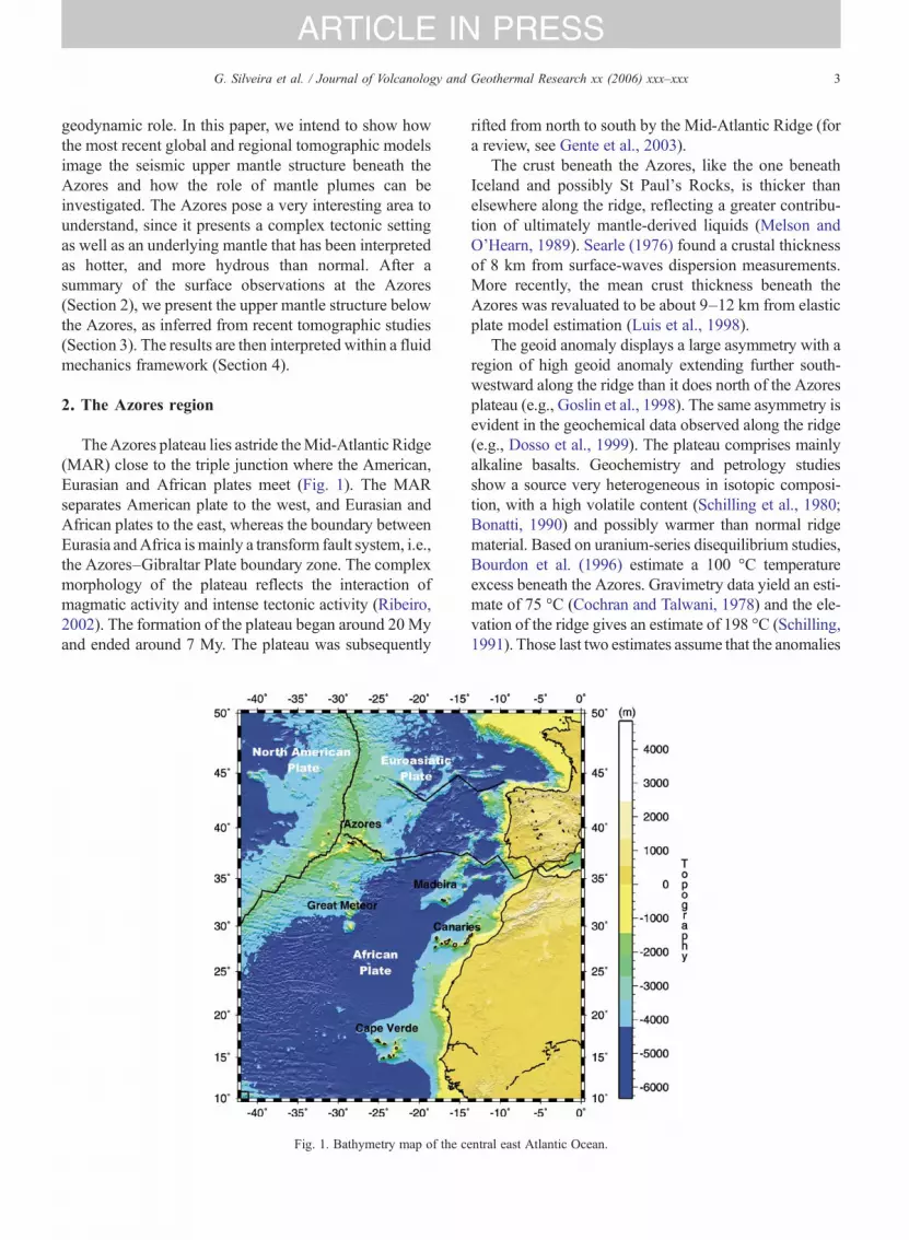
TheAzores plateau lies astride theMid-Atlantic Ridge(MAR) close to the triple junction where the American,Eurasian and African plates meet (Fig. 1). The MARseparates American plate to the west, and Eurasian andAfrican plates to the east, whereas the boundary betweenEurasia andAfrica ismainly a transform fault system, i.e.,the Azores–Gibraltar Plate boundary zone. The complexmorphology of the plateau reflects the interaction ofmagmatic activity and intense tectonic activity (Ribeiro,2002). The formation of the plateau began around 20Myand ended around 7 My. The plateau was subsequently
Fig. 1. Bathymetry map of the c
rifted from north to south by the Mid-Atlantic Ridge (fora review, see Gente et al., 2003).
The crust beneath the Azores, like the one beneathIceland and possibly St Paul's Rocks, is thicker thanelsewhere along the ridge, reflecting a greater contribu-tion of ultimately mantle-derived liquids (Melson andO'Hearn, 1989). Searle (1976) found a crustal thicknessof 8 km from surface-waves dispersion measurements.More recently, the mean crust thickness beneath theAzores was revaluated to be about 9–12 km from elasticplate model estimation (Luis et al., 1998).
The geoid anomaly displays a large asymmetry with aregion of high geoid anomaly extending further south-westward along the ridge than it does north of the Azoresplateau (e.g., Goslin et al., 1998). The same asymmetry isevident in the geochemical data observed along the ridge(e.g., Dosso et al., 1999). The plateau comprises mainlyalkaline basalts. Geochemistry and petrology studiesshow a source very heterogeneous in isotopic composi-tion, with a high volatile content (Schilling et al., 1980;Bonatti, 1990) and possibly warmer than normal ridgematerial. Based on uranium-series disequilibrium studies,Bourdon et al. (1996) estimate a 100 °C temperatureexcess beneath the Azores. Gravimetry data yield an esti-mate of 75 °C (Cochran and Talwani, 1978) and the ele-vation of the ridge gives an estimate of 198 °C (Schilling,1991). Those last two estimates assume that the anomalies
entral east Atlantic Ocean.
4 G. Silveira et al. / Journal of Volcanology and Geothermal Research xx (2006) xxx–xxx
ARTICLE IN PRESS
are solely due to temperature, and could be reduced if thevolatile content is taken into account (e.g., Bonatti, 1990;Asimow and Langmuir, 2003). The relative contributionsof excess temperature and volatile content (mostly water)are still heavily debated today. However, if the Azoresmaterial is indeed 100–200 °C warmer than normalmantle, then it would be compatible with a plume origin(Schilling, 1975; Schilling et al., 1983).
On top of the plateau has emerged a volcanic archi-pelago, still active today. Two islands are located westof the ridge axis and seven islands extend up to 550 kmeast of it. The oldest rocks recovered are 8 My andwere found in Santa Maria island. Geochemical dataare heterogeneous, but point to the possible coexistenceand/or mixing in the source of recycled oceanic crust,Jurassic delamination of continental lithosphere, andundegassed material, high 3He, coming from the deepmantle (e.g., Moreira et al., 1999). Based on the rare-gas signature, the Azores hotspot is presently locatedon the eastern side of the MAR under the central groupof islands (see Gente et al., 2003, for a review).
3. Tomographic seismic imaging
Tomographic models are derived from differenttypes of measurements involving the recording of anearthquake by seismic stations. Classical tomographicmethods use body-wave travel times, surface-wavephase velocities and/or normal-mode frequencies. Bodywaves are the first phases that are recorded by a stationafter an earthquake, and they have a dominant period of1 s for P-waves and 4 s for S-waves. The associatedtravel times correspond to propagation along raysthrough the Earth. The seismic signal that arrives afterbody waves is the most energetic at teleseismicdistances and corresponds to the surface-wave train.Surface waves are guided waves that are dispersiveand, for studying the mantle, their phase velocities aremeasured in the period band 40–250 s. Finally, byconsidering several hour-length seismograms after astrong earthquake, normal modes or eigenfrequenciesof the Earth are determined for periods larger thanabout 150 s. The way of propagation through the Earthand the period domain associated with each type ofmeasurement control the resolution of a tomographicmodel. Body waves are sensitive to small-scalestructures along the rays and the minimum size of astructure that can be recovered is limited by the pathcoverage, which in turn is controlled by the source andreceiver configuration. On the other hand, surfacewaves sample the mantle along a path epicenter stationfrom the surface down to a depth that depends on the
period. The minimum size of the structures that can berecovered using surface waves is about 200 km for a40-s period measurement and 1000 km for a measure-ment at 200 s. Therefore, for surface waves theresolution limit is controlled by both the measurementperiod band and the path coverage.
Body waves, surface waves and normal modes havebeen extensively used since the mid-1980s for derivingtomographic models. Each measurement is associatedwith a path through the Earth, and the combination ofmany crossing paths in a suitable dense source–receiverconfiguration allows the determination of the shape andamplitude of three-dimensional anomalies with respectto a standard reference model (e.g., PREM model ofDziewonski and Anderson, 1981). This methodologywas introduced in the late 1970s (among others: Aki etal., 1977; Dziewonski et al., 1977) and, since then, thenumber of both global and regional tomographic modelsusing more and more sophisticated methodologiesgreatly increased (see Romanowicz, 2003, for a recentreview on global tomographic models). Nevertheless,depending on the type of data used in the inversion (e.g.,body wave versus surface wave), and the model para-meterization taking account of anisotropy and anelastic-ity the resulting tomographic models may provideslightly different images of the Earth.
3.1. Global tomographic models
Most recent global tomographic models include bothbody- and surface-wave data. However, because of thelack of an adequate number of seismic stations andearthquakes, surface waves are the only seismic wavesthat provide information on the upper mantle structurebeneath oceanic areas with uniform resolution. Amongthe large number of available global models, we haveselected three of them for discussion. The first model,SAW24B16 (Mégnin and Romanowicz, 2000), wasderived from waveform inversion using an asymptotictheory (Li and Romanowicz, 1996). Waveforms of SH-body waves and fundamental and higher mode Lovewaves were used to derive an SH-wave velocity model.The second model, S20RTS (Ritsema and van Heijst,2000) was obtained by inverting body wave travel times(SH, ScSH, SKS, and multiple reflected phases) andRayleigh surface-wave phase velocities. The authorscombined measurements on the transverse and verticalcomponents of the seismogram, but anisotropy wasneglected in the inversion for the S-wave velocitymodel. The third model, SG (Grand et al., 1997), wasderived from travel times inversion of SH, ScSH andmultiple reflected phases measured on the transverse
5G. Silveira et al. / Journal of Volcanology and Geothermal Research xx (2006) xxx–xxx
ARTICLE IN PRESS
component and the model corresponds to SH-wavevelocity perturbations.
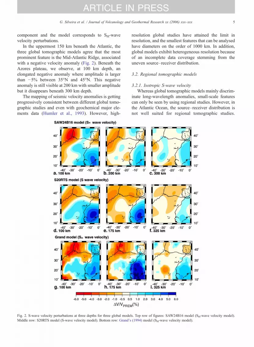
In the uppermost 150 km beneath the Atlantic, thethree global tomographic models agree that the mostprominent feature is the Mid-Atlantic Ridge, associatedwith a negative velocity anomaly (Fig. 2). Beneath theAzores plateau, we observe, at 100 km depth, anelongated negative anomaly where amplitude is largerthan −5% between 35°N and 45°N. This negativeanomaly is still visible at 200 km with smaller amplitudebut it disappears beneath 300 km depth.
The mapping of seismic velocity anomalies is gettingprogressively consistent between different global tomo-graphic studies and even with geochemical major ele-ments data (Humler et al., 1993). However, high-
Fig. 2. S-wave velocity perturbations at three depths for three global modeMiddle row: S20RTS model (S-wave velocity model). Bottom row: Grand's
resolution global studies have attained the limit inresolution, and the smallest features that can be analysedhave diameters on the order of 1000 km. In addition,global models exhibit heterogeneous resolution becauseof an incomplete data coverage stemming from theuneven source–receiver distribution.
3.2. Regional tomographic models
3.2.1. Isotropic S-wave velocityWhereas global tomographic models mainly discrim-
inate long-wavelength anomalies, small-scale featurescan only be seen by using regional studies. However, inthe Atlantic Ocean, the source–receiver distribution isnot well suited for regional tomographic studies.
ls. Top row of figures: SAW24B16 model (SH-wave velocity model).(1994) model (SH-wave velocity model).
6 G. Silveira et al. / Journal of Volcanology and Geothermal Research xx (2006) xxx–xxx
ARTICLE IN PRESS
Whereas the Pacific Ocean is ringed by seismogeniczones, most of the seismicity around the Atlantic isconcentrated in the west American coasts, Mediterra-nean region and Central Africa. Even the high seismicityof the Mid-Atlantic Ridge is characterized by earth-quakes of magnitude smaller than 5.8. So, it is difficultin any tomographic study to isolate the Atlantic Oceanfrom surrounding continents.
In the mid-1970s and early 1980s, surface-wavedispersion measurements were used to study the averageupper mantle structure beneath the entire Atlantic Oceanor parts of it (Weidner, 1974; Canas and Mitchell, 1981;Marillier and Mueller, 1982). Those studies mainlydistinguish the Mid-Atlantic Ridge from the ocean ba-sins. Searle (1976) performed local surface-wavedispersion measurements that primarily show that theAzores plateau has a crust with a thickness of about 8 km.The proposed upper mantle structure that fits suchobservations suggests S-wave velocity not higher than4.5 km/s.
Honda and Tanimoto (1987) published the firstregional tomographic model for the Atlantic Ocean, bysurface-wave phase inversion. At shallow depths, theydetected the presence of low velocities beneath the Azorestriple junction. Mocquet and Romanowicz (1990)inverted Rayleigh wave-phase velocities (Mocquet etal., 1989), to obtain a three-dimensional shear-wavevelocity of the upper mantle beneath the Atlantic Ocean.Due to the inhomogeneity of the azimuthal path coverage,the model does not include anisotropy. The lateralresolution of these first regional models is very poor,larger than 2000 km. They found slower velocitiesbeneath the Mid-Atlantic Ridge than beneath oceanbasins. Except for the low-velocity anomaly beneath theAzores triple junction (confined to the lithosphere), it isnot possible to associate any other negative anomaly withother ridge or near ridge hotspots.
Four years later, Grand (1994), using SH-wave traveltimes proposed a mantle shear structure beneath theAmerica and surrounding oceans. In the entire uppermantle, it is possible to trace a low-velocity anomalybeneath the Azores, with amplitudes ranging from −4.0%, in the first 100 km, to ∼−1% between 325 and400 km. However, the vertical extent of the low-velocityanomaly is not well resolved because of the lack of bodywaves that sample the area.
3.2.2. Anisotropic tomographic modelsRadial (or polarization) anisotropy and azimuthal
anisotropy are two manifestations of the upper mantleanisotropy. Radial anisotropy means that the elasticproperties of media differ between horizontal and
vertical orientations. This was first inferred from theincompatibility between fundamental mode Love andRayleigh phase-velocity measurements (Anderson,1961). Azimuthal anisotropy means that media proper-ties depend on the azimuth, as was first observed bycomparing Rayleigh wave-phase velocity measurementsalong different directions of propagation in the Nazcaplate (Forsyth, 1975).
The rapid expansion of broadband seismographnetworks during the last two decades of the 20th cen-tury have enabled better coverage worldwide, even forpoorly sampled regions such as Atlantic. This has madeit possible to improve model parameterization by in-cluding seismic anisotropy in tomographic methods(Montagner and Nataf, 1986).
Silveira et al. (1998) proposed the first anisotropicRayleigh wave phase-velocity maps at a regional scalefor the Atlantic Ocean. Only the surface-wave funda-mental mode was used and, consequently, only theupper 300 km of the mantle could be investigated. Thephase velocity maps revealed the presence of a slow-velocity anomaly beneath all the Mid-Atlantic Ridgehotspots up to the largest period inverted (200 , thatcorresponds roughly to 200–300 km depth) as well asbeneath most of Atlantic hotspots. More recently,Silveira and Stutzmann (2002), using Rayleigh andLove wave phase-velocity measurements, derived amodel from the Moho down to 300 km depth with alateral resolution of about 700 km. The tomographicmaps display negative S-wave velocity anomaliesbeneath most of the Atlantic hotspots, from the surfacedown to 200–300 km depth, confirming the previousinterpretation based on phase-velocity maps. All thenegative S-wave velocity anomalies associated with theMid-Atlantic Ridge or near-ridge hotspots are strongerand deeper than the ambient ridge anomalies whosemaximum depth is around 150 km. This model wasobtained without shallow layer corrections. Crustallayers cannot be recovered using surface waves in theperiod band 50–250 s but they have an effect on phasevelocities even at longer periods (e.g., Stutzmann andMontagner, 1994). Beneath an ocean, a tomographicmodel without crustal corrections displays higher velo-cities than after crustal corrections.
The phase-velocity data set used by Silveira andStutzmann (2002) has been enlarged to about 2500 pathsper period to improve the resolution in the Azores area.Crustal corrections have been applied to each path-phase velocity and the inversion procedure is the sameas in Silveira and Stutzmann (2002). The new tomog-raphic model is presented in Fig. 3 together with theerror maps and a resolution test is presented in the
Fig. 3. Regional S-wave velocity model at three depths: 100 km, 180 km and 280 km. Top figures (a–c): SV-wave-velocity model in percent (colour)with respect to the PREM and azimuthal anisotropy fast directions (bars). The bar azimuth gives the S-wave velocity fast direction and its length isproportional to the magnitude. Middle figures (d–f): shows the errors for a–c. Bottom figures (g–i): radial anisotropy lateral variation in percent withrespect to PREM.
7G. Silveira et al. / Journal of Volcanology and Geothermal Research xx (2006) xxx–xxx
ARTICLE IN PRESS
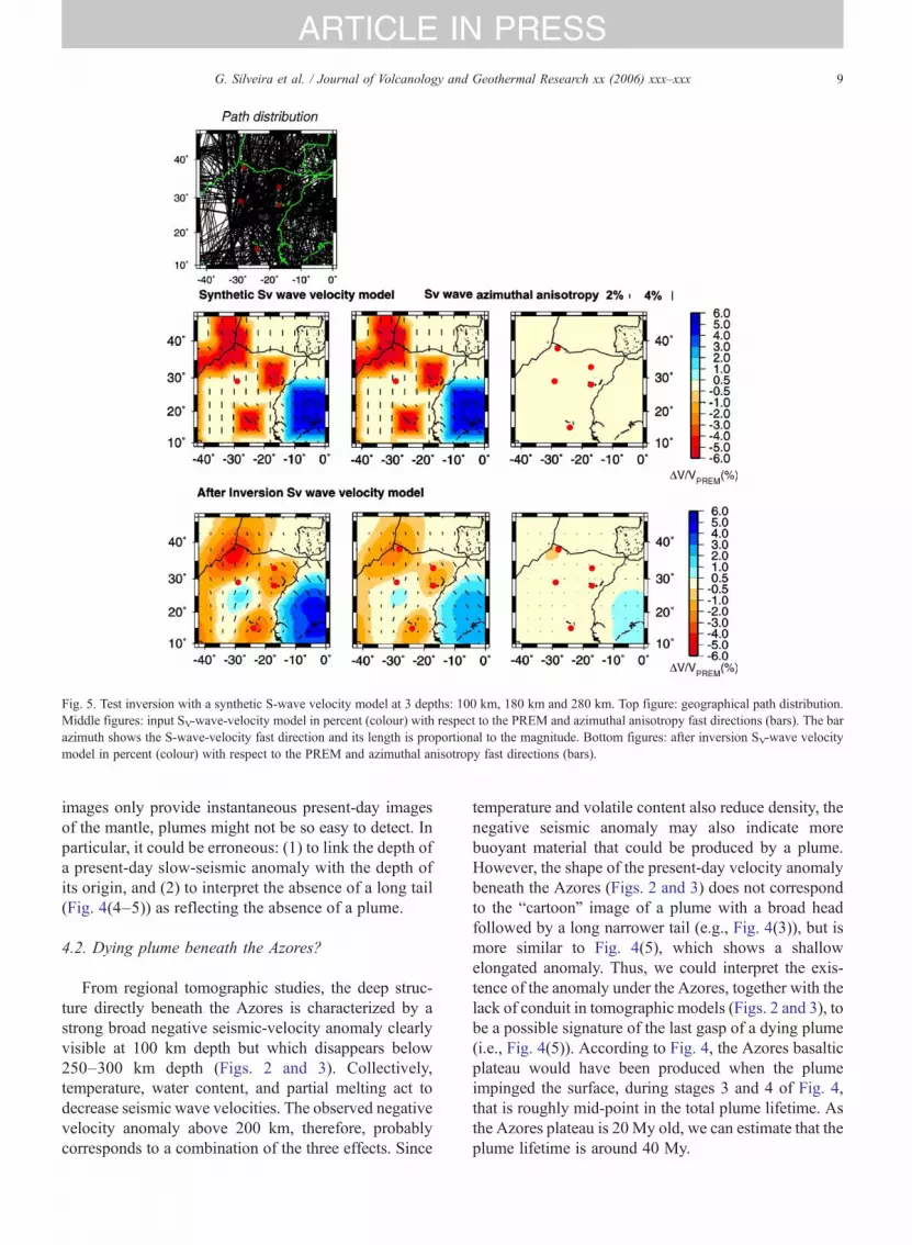
appendix. As for global models, we retrieve fastvelocities beneath the West African craton and slowvelocities beneath the Mid-Atlantic Ridge. The pathcoverage presented in the appendix enables us to samplecorrectly the area that includes Azores, Great Meteor,Cape Verde and Canaries hotspots and West Africa.Synthetic tests show that if there were three separateanomalies beneath the Azores, Canaries and Cape Verdehotspots having a ray of 200 km and a velocity contrastlarger than 3–4% in the upper mantle, they would beseen on the tomographic maps (see the appendix).
The deep structure beneath the Azores is character-ized by a broad slow-velocity anomaly clearly visibleat 100 km depth. The eastern edges of this low velocityare close to the Great Meteor and Canaries islands.Deeper in the mantle, this slow anomaly remainslocated beneath the Azores, but its size decreases to
disappear around 300 km depth. The anomalyamplitude decreases from −6% at 100 km depth to−3% at 180 km depth and less than −1% at 280 kmdepth. The associated error maps show that the errors isaround 1.1–1.3% in this area at every depth andtherefore only anomalies with amplitude larger than∼±0.5% are significant. Synthetic tests have shownthat if there were a plume conduit beneath the Azoresdeeper than 250–350 km depth with a velocity contrastlarger than 3–4% it would be observed on thetomographic map of Fig. 3.
Close to the ridge, the SV-wave azimuthal anisotropyfast directions are perpendicular to the ridge axis(Fig. 3b). Beneath the Azores, the anisotropy fastdirection is along a northwest–southeast direction.Radial anisotropy, ξ, is plotted as a perturbation withrespect to PREM (Fig. 3c).
8 G. Silveira et al. / Journal of Volcanology and Geothermal Research xx (2006) xxx–xxx
ARTICLE IN PRESS
Radial-anisotropy perturbation is negative beneaththe Azores at every depth and its amplitude tends to 0 at200 km depth. To a first approximation, we have:
n−1i2� ððVSH−VSVÞ=VSVÞ
The negative radial anisotropy anomaly observeddown to 220 km depth means that SV-wave velocity islarger than SH-wave velocity, which can be interpreted asan indication of dominantly vertical flow in this area.Radial anisotropy is derived from the discrepancybetween Rayleigh and Love wave-phase velocities.There are less measurements for Love waves than forRayleigh waves because Love waves are observed on theseismogram horizontal component which is noisier thanthe vertical component. In this study, we have 3000 pathsfor Rayleigh waves and 800 for Love waves and,therefore, radial anisotropy cannot be as well resolved asSV-wave velocity and the associate error is around 3–4%.
4. Discussion
4.1. What is a plume? Cartoons versus fluid-mechan-ical reality
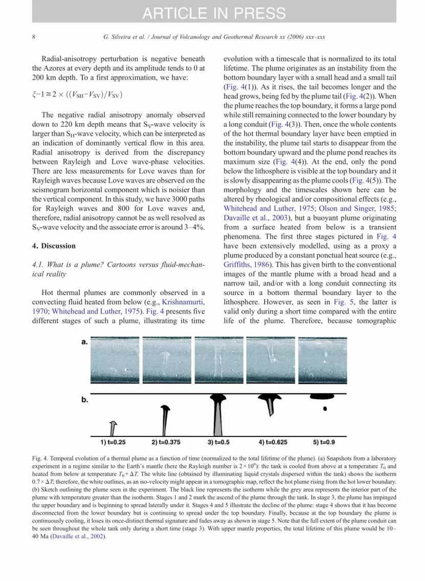
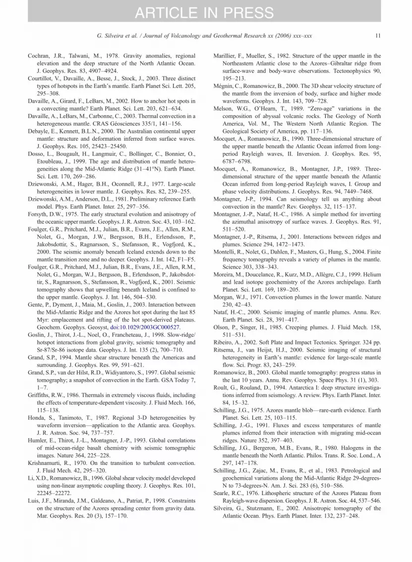
Hot thermal plumes are commonly observed in aconvecting fluid heated from below (e.g., Krishnamurti,1970; Whitehead and Luther, 1975). Fig. 4 presents fivedifferent stages of such a plume, illustrating its time
Fig. 4. Temporal evolution of a thermal plume as a function of time (normaliexperiment in a regime similar to the Earth's mantle (here the Rayleigh numheated from below at temperature T0+ΔT. The white line (obtained by illum0.7×ΔT; therefore, the white outlines, as an iso-velocity might appear in a tom(b) Sketch outlining the plume seen in the experiment. The black line represplume with temperature greater than the isotherm. Stages 1 and 2 mark the asthe upper boundary and is beginning to spread laterally under it. Stages 4 anddisconnected from the lower boundary but is continuing to spread undercontinuously cooling, it loses its once-distinct thermal signature and fades awabe seen throughout the whole tank only during a short time (stage 3). With40 Ma (Davaille et al., 2002).
evolution with a timescale that is normalized to its totallifetime. The plume originates as an instability from thebottom boundary layer with a small head and a small tail(Fig. 4(1)). As it rises, the tail becomes longer and thehead grows, being fed by the plume tail (Fig. 4(2)).Whenthe plume reaches the top boundary, it forms a large pondwhile still remaining connected to the lower boundary bya long conduit (Fig. 4(3)). Then, once the whole contentsof the hot thermal boundary layer have been emptied inthe instability, the plume tail starts to disappear from thebottom boundary upward and the plume pond reaches itsmaximum size (Fig. 4(4)). At the end, only the pondbelow the lithosphere is visible at the top boundary and itis slowly disappearing as the plume cools (Fig. 4(5)). Themorphology and the timescales shown here can bealtered by rheological and/or compositional effects (e.g.,Whitehead and Luther, 1975; Olson and Singer, 1985;Davaille et al., 2003), but a buoyant plume originatingfrom a surface heated from below is a transientphenomena. The first three stages pictured in Fig. 4have been extensively modelled, using as a proxy aplume produced by a constant ponctual heat source (e.g.,Griffiths, 1986). This has given birth to the conventionalimages of the mantle plume with a broad head and anarrow tail, and/or with a long conduit connecting itssource in a bottom thermal boundary layer to thelithosphere. However, as seen in Fig. 5, the latter isvalid only during a short time compared with the entirelife of the plume. Therefore, because tomographic
zed to the total lifetime of the plume). (a) Snapshots from a laboratoryber is 2×10⁶): the tank is cooled from above at a temperature T0 andinating liquid crystals dispersed within the tank) shows the isothermographic map, reflect the hot plume rising from the hot lower boundary.ents the isotherm while the grey area represents the interior part of thecend of the plume through the tank. In stage 3, the plume has impinged5 illustrate the decline of the plume: stage 4 shows that it has become
the top boundary. Finally, because at the top boundary the plume isy as shown in stage 5. Note that the full extent of the plume conduit canupper mantle properties, the total lifetime of this plume would be 10–
Fig. 5. Test inversion with a synthetic S-wave velocity model at 3 depths: 100 km, 180 km and 280 km. Top figure: geographical path distribution.Middle figures: input SV-wave-velocity model in percent (colour) with respect to the PREM and azimuthal anisotropy fast directions (bars). The barazimuth shows the S-wave-velocity fast direction and its length is proportional to the magnitude. Bottom figures: after inversion SV-wave velocitymodel in percent (colour) with respect to the PREM and azimuthal anisotropy fast directions (bars).
9G. Silveira et al. / Journal of Volcanology and Geothermal Research xx (2006) xxx–xxx
ARTICLE IN PRESS
images only provide instantaneous present-day imagesof the mantle, plumes might not be so easy to detect. Inparticular, it could be erroneous: (1) to link the depth ofa present-day slow-seismic anomaly with the depth ofits origin, and (2) to interpret the absence of a long tail(Fig. 4(4–5)) as reflecting the absence of a plume.
4.2. Dying plume beneath the Azores?
From regional tomographic studies, the deep struc-ture directly beneath the Azores is characterized by astrong broad negative seismic-velocity anomaly clearlyvisible at 100 km depth but which disappears below250–300 km depth (Figs. 2 and 3). Collectively,temperature, water content, and partial melting act todecrease seismic wave velocities. The observed negativevelocity anomaly above 200 km, therefore, probablycorresponds to a combination of the three effects. Since
temperature and volatile content also reduce density, thenegative seismic anomaly may also indicate morebuoyant material that could be produced by a plume.However, the shape of the present-day velocity anomalybeneath the Azores (Figs. 2 and 3) does not correspondto the “cartoon” image of a plume with a broad headfollowed by a long narrower tail (e.g., Fig. 4(3)), but ismore similar to Fig. 4(5), which shows a shallowelongated anomaly. Thus, we could interpret the exis-tence of the anomaly under the Azores, together with thelack of conduit in tomographic models (Figs. 2 and 3), tobe a possible signature of the last gasp of a dying plume(i.e., Fig. 4(5)). According to Fig. 4, the Azores basalticplateau would have been produced when the plumeimpinged the surface, during stages 3 and 4 of Fig. 4,that is roughly mid-point in the total plume lifetime. Asthe Azores plateau is 20 My old, we can estimate that theplume lifetime is around 40 My.
10 G. Silveira et al. / Journal of Volcanology and Geothermal Research xx (2006) xxx–xxx
ARTICLE IN PRESS
5. Conclusions
Global and regional tomographic studies show nodeep vertical anomaly beneath the Azores, and seem topreclude the present-day existence of a long plume tailthere. If it is indeed plume-related, the Azores plateauwould, therefore, have been created 20 My ago by aplume which is currently dying. A better understandingof the competing effects of water content, partial melt-ing, and temperature variation on geophysical signals isnow required to push the analysis further.
To better characterize the geometry of the low-ve-locity anomaly, we need a better resolution of tomog-raphic models for the area between the Azores, GreatMeteor, Canaries, and Cape Verde, particularly in the300–1000 km depth zone. This will be achieved only byimproving our seismic coverage in the area. The long-term deployment of seafloor broadband seismic stations,combined with permanent land broadband stations onthe Azores and Cape Verde islands, seems critical to gainmore insight into the mantle dynamics of the Atlanticregion.
Acknowledgments
We thank B. Romanowicz, S. Grand and J. Ritsemafor providing their tomographic models. Thanks also toB. Bourdon, M. Cannat, R. Doucelance, M. Maia, M.Moreira, N. Ribe, N. Lourenço and M. A. Moreira forilluminating discussions. Most figures were generatedwith GMT software. This is an I.P.G.P contribution2131, UMR CNRS 7580 and 7579. This work waspartially sponsored by MASHA (POCTI/CTA/39158/2001), and the CNRS/GRICES cooperation program.
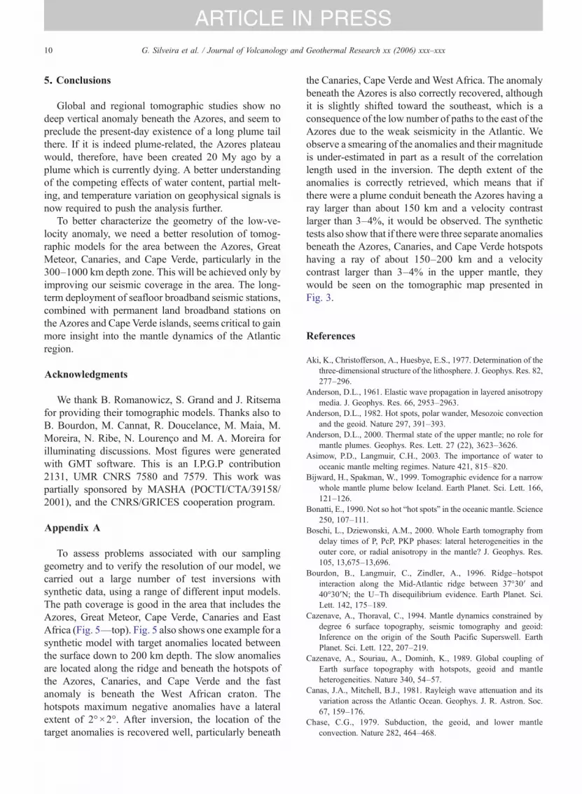
Appendix A
To assess problems associated with our samplinggeometry and to verify the resolution of our model, wecarried out a large number of test inversions withsynthetic data, using a range of different input models.The path coverage is good in the area that includes theAzores, Great Meteor, Cape Verde, Canaries and EastAfrica (Fig. 5—top). Fig. 5 also shows one example for asynthetic model with target anomalies located betweenthe surface down to 200 km depth. The slow anomaliesare located along the ridge and beneath the hotspots ofthe Azores, Canaries, and Cape Verde and the fastanomaly is beneath the West African craton. Thehotspots maximum negative anomalies have a lateralextent of 2°×2°. After inversion, the location of thetarget anomalies is recovered well, particularly beneath
the Canaries, Cape Verde and West Africa. The anomalybeneath the Azores is also correctly recovered, althoughit is slightly shifted toward the southeast, which is aconsequence of the low number of paths to the east of theAzores due to the weak seismicity in the Atlantic. Weobserve a smearing of the anomalies and their magnitudeis under-estimated in part as a result of the correlationlength used in the inversion. The depth extent of theanomalies is correctly retrieved, which means that ifthere were a plume conduit beneath the Azores having aray larger than about 150 km and a velocity contrastlarger than 3–4%, it would be observed. The synthetictests also show that if there were three separate anomaliesbeneath the Azores, Canaries, and Cape Verde hotspotshaving a ray of about 150–200 km and a velocitycontrast larger than 3–4% in the upper mantle, theywould be seen on the tomographic map presented inFig. 3.
References
Aki, K., Christofferson, A., Huesbye, E.S., 1977. Determination of thethree-dimensional structure of the lithosphere. J. Geophys. Res. 82,277–296.
Anderson, D.L., 1961. Elastic wave propagation in layered anisotropymedia. J. Geophys. Res. 66, 2953–2963.
Anderson, D.L., 1982. Hot spots, polar wander, Mesozoic convectionand the geoid. Nature 297, 391–393.
Anderson, D.L., 2000. Thermal state of the upper mantle; no role formantle plumes. Geophys. Res. Lett. 27 (22), 3623–3626.
Asimow, P.D., Langmuir, C.H., 2003. The importance of water tooceanic mantle melting regimes. Nature 421, 815–820.
Bijward, H., Spakman, W., 1999. Tomographic evidence for a narrowwhole mantle plume below Iceland. Earth Planet. Sci. Lett. 166,121–126.
Bonatti, E., 1990. Not so hot “hot spots” in the oceanic mantle. Science250, 107–111.
Boschi, L., Dziewonski, A.M., 2000. Whole Earth tomography fromdelay times of P, PcP, PKP phases: lateral heterogeneities in theouter core, or radial anisotropy in the mantle? J. Geophys. Res.105, 13,675–13,696.
Bourdon, B., Langmuir, C., Zindler, A., 1996. Ridge–hotspotinteraction along the Mid-Atlantic ridge between 37°30′ and40°30′N; the U–Th disequilibrium evidence. Earth Planet. Sci.Lett. 142, 175–189.
Cazenave, A., Thoraval, C., 1994. Mantle dynamics constrained bydegree 6 surface topography, seismic tomography and geoid:Inference on the origin of the South Pacific Superswell. EarthPlanet. Sci. Lett. 122, 207–219.
Cazenave, A., Souriau, A., Dominh, K., 1989. Global coupling ofEarth surface topography with hotspots, geoid and mantleheterogeneities. Nature 340, 54–57.
Canas, J.A., Mitchell, B.J., 1981. Rayleigh wave attenuation and itsvariation across the Atlantic Ocean. Geophys. J. R. Astron. Soc.67, 159–176.
Chase, C.G., 1979. Subduction, the geoid, and lower mantleconvection. Nature 282, 464–468.
11G. Silveira et al. / Journal of Volcanology and Geothermal Research xx (2006) xxx–xxx
ARTICLE IN PRESS
Cochran, J.R., Talwani, M., 1978. Gravity anomalies, regionalelevation and the deep structure of the North Atlantic Ocean.J. Geophys. Res. 83, 4907–4924.
Courtillot, V., Davaille, A., Besse, J., Stock, J., 2003. Three distincttypes of hotspots in the Earth's mantle. Earth Planet Sci. Lett. 205,295–308.
Davaille, A., Girard, F., LeBars, M., 2002. How to anchor hot spots ina convecting mantle? Earth Planet. Sci. Lett. 203, 621–634.
Davaille, A., LeBars, M., Carbonne, C., 2003. Thermal convection in aheterogeneous mantle. CRAS Géosciences 335/1, 141–156.
Debayle, E., Kennett, B.L.N., 2000. The Australian continental uppermantle: structure and deformation inferred from surface waves.J. Geophys. Res. 105, 25423–25450.
Dosso, L., Bougault, H., Langmuir, C., Bollinger, C., Bonnier, O.,Etoubleau, J., 1999. The age and distribution of mantle hetero-geneities along the Mid-Atlantic Ridge (31–41°N). Earth Planet.Sci. Lett. 170, 269–286.
Dziewonski, A.M., Hager, B.H., Oconnell, R.J., 1977. Large-scaleheterogeneities in lower mantle. J. Geophys. Res. 82, 239–255.
Forsyth, D.W., 1975. The early structural evolution and anisotropy ofthe oceanic uppermantle. Geophys. J. R. Astron. Soc. 43, 103–162.
Foulger, G.R., Pritchard, M.J., Julian, B.R., Evans, J.E., Allen, R.M.,Nolet, G., Morgan, J.W., Bergsson, B.H., Erlendsson, P.,Jakobsdottir, S., Ragnarsson, S., Stefansson, R., Vogfjord, K.,2000. The seismic anomaly beneath Iceland extends down to themantle transition zone and no deeper. Geophys. J. Int. 142, F1–F5.
Foulger, G.R., Pritchard, M.J., Julian, B.R., Evans, J.E., Allen, R.M.,Nolet, G., Morgan, W.J., Bergsson, B., Erlendsson, P., Jakobsdot-tir, S., Ragnarsson, S., Stefansson, R., Vogfjord, K., 2001. Seismictomography shows that upwelling beneath Iceland is confined tothe upper mantle. Geophys. J. Int. 146, 504–530.
Gente, P., Dyment, J., Maia, M., Goslin, J., 2003. Interaction betweenthe Mid-Atlantic Ridge and the Azores hot spot during the last 85Myr: emplacement and rifting of the hot spot-derived plateaus.Geochem. Geophys. Geosyst, doi:10.1029/2003GC000527.
Goslin, J., Thirot, J.-L., Noel, O., Francheteau, J., 1998. Slow-ridge/hotspot interactions from global gravity, seismic tomography andSr-87/Sr-86 isotope data. Geophys. J. Int. 135 (2), 700–710.
Grand, S.P., 1994. Mantle shear structure beneath the Americas andsurrounding. J. Geophys. Res. 99, 591–621.
Grand, S.P., van der Hilst, R.D., Widiyantoro, S., 1997. Global seismictomography; a snapshot of convection in the Earth. GSAToday 7,1–7.
Griffiths, R.W., 1986. Thermals in extremely viscous fluids, includingthe effects of temperature-dependent viscosity. J. Fluid Mech. 166,115–138.
Honda, S., Tanimoto, T., 1987. Regional 3-D heterogeneities bywaveform inversion—application to the Atlantic area. Geophys.J. R. Astron. Soc. 94, 737–757.
Humler, E., Thirot, J.-L., Montagner, J.-P., 1993. Global correlationsof mid-ocean-ridge basalt chemistry with seismic tomographicimages. Nature 364, 225–228.
Krishnamurti, R., 1970. On the transition to turbulent convection.J. Fluid Mech. 42, 295–320.
Li, X.D., Romanowicz, B., 1996. Global shear velocity model developedusing non-linear asymptotic coupling theory. J. Geophys. Res. 101,22245–22272.
Luis, J.F., Miranda, J.M., Galdeano, A., Patriat, P., 1998. Constraintson the structure of the Azores spreading center from gravity data.Mar. Geophys. Res. 20 (3), 157–170.
Marillier, F., Mueller, S., 1982. Structure of the upper mantle in theNortheastern Atlantic close to the Azores–Gibraltar ridge fromsurface-wave and body-wave observations. Tectonophysics 90,195–213.
Mégnin, C., Romanowicz, B., 2000. The 3D shear velocity structure ofthe mantle from the inversion of body, surface and higher modewaveforms. Geophys. J. Int. 143, 709–728.
Melson, W.G., O'Hearn, T., 1989. “Zero-age” variations in thecomposition of abyssal volcanic rocks. The Geology of NorthAmerica, Vol. M., The Western North Atlantic Region. TheGeological Society of America, pp. 117–136.
Mocquet, A., Romanowicz, B., 1990. Three-dimensional structure ofthe upper mantle beneath the Atlantic Ocean inferred from long-period Rayleigh waves, II. Inversion. J. Geophys. Res. 95,6787–6798.
Mocquet, A., Romanowicz, B., Montagner, J.P., 1989. Three-dimensional structure of the upper mantle beneath the AtlanticOcean inferred from long-period Rayleigh waves, I. Group andphase velocity distributions. J. Geophys. Res. 94, 7449–7468.
Montagner, J-P., 1994. Can seismology tell us anything aboutconvection in the mantle? Rev. Geophys. 32, 115–137.
Montagner, J.-P., Nataf, H.-C., 1986. A simple method for invertingthe azimuthal anisotropy of surface waves. J. Geophys. Res. 91,511–520.
Montelli, R., Nolet, G., Dahlen, F., Masters, G., Hung, S., 2004. Finitefrequency tomography reveals a variety of plumes in the mantle.Science 303, 338–343.
Moreira, M., Doucelance, R., Kurz, M.D., Allègre, C.J., 1999. Heliumand lead isotope geochemistry of the Azores archipelago. EarthPlanet. Sci. Lett. 169, 189–205.
Morgan, W.J., 1971. Convection plumes in the lower mantle. Nature230, 42–43.
Schilling, J.-G., 1991. Fluxes and excess temperatures of mantleplumes inferred from their interaction with migrating mid-oceanridges. Nature 352, 397–403.
Schilling, J.G., Bergeron, M.B., Evans, R., 1980. Halogens in themantle beneath the North Atlantic. Philos. Trans. R. Soc. Lond., A297, 147–178.
Schilling, J.G., Zajac, M., Evans, R., et al., 1983. Petrological andgeochemical variations along the Mid-Atlantic Ridge 29-degrees-N to 73-degrees-N. Am. J. Sci. 283 (6), 510–586.
Searle, R.C., 1976. Lithospheric structure of the Azores Plateau fromRayleigh-wave dispersion. Geophys. J. R. Astron. Soc. 44, 537–546.
Silveira, G., Stutzmann, E., 2002. Anisotropic tomography of theAtlantic Ocean. Phys. Earth Planet. Inter. 132, 237–248.
12 G. Silveira et al. / Journal of Volcanology and Geothermal Research xx (2006) xxx–xxx
ARTICLE IN PRESS
Silveira, G., Stutzmann, E., Griot, D., Montagner, P., Mendes Victor,L., 1998. Anisotropic tomography of the Atlantic Ocean fromRayleigh surface waves. Phys. Earth Planet. Inter. 106, 257–273.
Stutzmann, E., Montagner, J.-P., 1994. Tomography of the transitionzone from the inversion of higher mode surface waves. Phys. EarthPlanet. Inter. 86 (1–3), 99–115.