Page 1
[B.Sc. GEOGRAPHY, MTWU, SYLLABUS, 2021]
Page 1
MOTHER TERESA WOMEN’S UNIVERSITY
KODAIKANAL
DEPARTMENT OF GEOGRAPHY
B.Sc. GEOGRAPHY
SYLLABUS TO BE IMPLEMENTED FROM THE ACADEMIC YEAR 2021-2022
(CHOICE BASED CREDIT SYSTEM)
Page 2
[B.Sc. GEOGRAPHY, MTWU, SYLLABUS, 2021]
Page 2
Mother Teresa Women’s University, Kodaikanal
Department of Geography
Choice Based Credit System (CBCS)
(2021-2022 onwards)
B.Sc. Geography
1. About the Programme
The CBCS provides an opportunity for the students to choose courses from the prescribed
courses comprising core and elective courses. The courses are evaluated following the grading
system, which provides uniformity in the evaluation and computation of the Cumulative Grade
Point Average (CGPA) based on student’s performance in examinations which enables the
student to move across institutions of higher learning. The uniformity in evaluation system also
enables the potential employers in assessing the performance of the candidates. B.Sc. Geography
or Bachelor in Science in Geography is an undergraduate degree with an emphasis on Geography
for 3 years. It is the study of the Earth and its many properties, characteristics, people and
phenomena, in addition to the map and geographical image-interpretation. There are a broad range
of careers open to a geography graduate. If students pursue higher studies or gain some work
experience, students can get jobs in MNCs and abroad. Graduates can also do
Certificate courses or gain higher education to increase their chances of getting a job abroad.
There are many job opportunities available abroad for B.Sc. Geography graduates. This syllabus
will be followed from the academic year 2021-2022 onwards.
2. Programme Educational Objectives (PEOs)
PEO1: Students will be able to define geography and be able to describe in good detail the major
subdivisions of the field of geography; explain what geographers do; and how geography
relates to a variety of real-world jobs (all majors).
PEO2: Students will gain factual knowledge about the world and its regions focusing on the
diversity of natural and cultural landscape features, and they will know some basic
principles, definitions, and themes in the subject matter of geography (all majors).
PEO3: Students will attain increased global awareness and become more geographically informed
people.
PEO4: Students will know the history and development of urbanization in recent times. Students
will be familiar with the variety of issues and problems studied by urban and regional
planners and how they apply their expertise to resolve these issues and problems in modern
urban America (Environmental Studies and Sustainability).
PEO5: Students will be able to apply their understanding of land use and planning principles in a
manner that will allow them to elicit and formulate an effective plan.
PEO6: Students will be able to effectively articulate their proposals both written and orally and
be capable of advocating on behalf of their plan, as well as to negotiate with those who
may oppose their plan (Environmental Studies and Sustainability)
PEO7: Students will have a basic knowledge of the theoretical and applied realms of geographic
information science (GIS).
Page 3
[B.Sc. GEOGRAPHY, MTWU, SYLLABUS, 2021]
Page 3
3. Eligibility
Students must complete their 10+2 from a recognized board.
4. General Guidelines for UG Programme
i. Duration: The programme shall extend through a period of 6 consecutive semesters and
the duration of a semester shall normally be 90 days or 450 hours. Examinations shall be
conducted at the end of each semester for the respective subjects.
ii. Medium of Instruction: English
iii. Evaluation: Evaluation of the candidates shall be through Internal Assessment and
External Examination.
Assessment/Examination Theory Practical
Min Max Min Max
Internal 10 25 10 25
External 30 75 30 75
• Internal (Theory): Test (15) + Assignment (5) + Seminar/Quiz(5) = 25
• External Theory: 75
• Question Paper Pattern for External examination for all course papers.
Max. Marks: 75 Time: 3 Hrs.
S.No. Part Type Marks
1 A 10*1 Marks=10
Multiple Choice Questions (MCQs): 2 questions from each Unit
10
2 B 5*4=20
Two questions from each Unit with Internal Choice (either / or)
20
3 C 3*15=45
Open Choice: Any three questions out of 5 : one question from
each unit
45
Total Marks 75
Minimum credits required to pass: 156
• Project Report
A student should select a topic for the Project Work at the end of the third semester
itself and submit the Project Report at the end of the fourth semester. The Project Report
shall not exceed 75 typed pages in Times New Roman font with 1.5 lines space.
Page 4
[B.Sc. GEOGRAPHY, MTWU, SYLLABUS, 2021]
Page 4
• Project Evaluation
There is a Viva Voce Examination for Project Work. The Guide and an External
Examiner shall evaluate and conduct the Viva Voce Examination. The Project Work
carries 100 marks (Internal: 25 Marks; External (Viva): 75 Marks).
5. Conversion of Marks to Grade Points and Letter Grade (Performance in a Course/
Paper)
Range of
Marks
Grade Points Letter Grade Description
90 – 100 9.0 – 10.0 O Outstanding
80-89 8.0 – 8.9 D+ Excellent
75-79 7.5 – 7.9 D Distinction
70-74 7.0 – 7.4 A+ Very Good
60-69 6.0 – 6.9 A Good
50-59 5.0 – 5.9 B Average
40-49 4.0 – 4.9 C Satisfactory
00-39 0.0 U Re-appear
ABSENT 0.0 AAA ABSENT
6. Attendance
Students must have earned 75% of attendance in each course for appearing for the
examination. Students with 71% to 74% of attendance must apply for condonation in the
Prescribed Form with prescribed fee. Students with 65% to 70% of attendance must apply
for condonation in the Prescribed Form with the prescribed fee along with the Medical
Certificate. Students with attendance lesser than 65% are not eligible to appear for the
examination and they shall re-do the course with the prior permission of the Head of the
Department, Principal and the Registrar of the University.
7. Maternity Leave
The student who avails maternity leave may be considered to appear for the
examination with the approval of Staff i/c, Head of the Department, Controller of
Examination and the Registrar.
8. Any other Information
In addition to the above mentioned regulations, any other common regulations
pertaining to the UG Programmes are also applicable for this Programme.
Program Outcomes (POs)
PO1 demonstrate knowledge of physical and cultural features of the earth and locate them
on a map.
PO2 know about the basic disciplines of Geography and its sub branches.
PO3 know the basic concepts and terminologies used in Geography like interior of the
earth, plate tectonic, sea floor spreading, population growth, disasters, composition
and structure of atmosphere, hydrosphere, etc.
PO4 differentiate between minerals and rocks, weather and climate, interior of the earth,
basic industries, farming etc.
PO5 get information about the causes and effects of local, national and international
problems like global warming, acid rain, ozone depletion, soil degradation,
deforestation etc.
Page 5
[B.Sc. GEOGRAPHY, MTWU, SYLLABUS, 2021]
Page 5
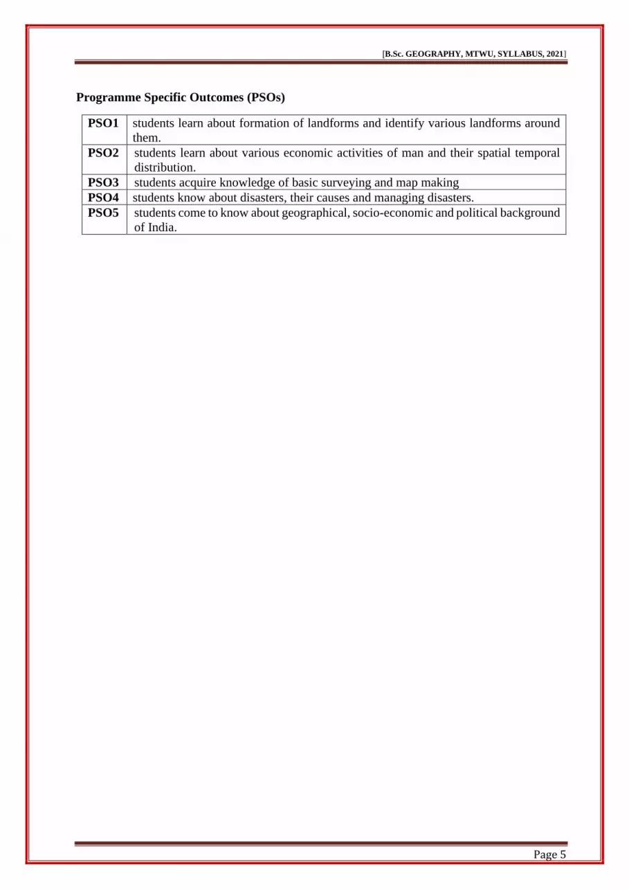
Programme Specific Outcomes (PSOs)
PSO1 students learn about formation of landforms and identify various landforms around
them.
PSO2 students learn about various economic activities of man and their spatial temporal
distribution.
PSO3 students acquire knowledge of basic surveying and map making
PSO4 students know about disasters, their causes and managing disasters.
PSO5 students come to know about geographical, socio-economic and political background
of India.
Page 6
[B.Sc. GEOGRAPHY, MTWU, SYLLABUS, 2021]
Page 6
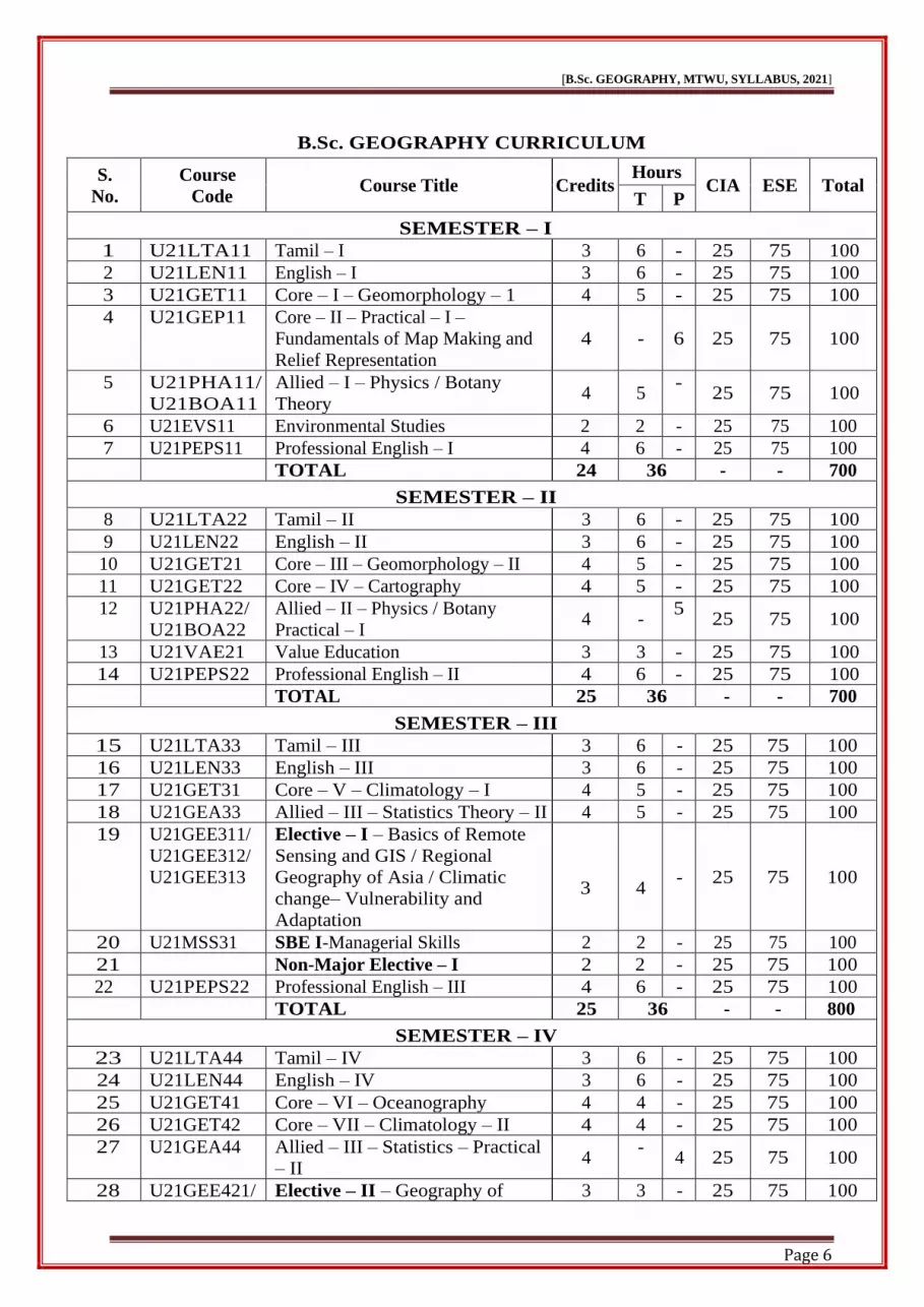
B.Sc. GEOGRAPHY CURRICULUM
S.
No.
Course
Code Course Title Credits
Hours CIA ESE Total
T P
SEMESTER – I
1 U21LTA11 Tamil – I 3 6 - 25 75 100
2 U21LEN11 English – I 3 6 - 25 75 100
3 U21GET11 Core – I – Geomorphology – 1 4 5 - 25 75 100
4 U21GEP11 Core – II – Practical – I –
Fundamentals of Map Making and
Relief Representation
4 -
6 25 75 100
5 U21PHA11/
U21BOA11
Allied – I – Physics / Botany
Theory 4 5
- 25 75 100
6 U21EVS11 Environmental Studies 2 2 - 25 75 100
7 U21PEPS11 Professional English – I 4 6 - 25 75 100
TOTAL 24 36 - - 700
SEMESTER – II
8 U21LTA22 Tamil – II 3 6 - 25 75 100
9 U21LEN22 English – II 3 6 - 25 75 100
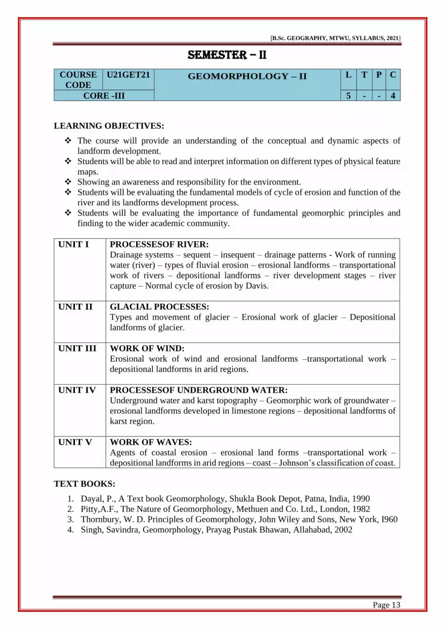
10 U21GET21 Core – III – Geomorphology – II 4 5 - 25 75 100
11 U21GET22 Core – IV – Cartography 4 5 - 25 75 100
12 U21PHA22/
U21BOA22
Allied – II – Physics / Botany
Practical – I 4 -
5 25 75 100
13 U21VAE21 Value Education 3 3 - 25 75 100
14 U21PEPS22 Professional English – II 4 6 - 25 75 100
TOTAL 25 36 - - 700
SEMESTER – III
15 U21LTA33 Tamil – III 3 6 - 25 75 100
16 U21LEN33 English – III 3 6 - 25 75 100
17 U21GET31 Core – V – Climatology – I 4 5 - 25 75 100
18 U21GEA33 Allied – III – Statistics Theory – II 4 5 - 25 75 100
19 U21GEE311/
U21GEE312/
U21GEE313
Elective – I – Basics of Remote
Sensing and GIS / Regional
Geography of Asia / Climatic
change– Vulnerability and
Adaptation
3
4 - 25 75 100
20 U21MSS31 SBE I-Managerial Skills 2 2 - 25 75 100
21 Non-Major Elective – I 2 2 - 25 75 100
22 U21PEPS22 Professional English – III 4 6 - 25 75 100
TOTAL 25 36 - - 800
SEMESTER – IV
23 U21LTA44 Tamil – IV 3 6 - 25 75 100
24 U21LEN44 English – IV 3 6 - 25 75 100
25 U21GET41 Core – VI – Oceanography 4 4 - 25 75 100
26 U21GET42 Core – VII – Climatology – II 4 4 - 25 75 100
27 U21GEA44 Allied – III – Statistics – Practical
– II 4
- 4 25 75 100
28 U21GEE421/ Elective – II – Geography of 3 3 - 25 75 100
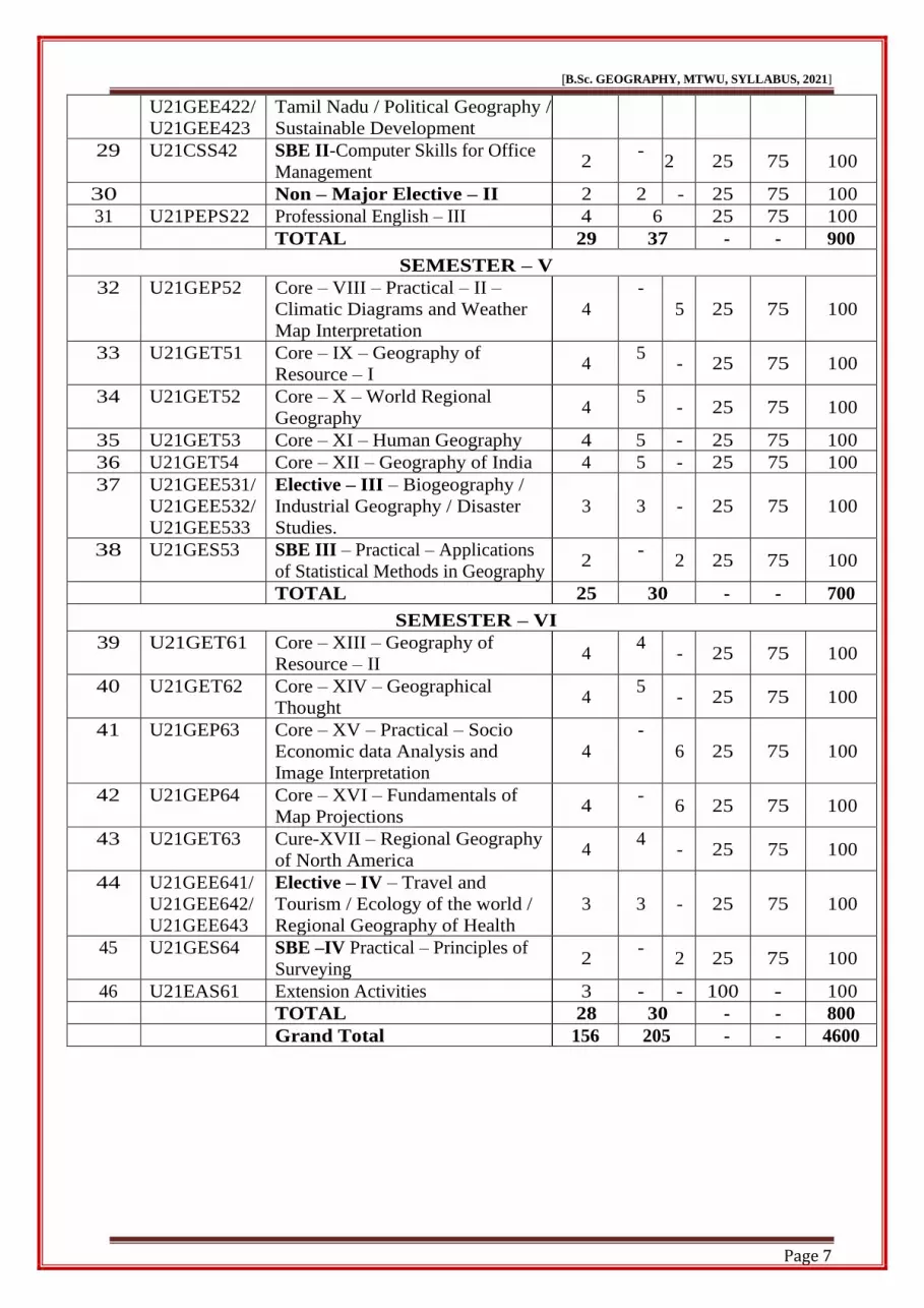
Page 7
[B.Sc. GEOGRAPHY, MTWU, SYLLABUS, 2021]
Page 7
U21GEE422/
U21GEE423
Tamil Nadu / Political Geography /
Sustainable Development
29 U21CSS42 SBE II-Computer Skills for Office
Management 2
- 2 25 75 100
30 Non – Major Elective – II 2 2 - 25 75 100
31 U21PEPS22 Professional English – III 4 6 25 75 100
TOTAL 29 37 - - 900
SEMESTER – V
32 U21GEP52 Core – VIII – Practical – II –
Climatic Diagrams and Weather
Map Interpretation
4
-
5 25 75 100
33 U21GET51 Core – IX – Geography of
Resource – I 4
5 - 25 75 100
34 U21GET52 Core – X – World Regional
Geography 4
5 - 25 75 100
35 U21GET53 Core – XI – Human Geography 4 5 - 25 75 100
36 U21GET54 Core – XII – Geography of India 4 5 - 25 75 100
37 U21GEE531/
U21GEE532/
U21GEE533
Elective – III – Biogeography /
Industrial Geography / Disaster
Studies.
3
3 - 25 75 100
38 U21GES53 SBE III – Practical – Applications
of Statistical Methods in Geography 2
- 2 25 75 100
TOTAL 25 30 - - 700
SEMESTER – VI
39 U21GET61 Core – XIII – Geography of
Resource – II 4
4 - 25 75 100
40 U21GET62 Core – XIV – Geographical
Thought 4
5 - 25 75 100
41 U21GEP63 Core – XV – Practical – Socio
Economic data Analysis and
Image Interpretation
4
-
6 25 75 100
42 U21GEP64 Core – XVI – Fundamentals of
Map Projections 4
- 6 25 75 100
43 U21GET63 Cure-XVII – Regional Geography
of North America 4
4 - 25 75 100
44 U21GEE641/
U21GEE642/
U21GEE643
Elective – IV – Travel and
Tourism / Ecology of the world /
Regional Geography of Health
3
3 - 25 75 100
45 U21GES64 SBE –IV Practical – Principles of
Surveying 2
- 2 25 75 100
46 U21EAS61 Extension Activities 3 - - 100 - 100
TOTAL 28 30 - - 800
Grand Total 156 205 - - 4600
Page 8
[B.Sc. GEOGRAPHY, MTWU, SYLLABUS, 2021]
Page 8
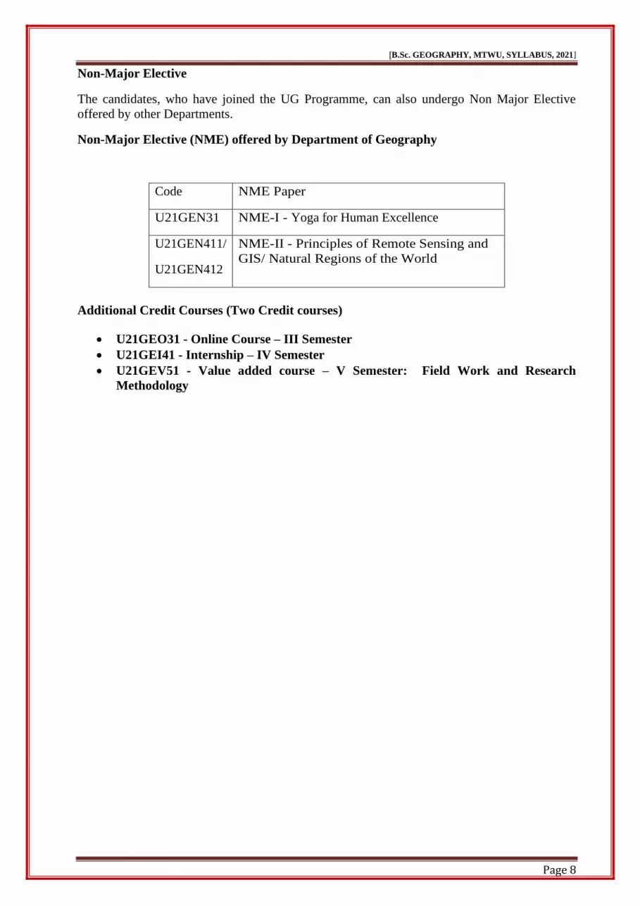
Non-Major Elective
The candidates, who have joined the UG Programme, can also undergo Non Major Elective
offered by other Departments.
Non-Major Elective (NME) offered by Department of Geography
Code NME Paper
U21GEN31 NME-I - Yoga for Human Excellence
U21GEN411/
U21GEN412
NME-II - Principles of Remote Sensing and
GIS/ Natural Regions of the World
Additional Credit Courses (Two Credit courses)
• U21GEO31 - Online Course – III Semester
• U21GEI41 - Internship – IV Semester
• U21GEV51 - Value added course – V Semester: Field Work and Research
Methodology
Page 9
[B.Sc. GEOGRAPHY, MTWU, SYLLABUS, 2021]
Page 9
SEMESTER – I
COURSE
CODE
U21GET11 GEOMORPHOLOGY–I
L T P C
CORE -I 5 - - 4
LEARNING OBJECTIVES
• Students will understand the concept of place and how it is connected to people's sense of
belonging to the physical environment, landscape and culture.
• The students will have a basic knowledge about the premises of origin of the solar system
and the earth.
• Students can acquire an overall knowledge regarding the various processes and forms that
operate in our physical environment, it may include river processes, mountain building
processes, theories related to plate tectonics, mass balance, dynamics, hydrology,
earthquakes, etc.
• Describing human-environment and nature-society interactions as well as global human
and environmental issues.
• Identifying and explaining the planet’s human and physical characteristics and processes,
from global to local scales.
UNIT I THEORIES AND PROCESSES:
Definition of geomorphology – Origin of the earth – Gaseous Hypothesis of
Immanuel Kant – Nebular theory of Laplace – Tidal hypothesis of James Jeans
and Modification by Jeffrey – Binary star theory of Russell – Structure of the
earth’s interior – Crust – mantle – core – Rocks – classification of rocks –
igneous, sedimentary and metamorphic rocks.
UNIT II EARTH MOVEMENTS:
Endogenetic forces – sudden forces and movements – diastrophic forces and
movements – epeirogenetic movements – orogenetic movements – folds – faults
– rift valleys – exogenetic forces.
UNIT III ENDOGENIC PROCESS AND DRIFT THEORY:
Volcanoes – components of volcanoes – classification of volcanoes – volcanic
materials – world distribution of volcanoes – hazardous effects of volcanism –
earthquakes – causes of earthquakes – types and world distribution distribution–
hazardous effects of earthquake – Wegner’s Continental drift theory – Isostasy.
UNIT IV MAJOR LANDFORMS:
Mountains – classification – plateaus – classification – plains – classification.
UNIT V GEOMORPHIC PROCESSES:
Weathering – Meaning – controlling factors – types – physical – chemical and
biological weathering – geomorphic importance of weathering – mass movement
– concept – classification – resultant features – Soil – formation of soil –
characteristics, types and distribution – soil profile.
Page 10
[B.Sc. GEOGRAPHY, MTWU, SYLLABUS, 2021]
Page 10
TEXT BOOKS:
1. Dayal, P., A Text book Geomorphology, Shukla Book Depot, Patna, India, 1990
2. Thornbury, W. D. Principles of Geomorphology, John Wiley and Sons, New York, I960
3. Kale, V. S. and Gupta, A. Introduction to Geomorphology, Orient Longman, Calcutta,
2010
4. Singh, Savindra, Geomorphology, PrayagPustakBhawan, Allahabad, 2002.
REFERENCE BOOKS:
1. Balbir Singh Negi, Physical Geography, S.J Publications Meerut, 1993
2. Das Gupta, A., and Kapoor, A.N, Principles of Physical Geography, S.C. Chand &
Company Ltd, 2001.
3. Lobeck. A.K., An Introduction to the study of Landscapes, McGraw –Hill Book company,
1939
4. Thorn Bury.D., - Principles of Geomorphology, Wiley Eastern Ltd, New Delhi, 1984
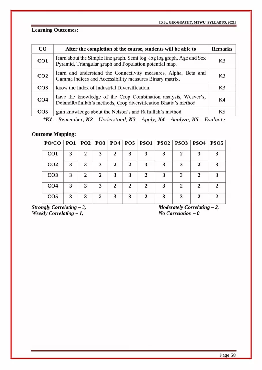
Learning Outcomes:
CO After the completion of the course, students will be able to Remarks
CO1 acquired knowledge about the relationship of physical geography with
other branches of earth science and divisions of physical geography. K2
CO2 understand an overview of the structure of the earth, origin, composition
and interior of the earth. K2
CO3 have basic concepts about relief features of plateaus, hills, foothills,
valleys, plains and flood plains. K2
CO4 understand the endogenic and exogenetic movements of the earth. K2
CO5 learn about the effects of hazardous K4
*K1 – Remember, K2 – Understand, K3 – Apply, K4 – Analyze, K5 – Evaluate
Outcome Mapping:
PO/CO PO1 PO2 PO3 PO4 PO5 PSO1 PSO2 PSO3 PSO4 PSO5
CO1 3 3 3 2 3 3 3 2 2 2
CO2 3 3 3 3 3 3 3 3 2 2
CO3 3 2 3 3 2 3 3 3 2 2
CO4 3 2 3 2 2 2 3 3 2 2
CO5 3 3 3 3 2 2 3 3 2 2
Strongly Correlating – 3, Moderately Correlating – 2,
Weekly Correlating – 1, No Correlation – 0
Page 11
[B.Sc. GEOGRAPHY, MTWU, SYLLABUS, 2021]
Page 11
COURSE
CODE
U21GEP11 FUNDAMENTALS OF
MAPMAKINGAND RELIEF
REPRESENTATION
L T P C
CORE -II - - 6 4
Learning Objectives
• Explaining of scales, type, construction of plain scales and comparative and diagonal
scales
• Calculating the basic map the refusing triangle method and enlarging and reduction with
instrument.
• Identifying the map direction and hearing measurements of distance-using thread and
Rotometer.
• Describing the measurement of area by square, linear and plain meter methods.
• Explaining the Contours, contour interval and representation of relief features by contours.
UNIT I Scales
Definition – types – conversion of scales – construction of Palin scales –
comparative and diagonal scales – time scale.
UNIT II ENLARGEMENT AND REDUCTION METHOD:
Enlargement and reduction by square – similar triangle method – Enlargement
and reduction with instruments.
UNIT III DIRECTIONS AND BEARINGS:
Map direction and bearing – Measurements of Distance – using Thread, Divider
and Rotometer.
UNIT IV MEASUREMENT OF AREA:
Measurement of area by square, linear and by planimeter methods.
UNIT V RELIEF FEATURES:
Representation of relief features by hachures – hill shading – layer tinting – spot
heights – and bench marks – Contours – contour interval – gradient –
representation of relief features by contours.
TEXT BOOKS:
1. Gopal Singh, Map Work and Practical Geography, (4th Edition), Vikas
Publishing House, Ahmedabad, 1998
2. Zamir Alvi, A Text Book of Practical Geography, Vikas Publishing house
Pvt ltd,1994
3. Zulfequar Ahmad Khan.M.D., Text book of Practical Geography, Concept
Publishing Company, NewDelhi,1998.
4. Singh R.L & Rana P.B. Singh, Elements of Practical geography, Kalyani,
Publishers, 2005.
5. Siya Ram Sharma, Practical Geography, Murali Lal& Sons Pvt.Ltd, 2008
Page 12
[B.Sc. GEOGRAPHY, MTWU, SYLLABUS, 2021]
Page 12
REFERENCE BOOKS:
1. F.J.Monkhouse and H.RWilkinson, Maps and Diagrams, B.I.Publications,
Madras, 1952
2. V.P.Subrahmanyam and Subramaniam,A.R. Application of water balance
concept for aclimatic study of droughts in south India,1964
3. M.D.Zulfequar Ahamad Khan, Text Book of Practical Geography, Concept
Publishing Company, New Delhi, 1998.
Learning Outcomes:
CO After the completion of the course, students will be able to Remarks
CO1 get basic knowledge of scales and measurements. K2
CO2 understand and knowledge use of instruments. K3
CO3 learn practically explain the rotometer. K3
CO4 know how to measurement of area by square and plain meters methods. K4
CO5 acquiring knowledge about the base level of the features of the maps. K5
*K1 – Remember, K2 – Understand, K3 – Apply, K4 – Analyze, K5 – Evaluate
Outcome Mapping:
PO/CO PO1 PO2 PO3 PO4 PO5 PSO1 PSO2 PSO3 PSO4 PSO5
CO1 3 3 3 2 3 3 3 2 2 3
CO2 3 3 3 3 3 3 3 3 2 3
CO3 3 2 3 3 3 2 3 3 2 3
CO4 3 2 3 2 3 2 3 3 2 3
CO5 3 3 3 3 3 2 3 3 2 3
Strongly Correlating – 3, Moderately Correlating – 2,
Weekly Correlating – 1, No Correlation – 0
Page 13
[B.Sc. GEOGRAPHY, MTWU, SYLLABUS, 2021]
Page 13
SEMESTER – II
COURSE
CODE
U21GET21 GEOMORPHOLOGY – II
L T P C
CORE -III 5 - - 4
LEARNING OBJECTIVES:
❖ The course will provide an understanding of the conceptual and dynamic aspects of
landform development.
❖ Students will be able to read and interpret information on different types of physical feature
maps.
❖ Showing an awareness and responsibility for the environment.
❖ Students will be evaluating the fundamental models of cycle of erosion and function of the
river and its landforms development process.
❖ Students will be evaluating the importance of fundamental geomorphic principles and
finding to the wider academic community.
UNIT I PROCESSESOF RIVER:
Drainage systems – sequent – insequent – drainage patterns - Work of running
water (river) – types of fluvial erosion – erosional landforms – transportational
work of rivers – depositional landforms – river development stages – river
capture – Normal cycle of erosion by Davis.
UNIT II GLACIAL PROCESSES:
Types and movement of glacier – Erosional work of glacier – Depositional
landforms of glacier.
UNIT III WORK OF WIND:
Erosional work of wind and erosional landforms –transportational work –
depositional landforms in arid regions.
UNIT IV PROCESSESOF UNDERGROUND WATER:
Underground water and karst topography – Geomorphic work of groundwater –
erosional landforms developed in limestone regions – depositional landforms of
karst region.
UNIT V WORK OF WAVES:
Agents of coastal erosion – erosional land forms –transportational work –
depositional landforms in arid regions – coast – Johnson’s classification of coast.
TEXT BOOKS:
1. Dayal, P., A Text book Geomorphology, Shukla Book Depot, Patna, India, 1990
2. Pitty,A.F., The Nature of Geomorphology, Methuen and Co. Ltd., London, 1982
3. Thornbury, W. D. Principles of Geomorphology, John Wiley and Sons, New York, I960
4. Singh, Savindra, Geomorphology, Prayag Pustak Bhawan, Allahabad, 2002
Page 14
[B.Sc. GEOGRAPHY, MTWU, SYLLABUS, 2021]
Page 14
REFERENCE BOOKS:
1. Balbir Singh Negi, Physical Geography, S.J Publications Meerut, 1993
2. Das Gupta, A., and Kapoor, A.N, Principles of Physical Geography, S.C. Chand &
Company Ltd, 2001
3. Lobeck. A.K., An Introduction to the study of Landscapes, McGraw –Hill Book company,
1939.
4. Thorn Bury.D., - Principles of Geomorphology, Wiley Eastern Ltd, New Delhi, 1984
Learning Outcomes:
CO After the completion of the course, students will be able to Remarks
CO1 geomorphology produces an outcome, indicating that students should be
able to work out a geomorphic process. K2
CO2 have acquired knowledge about the development of the earth's crust and
methods of development of the major landforms. K2
CO3 understand the processes by which transportation of earth material occurs
through fluvial and gravitational processes. K2
CO4 determine the physical, chemical and biological processes controlling the
modern evolution of identified landforms. K4
CO5
know about the formation of the earth’s surface features, the role played
by humans in changing the landscape and the significance of landforms
in shaping the physical environment in an area.
K5
*K1 – Remember, K2 – Understand, K3 – Apply, K4 – Analyze, K5 – Evaluate
Outcome Mapping:
PO/CO PO1 PO2 PO3 PO4 PO5 PSO1 PSO2 PSO3 PSO4 PSO5
CO1 3 3 3 2 3 3 3 2 2 2
CO2 3 3 3 3 3 3 3 3 2 2
CO3 3 3 3 3 2 3 3 3 2 2
CO4 3 3 3 2 2 2 3 3 2 2
CO5 3 3 3 3 3 2 3 3 2 2
Strongly Correlating – 3, Moderately Correlating – 2,
Weekly Correlating – 1, No Correlation – 0
Page 15
[B.Sc. GEOGRAPHY, MTWU, SYLLABUS, 2021]
Page 15
COURSE
CODE
U21GET22 CARTOGRAPHY
L T P C
CORE -IV 5 - - 4
LEARNING OBJECTIVES:
• Students can able to understand the general classification of maps and their importance with
relevant cartographic technique.
• Students will be able to think the position of earth and their dimensions using with
geographic coordinate principles.
• Students can acquire knowledge of various map scales and the earth drawing projections.
• Students will be able to apply the map generalization layout principles with reference to
SOI and NATMO.
• Understanding the techniques of constructing different types of cartographic symbols
representing various geographical data
UNIT I INTRODUCTION:
Nature, scope and content of cartography – maps – classification and uses –
development of cartography – branches in cartography.
UNIT II TOPOGRAPHICAL MAP:
Earth as a cartographic problem – shape, size and direction – dimension of the
earth – plane, spherical and rectangular systems – latitudes, longitudes and time.
UNIT III SCALES AND PROJECTIONS:
Map scale – types of scale – enlargement and reduction – map projection – basic
principles of cylindrical, conical and zenithal projections.
UNIT IV PROCESSES OF MAP MAKING:
Principles of map generalization – map design and layout – components of
layout – map index with reference to SOI and NATMO maps.
UNIT V MAP SYMBOLIZATION:
Point, line and area symbols – qualitative and quantitative symbols.
TEXT BOOKS:
1. Robinson Arthur H et.al, Elements of Cartography, 6th edition, Wiley India pvt.
Ltd, 2010
2. Misra.R.P and A.Ramesh, Fundamentals of cartography, Concept Publishing
Company, NewDelhi,2000.
3. Erwin and Raisz, Principles of cartography, McGraw Hill book company,
1962.
REFERENCE BOOKS:
1. Robinson.H., Elements of Cartography, John Wiley and Son INC, 1960
2. Rampal K K, Mapping and Compilation, Concept Publishing Company, New
Delhi, 1993.
3. Monhouse, Map and diagrams, Methuan,1971
4. RL Singh, Elements of practical geography, Students to friends, Allahabad,1968.
Page 16
[B.Sc. GEOGRAPHY, MTWU, SYLLABUS, 2021]
Page 16
Learning Outcomes:
CO After the completion of the course, students will be able to Remarks
CO1 get the knowledge about the relationship of cartography with other
branches of earth science and disciplines of geography. K2
CO2 identify the earth’s dimensions relating the cartographic problems and
their geographic coordinate system. K2
CO3 evaluate the techniques of scales and suitable projections of different
maps. K3
CO4 understand the various map components with help of SOI and NATMO. K4
CO5 get the capacity of map making with suitable cartographic symbols K5
*K1 – Remember, K2 – Understand, K3 – Apply, K4 – Analyze, K5 – Evaluate
Outcome Mapping:
PO/CO PO1 PO2 PO3 PO4 PO5 PSO1 PSO2 PSO3 PSO4 PSO5
CO1 3 3 3 2 3 2 2 3 2 2
CO2 3 3 3 3 3 2 2 3 2 2
CO3 3 2 3 3 2 2 3 3 3 2
CO4 3 2 3 2 2 3 3 3 3 2
CO5 3 3 3 3 2 3 2 3 2 2
Strongly Correlating – 3, Moderately Correlating – 2,
Weekly Correlating – 1, No Correlation – 0
Page 17
[B.Sc. GEOGRAPHY, MTWU, SYLLABUS, 2021]
Page 17
SEMESTER – III
COURSE
CODE
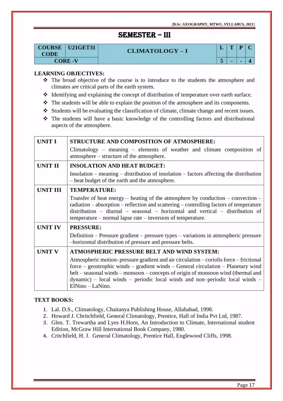
U21GET31 CLIMATOLOGY – I
L T P C
CORE -V 5 - - 4
LEARNING OBJECTIVES:
❖ The broad objective of the course is to introduce to the students the atmosphere and
climates are critical parts of the earth system.
❖ Identifying and explaining the concept of distribution of temperature over earth surface.
❖ The students will be able to explain the position of the atmosphere and its components.
❖ Students will be evaluating the classification of climate, climate change and recent issues.
❖ The students will have a basic knowledge of the controlling factors and distributional
aspects of the atmosphere.
UNIT I STRUCTURE AND COMPOSITION OF ATMOSPHERE:
Climatology – meaning – elements of weather and climate composition of
atmosphere – structure of the atmosphere.
UNIT II INSOLATION AND HEAT BUDGET:
Insolation – meaning – distribution of insolation – factors affecting the distribution
– heat budget of the earth and the atmosphere.
UNIT III TEMPERATURE:
Transfer of heat energy – heating of the atmosphere by conduction – convection –
radiation – absorption – reflection and scattering – controlling factors of temperature
distribution – diurnal – seasonal – horizontal and vertical – distribution of
temperature – normal lapse rate – inversion of temperature.
UNIT IV PRESSURE:
Definition – Pressure gradient – pressure types – variations in atmospheric pressure
–horizontal distribution of pressure and pressure belts.
UNIT V ATMOSPHERIC PRESSURE BELT AND WIND SYSTEM:
Atmospheric motion- pressure gradient and air circulation – coriolis force – frictional
force – geostrophic winds – gradient winds – General circulation – Planetary wind
belt – seasonal winds – monsoon – concepts of origin of monsoon wind (thermal and
dynamic) – local winds – periodic local winds and non–periodic local winds –
ElNino – LaNino.
TEXT BOOKS:
1. Lal. D.S., Climatology, Chaitanya Publishing House, Allahabad, 1998.
2. Howard J. Chritchfield, General Climatology, Prentice, Hall of India Pvt Ltd, 1987.
3. Glen. T. Trewartha and Lyes H.Horn, An Introduction to Climate, International student
Edition, McGraw Hill International Book Company, 1980.
4. Critchfield, H. J. General Climatology, Prentice Hall, Englewood Cliffs, 1998.
Page 18
[B.Sc. GEOGRAPHY, MTWU, SYLLABUS, 2021]
Page 18
REFERENCE BOOKS:
1. Trewartha, G.T., An Introduction to Climate, McGraw Hill Book Co., New York, 1968.
2. Woolridge and Morgan, Physical basis of Geography, Palala Press Indian Edition, 2015.
3. Ayoade, J.O. Introduction to Climatology for the Tropics, John Wiley and Sons Ltd., New
York, 1983.
Learning Outcomes:
CO After the completion of the course, students will be able to Remarks
CO1 understand the composition and structure of the atmosphere. K2
CO2 explain the position of weather phenomena, winds, humidity,
precipitation and heat budget. K2
CO3 understand the elements and processes of climates, different climatic
types and climate change. K2
CO4 understood the mean global atmospheric circulations and disturbances,
world climate systems, climatic variability and change. K4
CO5 identify of climatic differentiation and the consequences of human
activities. K4
*K1 – Remember, K2 – Understand, K3 – Apply, K4 – Analyze, K5 – Evaluate
Outcome Mapping:
PO/CO PO1 PO2 PO3 PO4 PO5 PSO1 PSO2 PSO3 PSO4 PSO5
CO1 3 3 3 2 3 3 2 2 2 2
CO2 3 3 3 3 3 3 2 3 2 2
CO3 3 2 3 3 3 2 2 3 2 2
CO4 3 2 3 2 2 2 3 3 2 2
CO5 3 3 3 3 3 3 3 3 2 2
Strongly Correlating – 3, Moderately Correlating – 2,
Weekly Correlating – 1, No Correlation – 0
Page 19
[B.Sc. GEOGRAPHY, MTWU, SYLLABUS, 2021]
Page 19
COURSE
CODE
U21GEE311 CHOICE - I
L T P C
ELECTIVE - I BASICS OF REMOTE SENSING AND GIS 4 - - 3
LEARNING OBJECTIVES:
❖ The aim of this course is to introduce students to the interface of Remote Sensing and GIS
❖ Also introduce about to various aspects of Aerial photographs.
❖ It will teach about the important elements of the Geospatial technology.
❖ To develop new insights among students on the relevance of geospatial studies within the
field of geography.
❖ It gives the technical knowledge of satellite system.
UNIT I INTRODUCTION:
Principles of remote sensing – History
UNIT II REMOTE SENSING:
EMR – Electromagnetic spectrum – energy interactions with atmosphere and
earth surface features – platforms – types of remotely sensed data.
UNIT III AERIAL PHOTOGRAPHS:
Types, elements and uses of aerial photographs – photogrammetry.
UNIT IV SATELLITE REMOTE SENSING:
Satellite imagery – Sensors – Multi spectral – Landsat – Thematic Mapper –
LISS – Comparison of maps with aerial photographs and satellite imageries.
UNIT V INTRODUCTION OF GIS:
Definition – history – components – DBMS – Geographic Database – Hardware
and Software – Use of GIS – raster and vector – GPS – history – segments.
TEXT BOOKS:
1. Campbell J. B., Introduction to Remote Sensing, Guildford Press, 2007.
2. Jensen J. R., Introductory Digital Image Processing: A Remote Sensing Perspective,
Prentice Hall, 2004.
3. Joseph, G. Fundamentals of Remote Sensing, United Press India, 2005.
4. Nag P. and Kudra, M., Digital Remote Sensing, Concept, New Delhi, 1998.
5. Rees W. G., Physical Principles of Remote Sensing, Cambridge University Press, 2001.
REFERENCE BOOKS:
1. LanHeywod, Sarah Cornelines, An Introduction to Geographical Information System I
Addison, Wesley, Longman Ltd, 2000.
2. C.S.Agarwal & P.K.Grag, Text Book of Remote Sensing, Wheeler Publishing, 2000.
3. Gampbell James B.I, Introduction to Remote Sensing, The Guild Press, New York, 2017
4. Curran, Fundamentals of Remote Sensing, Longman, London, 2006
5. Lillesend TM & Kiefer R.W, Remote Sensing & Image Interpretation, John Wiley & sons,
Page 20
[B.Sc. GEOGRAPHY, MTWU, SYLLABUS, 2021]
Page 20
New York, 2004.
6. Luedev D.R. Aerial Photographic Interpretation Mc. Graw Hill Company, New York,
2000.
Learning Outcomes:
CO After the completion of the course, students will be able to Remarks
CO1 demonstrate knowledge of the foundations and theories of geographic
information systems (GIS) and use the tools and methods of GIS. K2
CO2
demonstrate their knowledge of physical geography and the methods
and techniques for observing, measuring, recording and reporting on
geographic phenomena.
K2
CO3 demonstrate their competence to work individually and as a team to
develop and present a client-driven GIS solution. K2
CO4 be familiar with modern techniques in Geography. K4
CO5 apply their skills in professional careersfor UGC NET/SLET exams and
other competitive exams including the civil services. K5
*K1 – Remember, K2 – Understand, K3 – Apply, K4 – Analyze, K5 – Evaluate
Outcome Mapping:
PO/CO PO1 PO2 PO3 PO4 PO5 PSO1 PSO2 PSO3 PSO4 PSO5
CO1 3 3 3 2 2 3 3 2 2 2
CO2 3 3 3 3 2 3 3 3 2 2
CO3 3 2 3 3 2 2 3 3 2 2
CO4 3 2 3 2 3 3 3 3 2 2
CO5 3 3 3 3 3 2 3 3 2 2
Strongly Correlating – 3, Moderately Correlating – 2,
Weekly Correlating – 1, No Correlation – 0
Page 21
[B.Sc. GEOGRAPHY, MTWU, SYLLABUS, 2021]
Page 21
COURSE
CODE
U21GEE312 CHOICE - II
L T P C
ELECTIVE - I REGIONAL GEOGRAPHY OF ASIA 4 - - 3
LEARNING OBJECTIVES:
❖ Students should learn about the geographic diversity within South, Southeast and East
Asia
❖ Students understand how human geographers study this region of the world
❖ Write a substantial term project relating to the geography of Asia, exhibiting critical
thinking skills
❖ Students will be expected to gain an appreciation for the inter-relations of Asia’s physical,
cultural, political and economic realms.
❖ To evaluate the essential differences between the various countries, the various sub-
regions, and between realms of Asia and the West.
UNIT I PHYSICAL SETTING:
Geographic Location and Extent – Locational Significance – Physical Divisions;
Climate: Seasonal Pattern of Monsoons – Climatic Regions.
UNIT II DRAINAGE SYSTEM AND NATURAL VEGETATION:
Drainage System –Soil – Natural Vegetation – Types and distribution
UNIT III AGRICULTURE:
Farming Types – Major crops: Rice, Wheat, Cotton, Jute, Tea, Coffee and
Rubber – Recent developments in Agriculture; Fishing – Inland and Marine.
UNIT IV MINERAL RESOURCES & INDUSTRIES:
Distribution and Production of Iron ore, Manganese, Copper, Tin, Gold,
Gypsum and Mica; Industries: Locational Factors – Textiles – Sugar – Iron and
Steel.
UNIT V CONTROLLING FACTORS:
Growth – Distribution and Density, Transport: Roadways –Railways – Airways–
Waterways.
TEXT BOOKS:
1. RanjitTirtha, Geography of Asia, Rawat Publications, Jaipur, 2001.
2. Negai.B.S, The continent of Asia, S.Chand and co. (Pvt) Ltd, New Delhi, 1986.
3. Stamp, L.D. Asia: A Regional and Economic Geography. B.I. Publication Ltd., New
Delhi, 1967.
4. Shafi, M. Geography of South Asia. MacMillan and Co., Kolkata, 2000.
Page 22
[B.Sc. GEOGRAPHY, MTWU, SYLLABUS, 2021]
Page 22
REFERENCE BOOKS:
1. Richard and Chorley, Introduction to Physical Hydrology, Methuen &Co Ltd, 2009.
2. Manning, J.C, Applied Principles of Hydrology, CBS Publishers. New Delhi, 1989.
Learning Outcomes:
CO After the completion of the course, students will be able to Remarks
CO1 know about their land formation, climate and natural vegetation. K2
CO2 understand climatic condition and seasons in Asia. K2
CO3 understand the irrigation and agricultural developments. K2
CO4 understand the economic resources of Asia K2
CO5 evaluating the impacts of human activities on natural environments
special reference to Asia K4
*K1 – Remember, K2 – Understand, K3 – Apply, K4 – Analyze, K5 – Evaluate
Outcome Mapping:
PO/CO PO1 PO2 PO3 PO4 PO5 PSO1 PSO2 PSO3 PSO4 PSO5
CO1 3 3 3 2 3 3 3 2 2 2
CO2 3 3 2 3 3 3 3 3 2 2
CO3 3 2 3 3 3 3 3 3 2 2
CO4 3 2 2 2 3 2 3 3 2 2
CO5 3 3 3 3 3 2 3 3 2 2
Strongly Correlating – 3, Moderately Correlating – 2,
Weekly Correlating – 1, No Correlation – 0
Page 23
[B.Sc. GEOGRAPHY, MTWU, SYLLABUS, 2021]
Page 23
COURSE
CODE
U21GEE313 CHOICE - III
L T P C
ELECTIVE - I CLIMATIC CHANGE:
VULNERABILITY AND ADAPTATION
4 - - 3
LEARNING OBJECTIVES:
❖ To understand the foundational concepts of climate change and its impacts.
❖ To assess the human and environmental vulnerability to climate change.
❖ To learn the various adaptation and mitigation for reducing the impacts of climate change
and national action plan.
❖ Students will be learn about climate change to impact on human health
❖ Explain the National Action Plan on Climate Change
UNIT I SCIENCE OF CLIMATE CHANGE:
Understanding Climate Change; Green House Gases and Global Warming;
Global Climatic Assessment – IPCC
UNIT II CLIMATE CHANGE AND VULNERABILITY:
Physical Vulnerability; Economic Vulnerability; Social Vulnerability
UNIT III IMPACT OF CLIMATE CHANGE:
Agriculture and Water; Flora and Fauna; Human Health
UNIT IV ADAPTATION AND MITIGATION:
Global Initiatives with Particular Reference to South Asia.
UNIT V ACTION PLAN ON CLIMATE CHANGE:
National Action Plan on Climate Change; Local Institutions (Urban Local
Bodies, Panchayats)
TEXT BOOKS:
1. Singh, M., Singh, R.B. and Hassan, M.I. (Eds.) Climate change and biodiversity:
Proceedings of IGUR ohtak Conference, Volume 1, Advances in Geographical and
Environmental Studies, Springer, 2014.
2. Sen Roy,S. and Singh,R.B. Climate Variability, Extreme Events and Agricultural
Productivity in Mountain Regions, Oxford & IBH Pub., New Delhi, 2002.
3. OECD. Climate Change Mitigation: What Do we Do? Organisation and Economic Co-
Operation and Development, 2008.
4. UNEP. Global Environment Outlook: GEO4: Environment for Development, United
Nations Environment Programme, 2007.
REFERENCE BOOKS:
1. IPCC. Climate Change 2007: Impacts, Adaptation and Vulnerability. Contribution of
Working Group II to the Fourth Assessment Report of the Intergovernmental Panel on
Climate Change, 2007.
Page 24
[B.Sc. GEOGRAPHY, MTWU, SYLLABUS, 2021]
Page 24
2. IPCC Climate Change 2014: Impacts, Adaptation, and Vulnerability. Part A: Global and
Sectoral Aspects. Contribution of Working Group II to the Fifth Assessment Report of the
Intergovernmental Panel on Climate Change Cambridge University Press, Cambridge,
United Kingdom and New York, NY, USA, 2014.
Learning Outcomes:
CO After the completion of the course, students will be able to Remarks
CO1 understanding the foundational concepts of climate change and its
impacts K2
CO2 assessing the human and environmental vulnerability to climate
change K3
CO3 learning the various adaptation and mitigation for reducing the impacts
of climate change and national action plan. K2
CO4 have knowledge about climate change to impact on agriculture and
water, flora and fauna and human health K2
CO5 identify the climatic change differentiation and the consequences of
human activities K4
*K1 – Remember, K2 – Understand, K3 – Apply, K4 – Analyze, K5 – Evaluate
Outcome Mapping:
PO/CO PO1 PO2 PO3 PO4 PO5 PSO1 PSO2 PSO3 PSO4 PSO5
CO1 3 3 3 2 3 3 3 2 2 2
CO2 3 3 2 3 3 3 3 3 2 2
CO3 3 3 2 3 2 2 3 3 2 2
CO4 3 3 3 2 2 2 3 3 2 2
CO5 3 3 2 3 3 2 3 3 2 2
Strongly Correlating – 3, Moderately Correlating – 2,
Weekly Correlating – 1, No Correlation – 0
Page 25
[B.Sc. GEOGRAPHY, MTWU, SYLLABUS, 2021]
Page 25
SEMESTER – IV
COURSE
CODE
U21GET41
OCEANOGRAPHY
L T P C
CORE - VI 4 - - 4
LEARNING OBJECTIVES:
• To introduce the students to basic concepts of oceanography and stimulate students interest
and curiosity in the many and varied sciences used in the study of the oceans
• To introduce the students to the basic principles underlying physical processes in the ocean.
• To explain the distribution of sea surface temperature, pressure and salinity
• To explain the main factors that determine surface and deep ocean currents
• To explain the significance of marine resources and conservations.
UNIT I INTRODUCTION OF OCEAN & TOPOGRAPHY:
Oceanography – meaning – scope and branches of oceanography – Distribution
of continents and ocean – Bottom topography of Indian, Atlantic and Pacific
Ocean.
UNIT II OCEANTEMPERATURE & SALINITY:
Temperature – Process of Heating and Cooling – distribution of temperature –
horizontal and vertical – Salinity – Sources – Controlling factors – distribution
of salinity – horizontal and vertical.
UNIT III OCEAN CURRENTS:
Surface Currents – origin - Factors controlling currents – types of currents –
Currents of Indian, Atlantic and Pacific Oceans – Waves and Tides.
UNIT IV MARINE RESOURCES:
Classification – coral reef – conditions of growth types and distribution of coral
reefs.
UNIT V MARINE DEPOSITS:
Sources and types – Classification – Marine Sediments – Distribution of
Sediments.
TEXT BOOKS:
1. Sharma, R.C. and Vatal, M., Oceanography for Geographers, Chaitanya Publishing
House, Allahabad, 1970.
2. Thurman, H.V. and Trujillo, A. P. Introductory Oceanography, Prentice Hall, New Jersey,
1997.
3. Pinet, P.R. Invitation to Oceanography, Jones and Bartlett Publishers, Boston, 2009.
4. Joseph, W.S. and Parish, H.I. Introductory Oceanography, McGraw Hill, Tokyo, 1974.
5. Gross, G.M. Oceanography, Macmillan Publication, New York, 1990.
Page 26
[B.Sc. GEOGRAPHY, MTWU, SYLLABUS, 2021]
Page 26
REFERENCE BOOKS:
1. Christopherson, R. W. and Birkeland, G. H. Geosystems: An Introduction to Physical,
Geography (8thEdition), Pearson Education, New Jersey, 2012.
2. Strahler, A.H. and Strahler, A.N. Modern Physical Geography (4/E), John Wiley and
Sons, Inc., New York, 2001.
3. 4. Khullar, D.R. Physical Geography, Kalyani Publishers, New Delhi, 2012.
4. Das Gupta. A. and Kapoor, A.N. Principles of Physical Geography, S.C. Chand and
Company Ltd. New Delhi, 2001.
Learning Outcomes:
CO After the completion of the course, students will be able to Remarks
CO1 acquaint themselves with nature and scope of oceanography and
distribution pattern of land, sea and oceans. K2
CO2 have knowledge about specific concepts of oceanography into a
multidisciplinary analysis of the Earth K2
CO3 have knowledge about ocean resources, their types and distribution and
their influences upon mankind. K2
CO4
be learning about the principles involved in the generation of waves and
tides and evaluate their effects on coastal processes and marine
ecosystems.
K4
CO5
learning about how the oceans are connected to and drive major earth
processes, such as atmospheric and oceanic circulation, climate and
weather, plate tectonics, marine resources and sustainability of humans.
K2
*K1 – Remember, K2 – Understand, K3 – Apply, K4 – Analyze, K5 – Evaluate
Outcome Mapping:
PO/CO PO1 PO2 PO3 PO4 PO5 PSO1 PSO2 PSO3 PSO4 PSO5
CO1 3 3 3 3 3 3 3 2 2 2
CO2 3 3 2 3 2 3 3 3 2 2
CO3 3 3 2 3 3 3 3 3 2 2
CO4 3 3 3 2 2 3 3 3 2 2
CO5 3 2 3 3 2 3 3 3 2 2
Strongly Correlating – 3, Moderately Correlating – 2,
Weekly Correlating – 1, No Correlation – 0
Page 27
[B.Sc. GEOGRAPHY, MTWU, SYLLABUS, 2021]
Page 27
COURSE
CODE
U21GET42
CLIMATOLOGY – II
L T P C
CORE - VII 4 - - 4
LEARNING OBJECTIVES:
❖ To understand the dynamics of the atmosphere, the ocean and the overall
climatologically system.
❖ Students can acquire an overall knowledge about elements and factors influencing
climate.
❖ Students will be able to understand the process of weather and climate, Climate
Change & global warming.
❖ Students shall get to know about the different climatic systems found in the world.
❖ Examine the significance of air masses and associate their relationships and also
human influence on climate.
UNIT I HUMIDITY:
Water vapor – evaporation – latent heat - types of humidity – measurement of
humidity – Evaporation – evapotranspiration – Condensation – forms of
condensation - fog- classification of fogs.
UNIT II CLOUDS:
Classification and characteristic features of Clouds – Precipitations – forms –
types and distribution of precipitation.
UNIT III ATMOSPHERIC CIRCULATION:
Air mass – characteristics – source region – classification of air masses – fronts
– concepts – classification – cyclones – origin and distribution of tropical and
temperate cyclones – anti cyclones – thunderstorms- tornado – Jet streams.
UNIT IV CLIMATIC CLASSIFICATION:
Koppen’s and Thronth waite’s classifications.
UNIT V WEATHER FORECASTING:
Meaning and importance – procedures for forecasting – tools in weather
forecasting – types of weather forecasting – benefits of weather forecasting.
TEXT BOOKS:
1. Lal. D.S., Climatology, Chaitanya Publishing House, Allahabad, 1998
2. Howard J. Chritchfield, General Climatology, Prentice, Hall of India Pvt Ltd, 1987
3. Glen. T. Trewartha and Lyes H.Horn, An Introduction to Climate, International student
Edition, McGraw Hill International Book Company, 1980.
4. Critchfield, H. J. General Climatology, Prentice Hall, Englewood Cliffs, 1998
5. Smith, K., Principles of Applied Climatology, McGraw Hill Book Co., London, 1975.
Page 28
[B.Sc. GEOGRAPHY, MTWU, SYLLABUS, 2021]
Page 28
REFERENCE BOOKS:
1. Trewartha, G.T., An Introduction to Climate, McGraw Hill Book Co., New York, 1968.
2. Woolridge and Morgan, Physical basis of Geography, Palala Press Indian Edition, 2015.
3. Ayoade, J.O. Introduction to Climatology for the Tropics, John Wiley and Sons Ltd., New
York, 1983.
Learning Outcomes:
CO After the completion of the course, students will be able to Remarks
CO1 have basic concepts about the structure and composition of the
atmosphere and the elements of the hydrological cycle. K2
CO2
learn how atmosphere and climate are a critical part of the earth system
and climatic variability and change are central to the issue of current
and future global environmental change.
K2
CO3 understand the physical basis of the natural greenhouse effect,
including the meaning of the term radioactive forcing. K2
CO4 apply the knowledge about the process of weather and climate,
Climate Change & global warming through human activities. K4
CO5 develop a scientific understanding of climates and their characteristics. K2
*K1 – Remember, K2 – Understand, K3 – Apply, K4 – Analyze, K5 – Evaluate
Outcome Mapping:
PO/CO PO1 PO2 PO3 PO4 PO5 PSO1 PSO2 PSO3 PSO4 PSO5
CO1 3 3 3 2 3 2 3 2 2 2
CO2 3 3 3 3 3 2 3 3 2 2
CO3 3 2 3 3 2 2 3 3 2 3
CO4 3 2 3 2 2 2 3 3 2 3
CO5 3 3 3 3 2 2 3 3 2 2
Strongly Correlating – 3, Moderately Correlating – 2,
Weekly Correlating – 1, No Correlation – 0
Page 29
[B.Sc. GEOGRAPHY, MTWU, SYLLABUS, 2021]
Page 29
COURSE
CODE
U21GEE421 CHOICE - I
L T P C
ELECTIVE - II GEOGRAPHY OF TAMILNADU 3 - - 3
Learning Objectives:
❖ To understanding the general idea of location and physical aspects of Tamil Nadu State
❖ To learn the status of water and their irrigation types with their usage
❖ Students will be able to identify the different crop types and cultivating regions
❖ Students can acquire knowledge of different types of minerals with their relationship of
industries
❖ Students will have a general understanding of human population patterns and various
influencing factors.
UNIT I PHYSICAL SETTINGS:
Location – relief – Drainage – Climate – soil and Natural Vegetation.
UNIT II IRRIGATION AND RIVER VALLEY PROJECTS:
Irrigation types – multipurpose projects
UNIT III AGRICULTURE:
Rice – Cotton – Sugarcane – Coffee Tea – Agricultural regions.
UNIT IV RESOURCES&MAJOR INDUSTRIES:
Minerals – Iron– Coal – Bauxite; Industries – textile Industries – sugar Industry
– cement Industry – Industrial regions.
UNIT V POPULATION:
Growth, distribution, density and problems; Transport and Trade.
TEXT BOOKS:
1. R.L.Singh, India Regional Geography –VBS publishers and Distributors Ltd.,
New Delhi, 1995.
2. Dr.A.Ramesh and P.S. Tiwari, Basic Resource Atlas Tamil Nadu, University
of Madras, 1983
3. Poduval R.N, Food grain Economy of Tamil Nadu Problems and Prospects,
Emerald Publishers, Chennai, 1987.
4. Spate, O.H.K. and Learmonth, A.T.A. India and Pakistan: A General and
Regional Geography, Methuen Publications, London, 1967.
REFERENCE BOOKS:
1. Velappan D, Economic Development of Tamil Nadu, Emerald Publishers,
Chennai,1986.
2. Ranjet Tirtha & Gopala Krishnan, Geography of India, Rawat Publications,
Jaipur, 1996.
3. Prithvish Nag & Smitha Sengupta, Geography of India, Concept publishing
Page 30
[B.Sc. GEOGRAPHY, MTWU, SYLLABUS, 2021]
Page 30
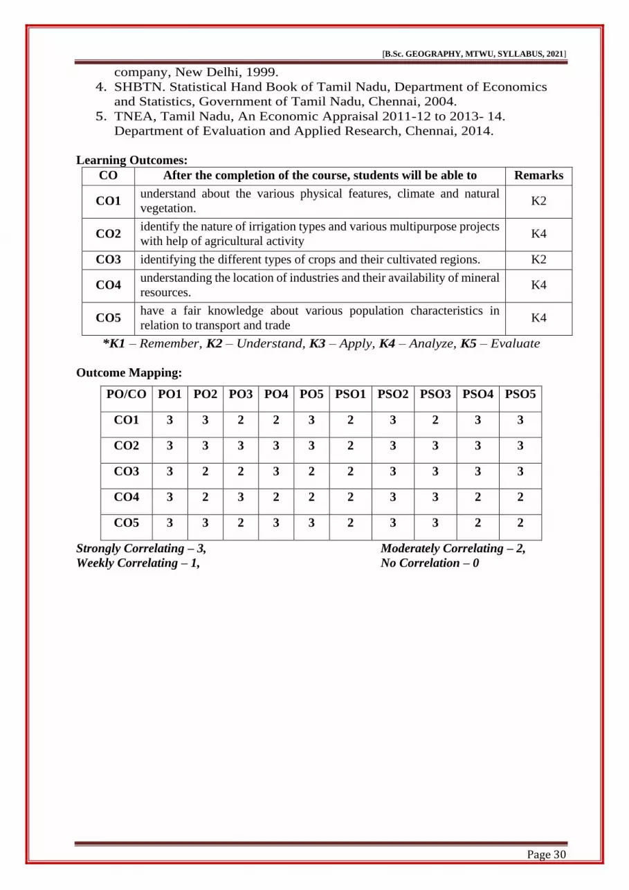
company, New Delhi, 1999.
4. SHBTN. Statistical Hand Book of Tamil Nadu, Department of Economics
and Statistics, Government of Tamil Nadu, Chennai, 2004.
5. TNEA, Tamil Nadu, An Economic Appraisal 2011-12 to 2013- 14.
Department of Evaluation and Applied Research, Chennai, 2014.
Learning Outcomes:
CO After the completion of the course, students will be able to Remarks
CO1 understand about the various physical features, climate and natural
vegetation. K2
CO2 identify the nature of irrigation types and various multipurpose projects
with help of agricultural activity K4
CO3 identifying the different types of crops and their cultivated regions. K2
CO4 understanding the location of industries and their availability of mineral
resources. K4
CO5 have a fair knowledge about various population characteristics in
relation to transport and trade K4
*K1 – Remember, K2 – Understand, K3 – Apply, K4 – Analyze, K5 – Evaluate
Outcome Mapping:
PO/CO PO1 PO2 PO3 PO4 PO5 PSO1 PSO2 PSO3 PSO4 PSO5
CO1 3 3 2 2 3 2 3 2 3 3
CO2 3 3 3 3 3 2 3 3 3 3
CO3 3 2 2 3 2 2 3 3 3 3
CO4 3 2 3 2 2 2 3 3 2 2
CO5 3 3 2 3 3 2 3 3 2 2
Strongly Correlating – 3, Moderately Correlating – 2,
Weekly Correlating – 1, No Correlation – 0
Page 31
[B.Sc. GEOGRAPHY, MTWU, SYLLABUS, 2021]
Page 31
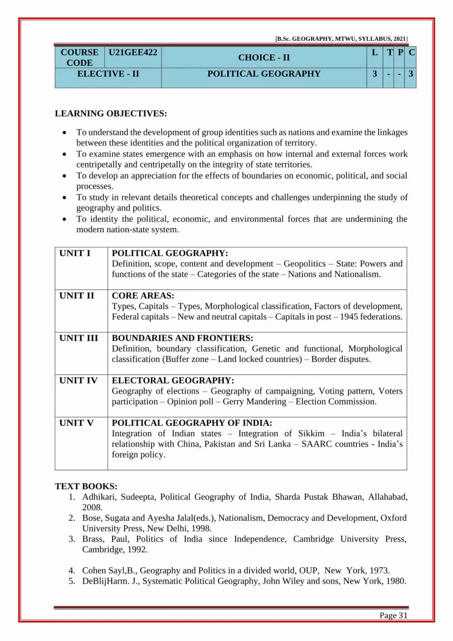
COURSE
CODE
U21GEE422 CHOICE - II
L T P C
ELECTIVE - II POLITICAL GEOGRAPHY 3 - - 3
LEARNING OBJECTIVES:
• To understand the development of group identities such as nations and examine the linkages
between these identities and the political organization of territory.
• To examine states emergence with an emphasis on how internal and external forces work
centripetally and centripetally on the integrity of state territories.
• To develop an appreciation for the effects of boundaries on economic, political, and social
processes.
• To study in relevant details theoretical concepts and challenges underpinning the study of
geography and politics.
• To identity the political, economic, and environmental forces that are undermining the
modern nation-state system.
UNIT I POLITICAL GEOGRAPHY:
Definition, scope, content and development – Geopolitics – State: Powers and
functions of the state – Categories of the state – Nations and Nationalism.
UNIT II CORE AREAS:
Types, Capitals – Types, Morphological classification, Factors of development,
Federal capitals – New and neutral capitals – Capitals in post – 1945 federations.
UNIT III BOUNDARIES AND FRONTIERS:
Definition, boundary classification, Genetic and functional, Morphological
classification (Buffer zone – Land locked countries) – Border disputes.
UNIT IV ELECTORAL GEOGRAPHY:
Geography of elections – Geography of campaigning, Voting pattern, Voters
participation – Opinion poll – Gerry Mandering – Election Commission.
UNIT V POLITICAL GEOGRAPHY OF INDIA:
Integration of Indian states – Integration of Sikkim – India’s bilateral
relationship with China, Pakistan and Sri Lanka – SAARC countries - India’s
foreign policy.
TEXT BOOKS:
1. Adhikari, Sudeepta, Political Geography of India, Sharda Pustak Bhawan, Allahabad,
2008.
2. Bose, Sugata and Ayesha Jalal(eds.), Nationalism, Democracy and Development, Oxford
University Press, New Delhi, 1998.
3. Brass, Paul, Politics of India since Independence, Cambridge University Press,
Cambridge, 1992.
4. Cohen Sayl,B., Geography and Politics in a divided world, OUP, New York, 1973.
5. DeBlijHarm. J., Systematic Political Geography, John Wiley and sons, New York, 1980.
Page 32
[B.Sc. GEOGRAPHY, MTWU, SYLLABUS, 2021]
Page 32
REFERENCE BOOKS:
1. Dikshit, R.D., Political Geography of Federalism: An Inquiry into Origins and Stability,
Macmillan publication, New Delhi, 1975.
2. Dikshit. R.D., Political Geography: A contemporary perspective, Mc Graw Hill
Publishing co., New Delhi, 1982.
3. Muir.R., Modern Political Geography, Macmillan, London, 1981.
Learning Outcomes:
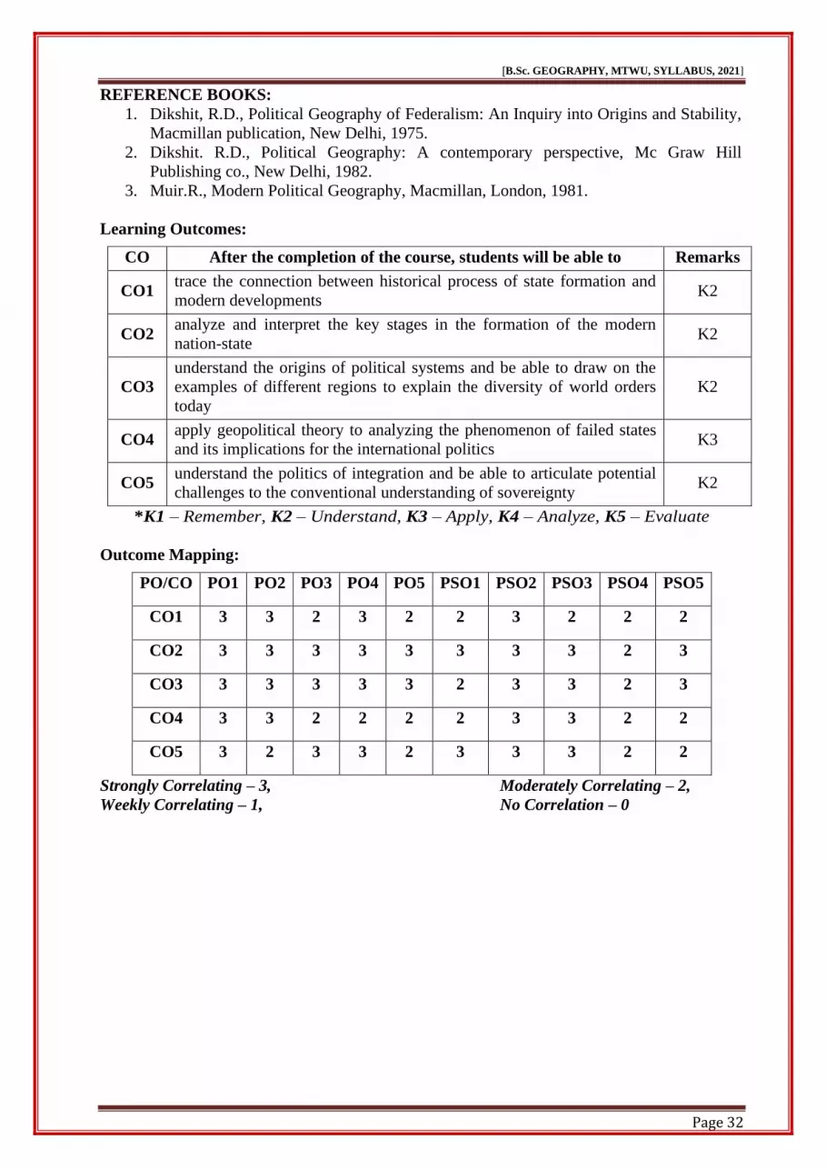
CO After the completion of the course, students will be able to Remarks
CO1 trace the connection between historical process of state formation and
modern developments K2
CO2 analyze and interpret the key stages in the formation of the modern
nation-state K2
CO3
understand the origins of political systems and be able to draw on the
examples of different regions to explain the diversity of world orders
today
K2
CO4 apply geopolitical theory to analyzing the phenomenon of failed states
and its implications for the international politics K3
CO5 understand the politics of integration and be able to articulate potential
challenges to the conventional understanding of sovereignty K2
*K1 – Remember, K2 – Understand, K3 – Apply, K4 – Analyze, K5 – Evaluate
Outcome Mapping:
PO/CO PO1 PO2 PO3 PO4 PO5 PSO1 PSO2 PSO3 PSO4 PSO5
CO1 3 3 2 3 2 2 3 2 2 2
CO2 3 3 3 3 3 3 3 3 2 3
CO3 3 3 3 3 3 2 3 3 2 3
CO4 3 3 2 2 2 2 3 3 2 2
CO5 3 2 3 3 2 3 3 3 2 2
Strongly Correlating – 3, Moderately Correlating – 2,
Weekly Correlating – 1, No Correlation – 0
Page 33
[B.Sc. GEOGRAPHY, MTWU, SYLLABUS, 2021]
Page 33
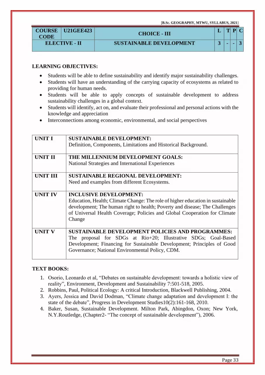
COURSE
CODE
U21GEE423 CHOICE - III
L T P C
ELECTIVE - II SUSTAINABLE DEVELOPMENT 3 - - 3
LEARNING OBJECTIVES:
• Students will be able to define sustainability and identify major sustainability challenges.
• Students will have an understanding of the carrying capacity of ecosystems as related to
providing for human needs.
• Students will be able to apply concepts of sustainable development to address
sustainability challenges in a global context.
• Students will identify, act on, and evaluate their professional and personal actions with the
knowledge and appreciation
• Interconnections among economic, environmental, and social perspectives
UNIT I SUSTAINABLE DEVELOPMENT:
Definition, Components, Limitations and Historical Background.
UNIT II THE MILLENNIUM DEVELOPMENT GOALS:
National Strategies and International Experiences
UNIT III SUSTAINABLE REGIONAL DEVELOPMENT:
Need and examples from different Ecosystems.
UNIT IV INCLUSIVE DEVELOPMENT:
Education, Health; Climate Change: The role of higher education in sustainable
development; The human right to health; Poverty and disease; The Challenges
of Universal Health Coverage; Policies and Global Cooperation for Climate
Change
UNIT V SUSTAINABLE DEVELOPMENT POLICIES AND PROGRAMMES:
The proposal for SDGs at Rio+20; Illustrative SDGs; Goal-Based
Development; Financing for Sustainable Development; Principles of Good
Governance; National Environmental Policy, CDM.
TEXT BOOKS:
1. Osorio, Leonardo et al, “Debates on sustainable development: towards a holistic view of
reality”, Environment, Development and Sustainability 7:501-518, 2005.
2. Robbins, Paul, Political Ecology: A critical Introduction, Blackwell Publishing, 2004.
3. Ayers, Jessica and David Dodman, “Climate change adaptation and development I: the
state of the debate”, Progress in Development Studies10(2):161-168, 2010.
4. Baker, Susan, Sustainable Development. Milton Park, Abingdon, Oxon; New York,
N.Y.Routledge, (Chapter2- “The concept of sustainable development”), 2006.
Page 34
[B.Sc. GEOGRAPHY, MTWU, SYLLABUS, 2021]
Page 34
REFERENCE BOOKS:
1. Agyeman, Julian, Robert D. Bullard and Bob Evans (Eds.), Just Sustainabilities:
Development in an Unequal World, London: Earthscan, 2003.
2. Brosius, Peter, “Endangered Forest, Endangered People: Environmentalist
Representations of Indigenous Knowledge”, Human Ecology25:47-69, 1997.
3. Lohman, Larry, “Re-imagining the population debate”, Corner House Briefing 28, 2003.
4. Martínez-Alier, Joan et al, “Sustainable de-growth: Mapping the context, criticisms and
future prospects of an emergent paradigm”, Ecological Economics 69:1741-1747, 2010.
5. Merchant, Carolyn (Ed.) Ecology. Atlantic Highlands, N.J: Humanities Press.
(Introduction, pp 1-25.), 1994.
Learning Outcomes:
CO After the completion of the course, students will be able to Remarks
CO1 have acquired Knowledge about the sustainable development of
components, limitations and historical background. K2
CO2 understand an overview of the millennium development goals of the
national strategies and international experiences K2
CO3 understand the different ecosystems. K2
CO4 have basic concepts about challenges of universal health coverage,
policies and global cooperation for climate change K4
CO5 learn about the good governance. K2
*K1 – Remember, K2 – Understand, K3 – Apply, K4 – Analyze, K5 – Evaluate
Outcome Mapping:
PO/CO PO1 PO2 PO3 PO4 PO5 PSO1 PSO2 PSO3 PSO4 PSO5
CO1 3 2 3 2 3 2 3 2 2 3
CO2 3 2 3 3 2 2 3 3 2 3
CO3 3 3 2 3 3 2 3 3 2 2
CO4 3 3 3 2 2 3 3 3 2 2
CO5 3 3 3 3 3 3 3 3 2 3
Strongly Correlating – 3, Moderately Correlating – 2,
Weekly Correlating – 1, No Correlation – 0
Page 35
[B.Sc. GEOGRAPHY, MTWU, SYLLABUS, 2021]
Page 35
SEMESTER – V
COURSE
CODE
U21GEP52 CLIMATIC DIAGRAM AND WEATHER
MAP INTERPRETATION
L T P C
CORE - VIII 5 - - 4
LEARNING OBJECTIVES:
• Diagrammatic data presentation makes it easier for a student to understand the data
• To draw graphs, using suitable axes and scales draw, interpret and compare line graph,
Dispersion Diagram, frequency diagrams and climate graph.
• To identify and explain differing weather symbols and the uses and purposes of weather
symbols.
• Explain the list of the some instruments that meteorologists use to collect weather data.
• To identify and describe the main human and physical features of your local area.
UNIT I CLIMATIC DATA ANALYSIS:
Diagrammatic representation of Climatic data – Hyther graph – Climograph –
Wind Rose diagram and Ergo graph.
UNIT II REPRESENTATION OF CLIMATIC DATA:
Temperature and rainfall – Line graphs – Dispersion diagram – Isopleth maps –
uses, merits and demerits – Isotherm, Isobars and Isohyets
UNIT III INDIAN WEATHER MAP INTERPRETATION:
Weather symbols, station model – Weather map interpretation.
UNIT IV METEOROLOGICAL INSTRUMENTS:
Maximum and minimum Thermometer, Dry and Wet Bulb Thermometer,
Fortin’s Barometer, Aneroid Barometer, Rain Gauge, Wind Vane, Anemometer.
UNIT V FIELD WORK OR LOCAL GEOGRAPHY:
Field work and local geography.
TEXT BOOKS:
1. M.Ishtiaq-Practical Geography – published by Jawahar publishers and
Distributors-1994.
2. F.J. Monkhouse and H.R. Wilkinson – Maps and Diagrams - B.I
Publications - 1952.
3. MD.Zulfequar Ahmad Khan-Text Book of Practical Geography – Concept
Publishing Company, NewDelhi-1998.
4. Gopal Singh - Map work and practical geography –
VikaspublishingHousepvt.Ltd-1996.
5. R.L.Singh–Elements of Practical Geography, Kalyani Publishers, 1979
Page 36
[B.Sc. GEOGRAPHY, MTWU, SYLLABUS, 2021]
Page 36
Learning Outcomes:
CO After the completion of the course, students will be able to Remarks
CO1 diagrammatic representation can be used for both the educated section
and uneducated section of the society. K2
CO2 the graph like Hyther Graph, Climograph, and Ergo graph and difference
between the Temperature and Rainfall data analysis. K4
CO3 describe how these instruments are used to collect weather data from
many geographic locations and many altitudes. K4
CO4 the role of satellites and computers in modern weather forecasting and
meteorologists develop accurate weather forecasts K3
CO5 help Students learn more about their local area and describe how places
make them feel. K5
*K1 – Remember, K2 – Understand, K3 – Apply, K4 – Analyze, K5 – Evaluate
Outcome Mapping:
PO/CO PO1 PO2 PO3 PO4 PO5 PSO1 PSO2 PSO3 PSO4 PSO5
CO1 3 3 2 2 3 3 3 2 3 3
CO2 3 3 3 3 2 3 3 3 2 2
CO3 3 3 3 3 2 2 3 2 2 3
CO4 3 2 2 2 3 3 3 3 3 3
CO5 3 3 3 3 2 2 3 2 2 2
Strongly Correlating – 3, Moderately Correlating – 2,
Weekly Correlating – 1, No Correlation – 0
Page 37
[B.Sc. GEOGRAPHY, MTWU, SYLLABUS, 2021]
Page 37
COURSE
CODE
U21GET51
GEOGRAPHY OF RESOURCES – I
L T P C
CORE - IX 5 - - 4
LEARNING OBJECTIVES:
❖ The course will provide knowledge about the concepts of different types of resources.
❖ It also gives knowledge about natural resource processes.
❖ Conservation and management of resources for sustainable development.
❖ Students will be able to read and interpret information on different types of physical
features maps.
❖ Students shall get to know about the Grassl and types and livestock distribution
UNIT I INTRODUCTION:
Resource – Meaning – Concept of resources – functional – dynamic concepts –
Classification of resources – renewable – nonrenewable resources.
UNIT II LAND RESOURCES:
Land as a resource – land use types and conservation; soil as a resource – erosion
and conservation; man as a resource.
UNIT III WATER RESOURCES:
Water as a resource – uses – irrigation – transport – problems – conservation –
fisheries – major fishing grounds of the world – problems.
UNIT IV NATURAL VEGETATION:
Forest – types – products and conservation.
UNIT V GRASSLANDS OF WORLD:
Grassland types – livestock distribution.
TEXT BOOKS:
1. Leong G C, Morgan G C, ‘Human and Economic Geography’, Oxford
University Press, the U.K, 2009.
2. Roy Prithwish, ‘Economic Geography: A Study of Resources’, New
Central, Book Agency Pvt. Ltd, 2001.
3. Alka Goutham, Geography of Resources, Exploration, Conservation and
Management, Sharada Pusthak Bhavan, New Delhi, 2013.
4. Khanna K. K. and Gupta, V. K., Economic & Commercial Geography,
Sultan Chand & Sons, 1996.
REFERENCE BOOKS:
1. Prithvish Roy &Somnath mukerjee–Economic geography an appraisal of
resources, new central book agency, Calcutta, 2009.
2. V.K.Gupta–Economic and Commercial Geography, Sultan Chand and
Sons,1977.
3. S.K.Sadhukhan–Economic Geography an Appraisal of resources, S.Chand
Page 38
[B.Sc. GEOGRAPHY, MTWU, SYLLABUS, 2021]
Page 38
and company Ltd. – 1982.
4. A.Das Gupta–Economic and Commercial Geography, Mukhrjee and
Co.Pvt.Ltd. 1978.
5. M.C.Agarwal–Commercial Geography, Himalaya Publishing House,1981.
6. B.S.Negi–Economic and Commercial Geography of the World, S.Chand and
Co.Ltd, 1980.
Learning Outcomes:
CO After the completion of the course, students will be able to Remarks
CO1 become sensitized the classification of resources. K2
CO2 learn conservation methods and techniques. K2
CO3 understand the basic concept of resource and its various types and their
utilities K2
CO4 acquire basic information about potentials and management of resources
like land, water, forest and power in global context. K4
CO5 understand the prevailing natural resource potential and problems of
management. K2
*K1 – Remember, K2 – Understand, K3 – Apply, K4 – Analyze, K5 – Evaluate
Outcome Mapping:
PO/CO PO1 PO2 PO3 PO4 PO5 PSO1 PSO2 PSO3 PSO4 PSO5
CO1 3 2 3 2 3 3 3 2 3 2
CO2 3 3 2 3 2 2 3 3 2 3
CO3 3 3 3 3 3 2 3 2 3 2
CO4 3 2 3 2 2 3 3 3 2 3
CO5 3 3 2 3 3 2 3 3 2 3
Strongly Correlating – 3, Moderately Correlating – 2,
Weekly Correlating – 1, No Correlation – 0
Page 39
[B.Sc. GEOGRAPHY, MTWU, SYLLABUS, 2021]
Page 39
COURSE
CODE
U21GET52
WORLD REGIONAL GEOGRAPHY
L T P C
CORE – X 5 - - 4
LEARNING OBJECTIVES:
❖ Describe what Geography and world Regional Geography are.
❖ Locate and define the Natural Region of the World.
❖ Understand the Warm temperate regions and temperate desert region.
❖ Explain the Cold temperate regions.
❖ Briefly Explain Cold regions.
UNIT I INTRODUCTION:
Region – Definition – evolution of regional concept – characteristics of region
– Types of region – Generic regions – Major generic regions – Formal –
Functional – specific region.
UNIT II NATURAL REGION OF THE WORLD:
Meaning – Criteria of delimitation of natural regions – Tropical Regions –
Equatorial region – savanna region or Sudan type – tropical monsoon region –
tropical deserts or Sahara type region.
UNIT III WARM TEMPERATE REGIONS:
Mediterranean region – temperate desert region – China type region.
UNIT IV COLD TEMPERATE REGION:
prairie type region – west European region – St.Lawrence type region
UNIT V COLD REGIONS:
Taiga type – Tundra type – high mountain regions.
TEXT BOOKS:
1. Heintzelman and Highsmith–World Regional Geography Prentice– Hall,India–
1965.
2. Don R.Hoy–Geography and Developmental World Regional Approach,Collier
Mac Millan Publisher–1978.
REFERENCE BOOKS:
1. Goh – Chengleong– Certificate Human and Economic Geography – Oxford
Un i v e r s i t y Publications–1995.
Page 40
[B.Sc. GEOGRAPHY, MTWU, SYLLABUS, 2021]
Page 40
Learning Outcomes:
CO After the completion of the course, students will be able to Remarks
CO1 have acquired knowledge about the characteristics of region, Types of
regions, Formal, Functional and Specific region. K2
CO2 have Knowledge of the Tropical Regions, Equatorial region, Savanna
region, tropical monsoon region and tropical deserts. K2
CO3 gain a better understanding of Mediterranean region, temperate desert
region and chinna type region. K3
CO4 have an effective understand the Prairie type region and West
European region. K2
CO5 gain Knowledge about the Taiga type, Tundra type and high mountain
regions. K2
*K1 – Remember, K2 – Understand, K3 – Apply, K4 – Analyze, K5 – Evaluate
Outcome Mapping:
PO/CO PO1 PO2 PO3 PO4 PO5 PSO1 PSO2 PSO3 PSO4 PSO5
CO1 3 2 3 2 2 3 3 2 2 2
CO2 3 3 3 3 3 3 3 3 2 2
CO3 3 2 2 2 3 2 3 3 2 2
CO4 3 2 3 2 3 3 3 3 2 3
CO5 3 3 3 3 2 2 3 3 2 3
Strongly Correlating – 3, Moderately Correlating – 2,
Weekly Correlating – 1, No Correlation – 0
Page 41
[B.Sc. GEOGRAPHY, MTWU, SYLLABUS, 2021]
Page 41
COURSE
CODE
U21GET53
HUMAN GEOGRAPHY
L T P C
CORE - XI 5 - - 4
LEARNING OBJECTIVES:
• This paper gives an overall idea about human environment relationship in different
environmental condition
• To develop an idea about the world population distribution and the factors that lead to uneven
distribution of the population.
• It also focuses on the problem that is likely to arise due to an increase in the world population.
• Students will be able to locate on a map major physical features, cultural regions, and
individual states and urban centers.
• Students will understand global and regional patterns of cultural, political and economic
institutions, and their effects on the preservation.
UNIT I NATURE AND PRINCIPLES:
Scope and content, definition – different viewpoints – concept of determinism,
Possibilism and Probabilism – Recent trends in human geography – branches
in human geography.
UNIT II SPACE AND SOCIETY:
World cultural regions – Food gatherers – Semang and Sakai; Hunters –
Bushmen – Cultivators – People of the Malabar coast – Nomads- Masai and
levels of culture in twentieth century.
UNIT III HUMAN RACE IN WORLD:
Human Races – Classification – Distribution – Religion – Major types and
distribution.
UNIT IV POPULATION:
Spatial pattern of distribution – growth – problems of over population and
under population – population Theory – Malthus and optimum theory –
Migration – Causes – consequences and problems.
UNIT V SETTLEMENTS:
Rural and Urban settlement – factors – types – growth – Urban morphology
and functional classification of towns – Urbanization – Trend, level, – World
, India
TEXT BOOKS:
1. Majid Husain, Human Geography, Rawat Publications,1994.
2. Gillian C.Morgan, Human and Economics Geography,Oxford University
Publications, 1999.
3. Aime Vincent Perpillou, Human Geography,Longman Group limited London,
1977.
4. C.Daryll Forde, Habitat, Economy and Society, Methuen Publishers, 1977.
5. Ray M.Northam, Urban Geography, John Wiley and sons Publications, 1979.
Page 42
[B.Sc. GEOGRAPHY, MTWU, SYLLABUS, 2021]
Page 42
REFERENCE BOOKS:
1. S.K.Shelar, Human geography, Chandralok Prakashan, 2012.
2. Amal Datta, Human Migration a social phenomenon, Mittal publication, 2003.
3. K.Chakraworthy, Population Geography, Mohit Publication, 2006.
4. R.Jagannathan, Human Geography, Dominant Publishers and Distributers, 2012.
Learning Outcomes:
CO After the completion of the course, students will be able to Remarks
CO1 Know about the scope and contents of human geography. K2
CO2 acquire an understanding regarding the relationship between prevailing
geographic environment and cultural practices of human being. K2
CO3 build an idea among students regarding the role that geography play in
community engagement. K2
CO4 have a general understanding of global human population patterns, and
human impacts on the physical environment. K3
CO5
have a general understanding of how the physical environment, human
societies, and local and global economic systems are integral to the
principles of sustainable development.
K2
*K1 – Remember, K2 – Understand, K3 – Apply, K4 – Analyze, K5 – Evaluate
Outcome Mapping:
PO/CO PO1 PO2 PO3 PO4 PO5 PSO1 PSO2 PSO3 PSO4 PSO5
CO1 3 3 2 2 2 3 3 3 3 3
CO2 3 3 3 3 2 3 3 3 2 3
CO3 3 2 3 3 3 3 3 2 3 2
CO4 3 2 3 2 2 2 3 2 2 2
CO5 3 3 2 3 2 2 3 3 2 3
Strongly Correlating – 3, Moderately Correlating – 2,
Weekly Correlating – 1, No Correlation – 0
Page 43
[B.Sc. GEOGRAPHY, MTWU, SYLLABUS, 2021]
Page 43
COURSE
CODE
U21GET54
GEOGRAPHY OF INDIA
L T P C
CORE - XII 5 - - 4
LEARNING OBJECTIVES:
❖ This course provides an insight into different aspects of physiography, climate, regional
variability and culture in India.
❖ Describing the Importance of the value of Regional and Regionalization of Indian.
❖ Students can acquire an overall knowledge of agriculture, region, industry, transport and
trade of India.
❖ Students will understand the social distribution of population and transportation network
of their country.
❖ They understand the economic resources of India.
UNIT I PHYSICAL:
Location – Continent of unity in diversity – Relief – drainage – climate – soil
– types and distribution – Natural vegetation – types and distribution.
UNIT II IRRIGATION:
Need for Irrigation – Types – canal – tank – well – Multipurpose projects.
UNIT III AGRICULTURE:
Types – Major crops – rice, wheat, millets, cotton, oilseeds, tea, coffee and jute
– Agricultural regions – problems – Animal husbandry.
UNIT IV RESOURCES&INDUSTRIES:
Minerals – coal, oil, iron ore, manganese, bauxite, copper – Power resources –
Hydel, thermal and atomic – Industries – Iron and Steel, Cement, Textile,
Sugar, Paper, Shipbuilding – Small scale and Cottage Industries.
UNIT V POPULATION:
Population Growth – distribution – density and problems – Transport and trade.
TEXT BOOKS:
1. Gopal Singh, Geography of India, Atma Ram, India, 1976.
2. Nag, P. and Roy, P., Geography of India, Concept Publications, New Delhi,
1998.
3. Tirtha, R., Geography of India, Rawat Publications, Jaipur, 1996.
4. Majid Hussain, Geography of India, McGraw, 2009.
5. Hill India Rajaram K, Geography of India, Spectrum Books (P) Ltd, 2015.
REFERENCE BOOKS:
1. Ranjit Tirtha and Gopal Krishnan, Geography of India Rawat publications,
Jaipur, New Delhi, 1996.
2. Prithvish Nag and Smita Sengupta, Geography of India, Concept Publishing
Company, New Delhi, 1999.
3. C.B.Mamoria, Geography of India, Shivalal Agarwala &Company, Agra, 1975.
Page 44
[B.Sc. GEOGRAPHY, MTWU, SYLLABUS, 2021]
Page 44
4. R.L.Singh, India A Regional Geography, National Geographical Society of
India, 1971.
Learning Outcomes:
CO After the completion of the course, students will be able to Remarks
CO1
get familiarized with the geographic dimensions of India in terms of its
political and administrative characteristics; aspects of its regional
vitality; and formation of regions.
K2
CO2 understand climatic condition and seasons in India. K3
CO3 understand globalization and Indian economy and also understand the
regional distribution of resource. K2
CO4 understand the population problems in India. Access the population
policies and reaction the countries. K3
CO5 apply the knowledge of global issues to a unique scientific problem. K4
*K1 – Remember, K2 – Understand, K3 – Apply, K4 – Analyze, K5 – Evaluate
Outcome Mapping:
PO/CO PO1 PO2 PO3 PO4 PO5 PSO1 PSO2 PSO3 PSO4 PSO5
CO1 3 3 3 2 3 3 3 2 3 3
CO2 3 3 2 3 2 2 3 3 2 3
CO3 3 3 3 3 3 2 3 3 3 3
CO4 3 2 3 2 2 2 3 3 2 2
CO5 3 3 3 3 3 2 3 3 2 2
Strongly Correlating – 3, Moderately Correlating – 2,
Weekly Correlating – 1, No Correlation – 0
Page 45
[B.Sc. GEOGRAPHY, MTWU, SYLLABUS, 2021]
Page 45
COURSE
CODE
U21GEE531 CHOICE - I
L T P C
ELECTIVE - III BIOGEOGRAPHY 3 - - 3
LEARNING OBJECTIVES:
❖ To introduce the students, the concept of Biogeography.
❖ Students will also learn the components, interpretation and application of biogeography.
❖ Interaction between living organisms and non-living organisms.
❖ The students will have a basic knowledge of Living organisms with climate and physical
environment.
❖ Students will be evaluating the biogeochemical cycle and biodiversity conservation
measures in India.
UNIT I BASIC CONCEPTS:
Definition, scope and significance of biogeography – basic ecological concepts
and principles – ecosystem – types of ecosystems – components of ecosystem
– functioning of ecosystem – concepts of biome – types, ecotone and
community – bio diversity.
UNIT II EVOLUTION OF LIFE ON EARTH THROUGH GEOLOGICAL
TIME:
Origin of fauna and flora – plant and animal evolution through geological times
– distribution of plant life on earth and its relation to soil types – climates and
human practices.
UNIT III EXTINCTION OF FLORA AND FAUNA:
Problem of extinction of plant and animal life – habitat decay and their
conservation – process of desertification – its consequences and its
management principles.
UNIT IV INDUSTRIES EFFLUENTS SPECIAL REFERENCE OF RIVERS IN
INDIA:
Industrial effluent and its effect on fresh water biology – management practices
(special reference to India)
UNIT V STUDY OF ECOLOGICAL REGIONS IN INDIA:
Study of ecological regions of Himalayas and Western Ghats in relations to
their plant and animal life, their Interrelations, problems – conservation and
management measures.
TEXT BOOKS:
1. MacDonald, G., Biogeography: Introduction to space, time and life. Wiley,
Page 46
[B.Sc. GEOGRAPHY, MTWU, SYLLABUS, 2021]
Page 46
2001.
2. Eugene Pleasants Odum, Basic Ecology. Saunders College Pub; and digital
edition, 2011, The University of Michigan, 1983.
3. G. Tyler Miller and Scott Spoolma. Essentials of Ecology. Cengage Learning,
2014.
4. Swarnim K, Climate, Forest, Biodiversity and Desert, Surendra Publications,
NewDelhi, 2012.
5. Gerald G Marten., Human Ecology: Basic Concepts for Sustainable
Development. Taylor and Francis. USA, 2008.
REFERENCE BOOKS:
1. Robinson, Biogeography, ELBS McDonald and Evans London,1982
2. L.G.Simons, Biogeographically process, Allen and Unwell, London.
3. CBarry, Cox,BlackWell, Biographical An Ecological Evolutionary Approach,
Oxford1977.
4. B. Seddon, Biogeography, Duckworth, London,1971.
Learning Outcomes:
CO After the completion of the course, students will be able to Remarks
CO1 learn about the concept and relevance of biogeography, ecosystem and
ecology responsible for the global trend. K2
CO2
understand biodiversity, types of biodiversity, the role of humans in
ecological disturbances and conservation issues and identify ecological
aspects of the environment.
K3
CO3 understand geography converging and forming of our biosphere. K2
CO4 discuss the basics of ecosystem services and the consequences of
ecosystems. K4
CO5 apply interaction of biotic and abiotic resources. K4
*K1 – Remember, K2 – Understand, K3 – Apply, K4 – Analyze, K5 – Evaluate
Outcome Mapping:
PO/CO PO1 PO2 PO3 PO4 PO5 PSO1 PSO2 PSO3 PSO4 PSO5
CO1 3 2 3 2 2 3 3 2 3 3
CO2 3 3 2 3 3 3 3 3 2 2
CO3 3 2 2 3 3 2 3 3 3 3
CO4 3 2 3 2 2 2 3 2 2 2
CO5 3 3 3 3 3 2 3 3 2 3
Strongly Correlating – 3, Moderately Correlating – 2,
Weekly Correlating – 1, No Correlation – 0
Page 47
[B.Sc. GEOGRAPHY, MTWU, SYLLABUS, 2021]
Page 47
COURSE
CODE
U21GEE532 CHOICE - II
L T P C
ELECTIVE - III INDUSTRIAL GEOGRAPHY 3 - - 3
LEARNING OBJECTIVES:
❖ They can know about their nature and scope of industrial geography.
❖ They understand the industrial location
❖ Students understanding the general idea of coal and iron based industries
❖ Students can acquire knowledge of different types of minerals with their relationship of
industries
❖ Students will have a general understanding of industrial patterns and various influencing
factors.
UNIT I INTRODUCTION:
Nature and Scope of Industrial Geography
UNIT II INDUSTRIES:
Types, Geographical Characteristics and Location of Industries (Weber’s
Theory): Small and Medium Industries, Heavy Industries: Coal and Iron based
industries, Rural based Industries, Footloose Industry
UNIT III MEGA INDUSTRIAL COMPLEXES:
National Capital Region, Mumbai – Pune Industrial Region, Bengaluru-
Chennai Industrial Region and Chota Nagpur Industrial Region
UNIT IV IMPACT OF INDUSTRIALIZATION IN INDIA:
Environmental; Social and Economic
UNIT V INDUSTRIAL POLICY:
Industrial Policy of India
TEXT BOOKS:
1. Alexander J.W. Economic Geography, Prentice Hall of India Pvt.Ltd., New Delhi, 1979.
2. Goh Cheng Leong, "Human and economic geography",Oxford University Press,New
York, 1997.
3. Thoman, R.S., Conkling E.C. and Yeates, M.H. Geography of Economic Activity,
McGraw Hill Book Company, 1968.
4. Miller, E.Geography of Manufacturing Prentice Hall-Englewood Cliff, New Jersey,
1962.
5. Tiwari, R.C.Geography of India, Prayag Pustak Bhawan, Allahabad, 2007.
6. Tirtha, Ranjit Geography of India, Rawat Publs., Jaipur & New Delhi, 2002.
Page 48
[B.Sc. GEOGRAPHY, MTWU, SYLLABUS, 2021]
Page 48
REFERENCE BOOKS:
1. Gunnar Alex Andersson, "Geography of Manufacturing”, Prentice Hall, New
Jersey Truman, 1967.
2. A. Harishorn, John W. Alexander " Economic Geography", Prentice Hall of India
Ltd., New Delhi, 2000.
3. Singh, Jagdish India - A Comprehensive & Systematic Geography, Gyanodaya
Prakashan, Gorakhpur, 2003.
4. Pathak, C. R. Spatial Structure and Processes of Development in India. Regional
Science Assoc., Kolkata, 2003.
5. Sharma, T.C.Economic Geography of India, Rawat Publication, 2013.
Learning Outcomes:
CO After the completion of the course, students will be able to Remarks
CO1 identify the different industrial regions in India K2
CO2 gain knowledge about the Weber’s Theory K3
CO3 learn the significance of various industries. K2
CO4 evaluate the impacts of industrialization growth on natural environments,
social and economic special reference to India K4
CO5 get the appropriate awareness about Industrial Policy of India K5
*K1 – Remember, K2 – Understand, K3 – Apply, K4 – Analyze, K5 – Evaluate
Outcome Mapping:
PO/CO PO1 PO2 PO3 PO4 PO5 PSO1 PSO2 PSO3 PSO4 PSO5
CO1 3 2 3 3 3 3 3 2 3 2
CO2 3 3 2 2 2 2 3 3 2 3
CO3 3 2 3 3 2 2 2 3 3 3
CO4 3 3 2 2 3 2 3 2 2 3
CO5 3 3 3 3 2 3 3 3 2 2
Strongly Correlating – 3, Moderately Correlating – 2,
Weekly Correlating – 1, No Correlation – 0
Page 49
[B.Sc. GEOGRAPHY, MTWU, SYLLABUS, 2021]
Page 49
COURSE
CODE
U21GEE533 CHOICE - III
L T P C
ELECTIVE - III DISASTER STUDIES 3 - - 3
LEARNING OBJECTIVES:
❖ To understand basic concepts in Disaster Management
❖ To Understand Definitions and Terminologies used in Disaster management
❖ To Understand Types and Categories of Disasters
❖ To Understand the Challenges posed by Disasters
❖ To understand Impacts of Disasters
UNIT I DISASTER:
Meaning and classification – Concepts of disaster – Hazard – Catastrophe – Risk
and vulnerability – Disaster zones of India.
UNIT II GEOLOGICAL HAZARDS:
Earthquakes - Scale of measurement - Intensity and magnitude - Earthquake
prone zones - Volcanic hazards - Landslides and Tsunami.
UNIT III CLIMATIC DISASTERS:
Cyclones – Flood – Drought – Avalanche and Frost - Forest fire.
UNIT IV HUMAN INDUCED:
Thermal, Nuclear and chemical disaster – Health hazard, Global warming –
Ground water depletion and deforestation.
UNIT V DISASTER MANAGEMENT ORGANIZATIONS:
International – National – State and Local level - NGO - Disaster Cycle –
Preparatory phase – Emergency phase, Rehabilitation and Reconstruction
process – Mitigation and management. NROM – NIDM – SDMC.
TEXT BOOKS:
1. Abbott, P.L.Natural Disasters, Wm. C.Brown Publishing Co., NewYork, 1996.
2. Agarwal Gurcharan Singh S.K., and Inderjeet Sethi, The Degrading Environment
(cause of Concern), Common wealth Publication, New Delhi, 1993.
3. Agarwal S.K., Global Warming and Climate Change, A.P.H.Publications, New Delhi,
2004.
4. Ghosh G.K., Disaster Management, A.P.H.Publishing Corporation, New Delhi, 2008.
5. Goel S.L., Disaster Management, Deep & Deep Publication Pvt.Ltd, New Delhi, 2008.
REFERENCE BOOKS:
1. Kumaraswamy.K, GIS for Natural Resources and Disaster Management, Union
offset printers, Tiruchirappalli, 2009.
2. Narayan.B, Disaster Management, A.P.H.Publishing Corporation, New Delhi, 2009.
Page 50
[B.Sc. GEOGRAPHY, MTWU, SYLLABUS, 2021]
Page 50
3. Nicholas.K, Geohazards, Natural and human, Prentice hall of India, Delhi, 1995.
4. Saxena, H.M. Natural Disasters,Wm. C. Brown Publishing Co., New York, 1996.
5. Singh R.B, Disaster Management, Rawat Publications, New Delhi, 2008.
Learning Outcomes:
CO After the completion of the course, students will be able to Remarks
CO1 describe Definitions and Terminologies used in Disaster Management,
Types and Categories of Disasters K2
CO2 understand the challenges posed by Disasters and Impacts of Disasters K2
CO3 describe various disasters that India is vulnerable to, and the hazard maps
that enable them to visualize their vulnerabilities K3
CO4 understand about the Natural Disasters its Causes and Consequences K4
CO5 learn about Disaster Management and Mitigation. K2
*K1 – Remember, K2 – Understand, K3 – Apply, K4 – Analyze, K5 – Evaluate
Outcome Mapping:
PO/CO PO1 PO2 PO3 PO4 PO5 PSO1 PSO2 PSO3 PSO4 PSO5
CO1 3 2 3 2 2 3 3 2 2 2
CO2 3 3 3 3 2 3 2 3 3 3
CO3 3 2 2 3 3 2 3 3 2 2
CO4 3 2 3 2 3 2 2 3 3 3
CO5 3 3 2 3 2 3 3 3 2 2
Strongly Correlating – 3, Moderately Correlating – 2,
Weekly Correlating – 1, No Correlation – 0
Page 51
[B.Sc. GEOGRAPHY, MTWU, SYLLABUS, 2021]
Page 51
COURSE
CODE
U21GES53 APPLICATION OF
STATISTICALMETHODSINGEOGRAP
HY
L T P C
SKILL BASED
ELECTIVE III
- - 2 2
LEARNING OBJECTIVES:
o Understanding for the student on statistical concepts to include measurements of location and
dispersion, sampling, estimation, hypothesis testing, regression, and correlation analysis,
multiple regression analysis.
o Students will be understood the statistical methods are applied in geography in order to make
precise statements.
o Keeping the nature of data and purpose of study, students would be able to make a rational
choice amongst listed various statistical methods.
o Perform Test of Hypothesis as well as calculate confidence interval for a population
parameter for single sample and two sample cases.
o Compute and interpret the results of Multivariate Regression and Correlation Analysis, for
forecasting.
UNIT I BASIC CONCEPTS:
Data – Data sources and types of data raw data – variables – class – class limits
– class boundaries – class width – class – class mark – class frequencies.
UNIT II FREQUENCY DISTRIBUTION AND GRAPHS:
Frequency distribution – cumulative frequency – graphical representation of
frequency distribution.
UNIT III MEASURES OF FREQUENCY DISTRIBUTION:
Histogram – frequency curve – frequency polygon – cumulative frequency
polygon – cumulative frequency curve.
UNIT IV MEASURES OF CENTRAL TENDENCY:
Mean – median– mode – Skewness and Kurtosis – Selection of class intervals
for mapping.
UNIT V MEASURES OF DISPERSION:
Mean Deviation, Standard Deviation, Quartile Deviation and Coefficient
Variation, Quartiles, Deciles and Percentiles
TEXT BOOKS:
1. Ebdon D., Statistics in Geography: A Practical Approach, 1977.
2. Hammond P. and McCullagh P. S., Quantitative Techniques in
Geography: An Introduction, Oxford University Press, 1978.
3. King L. S., Statistical Analysis in Geography, Prentice-Hall, 1969.
4. Mahmood A., Statistical Methods in Geographical Studies, Concept Pub.
Co, 1977.
5. Pal S. K., Statistics for Geoscientists, Tata McGraw Hill, New Delhi, 1998.
Page 52
[B.Sc. GEOGRAPHY, MTWU, SYLLABUS, 2021]
Page 52
REFERENCE BOOKS:
1. V.P. Subrahmanyam and Subramaniam A.R, Application of water
balance concept for a climatic study of droughts in south India, 1964
2. Sarkar, A. Quantitative geography: techniques and presentations. Orient,
2013.
3. Silk J., Statistical Concepts in Geography, Allen and Unwin, London,
1979.
4. Yeats M., An Introduction to Quantitative Analysis in Human
Geography, McGraw Hill, New York, 1974.
Learning Outcomes:
CO After the completion of the course, students will be able to Remarks
CO1
keep in view the nature of data and purpose of study, students would be
able to make a rational choice amongst listed various statistical
methods.
K2
CO2 demonstrate understanding of basic concepts of probability and
statistics embedded in their courses. K3
CO3 apply discrete and continuous probability distribution to various
business problems. K3
CO4 show proficiency in basic statistical skills embedded in their courses. K4
CO5 know how to organize, manage, and present data. K5
*K1 – Remember, K2 – Understand, K3 – Apply, K4 – Analyze, K5 – Evaluate
Outcome Mapping:
PO/CO PO1 PO2 PO3 PO4 PO5 PSO1 PSO2 PSO3 PSO4 PSO5
CO1 3 3 3 3 3 2 3 2 3 2
CO2 3 3 3 2 3 2 3 3 2 3
CO3 3 2 3 3 2 3 3 3 2 3
CO4 3 2 2 2 2 2 3 3 3 2
CO5 3 3 3 3 3 2 3 3 2 3
Strongly Correlating – 3, Moderately Correlating – 2,
Weekly Correlating – 1, No Correlation – 0
Page 53
[B.Sc. GEOGRAPHY, MTWU, SYLLABUS, 2021]
Page 53
SEMESTER – VI
COURSE
CODE
U21GET61
GEOGRAPHY OF RESOURCE–II
L T P C
CORE - XIII 4 - - 4
LEARNING OBJECTIVES:
• It is an introductory course of resource geography which is aimed at providing knowledge
about the concept of resource and its classification, and the distribution, utilization and
management of land, water, forest and energy resources.
• It also focuses on the natural resource and its problems of conservation and management.
• Besides, it also provides basic idea about sustainable development of resources.
• They understand the concept of different types of resources
• They learn about use and misuse of resources.
UNIT I AGRICULTURE:
Types – intensive, extensive, wet and dry, mixed farming, subsistence farming,
commercial farming and plantation agriculture.
UNIT II RESOURCE:
Energy as a resource – coal, oil, water and a nuclear power, – non conventional
– solar and wind.
UNIT III MINERALS:
Ferrous, non– ferrous – iron ore, manganese, mica, copper and bauxite.
UNIT IV MAJOR INDUSTRIES:
Location factors, iron and steel, automobile, shipbuilding and textile industries.
UNIT V TRANSPORT:
Land, water and air – trade – internal and international.
TEXT BOOKS:
1. Leong G C, Morgan G C, ‘Human and Economic Geography’, Oxford
University Press, the U.K, 2009.
2. Roy Prithwish, ‘Economic Geography: A Study of Resources’, New
Central, Book Agency Pvt. Ltd, 2001.
3. Alka Goutham, Geography of Resources, Exploration, Conservation and
Management, Sharada Pusthak Bhavan, New Delhi, 2013.
4. Khanna K. K. and Gupta, V. K., Economic & Commercial Geography,
Sultan Chand & Sons, 1996.
Page 54
[B.Sc. GEOGRAPHY, MTWU, SYLLABUS, 2021]
Page 54
REFERENCE BOOKS:
1. Prithvish Roy & Somnathmukerjee, Economic geography an appraisal of
resources, New Central Book Agency, Culcutta, 2009.
2. V.K.Gupta, Economic and Commercial Geography, Sultan Chand and
Sons,1977.
3. S.K.Sadhukhan, Economic Geographyan Appraisal of resources, S.Chand
and company Ltd, 1982.
4. A.Das Gupta, Economic and Commercial Geography, Mukhrjee and
Co.Pvt.Ltd, 1978.
5. M.C.Agarwal, Commercial Geography, Himalaya Publishing House,1981.
6. B.S.Negi, Economic and Commercial Geography of the World, S.Chand and
Co.Ltd, 1980.
Learning Outcomes:
CO After the completion of the course, students will be able to Remarks
CO1 become sensitized to concept and classification of resources, use or
misuse and will learn conservation methods and techniques. K2
CO2 develop an idea about resource. K3
CO3 understand the agricultural recourses K2
CO4 acquire knowledge about different types of Mineral and power resources. K2
CO5 have awareness and responsibility for the environment. K4
*K1 – Remember, K2 – Understand, K3 – Apply, K4 – Analyze, K5 – Evaluate
Outcome Mapping:
PO/CO PO1 PO2 PO3 PO4 PO5 PSO1 PSO2 PSO3 PSO4 PSO5
CO1 3 3 2 2 3 3 3 2 2 3
CO2 3 3 3 3 2 3 3 3 2 2
CO3 3 2 3 3 3 3 3 3 2 3
CO4 3 2 3 2 2 2 3 3 2 2
CO5 3 3 3 3 2 3 3 3 2 2
Strongly Correlating – 3, Moderately Correlating – 2,
Weekly Correlating – 1, No Correlation – 0
Page 55
[B.Sc. GEOGRAPHY, MTWU, SYLLABUS, 2021]
Page 55
COURSE
CODE
U21GET62
GEOGRAPHICAL THOUGHT
L T P C
CORE - XIV 5 - - 4
LEARNING OBJECTIVES:
❖ This paper is a core paper that intends to introduce students to philosophical and
methodological issues in the development of the discipline of geography.
❖ To assess the nature and trend of ancient, modern and post-modern trends in the field of
geography
❖ Explain the pre-history of geographical ideas in different dimension form Greek, Roman
and impact of explorations and discoveries.
❖ Students will be evaluating the fundamental concepts in geography these are general
geography was regional geography, determinism/possibilism.
❖ Student will learn about the trend of Indian Geography in Colonial and postcolonial
period.
UNIT I PREHISTORY OF GEOGRAPHICAL IDEAS:
Greek, Roman, Arab – impact of exploration and discoveries.
UNIT II MODERN GEOGRAPHICAL THOUGHT:
American, British, German, French – development of geography of India.
UNIT III PERSPECTIVES IN GEOGRAPHY:
Dualism and dichotomy in Geography – physical Vs human, determinism Vs
possibilism, qualitative Vs quantitative
UNIT IV RECENT TRENDS IN GEOGRAPHY:
Tradition in geography – quantitative revolutions – regional concepts.
UNIT V NEW SYNTHESIS IN GEOGRAPHY:
Multi-disciplinary approach – role of remote sensing – GPS and GIS.
TEXT BOOKS:
1. Dikshit R. D., Geographical Thought: A Contextual History of Ideas, Prentice–
Hall India, 1997.
2. Hartshone R., Perspectives of Nature of Geography, Rand Mac Nally and Co,
1959.
3. Holt-Jensen A., Geography: History and Its Concepts: A Students Guide, SAGE,
2011.
4. Johnston R. J., Geography and Geographers, Anglo-American Human
Geography since 1945, Arnold, London, 1997.
5. Kapur A., Indian Geography: Voice of Concern, Concept Publications.
Page 56
[B.Sc. GEOGRAPHY, MTWU, SYLLABUS, 2021]
Page 56
REFERENCE BOOKS:
1. Negi B.S. Geographical thought–Karinath Ramnathmeerat, 1994.
2. Freeman.R. Hundred Years of geography–Hutchinson, London, 1970
3. Martin Geoffrey J., 2005: All Possible Worlds: A History of Geographical Ideas,
Oxford, 2001.
4. Soja, Edward, Post-Modern Geographies, Verso, London. Rawat Publ., Jaipur
and New Delhi, 1997.
Learning Outcomes:
CO After the completion of the course, students will be able to Remarks
CO1 understand the perspectives on the development and contemporary trends
in geography and its systematic study. K2
CO2 demonstrate an advanced understanding of the historical development of
geographical thought. K2
CO3
develop an idea about evolution of geographical thinking and
disciplinary trends in Germany, France, Britain, and United States of
America.
K2
CO4 build an idea about between environmental determinism and
possibillism, systematic and regional. K2
CO5 know about the modern geographical thoughts and contribution of
geography. K4
*K1 – Remember, K2 – Understand, K3 – Apply, K4 – Analyze, K5 – Evaluate
Outcome Mapping:
PO/CO PO1 PO2 PO3 PO4 PO5 PSO1 PSO2 PSO3 PSO4 PSO5
CO1 3 3 2 2 2 3 3 2 3 3
CO2 3 3 3 3 2 3 3 2 2 2
CO3 3 2 3 3 3 2 3 3 2 2
CO4 3 2 3 2 3 2 3 3 3 2
CO5 3 3 2 3 3 3 3 2 3 2
Strongly Correlating – 3, Moderately Correlating – 2,
Weekly Correlating – 1, No Correlation – 0
Page 57
[B.Sc. GEOGRAPHY, MTWU, SYLLABUS, 2021]
Page 57
COURSE
CODE
U21GEP63 PRACTICAL – SOCIO ECONOMIC
DATA ANALYSIS AND IMAGE
INTERPRETATION
L T P C
CORE – XV - - 6 4
LEARNING OBJECTIVES:
❖ Understanding Population data.
❖ Explaining Transport analysis.
❖ Understand Agricultural data analysis
❖ Briefly Explain Index of industrial Diversification.
❖ Understand Nelson’s and Rafiullah’s methods.
UNIT I DIAGRAMMATIC REPRESENTATION OF DATA:
Line, Bar, Isopleths
UNIT II REPRESENTATION OF AREA DATA:
Dots and spheres, proportional circles and Choropleth
UNIT III CONVENTIONAL SIGN AND SYMBOLS:
Conventional signs and symbols in topographical maps – NATMO maps and
ordinance survey maps
UNIT IV INTERPRETATION OF TOPOGRAPHICAL MAP:
Interpretation of SOI Topographic sheets – Relief features, land use, settlement
and transportation and vegetation type
UNIT V INTERPRETATION OF ORDNANCE SURVEY MAP:
Interpretation of Ordinance survey maps – Interpretation of aerial photographs
and satellite images.
TEXT BOOKS:
1. Dr.M. Kudrat – Digital Remote Sensing concept publishing company, NewDelhi –
1998.
2. K.K. Rampal – Handbook of Aerial Photography and Interpretation – concept
publishing company, NewDelhi-1999.
3. R.K.Banerjee Bireswar Banerjee – Remote Sensing Techniques for Regional
Development – Ashok Kumar Mittal Concept publishing Company – 2000.
4. F.J.Monkhouse and H.R Wilkinson, Maps and Diagrams, B.I. Publications, Madras,
2003.
REFERENCE BOOKS:
1. R.P.Misra, A. Ramesh – Fundamentals of cartography – concept publishing company –
2000.
2. R.L.Singh, Elements of Practical Geography, Kalyani Publishers, New Delhi, 2003.
3. Gopal Singh, Map work and Practical Geography, Vikas publishing house Ltd, 1986.
4. M.D.Zulfequarahamad Khan, Text Book of Practical Geography, Concept Publishing
Company, New Delhi, 1991.
Page 58
[B.Sc. GEOGRAPHY, MTWU, SYLLABUS, 2021]
Page 58
Learning Outcomes:
CO After the completion of the course, students will be able to Remarks
CO1 learn about the Simple line graph, Semi log -log log graph, Age and Sex
Pyramid, Triangular graph and Population potential map. K3
CO2 learn and understand the Connectivity measures, Alpha, Beta and
Gamma indices and Accessibility measures Binary matrix. K3
CO3 know the Index of Industrial Diversification. K3
CO4 have the knowledge of the Crop Combination analysis, Weaver’s,
DoiandRafiullah’s methods, Crop diversification Bhatia’s method. K4
CO5 gain knowledge about the Nelson’s and Rafiullah’s method. K5
*K1 – Remember, K2 – Understand, K3 – Apply, K4 – Analyze, K5 – Evaluate
Outcome Mapping:
PO/CO PO1 PO2 PO3 PO4 PO5 PSO1 PSO2 PSO3 PSO4 PSO5
CO1 3 2 3 2 3 3 3 2 3 3
CO2 3 3 3 2 2 3 3 3 2 3
CO3 3 2 2 3 3 2 3 3 2 3
CO4 3 3 3 2 2 2 3 2 2 2
CO5 3 3 2 3 3 2 3 3 2 2
Strongly Correlating – 3, Moderately Correlating – 2,
Weekly Correlating – 1, No Correlation – 0
Page 59
[B.Sc. GEOGRAPHY, MTWU, SYLLABUS, 2021]
Page 59
COURSE
CODE
U21GEP64 PRACTICAL –FUNDAMENTALSOF
MAP PROJECTIONS
L T P C
CORE - XVI - - 6 4
LEARNING OBJECTIVES:
❖ To understanding the general idea of maps and projections.
❖ To learn the graphical and polar case projection types with their usage
❖ Students will be able to identify the different forms of projection
❖ Students can acquire knowledge of how the three dimensional earth drawn into two
dimensional representations in a paper or sheet.
❖ At the end of the lesson students can get a clear idea about cartographic techniques and
GIS based software’s.
UNIT I INTRODUCTION:
Properties of the maps and globe; Map Projection: General principles and
classification of Projections: Construction, Properties, limitations and uses of
projections.
UNIT II ZENITHAL PROJECTIONS:
Gnomonic, Stereographic and Orthographic (Polar cases) – characteristics
and their uses.
UNIT III CONICAL PROJECTIONS:
One standard parallel, Two standard parallels, Bonne’s and Polyconic
projection – characteristics and their uses.
UNIT IV CYLINDRICAL PROJECTIONS:
Simple cylindrical, Equal area cylindrical – characteristics and uses.
UNIT V SINUSOIDAL AND MOLLWEIDE’S PROJECTIONS:
Sinusoidal and Mollweide’s projections – choice of projections.
TEXT BOOKS:
1. Zulfequar Ahmad Khan M.D, Text book of Practical Geography, concept
Pubishing Company, 1998.
2. Siya Ram Sharma, Practical Geography, Murali Lal& Sons Pvt.Ltd, 2008.
3. Singh L.R, Fundamentals of Practical Geography, Sharda Pustak Bhavan,
2009.
4. Gopal Singh, Map Work and Practical Geography (4th Edition), Vikas
Publishing House, Ahmedabad, 1998.
Page 60
[B.Sc. GEOGRAPHY, MTWU, SYLLABUS, 2021]
Page 60
REFERENCE BOOKS:
1. M.Ishtiaq- Practical Geography- published by Jawahar publishers and
Distributors-1994.
2. F.J.Monkhouse and H.R.Wilkinson-Maps and Diagrams – B.I.Publications-
1952.
3. M.D.Zulfequar Ahmad Khan-Text Book of Practical Geography – Concept
Publishing Company, New Delhi-1998.
4. R.LSingh–Elements of Practical Geography, Kalyani publishers,1979.
Learning Outcomes:
CO After the completion of the course, students will be able to Remarks
CO1 train the basic principles of geographic coordinate systems in relation
to the earth shape. K2
CO2 identify how to drawn our earth surface in a suitable projection in our
place K3
CO3 identify the different forms of projections in relation to the surface of
the earth transformed into a flat surface drawn by plain paper. K3
CO4 develop a solid understanding of the distortion of various map
projection on the earth surface K2
CO5 get the appropriate awareness of coordinate system of projection in
various countries of the world. K5
*K1 – Remember, K2 – Understand, K3 – Apply, K4 – Analyze, K5 – Evaluate
Outcome Mapping:
PO/CO PO1 PO2 PO3 PO4 PO5 PSO1 PSO2 PSO3 PSO4 PSO5
CO1 3 3 3 2 2 2 3 3 3 3
CO2 3 3 2 3 3 2 2 3 2 2
CO3 3 3 3 3 2 2 3 3 3 2
CO4 3 2 3 2 3 2 2 3 2 3
CO5 3 3 2 3 3 2 3 3 2 3
Strongly Correlating – 3, Moderately Correlating – 2,
Weekly Correlating – 1, No Correlation – 0
Page 61
[B.Sc. GEOGRAPHY, MTWU, SYLLABUS, 2021]
Page 61
COURSE
CODE
U21GET63 REGIONAL GEOGRAPHY OF NORTH
AMERICA
L T P C
CORE - XVII 4 - - 4
LEARNING OBJECTIVES:
❖ Students understanding the general idea of location and physical aspects of North America
❖ Understand climatic condition and seasons in North America
❖ Students will be able to identify the different crop types and cultivating regions
❖ Students can acquire knowledge of different types of minerals with their relationship of
industries
❖ Students will have a general understanding of human population patterns and various
influencing factors.
UNIT I PHYSICAL SETTINGS:
Relief – The Canadian shield – Western mountains – interior plains –
Appalachian mountains – coastal plains – drainage – The Artic – Pacific –
Atlantic and Inland drainage systems – climate – Winter – Summer –climatic
regions – soil – Major types – natural vegetation – major natural vegetation
zones of North America.
UNIT II AGRICULTURE:
Main crops – wheat – rice corn – cotton – tobacco – sugarcane- sugar beet –
Agricultural regions of North America.
UNIT III MINERAL AND POWER RESOURCES:
Iron ore, – copper – zinc – lead – gold – coal – petroleum – natural gas –
hydroelectricity – Industries – iron and steel – cotton textile – woollen –
automobile – ship building – air craft – chemical industries.
UNIT IV POPULATION:
Distribution – density – problems – urbanization
UNIT V TRANSPORT:
Land, water and air – Trade.
TEXT BOOKS:
1. Jone S and Briyan – North America – Methuen. – 1963.
2. Paterson – North America – Oxford University Press – 1984.
3. White C – Regional Geography of Anglo America, Methuen -1979.
Page 62
[B.Sc. GEOGRAPHY, MTWU, SYLLABUS, 2021]
Page 62
REFERENCE BOOKS:
1. B.S. Negi – Economic and Commercial Geography of the World, S. Chand and
Company Ltd., - 1982.
2. S.K. Sadhukhan – Economic Geography and appraisal of resources Chand S and
company Ltd., - 1982.
Learning Outcomes:
CO After the completion of the course, students will be able to Remarks
CO1 know about their land formation, climate and natural vegetation in North
America K2
CO2 understand the economic resources of region. K2
CO3 identify the different types of crops and their cultivated regions. K2
CO4 understand the location of industries and their availability of mineral
resources. K2
CO5 have a fair knowledge about various population characteristics in relation
to transport and trade K2
*K1 – Remember, K2 – Understand, K3 – Apply, K4 – Analyze, K5 – Evaluate
Outcome Mapping:
PO/CO PO1 PO2 PO3 PO4 PO5 PSO1 PSO2 PSO3 PSO4 PSO5
CO1 3 3 2 3 2 3 3 2 3 2
CO2 3 3 3 3 3 3 3 3 3 2
CO3 3 2 2 3 3 3 2 2 2 2
CO4 3 2 3 2 2 2 3 3 2 2
CO5 3 3 2 3 3 2 3 3 3 2
Strongly Correlating – 3, Moderately Correlating – 2,
Weekly Correlating – 1, No Correlation – 0
Page 63
[B.Sc. GEOGRAPHY, MTWU, SYLLABUS, 2021]
Page 63
COURSE
CODE
U21GEE641 CHOICE - I L T P C
TRAVELAND TOURISM ELECTIVE - IV 3 - - 3
LEARNING OBJECTIVES:
❖ Understanding the concept of tourism, leisure, history of tourism and type of tourism.
❖ Explaining determinants and motivation tourism.
❖ Describing elements of tourism, socio economic impact on tourism development.
❖ Students will be able to travel formalities, travel, facilities visa, passport, etc.
❖ Students will understand tourism planning and problem to Tamil Nadu.
UNIT I BASIC CONCEPTS AND TYPES OF TOURISM:
Concepts of tourism and leisure – principles and purpose of geography of
tourism – history of tourism – ancient – medieval – modern – Types of tourism.
UNIT II DETERMINANTS OF TOURISM:
Determinants and motivation of tourism – measurement of tourism
UNIT III ELEMENTS OF TOURISM:
Attraction, accommodation and accessibility Socio economic impact on
tourism development
UNIT IV TRAVEL FORMALITIES:
Tour Itinerary – Travel Agencies – International Concessions – Travel abroad-
facilities- Visa, Passport, Bank restrictions – Traveler’s Cheques.
UNIT V TOURISM AND ENVIRONMENT:
Tourism and planning and development in India with Special reference to
Tamil Nadu – Tourist potential – problems – planning – medical tourism
TEXT BOOKS:
1. Robinson, H. A Geography of Tourism. Mc Donald and Evans, London, 1976.
2. Seth, P.N. and Bhat, S.S. An Introduction to Travel and Tourism. Sterling Publishers
Private Ltd., New Delhi, 2012.
3. Ghosh, B. Tourism and Travel Management (2nd Edition). Vikas Publishing House Pvt.
Limited. New Delhi, 2009.
4. Singh, A.P. Himalayan Environment and Tourism. Chugh Publications, Allahabad,
1989.
5. Kaul, R.N. Dynamics if Tourism: A Trilogy. Sterling Publishers Pvt. Limited,New
Delhi, 1985.
6. Bhatia, A.K. Tourism Development: Principles and Practices. Sterling Publishers Pvt.
Limited, New Delhi, 2002.
Page 64
[B.Sc. GEOGRAPHY, MTWU, SYLLABUS, 2021]
Page 64
REFERENCE BOOKS:
1. Singh, S.N. Geography of Tourism and Recreation with Special Reference to Varanasi.
Inter India Publication, New Delhi, 1985.
2. Das, M. India, a Tourist Paradise: Introducing a Wonderful Land and a Wonderful
People. Sterling Publishers Pvt. Limited, New Delhi, 1983.
3. Kaul R.N., Dynamics of Tourism, New Delhi, Sterling Publishers, 1985.
4. Francois Vellas and Lionel B’echerel, Greate Britain, Antony Raw Ltd., 1995.
5. Bhatia A.K. – Tourism Development Bangalore sterling Publishers (p) Ltd. 1999.
Learning Outcomes:
CO After the completion of the course, students will be able to Remarks
CO1 have acquired about tourism and history of tourism. K2
CO2 understand the tourism development. K2
CO3 understand the element of tourism and socio economic tourism. K3
CO4 acquire knowledge about the tourism potential and different tourism
organizations in India. K3
CO5
apply the principles of tourism to a local, regional or national
community to develop a tourism policy and plan based on tourism
parameters
K3
*K1 – Remember, K2 – Understand, K3 – Apply, K4 – Analyze, K5 – Evaluate
Outcome Mapping:
PO/CO PO1 PO2 PO3 PO4 PO5 PSO1 PSO2 PSO3 PSO4 PSO5
CO1 3 3 3 3 2 2 3 2 3 2
CO2 3 2 3 3 3 2 3 3 3 3
CO3 3 2 2 2 3 2 2 3 2 3
CO4 3 3 3 2 2 2 3 3 2 2
CO5 3 3 2 3 3 3 2 3 3 3
Strongly Correlating – 3, Moderately Correlating – 2,
Weekly Correlating – 1, No Correlation – 0
Page 65
[B.Sc. GEOGRAPHY, MTWU, SYLLABUS, 2021]
Page 65
COURSE
CODE
U21GEE642 CHOICE - II L T P C
ECOLOGYOF THE WORLD ELECTIVE - IV 3 - - 3
LEARNING OBJECTIVES:
❖ Define the basic rules and concepts of the ecology science.
❖ Define the ecology of individual, population, community and ecosystem.
❖ Define the concepts that are the ambient, environment, biome, biosphere,
ecosphere, ecological relationship and factors, and homeostasis.
❖ To understand about regional studies of the world.
❖ To learn about Equatorial, Tropical, Temperate and Polar Regions.
UNIT I EQUATORIAL REGIONS:
Amazon type and Equator type: Situation, Extent, Climate, Natural vegetation,
Flora and fauna, Natural resources, Human life and economic development.
UNIT II TROPICAL REGIONS:
Monsoon, Sudan, Sahara and Caribbean – Situation, Extent, Climate, Natural
vegetation Flora and fauna, Natural resources, Human life and Economic
development.
UNIT III WARM TEMPERATE REGIONS:
Mediterranean, China and Steppe - Situation, Extent, Climate, Natural
vegetation, Flora and fauna, Natural resources, Human life and Economic
development.
UNIT IV COOL TEMPERATE REGIONS:
West European, Lawrence, Prairie – Situation, Extent, Climate, Natural
vegetation, Flora and fauna, Natural resources, Human life and Economic
development.
UNIT V COOL TEMPERATE POLAR REGIONS:
Taiga and Tundra – Situation, Extent, Climate, Natural vegetation, Flora and
fauna, Natural resources, Human life and Economic development.
TEXT BOOKS:
1. Cole, J.A , Geography of the World’s Major Regions, Routledge, London, 1996.
2. Darshansinghmanku, A Regional Geography of the world, Kalyani publishers, New
Delhi, 1998.
3. Deblij H.J., Geography : Regions and Concepts, John Wiley, New York, 1994.
4. Dudley Stamp, Asia–A regional and economic Geography, OrientB.I. publisher’s Pvt
Limited, New Delhi, 1979.
5. Dudley Stamp, The World Regional Geography, Orient Longman Limited, New Delhi,
1979.
Page 66
[B.Sc. GEOGRAPHY, MTWU, SYLLABUS, 2021]
Page 66
REFERENCE BOOKS:
1. Goh Cheng Leong, Human & Economic Geography, Oxford University Press,
NewYork, 1982.
2. Khanna,K.K. and Gupta,V.K., Economic and Commercial geography, Sultan Chand and
Sons, New Delhi, 1988.
3. Singh,R.L., India: A Regional Geography, NGSI, Varanasi, 1971.
4. Dudley Stamp, The World Regional Geography, Orient Longman Limited, New Delhi,
1979.
Learning Outcomes:
CO After the completion of the course, students will be able to Remarks
CO1 demonstrate a history of social and environmental processes that have
influenced forming of the world’s major cultural regions. K2
CO2 compare evolutionary processes of human societies under different
historical, cultural and environmental perspectives. K2
CO3 acquire knowledge of major regions of the world with cultural and
physical features. K2
CO4 know about different types of region in the world K2
CO5 acquire knowledge regarding developed, underdeveloped and developing
regions of the world. K4
*K1 – Remember, K2 – Understand, K3 – Apply, K4 – Analyze, K5 – Evaluate
Outcome Mapping:
PO/CO PO1 PO2 PO3 PO4 PO5 PSO1 PSO2 PSO3 PSO4 PSO5
CO1 3 3 3 2 3 2 3 2 3 2
CO2 3 3 2 3 2 2 2 3 2 2
CO3 3 3 3 2 3 3 3 2 3 3
CO4 3 2 3 2 2 2 2 3 2 3
CO5 3 3 2 3 3 2 3 3 2 2
Strongly Correlating – 3, Moderately Correlating – 2,
Weekly Correlating – 1, No Correlation – 0
Page 67
[B.Sc. GEOGRAPHY, MTWU, SYLLABUS, 2021]
Page 67
COURSE
CODE
U21GEE643 CHOICE - III L T P C
REGIONAL GEOGRAPHYOF HEALTH ELECTIVE - IV 3 - - 3
LEARNING OBJECTIVES:
❖ Students understand the general idea of nature, scope, significance and development of
geography of health
❖ Understand climatic condition and seasonal diseases
❖ Students will be able to identify the climatic change in human health
❖ Students can acquire knowledge of different types of health risks
❖ Students will have a general understanding of human health and various influencing
factors.
UNIT I GEOGRAPHY OF HEALTH:
Nature, Scope, Significance and development.
UNIT II GEOGRAPHICAL FACTORS AFFECTING HUMAN HEALTH:
Physical– Social and environmental Factors
UNIT III EXPOSURE AND HEALTH RISKS:
Air pollution; household wastes; water; housing; workplace.
UNIT IV REGIONAL PATTERN OF HEALTH AND DISEASE:
Health and Disease Pattern in Environmental Context with special reference to
India, Types of Diseases and their regional pattern–Geographical perspectives
of Communicable and Non communicable diseases.
UNIT V CLIMATE CHANGE AND HUMAN HEALTH:
Changes in climate system – heat and cold; Biological disease agents; food
production and nutrition.
TEXT BOOKS:
1. Akhtar Rais (Ed.), Environment and Health Themes in Medical Geography, Ashish,
Publishing House, New Delhi, 1990.
2. Avon Joan L. and Jonathan A Patzed. Ecosystem Changes and Public Health, Baltimin,
John Hopling, Unit Press(ed), 2001.
3. Bradley,D., Water, Wastes and Health in Hot Climates, John Wiley Chichesten, 1977.
4. Christaler George and Hristopoles Dionissios, Spatio Temporal Environment Health
Modelling , Boston Kluwer Academic Press, 1998.
5. Cliff, A.D. and Peter,H., Atlas of Disease Distributions, Blackwell Publishers, Oxford,
1988.
Page 68
[B.Sc. GEOGRAPHY, MTWU, SYLLABUS, 2021]
Page 68
REFERENCE BOOKS:
1. Murray C. and A. Lopez, The Global Burden of Disease, Harvard University Press,
1996.
2. Moeller Dade wed., Environmental Health, Cambridge, Harward Univ. Press, 1993.
3. Phillips, D.and Verhasselt, Y., Health and Development, Routledge, London, 1994.
4. Tromp, S., Biometeorology: The Impact of Weather and Climate on Humans and their
Environment, Heydon and Son, 1980.
5. Gatrell, A., and Loytonen, GIS and Health, Taylor and Francis Ltd, London, 1998.
Learning Outcomes:
CO After the completion of the course, students will be able to Remarks
CO1 know about their Geographical factors affecting in human health K2
CO2 understand the health risks of region. K2
CO3 Identify the different types of diseases. K3
CO4 understand the Climate Change and Human Health. K4
CO5 have a fair knowledge about various communicable and non –
communicable diseases in relation to Geographical perspectives K2
*K1 – Remember, K2 – Understand, K3 – Apply, K4 – Analyze, K5 – Evaluate
Outcome Mapping:
PO/CO PO1 PO2 PO3 PO4 PO5 PSO1 PSO2 PSO3 PSO4 PSO5
CO1 3 2 3 3 3 3 2 3 2 3
CO2 3 3 2 3 2 2 3 3 3 2
CO3 3 3 3 2 3 2 3 2 2 3
CO4 3 2 3 2 3 2 2 3 3 2
CO5 3 3 2 3 2 3 3 2 2 3
Strongly Correlating – 3, Moderately Correlating – 2,
Weekly Correlating – 1, No Correlation – 0
Page 69
[B.Sc. GEOGRAPHY, MTWU, SYLLABUS, 2021]
Page 69
COURSE
CODE
U21GES64
PRACTICAL– PRINCIPLES OF
SURVEYING
L T P C
SKILL BASED
ELECTIVE – IV
- - 2 2
LEARNING OBJECTIVES:
❖ Anyone have a basic, practical understanding of the survey techniques and survey related
instruments are necessary in the present context
❖ To learn the basic survey methods like chain survey in the field study
❖ Students will be able to get the knowledge about simple graphical survey methods using
some traditional survey method
❖ Students can acquire knowledge of traditional Indian survey methods
❖ At the end of the lesson students can get a clear idea about cartographic techniques and
GIS based software’s.
UNIT I BASIC CONCEPTS OF SURVEYING AND SURVEY EQUIPMENT:
Chain
UNIT II BASIC CONCEPTS OF SURVEYING AND SURVEY EQUIPMENT:
Prismatic Campus
UNIT III BASIC CONCEPTS OF SURVEYING AND SURVEY EQUIPMENT:
Plane Table
UNIT IV BASIC CONCEPTS OF SURVEYING AND SURVEY EQUIPMENT:
Dumby Level
UNIT V BASIC CONCEPTS OF SURVEYING AND SURVEY EQUIPMENT:
Indian Clinometer
TEXT BOOKS:
1. R.L. Singh _ Elements of Practical Geography, Kalyani Publishers, New Delhi, 1999
2. F.J. Monkhouse and H.R Wilkinson, Maps and Diagrams, B.I. Publications, Madras,
2005.
3. Gopal Singh – Map work and Practical Geography, Vikas publishing house Ltd, 1992.
REFERENCE BOOKS:
1. V.P. Subrahmanyam and Subramaniam A.R., Application of water balance concept for a
climatic study of droughts in south India, 1964
2. M.D.Zulfequarahamad Khan –Text Book of Practical Geography, Concept Publishing
Company, New Delhi, 1996.
Page 70
[B.Sc. GEOGRAPHY, MTWU, SYLLABUS, 2021]
Page 70
Learning Outcomes:
CO After the completion of the course, students will be able to Remarks
CO1 learn the basic principles of survey in relation to their survey
instruments. K2
CO2 get the capability of handling the survey instruments with direct field
knowledge K3
CO3 do the field work using various instruments like graphical survey
methods K4
CO4 demonstrate an understanding to the direction related measuring survey
equipment’s K4
CO5 get the appropriate knowledge of handling different survey methods K5
*K1 – Remember, K2 – Understand, K3 – Apply, K4 – Analyze, K5 – Evaluate
Outcome Mapping:
PO/CO PO1 PO2 PO3 PO4 PO5 PSO1 PSO2 PSO3 PSO4 PSO5
CO1 3 2 3 3 3 3 2 3 3 3
CO2 3 3 3 3 2 3 3 3 2 3
CO3 3 3 2 3 3 3 2 2 3 3
CO4 3 2 3 2 3 3 2 3 2 3
CO5 3 3 3 3 2 2 3 2 3 3
Strongly Correlating – 3, Moderately Correlating – 2,
Weekly Correlating – 1, No Correlation – 0
Page 71
[B.Sc. GEOGRAPHY, MTWU, SYLLABUS, 2021]
Page 71
Non-Major Elective
COURSE
CODE
U21GEN31 YOGA FOR HUMAN EXCELLENCE
L T P C
SEMESTER – III 2 - - 2
LEARNING OBJECTIVES:
• The course aims to cultivate a pure mindset in learners which in turn reduces the
possibility of corruption, crime, and injustice in the society.
• It also aims to instill a healthy mindset that allows learners to break free from
themselves (addictions, depression, personal problems) and experience true change
in their lives.
UNIT I YOGA:
Concept, Meaning, and Origin; Relation between mind and body; Importance of
healthy body and mind; Body Management Techniques: Asana, Pranayama,
Kriya. Principles of yogic practice, Meaning of Asana, its types and principles,
Meaning of pranayama, its types and principles. Impact of yoga limbs like asana,
pranayama, meditation, etc. on achieving excellence in performance.
UNIT II CLASSICAL SCHOOLS OF THOUGHTS IN YOGA:
Hatha Yoga, Raja Yoga, Laya Yoga, Bhakti Yoga, Gyana Yoga, Karma Yoga;
Asthang Yoga. Patanjali Yoga Sutra. Emerging schools of thoughts in Yoga.
UNIT III RELATION BETWEEN BODY, BREATH, AND MIND:
Meaning of meditation and its types and principles. Ancient Scriptures and
relevance of Meditation; Meaning and importance of prayer. Psychology of
mantras. Essence of Mudras. Relevance of Meditation for different age groups
and body requirements. Healing and Meditation. Seven layers of existence.
Meditation for adding hours to your day, excellence at workplace, harmony in
relationships, better decision making, heightened awareness and concentration.
UNIT IV YOGIC THERAPIES AND MODERN CONCEPT OF YOGA:
Naturopathy, Hydrotherapy, Electrotherapy, Mesotherapy, Acupressure,
acupuncture. Anatomy and Physiology and their importance in Yogic Practices.
Food and Lifestyle: Basics of Ayurveda, Yogic Diet; Importance of having
Sattvic Ayurvedic Food, Workplace productivity which is directly linked to
Healthy Sattvic food. Modulation of ailments through food and balanced
nutrition and dieting practices, integrating traditional food items with modern
food habits, mental health and food types.
UNIT V HAPPINESS:
Meaning and sources. Four hormones of happiness: Dopamine, Oxytocin,
Serotonin, Endorphins. Happiness: independent variable Vs. dependent variable,
life view, models of happiness, Distinction between Religion and Spirituality.
Myths about Happiness, Principles of being happy. Concept of Self; Positive
thinking; Self Introspection; Religion and Spirituality; Life Stories of Spiritual
Masters. Concept of Prana. Techniques of studying spiritual quotient. Applied
Kinesiology: Introduction to the concept of Applied Kinesiology; Muscle
Testing, Nutrient Testing.
Page 72
[B.Sc. GEOGRAPHY, MTWU, SYLLABUS, 2021]
Page 72
Practical Exercises:
Learners are required to:
1. Participate in the practical sessions in Yoga Lab. on Asanas, Pranayama, Kriya:
Sudarshan Kriya of Art of Living, Isha Kriya, etc.
2. Participate in the practical sessions in Yoga Lab. on Hatha Yoga, Raja Yoga, Laya
Yoga.
3. Interpret the Yog Sutras by Patanjali as per their applicability in real life situations and
submit a report of the same.
4. Submit and present report on their key leanings from the following:
a. Sudarshan kriya yoga: Breathing for health–NCBI
b. How Meditation Benefits CEOs–A case study at Harvard Business School
c. A Little Meditating Helps You Make Better Business Decisions–A case study at
Harvard Business School.
5. Participate in simulation exercises in class where all learners are divided into two teams
wherein, they have to debate for and against imbibing Ayurveda & health in modern
lifestyle.
6. Participate in simulation exercises in class using applied kinesiology techniques.
7. Write a summary of their personal experience of learning various yoga, breathing, and
meditation techniques in the course and how do you think it will help you in the future.
TEXT BOOKS:
1. Shankar, S. S. R. Patanjali Yoga Sutra. Bangalore: Sri Publications Trust, 2018.
2. Shankar, S. S. R. 25 Ways To Improve Your Life. Bangalore: Sri Publications Trust,
2010.
3. Shankar, S. S. R. Ayurveda & Breath. Bangalore: Sri Publications Trust, 2010.
4. Taimni, I. K. The Science of Yoga. Adyar, Chennai: Theosophical Publishing House,
2005.
5. Verma, K. Sri Sri Yoga. Bangalore: Sri Publications Trust, 2008.
6. Vivekananda, S. The Complete Book of Yoga: Karma Yoga, Bhakti Yoga, Raja Yoga,
Jnana Yoga. Delhi: Fingerprint Publishing, 2019.
Page 73
[B.Sc. GEOGRAPHY, MTWU, SYLLABUS, 2021]
Page 73
COURSE
CODE
U21GEN411 CHOICE - I
L T P C
SEMESTER - IV PRICIPLESOF REMOTE SENSING
AND GIS
2 - - 2
LEARNING OBJECTIVES:
❖ They can know about concept and components of Geographical Information System.
❖ Know about GIS data structures.
❖ Students will able to an idea about GIS Data Analysis.
❖ They understand the satellite remote sensing
❖ Students understand the Global Positioning System.
UNIT I INTRODUCTION:
Principles of remote sensing – History – EMR– Electromagnetic spectrum –
Energy interactions with atmosphere and earth surface features
UNIT II REMOTE SENSING: Platforms – Sensors – Aerial photographs – types –
elements of interpretation and uses of aerial photographs.
UNIT III SATELLITE IMAGERY:
Types – visual image interpretation – uses of satellite imageries.
UNIT IV GIS DATA STRUCTURES TYPES:
Spatial and non-spatial – raster and vector – Principles of preparing attribute
tables – data manipulation, and overlay analysis.
UNIT V GIS DATA ANALYSIS:
Principles and significance of buffer preparation – Principles and significance
of overlay analysis
TEXT BOOKS:
1. Campbell J. B., Introduction to Remote Sensing, Guildford Press, 2007.
2. Jensen J. R., Introductory Digital Image Processing: A Remote Sensing Perspective,
Prentice Hall, 2004.
3. Joseph, G. Fundamentals of Remote Sensing, United Press India, 2005.
4. Nag P. and Kudra, M., Digital Remote Sensing, Concept, New Delhi, 1998.
5. Rees W. G., Physical Principles of Remote Sensing, Cambridge University Press, 2001.
Page 74
[B.Sc. GEOGRAPHY, MTWU, SYLLABUS, 2021]
Page 74
REFERENCE BOOKS:
1. C.S.Agarwal & P.K.Grag, Text Book of Remote Sensing, Wheeler Publishing, 2000.
2. Gampbell. James B.I Introduction to Remote Sensing, The Guild Press, New York,
2017.
3. Curran, Fundamentals of Remote Sensing, Longman, London, 2006
4. Lillesend TM & Kiefer R.W, Remote Sensing & Image Interpretation, John Wiley &
sons, New York, 2004.
5. Luedev D.R. Aerial Photographic Interpretation Mc. Graw Hill Company, New York,
2000
Learning Outcomes:
CO After the completion of the course, students will be able to Remarks
CO1
acquire knowledge regarding the use of modern tools and technology
like GPS, GIS in geographical studies and can apply this knowledge in
any field of study.
K3
CO2 know about concepts, components, development, platforms and types
of remote sensing and GIS K2
CO3 acquire a broad knowledge regarding remote sensing, various sensors
and can developed idea about aerial photographs, satellite imagery etc. K4
CO4 understand about Aerial photography and Satellite Remote Sensing. K2
CO5 develop an idea about interpretation and application of remote sensing
and GIS K4
*K1 – Remember, K2 – Understand, K3 – Apply, K4 – Analyze, K5 – Evaluate
Outcome Mapping:
PO/CO PO1 PO2 PO3 PO4 PO5 PSO1 PSO2 PSO3 PSO4 PSO5
CO1 3 3 3 2 3 3 3 2 2 3
CO2 3 3 2 3 2 3 3 3 3 2
CO3 3 2 2 2 2 3 3 2 2 3
CO4 3 2 3 3 3 3 3 3 3 2
CO5 3 3 3 3 2 3 3 2 2 2
Strongly Correlating – 3, Moderately Correlating – 2,
Weekly Correlating – 1, No Correlation – 0
Page 75
[B.Sc. GEOGRAPHY, MTWU, SYLLABUS, 2021]
Page 75
COURSE
CODE
U21GEN412 CHOICE - II
L T P C
SEMESTER - IV NATURAL REGIONS OF THE WORLD
2 - - 2
LEARNING OBJECTIVES:
❖ They can know about concept and components of Geographical Information System.
❖ Know about Natural Regions of the World.
❖ Students will able to an idea Tropical Monsoon Region.
❖ They understand the World Deserts
❖ Students understand the Climate, Natural Vegetation, Animal life, Human life and
Economic Development.
UNIT I INTRODUCTION:
Definition – Natural Regions of the World – Equatorial Region: Situation
and extent, Climate, Natural Vegetation, Animal life, Human life and Economic
Development.
UNIT II TROPICAL REGION:
Tropical Monsoon Region – Tropical Savanna – Climate – Soil – Vegetation –
Life in Tropics – Economic Activity.
UNIT III ARID REGION:
World Deserts – Hot Deserts – Cold Deserts – Climate – Soil – Vegetation –
Life in Deserts – Economic Activity.
UNIT IV TEMPERATE REGION:
World Grasslands – (Prairies – Pampas – Downs – Valdes – Canterbury) Climate
– Soils – Life in Temperate Regions – Economic activity.
UNIT V TUNDRA REGION:
Arctic Region – Climate – Vegetation – Life in Tundra Region - Economic
Activity.
TEXT BOOKS:
1. Heintzelman, O.H. and Highsmith R.M. World Regional Geography, Prentice Hall Ltd.,
New Delhi, 1973.
2. Hussain, M. World Geography. Rawat Publication, New Delhi, 2004.
3. Robinson, H. Monsoon Asia. McDonald and Evans Ltd., Plymouth, 1977.
REFERENCE BOOKS:
1. Stamp, L.D. Asia: A Regional and Economic Geography. B.I. Publication Ltd., New
Delhi, 1967.
2. Tirtha, R. Geography of Asia. Rawat Publication, New Delhi, 2005.
Page 76
[B.Sc. GEOGRAPHY, MTWU, SYLLABUS, 2021]
Page 76
3. Wheeler, J., Kostabade, R. and Thoman, R.S. Regional Geography of the World. Holt
Rinehart and Winston, New York, 1969.
Learning Outcomes:
CO After the completion of the course, students will be able to Remarks
CO1 acquire knowledge regarding the Equatorial Region K2
CO2 know about Tropical Monsoon Region, Tropical Savanna, Climate,
Soil, Vegetation, Life in Tropics and Economic Activity K2
CO3 acquire a broad knowledge regarding World Grasslands K2
CO4 understand about Arid Region. K2
CO5 help Students learn more about their local area and describe how places
make them feel. K3
*K1 – Remember, K2 – Understand, K3 – Apply, K4 – Analyze, K5 – Evaluate
Outcome Mapping:
PO/CO PO1 PO2 PO3 PO4 PO5 PSO1 PSO2 PSO3 PSO4 PSO5
CO1 3 3 2 3 3 3 3 2 3 2
CO2 3 3 3 3 2 3 3 3 2 2
CO3 3 2 2 3 3 2 3 3 3 2
CO4 3 2 3 2 3 2 3 3 2 2
CO5 3 3 3 2 2 3 3 3 3 2
Strongly Correlating – 3, Moderately Correlating – 2,
Weekly Correlating – 1, No Correlation – 0
Page 77
[B.Sc. GEOGRAPHY, MTWU, SYLLABUS, 2021]
Page 77
VALUE ADDED COURSE
COURSE
CODE
U21GEV51 FIELD WORK AND RESEARCH
METHODOLOGY (PRACTICAL)
L T P C
SEMESTER – V - - - 2
LEARNING OBJECTIVES:
❖ This paper is a field based paper where students developed their field based knowledge
❖ Examine the introduction of Research, motivation in research, types of research,
significance of research, research process and criteria of good research.
❖ Students will be able to tackle or face any problem while conducting a research project.
❖ To understand need, features, development of research and sampling design and its basis
types.
❖ Understand interpretation and report-writing techniques, mechanics of writing of Report.
UNIT I FIELD WORK IN GEOGRAPHICAL STUDIES:
Role, Value, Data and Ethics of Field-Work
UNIT II A CASE STUDY:
Defining the Field and Identifying the Case Study – Rural / Urban / Physical /
Human / Environmental.
UNIT III METHOD OF COLLECTION OF DATA:
Field Techniques – Merits, Demerits and Selection of the Appropriate
Technique; Observation (Participant / Non Participant), Questionnaires (Open/
Closed / Structured / Non-Structured); Interview with Special Focus on Focused
Group Discussions; Space Survey (Transects and Quadrants, Constructing a
Sketch)
UNIT IV QUANTITATIVE TECHNIQUE IN GEOGRAPHY:
Use of Field Tools – Collection of Material for Physical and Socio-Economic
Surveys.
UNIT V RESEARCH DESIGN:
Designing the Field Report – Aims and Objectives, Methodology, Analysis,
Interpretation and Writing the Report.
PRACTICALRECORD
1. Each student will prepare an individual report based on primary and secondary data
collected during field work.
2. The duration of the field work should not exceed 10 days.
3. The word count of the report should be about 8000 to 12,000 excluding figures, tables,
photographs, maps, references and appendices.
4. One copy of the report on A4 size paper should be submitted in soft binding.
Page 78
[B.Sc. GEOGRAPHY, MTWU, SYLLABUS, 2021]
Page 78
TEXT BOOKS:
1. Creswell J., Research Design: Qualitative and Quantitative Approaches, Sage
Publications, 1994.
2. Dikshit, R. D. The Art and Science of Geography: Integrated Readings. Prentice-Hall
of India, New Delhi, 2003.
3. Evans M., “Participant Observation: The Researcher as Research Tool” in Qualitative
Methods in Human Geography, eds.J.Eyles and D.Smith, Polity, 1988.
4. Mukherjee, Neela. Participatory Rural Appraisal: Methodology and Application.
Concept Publs.Co.,New Delhi, 1993.
REFERENCE BOOKS:
1. Mukherjee, Neela. Participatory Learning and Action: with 100 Field Methods.
Concept Publs.Co., New Delhi, 2002.
2. Special Issue on,“Doing Field work”, The Geographical Review91:1-2, 2001.
3. StoddardR.H., Field Techniques and Research Methods in Geography, Kendall/Hunt,
1982.
Learning Outcomes:
CO After the completion of the course, students will be able to Remarks
CO1 understand the link between quantitative research questions and data
collection K2
CO2 learn the significance of field work in geographical studies. K2
CO3 understand the meaning of field and identifying the case study. K2
CO4 know about different types of field techniques. K4
CO5 develop an idea about research problems. K5
*K1 – Remember, K2 – Understand, K3 – Apply, K4 – Analyze, K5 – Evaluate
Outcome Mapping:
PO/CO PO1 PO2 PO3 PO4 PO5 PSO1 PSO2 PSO3 PSO4 PSO5
CO1 3 3 2 2 3 3 3 2 3 3
CO2 3 3 2 3 3 2 2 2 3 2
CO3 3 2 3 3 2 3 3 3 2 3
CO4 3 2 3 2 3 2 2 3 2 2
CO5 3 3 3 3 2 2 3 3 2 2
Strongly Correlating – 3, Moderately Correlating – 2,
Weekly Correlating – 1, No Correlation – 0
********