Tectonophysics, 86 (1982) 27-43 Elsevier Scientific Publishing Company, Amsterdam-Printed in The Netherlands 27 CRUSTAL BLOCK MOVEMENTS FROM HOLOCENE SHORELINES: CRIWE AND ANTIKYTHIRA (GREECE) P.A. PIRAZZOLI ‘, J. COMMENT *, Y. THOMMER~ 2, J. LABOREL 3 and L.F. MONTAG- GIONI ’ ’ Laboratorre de Gkomorphologie de l’E.P.H.E. (E.R.A. 867 du C.N.R.S.), I rue M. Amoux, 92120- Montrouga (France) ’ Luboratoire de Radioactiuitk Appliquie, Centre Scientijique de Monaco (Monaco) ’ U.E.R. des Sciences de la Mer, b&y, 13~-M~seilte (France) * Laboratoire de Gtiogie, Centre U~j~r~ita~re de Lo R&nion, BP. 5, 97490~Ste. Clothilde (France, D.O.M.) (Received December 14, 1981) ABSTRACT Pirazzoli, P.A., Thommeret, J., Thommeret, Y., Laborel, J. and Montaggioni, L.F., 1982. Crustal block movements from Holocene shorelines:‘Crete and Antikythira (Greece). In: X. Le Pichon, S.S. Augustithis and J. Mascle (Editors), Geodynamics of the Hellenic Arc and Trench. Tectonophysics, 86: 27-43. Marks of several shorelines left by sea-level stands during the last 4000 yrs occur along the coasts of the islands of Crete and Antikythira. In this area, recent movements of the earth’s crust were identified by using a systematic survey based on multidisciplinary analyses, strengthened by 60 radiometric datings. Between 4000 and 1700 yr BP., a block of lithosphere, A, about 1.50 km long (Fig. 10) which included Antikythira and the Levka Mountains in Crete, underwent a series of ten rapid subsidences (from 10 to 25 cm each time) without noticeable tilting. These movements ended about 1,53O-C40 yr B.P. A further block of lithosphere, B, approximately 200 km long, was then uplifted about 10 m and inclined northeastwards in a single event. Block B includes block A and extends 50 km further eastwards, beyond the Ida Mountains, as far as the Iraklion sedimentary basin. The tectonic movements were preceded by vertically reversed displacements of short-duration on at least three occasions. If the A block subsidences can be ascribed to gravitational forces, then the B block uplift suggests a cause that originated at depth (crustal consumption and elastic rebound). To the east of the Ierapetra graben, the Sitian Peninsula appears to belong to a block of lithosphere, C, affected by a northeast tilting and separated by an active fault from the crustal block of Khrisi- Koufonisi. INTRODUCTION Within subduction zones of the island arcs, the high ma~tude seismic events are often accompanied by vertical displacements which induce emergence or submer- gence of sea-level marks. A thorough examination of these marks allows one to determine: OO40- 195 l/82/~-~/$02.75 0 1982 Elsevier Scientific Publishing Company
Transcript
Tectonophysics, 86 (1982) 27-43 Elsevier Scientific Publishing Company, Amsterdam-Printed in The Netherlands
27
CRUSTAL BLOCK MOVEMENTS FROM HOLOCENE SHORELINES: CRIWE AND ANTIKYTHIRA (GREECE)
P.A. PIRAZZOLI ‘, J. COMMENT *, Y. THOMMER~ 2, J. LABOREL 3 and L.F. MONTAG- GIONI ’
’ Laboratorre de Gkomorphologie de l’E.P.H.E. (E.R.A. 867 du C.N.R.S.), I rue M. Amoux, 92120- Montrouga (France) ’ Luboratoire de Radioactiuitk Appliquie, Centre Scientijique de Monaco (Monaco)
’ U.E.R. des Sciences de la Mer, b&y, 13~-M~seilte (France) * Laboratoire de Gtiogie, Centre U~j~r~ita~re de Lo R&nion, BP. 5, 97490~Ste. Clothilde (France, D.O.M.)
(Received December 14, 1981)
ABSTRACT
Pirazzoli, P.A., Thommeret, J., Thommeret, Y., Laborel, J. and Montaggioni, L.F., 1982. Crustal block movements from Holocene shorelines:‘Crete and Antikythira (Greece). In: X. Le Pichon, S.S. Augustithis and J. Mascle (Editors), Geodynamics of the Hellenic Arc and Trench. Tectonophysics, 86: 27-43.
Marks of several shorelines left by sea-level stands during the last 4000 yrs occur along the coasts of the islands of Crete and Antikythira. In this area, recent movements of the earth’s crust were identified by using a systematic survey based on multidisciplinary analyses, strengthened by 60 radiometric datings.
Between 4000 and 1700 yr BP., a block of lithosphere, A, about 1.50 km long (Fig. 10) which included Antikythira and the Levka Mountains in Crete, underwent a series of ten rapid subsidences (from 10 to 25 cm each time) without noticeable tilting. These movements ended about 1,53O-C40 yr B.P. A further block of lithosphere, B, approximately 200 km long, was then uplifted about 10 m and inclined northeastwards
in a single event. Block B includes block A and extends 50 km further eastwards, beyond the Ida Mountains, as far as the Iraklion sedimentary basin. The tectonic movements were preceded by vertically reversed displacements of short-duration on at least three occasions.
If the A block subsidences can be ascribed to gravitational forces, then the B block uplift suggests a cause that originated at depth (crustal consumption and elastic rebound).
To the east of the Ierapetra graben, the Sitian Peninsula appears to belong to a block of lithosphere, C, affected by a northeast tilting and separated by an active fault from the crustal block of Khrisi- Koufonisi.
INTRODUCTION
Within subduction zones of the island arcs, the high ma~tude seismic events are
often accompanied by vertical displacements which induce emergence or submer-
gence of sea-level marks. A thorough examination of these marks allows one to
determine:
OO40- 195 l/82/~-~/$02.75 0 1982 Elsevier Scientific Publishing Company
28
(1) The approximate age, distribution and succession of the vertical displace- ments along the coast.
(2) The limits between lithospheric blocks of different tectonic behaviour. (3) An estimation of the mean velocity and of the frequency of neotectonic
movements. In this article we present the results obtained from a study of the Holocene
shorelines in the central part of the Hellenic Arc.
METHODS
The field work took place between 1976 and 1979. The coasts of western Crete and Antikythira were surveyed systematically and in detail, with the exception of the military bases. In central Crete the coasts were surveyed in less detail, because lithology is less favourable to the preservation of sea level indicators. Finally, in eastern Crete, the survey was again done systematically; however, most of the Holocene shorelines are submerged in eastern Crete and underwater surveys were brief. The shorelines were identified either from the traces left by marine corrosion on the calcareous rocks (Pirazzoli, 1979a), or by bioconstructed rims of organisms living in the boundary between the infra and mediolittoral zones (Dendropomu,
Neogoniolithon, Lithophylfwn, etc.) (Fevret and Sanlaville, 1966; Laborel, 1979), or from archaeological remnants (Flemming, 1978, 1979; Pirazzoli, 1979b, 1980; Flem- ming and Pirazzoli, 1981).
The organism-built rock samples collected were identified, analysed by X rays, cut in thin-sections and 14C dated. Since the present work is mainly concerned with the kinematic and geodynamic aspects we refer the reader to some other publications for a more detailed review of the methods employed, the field observations and the analyses: Montaggioni (1979), Laborel et al. (1979), Pirazzoli et al. (198 I), Montag- gioni et al. (1981), Thommeret et al. (198la, b).
WESTERN CRETE AND ANTIKYTHIRA
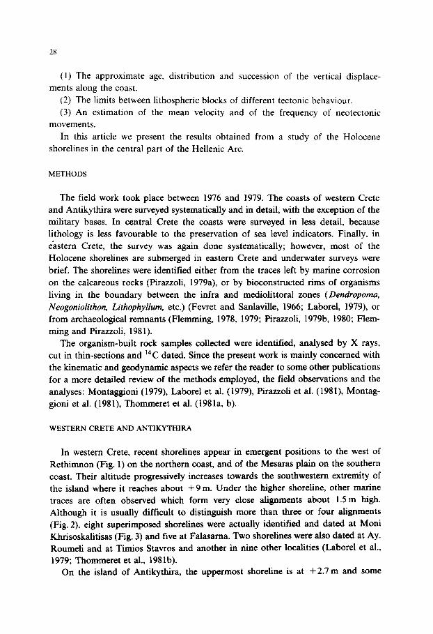
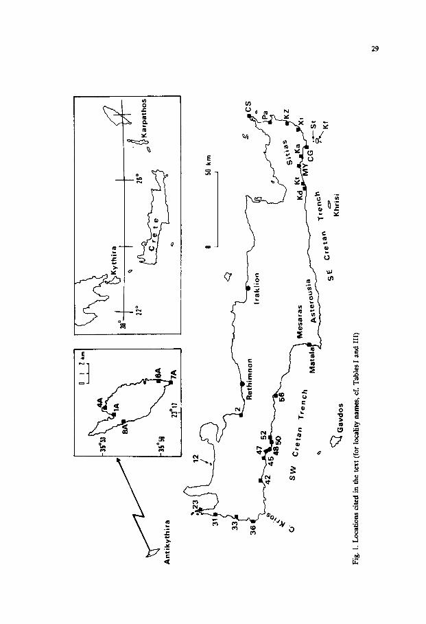
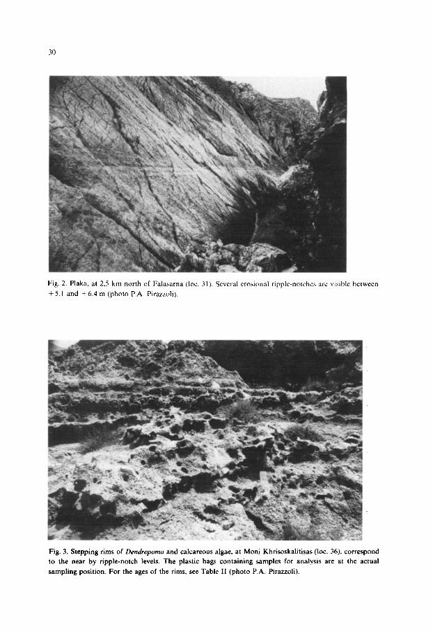
In western Crete, recent shorelines appear in emergent positions to the west of Rethimnon (Fig. 1) on the northern coast, and of the Mesaras plain on the southern coast. Their altitude progressively increases towards the southwestern extremity of the island where it reaches about + 9 m. Under the higher shoreline, other marine traces are often observed which form very close alignments about I.5 m high. Although it is usually difficult to distinguish more than three or four alignments (Fig. 2), eight superimposed shorelines were actually identified and dated at Moni Khrisoskalitisas (Fig. 3) and five at Falasama. Two shorelines were also dated at Ay. Roumeli and at Timios Stavros and another in nine other localities (Laborel et al., 1979; Thommeret et al., 1981b).
On the island of Antikythira, the uppermost shoreline is at + 2.7 m and some
An
tiky
thir
a
0 50
km
L
I
Fig
. I.
Loc
atio
ns
cite
d in
the
tex
t (f
or
loca
lity
nam
es,
cf.
Tab
les
I an
d II
I)
Fig. 2. Plaka. at 2.5 km north of Falaaarna (1~. 3 I). Several erosional ripple-notches are wsihle
+ 5. I and + 6.4 m (photo P.A. Pirazzoli).
between
Fig. 3. Stepping rims of Dendropoma and calcareous algae, at Moni Khrisoskalitisas (lot. 36). correspond
to the near by ripple-notch levels. The plastic bags containing samples for analysis are at the actual
sampling position. For the ages of the rims, see Table II (photo P.A. Pirazzoli).
31
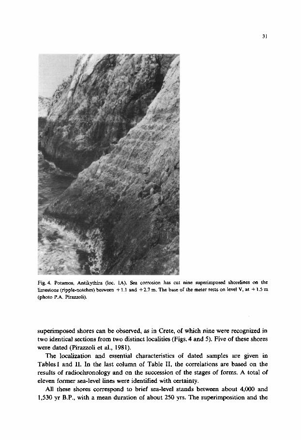
Fig. 4. Potamos, Antikythira (10~. 1A). Sea corrosion has cut nine superimposed shorelines on the
limestone (ripple-notches) between + 1 .I and + 2.7 m. The base of the meter rests on level V, at + 1.5 m
(photo P.A. Pirazzoli).
superimposed shores can be observed, as in Crete, of which nine were recognized in two identical sections from two distinct localities (Figs. 4 and 5). Five of these shores were dated (Pirazzoli et al., 1981).
The localization and essential characteristics of dated samples are given in Tables I and II. In the last column of Table II, the correlations are based on the results of radiochronology and on the succession of the stages of forms. A total of eleven former sea-level lines were identified with certainty.
All these shores correspond to brief sea-level stands between about 4,000 and 1,530 yr B.P., with a mean duration of about 250 yrs. The superimposition and the
32
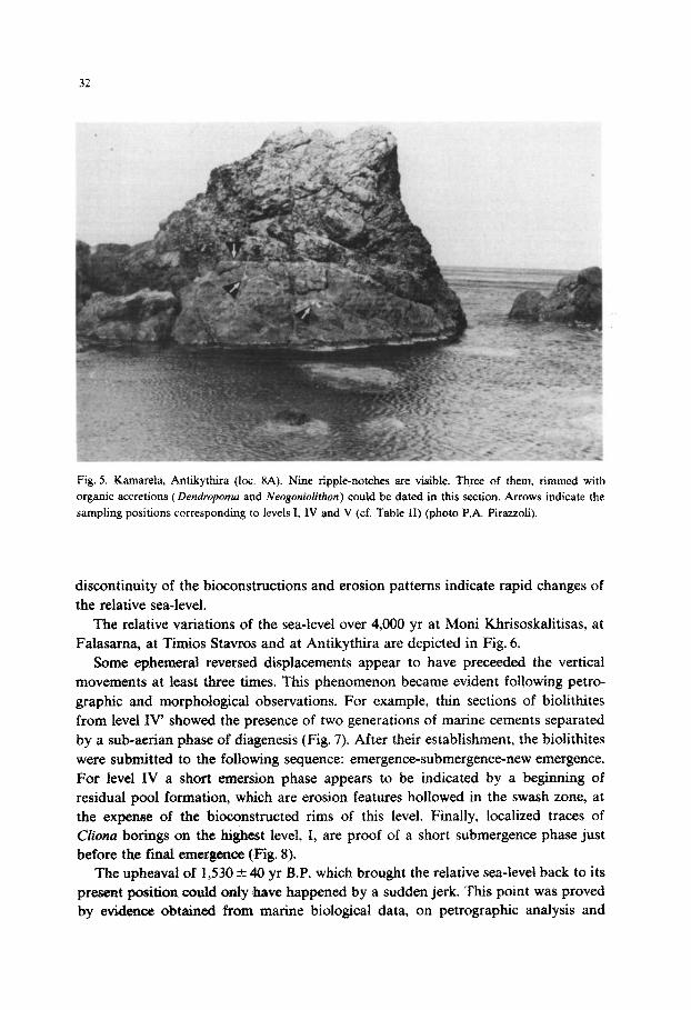
Fig. 5. Kamarela, Antikyt~ra (lot. 8A). Nine ripple-notches are visible. Three of them, rimmed with organic accretions (Dendropomu and Neogonioliihon) could be dated in this section. Arrows indicate the sampling positions corresponding to levels I, IV and V (cf. Table II) (photo P.A. Pirazzoli).
discontinuity of the bi~onst~ctions and erosion patterns indicate rapid changes of the relative sea-level.
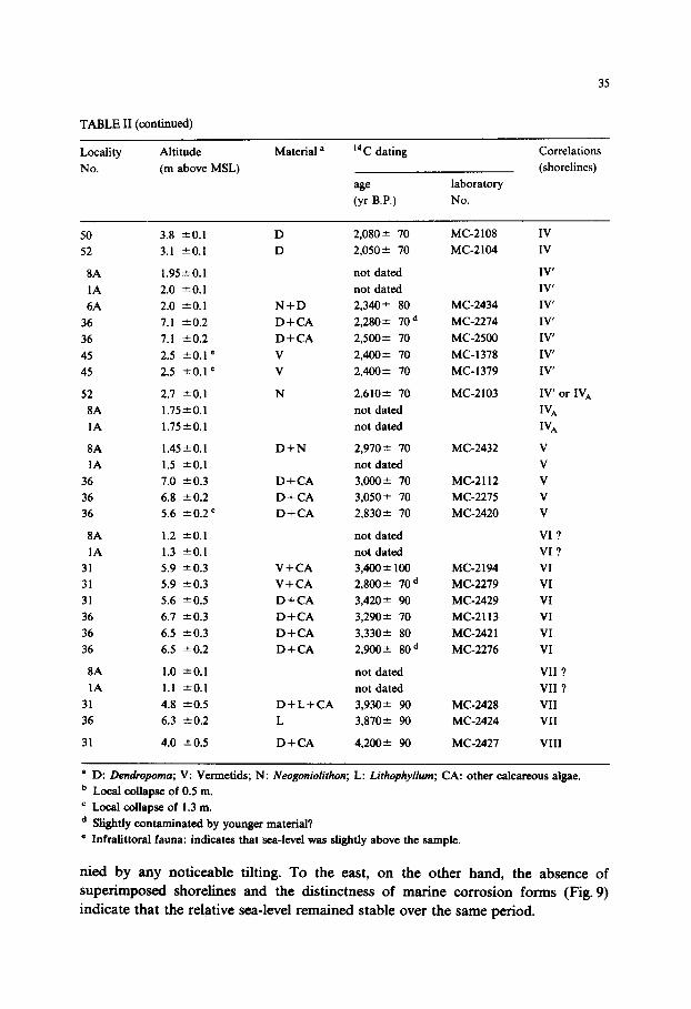
The relative variations of the sea-level over 4,000 yr at Moni Khrisoskalitisas, at Falasama, at Timios Stavros and at Antikythira are depicted in Fig. 6.
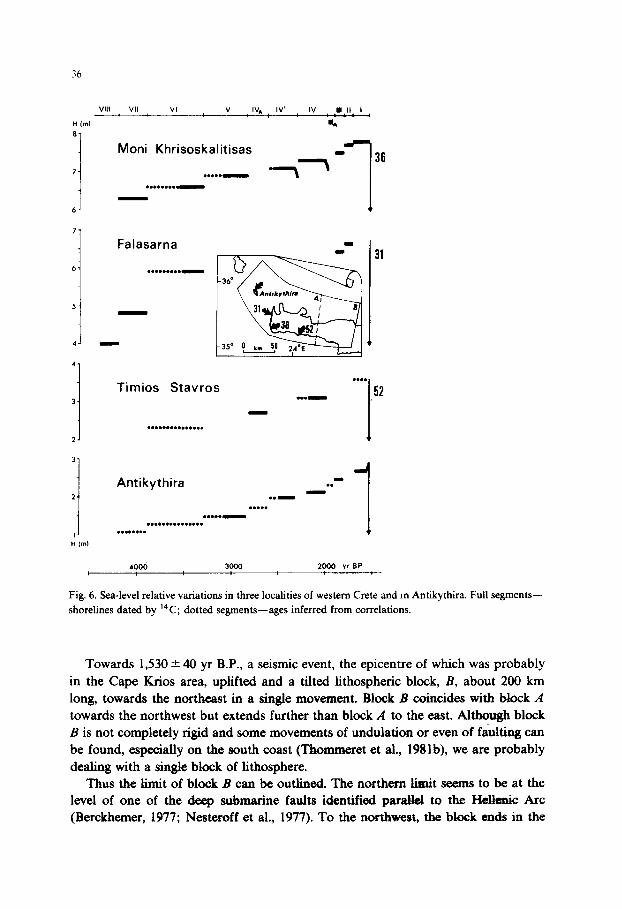
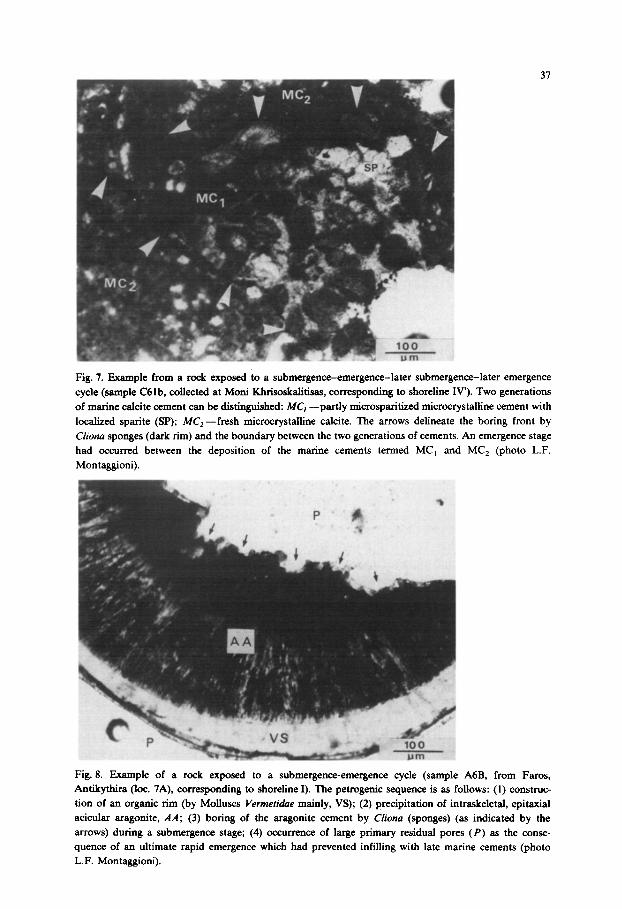
Some ephemeral reversed displacements appear to have preceeded the vertical movements at least three times. This phenomenon became evident following petro- graphic and morphological observations. For example, thin sections of biolithites from level IV’ showed the presence of two generations of marine cements separated by a sub-aeon phase of diagenesis (Fig. 7). After their estabIi~ment, the biolithites were submitted to the following sequence: emergence-submergence-new emergence. For level IV a short emersion phase appears to be indicated by a beginning of residual pool formation, which are erosion features hollowed in the swash zone, at the expense of the bioconstructed rims of this level. Finally, localized traces of Cfiona borings on the highest level, I, are proof of a short submergence phase just before the final emergence (Fig. 8).
The upheaval of 1,530 Z+Z 40 yr BP. which brought the relative sea-level back to its present position could only have happened by a sudden jerk. This point was proved by evidence obtained from marine biological data, on petrographic analysis and
33
TABLE I
Names and geographical coordinates of the localities with dated shorelines in western Crete and
Antikythira
Locality Lat. N Long. E
No.
(cf. Fig. 1)
name
Wesfern Crete
2
12
23
31
33
36
42
45
47
48
50
52
56
Anrikyrhira
8A
1A
4A
6A
IA
Yeoryohpolis 35O22’ 24” 16’
Ay. Thebdhoroi 35’32 23”56’
Kamerelou 35’36 23”36’
FalLama 35O30’ 23’34’
Peristerias 35”23’ 23’33’
Moni Khrisoskalitisas 35Ol9’ 23’32’
Pevkoi 35”15’ 23”49’
Ay. Roumeli 35014’ 23’51’
Akr. Plaka 35’12’ 24”Ol’
Koitrta 35’12 24’01’
Cape Mouros 35’12’ 24’04
Timios Stavrbs 35’12’ 24”06’
PlakaS Bay 35011’ 24’24’
Kamarela 35’52 23”16’
Potambs 35”52’ 23’17’
Kaminakia 35O53’ 23”17’
Stavrotc 35O50 23”19’
Faros 35”49’ 23’19’
from 14C datings (Thommeret et al., 1981a, b). The various shorelines are found more or less parallel to one another. Thus, at
Antikythira and at Moni Khrisoskalitisas, though separated by a distance of nearly 70 km, the interval between the different shorelines is nearly constant: 0.2-0.3 m between I and III, 0.5-0.55 m between I and IV, and 0.15-0.2 m between IV and IV’. At Falasarna, the interval between levels II and III is 0.2m, as at Moni
Khrisoskalitisas. At Timios Stavros, on the south coast of Crete, an undated shoreline, which could correspond to level I, is found 0.5 m above level IV, as at Antikythira and Moni Khrisoskalitisas.
The tectonic movements seem to differ to the west and to the east of Plakas Bay, on the southern coast, and the gulf of Yeoryioupolis, on the northern coast of Crete. To the west, a lithospheric block A, about 150 km long, including Antikythira and the Levka Ori area, seems to have undergone ten subsidences in the order of decirnetres. Altogether, the subsidence of block A was about 1.5 m and not accompa-
34
TABLE II
List of dated shorelines in western Crete and Anttkythira and correlations (for locations cf. Fig. 1 and
’ Infralittoral fauna: indicates that sea-level was slightly above the sample.
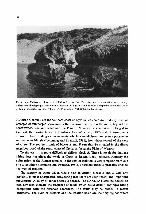
nied by any noticeable tilting. To the east, on the other hand, the absence of superimposed shorelines and the distinctness of marine corrosion forms (Fig. 9) indicate that the relative sea-level remained stable over the same period.
36
VIII VII VI V IV, IV’ IV YII I
H hl %
Moni Khrisoskalitisas
7- . . . ..-
. . . . . . ..-
-
6-
77
6.
5-
41
Falasarna -
. . . . . . . ..W
-
-
4-
3. Timios Stavros
. . . .
. ..- 1 52
,1 . . . . . . . . . . . . . . .
31
.
Antikythira . . 1. ..e
. . . . . . . . ..-
.*.............
I- . . . . . . . . -- I
Hlrn,
400ci 3ooo 2ooo YrBP I
Fig. 6. Sea-level relative variations in three localities of western Crete and m Antikythira. Full segments-
shorelines dated by 14C; dotted segments-ages inferred from correlations.
Towards 1,530 * 40 yr B.P., a seismic event, the epicentre of which was probably in the Cape Krios area, uplifted and a tilted lithospheric block, 8, about 200 km long, towards the northeast in a single movement. Block B coincides with block A towards the northwest but extends further than block A to the east. Although block B is not completely rigid and some movements of undulation or even of faulting can be found, especially on the south coast (Thommeret et al,, 1981b), we are probably dealing with a single block of lithosphere.
Thus the limit of block B can be outlined. The northern limit seems to be at the level of one of the deep submarine faults identified paraM to the HeUenic Arc (Berckhemer, 1977; Nesteroff et al., 1977). To the northwest, the block ends in the
37
Fig. 7. Example from a rock exposed to a submergence-emergence-later submergence-later emergence
cycle (sample C61 b, collected at Mom Khrisoskalitisas, corresponding to shoreline IV’). Two generations
of marine calcite cement can be distinguished: MC, -partly microsparitized microcrystalline cement with
localized sparite (SP); MC,-fresh microcrystalline calcite. The arrows delineate the boring front by
Ciiona sponges (dark rim) and the boundary between the two generations of cements. An emergence stage
had occurred between the deposition of the marine cements termed MC, and MC, (photo L.F.
Montaggioni).
_. .” ” -- .-
Fig. 8. Example of a rock exposed to a submergence-emergence cycle (sample A6B, from Faros,
Antikythira (10~. 7A), corresponding to shoreline I). The petrogenic sequence is as follows: (1) construc-
tion of an organic rim (by Molluscs Vermetidae mainly, VS); (2) precipitation of intraskeletal, epitaxial
acicular aragonite, AA; (3) boring of the aragonite cement by Cliona (sponges) (as indicated by the
arrows) during a submergence stage; (4) occurrence of large primary residual pores (P) as the conse-
quence of an ultimate rapid emergence which had prevented infilling with late marine cements (photo
L.F. Montaggioni).
Fig. 9. Cape Melissa, at 18 km east of Plakas Bay (lot. 56). The raised notch. about 0.8 m deep, clearly
differs from the tipple patterns typical of block A (cf. Figs. 2.4 and 5). Such a deepening could occur only
with a lasting stable sea-level (photo P.A. Pirazzoli. <Q 1981 Gebriider Borntraeger).
Kythiran Channel. On the southern coast of Kythira, we could not find any trace of emerged or submerged shorelines in the shallower depths. To the south, beyond the southwestern Cretan Trench and the Plain of Mesaras, in which it is prolonged to
the east, the crustal block of Gavdos (Nesteroff et al., 1977) and of Asteroussia seems to have undergone movements which were different or even opposite in nature, as in Matala (Lemming and Pirau;oli, 1981), from those typical of the west of Crete. The southern limit of blocksA and B can thus be situated in the direct neighbourhood of the south coast of Crete, as far as the Plain of Mesaras.
To the east, it is more difficult to delimit block B. There is no doubt that the tilting does not affect the whole of Crete, as Raulin (1869) believed. Actually the submersion of the Roman remains to the east of I&lion is very irregular from one site to another (Flemming and Pirazzoli, 1981). Therefore, block B probably ends to the west of Iraklion.
The scarcity of traces which would help to delimit blocksA and B with any certainty is most unexpected, considering that there are such recent and important movements. A study of aerial photos is needed. The LANDSAT satellite photos do not, however, indicate the existence of faults which could delimit any rigid tilting compatible with the observed shorelines. The faults may be hidden in recent sediments. The Plain of Mesaras and the Iraklion basin are the only regions where
39
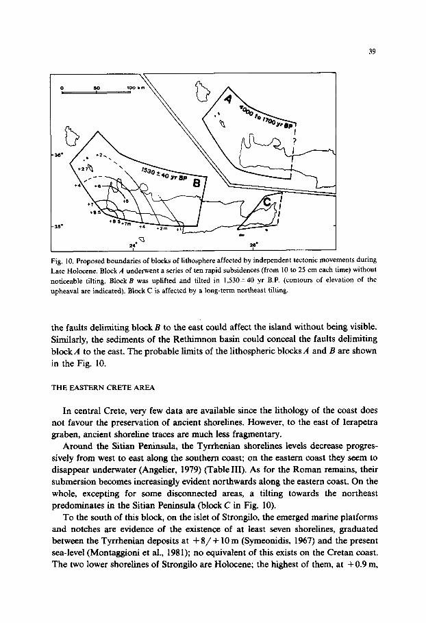
Fig. 10. Proposed boundaries of blocks of lithosphere affected by independent tectonic movements during
Late Holocene. Block A underwent a series of ten rapid subsidences (from IO to 25 cm each time) without
noticeable tilting. Block B was uplifted and tilted in 1,530*40 yr B.P. (contours of elevation of the
upheaval are indicated). Block C is affected by a long-term northeast tilting.
the faults delimiting block B to the east could affect the island without being visible. Similarly, the sediments of the Rethimnon basin could conceal the faults delimiting block,4 to the east. The probable limits of the lithospheric blocks A and B are shown in the Fig. 10.
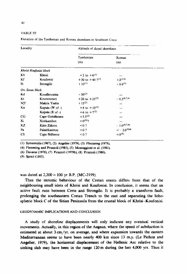
THE EASTERN CRETE AREA
In central Crete, very few data are available since the lithology of the coast does not favour the preservation of ancient shorelines. However, to the east of Ierapetra graben, ancient shoreline traces are much less fragmentary.
Around the Sitian Peninsula, the Tyrrhenian shorelines levels decrease progres- sively from west to east along the southern coast; on the eastern coast they seem to disappear underwater (Angelier, 1979) (Table III). As for the Roman remains, their submersion becomes increasingly evident northwards along the eastern coast. On the whole, excepting for some disconnected areas, a tilting towards the northeast predominates in the Sitian Peninsula (block C in Fig. 10).
To the south of this block, on the islet of Strongilo, the emerged marine platforms and notches are evidence of the existence of at least seven shorelines, graduated between the Tyrrhenian deposits at +8/+ 10 m (Symeonidis, 1967) and the present sea-level (Montaggioni et al., 1981); no equivalent of this exists on the Cretan coast. The two lower shorelines of Strongilo are Holocene; the highest of them, at +0.9 m,
40
TABLE III
Elevation of the Tyrrheman and Roman shorehnes tn Southeast Creta
was dated at 2,200 f 100 yr B.P. (MC-2199). Thus the tectonic behaviour of the Cretan coasts differs from that of the
neighbouring small islets of Khrisi and Koufonisi. In conclusion, it seems that an active fault runs between Crete and Strongilo. It is probably a transform fault, prolonging the southeastern Cretan Trench to the east and separating the litho- spheric block C of the Sitian Peninsula from the crustal block of Khrisi-Koufonisi.
GEODYNAMIC IMPLICATIONS AND CONCLUSION
A study of shoreline displacements will only indicate any eventual vertical movements. Actually, in this region of the Aegean, where the speed of subduction is estimated at about 3 cm/yr, on average, and where expansion towards the eastern Mediterranean seems to have been nearly 400 km since 13 m.y. (Le Pichon and Angelier, 1979), the horizontal displacement of the Hellenic Arc relative to the sinking slab may have been in the range 120 m during the last 4,000 yrs. Thus it
41
seems likely that for each subsidence of block A, translation movements occurred
towards the southwest, but their amplitude has not yet been determined. It can be said that blockA was dragged, without tilting, by a series of sliding jolts between 4,000 and 1,700 yr B.P.; the impetus for these movements was probably gravitational forces caused by the height of the Aegean above the adjacent sea-floor (Berckhemer,
1977; Le Pichon, 1979). The tilting of block& in 1,530 * 40 yr B.P., seems to have a different origin. In
order to tilt a block nearly 200 km long, and to uplift it over about 10 m, forces acting at a much deeper level must be involved. For blockB, the constraints associated with subduction of the oceanic crust of the Ionian basin below the
Hellenic Arc supply a much more satisfactory explanation. Blocks of the size of B are frequently found along the circumpacific border,
especially in southwestern Japan (Yonekura, 1975; Pirazzoli, 1978). These blocks are marked by high magnitude earthquakes; they are uplifted and tilted rigidly, with
recurrence times ranging from 90-264 yrs (Yonekura, 1975) to l,OOO-2,000 yrs (Yoshikawa et al., 1968; Matsuda et al., 1978; Nakata et al., 1979) thus providing evidence of an intense subduction activity associated with rapid deformations (ranging about 8 cm/yr).
In Japan, as in the Hellenic Arc, the tiltings are usually orientated in the direction of subduction and are probably a result of asperities on the surface of the sinking slab, which occasionally hook onto a block of lithosphere in the insular arc. Unable to be dragged towards the bottom because of its very low density, the block opposes the progression of the slab for some time. Then, as the constraints increase sufficiently, a fault occurs and the lithospheric block, suddenly freed, is uplifted and tilted by elastic rebound.
However, the movements around Japan tend to be predictable under comparable conditions, whereas in the Hellenic Arc the vertical movements are irregular. In
western Crete, for example, one can often observe Pleistocene shorelines situated either above or below the Holocene shorelines.
Whatever the causes of the subduction might be-forces on the boundary of the region (Tapponnier, 1977), forces on the base of the lithosphere (McKenzie, 1978) or, more likely, the density of the sinking slab is higher than that of the surrounding mantle (Le Pichon and Angelier, 1979), the recently observed movements in Crete and at Antikythira seem to correspond to relatively isolated tectonic paroxysmal phenomena. In addition, since the upheaval of 1,530* 40 yr B.P., jolting subsi- dences, previously so frequent, have entirely stopped.
However, it is likely that a similar phenomenon is developing in neighbouring areas; at Karpathos, for example, the post-Tyrrhenian upheavals have given place to sinking by jolts, without noticeable tilting, during historical ages (Flemming, 1978, appendix 1; Pirazzoli, 1980). This may be a precursory sign of the imminence of an important upheaval in this region.
42
REFERENCES
Angeher, J.. 1979. Neotectomque de l’arc C&m. Societe Geologique du Nord. Publ. No. 3. 418 pp.
Berckhemer, H., 1977. Some aspects of the evolution of marginal seas deduced from observations in the
Aegean region. In: B. BiJu-Duval and L. Montadert (Editors), International Symposium on the
Structural History of the Mediterranean Basins, Split. Editions Technip. Paris, pp. 303-313.
Davaras, C., 1978. A rock-cut fish-tank near Hierapetra (m Greek, with English abstract). Archaiologikon
Deltion, 30 (1975): 149- 157.
Fevret. M. and Sanlaville, P., 1966. L’utilisation des Vermets dans la determination des anciens niveaux
matins. MWiterranee, 7: 357-364.
Flemming, N.C., 1978. Holocene eustatic changes and coastal tectonics m the northeast Mediterranean:
implications for models of crustal consumption. Philos. Trans. R. Sot. London, Ser. A, 289 (1362):
405-458 + Appendix 1.
Flemming, N.C., 1979. Archaeological indicators of sea level. In: Groupe Nivmer (Editor), Les indi-
cateurs de niveaux marins. Qceanis, 5 (Fast. Hors-S&.): 149-166.
Flemming, N.C. and Ptrazzoli, P.A., 1981. Archeologic des c&es de la Crete. Hist. Arch(to1. Dossiers, 50:
66-81.
Laborel, J., 1979. Les Gasteropodes vermetides: leur utilisation comme marqueurs biologiques de rivages
fossiles. In: Groupe Nivmer (Editor), Les indicateurs de niveaux matins. Oceams, 5 (Fast. Hors-!&%.):
221-239.
Laborel, J., Pirazzoh, P.A., Thommeret, J. and Thommeret, Y.. 1979. Holocene raised shorelines in
western Crete (Greece). In: K. Suguio, T.R. Fairchild, L. Martin and J.M. Flexor (Editors),
Proceedings of the “1978 International Symposium on Coastal Evolution in the Quatemary” S&o
Paulo, Brasil. pp. 475-50 1. Le Pichon, X., 1979. Bassins margmaux et collision intracontinentale: exemple de la zone Cgeenne. C.R.
Acad. Sci Paris, Ser. D, 288: 1083-1086.
Le Pichon, X. and Angelier, J., 1979. The Hellenic arc and trench system: a key to the neotectonic
evolution of the eastern Mediterranean area. Tectonophysics, 60: l-42.
Matsuda, T., Ota, Y., Ando, M. and Yonekura, N.. 1978. Fault mechanism and recurrence time of major
earthquakes in southern Kanto district, Japan, as deduced from coastal terrace data. Geol. Sot. Am.
Bull., 89: 1610-1618.
McKenzie, D., 1978. Active tectonics of the Alpine-Himalayan belt: the Aegean Sea and surrounding
regions. Geophys. J.R. Astron. Sot., 55: 217-254.
Montaggioni. L.. 1979. Les modifications diagenttiques des roches carbonatires en tant qu’indtcatrices des
variations relatives du niveau marin. In: Groupe Nivmer (Editor), Les indicateurs de niveaux marins.