www.elsevier.com/locate/catena
Catena 58 (2004) 41–64
Enhancing ethno-pedology: integrated approaches
to Kanuri and Shuwa Arab definitions in the
Kala–Balge region, northeast Nigeria
W. Paul Adderleya,*, Ian A. Simpsona, Holger Kirschtb,Mohammed Adamc, Joel Q. Spencerd,1, David C.W. Sandersond
aSchool of Biological and Environmental Sciences, University of Stirling, Stirling, FK9 4LA Scotland, UKb Institut fur Historische Ethnologie, Johann Wolfgang Goethe-Universitat, Frankfurt am Main, Germany
cCentre for Trans-Saharan Studies, University of Maiduguri, PMB 1068 Maiduguri, Borno, NigeriadScottish Universities Environmental Research Centre, Rankine Avenue, East Kilbride G75 OQF, Scotland, UK
Received 17 February 2003; received in revised form 8 December 2003; accepted 16 December 2003
Abstract
Ethno-pedology, the systematic definition and classification of indigenous technical knowledge
of soil attributes, has often ignored scientific knowledge of soil properties. This paper considers one
ethno-pedological class, cesa–goz soils, managed by Kanuri and Shuwa Arab peoples in the Kala–
Balge region, northeast Nigeria. Soil micromorphology demonstrates that these soils have been
managed in different ways over extended periods, defined by optically stimulated luminescence
(OSL) dating. This has resulted in discrete soil types, indicating that ethno-pedological soil
classification can be enhanced by integrating it with scientifically defined soil properties and
chronologies. These observations carry major implications for the application of ethno-pedology
approaches to land management development and the understanding of landscape history.
D 2004 Elsevier B.V. All rights reserved.
Keywords: Ethno-pedology; Soil classification; Shuwa Arab, Kanuri; Manuring; Soil micromorphology;
Optically stimulated luminescence (OSL)
0341-8162/$ - see front matter D 2004 Elsevier B.V. All rights reserved.
doi:10.1016/j.catena.2003.12.003
* Corresponding author. Tel.: +44-1786-467840; fax: +44-1786-467843.
E-mail address: [email protected] (W.P. Adderley).1 Present address: School of Geography and Geosciences, University of St. Andrews, St. Andrews, Fife
KY16 9AL, Scotland, UK.
W.P. Adderley et al. / Catena 58 (2004) 41–6442
1. Introduction
Ethno-pedology, defined as the articulation of indigenous and local cultural
knowledge of soils, has developed as a research arena attempting to classify soils
according to social criteria, rather than the physical and chemical criteria favoured by
national and international soil surveys such as USDA (Soil Survey Staff, 1999) and
World Reference Base (FAO/ISRIC/ISSS, 1998; ISSS Working Group RB, 1998).
Ethno-pedology has been seen as a key requirement for understanding the maintenance
of soil fertility, in making soil research findings more understandable to local farmers,
and in the understanding of cultural landscape change, particularly in development
contexts. This is leading towards a dichotomy between social science and physical
science approaches to soil classification, and thus soil process understanding. The
dichotomy runs counter to the emerging demands, and indeed requirements, for the
integration of these two approaches to allow a fuller understanding of human–
environment relationships within landscape contexts (Balee, 1998; Crumley, 1994).
The primary aim of this paper is to show that integration of ethnographic approaches
with appropriate physical soil science and dating techniques is essential to improve
ethno-pedological classification.
In the Kala–Balge region, Borno State, northeast Nigeria, yellow aeolian-derived
sandy soils occur around settlements within the clay-rich lacustrine plain of the
southern part of the Lake Chad basin. These sandy soils, generally classified as
Ustic Psamments in the USDA classification (Soil Survey Staff, 1999) or Arenosols
in the World Reference Base (FAO/ISRIC/ISSS, 1998), have common features of
weak soil peds, high water permeability, and low water retention. The main ethnic
groups who occupy the area give them the vernacular names of cesa (Kanuri
peoples) and goz (Shuwa Arab peoples). These soils have been classified as one
distinct ethno-pedological unit because their descriptions are the same within the two
ethnic groups (Braukamper et al., 1993). Subdivisions within this cesa–goz class are
recognised, based on location and surface soil texture (Kirscht and Skorupinski,
1996). However, this system has not recognised the possibility of soil management
by different ethnic groups resulting in distinctive cesa and goz soils. This carries
implications for the application of such classifications in rural survey and policy
development.
The first objective of this paper is to assess whether present day field management
activities, as derived by ethnographic interview, can justify distinction between cesa
and goz classes. The second objective is to apply thin section micromorphology
analyses to them, to assess whether there are physical soil distinctions associated with
soil management by the Kanuri and Shuwa Arab peoples. This will test whether cesa
and goz should be considered as distinct ethno-pedological classes. A third objective
of the paper is to consider if any such distinctions are cumulative over extended time-
depth periods and are critical in deriving appropriate ethno-pedological classification
and understanding traditional land management. To consider the chronology of these
soils, optically stimulated luminescence (OSL) techniques are used because of the
abundance of quartz in the soil profiles and the absence of materials suitable for
radiocarbon measurements.
W.P. Adderley et al. / Catena 58 (2004) 41–64 43
2. The study area
The Kala–Balge region is a geographic area within the Lake Chad basin centred on the
trading town Kala (Fig. 1). The region lies at the northern limit of the Sudan Centre
vegetation zone, immediately south of the Sahel Transition zone (White, 1983). At the
macro-scale no recognisable vegetational differences occur latitudinally in this region,
although local variations in woodland extent have long been recorded (Foster, 1914). The
climate is semi-arid with mean annual rainfall f600 mm and a mean annual potential
evapotranspiration of f1300 mm. With a unimodal rainfall distribution, the seasons are a
long dry season (October–May) and a short (f110 day) rainy period (June–September).
Since the 1970s, temporal changes in rainfall patterns have been recorded at Maiduguri
and N’Djamena. Compared with 30-year mean values, there is a trend towards lower
overall and more erratic rainfall distribution throughout the rainy season (FAO, 1984; Hess
et al., 1995). Recent, highly erratic year to year changes in rainfall have been recorded in
the lacustrine plain at New Marte (Adderley, 1998). The social effect of these changes in
rainfall was especially severe during the pan-Sahelian droughts of 1968–1973 and 1983,
causing many deaths and many people to move away.
The land systems map of the lacustrine areas in the southern Lake Chad basin (Fig. 2) is
based on aerial photography and indicates that the clay-rich plains extend over 8500 km2.
Within this area, the Kala plain land system exceeds 2000 km2 (Aitchison et al., 1972). There
is little ( < 7 m) relief across the Kala–Balge region and the sediment stratigraphy is
distinctive, with lacustrine clays (V 3 m) overlying multiple lacustrine-derived sand-rich
strata. These sands are exposed in discrete raised areas and can form the basis for settlement
mounds. The soils developing on the lacustrine clay are inherently nutrient-rich, and whilst
water is a limiting factor, the relative productivity of agrarian systems is dependent on both
land- and water-use management (Adderley et al., 1997). The resilience of the Kanuri and
Shuwa Arab communities in this region is primarily determined by their adaptive responses
in land management to short-term climatic variability and long-term climatic trends.
With a restricted topographic range and vegetation, the Kala–Balge region is a spatially
uniform biome. Consequently, the effects of the different agricultural practices resulting
from cultural adaptation to the variable climatic regime by the two main ethnic groups,
Kanuri and Shuwa Arab, can be reliably assessed. There are clear differences in material
cultures and value systems (Braukamper et al., 1993), extending to agricultural practices: the
Shuwa Arab people focus on livestock production, the Kanuri are more agrarian. Both
groups grow crops and rear cattle and small animals, but their different economic foci are
reflected in different agricultural strategies. In particular, the numbers and the cultural
importance of cattle are greater for Shuwa Arab people than for Kanuri people. Braukam-
per’s (1993) review of the region’s history and folk-lore concludes that Kanuri people have
settled on these clay plains since at least the 16th century, whereas the Shuwa Arab people
migrated into the region as semi-nomadic pastoralists during the 18th and early 19th
centuries. A longer record of continuous settlement is provided by archaeological studies on
the construction of the settlement mounds, with the earliest (>3000 cal BP) cultural deposits
reported at the abandoned settlement mound of Daima (Gronenborn, 1996; Connah, 1981).
Crop production in this region today, for both the Kanuri and Shuwa Arab, is
characterised by dry-season cropping of masakwa sorghum on the residual moisture
Fig. 1. The southern Lake Chad basin, indicating sampling locations Kala, Tiwa and Bidelli.
W.P. Adderley et al. / Catena 58 (2004) 41–6444
Fig. 2. Land systems of the southern Lake Chad basin (after Aitchison et al., 1972).
W.P. Adderley et al. / Catena 58 (2004) 41–64 45
Fig. 3. Manured and cultivated goz area, Bidelli (Shuwa Arab village), Kala–Balge region, Borno State, Nigeria.
W.P. Adderley et al. / Catena 58 (2004) 41–6446
contained in the clay-rich soils (Usterts; Soil Survey Staff, 1999; Vertisols; FAO/ISRIC/
ISSS, 1998). These soils have been extensively characterised within an ethno-pedological
framework (Kirscht and Skorupinski, 1996) and are locally called firki (Kanuri) or kerga
(Shuwa Arab). The other major soil type used in dry season cropping is motusku (Kanuri)
or marsiya (Shuwa Arab) (Inceptisols; Soil Survey Staff, 1999; Cambisols; FAO/ISRIC/
ISSS, 1998): areas where lacustrine clay has intermixed or has been overlain with aeolian
sands. The distinctive dry-season cropping was noted by early explorers (Barth, 1857) and
has been the past focus of both ethnographic (Braukamper et al., 1993) and process-based
(Adderley et al., 1997) studies. Although the clay soils have been widely studied, rain-fed
agriculture on sandy cesa–goz soils has received little attention. These sandy soils fringing
the settlement mounds support the production of rain-fed legumes, millet (Pennesetum sp.)
and minor quantities of sorghum, and are key to the successful initial and continued
settlement of the region (Fig. 3).
3. Methods
3.1. Field survey and sampling
Following discussion with the head of the local government area and village elders, two
villages typifying Kanuri and Shuwa Arab agrarian practices were selected for study:
Tiwa, a Kanuri settlement (11j59VN, 14j21VE), and Bidelli, a Shuwa Arab settlement
(12j02VN, 14j24VE) (Fig. 1). At each site two soil profiles were dug in random locations in
manured cesa–goz fields and described in terms of Munsell colour, texture and structure.
One additional profile (12j05VN, 14j28VE) on the firki clay plain outside the village of
Kala provided undisturbed and unmodified sands and clays at depth for comparison with
W.P. Adderley et al. / Catena 58 (2004) 41–64 47
the cesa–goz soils. Representative undisturbed samples were collected from these profiles
(Fig. 4) in Kubiena tins for manufacture of thin sections.
Samples for optically stimulated luminescence (OSL) dating were taken immediately
below the horizons that showed field evidence (i.e. fuel and building debris) of cultural
amendment (Fig. 4). They were collected in 1 cm diameter copper tubes and transported
capped with foil to prevent light penetration. Additional bulk samples were collected in the
same way for gamma spectrometry to allow environmental dose rates to be established.
The OSL of four samples from Tiwa profile 2 was measured to investigate chronological
variation with depth through the settlement mound. The sample collected at 4–12 cm
depth (SUTL1410) was considered equivalent to a modern analogue sample.
3.2. Ethnographic fieldwork
Ethnographic fieldwork in Tiwa was conducted by non-standardised interview, to
obtain information about present-day agricultural systems from local agricultural experts
and the village head (bulama). As an interview with the village head at Bidelli was not
possible, the Shuwa Arab village of Medina was choosen for comparison and an equal
number of interviews were carried out. To compare field systems, field areas were
measured using a Garmin 12-channel GPS system (minimum of six satellites tracked:
positional accuracy F 12 m).
3.3. Thin section manufacture and description
The undisturbed soil blocks were prepared as thin sections following acetone replace-
ment of water in the liquid phase and impregnation under vacuum of a polyester resin
system (Crystic 17449), using butan-1-one peroxide as a catalyst. Sections were cut and
bonded by epoxy resin to polished custom slides (110� 75� 3 mm), then ground and
polished to a nominal 30 Am thickness.
Thin sections were described according to Bullock et al. (1985) using a petrological
microscope over a range of magnifications (� 10 to � 400) and illumination sources
(plane polarized, between crossed polars, circular polarized and oblique incident light).
Feature interpretation follows from other anthropogenic soils (Simpson et al., 2002;
Simpson, 1997) and is based on Courty et al. (1989) and FitzPatrick (1993).
3.4. Optically stimulated luminescence (OSL) measurements
To avoid bleaching the luminescence, all work was done under safelight conditions. The
moisture content of the OSL samples was measured after drying at 50 jC to constant
weight. Portions (20 g) from each sample were used to measure beta dose-rates by thick
source beta counting (Sanderson, 1988). Bulk sediment samples, from the OSL sampling
positions, were dried and 200 g portions placed in gas-tight counting-apparatus containers.
A Shap granite standard was prepared in the same way, and all were stored for 1 week to
allow any radon daughters to equilibrate, for both samples and standard, before measure-
ment using a high-resolution gamma spectrometry system. Quartz grains (90–125 Am)
were separated from the remainder of each sample by sieving, removing carbonates with
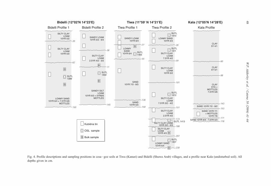
Fig. 4. Profile descriptions and sampling positions in cesa–goz soils at Tiwa (Kanuri) and Bidelli (Shuwa Arab) villages, and a profile near Kala (undisturbed soil). All
depths given in cm.
W.P.Adderley
etal./Caten
a58(2004)41–64
48
W.P. Adderley et al. / Catena 58 (2004) 41–64 49
HCl, feldspars with 40% HF, and heavy minerals by density separation using sodium-
polytungstate (2.74 g cm� 3) solution. The quartz grains were mounted on stainless steel
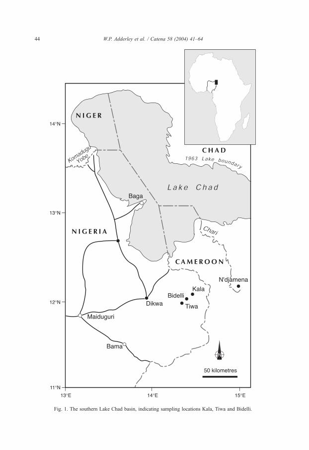
discs (9.6 mm diameter) coated with silicone grease; several discs were prepared from each
sample with a circle (diameter < 5 mm) of grains positioned in the centre of each disc.
OSL was measured with a Risø TL/OSL-DA-15 automated system. Luminescence
from the quartz grains was stimulated using blue light emitting diodes (470 D 20 nm) with
detection in the ultraviolet defined by a Hoya U340 filter. A single aliquot regenerative-
dose (SAR) protocol (Murray and Wintle, 2000; Sanderson et al., 2001) was used to
measure the equivalent dose (De). In the SAR method, each natural or regenerated OSL
signal was corrected for changes in sensitivity using the luminescence response to a
subsequent test dose. Each measurement cycle comprised a regeneration dose (0 Gy for
natural OSL), a sample preheat for 30 s, optical stimulation for 100 s at 125 jC, a constanttest-dose, a test-dose preheat of 160 jC for 30 s and a final optical stimulation for 100 s at
125jC. The stability of De was monitored over sample preheats from 250 to 280 jCincreasing in 10 jC steps. Several measurement cycles at different regeneration doses were
used to construct a growth curve. The growth curve data were fitted with a linear or single
saturating exponential function and the De was estimated by interpolation with the net-
natural sensitivity-corrected luminescence level. The distribution in De values was then
examined using weighted histogram plots (Duller et al., 2000).
Table 1
Field areas at Tiwa (Kanuri) and Madina (Shuwa Arab) villages
Village/farmer Field Soil type and
manuring strategy
Field area
(m2)
Percentage of total
cesa–goz field
area manured
Tiwa (Kanuri)
Bulama Goni
Mohammed
1 Cesa—manure applied 2385 15
2 Cesa—no manure applied 13,411
3 Motusku—dry season cultivation 41,922
4 Firgi—dry season cultivation 182,004
Abba Kime 1 Cesa—manure applied 369 34
2 Cesa—manure applied 701
3 Cesa—no manure applied 15,342
Madina (Shuwa Arab)
Bulama Haruna
Mohammed
1 Goz—manure applied 389 13
2 Goz—no manure applied 2497
3 Motusku—dry season cultivation 56,357
4 Firki—dry season cultivation 33,814
Murra Mohammed 1 Goz—manure applied 849 20
2 Goz—no manure applied 3257
3 Goz—no manure applied 3766
4 Marsiya—dry season cultivation 33,841
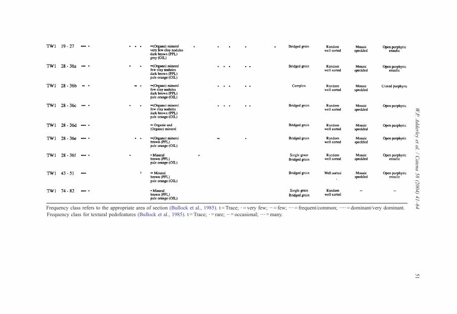
Frequency class refers to the appropriate area of section (Bullock et al., 1985). t = Trace; b = very few; bb = few; bbb= frequent/common; bbbb= dominant/very dominant.
Frequency class for textural pedofeatures (Bullock et al., 1985). t = Trace; b = rare; bb = occasional; bbb=many.
W.P.Adderley
etal./Caten
a58(2004)41–64
51
W.P. Adderley et al. / Catena 58 (2004) 41–6452
4. Results
4.1. Cesa and goz field management
At Tiwa (Kanuri) the areas of the seven fields managed by Bulama Goni Mohammed
(the Bulama of Tiwa) and Abba Kimes were measured. At Madina (Shuwa Arab) eight
fields were measured of Bulama Haruna Mohammed (the Bulama of Madina) and Murra
Mohammed (Table 1). These farms allow comparison of the cultural aspects of land
management, but since the fields of the bulama are included, and the bulama is usually
amongst the farmers with the largest land possessions, the measurements are not
considered representative of an average farm. This is also the case in both villages for
the second person whose fields were measured, since they are important people within
their villages and their land possessions are larger than average. Nevertheless, the
combinations of land use and field measurement are indicative of contrasts between
Kanuri and Shuwa Arab villages (Table 1).
The number and mean area of the cesa–goz fields are of the same order at both villages,
but there is greater emphasis on manured cesa cultivation at Tiwa (Table 1). At both the
Kanuri and Shuwa Arab villages, there are large unmanured cesa–goz fields and like the
manured cesa–goz soils, these are used for rain-fed crop production. Whilst individual
field areas vary, the ratio of field areas used for rain-fed and dry-season cropping is similar
for both villages; however, the total amount of land cropped per head of population in
Tiwa, the Kanuri village, is greater.
4.2. Field characteristics of cesa and goz soils
The cesa and goz profiles at Tiwa and Bidelli show a wide range of textural classes and
Munsell colours (Fig. 4). Typically, the lower parts of the profile lack field evidence of
cultural inclusions with no visible fuel residue materials or building debris. Within each
profile, these horizons are sharply distinct from one another and contain a significant
proportion of sand (sand, loamy sand and sandy silt loam textures) and are light yellowish
brown and pale brown in colour, with rare reddish yellow mottles in the Bidelli profiles.
These lower horizons represent the original parent material of the cesa–goz soils. The
boundaries between upper horizons in both profiles are more diffuse and contain cultural
material especially charcoal and pottery shards. These horizons range in texture from
loamy sand through to silty clay loam with Munsell colours ranging from dark grayish
brown to brown. At Tiwa the soils contain more sand than at Bidelli, although there is
limited overlap in textural classes, suggesting a slight difference in sediment sources
between the two localities.
4.3. Micromorphology of cesa and goz soils
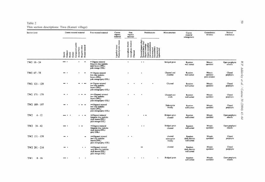
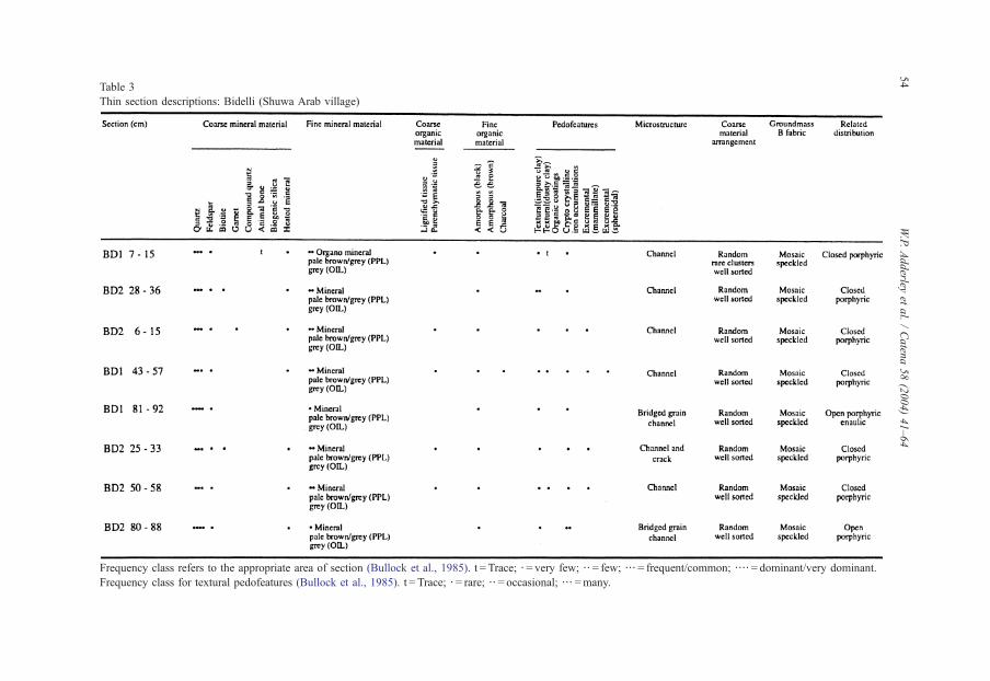
Tables 2 and 3 provide thin section descriptions for cesa–goz soils at Tiwa (Kanuri
village) and Bidelli (Shuwa Arab village). Both soils are consistently characterised by
common (30–50%) to dominant (50–70%) well-sorted sub-angular and sub-rounded
quartz grains up to 450 Am in diameter, with very few ( < 5%) feldspars. Few (5–15%) to
W.P. Adderley et al. / Catena 58 (2004) 41–64 53
dominant frequency classes of fine materials (V 60 Am) dominated by clays and silts with
mosaic speckled b fabrics are also consistently present, in-filling spaces between the quartz
grains. Under oblique incident light, the matrix of these materials is generally pale orange
and grey, contrasting with the brown matrix colours observed with transmitted plane
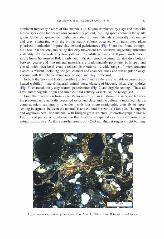
polarised illumination. Impure clay textural pedofeatures (Fig. 5) are also found through-
out these thin sections, indicating that clay movement has occurred, suggesting structural
instability of these soils. Crypto-crystalline iron infills generally < 50 Am diameter occur
in the lower horizons at Bidelli only, and indicate periodic wetting. Related distributions
between coarse and fine mineral materials are predominantly porphyric, both open and
closed, with occasional enaulic-related distributions. A wide range of microstructure
classes is evident, including bridged, channel and chamber, crack and sub-angular blocky,
varying with the relative abundance of sand and clay in the soil.
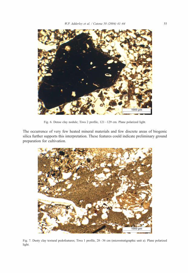
In both the Tiwa and Bidelli profiles (Tables 2 and 3), there are variable occurrences of
heated (rubified) mineral material, animal bone, clusters of biogenic silica, clay nodules
(Fig. 6), charcoal, dusty clay textural pedofeatures (Fig. 7) and organic coatings. These all
have anthropogenic origin and three cultural activity variants can be recognised.
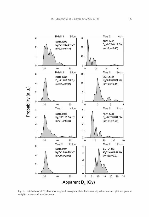
First, the thin section from 28 to 36 cm in profile Tiwa 1 shows the interface between
the predominantly naturally deposited sands and clays and the culturally modified. Here a
complex micro-stratigraphy is evident, with four micro-stratigraphic units (b–e) repre-
senting intergrades between the natural (f) and cultural horizon (a) (Table 2). The organic
and organo-mineral fine material with bridged grain structure (microstratigraphic unit b;
Fig. 8) is of particular significance in that it can be interpreted as a result of burning the
natural soil surface. As this micro-horizon is only 2–3 mm thick it suggests light burning.
Fig. 5. Impure clay textural pedofeatures; Tiwa 2 profile, 208–216 cm. Between crossed Polars.
Table 3
Thin section descriptions: Bidelli (Shuwa Arab village)
Frequency class refers to the appropriate area of section (Bullock et al., 1985). t = Trace; b = very few; bb = few; bbb= frequent/common; bbbb= dominant/very dominant.
Frequency class for textural pedofeatures (Bullock et al., 1985). t = Trace; b = rare; bb= occasional; bbb =many.
W.P.Adderley
etal./Caten
a58(2004)41–64
54
Fig. 6. Dense clay nodule; Tiwa 2 profile, 121–129 cm. Plane polarized light.
W.P. Adderley et al. / Catena 58 (2004) 41–64 55
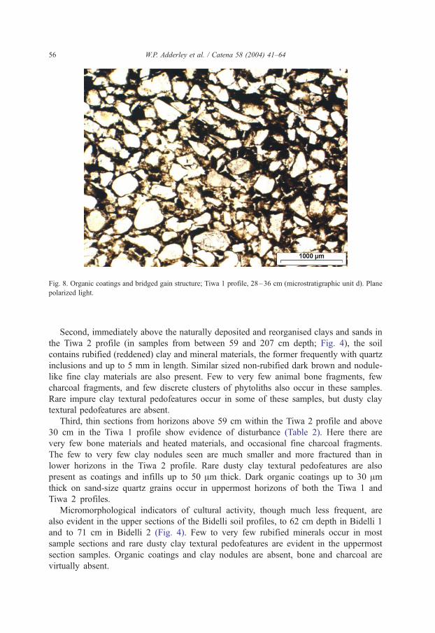
The occurrence of very few heated mineral materials and few discrete areas of biogenic
silica further supports this interpretation. These features could indicate preliminary ground
preparation for cultivation.
Fig. 7. Dusty clay textural pedofeatures; Tiwa 1 profile, 28–36 cm (microstratigraphic unit a). Plane polarized
light.
Fig. 8. Organic coatings and bridged gain structure; Tiwa 1 profile, 28–36 cm (microstratigraphic unit d). Plane
polarized light.
W.P. Adderley et al. / Catena 58 (2004) 41–6456
Second, immediately above the naturally deposited and reorganised clays and sands in
the Tiwa 2 profile (in samples from between 59 and 207 cm depth; Fig. 4), the soil
contains rubified (reddened) clay and mineral materials, the former frequently with quartz
inclusions and up to 5 mm in length. Similar sized non-rubified dark brown and nodule-
like fine clay materials are also present. Few to very few animal bone fragments, few
charcoal fragments, and few discrete clusters of phytoliths also occur in these samples.
Rare impure clay textural pedofeatures occur in some of these samples, but dusty clay
textural pedofeatures are absent.
Third, thin sections from horizons above 59 cm within the Tiwa 2 profile and above
30 cm in the Tiwa 1 profile show evidence of disturbance (Table 2). Here there are
very few bone materials and heated materials, and occasional fine charcoal fragments.
The few to very few clay nodules seen are much smaller and more fractured than in
lower horizons in the Tiwa 2 profile. Rare dusty clay textural pedofeatures are also
present as coatings and infills up to 50 Am thick. Dark organic coatings up to 30 Amthick on sand-size quartz grains occur in uppermost horizons of both the Tiwa 1 and
Tiwa 2 profiles.
Micromorphological indicators of cultural activity, though much less frequent, are
also evident in the upper sections of the Bidelli soil profiles, to 62 cm depth in Bidelli 1
and to 71 cm in Bidelli 2 (Fig. 4). Few to very few rubified minerals occur in most
sample sections and rare dusty clay textural pedofeatures are evident in the uppermost
section samples. Organic coatings and clay nodules are absent, bone and charcoal are
virtually absent.
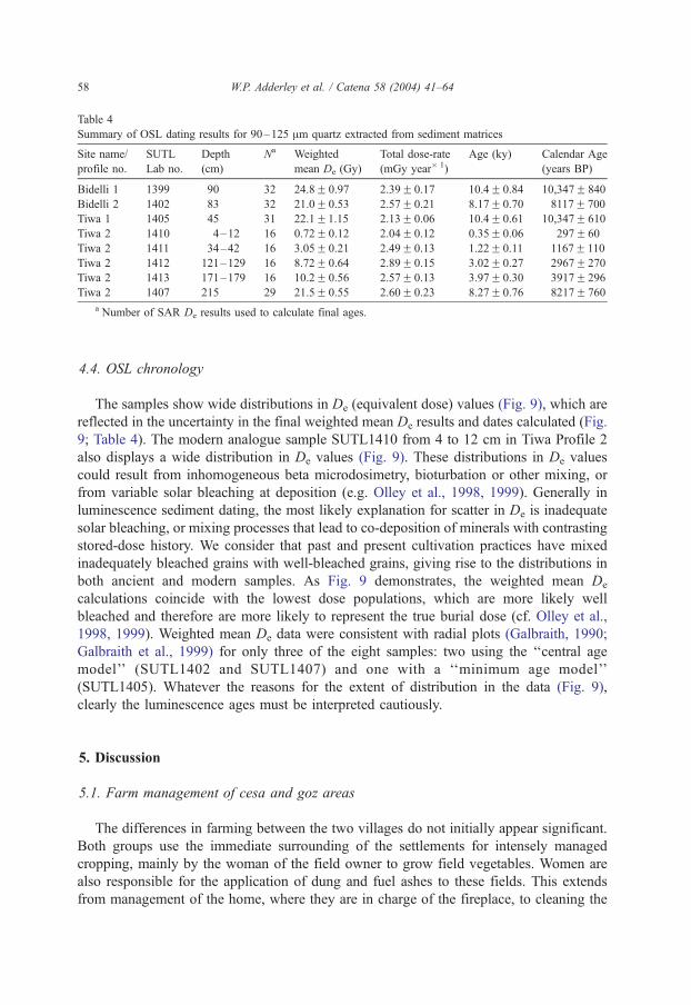
Fig. 9. Distributions of De shown as weighted histogram plots. Individual De values on each plot are given as
weighted means and standard error.
W.P. Adderley et al. / Catena 58 (2004) 41–64 57
Table 4
Summary of OSL dating results for 90–125 Am quartz extracted from sediment matrices
Site name/
profile no.
SUTL
Lab no.
Depth
(cm)
Na Weighted
mean De (Gy)
Total dose-rate
(mGy year� 1)
Age (ky) Calendar Age
(years BP)
Bidelli 1 1399 90 32 24.8F 0.97 2.39F 0.17 10.4F 0.84 10,347F 840
Bidelli 2 1402 83 32 21.0F 0.53 2.57F 0.21 8.17F 0.70 8117F 700
Tiwa 1 1405 45 31 22.1F1.15 2.13F 0.06 10.4F 0.61 10,347F 610
Tiwa 2 1410 4–12 16 0.72F 0.12 2.04F 0.12 0.35F 0.06 297F 60
Tiwa 2 1411 34–42 16 3.05F 0.21 2.49F 0.13 1.22F 0.11 1167F 110
Tiwa 2 1412 121–129 16 8.72F 0.64 2.89F 0.15 3.02F 0.27 2967F 270
Tiwa 2 1413 171–179 16 10.2F 0.56 2.57F 0.13 3.97F 0.30 3917F 296
Tiwa 2 1407 215 29 21.5F 0.55 2.60F 0.23 8.27F 0.76 8217F 760
a Number of SAR De results used to calculate final ages.
W.P. Adderley et al. / Catena 58 (2004) 41–6458
4.4. OSL chronology
The samples show wide distributions in De (equivalent dose) values (Fig. 9), which are
reflected in the uncertainty in the final weighted mean De results and dates calculated (Fig.
9; Table 4). The modern analogue sample SUTL1410 from 4 to 12 cm in Tiwa Profile 2
also displays a wide distribution in De values (Fig. 9). These distributions in De values
could result from inhomogeneous beta microdosimetry, bioturbation or other mixing, or
from variable solar bleaching at deposition (e.g. Olley et al., 1998, 1999). Generally in
luminescence sediment dating, the most likely explanation for scatter in De is inadequate
solar bleaching, or mixing processes that lead to co-deposition of minerals with contrasting
stored-dose history. We consider that past and present cultivation practices have mixed
inadequately bleached grains with well-bleached grains, giving rise to the distributions in
both ancient and modern samples. As Fig. 9 demonstrates, the weighted mean De
calculations coincide with the lowest dose populations, which are more likely well
bleached and therefore are more likely to represent the true burial dose (cf. Olley et al.,
1998, 1999). Weighted mean De data were consistent with radial plots (Galbraith, 1990;
Galbraith et al., 1999) for only three of the eight samples: two using the ‘‘central age
model’’ (SUTL1402 and SUTL1407) and one with a ‘‘minimum age model’’
(SUTL1405). Whatever the reasons for the extent of distribution in the data (Fig. 9),
clearly the luminescence ages must be interpreted cautiously.
5. Discussion
5.1. Farm management of cesa and goz areas
The differences in farming between the two villages do not initially appear significant.
Both groups use the immediate surrounding of the settlements for intensely managed
cropping, mainly by the woman of the field owner to grow field vegetables. Women are
also responsible for the application of dung and fuel ashes to these fields. This extends
from management of the home, where they are in charge of the fireplace, to cleaning the
W.P. Adderley et al. / Catena 58 (2004) 41–64 59
kitchen and compound where various small domesticated animals are kept. Cleaning of
the compound, removal of dung and fireplace ashes, through to manuring the fields (Fig.
3) takes place as one process. In both Kanuri and Shuwa Arab villages, the cesa–goz
areas are therefore manured house fields, with their management closely linked to other
domestic activities.
Differences between the practices of each village derive from the type of manure used
depending on fuel use and the types of livestock kept in the vicinity of the villages. In our
study examples, more cattle dung was used in the Shuwa Arab village than in the Kanuri
village, even though in Kanuri villages cattle are kept close to the village and more cattle
dung could be available for use. No cultural or ethnic preferences were stated concerning
the specific type of manure used on the cesa and goz fields.
In addition to the manured cesa and goz soils, there are similar soils that receive no
manure. In both villages, these fields are much larger than the manured areas (Table 1).
There is a ratio of 1:5 between manured and non-manured farms. The long-term fertility of
these unmanured cesa and goz soils must be questioned. While there is an input of dust
during the harmattan winds (Drees et al., 1993; Chappell et al., 1998), which can increase
nutrients, soil fertility is mainly dependent on unmanaged application of dung by
domesticated animals and on fallowing. Nevertheless, a fertility difference is likely to
emerge, determined by the numbers of domesticated non-household animals associated
with each village. On the basis of these field management attributes and on the
ethnographic understanding of the manuring inputs, the cesa and goz should be regarded
as distinct ethno-pedological entities.
5.2. Soil micromorphology
Systematic observation of soil features in thin section suggests that the cesa–goz soils
at both the Kanuri and Shuwa Arab village have formed as a result of variable cultural
activities superimposed on near-uniform materials and natural processes. The range of
microstructure classes seen is similar to those of undisturbed sands and clays in the Kala
profile (Fig. 4), which have not been culturally modified. Here, the clays contain
common biogenic silica, and the sand within a clay matrix that includes impure clay
textural pedofeatures commonly showing linear organisation. These observations em-
phasise similarities in sedimentary processes; wind-blown dune sands dominate, with
subordinate deposition of aeolian clay and silt originating from lacustrine and lagoonal
sediments. As observed in the field, the Tiwa profiles have a greater proportion of coarse
mineral sands than the Bidelli profiles, reflecting minor differences in patterns of
sediment accumulation. Post-depositional clay movement is the dominant pedological
process evident, suggesting some structural instability in the seasonal wetting and drying
soil environment.
The anthropogenic micromorphology features seen in the upper horizons of the Tiwa 1
and 2 profiles suggest that much of the material in these horizons is derived from
settlement construction and abandonment. The non-rubified clay nodule-like materials are
probably remains of locally derived mud bricks, and it is likely that the frequent (15–
30%) to common occurrence of fine clay (organo)-mineral material is from this source.
The associated phytolith clusters are likely to be derived from straw thatch used as a
W.P. Adderley et al. / Catena 58 (2004) 41–6460
roofing material. Rubified clay materials of the size range identified in these thin sections
are clearly derived from fragmented fired-pottery, as impressed marks are occasionally
seen.
In contrast, in the upper parts of both the Bidelli profiles, the micromorphology
observations suggest a much lower level of soil amendment that, where it occurs, is
dominantly fuel residue material (rubified minerals, with traces ( < 1%) of charcoal). The
smaller quantities of material amendment than in the Tiwa profiles may be explained by a
greater inherent fertility resulting from a greater proportion of clay within these soils
relative to the quartz-rich sands. The infrequent occurrence of dusty clay textural
pedofeatures may indicate a generally lower level of cultivation, although it could also
be explained by the greater soil stability that a higher clay content affords.
5.3. Contrasting soil management of cesa and goz areas
The micromorphology features observed in all but the deepest horizons of the Tiwa
and Bidelli profiles suggest cultural amendment of these soils together with disturbance
through cultivation. The material used to amend these soils is domestic refuse, with fuel
residues and building debris the most frequent components, with lesser amounts of
pottery. Additional to these inorganic amendments, the dark organic coatings on quartz
grains also suggest that there has been significant organic material input to the soil. The
ethnographic evidence of field management indicates that domestic animal dung is
applied to these field areas, which we suggest as one primary origin of the organic
coatings seen. With the soil parent material a quartz-rich sand, substantial amendment
with both organic faecal manures and inorganic fuel-derived materials is essential for
fertility. The clay nodules seen in thin section are small and fractured, suggesting
intensive tillage in the past. The dusty clay textural pedofeatures, which include silt size
organic fragments, are also interpreted as an indicator of tillage. These pedofeatures have
been consistently found in early and traditionally cultivated soils in widely disparate
regions of the world (Simpson, 1997; Wilson et al., 2002) and can be interpreted as
resulting from slaking processes in which fine material from a bare, structurally unstable,
but amended and cultivated surface, is washed through the soil profile. The interrela-
tionship between animal husbandry, domestic waste use and rain-fed crop production in
the management of the cesa and goz soils is therefore clear both in ethnographic and soils
results.
The more subtle differences in relative field areas managed, combined with the
management of the available manure resource in the two villages does, however, result
in distinctions in the cultural attributes between the cesa and goz soils. The soils indicate
that the Kanuri have placed considerable emphasis on the fertility of their cultivated cesa
soils by exploiting the inherent fertility of previously settled areas of land, and by
organising the collection, transportation, and distribution of manures, fuel residues and
other domestic debris. This is further reflected in the evidence for more intensive tillage. In
contrast, the soil-based evidence suggests that the Shuwa Arab have made less attempt to
maintain the fertility of the goz soils with an associated lower intensity of tillage. There
are, therefore, soil-based grounds for regarding cesa and goz soils as distinct within ethno-
pedological frameworks.
5.4. Optically stimulated luminescence
The OSL results for horizons below those showing evidence of cultural disturbance
range from 8117F 700 to 10,347F 840 BP. These dates are consistent with the last major
oscillations of Lake Chad (Thiemeyer, 1992) and the age of dune systems surrounding the
Kala–Balge region (Fig. 2; Thiemeyer, 1997). Since the soil materials appear aeolian in
origin, and therefore would have been deposited with low stored dose, the underlying
lacustrine formation must have been emplaced at least 8000 years BP. Samples SUTL1411,
1412 and 1413 from the cultural horizons of the Tiwa Profile 2 all follow in chronological
sequence, ranging from 3917F 296 to 1167F 110 BP (Table 4). These OSL dates and the
relative stratigraphic positions of these samples are consistent with the onset of agricultural
activity in the southern Lake Chad basin and permanent settlement in the Kala–Balge
region at 3000 BP (Gronenborn et al., 1995; Connah, 1981). Cultivation of the Tiwa 2
profile is considered to have occurred only since 1200 BP and from the soil micromor-
phology evidence this appears to have been continuous from this depth to present day. In
this profile, while there is occupational debris evident below this time depth, there is no soil
micromorphology evidence to support an earlier period of cultivation.
The OSL chronology indicates that the soil changes mediated by cultural activity and
seen in the micromorphology sections have been occurring for long periods. It is therefore
clear that the cultural difference between cesa and goz is long-standing. The implication
for future ethno-pedological classifications is that to robustly classify these soils, an
understanding of past cultural soil activities is required.
W.P. Adderley et al. / Catena 58 (2004) 41–64 61
6. Conclusions
Consideration of long-term soil management activities associated with the yellow
aeolian-derived sandy soils classified as Ustic Psamments (Soil Survey Staff, 1999) or
Arenosols (FAO/ISRIC/ISSS, 1998) in the Kala–Balge region suggests that their
attribution to a single ethno-pedological class as cesa–goz soils requires revision.
Evidence of contemporary field management, soil micromorphological indicators of
cultural activity and OSL chronologies, all point to cesa and goz being discrete classes
of soil, reflecting cultural land management differences between Kanuri and Shuwa Arab
peoples. This has a more general implication for ethno-pedology, as it appears essential to
include soil management criteria and their associated chronologies in any ethno-pedolog-
ical classification; to do so requires an acceptance that social and physical criteria should
be integrated. The implications include the long-term sustainability of each system and a
warning that the ethno-pedologic approach must allow for nuances of the pedogenic
process, as well as linguistic distinctions in the naming of soils and land units.
The ethnological approach in this paper has focussed on contrasts in land management
between two peoples in villages in the Kala–Balge region. To aid the development of local
rural land-use policy, a greater focus on the distribution of cesa–goz cultivation by a
variety of individual farmers over a wider geographic range of villages would be required.
In addition to field size and manuring strategies, a greater focus on gender involvement
would also enhance ethnographic understanding. Similarly, in the consideration of soil
W.P. Adderley et al. / Catena 58 (2004) 41–6462
physical properties and the quantification of micromorphological features, other comple-
mentary physico-chemical properties such as soil phosphorus and lipid-biomarker con-
centrations could be considered in future. The equivalent dose (De) data, for both the older
materials and modern analogues, suggest that mixing has occurred and this has led to wide
ranges in the De values so that the dates calculated must be interpreted with caution. A
clear target for future OSL studies in this and similar geographic contexts must include
consideration of these mixing processes. This could be addressed by small aliquot
procedures (e.g. Spencer et al., 2003), and by incorporating a wider range of control
measurements on modern sediments.
The successful incorporation of social and physical sciences soil management criteria
into ethno-pedological work should enhance the value of ethno-pedological classifications.
In this specific regional context the migration of communities, last seen during the pan-
Sahelian droughts of the 1970s and 1980s, which are loosely described in earlier historical
records (Gronenborn, 2002), could be more firmly established. Furthermore, present-day
rural land-use policy development in this region is critically dependent on the soil
properties at each locale. This study has demonstrated that traditional soil management
practices are a major determinant of the variations in these properties and that integrated
ethno-pedological approaches are a means to understanding this vital human–environment
relationship.
Acknowledgements
We thank the British Academy for their financial support of the ethnographic and
geoarchaeological fieldwork components of this study. The University of Stirling faculty
development fund provided financial assistance for the OSL dating. The Cartography Unit,
Department of Environmental Science, University of Stirling, assisted the production of
figures and George MacLeod processed the thin sections. We especially thank Prof. Kyari
Tijani, Abubakar Garba and Gisela Seidensticker-Brikay from the Centre for Trans-
Saharan Studies, University of Maiduguri, for their sincere advice and logistical assistance
in Nigeria.
References
Adderley, W.P., 1998. Vertisolic soils under agroforestry in northeast Nigeria. PhD thesis. University of Wales.
Adderley, W.P., Jenkins, D.A., Sinclair, F.L., Stevens, P.A., Verinumbe, I., 1997. The influence of soil variability on
tree establishment at an experimental agroforestry site inNorth East Nigeria. Soil Use andManagement 13, 1–8.
Aitchison, P.J., Bawden, M.G., Caroll, D.M., Glover, P.E., Klinkenberg, K., De Leeu, P.N., Tuley, P., 1972. The
land resources of North East Nigeria: Volume 1. The Environment. Land Resource Study 9. Series Editor
Tuley, P. Directorate of Overseas Survey, Surbiton, Surrey.
Balee, W. (Ed.), 1998. Advances in Historical Ecology. Columbia Univ. Press, New York, pp. 13–30.
Barth, H., 1857. Travels and Discoveries in North and Central Africa. 3 Vols. Cassell, London (1965 reprint).
Braukamper, U., 1993. Notes on the origin of Baggara Arab Culture with special reference to the Shuwa. In:
Owens, J. (Ed.), SUGIA Sprache und Geschichte in Afrika. Special Issue: Arabs and Arabic in the Lake Chad
Region. Rudiger Koppe Verlag, Cologne, pp. 3–47.
Braukamper, U., Kirscht, H., Platte, E., Thiemeyer, H., 1993. Systems of land use in the Firgi plains of the Chad
W.P. Adderley et al. / Catena 58 (2004) 41–64 63
Basin. In: Greinert-Byer, U. (Ed.), Berichte des Sonderforschungsbereichs 268, vol. 2. Johann Wolfgang
Goethe-Universitat, Frankfurt am Main, pp. 43–50.
Bullock, P., Fedoroff, N., Jongerius, A., Stoops, G., Tursina, T., Babel, U., 1985. Handbook for Soil Thin-Section
Description. Waine Research Publications, Wolverhampton.
Chappell, A., Warren, A., Taylor, N., Charlton, M., 1998. Soil flux (loss and gain) in southwestern Niger and its
agricultural impact. Land Degradation and Development 9, 295–310.
Connah, G., 1981. Three Thousand Years in Africa: Man and His Environment in the Lake Chad Region of
Nigeria. Cambridge Univ. Press, Cambridge.
Courty, M.A., Goldberg, P., MacPhail, R., 1989. Soils and Micromorphology in Archaeology. Cambridge Univ.
Press, Cambridge.
Crumley, C.L. (Ed.), 1994. Historical Ecology: Cultural Knowledge and Changing Landscapes. School of
American Research Press, Santa Fe, NM, pp. 1–17; 183–203.
Drees, L.R., Manu, A., Wilding, L.P., 1993. Characteristics of aeolian dusts in Niger, West Africa. Geoderma 59,
213–233.
Duller, G.A.T., Bøtter-Jensen, L., Murray, A.S., 2000. Optical dating of single sand-sized grains of quartz:
sources of variability. Radiation Measurements 32, 453–457.
FAO, 1984. Agroclimatalogical data for Africa. FAO Plant Production and Protection Series, vols. 1 and 2. FAO,
Rome.
FAO/ISRIC/ISSS, 1998. World reference base for soil resources. World Soil Resources Reports, vol. 84. FAO,
Rome.
FitzPatrick, E.A., 1993. Soil Microscopy and Micromorphology. Wiley, Chichester.
Foster, E.W., 1914. Notes on Nigeria Trees and Plants. Biddle and Son, Guildford.
Galbraith, R.F., 1990. The radial plot: graphical assessment of spread in ages. Nuclear Tracks and Radiation
Measurements 17, 207–214.
Galbraith, R.F., Roberts, R.G., Laslett, G.M., Yoshida, H., Olley, J.M., 1999. Optical dating of single and
multiple grains of quartz from Jinmium rock shelter, northern Australia: Part I. Experimental design and
statistical models. Archaeometry 41, 339–364.
Gronenborn, D., 1996. Archaeology and ethnoarchaeology in the Kala–Balge region of Borno State, Nigeria. In:
Pwiti, G., Soper, R. (Eds.), Proceedings of the 10th Congress of the Pan-African Association for Prehistory
and Related Studies. Harare, Zimbabwe, 19–23 June 1995. University of Zimbabwe Publications, Harare,
pp. 449–461.
Gronenborn, D., 2002. Kanem-Borno. A brief summary of the history and archaeology of an empire in the central
‘bilad al-Sudan’. In: DeCorse, C.R. (Ed.), West Africa During the Atlantic Slave Trade: Archaeological
Perspectives. Leicester University Press/Continuum, New York, pp. 101–130.
Gronenborn, D., Van Neer, W., Skorupinski, T., 1995. Kleiner Vorbericht zur archaologischen Feldarbeit
sudlich des Tschad-Sees. In: Brunk, K., Greinert-Byer, U. (Eds.), Berichte des Sonderforschungsbereichs 268,
vol. 5. Johann Wolfgang Goethe-Universitat, Frankfurt am Main, pp. 27–41.
Hess, T.M., Stephens, W., Maryah, U.M., 1995. Rainfall trends in the North East arid zone of Nigeria
1961–1990. Agricultural and Forest Meteorology 74, 87–97.
ISSS Working Group RB, 1998. World Reference Base for Soil Resources: Introduction. In: Deckers, J.A.,
Nachtergaele, F.O., Spargaren, O. (Eds.), 1st edition. ISSS, ISRIC, FAO, Acco, Leuven.
Kirscht, H., Skorupinski, T., 1996. Soils and peasants—geographical and ethnological investigations on soil
classification and land-use in the Southern Chad Basin. In: Greinert-Byer, U., Werthmann, K. (Eds.),
Berichte des Sonderforschungsbereichs 268, vol. 8. Johann Wolfgang Goethe-Universitat, Frankfurt am
Main, pp. 269–285.
Murray, A.S., Wintle, A.G., 2000. Luminescence dating of quartz using an improved single-aliquot regenerative-
dose protocol. Radiation Measurements 32, 57–73.
Olley, J., Caitcheon, G., Murray, A., 1998. The distribution of apparent dose as determined by optically stim-
ulated luminescence in small aliquots of fluvial quartz: implications for dating young sediments. Quaternary
Geochronology 17, 1033–1040.
Olley, J.M., Caitcheon, G.G., Roberts, R.G., 1999. The origin of dose distributions in fluvial sediments, and the
prospect of dating single grains from fluvial sediments using optically stimulated luminescence. Radiation
Measurements 30, 207–217.
W.P. Adderley et al. / Catena 58 (2004) 41–6464
Sanderson, D.C.W., 1988. Thick source beta counting (TSBC): a rapid method for measuring beta dose-rates.
Nuclear Tracks and Radiation Measurements 14, 203–207.
Sanderson, D.C.W., Bishop, P., Houston, I., Boonsener, M., 2001. Luminescence characterisation of quartz-rich
cover sands from NE Thailand. Quaternary Geochronology 20, 893–900.
Simpson, I.A., 1997. Relict properties of anthropogenic deep top soils as indicators of infield management in
Marwick, West Mainland, Orkney. Journal of Archaeological Science 24, 365–380.
Simpson, I.A., Adderley, W.P., Guðmundsson, G., Hallsdottir, M., Sigurgeirsson, M.A., Snæsdottir, M., 2002.
Soil limitations to agrarian land production in pre-modern Iceland. Human Ecology 30, 423–443.
Soil Survey Staff, 1999. Soil taxonomy, 2nd edition. Agriculture Handbook, vol. 436. United States Department
of Agriculture/Natural Resources Conservation Service, Washington, DC.
Spencer, J.Q., Sanderson, D.C.W., Deckers, K., Sommerville, A.A., 2003. Assessing mixed dose distributions in
young sediments identified using small aliquots and a simple two-step SAR procedure: the F-statistic as a
diagnostic tool. Radiation Measurements 37, 425–431.
Thiemeyer, H., 1992. Desertification in the ancient erg of NE Nigeria. Zeitschrift fur Geomorphologie N.F.
Supplementband 91, 197–208.
Thiemeyer, H., 1997. Untersuchungen zur spatpleistozanen und holozanen Landschaftsentwicklung im
sudwestlichen Tschadbecken (NE-Nigeria). Jenaer Geographische Schriften, vol. 5. Frederich-Schiller-Univer-
sitat, Jena.
White, F., 1983. The Vegetation of Africa. UNESCO, Paris.
Wilson, C., Simpson, I.A., Currie, E.J., 2002. Soil management in pre-Hispanic raised field systems: micromor-
phological evidence from Haciende Zuleta, Equador. Geoarchaeology 17, 261–283.