Geologic and hydrogeologic understanding of caprock strata overlying the Utica Shale in the St. Lawrence Lowlands (Quebec, Canada) Stephan Séjourné 1 , René Lefebvre 2 , Denis Lavoie 3 , Xavier Malet 2 1 : Consultant, Montreal, Quebec, Canada, 2 : INRS, Centre Eau Terre Environnement, Quebec City, Quebec, Canada, 3 : NRCan, Geological Survey of Canada, Quebec City, Quebec, Canada. ABSTRACT A synthesis of publicly available data on the geology and hydrogeology of the strata overlying the Utica Shale was carried out to serve as a basis for future research required to evaluate the integrity of the caprock separating the Utica Shale from exploited shallow groundwater. Conceptual structural models were also developed to provide a tectonostratigraphic framework representative of the shale gas exploration area. Most of the characterization effort should be focused on an area between the south shore of the St. Lawrence River and Logan’s Line, which has the best shale gas potential. The data also suggest that the freshwater aquifers in the area of interest are generally restricted to the shallow fractured bedrock (first tens of meters), with no direct connectivity to deeper units, except where structural discontinuities are present. RÉSUMÉ Une synthèse des données géologiques et hydrogéologiques disponibles sur les roches couvertures du Shale d’Utica a été réalisée pour orienter l’évaluation future du degré d’isolement hydraulique qu’offrent les successions rocheuses entre l’unité de shale ciblée pour l’exploitation du gaz de shale et les aquifères peu profonds. Des modèles structuraux conceptuels ont aussi été élaborés afin d’obtenir un portrait géologiquement représentatif du territoire visé par l’exploration pour le gaz de shale. L’essentiel de l’effort de caractérisation devrait porter sur la rive sud du fleuve Saint- Laurent, jusqu’à la Ligne de Logan, où le potentiel gazier est plus important. Les données disponibles indiquent que les aquifères d’eau douce dans la région d’étude correspondent généralement à un intervalle de roc fracturé profond de quelques dizaines de mètres au plus, sans connexion directe avec les unités plus profondes, sauf lorsqu’il y a présence de discontinuités structurales. 1 INTRODUCTION The Upper Ordovician Utica Shale has been penetrated by numerous exploration wells drilled in the St. Lawrence Platform of southern Quebec over the past century. Sporadic attempts have been made, between 1971 and 1992, to explore for gas in naturally fractured shale (Utica and Lorraine) close to Quebec City in Villeroy, but no commercial production was achieved due to inadequate technology at that time. In 2006, the industry started enthusiastically to consider the unconventional potential of the Utica Shale. 29 wells have been drilled (including 11 horizontals) and 18 of them had been frac-stimulated by late 2010 (Figure 1), when the Quebec government initiated a series of public hearings on the potential development of shale gas production in southern Quebec. Following those hearings, the Bureau d’audiences publiques sur l’environnement (BAPE) recommended a Strategic Environmental Assessment (SEA) to be completed by November 2013. Among many other aspects, the mandate of this SEA included the evaluation of the potential impacts and environmental risks of shale gas development. In this context, the authors carried out a comprehensive synthesis of publicly available geological and hydrogeological information to support the ongoing and future research effort needed to assess the integrity of the geological seal between the Utica Shale and shallow groundwater (Séjourné et al. 2013). In the St. Lawrence Platform, potable groundwater is mostly found in the first tens of meters below surface, at times in the surficial Quaternary deposits but mostly in the underlying shallow, naturally fractured sedimentary rock. However, little data exist to evaluate the possible occurrence of fresh water at greater depths. Therefore, part of this work was also aimed at documenting the existing petroleum industry data that could be used to characterize the natural fracture pattern and the hydrogeological environment at greater depths. By highlighting geographic or thematic weaknesses in the datasets, this contribution also aimed at supporting ongoing research projects to develop a method to evaluate the vulnerability of aquifers relative to activities carried out in the subsurface, especially hydraulic fracturing and shale gas production.
Transcript
Geologic and hydrogeologic understanding of caprock strata overlying the Utica Shale in the St. Lawrence Lowlands (Quebec, Canada) Stephan Séjourné1, René Lefebvre2, Denis Lavoie3, Xavier Malet2 1 : Consultant, Montreal, Quebec, Canada, 2 : INRS, Centre Eau Terre Environnement, Quebec City, Quebec, Canada, 3 : NRCan, Geological Survey of Canada, Quebec City, Quebec, Canada. ABSTRACT A synthesis of publicly available data on the geology and hydrogeology of the strata overlying the Utica Shale was carried out to serve as a basis for future research required to evaluate the integrity of the caprock separating the Utica Shale from exploited shallow groundwater. Conceptual structural models were also developed to provide a tectonostratigraphic framework representative of the shale gas exploration area. Most of the characterization effort should be focused on an area between the south shore of the St. Lawrence River and Logan’s Line, which has the best shale gas potential. The data also suggest that the freshwater aquifers in the area of interest are generally restricted to the shallow fractured bedrock (first tens of meters), with no direct connectivity to deeper units, except where structural discontinuities are present. RÉSUMÉ Une synthèse des données géologiques et hydrogéologiques disponibles sur les roches couvertures du Shale d’Utica a été réalisée pour orienter l’évaluation future du degré d’isolement hydraulique qu’offrent les successions rocheuses entre l’unité de shale ciblée pour l’exploitation du gaz de shale et les aquifères peu profonds. Des modèles structuraux conceptuels ont aussi été élaborés afin d’obtenir un portrait géologiquement représentatif du territoire visé par l’exploration pour le gaz de shale. L’essentiel de l’effort de caractérisation devrait porter sur la rive sud du fleuve Saint-Laurent, jusqu’à la Ligne de Logan, où le potentiel gazier est plus important. Les données disponibles indiquent que les aquifères d’eau douce dans la région d’étude correspondent généralement à un intervalle de roc fracturé profond de quelques dizaines de mètres au plus, sans connexion directe avec les unités plus profondes, sauf lorsqu’il y a présence de discontinuités structurales. 1 INTRODUCTION The Upper Ordovician Utica Shale has been penetrated by numerous exploration wells drilled in the St. Lawrence Platform of southern Quebec over the past century. Sporadic attempts have been made, between 1971 and 1992, to explore for gas in naturally fractured shale (Utica and Lorraine) close to Quebec City in Villeroy, but no commercial production was achieved due to inadequate technology at that time.
In 2006, the industry started enthusiastically to consider the unconventional potential of the Utica Shale. 29 wells have been drilled (including 11 horizontals) and 18 of them had been frac-stimulated by late 2010 (Figure 1), when the Quebec government initiated a series of public hearings on the potential development of shale gas production in southern Quebec. Following those hearings, the Bureau d’audiences publiques sur l’environnement (BAPE) recommended a Strategic Environmental Assessment (SEA) to be completed by November 2013. Among many other aspects, the mandate of this SEA included the evaluation of the potential impacts and environmental risks of shale gas development.
In this context, the authors carried out a comprehensive synthesis of publicly available geological and hydrogeological information to support the ongoing
and future research effort needed to assess the integrity of the geological seal between the Utica Shale and shallow groundwater (Séjourné et al. 2013). In the St. Lawrence Platform, potable groundwater is mostly found in the first tens of meters below surface, at times in the surficial Quaternary deposits but mostly in the underlying shallow, naturally fractured sedimentary rock. However, little data exist to evaluate the possible occurrence of fresh water at greater depths. Therefore, part of this work was also aimed at documenting the existing petroleum industry data that could be used to characterize the natural fracture pattern and the hydrogeological environment at greater depths. By highlighting geographic or thematic weaknesses in the datasets, this contribution also aimed at supporting ongoing research projects to develop a method to evaluate the vulnerability of aquifers relative to activities carried out in the subsurface, especially hydraulic fracturing and shale gas production.
Figure 1: Prospective zone for the Utica Shale as defined by MRN (2010) and location of the shale gas wells drilled between 2006 and 2010. Three exploration corridors have been delineated (Thériault, 2012), the central one (2) being deemed the most prospective for the moment. 2 DATASETS COVERED In the absence of new well data, understanding the deep hydrogeological environment and the intermediate one (comprised between the targeted shale unit and the shallow aquifer) can only be achieved through the gathering and synthesis of publicly available data. A comprehensive synthesis of the publicly available geological and hydrogeological information was carried out, following three main avenues of investigation described in the following sections. 2.1 Hydrogeological data A synthesis was done of the main results of past and ongoing regional hydrogeological studies carried out as part of a program of the Department of Environment of Quebec (Programmes d'acquisition de connaissances sur les eaux souterraines du Québec – PACES). This involved the history of the past and ongoing PACES projects, synthesis of the hydrogeological data available, synthesis of the gas shows and gas, oil and water analyses. Governmental reports, university datasets and well data were also used to achieve this task. 2.2 Geological data A synthesis was also done of all relevant geological data for the Utica Shale and overlying strata (Lorraine and Queenston groups and Quaternary deposits). These data included stratigraphic and structural settings; depth, thickness, lithology and mineralogy of the strata; synthesis of the petrophysical logs and the cores
available; and synthesis of the known physical properties (pressure, temperature, porosity, permeability and fluid saturations).
2.3 Structural models The project also involves the development of a series of conceptual structural models in areas representative of the general tectonostratigraphic setting of the prospective shale gas domain. These models are aimed at assisting future research focusing on developing a regional 3D hydrogeological model over the area of interest and which has led to the identification of medium-depth sandy intervals within the Lorraine Group. Geological maps, 2D seismic and well data were used to achieve this task.
3 AREA OF INTEREST The prospective area for shale gas in southern Quebec (Figure 1) was delineated by the MRN database (SIGPEG 2010) based on the extent of exploration permits held in the area at that time. Three exploration fairways were defined by Thériault (2012) to account for the depth and structural changes in the Utica Shale within the basin.
Analysis of geological data indicates that the prospective area for shale gas can be reduced to the west where the Utica Shale is only present at surface (Figure 2) and, accounting for the narrowness of the prospective area north of the St. Lawrence River and the dominant interest of the industry for the central fairway, it is recommended that future hydrogeological research focus on caprock integrity and deep aquifers, emphasizing an area contained between the southern shore of St. Lawrence River and Logan’s Line (Figure 1).
Figure 2: Regional geological map adapted from MRNF (2008), and location of the conceptual structural models prepared as part of the synthesis.
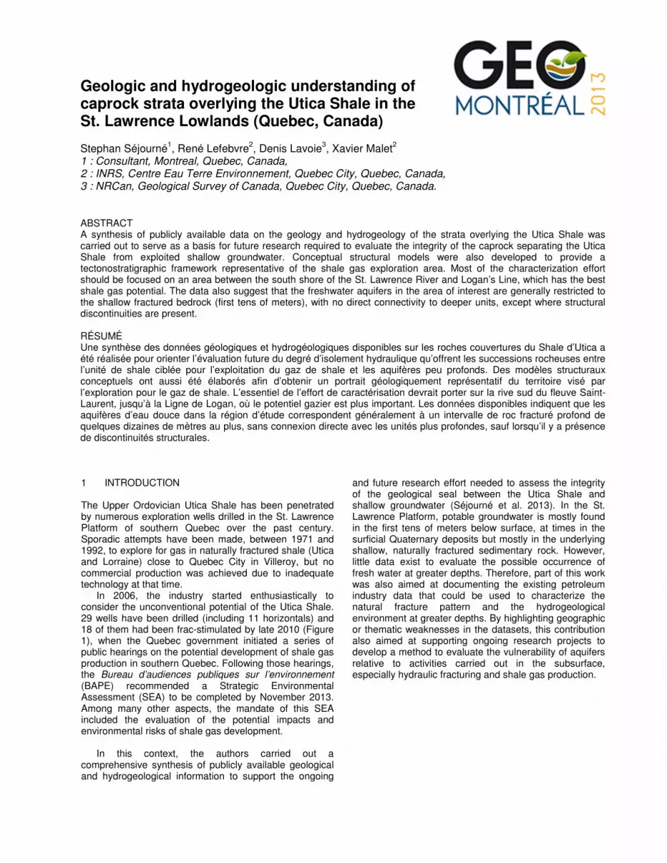
Figure 3: Conceptual structural models built along the southern limits of corridors A, B and C (Location of these corridors on Figure 2). 4 TECTONOSTRATIGRAPHIC SETTING Six conceptual structural models were prepared over the three corridors (Figure 2) to account for the variability and relative complexity of the structural setting over the area of interest and to illustrate the regional background in which to analyze the possible risks of connectivity between the Utica Shale and shallow aquifers (Figure 3). Overall, the models present many similarities and highlight the nature and distribution of normal and thrust faults in two separated domains, along with localized occurrences of Mesozoic dykes. The models also highlight the presence and geometry of sandy to silty intervals in the upper sections (upper part of the Nicolet Formation and overlying units).
5 AQUIFERS Review of existing data indicates that freshwater aquifers in the area of interest are restricted locally to Quaternary deposits and, regionally, to the first tens of meters of the underlying naturally fractured sedimentary rocks (Laurencelle et al. 2011).
In only two instances, oil and gas exploration wells revealed the presence of freshwater or slightly salty water at greater depths: a) well A074 northeast of Trois-Rivières at around 814m depth in the Chazy Group and b) well A202 southwest of Quebec City between 820 m and 865 m depth in the Beekmantown Group. These occurrences are unusual for the study area and have not been explained yet. Natural gas was found associated with the freshwater in at least the second case.
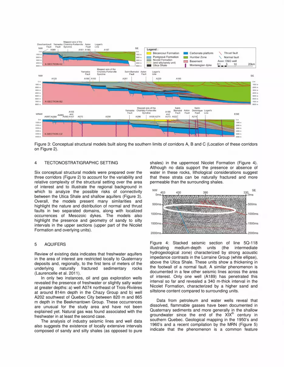
The analysis of industry seismic lines and well data also suggests the existence of locally extensive intervals composed of sandy and silty shales (as opposed to pure
shales) in the uppermost Nicolet Formation (Figure 4). Although no data support the presence or absence of water in these rocks, lithological considerations suggest that these strata can be naturally fractured and more permeable than the surrounding shales.
Figure 4: Stacked seismic section of line 5Q-118 illustrating medium-depth units (the intermediate hydrogeological zone) characterized by strong acoustic impedance contrasts in the Lorraine Group (white ellipse), above the Utica Shale. These units show a thickening in the footwall of a normal fault. A similar phenomenon is documented in a few other seismic lines across the area of interest. Only one well (A189) has penetrated this interval so far and revealed a 340 m-thick interval in the Nicolet Formation, characterized by a higher sand and siltstone content compared to surrounding units.
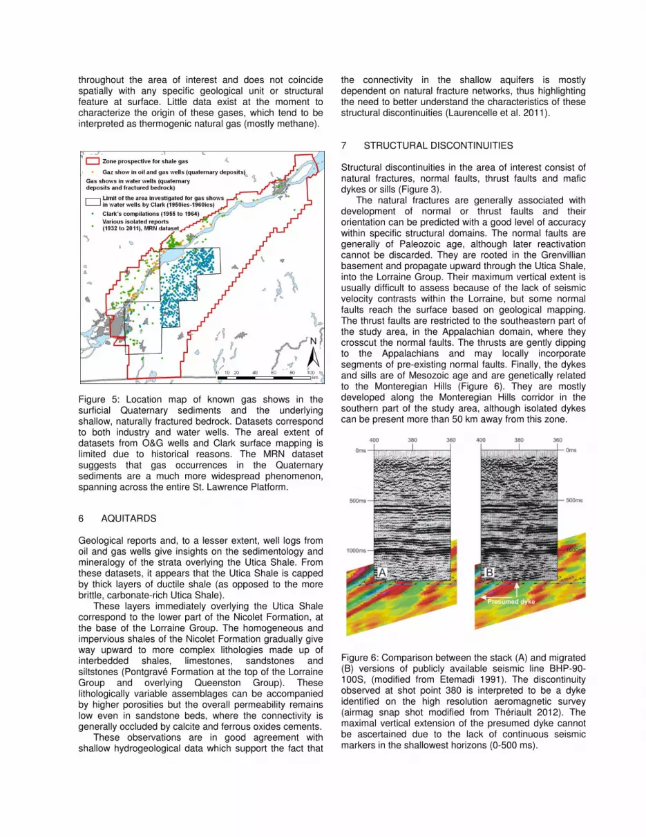
Data from petroleum and water wells reveal that dissolved, flammable gasses have been documented in Quaternary sediments and more generally in the shallow groundwater since the end of the XIXth century in southern Quebec. Geological mapping in the 1950’s and 1960’s and a recent compilation by the MRN (Figure 5) indicate that the phenomenon is a common feature
throughout the area of interest and does not coincide spatially with any specific geological unit or structural feature at surface. Little data exist at the moment to characterize the origin of these gases, which tend to be interpreted as thermogenic natural gas (mostly methane).
Figure 5: Location map of known gas shows in the surficial Quaternary sediments and the underlying shallow, naturally fractured bedrock. Datasets correspond to both industry and water wells. The areal extent of datasets from O&G wells and Clark surface mapping is limited due to historical reasons. The MRN dataset suggests that gas occurrences in the Quaternary sediments are a much more widespread phenomenon, spanning across the entire St. Lawrence Platform. 6 AQUITARDS Geological reports and, to a lesser extent, well logs from oil and gas wells give insights on the sedimentology and mineralogy of the strata overlying the Utica Shale. From these datasets, it appears that the Utica Shale is capped by thick layers of ductile shale (as opposed to the more brittle, carbonate-rich Utica Shale).
These layers immediately overlying the Utica Shale correspond to the lower part of the Nicolet Formation, at the base of the Lorraine Group. The homogeneous and impervious shales of the Nicolet Formation gradually give way upward to more complex lithologies made up of interbedded shales, limestones, sandstones and siltstones (Pontgravé Formation at the top of the Lorraine Group and overlying Queenston Group). These lithologically variable assemblages can be accompanied by higher porosities but the overall permeability remains low even in sandstone beds, where the connectivity is generally occluded by calcite and ferrous oxides cements.
These observations are in good agreement with shallow hydrogeological data which support the fact that
the connectivity in the shallow aquifers is mostly dependent on natural fracture networks, thus highlighting the need to better understand the characteristics of these structural discontinuities (Laurencelle et al. 2011).
7 STRUCTURAL DISCONTINUITIES Structural discontinuities in the area of interest consist of natural fractures, normal faults, thrust faults and mafic dykes or sills (Figure 3).
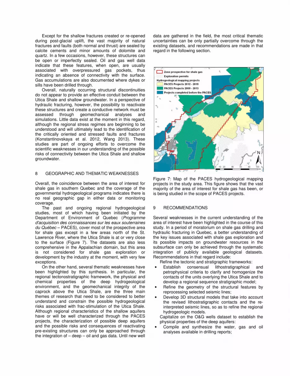
The natural fractures are generally associated with development of normal or thrust faults and their orientation can be predicted with a good level of accuracy within specific structural domains. The normal faults are generally of Paleozoic age, although later reactivation cannot be discarded. They are rooted in the Grenvillian basement and propagate upward through the Utica Shale, into the Lorraine Group. Their maximum vertical extent is usually difficult to assess because of the lack of seismic velocity contrasts within the Lorraine, but some normal faults reach the surface based on geological mapping. The thrust faults are restricted to the southeastern part of the study area, in the Appalachian domain, where they crosscut the normal faults. The thrusts are gently dipping to the Appalachians and may locally incorporate segments of pre-existing normal faults. Finally, the dykes and sills are of Mesozoic age and are genetically related to the Monteregian Hills (Figure 6). They are mostly developed along the Monteregian Hills corridor in the southern part of the study area, although isolated dykes can be present more than 50 km away from this zone.
Figure 6: Comparison between the stack (A) and migrated (B) versions of publicly available seismic line BHP-90-100S, (modified from Etemadi 1991). The discontinuity observed at shot point 380 is interpreted to be a dyke identified on the high resolution aeromagnetic survey (airmag snap shot modified from Thériault 2012). The maximal vertical extension of the presumed dyke cannot be ascertained due to the lack of continuous seismic markers in the shallowest horizons (0-500 ms).
Except for the shallow fractures created or re-opened during post-glacial uplift, the vast majority of natural fractures and faults (both normal and thrust) are sealed by calcite cements and minor amounts of dolomite and quartz. In a few occasions, however, these structures can be open or imperfectly sealed. Oil and gas well data indicate that these features, when open, are usually associated with overpressured gas pockets, thus indicating an absence of connectivity with the surface. Gas accumulations are also documented where dykes or sills have been drilled through.
Overall, naturally occurring structural discontinuities do not appear to provide an effective conduit between the Utica Shale and shallow groundwater. In a perspective of hydraulic fracturing, however, the possibility to reactivate these structures and create a conductive network must be assessed through geomechanical analyses and simulations. Little data exist at the moment in this regard, although the regional stress regimes are beginning to be understood and will ultimately lead to the identification of the critically oriented and stressed faults and fractures (Konstantinovskaya et al. 2012, Wang 2013). These studies are part of ongoing efforts to overcome the scientific weaknesses in our understanding of the possible risks of connectivity between the Utica Shale and shallow groundwater.
8 GEOGRAPHIC AND THEMATIC WEAKNESSES Overall, the coincidence between the area of interest for shale gas in southern Quebec and the coverage of the governmental hydrogeological programs indicates there is no real geographic gap in either data or monitoring coverage.
The past and ongoing regional hydrogeological studies, most of which having been initiated by the Department of Environment of Quebec (Programme d'acquisition des connaissances sur les eaux souterraines du Québec – PACES), cover most of the prospective area for shale gas except in a few areas north of the St. Lawrence River, where the Utica Shale is at or very close to the surface (Figure 7). The datasets are also less comprehensive in the Appalachian domain, but this area is not considered for shale gas exploration or development by the industry at the moment, with very few exceptions.
On the other hand, several thematic weaknesses have been highlighted by this synthesis. In particular, the regional tectonostratigraphic framework, the physical and chemical properties of the deep hydrogeological environment, and the geomechanical integrity of the caprock above the Utica Shale, are the three main themes of research that need to be considered to better understand and constrain the possible hydrogeological risks associated with frac-stimulation of the Utica Shale. Although regional characteristics of the shallow aquifers have or will be well characterized through the PACES projects, the characterization of possible deep aquifers and the possible risks and consequences of reactivating pre-existing structures can only be approached through the integration of – deep – oil and gas data. Until new well
data are gathered in the field, the most critical thematic uncertainties can be only partially overcome through the existing datasets, and recommendations are made in that regard in the following section.
Figure 7: Map of the PACES hydrogeological mapping projects in the study area. This figure shows that the vast majority of the area of interest for shale gas has been, or is being studied in the scope of PACES projects. 9 RECOMMENDATIONS Several weaknesses in the current understanding of the area of interest have been highlighted in the course of this study. In a period of moratorium on shale gas drilling and hydraulic fracturing in Quebec, a better understanding of the key issues associated with shale gas exploration and its possible impacts on groundwater resources in the subsurface can only be achieved through the systematic integration of publicly available geological datasets. Recommendations in that regard include:
Refine the tectonic and stratigraphic frameworks: • Establish consensual lithostratigraphical and
petrophysical criteria to clarify and homogenize the contacts of the units overlying the Utica Shale and to develop a regional sequence stratigraphic model;
• Refine the geometry of the structural features by reprocessing selected seismic lines;
• Develop 3D structural models that take into account the revised lithostratigraphic contacts and the re-interpreted seismic lines, so as to refine the regional hydrogeologic models.
Capitalize on the O&G wells dataset to establish the physical properties of the deep aquifers:
• Compile and synthesize the water, gas and oil analyses available in drilling reports;
• Analyze available cores and cuttings to characterize the coarser intervals of the strata overlying the Utica;
• Analyze available geophysical logs to estimate the effective porosity, water saturation and water salinity in the most porous intervals above the Utica Shale;
• Evaluate the technical feasibility to acquire new geophysical logs through casing in suspended wells.
Evaluate the integrity of the seal and the possible connectivity with aquifers:
• Use indirect characterization methods to provide evidence of upward fluid migrations, such as dissolved gas sampling, shallow seismic surveys, etc.;
• Evaluate the possible impact of frac fluids on the hydraulic conductivity of existing structural discontinuities under both dynamic and static fluid/rock interaction regimes;
• Characterize the mechanical properties of the seal through examination of existing cores and logs.
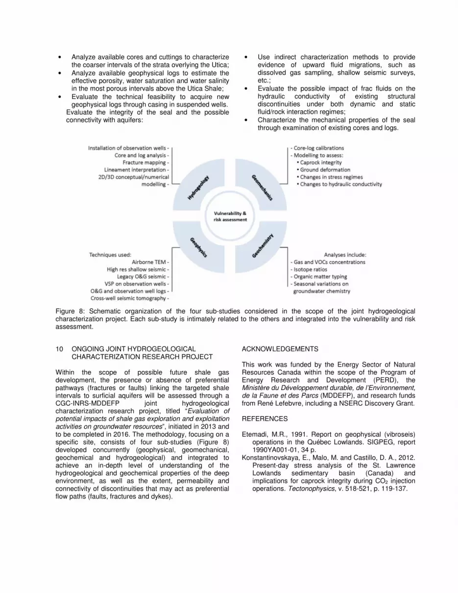
Figure 8: Schematic organization of the four sub-studies considered in the scope of the joint hydrogeological characterization project. Each sub-study is intimately related to the others and integrated into the vulnerability and risk assessment. 10 ONGOING JOINT HYDROGEOLOGICAL
CHARACTERIZATION RESEARCH PROJECT Within the scope of possible future shale gas development, the presence or absence of preferential pathways (fractures or faults) linking the targeted shale intervals to surficial aquifers will be assessed through a CGC-INRS-MDDEFP joint hydrogeological characterization research project, titled “Evaluation of potential impacts of shale gas exploration and exploitation activities on groundwater resources”, initiated in 2013 and to be completed in 2016. The methodology, focusing on a specific site, consists of four sub-studies (Figure 8) developed concurrently (geophysical, geomechanical, geochemical and hydrogeological) and integrated to achieve an in-depth level of understanding of the hydrogeological and geochemical properties of the deep environment, as well as the extent, permeability and connectivity of discontinuities that may act as preferential flow paths (faults, fractures and dykes).
ACKNOWLEDGEMENTS This work was funded by the Energy Sector of Natural Resources Canada within the scope of the Program of Energy Research and Development (PERD), the Ministère du Développement durable, de l’Environnement, de la Faune et des Parcs (MDDEFP), and research funds from René Lefebvre, including a NSERC Discovery Grant. REFERENCES Etemadi, M.R., 1991. Report on geophysical (vibroseis)
operations in the Québec Lowlands. SIGPEG, report 1990YA001-01, 34 p.
Konstantinovskaya, E., Malo, M. and Castillo, D. A., 2012. Present-day stress analysis of the St. Lawrence Lowlands sedimentary basin (Canada) and implications for caprock integrity during CO2 injection operations. Tectonophysics, v. 518-521, p. 119-137.
Laurencelle, M., Morin, R.H., Lefebvre, R., Rivard, C., Paradis, D., Lavoie, D., Benoit, N., Carrier, M.A. and Beaudry, C., 2011. Initial characterization of fractures and hydraulic properties of a rock aquifer system, Montérégie Est, Quebec, Canada. Geohydro2011, Joint IAH-CNC, CANQUA and AHQ conference, Quebec City, Canada, August 28-31, 2011, 7 p.
MRNF, 2008. Compilation pétrolière et gazière. Basses-Terres du Saint-Laurent et sud des Appalaches. Ministère des Ressources naturelles et de la Faune du Québec, SIGPEG, map AB_CE_250K_C.
Séjourné, S., Lefebvre, R., Malet, X. and Lavoie, D., 2013. Synthèse géologique et hydrogéologique du Shale d’Utica et des unités sus-jacentes (Lorraine, Queenston et dépôts meubles), Basses-Terres du Saint-Laurent, Province de Québec; Geological Survey of Canada, Open File 7338, 165 p.
SIGPEG, 2010. Zone avec Potentiel de Gaz de Schiste dans les Basses-Terres du Saint-Laurent. Map (pdf), Series Compilation pétrolière et gazière, 1/500,000.
Thériault, R., 2012. Caractérisation du Shale d'Utica et du Groupe de Lorraine, Basses-Terres du Saint-Laurent - Partie 2 : Interprétation géologique. Ministère des Ressources naturelles et de la Faune, SIGEOM, DV 2012-04, 80 p.
Wang, B. 2013. A hypothetical geomechanics model for qualitative assessment of environmental impact of shale gas fracking – Part I: Potential effect on groundwater. Submitted to the 66th Canadian Geotechnical Conference, Montreal, Sept. 29-Oct. 3, 2013.