123
The SSIP is supported by The SSIP is supported by SENIOR SECONDARY IMPROVEMENT PROGRAMME 2013 GRADE 12 GEOGRAPHY LEARNER NOTES 1
| Date post: | 27-Jan-2023 |
| Category: |
Documents |
| Upload: | khangminh22 |
| View: | 0 times |
| Download: | 0 times |
The SSIP is supported by The SSIP is supported by
SENIOR SECONDARY IMPROVEMENT PROGRAMME 2013
GRADE 12
GEOGRAPHY
LEARNER NOTES
1
TABLE OF CONTENTS
LEARNER NOTES
SESSION TOPIC PAGE
12 People and Places – Processes and Spatial Patterns 3 - 41
1. Sustainability - related strategies and urban settlements
2. Structures and Patterns of Urban Settlements,Human-Environment Interactions and SustainabilityStrategies.
13
2: Globalisation and trade: food security in southern Africa
1. Transport and trade - the importance and challenges ofthe informal sector 42 - 59
14 Examination Paper 1: Theory 60 - 103
15 Consolidation – Examination Paper 1
16 Consolidation – Examination Paper 2: Mapwork 104 - 123
17 Consolidation – Examination Paper 2: Mapwork (2)
2
GAUTENG DEPARTMENT OF EDUCATION SENIOR SECONDARY INTERVENTION PROGRAMME
GEOGRAPHY GRADE 12 SESSION 12 (LEARNER NOTES)
SESSION 12
TOPIC: PEOPLE AND PLACES – PROCESSES AND SPATIAL PATTERNS
Learner Note: During the examinations, the topic People and Places, and the topic Rural and Urban Settlements will be addressed in Paper 1 Section B. Your experience of place(s) where you have lived will help you recognise aspects of various kinds of settlements. When travelling, look for examples as well as at examples addressed in the media (TV or radio, newspapers and magazines). You will be able to see what is happening to the world‟s cities, towns and rural areas all around you.
SECTION A: TYPICAL EXAM QUESTIONS
QUESTION 1: Multiple-choice questions 5 minutes (Adapted from various past papers)
1.1 Four options are provided as possible answers to the following questions. Choose the answer and write only the letter A-D next to the question number (1.1.1 – 1.1.5), for example 1.1.6.B.
1.1.1 The smallest rural settlement type is a: A hamlet B isolated farmstead C low-order service D village
1.1.2 A settlement is classified as rural as a result of the… A number of people living in the settlement B size of the settlement C function of the settlement D number of low-order activities performed by the settlement
1.1.3 Site is influenced by the following factors: A water, defence, climate, aspect B water, defence, relief, fuel C water, topography, altitude, aspect D historical circumstances, water, farmland
1.1.4 Dry-point settlements occur near… A deserts B oases C marshes D higher ground
1.1.5 Agriculture is an example of a … economic activity A quaternary B tertiary C secondary D primary. (5 x 2) [10]
HINTS Hint 1 – Never leave out questions – especially not multiple choice questions Hint 2 – Number correctly and write only the correct letter next to the number, e.g. 1.1.4 C Hint 3 – Never write down two answers – you will get no marks
3
GAUTENG DEPARTMENT OF EDUCATION SENIOR SECONDARY INTERVENTION PROGRAMME
GEOGRAPHY GRADE 12 SESSION 12 (LEARNER NOTES)
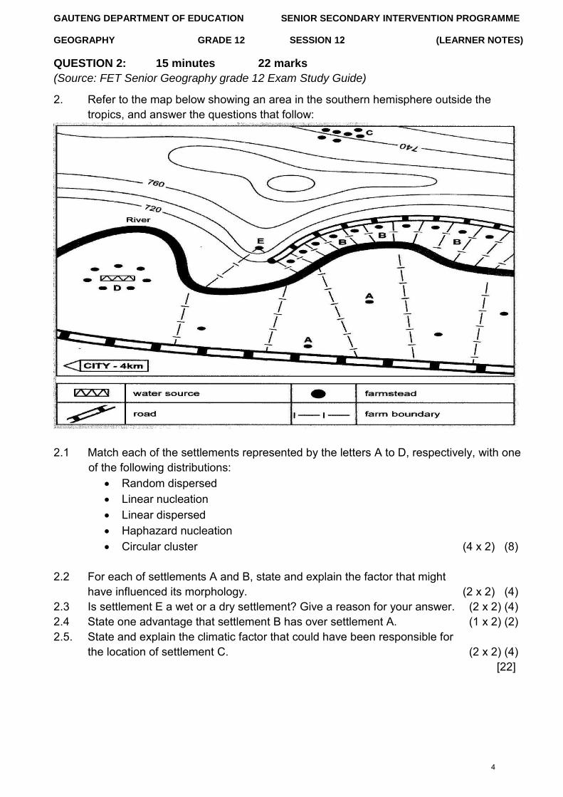
QUESTION 2: 15 minutes 22 marks (Source: FET Senior Geography grade 12 Exam Study Guide)
2. Refer to the map below showing an area in the southern hemisphere outside thetropics, and answer the questions that follow:
2.1 Match each of the settlements represented by the letters A to D, respectively, with one of the following distributions:
Random dispersed Linear nucleation Linear dispersed Haphazard nucleation Circular cluster (4 x 2) (8)
2.2 For each of settlements A and B, state and explain the factor that might have influenced its morphology. (2 x 2) (4)
2.3 Is settlement E a wet or a dry settlement? Give a reason for your answer. (2 x 2) (4) 2.4 State one advantage that settlement B has over settlement A. (1 x 2) (2) 2.5. State and explain the climatic factor that could have been responsible for
the location of settlement C. (2 x 2) (4) [22]
4
GAUTENG DEPARTMENT OF EDUCATION SENIOR SECONDARY INTERVENTION PROGRAMME
GEOGRAPHY GRADE 12 SESSION 12 (LEARNER NOTES)
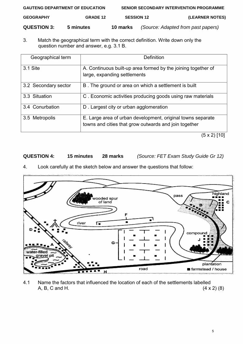
QUESTION 3: 5 minutes 10 marks (Source: Adapted from past papers)
3. Match the geographical term with the correct definition. Write down only thequestion number and answer, e.g. 3.1 B.
Geographical term Definition
3.1 Site A. Continuous built-up area formed by the joining together of large, expanding settlements
3.2 Secondary sector B . The ground or area on which a settlement is built
3.3 Situation C . Economic activities producing goods using raw materials
3.4 Conurbation D . Largest city or urban agglomeration
3.5 Metropolis E. Large area of urban development, original towns separate towns and cities that grow outwards and join together
(5 x 2) [10]
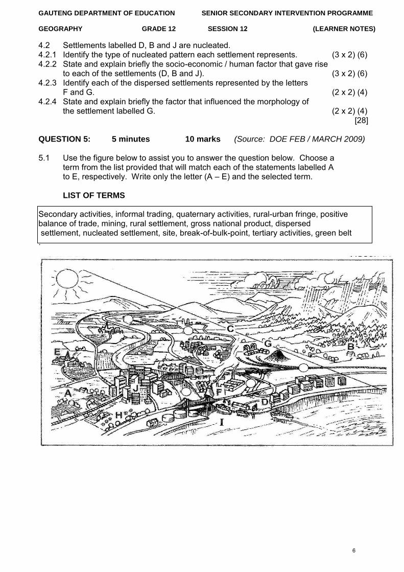
QUESTION 4: 15 minutes 28 marks (Source: FET Exam Study Guide Gr 12)
4. Look carefully at the sketch below and answer the questions that follow:
4.1 Name the factors that influenced the location of each of the settlements labelled A, B, C and H. (4 x 2) (8)
5
GAUTENG DEPARTMENT OF EDUCATION SENIOR SECONDARY INTERVENTION PROGRAMME
GEOGRAPHY GRADE 12 SESSION 12 (LEARNER NOTES)
4.2 Settlements labelled D, B and J are nucleated. 4.2.1 Identify the type of nucleated pattern each settlement represents. (3 x 2) (6) 4.2.2 State and explain briefly the socio-economic / human factor that gave rise
to each of the settlements (D, B and J). (3 x 2) (6) 4.2.3 Identify each of the dispersed settlements represented by the letters
F and G. (2 x 2) (4) 4.2.4 State and explain briefly the factor that influenced the morphology of
the settlement labelled G. (2 x 2) (4) [28]
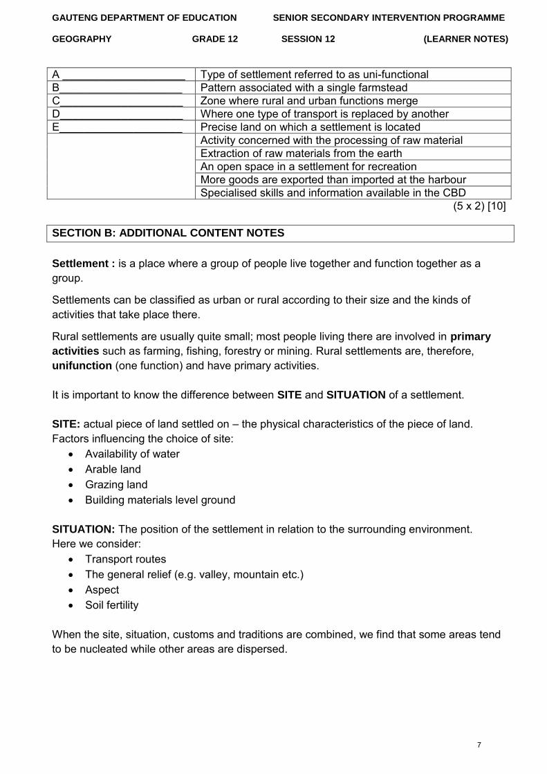
QUESTION 5: 5 minutes 10 marks (Source: DOE FEB / MARCH 2009)
5.1 Use the figure below to assist you to answer the question below. Choose a term from the list provided that will match each of the statements labelled A to E, respectively. Write only the letter (A – E) and the selected term.
LIST OF TERMS
Secondary activities, informal trading, quaternary activities, rural-urban fringe, positive balance of trade, mining, rural settlement, gross national product, dispersed settlement, nucleated settlement, site, break-of-bulk-point, tertiary activities, green belt .
6
GAUTENG DEPARTMENT OF EDUCATION SENIOR SECONDARY INTERVENTION PROGRAMME
GEOGRAPHY GRADE 12 SESSION 12 (LEARNER NOTES)
A ____________________ Type of settlement referred to as uni-functional B____________________ Pattern associated with a single farmstead C____________________ Zone where rural and urban functions merge D____________________ Where one type of transport is replaced by another E____________________ Precise land on which a settlement is located
Activity concerned with the processing of raw material Extraction of raw materials from the earth An open space in a settlement for recreation More goods are exported than imported at the harbour Specialised skills and information available in the CBD
(5 x 2) [10]
SECTION B: ADDITIONAL CONTENT NOTES
Settlement : is a place where a group of people live together and function together as a group.
Settlements can be classified as urban or rural according to their size and the kinds of activities that take place there.
Rural settlements are usually quite small; most people living there are involved in primary
activities such as farming, fishing, forestry or mining. Rural settlements are, therefore, unifunction (one function) and have primary activities.
It is important to know the difference between SITE and SITUATION of a settlement.
SITE: actual piece of land settled on – the physical characteristics of the piece of land. Factors influencing the choice of site:
Availability of water Arable land Grazing land Building materials level ground
SITUATION: The position of the settlement in relation to the surrounding environment. Here we consider:
Transport routes The general relief (e.g. valley, mountain etc.) Aspect Soil fertility
When the site, situation, customs and traditions are combined, we find that some areas tend to be nucleated while other areas are dispersed.
7
GAUTENG DEPARTMENT OF EDUCATION SENIOR SECONDARY INTERVENTION PROGRAMME
GEOGRAPHY GRADE 12 SESSION 12 (LEARNER NOTES)
Brief summary Dispersed Nucleated
Water Freely available In short supply Relief Flat ground Steeper ground Soil Unfertile Fertile Tradition Nguni settlement Tswana village Defence Peace time War and violence Climate Mild Extreme climates
Wet-point settlement: where there is water in a dry area, e.g. spring, oasis. If water is scarce, people gather around a wet point. Dry-point settlement: where there is a dry point in a wet area, people settle on dry land, e.g. small hills suitable for settlement in a marshy area. Function of a Settlement: most rural settlements are serviced by a central service centre. The service centres provide a market and provide goods and services to the surrounding population, for example, transport, medical, etc. Once you have identified the settlement, you must identify the characteristics of that settlement.
Characteristics of a settlement:
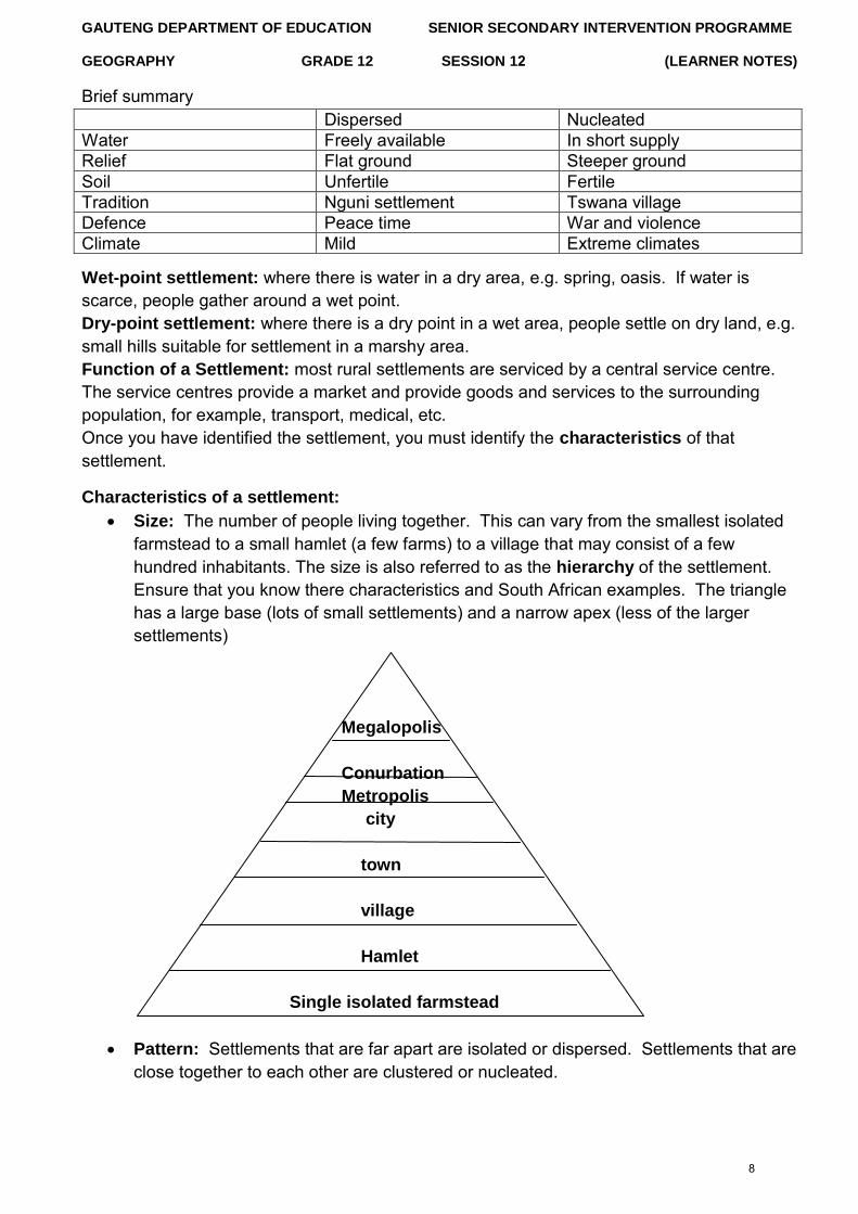
Size: The number of people living together. This can vary from the smallest isolatedfarmstead to a small hamlet (a few farms) to a village that may consist of a fewhundred inhabitants. The size is also referred to as the hierarchy of the settlement.Ensure that you know there characteristics and South African examples. The trianglehas a large base (lots of small settlements) and a narrow apex (less of the largersettlements)
Megalopolis
Conurbation
Metropolis
city
town
village
Hamlet
Single isolated farmstead
Pattern: Settlements that are far apart are isolated or dispersed. Settlements that areclose together to each other are clustered or nucleated.
8
GAUTENG DEPARTMENT OF EDUCATION SENIOR SECONDARY INTERVENTION PROGRAMME
GEOGRAPHY GRADE 12 SESSION 12 (LEARNER NOTES) There are various
positives and negatives to living in isolated or dispersed settlements
Dispersed Nucleated
Advantages Advantages
Farmers can make their own decisions Help is readily available in times of trouble, health emergencies and war
They can mechanise and implement environmentally friendly farming methods
Farmers need less capital, seeing that they can borrow machines and other implements from each other
Disadvantages Disadvantages
There is a shortage of social contact Farmers cannot rely on community
for any help Requires a large amount of capital to
maintain the farming practices
All farmers have to reach consentwith regards to certain farmingmethods
Land is often fragmented, and thussometimes too small to mechanise
If soil erosion occurs, all farmers areaffected, for example dongas thatreach across farm boundaries
There is less opportunity for the useof individual choices
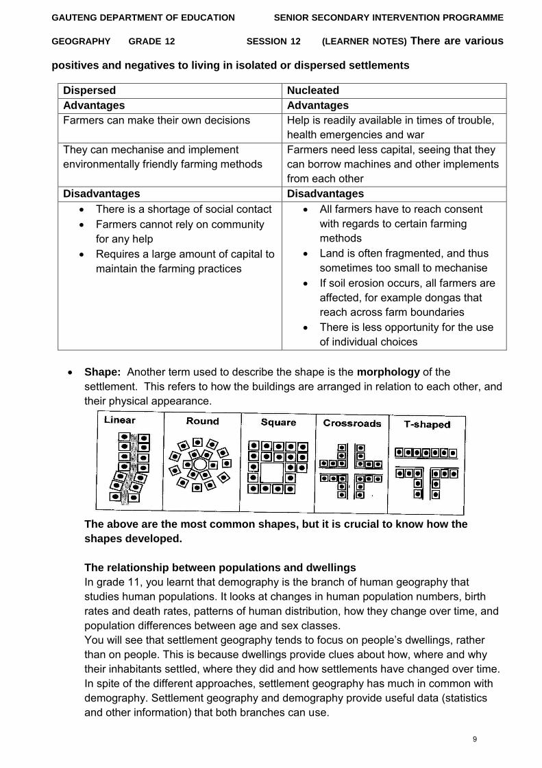
Shape: Another term used to describe the shape is the morphology of thesettlement. This refers to how the buildings are arranged in relation to each other, andtheir physical appearance.
The above are the most common shapes, but it is crucial to know how the
shapes developed.
The relationship between populations and dwellings
In grade 11, you learnt that demography is the branch of human geography that studies human populations. It looks at changes in human population numbers, birth rates and death rates, patterns of human distribution, how they change over time, and population differences between age and sex classes. You will see that settlement geography tends to focus on people‟s dwellings, rather
than on people. This is because dwellings provide clues about how, where and why their inhabitants settled, where they did and how settlements have changed over time. In spite of the different approaches, settlement geography has much in common with demography. Settlement geography and demography provide useful data (statistics and other information) that both branches can use.
9
GAUTENG DEPARTMENT OF EDUCATION SENIOR SECONDARY INTERVENTION PROGRAMME
GEOGRAPHY GRADE 12 SESSION 12 (LEARNER NOTES)
HINTS Hint 1 – In the final examination, 20% to 30% of the settlement questions will be about rural
settlement, with urban settlement making up the rest. Hint 2 – Expect to be examined on some settlement work in the mapwork examination. Hint 3 – Photographs, sketches, maps, advertisements and statistical data can also be
expected in this section. Hint 4 – Make sure you know the key concepts and terminology and are able to apply this
knowledge to new situation
SECTION C: HOMEWORK
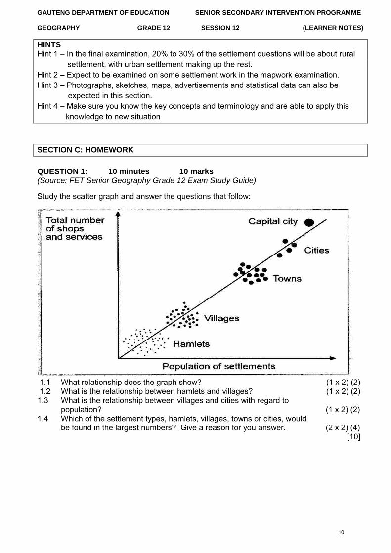
QUESTION 1: 10 minutes 10 marks (Source: FET Senior Geography Grade 12 Exam Study Guide)
Study the scatter graph and answer the questions that follow:
1.1 What relationship does the graph show? (1 x 2) (2) 1.2 What is the relationship between hamlets and villages? (1 x 2) (2) 1.3 What is the relationship between villages and cities with regard to
population? (1 x 2) (2) 1.4 Which of the settlement types, hamlets, villages, towns or cities, would
be found in the largest numbers? Give a reason for you answer. (2 x 2) (4) [10]
10
GAUTENG DEPARTMENT OF EDUCATION SENIOR SECONDARY INTERVENTION PROGRAMME
GEOGRAPHY GRADE 12 SESSION 12 (LEARNER NOTES)
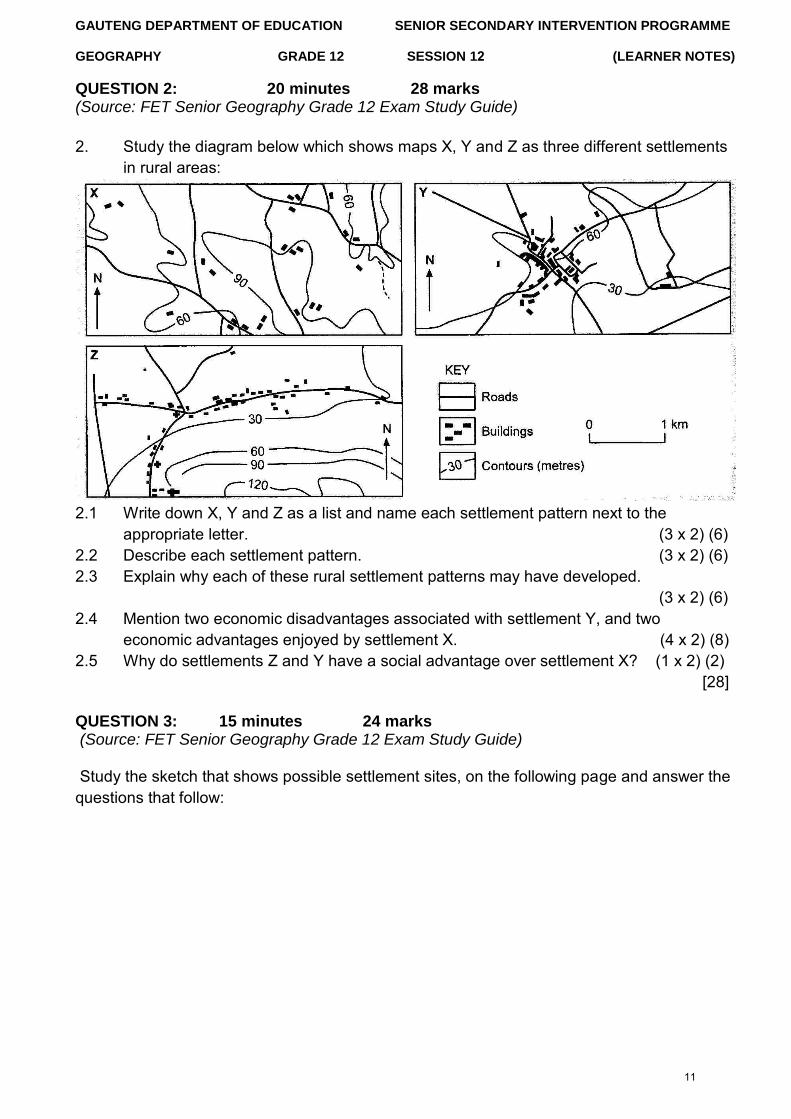
QUESTION 2: 20 minutes 28 marks (Source: FET Senior Geography Grade 12 Exam Study Guide)
2. Study the diagram below which shows maps X, Y and Z as three different settlementsin rural areas:
2.1 Write down X, Y and Z as a list and name each settlement pattern next to the appropriate letter. (3 x 2) (6)
2.2 Describe each settlement pattern. (3 x 2) (6) 2.3 Explain why each of these rural settlement patterns may have developed.
(3 x 2) (6) 2.4 Mention two economic disadvantages associated with settlement Y, and two
economic advantages enjoyed by settlement X. (4 x 2) (8) 2.5 Why do settlements Z and Y have a social advantage over settlement X? (1 x 2) (2)
[28]
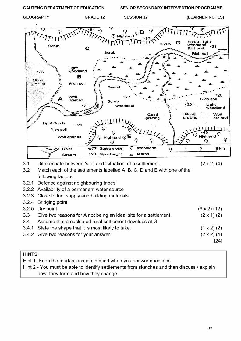
QUESTION 3: 15 minutes 24 marks (Source: FET Senior Geography Grade 12 Exam Study Guide)
Study the sketch that shows possible settlement sites, on the following page and answer the questions that follow:
11
GAUTENG DEPARTMENT OF EDUCATION SENIOR SECONDARY INTERVENTION PROGRAMME
GEOGRAPHY GRADE 12 SESSION 12 (LEARNER NOTES)
3.1 Differentiate between „site‟ and „situation‟ of a settlement. (2 x 2) (4) 3.2 Match each of the settlements labelled A, B, C, D and E with one of the
following factors: 3.2.1 Defence against neighbouring tribes 3.2.2 Availability of a permanent water source 3.2.3 Close to fuel supply and building materials 3.2.4 Bridging point 3.2.5 Dry point (6 x 2) (12) 3.3 Give two reasons for A not being an ideal site for a settlement. (2 x 1) (2) 3.4 Assume that a nucleated rural settlement develops at G: 3.4.1 State the shape that it is most likely to take. (1 x 2) (2) 3.4.2 Give two reasons for your answer. (2 x 2) (4)
[24]
HINTS
Hint 1- Keep the mark allocation in mind when you answer questions. Hint 2 - You must be able to identify settlements from sketches and then discuss / explain
how they form and how they change.
12
GAUTENG DEPARTMENT OF EDUCATION SENIOR SECONDARY INTERVENTION PROGRAMME
GEOGRAPHY GRADE 12 SESSION 12 (LEARNER NOTES)
QUESTION 1
1.1 1.1.1 B√√ 1.1.2 C√√ 1.1.3 B√√ 1.1.4 D√√ 1.1.5 D√√ (5 x 2) [10]
QUESTION 2
2.1 A = random dispersed√√ B = linear dispersed√√ C = linear nucleated√√ D = circular cluster√√ (4 x 2) (8)
2.2 A – relief – flat land / private land ownership√√ B – access to the road / river√√ (2 x 2) (4)
2.3 Dry-point settlement found on river terrace to avoid flooding. (2 x 2) (4) 2.4 Access to transport routes√√
Sharing of agricultural ideas√√ Greater degree of social contact√√ Greater security√√ [Any ONE] (1 x 2) (2)
2.5 Aspect/ angle of insolation√√ C is located on the north-facing slope and in the southern hemisphere the north- facing slopes are warmer because they receive the direct rays of the sun√√ (2 x 2) (4)
[22]
QUESTION 3
3.1 A√√ 3.2 C√√ 3.3 B√√ 3.4 E√√ 3.5 D√√ (5 x 2) [10]
QUESTION 4
4.1 A – water√√ B – pass / road√√ C – defence H – break-of-bulk point√√ (4 x 2) (8)
SECTION D: SOLUTIONS AND HINTS TO SECTION A
13
GAUTENG DEPARTMENT OF EDUCATION SENIOR SECONDARY INTERVENTION PROGRAMME
GEOGRAPHY GRADE 12 SESSION 12 (LEARNER NOTES)
4.2 4.2.1 D – haphazard nucleated√√
B – linear nucleation√√ J – uniform cluster√√ (3 x 2) (6)
4.2.2 D – religion- people of common faith e.g. Mormons√√ B – found at entrance to pass – access to other side√√ J – labourers nucleated on plantation estate√√ (3 x 2) (6)
4.2.3 F – loose linear√√ G – regular / uniform dispersion√√ (2 x 2) (4)
4.2.4 Relief√√ - flat land lead to uniform dispersed settlements√√ (2 x 2) (4) [28]
QUESTION 5
5.1 A – rural settlement√√ B - dispersed√√ C – site√√ D - secondary√√ G - mining√√ (5 x 2) [10]
14
SENIOR SECONDARY INTERVENTION PROGRAMME
SESSION 12 (LEARNER NOTES)
GAUTENG DEPARTMENT OF EDUCATION
GEOGRAPHY GRADE 12 SESSION 12.2
TOPIC 1: SUSTAINABILITY- RELATED STRATEGIES AND URBAN SETTLEMENTS
Learner Note: The content of Sessions 15 to 17 covers all work examined in Question 3 and Question 4 of Paper 1. It is advisable for you to ensure that you study definitions and terminology well. Questions 3 and 4 are also the most popular questions that are answered in Paper 1. You might find this work much easier to study and understand. The content relates closely to everyday life, and we are confronted by a lot of information with regards to these topics in the media every day. It is vital that you use the stimulus material in all of the questions, as most answers are found in the accompanying diagrams, figures and graphs
SECTION A: TYPICAL EXAM QUESTIONS
QUESTION 1: 10 minutes 14 marks (Source: DoE various papers)
Shortly after coming to power in 1994, the new government introduced the RDP. The RDP principles are still used as guidelines today, but the basis of the government‟s economic
strategy at present is called GEAR.
1.1 What does RDP stand for? (1 x 2) (2) 1.2 Name the key principles of this programme. (2 x 2) (4) 1.3 What does GEAR stand for? (1 x 2) (2) 1.4 What are the key elements of this strategy? (3 x 2) (6)
[14]
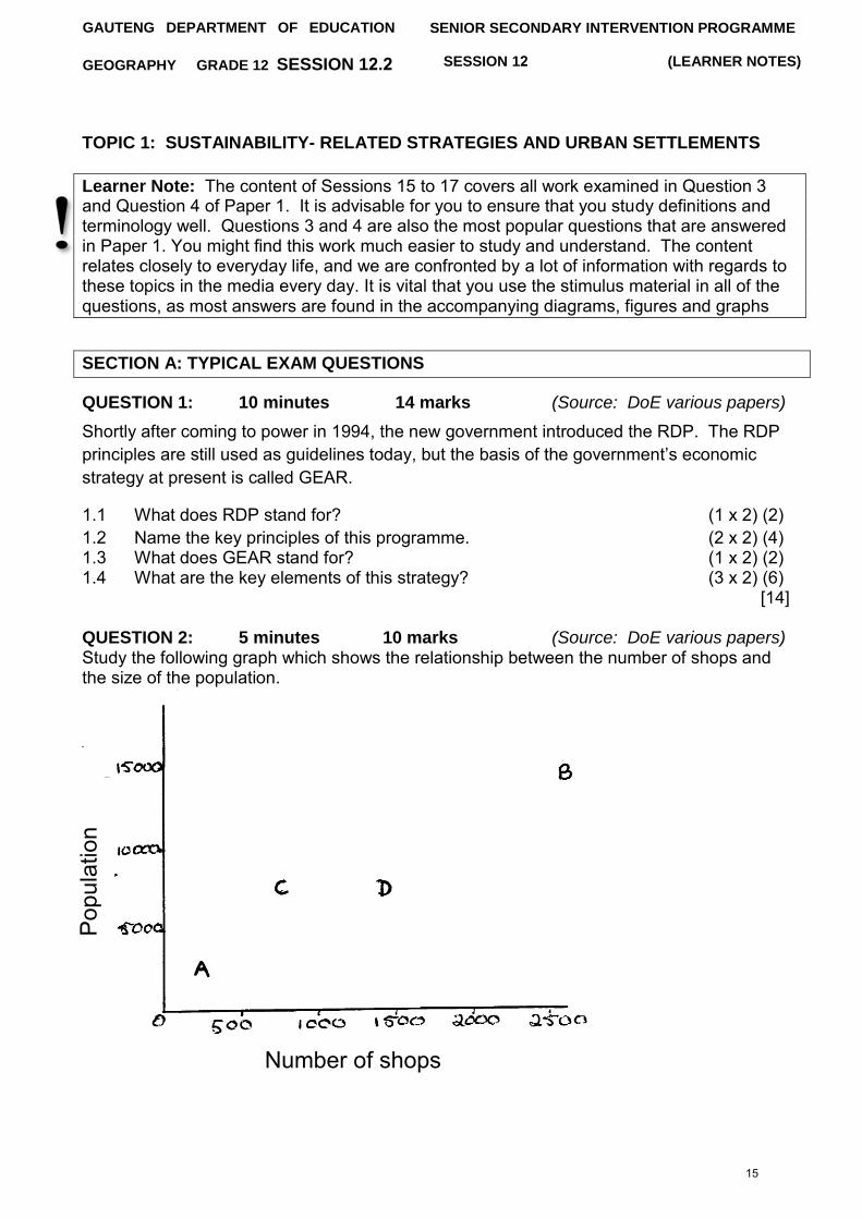
QUESTION 2: 5 minutes 10 marks (Source: DoE various papers) Study the following graph which shows the relationship between the number of shops and the size of the population.
Number of shops
Pop
ulat
ion
15
GAUTENG DEPARTMENT OF EDUCATION SENIOR SECONDARY INTERVENTION PROGRAMME
GEOGRAPHY GRADE 12 SESSION 12 (LEARNER NOTES)
2.1 How many shops are there in settlement A? (1 x 2) (2) 2.2 What is the population of settlement B? (1 x 2) (2) 2.3 Explain what is meant by the term “urban hierarchy”, using the
relationship shown on the graph between the number of shops and the size of the population. (3 x 2) (6)
[10]
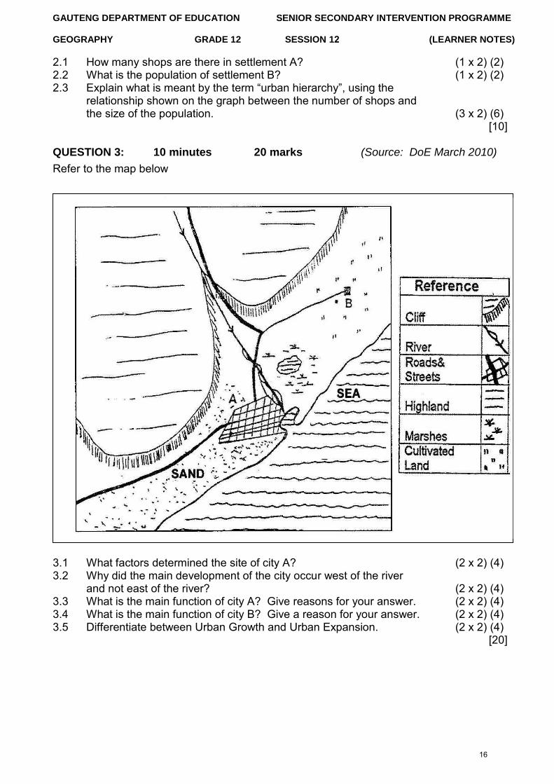
QUESTION 3: 10 minutes 20 marks (Source: DoE March 2010) Refer to the map below
3.1 What factors determined the site of city A? (2 x 2) (4) 3.2 Why did the main development of the city occur west of the river
and not east of the river? (2 x 2) (4) 3.3 What is the main function of city A? Give reasons for your answer. (2 x 2) (4) 3.4 What is the main function of city B? Give a reason for your answer. (2 x 2) (4) 3.5 Differentiate between Urban Growth and Urban Expansion. (2 x 2) (4)
[20]
16
GAUTENG DEPARTMENT OF EDUCATION SENIOR SECONDARY INTERVENTION PROGRAMME
GEOGRAPHY GRADE 12 SESSION 12 (LEARNER NOTES)
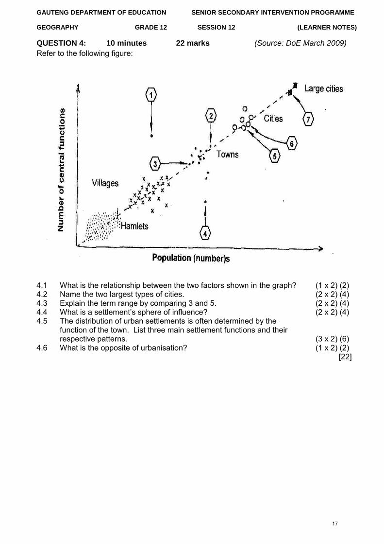
QUESTION 4: 10 minutes 22 marks (Source: DoE March 2009)
Refer to the following figure:
4.1 What is the relationship between the two factors shown in the graph? (1 x 2) (2) 4.2 Name the two largest types of cities. (2 x 2) (4) 4.3 Explain the term range by comparing 3 and 5. (2 x 2) (4) 4.4 What is a settlement‟s sphere of influence? (2 x 2) (4) 4.5 The distribution of urban settlements is often determined by the
function of the town. List three main settlement functions and their respective patterns. (3 x 2) (6)
4.6 What is the opposite of urbanisation? (1 x 2) (2) [22]
17
GAUTENG DEPARTMENT OF EDUCATION SENIOR SECONDARY INTERVENTION PROGRAMME
GEOGRAPHY GRADE 12 SESSION 12 (LEARNER NOTES)
TOPIC 2: STRUCTURES AND PATTERNS OF URBAN SETTLEMENTS, HUMAN-ENVIRONMENT INTERACTIONS AND SUSTAINABILITY STRATEGIES
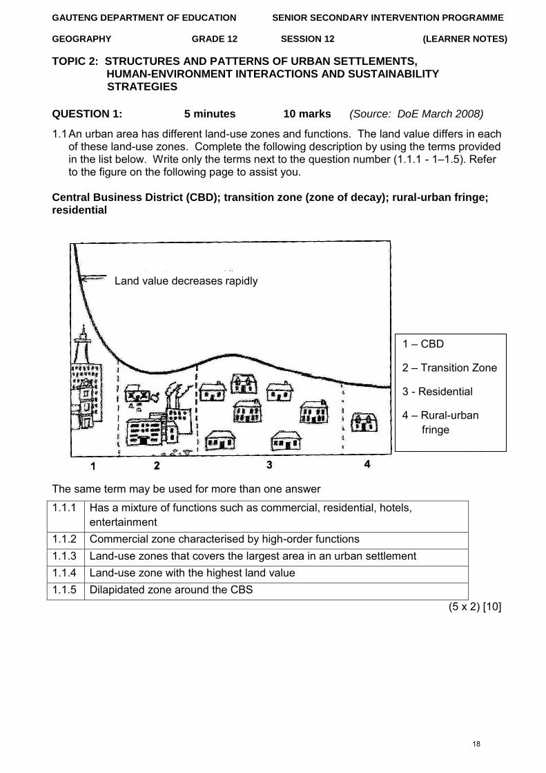
QUESTION 1: 5 minutes 10 marks (Source: DoE March 2008)
1.1 An urban area has different land-use zones and functions. The land value differs in each of these land-use zones. Complete the following description by using the terms provided in the list below. Write only the terms next to the question number (1.1.1 - 1–1.5). Refer to the figure on the following page to assist you.
Central Business District (CBD); transition zone (zone of decay); rural-urban fringe; residential
The same term may be used for more than one answer
1.1.1 Has a mixture of functions such as commercial, residential, hotels, entertainment
1.1.2 Commercial zone characterised by high-order functions 1.1.3 Land-use zones that covers the largest area in an urban settlement 1.1.4 Land-use zone with the highest land value 1.1.5 Dilapidated zone around the CBS
(5 x 2) [10]
Land value decreases rapidly
1 – CBD
2 – Transition Zone
3 - Residential
4 – Rural-urban fringe
18
GAUTENG DEPARTMENT OF EDUCATION SENIOR SECONDARY INTERVENTION PROGRAMME
GEOGRAPHY GRADE 12 (LEARNER NOTES)
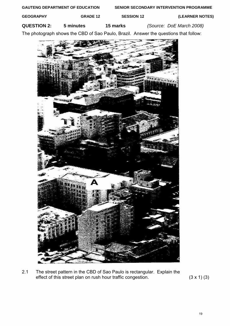
QUESTION 2: 5 minutes
SESSION 12
15 marks (Source: DoE March 2008)
The photograph shows the CBD of Sao Paulo, Brazil. Answer the questions that follow:
2.1 The street pattern in the CBD of Sao Paulo is rectangular. Explain the effect of this street plan on rush hour traffic congestion. (3 x 1) (3)
19
GAUTENG DEPARTMENT OF EDUCATION SENIOR SECONDARY INTERVENTION PROGRAMME
GEOGRAPHY GRADE 12 SESSION 12 (LEARNER NOTES)
2.2 Arrange the following from the lowest to the highest rent and give a reason in each case: Top floor Middle floor Ground floor (3 x 1) (3)
2.3 Explain why it was necessary for the owner of building A to build such a tall building. (3 x 1) (3)
2.4 As the CBD becomes increasingly overcrowded and congested, many businesses will move to cheaper more attractive locations in the suburbs. What effect will this have on the rents charged for office space in building A? Explain your answer. (3 x 2) (6)
[15]
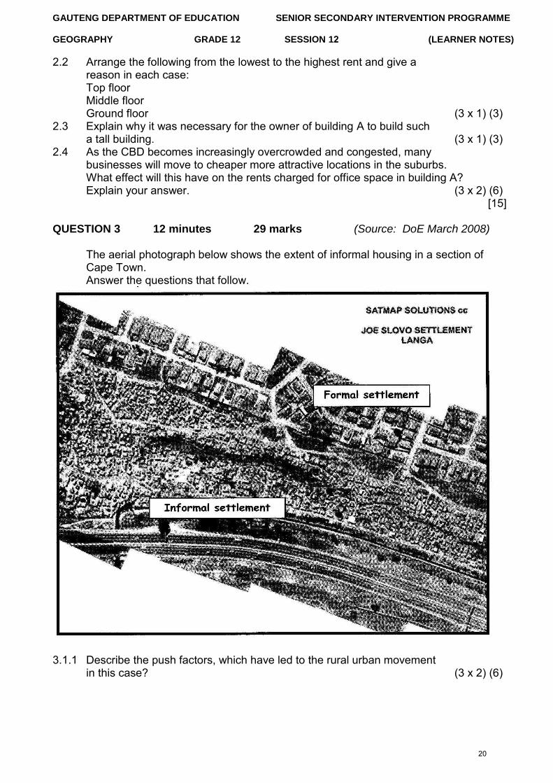
QUESTION 3 12 minutes 29 marks (Source: DoE March 2008)
The aerial photograph below shows the extent of informal housing in a section of Cape Town. Answer the questions that follow.
3.1.1 Describe the push factors, which have led to the rural urban movement in this case? (3 x 2) (6)
20
GAUTENG DEPARTMENT OF EDUCATION SENIOR SECONDARY INTERVENTION PROGRAMME
GEOGRAPHY GRADE 12 SESSION 12 (LEARNER NOTES)
3.1.2 Name FIVE socio-economic problems that the inhabitants of the informal settlement shown in the photograph experiences? (5 x 1) (5)
3.1.3 An informal settlement of this size is a serious problem for any city. Explain why it is necessary for the local municipality to spend large sums of money upgrading the informal settlement. (4 x 2) (8)
3.1.4 Name FOUR basic municipal services which should be supplied to the informal area as a priority. (4 x 1) (4)
3.1.5 Make a list of the basic needs which need to be satisfied in this community before social upliftment projects, such as the provision of playgrounds and centers for skills training, can be successful. (6 x 1) (6)
` [29]
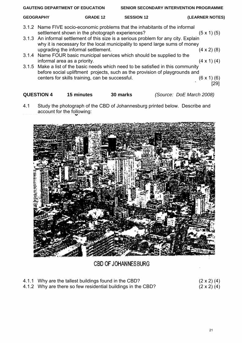
QUESTION 4 15 minutes 30 marks (Source: DoE March 2008)
4.1 Study the photograph of the CBD of Johannesburg printed below. Describe and account for the following:
4.1.1 Why are the tallest buildings found in the CBD? (2 x 2) (4) 4.1.2 Why are there so few residential buildings in the CBD? (2 x 2) (4)
21
GAUTENG DEPARTMENT OF EDUCATION SENIOR SECONDARY INTERVENTION PROGRAMME
GEOGRAPHY GRADE 12 SESSION 12 (LEARNER NOTES)
4.1.3 (a) Retail occurs on a large scale in the CBD. What is meant by the term „retailing‟? (1 x 2) (2)
(b) Give a reason why most of the retail shops occur on the ground and first floors of buildings. (1 x 2) (2)
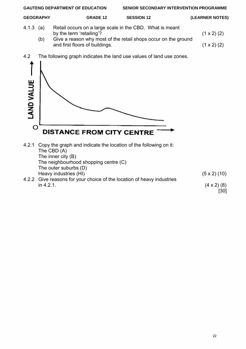
4.2 The following graph indicates the land use values of land use zones.
4.2.1 Copy the graph and indicate the location of the following on it: The CBD (A) The inner city (B) The neighbourhood shopping centre (C) The outer suburbs (D) Heavy industries (HI) (5 x 2) (10)
4.2.2 Give reasons for your choice of the location of heavy industries in 4.2.1. (4 x 2) (8)
[30]
22
GAUTENG DEPARTMENT OF EDUCATION SENIOR SECONDARY INTERVENTION PROGRAMME
GEOGRAPHY GRADE 12 SESSION 12 (LEARNER NOTES)
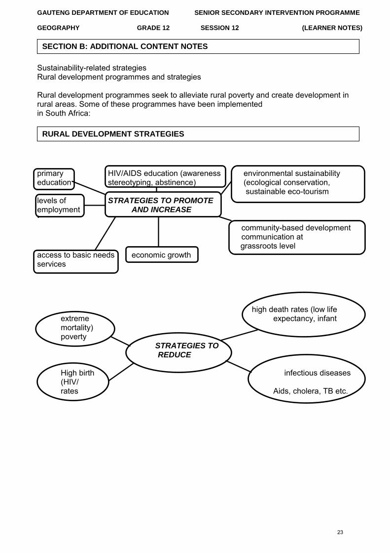
Sustainability-related strategies Rural development programmes and strategies
Rural development programmes seek to alleviate rural poverty and create development in rural areas. Some of these programmes have been implemented in South Africa:
primary HIV/AIDS education (awareness environmental sustainability education stereotyping, abstinence) (ecological conservation,
sustainable eco-tourism levels of STRATEGIES TO PROMOTE employment AND INCREASE ‘
community-based development communication at grassroots level
access to basic needs economic growth services
high death rates (low life extreme expectancy, infant mortality) poverty
STRATEGIES TO REDUCE
High birth infectious diseases (HIV/ rates Aids, cholera, TB etc.
RURAL DEVELOPMENT STRATEGIES
SECTION B: ADDITIONAL CONTENT NOTES
23
GAUTENG DEPARTMENT OF EDUCATION SENIOR SECONDARY INTERVENTION PROGRAMME
GEOGRAPHY GRADE 12 SESSION 12 (LEARNER NOTES)
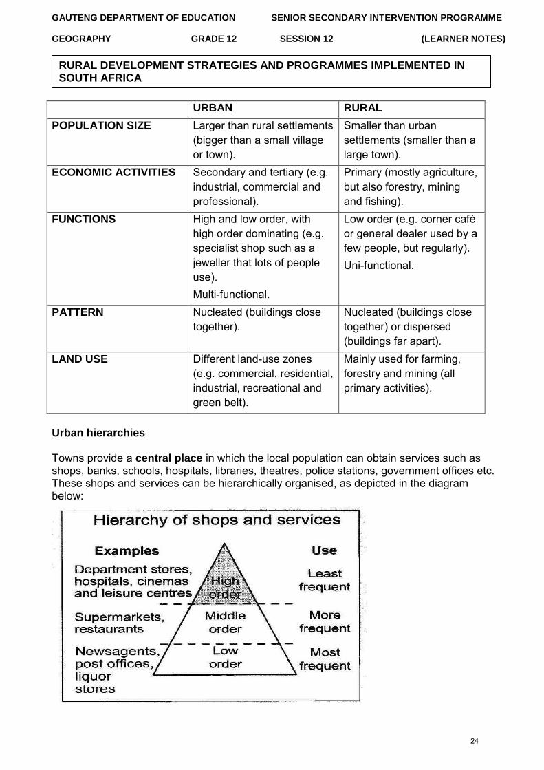
URBAN RURAL
POPULATION SIZE Larger than rural settlements (bigger than a small village or town).
Smaller than urban settlements (smaller than a large town).
ECONOMIC ACTIVITIES Secondary and tertiary (e.g. industrial, commercial and professional).
Primary (mostly agriculture, but also forestry, mining and fishing).
FUNCTIONS High and low order, with high order dominating (e.g. specialist shop such as a jeweller that lots of people use). Multi-functional.
Low order (e.g. corner café or general dealer used by a few people, but regularly). Uni-functional.
PATTERN Nucleated (buildings close together).
Nucleated (buildings close together) or dispersed (buildings far apart).
LAND USE Different land-use zones (e.g. commercial, residential, industrial, recreational and green belt).
Mainly used for farming, forestry and mining (all primary activities).
Urban hierarchies
Towns provide a central place in which the local population can obtain services such as shops, banks, schools, hospitals, libraries, theatres, police stations, government offices etc. These shops and services can be hierarchically organised, as depicted in the diagram below:
RURAL DEVELOPMENT STRATEGIES AND PROGRAMMES IMPLEMENTED IN SOUTH AFRICA
24
GAUTENG DEPARTMENT OF EDUCATION SENIOR SECONDARY INTERVENTION PROGRAMME
GEOGRAPHY GRADE 12 SESSION 12 (LEARNER NOTES)
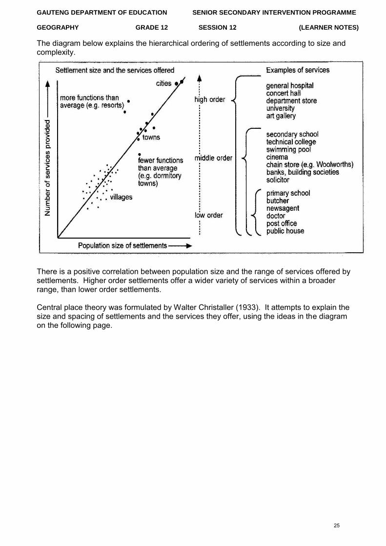
The diagram below explains the hierarchical ordering of settlements according to size and complexity.
There is a positive correlation between population size and the range of services offered by settlements. Higher order settlements offer a wider variety of services within a broader range, than lower order settlements.
Central place theory was formulated by Walter Christaller (1933). It attempts to explain the size and spacing of settlements and the services they offer, using the ideas in the diagram on the following page.
25
GAUTENG DEPARTMENT OF EDUCATION SENIOR SECONDARY INTERVENTION PROGRAMME
GEOGRAPHY GRADE 12 SESSION 12 (LEARNER NOTES)
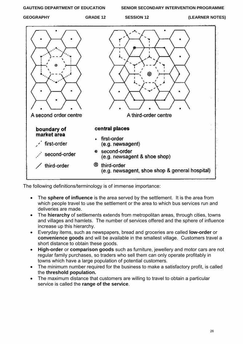
The following definitions/terminology is of immense importance:
The sphere of influence is the area served by the settlement. It is the area fromwhich people travel to use the settlement or the area to which bus services run anddeliveries are made.
The hierarchy of settlements extends from metropolitan areas, through cities, townsand villages and hamlets. The number of services offered and the sphere of influenceincrease up this hierarchy.
Everyday items, such as newspapers, bread and groceries are called low-order orconvenience goods and will be available in the smallest village. Customers travel ashort distance to obtain these goods.
High-order or comparison goods such as furniture, jewellery and motor cars are notregular family purchases, so traders who sell them can only operate profitably intowns which have a large population of potential customers.
The minimum number required for the business to make a satisfactory profit, is calledthe threshold population.
The maximum distance that customers are willing to travel to obtain a particularservice is called the range of the service.
26
GAUTENG DEPARTMENT OF EDUCATION SENIOR SECONDARY INTERVENTION PROGRAMME
GEOGRAPHY GRADE 12 SESSION 12 (LEARNER NOTES)
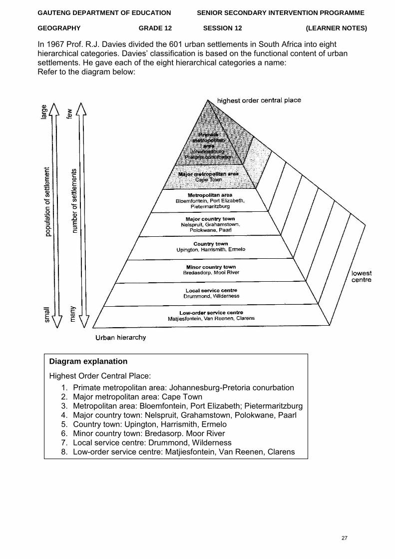
In 1967 Prof. R.J. Davies divided the 601 urban settlements in South Africa into eight hierarchical categories. Davies‟ classification is based on the functional content of urban settlements. He gave each of the eight hierarchical categories a name: Refer to the diagram below:
Diagram explanation
Highest Order Central Place: 1. Primate metropolitan area: Johannesburg-Pretoria conurbation2. Major metropolitan area: Cape Town3. Metropolitan area: Bloemfontein, Port Elizabeth; Pietermaritzburg4. Major country town: Nelspruit, Grahamstown, Polokwane, Paarl5. Country town: Upington, Harrismith, Ermelo6. Minor country town: Bredasorp. Moor River7. Local service centre: Drummond, Wilderness8. Low-order service centre: Matjiesfontein, Van Reenen, Clarens
27
GAUTENG DEPARTMENT OF EDUCATION SENIOR SECONDARY INTERVENTION PROGRAMME
GEOGRAPHY GRADE 12 SESSION 12 (LEARNER NOTES)
URBANISATION (%):
The process in which an increasing proportion of the country‟s population is concentrated in urban areas. It is caused by rural-urban migration.
URBAN GROWTH (numbers):
Refers to the increase in actual number of people living in cities due to urbanisation and natural increases. Thus, the increase of the number of people living in urban areas.
URBAN EXPANSION (area):
Is the increase of the actual physical size of an urban area. Urban sprawl is the unplanned spread of urban areas.
URBAN PROFILES
The urban profile is a cross-section of the city from the CBD to the periphery. It is a view of a city as seen from the side. The differences in relief are ignored, while the height of the buildings is the important factor. In a city in the developed world you might expect the following changes:
Buildings get older towards the centre There will be many newer buildings in the CBD Building density increases towards the centre Buildings are taller towards the centre Roads and pavements are busier towards the centre There is less open space towards the centre Beyond the edge of the city is the rural-urban fringe, an area being gradually
„urbanised‟ as villages are taken over by new housing for commuters
Some towns have protected these areas with „green belts‟ where development isrestricted
28
GAUTENG DEPARTMENT OF EDUCATION SENIOR SECONDARY INTERVENTION PROGRAMME
GEOGRAPHY GRADE 12 SESSION 12 (LEARNER NOTES)
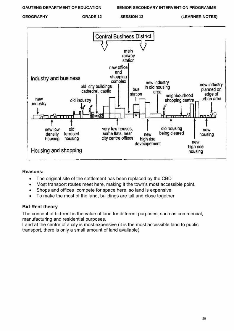
Reasons:
The original site of the settlement has been replaced by the CBD Most transport routes meet here, making it the town‟s most accessible point.
Shops and offices compete for space here, so land is expensive To make the most of the land, buildings are tall and close together
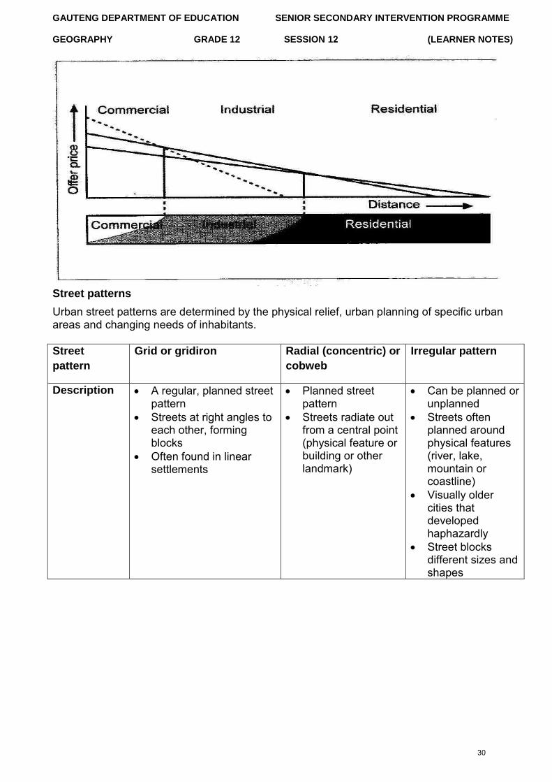
Bid-Rent theory
The concept of bid-rent is the value of land for different purposes, such as commercial, manufacturing and residential purposes. Land at the centre of a city is most expensive (it is the most accessible land to public transport, there is only a small amount of land available)
29
GAUTENG DEPARTMENT OF EDUCATION SENIOR SECONDARY INTERVENTION PROGRAMME
GEOGRAPHY GRADE 12 SESSION 12 (LEARNER NOTES)
Street patterns
Urban street patterns are determined by the physical relief, urban planning of specific urban areas and changing needs of inhabitants.
Street
pattern
Grid or gridiron Radial (concentric) or
cobweb
Irregular pattern
Description A regular, planned streetpattern
Streets at right angles toeach other, formingblocks
Often found in linearsettlements
Planned streetpattern
Streets radiate outfrom a central point(physical feature orbuilding or otherlandmark)
Can be planned orunplanned
Streets oftenplanned aroundphysical features(river, lake,mountain orcoastline)
Visually oldercities thatdevelopedhaphazardly
Street blocksdifferent sizes andshapes
30
GAUTENG DEPARTMENT OF EDUCATION SENIOR SECONDARY INTERVENTION PROGRAMME
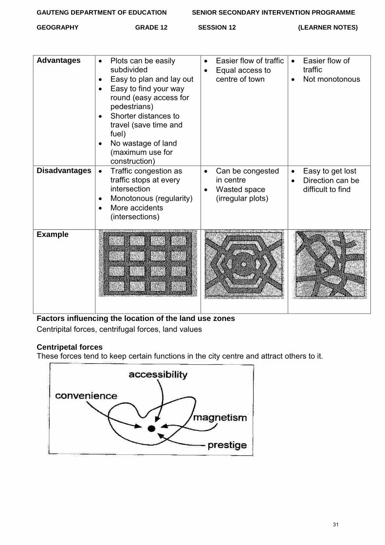
GEOGRAPHY GRADE 12 SESSION 12 (LEARNER NOTES)
Advantages Plots can be easilysubdivided
Easy to plan and lay out Easy to find your way
round (easy access forpedestrians)
Shorter distances totravel (save time andfuel)
No wastage of land(maximum use forconstruction)
Easier flow of traffic Equal access to
centre of town
Easier flow oftraffic
Not monotonous
Disadvantages Traffic congestion astraffic stops at everyintersection
Monotonous (regularity) More accidents
(intersections)
Can be congestedin centre
Wasted space(irregular plots)
Easy to get lost Direction can be
difficult to find
Example
Factors influencing the location of the land use zones
Centripital forces, centrifugal forces, land values
Centripetal forces These forces tend to keep certain functions in the city centre and attract others to it.
31
GAUTENG DEPARTMENT OF EDUCATION SENIOR SECONDARY INTERVENTION PROGRAMME
GEOGRAPHY GRADE 12 SESSION 12 (LEARNER NOTES)
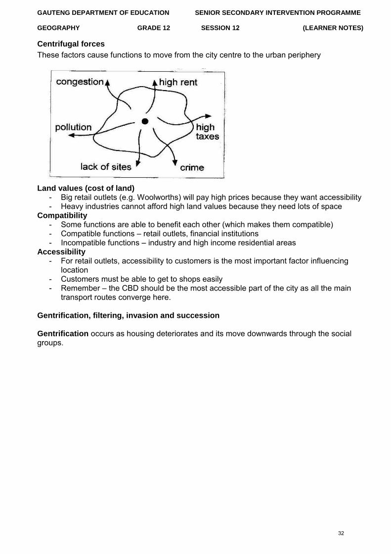
Centrifugal forces
These factors cause functions to move from the city centre to the urban periphery
Land values (cost of land) - Big retail outlets (e.g. Woolworths) will pay high prices because they want accessibility - Heavy industries cannot afford high land values because they need lots of space
Compatibility - Some functions are able to benefit each other (which makes them compatible) - Compatible functions – retail outlets, financial institutions - Incompatible functions – industry and high income residential areas
Accessibility - For retail outlets, accessibility to customers is the most important factor influencing
location - Customers must be able to get to shops easily - Remember – the CBD should be the most accessible part of the city as all the main
transport routes converge here.
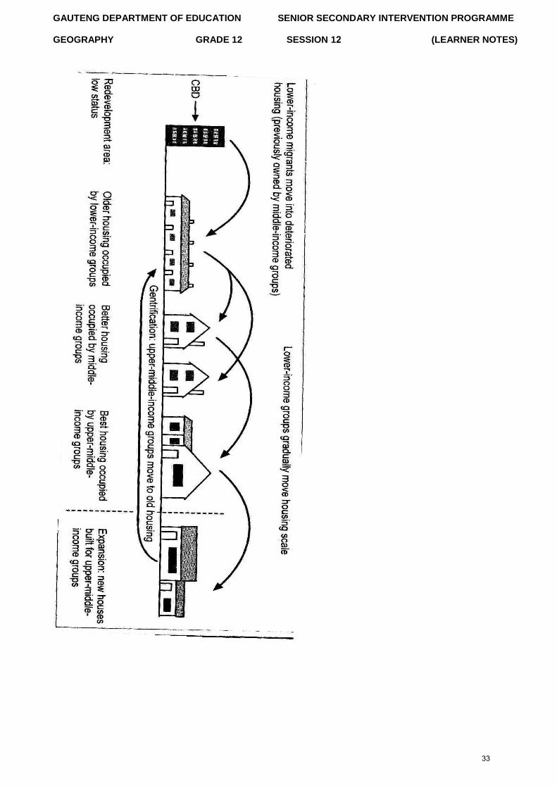
Gentrification, filtering, invasion and succession
Gentrification occurs as housing deteriorates and its move downwards through the social groups.
32
GAUTENG DEPARTMENT OF EDUCATION SENIOR SECONDARY INTERVENTION PROGRAMME
GEOGRAPHY GRADE 12 SESSION 12 (LEARNER NOTES)
33
GAUTENG DEPARTMENT OF EDUCATION SENIOR SECONDARY INTERVENTION PROGRAMME
GEOGRAPHY GRADE 12 SESSION 12 (LEARNER NOTES)
Filtering reverses the process of gentrification as middle-income groups upgrade older city properties by renovating them.
Invasion and succession As the city grows and spreads out, the urban functions will invade and take over the rural functions.
Another process which is changing the character of residential areas in South Africa is golf estates and security living.
Residential facilities of this type have become very popular. This is mainly an offshoot of the current crime situation in South Africa. Most of the security villages and golf estate focus on secure environment linked to specific lifestyle. People buy into a specific lifestyle.
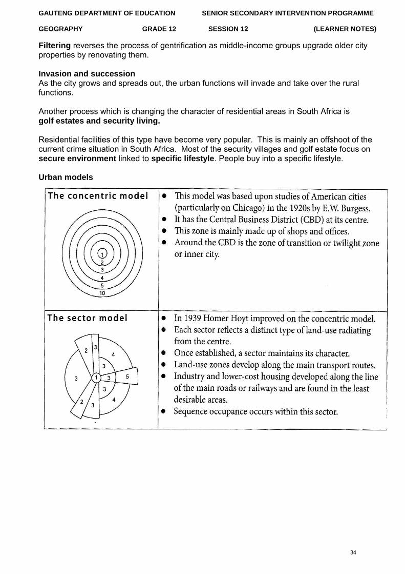
Urban models
34
GAUTENG DEPARTMENT OF EDUCATION SENIOR SECONDARY INTERVENTION PROGRAMME
GEOGRAPHY GRADE 12 SESSION 12 (LEARNER NOTES)
Every city performs certain functions to provide for the needs of its inhabitants. Each activity needs its own specialist type of land use such as:
- Administration: town hall, courts of justice, government offices, police headquarters - Industy: factories and workshops, industrial estates - Commerce: shops, warehouses, banks, building societies, insurance offices, general
offices - Transport: bus, rail, taxi and air termini, roads, pavements, car parks, etc. - Residential: housing, hotels, nursing homes - Recreation: space for leisure centres, parks, playing fields, theatres, cinemas, clubs - Social services: schools, hospitals, health centres, fire stations, water and sewage
treatment works.
As towns grow, the different functions that they perform tend to separate out into different areas. For example, industries may group together along a riverside or railway to form an industrial zone. As a result it is possible to recognise functional zones within every town, which are characterised by distinctive types of land use.
35
GAUTENG DEPARTMENT OF EDUCATION SENIOR SECONDARY INTERVENTION PROGRAMME
GEOGRAPHY GRADE 12 SESSION 12 (LEARNER NOTES)
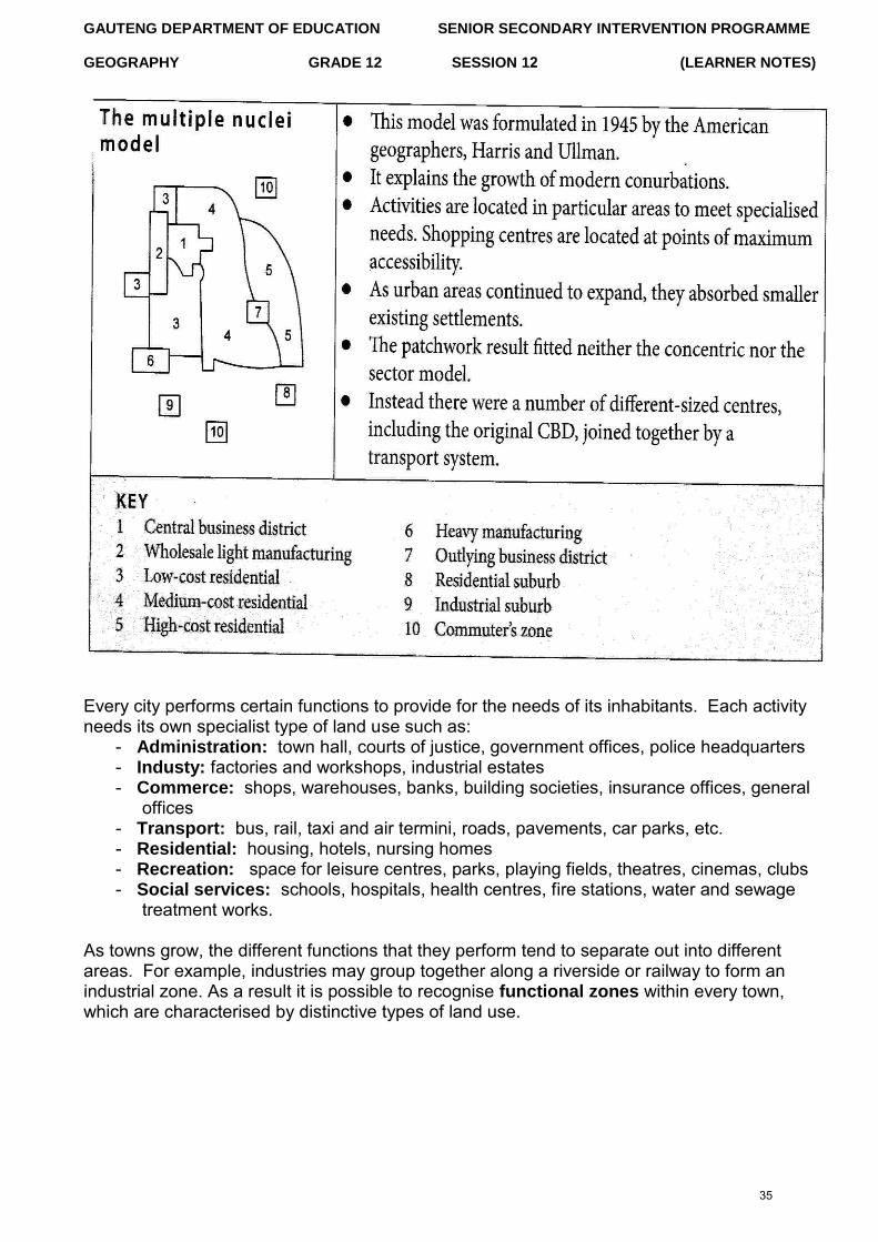
To simplify and explain the complex pattern of land use in settlements a number of models have been developed. The three main models are the concentric model, sector and the multiple nuclei.
Urban settlement issues/problems Urban problems are becoming more challenging and demanding for urban planners. With the rapid increase in population and expanding of land-use zones, urban areas experience greater demands for infrastructure, basic needs and employment. Urban problems are on the increase because of rapid urbanisation - CBD heat island and urban decay.
1. Overcrowding and informal settlementsOvercrowding is a major problem for most urban areas. Cities cannot keep up withthe demand for housing and infrastructure, and so informal settlements are erected toaccommodate people from the rural areas and immigrants from the bordering statesof South Africa.
2. Lack of basic services and povertyThe increasing demand for services and infrastructure is greatest informal settlementsand the transition zone, and this is where poverty is also the greatest problem.Basic services include housing, healthcare facilities, educational facilities, sanitation,clean drinking water and electricity. These are basic services because they arerequired for human wellbeing.Infrastructure includes roads, power lines and communication networks. People needinfrastructure to access the services and function offered by the city.
3. CBD heat island (refer to Climatology notes)Urban decay: When the city, or parts of it, fall into a state of disrepair. Some of thecharacteristics of urban decay are:- Slums- Increasing crime- Pollution- Environmental degradation- Inner city buildings being abandoned
4. Centralisation and urban sprawl- Centralisation is the high concentration of functions and people in a specific area.- Urban sprawl usually occurs on the fringe of the urban area. S.A. cities are
charaterised by low-density urban sprawl. - Some of the major consequences of urban sprawl are: valuable agricultural land is
used for urbanisation, People are increasingly located far away from places of employment and the services and functions offered in the city, traffic congestion increases because the more spread out a city becomes, the less viable public transport becomes so the more people use cars.
5. Pollution and traffic congestion
6. Crime and healthcareIncrease in crime and a drop in life expectancy
36
GAUTENG DEPARTMENT OF EDUCATION SENIOR SECONDARY INTERVENTION PROGRAMME
GEOGRAPHY GRADE 12 SESSION 12 (LEARNER NOTES)
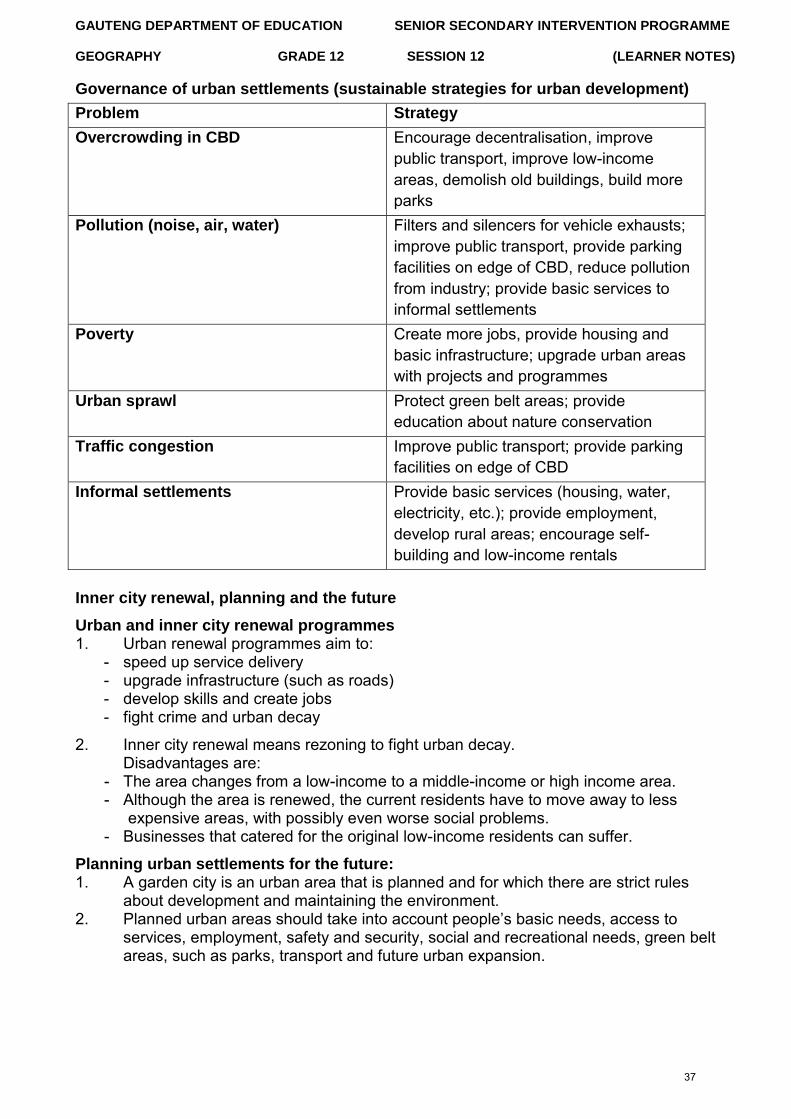
Governance of urban settlements (sustainable strategies for urban development)
Problem Strategy
Overcrowding in CBD Encourage decentralisation, improve public transport, improve low-income areas, demolish old buildings, build more parks
Pollution (noise, air, water) Filters and silencers for vehicle exhausts; improve public transport, provide parking facilities on edge of CBD, reduce pollution from industry; provide basic services to informal settlements
Poverty Create more jobs, provide housing and basic infrastructure; upgrade urban areas with projects and programmes
Urban sprawl Protect green belt areas; provide education about nature conservation
Traffic congestion Improve public transport; provide parking facilities on edge of CBD
Informal settlements Provide basic services (housing, water, electricity, etc.); provide employment, develop rural areas; encourage self-building and low-income rentals
Inner city renewal, planning and the future
Urban and inner city renewal programmes 1. Urban renewal programmes aim to:
- speed up service delivery - upgrade infrastructure (such as roads) - develop skills and create jobs - fight crime and urban decay
2. Inner city renewal means rezoning to fight urban decay.Disadvantages are:
- The area changes from a low-income to a middle-income or high income area. - Although the area is renewed, the current residents have to move away to less
expensive areas, with possibly even worse social problems. - Businesses that catered for the original low-income residents can suffer.
Planning urban settlements for the future: 1. A garden city is an urban area that is planned and for which there are strict rules
about development and maintaining the environment.2. Planned urban areas should take into account people‟s basic needs, access to
services, employment, safety and security, social and recreational needs, green beltareas, such as parks, transport and future urban expansion.
37
GAUTENG DEPARTMENT OF EDUCATION SENIOR SECONDARY INTERVENTION PROGRAMME
GEOGRAPHY GRADE 12 SESSION 12 (LEARNER NOTES)
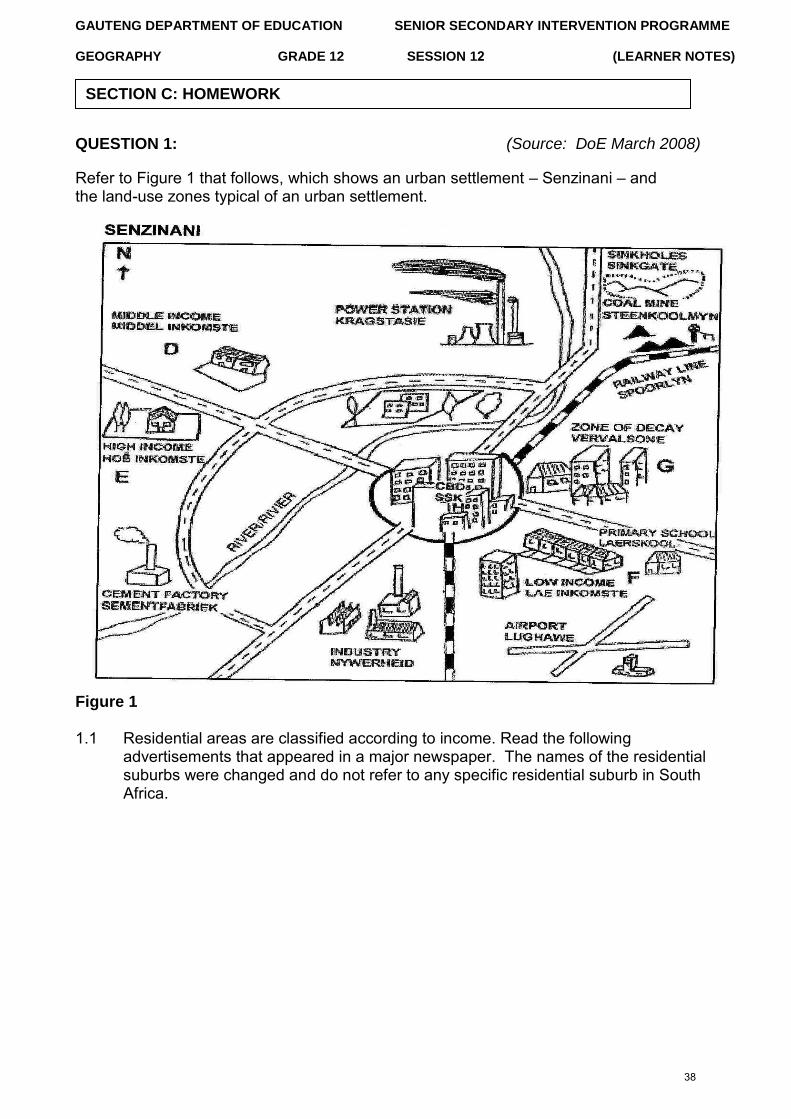
QUESTION 1: (Source: DoE March 2008)
Refer to Figure 1 that follows, which shows an urban settlement – Senzinani – and the land-use zones typical of an urban settlement.
Figure 1
1.1 Residential areas are classified according to income. Read the following advertisements that appeared in a major newspaper. The names of the residential suburbs were changed and do not refer to any specific residential suburb in South Africa.
SECTION C: HOMEWORK
38
GAUTENG DEPARTMENT OF EDUCATION SENIOR SECONDARY INTERVENTION PROGRAMME
GEOGRAPHY GRADE 12 SESSION 12 (LEARNER NOTES)
SHONA:
Spacious 2½ bedroom flat, excellent condition, lovely kitchen, intercom/security system, under-cover parking. Prime position, close to primary school. Private sale. R150 000 or nearest offer.
ROSA:
3 bedrooms, lounge/dining room, 1½ bathroom, kitchen, outside buildings and large stand. R300 000, negotiable.
VIOLET:
House for sale: R950 000 not negotiable. 4 bedrooms, 2 lounges, sunroom, TV room, study, 2 toilets, guest toilet, 2 full bathrooms, dining room, kitchen, scullery. Large grounds.
Match each of the advertisements with one of the places. (D, E, F or G) in Figure 1. (3 x 2) (6) (a) Give a reason for each of the choices you made in question 1.1.
(3 x 2) (6) (b) Explain the difference in building density, visible in Figure 1, which
exists between low- and high-income residential areas. (2 x 2) (4) 1.2 Refer to the CBD located in the centre of the settlement illustrated in Figure 1.
The following headline (loosely translated) appeared in the Beeld:
(a) What process is being referred to in the headline? (1 x 2) (2) (b) State TWO factors responsible for this process. (2 x 2) (4) (c) Discuss TWO factors that would attract office workers to work in offices
away from the CBD. (2 x 2) (4) (d) State ONE location to which many new offices would migrate. (1 x 2) (2) (e) With reference to urban renewal projects, describe what can be done to
reverse the process identified in Question 5.2 (a). (2 x 2) (4) [32]
SHARP INCREASE IN NUMBER OF EMPTY OFFICES IN CBD
39
GAUTENG DEPARTMENT OF EDUCATION SENIOR SECONDARY INTERVENTION PROGRAMME
GEOGRAPHY GRADE 12 SESSION 12 (LEARNER NOTES)
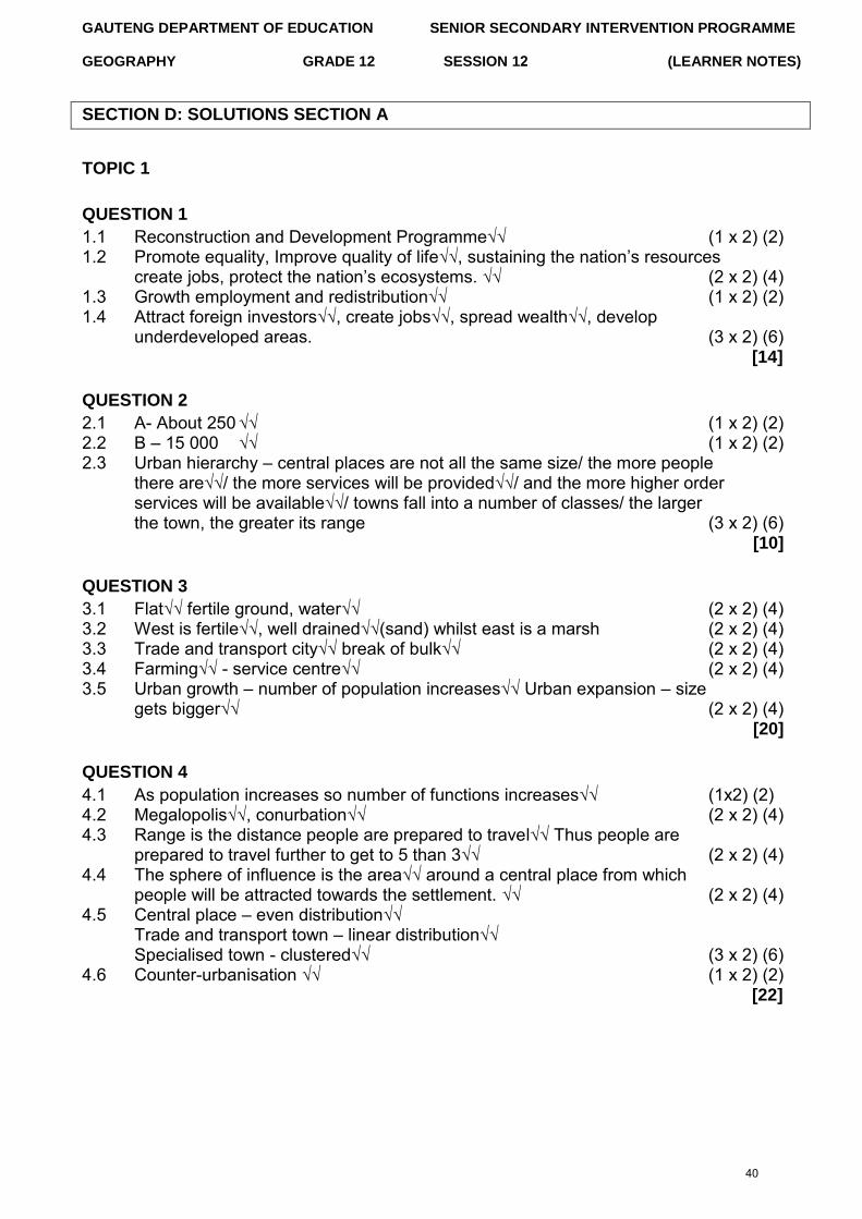
SECTION D: SOLUTIONS SECTION A
TOPIC 1
QUESTION 1
1.1 Reconstruction and Development Programme√√ (1 x 2) (2) 1.2 Promote equality, Improve quality of life√√, sustaining the nation‟s resources
create jobs, protect the nation‟s ecosystems. √√ (2 x 2) (4) 1.3 Growth employment and redistribution√√ (1 x 2) (2) 1.4 Attract foreign investors√√, create jobs√√, spread wealth√√, develop
underdeveloped areas. (3 x 2) (6) [14]
QUESTION 2
2.1 A- About 250 √√ (1 x 2) (2) 2.2 B – 15 000 √√ (1 x 2) (2) 2.3 Urban hierarchy – central places are not all the same size/ the more people
there are√√/ the more services will be provided√√/ and the more higher order services will be available√√/ towns fall into a number of classes/ the larger the town, the greater its range (3 x 2) (6)
[10]
QUESTION 3
3.1 Flat√√ fertile ground, water√√ (2 x 2) (4) 3.2 West is fertile√√, well drained√√(sand) whilst east is a marsh (2 x 2) (4) 3.3 Trade and transport city√√ break of bulk√√ (2 x 2) (4) 3.4 Farming√√ - service centre√√ (2 x 2) (4) 3.5 Urban growth – number of population increases√√ Urban expansion – size
gets bigger√√ (2 x 2) (4) [20]
QUESTION 4
4.1 As population increases so number of functions increases√√ (1x2) (2) 4.2 Megalopolis√√, conurbation√√ (2 x 2) (4) 4.3 Range is the distance people are prepared to travel√√ Thus people are
prepared to travel further to get to 5 than 3√√ (2 x 2) (4) 4.4 The sphere of influence is the area√√ around a central place from which
people will be attracted towards the settlement. √√ (2 x 2) (4) 4.5 Central place – even distribution√√
Trade and transport town – linear distribution√√ Specialised town - clustered√√ (3 x 2) (6)
4.6 Counter-urbanisation √√ (1 x 2) (2) [22]
40
GAUTENG DEPARTMENT OF EDUCATION SENIOR SECONDARY INTERVENTION PROGRAMME
GEOGRAPHY GRADE 12 SESSION 12 (LEARNER NOTES)
TOPIC 2
QUESTION 1
1.1 1.1.1 Transition zone / zone of decay / CBD√√ 1.1.2 Central Business District / CBD√√ 1.1.3 Residential√√ 1.1.4 Central Business District / CBD√√ 1.1.5 Transition zone / zone of decay√√ (5 x 2) [10]
QUESTION 2
2.1 Grid pattern√ – leads to congestion√, may lead to grid lock√, wastes fuel and time (3 x 1) (3)
2.2 Middle – usually offices, not easy to access √ Top – good view√ Ground – many passing consumers thus high rent√ (3 x 1) (3)
2.3 Land is very expensive√. The more floors the greater the rental space he has available√. This will affect the land and rates found in the CBD√ (3 x 1) (3)
2.4 It will lower rents√√ as the demand decreases√√, i.e. less demand thus lower prices, but will still be expensive√√ (3 x 2) (6)
[15]
QUESTION 3
3.1 3.1.1 Lack of jobs√√ few services√√ famine√√ low standard of living (3 x 2) (6) 3.1.2 Lack of food√ lack of services such as sanitation /water√ no formal
housing√ unemployment√ no/few educational facilities√ (5 x 1) (5) 3.1.3 Crime√√, diseases break out√√, fires spread rapidly√√, improve basic
standard of living√√ (4 x 2) (8) 3.1.4 Basic needs - food√, shelter√, water√, education√, clothing, safety
(4 x 1) (4) 3.1.5 Food√, water√, housing√, sanitation√, jobs√, education√ (6 x 1) (6)
[29]
QUESTION 4
4.1 4.1.1 Land here is the most in demand√√ thus land prices are very high.√√ It is
the most accessible part of the city. (2 x 2) (4) 4.1.2 Residents have moved away to cheaper land.√√ Residents prefer quiet of
the suburbs where there is less congestion and pollution. √√ (2 x 2) (4) 4.1.3 (a) Shops that sell goods to the public√√ (1 x 2) (2)
(b) This allows customers the opportunity to do window shopping,. √√ Customers do not want to travel up a lift to browse for goods to purchase. (1 x 2)(2)
41
SENIOR SECONDARY IMPROVEMENT PROGRAMME
SESSION 13 (LEARNER NOTES)
GAUTENG DEPARTMENT OF EDUCATION
GEOGRAPHY GRADE 12 SESSION 13
TOPIC 1: TRANSPORT AND TRADE - THE IMPORTANCE AND CHALLENGES OF THE INFORMAL SECTOR
Learner Note: The content of this session covers work that has been extensively covered in Grade 11, thus no hints or tips should be required. The work is purely revision of Grade 11 knowledge. This work is also examined in Question 3 and Question 4 of Paper 1. It is advisable for you to ensure that you study definitions and terminology well. Questions 3 and 4 are also the most popular questions that are answered in Paper 1. You might find this work much easier to study and understand. The content relates closely to everyday life and we are confronted by a lot of information with regards to these topics in the media every day. It is vital that you use the stimulus material in all of the questions, as most answers are found in the accompanying diagrams, figures and graphs.
SECTION A: TYPICAL EXAM QUESTIONS
QUESTION 1: 8 minutes (Source: DoE various papers)
1.1 Define the concept ‘balance of payments’ (1 x 2) (2) 1.2 Describe ways in which agriculture could possibly contribute to a
favourable trade balance in South Africa. (4 x 2) (8) 1.2 How can South Africa improve its trade balance without being too
Dependent on the gold price? (3 x 2) (6) [16]
QUESTION 2: 5 minutes (Source: DoE November 2008)
Provide the correct term for the following: 2.1 Export value greater than import value. (1 x 2) (2) 2.2 Value of all goods and services produced in a country in one year. (1 x 2) (2) 2.3 United Nations policy on sustainable development. (1 x 2) (2)
[6]
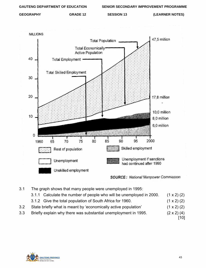
QUESTION 3: 10 minutes (Source: DoE November 2009)
Study the graph on the following page, which shows the total population, the economically active population and employment trends in South Africa (1960 – 2000) and answer the questions that follow.
42
GAUTENG DEPARTMENT OF EDUCATION SENIOR SECONDARY IMPROVEMENT PROGRAMME
GEOGRAPHY GRADE 12 SESSION 13 (LEARNER NOTES)
3.1 The graph shows that many people were unemployed in 1995: 3.1.1 Calculate the number of people who will be unemployed in 2000. (1 x 2) (2) 3.1.2 Give the total population of South Africa for 1960. (1 x 2) (2)
3.2 State briefly what is meant by ‘economically active population’ (1 x 2) (2) 3.3 Briefly explain why there was substantial unemployment in 1995. (2 x 2) (4)
[10]
43
GAUTENG DEPARTMENT OF EDUCATION SENIOR SECONDARY IMPROVEMENT PROGRAMME
GEOGRAPHY GRADE 12 SESSION 13 (LEARNER NOTES)
Page 5 of 83
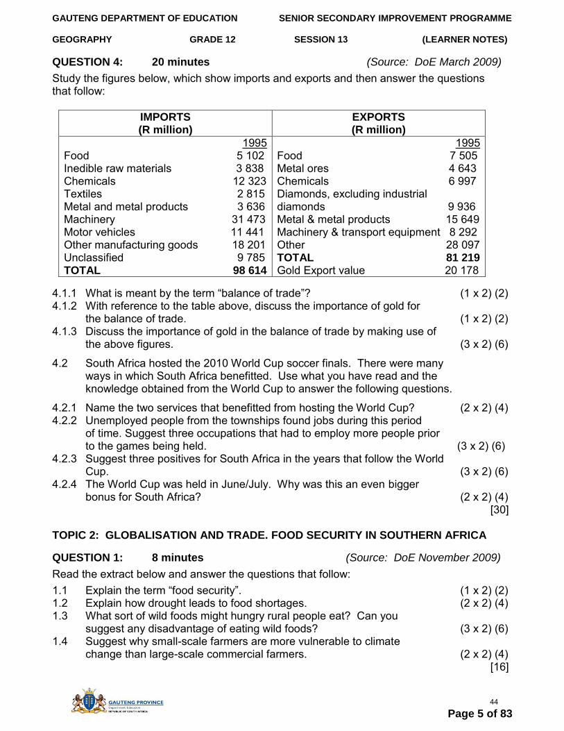
QUESTION 4: 20 minutes (Source: DoE March 2009) Study the figures below, which show imports and exports and then answer the questions that follow:
IMPORTS (R million)
EXPORTS (R million)
1995 Food 5 102 Inedible raw materials 3 838 Chemicals 12 323 Textiles 2 815 Metal and metal products 3 636 Machinery 31 473 Motor vehicles 11 441 Other manufacturing goods 18 201 Unclassified 9 785 TOTAL 98 614
1995 Food 7 505 Metal ores 4 643 Chemicals 6 997 Diamonds, excluding industrial diamonds 9 936 Metal & metal products 15 649 Machinery & transport equipment 8 292 Other 28 097 TOTAL 81 219 Gold Export value 20 178
4.1.1 What is meant by the term “balance of trade”? (1 x 2) (2) 4.1.2 With reference to the table above, discuss the importance of gold for
the balance of trade. (1 x 2) (2) 4.1.3 Discuss the importance of gold in the balance of trade by making use of
the above figures. (3 x 2) (6)
4.2 South Africa hosted the 2010 World Cup soccer finals. There were many ways in which South Africa benefitted. Use what you have read and the knowledge obtained from the World Cup to answer the following questions.
4.2.1 Name the two services that benefitted from hosting the World Cup? (2 x 2) (4) 4.2.2 Unemployed people from the townships found jobs during this period
of time. Suggest three occupations that had to employ more people prior to the games being held. (3 x 2) (6)
4.2.3 Suggest three positives for South Africa in the years that follow the World Cup. (3 x 2) (6)
4.2.4 The World Cup was held in June/July. Why was this an even bigger bonus for South Africa? (2 x 2) (4)
[30]
TOPIC 2: GLOBALISATION AND TRADE. FOOD SECURITY IN SOUTHERN AFRICA
QUESTION 1: 8 minutes (Source: DoE November 2009)
Read the extract below and answer the questions that follow: 1.1 Explain the term “food security”. (1 x 2) (2) 1.2 Explain how drought leads to food shortages. (2 x 2) (4) 1.3 What sort of wild foods might hungry rural people eat? Can you
suggest any disadvantage of eating wild foods? (3 x 2) (6) 1.4 Suggest why small-scale farmers are more vulnerable to climate
change than large-scale commercial farmers. (2 x 2) (4) [16]
44
GAUTENG DEPARTMENT OF EDUCATION SENIOR SECONDARY IMPROVEMENT PROGRAMME
GEOGRAPHY GRADE 12 SESSION 15 (LEARNER NOTES)
QUESTION 2: 10 minutes (Source: DoE March 2009)
Read the two extracts, below, and then answer the questions that follow:
2.1 Explain the term “GM food”. (2 x 2) (4) 2.2 How can GM crops contribute to food security? (2 x 2) (4) 2.3 If GM crops produce good yields, who is more likely to be enthusiastic:
the farmer or the consumer? Give a reason for your answer. (2 x 2) (4) 2.4 In poor communities, if GM maize is cheaper than non-GM maize,
which are people likely to buy? Give a reason for your answer. (2 x 2) (4) [16]
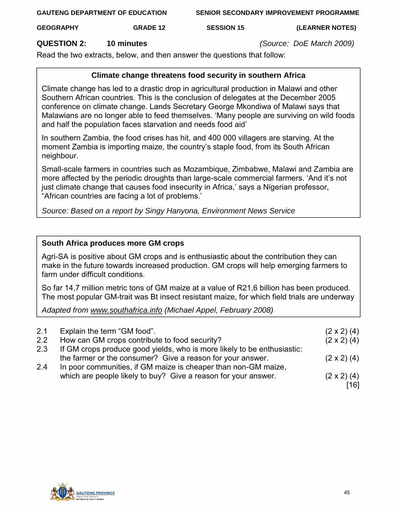
Climate change threatens food security in southern Africa
Climate change has led to a drastic drop in agricultural production in Malawi and other Southern African countries. This is the conclusion of delegates at the December 2005 conference on climate change. Lands Secretary George Mkondiwa of Malawi says that Malawians are no longer able to feed themselves. ‘Many people are surviving on wild foods and half the population faces starvation and needs food aid’
In southern Zambia, the food crises has hit, and 400 000 villagers are starving. At the moment Zambia is importing maize, the country’s staple food, from its South African neighbour.
Small-scale farmers in countries such as Mozambique, Zimbabwe, Malawi and Zambia are more affected by the periodic droughts than large-scale commercial farmers. ‘And it’s not just climate change that causes food insecurity in Africa,’ says a Nigerian professor, “African countries are facing a lot of problems.’
Source: Based on a report by Singy Hanyona, Environment News Service
GM crops fail to deliver benefits of Africa
Ten years after introduction of GM crops there are no obvious benefits for consumers, farmers of the environment. These crops are not cheaper or better quality and they will not solve hunger in Africa. Most GM crops grown so far are used for animal feed. Information from online Mail & Guardian article, January 2006
South Africa produces more GM crops
Agri-SA is positive about GM crops and is enthusiastic about the contribution they can make in the future towards increased production. GM crops will help emerging farmers to farm under difficult conditions.
So far 14,7 million metric tons of GM maize at a value of R21,6 billion has been produced. The most popular GM-trait was Bt insect resistant maize, for which field trials are underway
Adapted from www.southafrica.info (Michael Appel, February 2008)
45
GAUTENG DEPARTMENT OF EDUCATION SENIOR SECONDARY IMPROVEMENT PROGRAMME
GEOGRAPHY GRADE 12 SESSION 13 (LEARNER NOTES)
SECTION B: ADDITIONAL CONTENT NOTES ON TOPIC 1 AND 2
OVERVIEW OF TRANSPORT You must know, or be able to do the following:
- Define trade, balance of payments, balance of trade, imports and exports - Identify and describe positive and negative balances of trade. - Explain how a negative balance of trade can be rectified. - Use and interpret statistics and graphs in your explanations. - Apply your knowledge to trading partners of South Africa.
1. Air transport- Airports Company of South Africa (ACSA) owns and operates 10 airports. - Three international airports: OR Tambo, Cape Town and Durban - OR Tambo is the largest airport and can carry 18 million passengers annually
2. Ports- No navigable rivers, 3 000km coastline - Important for containers cargo, dry docks - Durban: largest and busiest port
- Saldanha: largest natural port 3. Pipelines
- Petronet operates a network of 3 000km of pipes - Large volumes of fuel are transported inland to refineries and industrial areas - New pipeline from Mozambique
4. Road transport- Approximately 500 000 km of roads in SA - Four major industrial areas, well connected - Longest network in Africa - 2 200 km – toll roads - Fast link between ports - 80% of all freight carried by road
5. Rail transport- Spoornet focuses on transport by rail - Spoornet has an annual turnover of R9 billion - Developed with discovery of minerals - Sishen-Saldanha: 861 km transports iron ore - Coal transported along Vryheid-Richards Bay line
Trade is vital for any country and in order to trade, a country needs a developed infrastructure. SA has a well-developed road, railway and port network. This is partly as a result of minerals being exported. The value of imports compared to the value of exports is called a balance of trade. The two figures are not equal. If we export more than what we import, then we have a trade surplus, if we import more than we export, then we have a trade deficit.
46
GAUTENG DEPARTMENT OF EDUCATION SENIOR SECONDARY IMPROVEMENT PROGRAMME
GEOGRAPHY GRADE 12 SESSION 13 (LEARNER NOTES)
Trade is often promoted by central government who will sign treaties, with other countries to promote trade with one another. For example, in Europe countries that belong to the EU (European Union) do not have to pay import duties. An import duty is a tax on imported goods. If no tax, tariff raises the price of foreign goods and protects the local industries. For example, in SA, cheap imported clothing is taxed to protect local textile industries. SA belongs to SADC (Southern African Development Community), which aims to reduce tariffs between members.
The world is broken up into numerous groupings of countries that have trade agreements among themselves. Such a group of countries is called a trading bloc.
Examples include: - OPEC (Organisation of Petroleum Exporting Countries) - AU (African Union) - EU (European Union) - NAFTA (North American Free Trade Association)
International trade is encouraged by the WTO (World Trade Organisation). It helps to negotiate new trade agreements and implement trade rules.
Transport plays a very important role in international trade. Without container ships, railways and international flights, trade between nations would be severely reduced. South Africa is trying to promote trade by developing Coega as a tax free port. This will, hopefully, improve our balance of trade
With regard to trade, there are major stumbling blocks. An attempt is being made to eliminate unfair trade agreements between rich and poor countries. The wealthy countries control a large percentage of all trade. In South Africa, quotas are often used to restrict how much may be imported.
47
GAUTENG DEPARTMENT OF EDUCATION SENIOR SECONDARY IMPROVEMENT PROGRAMME
GEOGRAPHY GRADE 12 SESSION 13 (LEARNER NOTES)
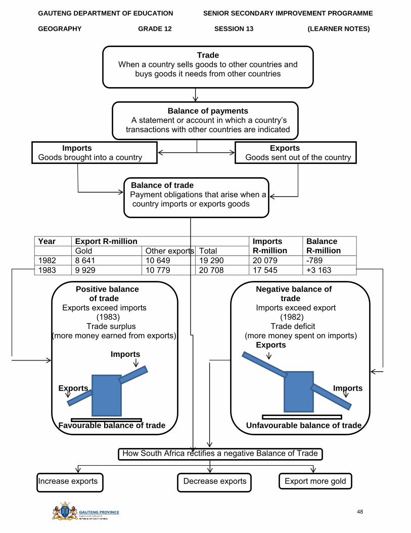
Trade When a country sells goods to other countries and
buys goods it needs from other countries
Balance of payments A statement or account in which a country’s
transactions with other countries are indicated
Imports Exports Goods brought into a country Goods sent out of the country
Balance of trade Payment obligations that arise when a country imports or exports goods
Year Export R-million Imports R-million
Balance R-million Gold Other exports Total
1982 8 641 10 649 19 290 20 079 -789 1983 9 929 10 779 20 708 17 545 +3 163
Positive balance Negative balance of of trade trade
Exports exceed imports Imports exceed export (1983) (1982)
Trade surplus Trade deficit (more money earned from exports) (more money spent on imports)
Exports Imports
Exports Imports
Favourable balance of trade Unfavourable balance of trade
How South Africa rectifies a negative Balance of Trade
Increase exports Decrease exports Export more gold
48
GAUTENG DEPARTMENT OF EDUCATION SENIOR SECONDARY IMPROVEMENT PROGRAMME
GEOGRAPHY GRADE 12 SESSION 13 (LEARNER NOTES)
Globalisation and trade Globalisation is the process of growing exchange between countries of the world. It involves international trade and tourism, and the spread of technology and ideas. It is the ‘free’ exchange of capital (money), information, people and ideas across the world. Technological development and the growth of consumerism sped up the process, so now there is a ‘global workforce’ and companies manufacturing ‘global brands’, for example, Coca-Cola, McDonalds and Microsoft. It is made possible by:
Advances in telecommunications Faster, cheaper transport Changes in trade regulations and controls Emerging markets in developing countries (e.g. China)
Characteristics of globalisation include:
An increase in international trade A bigger role for international organisations, such as the World Trade
Organisation (WTO) and the International Monetary Fund (IMF) An increase in practices such as outsourcing (the subcontracting of services or
manufacture to another company) More travel and tourism More immigration The spread of local consumer goods (e.g. food products) An increase in world-wide sporting events (e.g. FIFA World Cup) The development of global telecommunications infrastructure
It leads to integration: Economic: Multinational organisations Political: NGOs, NEPAD, SADC Cultural: American (western) lifestyle (manners, fashion, practices and English as medium of
communication). All this leads to tension between the rich, developed countries of the north and the poor, developing countries in Africa, South America and Asia.
49
GAUTENG DEPARTMENT OF EDUCATION SENIOR SECONDARY IMPROVEMENT PROGRAMME
GEOGRAPHY GRADE 12 SESSION 13 (LEARNER NOTES)
Advantages of globalisation
More aid and direct investment to developing countries helps economicdevelopment
More economic opportunities Cheaper products available to consumers Products are standardised and quality improves Everyone shares in the benefits of technology People gain access to goods and services from all over the
world There is a greater variety of things to buy and experience from all over the
world Benefits can trickle out from investment areas to improve the lives of many.
Foreign investment in a country can help governments raise money forhealthcare, education, etc.
Disadvantages of globalisation
Greater economic vulnerability between countries – if one country suffers aneconomic slump, many other countries will too (Thus, lack of responsibility– multinational companies in place of independent governments become
responsible for decisions about where to set up factories, where to close them down, which countries to invest in and how they will treat workers. Strong competition between producers Unequal distribution of wealth Gap widens between developed and developing countries International organisations, such as the IMF and WTO apply
Western standards to non-Western countries Vulnerability – the power of multinational companies can leave governments and
workers vulnerable The poor – the world’s poorest do not see much benefit from globalisation,
and some people argue it makes their position worse. Cultural loss and ‘sameness’- the presence of global brands and the
sophisticated advertising used to sell them, makes every street start to lookthe same – people everywhere (if they can) buy the same burgers andwant to wear the same few brands of clothing
Food security and insecurity
Definitions:
Food security: Is the availability of, and access to food, and it is important for a healthy and productive life.
50
GAUTENG DEPARTMENT OF EDUCATION SENIOR SECONDARY IMPROVEMENT PROGRAMME
GEOGRAPHY GRADE 12 SESSION 13 (LEARNER NOTES)
Food insecurity: is the lack of basic food. It ranges from chronic hunger and malnutrition to famine and starvation
World food security is threatened by climate change, the oil prices and the farmingof crops for biofuels rather than food.
Global organisations that help to provide less developed countries with the food,include the World Health Organization, the Red Cross and the United Nations.
Food insecurity is worst in developing countries in Africa and Asia. For food security at a national level, a country must be able to produce, store,
distribute and import enough food to meet the needs of its people. In South Africa, at least one-third of the population does not have food security.
Wealthier provinces (e.g. Gauteng) are more food secure than poorer provinces(e.g. Eastern Cape). Rural areas usually have the least food security.
Poverty is always linked to food insecurity. Hungry people are less able to work, sothey remain poor, which leads to more hunger.
Factors contributing to food insecurity: Poverty is always linked to food insecurity. Poor people are often caught in a hunger-poverty trap: hunger leads to poverty, because a hungry person is less able to compete for work (they are tired, undernourished or ill), and because of this, a hungry person remains poor and hungry. Food insecurity is often blamed on natural disasters, but it is generally a social and political problem.
Physical environment factors that can lead to food insecurity include: Droughts Floods Outbreaks of diseases Land degradation and soil infertility
Mozambique often suffers natural disasters such as cyclones, floods and droughts.Floods destroy crops, drown livestock and wash away transport routes.
Social, economic and political factors that can lead to food insecurity include: A shortage of arable land The replacement of subsistence farming with cash crops High production costs Foreign competition Wars and conflict Poor infrastructure Overcrowding Lack of funds for agricultural research Lack of capital (money) – to invest in supplies and machinery
51
GAUTENG DEPARTMENT OF EDUCATION SENIOR SECONDARY IMPROVEMENT PROGRAMME
GEOGRAPHY GRADE 12 SESSION 13 (LEARNER NOTES)
Measures to prevent food insecurity:
In South Africa, there are two approaches to address the threat of food insecurity. The government aims to maintain and increase the ability of South Africa to meet its national food requirements as the population and the demand increases by:
Making sure that domestic agriculture continues to produce what is needed Importing foods that cannot be produced cost effectively Eradicating inequality and poverty Exporting food excesses at good prices
Inequality and poverty can be eradicated by:
Introducing rural development schemes that include skills training and thefunding of farms
Promoting sustainable agriculture practices Addressing and resolving issues of land ownership Helping rural households to produce their own food Creating job opportunities Improving nutrition Improving food emergency management systems
National Food Fortification Programme
Lack of essential vitamins and minerals in the diet causes deficiency diseases.The poor are especially vulnerable to dietary deficiencies
Food fortification is the addition of essential micronutrients to basic foods.The National Food Fortification Programme in South Africa ensures that all staplefoods (e.g. maize) are fortified
Genetically modified food:
Genetically modified (GM) foods produced from genetically modified plants or animals Genetically modified plants have been engineered so that they contain one or more
foreign genes. This gives the plants improved growing properties, such as increasedresistance to pests. An insect-resistant GM plant produces a protein toxin that killspests such as caterpillars.
Advantages Disadvantages
Increased yields Better quality More environmentally friendly pest
Control (farmers use fewer pesticides)
GM seed is more expensive The public is wary of GM foods The impact of GM plants on the
environment and human health isunknown
52
GAUTENG DEPARTMENT OF EDUCATION SENIOR SECONDARY IMPROVEMENT PROGRAMME
GEOGRAPHY GRADE 12 SESSION 13 (LEARNER NOTES)
SECTION C: HOMEWORK
QUESTION 1 (Source: DoE March 2009)
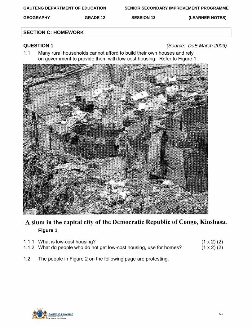
1.1 Many rural households cannot afford to build their own houses and rely on government to provide them with low-cost housing. Refer to Figure 1.
Figure 1
1.1.1 What is low-cost housing? (1 x 2) (2) 1.1.2 What do people who do not get low-cost housing, use for homes? (1 x 2) (2)
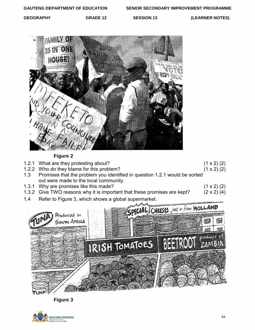
1.2 The people in Figure 2 on the following page are protesting.
53
GAUTENG DEPARTMENT OF EDUCATION SENIOR SECONDARY IMPROVEMENT PROGRAMME
GEOGRAPHY GRADE 12 SESSION 13 (LEARNER NOTES)
Figure 2
1.2.1 What are they protesting about? (1 x 2) (2) 1.2.2 Who do they blame for this problem? (1 x 2) (2) 1.3 Promises that the problem you identified in question 1.2.1 would be sorted
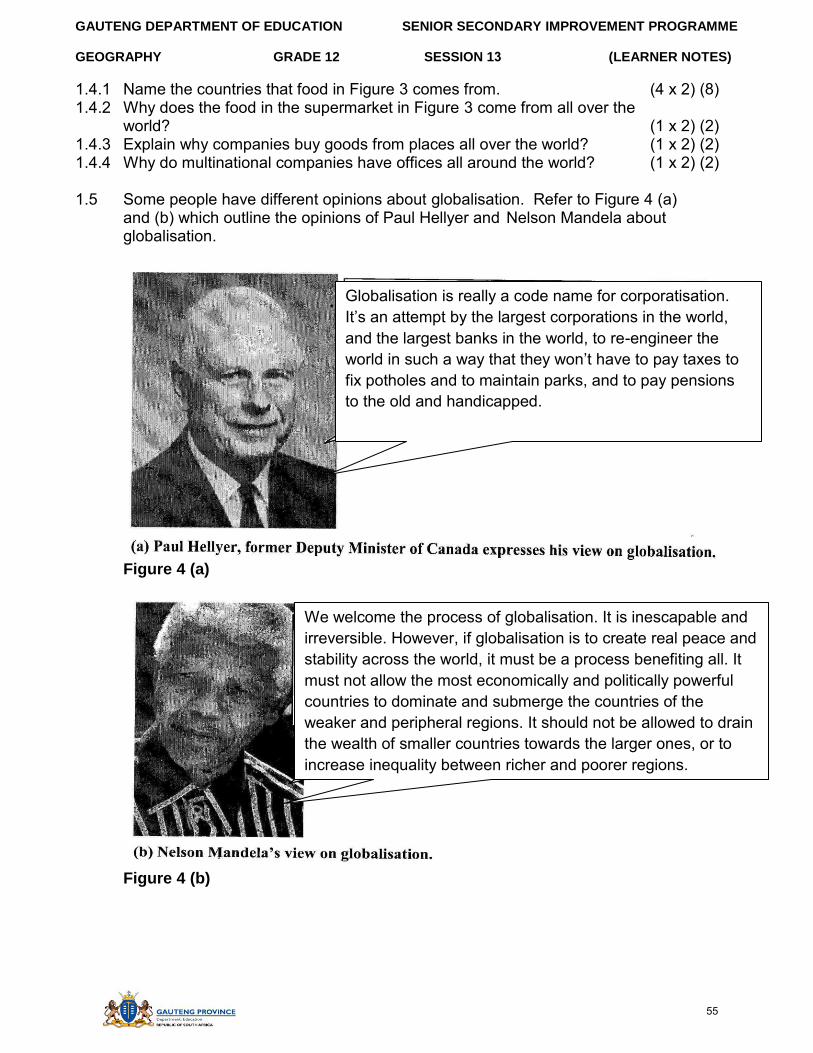
out were made to the local community. 1.3.1 Why are promises like this made? (1 x 2) (2) 1.3.2 Give TWO reasons why it is important that these promises are kept? (2 x 2) (4) 1.4 Refer to Figure 3, which shows a global supermarket.
Figure 3
54
GAUTENG DEPARTMENT OF EDUCATION SENIOR SECONDARY IMPROVEMENT PROGRAMME
GEOGRAPHY GRADE 12 SESSION 13 (LEARNER NOTES)
1.4.1 Name the countries that food in Figure 3 comes from. (4 x 2) (8) 1.4.2 Why does the food in the supermarket in Figure 3 come from all over the
world? (1 x 2) (2) 1.4.3 Explain why companies buy goods from places all over the world? (1 x 2) (2) 1.4.4 Why do multinational companies have offices all around the world? (1 x 2) (2)
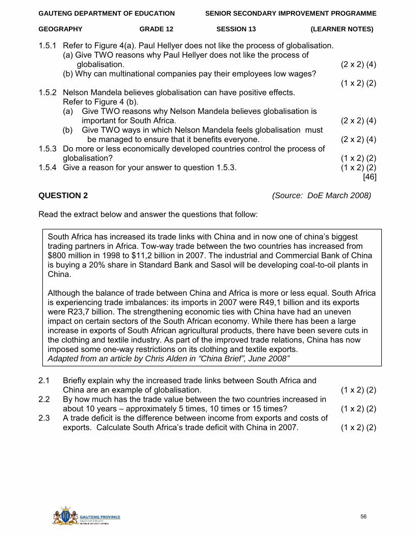
1.5 Some people have different opinions about globalisation. Refer to Figure 4 (a) and (b) which outline the opinions of Paul Hellyer and Nelson Mandela about globalisation.
Figure 4 (a)
Figure 4 (b)
We welcome the process of globalisation. It is inescapable and irreversible. However, if globalisation is to create real peace and stability across the world, it must be a process benefiting all. It must not allow the most economically and politically powerful countries to dominate and submerge the countries of the weaker and peripheral regions. It should not be allowed to drain the wealth of smaller countries towards the larger ones, or to increase inequality between richer and poorer regions.
Globalisation is really a code name for corporatisation. It’s an attempt by the largest corporations in the world, and the largest banks in the world, to re-engineer the world in such a way that they won’t have to pay taxes to
fix potholes and to maintain parks, and to pay pensions to the old and handicapped.
55
GAUTENG DEPARTMENT OF EDUCATION SENIOR SECONDARY IMPROVEMENT PROGRAMME
GEOGRAPHY GRADE 12 SESSION 13 (LEARNER NOTES)
1.5.1 Refer to Figure 4(a). Paul Hellyer does not like the process of globalisation. (a) Give TWO reasons why Paul Hellyer does not like the process of
globalisation. (2 x 2) (4) (b) Why can multinational companies pay their employees low wages?
(1 x 2) (2) 1.5.2 Nelson Mandela believes globalisation can have positive effects.
Refer to Figure 4 (b). (a) Give TWO reasons why Nelson Mandela believes globalisation is
important for South Africa. (2 x 2) (4) (b) Give TWO ways in which Nelson Mandela feels globalisation must
be managed to ensure that it benefits everyone. (2 x 2) (4) 1.5.3 Do more or less economically developed countries control the process of
globalisation? (1 x 2) (2) 1.5.4 Give a reason for your answer to question 1.5.3. (1 x 2) (2)
[46]
QUESTION 2 (Source: DoE March 2008)
Read the extract below and answer the questions that follow:
2.1 Briefly explain why the increased trade links between South Africa and China are an example of globalisation. (1 x 2) (2)
2.2 By how much has the trade value between the two countries increased in about 10 years – approximately 5 times, 10 times or 15 times? (1 x 2) (2)
2.3 A trade deficit is the difference between income from exports and costs of exports. Calculate South Africa’s trade deficit with China in 2007. (1 x 2) (2)
South Africa has increased its trade links with China and in now one of china’s biggest trading partners in Africa. Tow-way trade between the two countries has increased from $800 million in 1998 to $11,2 billion in 2007. The industrial and Commercial Bank of China is buying a 20% share in Standard Bank and Sasol will be developing coal-to-oil plants in China.
Although the balance of trade between China and Africa is more or less equal. South Africa is experiencing trade imbalances: its imports in 2007 were R49,1 billion and its exports were R23,7 billion. The strengthening economic ties with China have had an uneven impact on certain sectors of the South African economy. While there has been a large increase in exports of South African agricultural products, there have been severe cuts in the clothing and textile industry. As part of the improved trade relations, China has now imposed some one-way restrictions on its clothing and textile exports. Adapted from an article by Chris Alden in “China Brief”, June 2008”
56
GAUTENG DEPARTMENT OF EDUCATION SENIOR SECONDARY IMPROVEMENT PROGRAMME
GEOGRAPHY GRADE 12 SESSION 13 (LEARNER NOTES)
2.4 A lot of clothing has been imported from China more cheaply than it can be made in South Africa. Suggest a negative effect of this on workers in the clothing manufacturing industry
2.4.1 in China (1 x 2) (2) 2.4.2 in South Africa (1 x 2) (2) 2.5 Suggest TWO ways of addressing the negative impact of Chinese exports
on the clothing industry in South Africa. (2 x 2) (4) [14]
QUESTION 3 (Source: DoE November 2008)
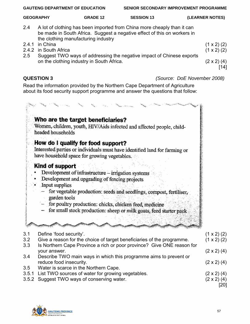
Read the information provided by the Northern Cape Department of Agriculture about its food security support programme and answer the questions that follow:
3.1 Define ‘food security’. (1 x 2) (2) 3.2 Give a reason for the choice of target beneficiaries of the programme. (1 x 2) (2) 3.3 Is Northern Cape Province a rich or poor province? Give ONE reason for
your answer. (2 x 2) (4) 3.4 Describe TWO main ways in which this programme aims to prevent or
reduce food insecurity. (2 x 2) (4) 3.5 Water is scarce in the Northern Cape. 3.5.1 List TWO sources of water for growing vegetables. (2 x 2) (4) 3.5.2 Suggest TWO ways of conserving water. (2 x 2) (4)
[20]
57
GAUTENG DEPARTMENT OF EDUCATION SENIOR SECONDARY IMPROVEMENT PROGRAMME
GEOGRAPHY GRADE 12 SESSION 13 (LEARNER NOTES)
SECTION D: SOLUTIONS TO SECTION A
TOPIC 1
QUESTION 1
1.1 Comparison of value of imports compared to value of exports. √√ (1 x 2) (2) 1.2 Agriculture production means that we do not have to import food√√
Agricultural products can earn revenue when exported√√ Agricultural goods can be processed and then exported√√ Goods exported are sold in dollars earning South Africa revenue√√ (4 x 2) (8)
1.3 South Africa needs to import less oil in particular√√ South Africa needs to process more of its own raw materials before exporting√√ Beneficiation will not only earn higher prices but also create more jobs√√ (3 x 2) (6)
[16]
QUESTION 2
2.1 Trade surplus√√ (1 x 2) (2) 2.2 Gross domestic product√√ (1 x 2) (2) 2.3 Policy 21√√ (1 x 2) (2)
[6] QUESTION 3
3.1.1 7,8 million√√ (1 x 2) (2) 3.1.2 15 – 16 million√√ (1 x 2) (2) 3.2 People that are capable of working. They are in the age group 16
to 64 years of age. √√ (1 x 2) (2) 3.3 Large unskilled population√√
The former homelands of South Africa were now included in statistics of South Africa√√ Many laws such as pass laws had been removed and large numbers of unemployed people had moved to the cities. (2 x 2) (4)
[10]
QUESTION 4
4.1.1 Comparison of the value of Imports compared to value of Exports√√ (1 x 2) (2) 4.1.2 Gold is very important as an export as it helps to offset cost of imports√√ (1 x 2) (2) 4.1.3 Gold is the single most important export√√
Gold’s contribution fluctuates depending on exchange rate√√ and gold prices√√ (3 x 2) (6)
4.2.1 Hotels√√ / taxi’s√√ / etc. (2 x 2) (4) 4.2.2 Security √√ construction √√ transport √√ (3 x 2) (6) 4.2.3 Upgraded infrastructure√√ more foreign visitors√√ foreign investment√√ (3 x 2) (6) 4.2.4 It was winter√√ hotels are normally empty thus there were extra capacity√√ (2 x 2) (4)
[30]
58
GAUTENG DEPARTMENT OF EDUCATION SENIOR SECONDARY IMPROVEMENT PROGRAMME
GEOGRAPHY GRADE 12 SESSION 13 (LEARNER NOTES)
TOPIC 2
QUESTION 1
1.1 Food security is a reliable supply of food for a country and its citizens√√ (1 x 2) (2) 1.2 Crops fail because of no rainfall and water shortages√√
As a result, there is no harvest or only a small harvest√√ (2 x 2) (4) 2.3 Wild food will include berries, pods, roots, insects, lizards, snakes, birds
and small mammals√√. Disadvantages are: Some wild plant foods are poisonous√√ Some of these foods are unpalatable (not nice to eat) √√ Biodiversity is threatened√√ (3 x 2) (6)
1.3 Small-scale farmers don’t have irrigation systems and are dependent on rainfall or water from rivers√√ They usually are subsistence farmers and so they have little or no other income to see them through the hard times√√ (2 x 2) (4)
[16]
QUESTION 2
2.1 GM foods are food produced from genetically modified crops√√ They are plants that carry foreign genes to make them insect-resistant or drought-tolerant√√ (2 x 2) (4)
2.2 GM crops can make it easier to grow crops under difficult conditions√√ such as drought or insect attack, leading to increased food supplies√√ (2 x 2) (4)
2.3 The farmer will be happier√√ as he or she will want to produce the largest, best quality crop that will fetch the best price. The consumer is more likely to worry about any negative effects of eating GM food. √√ (2 x 2) (4)
2.4 The GM maize√√ poor people will want best value for money, rather than worry about the way in which it was produced√√. (2 x 2) (4)
[16]
59
SENIOR SECONDARY IMPROVEMENT PROGRAMME
SESSION 14 (LEARNER NOTES)
GAUTENG DEPARTMENT OF EDUCATION
GEOGRAPHY GRADE 12
SESSION 14
TOPIC: EXAMINATION PAPER 1: THEORY
Learner Note: Paper 1 will have four questions. You must choose THREE out of the four questions. It is very important that you do not do all four in the examination, as only the first 3 questions that you write, will be marked. You should allocate 1 hour per question in the exams. Read your questions carefully, and make sure that you number correctly. You MUST be able to cross-reference the annexure to the questions.
SECTION A: TYPICAL EXAM QUESTIONS FOR PAPER 1
55 minutes (Source: DoE Various papers from 2008, 2009 and 2010)
SECTION A: WEATHER AND CLIMATE, FLUVIAL PROCESSES AND STRUCTURAL LANDFORMS
QUESTION 1
1.1 Indicate if the following is TRUE or FALSE. Write only the question number and ‘true’ or ‘false’. (e.g. 1.1.6 True).
1.1.1 A temperature inversion in a valley will lead to an increase level of smog formation
1.1.2 The Coriolis force causes air to be deflected to the left in the Southern Hemisphere, and to the right in the Northern Hemisphere.
1.1.3 The ITCZ is a zone of High Pressure found in the equatorial regions, characterised by uplifting air and increased rainfall.
1.1.4 Deforestation causes an increase of carbon dioxide in the atmosphere, and is one of the contributors to global warming.
1.1.5 Tropical cyclones move east to west and mid latitude depressions move west to east in both hemispheres. (5 x 2) [10]
1.2 Indicate which one of the terms in brackets is correct. Write only the question number and chosen answer. (e.g. 1.2.1 west). 1.2.1 A delta is found at the mouth of river systems where material is deposited,
causing the river to break up into (tributaries/distributaries). 1.2.2 Impermeable rock will lead to an (increased /decreased) amount of river run-off in
a drainage basin. 1.2.3 There is a (larger/smaller) amount of suspended river load in the upper course
than in the lower course of a river
Learner Note: The diagrams required for the following questions appear after the questions, on pages 24-32
60
GAUTENG DEPARTMENT OF EDUCATION SENIOR SECONDARY IMPROVEMENT PROGRAMME
GEOGRAPHY GRADE 12 SESSION 14 (LEARNER NOTES)
1.2.4 River capture can lead to the (rejuvenation / abstraction) of a river system resulting in the formation of incised meanders.
1.2.5 A flow hydrograph in an (urban / rural) area will have a shorter lag time. (5 x 2) [10]
1.3 Refer to Figure 1.3 showing the seasonal migration of pressure belts over southern Africa in January and July.
1.3.1 Describe the differences in the position of the HP and LP cells as shown in Figure 1.3 for January and July respective (2 x 2) (4)
1.3.2 Give a reason why this seasonal movement of pressure belts occurs. (1 x 2) (2) 1.3.3 How does this movement affect the weather of the SW Cape? (1 x 2) (2)
[8] 1.4 Refer to Figure 1.4 showing an urban area. The building of such an urban
area results in it experiencing very different climatic conditions compared to those in a rural area.
1.4.1 Describe ONE way the climate of an urban area will differ from that of a rural area. (1 x 2) (2)
1.4.2 Explain THREE reasons why an urban climate differs from that of a rural area. (3 x 2) (6)
1.4.3 As a member of a management committee responsible for looking into urban problems, write a report (of no more than 12 lines) in which you explain: (a) Why these changes in the urban climate are a concern to you, (b) What plan of action you suggest to deal with these problems. (6 x 2) (12)
[20]
1.5 Refer to Figure 1.5 showing the features of a mid-latitude cyclone or depression. 1.5.1 Describe where these systems form in the Southern Hemisphere. (1 x 2) (2) 1.5.2 Describe how these weather systems form. (2 x 2) (4) 1.5.3 Describe the type of weather that is associated with a cold front. (2 x 2) (4) 1.5.4 (a) What is the name given to the dying out or dissipating stage
of this system? (1 x 2) (2) (b) Draw the symbol to show how this stage of the system would
be shown on a synoptic chart. (1 x 2) (2) [14]
1.6 Refer to Figure 1.6 (a) and (b) showing flow hydrographs and drainage patterns. 1.6.1 Identify the drainage pattern shown by river system A. (1 x 2) (2) 1.6.2 Which of the flow hydrographs X or Y will show the river discharge
measured at point D in river system A? Give a reason for your answer. (2 x 2) (4)
1.6.3 Identify the drainage pattern shown by river system B. (1 x 2) (2) 1.6.4 Which of the flow hydrographs X or Y will show the river discharge measure
at point E in river system B? Give a reason for your answer. (2 x 2) (4)
61
GAUTENG DEPARTMENT OF EDUCATION SENIOR SECONDARY IMPROVEMENT PROGRAMME
GEOGRAPHY GRADE 12 SESSION 14 (LEARNER NOTES)
1.6.5 (a) Explain why measuring discharge is an important part of catchment management of a river system. (1 x 2) (2)
(b) Suggest TWO other methods of catchment management and why they need to be done. (2 x 2) (4)
[18] Refer to Figure 1.7 showing different types of landforms features.
1.6.1 Name the two slope types labeled 2 and 3 respectively, which form part of landform feature A. (2 x 2) (4)
1.6.2 Name the landform feature labeled E and describe how it is formed. (2 x 2) (4)
1.6.3 Describe how the rock structure differs between the area labeled P and Q and the area labelled R and P. (2 x 2) (4)
1.6.4 Suggest one reason for the formation of the rock structure found between P and Q. (1 x 2) (2)
1.6.5 Draw a sketch of landform feature D in your answer book. Label the scarp and dip slope on your sketch. (1 x 2) (2)
1.6.6 Choose any ONE of the landform features A, C or D. State which one you have chosen and describe one way in which this landform affects human activities. (1 x 2) (2)
[22]
QUESTION 2
2.1 Choose the correct term that matches each of the following statements. Write down only the question number and the chosen term.
2.1.1 The process of moving from a rural to an urban area. 2.1.2 An economic activity that involves extracting raw materials from the earth. 2.1.3 The system that involved people from rural areas moving to urban areas only to work. 2.1.4 An economic activity that involves providing a service to people. 2.1.5 The area in a city where people live.
(5 x 2) [10]
62
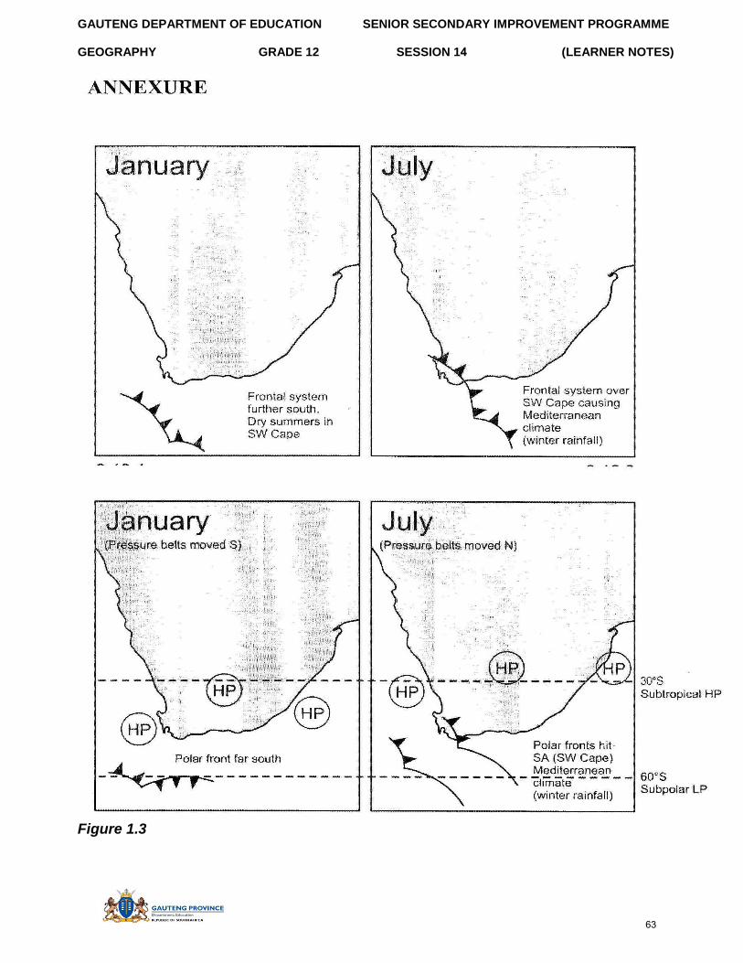
GAUTENG DEPARTMENT OF EDUCATION SENIOR SECONDARY IMPROVEMENT PROGRAMME
GEOGRAPHY GRADE 12 SESSION 14 (LEARNER NOTES)
Figure 1.3
63
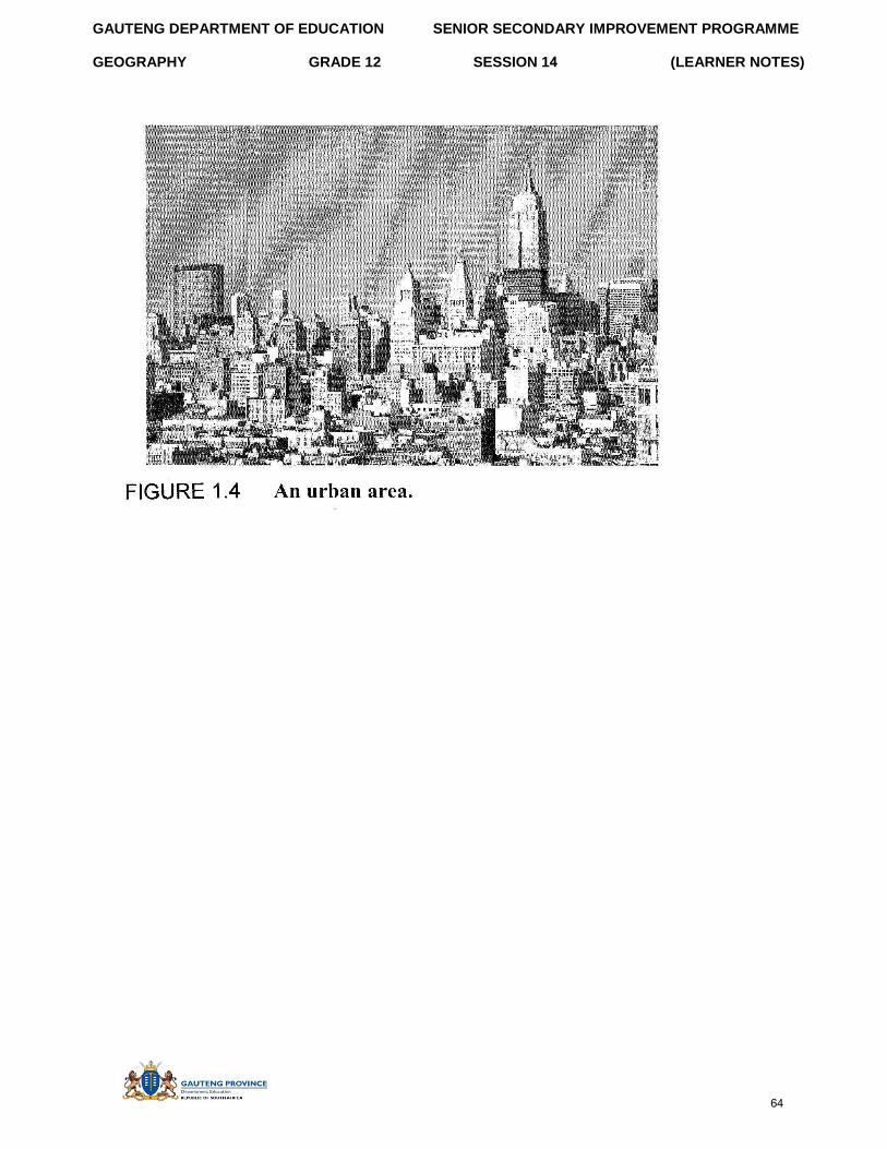
GAUTENG DEPARTMENT OF EDUCATION SENIOR SECONDARY IMPROVEMENT PROGRAMME
GEOGRAPHY GRADE 12 SESSION 14 (LEARNER NOTES)
64
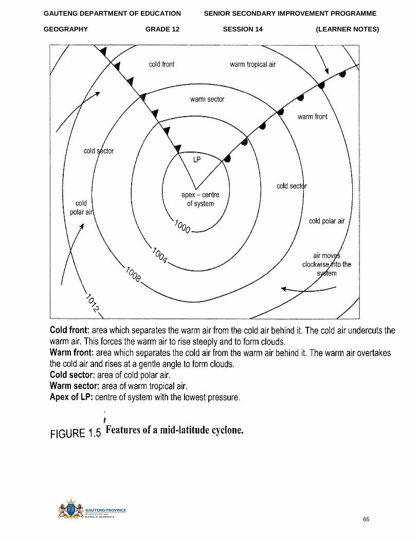
GAUTENG DEPARTMENT OF EDUCATION SENIOR SECONDARY IMPROVEMENT PROGRAMME
GEOGRAPHY GRADE 12 SESSION 14 (LEARNER NOTES)
65
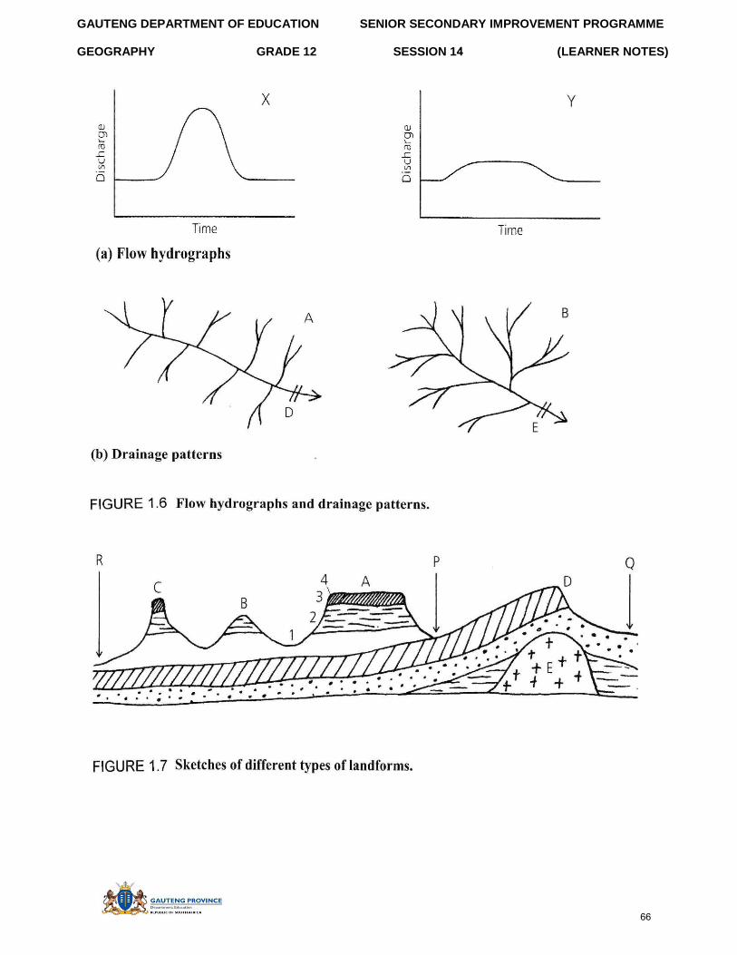
GAUTENG DEPARTMENT OF EDUCATION SENIOR SECONDARY IMPROVEMENT PROGRAMME
GEOGRAPHY GRADE 12 SESSION 14 (LEARNER NOTES)
66
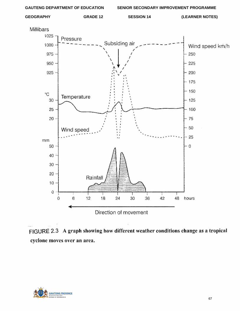
GAUTENG DEPARTMENT OF EDUCATION SENIOR SECONDARY IMPROVEMENT PROGRAMME
GEOGRAPHY GRADE 12 SESSION 14 (LEARNER NOTES)
67
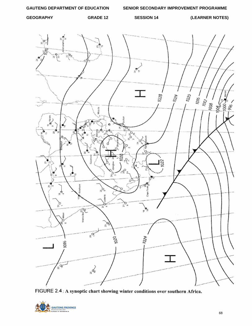
GAUTENG DEPARTMENT OF EDUCATION SENIOR SECONDARY IMPROVEMENT PROGRAMME
GEOGRAPHY GRADE 12 SESSION 14 (LEARNER NOTES)
68
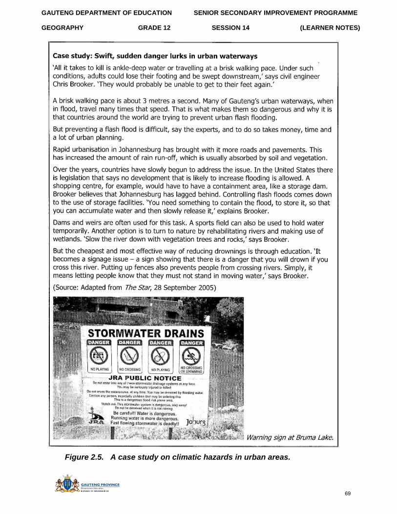
GAUTENG DEPARTMENT OF EDUCATION SENIOR SECONDARY IMPROVEMENT PROGRAMME
GEOGRAPHY GRADE 12 SESSION 14 (LEARNER NOTES)
Figure 2.5. A case study on climatic hazards in urban areas.
69
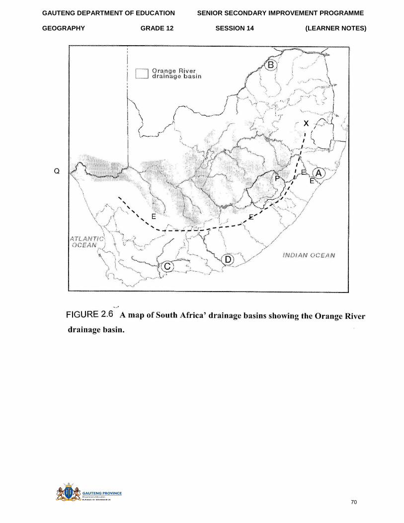
GAUTENG DEPARTMENT OF EDUCATION SENIOR SECONDARY IMPROVEMENT PROGRAMME
GEOGRAPHY GRADE 12 SESSION 14 (LEARNER NOTES)
x
70
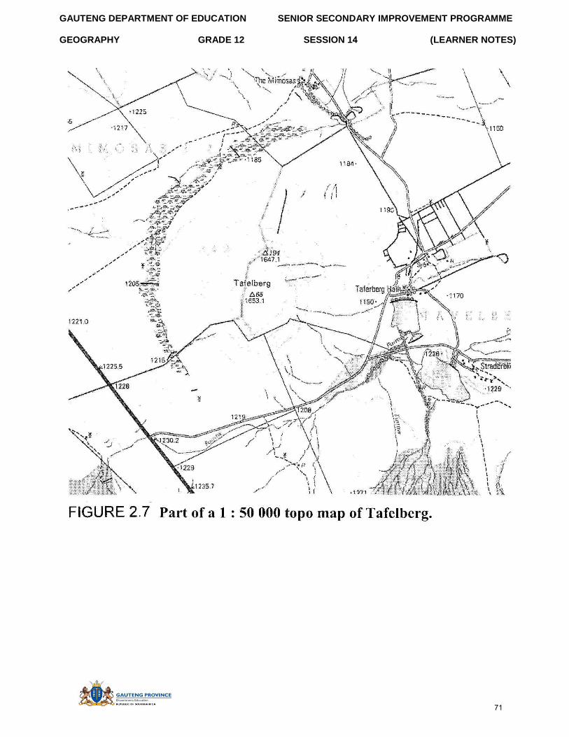
GAUTENG DEPARTMENT OF EDUCATION SENIOR SECONDARY IMPROVEMENT PROGRAMME
GEOGRAPHY GRADE 12 SESSION 14 (LEARNER NOTES)
71
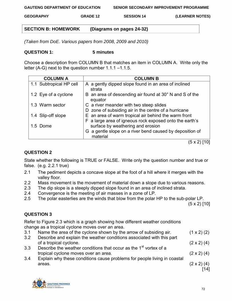
GAUTENG DEPARTMENT OF EDUCATION SENIOR SECONDARY IMPROVEMENT PROGRAMME
GEOGRAPHY GRADE 12 SESSION 14 (LEARNER NOTES)
(Taken from DoE. Various papers from 2008, 2009 and 2010)
QUESTION 1: 5 minutes
Choose a description from COLUMN B that matches an item in COLUMN A. Write only the letter (A-G) next to the question number 1.1.1 –1.1.5.
COLUMN A COLUMN B
1.1 Subtropical HP cell
1.2 Eye of a cyclone
1.3 Warm sector
1.4 Slip-off slope
1.5 Dome
A a gently dipped slope found in an area of inclined strata B an area of descending air found at 30° N and S of the equator C a river meander with two steep slides D zone of subsiding air in the centre of a hurricane E an area of warm tropical air behind the warm front F a large area of igneous rock exposed onto the earth’s surface by weathering and erosion G a gentle slope on a river bend caused by deposition of
material (5 x 2) [10]
QUESTION 2
State whether the following is TRUE or FALSE. Write only the question number and true or false. (e.g. 2.2.1 true)
2.1 The pediment depicts a concave slope at the foot of a hill where it merges with the valley floor.
2.2 Mass movement is the movement of material down a slope due to various reasons. 2.3 The dip slope is a steeply dipped slope found in an area of inclined strata. 2.4 Convergence is the meeting of air masses in a zone of LP. 2.5 The polar easterlies are the winds that blow from the polar HP to the sub-polar LP.
(5 x 2) [10]
QUESTION 3
Refer to Figure 2.3 which is a graph showing how different weather conditions change as a tropical cyclone moves over an area. 3.1 Name the area of the cyclone shown by the arrow of subsiding air. (1 x 2) (2) 3.2 Describe and explain the weather conditions associated with this part
of a tropical cyclone. (2 x 2) (4) 3.3 Describe the weather conditions that occur as the 1st vortex of a
tropical cyclone moves over an area. (2 x 2) (4) 3.4 Explain why these conditions cause problems for people living in coastal
areas. (2 x 2) (4) [14]
SECTION B: HOMEWORK (Diagrams on pages 24-32)
72
GAUTENG DEPARTMENT OF EDUCATION SENIOR SECONDARY IMPROVEMENT PROGRAMME
GEOGRAPHY GRADE 12 SESSION 14 (LEARNER NOTES)
QUESTION 4
Refer to Figure 2.4 showing a synoptic chart of winter conditions over southern Africa. 4.1 Give TWO reasons besides the date, that tell you that this synoptic chart
shows winter conditions. (2 x 2) (4) 4.2 Describe the weather conditions that Marion island is experiencing. (2 x 2) (4) 4.3 Explain why the weather conditions you described in 2.4.2 are occurring.
(2 x 2) (4) 4.4 Give a reason why most of the weather stations over South Africa are
experiencing cloudless conditions. (1 x 2) (2) [14]
QUESTION 5
Refer to Figure 2.5: A case study on climatic hazards in urban areas. 5.1 Name any weather system you have studied, that can lead to a ‘flash flood’.
(1 x 2) (2) 5.2 In a short paragraph (of no more than 12 lines) discuss methods you would
introduce in an urban area to deal with the climatic hazard of flash floods. (6 x 2) (12) [14]
QUESTION 6
Refer to Figure 2.6 showing a map of South Africa’s drainage basins. The Orange River drainage basin is outlined and shaded. 6.1 What is meant by a drainage basin? (1 x 2) (2) 6.2 The Great Escarpment is the major watershed in South Africa. It is indicated
with a dashed line marked X on the map. Explain what a watershed is. (1 x 2) (2) 6.3 Is the mouth of the Orange River indicated by the letter P or Q on the map?
Give a reason for your answer. (1 x 2) (2) 6.4 The Orange River is described as an exotic river when it flows through
parts of the Northern Cape. Explain why this is the case. (2 x 2) (4) 6.5 Name and describe the type of drainage pattern the Orange River forms. (2 x 2) (4) 6.6 The local community has proposed the construction of a major dam in the
river system. Write a short essay (no more than 12 lines) to outline the advantages and disadvantages of such a proposal. (6 x 2) (12)
[26] QUESTION 7 Refer to Figure 2.7 showing part of a 1: 50 000 topographical map of the Tafelberg area. 7.1 The landform feature called Tafelberg that is shown on the map is an example
of a landform formed by horizontal strata. Identify this type of landform. (1 x 2) (2) 7.2 Draw a cross section through the landform identified in 2.7.1 to show
the characteristics of this landform feature. (2 x 2) (4) 7.3 On the cross section drawn in question 2.7.2, label the four slope types –
crest, scarp, talus and pediment. (4 x 1) (4) 7.4 Mass movement is likely to occur on such a landform. Name and describe
any one type of mass movement that could occur. (2 x 2) (4) [14]
73
GAUTENG DEPARTMENT OF EDUCATION SENIOR SECONDARY IMPROVEMENT PROGRAMME
GEOGRAPHY GRADE 12 SESSION 14 (LEARNER NOTES)
SECTION C: SOLUTIONS SECTION A
QUESTION 1
1.1.1 True√√ 1.1.2 True√√ 1.1.3 False√√
1.1.4 True√√ 1.1.5 True√√
(5 x 2) [10]
1.2.1 distributaries√√ 1.2.2 increased√√ 1.2.3 smaller√√
1.2.4 rejuvenation√√ 1.2.5 urban√√
(5 x 2) [10]
1.3.1 January the HP and LP areas are found further south√√ July – they are found further north – the HP are further north than 30°S√√ (2 x 2) (4)
1.3.2 The thermal equator moves further north and south depending on where the sun’s direct rays are shining. This means that all the pressure belts move as the equatorial LP moves with the sun’s rays. √√ (1 x 2) (2)
1.3.3 In the winter months of July the polar fronts move further north and are found over the SW Cape causing winter rainfall. √√ (1 x 2) (2)
[8]
1.4.1 (Any ONE) Urban areas will have higher temperatures than the rural areas√√ Increased cloud cover over urban areas, etc (1 x 2) (2)
1.4.2 (Any THREE) Large surface area in urban areas for greater absorption of heat√√ Material of tar and bricks absorb more heat than grass in rural areas√√ Little greenery in urban area results in less evaporational cooling√√ (3 x 2) (6)
1.4.3 Ensure that learners formulate full sentences. There should be at least six individual facts. (a) Cause problems for people’s health √√e.g. increased eye irritation, heat
stress and respiratory problems√√ Increase smog from more pollution cause problems with visibility√√ and so lead to more traffic accidents on the roads√√
(b) Control urban developments by ensuring more trees and green areas√√ Control emissions of pollutants from factories through fines√√ (Any acceptable) (6 x 2) (12)
[20]
1.5.1 Form between 40° - 60°S of the equator in the sub polar LP cell√√ (1 x 2) (2) 1.5.2 Warm air from the tropics meets cold air from the poles in the LP cell. √√
Warm air rises up the cold air at the front, which is the meeting place of these two air masses. √√ The polar front develops kinks or waves because of the different strengths of air movements. (2 x 2) (4)
1.5.3 Cool√√, cloudy conditions with possible rain√√ and strong winds (2 x 2) (4)
74
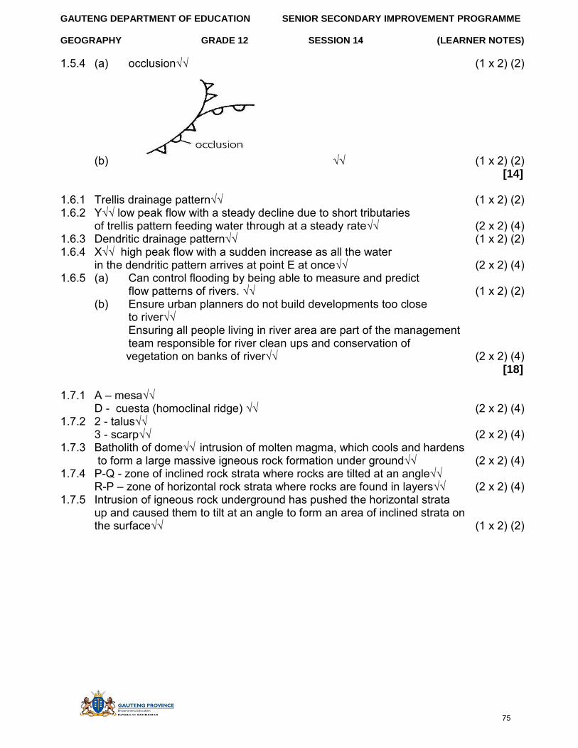
GAUTENG DEPARTMENT OF EDUCATION SENIOR SECONDARY IMPROVEMENT PROGRAMME
GEOGRAPHY GRADE 12 SESSION 14 (LEARNER NOTES)
1.5.4 (a) occlusion√√ (1 x 2) (2)
(b) √√ (1 x 2) (2) [14]
1.6.1 Trellis drainage pattern√√ (1 x 2) (2) 1.6.2 Y√√ low peak flow with a steady decline due to short tributaries
of trellis pattern feeding water through at a steady rate√√ (2 x 2) (4) 1.6.3 Dendritic drainage pattern√√ (1 x 2) (2) 1.6.4 X√√ high peak flow with a sudden increase as all the water
in the dendritic pattern arrives at point E at once√√ (2 x 2) (4) 1.6.5 (a) Can control flooding by being able to measure and predict
flow patterns of rivers. √√ (1 x 2) (2) (b) Ensure urban planners do not build developments too close
to river√√ Ensuring all people living in river area are part of the management team responsible for river clean ups and conservation of
vegetation on banks of river√√ (2 x 2) (4) [18]
1.7.1 A – mesa√√ D - cuesta (homoclinal ridge) √√ (2 x 2) (4)
1.7.2 2 - talus√√ 3 - scarp√√ (2 x 2) (4)
1.7.3 Batholith of dome√√ intrusion of molten magma, which cools and hardens to form a large massive igneous rock formation under ground√√ (2 x 2) (4)
1.7.4 P-Q - zone of inclined rock strata where rocks are tilted at an angle√√ R-P – zone of horizontal rock strata where rocks are found in layers√√ (2 x 2) (4)
1.7.5 Intrusion of igneous rock underground has pushed the horizontal strata up and caused them to tilt at an angle to form an area of inclined strata on the surface√√ (1 x 2) (2)
75
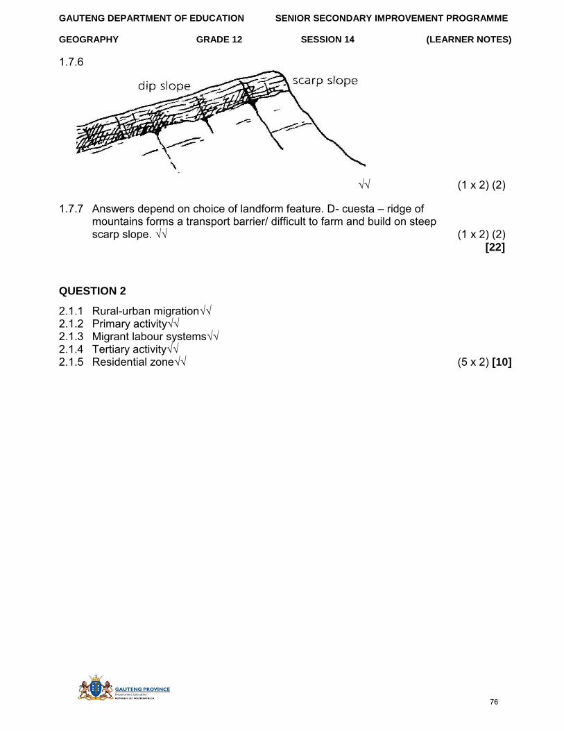
GAUTENG DEPARTMENT OF EDUCATION SENIOR SECONDARY IMPROVEMENT PROGRAMME
GEOGRAPHY GRADE 12 SESSION 14 (LEARNER NOTES)
1.7.6
√√ (1 x 2) (2)
1.7.7 Answers depend on choice of landform feature. D- cuesta – ridge of mountains forms a transport barrier/ difficult to farm and build on steep scarp slope. √√ (1 x 2) (2)
[22]
QUESTION 2
2.1.1 Rural-urban migration√√ 2.1.2 Primary activity√√ 2.1.3 Migrant labour systems√√ 2.1.4 Tertiary activity√√ 2.1.5 Residential zone√√ (5 x 2) [10]
76
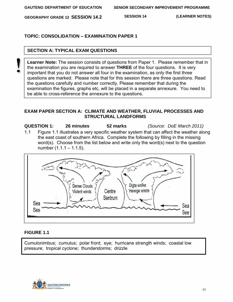
SENIOR SECONDARY IMPROVEMENT PROGRAMME
SESSION 14 (LEARNER NOTES)
GAUTENG DEPARTMENT OF EDUCATION
GEOGRAPHY GRADE 12 SESSION 14.2
TOPIC: CONSOLIDATION – EXAMINATION PAPER 1
EXAM PAPER SECTION A: CLIMATE AND WEATHER, FLUVIAL PROCESSES AND STRUCTURAL LANDFORMS
QUESTION 1: 26 minutes 52 marks (Source: DoE March 2011)
1.1 Figure 1.1 illustrates a very specific weather system that can affect the weather along the east coast of southern Africa. Complete the following by filling in the missing word(s). Choose from the list below and write only the word(s) next to the question number (1.1.1 – 1.1.5).
FIGURE 1.1
Cumulonimbus; cumulus; polar front; eye; hurricane strength winds; coastal low pressure; tropical cyclone; thunderstorms; drizzle
Learner Note: The session consists of questions from Paper 1. Please remember that in the examination you are required to answer THREE of the four questions. It is very important that you do not answer all four in the examination, as only the first three questions are marked. Please note that for this session there are three questions. Read the questions carefully and number correctly. Please remember that during the examination the figures, graphs etc, will be placed in a separate annexure. You need to be able to cross-reference the annexure to the questions.
SECTION A: TYPICAL EXAM QUESTIONS
77
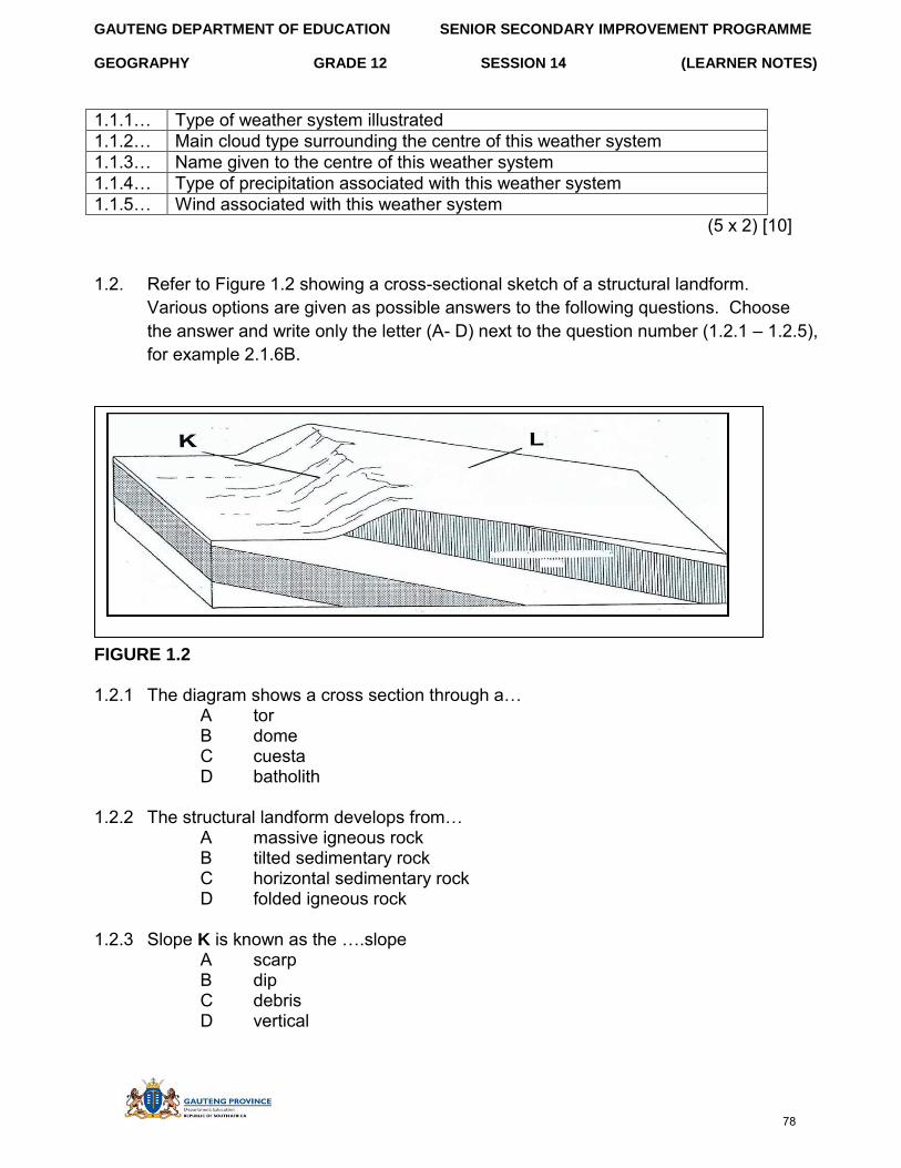
GAUTENG DEPARTMENT OF EDUCATION SENIOR SECONDARY IMPROVEMENT PROGRAMME
GEOGRAPHY GRADE 12 SESSION 14 (LEARNER NOTES)
1.1.1… Type of weather system illustrated 1.1.2… Main cloud type surrounding the centre of this weather system 1.1.3… Name given to the centre of this weather system 1.1.4… Type of precipitation associated with this weather system 1.1.5… Wind associated with this weather system
(5 x 2) [10]
1.2. Refer to Figure 1.2 showing a cross-sectional sketch of a structural landform. Various options are given as possible answers to the following questions. Choose the answer and write only the letter (A- D) next to the question number (1.2.1 – 1.2.5), for example 2.1.6B.
FIGURE 1.2
1.2.1 The diagram shows a cross section through a… A tor B dome C cuesta D batholith
1.2.2 The structural landform develops from… A massive igneous rock B tilted sedimentary rock C horizontal sedimentary rock D folded igneous rock
1.2.3 Slope K is known as the ….slope A scarp B dip C debris D vertical
78
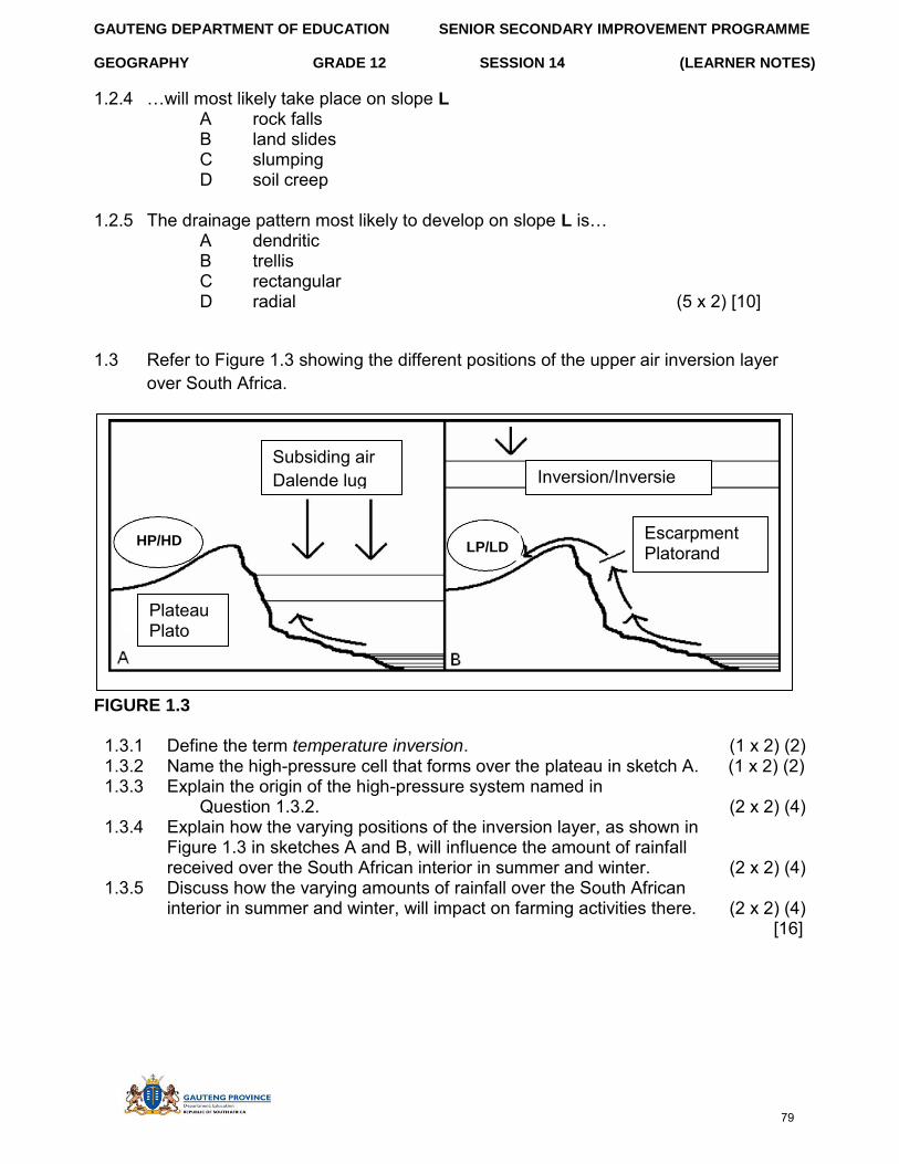
GAUTENG DEPARTMENT OF EDUCATION SENIOR SECONDARY IMPROVEMENT PROGRAMME
GEOGRAPHY GRADE 12 SESSION 14 (LEARNER NOTES)
1.2.4 …will most likely take place on slope L A rock falls B land slides C slumping D soil creep
1.2.5 The drainage pattern most likely to develop on slope L is… A dendritic B trellis C rectangular D radial (5 x 2) [10]
1.3 Refer to Figure 1.3 showing the different positions of the upper air inversion layer over South Africa.
FIGURE 1.3
1.3.1 Define the term temperature inversion. (1 x 2) (2) 1.3.2 Name the high-pressure cell that forms over the plateau in sketch A. (1 x 2) (2) 1.3.3 Explain the origin of the high-pressure system named in
Question 1.3.2. (2 x 2) (4) 1.3.4 Explain how the varying positions of the inversion layer, as shown in
Figure 1.3 in sketches A and B, will influence the amount of rainfall received over the South African interior in summer and winter. (2 x 2) (4)
1.3.5 Discuss how the varying amounts of rainfall over the South African interior in summer and winter, will impact on farming activities there. (2 x 2) (4)
[16]
Escarpment Platorand
Subsiding air Dalende lug
Plateau Plato
Inversion/Inversie
HP/HD LP/LD
79
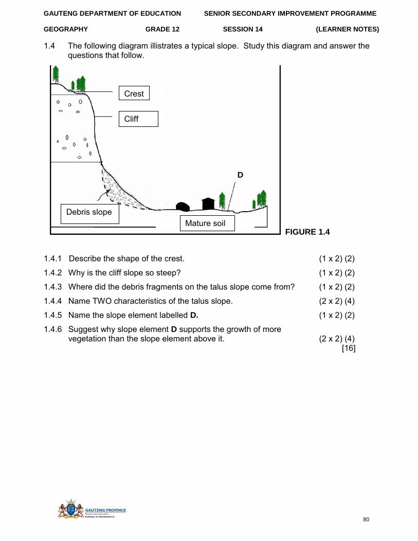
GAUTENG DEPARTMENT OF EDUCATION SENIOR SECONDARY IMPROVEMENT PROGRAMME
GEOGRAPHY GRADE 12 SESSION 14 (LEARNER NOTES)
1.4 The following diagram illistrates a typical slope. Study this diagram and answer the questions that follow.
Mature soil
1.4.1 Describe the shape of the crest. (1 x 2) (2)
1.4.2 Why is the cliff slope so steep? (1 x 2) (2)
1.4.3 Where did the debris fragments on the talus slope come from? (1 x 2) (2)
1.4.4 Name TWO characteristics of the talus slope. (2 x 2) (4)
1.4.5 Name the slope element labelled D. (1 x 2) (2)
1.4.6 Suggest why slope element D supports the growth of more vegetation than the slope element above it. (2 x 2) (4)
[16]
Debris slope
FIGURE 1.4
Crest
Cliff
Debris slope Mature soil
D
80
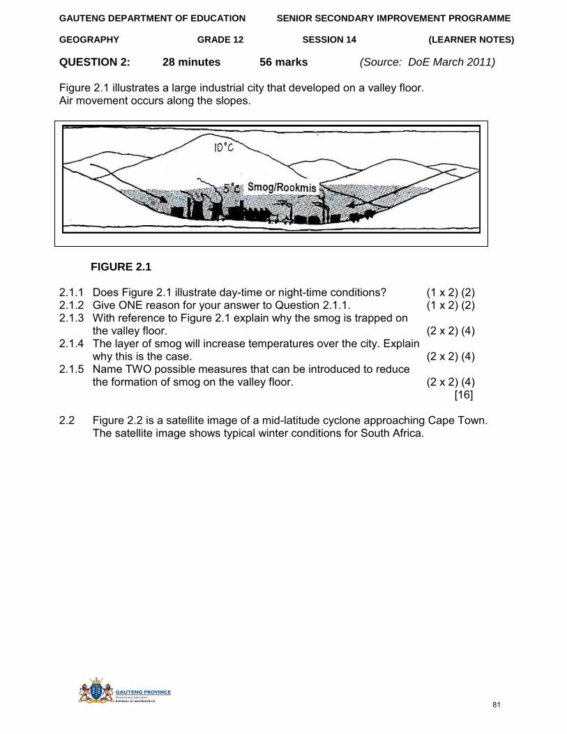
GAUTENG DEPARTMENT OF EDUCATION SENIOR SECONDARY IMPROVEMENT PROGRAMME
GEOGRAPHY GRADE 12 (LEARNER NOTES)
QUESTION 2: 28 minutes
SESSION 14
56 marks (Source: DoE March 2011)
Figure 2.1 illustrates a large industrial city that developed on a valley floor. Air movement occurs along the slopes.
FIGURE 2.1
2.1.1 Does Figure 2.1 illustrate day-time or night-time conditions? (1 x 2) (2) 2.1.2 Give ONE reason for your answer to Question 2.1.1. (1 x 2) (2) 2.1.3 With reference to Figure 2.1 explain why the smog is trapped on
the valley floor. (2 x 2) (4) 2.1.4 The layer of smog will increase temperatures over the city. Explain
why this is the case. (2 x 2) (4) 2.1.5 Name TWO possible measures that can be introduced to reduce
the formation of smog on the valley floor. (2 x 2) (4) [16]
2.2 Figure 2.2 is a satellite image of a mid-latitude cyclone approaching Cape Town. The satellite image shows typical winter conditions for South Africa.
81
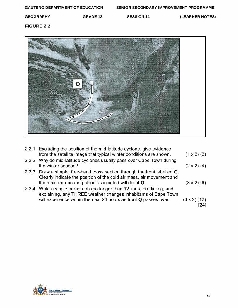
GAUTENG DEPARTMENT OF EDUCATION SENIOR SECONDARY IMPROVEMENT PROGRAMME
GEOGRAPHY GRADE 12 SESSION 14 (LEARNER NOTES)
FIGURE 2.2
2.2.1 Excluding the position of the mid-latitude cyclone, give evidence from the satellite image that typical winter conditions are shown. (1 x 2) (2)
2.2.2 Why do mid-latitude cyclones usually pass over Cape Town during the winter season? (2 x 2) (4)
2.2.3 Draw a simple, free-hand cross section through the front labelled Q. Clearly indicate the position of the cold air mass, air movement and the main rain-bearing cloud associated with front Q. (3 x 2) (6)
2.2.4 Write a single paragraph (no longer than 12 lines) predicting, and explaining, any THREE weather changes inhabitants of Cape Town will experience within the next 24 hours as front Q passes over. (6 x 2) (12)
[24]
82
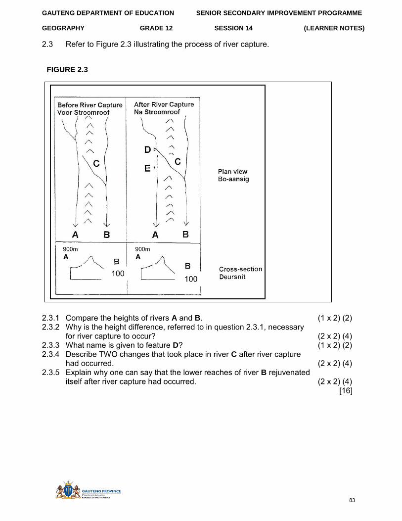
GAUTENG DEPARTMENT OF EDUCATION SENIOR SECONDARY IMPROVEMENT PROGRAMME
GEOGRAPHY GRADE 12 SESSION 14 (LEARNER NOTES)
2.3 Refer to Figure 2.3 illustrating the process of river capture.
FIGURE 2.3
2.3.1 Compare the heights of rivers A and B. (1 x 2) (2) 2.3.2 Why is the height difference, referred to in question 2.3.1, necessary
for river capture to occur? (2 x 2) (4) 2.3.3 What name is given to feature D? (1 x 2) (2) 2.3.4 Describe TWO changes that took place in river C after river capture
had occurred. (2 x 2) (4) 2.3.5 Explain why one can say that the lower reaches of river B rejuvenated
itself after river capture had occurred. (2 x 2) (4) [16]
900m A
100m
900m A
100m
83
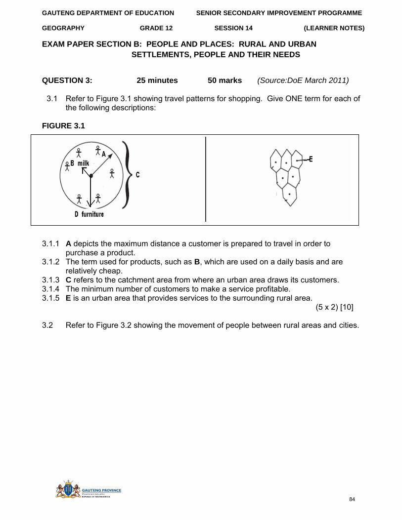
GAUTENG DEPARTMENT OF EDUCATION SENIOR SECONDARY IMPROVEMENT PROGRAMME
GEOGRAPHY GRADE 12 SESSION 14 (LEARNER NOTES)
EXAM PAPER SECTION B: PEOPLE AND PLACES: RURAL AND URBAN
SETTLEMENTS, PEOPLE AND THEIR NEEDS
QUESTION 3: 25 minutes 50 marks (Source:DoE March 2011)
3.1 Refer to Figure 3.1 showing travel patterns for shopping. Give ONE term for each of the following descriptions:
FIGURE 3.1
3.1.1 A depicts the maximum distance a customer is prepared to travel in order to purchase a product.
3.1.2 The term used for products, such as B, which are used on a daily basis and are relatively cheap.
3.1.3 C refers to the catchment area from where an urban area draws its customers. 3.1.4 The minimum number of customers to make a service profitable. 3.1.5 E is an urban area that provides services to the surrounding rural area.
(5 x 2) [10]
3.2 Refer to Figure 3.2 showing the movement of people between rural areas and cities.
84
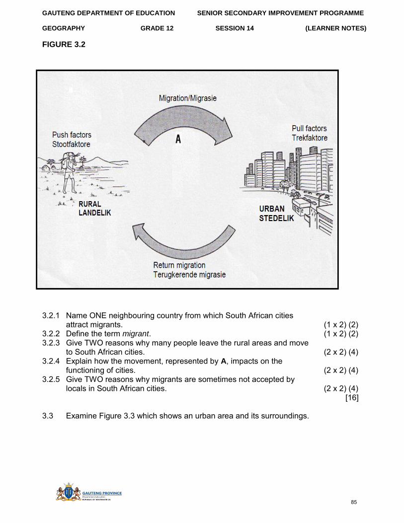
GAUTENG DEPARTMENT OF EDUCATION SENIOR SECONDARY IMPROVEMENT PROGRAMME
GEOGRAPHY GRADE 12 SESSION 14 (LEARNER NOTES)
FIGURE 3.2
3.2.1 Name ONE neighbouring country from which South African cities attract migrants. (1 x 2) (2)
3.2.2 Define the term migrant. (1 x 2) (2) 3.2.3 Give TWO reasons why many people leave the rural areas and move
to South African cities. (2 x 2) (4) 3.2.4 Explain how the movement, represented by A, impacts on the
functioning of cities. (2 x 2) (4) 3.2.5 Give TWO reasons why migrants are sometimes not accepted by
locals in South African cities. (2 x 2) (4) [16]
3.3 Examine Figure 3.3 which shows an urban area and its surroundings.
85
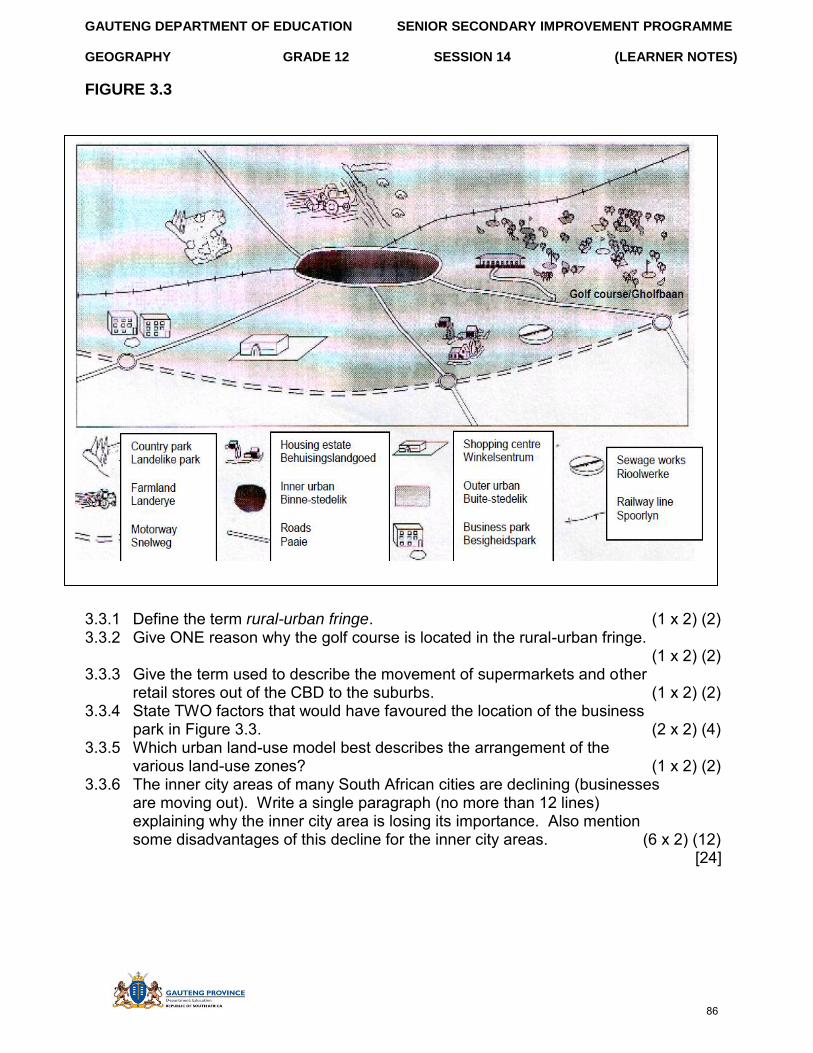
GAUTENG DEPARTMENT OF EDUCATION SENIOR SECONDARY IMPROVEMENT PROGRAMME
GEOGRAPHY GRADE 12 SESSION 14 (LEARNER NOTES)
FIGURE 3.3
3.3.1 Define the term rural-urban fringe. (1 x 2) (2) 3.3.2 Give ONE reason why the golf course is located in the rural-urban fringe.
(1 x 2) (2) 3.3.3 Give the term used to describe the movement of supermarkets and other
retail stores out of the CBD to the suburbs. (1 x 2) (2) 3.3.4 State TWO factors that would have favoured the location of the business
park in Figure 3.3. (2 x 2) (4) 3.3.5 Which urban land-use model best describes the arrangement of the
various land-use zones? (1 x 2) (2) 3.3.6 The inner city areas of many South African cities are declining (businesses
are moving out). Write a single paragraph (no more than 12 lines) explaining why the inner city area is losing its importance. Also mention some disadvantages of this decline for the inner city areas. (6 x 2) (12)
[24]
86
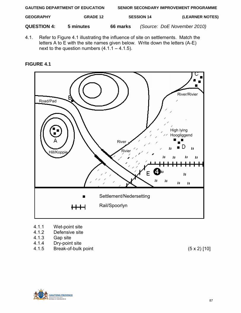
GAUTENG DEPARTMENT OF EDUCATION SENIOR SECONDARY IMPROVEMENT PROGRAMME
GEOGRAPHY GRADE 12 SESSION 14 (LEARNER NOTES)
QUESTION 4: 5 minutes 66 marks (Source: DoE November 2010)
4.1. Refer to Figure 4.1 illustrating the influence of site on settlements. Match the letters A to E with the site names given below. Write down the letters (A-E) next to the question numbers (4.1.1 – 4.1.5).
FIGURE 4.1
River/Rivier
Road/Pad
High lying Hoogliggend
River
Hill/Koppie Rivier
Settlement/Nedersetting
Rail/Spoorlyn
4.1.1 Wet-point site 4.1.2 Defensive site 4.1.3 Gap site 4.1.4 Dry-point site 4.1.5 Break-of-bulk point (5 x 2) [10]
87
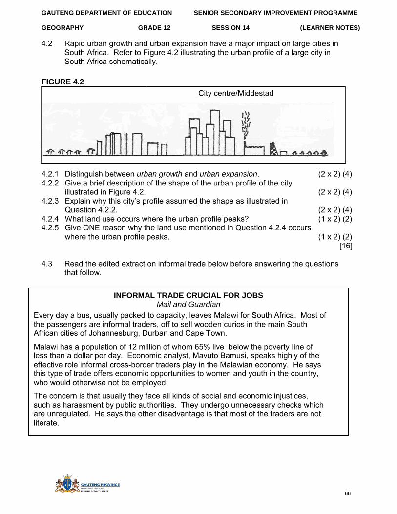
GAUTENG DEPARTMENT OF EDUCATION SENIOR SECONDARY IMPROVEMENT PROGRAMME
GEOGRAPHY GRADE 12 SESSION 14 (LEARNER NOTES)
4.2 Rapid urban growth and urban expansion have a major impact on large cities in South Africa. Refer to Figure 4.2 illustrating the urban profile of a large city in South Africa schematically.
FIGURE 4.2
City centre/Middestad
4.2.1 Distinguish between urban growth and urban expansion. (2 x 2) (4) 4.2.2 Give a brief description of the shape of the urban profile of the city
illustrated in Figure 4.2. (2 x 2) (4) 4.2.3 Explain why this city’s profile assumed the shape as illustrated in
Question 4.2.2. (2 x 2) (4) 4.2.4 What land use occurs where the urban profile peaks? (1 x 2) (2) 4.2.5 Give ONE reason why the land use mentioned in Question 4.2.4 occurs
where the urban profile peaks. (1 x 2) (2) [16]
4.3 Read the edited extract on informal trade below before answering the questions that follow.
INFORMAL TRADE CRUCIAL FOR JOBS Mail and Guardian
Every day a bus, usually packed to capacity, leaves Malawi for South Africa. Most of the passengers are informal traders, off to sell wooden curios in the main South African cities of Johannesburg, Durban and Cape Town.
Malawi has a population of 12 million of whom 65% live below the poverty line of less than a dollar per day. Economic analyst, Mavuto Bamusi, speaks highly of the effective role informal cross-border traders play in the Malawian economy. He says this type of trade offers economic opportunities to women and youth in the country, who would otherwise not be employed.
The concern is that usually they face all kinds of social and economic injustices, such as harassment by public authorities. They undergo unnecessary checks which are unregulated. He says the other disadvantage is that most of the traders are not literate.
88
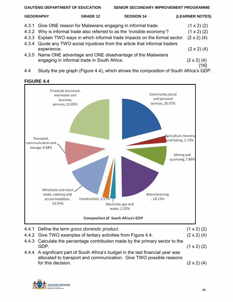
GAUTENG DEPARTMENT OF EDUCATION SENIOR SECONDARY IMPROVEMENT PROGRAMME
GEOGRAPHY GRADE 12 SESSION 14 (LEARNER NOTES)
4.3.1 Give ONE reason for Malawians engaging in informal trade. (1 x 2) (2) 4.3.2 Why is informal trade also referred to as the ‘invisible economy’? (1 x 2) (2) 4.3.3 Explain TWO ways in which informal trade impacts on the formal sector. (2 x 2) (4) 4.3.4 Quote any TWO social injustices from the article that informal traders
experience. (2 x 2) (4) 4.3.5 Name ONE advantage and ONE disadvantage of the Malawians
engaging in informal trade in South Africa. (2 x 2) (4) [16]
4.4 Study the pie graph (Figure 4.4), which shows the composition of South Africa’s GDP.
FIGURE 4.4
4.4.1 Define the term gross domestic product. (1 x 2) (2) 4.4.2 Give TWO examples of tertiary activities from Figure 4.4. (2 x 2) (4) 4.4.3 Calculate the percentage contribution made by the primary sector to the
GDP. (1 x 2) (2) 4.4.4 A significant part of South Africa’s budget in the last financial year was
allocated to transport and communication. Give TWO possible reasons for this decision. (2 x 2) (4)
89
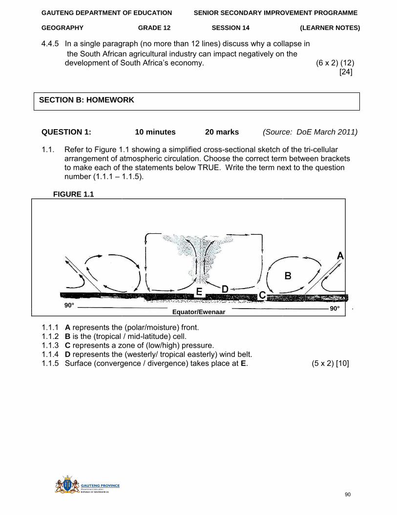
GAUTENG DEPARTMENT OF EDUCATION SENIOR SECONDARY IMPROVEMENT PROGRAMME
GEOGRAPHY GRADE 12 SESSION 14 (LEARNER NOTES)
4.4.5 In a single paragraph (no more than 12 lines) discuss why a collapse in the South African agricultural industry can impact negatively on the development of South Africa’s economy. (6 x 2) (12)
[24]
QUESTION 1: 10 minutes 20 marks (Source: DoE March 2011)
1.1. Refer to Figure 1.1 showing a simplified cross-sectional sketch of the tri-cellular arrangement of atmospheric circulation. Choose the correct term between brackets to make each of the statements below TRUE. Write the term next to the question number (1.1.1 – 1.1.5).
FIGURE 1.1
90° Equator/Ewenaar 90°
1.1.1 A represents the (polar/moisture) front. 1.1.2 B is the (tropical / mid-latitude) cell. 1.1.3 C represents a zone of (low/high) pressure. 1.1.4 D represents the (westerly/ tropical easterly) wind belt. 1.1.5 Surface (convergence / divergence) takes place at E. (5 x 2) [10]
SECTION B: HOMEWORK
90
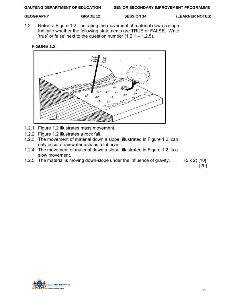
GAUTENG DEPARTMENT OF EDUCATION SENIOR SECONDARY IMPROVEMENT PROGRAMME
GEOGRAPHY GRADE 12 SESSION 14 (LEARNER NOTES)
1.2 Refer to Figure 1.2 illustrating the movement of material down a slope. Indicate whether the following statements are TRUE or FALSE. Write ‘true’ or false’ next to the question number (1.2.1 – 1.2.5).
FIGURE 1.2
1.2.1 Figure 1.2 illustrates mass movement. 1.2.2 Figure 1.2 illustrates a rock fall. 1.2.3 The movement of material down a slope, illustrated in Figure 1.2, can
only occur if rainwater acts as a lubricant. 1.2.4 The movement of material down a slope, illustrated in Figure 1.2, is a
slow movement. 1.2.5 The material is moving down-slope under the influence of gravity. (5 x 2) [10]
[20]
91
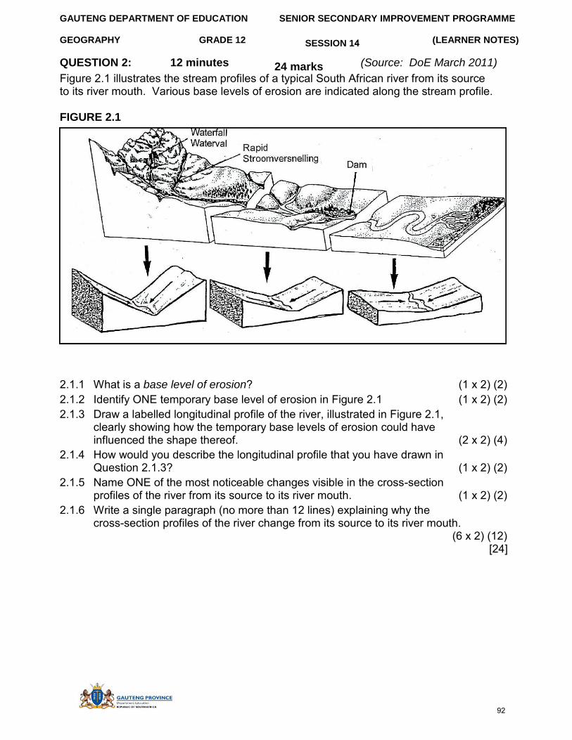
GAUTENG DEPARTMENT OF EDUCATION SENIOR SECONDARY IMPROVEMENT PROGRAMME
GEOGRAPHY GRADE 12 (LEARNER NOTES)
QUESTION 2: 12 minutes
SESSION 14
24 marks (Source: DoE March 2011) Figure 2.1 illustrates the stream profiles of a typical South African river from its source to its river mouth. Various base levels of erosion are indicated along the stream profile.
FIGURE 2.1
2.1.1 What is a base level of erosion? (1 x 2) (2) 2.1.2 Identify ONE temporary base level of erosion in Figure 2.1 (1 x 2) (2) 2.1.3 Draw a labelled longitudinal profile of the river, illustrated in Figure 2.1,
clearly showing how the temporary base levels of erosion could have influenced the shape thereof. (2 x 2) (4)
2.1.4 How would you describe the longitudinal profile that you have drawn in Question 2.1.3? (1 x 2) (2)
2.1.5 Name ONE of the most noticeable changes visible in the cross-section profiles of the river from its source to its river mouth. (1 x 2) (2)
2.1.6 Write a single paragraph (no more than 12 lines) explaining why the cross-section profiles of the river change from its source to its river mouth.
(6 x 2) (12) [24]
92
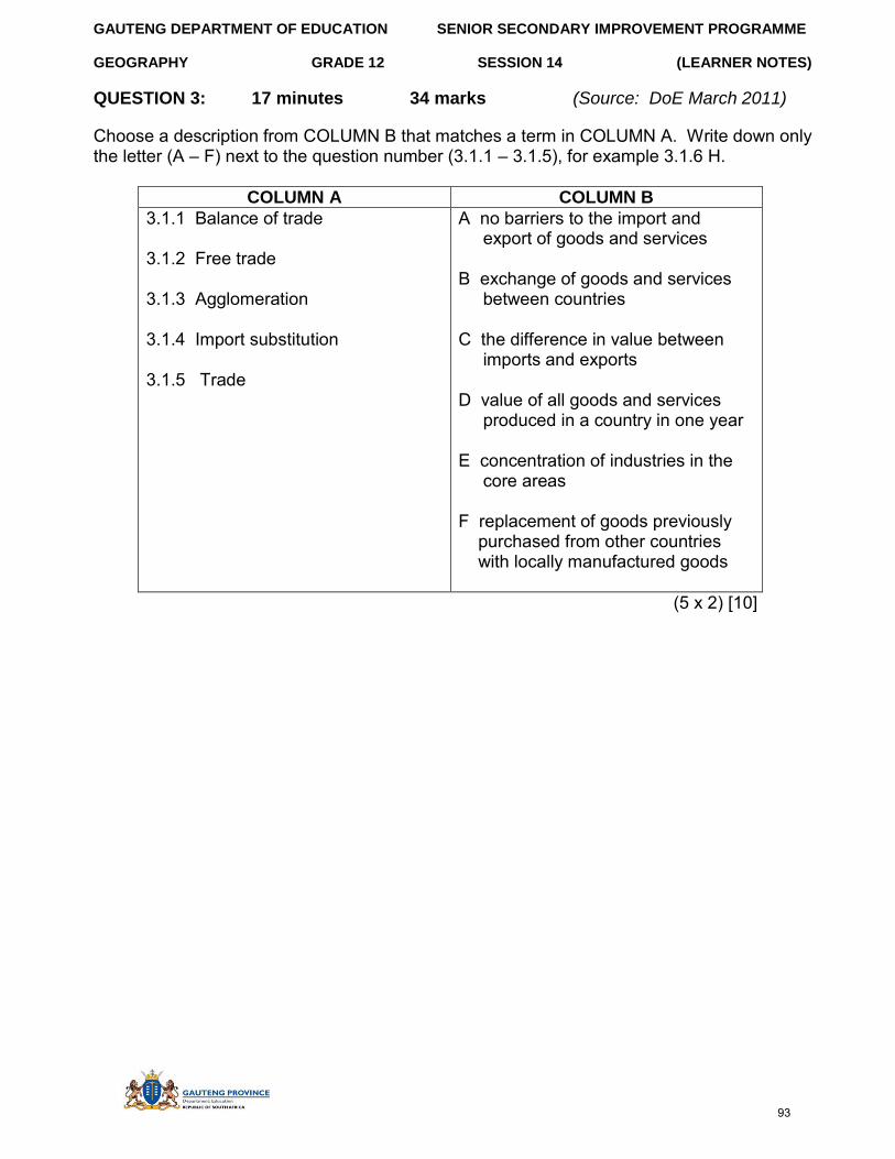
GAUTENG DEPARTMENT OF EDUCATION SENIOR SECONDARY IMPROVEMENT PROGRAMME
GEOGRAPHY GRADE 12 (LEARNER NOTES)
QUESTION 3: 17 minutes
SESSION 14
34 marks (Source: DoE March 2011)
Choose a description from COLUMN B that matches a term in COLUMN A. Write down only the letter (A – F) next to the question number (3.1.1 – 3.1.5), for example 3.1.6 H.
COLUMN A COLUMN B
3.1.1 Balance of trade
3.1.2 Free trade
3.1.3 Agglomeration
3.1.4 Import substitution
3.1.5 Trade
A no barriers to the import and export of goods and services
B exchange of goods and services between countries
C the difference in value between imports and exports
D value of all goods and services produced in a country in one year
E concentration of industries in the core areas
F replacement of goods previously purchased from other countries with locally manufactured goods
(5 x 2) [10]
93
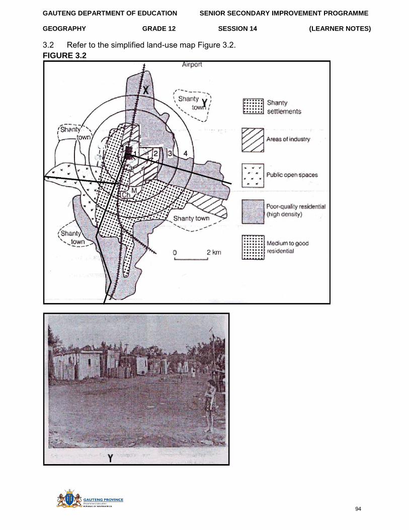
GAUTENG DEPARTMENT OF EDUCATION SENIOR SECONDARY IMPROVEMENT PROGRAMME
GEOGRAPHY GRADE 12 SESSION 14 (LEARNER NOTES)
3.2 Refer to the simplified land-use map Figure 3.2. FIGURE 3.2
94
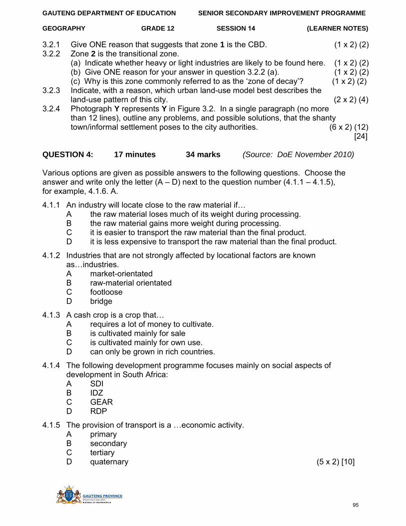
GAUTENG DEPARTMENT OF EDUCATION SENIOR SECONDARY IMPROVEMENT PROGRAMME
GEOGRAPHY GRADE 12 SESSION 14 (LEARNER NOTES)
3.2.1 Give ONE reason that suggests that zone 1 is the CBD. (1 x 2) (2) 3.2.2 Zone 2 is the transitional zone.
(a) Indicate whether heavy or light industries are likely to be found here. (1 x 2) (2) (b) Give ONE reason for your answer in question 3.2.2 (a). (1 x 2) (2) (c) Why is this zone commonly referred to as the ‘zone of decay’? (1 x 2) (2)
3.2.3 Indicate, with a reason, which urban land-use model best describes the land-use pattern of this city. (2 x 2) (4)
3.2.4 Photograph Y represents Y in Figure 3.2. In a single paragraph (no more than 12 lines), outline any problems, and possible solutions, that the shanty town/informal settlement poses to the city authorities. (6 x 2) (12)
[24]
QUESTION 4: 17 minutes 34 marks (Source: DoE November 2010)
Various options are given as possible answers to the following questions. Choose the answer and write only the letter (A – D) next to the question number (4.1.1 – 4.1.5), for example, 4.1.6. A.
4.1.1 An industry will locate close to the raw material if… A the raw material loses much of its weight during processing. B the raw material gains more weight during processing. C it is easier to transport the raw material than the final product. D it is less expensive to transport the raw material than the final product.
4.1.2 Industries that are not strongly affected by locational factors are known as…industries. A market-orientated B raw-material orientated C footloose D bridge
4.1.3 A cash crop is a crop that… A requires a lot of money to cultivate. B is cultivated mainly for sale C is cultivated mainly for own use. D can only be grown in rich countries.
4.1.4 The following development programme focuses mainly on social aspects of development in South Africa: A SDI B IDZ C GEAR D RDP
4.1.5 The provision of transport is a …economic activity. A primary B secondary C tertiary D quaternary (5 x 2) [10]
95
GAUTENG DEPARTMENT OF EDUCATION SENIOR SECONDARY IMPROVEMENT PROGRAMME
GEOGRAPHY GRADE 12 SESSION 14 (LEARNER NOTES)
4.2 Read the extract below answering the questions that follow.
4.2.1 Define the term food security. (1 x 2) (2) 4.2.2 What does the abbreviation RDP stand for? (1 x 2) (2) 4.2.3 Name TWO factors that contribute to food insecurity in South Africa. (2 x 2) (4) 4.2.4 Briefly discuss the role that genetically modified food could play in
ensuring food security in South Africa. (2 x 2) (4) 4.2.5 Write a single paragraph (no longer than 12 lines) and name possible
strategies that have been implemented and that could still be implemented to prevent food insecurity in southern Africa. (6 x 2) (12)
[24]
SECTION D: SOLUTIONS TO SECTION A
QUESTION 1
1.1 1.1.1 tropical cyclone√√ 1.1.2 cumulonimbus √√ 1.1.3 eye√√ 1.1.4 thunderstorms√√ 1.1.5 hurricane-strength winds√√ (5 x 2) (10)
1.2 1.2.1 C√√ 1.2.2 B√√ 1.2.3 A√√ 1.2.4 D√√ 1.2.5 A√√ (5 x 2) (10)
The right of access to food is included in section 27 of the South African Constitution. The Constitution obliges the state to provide legislation and other supporting measures to ensure that all citizens are able to meet their basic food needs. The strategic framework for action to achieve food security was first outlined in the RDP in 1994 which identified food security as a basic human need. In 2000 the cabinet decided to launch an updated national food security strategy to streamline, harmonise and integrate diverse food security sub-programmes in South Africa into the Integrated Food Security Strategy.
96
GAUTENG DEPARTMENT OF EDUCATION SENIOR SECONDARY IMPROVEMENT PROGRAMME
GEOGRAPHY GRADE 12 SESSION 14 (LEARNER NOTES)
1.3 1.3.1 An increase in temperature with height√√ (1 x 2) (2) 1.3.2 Kalahari/Continental√√ (1 x 2) (2) 1.3.3 It originates in the subtropical high pressure zone√√
It is, therefore, associated with subsiding air√√ Land is cool in winter resulting in subsiding air Upper air convergence results in subsidence Subsidence resulting from the Hadley and Ferrel cells of circulation
(Any TWO) (2 x 2) (4)
1.3.4 In summer the inversion layer is high above the escarpment which allows the moist air from over the Indian Ocean to be carried over the interior to result in high rainfall√√ In winter the inversion layer is below the escarpment because of strong subsidence, and moist air is prevented from reaching the land resulting in stable conditions with no rain√√ (Any TWO) (2 x 2) (4)
1.3.5 In summer, due to the high rains, a variety of crops can be grown because water is readily available√√ In winter drought resistant crops are planted and the farmer is restricted in his/her choice√√ Stock graze freely during high rainfall in summer Stock to be fed during lower rainfall in winter
(Any TWO) (2 x 2) (4)
1.4 1.4.1 Convex√√ (1 x 2) (2) 1.4.2 It is made up of resistant rock√√
Resistant rock does not round easily Forms at an angel of between 20 and 35 degrees A zone of accumulated weathered material Predominant activity is deposition (Any ONE) (1 x 2) (2)
1.4.3 Crest√√ or cliff/scarp slope√√ (1 x 2) (2) 1.4.4 Uniform/constant slope√√
Retreats parallel to the original slope√√ Forms at an angle of between 20 and 35 degrees A zone of accumulated weathered material Predominant activity is deposition
(Any TWO) (2 x 2) (4) 1.4.5 Pediment √√ (1 x 2) (2) 1.4.6 It has mature soil√√
It has more soil accumulated from erosion of other slopes√√ It is gentle so water infiltrates
(Any TWO) (2 x 2) (4) [52]
97
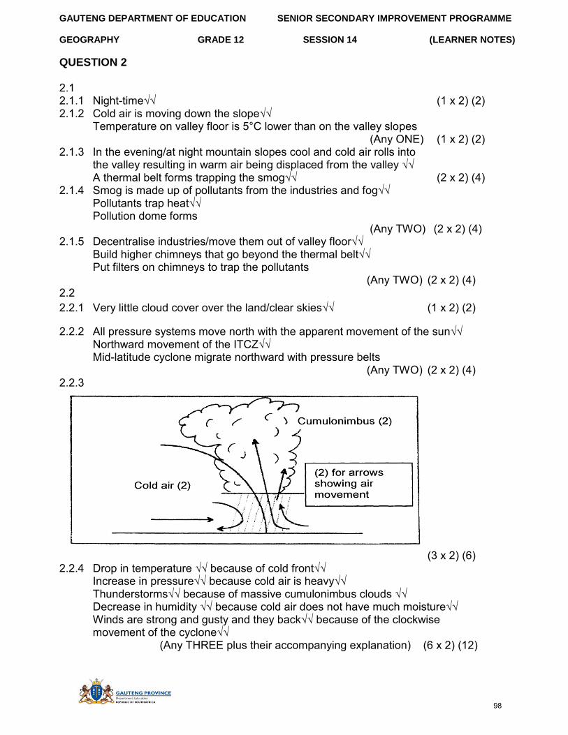
GAUTENG DEPARTMENT OF EDUCATION SENIOR SECONDARY IMPROVEMENT PROGRAMME
GEOGRAPHY GRADE 12 SESSION 14 (LEARNER NOTES)
QUESTION 2
2.1 2.1.1 Night-time√√ (1 x 2) (2) 2.1.2 Cold air is moving down the slope√√
Temperature on valley floor is 5°C lower than on the valley slopes (Any ONE) (1 x 2) (2)
2.1.3 In the evening/at night mountain slopes cool and cold air rolls into the valley resulting in warm air being displaced from the valley √√ A thermal belt forms trapping the smog√√ (2 x 2) (4)
2.1.4 Smog is made up of pollutants from the industries and fog√√ Pollutants trap heat√√ Pollution dome forms
(Any TWO) (2 x 2) (4) 2.1.5 Decentralise industries/move them out of valley floor√√
Build higher chimneys that go beyond the thermal belt√√ Put filters on chimneys to trap the pollutants
(Any TWO) (2 x 2) (4) 2.2 2.2.1 Very little cloud cover over the land/clear skies√√ (1 x 2) (2)
2.2.2 All pressure systems move north with the apparent movement of the sun√√ Northward movement of the ITCZ√√ Mid-latitude cyclone migrate northward with pressure belts
(Any TWO) (2 x 2) (4) 2.2.3
(3 x 2) (6) 2.2.4 Drop in temperature √√ because of cold front√√
Increase in pressure√√ because cold air is heavy√√ Thunderstorms√√ because of massive cumulonimbus clouds √√ Decrease in humidity √√ because cold air does not have much moisture√√ Winds are strong and gusty and they back√√ because of the clockwise movement of the cyclone√√
(Any THREE plus their accompanying explanation) (6 x 2) (12)
98
GAUTENG DEPARTMENT OF EDUCATION SENIOR SECONDARY IMPROVEMENT PROGRAMME
GEOGRAPHY GRADE 12 SESSION 14 (LEARNER NOTES)
2.3 2.3.1 A = 900m OR higher up and B = 100m OR lower/ river A is higher
than river B√√ (1 x 2) (2) 2.3.2 Steeper slope creates a difference in the speed of the rivers√√
The rate of erosion will also be different√√ Stream will erode headward√√ Makes it possible for river at lower level to capture headwaters of river at higher level√√
(Any TWO) (2 x 2) (4) 2.3.3 Elbow of capture√√ (1 x 2) (2) 2.3.4 Increased velocity√√
Volume of water increases√√ Rate of erosion increases Rejuvenation may occur Vertical erosion will increase Deposition will decrease
(Any TWO) (2 x 2) (4) 2.3.5 More water and energy to form the following features√√
Incised/entrenched meanders√√ Valleys within valleys Paired terraces/terraces Knickpoint waterfalls (Any TWO) (2 x 2) (4)
[56]
QUESTION 3 3.1 3.1.1 Range√√ 3.1.2 Low order/convenience goods√√ 3.1.3 Sphere of influence/market area√√ 3.1.4 Threshold population√√ 3.1.5 Central place√√ (5 x 2) [10]
3.2 3.2.1 Zimbabwe√√
Mozambique √√ Lesotho√√ Swaziland√√
(Any ONE) (1 x 2) (2) 3.2.2 People that move voluntarily from one country to another√√ (Concept) (1x 2) (2) 3.2.3 Infertile soil √√ natural disasters √√ consolidation of farmland
lack of services; poverty; fewer jobs; low salaries; crime in rural areas; more jobs; better housing; good infrastructure; high standard of living; better facilities in the cities; better salaries (Any TWO) (2 x 2) (4)
3.2.4 Growth of informal settlements√√ backlog in housing√√ backlog in infrastructural development; backlog in services, crime, overcrowding, traffic congestion and pollution, breakdown of values, traditions and customs.
(Any TWO) (2 x 2) (4)
99
GAUTENG DEPARTMENT OF EDUCATION SENIOR SECONDARY IMPROVEMENT PROGRAMME
GEOGRAPHY GRADE 12 SESSION 14 (LEARNER NOTES)
3.2.5 Xenophobia √√ taking the jobs of locals √√ taking women from locals; have strange customs and traditions that the locals don’t understand; associated with crime and drugs; sell goods at a cheaper rate, therefore, taking business from the local entrepreneurs; they speak a different language that is strange to the locals. (Any TWO) (2 x 2) (4)
3.3 3.3.1 It is a zone that has a mixture of rural and urban functions and marks the
point where urban land merges with rural√√ (Concept) (1 x 2) (2)
3.3.2 Land is cheaper√√ golf course requires large tracks of land and it is much more feasible to locate on the rural urban fringe (Any ONE)(1 x 2) (2)
3.3.3 Commercial decentralisation√√ (1 x 2) (2) 3.3.4 Close to road√√ close to railway√√ vacant land for expansion, away from
built-up area, accessibility to CBD, close to motorway (Any TWO) (2 x 2) (4)
3.3.5 Sector model√√ (1 x 2) (2)
3.3.6 Why inner city is losing prominence: Crime√√ Pollution√√ Un-hygienic conditions/litter√√ Traffic congestion√√ Decrease in accessibility√√ Overcrowding√√ Illegal trading on pavements√√
Disadvantages of the decline Buildings left vacant√√ Attract vagrants/homeless people√√ Loss of business√√ Loss of income√√ Buildings become dilapidated√√ Loss of employment√√ Ghost cities√√ Mixed income√√ Sphere of influence of CBD will become smaller√√ Attracts a lot of foreign businesses√√ Xenophobia√√ Social ills, e.g. drugs and prostitution√√ Ghettos from in the city centre√√
(Any SIX) (6 x 2) (12) [50]
100
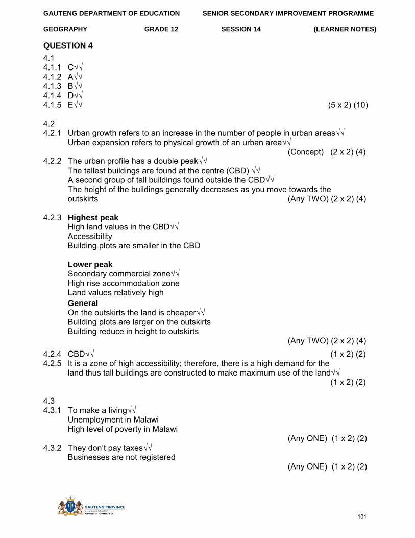
GAUTENG DEPARTMENT OF EDUCATION SENIOR SECONDARY IMPROVEMENT PROGRAMME
GEOGRAPHY GRADE 12 SESSION 14 (LEARNER NOTES)
QUESTION 4
4.1 4.1.1 C√√ 4.1.2 A√√ 4.1.3 B√√ 4.1.4 D√√ 4.1.5 E√√ (5 x 2) (10)
4.2 4.2.1 Urban growth refers to an increase in the number of people in urban areas√√
Urban expansion refers to physical growth of an urban area√√ (Concept) (2 x 2) (4)
4.2.2 The urban profile has a double peak√√ The tallest buildings are found at the centre (CBD) √√ A second group of tall buildings found outside the CBD√√ The height of the buildings generally decreases as you move towards the outskirts (Any TWO) (2 x 2) (4)
4.2.3 Highest peak High land values in the CBD√√ Accessibility Building plots are smaller in the CBD
Lower peak Secondary commercial zone√√ High rise accommodation zone Land values relatively high General On the outskirts the land is cheaper√√ Building plots are larger on the outskirts Building reduce in height to outskirts
(Any TWO) (2 x 2) (4) 4.2.4 CBD√√ (1 x 2) (2) 4.2.5 It is a zone of high accessibility; therefore, there is a high demand for the
land thus tall buildings are constructed to make maximum use of the land√√ (1 x 2) (2)
4.3 4.3.1 To make a living√√
Unemployment in Malawi High level of poverty in Malawi
(Any ONE) (1 x 2) (2) 4.3.2 They don’t pay taxes√√
Businesses are not registered (Any ONE) (1 x 2) (2)
101
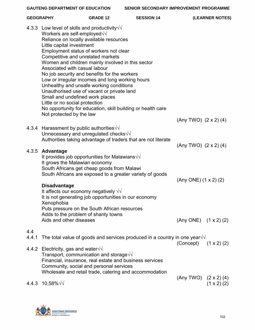
GAUTENG DEPARTMENT OF EDUCATION SENIOR SECONDARY IMPROVEMENT PROGRAMME
GEOGRAPHY GRADE 12 SESSION 14 (LEARNER NOTES)
4.3.3 Low level of skills and productivity√√ Workers are self-employed√√ Reliance on locally available resources Little capital investment Employment status of workers not clear Competitive and unrelated markets Women and children mainly involved in this sector Associated with casual labour No job security and benefits for the workers Low or irregular incomes and long working hours Unhealthy and unsafe working conditions Unauthorised use of vacant or private land Small and undefined work places Little or no social protection No opportunity for education, skill building or health care Not protected by the law
(Any TWO) (2 x 2) (4) 4.3.4 Harassment by public authorities√√
Unnecessary and unregulated checks√√ Authorities taking advantage of traders that are not literate
(Any TWO) (2 x 2) (4) 4.3.5 Advantage
It provides job opportunities for Malawians√√ It grows the Malawian economy South Africans get cheap goods from Malawi South Africans are exposed to a greater variety of goods
(Any ONE) (1 x 2) (2) Disadvantage It affects our economy negatively √√ It is not generating job opportunities in our economy Xenophobia Puts pressure on the South African resources Adds to the problem of shanty towns Aids and other diseases (Any ONE) (1 x 2) (2)
4.4 4.4.1 The total value of goods and services produced in a country in one year√√
(Concept) (1 x 2) (2) 4.4.2 Electricity, gas and water√√
Transport, communication and storage√√ Financial, insurance, real estate and business services Community, social and personal services Wholesale and retail trade, catering and accommodation
(Any TWO) (2 x 2) (4) 4.4.3 10,58%√√ (1 x 2) (2)
102
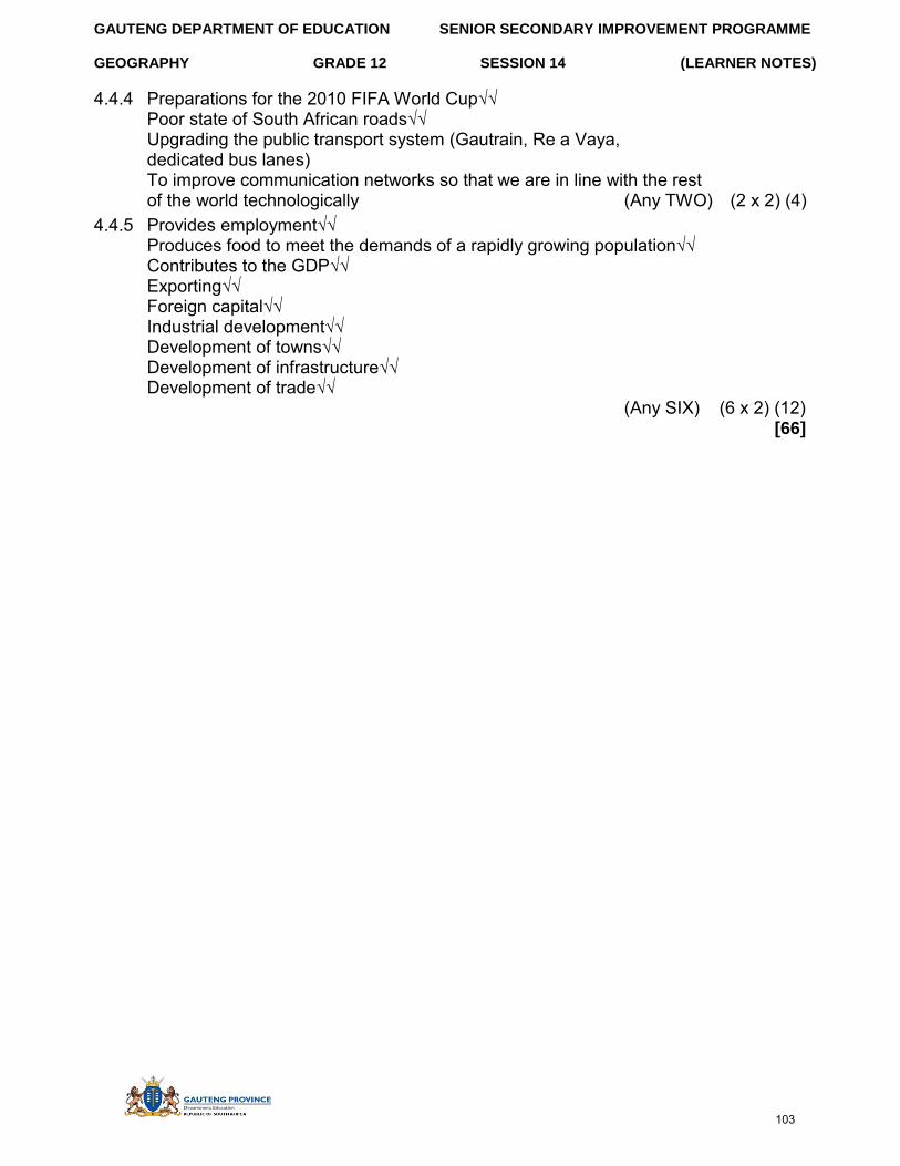
GAUTENG DEPARTMENT OF EDUCATION SENIOR SECONDARY IMPROVEMENT PROGRAMME
GEOGRAPHY GRADE 12 SESSION 14 (LEARNER NOTES)
4.4.4 Preparations for the 2010 FIFA World Cup√√ Poor state of South African roads√√Upgrading the public transport system (Gautrain, Re a Vaya, dedicated bus lanes) To improve communication networks so that we are in line with the rest of the world technologically (Any TWO) (2 x 2) (4)
4.4.5 Provides employment√√ Produces food to meet the demands of a rapidly growing population√√Contributes to the GDP√√Exporting√√Foreign capital√√Industrial development√√Development of towns√√Development of infrastructure√√Development of trade√√
(Any SIX) (6 x 2) (12) [66]
103
GAUTENG DEPARTMENT OF EDUCATION
GEOGRAPHY GRADE 12
SENIOR SECONDARY IMPROVEMENT PROGRAMME
SESSION 15 (LEARNER NOTES)
SESSION 15.1
TOPIC: CONSOLIDATION – EXAMINATION PAPER 2: MAPWORK
RESOURCES: ANNEXURE A AND ANNEXURE B ON PAGES 72 & 73
1. An extract from the topographical map 3322CD & 3422AB GEORGE2. An extract of an orthophoto George
Instructions: Answer all the questions in the spaces provided on this question paper.
The following English terms and their Afrikaans translations are shown on the 1:50 000 topographical map.
ENGLISH AFRIKAANS
Aerodrome Vliegveld Canal Kanaal Cemetry Begrafplaas College Kollege Crocodile Ranch Krokodilplaas Factory Fabriek Furrow Voor Game Park Wildpark Golf Course Gholfbaan Rifle Range Skietbaan Sewage Disposal Works Rioolslykwerke Showgrounds Skougronde Tourist Camp Toeristekamp Weir Dwarswal
Learner Note: The session consists of questions from Paper 2. Please remember that in the examination you are required to answer ALL the questions on the question paper. It is very important that you ensure that your name and exam number is clearly indicated on the question paper. Please note that for this session there are three questions. They do not add up to a 100 marks as would be the case in the examination. Read the questions carefully and number correctly. Do not leave out any questions, and attempt all, especially the multiple-choice ones.
SECTION A: TYPICAL EXAM QUESTIONS
104
GAUTENG DEPARTMENT OF EDUCATION SENIOR SECONDARY IMPROVEMENT PROGRAMME
GEOGRAPHY GRADE 12 SESSION 15 (LEARNER NOTES)
QUESTION 1: MULTIPLE CHOICE 10 minutes (Source: DoE March 2011)
Choose the correct answer and write in into the block provided.
1.1 George is a… A city B residential area C town D farm area
1.2 The direction from Camphers Drift to George is… A south-east B south C south-west D north
1.3 The landform in the vicinity of F on the topographical map is a…. A gorge B saddle C valley D spur
1.4 The Gwaing River is an example of a ……river. A perennial B non-perennial C periodic D episodic
1.5 The location of the George station (B3). A 33°57’55” E; 22° 28’ 05” S B 33° 56’ 48” S; 22° 25’ 05”E C 33°57’ 55”S; 22° 28’ 05”E D 22° 57’ 55”S; 33°28’05”E
1.6 The area labelled C on the orthophomap is….. A CBD B residential C greenbelt D industry
1.7 The land in along the N9 is descending in a……. direction. A north-west to south-east B south to north C north-east to north-west D south-west
105
GAUTENG DEPARTMENT OF EDUCATION SENIOR SECONDARY IMPROVEMENT PROGRAMME
GEOGRAPHY GRADE 12 SESSION 15 (LEARNER NOTES)
1.8 Calculate the distance along the railway line from the station at George to Gwaing station (E1). Give your answer in km ….
A 690 km B 0,69km C 6,9 km D 69,0km
1.9 Identify land use at G on the orthophoto map. A Industry B School C Recreational facility D Dam
1.10 What type of rainfall does the mapped area receive? A periodical B throughout the year C seasonal D sporadic
(10 x 2) [20]
QUESTION 2: 20 minutes (Source: Exam Success Grade 12, X-Kit grade 12)
2.1 Calculate the area of the marked section on the orthophoto map. Give your answer in km². (4)
2.2 Calculate the average gradient of ∆123 (A1) to the dam at Z (C1). (4)
2.3 Draw a cross-section from •212 (C1) to •196 (E2). Use a vertical scale of 5mm = 20m. On your cross-section label the N2 and the Camfersdrift River. (8)
2.4 Calculate the vertical exaggeration of the cross-section. (4) [20]
QUESTION 3: 30 minutes (Source: Exam Success Grade 12, X-Kit grade 12)
3.1 In which direction is the Gwaing River flowing? Provide a reason for your answer. (2 x 2) (4)
3.2 Comment on the impact of the Gwaing River on the land uses on either side of it. (3 x 2) (6)
3.3 Give evidence from the map that George receives rain throughout the year. (2 x 2) (4)
3.4 If the prevailing wind is north-west, name two residential suburbs that will be subjected to pollution from the factories at George Industria. (2 x 2) (4)
3.5 Locate the Skaapkop River in E4 and F4 and identify the drainage pattern in this area. (1 x 2) (2)
106
GAUTENG DEPARTMENT OF EDUCATION
GEOGRAPHY GRADE 12
SENIOR SECONDARY IMPROVEMENT PROGRAMME
SESSION 15 (LEARNER NOTES)
3.6 The river is nearing the ocean, yet the river course does not have lower course characteristics.
3.6.1 Describe the river course as it appears on the map. (2 x 2) (4) 3.6.2 Explain why the river course appears this way? (2 x 2) (4)
3.7 Locate the farm Die Bof (F2). 3.7.1 Identify this settlement pattern. (1 x 2) (2) 3.7.2 What evidence supports that this is a commercial farmer? (3 x 2) (6)
3.8 Heavy industries are situated at D in George. Give TWO reasons which make this site suitable for industry. (2 x 2) (4)
[40]
QUESTION 1: CALCULATION 4 minutes
(Source: Exam Success Grade 12, X-Kit grade 12)
1.1 Calculate the current Magnetic bearing for •212 (C1) from •196 (E1). [8]
QUESTION 2: GIS 30 minutes (Source:DoE various papers)
2.1 Define the following concepts:
2.1.1 Satellite remote sensing (1 x 2) (2)
2.1.2 Satellite data (1 x 2) (2)
2.2 State any TWO ways in which geographical information can be obtained. (2 x 2) (4)
2.3 Differentiate between spatial and attribute data. (2 x 2) (4)
2.4 Name THREE attributes in the map overlay shown on the following page:
SECTION B: HOMEWORK
107
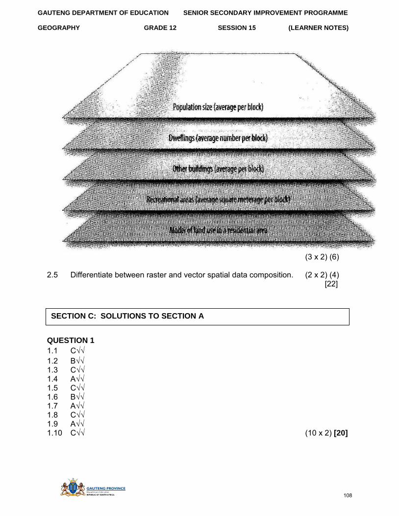
GAUTENG DEPARTMENT OF EDUCATION SENIOR SECONDARY IMPROVEMENT PROGRAMME
GEOGRAPHY GRADE 12 SESSION 15 (LEARNER NOTES)
(3 x 2) (6)
2.5 Differentiate between raster and vector spatial data composition. (2 x 2) (4) [22]
QUESTION 1
1.1 C√√ 1.2 B√√ 1.3 C√√ 1.4 A√√ 1.5 C√√ 1.6 B√√ 1.7 A√√ 1.8 C√√ 1.9 A√√ 1.10 C√√ (10 x 2) [20]
SECTION C: SOLUTIONS TO SECTION A
108
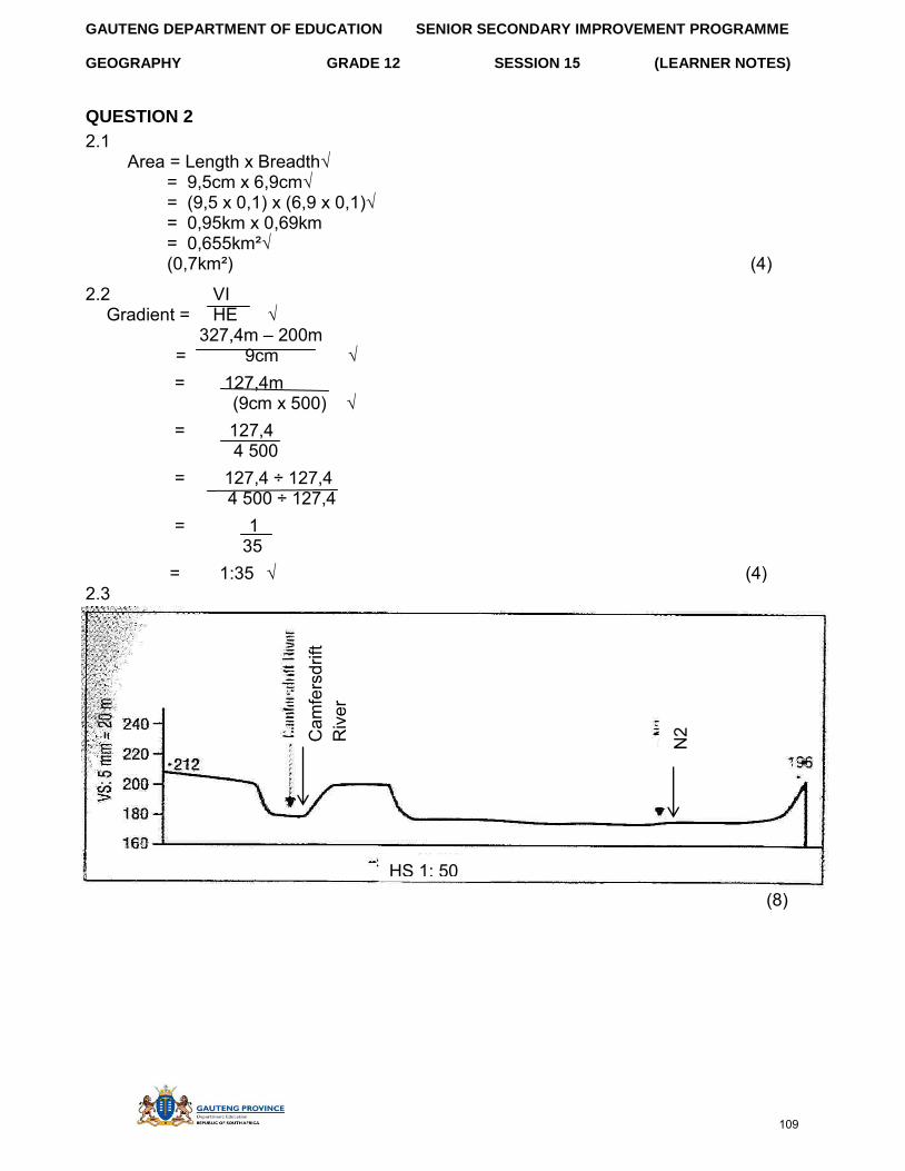
GAUTENG DEPARTMENT OF EDUCATION SENIOR SECONDARY IMPROVEMENT PROGRAMME
GEOGRAPHY GRADE 12 SESSION 15 (LEARNER NOTES)
QUESTION 2
2.1 Area = Length x Breadth√
= 9,5cm x 6,9cm√ = (9,5 x 0,1) x (6,9 x 0,1)√ = 0,95km x 0,69km = 0,655km²√ (0,7km²) (4)
2.2 VI Gradient = HE √
327,4m – 200m = 9cm √
= 127,4m (9cm x 500) √
= 127,4 4 500
= 127,4 ÷ 127,4 4 500 ÷ 127,4
= 1 35
= 1:35 √ (4) 2.3
(8) HS 1: 50000
N2 Cam
fers
drift
R
iver
109
GAUTENG DEPARTMENT OF EDUCATION SENIOR SECONDARY IMPROVEMENT PROGRAMME
GEOGRAPHY GRADE 12 SESSION 15 (LEARNER NOTES)
2.4 VS √ VE = HS 5mm = 20m
1mm = 4m √ = 5mm = 20m 1: 4 000
1: 50 000 √ = 1 x 50 000
4 000 1 = 12,5 times √ (4)
[20]
QUESTION 3
3.1 South East.√√ River flows from high land to lower land, towards the sea. √√ (2 x 2) (4)
3.2 Water used for extensive agriculture (cultivated land) √√ Water used for recreation (Fancourt Golf Course) √√ Water used for sewage works√√ (3 x 2) (6)
3.3 Perennial rivers √√, forests√√, very few dams for storage√√, near coast – receives moisture-bearing onshore winds. (2 x 2) (4)
3.4 Borchards√√ Conville√√ Thembalethu (2 x 2) (4)
3.5 Trellis√√ (1 x 2) (2)
3.6 3.6.1 The river course is narrow√√ with steep valley sides√√ . (2 x 2) (4) 3.6.2 The river shows characteristics of incised features√√, which
indicate the possibility of uplift and rejuvenation√√ (2 x 2) (4)
3.7 3.7.1 Dispersed√√ (1 x 2) (2) 3.7.2 Infrastructure such as roads√√ and dams√√, land under cultivation√√
(3 x 2) (6) 3.8 The site is near the railway line√√, away from the town√√, on flat land,
near a water supply and has space to expand. (2 x 2) (4) [40]
110
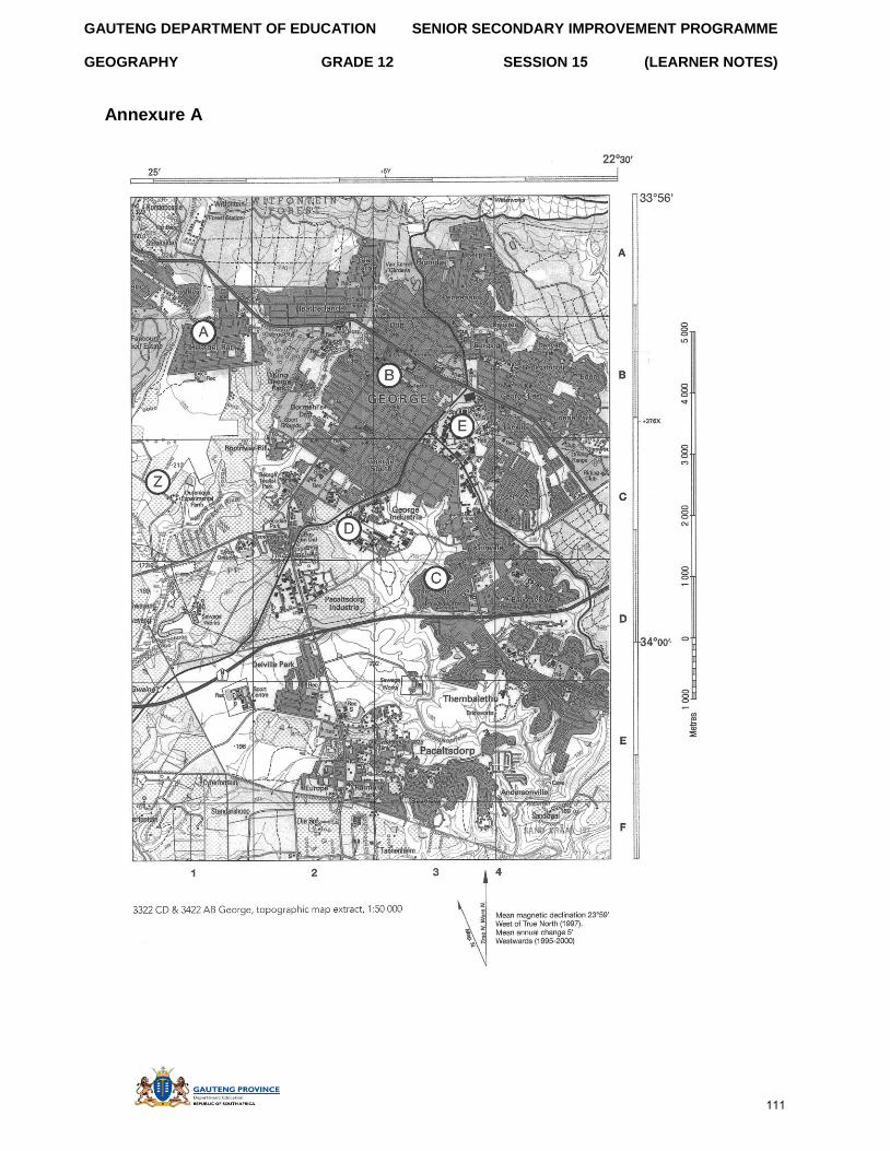
GAUTENG DEPARTMENT OF EDUCATION
GEOGRAPHY GRADE 12
SENIOR SECONDARY IMPROVEMENT PROGRAMME
SESSION 15 (LEARNER NOTES)
Annexure A
111
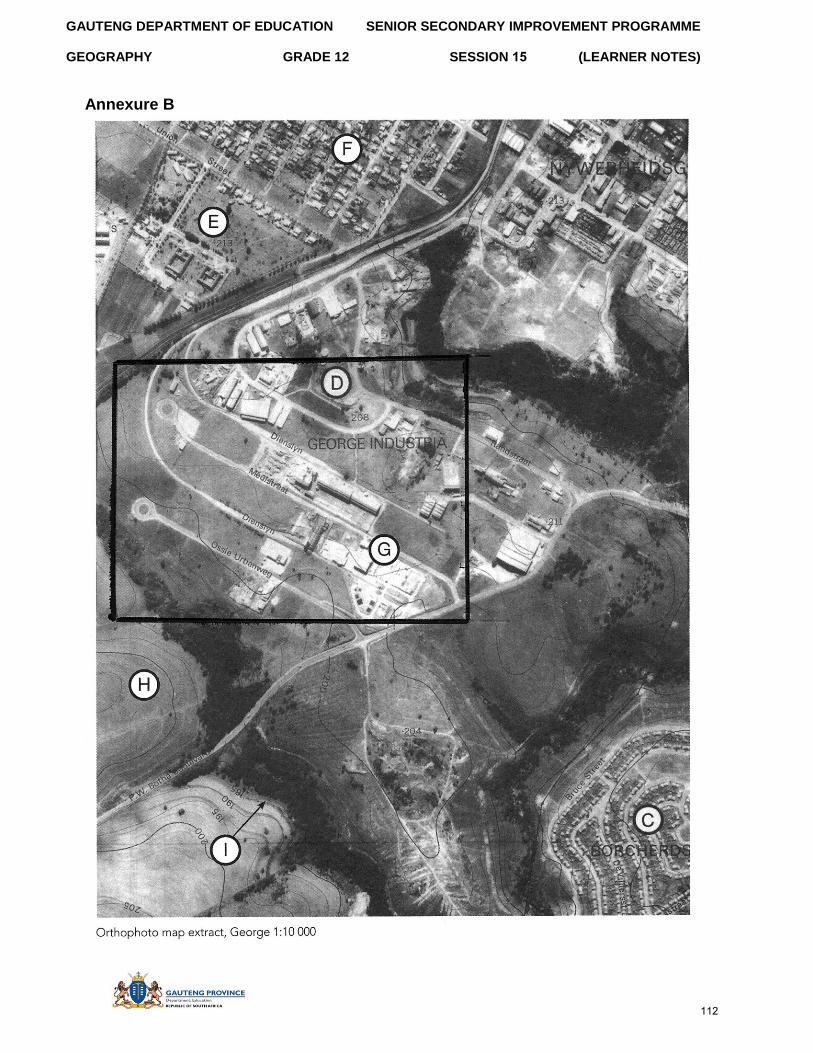
GAUTENG DEPARTMENT OF EDUCATION
GEOGRAPHY GRADE 12
SENIOR SECONDARY IMPROVEMENT PROGRAMME
SESSION 15 (LEARNER NOTES)
Annexure B
112
GAUTENG DEPARTMENT OF EDUCATION
GEOGRAPHY GRADE 12
SENIOR SECONDARY IMPROVEMENT PROGRAMME
SESSION 15 (LEARNER NOTES)
SESSION 15.2
TOPIC: CONSOLIDATION – EXAMINATION PAPER 2: MAPWORK (2)
RESOURCES: ANNEXURE A AND ANNEXURE B ON PAGES 82 & 83
1. An extract from the topographical map 3227CD King William’s Town2. An extract of an orthophoto King William’s Town
Instructions: Answer all the questions in the spaces provided on this question paper.
The following English terms and their Afrikaans translations are shown on the 1:50 000 topographical map.
ENGLISH AFRIKAANS
Aerodrome Vliegveld Canal Kanaal Cemetery Begrafplaas College Kollege Factory Fabriek Furrow Voor Golf Course Gholfbaan Rifle Range Skietbaan Sewage Disposal Works Rioolslykwerke Showgrounds Skougronde Weir Dwarswal
Learner Note: The session consists of questions from Paper 2. Please remember that in the examination you are required to answer ALL the questions on the question paper. It is very important that you ensure that your name and exam number is clearly indicated on the question paper. Please note that for this session there are three questions. They do not add up to a 100 marks as would be the case in the examination. Read the questions carefully and number correctly. Please attempt all the questions, especially the multiple-choice ones.
SECTION A: TYPICAL EXAM QUESTIONS
113
GAUTENG DEPARTMENT OF EDUCATION SENIOR SECONDARY IMPROVEMENT PROGRAMME
GEOGRAPHY GRADE 12 SESSION 15 (LEARNER NOTES)
QUESTION 1: 10 minutes (Source: Exam success: Geography grade 12)
1.1 Determine the compass direction from King William’s Town to Bisho A SW B NW C NE D E
1.2 Calculate the true bearing from Reservoir Hill (C5) to Breidbach(D8). A 102° B 244° C 56° D 116°
1.3 Name the map sheet NW of the map 3227 CD King William’s Town. A 3227CA B 3227DA C 3327CA D 2733DA
1.4 Find the co-ordinates of Jan Tshatshu Dam (F8). A 27°55’30”S 32°55’15”E B 32°55’30”S 27°55’15”E C 27°56’36”S 32°54’12”E D 32°55’12”S 27°54’24”E
1.5 Name the land use located at grid reference 32°54’45”S 27°23’45”E. A Cultivated land B Recreation C Show grounds D Orchards
1.6 Calculate the area of block E6 on the King William’s Town topographical map. A 2 900km² B 290km² C 2,9km² D 0,29km²
1.7 Identify the feature marked A on the orthophoto map. A Ridge B Saddle C Poort D Valley
114
GAUTENG DEPARTMENT OF EDUCATION
GEOGRAPHY GRADE 12
SENIOR SECONDARY IMPROVEMENT PROGRAMME
SESSION 15 (LEARNER NOTES)
1.8 Identify the land use at B on the orthophoto map. A Recreation B Cemetery C School D Factory
1.9 The word scale of the orthophoto map is… A 1cm represents 0,01km B 1cm represents 0,1km C 1cm represents 1 000km D 1cm represents 10m
1.10 Calculate the straight line distance from the golf course (A6) to the first road to eBhalasi (A7), along the main road. A 0,5km B 5km C 1km D 50km (5 x 2) [10]
QUESTION 2: 20 minutes
(Source: Exam Success Grade 12, X-Kit grade 12, Exam success: Geography grade 12)
2.1 Calculate the curved distance (in km) from Belstone Station (D6) to Plumbago Station (C7), along the railway line. (3)
2.2 Calculate the gradient of •473 (A4) to •453 (C7). (4)
2.2 Calculate the magnetic bearing from •473 (A4) to •453 (C7). Make use of the magnetic declination below to do the calculation.
TN MN Mean magnetic declination 19°36’ West of True North (July 1997). Mean
annual change 6’Eastwards (1996-2000).
(8)
2.4 If a cross-section had to be drawn, the vertical scale would have been 1cm=20m. Keeping this in mind, calculate the vertical exaggeration of the cross-section. (4)
[19]
115
GAUTENG DEPARTMENT OF EDUCATION SENIOR SECONDARY IMPROVEMENT PROGRAMME
GEOGRAPHY GRADE 12 SESSION 15 (LEARNER NOTES)
QUESTION 3: 30 minutes (Source: Exam Success Grade 12, X-Kit grade 12)
3.1 What TWO physical factors have influenced the site and situation of King William’s Town? (2 x 2) (4)
3.2 Name TWO types of communication networks that make this an accessible area. (2 x 2) (4)
3.3 Identify TWO urban land-use zones in Block C5. (2 x 2) (4) 3.4 Which TWO factors have favoured the site and situation of the
Schornville industrial area (D4-D5)? (2 x 2) (4) 3.5 Is there sufficient labour supply for this industrial area? Provide map
evidence to justify your answer. (2 x 2) (4) 3.6 Name TWO high-order functions in King William’s Town and its
surrounding area. (2 x 2) (4) 3.7 Name TWO tourist attractions of King William’s Town and its
surrounding area. (2 x 2) (4) 3.8 Provide map evidence to show that the inhabitants of King William’s
Town practise environmental conservation. (1 x 2) (2)
3.9.1 Name the type of primary activity that takes place at A. (1 x 2) (2) 3.9.2 What physical factor has influenced the site and situation of this
primary activity? (1 x 2) (2) 3.9.3 Is this primary activity for commercial or subsistence use? Provide
a reason for your answer. (2 x 2) (4)
3.10 What is the type of settlement pattern of Phakamisa and its surrounding area? (1 x 2) (2)
[40]
116
GAUTENG DEPARTMENT OF EDUCATION SENIOR SECONDARY IMPROVEMENT PROGRAMME
GEOGRAPHY GRADE 12 SESSION 15 (LEARNER NOTES)
QUESTION 1: 16 minutes (Source: Exam Success Grade 12, X-Kit grade 12)
1.1 Choose the term from COLUMN B that matches a description in COLUMN A. Write only the letter (A –E) next to the question number (4.1.1 – 4.1.3), for example 4.1.4 F.
COLUMN A COLUMN B
1.1.1 The raw facts that are collected about a feature
1.1.2 Gathering of data about the earth from a distance, using
satellites such as Landsat 1.1.3 Data represented by pixels in the
form of grid cells or pixels
A raster data
B vector data
C remote sensing
D data base
E data (3 x 2) (6)
1.2 Name any TWO functional elements of GIS. (2 x 2) (4)
1.3 With reference to the term buffering: 1.3.1 Define the term buffering: (1 x 2) (2) 1.3.2 Explain how buffering can be used to protect the Yellowwoods Falls
area on the topographical map. (1 x 2) (2)
1.4 Which ONE, the topographical map or the orthophoto map, is an example of vector data? (1 x 2) (2)
1.5 The police have not been able to track a car hijacking gang in the greater King William’s Town area. How can they use GIS to narrow their search? (2 x 2) (4)
[20]
QUESTION 2: 35 minutes (Source: Exam Success Grade 12, X-Kit grade 12)
(GENERAL QUESTIONS ON MAP PROJECTIONS AND GIS)
2.1 What is the difference between the Mercator’s Cylindrical Projection and the Transverse Mercator Projection (Gauss Conformal)? (1 x 2) (2)
2.2 State TWO advantages of Mercator’s Cylindrical Projection. (2 x 2) (4) 2.3 The accompanying diagram on the following page shows areas of a
wetland that are vulnerable to pollution.
SECTION B: HOMEWORK
117
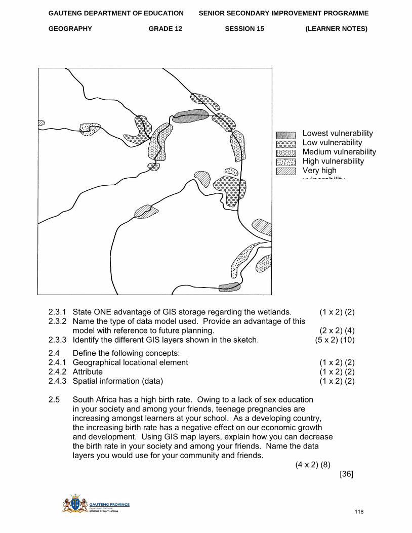
GAUTENG DEPARTMENT OF EDUCATION SENIOR SECONDARY IMPROVEMENT PROGRAMME
GEOGRAPHY GRADE 12 SESSION 15 (LEARNER NOTES)
2.3.1 State ONE advantage of GIS storage regarding the wetlands. (1 x 2) (2) 2.3.2 Name the type of data model used. Provide an advantage of this
model with reference to future planning. (2 x 2) (4) 2.3.3 Identify the different GIS layers shown in the sketch. (5 x 2) (10) 2.4 Define the following concepts: 2.4.1 Geographical locational element (1 x 2) (2) 2.4.2 Attribute (1 x 2) (2) 2.4.3 Spatial information (data) (1 x 2) (2)
2.5 South Africa has a high birth rate. Owing to a lack of sex education in your society and among your friends, teenage pregnancies are increasing amongst learners at your school. As a developing country, the increasing birth rate has a negative effect on our economic growth and development. Using GIS map layers, explain how you can decrease the birth rate in your society and among your friends. Name the data layers you would use for your community and friends.
(4 x 2) (8) [36]
Lowest vulnerability Low vulnerability Medium vulnerability High vulnerability Very high vulnerability
118
GAUTENG DEPARTMENT OF EDUCATION SENIOR SECONDARY IMPROVEMENT PROGRAMME
GEOGRAPHY GRADE 12 SESSION 15 (LEARNER NOTES)
QUESTION 1: MULTIPLE-CHOICE
1.1 C√√ 1.2 D√√ 1.3 A√√ 1.4 B√√ 1.5 A√√ 1.6 C√√ 1.7 A√√ 1.8 B√√ 1.9 B√√ 1.10 A√√ (5 x 2) [10]
QUESTION 2 2.1
Distance on the map = 6cm√ Scale of the map 1:50 000 Distance = 6cm x 0,5√
= 3km√ (3)
2.2 VI G = HE
= 473 – 453 12,4cm x 500 12,4cm√ 6 200m √
= 20 ÷ 20 6 200 ÷ 20 √
= 1: 310 √ (4)
2.3 MB = TB + MD TB = 122° √ = 122° + 18°12’ √ MD in 1997 = 19°36’W of TN√ = 140°12’ √ Annual change = 6’E
Difference in years = 2011 - 1997 = 14years√
Change in MD = 14x6’ = 84’E√ = 1°24’E
MD in 2011 = 19°36’ – 1° 24’√ = 18°12’√ W of TN
(8)
SECTION C: SOLUTIONS TO SECTION A
119
GAUTENG DEPARTMENT OF EDUCATION SENIOR SECONDARY IMPROVEMENT PROGRAMME
GEOGRAPHY GRADE 12 SESSION 15 (LEARNER NOTES)
VS 2.4 VE = HS
= 1cm = 20m 1cm = 20 x 100 1 : 50 000 √ = 2000cm√
= 1 x 50 000 √ 2 000 1
= 25 times√ (4) [19]
QUESTION 3
3.1 Gradual land√√ Buffalo River√√ (2 x 2) (4)
3.2 (Any two) Roads√√ railways √√ power lines (2 x 2) (4)
3.3 Residential area √√ Recreational area√√ (2 x 2) (4) 3.4 (Any two)
Accessible transport and communication networks√√, close to water resource (Buffalo River) √√, situated on gradual land, large open area for factories. (2 x 2) (4)
3.5 Yes√√ close to residential areas for labour resource√√ (2 x 2) (4) 3.6 (Any two)
Fort Hare University√√ hospitals / clinics√√ recreational activities, e.g. golf course, show grounds (2 x 2) (4)
3.7 (Any two) House of Steven Bantu Biko 1997√√ Presidential residence√√ Yellowwoods Falls (2 x 2) (4)
3.8 Protected areas (woodland) (1 x 2) (2) 3.9 3.9.1 Farming√√ (1 x 2) (2) 3.9.2 Gradual land√√, large open area, close to Buffalo River for irrigation (1 x 2) (2) 3.9.3 Commercial farming√√ large farming area√√ close to transport routes
Extensive cultural land, (intensive farming, specialists) close to settlements for easy access to workers. (2 x 2) (4)
3.10 Nucleated settlement pattern√√ (1 x 2) (2) [40]
120
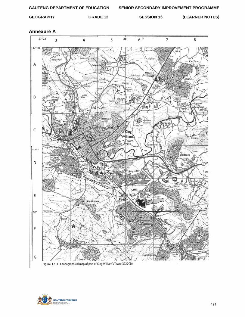
GAUTENG DEPARTMENT OF EDUCATION
GEOGRAPHY GRADE 12
SENIOR SECONDARY IMPROVEMENT PROGRAMME
SESSION 15 (LEARNER NOTES)
Annexure A
121
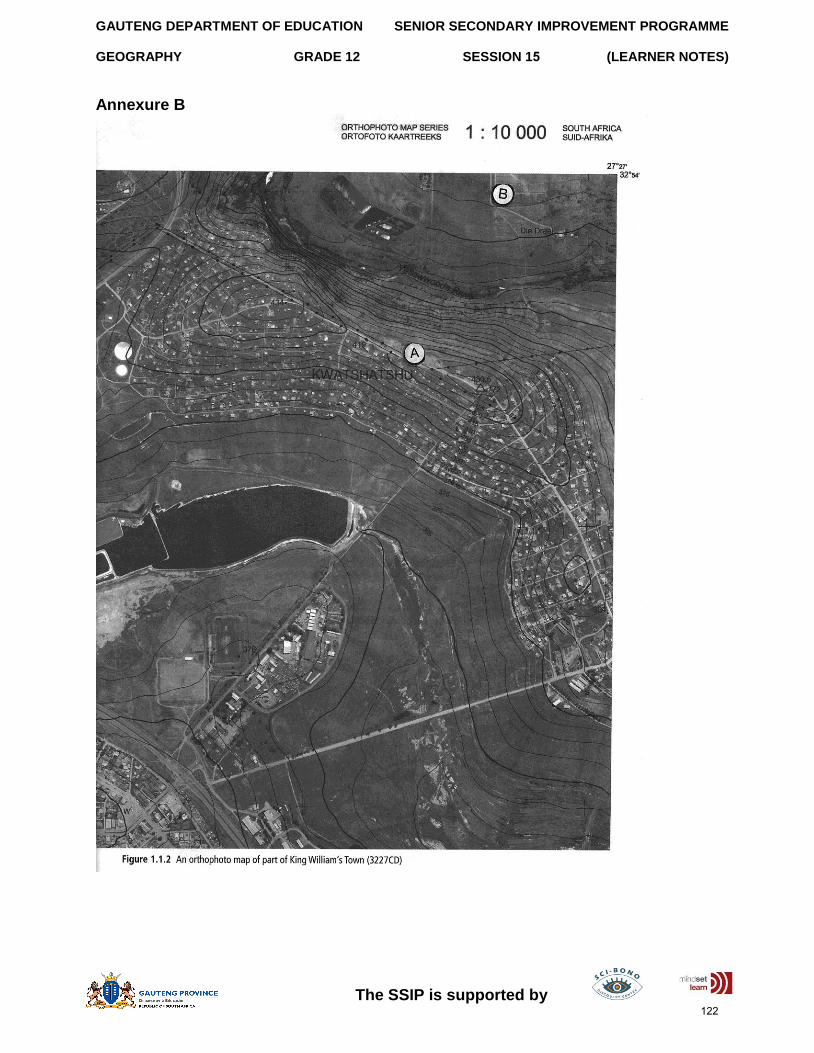
GAUTENG DEPARTMENT OF EDUCATION
GEOGRAPHY GRADE 12
SENIOR SECONDARY IMPROVEMENT PROGRAMME
SESSION 15 (LEARNER NOTES)
The SSIP is supported by
Annexure B
122
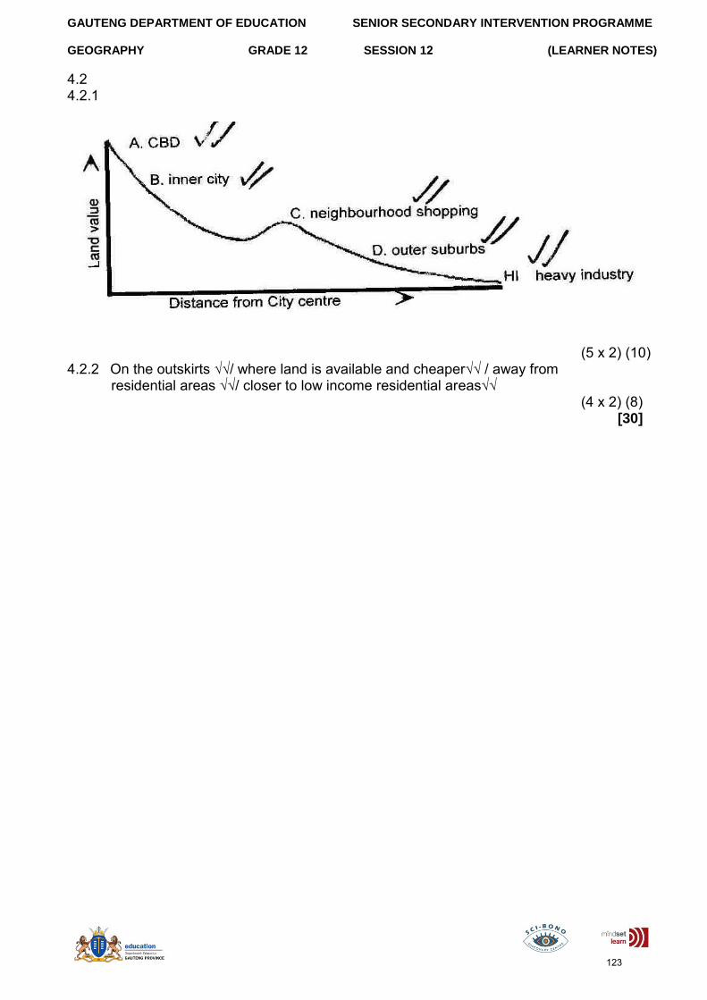
GAUTENG DEPARTMENT OF EDUCATION SENIOR SECONDARY INTERVENTION PROGRAMME
GEOGRAPHY GRADE 12 SESSION 12 (LEARNER NOTES)
4.2 4.2.1
(5 x 2) (10) 4.2.2 On the outskirts √√/ where land is available and cheaper√√ / away from
residential areas √√/ closer to low income residential areas√√ (4 x 2) (8)
[30]
123


