vol. 12, 1/2012 BDC Bollettino del Dipartimento di Conservazione dei Beni Architettonici ed Ambientali Università degli Studi di Napoli “Federico II” Direttore responsabile Luigi Fusco Girard Comitato scientifico Francesco Bruno Mario Coletta Teresa Colletta Francesco Forte Rosa Anna Genovese Luigi Fusco Girard Lucio Morrica Segreteria di redazione Maria Cerreta Gianluigi De Martino Pasquale De Toro Francesca Ferretti Redazione via Roma, 402 80132 Napoli tel. 081 2538650 fax 081 2538649 aut. trib. n. 5144 del 6.9.2000 ISSN 1121-2918
Transcript
1
vol. 12, 1/2012
BDCBollettino del Dipartimento di Conservazione dei BeniArchitettonici ed Ambientali
presso le Officine Grafiche Francesco Giannini e Figli S.p.A.
Bollettino del Dipartimento di Conservazione dei Beni Architettonici ed Ambientali 3
vol. 12, 1/2012
SECTION AUrban Design and Creative Architecture in Port Areas
EditorialLuigi Fusco Girard
The urban futureLuigi Fusco Girard
Port cities: capitalizing on re-development with examples from Baltimore, Bilbao and LiverpoolNicholas You, Sjoerd Louwaars
Hafencity Hamburg and further waterfront transformations in European seaport cities: from project-based strategies to sustainable redevelopment solutionsDirk Schubert
Teamwork: why metropolitan economic strategy is the key to generating sustainable prosperity and quality of life for the worldMarc A. Weiss
A research and policy development agenda: fostering creative, equitable, and sustainable port citiesJoe Ravetz, Luigi Fusco Girard, Lisa Bornstein
Introduction to Section APasquale Miano
The Port of Naples and the perspectives of a dialogue between conservation and regenerationPasquale Miano, Valentina Russo
Geography and architecture of the infrastructure of the portLilia Pagano
17
19
35
43
55
67
72
75
93
vol. 12, 1/2012
Bollettino del Dipartimento di Conservazione dei Beni Architettonici ed Ambientali4
Venice urban renaissancePaolo Viola, Andrea Silipo, Davide Viganò
Napoli WaterCity. Metaphors and landscape networks visualize projects of the contemporary cityAnna Terracciano
The city of Naples: resilience and environmental sustainabilityMaria Gabriella Errico
The interface between port and city: integrative characters for the transformation areasFilomena Cicala
Guidelines for the preparation of the Port Development Plan of Corigliano CalabroSalvatore Graziano
Strategies to patch together urban fragments of an industrial pastLibera Amenta
Seaside-Cities: landscape representations as figures of contemporary identity – The conflict between global and local – Giovanni Auriemma
Renovation of Castellammare di Stabia’s urban port areasAlessandro Sgobbo
Planning in time of crises, Naples/Istanbul one-wayMaria Luna Nobile
From the gasholder to the port. A regeneration of eastern area of NaplesMarina Di Iorio
Bollettino del Dipartimento di Conservazione dei Beni Architettonici ed Ambientali 5
vol. 12, 1/2012
SECTION BUrban Planning and Sustainable Development
Waterfront and city: redevelopment and urban qualityEleonora Giovene di Girasole
Municipio Square - Naples: A Siza and E. Souto de Moura projectBruna Di Palma
Hybrid spacefront. An industrial building as threshold between water and the cityFrancesca Avitabile
Modern ruins on the water’s edge: from the old harbour heritage towards new urban-port landscapesGiorgia Aquilar
From limit to centrality. Regeneration of Genoa’s port area through architectural and urban designPasquale Mei, Elena Fontanella
Beetween city and port. Elements of a border spaceClaudio Finaldi Russo
Urban waterfront regeneration processes. An integrated local approach for the marine protected area “Parco sommerso di Gaiola” in NaplesCarolina Girardi, Maurizio Simeone
Introduction to Section BFrancesco Domenico Moccia
Port operations and displacement vs. urban redevelopment of port areas. There could be an alternative model of waterfront redevelopment for small, medium port city based on port operations?Francesco Domenico Moccia
A smart policy to open the seaport to the cityFrancesco Ceci, Daniela Lepore
Safer public spaces in Naples as a port cityAntonio Acierno
201
208
220
231
241
252
262
273
277
289
297
vol. 12, 1/2012
Bollettino del Dipartimento di Conservazione dei Beni Architettonici ed Ambientali6
Environmental assessment in port areas: values, approaches, experiencesMaria Cerreta, Pasquale De Toro
A bottom-up approach to urban waterfront regeneration: a proposal for the city of PorticiPasquale De Toro, Carmine Buonocore, Alfredo Franciosa
Any port in the perfect storm: port cities and 21st century challengesGlen David Kuecker
The drivers for port city sustainable development: what triggers these and what changes does the current economic climate facilitate?Helen Meikle, Murray Herron
Which shadow in the ‘cities of sun’? The social division of space in the cities of the SouthGiovanni Laino
Restoring the sense of place. Local development and cultural production in east Naples waterfrontGilda Berruti
Achieving sustainability in waterfront renewal: creativity, innovation and quality of livingAssunta Martone, Marichela Sepe
The opportunity of the new waterfront and a tourist port for the territories. The case of Bagnoli-CoroglioEmanuela Coppola
Barcelona: from river to riverChiara Ingrosso
Aquatecture and Aquapuncture – Recreating and remediating lively water-cities upstream-downstream, from micro- to macro-watershedsGrit Bürgow
310
318
328
334
343
357
367
379
389
397
Bollettino del Dipartimento di Conservazione dei Beni Architettonici ed Ambientali 7
vol. 12, 1/2012
SECTION CSustainable Technologies for Harbour Architecture
Building the Lagoon City: from Venice to the lagoon, from the lagoon to VeniceDaniele Cannatella, Sabrina Sposito
Sustainability and democracy in spatial planning: the case of the Italian port city of BrindisiRaffaele Attardi, Carmelo M. Torre
Introduction to Section CMario LosassoRiccardo Florio
Regeneration and sustainable development of the east coast of NaplesValeria Pezza, Camillo Orfeo
Granatello Harbour and coastline redevelopment in Portici, NaplesValeria Pezza, Renato Capozzi
Eenhancement and sustainable rehabilitation processes for Meta waterfrontAntonella Falotico
Naples coastline regeneration – Technical control toolsMariangela Bellomo
Sustainable actions on sensitive contexts of Naples waterfrontsAlessandro Claudi de Saint Mihiel
Port cities as hotspots of creative and sustainable local developmentGiuliana Gritti
From Godown to Downtown: the evolution of Singapore’s port-related building stockIris Belle, Uta Hassler, Wiepke van Aaken
The drawings of the soil. Allographies of a denied report, between permanencies and overlapping of settlements tracesTeresa Della Corte
409
417
432
435
447
467
477
484
493
500
508
renatocartesio
Highlight
vol. 12, 1/2012
Bollettino del Dipartimento di Conservazione dei Beni Architettonici ed Ambientali8
SECTION DCultural Heritage Regeneration
Sustainable urban regeneration of Västra Hamnen port area in MalmöValeria D’Ambrosio
Living and working on waterMaria Lisa De Cristofaro, Holger König, Peter Thomas
Renovating harbour in the Mediterranean city: the case of the Saint Vincent’s pier in NaplesDora Francese, Cristian Filagrossi Ambrosino
Introduction to Section DAldo Aveta
Port cities and UNESCO World HeritageRosa Anna Genovese
Naples and its port area from Middle Ages to XX Century: strategies for an integrationGiovanni Menna
Environmental green and historic gardens: nature of the unbuilt in NaplesClaudia Aveta
From the Hafencity Hamburg to the urban park of Bagnoli (Naples): port development through the industrial heritage renovation and preservationMaria Falcone
The construction of the port of Capri: the foundations of the island’s economic developmentLuigi Veronese
The Historic Urban Landscape approach in the Management Plan for the historic center of NaplesBarbara Del Prete
Historic Urban Landscape and conservation. opportunities and boundaries of a notion for the historic townBianca Gioia Marino
513
519
525
536
540
553
570
577
585
593
600
Bollettino del Dipartimento di Conservazione dei Beni Architettonici ed Ambientali 9
vol. 12, 1/2012
SECTION ERecovery, Maintenance, Management of Coastal/Urban Areas: Innovative Tools for Decision Making
The development of portual city between old and new portual architecture. The old port and the new port of Marina d’Arechi in SalernoMariarosaria Villani
Archaeological sites: specificity of Neapolitan “Historical Urban Landscape”Marida Salvatori
The “color” of the Historic Urban LandscapeRaffaele Amore
The urban regeneration and the relation between monument/habitat: the case of Filangieri Museum in NaplesPaola Brancaccio, Piera Della Morte, Laura Grazia Mariniello
Merging ELC and HUL recommendation: toward a toolbox to foster heritage values in a global sustainable urban contextAlessio D’Auria
Introduction to Section ELuigi Fusco Girard
Port-city areas, looking to the futureFrancesco Forte
Strategies of local development and strategies of sustainability: the economic policies for urban regenerationGiordano Buono Andrea
A multicriteria decision making method for sustainable developmentBice Cavallo, Livia D’Apuzzo
Process and tools for identifying and evaluation of the strategies for the port area of city of Rijeka, CroatiaIva Mrak
The city of Montreal’s public consultation office: the case of an interior port redevelopment projectCatherine Vandermeulen, Lisa Bornstein
608
615
623
628
636
642
644
664
670
678
694
vol. 12, 1/2012
Bollettino del Dipartimento di Conservazione dei Beni Architettonici ed Ambientali10
Anchoring the creativity of port cities: inclusion of diverse stakeholders in the redevelopment of urban districtsLisa Bornstein, Krista Leetmaa
Information and creativity of the Port City Plan: a GIS-based assessment model for Catania’s harbor areaSalvatore Giuffrida, Filippo Gagliano
Renewal and conservation of the historic water front: analysis, evaluation and project in the grand harbor area of SyracuseSalvatore Giuffrida, Giovanna Ferluga
Participatory approaches to assess landscape values in Florianópolis - BrazilTalita Weissheimer Abraham de Lemos
Responsible innovation at port citiesJeroen van den Hoven, Eric Wildschut, Eugenie Bakker
Decision making models for a sustainable reuse of port areas: the case of PescaraBarbara Ferri, Antonio Maturo
Critical reassessment in port cities’ Maintenance PlanGabriella Caterina, Serena Viola, Donatella Diano, Teresa Napolitano, Renè Bozzella
The impact of the European maritime transportation in the Mediterranean Sea on the city of TunisHamza Zeghlache
Identity formation and ethnic diversity in port cities: a study of cultural heritage perception in AmsterdamPatrizia Riganti
New strategies for the enhancement and promotion of local identity in coastal areas. The case of the Sorrento PeninsulaMaria Rita Pinto, Stefania Oppido, Katia Fabbricatti, Flavia Leone
707
721
735
755
765
771
784
792
800
811
Bollettino del Dipartimento di Conservazione dei Beni Architettonici ed Ambientali 11
vol. 12, 1/2012
Facelift for a new port area image: the case of PalermoFilomena Borriello, Paola Carone, Elvira Nicolini, Simona Panaro
Port, more than transport infrastructurePiedad Gómez Sánchez
A dynamic spatial decision making support system for marginal landscapes: a map of complex values in NaplesMaria Cerreta, Giuliano Poli
Sustainable port cities based on Green StrategyAmin Padash
How revitalized trough interpretation: study case Piazza del Gesù Nuovo, NaplesElena Aufiero, Vincenzo Gerardo Salvati
Sewing up the tear: the port of BariAntonietta Canta, Claudia Piscitelli, Francesco Selicato
Reuse of heritage in port areas: “Casa del Portuale” in SyracuseStefania De Medici, Carla Senia
A methodological proposal for the measurement of stakeholders benefits interested to the exploitation of port of NaplesDomenico Tirendi
Smart Med: an initial evaluation of Mediterranean smart cities creativenessPatrizia Lombardi, Silvia Giordano, Mila Sichera
Preliminary design Port Master Plan of Castellammare di StabiaBiagina Di Benedetto, Nunzio Marrone, Carmine Tesauro
Territorial vulnerability and resilience: the case of CastelvolturnoCristina Iterar, Ferdinando Orabona, Claudia Raddi, Barbara Scalera
820
829
836
844
852
858
872
882
891
900
906
vol. 12, 1/2012
Bollettino del Dipartimento di Conservazione dei Beni Architettonici ed Ambientali12
The sea of Procida: a different view to relaunch the islandAngela Sarcinelli
The green building as smart innovation of port areasPaolo Franco Biancamano
The impact of coastal defense works. The port of Torre San Giovanni in UgentoMartino Cassano, Claudia Piscitelli, Francesco Selicato
Creative city: a morphological approachArunava Sarkar
A multidimensional model based on the Choquet integral to evaluate performance of waterfront redevelopment projects in promoting local growthGranata Maria Fiorella
The plain of Gioia Tauro and its port: conflicts and convergences between local demands and global developmentRosa Grazia De Paoli
URBAN NETWORK: new strategies for the development of Torre AnnunziataNunzio Cirillo, Flavio Borrelli, Vito del Gaudio, Alessandro Di Prisco, Claudio Izzo, Nello Luca Magliulo, Danilo Nappo
Mediterranean port towns’ historical waterfronts regeneration. conservation strategies as fundamental component of sustainable urban heritageTeresa Colletta
A bottom-up approach to build a vision for urban redevelopment plans: physical and visual reconnections between historic center and waterfront in NaplesRaffaele Attardi, Fortuna De Rosa, Maria Di Palma
The regeneration of the portcity of Torre Annunziata in the Gulf of NaplesMariarosaria Angrisano, Paolo Biancamano, Amalia Cancelliere, Antonia Gravagnuolo
917
927
935
947
960
972
980
988
997
1006
Bollettino del Dipartimento di Conservazione dei Beni Architettonici ed Ambientali 13
vol. 12, 1/2012
SECTION FThe Wealth of Nations – The Wealth of Cities: Promoting Dynamic Local Economic Development
Sustainable development of the coast of NaplesGaetana Laezza
Introduction to Section FLuigi Fusco Girard
Understanding the wealth of disadvantaged cities’ neighbourhoods: local identity and the perception of safety in the meadows, NottinghamPatrizia Riganti, Somayeh Sabaghian
Urban cultural heritage in Africa: an elite concept or a basic need?Sara Candiracci
Assessment of landscape as a form of protecting local resources in Florianopolis, BrazilTalita Weissheimer Abraham de Lemos
Heritage and local economic developmentGuido Licciardi
Participation and widespread creativity: a new model for defining and evaluating plans for innovative conservation of historic districtsPaolo Stampacchia, Francesco Bifulco, Tiziana Russo Spena, Marco Tregua
Cultural capital, spatial productions: cases of transnational networks from ShanghaiYing Zhou
Port cities looking for a brand new development. Genoa facing threats and opportunitiesRoberto Bobbio
Local resources and sustainable building technologiesMario Losasso
Environmental sustainability of urban design in the historical city. ‘Quartiere Avvocata’ in NaplesRiccardo Florio
1020
1025
1027
1037
1047
1058
1062
1073
1081
1089
1094
vol. 12, 1/2012
Bollettino del Dipartimento di Conservazione dei Beni Architettonici ed Ambientali14
1103
1113
1127
1141
1145
1158
1178
1188
1201
1220
1231
Cities as nodes for global governance or battlefields for social conflicts? – Security, development and justice in an urban contextHans Abrahamsson
The poverty-environment nexus: dynamic solutions in Asian citiesCristina Garzillo, Bedoshruti Sadhukhan
Urban regeneration and cultural diversity: a review of European best practicesPatrizia Riganti, Candida Cuturi, Marianna D’Angiolo
The real wealth of the nations and citiesFrancesco Paolo Rosapepe
The role of urban governance in the rapid development of Singapore, 1959-presentMark Chen, Vernie Oliveiro, Toh Boon Kwan
Local resources as drivers for future – Tools and processes for identifying the opportunities and facilitating the growthIva Mrak
Western cities to promote a new economic paradigm by innovative development strategiesFrancesco Fusco Girard
From city to polisBenedetta Bottino
Well being in Maratea. A Strategic Development PlanPaolo Franco Biancamano, Antonella Rita Ferrara, Anna Licia Giacopelli
From micro-strategies to soft policies. Situated processes of regeneration in the historic center of NaplesMaria Federica Palestino
Civic economics and cultural-led urban regenerationClaudia Trillo
Bollettino del Dipartimento di Conservazione dei Beni Architettonici ed Ambientali 15
vol. 12, 1/2012
Selling port-cities. The case of IstanbulCecilia Scoppetta
Historical Urban Landscape in a changing contextMarialuce Stanganelli
1247
1256
BDC, vol. 12, 1/2012 – ISSN: 1121-2918 447
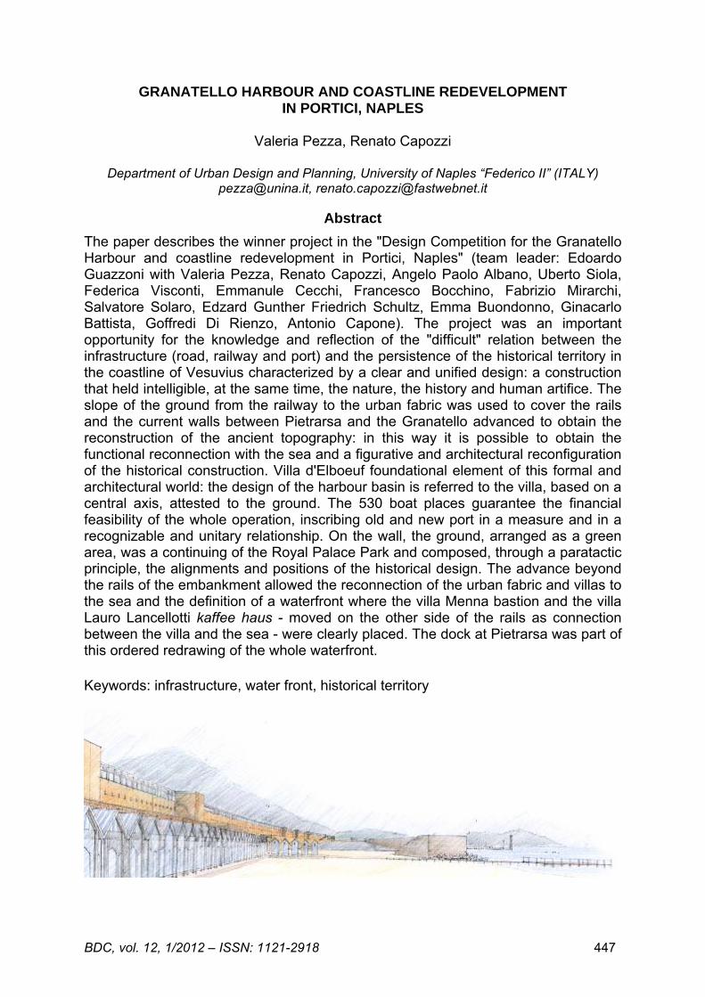
GRANATELLO HARBOUR AND COASTLINE REDEVELOPMENT IN PORTICI, NAPLES
The paper describes the winner project in the "Design Competition for the Granatello Harbour and coastline redevelopment in Portici, Naples" (team leader: Edoardo Guazzoni with Valeria Pezza, Renato Capozzi, Angelo Paolo Albano, Uberto Siola, Federica Visconti, Emmanule Cecchi, Francesco Bocchino, Fabrizio Mirarchi, Salvatore Solaro, Edzard Gunther Friedrich Schultz, Emma Buondonno, Ginacarlo Battista, Goffredi Di Rienzo, Antonio Capone). The project was an important opportunity for the knowledge and reflection of the "difficult" relation between the infrastructure (road, railway and port) and the persistence of the historical territory in the coastline of Vesuvius characterized by a clear and unified design: a construction that held intelligible, at the same time, the nature, the history and human artifice. The slope of the ground from the railway to the urban fabric was used to cover the rails and the current walls between Pietrarsa and the Granatello advanced to obtain the reconstruction of the ancient topography: in this way it is possible to obtain the functional reconnection with the sea and a figurative and architectural reconfiguration of the historical construction. Villa d'Elboeuf foundational element of this formal and architectural world: the design of the harbour basin is referred to the villa, based on a central axis, attested to the ground. The 530 boat places guarantee the financial feasibility of the whole operation, inscribing old and new port in a measure and in a recognizable and unitary relationship. On the wall, the ground, arranged as a green area, was a continuing of the Royal Palace Park and composed, through a paratactic principle, the alignments and positions of the historical design. The advance beyond the rails of the embankment allowed the reconnection of the urban fabric and villas to the sea and the definition of a waterfront where the villa Menna bastion and the villa Lauro Lancellotti kaffee haus - moved on the other side of the rails as connection between the villa and the sea - were clearly placed. The dock at Pietrarsa was part of this ordered redrawing of the whole waterfront. Keywords: infrastructure, water front, historical territory
BDC, vol. 12, 1/2012 – ISSN: 1121-2918 448
THE DESIGN OF THE WHOLE. THE READING OF THE EXISTING DESIGN OF THE PROJECT AND STRATEGIC CHOICES
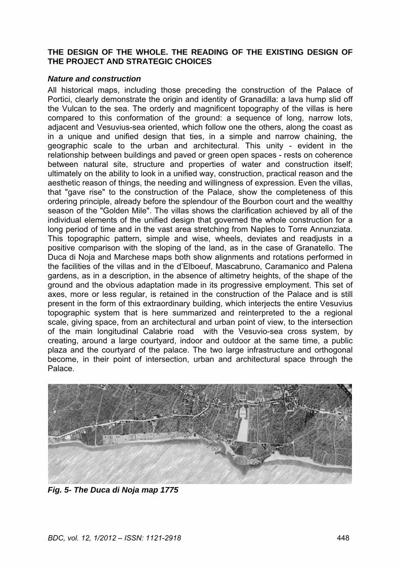
Nature and construction All historical maps, including those preceding the construction of the Palace of Portici, clearly demonstrate the origin and identity of Granadilla: a lava hump slid off the Vulcan to the sea. The orderly and magnificent topography of the villas is here compared to this conformation of the ground: a sequence of long, narrow lots, adjacent and Vesuvius-sea oriented, which follow one the others, along the coast as in a unique and unified design that ties, in a simple and narrow chaining, the geographic scale to the urban and architectural. This unity - evident in the relationship between buildings and paved or green open spaces - rests on coherence between natural site, structure and properties of water and construction itself; ultimately on the ability to look in a unified way, construction, practical reason and the aesthetic reason of things, the needing and willingness of expression. Even the villas, that "gave rise" to the construction of the Palace, show the completeness of this ordering principle, already before the splendour of the Bourbon court and the wealthy season of the "Golden Mile". The villas shows the clarification achieved by all of the individual elements of the unified design that governed the whole construction for a long period of time and in the vast area stretching from Naples to Torre Annunziata. This topographic pattern, simple and wise, wheels, deviates and readjusts in a positive comparison with the sloping of the land, as in the case of Granatello. The Duca di Noja and Marchese maps both show alignments and rotations performed in the facilities of the villas and in the d’Elboeuf, Mascabruno, Caramanico and Palena gardens, as in a description, in the absence of altimetry heights, of the shape of the ground and the obvious adaptation made in its progressive employment. This set of axes, more or less regular, is retained in the construction of the Palace and is still present in the form of this extraordinary building, which interjects the entire Vesuvius topographic system that is here summarized and reinterpreted to the a regional scale, giving space, from an architectural and urban point of view, to the intersection of the main longitudinal Calabrie road with the Vesuvio-sea cross system, by creating, around a large courtyard, indoor and outdoor at the same time, a public plaza and the courtyard of the palace. The two large infrastructure and orthogonal become, in their point of intersection, urban and architectural space through the Palace.
Fig. 5- The Duca di Noja map 1775
BDC, vol. 12, 1/2012 – ISSN: 1121-2918 449
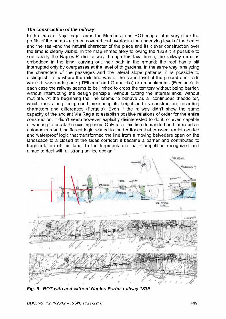
The construction of the railway In the Duca di Noja map - as in the Marchese and ROT maps - it is very clear the profile of the hump - a green covered that overlooks the underlying level of the beach and the sea -and the natural character of the place and its clever construction over the time is clearly visible. In the map immediately following the 1839 it is possible to see clearly the Naples-Portici railway through this lava hump; the railway remains embedded in the land, carving out their path in the ground; the roof has a slit interrupted only by overpasses at the level of th gardens. In the same way, analyzing the characters of the passages and the lateral slope patterns, it is possible to distinguish traits where the rails line was at the same level of the ground and traits where it was undergone (d’Elboeuf and Granatello) or embankments (Ercolano); in each case the railway seems to be limited to cross the territory without being barrier, without interrupting the design principle, without cutting the internal links, without mutilate. At the beginning the line seems to behave as a "continuous theodolite", which runs along the ground measuring its height and its construction, recording characters and differences (Fergola). Even if the railway didn’t show the same capacity of the ancient Via Regia to establish positive relations of order for the entire construction, it didn’t seem however explicitly disinterested to do it, or even capable of wanting to break the existing ones. Only after this line demanded and imposed an autonomous and indifferent logic related to the territories that crossed, an introverted and waterproof logic that transformed the line from a moving belvedere open on the landscape to a closed at the sides corridor: it became a barrier and contributed to fragmentation of this land, to the fragmentation that Competition recognized and aimed to deal with a "strong unified design."
Fig. 6 - ROT with and without Naples-Portici railway 1839
BDC, vol. 12, 1/2012 – ISSN: 1121-2918 450
In the presence of barriers, all the surrounding spaces become blind, occluded and interstitial. The constitutive relations of a place are severed: in this case both at the large and the small scale that design the villas, the gardens, the Palace and all the historical permanencies as a unitary system of construction. Above all the relationship with the sea is severed. In the general process of devaluation and degradation, the spaces between the villas and the barrier and between the barrier and the sea were occasionally and messy filled and have become unknown with the current cartographic representations that are not able to understand and make understand what happened in this "no man's land." To mend, therefore, the area in a "strong unified design" a cartographic, graphic and photographic analysis has been primarily useful to understand, whole and in detail, what there is between the sea and the villas and to clearly represent it in a map that would make intelligible the places and their historical construction. Because in a place like this, the strong urban design is already there and the only design operation is to recognize it, pull it out, put it back in the game, avoid crushing errors; in a place like this, projecting is not adding and hiding the historic structure, but above all "working "with the extraordinary artefact that already exist, with their principles, their measurements, the formal and figurative world they evoke. In a place like this, to really start a real process of regeneration, it is necessary to keep a "fixed view" on the unity and completeness of this historical drawing and not stop to interrogate its logic and solutions to find the answers to new problems.
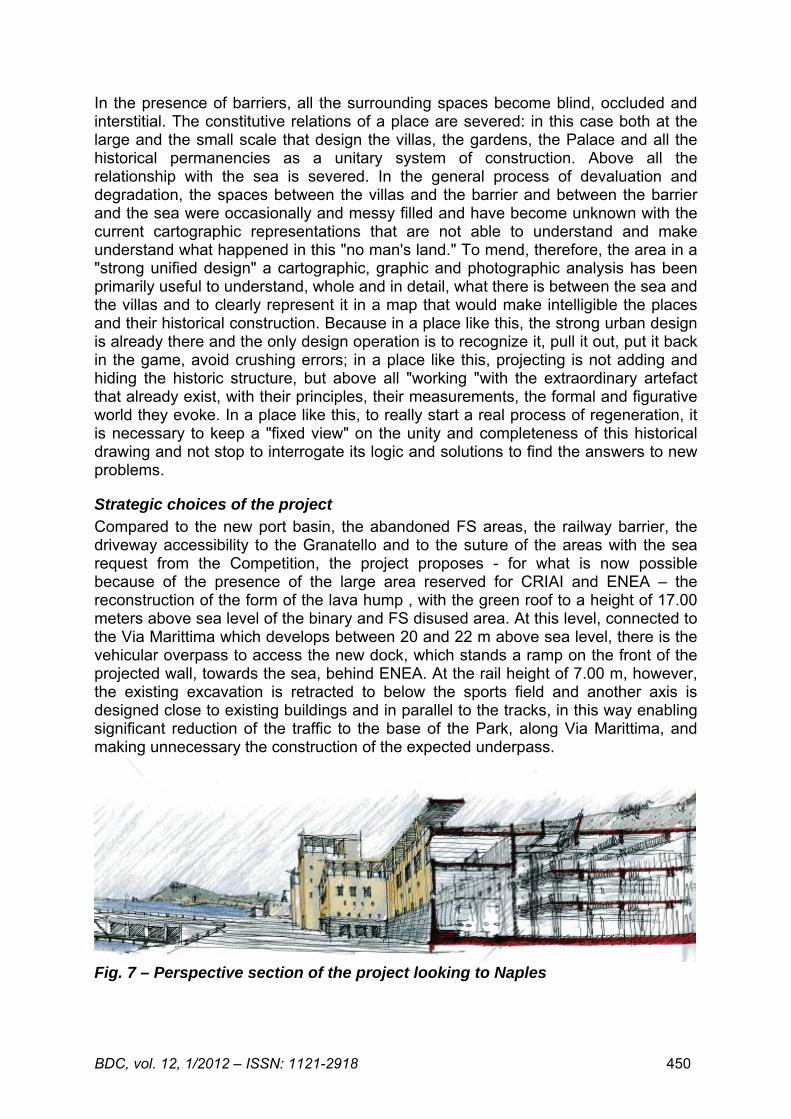
Strategic choices of the project Compared to the new port basin, the abandoned FS areas, the railway barrier, the driveway accessibility to the Granatello and to the suture of the areas with the sea request from the Competition, the project proposes - for what is now possible because of the presence of the large area reserved for CRIAI and ENEA – the reconstruction of the form of the lava hump , with the green roof to a height of 17.00 meters above sea level of the binary and FS disused area. At this level, connected to the Via Marittima which develops between 20 and 22 m above sea level, there is the vehicular overpass to access the new dock, which stands a ramp on the front of the projected wall, towards the sea, behind ENEA. At the rail height of 7.00 m, however, the existing excavation is retracted to below the sports field and another axis is designed close to existing buildings and in parallel to the tracks, in this way enabling significant reduction of the traffic to the base of the Park, along Via Marittima, and making unnecessary the construction of the expected underpass.
Fig. 7 – Perspective section of the project looking to Naples
BDC, vol. 12, 1/2012 – ISSN: 1121-2918 451
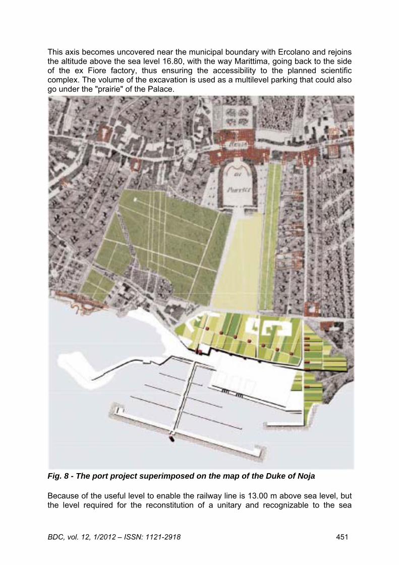
This axis becomes uncovered near the municipal boundary with Ercolano and rejoins the altitude above the sea level 16.80, with the way Marittima, going back to the side of the ex Fiore factory, thus ensuring the accessibility to the planned scientific complex. The volume of the excavation is used as a multilevel parking that could also go under the "prairie" of the Palace.
Fig. 8 - The port project superimposed on the map of the Duke of Noja Because of the useful level to enable the railway line is 13.00 m above sea level, but the level required for the reconstitution of a unitary and recognizable to the sea
BDC, vol. 12, 1/2012 – ISSN: 1121-2918 452
profile, must take into account the height of the Enea volumes, it is possible to think that, between the 13, 00 and 17.00 levels of the roof, there are spaces for equipment and services, which mark the culmination of the front of the wall towards the sea. The choice of reconstructing the footprint of the lava hump would, in this way, produce an overall and significant benefit from the economic, managerial and road network point of view, and, at the same time, the spatial and functional reconnection of the Park and the Royal Palace with the Granatello. The progress over the tracks of the embankment that currently limits the disused FS area, is a strategic choice that is repeated in the project, whenever the relationship between railway tracks and historical territory allows it, as in the areas where the railway is significantly undergone to the terrain. Between Pietrarsa and the Granatello this condition occurs twice: between the d’Elboeuf villa and the Bagnara Villa and between the Menna villa and the Perretti Palace. In these two areas the simple cover of the railroad, advancing the buttress wall beyond the existing tracks, allows the reconnection of the villas and the urban fabric with the sea. An appropriate policy of arrangements for a private managing for a public use of still existing gardens and parks or of those that can be recovered - at least the passages-, would reconstitute the system of transverse visual, spatial and functional relationships between the Via Regia and the sea defined by the architecture of the villas; a legislation to regulate the treatment of the fronts along the via Regia (including doors, entrance halls, courtyards, patios, doorways, paths, as well as colour and lighting), could help to reinforce the urban and architectural unity and allow the reopening, at least from a visual point of view, of the optical cones of the villas opened to the sea. The choice to propose a beach nourishment of the coast, close to the cover of the riverbed, reinforces this cross topography. The nourishment is made by submerged barriers and reefs of stabilization of the beaches that redefine the project profile of the collector cover to the sea, currently in progress, re-establishing the link with the axes of the villas that still exist. These cliffs, walked to the top, could allow to obtain equipment necessary to swimming, sports and tourist use of the beaches for which there are integrations with mobile structures. Within this ordered redesign of the waterfront is also resolved the issue of the planned landing dock to Pietrarsa. The choice of working on the reconnections through the sloping and the redesign of the ground containment, repurposes the figurative and architectural world of the charming historic views by Gravier or Jolivet: the sequence of elements - walls, ramps, counters, stairs, gates - that interpret the sloping of the ground and its elevation, deforming evidently relations and alignments, but also making very clear the overall relationship of the coast with the sea. In this formal and architectural world, the d’Elboeuf villa, clearly visible in both views, is a foundational element, not only by King’s living in the villa, as guest of the Principe, was born the desire to build a Royal Palace here, but because, in spite of mutilations and additions, the building is still a recognizable landmark in the waterfront, in the plan drawing, in its architectural and spatial character: the villa itself represents an ingenious and magnificent solution to the subject of the terraces and buttresses which this coastline appeared towards the sea. These are the elements and the idea of the place that the project elaborates and expands. The dock required by the Competition is attached to this general choice and it is set around a central axis that ends on a breakwater, almost parallel to the coast.
BDC, vol. 12, 1/2012 – ISSN: 1121-2918 453
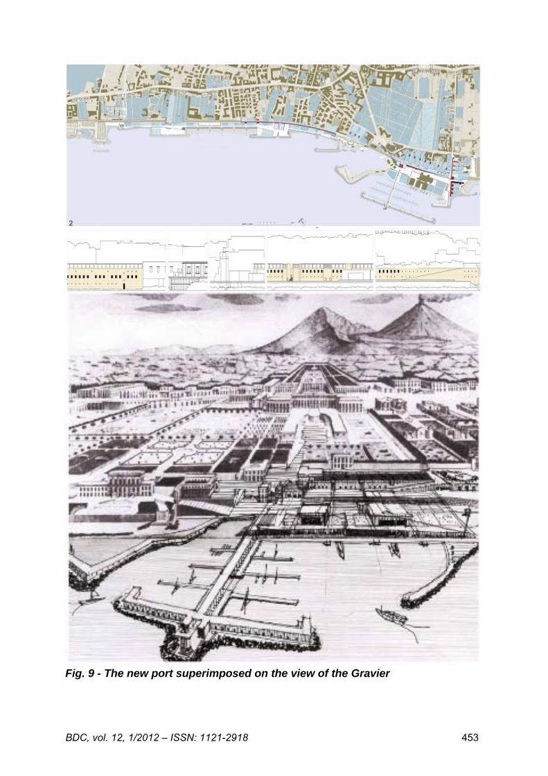
Fig. 9 - The new port superimposed on the view of the Gravier
BDC, vol. 12, 1/2012 – ISSN: 1121-2918 454
Along these two directions, orthogonal to each other, the dock spreads, to the 1.50 m above sea level, and the volume of the dock (used for deposits, services, facilities, parking lots) is feasible, on the roof, to 6.00 level so able to ensure continuity with the Bourbon dock. The axis on which is set the new port - the most visible element of the whole project together with the theme of the continuous wall - is an axis that belongs to the etched tracks into the Duca di Noja map, still fresh in the current urban topography, in the proprietary alignments (d’Elboeuf and Mascabruno) and in some buildings. The axis came to the ground in the place where the coverage of the station and the reconstruction of the lava hump can go a step further towards the sea. In this place there is a new metro station that emerges as a door along the wall of the new counter, helping to confirm its ability to summarize, in their usual forms, the answers useful to the themes of the competition. The green roof of the entire system, multiplies and composed, according to a paratactic and unitary principle but not single-centre, the alignments and directions recognized in the historic design and assumed by the project. The lift from the underground multi-storey car park are the only elements above ground that mark the horizontal roof level, similar to the Gravier view, while on the ground, the ventilation grilles, arbores, benches etc. may subscribe in the overall design that governs the functional connection, the architectural and landscape design of the project with the existing historical design, the Park, the exedra, the Royal Palace and the hills of Vesuvius. In this way, the aim of constructing an intermodal exchanger useful for the connections between sea, railway and roads, is achieved within the same world of forms, alignments, measurements and elements of that heritage that is to be safeguarded. The mechanized connection between the Royal Place – Ercolano excavations - up to the projected rack railway will be carried out – in both hypotheses of a surface or underground line - within a suitable reference system, a unified design for green and built areas. The whole organization of the Granatello contributes to realizes the objective of PSO, to attest in that point the new Gateway to the Vesuvius Park. The projected port basin excavates into the ground, the old root of the Bourbon port, visible in the historical maps and documents, strengthening their presence in the overall design and obtaining, through the reopening of underwater connections, the passage of tides and the consequent contrast to the siltation. In this way it is possible to improve the number of the boats to 530 and to make the operation realistically profitable in terms of financial and managerial engineering, avoiding to push the new dock too far into the sea, without gigantism, containing the old and the new port in a measure and in a still recognizable and substantially unitary relationship.
The new railway station
The planned transformation of the railway line in a regional underground requires more and closer stations and different from the existing one in Portici. The project involves the provision of at least two station, both related to the treatment of the projected great wall: one near the root of the new port to the end of the Portici "lava hump", the other, about 500 ml to Herculaneum, along the lying posture that defines the southeast boundary of the port basin - where it is provided a slipway – and catch, in the overall design, the building of the future museum of the sea, the former slaughterhouse, today isolated and in a marginal position. In this way the project reinforces the functional, spatial and architectural reconnection between the historical territory and the transformation project, between administrative divisions and unity of the construction, including current programming and sustainable and measured rehabilitation of the area. The current Portici railway station can be allocated to those
BDC, vol. 12, 1/2012 – ISSN: 1121-2918 455
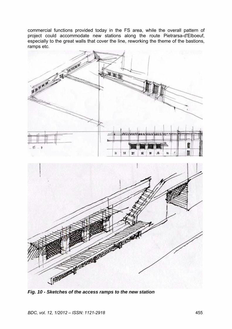
commercial functions provided today in the FS area, while the overall pattern of project could accommodate new stations along the route Pietrarsa-d'Elboeuf, especially to the great walls that cover the line, reworking the theme of the bastions, ramps etc.
Fig. 10 - Sketches of the access ramps to the new station
BDC, vol. 12, 1/2012 – ISSN: 1121-2918 456
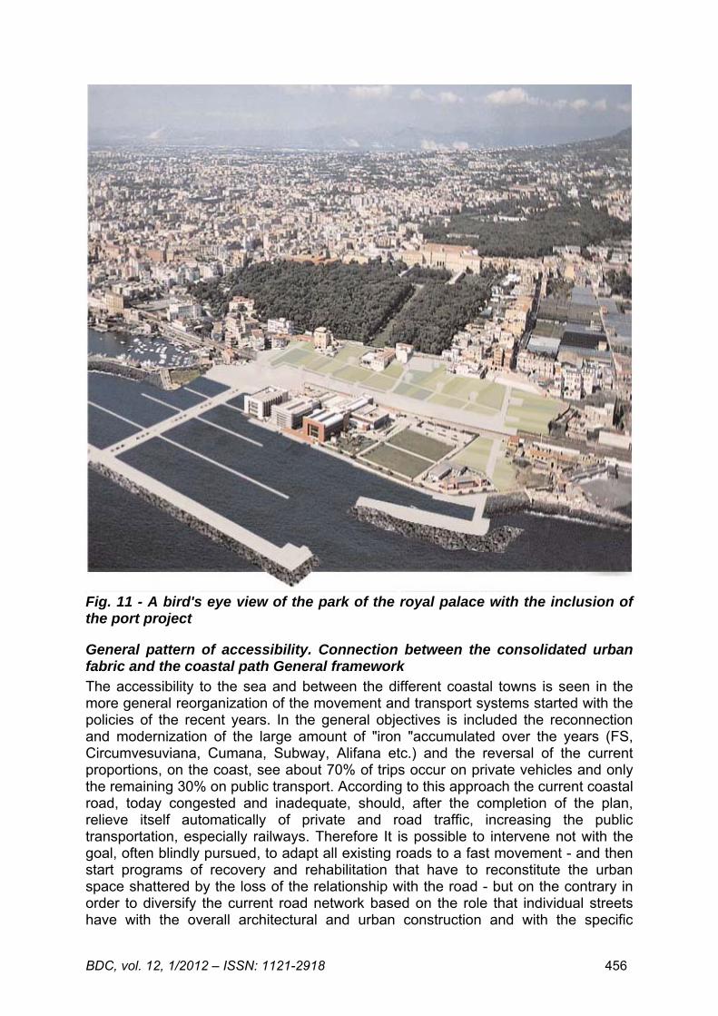
Fig. 11 - A bird's eye view of the park of the royal palace with the inclusion of the port project
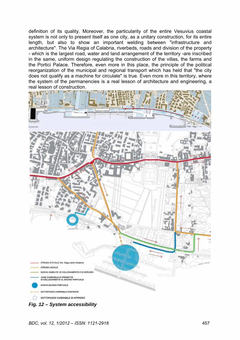
General pattern of accessibility. Connection between the consolidated urban fabric and the coastal path General framework The accessibility to the sea and between the different coastal towns is seen in the more general reorganization of the movement and transport systems started with the policies of the recent years. In the general objectives is included the reconnection and modernization of the large amount of "iron "accumulated over the years (FS, Circumvesuviana, Cumana, Subway, Alifana etc.) and the reversal of the current proportions, on the coast, see about 70% of trips occur on private vehicles and only the remaining 30% on public transport. According to this approach the current coastal road, today congested and inadequate, should, after the completion of the plan, relieve itself automatically of private and road traffic, increasing the public transportation, especially railways. Therefore It is possible to intervene not with the goal, often blindly pursued, to adapt all existing roads to a fast movement - and then start programs of recovery and rehabilitation that have to reconstitute the urban space shattered by the loss of the relationship with the road - but on the contrary in order to diversify the current road network based on the role that individual streets have with the overall architectural and urban construction and with the specific
BDC, vol. 12, 1/2012 – ISSN: 1121-2918 457
definition of its quality. Moreover, the particularity of the entire Vesuvius coastal system is not only to present itself as one city, as a unitary construction, for its entire length, but also to show an important welding between "infrastructure and architecture". The Via Regia of Calabria, riverbeds, roads and division of the property - which is the largest road, water and land arrangement of the territory -are inscribed in the same, uniform design regulating the construction of the villas, the farms and the Portici Palace. Therefore, even more in this place, the principle of the political reorganization of the municipal and regional transport which has held that "the city does not qualify as a machine for circulate" is true. Even more in this territory, where the system of the permanencies is a real lesson of architecture and engineering, a real lesson of construction.
Fig. 12 – System accessibility
BDC, vol. 12, 1/2012 – ISSN: 1121-2918 458
Here it is necessary to keep in mind the general pattern of roads - that during the time has already added, upstream and parallel to the Via Regia, two speed axes (the Panoramica and the highway) - and their diversification "to understand where we are" and it is necessary also to understand this unified design of the construction, based on the consistent relationship between the dense transversal arrangement Vesuvius/sea and the great artery of the Via Regia, to decide a general strategy. The accessibility to the coast, impeded by railway barrier, is sewn up as much as possible with regard to the pedestrian, but it must remain set on a schema with transversal elements, with arms landing to the sea, perpendicular to the main axis of the Via Regia: therefore light axes, calibrated on the access ramps to parking, not to axes for speed circulation. This seemed to us the only way to throw in the amazing " machine à habiter " of the villas and heritage: put it back in place, in fact, not dismiss it simply showing it and preserving it without understanding its intelligence as well as the beauty. If the defence of the coast, its reuse and beach nourishment that we propose will be discussed without understanding and reinterpreting the design, substantially transverse, of this unitary construction, we are going to do, beyond declarations of intent, an additional fragmentation of the historical territory: the layout of the road network, to solve the railway barrier, must be able to reject the easy appeal of building yet another coastal road that, in addition to imposing a massive and invasive connection to the ground respect to existing spatial and architectural measures, would further strengthen the fragmentation in parallel bands, landlocked between themselves, of the historical territory instead ordered according to a cross topography. To avoid of turning this great and unified design in scattered fragments it is necessary to act with care and tact, trusting in this framework of infrastructural reorganization, which promises to reduce the burden of vehicular traffic and therefore the useful survival of the current road network, without demolition but also without congestion. It is important to pursue a land-sea reconnection through roads, not for a crossing traffic but designed as pendulums, roads for berthing the coast and access to parking lots, leaving the new coastal path strictly pedestrian even if, of course, accessible to emergency and service vehicles. For this reason, the vehicular connections to the sea, between Pietrarsa d’Elboeuf villa, are two and both pass under the railway: the first one to the perimeter of the lot of Villa Maria has been already used for roofing work of the collector, the other one is expected in the section where territory and railway are at the same level, near Via Bagnara. The pedestrian connections, on the contrary, add to the underpasses already provided by the preliminary project of the waterfront reorganization, the wide bands obtained from the coverage of the FS line towards the sea and the advancement of the existing retaining walls where ramps, belvedere, overlooking could be build...
Feasibility and sustainability management, business model proposed The tourist harbours is for the Campania Region, and for the whole Italy, a strategic element to upgrade the physical environment, to decongest the traffic flows along the coast through the provision of services and the reorganization of the access port systems to promote the local economy through the creation and/or the re-use of economic activities and human resources, to protect and enhance the cultural and environmental heritage. The primary goal is to create, through the involvement of the private capital, an integrated system of marinas and coastal intermodal able to guide the future of the region towards a model of sustainable development for the environment, efficient for the economy and fair for the people and the involved territories. The development of marinas is also one of the objectives of the national
BDC, vol. 12, 1/2012 – ISSN: 1121-2918 459
economic policy that contribute to the strategic plan to increase the overall supply of the country to attract new and larger national and international tourist flows. The guidelines for the development of an integrated system of marinas in Campania include the Vesuvius coast: an area that, in the recent years, has expressed a willingness to address the abovementioned objectives to its development, through the increasing of the touristic activities, integrated with ways of use of the historical-cultural, landscape and coastal-resorts resources, in this area often not properly valued. In this perspective, the project concerning the construction of a new tourist port in the municipality of Portici has an important role in the main strategy and, with the redevelopment of the waterfront, as an opportunity for development of the area and redevelopment of tourism demand to encourage its development in terms of high and integrated quality. The other proposed interventions – urban, planning and landscape regeneration as well as those related to the accessibility system - are a natural integration of the marina project, in terms of functionality and safeguard of the delicate urban and territorial balance. The aspects related to the costs of construction and to the management complexity make immediate assume, for the construction of the marina and the rail-road exchanger, the use of project financing. The typology of works it sees can do them as a possible object of economic management: the municipality, in the next phase of study, will decide if the two big constructions will be subject to one or more procedures. There are two possible hypotheses to realize the project: the first one is the project financing, the second is the constitution of a mixed public-private company, with public majority. Those are the instruments that, from the point of view of a proper use of the public funds, are the best in order to reconcile two important requirements: the control by "the public" and a remunerative use of the private capital. The first hypothesis, given the ability of the intervention to generate an active cash flow active and considered the availability of areas to be given in concession for activities and services related to yachting and parking, is a concession competition for the design, implementation and management of some of the works in the general redevelopment project.
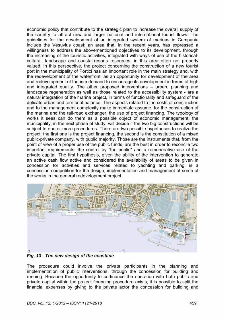
Fig. 13 - The new design of the coastline The procedure could involve the private participants in the planning and implementation of public interventions, through the concession for building and running. Because the opportunity to co-finance the operation with both public and private capital within the project financing procedure exists, it is possible to split the financial expenses by giving to the private actor the concession for building and
BDC, vol. 12, 1/2012 – ISSN: 1121-2918 460
running the profitable works for a period of time useful for the capital consumption allowance and upon payment of a fee. The public subject should be cover the remaining costs for the construction and running of the works with public function. The private actor could build the public buildings and infrastructures too if the net margins of the business was able to cover the running costs and compensate the invested capital invested and able to contribute to the public service. Similarly if the economic and financial equilibrium is unfavourable for the private, It is possible to think about a public grant. The amount planned in the competition announcement (20 M €) could be the public grant or be used to some works outside the economic management. The alternative hypotheses is the establishment of a mixed public-private company, with public majority. In this case the Municipality could adopt a business tool able to speed up the decision-making processes relating to the various stages of implementation of the project but, even more, able to allow the contracting authority to exercise the full control of the operation and participate in the profits. About the procedure to be adopted for the selection of the private partner/s is clear that the choice must take place through the use of a public tender. Once set up the Company, it functionally and economically runs the works for the entire time of the concession, on their own and through the outsourcing in particular through the forms of real estate leasing, the service contract, in accordance with the financial plan of the proposal.
The destiny of the winning project of the competition Following the award of the first prize in the design competition1, the project described unfortunately didn’t be hired as a guide and framework for future transformation and development scenarios for the area of the Portici municipality. The project was fragmented into isolated and partial interventions and partially incorporated in the program "PIU’ Europa" promoted by the Campania region. Today none of the interventions contained in the project was realized. This sad observation, in more general terms, clarifies the present realty of design competitions in Italy in recent years. Especially if compared to the number of projects, the remarkable imaginative and technical efforts to improve the collective construction of the architecture of the city2 and to promote its sustainable development didn’t meet clear investment policies (also, as in this case, with the prevailing contribution of private funds) and of governance. The continuing neglect of our territories - often, as in this precious and delicate area, offended, and not recognized in their beauty, and not considered as important reserves for their civil, economic, social and cultural development is the result of this inadequacy.
REFERENCES [1] Var. Authors (2008), Concorso Internazionale di Progettazione per la riqualificazione del litorale di
Portici e del porto del Granatello, Catalogue, Ed. Graffiti, Naples, Italy. [2] Pezza V. (2009), Progetti per l’archiettura della città, Orfeo C. (ed), Electa Napoli, Naples, Italy.
BDC, vol. 12, 1/2012 – ISSN: 1121-2918 461
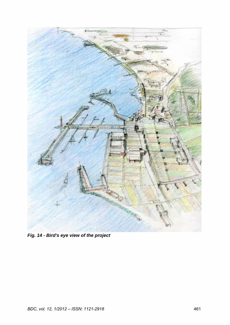
Fig. 14 - Bird's eye view of the project
BDC, vol. 12, 1/2012 – ISSN: 1121-2918 462
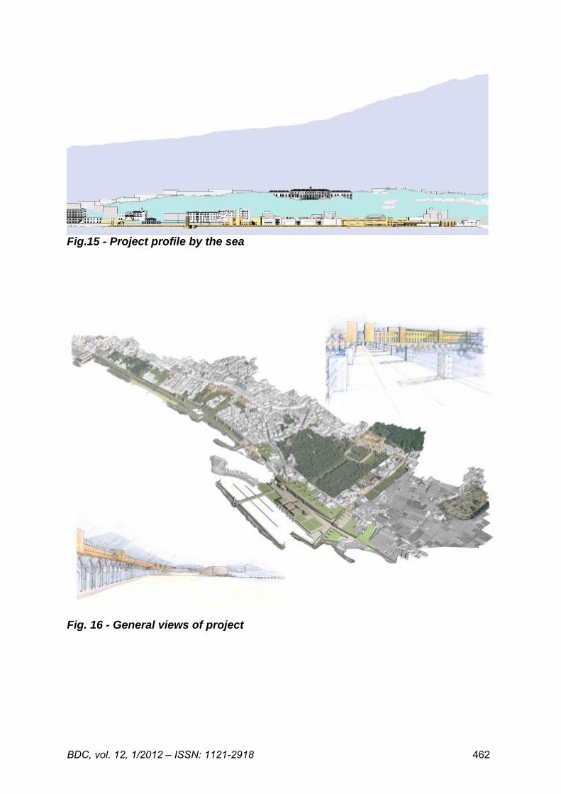
Fig.15 - Project profile by the sea
Fig. 16 - General views of project
BDC, vol. 12, 1/2012 – ISSN: 1121-2918 463
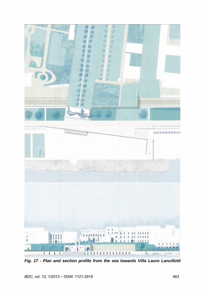
Fig. 17 - Plan and section profile from the sea towards Villa Lauro Lancillotti
BDC, vol. 12, 1/2012 – ISSN: 1121-2918 464
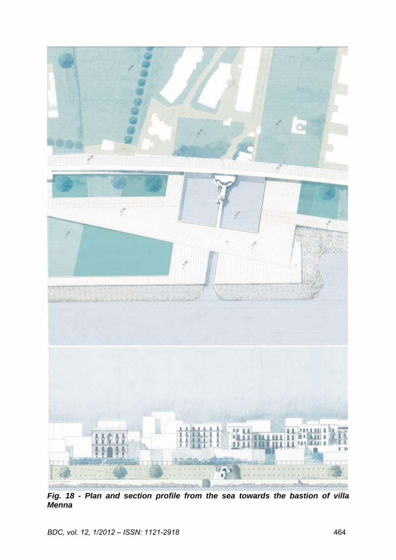
Fig. 18 - Plan and section profile from the sea towards the bastion of villa Menna
BDC, vol. 12, 1/2012 – ISSN: 1121-2918 465
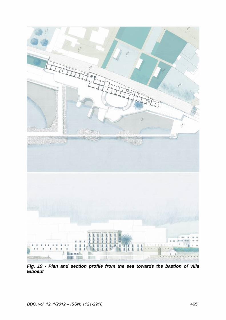
Fig. 19 - Plan and section profile from the sea towards the bastion of villa Elboeuf
BDC, vol. 12, 1/2012 – ISSN: 1121-2918 466
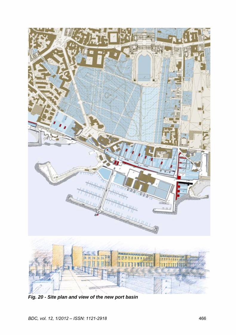
Fig. 20 - Site plan and view of the new port basin