Article Volume 11, Number 6 26 June 2010 Q06014, doi:10.1029/2009GC002893 ISSN: 1525‐2027 Click Here for Full Article Historic 1771 Meiwa tsunami confirmed by high‐resolution U/Th dating of massive Porites coral boulders at Ishigaki Island in the Ryukyus, Japan Daisuke Araoka Graduate School of Frontier Sciences, University of Tokyo, Kashiwa 277‐8561, Japan Also at Atmosphere and Ocean Research Institute, University of Tokyo, Kashiwa 277‐8564, Japan Mayuri Inoue Atmosphere and Ocean Research Institute, University of Tokyo, Kashiwa 277‐8564, Japan Atsushi Suzuki Geological Survey of Japan, National Institute of Advanced Industrial Science and Technology, Tsukuba 305‐8567, Japan ([email protected]) Yusuke Yokoyama Atmosphere and Ocean Research Institute, University of Tokyo, Kashiwa 277‐8564, Japan Also at Institute of Biogeosciences, Japan Agency for Marine‐Earth Science and Technology, Yokosuka 237‐0061, Japan R. Lawrence Edwards and Hai Cheng Minnesota Isotope Laboratory, Department of Geology and Geophysics, University of Minnesota–Twin Cities, Minneapolis, Minnesota 55455, USA Hiroyuki Matsuzaki Department of Nuclear Engineering and Management, School of Engineering, University of Tokyo, Tokyo 113‐8656, Japan Hironobu Kan Faculty of Education, Okayama University, Okayama 700‐8530, Japan Naotatsu Shikazono Department of Applied Chemistry, Faculty of Science and Technology, Keio University, 3‐14‐1 Hiyoshi, Kouhoku‐ku, Yokohama, Kanagawa 223‐8522, Japan Hodaka Kawahata Graduate School of Frontier Sciences, University of Tokyo, Kashiwa 277‐8561, Japan Also at Atmosphere and Ocean Research Institute, University of Tokyo, Kashiwa 277‐8564, Japan Also at Geological Survey of Japan, National Institute of Advanced Industrial Science and Technology, Tsukuba 305‐8567, Japan Copyright 2010 by the American Geophysical Union 1 of 11
Transcript
Article
Volume 11, Number 6
26 June 2010
Q06014, doi:10.1029/2009GC002893
ISSN: 1525‐2027
ClickHere
for
FullArticle
Historic 1771 Meiwa tsunami confirmed by high‐resolutionU/Th dating of massive Porites coral bouldersat Ishigaki Island in the Ryukyus, Japan
Daisuke AraokaGraduate School of Frontier Sciences, University of Tokyo, Kashiwa 277‐8561, Japan
Also at Atmosphere and Ocean Research Institute, University of Tokyo, Kashiwa 277‐8564, Japan
Mayuri InoueAtmosphere and Ocean Research Institute, University of Tokyo, Kashiwa 277‐8564, Japan
Atsushi SuzukiGeological Survey of Japan, National Institute of Advanced Industrial Science and Technology,Tsukuba 305‐8567, Japan ([email protected])
Yusuke YokoyamaAtmosphere and Ocean Research Institute, University of Tokyo, Kashiwa 277‐8564, Japan
Also at Institute of Biogeosciences, Japan Agency for Marine‐Earth Science and Technology, Yokosuka237‐0061, Japan
R. Lawrence Edwards and Hai ChengMinnesota Isotope Laboratory, Department of Geology and Geophysics, University ofMinnesota–Twin Cities, Minneapolis, Minnesota 55455, USA
Hiroyuki MatsuzakiDepartment of Nuclear Engineering and Management, School of Engineering, University of Tokyo,Tokyo 113‐8656, Japan
Hironobu KanFaculty of Education, Okayama University, Okayama 700‐8530, Japan
Naotatsu ShikazonoDepartment of Applied Chemistry, Faculty of Science and Technology, Keio University,3‐14‐1 Hiyoshi, Kouhoku‐ku, Yokohama, Kanagawa 223‐8522, Japan
Hodaka KawahataGraduate School of Frontier Sciences, University of Tokyo, Kashiwa 277‐8561, Japan
Also at Atmosphere and Ocean Research Institute, University of Tokyo, Kashiwa 277‐8564, Japan
Also at Geological Survey of Japan, National Institute of Advanced Industrial Science and Technology,Tsukuba 305‐8567, Japan
Copyright 2010 by the American Geophysical Union 1 of 11
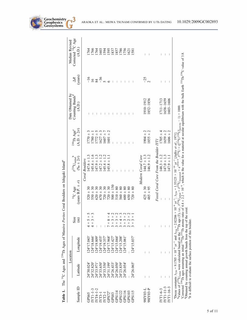
[1] The chronicles of the Ryukyu Kingdom describe at least four coastal inundation events at IshigakiIsland during the seventeenth through nineteenth centuries: the 1771 Meiwa earthquake tsunami, whichkilled 12,000 people; another earthquake tsunami (1687); and two events with unrecorded causes (1625and 1714). We used a high‐resolution U/Th method to date well‐preserved surface parts of massive Poritesspp. coral head boulders that had been cast ashore and found that the ages of two boulders correspond tothe 1771 event. One large Porites boulder (diameter > 4 m) was dated to 1625, suggesting that that eventwas also a large inundation event. Calibrated 14C ages, based on a newly estimated local value for theradiocarbon marine reservoir effect, clustered around 1625 and 1771, suggesting that these events werelarger than the others. Our study demonstrated that Porites boulders have enormous potential value forstudies of paleoinundation events such as tsunamis and extreme storms.
Index Terms: 1115 Geochronology: Radioisotope geochronology; 4564 Oceanography: Physical: Tsunamis and stormsurges; 1165 Geochronology: Sedimentary geochronology.
Received 9 October 2009; Revised 6 May 2010; Accepted 17 May 2010; Published 26 June 2010.
Araoka, D., M. Inoue, A. Suzuki, Y. Yokoyama, R. L. Edwards, H. Cheng, H. Matsuzaki, H. Kan, N. Shikazono, andH. Kawahata (2010), Historic 1771Meiwa tsunami confirmed by high‐resolution U/Th dating of massive Porites coral bouldersat Ishigaki Island in the Ryukyus, Japan, Geochem. Geophys. Geosyst., 11, Q06014, doi:10.1029/2009GC002893.
1. Introduction
[2] A large number of massive coral head bouldersare scattered both along the shore and on the reefat eastern Ishigaki Island, one of the YaeyamaIslands in the southern Ryukyus (Figures 1 and 2a).Many of these boulders were likely cast ashore bythe 1771 Meiwa earthquake tsunami, which wasone of the largest tsunami disasters in Japanesehistory, resulting in the deaths of 12,000 people inthe region. Suzuki et al. [2008] analyzed 14C agesof surface parts of these Porites spp. coral boulderswith the aim of confirming that they had beentransported by the Meiwa tsunami. Unlike reef rockboulders, Porites coral boulders can be used todetermine the exact ages of past events because theage of the coral surface should indicate when theboulder cast ashore by the tsunamis and severestorms. However, the calibrated 14C age distribu-tion showed a relatively wide range, and they henceconcluded that the massive Porites coral boulderswere not caused by a single event. In additionto the Meiwa tsunami, typhoons, storms, or othertsunamis may have been the agents of transport ofthese Porites boulders [Suzuki et al., 2008].Moreover, the location of the Meiwa earthquakefault and the origin of its tsunami are still contro-versial [Matsumoto et al., 1997, 2009a, 2009b;Nakamura, 2006].
[3] These tsunami coral boulders attract a greatdeal of attention from hydrologists and tsunamiscientists. Identifying coral boulders cast ashore bythe 1771 Meiwa tsunami has scientific merit forconstraining their tsunami models to apply theseboulders [Imamura et al., 2008; Goto et al., 2009].In addition, it is important to determine the seismicrecurrence period for long‐term assessment offuture earthquake and tsunami risk in this region,and, if the boulders were cast onshore by largetyphoons, the frequency of such events should alsobe known for future disaster mitigation.
[4] The 14C dating method is not ideal for preciseage determination of events of the near past,although it is widely used for this. One limitation ofthe method is that the marine radiocarbon reservoireffect, which varies locally and temporally, must beknown. Moreover, 14C ages must be converted tocalendar ages for comparison, for example, withthe dates of known historical events, but a lack ofinformation on local marine reservoir correctionvalues (DR) is a bar to accurate conversion of 14Cages. Suzuki et al. [2008] applied a local DR valueof 41 ± 19 years [Hideshima et al., 2001] to radio-carbon dates obtained around Ishigaki Island, butHideshima et al. [2001] reported large variability ofDR in samples from the same region, suggestingthat around Ishigaki Island DR might not be con-stant over time.
GeochemistryGeophysicsGeosystems G3G3 ARAOKA ET AL.: MEIWA TSUNAMI CONFIRMED BY U/Th DATING 10.1029/2009GC002893
[5] Precise and direct dating of coral carbonatesamples is now possible by U/Th dating owing tothe development of an improved technique formeasuring 230Th in corals [Edwards et al., 1987].To assess the accuracy of 230Th ages, Edwards etal. [1988] compared the 230Th ages of corals withtheir known ages, obtained by counting annualgrowth bands, and found complete agreementbetween them. Cobb et al. [2003a] developed ahigh‐precision (±1%–2%) U/Th dating method foryoung reef corals, both living and fossil, and Cobbet al. [2003b] utilized high‐precision, accurate230Th ages to splice together fossil coral oxygenisotopic records from Palmyra Island, in the tropi-cal Pacific, for the last 1100 years. The seismicrecurrence interval inferred from the U/Th dating ofPorites microatolls contributed to understanding ofthe 2004 Sumatra earthquake that caused the tsu-nami [Sieh, 2005; Sieh et al., 2008].
[6] Once accurate 230Th ages become available forcoral specimens that have also been dated by the14C method, more accurate DR values can be cal-
culated for each time window [Yokoyama et al.,2000]. These DR values would contribute to pre-cise conversion of 14C ages of samples to calendarages. DR values are also an important parameterfor paleoclimate reconstruction.
[7] An advantage of the Ryukyu Islands as a studyregion is the availability of historical documentsdescribing past disasters. These documents werewritten by the central government and local officesof the Kingdom of the Ryukyus (1429–1879),whose national capital was located in Shuri (Naha),Okinawa Island (Figure 1a). Although scanty de-scriptions sometimes make it difficult to distinguishflooding events caused by typhoons from those causedby earthquake tsunamis [Kawana and Nakata,1994], accurate age dating can confirm the accu-racy of the descriptions and increase the utility ofthe documents.
[8] The aim of this study was to determine the agesof past disaster events by direct dating of well‐preserved surface parts of massive Porites coralboulders cast ashore during those events. In addi-tion, we estimated new DR values in this regionby comparing 230Th ages and 14C ages for moreaccurate conversion of 14C ages to calendar ages.This is the first time that high‐precision U/Thdating has been applied to tsunami deposits inJapan.
2. Materials and Methods
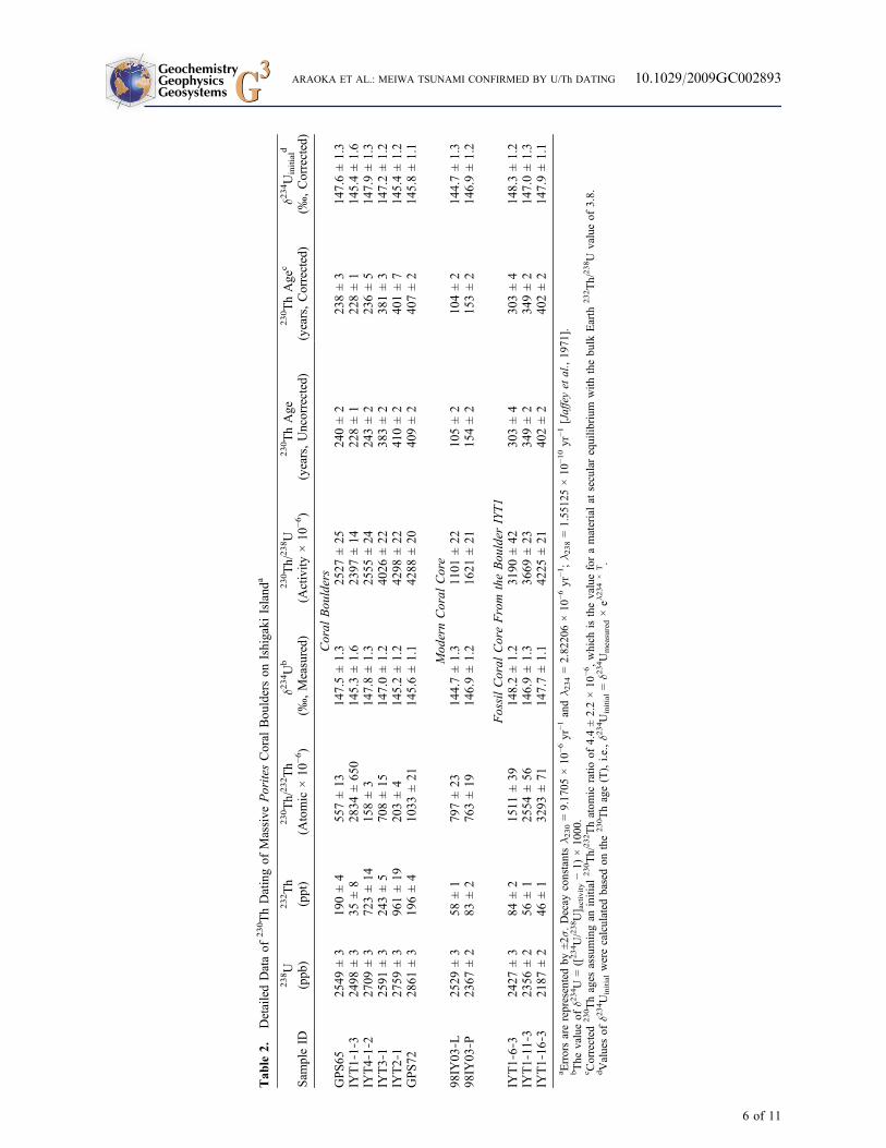
[9] The Porites boulders analyzed here wereselected from samples previously 14C dated bySuzuki et al. [2008]. Skeletal portions 2–3 yearsolder than the well‐preserved colony surface werecollected to preclude the use of altered materials,and we assumed that density bandings of Poritescorals are annual and adjusted dates to compensatefor their depth in time from the surface. Suzukiet al. [2008] examined coral skeletal samplesby X‐ray diffraction analysis to confirm that thecoral aragonite was well preserved. The 14C mea-surements were done with a Micro Analysis Labo-ratory TandemAccelerator (MALT), TheUniversityof Tokyo [Matsuzaki et al., 2004; Yokoyama et al.,2007]. 230Th dating was performed with a multi-collector inductively coupled plasma mass spec-trometer (MC‐ICP‐MS, Thermo‐FinniganNeptune)at the Minnesota Isotope Laboratory, Universityof Minnesota. The basic chemical procedures andstandards have been described by Edwards et al.[1987], Cheng et al. [2000], and Shen et al.[2002]. The data reported here use updated stan-
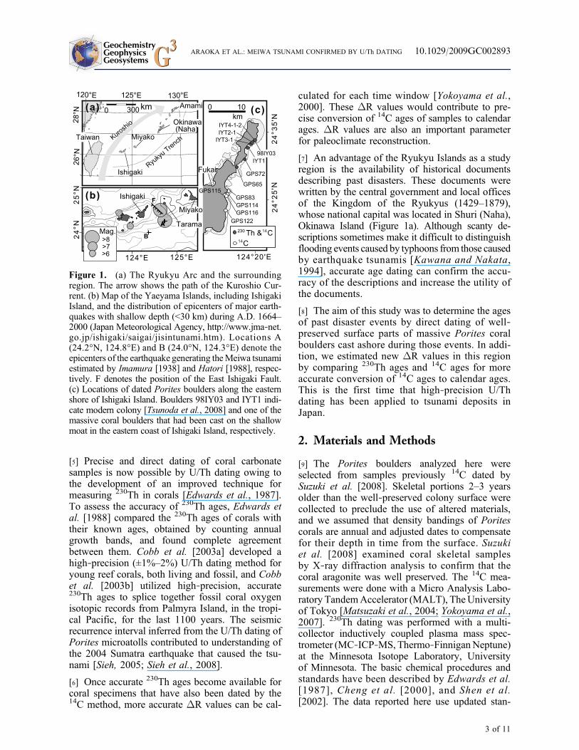
Figure 1. (a) The Ryukyu Arc and the surroundingregion. The arrow shows the path of the Kuroshio Cur-rent. (b) Map of the Yaeyama Islands, including IshigakiIsland, and the distribution of epicenters of major earth-quakes with shallow depth (<30 km) during A.D. 1664–2000 (Japan Meteorological Agency, http://www.jma‐net.go.jp/ishigaki/saigai/jisintunami.htm). Locations A(24.2°N, 124.8°E) and B (24.0°N, 124.3°E) denote theepicenters of the earthquake generating theMeiwa tsunamiestimated by Imamura [1938] and Hatori [1988], respec-tively. F denotes the position of the East Ishigaki Fault.(c) Locations of dated Porites boulders along the easternshore of Ishigaki Island. Boulders 98IY03 and IYT1 indi-cate modern colony [Tsunoda et al., 2008] and one of themassive coral boulders that had been cast on the shallowmoat in the eastern coast of Ishigaki Island, respectively.
GeochemistryGeophysicsGeosystems G3G3 ARAOKA ET AL.: MEIWA TSUNAMI CONFIRMED BY U/Th DATING 10.1029/2009GC002893
dardization and new decay constants of 230Th (l230 =9.1705 × 10⁻⁶ yr−1) and 234U (l234 = 2.82206 ×10⁻⁶ yr−1), in use in the Minnesota Isotope Labo-ratory as of 2009. The updated values were pre-viously used by Cheng et al. [2009].
[10] To assess the accuracy of the 230Th dating, weobtained 230Th ages of skeletal portions of annuallybanded Porites coral cores extracted from a moderncolony (sample 98IY03) [Tsunoda et al., 2008] andof one of the massive coral boulders that had beencast on the shallow moat (sample IYT1) in theeastern coast of Ishigaki Island. Age differencesbetween 230Th dates for some skeletal portions ofeach core and the estimates by counting annualgrowth bands were examined.
[11] By comparing 230Th and 14C age, marine res-ervoir age and regional correction value (DR) wereobtained by using INTCAL04 and MARINE04
radiocarbon calibration curves [Reimer et al., 2004;Hughen et al., 2004]. The newly determined DRvalues revised 14C ages to calendar ages using theonline CALIB program (http://calib.qub.ac.uk/calib).
[12] Two important collections of historical docu-ments are pertinent to Ishigaki Island: the “Kyuyo”and the “Yaeyama‐jima Nenraiki” (Chronicles ofYaeyama). The “Kyuyo” is an official chronicle ofthe Ryukyu Kingdom that was begun in 1745 andcontains records of events that took place in eachregion of the Ryukyus, including the YaeyamaIslands, until just before the dissolution of theRyukyuKingdom in 1872. “Yaeyama‐jimaNenraiki”is a collection of documents related to the Yaeyamaregion throughout the successive years until the lastdocument in 1775. It contains many importantdocuments on natural disasters, relocation of vil-lages, and population statistics, as well as personalcorrespondence of the inhabitants of Ishigaki and
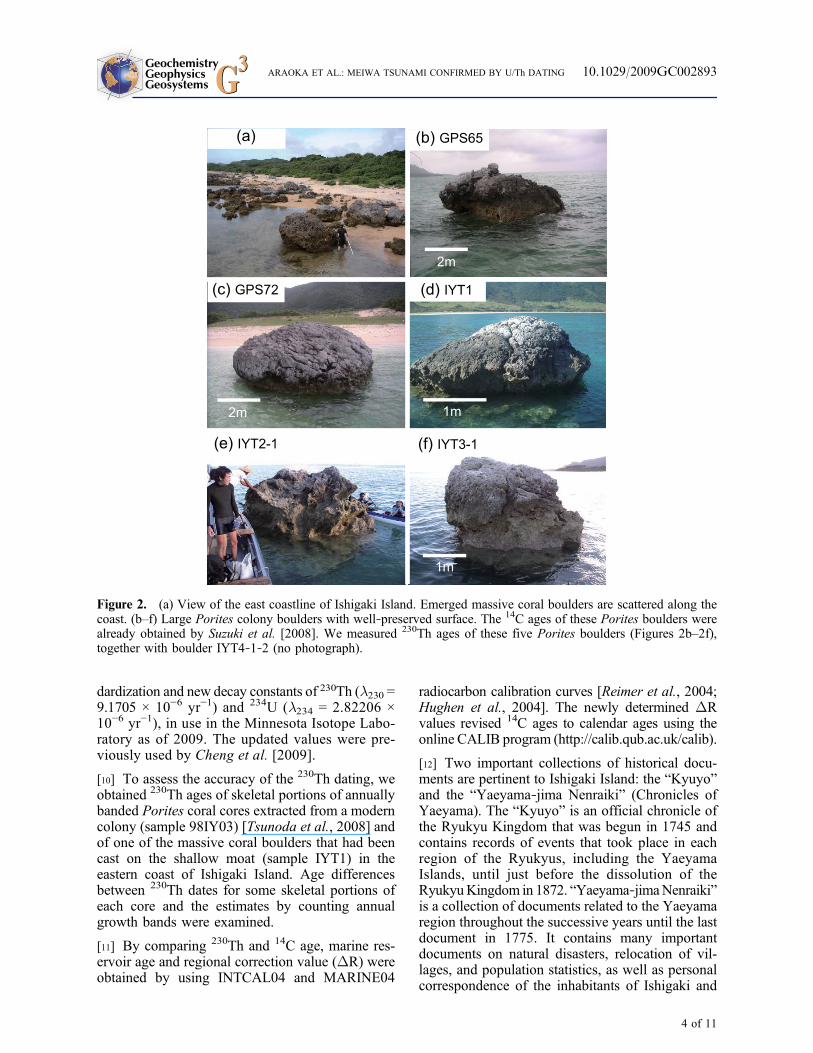
Figure 2. (a) View of the east coastline of Ishigaki Island. Emerged massive coral boulders are scattered along thecoast. (b–f) Large Porites colony boulders with well‐preserved surface. The 14C ages of these Porites boulders werealready obtained by Suzuki et al. [2008]. We measured 230Th ages of these five Porites boulders (Figures 2b–2f),together with boulder IYT4‐1‐2 (no photograph).
GeochemistryGeophysicsGeosystems G3G3 ARAOKA ET AL.: MEIWA TSUNAMI CONFIRMED BY U/Th DATING 10.1029/2009GC002893
GeochemistryGeophysicsGeosystems G3G3 ARAOKA ET AL.: MEIWA TSUNAMI CONFIRMED BY U/Th DATING 10.1029/2009GC002893
5 of 11
Tab
le2.
DetailedDataof
230ThDatingof
Massive
PoritesCoral
Bou
lderson
Ishigaki
Island
a
Sam
pleID
238U
(ppb
)
232Th
(ppt)
230Th/
232Th
(Atomic
×10
−6)
d234Ub
(‰,Measured)
230Th/
238U
(Activity
×10
−6)
230ThAge
(years,Uncorrected)
230ThAge
c
(years,Corrected)
d234Uinitiald
(‰,Corrected)
Coral
Bou
lders
GPS65
2549
±3
190±4
557±13
147.5±1.3
2527
±25
240±2
238±3
147.6±1.3
IYT1‐1‐3
2498
±3
35±8
2834
±65
014
5.3±1.6
2397
±14
228±1
228±1
145.4±1.6
IYT4‐1‐2
2709
±3
723±14
158±3
147.8±1.3
2555
±24
243±2
236±5
147.9±1.3
IYT3‐1
2591
±3
243±5
708±15
147.0±1.2
4026
±22
383±2
381±3
147.2±1.2
IYT2‐1
2759
±3
961±19
203±4
145.2±1.2
4298
±22
410±2
401±7
145.4±1.2
GPS72
2861
±3
196±4
1033
±21
145.6±1.1
4288
±20
409±2
407±2
145.8±1.1
Mod
ernCoral
Core
98IY
03‐L
2529
±3
58±1
797±23
144.7±1.3
1101
±22
105±2
104±2
144.7±1.3
98IY
03‐P
2367
±2
83±2
763±19
146.9±1.2
1621
±21
154±2
153±2
146.9±1.2
FossilCoral
CoreFrom
theBou
lder
IYT1
IYT1‐6‐3
2427
±3
84±2
1511
±39
148.2±1.2
3190
±42
303±4
303±4
148.3±1.2
IYT1‐11‐3
2356
±2
56±1
2554
±56
146.9±1.3
3669
±23
349±2
349±2
147.0±1.3
IYT1‐16‐3
2187
±2
46±1
3293
±71
147.7±1.1
4225
±21
402±2
402±2
147.9±1.1
a Errorsarerepresentedby
±2s.
Decay
constantsl 2
30=9.17
05×10
−6yr
−1andl 2
34=2.82
206×10
−6yr
−1;l 2
38=1.55
125×10
−10yr
−1[Jaffeyet
al.,19
71].
bThe
valueof
d234U
=([234U/238U] activity−1)
×10
00.
c Corrected
230Thages
assumingan
initial
230Th/
232Thatom
icratio
of4.4±2.2×10
−6,which
isthevalueforamaterialat
secularequilib
rium
with
thebu
lkEarth
232Th/
238U
valueof
3.8.
dValuesof
d234Uinitialwerecalculated
basedon
the
230Thage(T),i.e.,d2
34Uinitial=d2
34Umeasured×el
234×
T.
GeochemistryGeophysicsGeosystems G3G3 ARAOKA ET AL.: MEIWA TSUNAMI CONFIRMED BY U/Th DATING 10.1029/2009GC002893
6 of 11
neighboring islands. Images of these documents areaccessible through the University of the RyukyusRepository (http://ir.lib.u‐ryukyu.ac.jp/).
3. Results
[13] Our 230Th dating results, together with thepreviously reported 14C ages, are shown in Tables 1and 2. The d234Uinitial values are used as an indicatorof diagenetic alteration of fossil corals. If the initiald234U values of the samples are similar to those ofmodern corals and seawater, the samples have beenkept in the closed system regarding uranium andthorium. In this study, all of our d234Uinitial mea-surements of Porites corals were similar to d234Uvalue of modern corals (145.8‰) reported byChenget al. [2000]. By using the new 234U decay constantvalue, the d234U value of modern corals can becalculated to be 144.1‰. But, that updated value isstill close to our d234Uinitial values. There are someother studies. Delanghe et al. [2002] reported146.6‰ for the d234U value of modern coral, whileDelanghe et al. [2002] and Robinson et al. [2004]reported that value of modern seawater as 149.6‰and 146.6‰, respectively. These are all similar toour d234Uinitial measurements. Overall, these indi-cate that correction for such alteration is probablynot needed.
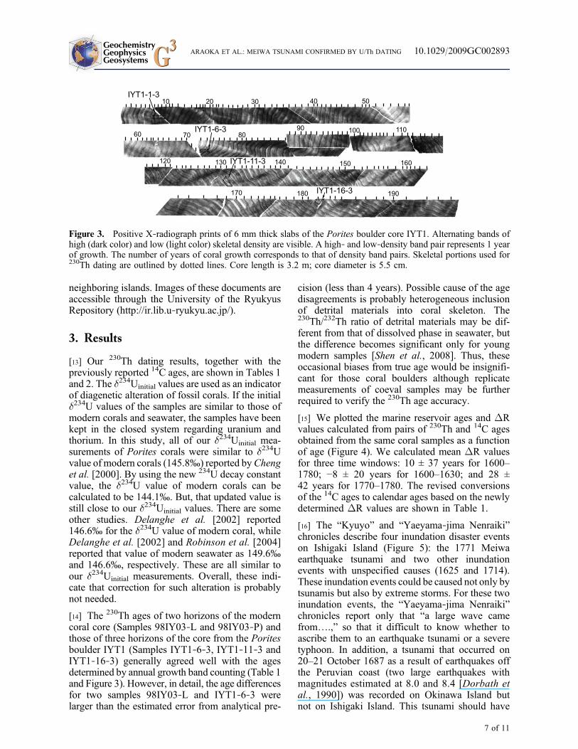
[14] The 230Th ages of two horizons of the moderncoral core (Samples 98IY03‐L and 98IY03‐P) andthose of three horizons of the core from the Poritesboulder IYT1 (Samples IYT1‐6‐3, IYT1‐11‐3 andIYT1‐16‐3) generally agreed well with the agesdetermined by annual growth band counting (Table 1and Figure 3). However, in detail, the age differencesfor two samples 98IY03‐L and IYT1‐6‐3 werelarger than the estimated error from analytical pre-
cision (less than 4 years). Possible cause of the agedisagreements is probably heterogeneous inclusionof detrital materials into coral skeleton. The230Th/232Th ratio of detrital materials may be dif-ferent from that of dissolved phase in seawater, butthe difference becomes significant only for youngmodern samples [Shen et al., 2008]. Thus, theseoccasional biases from true age would be insignifi-cant for those coral boulders although replicatemeasurements of coeval samples may be furtherrequired to verify the 230Th age accuracy.
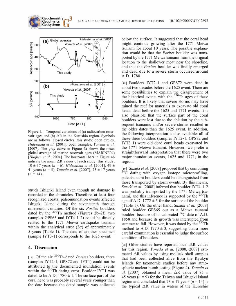
[15] We plotted the marine reservoir ages and DRvalues calculated from pairs of 230Th and 14C agesobtained from the same coral samples as a functionof age (Figure 4). We calculated mean DR valuesfor three time windows: 10 ± 37 years for 1600–1780; −8 ± 20 years for 1600–1630; and 28 ±42 years for 1770–1780. The revised conversionsof the 14C ages to calendar ages based on the newlydetermined DR values are shown in Table 1.
[16] The “Kyuyo” and “Yaeyama‐jima Nenraiki”chronicles describe four inundation disaster eventson Ishigaki Island (Figure 5): the 1771 Meiwaearthquake tsunami and two other inundationevents with unspecified causes (1625 and 1714).These inundation events could be caused not only bytsunamis but also by extreme storms. For these twoinundation events, the “Yaeyama‐jima Nenraiki”chronicles report only that “a large wave camefrom….,” so that it difficult to know whether toascribe them to an earthquake tsunami or a severetyphoon. In addition, a tsunami that occurred on20–21 October 1687 as a result of earthquakes offthe Peruvian coast (two large earthquakes withmagnitudes estimated at 8.0 and 8.4 [Dorbath etal., 1990]) was recorded on Okinawa Island butnot on Ishigaki Island. This tsunami should have
Figure 3. Positive X‐radiograph prints of 6 mm thick slabs of the Porites boulder core IYT1. Alternating bands ofhigh (dark color) and low (light color) skeletal density are visible. A high‐ and low‐density band pair represents 1 yearof growth. The number of years of coral growth corresponds to that of density band pairs. Skeletal portions used for230Th dating are outlined by dotted lines. Core length is 3.2 m; core diameter is 5.5 cm.
GeochemistryGeophysicsGeosystems G3G3 ARAOKA ET AL.: MEIWA TSUNAMI CONFIRMED BY U/Th DATING 10.1029/2009GC002893
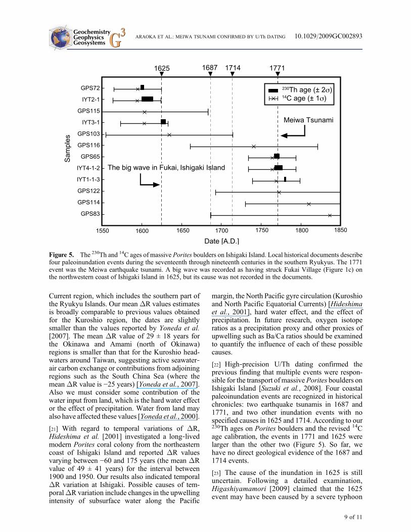
struck Ishigaki Island even though no damage isrecorded in the chronicles. Therefore, at least fourrecognized coastal paleoinundation events affectedIshigaki Island during the seventeenth throughnineteenth centuries. Of the six Porites bouldersdated by the 230Th method (Figures 2b–2f), two(samples GPS65 and IYT4‐1‐2) could be directlyrelated to the 1771 Meiwa earthquake tsunamiwithin the analytical error (2s) of approximately5 years (Table 1). The date of another specimen(sample IYT3‐1) corresponds to the 1625 event.
4. Discussion
[17] Of the six 230Th‐dated Porites boulders, three(samples IYT2‐1, GPS72 and IYT1) could not beattributed to the documented inundation eventswithin the 230Th dating error. Boulder IYT1 wasdated to be A.D. 1780 ± 1. The surface part of thecoral head was probably several years younger thanthe date because the dated sample was collected
below the surface. It suggested that the coral headmight continue growing after the 1771 Meiwatsunami for about 10 years. The possible explana-tion would be that the Porites boulder was trans-ported by the 1771 Meiwa tsunami from the originallocation to the shallower moat near the shoreline,and that the Porites boulder was finally emergedand dead due to a severe storm occurred aroundA.D. 1780.
[18] Boulders IYT2‐1 and GPS72 were dead inabout two decades before the 1625 event. There aresome possibilities to explain the disagreement ofthe historical events with the 230Th ages of theseboulders. It is likely that severe storms may havemined the reef for materials to excavate old coralheads dead before the 1625 and 1771 events. It isalso plausible that the surface part of the coralboulders were lost due to the ablation by the sub-sequent tsunamis and/or severe storms resulted inthe older dates than the 1625 event. In addition,the following interpretation is also available: all ofthese three boulders (samples IYT2‐1, GPS72 andIYT3‐1) were old dead coral heads excavated bythe 1771 Meiwa tsunami. However, we prefer astraightforward interpretation that there were twomajor inundation events, 1625 and 1771, in theregion.
[19] Suzuki et al. [2008] proposed that by combining14C dating with oxygen isotope microprofiling,paleotsunami boulders could be distinguished fromthose transported by storm events. By this means,Suzuki et al. [2008] inferred that boulder IYT4‐1‐2was probably transported by the 1771 Meiwa tsu-nami, and this inference is supported by the 230Thage of A.D. 1772 ± 5 for the surface of the boulder(Table 1). On the other hand, Suzuki et al. [2008]ruled boulder GPS65 out as a Meiwa tsunamiboulder, because of its calibrated 14C date of A.D.1858 and because its growth was interrupted fromsummer to fall. However, it was dated by the 230Thmethod to A.D. 1770 ± 3, suggesting that a morecareful examination is essential to judge the surfacecondition of boulders.
[20] Other studies have reported local DR valuesfor this region. Yoneda et al. [2000, 2007] esti-mated DR values by using mollusk shell samplesthat had been collected alive from the RyukyuIslands for taxonomic studies before any atmo-spheric nuclear bomb testing (Figure 4). Yoneda etal. [2007] obtained a mean DR value of 85 ±45 years (n = 9) for the Taiwan and Ishigaki Islandregion and concluded that 73 ± 17 years (n = 14) isthe typical DR value in waters of the Kuroshio
Figure 4. Temporal variations of (a) radiocarbon reser-voir ages and (b) DR in the Kuroshio region. Symbolsare as follows: closed circles, this study; open circles,Hideshima et al. [2001]; open triangles, Yoneda et al.[2007]. The gray curve in Figure 4a shows the meanglobal average of marine reservoir ages (MARINE04)[Hughen et al., 2004]. The horizontal bars in Figure 4bindicate the mean DR values of each study: this study,10 ± 37 years (n = 6); Hideshima et al. [2001], 49 ±41 years (n = 5); Yoneda et al. [2007], 73 ± 17 years(n = 14).
GeochemistryGeophysicsGeosystems G3G3 ARAOKA ET AL.: MEIWA TSUNAMI CONFIRMED BY U/Th DATING 10.1029/2009GC002893
8 of 11
Current region, which includes the southern part ofthe Ryukyu Islands. Our meanDR values estimatesis broadly comparable to previous values obtainedfor the Kuroshio region, the dates are slightlysmaller than the values reported by Yoneda et al.[2007]. The mean DR value of 29 ± 18 years forthe Okinawa and Amami (north of Okinawa)regions is smaller than that for the Kuroshio head-waters around Taiwan, suggesting active seawater‐air carbon exchange or contributions from adjoiningregions such as the South China Sea (where themeanDR value is −25 years) [Yoneda et al., 2007].Also we must consider some contribution of thewater input from land, which is the hard water effector the effect of precipitation. Water from land mayalso have affected these values [Yoneda et al., 2000].
[21] With regard to temporal variations of DR,Hideshima et al. [2001] investigated a long‐livedmodern Porites coral colony from the northeasterncoast of Ishigaki Island and reported DR valuesvarying between −60 and 175 years (the mean DRvalue of 49 ± 41 years) for the interval between1900 and 1950. Our results also indicated temporalDR variation at Ishigaki. Possible causes of tem-poralDR variation include changes in the upwellingintensity of subsurface water along the Pacific
margin, the North Pacific gyre circulation (Kuroshioand North Pacific Equatorial Currents) [Hideshimaet al., 2001], hard water effect, and the effect ofprecipitation. In future research, oxygen isotoperatios as a precipitation proxy and other proxies ofupwelling such as Ba/Ca ratios should be examinedto quantify the influence of each of these possiblecauses.
[22] High‐precision U/Th dating confirmed theprevious finding that multiple events were respon-sible for the transport of massive Porites boulders onIshigaki Island [Suzuki et al., 2008]. Four coastalpaleoinundation events are recognized in historicalchronicles: two earthquake tsunamis in 1687 and1771, and two other inundation events with nospecified causes in 1625 and 1714. According to our230Th ages on Porites boulders and the revised 14Cage calibration, the events in 1771 and 1625 werelarger than the other two (Figure 5). So far, wehave no direct geological evidence of the 1687 and1714 events.
[23] The cause of the inundation in 1625 is stilluncertain. Following a detailed examination,Higashiyamamori [2009] claimed that the 1625event may have been caused by a severe typhoon
Figure 5. The 230Th and 14C ages of massive Porites boulders on Ishigaki Island. Local historical documents describefour paleoinundation events during the seventeenth through nineteenth centuries in the southern Ryukyus. The 1771event was the Meiwa earthquake tsunami. A big wave was recorded as having struck Fukai Village (Figure 1c) onthe northwestern coast of Ishigaki Island in 1625, but its cause was not recorded in the documents.
GeochemistryGeophysicsGeosystems G3G3 ARAOKA ET AL.: MEIWA TSUNAMI CONFIRMED BY U/Th DATING 10.1029/2009GC002893
because the inundation pattern was different fromthat of the 1771 Meiwa earthquake tsunami, whichcaused dreadful damage to villages along theeastern coast of Ishigaki Island. According to thedescription in “Yaeyama‐jima Nenraiki,” Fukaivillage on the northwestern coast of Ishigaki Islandwas mostly destroyed by the event (Figure 1c).However, by the hydrodynamic examination,Gotoet al. [2009] suggested that only tsunamis cantransport large boulders over wide reef flats. Theresult of this study is supportive that the 1625 eventwas also a tsunami because one of the largestPorites boulders (sample IYT3‐1) was cast ashorebehind the wide Ishigaki coral reef (>0.8 km).
[24] The East Ishigaki Fault has attracted attentionas a possible source fault of the 1771 Meiwaearthquake, because its length of 44 km, whichcorresponds to a magnitude of 7.4 Meiwa earth-quake [Nakamura, 2006]. If the 1625 event wasalso a tsunami and if both the 1625 and 1771tsunamis were caused by the same fault, therecurrence interval could be estimated. But, mostrecently, Matsumoto et al. [2009a, 2009b] con-cluded that the East Ishigaki Fault might not be asource fault of the 1771 tsunami because noindication of the entire slip along the fault wasfound by seafloor observation from a remotelyoperated vehicle.
[25] The available information is still too limitedfor reliable discussion of the source fault locationand the seismic recurrence period in the region.However, this study shows the potential value ofU/Th dating of paleoinundation events through theages of materials they transport on shore, particu-larly large Porites boulders.
5. Conclusion
[26] This study is the first report of high‐precision230Th dating applied to tsunami deposits in IshigakiIsland, southwest Japan. Among the six Poritesboulders dated by the 230Th method, two Poritesboulders could be directly related to the 1771Meiwaearthquake tsunami within the analytical error (2s)of approximately 5 years. One large Porites boulderwas dated to 1625, which corresponds to thecoastal paleoinundation event described in thechronicles of the Ryukyu Kingdom. These resultssuggested that these two coastal paleoinundationevents were larger than the others during the sev-enteenth through nineteenth centuries. In addition,marine reservoir ages and regional correction va-lues (DR) were calculated by comparing 230Th and
14C ages of Porites coral boulders. While Poritescorals are often used for paleoclimate and paleo-ceanographic reconstructions, we have demon-strated that Porites coral boulders are also useful forstudies of paleoinundation events such as tsunamisand extreme storms.
Acknowledgments
[27] We express our special appreciation to T. Kawana ofUniversity of the Ryukyus, K. Goto and F. Imamura of TohokuUniversity, T. Yoshimura and H. Ushie of the University ofTokyo, andM.Nagao ofAIST for valuable discussion. Assistancein the laboratory and the field was provided by K. Minoshima,N. Hokanishi, Y. Yoshinaga, M. Takaoka, N. Hamanaka,T. Sato, A. Iwase, and K. Tottori. This study was partly sup-ported by the Global Environment Research Fund (RF081) byMinistry of the Environment and GCOE project to Y.Y. andJSPS Grants‐in‐Aid for Scientific Research (21674003,20403002, 19340158, 18340163, 19840020, 21340166, and18340180) to Y.Y., M.I., and A.S.
References
Cheng, H., R. L. Edwards, J. Hoff, C. D. Gallup, D. A. Richards,and Y. Asmeron (2000), The half‐lives of uranium‐234 andthorium‐230, Chem. Geol., 169, 17–33, doi:10.1016/S0009-2541(99)00157-6.
Cheng, H., R. L. Edwards, W. S. Broecker, G. H. Denton,X. G. Kong, Y. J. Wang, R. Zhang, and X. F. Wang (2009),Ice age terminations, Science, 326, 248–252, doi:10.1126/science.1177840.
Cobb, K. M., C. D. Charles, H. Cheng, M. Kastner, and R. L.Edwards (2003a), U/Th‐dating living and young fossil coralsfrom the central tropical Pacific, Earth Planet. Sci. Lett.,210, 91–103, doi:10.1016/S0012-821X(03)00138-9.
Cobb, K. M., C. D. Charles, H. Cheng, and R. L. Edwards(2003b), El Niño/Southern Oscillation and tropical Pacificclimate during the last millennium, Nature, 424, 271–276,doi:10.1038/nature01779.
Delanghe, D., E. Bard, and B. Hemelin (2002), New TIMSconstrains on the uranium‐238 and uranium‐234 in sea-waters from the main ocean basins and the MediterraneanSea, Mar. Chem., 80, 79–93, doi:10.1016/S0304-4203(02)00100-7.
Dorbath, L., A. Cisternas, and C. Dorbath (1990), Assessmentof the size of large and great historical earthquakes of Peru,Bull. Seismol. Soc. Am., 80, 551–576.
Edwards, R. L., J. H. Chen, and G. J. Wasserburg (1987),238U‐234U‐230Th‐232Th systematics and the precise measure-ment of time over the past 500,000 years, Earth Planet. Sci.Lett., 81, 175–192, doi:10.1016/0012-821X(87)90154-3.
Edwards, R. L., F. W. Taylor, and G. J. Wasserburg (1988),Dating earthquakes with high‐precision thorium‐230 agesof very young corals, Earth Planet. Sci. Lett., 90, 371–381, doi:10.1016/0012-821X(88)90136-7.
Goto, K., K. Okada, and F. Imamura (2009), Characteristicsand hydrodynamics of boulders transported by storm wavesat Kudaka Island, Japan, Mar. Geol. , 262 , 14–24,doi:10.1016/j.margeo.2009.03.001.
GeochemistryGeophysicsGeosystems G3G3 ARAOKA ET AL.: MEIWA TSUNAMI CONFIRMED BY U/Th DATING 10.1029/2009GC002893
Hatori, T. (1988), Tsunami magnitudes and source areasalong the Ryukyu Islands (in Japanese with English abstract),J. Seismol. Soc. Jpn., 41, 541–547.
Hideshima, S., E. Matsumoto, O. Abe, and H. Kitagawa(2001), Northwest Pacific marine reservoir correction esti-mated from annually banded coral from Ishigaki Island,southern Japan, Radiocarbon, 43, 473–476.
Higashiyamamori, A. (2009), Verification of large waves andearthquakes described in historical documents: Exemplifiedfrom Ishigaki Island, the South Ryukyus, Japan, M.S. thesis,52 pp., Univ. of the Ryukyus, Nishihara, Japan.
Hughen, K. A., et al. (2004), MARINE04 marine radiocarbonage calibration, 0–26 cal kyr BP, Radiocarbon, 46, 1059–1086.
Imamura, A. (1938), On the earthquakes zone of the Ryukyuand large Meiwa tsunami (in Japanese with English abstract),J. Seismol. Soc. Jpn., 10, 350–431.
Imamura, F., K. Goto, and S. Ohkubo (2008), A numericalmodel for the transport of a boulder by tsunami, J. Geophys.Res., 113, C01008, doi:10.1029/2007JC004170.
Jaffey, A. H. K., F. Flynn, L. E. Glendenin, W. C. Bentley, andA. M. Essling (1971), Precision measurement of half‐livesand specific activities of 235U and 238U, Phys. Rev. C, 4,1889–1906, doi:10.1103/PhysRevC.4.1889.
Kawana, T., and T. Nakata (1994), Timing of Late Holocenetsunamis originating around the southern Ryukyu Islands,Japan, deduced from coralline tsunami deposits (in Japanesewith English abstract), J. Geogr., 103, 352–376.
Matsumoto, T., C. Uechi, and M. Kimura (1997), Surfacedeformation at the origin area of the 1771 Yaeyama earth-quake tsunami observed by the precise survey off Yaeyamadistricts, Ryukyu area, JAMSTEC J. Deep Sea Res., 13,535–561.
Matsumoto, T., R. Shinjo, M. Nakamura, M. Kimura, andT. Ono (2009a), Submarine active normal faults completelycrossing the southwest Ryukyu Arc, Tectonophysics, 466,289–299, doi:10.1016/j.tecto.2007.11.032.
Matsumoto, T., R. Shinjo, M. Nakamura, A. Doi, M. Kimura,T. Ono, and A. Kubo (2009b), Did the submarine, across arcnormal fault system in the southwest Ryukyu Arc trigger the1771 tsunami? Field evidence from multibeam survey andin‐situ observation, Pol. J. Environ. Stud., 18, 123–129.
Matsuzaki, H., C. Nakano, H. Yamashita, Y.Maejima, Y.Miyairi,S. Wakasa, and K. Horiuchi (2004), Current status and futuredirection of MALT, the University of Tokyo, Nucl. Instrum.Methods Phys. Res., Sect. B, 223–224, 92–99, doi:10.1016/j.nimb.2004.04.022.
Nakamura, M. (2006), Source fault model of the 1771 Yaeyamatsunami, southern Ryukyu Islands, Japan, inferred fromnumerical simulation, Pure Appl. Geophys., 163, 41–54,doi:10.1007/s00024-005-0007-9.
Reimer, P. J., et al. (2004), INTCAL04 terrestrial radiocarbon agecalibration, 0–26 cal kyr BP, Radiocarbon, 46, 1029–1058.
Robinson, L. F., N. S. Belshaw, and G. M. Henderson (2004),U and Th concentrations and isotope ratios in modern carbo-
nates and waters from the Bahamas, Geochim. Cosmochim.Acta, 68, 1777–1789, doi:10.1016/j.gca.2003.10.005.
Shen, C. C., R. L. Edwards, H. Cheng, J. A. Dorale, R. B.Thomas, S. B. Moran, S. E. Weinstein, and H. N. Edmonds(2002), Uranium and thorium isotopic and concentrationmeasurements by magnetic sector inductively coupledplasma mass spectrometry, Chem. Geol., 185, 165–178,doi:10.1016/S0009-2541(01)00404-1.
Shen, C. C., et al. (2008), Variation of initial 230Th/232Th andlimits of high precision U‐Th dating of shallow‐water corals,Geochim. Cosmochim. Acta, 72, 4201–4223, doi:10.1016/j.gca.2008.06.011.
Sieh, K. (2005), What happened and what’s next?, Nature,434, 573–574, doi:10.1038/434573a.
Sieh, K., D.H.Natawidjaja, A. J.Meltzner, C. C. Shen, H. Cheng,K. S. Li, B. W. Suwargadi, J. Galetzka, B. Philibosian, andR. L. Edwards (2008), Earthquake supercycles inferred fromsea‐level changes recorded in the corals of West Sumatra,Science, 322, 1674–1678, doi:10.1126/science.1163589.
Suzuki, A., Y. Yokoyama, H. Kan, K.Minoshima, H.Matsuzaki,N. Hamanaka, and H. Kawahata (2008), Identification of1771 Meiwa Tsunami deposits using a combination ofradiocarbon dating and oxygen isotope microprofiling ofemerged massive Porites boulders, Quat. Geochronol., 3,226–234, doi:10.1016/j.quageo.2007.12.002.
Tsunoda, T., H. Kawahata, A. Suzuki, K. Minoshima, andN. Shikazono (2008), East Asian monsoon to El Niño/Southern Oscillation: A shift in the winter climate of IshigakiIsland accompanying the 1988/1989 regime shift, based oninstrumental and coral records, Geophys. Res. Lett., 35,L13708, doi:10.1029/2008GL033539.
Yokoyama, Y., T. M. Esat, K. Lambeck, and L. K. Fifield(2000), Last ice age millennial scale climate changesrecorded in Huon Peninsula Corals, Radiocarbon, 42,383–401.
Yokoyama, Y., Y. Miyairi, H. Matsuzaki, and F. Tsunomori(2007), Relation between acid dissolution time in the vac-uum test tube and time required for graphitization forAMS target preparation, Nucl. Instrum. Methods Phys. Res.,Sect. B, 259, 330–334, doi:10.1016/j.nimb.2007.01.176.
Yoneda,M.,H.Kitagawa, J. van der Plicht,M.Uchida,A.Tanaka,T. Uehiro, Y. Shibata, M. Morita, and T. Ohno (2000), Pre‐bomb marine reservoir ages in the western north Pacific: Pre-liminary result on Kyoto University collection, Nucl. Instrum.Methods Phys. Res., Sect. B, 172, 377–381, doi:10.1016/S0168-583X(00)00361-X.
Yoneda, M., H. Uno, Y. Shibata, R. Suzuki, Y. Kumamoto,K. Yoshida, T. Sasaki, A. Suzuki, and H. Kawahata (2007),Radiocarbon marine reservoir ages in the western Pacificestimated by pre‐bomb molluscan shells, Nucl. Instrum.Methods Phys. Res., Sect. B, 259, 432–437, doi:10.1016/j.nimb.2007.01.184.
GeochemistryGeophysicsGeosystems G3G3 ARAOKA ET AL.: MEIWA TSUNAMI CONFIRMED BY U/Th DATING 10.1029/2009GC002893