Received: 15 May 2013 – Revised: 19 August 2013 – Accepted: 1 October 2013 – Published: 16 December 2013
Abstract. Changes in Switzerland’s climate are expected to have major impacts on glaciers, the hydrologicalregime and the natural hazard potential in mountainous regions. Glacier de la Plaine Morte is the largestplateau glacier in the European Alps and thus represents a particularly interesting site for studying rapid andfar-reaching effects of atmospheric warming on Alpine glaciers. Based on detailed field observations combinedwith numerical modelling, the changes in total ice volume of Glacier de la Plaine Morte since the 1950s and thedynamics of present glacier mass loss are assessed. Future ice melt and changes in glacier runoff are computedusing climate scenarios, and a possible increase in the natural hazard potential of glacier-dammed lakes aroundPlaine Morte over the next decades is discussed. This article provides an integrative view of the past, currentand future retreat of an extraordinary Swiss glacier and emphasizes the implications of climate change onAlpine glaciers.
1 Introduction
Glaciers are known as one of the most direct indicators of cli-matic change (e.g.Haeberli and Beniston, 1998). They reactsensitively to small variations in air temperature and precip-itation, and their retreat is iconic for the recently observedglobal warming trend (Oerlemans, 2001). Glacier mass lossin the European Alps is expected to have serious conse-quences for the hydrological regime (Huss, 2011; Finger etal., 2012), and thus water supply in dry Alpine valleys aswell as future hydropower production (Schaefli et al., 2007).Furthermore, an increase in the frequency of natural haz-ards in mountainous regions, such as rock face instabilitiesor flooding events, has been observed over the last decades(e.g. Huggel et al., 2012), and significant impacts of a di-minishing glacier area on winter and summer tourism arelikely (Bürki et al., 2003; Fischer et al., 2011). A combina-tion of field measurements and model approaches is requiredto understand the governing processes that determine futureglacier changes and the related impacts on the environment.Specific case studies on individual glaciers are necessary forbetter understanding the implications of climate change onthe high-Alpine environment.
Glacier de la Plaine Morte, located on the main waterdivide between the Rhine and Rhone in the Bernese Alps,is highly particular in different aspects. Plaine Morte is thelargest plateau glacier in the European Alps; almost its en-tire surface area shows no significant topographic gradients.Dye tracer experiments have shown that a considerable frac-tion of the meltwater is drained southwards to the RhoneValley through subsurface conduits in the karstic system al-though the glacier surface is entirely located in the drainagebasin of the Rhine River (Finger et al., 2013). A poten-tial future change in the water supply due to glacier massloss is a major concern in the summer-dry region aroundCrans-Montana, Valais, which is studied in the frame of theinterdisciplinary project MontanAqua (Weingartner et al.,2010; Schneider and Homewood, 2013). Glacier de la PlaineMorte represents the top of the hydrological system. Snow-and ice melt provides vital water input during the summermonths which is used for hydropower production, irriga-tion, and private water use (Reynard and Bonriposi, 2012).The glacier is also an important touristic factor for recre-ational activities in winter and summer and can be accessedvia a cable car from Crans-Montana. Moreover, since 2011,the outburst of several glacier-dammed lakes around Plaine
Published by Copernicus Publications for the Geographisch-Ethnographische Gesellschaft Zürich & Association Suisse de Géographie.
228 M. Huss et al.: Climate change implications on Glacier de la Plaine Morte
Morte is documented causing floods in the Simme Valleyon the Bernese side (Hählen, 2012). Plaine Morte is thusan ideal testing case for an integrative assessment of variouseconomic and environmental implications of future glacierchanges.
Glacier de la Plaine Morte has already received con-siderable attention in glaciological literature. In the 1940s,Süsstrunk(1951) was a pioneer in applying seismic meth-ods for the determination of ice thickness, and Glacier de laPlaine Morte was one of the first sites where this new tech-nology was tested. Studies focusing on the chemical compo-sition of the ice (Schotterer et al., 1977), and the drainageof meltwater through the subglacial karst were carried out(Maire, 1978). More recently, the surface energy balance(Huwald et al., 2009, 2012; Bou-Zeid et al., 2010), and theice surface albedo (Paul et al., 2005; Bühlmann, 2011) wereinvestigated. Since 2010, Plaine Morte is subject to glacio-logical field studies related to the MontanAqua project. Dif-ferent types of measurements were performed in order tocharacterize the present state of the glacier, to understand itsresponse to past, present and future climatic forcing, and toassess its hydrological importance.
This paper highlights different aspects of the response ofGlacier de la Plaine Morte to climate change. We presentresults of a detailed ice thickness mapping, recent changesin snow accumulation and ice melt based on in situ mea-surements, and a reconstruction of glacier change since the1950s. Future glacier retreat and the consequent impacts onthe runoff regime are investigated using a glacio-hydrologicalmodel. We also present a new approach to estimate temporalchanges in the volume and the shape of ice-dammed lakesover the next decades, and discuss the implications on thehazard potential of glacier lakes on Plaine Morte for down-stream communities. This study thus provides an integrativeassessment of past and future changes in a large Swiss glacierwhich is particular in many ways.
2 Study site and field data
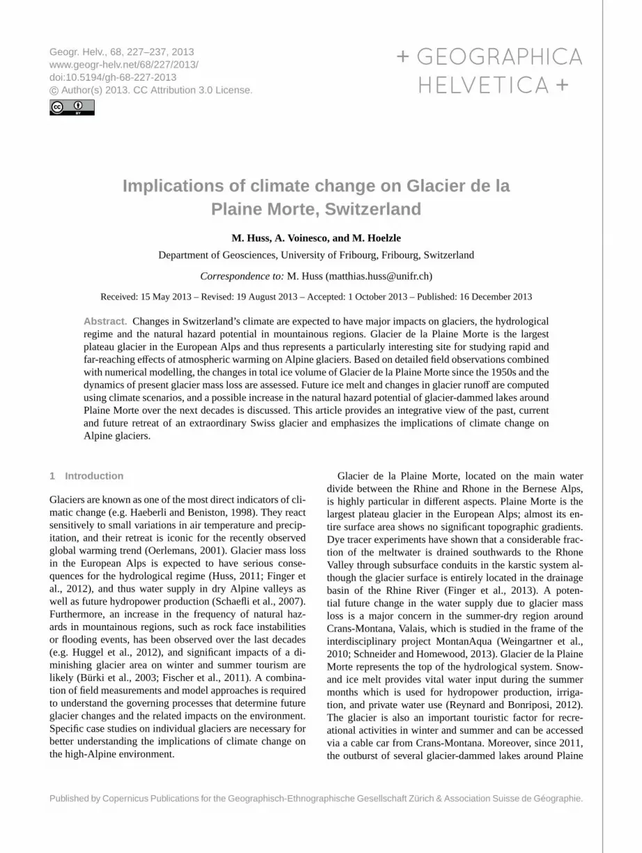
Glacier de la Plaine Morte currently has an area of 7.88 km2.More than 90 % of its surface lies between 2650 and2800 m a.s.l. which emphasizes the narrow altitude range oc-cupied by the glacier (Fig.1a). From the 5 km wide plateauwith an average slope of less than 4◦, a small glacier tongue,termed Rezligletscher, flows northwards. There is no sepa-ration between the accumulation and the ablation area. Inmost years, the entire glacier is snow-covered or completelysnow-free at the end of summer, i.e. the equilibrium line ei-ther lies above or below the glacier. Ice flow speed seems tobe very limited and some crevasses are only observed on Re-zligletscher. Glacier surface structures, such as large circulardepressions, probably related to cryo-karst (Maire, 1978), arestable over several decades (Fig.1a).
Considerable parts of the glacier surface are imperme-able to water flow which is related to the absence of signifi-cant glacier dynamics. Meltwater thus accumulates in surfacestreams reaching lengths of up to 1 km and is routed to largeand temporally stable moulins that conduct water verticallythrough the ice. Whereas most meltwater is drained alongthe glacier bed to the north and reappears at the tongue ofRezligletscher, a significant fraction of surface melt from thewestern part of Plaine Morte enters the karstic system that isconnected to the Rhone Valley through subsurface conduits(Finger et al., 2013). The meltwater thus crosses the mainsurface water divide.
Since several years, three glacier-marginal lakes aroundPlaine Morte are observed. Strubelsee and Lac de Vatseretare rather small; Lac des Faverges at the south-western mar-gin of the glacier (Fig.1a) currently has a considerable watervolume of about 1.5 Mm3 (million cubic metres) (Hählen,2012). All lakes form on impermeable sediments and aredammed by the ice on one side, thus making them poten-tially instable. Until 2011, no outbursts were documented(although smaller events might have gone unnoticed), and thelakes filled until the water level reached a surface overflow. In2011–2013, however, some lakes were subject to subglacialdrainage within a few days in early summer (Hählen, 2012).
The ice thickness of Glacier de la Plaine Morte was mea-sured in a 2 day field campaign in February 2010. About20 km of tracks with a ground penetrating radar (GPR) sys-tem were achieved, covering the entire glacier (Voinesco,2012). GPR is a standard method to determine the ice thick-ness of Alpine glaciers and is based on the reflection ofelectromagnetic waves at the ice–bedrock interface (e.g.Macheret et al., 1993; Bauder et al., 2003). We used a GPRsystem by Måla and a rough-terrain antenna with a fre-quency of 25 MHz. Data quality was excellent in the southernand western part of the glacier. In the north and east how-ever, bedrock reflections were partly unclear, probably dueto absorption by englacial water or noise due to crevasses(Voinesco, 2012).
Seasonal mass balance measurements for the four hydro-logical years 2009/2010–2012/2013 have been carried outbased on the direct glaciological method. A network of ab-lation stakes (Fig.1a), placed in the ice using a steam drill,was surveyed 2–4 times over the summer season, providingmonthly measurements of snow and ice ablation. At leastfour stakes were measured in every year. Observed abla-tion varies within a relatively small range. We thus assumethat the limited number of measurement sites is sufficient forcapturing the mass balance of the entire glacier. We mea-sured winter accumulation in mid-April based on 100–200snow probings (depending on the survey year) distributedover the entire glacier surface. Snow density was determinedin 1–2 snow pits. The extrapolation of accumulation and ab-lation measurements is supported by a spatially distributedglacier mass balance model including the influence of directsolar radiation and wind redistribution (Huss, 2010). This
M. Huss et al.: Climate change implications on Glacier de la Plaine Morte 229
Ice thickness (m)0 40 80 120 160 200
2500
2500
2550
2550
2550
2600
26002600
2650
2650
2650
2700
2700
2700
2700
27502750
2750
2750
2800
2800
2850
Glacier area (2011): 7.88 km2
Ice volume (2011): 0.82 km3
260026202640
26602680
2700
2700
2720
2720
2720
2740
2740
2740
2740
27602760
2760
2760
2780
2780
2800
2800
282028402860
Lac de Vatseret Lac des
Faverges
Strubelsee
Cryokarst depressions
Glacier de la Plaine Morte
0 500 1000 1500
m
Les Faverges
Rezli-gletscher
b
a
c d
Figure 1. (a) Map of Glacier de la Plaine Morte with surface topography in 2011. The position of mass balance measurement sites (dia-monds), cryo-karst depressions, and ice-marginal lakes is indicated.(b) Ice thickness distribution of Glacier de la Plaine Morte with GPRmeasurement tracks. Contours show bedrock elevation.(c, d) Overview photographs of Glacier de la Plaine Morte.
allows calculating the seasonal glacier volume change in wa-ter equivalent (w.e.).
Information on glacier surface geometry is obtained froma digital elevation model (DEM) acquired in 2011 based on aphotogrammetrical evaluation of aerial photographs (kindlyprovided by Oberingenieurskreis I, Thun). Another DEM forthe year 1954 was established by digitizing contour lines ofthe first topographic map in the 1 : 25 000 scale (Voinesco,2012). Both DEMs were interpolated to a 25m×25 m gridand are accompanied by a mapping of the glacier outline. Ad-ditional high-resolution aerial photographs from Swisstopofrom the years 2000, 2007 and 2010 are available providing
evidence on short-term changes in glacier extent and ice sur-face features.
Meteorological data are provided by MeteoSwiss weatherstations at Montana (1495 m a.s.l., at 8 km from the glacier)and at Adelboden (1320 m a.s.l., 13 km). We use daily airtemperature and precipitation. In addition, long-term weatherdata from the homogenized series at Sion (542 m a.s.l.,20 km) were used.
3 Ice thickness
The ice thickness distribution and the volume of a glacier de-termine its response to climate change and its importance to
230 M. Huss et al.: Climate change implications on Glacier de la Plaine Morte
local and regional hydrology (e.g.Huss et al., 2008b; Gabbiet al., 2012). The favourable accessibility of Plaine Morte al-lowed us to cover the entire glacier with the ice thicknesssurvey thus providing complete information on subglacialbedrock topography (Fig.1b).
GPR signals were treated and enhanced using standardprocessing methods (Voinesco, 2012). Bedrock reflections onthe GPR tracks were converted to ice thickness by assuminga radio wave velocity of 0.169 m ns−1 in temperate ice (e.g.Macheret et al., 1993; Blindow et al., 2010). Measured thick-ness along the GPR profiles was subsequently interpolatedin space. We also used ice thickness estimates bySüsstrunk(1951) based on seismic surveys for the interpolation.
A total ice volume of 0.82±0.1 km3 is inferred for 2011(Fig. 1b). The mean ice thickness of Glacier de la PlaineMorte is 104 m, the maximum thickness detected is 226±18 m. The uncertainty in total ice volume is estimated basedon the accuracy and the spatial representativeness of theradio-echo sounding profiles, and the quality of the bedrockreflections. Compared to the size of Plaine Morte, the ice vol-ume is considerable and corresponds to almost 1.5 % of theglacier volume (updated to 2011) in the Swiss Alps (Farinottiet al., 2009). The interpolated bedrock shows several depres-sions in the southern part of the glacier. The shape of thesubglacial topography slightly resembles a bathtub (Fig.1b).A ridge with smaller ice thicknesses separates the deepest re-gions from the glacier tongue. It is however difficult to judgefrom the direct measurements whether lakes might form inthese bedrock depressions after the complete disintegrationof the ice. The depressions might be drained through waterchannels in the karst (Finger et al., 2013), or they might beconnected by valleys in the bedrock that could not be de-tected by the relatively coarsely spaced GPR measurements.
4 Glacier mass balance
The direct mass balance measurements for the hydrologi-cal years 2009/2010–2012/2013 indicate that Glacier de laPlaine Morte currently is in a state of disequilibrium withstrongly negative mass balance. One of the ski lifts on PlaineMorte had to be recently closed down due to glacier reces-sion, and the installations of the other lift are artificially dis-mantled in order to warrant mechanical stability. Over thelast four years, almost the entire glacier was snow-free bythe end of the summer. In order to maintain an equilibrium,at least 66 % of the glacier surface would need to be cov-ered with winter snow by September (Gross et al., 1977).Presently, three positive feedback effects further accelerateglacier mass loss. (1) As the glacier is snow-free, bare icewith a lower surface albedo is exposed. This leads to in-creased absorption of solar radiation, and thus enhanced melt(Paul et al., 2005; Bühlmann, 2011). (2) With negative massbalances the glacier surface continuously lowers and is thusexposed to progressively warmer air temperatures. (3) With
-3
-2
-1
0
1
2
Mas
s b
alan
ce (
m w
.e.)
2010
Win
ter
bal
ance
Su
mm
er b
alan
ceA
nn
ual
bal
ance
2011 2012 2013
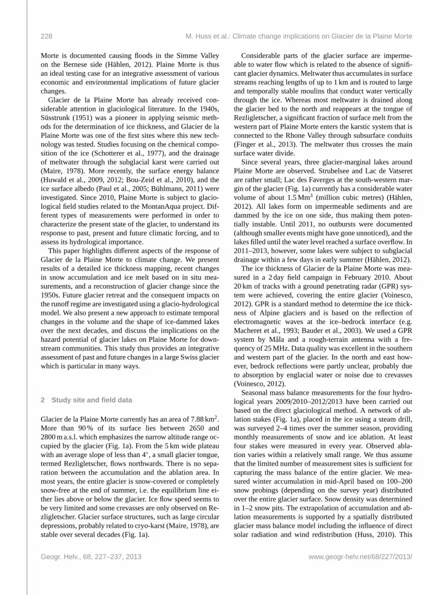
Figure 2. Measured seasonal mass balance of Glacier de la PlaineMorte for the hydrological years 2009/2010–2012/2013.
glacier retreat bedrock or sediments with low albedo are re-vealed affecting local air temperatures. As Plaine Morte doesnot extend beyond 2900 m a.s.l., the glacier cannot retreatto higher elevations in order to reach a new balance withthe modified climatic conditions. The current ice wastage isthus a self-amplifying process. With its current geometry, theglacier could not stabilize over the next decades even with amore glacier-friendly climate than today.
Although Glacier de la Plaine Morte exhibits a very ho-mogenous surface topography, some significant variations inwinter snow depth persisted for the last years. Whereas snowaccumulation is maximal in a band from the summit of LesFaverges to the glacier tongue, less snow is found in the eastand the west of the glacier. These variations are attributed topreferential snow deposition related to the movement of theair masses and subsequent redistribution of unconsolidatedsnow by wind (e.g.Lehning et al., 2008).
Compared to the quantities of winter precipitationrecorded at Montana and Adelboden, the difference in snowwater equivalent deposited on Plaine Morte is considerable.On average, more than five times (Montana), and three times(Adelboden) higher accumulation is found on the glacier.Plaine Morte is situated on the main water divide and re-ceives precipitation from the north as well as from the westresulting in a strong amplification of precipitation with ele-vation. In addition, strong winds tend to erode snow on thesurrounding mountain flanks and deposit it on the glacier.
The spatial distribution of glacier mass balance remainssimilar throughout the years. The most negative mass bal-ances are found in the east of the glacier (likely explained bysmaller snow accumulation), in the west (due to very low sur-face albedo, seeBühlmann, 2011), and on the glacier tongue(lower elevation, and thus higher air temperatures). How-ever, generally, surface mass balance shows small variations
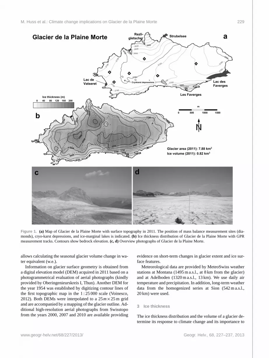
Total ice volume change (km3): -0.316Mean thickness change (m): -35.3
Profile 1
Profile 2 0.0 0.5 1.0 1.5 2.0Distance (km)
2500
2600
2700
2800
2900
Ele
vati
on
(m
a.s
.l.)
N S
Surface 1954
Surface 2011
0 1 2 3 4 5Distance (km)
2500
2600
2700
2800
2900
Ele
vati
on
(m
a.s
.l.)
W E
Surface 1954
Surface 2011
Fig. 3. Observed glacier surface elevation changes between 1954 and 2011. Two cross-profiles are shown in the insets.
Figure 3. Observed glacier surface elevation changes between 1954 and 2011. Two cross-profiles are shown in the insets.
in space compared to a typical Alpine glacier and measur-ing ablation at a few index sites only (Fig.1a) has proven tobe well suited to characterize the mass change of the entireglacier.
Winter mass balance was+1.35 m w.e. in 2010 and 2012(Fig. 2), corresponding to a mean snow depth of 3–4 m.In 2011, significantly smaller accumulation was observed,contributing to an early depletion of the winter snow. An-nual mass balance was similar in 2010 and 2012, with−1.0and −1.1 m w.e., respectively (Fig.2), corresponding to aloss in glacial water storage of about 8 Mm3. Glacier icewastage in the year 2011 was extreme with a mass balanceof −2.4 m w.e. The strong mass loss in 2011 is explainedby the reduced winter accumulation, the hot spring leadingto a complete disappearance of the protecting snow cover-age already in the beginning of July, and the phase of excel-lent weather conditions with stable high pressure cells last-ing throughout August and September. In total, almost 3 % ofthe total ice volume of Plaine Morte, or 18.3 Mm3 of water,was removed during 2011, providing a scenario for condi-tions to come in the next decades. A slightly less negativemass balance (−0.8 m w.e.) was observed despite high sum-mer temperatures in the hydrological year 2012/2013 whichis attributed to enhanced snow accumulation in winter andspring (Fig.2).
By differencing the DEMs of 1954 and 2011 (see e.g.Bauder et al., 2007), surface elevation changes over the57 yr period, and the total ice volume loss were determined(Fig. 3). Glacier ice thickness has decreased by 35 m overthe last six decades on average, with maximum values of70 m. The spatial distribution of surface elevation changes
correlates with observed surface mass balance distributionsupporting the hypothesis that ice flow dynamics are almostnegligible on Plaine Morte. Glacier area has been reducedfrom 10.0 km2 in 1954 to 7.88 km2 in 2011, correspondingto a relative area change of−21 %. Unlike for typical Alpineglaciers, the area loss is not primarily concentrated at theglacier tongue but is distributed around the entire glacier;a significant reduction in glacier area was also observed inthe accumulation area (Fig.3). The length change of theglacier tongue, measured since almost one century (Glacio-logical reports, 1881–2011), is therefore relatively small de-spite the strong glacier mass loss. Ice volume has decreasedfrom 1.14 km3 (1954) to 0.82 km3 in 2011 corresponding toa reduction of 28 %.
Using an accumulation-melt model (Hock, 1999; Husset al., 2008a), annual mass balance of Glacier de la PlaineMorte was calculated based on long-term daily meteorolog-ical series from Sion. The model was calibrated on the ob-served ice volume change, 1954−2011 (Fig.3), and the spa-tial mass balance distribution was validated using the in situmeasurements since 2009.
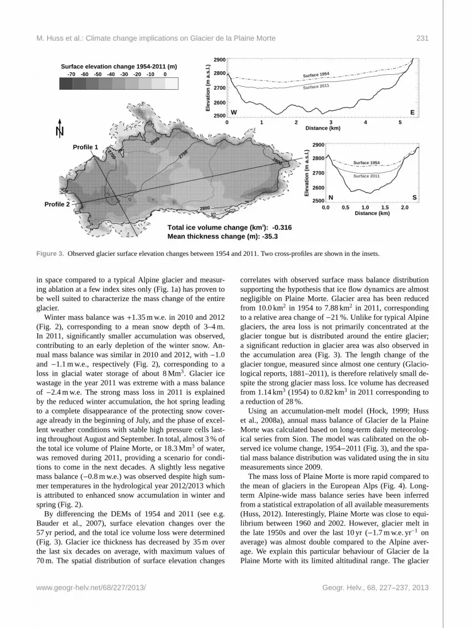
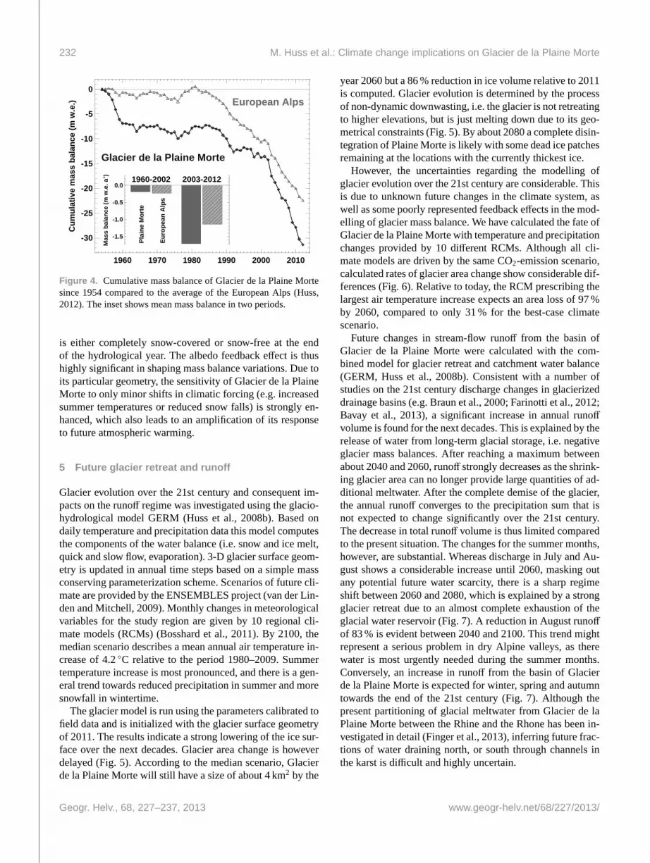
The mass loss of Plaine Morte is more rapid compared tothe mean of glaciers in the European Alps (Fig.4). Long-term Alpine-wide mass balance series have been inferredfrom a statistical extrapolation of all available measurements(Huss, 2012). Interestingly, Plaine Morte was close to equi-librium between 1960 and 2002. However, glacier melt inthe late 1950s and over the last 10 yr (−1.7 m w.e. yr−1 onaverage) was almost double compared to the Alpine aver-age. We explain this particular behaviour of Glacier de laPlaine Morte with its limited altitudinal range. The glacier
232 M. Huss et al.: Climate change implications on Glacier de la Plaine Morte
1960 1970 1980 1990 2000 2010
-30
-25
-20
-15
-10
-5
0
Cu
mu
lati
ve m
ass
bal
ance
(m
w.e
.)
Glacier de la Plaine Morte
European Alps
-1.5
-1.0
-0.5
0.0
Mas
s b
alan
ce (
m w
.e. a
-1)
1960-2002 2003-2012
Pla
ine
Mo
rte
Eu
rop
ean
Alp
s
Figure 4. Cumulative mass balance of Glacier de la Plaine Mortesince 1954 compared to the average of the European Alps (Huss,2012). The inset shows mean mass balance in two periods.
is either completely snow-covered or snow-free at the endof the hydrological year. The albedo feedback effect is thushighly significant in shaping mass balance variations. Due toits particular geometry, the sensitivity of Glacier de la PlaineMorte to only minor shifts in climatic forcing (e.g. increasedsummer temperatures or reduced snow falls) is strongly en-hanced, which also leads to an amplification of its responseto future atmospheric warming.
5 Future glacier retreat and runoff
Glacier evolution over the 21st century and consequent im-pacts on the runoff regime was investigated using the glacio-hydrological model GERM (Huss et al., 2008b). Based ondaily temperature and precipitation data this model computesthe components of the water balance (i.e. snow and ice melt,quick and slow flow, evaporation). 3-D glacier surface geom-etry is updated in annual time steps based on a simple massconserving parameterization scheme. Scenarios of future cli-mate are provided by the ENSEMBLES project (van der Lin-den and Mitchell, 2009). Monthly changes in meteorologicalvariables for the study region are given by 10 regional cli-mate models (RCMs) (Bosshard et al., 2011). By 2100, themedian scenario describes a mean annual air temperature in-crease of 4.2◦C relative to the period 1980–2009. Summertemperature increase is most pronounced, and there is a gen-eral trend towards reduced precipitation in summer and moresnowfall in wintertime.
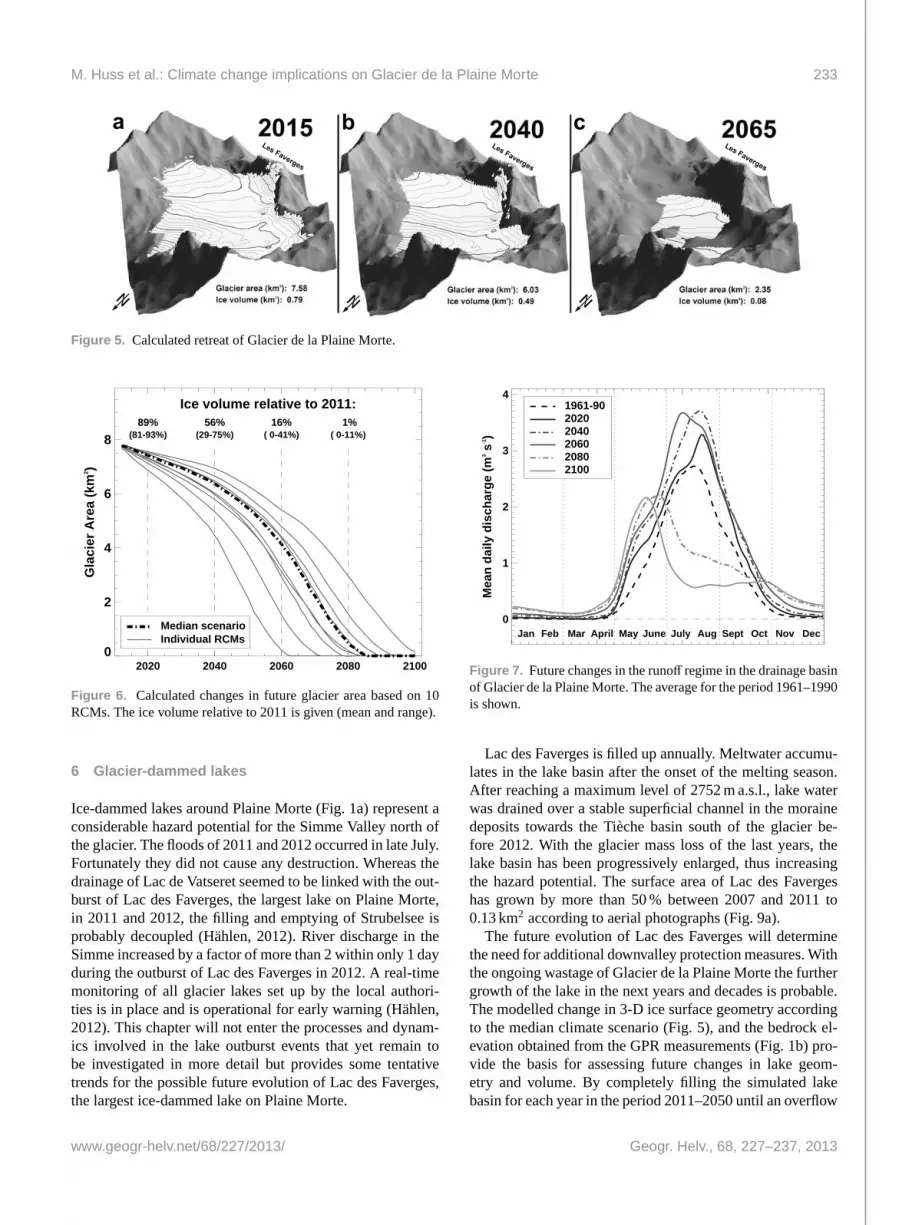
The glacier model is run using the parameters calibrated tofield data and is initialized with the glacier surface geometryof 2011. The results indicate a strong lowering of the ice sur-face over the next decades. Glacier area change is howeverdelayed (Fig.5). According to the median scenario, Glacierde la Plaine Morte will still have a size of about 4 km2 by the
year 2060 but a 86 % reduction in ice volume relative to 2011is computed. Glacier evolution is determined by the processof non-dynamic downwasting, i.e. the glacier is not retreatingto higher elevations, but is just melting down due to its geo-metrical constraints (Fig.5). By about 2080 a complete disin-tegration of Plaine Morte is likely with some dead ice patchesremaining at the locations with the currently thickest ice.
However, the uncertainties regarding the modelling ofglacier evolution over the 21st century are considerable. Thisis due to unknown future changes in the climate system, aswell as some poorly represented feedback effects in the mod-elling of glacier mass balance. We have calculated the fate ofGlacier de la Plaine Morte with temperature and precipitationchanges provided by 10 different RCMs. Although all cli-mate models are driven by the same CO2-emission scenario,calculated rates of glacier area change show considerable dif-ferences (Fig.6). Relative to today, the RCM prescribing thelargest air temperature increase expects an area loss of 97 %by 2060, compared to only 31 % for the best-case climatescenario.
Future changes in stream-flow runoff from the basin ofGlacier de la Plaine Morte were calculated with the com-bined model for glacier retreat and catchment water balance(GERM, Huss et al., 2008b). Consistent with a number ofstudies on the 21st century discharge changes in glacierizeddrainage basins (e.g.Braun et al., 2000; Farinotti et al., 2012;Bavay et al., 2013), a significant increase in annual runoffvolume is found for the next decades. This is explained by therelease of water from long-term glacial storage, i.e. negativeglacier mass balances. After reaching a maximum betweenabout 2040 and 2060, runoff strongly decreases as the shrink-ing glacier area can no longer provide large quantities of ad-ditional meltwater. After the complete demise of the glacier,the annual runoff converges to the precipitation sum that isnot expected to change significantly over the 21st century.The decrease in total runoff volume is thus limited comparedto the present situation. The changes for the summer months,however, are substantial. Whereas discharge in July and Au-gust shows a considerable increase until 2060, masking outany potential future water scarcity, there is a sharp regimeshift between 2060 and 2080, which is explained by a strongglacier retreat due to an almost complete exhaustion of theglacial water reservoir (Fig.7). A reduction in August runoffof 83 % is evident between 2040 and 2100. This trend mightrepresent a serious problem in dry Alpine valleys, as therewater is most urgently needed during the summer months.Conversely, an increase in runoff from the basin of Glacierde la Plaine Morte is expected for winter, spring and autumntowards the end of the 21st century (Fig.7). Although thepresent partitioning of glacial meltwater from Glacier de laPlaine Morte between the Rhine and the Rhone has been in-vestigated in detail (Finger et al., 2013), inferring future frac-tions of water draining north, or south through channels inthe karst is difficult and highly uncertain.
M. Huss et al.: Climate change implications on Glacier de la Plaine Morte 233
a b cLes Faverges
Les Faverges
Les Faverges
Figure 5. Calculated retreat of Glacier de la Plaine Morte.
2020 2040 2060 2080 21000
2
4
6
8
Gla
cier
Are
a (k
m2 )
Ice volume relative to 2011:89%
(81-93%)56%
(29-75%)16%
( 0-41%) 1%
( 0-11%)
Median scenarioIndividual RCMs
Figure 6. Calculated changes in future glacier area based on 10RCMs. The ice volume relative to 2011 is given (mean and range).
6 Glacier-dammed lakes
Ice-dammed lakes around Plaine Morte (Fig.1a) represent aconsiderable hazard potential for the Simme Valley north ofthe glacier. The floods of 2011 and 2012 occurred in late July.Fortunately they did not cause any destruction. Whereas thedrainage of Lac de Vatseret seemed to be linked with the out-burst of Lac des Faverges, the largest lake on Plaine Morte,in 2011 and 2012, the filling and emptying of Strubelsee isprobably decoupled (Hählen, 2012). River discharge in theSimme increased by a factor of more than 2 within only 1 dayduring the outburst of Lac des Faverges in 2012. A real-timemonitoring of all glacier lakes set up by the local authori-ties is in place and is operational for early warning (Hählen,2012). This chapter will not enter the processes and dynam-ics involved in the lake outburst events that yet remain tobe investigated in more detail but provides some tentativetrends for the possible future evolution of Lac des Faverges,the largest ice-dammed lake on Plaine Morte.
0
1
2
3
4
Jan Feb Mar April May June July Aug Sept Oct Nov Dec
Mea
n d
aily
dis
char
ge
(m3 s
-1)
1961-9020202040206020802100
Figure 7. Future changes in the runoff regime in the drainage basinof Glacier de la Plaine Morte. The average for the period 1961–1990is shown.
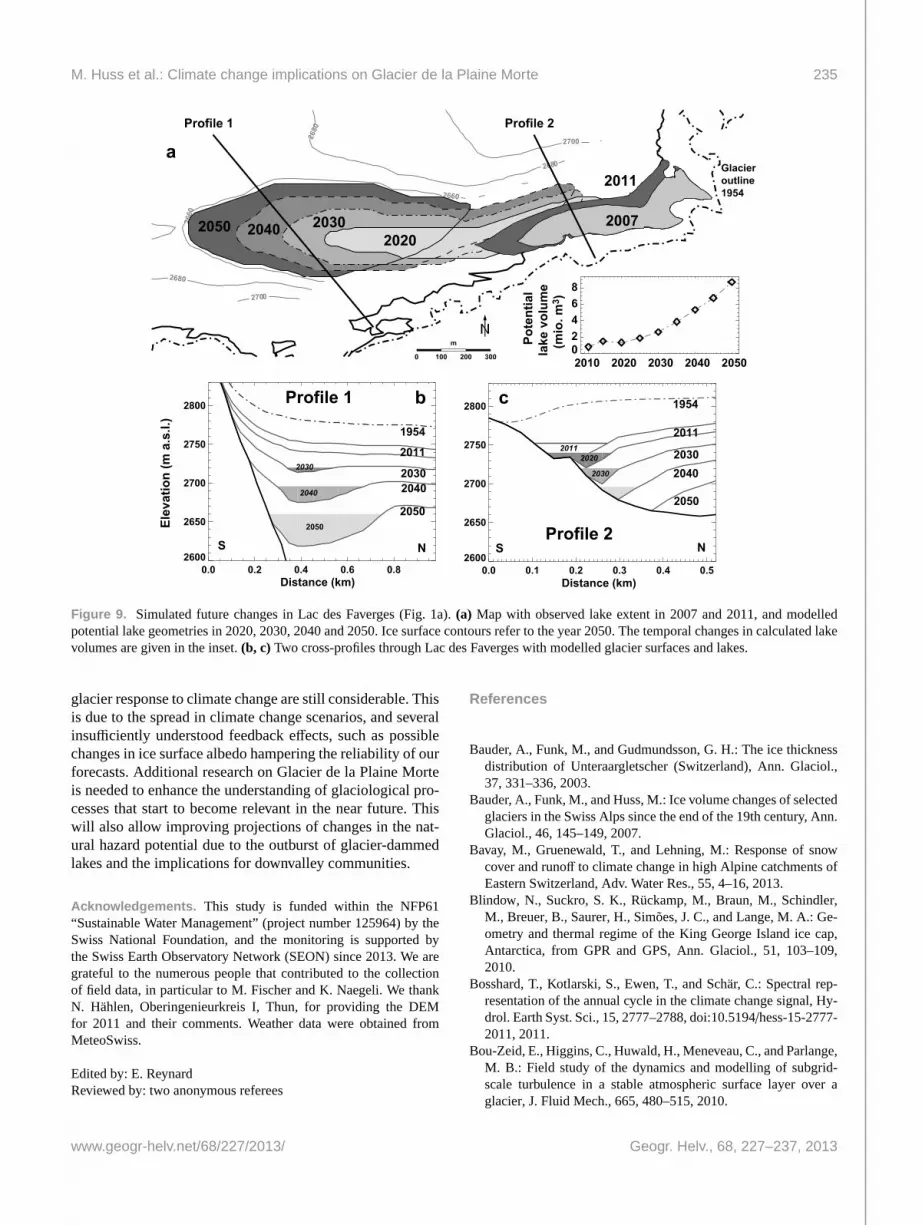
Lac des Faverges is filled up annually. Meltwater accumu-lates in the lake basin after the onset of the melting season.After reaching a maximum level of 2752 m a.s.l., lake waterwas drained over a stable superficial channel in the morainedeposits towards the Tièche basin south of the glacier be-fore 2012. With the glacier mass loss of the last years, thelake basin has been progressively enlarged, thus increasingthe hazard potential. The surface area of Lac des Favergeshas grown by more than 50 % between 2007 and 2011 to0.13 km2 according to aerial photographs (Fig.9a).
The future evolution of Lac des Faverges will determinethe need for additional downvalley protection measures. Withthe ongoing wastage of Glacier de la Plaine Morte the furthergrowth of the lake in the next years and decades is probable.The modelled change in 3-D ice surface geometry accordingto the median climate scenario (Fig.5), and the bedrock el-evation obtained from the GPR measurements (Fig.1b) pro-vide the basis for assessing future changes in lake geom-etry and volume. By completely filling the simulated lakebasin for each year in the period 2011–2050 until an overflow
234 M. Huss et al.: Climate change implications on Glacier de la Plaine Morte
-0.1 0.0 0.1 0.2 0.3 0.4Distance from lake (km)
-60
-40
-20
0Su
rfac
e el
evat
ion
chan
ge (m
)
ObservedParameterization
Elevation change without lake influence dH0
Lac
des
Fave
rges
Crit
ical
dis
tanc
e (d
crit
= 20
0 m
)
dHlake=dH0.25(dcrit - dlake)2
Figure 8. Observed amplification of ice surface lowering between1954 and 2011 for a profile at Lac des Faverges (Fig.1a). The em-pirical function used to simulate future growth of the lake basin isshown, and parameters are given.
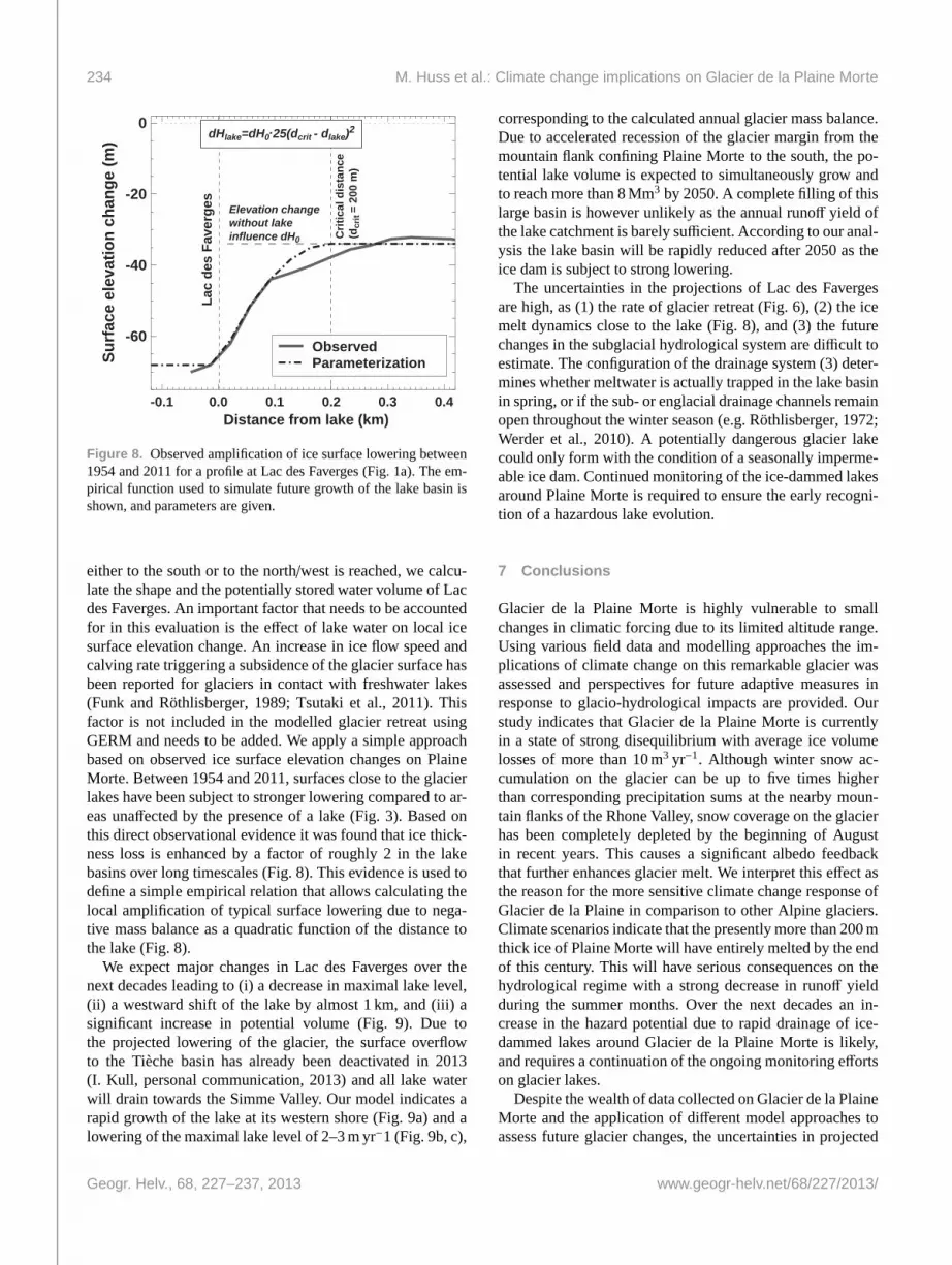
either to the south or to the north/west is reached, we calcu-late the shape and the potentially stored water volume of Lacdes Faverges. An important factor that needs to be accountedfor in this evaluation is the effect of lake water on local icesurface elevation change. An increase in ice flow speed andcalving rate triggering a subsidence of the glacier surface hasbeen reported for glaciers in contact with freshwater lakes(Funk and Röthlisberger, 1989; Tsutaki et al., 2011). Thisfactor is not included in the modelled glacier retreat usingGERM and needs to be added. We apply a simple approachbased on observed ice surface elevation changes on PlaineMorte. Between 1954 and 2011, surfaces close to the glacierlakes have been subject to stronger lowering compared to ar-eas unaffected by the presence of a lake (Fig.3). Based onthis direct observational evidence it was found that ice thick-ness loss is enhanced by a factor of roughly 2 in the lakebasins over long timescales (Fig.8). This evidence is used todefine a simple empirical relation that allows calculating thelocal amplification of typical surface lowering due to nega-tive mass balance as a quadratic function of the distance tothe lake (Fig.8).
We expect major changes in Lac des Faverges over thenext decades leading to (i) a decrease in maximal lake level,(ii) a westward shift of the lake by almost 1 km, and (iii) asignificant increase in potential volume (Fig.9). Due tothe projected lowering of the glacier, the surface overflowto the Tièche basin has already been deactivated in 2013(I. Kull, personal communication, 2013) and all lake waterwill drain towards the Simme Valley. Our model indicates arapid growth of the lake at its western shore (Fig.9a) and alowering of the maximal lake level of 2–3 m yr−1 (Fig.9b, c),
corresponding to the calculated annual glacier mass balance.Due to accelerated recession of the glacier margin from themountain flank confining Plaine Morte to the south, the po-tential lake volume is expected to simultaneously grow andto reach more than 8 Mm3 by 2050. A complete filling of thislarge basin is however unlikely as the annual runoff yield ofthe lake catchment is barely sufficient. According to our anal-ysis the lake basin will be rapidly reduced after 2050 as theice dam is subject to strong lowering.
The uncertainties in the projections of Lac des Favergesare high, as (1) the rate of glacier retreat (Fig.6), (2) the icemelt dynamics close to the lake (Fig.8), and (3) the futurechanges in the subglacial hydrological system are difficult toestimate. The configuration of the drainage system (3) deter-mines whether meltwater is actually trapped in the lake basinin spring, or if the sub- or englacial drainage channels remainopen throughout the winter season (e.g.Röthlisberger, 1972;Werder et al., 2010). A potentially dangerous glacier lakecould only form with the condition of a seasonally imperme-able ice dam. Continued monitoring of the ice-dammed lakesaround Plaine Morte is required to ensure the early recogni-tion of a hazardous lake evolution.
7 Conclusions
Glacier de la Plaine Morte is highly vulnerable to smallchanges in climatic forcing due to its limited altitude range.Using various field data and modelling approaches the im-plications of climate change on this remarkable glacier wasassessed and perspectives for future adaptive measures inresponse to glacio-hydrological impacts are provided. Ourstudy indicates that Glacier de la Plaine Morte is currentlyin a state of strong disequilibrium with average ice volumelosses of more than 10 m3 yr−1. Although winter snow ac-cumulation on the glacier can be up to five times higherthan corresponding precipitation sums at the nearby moun-tain flanks of the Rhone Valley, snow coverage on the glacierhas been completely depleted by the beginning of Augustin recent years. This causes a significant albedo feedbackthat further enhances glacier melt. We interpret this effect asthe reason for the more sensitive climate change response ofGlacier de la Plaine in comparison to other Alpine glaciers.Climate scenarios indicate that the presently more than 200 mthick ice of Plaine Morte will have entirely melted by the endof this century. This will have serious consequences on thehydrological regime with a strong decrease in runoff yieldduring the summer months. Over the next decades an in-crease in the hazard potential due to rapid drainage of ice-dammed lakes around Glacier de la Plaine Morte is likely,and requires a continuation of the ongoing monitoring effortson glacier lakes.
Despite the wealth of data collected on Glacier de la PlaineMorte and the application of different model approaches toassess future glacier changes, the uncertainties in projected
M. Huss et al.: Climate change implications on Glacier de la Plaine Morte 235
2620
2640
2640
266026
60
2680
2680
2680
2700
2700
0 100 200 300
m
Profile 2 Profile 1
2010 2020 2030 2040 205002468
Pote
ntia
lla
ke v
olum
e (m
io. m
3 )
0.0 0.1 0.2 0.3 0.4 0.5Distance (km)
2600
2650
2700
2750
2800
Elev
atio
n (m
a.s
.l.)
S0.0 0.2 0.4 0.6 0.8
2600
2650
2700
2750
2800
Distance (km)
NN
2007
2011
2020203020402050
Glacieroutline1954
1954
2011
20302040
2050
1954
2011
2020 20302040
2050
2030
2040
2050
2011
cb
a
Profile 2
Profile 1
S
2030
Figure 9. Simulated future changes in Lac des Faverges (Fig.1a). (a) Map with observed lake extent in 2007 and 2011, and modelledpotential lake geometries in 2020, 2030, 2040 and 2050. Ice surface contours refer to the year 2050. The temporal changes in calculated lakevolumes are given in the inset.(b, c) Two cross-profiles through Lac des Faverges with modelled glacier surfaces and lakes.
glacier response to climate change are still considerable. Thisis due to the spread in climate change scenarios, and severalinsufficiently understood feedback effects, such as possiblechanges in ice surface albedo hampering the reliability of ourforecasts. Additional research on Glacier de la Plaine Morteis needed to enhance the understanding of glaciological pro-cesses that start to become relevant in the near future. Thiswill also allow improving projections of changes in the nat-ural hazard potential due to the outburst of glacier-dammedlakes and the implications for downvalley communities.
Acknowledgements. This study is funded within the NFP61“Sustainable Water Management” (project number 125964) by theSwiss National Foundation, and the monitoring is supported bythe Swiss Earth Observatory Network (SEON) since 2013. We aregrateful to the numerous people that contributed to the collectionof field data, in particular to M. Fischer and K. Naegeli. We thankN. Hählen, Oberingenieurkreis I, Thun, for providing the DEMfor 2011 and their comments. Weather data were obtained fromMeteoSwiss.
Edited by: E. ReynardReviewed by: two anonymous referees
References
Bauder, A., Funk, M., and Gudmundsson, G. H.: The ice thicknessdistribution of Unteraargletscher (Switzerland), Ann. Glaciol.,37, 331–336, 2003.
Bauder, A., Funk, M., and Huss, M.: Ice volume changes of selectedglaciers in the Swiss Alps since the end of the 19th century, Ann.Glaciol., 46, 145–149, 2007.
Bavay, M., Gruenewald, T., and Lehning, M.: Response of snowcover and runoff to climate change in high Alpine catchments ofEastern Switzerland, Adv. Water Res., 55, 4–16, 2013.
Blindow, N., Suckro, S. K., Rückamp, M., Braun, M., Schindler,M., Breuer, B., Saurer, H., Simões, J. C., and Lange, M. A.: Ge-ometry and thermal regime of the King George Island ice cap,Antarctica, from GPR and GPS, Ann. Glaciol., 51, 103–109,2010.
Bosshard, T., Kotlarski, S., Ewen, T., and Schär, C.: Spectral rep-resentation of the annual cycle in the climate change signal, Hy-drol. Earth Syst. Sci., 15, 2777–2788, doi:10.5194/hess-15-2777-2011, 2011.
Bou-Zeid, E., Higgins, C., Huwald, H., Meneveau, C., and Parlange,M. B.: Field study of the dynamics and modelling of subgrid-scale turbulence in a stable atmospheric surface layer over aglacier, J. Fluid Mech., 665, 480–515, 2010.
236 M. Huss et al.: Climate change implications on Glacier de la Plaine Morte
Braun, L. N., Weber, M., and Schulz, M.: Consequences of climatechange for runoff from Alpine regions, Ann. Glaciol., 31, 19–25,2000.
Bühlmann, E.: Influence of particulate matter on observed albedoreductions on Plaine Morte glacier, Swiss Alps, M.Sc. thesis,University of Bern, 2011.
Bürki, R., Elsasser, B., and Abegg, B.: Climate change: Impactson the tourism industry in mountain areas, Proceedings of the1st International Conference on Climate Change and Tourism,Djerba, 9–11 April 2003.
Farinotti, D., Huss, M., Bauder, A., and Funk, M.: An estimateof the glacier ice volume in the the Swiss Alps, Global Planet.Change, 68, 225–231, 2009.
Farinotti, D., Usselmann, S., Huss, M., Bauder, A., and Funk, M.:Runoff evolution in the Swiss Alps: projections for selected high-alpine catchments based on ENSEMBLES scenarios, Hydrol.Process., 26, 1909–1924, 2012.
Finger, D., Heinrich, G., Gobiet, A., and Bauder, A.: Projectionsof future water resources and their uncertainty in a glacierizedcatchment in the Swiss Alps and the subsequent effects on hy-dropower production during the 21st century, Water Resour. Res.,48, W02521, doi:10.1029/2011WR010733, 2012.
Finger, D., Hugentobler, A., Huss, M., Voinesco, A., Wernli, H.,Fischer, D., Weber, E., Jeannin, P.-Y., Kauzlaric, M., Wirz, A.,Vennemann, T., Hüsler, F., Schädler, B., and Weingartner, R.:Identification of glacial meltwater runoff in a karstic environmentand its implication for present and future water availability, Hy-drol. Earth Syst. Sci., 17, 3261–3277, doi:10.5194/hess-17-3261-2013, 2013.
Fischer, A., Olefs, M., and Abermann, J.: Glaciers, snow and skitourism in Austria’s changing climate, Ann. Glaciol., 52, 89–96,2011.
Funk, M. and Röthlisberger, H.: Forecasting the effects of a plannedreservoir that will partially flood the tongue of Unteraargletscherin Switzerland, Ann. Glaciol., 13, 76–80, 1989.
Gabbi, J., Farinotti, D., Bauder, A., and Maurer, H.: Ice vol-ume distribution and implications on runoff projections in aglacierized catchment, Hydrol. Earth Syst. Sci., 16, 4543–4556,doi:10.5194/hess-16-4543-2012, 2012.
Glaciological reports: The Swiss Glaciers, 1880–2006/07, Tech.Rep. 1–128, Yearbooks of the Cryospheric Commission of theSwiss Academy of Sciences (SCNAT), published since 1964 byLaboratory of Hydraulics, Hydrology and Glaciology (VAW) ofETH Zürich, 1881–2011.
Gross, G., Kerschner, H., and Patzelt, G.: Methodische Unter-suchungen über die Schneegrenze in alpinen Gletschergebieten,Zeitschrift für Gletscherkunde und Glazialgeologie, 12, 223–251, 1977.
Haeberli, W. and Beniston, M.: Climate change and its impacts onglaciers and permafrost in the Alps, Ambio, 27, 258–265, 1998.
Hählen, N.: Ausbruch Gletschersee Faverges, Oberingenieurkreis I,Tiefbauamt des Kantons Bern, Gemeinde Lenk, 2012.
Hock, R.: A distributed temperature-index ice- and snowmelt modelincluding potential direct solar radiation, J. Glaciol., 45, 101–111, 1999.
Huggel, C., Allen, S., Deline, P., Fischer, L., Noetzli, J., and Ra-vanel, L.: Ice thawing, mountains falling – are alpine rock slopefailures increasing?, Geology Today, 28, 98–104, 2012.
Huss, M.: Mass balance of Pizolgletscher, Geogr. Helv., 65, 80–91,doi:10.5194/gh-65-80-2010, 2010.
Huss, M.: Present and future contribution of glacier storage changeto runoff from macroscale drainage basins in Europe, Water Re-sour. Res., 47, W07511, doi:10.1029/2010WR010299, 2011.
Huss, M.: Extrapolating glacier mass balance to the mountain-rangescale: the European Alps 1900–2100, The Cryosphere, 6, 713–727, doi:10.5194/tc-6-713-2012, 2012.
Huss, M., Bauder, A., Funk, M., and Hock, R.: Determination of theseasonal mass balance of four Alpine glaciers since 1865, J. Geo-phys. Res., 113, F01015, doi:10.1029/2007JF000803, 2008a.
Huss, M., Farinotti, D., Bauder, A., and Funk, M.: Modelling runofffrom highly glacierized alpine drainage basins in a changing cli-mate, Hydrol. Process., 22, 3888–3902, 2008b.
Huwald, H., Higgins, C. W., Boldi, M.-O., Bou-Zeid, E., Lehning,M., and Parlange, M. B.: Albedo effect on radiative errors inair temperature measurements, Water Resour. Res., 45, W08431,doi:10.1029/2008WR007600, 2009.
Huwald, H., Selker, J. S., Tyler, S. W., Calaf, M., van de Giesen,N. C., and Parlange, M. B.: Carbon monoxide as a tracer of gastransport in snow and other natural porous media, Geophys. Res.Lett., 39, L02504, doi:10.1029/2011GL050247, 2012.
Lehning, M., Loewe, H., Ryser, M., and Raderschall, N.:Inhomogeneous precipitation distribution and snow trans-port in steep terrain, Water Resour. Res., 44, W07404,doi:10.1029/2007WR006545, 2008.
Macheret, Y. Y., Moskalevsky, M. Y., and Vasilenko, E. V.: Velocityof radio waves in glaciers as an indicator of their hydrothermalstate, structure and regime, J. Glaciol., 39, 373–384, 1993.
Maire, R.: Les karsts sous-glaciaires et leurs relations avec le karstprofond, Rev. Geogr. Alp., 66, 139–148, 1978.
Oerlemans, J.: Glaciers and climate change, A. A. Balkema Pub-lishers, 2001.
Paul, F., Machguth, H., and Kääb, A.: On the impact of glacieralbedo under conditions of extreme glacier melt: the summer of2003 in the Alps, EARSeL eProceedings, 4, 139–149, 2005.
Reynard, E. and Bonriposi, M.: Water use management in drymountains of Switzerland. The case of Crans-Montana-Sierrearea, in: The impact of urbanisation, industrial, agriculturaland forest technologies on the natural environment, edited by:Neményi, M. and Balint, H., Sopron, NyugatmagyarorszagiEgyetem, 281–301, 2012.
Röthlisberger, H.: Water pressure in intra- and subglacial channels,J. Glaciol., 11, 177–203, 1972.
Schaefli, B., Hingray, B., and Musy, A.: Climate change and hy-dropower production in the Swiss Alps: quantification of po-tential impacts and related modelling uncertainties, Hydrol.Earth Syst. Sci., 11, 1191–1205, doi:10.5194/hess-11-1191-2007, 2007.
Schneider, F. and Homewood, C.: Exploring water governance ar-rangements in the Swiss Alps from a perspective of adaptive ca-pacity, Mt. Res. Dev., 33, 225–233, 2013.
Schotterer, U., Finkel, R., Oeschger, H., Siegenthaler, U., Wahlen,M., Bart, G., Gaggeler, H., and von Gunten, H. R.: Isotope mea-surements on firn and ice cores from alpine glaciers, Proc. Symp.Isotopes and Impurities in Snow and Ice, Grenoble 1975, IAHS,118, 232–236, 1977.
Süsstrunk, A.: Sondage du glacier par la méthode sismique, LaHouille Blanche, A, 309–318, 1951.
M. Huss et al.: Climate change implications on Glacier de la Plaine Morte 237
Tsutaki, S., Nishimura, D., Yoshizawa, T., and Sugiyama, S.:Changes in glacier dynamics under the influence of proglaciallake formation in Rhonegletscher, Switzerland, Ann. Glaciol.,52, 31–36, 2011.
van der Linden, P. and Mitchell, J.: ENSEMBLES: Climate changeand its impacts: Summary of research and results from theENSEMBLES project, Tech. rep., Met Office Hadley Centre,FitzRoy Road, Exeter EX1 3PB, UK, 2009.
Voinesco, A.: Le glacier de la Plaine-Morte : Épaisseur de glace etbilan de masse, M.Sc. thesis, University of Fribourg, 2012.
Weingartner, R., Herweg, D., Liniger, H., Rist, S., Schädler,B., Schneider, F., Graefe, O., Hoelzle, M., and Reynard, E.: Op-tions for sustainable water use in the Crans-Montana-Sierre re-gion (Valais), MRI News, 5, 13–15, 2010.
Werder, M. A., Bauder, A., Funk, M., and Keusen, H.-R.: Hazardassessment investigations in connection with the formation ofa lake on the tongue of Unterer Grindelwaldgletscher, BerneseAlps, Switzerland, Nat. Hazards Earth Syst. Sci., 10, 227–237,doi:10.5194/nhess-10-227-2010, 2010.