254
Kinardochy Reactive Compensation Substation Environmental Impact Assessment Report Volume 2: Main Report February 2021
| Date post: | 17-Mar-2023 |
| Category: |
Documents |
| Upload: | khangminh22 |
| View: | 0 times |
| Download: | 0 times |
Kinardochy Reactive Compensation Substation
Environmental Impact Assessment Report Volume 2: Main Report
February 2021
Kinardochy Reactive Compensation Substation EIA Report: Volume 2: Main Report Table of Contents
VOLUME 2: MAIN REPORT TABLE OF CONTENTS Glossary and Abbreviations
Chapter 1: Introduction
1.1 Overview of the Proposed Development
1.2 The Applicant
1.3 Background to the Project
1.4 Purpose of the EIAR
1.5 EIA Process
1.6 Accessing and Viewing the EIAR
1.7 Commenting on the Application
Chapter 2 : Development Description
2.1 Introduction
2.2 The Project Site
2.3 Proposed Development Description
2.4 Associated Development Description
2.5 Construction Programme
2.6 CEMP
2.7 Operation and Maintenance
2.8 Land Use
2.9 Residues and Emissions
2.10 Decommissioning
Chapter 3 : Design Evolution and Alternatives
3.1 Introduction
3.2 Key Policy Considerations
3.3 Site Selection Consideration
3.4 Site Layout Evolution
3.5 Landscaping Design
3.6 Biodiversity Net Gain
3.7 Mitigation by Design
Chapter 4 : Landscape and Visual Impact
4.1 Introduction
4.2 Scope of Assessment
4.3 Assessment Methodology
4.4 Baseline Conditions
Kinardochy Reactive Compensation Substation EIA Report: Volume 2: Main Report Table of Contents
4.5 Assessment of Likely Effects
4.6 Mitigation
4.7 Assessment of Residual Effects
4.8 Summary
Chapter 5 : Ecology
5.1 Introduction
5.2 Scope of Assessment
5.3 Assessment Methodology
5.4 Baseline Conditions
5.5 Assessment of Likely Significant Effects
5.6 Mitigation
5.7 Assessment of Residual Effects
5.8 Summary
Chapter 6 : Ornithology
6.1 Introduction
6.2 Scope of Assessment
6.3 Assessment Methodology
6.4 Baseline Conditions
6.5 Assessment of Likely Significant Effects
6.6 Mitigation
6.7 Assessment of Residual Effects
6.8 Summary
Chapter 7 : Hydrology, Hydrogeology, Geology and Soils
7.1 Introduction
7.2 Scope of Assessment
7.3 Assessment Methodology
7.4 Baseline Conditions
7.5 Assessment of Likely Significant Effects
7.6 Mitigation
7.7 Assessment of Residual Effects
7.8 Summary
Chapter 8 : Cultural Heritage and Archaeology
8.1 Introduction
8.2 Scope of Assessment
Kinardochy Reactive Compensation Substation EIA Report: Volume 2: Main Report Table of Contents
8.3 Assessment Methodology
8.4 Baseline Conditions
8.5 Assessment of Likely Significant Effects
8.6 Mitigation
8.7 Assessment of Residual Effects
8.8 Summary
Chapter 9 : Forestry
9.1 Introduction
9.2 Scope of Assessment
9.3 Assessment Methodology
9.4 Baseline Conditions
9.5 Assessment of Likely Significant Effects
9.6 Mitigation
9.7 Assessment of Residual Effects
9.8 Summary
Chapter 10 : Traffic and Transport
10.1 Introduction
10.2 Scope of Assessment
10.3 Assessment Methodology
10.4 Baseline Conditions
10.5 Assessment of Likely Significant Effects
10.6 Mitigation
10.7 Assessment of Residual Effects
10.8 Summary
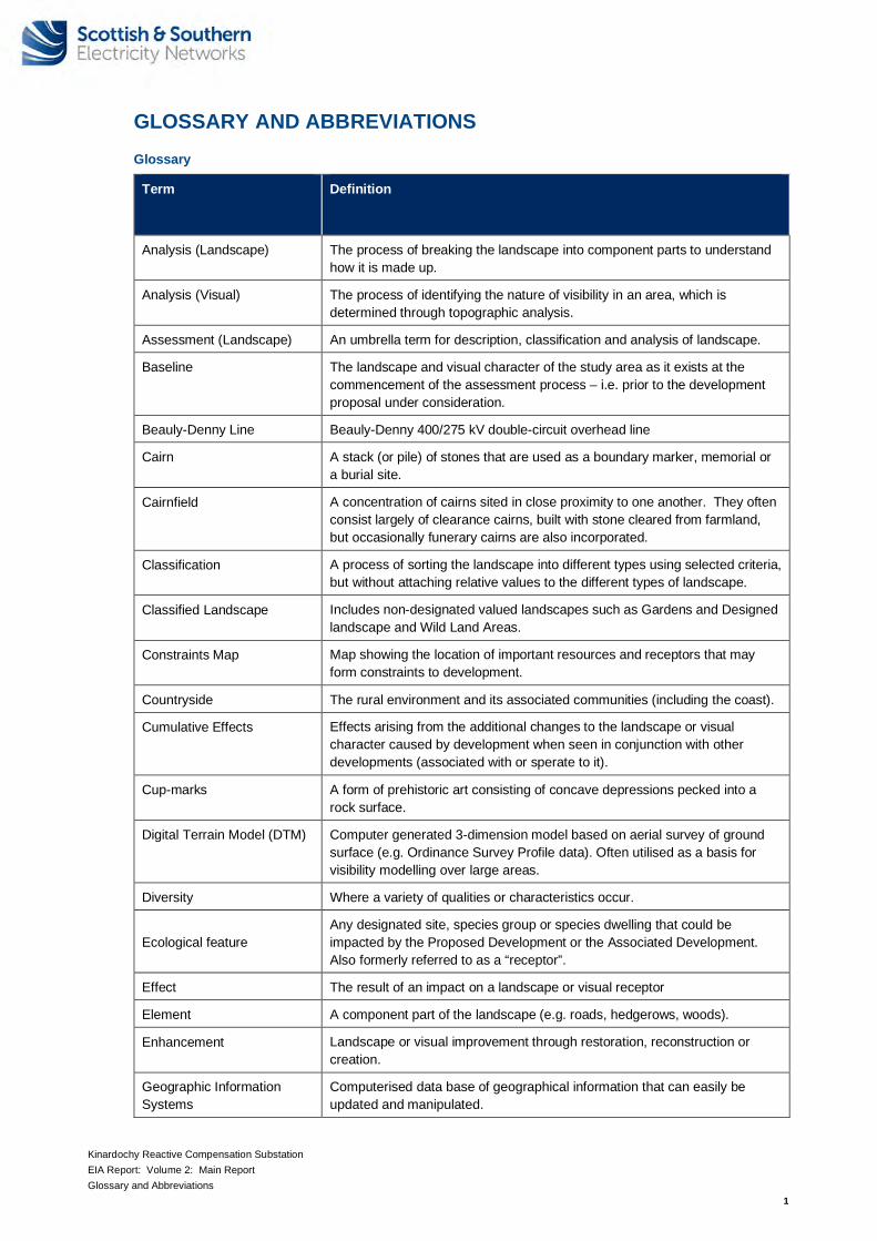
Kinardochy Reactive Compensation Substation EIA Report: Volume 2: Main Report Glossary and Abbreviations 1
GLOSSARY AND ABBREVIATIONS Glossary
Term Definition
Analysis (Landscape) The process of breaking the landscape into component parts to understand how it is made up.
Analysis (Visual) The process of identifying the nature of visibility in an area, which is determined through topographic analysis.
Assessment (Landscape) An umbrella term for description, classification and analysis of landscape.
Baseline The landscape and visual character of the study area as it exists at the commencement of the assessment process – i.e. prior to the development proposal under consideration.
Beauly-Denny Line Beauly-Denny 400/275 kV double-circuit overhead line
Cairn A stack (or pile) of stones that are used as a boundary marker, memorial or a burial site.
Cairnfield A concentration of cairns sited in close proximity to one another. They often consist largely of clearance cairns, built with stone cleared from farmland, but occasionally funerary cairns are also incorporated.
Classification A process of sorting the landscape into different types using selected criteria, but without attaching relative values to the different types of landscape.
Classified Landscape Includes non-designated valued landscapes such as Gardens and Designed landscape and Wild Land Areas.
Constraints Map Map showing the location of important resources and receptors that may form constraints to development.
Countryside The rural environment and its associated communities (including the coast).
Cumulative Effects Effects arising from the additional changes to the landscape or visual character caused by development when seen in conjunction with other developments (associated with or sperate to it).
Cup-marks A form of prehistoric art consisting of concave depressions pecked into a rock surface.
Digital Terrain Model (DTM) Computer generated 3-dimension model based on aerial survey of ground surface (e.g. Ordinance Survey Profile data). Often utilised as a basis for visibility modelling over large areas.
Diversity Where a variety of qualities or characteristics occur.
Ecological feature Any designated site, species group or species dwelling that could be impacted by the Proposed Development or the Associated Development. Also formerly referred to as a “receptor”.
Effect The result of an impact on a landscape or visual receptor
Element A component part of the landscape (e.g. roads, hedgerows, woods).
Enhancement Landscape or visual improvement through restoration, reconstruction or creation.
Geographic Information Systems
Computerised data base of geographical information that can easily be updated and manipulated.
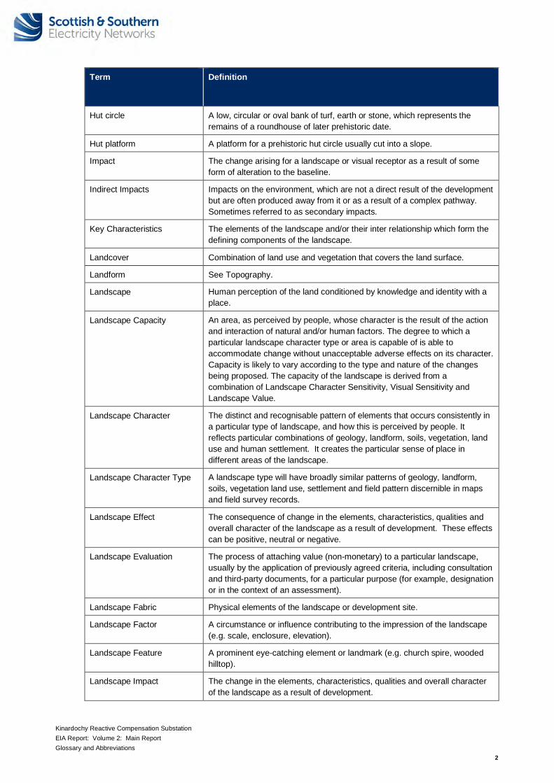
Kinardochy Reactive Compensation Substation EIA Report: Volume 2: Main Report Glossary and Abbreviations 2
Term Definition
Hut circle A low, circular or oval bank of turf, earth or stone, which represents the remains of a roundhouse of later prehistoric date.
Hut platform A platform for a prehistoric hut circle usually cut into a slope.
Impact The change arising for a landscape or visual receptor as a result of some form of alteration to the baseline.
Indirect Impacts Impacts on the environment, which are not a direct result of the development but are often produced away from it or as a result of a complex pathway. Sometimes referred to as secondary impacts.
Key Characteristics The elements of the landscape and/or their inter relationship which form the defining components of the landscape.
Landcover Combination of land use and vegetation that covers the land surface.
Landform See Topography.
Landscape Human perception of the land conditioned by knowledge and identity with a place.
Landscape Capacity An area, as perceived by people, whose character is the result of the action and interaction of natural and/or human factors. The degree to which a particular landscape character type or area is capable of is able to accommodate change without unacceptable adverse effects on its character. Capacity is likely to vary according to the type and nature of the changes being proposed. The capacity of the landscape is derived from a combination of Landscape Character Sensitivity, Visual Sensitivity and Landscape Value.
Landscape Character The distinct and recognisable pattern of elements that occurs consistently in a particular type of landscape, and how this is perceived by people. It reflects particular combinations of geology, landform, soils, vegetation, land use and human settlement. It creates the particular sense of place in different areas of the landscape.
Landscape Character Type A landscape type will have broadly similar patterns of geology, landform, soils, vegetation land use, settlement and field pattern discernible in maps and field survey records.
Landscape Effect The consequence of change in the elements, characteristics, qualities and overall character of the landscape as a result of development. These effects can be positive, neutral or negative.
Landscape Evaluation The process of attaching value (non-monetary) to a particular landscape, usually by the application of previously agreed criteria, including consultation and third-party documents, for a particular purpose (for example, designation or in the context of an assessment).
Landscape Fabric Physical elements of the landscape or development site.
Landscape Factor A circumstance or influence contributing to the impression of the landscape (e.g. scale, enclosure, elevation).
Landscape Feature A prominent eye-catching element or landmark (e.g. church spire, wooded hilltop).
Landscape Impact The change in the elements, characteristics, qualities and overall character of the landscape as a result of development.
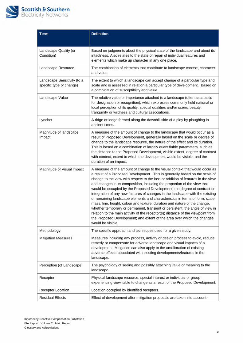
Kinardochy Reactive Compensation Substation EIA Report: Volume 2: Main Report Glossary and Abbreviations 3
Term Definition
Landscape Quality (or Condition)
Based on judgments about the physical state of the landscape and about its intactness. Also relates to the state of repair of individual features and elements which make up character in any one place.
Landscape Resource The combination of elements that contribute to landscape context, character and value.
Landscape Sensitivity (to a specific type of change)
The extent to which a landscape can accept change of a particular type and scale and is assessed in relation a particular type of development. Based on a combination of susceptibility and value.
Landscape Value The relative value or importance attached to a landscape (often as a basis for designation or recognition), which expresses commonly held national or local perception of its quality, special qualities and/or scenic beauty, tranquillity or wildness and cultural associations.
Lynchet A ridge or ledge formed along the downhill side of a ploy by ploughing in ancient times.
Magnitude of landscape Impact
A measure of the amount of change to the landscape that would occur as a result of Proposed Development, generally based on the scale or degree of change to the landscape resource, the nature of the effect and its duration. This is based on a combination of largely quantifiable parameters, such as the distance to the Proposed Development, visible extent, degree of contrast with context, extent to which the development would be visible, and the duration of an impact.
Magnitude of Visual Impact A measure of the amount of change to the visual context that would occur as a result of a Proposed Development. This is generally based on the scale of change to the view with respect to the loss or addition of features in the view and changes in its composition, including the proportion of the view that would be occupied by the Proposed Development; the degree of contrast or integration of any new features of changes in the landscape with the existing or remaining landscape elements and characteristics in terms of form, scale, mass, line, height, colour and texture; duration and nature of the change, whether temporary or permanent, transient or persistent, the angle of view in relation to the main activity of the receptor(s); distance of the viewpoint from the Proposed Development; and extent of the area over which the changes would be visible.
Methodology The specific approach and techniques used for a given study.
Mitigation Measures Measures including any process, activity or design process to avoid, reduce, remedy or compensate for adverse landscape and visual impacts of a development. Mitigation can also apply to the amelioration of existing adverse effects associated with existing developments/features in the landscape.
Perception (of Landscape): The psychology of seeing and possibly attaching value or meaning to the landscape.
Receptor Physical landscape resource, special interest or individual or group experiencing view liable to change as a result of the Proposed Development.
Receptor Location Location occupied by identified receptors.
Residual Effects Effect of development after mitigation proposals are taken into account.
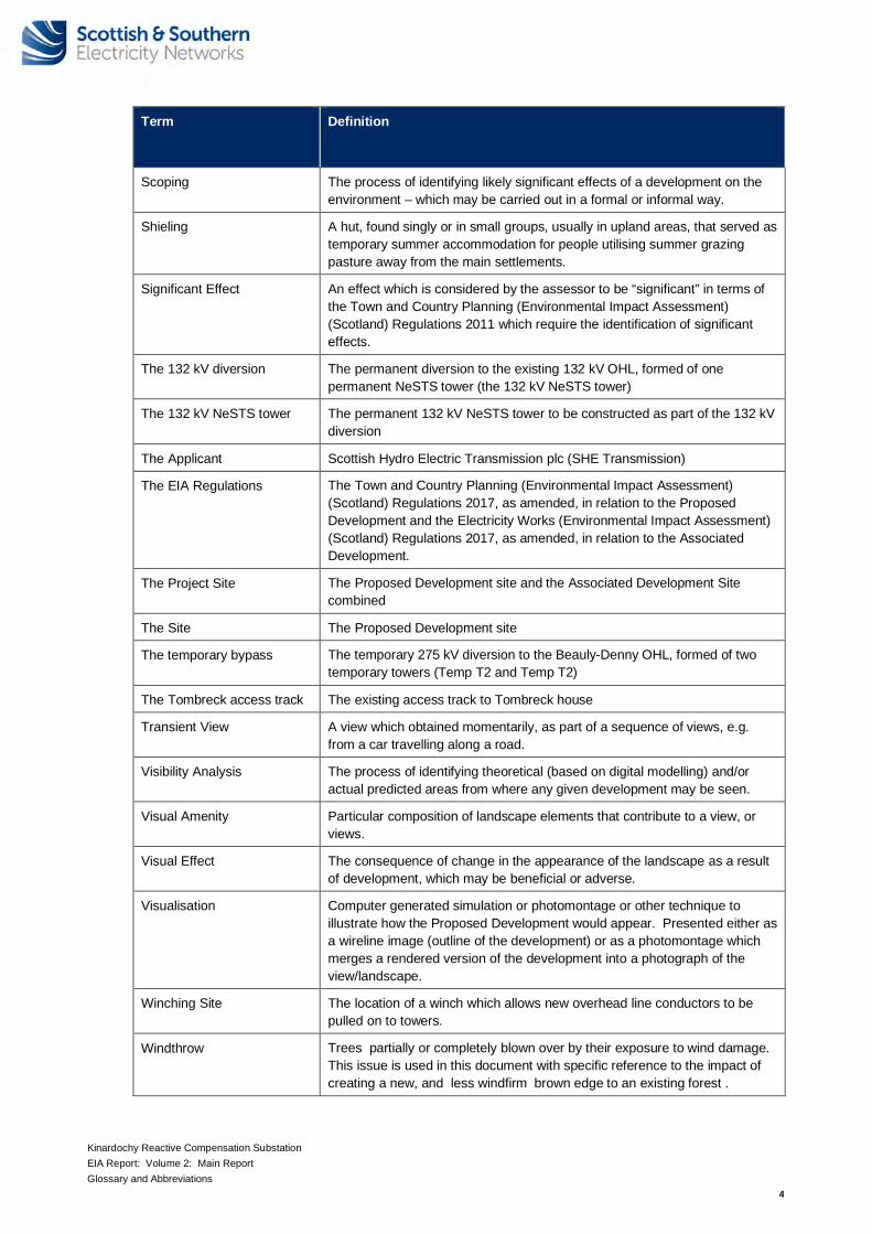
Kinardochy Reactive Compensation Substation EIA Report: Volume 2: Main Report Glossary and Abbreviations 4
Term Definition
Scoping The process of identifying likely significant effects of a development on the environment – which may be carried out in a formal or informal way.
Shieling A hut, found singly or in small groups, usually in upland areas, that served as temporary summer accommodation for people utilising summer grazing pasture away from the main settlements.
Significant Effect An effect which is considered by the assessor to be “significant” in terms of the Town and Country Planning (Environmental Impact Assessment) (Scotland) Regulations 2011 which require the identification of significant effects.
The 132 kV diversion The permanent diversion to the existing 132 kV OHL, formed of one permanent NeSTS tower (the 132 kV NeSTS tower)
The 132 kV NeSTS tower The permanent 132 kV NeSTS tower to be constructed as part of the 132 kV diversion
The Applicant Scottish Hydro Electric Transmission plc (SHE Transmission)
The EIA Regulations The Town and Country Planning (Environmental Impact Assessment) (Scotland) Regulations 2017, as amended, in relation to the Proposed Development and the Electricity Works (Environmental Impact Assessment) (Scotland) Regulations 2017, as amended, in relation to the Associated Development.
The Project Site The Proposed Development site and the Associated Development Site combined
The Site The Proposed Development site
The temporary bypass The temporary 275 kV diversion to the Beauly-Denny OHL, formed of two temporary towers (Temp T2 and Temp T2)
The Tombreck access track The existing access track to Tombreck house
Transient View A view which obtained momentarily, as part of a sequence of views, e.g. from a car travelling along a road.
Visibility Analysis The process of identifying theoretical (based on digital modelling) and/or actual predicted areas from where any given development may be seen.
Visual Amenity Particular composition of landscape elements that contribute to a view, or views.
Visual Effect The consequence of change in the appearance of the landscape as a result of development, which may be beneficial or adverse.
Visualisation Computer generated simulation or photomontage or other technique to illustrate how the Proposed Development would appear. Presented either as a wireline image (outline of the development) or as a photomontage which merges a rendered version of the development into a photograph of the view/landscape.
Winching Site The location of a winch which allows new overhead line conductors to be pulled on to towers.
Windthrow Trees partially or completely blown over by their exposure to wind damage. This issue is used in this document with specific reference to the impact of creating a new, and less windfirm brown edge to an existing forest .
Kinardochy Reactive Compensation Substation EIA Report: Volume 2: Main Report Glossary and Abbreviations 5
Term Definition
Zone of Theoretical Visibility (ZTV)
The area predicted to have views of a Proposed Development on the basis of a digital terrain model or digital surface model, which may/may not take account of landcover features.
Abbreviations
Abbreviation Expanded Term
ACIEEM Associate of the Chartered Institute of Ecology and Environmental Management
AIL Abnormal Indivisible Load
AIS Air Insulated Switchgear
AOD Above Ordnance Datum
AQMA Air Quality Management Area
ASNW Ancient Semi-Natural Woodland
ATC Automatic Traffic Counter
AWI Ancient Woodland Inventory
BAP Biodiversity Action Plan
BBS Breeding Bird Surveys
BGS British Geological Survey
BNG Biodiversity Net Gain
BoCC Birds of Conservation Concern
BRP Bat Roost Potential
CAR The Water Environment (Controlled Activities) (Scotland) Regulations 2011
CEMP Construction Environmental Management Plan
CFA CFA Archaeology Ltd
CIEEM Chartered Institute of Ecology and Environmental Management
CIfA Chartered Institute for Archaeologists
CIRIA Construction Industry Research and Information Association
CO2 Carbon Dioxide
CTMP Construction Traffic Management Plan
CVT Capacitive Voltage Transformer
dB Decibel
DfT Department for Transport
DIA Drainage Impact Assessment
DVT Discharge Voltage Transformer
Kinardochy Reactive Compensation Substation EIA Report: Volume 2: Main Report Glossary and Abbreviations 6
Abbreviation Expanded Term
DWQR Drinking Water Quality Regulator
EcIA Ecological Impact Assessment
ECoW Environmental Clerk of Works / Ecological Clerk of Works
ECU Energy Consents Unit
EIA Environmental Impact Assessment
EIAR Environmental Impact Assessment Report
EMF Electric and Magnetic Field
ES Earth Switch
FACTS Flexible Alternating Current Transmission Systems
FLS Forestry and Land Scotland
FMP Forest Management Plan
GDL Gardens and Designed Landscapes
GEMP General Environmental Management Plan
GHG Greenhouse Gas
GI Ground Investigation
GIB Gas Insulated Busbar
GIS (in relation to substation design)
Gas Insulated Switchgear
GIS (in relation to mapping software)
Geographical Information System
GLVIA Guidance for Landscape and Visual Impact Assessment
GWDTE Groundwater Dependent Terrestrial Ecosystems
GWP Global Warming Potential
ha Hectare
HEPS Historic Environment Policy for Scotland
HER Historic Environment Record
HES Historic Environment Scotland
HGV Heavy Goods Vehicle
HLA Map Historic Land-Use Assessment Data for Scotland
HPCLT Highland Perthshire Communities Land Trust
HPI High Level Post Insulator
IEMA Institute of Environmental Management and Assessment
IEMA Institute of Environmental Management and Assessment
IGBT Insulated Gate Bipolar Transistors
km Kilometre
Kinardochy Reactive Compensation Substation EIA Report: Volume 2: Main Report Glossary and Abbreviations 7
Abbreviation Expanded Term
kV Kilovolt
LB Listed Building
LCT Landscape Character Type
LDP (in relation to Planning) Local Development Plan
LDP (in relation to landscape design / mitigation)
Landscape Design Plan
LGV Light Goods Vehicles
LNR Local Nature Reserve
LOD Limits of Deviation
LPD Local Development Plan
m metre
MSCDN Mechanically Switched Capacitor with Damping Network
MVAr Mega volt amps (reactive)
MW Megawatt
N North
NCR National Cycle Route
NE North East
NeSTS New Suite of Transmission Structures
NETS SQSS National Energy Transmission System Security and Quality of Supply Standard
NGR National Grid Reference
NNR National Nature Reserve
NO2 Nitrogen Dioxide
NPF National Planning Framework
NRHE National Record of the Historic Environment
NRTF National Road Traffic Forecast
NS NatureScot
NSA National Scenic Area
NSR Noise Sensitive Receptor
NTS Non-technical Summary
NVC National Vegetation Classification
NW North West
NWSS The Native Woodland Survey of Scotland
OHL Overhead line
OS Ordnance Survey

Kinardochy Reactive Compensation Substation EIA Report: Volume 2: Main Report Glossary and Abbreviations 8
Abbreviation Expanded Term
PAN Planning Advice Note
PKC Perth and Kinross Council
PKHT Perth and Kinross Heritage Trust
PLHRA Peat Landslide Hazard Risk Assessment
PM10 Particulate Matter 10
PMP Peat Management Plan
POI Point of Interest
PPC Pollution Prevention and Control
PPG Pollution Prevention Guidelines
PWS Private Water Supply
RBMP River Basin Management Plan
S South
SA Surge Arrester
SAC Special Area of Conservation
SAF Species Action Framework
SDP Strategic Development Plan
SE South East
SEPA Scottish Environment Protection Agency
SF Scottish Forestry
SF6 Sulfur hexafluoride
SGT Super Grid Transformer
SHE Transmission Scottish Hydro Electric Transmission plc
SNH Scottish Natural Heritage (now renamed NatureScot)
SPA Special Protection Area
SPL Sound Power Level
SPP (in relation to Planning) Scottish Planning Policy
SPP (in relation to ecology and ornithology mitigation measures)
Species Protection Plan
SQSS Security Quality of Supply Standard
SSE Scottish and Southern Energy
SSSI Site of Special Scientific Interest
ST Statcom transformer
STATCOM Static Synchronous Compensators
SUDS Sustainable Urban Drainage System
Kinardochy Reactive Compensation Substation EIA Report: Volume 2: Main Report Glossary and Abbreviations 9
Abbreviation Expanded Term
SVC Static Var Compensators
SW South West
T227 Tower 227
T230 Tower 230
T230R Tower 230R
T231 Tower 231
T231A Tower 231A
Temp T1 Temporary Tower 1
Temp T2 Temporary Tower 2
TMP Transport Management Plan
TTRO Temporary Traffic Regulation Order
UK BAP UK Biodiversity Action Plan
W West
WFD Water Framework Directive
WLA Wild Land Area
WSI Written Scheme of Investigation
ZTV Zone of Theoretical Visibility

Kinardochy Reactive Compensation Substation Environmental Impact Assessment Report Chapter 1: Introduction 1-1
1. INTRODUCTION
1.1 Overview of the Proposed Development This Environmental Impact Assessment Report (EIAR) has been prepared by Ramboll UK Limited (Ramboll) on behalf of Scottish Hydro Electric (SHE) Transmission plc, hereafter referred to as “the Applicant”.
The EIAR will be submitted to Perth and Kinross Council (PKC) to support an application for Planning Permission under the Town and Country Planning (Scotland) Act 19971, as amended, to construct and operate the proposed Kinardochy reactive power compensation substation, and associated infrastructure, which is hereafter referred to as ‘the Proposed Development’.
The EIAR will also be submitted to the Scottish Ministers to support a separate application for consent under section 37 of the Electricity Act 1989, as amended, (section 37 consent) to install and keep installed a proposed connection to the Beauly-Denny 400/275 kV double-circuit overhead line (OHL) (herein referred to as the Beauly-Denny Line), located immediately to the west of the Proposed Development, along with other ancillary development, which are hereafter referred to as ‘the Associated Development’.
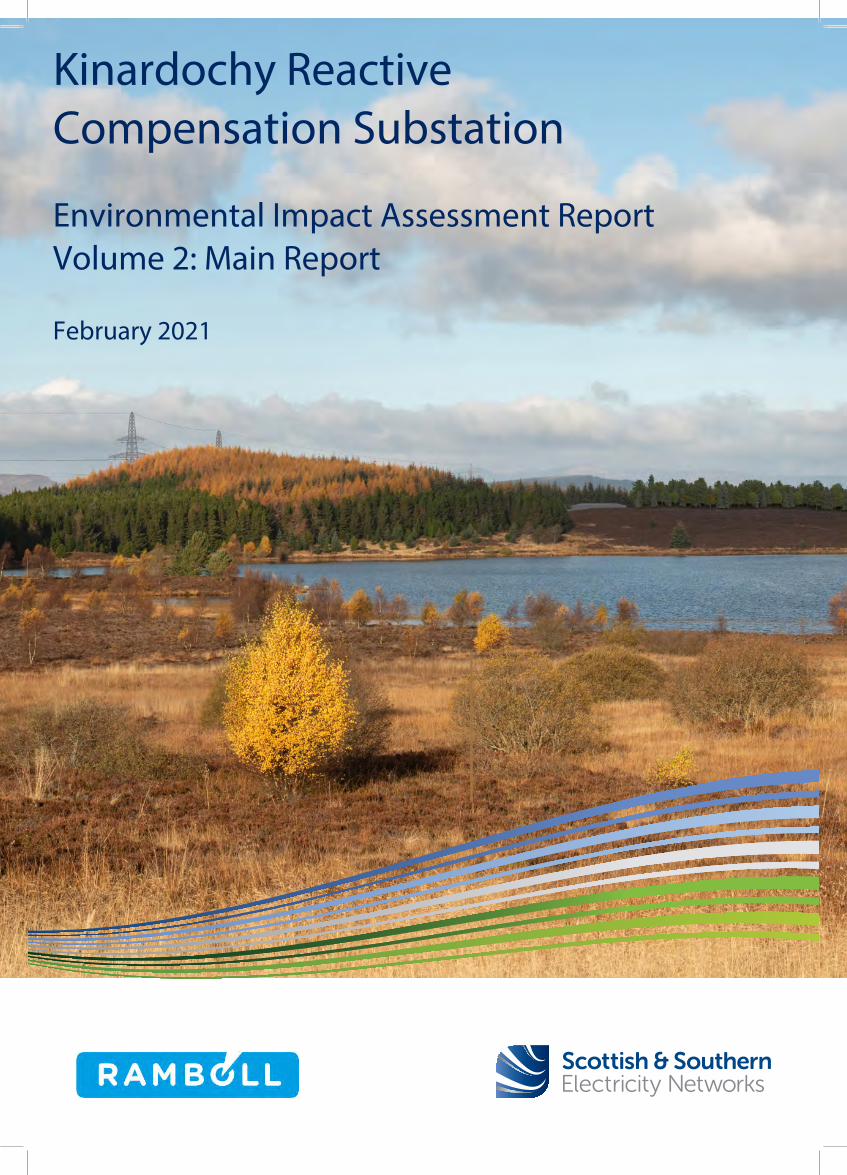
The Proposed Development, and the Associated Development where relevant, are assessed within this EIAR. The Proposed Development and Associated Development are approximately 3 kilometres (km) south of the village of Tummel Bridge in the Perth and Kinross local authority area. The Project Site location is shown in EIAR Volume 3a: Figure 1.1: Site Location.
In order to clearly identify the elements that require to be assessed under each of the aforementioned planning regimes the EIAR shall comprise five volumes, as outlined below:
• Volume 1: Non-Technical Summary (NTS);
• Volume 2: Main Report;
• Volume 3a: Figures;
• Volume 3b: Visualisations;
• Volume 4: Technical Appendices;
• Volume 5a: Schedule of Mitigation: The Proposed Development; and
• Volume 5b: Schedule of Mitigation: The Associated Development.
1.2 The Applicant SHE Transmission is a wholly owned subsidiary of the Scottish and Southern Energy (SSE) plc group of companies. SHE Transmission owns and maintains the electricity transmission network across the north of Scotland, and holds a license under the Electricity Act 1989, as amended2, to develop and maintain an efficient, co-ordinated and economical system of electricity transmission.
The Applicant has a statutory duty under Section 9(2) of the Electricity Act 1989, as amended, to develop and maintain an efficient, coordinated and economical electrical transmission system in its licensed areas. However, under Schedule 9(3) of the same regulations, the Applicant has a statutory duty to preserve natural beauty, conserve flora, fauna and geological or physiographical features of special interest and to protect sites, buildings and objects of architectural, historical or archaeological interest and to do what can reasonably be done to mitigate any effect which their proposals would have on the natural beauty of the countryside or on any such flora, fauna, features, sites, buildings or objects.
1Town and Country Planning (Scotland) Act 1997. Available at: https://www.legislation.gov.uk/ukpga/1997/8/contents Last Accessed: 21/01/2021]. 2 Electricity Act 1989 [online]. Available at: http://www.legislation.gov.uk/ukpga/1989/29/contents [Last Accessed: 30/04/2020].
Kinardochy Reactive Compensation Substation Environmental Impact Assessment Report Chapter 1: Introduction 1-2
In line with these regulations, where there is a requirement to extend, upgrade or reinforce its transmission network, SHE Transmission’s aim is to achieve an environmentally aware, technically feasible and economically viable route which would cause the least disturbance to the environment and the people who use the area.
1.3 Background to the Project The completion of Beauly-Denny Line in 2015 has significantly increased the thermal capacity of SHE Transmission’s network to transfer power from the highlands to the central belt of Scotland. In addition to the connection of the 228 MW Stronelairg Windfarm in March 2018, it is expected that, the power flowing through the Beauly-Denny line will increase significantly in the next 10 years, should expected renewable developments be granted consent.
Connecting generation can cause changes to the voltage levels along affected circuits. These changes could mean the network, without intervention, would not meet the voltage requirements set out within the National Energy Transmission System Security and Quality of Supply Standard (NETS SQSS). Network and system studies have shown that currently contracted generation will cause such a change within the Tummel Bridge area and reactive power support is needed to maintain voltage levels under a number of different system operating scenarios.
Reactive power support will ensure voltage levels stay within the required limits and assists in the continuation of the quality and supply of electricity across the network. Therefore, to ensure a safe, efficient and coordinated operation of the network, it is proposed that a new Reactive Compensation Substation is connected within the Tummel Bridge area.
1.4 Purpose of the EIAR The EIAR has been prepared to accompany an application for planning permission to PKC to construct and operate the Proposed Development in accordance with ‘The Town and Country Planning (Environmental Impact Assessment) (Scotland) Regulations 2017’.
The EIAR has also been prepared to accompany an application for section 37 (s37) consent to the Scottish Ministers to install and keep installed the Associated Development in accordance with the ‘Electricity Works (Environmental Impact Assessment) (Scotland) Regulations 2017’.
Hereafter any reference to either of the above EIA regulations is noted as the “EIA Regulations”.
The EIAR has been prepared to meet the requirements of Schedule 4 (Information for Inclusion in Environmental Impact Assessment Reports) of both of the above EIA Regulations, and the Institute of Environmental Management and Assessment (IEMA) Quality Mark Criteria. The EIAR also takes into account relevant guidance set out in the Scottish Government Planning Advice Note (PAN), which emphasises the importance of achieving a proportionate EIA scope, focussed on the likely significant effects.
1.5 EIA Process EIA is a process that identifies the potential environmental effects (both positive and negative) of a proposed development and proposes mitigation to avoid, reduce and offset any adverse environmental effects. EIA is required where a proposed development is 'likely to have significant effects on the environment by virtue of factors such as its nature, size or location’. The key stages in the EIA process adopted for the proposed development are summarised below.

Kinardochy Reactive Compensation Substation Environmental Impact Assessment Report Chapter 1: Introduction 1-3
1.5.1 Legislative Requirements, Screening and Scoping
The Proposed Development
The EIA Regulations for the Proposed Development contain two schedules. Schedule 1 lists projects where EIA is mandatory. Schedule 2 lists projects where EIA may be required ‘where proposed development is considered likely to give rise to significant effects on the environment by virtue of factors such as its nature, size or location’. The Proposed Development is not covered under the developments listed within Schedule 1 of the EIA Regulations, however, it is regarded as having the potential to be treated as an infrastructure project that exceeds 0.5 hectares (ha) under Schedule 2 EIA Regulations . The Proposed Development is part of a wider Project and the Associated Development referred to below is also Schedule 2 development.
The Applicant submitted a written request on 8 November 2019 for a Screening Opinion for the Proposed Development from PKC on the need for EIA under Regulation 8 (‘Requests for screening opinion of the planning authority) with reference to Schedule 3 (‘Selection Criteria for Screening Schedule 2 Development’) of the EIA Regulations. A Screening Opinion for the Proposed Development was received from PKC, dated 17 December 2019. PKC confirmed that “having taking account of the characteristics of the potential impact of the development, in terms of extent, scale, magnitude, complexity, probability, duration, frequency and reversibility, it is likely that the development would have a significant effect on the environment. As such any formal planning application must be accompanied by a detailed study through an Environmental Impact Assessment Report (EIAR)”.
The Applicant submitted a request for a Scoping Opinion in relation to the Proposed Development to PKC on 2 September 2020. This request was accompanied by a Scoping Report, prepared by the Applicant, which set out a summary of the proposals; identified the likely significant environmental effects, and summarised the proposed scope of the EIA. The Scoping Report was simultaneously issued to a list of statutory and non-statutory consultees by PKC.
A Scoping Opinion was received from PKC on 9 December 2020. The contents of this and other consultation responses received are summarised in Technical Appendix 1.1: Consultation Register, along with a list of all bodies consulted during the scoping exercise.
The Associated Development
The EIA Regulations for the Associated Development also contain two schedules, as described above. The Associated Development is not covered under the developments listed within Schedule 1 of the EIA Regulations, however, it is covered under Schedule 2, as it is an electric line installed above ground with a voltage of 132 kV or more.
The Applicant submitted a written request on 3 September 2020 for a Screening Opinion for the Associated Development from the Energy Consents Unit (ECU) on the need for EIA under Regulation 8 (‘Requests for screening opinion of the planning authority) with reference to Schedule 3 (‘Selection Criteria for Screening Schedule 2 Development’) of the EIA Regulations.
On 20 November 2020 the Applicant received a response from ECU stating that following consultation with PKC, the Council has advised that they considered the Associated Development to be an integral part of the Proposed Development, and that both developments should be incorporated into a single EIA.
A meeting3 between the Applicant, ECU, PKC and Ramboll to agree an approach to the EIA for the Project took place on 7 December 2020. During this meeting the Applicant proposed that the front end chapters of the EIAR should clearly describe both the substation and OHL elements of the project and that the OHL elements should be assessed within the cumulative effects’ assessment of the technical chapters of the EIAR (where relevant). The Applicant also proposed that two separate Schedule of Mitigations (one for the Proposed Development and
3 This meeting took place virtually due to the Covid-19 pandemic.
Kinardochy Reactive Compensation Substation Environmental Impact Assessment Report Chapter 1: Introduction 1-4
one for the Associated Development) should be included in separate volumes of EIAR (Volume 5a and Volume 5b) and that Volume 3a of the EIAR should include figures which clearly illustrate which elements of the Project were to be consented under the Town and Country Planning (Scotland) Act 1997 and which elements were to be consented under section 37 of the electricity act 1989. Both ECU and PKC agreed that this approach was sensible to describe the project in one EIAR.
By virtue of this consultation with ECU and PKC, the Associated Development is considered part of the wider project, albeit under a separate consenting regime, and as such a dual approach to the EIA has been adopted by the Applicant, and agreed with both ECU and PKC. The request for a Screening Opinion for the Associated Development was therefore retracted by the Applicant, as it had already been determined that the project was to be an EIA development through the Screening Opinion for the Proposed Development. As the Applicant had already submitted a request for a Scoping Opinion in relation to the Proposed Development to PKC at this stage, the Scoping Opinion received from PKC does not specifically address the Associated Development.
1.5.2 Pre-Application Consultation
In addition to seeking a Scoping Opinion, the Applicant conducted three public exhibitions, to seek the views of the local community. Exhibitions were held, as follows:
• 29 August 2019 – Kynachan Hall, Tummel Bridge;
• 21 November 2019 – Kynachan Hall, Tummel Bridge; and
• 20 August 2020 – Online Virtual Consultation Event (Available at http://ssen-kinardochy.virtualexhibition.info/splash.html).
A summary of the representations received during the public exhibitions is provided in the Report on Consultation, which will be submitted to PKC as a separate report to the EIAR.
Further detail on the key issues identified through the scoping and consultation process are described in Chapter 3: Design Evolution and Alternatives.
1.5.3 Baseline Characterisation
Baseline characterisation is the process by which the environmental conditions now and in the future assuming no development on the site are established. The process has included a combination of desk research, site survey, and empirical study and projection.
The environmental baseline adopted for the purposes of the EIA is stated in each of the technical assessment chapters provided in the EIAR. The baseline is normally taken as the current character and condition of the site and surrounds, and the likely significant environmental effects of the development are then assessed in the context of the current conditions. However, potential future baseline scenarios, particularly with regard to the ongoing mining operations and mine restoration work immediately adjacent to the site are included within the assessments, where applicable.
1.5.4 Mitigation by Design and Consideration of Alternatives
Following the baseline characterisation, the information collected on environmental constraints was used to inform the consideration of design alternatives. An iterative process was followed, whereby the Applicant considered a range of layout, height and access proposals for the proposed development. The aim of the design element of the EIA process was to develop an optimal solution which seeks to maximise potential electricity capacity, within technical and environmental constraints. The main aim has been to avoid likely significant environmental effects through the design. Further details on the design process adopted in the development of the proposed development are set out within Chapter 3: Design Evolution and Alternatives.

Kinardochy Reactive Compensation Substation Environmental Impact Assessment Report Chapter 1: Introduction 1-5
1.5.5 Impact Assessment
The next stage in the EIA process was to complete an impact assessment to address the likely significant effects remaining following the implementation of mitigation by design. An assessment chapter has been provided for each issue where it is considered that there are likely significant effects associated with the construction, and operation phases of the Proposed Development. Each assessment chapter considers whether the Proposed Development will have primary, secondary, direct, indirect and cumulative effects and defines the assessment methodology used and the criteria by which a significant effect is defined. The cumulative effects sections of each assessment chapter consider the potential effects of the Associated Development, both on own its own and in combination with the Proposed Development. Where possible, this assessment has been based upon quantitative and accepted criteria together with the use of value judgements and expert interpretations to establish to what extent an effect is environmentally significant. The threshold at which effects are likely to be "significant" is defined in each of the technical chapters.
1.5.6 Additional Mitigation
The impact assessment is used to identify where additional mitigation is required to address likely significant effects of both the Proposed Development and the Associated Development, where it has not been possible to avoid the effect through mitigation by design. Mitigation has been considered following a hierarchy of first seeking to avoid effects, followed by seeking a reduction in effects to a level not considered significant, and finally where necessary and possible, offsetting or compensatory measures are considered. Where the Applicant proposes mitigation it will be provided within each of the technical assessment chapters, separately for the Proposed Development and the Associated Development and also within the following schedules of mitigation:
• EIAR Volume 5a: Town and Country Planning Permission Schedule of Mitigation for the Proposed Development; and
• EIAR Volume 5b: Section 37 Consent Schedule of Mitigation for the Associated Development.
1.5.7 Environmental Impact Assessment Report (EIAR)
The process and outcomes of the assessment are presented in a single document, known as the EIAR. This EIAR has been prepared to provide clear and concise information on the likely significant environmental effects associated with the Proposed Development, along with the cumulative effects of the Associated Development. The EIAR is focussed on the residual effects that remain following the implementation of mitigation. The aim is to provide proportionate environmental information, as required in accordance with EIA regulations, to support the determination of the planning application for the Proposed Development and application for consent under section 37 of the Electricity Act 1989, for the Associated Development.
In accordance with the EIA Regulations, by appointing Ramboll the Applicant has ensured that the EIAR has been prepared by ‘competent experts’. The EIAR has been compiled and approved by professional EIAR practitioners at Ramboll, holding relevant undergraduate and post-graduate degrees, membership of the Institute of Environmental Management and Assessment (IEMA) and Chartered Environmentalist status with the Society for the Environment. The EIAR meets the requirements of the IEMA EIA Quality Mark Scheme. This is a voluntary scheme operated by IEMA that allows organisations to make a commitment to excellence in EIA and to have this commitment independently reviewed on an annual basis.
The project team comprises the companies presented in Table 1.1: Project Team below. A summary of the technical team’s qualifications for the lead author of each impact assessment chapter is presented in EIAR Volume 4: Technical Appendix 1.2: Technical Team. In addition, each of the impact assessment chapters provides details of the relevant professional memberships of the author, code or practice followed and assessment methodology used.
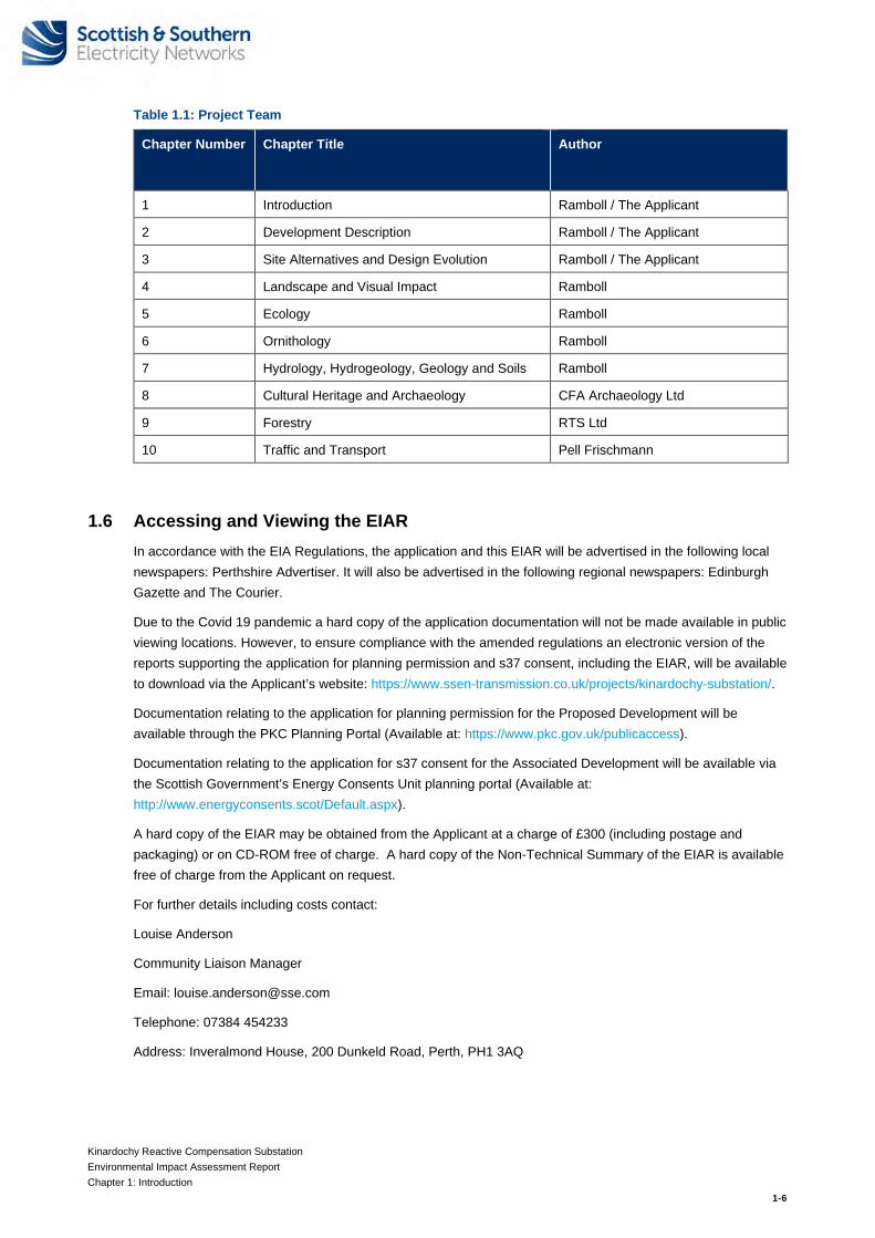
Kinardochy Reactive Compensation Substation Environmental Impact Assessment Report Chapter 1: Introduction 1-6
Table 1.1: Project Team
Chapter Number Chapter Title Author
1 Introduction Ramboll / The Applicant
2 Development Description Ramboll / The Applicant
3 Site Alternatives and Design Evolution Ramboll / The Applicant
4 Landscape and Visual Impact Ramboll
5 Ecology Ramboll
6 Ornithology Ramboll
7 Hydrology, Hydrogeology, Geology and Soils Ramboll
8 Cultural Heritage and Archaeology CFA Archaeology Ltd
9 Forestry RTS Ltd
10 Traffic and Transport Pell Frischmann
1.6 Accessing and Viewing the EIAR In accordance with the EIA Regulations, the application and this EIAR will be advertised in the following local newspapers: Perthshire Advertiser. It will also be advertised in the following regional newspapers: Edinburgh Gazette and The Courier.
Due to the Covid 19 pandemic a hard copy of the application documentation will not be made available in public viewing locations. However, to ensure compliance with the amended regulations an electronic version of the reports supporting the application for planning permission and s37 consent, including the EIAR, will be available to download via the Applicant’s website: https://www.ssen-transmission.co.uk/projects/kinardochy-substation/.
Documentation relating to the application for planning permission for the Proposed Development will be available through the PKC Planning Portal (Available at: https://www.pkc.gov.uk/publicaccess).
Documentation relating to the application for s37 consent for the Associated Development will be available via the Scottish Government’s Energy Consents Unit planning portal (Available at: http://www.energyconsents.scot/Default.aspx).
A hard copy of the EIAR may be obtained from the Applicant at a charge of £300 (including postage and packaging) or on CD-ROM free of charge. A hard copy of the Non-Technical Summary of the EIAR is available free of charge from the Applicant on request.
For further details including costs contact:
Louise Anderson
Community Liaison Manager
Email: [email protected]
Telephone: 07384 454233
Address: Inveralmond House, 200 Dunkeld Road, Perth, PH1 3AQ

Kinardochy Reactive Compensation Substation Environmental Impact Assessment Report Chapter 1: Introduction 1-7
1.7 Commenting on the Application Any representations in relation to the application for Town and Country planning permission for the Proposed Development may be submitted via:
• the PKC Planning Portal website at: https://www.pkc.gov.uk/publicaccess;
• by email to the PKC, Planning and Development mailbox at [email protected]; or
• by post to the Perth and Kinross Council, Planning and Development, Pullar House, Kinnoull Street, Perth PH1 5GD.
Written or emailed representations should be dated, clearly stating the name (in block capitals), full return email or postal address of those making representations, identify the proposal (Kinardochy Reactive Compensation Substation) and specify the grounds for representation. Only representations sent by email to [email protected] will receive acknowledgement.
Any representations to the application for section 37 consent for the Associated Development may be submitted via:
• the Energy Consents Unit website at www.energyconsents.scot/Register.aspx;
• by email to the Scottish Government, Energy Consents Unit mailbox at [email protected]; or
• by post to the Scottish Government, Energy Consents Unit, 4th Floor, 5 Atlantic Quay, 150 Broomielaw, Glasgow, G2 8LU, identifying the proposal and specifying the grounds for representation. Please note that there may be a delay in the Energy Consents Unit receiving representations by post.
Representations should be dated, clearly stating the name in block capitals, full return email and postal address of those making representations. Only representations sent by email to [email protected] will receive acknowledgement.
All representations should be received not later than 15 April 2021, although the planning authorities may consider representations received after this date.
Kinardochy Reactive Compensation Substation Environmental Impact Assessment Report Chapter 2: Development Description 2-1
2. DEVELOPMENT DESCRIPTION
2.1 Introduction This chapter provides a description of the Proposed Development and the Associated Development for the purposes of identifying and assessing likely significant effects. Information is provided on:
• the location of the Proposed Development and the Associated Development;
• the physical characteristics of the Proposed Development and the Associated Development, including, the land-use requirements during the construction and operational phases; and
• the main characteristics of the construction and operational phase of the Proposed Development and the Associated Development, having regard to the type and quantity of expected residues and emissions.
This chapter is supported by:
• Technical Appendix 2.1: Outline Construction Environmental Management Plan.
• Technical Appendix 2.2: Reinstatement and Landscape Design Specification;
• Technical Appendix 2.3: Baseline Noise Report; and
• Technical Appendix 2.4: Acoustic Modelling Report.
Figures 2.1-2.10 are presented in Volume 3a: Figures of the EIAR and are referred to in the text as appropriate. The figures are as follows:
• Figure 2.1a: Proposed Development Site Layout;
• Figure 2.1b: Associated Development Site Layout;
• Figure 2.1c: Combined Proposed Development and Associated Development Site Layout;
• Figure 2.2a: Proposed Development Substation Platform - Earthwork Volumes;
• Figure 2.2b: Proposed Development Construction Compound - Earthwork Volumes;
• Figure 2.2c: Proposed Development Access Track - Earthwork Volumes;
• Figure 2.3: Proposed Substation Layout;
• Figure 2.4: Proposed Substation Elevations and Dimensions;
• Figure 2.5: 275 kV Terminal Tower;
• Figure 2.6: 275 kV Tension Tower;
• Figure 2.7: 132 kV NeSTS Tower;
• Figure 2.8: Horizontal Limits of Deviation;
• Figure 2.9: Temporary Tower Works; and
• Figure 2.10: Permanent Tower Works
2.2 The Project Site The boundary for the Proposed Development (herein referred to as ‘the Site’) covers an area of 38.3 ha and is located immediately west of the B846 (Aberfeldy to Tummel Bridge) at Tomphubil, 3 km south of the village of Tummel Bridge, in the Perth and Kinross local authority area (See EIAR Volume 3a: Figure 1.1: Site Location). The Site is located within a topographical basin between Meall Damh to the east, and the foothills of Schiehallion, a popular Munro, to the west. Land cover within the Site is comprised predominantly of coniferous woodland plantation, semi improved grassland and heathland, as well as patches of sphagnum blanket bog. Scottish Natural Heritage’s (SNH’s) revised National Programme of Landscape Character Assessment (2019) identifies the Site as straddling Landscape Character Type (LCT) 375- Lower upland glens with lochs and LCT 376- Summits and plateaux Tayside. Two small watercourses flow into Loch Kinardochy: the upper reaches of
Kinardochy Reactive Compensation Substation Environmental Impact Assessment Report Chapter 2: Development Description 2-2
the Allt Kinardochy from the north and a small unnamed watercourse from the west. Both watercourses have connectivity to the River Tay.
The Associated Development is largely located immediately to the west of the Proposed Development, with the exception of an upgrade of a track to Tower 227 (T227) on the Beauly-Denny Line, located 1 km north of the Proposed Development and a temporary access track to Tower 231 (T231) on the Beauly-Denny line, which is located 0.5 km south of the Site.
Collectively the Site and the Associated Development are referred to as the ‘Project Site’. The Project Site lies within the River Tay catchment, near the northern banks of Loch Kinardochy.
The National Soil Map of Scotland shows that the Project Site is largely covered by Mineral gleys to the south and by Mineral podzols to the north. However some of the temporary infrastructure associated with the Associated Development, including the proposed temporary access track to T231, is located on peaty podzol soil. Peat is also present across the Project Site, at depths generally between 0.5 m and 1.5 m but up to >3 m near the southwest corner of the proposed substation platform.
The Loch Tummel National Scenic Area (NSA) is situated immediately east of the Project Site at its closest point (the proposed access track to T227) and 1 km east/north east of the Site at its closest point.
The Loch Rannoch and Glen Lyon NSA is located 1 km west/southwest of the Project Site at its closest point (the proposed access track to T231) and 1.3 km west/southwest of the Site at its closest point. In addition, a small section of the Schiehallion/ Breadalbane – Schiehallion Wild Land Area (WLA) is situated to the west/southwest of the Project Site.
The Dalcroy Promontory Site of Scientific Interest (SSSI) is located 1.4 km north of the Project Site at its closest point (the proposed access track to Tower 227) and 2.8 km north/north east of the Site at its closest point. The Dalcroy Promontory SSSI is designated for biological features, specifically pillwort Pilularia globulifera, a rare aquatic fern.
The Schiehallion SSSI is located 1.7 km west of the Project Site at its closest point (the proposed 132 kV NeSTS tower) and 1.9 km west of the Site at its closest point. The Schiehallion SSSI is designated for geological features including limestone pavement and Dalradian, as well as its montane assemblage habitats.
The River Tay Special Area for Conservation (SAC) is located 1.3 km north of the Project Site at its closest point (the proposed access track to Tower 227) and 2.8 km north of the Site at its closest point. The River Tay SAC is designated for Atlantic Salmon Salmo salar, Brook Lamprey Lampetra planeri, otter Lutra lutra and clear-water lakes or lochs with aquatic vegetation and poor to moderate nutrient levels.
Most of the Project Site is currently owned by Forestry and Lands Scotland (FLS), with the exception of the area to the west of the Beauly-Denny line, which is owned by Tombreck Estate and the proposed access track to T227, which is owned by Kynachan Estate. Land use within the Project Site is predominantly commercial forestry and rough grazing. There are also four existing transmission lines which pass through the Project Site, as described in Section 2.2.1 below.
2.2.1 Existing Developments
Existing developments identified within 3 km of the Project Site, which should be considered as part of the baseline for the Proposed Development and the Associated Development, comprise of the following (as shown on EIAR Volume 3a: Figure 1.1: Site Location):
• The existing Beauly-Denny line, routed in a north to south direction along the western boundary of the Site (of the Proposed Development), to the west of the proposed substation platform. This OHL also crosses over the proposed access track to T227. The existing Beauly-Denny line will be modified as part of the proposed works for the Associated Development;
Kinardochy Reactive Compensation Substation Environmental Impact Assessment Report Chapter 2: Development Description 2-3
• An existing 132 kV OHL, routed in a north to south direction 120 m west of the Site at its closest point. This OHL will be modified as part of the proposed works for the Associated Development. This OHL is also located 0.1 km west of the proposed access track to T227;
• An existing 33 kV OHL, routed in a north to south direction, located 170 m west of the Site (of the Proposed Development) at its closest point. This OHL is also located 0.1 km west of the proposed access track to T227;
• An existing 33 kV OHL, routed in an east to west direction, located 250 m west of the Site (of the Proposed Development) at its closest point;
• An existing 132 kV OHL, routed in a north west to south east direction, along the eastern boundary of the Site (of the Proposed Development), parallel to the proposed access junction to the Site. This OHL also crosses over the proposed access track to T227;
• The existing Tummel Power Station is located 2.2 km north / north west of the Project Site at its closest point, the proposed access track to T227;
• The existing 275 kV Tummel Substation is located 2.5 km north west of the Project Site at its closest point, the proposed access track to T227; and
• The existing 132 kV Errochty Substation is located 2 km north of the Project Site at its closest point, the proposed access track to T227.
2.3 Proposed Development Description The Proposed Development, for which planning permission is being sought under the Town and Country Planning (Scotland) Act 1997, would comprise of a new reactive power compensation substation along with associated infrastructure, arranged as illustrated on EIAR Volume 3a: Figure 2.1a: Proposed Development Site Layout. The Proposed Development would include the following key components:
• A level platform, with an area of up to 5.86 ha (excluding cut/fill);
• A reactive power compensation substation, comprising of buildings, infrastructure and electrical equipment including:
− 100 Mega volt amps (reactive) (MVAr) Mechanically Switched Capacitor with Damping Network (MSCDN);
− Insulated Gate Bipolar Transistors (IGBT) based Static Synchronous Compensators (STATCOMs);
− a Gas Insulated Switchgear (GIS) and Control building;
− transformers, busbars, and OHL gantry structures; and
− Internal roads, access paths, and hardstanding areas within the substation compound.
• An access track, connecting to the B846 road (Aberfeldy to Tummel Bridge);
• A temporary construction compound and laydown area;
• Associated landscaping works and felling of commercial forestry; and
• Drainage, including two attenuation basins (SuDS ponds).
2.3.1 Substation and Platform
A layout of the substation is included in EIAR Volume 3a: Figure 2.3: Proposed Substation Layout. In addition, the proposed dimensions of the substation buildings and electrical infrastructure, including elevations are included in EIAR Volume 3a: Figure 2.4: Proposed Substation Elevations and Dimensions. The maximum height of electrical equipment and plant, including the OHL gantry and MSCDN Bay, would be up to 15.5 m.

Kinardochy Reactive Compensation Substation Environmental Impact Assessment Report Chapter 2: Development Description 2-4
Platform
The location of the substation platform is shown in EIAR Volume 3a: Figure 2.1a: Proposed Development Site Layout. The purpose of the platform is to house the new reactive power compensation substation. The dimensions of the platform are up to 302 m x 212 m, although the south eastern corner of the platform has been reduced to avoid an area of blanket bog (See Chapter 3: Site Alternatives and Design Evolution), as illustrated in EIAR Volume 3a: Figure 2.1a: Proposed Development Site Layout. The platform total area would be 5.86 ha, which allows for network requirements at the time of application, but also provides provision for future development without needing to expand the footprint of the Proposed Development.
The platform formation would require rock cut and earthwork movements to create a level platform and cut/fill balance. The platform would be levelled at 372.5 m above ordnance datum (AOD). Civil engineering works and ground clearance would be required to achieve a level area of this size, as shown in EIAR Volume 3a: Figure 2.2a: Proposed Development Substation Platform - Earthwork Volumes.. All material movements required to prepare the platform would be managed on site with no anticipated movement of material off site.
The platform would be surrounded by a 4 m high palisade security fence and a 2 m wide perimeter walkway/path, as shown in EIAR Volume 3a: Figure 2.3: Proposed Substation Layout.
GIS and Control Building
The substation would be a double busbar Gas Insulated Switchgear (GIS), with associated bus section, rather than the traditional Air Insulated Switchgear (AIS). This means that the overall size of the substation would be smaller than an AIS and the majority of the equipment would be housed within single-storey buildings. The dimensions of the GIS and Control Building would be up to 35 m x 68 m and 15.5 m in height, as illustrated in in EIAR Volume 3a: Figure 2.4: Proposed Substation Elevations and Dimensions.
STATCOM
It is anticipated that following the connection of Glen Shero wind farm (estimated to be completed in May 2022), the voltage step change at the existing Tummel 275 kV substation will exceed the limit stated in Security and Quality of Supply Standard (SQSS). In order to mitigate voltage step change to be within the limit, Flexible Alternating Current Transmission Systems (FACTS) technology is required to accommodate a reactive compensation range of +225/-75 MVAr.
FACTS technology is considered to include thyristor and Insulated Gate Bipolar Transistors (IGBT) based Static Synchronous Compensators (STATCOMs), Static Var Compensators (SVC), Fixed Series Capacitors, Thyristor Controlled Series Capacitors as well as Synchronous Condensers. The Proposed Development technology would take the form of an IGBT based STATCOM, with a maximum design envelope of ±225 MVAr, as illustrated in Figures 2.3 and 2.4 (EIAR Volume 3a).
The ±225 MVAr STATCOM (herein referred to as the STATCOM) would occupy an area of up to 100 m x 40 m of the eastern section of the platform compound, as illustrated in Figure 2.3 and 2.4 (EIAR Volume 3a). The ±225 MVAr STATCOM is comprised of two main components:
• STATCOM Plant; and
• STATCOM Building.
The dimensions of the STATCOM Plant would be up to 22 m x 32 m and 7.5 m in height and the dimensions of the STATCOM Building would be up to 21 m x 30 m and 10 m in height, as illustrated in Figure 2.3 and 2.4 (EIAR Volume 3a).
MSCDN
In addition to the STATCOM, a 100 MVAr MSCDN (herein referred to as the MSCDN) would also be required to be connected, as enabling works for some of the generation connections. The dimensions of the MSCDN would
Kinardochy Reactive Compensation Substation Environmental Impact Assessment Report Chapter 2: Development Description 2-5
be up to 39 m x 34.5 m and 9.2 m in height and would be located to the south of the STATCOM, as illustrated in Figure 2.3 and 2.4 (EIAR Volume 3a). The substation compound also contains space for a second MSCDN, of the same dimensions, to be constructed to the north of the STATCOM at a later date, once operational requirements demand its installation (as illustrated in blue on EIAR Volume 3a: Figure 2.3: Substation Layout).
Transformers, Busbars, and OHL Gantry Structures
Two OHL Gantry Structures would be installed up to 5 m from the western boundary of the substation compound. The northernmost OHL Gantry would connect to the Tummel circuit (MK1), whilst the southernmost OHL Gantry would connect to the Braco West circuit (KB1), as illustrated in EIAR Volume 3a: Figure 2.3: Substation Layout. Each OHL Gantry would be up to 13 m in height.
The substation compound also contains space for two further 400 kV OHL Gantries, of the same dimensions, to be constructed once operational requirements demand their installation (as illustrated in blue on EIAR Volume 3a: Figure 2.3: Substation Layout).
From each OHL Gantry the connection would pass through a Surge Arrester (SA), Capacitive Voltage Transformer (CVP), an Earth Switch (ES), a Current Transformer (CT) and an AIS/GIS interface, before connecting to the 275 kV double busbar GIS substation and control building via a Gas Insulated Busbar (GIB).
The double busbar GIS substation and control building connect to the STACOM via GIB which connects to another GIS/AIS interface. From the GIS/AIS interface the connection passes through a High Level Post Insulator (HPI), a CVP, a second HPI, an ES and a SA before connecting to the STATCOM.
The double busbar GIS substation and control building connect to the MSCDN via a separate GIB which connects to another GIS/AIS interface. From the GIS/AIS interface the connection passes through a series of HPIs, a CT, a CVP, a Discharge Voltage Transformer (DVT), an ES and a SA before connecting to the MSCDN. The substation compound would include bus couplers, OHL feeders, a STATCOM feeder and a MSCDN feeder. The substation compound would also have additional capacity for a number of future bays, including OHL feeders, MSCDN feeder and future Super Grid Transformer (SGT) feeders.
2.3.2 Construction Compound and Laydown Area
A temporary construction compound with laydown area would be required to facilitate the construction of the Proposed Development and would incorporate temporary facilities such as boundary fencing, security lighting, parking for construction workers, site storage and site facilities such offices, welfare, toilet facilities, skips etc. The temporary construction compound and laydown area is located immediately east of the substation compound, as shown in EIAR Volume 3a: Figure 2.1a: Proposed Development Site layout.
The total area would be up to 3.16 ha and has been designed to avoid areas of sensitive habitat, including blanket bog habitat (See Chapter 3: Site Alternatives and Design Evolution).
The platform would be levelled at 372.5 m AOD. Civil engineering works and ground clearance would be required to achieve a level area of this size, as shown in EIAR Volume 3a: Figure 2.2b: Proposed Development Construction Compound - Earthwork Volumes. To prepare the level platform required for the compound area earthworks, including rock excavation will be undertaken to achieve a cut and fill balance.
2.3.3 Access Track
Access to the Site would be via a new junction off the western side of the B846 at NGR 278017 755432, north of Tomphubil, as illustrated in EIAR Volume 3a: Figure 2.1a: Proposed Development Site Layout. The access track would be routed in a general north westerly direction for 0.45 km, following the route of the existing 132 kV OHL, and crossing the Alt Kinardochy Burn at NGR 277939 755595. The track then runs in a westerly direction for 0.37 km, connecting to the eastern side of the substation platform at NGR 277337 755686. The proposed access track would typically be up to 5 m wide with appropriate widening at bends and passing places,

Kinardochy Reactive Compensation Substation Environmental Impact Assessment Report Chapter 2: Development Description 2-6
dependent on site conditions. Civil engineering works and ground clearance would be required to construct the proposed access track, as shown in EIAR Volume 3a: Figure 2.2b: Proposed Development Construction Compound - Earthwork Volumes. The verge of the proposed access track would be reinstated as appropriate after construction.
2.3.4 Watercourse Crossings
As noted above, the number of watercourses has been minimised through site design. Nevertheless, there is a requirement for one watercourse crossing, Water Crossing at NGR 277939 755595, where the proposed access track crosses the Allt Kinardochy burn. Further information about the watercourse crossing is provided in Chapter 7: Hydrology, Hydrogeology, Geology and Soils.
2.3.5 Borrow Pits
Stone would be required for various purposes, primarily for the construction of the platform and access track. At the time of application, the Applicant is anticipating the majority of rock to be site won as part of the substation cut/fill operations. If specific grades of rock cannot be sourced from site won material there would be a requirement for this to be brought to site from off-site licensed quarries.
At present there are no plans for on-site borrow pits and as such these are specifically excluded from the applications for planning permission and s37 consent. Should an on-site borrow pit be required following further detailed ground investigations undertaken by either of our Principal Contactors then a separate application for planning permission would be taken forward at that time.
2.3.6 Crushing Plant
A crushing plant may be required on the Site for rock breaking and crushing during the formation of the proposed substation platform, the access track and the construction compound and laydown area. Any use of mobile crushing plant would be subject to a Part B Pollution Prevention and Control (PPC) permit1, under the Pollution Prevention and Control (Scotland) Regulations 20122.
2.3.7 Site Drainage
The surface water site drainage from the substation platform and construction compound and laydown area will comprise of conveyance features draining into an attenuation basin (or SuDS pond) to the north of the proposed platform and a temporary silt sedimentation pond to the west of the construction compound during the construction phase. The access road will generally be serviced via trackside ditches and cut-off ditches prior to overland discharge. The drainage conveyance features at the compound and platform area would likely be comprised of the following features:
• Filter Trench;
• Surface Water Ditches;
• Perimeter Cut-off Ditches;
• Underground Pipes; and,
• Kerb Drainage.
1 SEPA (2012), PPC Part B activities. Available at: https://www.sepa.org.uk/regulations/pollution-prevention-and-control/ppc-part-b-activities/ [Last Accessed 19/01/2021]; 2 Pollution Prevention and Control (Scotland) Regulations 2012. Available at: [https://www.legislation.gov.uk/ssi/2012/360/contents/made [Last Accessed 19/01/2021];

Kinardochy Reactive Compensation Substation Environmental Impact Assessment Report Chapter 2: Development Description 2-7
Substation Platform Drainage
The substation platform would be designed to attenuate and treat surface water in line with standards set out by the Scottish Environment Protection Agency (SEPA). The design and construction would ensure that surface water run off would be carefully managed and would not discharge at any additional rate to the greenfield runoff. To satisfy requirements of the local flood risk and surface water management guidance, sustainable urban drainage (SuDS) principles as outlined in Ciria report C753 would be applied. This includes controlling the quantity and managing the quality of runoff to prevent pollution.
Permeable and Impermeable Surfaces
The substation platform will be formed with a 1 m thick layer of compacted rockfill, which will be permeable. However, there will be impermeable surfaces within the final Proposed Development, including:
• Sealed internal roadways and two small parking areas;
• Two buildings contributing roof water;
• One fuel delivery area with associated bund; and
• Future provision of external transformers (to be located within bunds).
Runoff from these impermeable surfaces would require management through SuDS.
All other surfaces would consist of isolated structural supports to equipment, and the runoff from these would not require treatment, and can drain vertically through the layer of rockfill. The estimated impermeable area requiring flow regulation is some 2.2 ha.
Clean Water Cut off
Clean water cut-off ditches are proposed adjacent to the cut batters on the west, south and east sides of the substation platform. These will direct natural surface flows back to the terrain around the substation, to allow it to continue to flow in a generally northward direction, maintaining hydraulic continuity.
General Site Roads and Loading Area
The sealed internal roadways and two small parking areas would be drained to filter drains running along one side of each road,
General site roads would be drained using roadside filter trenches. These hardstanding surfaces would be designed with an appropriate fall to allow runoff to readily drain towards the filter trenches. The filter trenches would then convey runoff north into the attenuation basin.
Bunded Areas
Bunded areas will be designed and constructed in accordance with SSE Specification SP-SST-CIV-509.
Perimeter Cut-off Ditches
A perimeter cut-off ditch is proposed around the footprint of the substation platform at the cut/fill level (i.e. 1 m below the finished substation level). This will receive any groundwater emanating from the cutting for the substation, as well as infiltrated rainwater falling on the permeable areas of the substation. This water would not require treatment or attenuation and would be discharged back to the terrain around the substation as for the clean water cut-off ditches.
Attenuation Basin
The drainage from the various impermeable areas of the substation platform will be conveyed by pipework to a single pipe leading down-slope northward to a proposed attenuation basin (SuDS pond), as illustrated in EIAR Volume 3a: Figure 2.1a: Proposed Development Site Layout. The concept sizing of the basin has a floor area of 2,500m2, a design depth of 1 m, side slopes of 1:4, and incorporates an overflow weir. The basin outflow
Kinardochy Reactive Compensation Substation Environmental Impact Assessment Report Chapter 2: Development Description 2-8
would be regulated by a flow control device such as a hydro-brake or orifice plate, located within a manhole just north of the basin. The attenuated/treated runoff water would then be conveyed to an adjacent flow spreader trench, which would distribute the flow across as wide a band of the terrain as possible.
The attenuation basin would service the proposed platform, prior to discharge via existing overland flow routes to mimic existing hydrological conditions. The outfalls of the attenuation basin would be designed to include suitable erosion control measures, such as rip-rap or proprietary erosion control matting.
Construction Compound Drainage
The construction compound is a temporary feature and as such will only require drainage infrastructure prior to restoration. The construction compound will mostly comprise a general hardstanding and laydown area, surfaced with a 75 mm layer of angular gravel above 200 mm of Type 1 capping layer.
The temporary control of surface waters within the construction compound and laydown area would include falls and ditches to help convey surface water run-off to a sedimentation pond to be located to the north west of the compound. The sedimentation pond would be designed to provide sufficient retention time to allow silts to settle out, as well as limit flows equivalent to greenfield conditions. The discharge from this settlement pond would be directed to the flow spreader trench, until such time as the compound is disused and reinstated.
Following construction, the construction compound and laydown area and the sedimentation pond shall be reinstated to pre-existing conditions.
Access Track Drainage
Track Drainage
With the exception of a few short sections of access track where the track is completely elevated above the terrain on both sides, runoff from the proposed access track will largely be drained via trackside ditches running parallel to one side of the alignment of the track. At suitable intervals, the trackside ditch shall discharge to the downgradient side of the access track. The manner of the discharge would depend on whether the proposed access track is in cut or fill. In areas of cut, ditches would discharge, typically at existing low spots and gully features, via a culvert to the downstream side of the track. In areas of fill, trackside ditches would discharge via cascading weirs built into the surface of the downstream embankment, typically backfilled with rip-rap to reduce erosion and retain silt.
Erosion control measures, such as rip-rap or proprietary erosion control matting, would be employed at all culvert discharge points on the downgradient side of the proposed access track.
The most critical period for track drainage impacts would be during construction, when the access track would be utilised daily for personnel, materials and plant deliveries, and within a year of construction, when batter slopes would be revegetated. For that period, silt control facilities such as basins would be employed to control the discharge from the proposed access track.
Clean Water Cut-off
Cut-off ditches are proposed on the upgradient side of the proposed access track. Ditches shall be constructed along the alignment of the crest of the upgradient embankment (where the proposed access track is in cut) and of the toe of the upgradient embankment (where the proposed access track is in fill).
In general, the locations of weirs and/or culverts for the cut-off ditches will align with local low spots and as such would also act to provide continuity for any minor streams or watercourses that may be encountered along the route of the proposed access track.
Existing Watercourses
It is anticipated that a number of minor streams will be encountered at localised low spots over the proposed access track alignment and these shall generally be dealt with via the same drainage infrastructure as the
Kinardochy Reactive Compensation Substation Environmental Impact Assessment Report Chapter 2: Development Description 2-9
upgradient cut-off ditches (as discussed above). Closed culverts are likely to be suitable for these ‘minor’ watercourse crossings and to be designed in accordance with SEPA’s requirements and the Water Environment Scotland Controlled Activities Regulations (CAR).
One larger existing watercourse crossing over the Allt Kinardochy would require a bespoke crossing. The crossing type is likely to be a ‘Bottomless Arch’ culvert and will require formal authorisation from SEPA via CAR. Other minor unknown watercourse crossings may also require formal CAR consent, which would be arranged post planning in consultation with SEPA.
Foul Drainage
SEPA’s order of preference for means of sewage discharge are:
• Connect to public sewer.
• Discharge to land.
• Discharge to watercourse.
Connection to a public sewer for the operational phase of the Proposed Development is not considered viable due to the distance and elevation difference between the site and the closest sewer. Discharge to land is the proposed sewage discharge option for the Proposed Development. Site foul flows from welfare facilities would be designed for discharging to land in line with SEPA’s ‘Regulatory Method for Indirect Sewage Discharges to Groundwater’3, It has been assumed that the Proposed Development would accommodate three operatives once operational; therefore a population equivalent (p.e.) of three people has been assumed for indicative hydraulic sizing of the treatment unit. For a p.e. of 15 or less, SEPA consider sewage discharges to the water environment to be relatively low risk and requires only an application of a ‘registration’ under CAR.
A secondary treatment package would likely be required to accept flows from the substation building. Foul sewer pipes connecting the substation building to the treatment plant would be designed in line with Sewers for Scotland4. It is proposed that treated effluent from the secondary treatment plant would be piped alongside the northern edge of the proposed access track to a partial soakaway, located to the east of the construction compound. From the partial soakaway the treated effluent discharged into the surrounding downslope superficial layers.
During the construction phase of the Proposed Development it is anticipated the Principal Contractor would store foul waste from the welfare facilities in tanks which will be removed by licensed waste carrier as required to a licensed waste handling facility. Should the Principal Contractor determine the best solution to be a septic tank and soakaway then they would be responsible for seeking an authorisation from SEPA in line CAR.
2.3.8 Construction Programme
It is anticipated that the construction of the Proposed Development would take 26 months, commencing in December 2021 (subject to consents and approvals being granted), and completing in February 2024. Final commissioning and ground restoration/reinstatement works would be completed in May 2024.
2.3.9 Construction Methods
This section describes the different phases of construction of the Proposed Development.
3 SEPA, 2017, Regulatory Method (WAT-RM-04): Indirect Sewage Discharges to Groundwater 4 Scottish Water, 2018. Sewers for Scotland v4.0
Kinardochy Reactive Compensation Substation Environmental Impact Assessment Report Chapter 2: Development Description 2-10
Phase 1 – Site Establishment and Enabling Works
Pre-Construction Surveys
Prior to commencement of the Proposed Development pre-construction surveys would be undertaken, and mitigation put in place, where required, as detailed within the CEMP. This may include measures to prevent disturbance to protected species and the installation of pollution prevention measures, such as silt fencing.
Tree Clearance
Once site controls are established site clearance, including the removal of any trees and other vegetation, can commence. The Applicant has sought to avoid positioning site infrastructure, such as the access track and temporary construction compound, in areas of woodland wherever possible through the design process (See Chapter 3: Site Alternatives and Design Evolution). Where this has not been possible, site infrastructure has been positioned to minimise the amount of felling required. It is anticipated that up to 13 ha of woodland would require removal, either permanently or temporarily, to accommodate the construction of the Proposed Development, as detailed in Chapter 9: Forestry.
Road Improvements and Site Access and Road
Vehicle access during construction would be via a new junction with the B846 between Glengoulandie and Tummel Bridge. The junction would be designed to the Design Manual for Roads and Bridges5 and would take into consideration the safety during the construction and operational phase.
A new stone access track would also be constructed between the new junction and the eastern side of the substation platform, as shown in EIAR Volume 3a: Figure 2.1a: Proposed Development Site Layout. This access track would also provide access to the temporary construction compound and laydown area, where parking would be available for construction staff.
The largest and heaviest single item of plant item would be the Statcom Transformer (ST), which is likely to weigh up to 207 tonnes. To enable the delivery of the transformer to the site, modifications to the existing public road network would be required to ensure traffic impacts on the road network are minimised and emergency access can be provided at all times. These modifications vary but would improve safety for existing road users and allow the safe delivery of the transformer to site. In addition, peak times would be avoided, and road signage would be implemented to provide advanced warning of abnormal load movements. A SHE Transmission Community Liaison officer has been appointed and part of their remit is to ensure that the local community and the general public have enough information to plan their journey during abnormal load movements. The geometry design of the new junction would also be suited to the safe delivery of the ST.
Construction Compound
In advance of the main compound being constructed (as outlined in section 2.3.2) there may be a requirement for other temporary compounds and laydown area to facilitate the construction of the Proposed Development. The location of these compounds would be determined by the Principal Contractor once they are appointed. Once these area(s) have been identified, the Principal Contractor would consult with the planning authority, and any other relevant statutory authority, to ascertain whether statutory permissions are required. Where statutory permissions are required the Principal Contractor would be responsible for securing all permissions necessary to operate these sites.
Phase 2 – Construction Works
Substation construction follows a similar pattern to any building works:
5 Standards for Highways (2020), Design Manual for Roads and Bridges . Available at: https://www.standardsforhighways.co.uk/dmrb/ [last Accessed 05/08/2020];
Kinardochy Reactive Compensation Substation Environmental Impact Assessment Report Chapter 2: Development Description 2-11
• Establish site controls, as per the CEMP, including pollution prevention measures and temporary works drainage;
• Stripping and storage of turves and soils in accordance with CEMP and best practise to ensure they can be reused for site reinstatement;
• Construction of access tracks, temporary construction compound and laydown area;
• Civil engineering to create a level platform for the substation infrastructure;
• Erection of a security fence;
• Installation of building and electrical infrastructure foundations;
• Construction of operational site drainage and SUDS;
• Construction of internal access roads, as illustrated in EIAR Volume 3a: Figure 2.3: Proposed Substation Layout;
• Erection of buildings;
• Mechanical and electrical installation of electrical plant; and
• Commissioning.
Phase 3 – Decommissioning of Temporary Infrastructure and Site Reinstatement
Following commissioning of the Proposed Development, all temporary infrastructure would be removed, and the construction site would be reinstated. Reinstatement would form part of the contract obligations for the Principal Contractor and would include all temporary works, such as temporary access tracks, temporary compounds and laydown area.
Following removal of the temporary works, best practise techniques would be used to ensure soils are replaced in the order they were removed with any turves replaced on top. Where required, reseeding of these areas would also be undertaken with an appropriate seed mix.
Landscape planting would be undertaken in line with the Landscape and Reinstatement Plan.
2.3.10 Construction Traffic
Vehicle access during construction would be via a new junction with the B846 between Glengoulandie and Tummel Bridge. The junction would be designed to the Design Manual for Roads and Bridges6 and would take into consideration safety during the construction and operational phase. A new access track would also be constructed between the new junction and the Proposed Development, as shown in EIAR Volume 3a: Figure 2.1a: Proposed Development Site Layout.
The construction would give rise to regular numbers of staff transport movements, with small work crews travelling to work site areas. It is anticipated that the Principal Contractor parking facilities for construction workers would be within the temporary construction compound.
Vehicle movements would also be required to construct some elements of the platform, the new access track and junction; to deliver the platform and substation components to site and to deliver and collect materials and construction plant from the construction compound.
Determined through earthworks and geotechnical design, the maximum volume of site won material would be reused on site, reducing the number of vehicle movements on the public road. It is the intention to build the substation platform, the temporary construction compound and laydown area, as well as the final layers of the access track from material sourced within the Project Site.
6 Standards for Highways (2020), Design Manual for Roads and Bridges . Available at: https://www.standardsforhighways.co.uk/dmrb/ [last Accessed 05/08/2020];
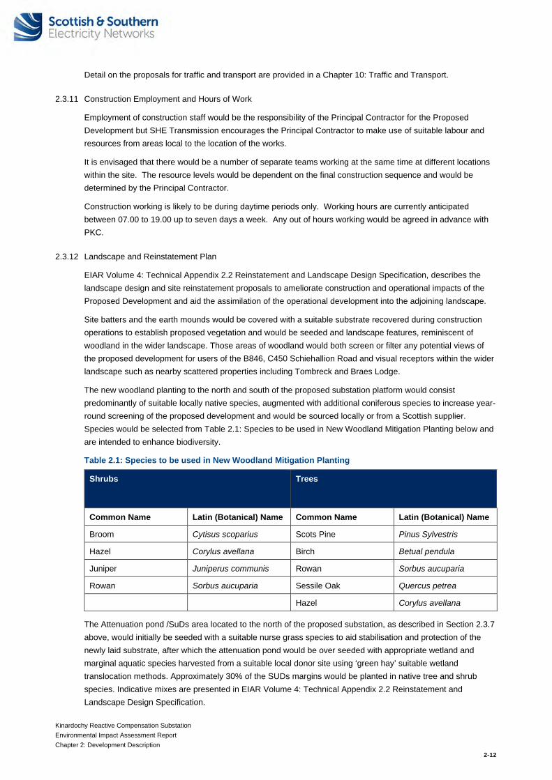
Kinardochy Reactive Compensation Substation Environmental Impact Assessment Report Chapter 2: Development Description 2-12
Detail on the proposals for traffic and transport are provided in a Chapter 10: Traffic and Transport.
2.3.11 Construction Employment and Hours of Work
Employment of construction staff would be the responsibility of the Principal Contractor for the Proposed Development but SHE Transmission encourages the Principal Contractor to make use of suitable labour and resources from areas local to the location of the works.
It is envisaged that there would be a number of separate teams working at the same time at different locations within the site. The resource levels would be dependent on the final construction sequence and would be determined by the Principal Contractor.
Construction working is likely to be during daytime periods only. Working hours are currently anticipated between 07.00 to 19.00 up to seven days a week. Any out of hours working would be agreed in advance with PKC.
2.3.12 Landscape and Reinstatement Plan
EIAR Volume 4: Technical Appendix 2.2 Reinstatement and Landscape Design Specification, describes the landscape design and site reinstatement proposals to ameliorate construction and operational impacts of the Proposed Development and aid the assimilation of the operational development into the adjoining landscape.
Site batters and the earth mounds would be covered with a suitable substrate recovered during construction operations to establish proposed vegetation and would be seeded and landscape features, reminiscent of woodland in the wider landscape. Those areas of woodland would both screen or filter any potential views of the proposed development for users of the B846, C450 Schiehallion Road and visual receptors within the wider landscape such as nearby scattered properties including Tombreck and Braes Lodge.
The new woodland planting to the north and south of the proposed substation platform would consist predominantly of suitable locally native species, augmented with additional coniferous species to increase year-round screening of the proposed development and would be sourced locally or from a Scottish supplier. Species would be selected from Table 2.1: Species to be used in New Woodland Mitigation Planting below and are intended to enhance biodiversity.
Table 2.1: Species to be used in New Woodland Mitigation Planting
Shrubs Trees
Common Name Latin (Botanical) Name Common Name Latin (Botanical) Name
Broom Cytisus scoparius Scots Pine Pinus Sylvestris
Hazel Corylus avellana Birch Betual pendula
Juniper Juniperus communis Rowan Sorbus aucuparia
Rowan Sorbus aucuparia Sessile Oak Quercus petrea
Hazel Corylus avellana
The Attenuation pond /SuDs area located to the north of the proposed substation, as described in Section 2.3.7 above, would initially be seeded with a suitable nurse grass species to aid stabilisation and protection of the newly laid substrate, after which the attenuation pond would be over seeded with appropriate wetland and marginal aquatic species harvested from a suitable local donor site using ‘green hay’ suitable wetland translocation methods. Approximately 30% of the SUDs margins would be planted in native tree and shrub species. Indicative mixes are presented in EIAR Volume 4: Technical Appendix 2.2 Reinstatement and Landscape Design Specification.
Kinardochy Reactive Compensation Substation Environmental Impact Assessment Report Chapter 2: Development Description 2-13
.
Species rich grassland (which includes acid and neutral mixes) and dwarf scrub heath mixes would be sown across the remainder of the Site in accordance with EIAR Volume 4: Technical Appendix 2.2: Reinstatement and Landscape Design Specification. Species rich grass would promote visual interest while enhancing and aiding biodiversity.
Further detail about the landscape and reinstatement design plan is provided in EIAR Volume 4: Technical Appendix 2.2 Reinstatement and Landscape Design Specification.
2.4 Associated Development Description The Associated Development, for which s37 consent is being sought under the Electricity Act (1996), is comprised of three main sections: the modifications to the Beauly-Denny line, the 275 kV temporary bypass and the 132 kV diversion. Other Ancillary Development will also be required, which includes the permanent upgrade of an existing track to Tower 227 and the construction of a new temporary track to T231 on the Beauly-Denny Line to facilitate winching operations.
Further details are outlined within this section and are illustrated in EIAR Volume 3a: Figure 2.1b: Associated Development Site Layout.
2.4.1 Modification to the Beauly-Denny line
The proposed modification to the Beauly-Denny line would be undertaken immediately west of the Proposed Development, as shown in EIAR Volume 3a: Figure 2.1c: Combined Proposed Development and Figure 2.1b Associated Development Site Layout,. The modification would comprise the decommissioning of an existing steel lattice tower (T230), located at NGR 276994 755708, and the construction of one replacement tower (T230R) and one new tower (T231A), located at NGR 276994 755756 and NGR 276994 755660 respectively. It is anticipated that both T230R and T231A would be steel lattice SSE400 DT terminal towers with auxiliary arms, as shown in EIAR Volume 3a: Figure 2.5: 275 kV Terminal Tower, and downleads from both towers would connect into the western side of the proposed Kinardochy Substation.
2.4.2 275 kV Temporary Bypass
The 275 kV temporary bypass (herein referred to as ‘the temporary bypass’) would be constructed approximately 100 m to the west of the existing Beauly-Denny line, as shown in EIAR Volume 3a: Figure 2.1b: Associated Development Site Layout, to ensure that transmission of electricity is maintained during construction of the Proposed Development.
The temporary bypass would be comprised of a temporary 1 km deviation from the existing Beauly-Denny Line, supported by two temporary towers. It is anticipated that both Temp T1 and Temp T2 would be steel lattice SSE400 D25 towers, as shown in EIAR Volume 3a: Figure 2.6: 275 kV Tension Tower.
From the north, the temporary bypass would divert from the Beauly-Denny line at existing Tower 229 (NGR 276989 756130). From here, the temporary bypass would run in a south westerly direction for 320 m, connecting to Temp T1 at NGR 276907 755806. The temporary bypass would then run in a southerly direction for 235 m, connecting to Temp T2 at NGR 276896 755546. The final section of the temporary bypass would run in a south easterly direction from Temp T2 for 465 m, reconnection to the Beauly-Denny line at Tower 231 at NGR 277001 755100.
2.4.3 132 kV Diversion
In order to accommodate the temporary bypass, an existing 132 kV OHL, which runs parallel to the Beauly-Denny Line, would require diversion, as illustrated in EIAR Volume 3a: Figure 2.1b: Associated Development Site Layout. It is anticipated that the diversion of the 132 kV OHL would be a permanent diversion comprised of
Kinardochy Reactive Compensation Substation Environmental Impact Assessment Report Chapter 2: Development Description 2-14
a single NeSTS7 tower (a monopole structure with three offset, cantilevered arms supporting the insulators and a top-mounted earthwire), as shown in EIAR Volume 3a: Figure 2.7: 132 kV NeSTS Tower.
The 132 kV diversion would be routed approximately 30 m to the west of the existing 132 kV OHL alignment and 200 m west of the Beauly-Denny line and would be 340 m in length. The 132 kV diversion would start at approximately NGR 276829 755887 and would run in a south westerly direction for 200 m where it would connect to the NeSTS tower. From here it would run in a south easterly direction for 140 m, reconnection to the existing 132 kV line at NGR 276819 755545.
2.4.4 Towers
The Associated Development would be constructed using three types of tower as described below. All towers would be constructed from fabricated galvanised steel and would be grey in colour.
Terminal Towers
Terminal towers are used to connect the OHL into the Proposed Development. The two new permanent 275 kV towers (T230R and T231A) are anticipated to consist of this tower type. It is anticipated that both T230R and T231A would be steel lattice SSE400 DT terminal towers with auxiliary arms, as shown in EIAR Volume 3a: Figure 2.5: 275 kV Terminal Tower. The terminal towers will vary in height between 56 m and 69 m. The statutory ground level clearance required for a 400/275 kV OHL is 7.3 m.
Angle/Tension Towers
Angle or tension towers are used either in-line, where there is a need to terminate the conductors, and/or where there is a need to change the orientation of the OHL. The temporary bypass is anticipated to consist of two towers of this type (Temp T1 and Temp T2). It is anticipated that both Temp T1 and Temp T2 would be steel lattice SSE400 D25 towers, as shown in EIAR Volume 3a: Figure 2.6: 275 kV Tension Tower. The temporary towers will vary in height between 54 m and 67 m.
It is anticipated that temporary bypass would be in operation for up to three years before it is decommissioned on the full energisation of the Proposed Development. Following the decommissioning of the temporary bypass, Temp T1 and Temp 2 would be removed from the Site and the ground would be reinstated.
NeSTS Tower
A NeSTS tower, as shown in EIAR Volume 3a: Figure 2.7: 132 kV NeSTS Tower, has been selected for the 132 kV diversion in order to minimise impacts on blanket bog habitat in the surrounding area. The NeSTS tower would have a nominal height of up to 24 m but, where terrain dictates, extensions could be added to the monopole to maintain conductor ground clearance. The NeSTS tower would be a maximum height of 33.38 m. The statutory ground level clearance required for a 132 kV OHL is 6.7 m.
2.4.5 Tower Construction Areas
Individual tower foundations, including the temporary towers, and associated construction activities would require a working area of up to 2,500 m2 (50 m x 50 m) around each section tower location, although tension towers, such as angle and terminal towers, typically require a larger working area of up to 6,400 m2 (80 m x 80 m). The exact dimensions of the working area around each tower would be confirmed following micrositing but would be no greater than 6,400 m2.
2.4.6 Tower Foundations
Each tower would be supported by below ground foundations at each tower leg. Foundation types and designs for each tower would be confirmed following detailed geotechnical investigation at each tower position.
7 NeSTS is an abbreviation for ‘New Suite of Transmission Structures’
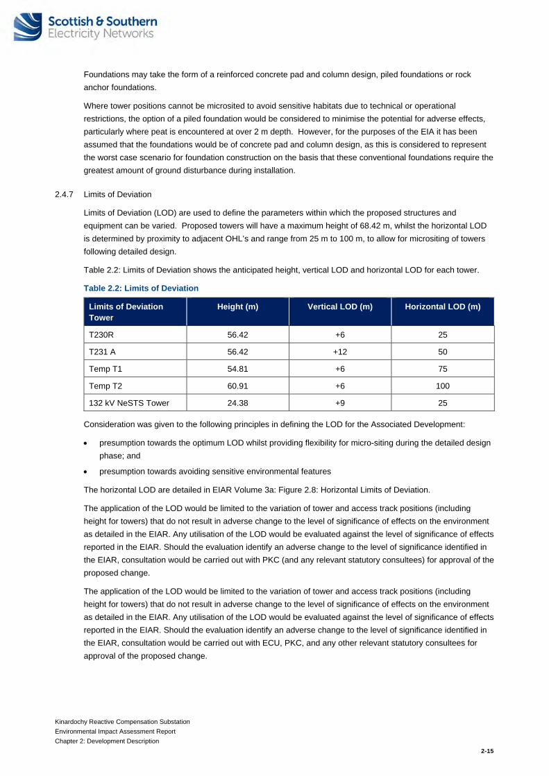
Kinardochy Reactive Compensation Substation Environmental Impact Assessment Report Chapter 2: Development Description 2-15
Foundations may take the form of a reinforced concrete pad and column design, piled foundations or rock anchor foundations.
Where tower positions cannot be microsited to avoid sensitive habitats due to technical or operational restrictions, the option of a piled foundation would be considered to minimise the potential for adverse effects, particularly where peat is encountered at over 2 m depth. However, for the purposes of the EIA it has been assumed that the foundations would be of concrete pad and column design, as this is considered to represent the worst case scenario for foundation construction on the basis that these conventional foundations require the greatest amount of ground disturbance during installation.
2.4.7 Limits of Deviation
Limits of Deviation (LOD) are used to define the parameters within which the proposed structures and equipment can be varied. Proposed towers will have a maximum height of 68.42 m, whilst the horizontal LOD is determined by proximity to adjacent OHL’s and range from 25 m to 100 m, to allow for micrositing of towers following detailed design.
Table 2.2: Limits of Deviation shows the anticipated height, vertical LOD and horizontal LOD for each tower.
Table 2.2: Limits of Deviation
Limits of Deviation Tower
Height (m) Vertical LOD (m) Horizontal LOD (m)
T230R 56.42 +6 25
T231 A 56.42 +12 50
Temp T1 54.81 +6 75
Temp T2 60.91 +6 100
132 kV NeSTS Tower 24.38 +9 25
Consideration was given to the following principles in defining the LOD for the Associated Development:
• presumption towards the optimum LOD whilst providing flexibility for micro-siting during the detailed design phase; and
• presumption towards avoiding sensitive environmental features
The horizontal LOD are detailed in EIAR Volume 3a: Figure 2.8: Horizontal Limits of Deviation.
The application of the LOD would be limited to the variation of tower and access track positions (including height for towers) that do not result in adverse change to the level of significance of effects on the environment as detailed in the EIAR. Any utilisation of the LOD would be evaluated against the level of significance of effects reported in the EIAR. Should the evaluation identify an adverse change to the level of significance identified in the EIAR, consultation would be carried out with PKC (and any relevant statutory consultees) for approval of the proposed change.
The application of the LOD would be limited to the variation of tower and access track positions (including height for towers) that do not result in adverse change to the level of significance of effects on the environment as detailed in the EIAR. Any utilisation of the LOD would be evaluated against the level of significance of effects reported in the EIAR. Should the evaluation identify an adverse change to the level of significance identified in the EIAR, consultation would be carried out with ECU, PKC, and any other relevant statutory consultees for approval of the proposed change.

Kinardochy Reactive Compensation Substation Environmental Impact Assessment Report Chapter 2: Development Description 2-16
2.4.8 Conductors and Span Length
All 275 kV lattice steel towers, including the temporary towers, will carry two circuits, each with three conductors supported from either, glass, porcelain, or composite insulators attached to the horizontal cross arms on both sides of each lattice steel tower.
The 132 kV diversion NeSTS tower will carry one circuit consisting of three conductors supported from either glass, porcelain or composite insulators attached to horizontal cross arms on both sides of the tower. An earth wire with a fibre optic core will be suspended between tower peaks, above the conductors.
The span length distance between towers, will vary depending on voltages, topography, and land usage, however individual towers would only be microsited within their specified horizontal LOD.
2.4.9 Construction Compound
A temporary construction compound for the Associated Development would be constructed to the west of the 132 kV diversion, at NGR 276758 755752. The construction compound would be up to 0.2 ha in area and 50 m x 50 m in size and accessed directly from the existing Tombreck access track.
The construction compound would remain in situ during the construction and operation of the temporary bypass, a period of up to three years. Once the temporary bypass has been decommissioned, the construction compound would be removed and the ground reinstated.
2.4.10 Winching Sites
To enable the installation of conductors on to the new towers, temporary winching sites would be required at the existing angle towers T227 and T231 on the Beauly-Denny line. It is anticipated that the winching sites would each be comprised of a 20 x 20 m area of plastic panels laid on level ground for the duration of the winching process.
2.4.11 Access
The Associated Development would be accessed from the A9 turn-off at Ballinluig to Aberfeldy via the A827, and the B846 from Aberfeldy to the Braes of Foss road. Existing access tracks, including the Tombreck access track and track to T230, would be utilised where possible.
As part of the Associated Development certain Ancillary Development such as the installation of temporary or permanent tracks, as well as the upgrade of existing access tracks will be required as shown on EIAR Volume 3a: Figure 2.1b: Associated Development Site Layout.
Further details on access arrangements to the Associated Development are provided in the Chapter 10: Traffic and Transport. A full Construction Traffic Management Plan (CTMP) shall be produced by the Applicants Principal Contractor once appointed prior to the commencement of construction of the Associated Development.
Access to T230R and T231R
During the construction of the Associated Development, access to T230R and T231A would be taken from the existing Tombreck access track and the existing access track to T230.
During operation of the Associated Development, access to T230R and T231A would be taken directly from the Proposed Development
Access to Temporary Bypass
Access to Temp T1 would be taken from the existing Tombreck access track and the existing access track to T230.
Kinardochy Reactive Compensation Substation Environmental Impact Assessment Report Chapter 2: Development Description 2-17
To access Temp T2 a temporary access track would be constructed. This access track would be up to 0.3 km in length and would be taken from the existing access track to T230, as shown in EIAR Volume 3a: Figure 2.1b: Associated Development Site Layout. Although temporary, this access track would remain in situ during the construction and operation of the temporary bypass, a period of up to three years. Once the temporary bypass is decommissioned, and the temporary towers removed, the temporary access track would be removed and the ground reinstated.
Access to Tower 227
T227 is located 1 km north of the Proposed Development. In order to access T277 an access track would be installed between the B846 and T227 . The proposed access track would be up to 1.2 km in length and would largely follow an existing 4x4 access track and would be routed in a westerly direction from the B846 (at NGR 277929 757453) to T277, parallel to the northern bank of the Allt Kynachan Burn.
The access track design to T227 is still to be finalised but it is assumed that a 10 m corridor surrounding the existing 4x4 track would be sufficient to incorporate a 3.5-4 m track running surface, trackside drainage and the excavation works required to upgrade the track. As part of the track upgrade, a new bridge would also need to be constructed over the Allt Kynachan Burn at NGR 277878 757415, and in this regards further consultation with SEPA will be undertaken in due course in line with the requirements of the Controlled Activities Regulations.
Access to Tower 231
T231 is located 0.5 km south of the Site at NGR 277002 755099 and adjacent to the south of the Braes of Foss road. In order to access T231 a 0.2 km temporary access track would be installed between the Foss road (at NGR 277030 755175) and T231.
The access track design to T231 is still to be finalised but it is assumed that the access track would be up to 0.2 km in length and that a 10 m corridor surrounding the track would be sufficient to incorporate a temporary 5 m track running surface, trackside drainage and the excavation works required to install the track.
Although temporary, this track would remain in situ for a period of up to three years. Once the Proposed Development is commissioned, the temporary access track would be removed and the ground reinstated.
2.4.12 Watercourse Crossings
A new, permanent bridge would be constructed over the Allt Kynachan at NGR 277878 757415, as part of the proposed access track to T227. There is a second watercourse crossing of an unnamed burn that flows into Loch Kinardochy to the west of the site. However, this watercourse is only to be crossed by the proposed OHL at height such that there not be at direct interaction with the watercourse. In addition, site visits conducted by Ramboll in Spring/Summer 2020 identified that this minor watercourse, located between T230 and T231, does not form a demarcated channel but is a saturated area with some areas of waterlogged soil and some areas of standing water with minimal flow. If required, bog mats would be used to cross minor watercourses without causing damage to bank integrity.
No other major watercourse crossings would be required to accommodate the construction of the Associated Development. Where tower installation is required within 10 m of a watercourse, silt traps or other mitigation would be put in place (which would be outlined in the Final CEMP), with nearby watercourses checked during periods of high rainfall. Ground excavation work would temporarily be stopped during periods of high rainfall, where a risk to surface water quality is identified.
Further information about the watercourse crossing is provided in Chapter 7: Hydrology, Hydrogeology, Geology and Soils.
Kinardochy Reactive Compensation Substation Environmental Impact Assessment Report Chapter 2: Development Description 2-18
2.4.13 Borrow Pits
Stone would be required for various purposes for the Associated Development, primarily for the construction of the temporary access tracks, the upgrading of the access track to T227 and the construction of the winching sites. At the time of application, the Applicant is anticipating the majority of rock to be site won as part of the substation cut/fill operations. Although part of the Proposed Development works, it is anticipated that there will be sufficient excess material from the substation cut/fill operations to accommodate the construction of the Associated Development infrastructure. If specific grades of rock cannot be sourced from site won material there would be a requirement for this to be brought to site from off-site licensed quarries.
At present there are no plans for on-site borrow pits and as such these are specifically excluded from our applications for planning permission and s37 consent. Should an on-site borrow pit be required following further detailed ground investigations undertaken by either of our Principal Contactors then a separate application for planning permission would be taken forward at that time.
2.4.14 Foul Drainage
During the construction phase of the Associated Development it is anticipated the Principal Contractor would store foul waste from the welfare facilities in tanks which will be removed by licensed waste carrier as required to a licensed waste handling facility. Should the Principal Contractor determine the best solution to be a septic tank and soakaway then they would be responsible for seeking an authorisation from SEPA in line CAR.
2.4.15 Construction Programme
The construction programme for the Associated Development is currently under development and is anticipated to commence in January 2022 with completion by August 2024.
2.4.16 Construction Methods
This section describes the different phases of construction of the Associated Development.
Phase 1 - Site Establishment and Enabling Works
Pre-Construction Surveys
Prior to commencement of the Proposed Development pre-construction surveys would be undertaken, and mitigation put in place, where required, as detailed within the CEMP. This may include measures to prevent disturbance to protected species and the installation of pollution prevention measures, such as silt fencing.
Tree Clearance
No felling of commercial plantation woodland would be required to construct the Associated Development. However, up to 10 trees, including mature Alder, Ash and Birch, would require felling near the water crossing of the Allt Kynachan burn, to accommodate the track upgrade to the winching site at T227. In addition, up to 20 birch trees, from within a dense stand of birch growing close to the track side, would require felling along the first 200 m of track to T227 from the B846. These trees are located in an area that is listed as Ancient Semi-Natural Woodland (ASNW), as designated by NatureScot. Further details of anticipated tree removal are presented in Chapter 9: Forestry.
Road Improvements and Site Access
Vehicle access during construction would be via the A9 turn-off at Ballinluig to Aberfeldy via the A827, and the B846 from Aberfeldy to the Braes of Foss road. The existing Tombreck access track and the existing access track to T230 would be utilised where possible during the construction of the Associated Development but temporary access track would be constructed to access Temp T2 and the winching site at T231, as shown in EIAR Volume 3a: Figure 2.1b: Associated Development Site Layout. The existing 4x4 access track between the
Kinardochy Reactive Compensation Substation Environmental Impact Assessment Report Chapter 2: Development Description 2-19
B846 and tower T227 would require upgrading to access a proposed winching site. A new watercourse crossing over the Allt Kynachan would also need to be constructed to allow access to the winching site at T227, as shown in EIAR Volume 3a: Figure 2.1b: Associated Development Site Layout and described in Section 2.4.13.
Associated Development Construction Compound
A 50 m x 50 m temporary construction compound for the Associated Development would be constructed to the west of the 132 kV diversion, as described in Section 2.4.8. The construction compound would be accessed directly from the existing Tombreck access track.
Phase 2 – 132 kV NeSTS Tower Construction and Diversion of the 132 kV OHL
• Construction of the 132 kV diversion NeSTS tower foundation and backfilling of excavations;
• Installation of permanent 132 kV diversion NeSTS tower;
• Circuit outage & diversion of 132 kV OHL to new permanent NeSTS tower; and
• Energise 132 kV diversion.
Phase 3 – Construction of the 275 kV Temporary Diversion (see EIAR Volume 3a: Figure 2.9: Temporary Tower Works)
• Construction of foundations for temporary towers (Temp T1 and Temp T2);
• Installation of Temp T1 and Temp T2 and backfilling excavations;
• Single circuit outage & removal of section of 400 kV OHL from T229 and T231;
• Stringing of new 400 kV OHL from T229 to temporary towers to T231;
• Single circuit outage & removal of section of 275 kV OHL from T229 and T231;
• Stringing of new earth wire and then new 275 kV OHL from T229 to temporary towers to T231;
• Energised temporary OHL; and
• Decommission and removal of existing tower T230.
Phase 4 - Construction of the 275 kV Permanent Towers (see EIAR Volume 3a: Figure 2.10: New Permanent Towers Works)
• Construction of the proposed Kinardochy Substation;
• Construction of permanent 275 kV tower (T230R and T231A) foundations;
• Installation of permanent towers T230R & T231A and gantries and backfilling of excavations;
• Installation of downleads into the proposed Kinardochy Substation;
• Single circuit outage and stringing of permanent 275 kV OHL and energise;
• Single circuit outage and stringing of permanent earth wire OHL and energise; and
• Single circuit outage and stringing of permanent 400 kV OHL and energise.
Phase 5 – Decommissioning of the Temporary Infrastructure and Site Reinstatement
• Decommissioning of the temporary bypass and removal of Temp T1 and Temp T2; and
• Removal of other temporary infrastructure and site reinstatement.
2.4.17 Tower Construction
Tower positions would be microsited, within the horizontal LODs, during the design phase to avoid deep peat and other environmental constraints where possible. The key construction stages for the towers, including conductor stringing and the reinstatement of tower sites, are described below:
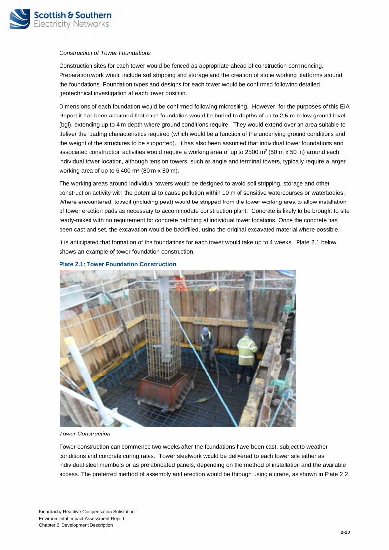
Kinardochy Reactive Compensation Substation Environmental Impact Assessment Report Chapter 2: Development Description 2-20
Construction of Tower Foundations
Construction sites for each tower would be fenced as appropriate ahead of construction commencing. Preparation work would include soil stripping and storage and the creation of stone working platforms around the foundations. Foundation types and designs for each tower would be confirmed following detailed geotechnical investigation at each tower position.
Dimensions of each foundation would be confirmed following micrositing. However, for the purposes of this EIA Report it has been assumed that each foundation would be buried to depths of up to 2.5 m below ground level (bgl), extending up to 4 m depth where ground conditions require. They would extend over an area suitable to deliver the loading characteristics required (which would be a function of the underlying ground conditions and the weight of the structures to be supported). It has also been assumed that individual tower foundations and associated construction activities would require a working area of up to 2500 m2 (50 m x 50 m) around each individual tower location, although tension towers, such as angle and terminal towers, typically require a larger working area of up to 6,400 m2 (80 m x 80 m).
The working areas around individual towers would be designed to avoid soil stripping, storage and other construction activity with the potential to cause pollution within 10 m of sensitive watercourses or waterbodies. Where encountered, topsoil (including peat) would be stripped from the tower working area to allow installation of tower erection pads as necessary to accommodate construction plant. Concrete is likely to be brought to site ready-mixed with no requirement for concrete batching at individual tower locations. Once the concrete has been cast and set, the excavation would be backfilled, using the original excavated material where possible.
It is anticipated that formation of the foundations for each tower would take up to 4 weeks. Plate 2.1 below shows an example of tower foundation construction.
Plate 2.1: Tower Foundation Construction
Tower Construction
Tower construction can commence two weeks after the foundations have been cast, subject to weather conditions and concrete curing rates. Tower steelwork would be delivered to each tower site either as individual steel members or as prefabricated panels, depending on the method of installation and the available access. The preferred method of assembly and erection would be through using a crane, as shown in Plate 2.2.
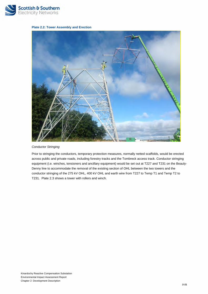
Kinardochy Reactive Compensation Substation Environmental Impact Assessment Report Chapter 2: Development Description 2-21
Plate 2.2: Tower Assembly and Erection
Conductor Stringing
Prior to stringing the conductors, temporary protection measures, normally netted scaffolds, would be erected across public and private roads, including forestry tracks and the Tombreck access track. Conductor stringing equipment (i.e. winches, tensioners and ancillary equipment) would be set out at T227 and T231 on the Beauly-Denny line to accommodate the removal of the existing section of OHL between the two towers and the conductor stringing of the 275 kV OHL, 400 kV OHL and earth wire from T227 to Temp T1 and Temp T2 to T231. Plate 2.3 shows a tower with rollers and winch.
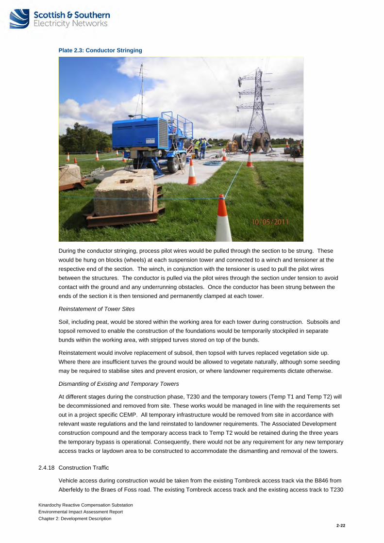
Kinardochy Reactive Compensation Substation Environmental Impact Assessment Report Chapter 2: Development Description 2-22
Plate 2.3: Conductor Stringing
During the conductor stringing, process pilot wires would be pulled through the section to be strung. These would be hung on blocks (wheels) at each suspension tower and connected to a winch and tensioner at the respective end of the section. The winch, in conjunction with the tensioner is used to pull the pilot wires between the structures. The conductor is pulled via the pilot wires through the section under tension to avoid contact with the ground and any underrunning obstacles. Once the conductor has been strung between the ends of the section it is then tensioned and permanently clamped at each tower.
Reinstatement of Tower Sites
Soil, including peat, would be stored within the working area for each tower during construction. Subsoils and topsoil removed to enable the construction of the foundations would be temporarily stockpiled in separate bunds within the working area, with stripped turves stored on top of the bunds.
Reinstatement would involve replacement of subsoil, then topsoil with turves replaced vegetation side up. Where there are insufficient turves the ground would be allowed to vegetate naturally, although some seeding may be required to stabilise sites and prevent erosion, or where landowner requirements dictate otherwise.
Dismantling of Existing and Temporary Towers
At different stages during the construction phase, T230 and the temporary towers (Temp T1 and Temp T2) will be decommissioned and removed from site. These works would be managed in line with the requirements set out in a project specific CEMP. All temporary infrastructure would be removed from site in accordance with relevant waste regulations and the land reinstated to landowner requirements. The Associated Development construction compound and the temporary access track to Temp T2 would be retained during the three years the temporary bypass is operational. Consequently, there would not be any requirement for any new temporary access tracks or laydown area to be constructed to accommodate the dismantling and removal of the towers.
2.4.18 Construction Traffic
Vehicle access during construction would be taken from the existing Tombreck access track via the B846 from Aberfeldy to the Braes of Foss road. The existing Tombreck access track and the existing access track to T230
Kinardochy Reactive Compensation Substation Environmental Impact Assessment Report Chapter 2: Development Description 2-23
would be utilised where possible during the construction but temporary access track would be constructed to access Temp T2 and the winching site at T231, as shown in EIAR Volume 3a: Figure 2.1b: Associated Development Site Layout. The existing 4x4 access track between the B846 and T227 would also require upgrading and the construction of a new watercourse crossing to access the proposed winching site at T227.
The construction would give rise to regular numbers of staff transport movements, with small work crews travelling to work site areas. It is anticipated that the Principal Contractor parking facilities for construction workers would be within the temporary construction compound.
Vehicle movements would also be required to construct some elements of the tower foundations and the new and upgraded access tracks; to deliver the tower components to site and to deliver and collect materials and construction plant from the Associated Development construction compound.
Determined through earthworks and geotechnical design, the maximum volume of site won material would be reused on site, reducing the number of vehicle movements on the public road. It is the intention to build the temporary Associated Development construction compound, the temporary access track to T231, the temporary access track to Temp T2 and the upgraded access track to T227 from material sourced within the Project Site.
Detail on the proposals for traffic and transport for the Associated Development are provided in Chapter 10: Traffic and Transport.
2.4.19 Construction Employment and Hours of Work
Employment of construction staff would be the responsibility of the Principal Contractor for the Associated Development but SHE Transmission encourages the Principal Contractor to make use of suitable labour and resources from areas local to the location of the works.
It is envisaged that there would be a number of separate teams working at the same time at different locations within the Project Site. The resource levels would be dependent on the final construction sequence and would be determined by the Principal Contractor.
2.5 Construction Programme Construction working is likely to be during daytime periods only. Working hours are currently anticipated between 07.00 to 19.00 up to seven days a week. Any out of hours working would be agreed in advance with PKC.
2.6 CEMP A contractual requirement of the Principal Contractor for the both the Proposed Development and the Associated Development would be to develop and implement a Construction Environmental Management Plan (CEMP). This document would detail how the Principal Contractor would manage the construction of the Proposed Development in accordance with all mitigation commitments detailed in this EIAR, and any conditions attached to statutory consents and authorisations. The CEMP would reference General Environmental Management Plans (GEMPs) and Species Protection Plans (SPPs), developed by the Applicant. The CEMP would also include, but not be limited to, a Stage 2 Peat Management Plan (PMP) based on the findings of further site investigations and the Stage 1 PMP, a Water Management Plan, a Pollution Prevention Plan and a Site Waste Management Plan. An outline of the CEMP is provided in Technical Appendix 2.1: Outline Construction Environmental Management Plan.
The implementation of the CEMP would be overseen, where appropriate, by a suitably qualified and experienced Environmental Clerk of Works (ECoW), with support from other environmental professionals as required.

Kinardochy Reactive Compensation Substation Environmental Impact Assessment Report Chapter 2: Development Description 2-24
The CEMP would also set out mechanisms to ensure that workers on the Site, including subcontractors, are aware of environmental risks, and are well controlled in this context, and the role of the ECoW and any other Clerk of Works appointed to provide specialist advice.
2.7 Operation and Maintenance
2.7.1 Life of the Project
The Applicant is planning for both the Proposed Development and the Associated Development to be permanent installations, with a lifespan well in excess of 50 years, and as a result will be a critical element of the National Grid in the area.
2.7.2 Maintenance Programme
Proposed Development Maintenance Programme
The Proposed Development requires maintenance and inspection at regular intervals, with most substations having monthly inspections and maintenance occurring about once every four to six years on each circuit. As the Proposed Development would have several circuits, it is likely that some maintenance would be completed most years. This is likely to involve a site presence for about one week with light vehicles, with other visits as required for operational duties.
Associated Development Maintenance Programme
The Associated Development once commissioned requires very little maintenance. It would be periodically inspected to identify any unacceptable deterioration of components so that they can be replaced. From time to time, inclement weather, storms or lightning can cause damage to either the insulators or the conductors. If conductors are damaged, short sections may have to be replaced. Insulators and conductors are normally replaced after around 40 years.
2.8 Land Use Table 2.3 summarises the indicative land take associated with the Proposed Development and Table 2.4 summarises the indicative land take associated with the Associated Development.
Table 2.3: Land Take Proposed Development
Infrastructure Construction (m2) Operation (m2)
Access Track 15,519* 5,231
Substation Platform 94,790* 58,639
Construction Compound and Laydown area
37,300* 0
Drainage 8,145** 6,379***
Total 155,754 70,249
*Includes Cut/Fill Area;**Drainage during construction includes the SUDs pond, sedimentation pond and the culvert and flow spreader trench between the construction compound, sedimentation pond and SUDS pond; and *** Drainage during operation includes the SUDs pond and the partial soakaway.
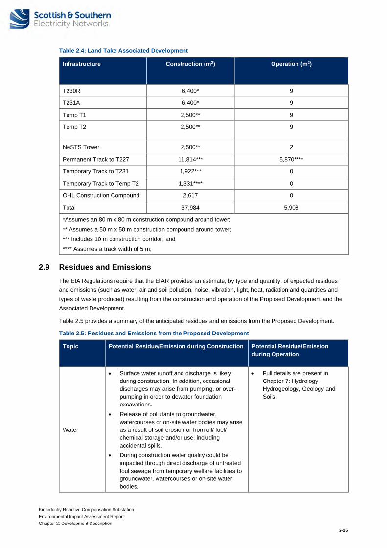
Kinardochy Reactive Compensation Substation Environmental Impact Assessment Report Chapter 2: Development Description 2-25
Table 2.4: Land Take Associated Development
Infrastructure Construction (m2) Operation (m2)
T230R 6,400* 9
T231A 6,400* 9
Temp T1 2,500** 9
Temp T2 2,500** 9
NeSTS Tower 2,500** 2
Permanent Track to T227 11,814*** 5,870****
Temporary Track to T231 1,922*** 0
Temporary Track to Temp T2 1,331**** 0
OHL Construction Compound 2,617 0
Total 37,984 5,908
*Assumes an 80 m x 80 m construction compound around tower; ** Assumes a 50 m x 50 m construction compound around tower; *** Includes 10 m construction corridor; and **** Assumes a track width of 5 m;
2.9 Residues and Emissions The EIA Regulations require that the EIAR provides an estimate, by type and quantity, of expected residues and emissions (such as water, air and soil pollution, noise, vibration, light, heat, radiation and quantities and types of waste produced) resulting from the construction and operation of the Proposed Development and the Associated Development.
Table 2.5 provides a summary of the anticipated residues and emissions from the Proposed Development.
Table 2.5: Residues and Emissions from the Proposed Development
Topic Potential Residue/Emission during Construction Potential Residue/Emission during Operation
Water
• Surface water runoff and discharge is likely during construction. In addition, occasional discharges may arise from pumping, or over-pumping in order to dewater foundation excavations.
• Release of pollutants to groundwater, watercourses or on-site water bodies may arise as a result of soil erosion or from oil/ fuel/ chemical storage and/or use, including accidental spills.
• During construction water quality could be impacted through direct discharge of untreated foul sewage from temporary welfare facilities to groundwater, watercourses or on-site water bodies.
• Full details are present in Chapter 7: Hydrology, Hydrogeology, Geology and Soils.
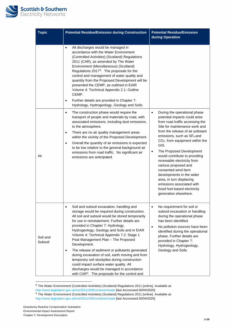
Kinardochy Reactive Compensation Substation Environmental Impact Assessment Report Chapter 2: Development Description 2-26
Topic Potential Residue/Emission during Construction Potential Residue/Emission during Operation
• All discharges would be managed in accordance with the Water Environment (Controlled Activities) (Scotland) Regulations 2011 (CAR), as amended by The Water Environment (Miscellaneous) (Scotland) Regulations 20178. The proposals for the control and management of water quality and quantity from the Proposed Development will be presented the CEMP, as outlined in EIAR Volume 4: Technical Appendix 2.1: Outline CEMP.
• Further details are provided in Chapter 7: Hydrology, Hydrogeology, Geology and Soils.
Air
• The construction phase would require the transport of people and materials by road, with associated emissions, including dust emissions, to the atmosphere.
• There are no air quality management areas within the vicinity of the Proposed Development.
• Overall the quantity of air emissions is expected to be low relative to the general background air emissions from road traffic. No significant air emissions are anticipated.
• During the operational phase potential impacts could arise from road traffic accessing the Site for maintenance work and from the release of air pollutant emissions, such as SF6 and CO2, from equipment within the GIS.
• The Proposed Development would contribute to providing renewable electricity from various proposed and consented wind farm developments in the wider area, in turn displacing emissions associated with fossil fuel-based electricity generation elsewhere.
Soil and Subsoil
• Soil and subsoil excavation, handling and storage would be required during construction. All soil and subsoil would be stored temporarily for use in reinstatement. Further details are provided in Chapter 7: Hydrology, Hydrogeology, Geology and Soils and in EIAR Volume 4: Technical Appendix 7.2: Stage 1 Peat Management Plan – The Proposed Development.
• The release of sediment or pollutants generated during excavation of soil, earth moving and from temporary soil stockpiles during construction could impact surface water quality. All discharges would be managed in accordance with CAR9. The proposals for the control and
• No requirement for soil or subsoil excavation or handling during the operational phase has been identified.
• No pollution sources have been identified during the operational phase. Further details are provided in Chapter 7: Hydrology, Hydrogeology, Geology and Soils.
8 The Water Environment (Controlled Activities) (Scotland) Regulations 2011 [online]. Available at: http://www.legislation.gov.uk/ssi/2011/209/contents/made [last Acccessed:30/04/2020] 9 The Water Environment (Controlled Activities) (Scotland) Regulations 2011 [online]. Available at: http://www.legislation.gov.uk/ssi/2011/209/contents/made [last Acccessed:30/04/2020]
Kinardochy Reactive Compensation Substation Environmental Impact Assessment Report Chapter 2: Development Description 2-27
Topic Potential Residue/Emission during Construction Potential Residue/Emission during Operation
management of water quality and quantity from the Proposed Development will be presented the CEMP, as outlined in EIAR Volume 4: Technical Appendix 2.1: Outline CEMP.
• Further details are provided in Chapter 7: Hydrology, Hydrogeology, Geology and Soils.
Noise and Vibration
• Noise sources during the construction phase would include increased traffic flows and noise from construction activities, including felling and timber haulage.
• Liaison with landowners and local residents would be carried out to ensure that minimum disruption occurs throughout all stages of construction of the Proposed Development. Appropriate working hours would be agreed with PKC.
• There is a potential need for blasting as part of the civil engineering/ earthworks phase of construction. The extent of any blasting requirement cannot be determined until intrusive site investigation tests are completed, however, where blasting is required, noise and vibration effects would be controlled through the inclusion of an appropriate blasting scheme detailed within the CEMP, as outlined in EIAR Volume 4: Technical Appendix 2.1: Outline CEMP).
• A Construction Noise Management Plan, detailing the working hours and how construction noise is to be controlled in line with best practise and guidance would be included part of the CEMP for the Proposed Development, as Outlined in EIAR Volume 4: Technical Appendix 2.1: Outline CEMP
• The substation would generate noise during operation. Details on the baseline noise levels at noise sensitive receptors (NSRs) identified for the Proposed Development and the predicted operational noise levels of the substation are provided in EIAR Volume 4: Technical Appendices 2.3: Baseline Noise Report and 2.4: Acoustic Modelling Report. The location of NSRs in relation to the Proposed Development was a consideration in the design development process and the predicted noise levels are within acceptable limits without the requirement for mitigation.
• No significant sources of vibration have been identified during the operation of the Proposed Development.
Light
• The temporary construction compounds are likely to be equipped with lighting installations for use during low light conditions and security lighting. All temporary lighting installations would be downward facing and all lights would be switched off during daylight hours and out with working hours. Any effect would be temporary and not expected to be significant.
• Substations are not generally illuminated during operation. Floodlights would be installed at the Proposed Development but would only be used in the event of a fault or when essential maintenance needs to be carried out during the hours of darkness.
Heat and Radiation
• No significant heat or radiation sources have been identified during the construction phase.
• No significant heat or radiation sources have been identified during the operational phase.
Waste
• Construction would generate general waste in the form of domestic wastes and other materials, for example, wood, metals, plastics and stone.
• The general maintenance of the Proposed Development has the potential to produce a small amount of waste. This is likely to be restricted to waste
Kinardochy Reactive Compensation Substation Environmental Impact Assessment Report Chapter 2: Development Description 2-28
Topic Potential Residue/Emission during Construction Potential Residue/Emission during Operation
• Details on pollution prevention control and site waste management that would be implemented during construction will be included in the CEMP, as outlined in in EIAR Volume 4: Technical Appendix 2.1: Outline CEMP. Litter would be managed in accordance with the appropriate waste regulations.
associated with employees and visiting contractors. All waste arising on site would be managed in accordance with the appropriate waste regulations.
Electric and Magnetic Fields (EMFs)
• There is no potential for public or occupational exposure to EMFs above appropriate thresholds as a result of the construction of the Proposed Development.
• There is no potential for public or occupational exposure to EMFs above appropriate thresholds as a result of the operation of the Proposed Development.
Table 2.6 provides a summary of the anticipated residues and emissions from the Associated Development.
Table 2.6: Residues and Emissions from the Associated Development
Topic Potential Residue/Emission during Construction
Potential Residue/Emission during Operation
Water
• Surface water runoff and discharge is likely during construction. In addition, occasional discharges may arise from pumping, or over-pumping in order to dewater tower foundation excavations.
• Release of pollutants to watercourses or ground water may arise as a result of soil erosion or from oil/ fuel/ chemical storage and/or use, including accidental spills.
• During construction water quality could be impacted through direct discharge of untreated foul sewage from temporary welfare facilities to groundwater, watercourses or on-site water bodies.
• All discharges would be managed in accordance with CAR10. The proposals for the control and management of water quality and quantity from the Associated Development would be provided in the CEMP, as outlined in EIAR Volume 4: Technical Appendix 2.1: Outline CEMP.
• Increased rates of surface runoff during operation due to an increase in impermeable surface area on the proposed access track to T227 and surface water drainage measures for tracks. Full details are present in Chapter 7: Hydrology, Hydrogeology, Geology and Soils.
10 The Water Environment (Controlled Activities) (Scotland) Regulations 2011 [online]. Available at: http://www.legislation.gov.uk/ssi/2011/209/contents/made [last Acccessed:30/04/2020]
Kinardochy Reactive Compensation Substation Environmental Impact Assessment Report Chapter 2: Development Description 2-29
Topic Potential Residue/Emission during Construction
Potential Residue/Emission during Operation
• Further details are provided in Chapter 7: Hydrology, Hydrogeology, Geology and Soils.
Air
• The construction phase would require the transport of people and materials by road, with associated emissions, including dust emissions, to the atmosphere.
• There are no air quality management areas within the vicinity of the Associated Development.
• Overall the quantity of air emissions during construction is expected to be low relative to the general background air emissions from road traffic. No significant air emissions are anticipated.
• No significant sources of air pollution have been identified during operation of the Associated Development.
• The Associated Development would contribute to providing renewable electricity from various proposed and consented wind farm developments in the wider area, in turn displacing emissions associated with fossil fuel-based electricity generation elsewhere.
Soil and Subsoil
• Soil and subsoil excavation, handling and storage would be required during construction. All soil and subsoil would be stored temporarily for use in reinstatement. Further details are provided in Chapter 7: Hydrology, Hydrogeology, Geology and Soils and in EIAR Volume 4: Technical Appendix 7.3: Stage 1 Peat Management Plan – The Associated Development.
• The release of sediment or pollutants generated during excavation of soil, earth moving and from temporary soil stockpiles during construction could impact surface water quality. All discharges would be managed in accordance with CAR. The proposals for the control and management of water quality and quantity from the Associated Development will be provided in the CEMP, as outlined in EIAR Volume 4: Outline CEMP.
• Further details are provided in Chapter 7: Hydrology, Hydrogeology, Geology and Soils.
• No requirement for soil or subsoil excavation or handling during the operational phase of the Associated Development have been identified.
• No pollution sources have been identified during the operational phase of the Associated Development.
• Further details are provided in Chapter 7: Hydrology, Hydrogeology, Geology and Soils.
Noise and Vibration
• Noise sources during the construction phase would include increased traffic flows and noise from construction activities.
• Liaison with landowners and local residents would be carried out to ensure that minimum disruption occurs throughout all stages of
• Noise sources, including traffic, during the operational phase of the Associated Development would be limited to noise from maintenance activities. It is anticipated that the Associated Development would require very little maintenance once operational and any maintenance

Kinardochy Reactive Compensation Substation Environmental Impact Assessment Report Chapter 2: Development Description 2-30
Topic Potential Residue/Emission during Construction
Potential Residue/Emission during Operation
construction of the Associated Development. Appropriate working hours would be agreed with PKC.
• A Construction Noise Management Plan, detailing the working hours and how construction noise is to be controlled in line with best practise and guidance would be included part of the CEMP for the Associated Development, as Outlined in EIAR Volume 4: Technical Appendix 2.1: Outline CEMP.
• No significant sources of vibration have been identified during construction of the Associated Development.
works that are undertaken would be short-term.
• No significant sources of vibration have been identified during operation of the Associated Development.
Light
• The temporary construction compound is likely to be equipped with lighting installations for use during low light conditions and security lighting. All temporary lighting installations would be downward facing and all lights would be switched off during daylight hours and out with working hours. Any effect would be temporary and not expected to be significant.
• No significant light sources have been identified during the operational phase of the Associated Development.
Heat and Radiation
• No significant heat or radiation sources have been identified during the construction phase of the Associated Development.
• No significant heat or radiation sources have been identified during the operational phase of the Associated Development.
Waste
• Construction would generate general waste in the form of domestic wastes and other materials, for example, wood, metals, plastics and stone.
• Details on pollution prevention control and site waste management that would be implemented during construction will be presented in the CEMP, as outlined in in EIAR Volume 4: Technical Appendix 2.1: Outline CEMP. Litter would be managed in accordance with the appropriate waste regulations.
• The general maintenance of the Associated Development has the potential to produce a small amount of waste. This is likely to be restricted to waste associated with employees and visiting contractors. All waste arising on site would be managed in accordance with the appropriate waste regulations.
Electric and Magnetic Fields (EMFs)
• There is no potential for public or occupational exposure to EMFs above appropriate thresholds as a result of the construction of the Associated Development.
• There is no potential for public or occupational exposure to EMFs above appropriate thresholds as a result of the operation of the Associated Development.

Kinardochy Reactive Compensation Substation Environmental Impact Assessment Report Chapter 2: Development Description 2-31
2.10 Decommissioning During the operational lifespan of the Proposed Development and the Associated Development there will be ongoing operational maintenance activities to keep them operating to network requirements and there is also capacity within the Proposed Development for future connections should they be required. As such, the Applicant does not anticipate or foresee the Proposed Development or the Associated Development will ever be closed and/or decommissioned.
However, in the highly unlikely event that the Proposed Development and/or the Associated Development are closed/decommissioned in the future, they would be decommissioned and the land reinstated as follows:
• the above ground infrastructure would be removed from site for reuse elsewhere or disposed of in line with the waste regulations in force at the time;
• where removal of infrastructure such as foundations would result in more damage than leaving them in place, they would be left in-situ; and
• disturbed ground would be reinstated, and where required tree planting similar to the surrounding woodland and/or reseeding with an appropriate seed mix.
Where required, details of the decommissioning plan would be agreed with appropriate authorities prior to any decommissioning works commencing.
The effects associated with the construction phase can be considered to be representative of reasonable worst-case decommissioning effects, and therefore no separate assessment of the decommissioning phase is considered necessary.
Kinardochy Reactive Compensation Substation Environmental Impact Assessment Report Chapter 3: Design Evolution and Alternatives 3-1
3. DESIGN EVOLUTION AND ALTERNATIVES
3.1 Introduction This chapter describes the site selection process for the Proposed Development and the Associated Development, including a description of alternative sites that were considered and a description of why the Project Site was selected. It also provides a description of how the design and layout of the Proposed Development and the Associated Development evolved through the design process, with consideration of environmental constraints identified by technical specialists through the EIA process.
This chapter is supported by:
• Figure 3.1: Potential Substation Sites (Site Selection Stage 1);
• Figure 3.2: Potential Substation Sites (Site Selection Stage 2);
• Figure 3.3: Grid Connection Options; and
• Figure 3.4: Design Evolution.
Figures 3.1-3.4 are presented in Volume 3a: Figures of the EIAR and are referred to in the text as appropriate.
3.2 Key Policy Considerations The chapter has been prepared in line with Schedule 4 of the EIA Regulations, which state that the EIAR should include a description of the reasonable alternatives (in terms of the design, technology, location, size and scale of the Proposed Development and the Associated Development) studied by the Applicant, as well as an indication of the main reasons for selecting the chosen option, including a comparison of the environmental effects.
3.3 Site Selection Considerations
3.3.1 Do Nothing Alternative
The “do nothing” scenario is a hypothetical alternative conventionally considered, albeit briefly, in EIA as a basis for comparing the development proposal under consideration. This scenario is considered to represent the current baseline situation as described in the individual chapters of this EIAR.
In the absence of the Proposed Development and the Associated Development, it is anticipated that the Project Site would continue to be managed for commercial forestry.
It is recognised that the baseline would not remain static for the lifetime of the Proposed Development or the Associated Development. In particular, and apart from any changes arising from economic and forestry policies and economic market considerations, it is predicted that biodiversity and landscape would undergo some level of change as a result of climate change. Two publications from the Landscape Institute1 and SNH (now NatureScot)2 consider the potential climate change effects on the landscape character. Due to the complexities and uncertainties inherent in attempting to predict the nature and extent of such changes to landscape and biodiversity during the lifetime of the Proposed Development and the Associated Development, it has been
1 Landscape Institute (2008): Landscape architecture and the challenge of climate change. Available at: https://landscapewpstorage01.blob.core.windows.net/www-landscapeinstitute-org/2016/03/LIClimateChangePositionStatement.pdf [Last Accessed, 12/01/2021]; 2 SNH (2011): Commissioned Report No. 488: As assessment of the impacts of Climate Change on Scottish Landscapes and their contribution to quality of life: Final Report. Available at: https://www.nature.scot/sites/default/files/2017-08/Publication%202012%20-%20SNH%20Commissioned%20Report%20488%20-%20An%20assessment%20of%20the%20impacts%20of%20climate%20change%20on%20Scottish%20landscapes%20and%20their%20contribution%20to%20quality%20of%20life%20-%20Final%20report%20-%20reduced%20size.pdf [Last Accessed 09/11/2020].

Kinardochy Reactive Compensation Substation Environmental Impact Assessment Report Chapter 3: Design Evolution and Alternatives 3-2
assumed that the current baseline would subsist. It is considered that this represents a precautionary and appropriate approach for EIA purposes.
3.3.2 Alternative Sites – The Proposed Development
2013/2014 Site Selection Exercise
An initial site identification exercise was conducted in the area between Tummel Bridge and Aberfeldy by the Applicant in 2013/2014. This area was identified as a suitable location for the Proposed Development due to its proximity to the existing Beauly-Denny line, as well as its remote location and existing grid infrastructure within the landscape.
The purpose of the initial site identification exercise was to identify potential suitable sites for the Proposed Development within the Tummel Bridge area, based on basic engineering and electricity network parameters. Nine potential sites were considered in the study (Sites 1 to 9). Of these, four locations (1, 4, 8 and 9) were identified by SHE Transmission as potentially viable in terms of engineering and cost factors, as shown on EIAR Volume 3a: Figure 3.1: Potential Substation Sites (Site Selection Stage 1). All of the sites were assessed based on the maximum platform size defined at 370 x 245 m.
In 2014, Ramboll UK Limited (Ramboll) were appointed to provide an environmental appraisal of these four site options, as part of a Site Selection Report3.
Methodology
The environmental appraisal was carried out in accordance with the Applicant’s internal guidance4 and specifically taking account of Appendix 2: Methodology for Comparative Assessment of Substation Sites, which states that the environmental appraisal should be based on ‘Environmental Impact Assessment’ criteria for sensitivity and magnitude. To facilitate the analysis, a series of topic-specific magnitude/sensitivity matrices were developed. In all cases, the site options were analysed at construction and operation stages. Conventional mitigation practice was assumed throughout the appraisal and the report focussed on post-mitigation residual impacts.
The following environmental topics were evaluated in the environmental appraisal for each site:
• Geology and Soils;
• Hydrology;
• Habitats;
• Protected Species;
• Ornithology;
• Cultural Heritage;
• Landscape character;
• Visual amenity;
• Land use;
• Access and Recreation; and
• Traffic and Transport.
In order to progress the analysis, a number of features were mapped using ArcGIS mapping software with reference to OS maps and aerial photography. These included:
3 Ramboll Environ UK Limited (2016); North Perthshire 275 kV Voltage Support Environmental Site Selection Study; 4 Scottish Hydro Electric Power Distribution (2014): Substation Site Selection Guidelines For Voltages at or Above 33KV - PR-PS-453;
Kinardochy Reactive Compensation Substation Environmental Impact Assessment Report Chapter 3: Design Evolution and Alternatives 3-3
• Ecological and ornithologic designations;
• Landscape designations;
• Zone of Theoretical Visibility (ZTV);
• Cultural heritage designations and assets;
• Residential properties;
• Recreation and tourism facilities;
• Geology, hydrology and hydrogeology features; and
• Transport, energy generation and transmission infrastructure.
Site walkover surveys were completed in order to review the landscape and visual context and the hydrology and ground conditions of each site. Phase 1 habitat surveys were also completed.
2013/2014 Site Selection Exercise Outcome
Following the environmental appraisal, Site 9 was identified as the preferred option from an environmental perspective, followed by Site 4 then Site 1. Site 8 was identified as the least preferred option.
Whilst environmental sensitivities were identified at Site 9, local receptors were found to be limited, as the site is located within an area of open moorland used primarily for grouse shooting and no peat or no ecological sensitivities were identified at the site. In addition, few residential receptors are located within the immediate vicinity of Site 9 and the predicted visibility of the site would be relatively enclosed. Few cultural heritage features or recreational resources are located in proximity to Site 9 and the landscape is characterised by the existing Calliachar Wind Farm. Upgrades to an existing single track road, as well as stretches of new track, would be required for accessing Site 9 during construction.
Site 4 was identified as the second preferred option in the site selection exercise, which concluded that relative to Site 9 (the preferred option), Site 4 had potential for impact on geology and soils, due to the presence of peat and that there was a slightly greater risk of impact on water quality associated with a downgradient private water supply. In addition, a greater number of recreational resources were identified in the vicinity of Site 4 compared to Site 9, which would have the potential to experience setting impacts.
2016 Site Selection Exercise Addendum
Following the completion of the initial site identification exercise in 2013/2014, the Applicant undertook further design work to consider the type of Reactive Compensation Equipment that would be appropriate at each of the sites (1, 4, 8 and 9).
Following this work, the Applicant concluded that at Sites 1, 8 and 9 only a hybrid technology solution, with switching gear being gas-insulated (GIS) and other technology being air-insulated (AIS), would be appropriate. The maximum platform size for the hybrid solution would be 203 m x 171 m. At Site 4, two different technology options could be considered. These comprise either air-insulated Reactive Compensation Equipment (with a maximum platform size of 370 m x 245 m) or the hybrid solution described above.
The smaller platform size of the hybrid solution would have implications for land take during construction and operation of the Proposed Development, with associated benefits in terms of potential impacts on geology/soils, habitats, landscape and visual amenity.
In August 2016 Ramboll was commissioned to update the conclusions of the initial site selection analysis, in the form of an addendum to the of the 2013/2014 Site Selection Report5, using the updated design information. Both substation design options were considered for Site 4.
5 Ramboll Environ UK Limited (2016); North Perthshire 275 kV Voltage Support: Addendum to Environmental Site Selection Study;
Kinardochy Reactive Compensation Substation Environmental Impact Assessment Report Chapter 3: Design Evolution and Alternatives 3-4
The updated environmental analysis concluded that the preferred site from an environmental perspective was Site 4 when the hybrid technology solution is constructed at this site. Although environmental sensitivities were identified at Site 4, local receptors would be reduced through selection of the hybrid technology with its smaller development footprint, which would allow for the retention of existing woodland between the site and Loch Kinardochy. Site 9 was the second preferred option, followed by the AIS technology solution at Site 4, then Site 1, with Site 8 being least preferred.
2018 Site Selection Exercise
Following the site selection exercise undertaken in 2016, Sites 8 and 9 were subsequently discounted from further consideration. This was due to their high altitude and the fact that the proposed Crossburns Wind Farm was terminated, causing the Proposed Development to be technically, economically and operationally challenging at these sites on its own.
In 2018 Ramboll were appointed to provide a more detailed environmental appraisal for Site 1 and Site 4, as part of a Site Selection Report6. Site 1 is located adjacent to the existing Tummel Substation, to the west of the SSE Generation building, while Site 4 is located to the north of Loch Kinardochy and east of the existing Beauly-Denny line as shown on EIAR Volume 3a: Figure 3.2: Potential Substation Sites (Site Selection Stage 2).
2018 Site Selection Exercise Methodology
The environmental appraisal was carried out in accordance with the Applicant’s internal guidance7, specifically taking account of ‘Annex 8: RAG Interpretation Guidance’. To facilitate the appraisal, a series of topic-specific constraint matrices were developed. Each matrix contains specific descriptors to inform distinctions between high (red), intermediate (amber) and low (green) potential for the development to be constrained.
In order to progress the analysis, the same features where mapped using ArcGIS mapping software with reference to OS maps and aerial photography as listed above for the Site Selection Stage 1. Information from the site visits undertaken in 2016 were also included in the analysis.
The following environmental topics were evaluated in the environmental appraisal for each site:
• Natural Heritage – Designations, Protected Species, Habitats, Ornithology & Hydrology / Geology;
• Cultural Heritage;
• People;
• Landscape and Visual – Designations, Landscape Character, Visual;
• Land Use – Agriculture, Forestry & Recreation; and
• Planning.
2018 Site Selection Exercise Outcome
Site 4 was preferred to Site 1 in relation to natural heritage designation, due to Site 1 being located within an area designated as Ancient Semi-Natural Woodland (ASNW) and the site’s close proximity to the River Tay Special Conservation Area (SAC). The analysis also concluded that Site 4 offered few opportunities for protected species, whereas the plantation coniferous woodland which dominates Site 1 has the potential to support protected species, including red squirrel and pine marten. Site 4 was also preferred to Site 1 in relation to people due to Site 1 being located in closer proximity to the settlement of Tummel Bridge, and immediately south of a core path.
6 Ramboll UK Limited (2018); Tummel Bridge Reactive Power Station; Environmental Site Selection Report; 7 Scottish Hydro Electric Power Distribution (2014): Substation Site Selection Guidelines For Voltages at or Above 33KV - PR-PS-453
Kinardochy Reactive Compensation Substation Environmental Impact Assessment Report Chapter 3: Design Evolution and Alternatives 3-5
Although surveys undertaken in 2016 identified peat ranging from 0.5 m to 1.5 m at both sites, Site 1 was preferred to Site 4 in relation to both habitats and hydrology/ geology because a small area of peat >1.5 m was identified within Site 4. Site 1 was also preferred to Site 4 in relation to landscape character as the presence of the existing Tummel substation indicates a greater degree of capacity to accommodate a new man-made development within an existing context of energy supply infrastructure than the more natural landscape surrounding Site 4.
Overall, the results of the 2018 site selection analysis did not conclude that there was a strong preference between Site 1 and Site 4 from a purely environmental perspective, as both sites had different environmental sensitivities associated with them (as described above). However, once other factors associated with Site 1 and Site 4, including engineering, cost, construction, operational and health and safety factors, were considered, the overall results of the 2018 Site Selection Report concluded that Site 4 was the preferred location for the Proposed Development.
3.3.3 Alternative Sites – The Associated Development
2018 Site Selection Exercise–Grid Connection Options
As part of the 2018 Site Selection Report, two potential grid connection routes associated with Site 48 were also considered, as illustrated in EIAR Volume 3a: Figure 3.3: Grid Connection Options and described below:
• Connection Option 1 would require the existing 275 kV equipment at the existing Tummel Substation to be reconfigured, although no changes to the Tummel Substation boundary would be required to undertake the reconfiguration works. In order to connect the Proposed Development into the 275 kV network, the Beauly-Denny line would require various modifications, including a 1.2 km OHL diversion and the decommissioning of an existing tower and associated conductors. In addition, new 275 kV cables would also be required to be installed between Tummel Substation and the Proposed Development. To accommodate the circuits, an estimated 6 HV power cables would be required to be installed, in a cable corridor up to 4.2 m wide and 4.5 km in length.
• Connection Option 2 would require the installation of two Statcom Transformers9 at the Proposed Development, allowing for the proposed substation to connect directly into the Beauly-Denny line. This option would require various modifications to the Beauly-Denny line, including a 1.2 km OHL diversion and the decommissioning of an existing tower and associated conductors. In addition, new 132 kV cables would also be required to be installed between Errochty Substation and the Proposed Development. To accommodate the circuits, an estimated 6 HV power cables would be required to be installed, in a cable corridor up to 4.2 m wide and 3.5 km in length.
Methodology - 2018 Site Selection Exercise–Grid Connection Options
The environmental appraisal was carried out in accordance with the Applicant’s internal guidance10, specifically taking account of ‘Annex 8: RAG Interpretation Guidance’. To facilitate the appraisal, a series of topic-specific constraint matrices were developed. Each matrix contains specific descriptors to inform distinctions between high (red), intermediate (amber) and low (green) potential for the development to be constrained.
In order to progress the analysis, the same features where mapped using ArcGIS mapping software with reference to OS maps and aerial photography as listed above for the Site Selection Stage 2. No field surveys
8 Two grid connection options were also considered for Site 1 during the 2018 Site Selection Report however since Site 4 was selected as the preferred site for the Proposed Development, only the two grid connection options associated with Site 4 have been considered in this EIAR. 9 Previous reporting has also referred to Statcom Transformers as Supergrid Transformers. These terms are interchangeable and refer to the same equipment. 10 Scottish Hydro Electric Power Distribution (2018): Procedures for Routeing Overhead lines of 132 kV and Above 33KV - PR-NET-ENV-501

Kinardochy Reactive Compensation Substation Environmental Impact Assessment Report Chapter 3: Design Evolution and Alternatives 3-6
were undertaken specifically for the Connection options but information from the site visits undertaken in 2016 for the substation site selection exercise were included in the analysis.
The same environmental topics were evaluated in the environmental appraisal for the grid connection options as the 2018 substation site selection exercise.
2018 Site Selection Exercise–Grid Connection Options Outcome
The proposed route of the two grid connection options considered in the 2018 Site Selection Report were largely similar, except the cable section of Connection Option 1 would connect to Tummel Substation, located 3.4 km north west of Site 4, and the cable section of Connection Option 2 would connect to Errochty Substation, located 3.1 km north of Site 4. Due to the similarity of Connection Option 1 and Connection Option 2, the results of the 2018 site selection analysis did not conclude that there was a strong preferred route between the two options in relation to their potential impacts on the environment.
3.3.4 Substation Design Evolution
Substation Design 1 – 2016 Site Selection Layout
The preliminary project design during Site Selection Stage 1 in May 2016 assumed that the Proposed Development would comprise of either an air insulated or a gas-insulated switching gear with the following parameters:
• maximum platform size would be 370 m x 245 m; and
• maximum gantry and/or GIS building height would be 12 m.
Substation Design 2 - 2016 Site Selection Addendum Layout
Two substation designs were considered at the development site in the Site Selection Stage 1 Addendum in August 2016:
1. air-insulated Reactive Compensation Equipment with a maximum platform size of 370 m x 245 m; or
2. a hybrid technology solution, with switching gear being gas-insulated and other technology being air-insulated. The maximum platform size for the hybrid solution would be 203 m x 171 m.
The maximum gantry and/or GIS building height would be 12 m.
Substation Design 3 – 2018 Site Selection Layout
During Site Selection Stage 2 in 2018 it was assumed that the Proposed Development would comprise of a GIS with the following parameters:
• the maximum platform size would be 255 m x 200 m; and
• maximum GIS building height would be 12 m;
Substation Design 4 – Screening Layout
During screening it was assumed that the substation would comprise a 275 kV double busbar GIS, with associated bus section with the following parameters:
• A rectangular level platform (levelled at 368.5 m AOD), up to 215 m x 165 m in size (and 3.6 ha in area) to house the substation. The platform and substation would be surrounded by a be surrounded a 7.3 m high security fence of palisade construction and a 2 m wide perimeter footpath;
• The GIS and Control Buildings would be dimensioned at up to 28 m x 78 m in size and 14 m in height; and
• The dimensions of the Static Synchronous Compensators (STATCOM) building would be a maximum of 110 m x 55 m in size and 14 m in height.
Kinardochy Reactive Compensation Substation Environmental Impact Assessment Report Chapter 3: Design Evolution and Alternatives 3-7
Substation Design 5 – Scoping Layout
During scoping it was assumed that the 275 kV double busbar GIS substation would be comprise of the following:
• A five-sided level platform (levelled at 371.5 m AOD), with an approximate area of 6.65 ha, to house the proposed substation. The platform would be surrounded by a 4.2 m high security fence of palisade construction and a 2 m wide perimeter footpath;
• Internal roads, access paths and hardstanding areas within the substation compound;
• Electrical equipment including:
• Mechanically Switched Capacitor with Damping Network (MSCDN);
• STATCOM building (up to 21 m x 30 m in size and 10 m in height);
• GIS and Control building (up to 35 m x 68 m in size and 15.5 m in height); and
• transformers, busbars, and OHL gantry structures;
• A permanent access track, connecting to the B846 road (Aberfeldy to Tummel Bridge); and
• A temporary construction compound and laydown areas.
The substation design included in the Scoping layout represented a worst case scenario for the Proposed Development.
Substation Design 6 – Final Layout
The final substation layout is comprised of the following:
• A five-sided level platform (levelled at 371.5 m AOD with a 1 m layer of engineered fill), with an area up to 5.86 ha to house the proposed substation. The platform would be surrounded by a 4.2 m high security fence of palisade construction and a 2 m wide perimeter footpath;
• A reactive power compensation substation (constructed at 372.5 LOD), comprising of buildings, infrastructure and electrical equipment including:
• 100 Mega volt amps (reactive) (MVAr) Mechanically Switched Capacitor with Damping Network (MSCDN);
• Insulated Gate Bipolar Transistors (IGBT) based Static Synchronous Compensators (STATCOMs);
• a Gas Insulated Switchgear (GIS) and Control building;
• transformers, busbars, and OHL gantry structures; and
• Internal roads, access paths, and hardstanding areas within the substation compound.
• A permanent access track, connecting to the B846 road (Aberfeldy to Tummel Bridge);
• A temporary construction compound and laydown areas;
• Drainage, including a permanent attenuation basin (SUDS pond) and a partial soakaway (see EIAR Volume 4:Technical Appendix 7.1); and
• Associated landscaping (see EIAR Volume 4: Technical Appendix 2.2 Reinstatement and Landscape Design Specification).
A detailed description of the final substation design is presented in Chapter 2: Development Description.
3.4 Site Layout Evolution
3.4.1 The Proposed Development
EIAR Volume 3a: Figure 3.4: Design Evolution summarises the design evolution of the Proposed Development from initial layout to design freeze layout. The following paragraphs explain the four key iterations.
Kinardochy Reactive Compensation Substation Environmental Impact Assessment Report Chapter 3: Design Evolution and Alternatives 3-8
Key design objectives were as follows:
• Minimisation of visibility of the Proposed Development (including substation and ancillary elements such as site access tracks), especially from designated landscapes, sensitive landscape character areas and receptor locations, including, residential properties, designated cultural heritage sites and key transportation and recreational routes;
• Avoid impacts on known/ recorded cultural heritage assets within the Project Site;
• Avoidance of sensitive habitats, including blanket bog;
• Minimise felling of commercial forestry required to accommodate the construction and operation of the Proposed Development;
• Avoid impacts on sites designated for ecological or ornithological purposes;
• Minimise disturbance and/ or displacement of protected avian and non-avian species;
• Avoid potential effects on waterbodies through increased rate/ volume or run-off and reduced quality of surface waters or groundwater run-off; and
• Minimise traffic required during construction.
Layout 1 – Initial Layout
The initial site boundary for the Proposed Development was comprised of an area of 170 ha, located 3 km south of the Village of Tummel Bridge in Perthshire. The eastern extremity of the Site boundary was located immediately west of the B846 (Aberfeldy to Tummel Bridge) at Tomphubil. The southern extremity of the site boundary was defined by Loch Kinardochy and the C450 Schiehallion Road. The northern extremity of the site boundary is partially defined by the existing Forestry and Land Scotland (FLS) land ownership boundary.
The initial substation platform was up to 6.4 ha in area (300 m x 200 m) and is located immediately east of the Beauly-Denny line in an area of existing commercial forestry.
In the initial layout it was proposed that access to the substation platform would be taken from the existing Tombreck access track and the access track would connect to the northern boundary of the platform. The Tombreck access track would be taken from the C450 Schiehallion Road via the B846.
Three potential areas for the construction compound and laydown areas were considered in the initial layout, as illustrated in EIAR Volume 3a: Figure 3.4: Design Evolution:
• Construction Compound and Laydown Area 1 is located immediately north of the substation platform and is 5 ha in area (250 m x 200 m);
• Construction Compound and Laydown Area 2 is located 525 m west of the substation platform and is 10.2 ha in area; and
• Construction Compound and Laydown Area 3 is located immediately east of the substation platform and is 5 ha in area (250 m x 200 m).
Layout 2 – Screening Layout
In the screening layout the Construction Compound and Laydown Area 2 was removed, following consultation responses from local and statutory stakeholders. Consequently, the westernmost area of the Site (to the west of the entrance to the existing Tombreck access track) was removed from the site boundary. A 100 m buffer surrounding Loch Kinardochy was also implemented to reduce the risk of pollution effects to the water body. Consequently, the area of the Site was reduced from 170 ha to 133 ha.
The substation platform was again located immediately east of the Beauly-Denny line in an area of existing commercial forestry, but the size of platform was reduced to 3.6 ha (215 m x 165 m) to minimise impacts on peatland habitats. It was proposed in the screening layout that the platform would be levelled at 368.5 m AOD
Kinardochy Reactive Compensation Substation Environmental Impact Assessment Report Chapter 3: Design Evolution and Alternatives 3-9
below the existing ground level, to reduce the landscape and visuals impacts of the Proposed Development. It was anticipated that the substation itself would be a maximum of 14 m in height.
The existing Tombreck access track was removed as an access option in the screening layout following consultation responses from local and statutory stakeholders, including feedback that during peak season the C450 Schiehallion Road accommodates high levels of tourist traffic and therefore would not be suitable for the level of construction traffic required to construct the Proposed Development during this time. Instead three alternative potential access tracks, all originating from the B846, were considered in the screening layout, as illustrated in EIAR Volume 3a: Figure 3.4: Design Evolution.
• Access Track 2 would branch off the B846 at NGR 278002 756150 and would be routed in a south westerly direction for 816 m, connecting to the to the north eastern corner of the proposed substation platform. The eastern section of Access Track 2 would pass through an area of mature forestry for 380 m. Access Track 2 would also cross the Alt Kinardochy burn and one non-designated cultural heritage asset and would pass underneath an existing 132 kV OHL;
• Access Track 3 would branch off the B846 at NGR 278019 755 456. Access Track 3 would be routed in a north easterly direction for 425 m and then in a south westerly direction for a further 415 m, connecting to the south eastern corner of the proposed substation platform. Access Track 3 would cross the Alt Kinardochy burn and would pass underneath an existing 132 kV OHL; and
• Access Track 4 would branch the B846 at NGR 278019 755 456 and would initially follow the same route as Route 3. After 200 m Access Track 4 would diverge from Access Track 3 in a westerly direction for 780 m, connecting to the to the south eastern corner of the proposed substation platform. Access Track 4 would cross the Alt Kinardochy burn and would pass underneath an existing 132 kV OHL.
Two potential areas for the construction compound and laydown areas were considered in the screening layout, as illustrated in EIAR Volume 3a: Figure 3.4: Design Evolution:
• Construction Compound and Laydown Area 1 is located immediately north of the substation platform and is up to 4 ha in area (220 m x 180 m); and
• Construction Compound and Laydown Area 3 is located 130 m east of the substation platform and is 2.1 ha in area (130 m x 165 m). Construction Compound and Laydown Area 3 was reduced in size and moved further east of the substation platform compared to the initial layout to avoid an area of blanket bog habitat, which was identified during ecological site surveys.
Layout 3 – Scoping Layout
During ecological field surveys undertaken in October 2019 and April 2020 (see Chapter 5: Ecology) three areas of habitat classified as blanket sphagnum bog were recorded within the Project Site, as shown in Layout 3 in EIAR Volume 3a: Figure 3.4: Design Evolution. Blanket bog is a UK Biodiversity Action Plan (BAP) Priority Habitat and, as these examples are functional bogs in good condition, these habitats are considered to be of national importance. In the Scoping layout the southeastern corner of the proposed substation platform was removed to avoid one of the areas of blanket bog, as illustrated in Layout 3 of Figure 3.4: Design Evolution (EIAR Volume 3a). The overall size of the proposed substation platform also increased to 6.65 ha (325 m x 225 m) in the scoping layout.
In the screening layout it was proposed that the platform would be levelled at 368.5 m to reduce the landscape and visual impacts of the Proposed Development, further analysis highlighted that the excavation of the platform at this level would produce a vast quantity of excess material from the substation platform alone. Furthermore, a Biodiversity Net Gain (BNG) Assessment undertaken for the Proposed Development (see Section 3.7), found the amount of excess material used on site for landscaping purposes (such as for mounds) would need to be minimised to avoid an overall net loss of biodiversity. Consequently, most of the excess
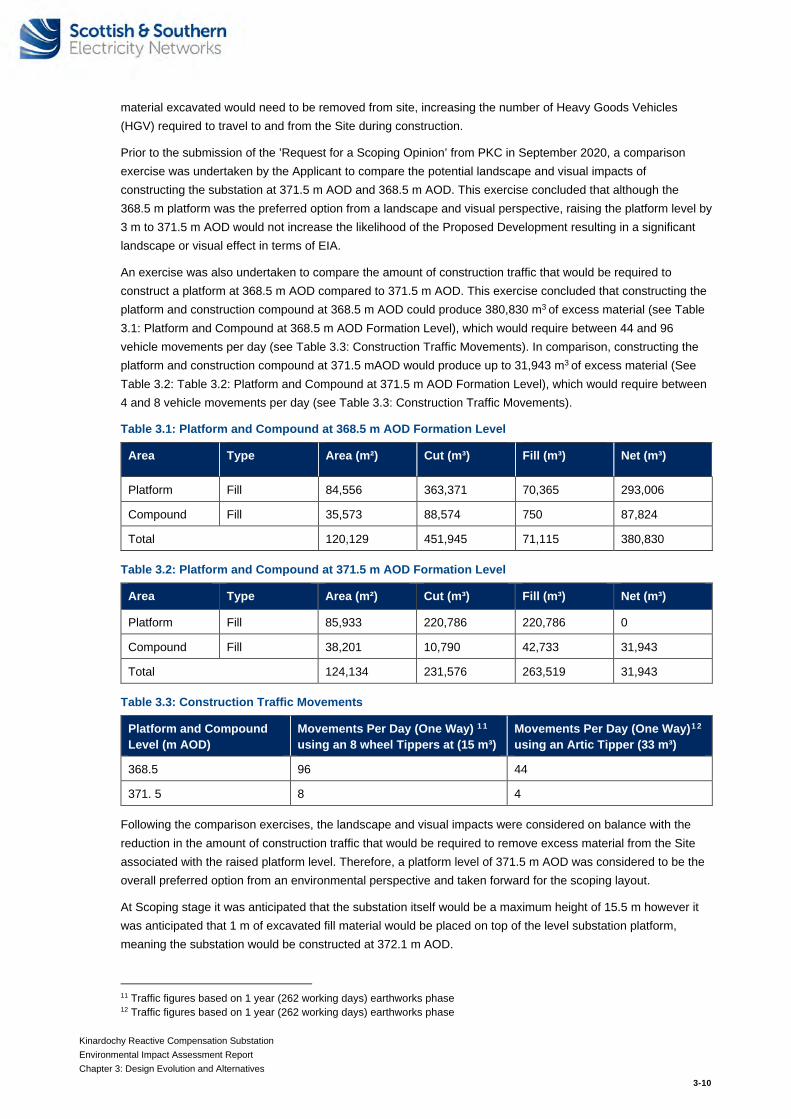
Kinardochy Reactive Compensation Substation Environmental Impact Assessment Report Chapter 3: Design Evolution and Alternatives 3-10
material excavated would need to be removed from site, increasing the number of Heavy Goods Vehicles (HGV) required to travel to and from the Site during construction.
Prior to the submission of the ’Request for a Scoping Opinion’ from PKC in September 2020, a comparison exercise was undertaken by the Applicant to compare the potential landscape and visual impacts of constructing the substation at 371.5 m AOD and 368.5 m AOD. This exercise concluded that although the 368.5 m platform was the preferred option from a landscape and visual perspective, raising the platform level by 3 m to 371.5 m AOD would not increase the likelihood of the Proposed Development resulting in a significant landscape or visual effect in terms of EIA.
An exercise was also undertaken to compare the amount of construction traffic that would be required to construct a platform at 368.5 m AOD compared to 371.5 m AOD. This exercise concluded that constructing the platform and construction compound at 368.5 m AOD could produce 380,830 m3 of excess material (see Table 3.1: Platform and Compound at 368.5 m AOD Formation Level), which would require between 44 and 96 vehicle movements per day (see Table 3.3: Construction Traffic Movements). In comparison, constructing the platform and construction compound at 371.5 mAOD would produce up to 31,943 m3 of excess material (See Table 3.2: Table 3.2: Platform and Compound at 371.5 m AOD Formation Level), which would require between 4 and 8 vehicle movements per day (see Table 3.3: Construction Traffic Movements).
Table 3.1: Platform and Compound at 368.5 m AOD Formation Level
Area Type Area (m²) Cut (m³) Fill (m³) Net (m³)
Platform Fill 84,556 363,371 70,365 293,006
Compound Fill 35,573 88,574 750 87,824
Total 120,129 451,945 71,115 380,830
Table 3.2: Platform and Compound at 371.5 m AOD Formation Level
Area Type Area (m²) Cut (m³) Fill (m³) Net (m³)
Platform Fill 85,933 220,786 220,786 0
Compound Fill 38,201 10,790 42,733 31,943
Total 124,134 231,576 263,519 31,943
Table 3.3: Construction Traffic Movements
Platform and Compound Level (m AOD)
Movements Per Day (One Way) 11 using an 8 wheel Tippers at (15 m³)
Movements Per Day (One Way)12 using an Artic Tipper (33 m³)
368.5 96 44
371. 5 8 4
Following the comparison exercises, the landscape and visual impacts were considered on balance with the reduction in the amount of construction traffic that would be required to remove excess material from the Site associated with the raised platform level. Therefore, a platform level of 371.5 m AOD was considered to be the overall preferred option from an environmental perspective and taken forward for the scoping layout.
At Scoping stage it was anticipated that the substation itself would be a maximum height of 15.5 m however it was anticipated that 1 m of excavated fill material would be placed on top of the level substation platform, meaning the substation would be constructed at 372.1 m AOD.
11 Traffic figures based on 1 year (262 working days) earthworks phase 12 Traffic figures based on 1 year (262 working days) earthworks phase
Kinardochy Reactive Compensation Substation Environmental Impact Assessment Report Chapter 3: Design Evolution and Alternatives 3-11
The access track proposed in the scoping layout would divert from the B846 via a new bellmouth junction at NGR 278081 755564, as illustrated in EIAR Volume 3a: Figure 3.4: Design Evolution. The access track would be routed in a general north westerly direction for 380 m, following the route of the existing 132 kV OHL and crossing the Alt Kinardochy Burn. The track then runs in a westerly direction for 390 m, connecting to the eastern side of the substation platform at NGR 277339 755686.
The access track in the scoping layout most closely resembles Access Track 3 from the screening layout however the westernmost section of the track was routed in a westerly direction rather than a south westerly direction on the approach to the substation platform in order to avoid a bog pool that was identified during ecological field surveys, as well as areas of blanket sphagnum bog habitat. This modification to the proposed access track also reduces the overall track length as the southeastern corner of the proposed substation, where Access Track 3 was proposed to connect to the substation platform, has been removed in the scoping layout.
Due to the presence of dense mature forestry immediately north of the proposed substation platform, it was not possible to undertake detailed ground investigation (GI) surveys in this area. Consequently, it could not be determined whether the ground conditions in the area immediately north proposed substation platform would be suitable for the construction of a construction compound. Therefore, Construction Compound and Laydown Area 1 was removed as a potential option in the scoping layout.
Construction Compound and Laydown Area 3 is located immediately east of the proposed substation platform and immediately north of the proposed access track and is up to 3.3 ha in area (180 m x 250 m). As noted in Table 3.2 above, the construction compound and laydown areas would be levelled at 371.5 m AOD, the same level as the substation platform. Similarly to the proposed substation, the shape of the proposed construction compound and laydown areas has been modified in the scoping layout to avoid an area of blanket sphagnum bog habitat that was identified during ecological field surveys, as illustrated in Layout 3 of Figure 3.4: Design Evolution (EIAR Volume 3a). This change resulted in the loss of more dry acid heath, a habitat considered to be of lower importance than the blanket bog. The proposed construction compound and laydown areas were also moved immediately east of the proposed substation to remove the requirement for a temporary access track between the compound and the proposed substation platform.
Layout 4 – Final Layout
For the final layout the substation platform was confirmed as being constructed at 371.5 m AOD. The substation was also confirmed to be a maximum height of 15.5 m and would be constructed at 372.5 m AOD, as 1 m of excavated fill material would be placed on top of the level substation platform. The area of the level platform was reduced to 5.86 ha in the final layout however the cut and fill area required to construct the platform was confirmed to be 9.48 ha. Like the scoping layout, the southeastern corner of the proposed substation platform has been removed in the final layout to avoid an area of blanket sphagnum bog habitat identified during ecological field work (as illustrated in Layout 4 of EIAR Volume 3a: Figure 3.4: Design Evolution).
The proposed substation platform would form a permanent feature of the Proposed Development however, following construction, the verges of the proposed substation platform would be reinstated in line with the Reinstatement and Landscape Design Specification (see EIAR Volume 4: Technical Appendix 2.2).
The size, shape or elevation of the proposed construction compound and laydown areas has not been altered between the scoping and final layout. However the cut and fill area required for the construction of the proposed construction compound and laydown areas was confirmed as 3.73 ha. Following the construction of the Proposed Development, the temporary construction compound and laydown areas would be reinstated in line with the Reinstatement and Landscape Design Specification (see EIAR Volume 4: Technical Appendix 2.2).
The bellmouth junction in the final layout is located 130 m further south than the scoping layout, as a forestry site walkover confirmed that up to 0.14 ha of the edge of an existing mature standing of Sitka Spruce would require felling to construct the junction in the scoping layout location. While this is a relatively small area, it would expose the remaining forest edge to the risk of wind throw, meaning that the whole forest block would
Kinardochy Reactive Compensation Substation Environmental Impact Assessment Report Chapter 3: Design Evolution and Alternatives 3-12
need to be felled in order to remove the risk of liability for wind throw. The bellmouth junction in the final layout diverges from the B846 at NGR 278017 755432 and will only require the removal of scrub trees. This location also provides improved visibility splays to the junction location in the scoping layout.
The access track would be routed in a general north westerly direction for 0.45 km, following the route of the existing 132 kV OHL and crossing the Alt Kinardochy Burn at NGR 277939 755595. The track then runs in a westerly direction for 0.37 km, connecting to the eastern side of the substation platform at NGR 277337 755686. The cut and fill area required to construct the proposed access track has been confirmed as 1.56 ha in the final layout.
The layout of the proposed access track has been carefully designed to avoid water crossings and sensitive habitats where possible, including the bog pool and blanket sphagnum bog habitat identified during ecological field work, as illustrated in Layout 4 of EIAR Volume 3a: Figure 3.4: Design Evolution. The layout of the proposed access track has also been designed to reduce the volume of imported stone required for the initial phase of access track and junction construction. The proposed access track, including the bellmouth junction, would form a permanent feature of the Proposed Development however following construction the verges of the access track would be reinstated in line with the Reinstatement and Landscape Design Specification (see EIAR Volume 4: Technical Appendix 2.2).
The final layout also includes one permanent attenuation basin and one temporary sedimentation pond, which would service the proposed substation platform and construction compound respectively, as shown in EIAR Volume 3a: Figure 3.4: Design Evolution. The purpose of the SUDs features is to manage drainage from the Proposed Development by storing surface runoff from the substation platform and construction compound, prior to discharge through existing overland flow routes to mimic existing hydrological conditions. Furthermore, the proposed drainage system for the Proposed Development (see EIAR Volume 4, Technical Appendix 7.1: Flood Risk Assessment and Drainage Impact Assessment) has been designed to minimise potential changes to the volume and rate of surface water runoff, to ensure that discharge is limited to a pre-development greenfield rate and to minimise potential risks associated with potential pollution incidents. Following construction, the temporary sedimentation pond, and any other temporary drainage features, would be reinstated in line with the Reinstatement and Landscape Design Specification (see EIAR Volume 4: Technical Appendix 2.2).
As a result of the final layout becoming fixed, the Applicant was able to reduce the size of the redline planning boundary to accommodate both temporary and permanent works associated with the Proposed Development, such as tree felling, temporary compounds, substation platform, access road and final landscape design.
3.4.2 The Associated Development
Although two connection options to Site 4 were identified during the 2018 Site Selection exercise, the Applicant has since determined that the Proposed Development would not require 132 kV cables to be installed between the proposed substation and either the existing Errochty or Tummel substations at the time due to insufficient network demand. Instead, it is proposed that the Associated Development would be comprised of a modification to the existing Beauly-Denny line (at a location immediately west of the Proposed Development) and associated works, as described in Section 2.4 of Chapter 2: Development Description. The proposed modification to the Beauly-Denny line is similar to the modification described for Connection Option 2 and would require a Statcom Transformer (ST) to be installed at as part of the Proposed Development, allowing for the Associated Development to connect directly into the proposed substation.
To minimise impacts associated with accessing the winching site at T227 on the Beauly-Denny line, it was proposed that an existing 4x4 access track between the B846 to the tower should be upgraded, as described in Chapter 2: Development Description. It was also proposed that this access track should be permanent so that it could be utilised for any future maintenance works associated with the tower. During the design process the junction and the location of the watercourse crossing on the proposed access track were moved further north to
Kinardochy Reactive Compensation Substation Environmental Impact Assessment Report Chapter 3: Design Evolution and Alternatives 3-13
avoid known cultural heritage assets, including a former blacksmith/mill site (MPK 534), and to improve visibility splays at the junction.
3.5 Landscaping Design Much of the mitigation of operational effects are accounted for in the design of the Proposed Development, is described in the Reinstatement and Landscape Design Specification (as described in EIAR Volume 4: Technical Appendix 2.2).
The embedded mitigation included in the Landscape Plan includes:
• The incorporation a roll over slope to avoid a ‘hard edge’ to the rim of the substation excavation;
• Establishment of screening landforms would have a maximum 3 m height (above existing ground levels) and have gently domed tops that are undulating to reflect the underling topographical forms in the vicinity and to avoid an overly engineered appearance to these features.
• The establishment of suitable locally native tree and scrub planting species around the periphery of the proposed substation platform, in order to reduce the visibility, prominence and perceived scale of structures within the proposed substation;
• Locating the proposed substation within an excavated void (levelled at 372.5 m AOD), so that it would be partially screened below adjoining ground levels, thereby reducing its prominence and scale, and reducing the incidence of them outcropping above the horizon in views from key receptor locations;
• Use of recessive colour for structures that would overtop the rim of the excavation. The colour would be agreed with the local planning authority before construction operations commence at the Proposed Development; and
• In terms of ensuring the mitigation measures are implemented, it should be noted that the proposals presented in the Reinstatement and Landscape Design Specification (see EIAR Volume 4: Technical Appendix 2.2) would be committed and developed as part of the works should the Proposed Development be consented, and a formal specification would be developed as part of the detailed design.
3.6 Biodiversity Net Gain A BNG Assessment has been undertaken for the Proposed Development and the Associated Development. The results of the BNG assessment informed the design process for both developments, including the alteration of the footprint/ shape of the proposed substation platform and construction compound and laydown areas to avoid blanket bog habitats and minimising the amount of excess material to be used on site to avoid an overall net loss of biodiversity on the Project Site.

Kinardochy Reactive Compensation Substation Environmental Impact Assessment Report Chapter 3: Design Evolution and Alternatives 3-14
3.7 Mitigation by Design Table 3.4: Mitigation by Design summarises the potentially significant effects and environmental constraints identified in relation to the Proposed Development and the Associated Development and how these were addressed through the design process, highlighting any outstanding issues following the implementation of mitigation by design.
Table 3.4: Mitigation by Design
Topic Environmental Constraint/ Potential Significant Effect
Mitigation by Design Outstanding Issues
Landscape and Visual Impact
• Site clearance, excavation of the ground for access track construction, substation construction, tower construction, placement of temporary construction compounds, reinstatement works during construction;
• Loss of vegetation within the Project Site, and consequent construction of the Proposed Development and the Associated Development;
• Presence of construction activity (including movement) and construction equipment such as excavators, tractors and scaffold tunnels;
• Presence of new high voltage substation (including conductors) and grid infrastructure within the landscape;
• Potential visual impacts from residences settlements, transport corridors, recreation and tourism routes/ assets;
• Potential adverse impacts on landscape designations, including Loch Rannoch and Glen Lyon National Scenic Area (NSA) and Loch Tummel NSA;
• Potential adverse impacts on landscape character; and
• The substation platform is to be constructed at 372.5 m AOD, below the existing ground level, to reduce the overall height of the Proposed Development, including insulators;
• Tree felling will be limited to only those necessary for the safe construction and operation of the Proposed Development and the Associated Development, meaning views of the developments will continue to be screened by the existing forestry as far as possible, until the forestry is felled; and
A Reinstatement and Landscape Design Specification (EIAR Volume 4: Technical Appendix 2.2) has been developed to minimise the visual impacts of the Proposed Development. The Specification contains a series of measures to supplement the integration of the Proposed Development within a framework of locally appropriate landscape features, such as those described in section 3.6 of this chapter.
• Outstanding landscape and visual issues are assessed in Chapter 4: Landscape and Visual Amenity; and
• Details on the felling and restocking of existing commercial forestry is provided in Chapter 9: Forestry.
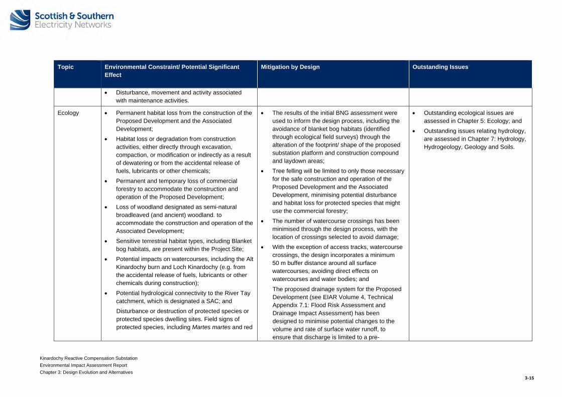
Kinardochy Reactive Compensation Substation Environmental Impact Assessment Report Chapter 3: Design Evolution and Alternatives 3-15
Topic Environmental Constraint/ Potential Significant Effect
Mitigation by Design Outstanding Issues
• Disturbance, movement and activity associated with maintenance activities.
Ecology • Permanent habitat loss from the construction of the Proposed Development and the Associated Development;
• Habitat loss or degradation from construction activities, either directly through excavation, compaction, or modification or indirectly as a result of dewatering or from the accidental release of fuels, lubricants or other chemicals;
• Permanent and temporary loss of commercial forestry to accommodate the construction and operation of the Proposed Development;
• Loss of woodland designated as semi-natural broadleaved (and ancient) woodland. to accommodate the construction and operation of the Associated Development;
• Sensitive terrestrial habitat types, including Blanket bog habitats, are present within the Project Site;
• Potential impacts on watercourses, including the Alt Kinardochy burn and Loch Kinardochy (e.g. from the accidental release of fuels, lubricants or other chemicals during construction);
• Potential hydrological connectivity to the River Tay catchment, which is designated a SAC; and Disturbance or destruction of protected species or protected species dwelling sites. Field signs of protected species, including Martes martes and red
• The results of the initial BNG assessment were used to inform the design process, including the avoidance of blanket bog habitats (identified through ecological field surveys) through the alteration of the footprint/ shape of the proposed substation platform and construction compound and laydown areas;
• Tree felling will be limited to only those necessary for the safe construction and operation of the Proposed Development and the Associated Development, minimising potential disturbance and habitat loss for protected species that might use the commercial forestry;
• The number of watercourse crossings has been minimised through the design process, with the location of crossings selected to avoid damage;
• With the exception of access tracks, watercourse crossings, the design incorporates a minimum 50 m buffer distance around all surface watercourses, avoiding direct effects on watercourses and water bodies; and The proposed drainage system for the Proposed Development (see EIAR Volume 4, Technical Appendix 7.1: Flood Risk Assessment and Drainage Impact Assessment) has been designed to minimise potential changes to the volume and rate of surface water runoff, to ensure that discharge is limited to a pre-
• Outstanding ecological issues are assessed in Chapter 5: Ecology; and
• Outstanding issues relating hydrology, are assessed in Chapter 7: Hydrology, Hydrogeology, Geology and Soils.
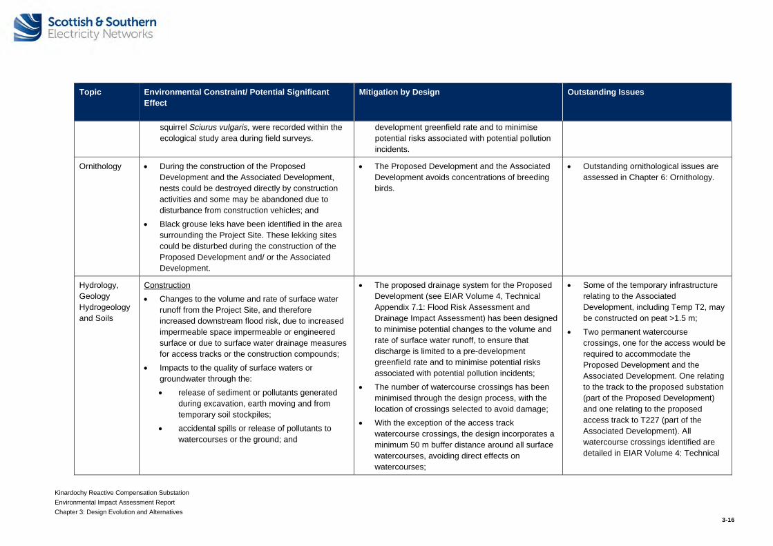
Kinardochy Reactive Compensation Substation Environmental Impact Assessment Report Chapter 3: Design Evolution and Alternatives 3-16
Topic Environmental Constraint/ Potential Significant Effect
Mitigation by Design Outstanding Issues
squirrel Sciurus vulgaris, were recorded within the ecological study area during field surveys.
development greenfield rate and to minimise potential risks associated with potential pollution incidents.
Ornithology • During the construction of the Proposed Development and the Associated Development, nests could be destroyed directly by construction activities and some may be abandoned due to disturbance from construction vehicles; and
• Black grouse leks have been identified in the area surrounding the Project Site. These lekking sites could be disturbed during the construction of the Proposed Development and/ or the Associated Development.
• The Proposed Development and the Associated Development avoids concentrations of breeding birds.
• Outstanding ornithological issues are assessed in Chapter 6: Ornithology.
Hydrology, Geology Hydrogeology and Soils
Construction • Changes to the volume and rate of surface water
runoff from the Project Site, and therefore increased downstream flood risk, due to increased impermeable space impermeable or engineered surface or due to surface water drainage measures for access tracks or the construction compounds;
• Impacts to the quality of surface waters or groundwater through the: • release of sediment or pollutants generated
during excavation, earth moving and from temporary soil stockpiles;
• accidental spills or release of pollutants to watercourses or the ground; and
• The proposed drainage system for the Proposed Development (see EIAR Volume 4, Technical Appendix 7.1: Flood Risk Assessment and Drainage Impact Assessment) has been designed to minimise potential changes to the volume and rate of surface water runoff, to ensure that discharge is limited to a pre-development greenfield rate and to minimise potential risks associated with potential pollution incidents;
• The number of watercourse crossings has been minimised through the design process, with the location of crossings selected to avoid damage;
• With the exception of the access track watercourse crossings, the design incorporates a minimum 50 m buffer distance around all surface watercourses, avoiding direct effects on watercourses;
• Some of the temporary infrastructure relating to the Associated Development, including Temp T2, may be constructed on peat >1.5 m;
• Two permanent watercourse crossings, one for the access would be required to accommodate the Proposed Development and the Associated Development. One relating to the track to the proposed substation (part of the Proposed Development) and one relating to the proposed access track to T227 (part of the Associated Development). All watercourse crossings identified are detailed in EIAR Volume 4: Technical
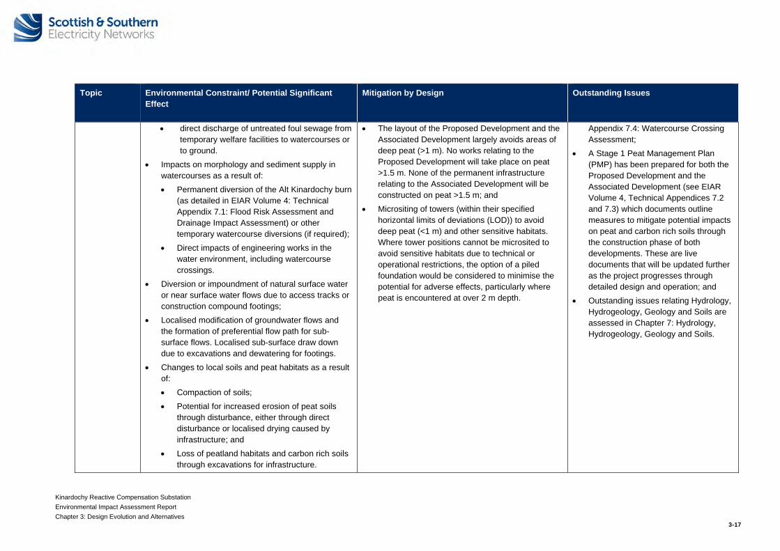
Kinardochy Reactive Compensation Substation Environmental Impact Assessment Report Chapter 3: Design Evolution and Alternatives 3-17
Topic Environmental Constraint/ Potential Significant Effect
Mitigation by Design Outstanding Issues
• direct discharge of untreated foul sewage from temporary welfare facilities to watercourses or to ground.
• Impacts on morphology and sediment supply in watercourses as a result of: • Permanent diversion of the Alt Kinardochy burn
(as detailed in EIAR Volume 4: Technical Appendix 7.1: Flood Risk Assessment and Drainage Impact Assessment) or other temporary watercourse diversions (if required);
• Direct impacts of engineering works in the water environment, including watercourse crossings.
• Diversion or impoundment of natural surface water or near surface water flows due to access tracks or construction compound footings;
• Localised modification of groundwater flows and the formation of preferential flow path for sub-surface flows. Localised sub-surface draw down due to excavations and dewatering for footings.
• Changes to local soils and peat habitats as a result of: • Compaction of soils; • Potential for increased erosion of peat soils
through disturbance, either through direct disturbance or localised drying caused by infrastructure; and
• Loss of peatland habitats and carbon rich soils through excavations for infrastructure.
• The layout of the Proposed Development and the Associated Development largely avoids areas of deep peat (>1 m). No works relating to the Proposed Development will take place on peat >1.5 m. None of the permanent infrastructure relating to the Associated Development will be constructed on peat >1.5 m; and
• Micrositing of towers (within their specified horizontal limits of deviations (LOD)) to avoid deep peat (<1 m) and other sensitive habitats. Where tower positions cannot be microsited to avoid sensitive habitats due to technical or operational restrictions, the option of a piled foundation would be considered to minimise the potential for adverse effects, particularly where peat is encountered at over 2 m depth.
Appendix 7.4: Watercourse Crossing Assessment;
• A Stage 1 Peat Management Plan (PMP) has been prepared for both the Proposed Development and the Associated Development (see EIAR Volume 4, Technical Appendices 7.2 and 7.3) which documents outline measures to mitigate potential impacts on peat and carbon rich soils through the construction phase of both developments. These are live documents that will be updated further as the project progresses through detailed design and operation; and
• Outstanding issues relating Hydrology, Hydrogeology, Geology and Soils are assessed in Chapter 7: Hydrology, Hydrogeology, Geology and Soils.
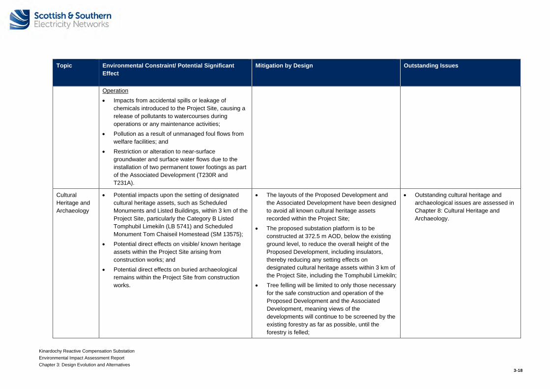
Kinardochy Reactive Compensation Substation Environmental Impact Assessment Report Chapter 3: Design Evolution and Alternatives 3-18
Topic Environmental Constraint/ Potential Significant Effect
Mitigation by Design Outstanding Issues
Operation • Impacts from accidental spills or leakage of
chemicals introduced to the Project Site, causing a release of pollutants to watercourses during operations or any maintenance activities;
• Pollution as a result of unmanaged foul flows from welfare facilities; and
• Restriction or alteration to near-surface groundwater and surface water flows due to the installation of two permanent tower footings as part of the Associated Development (T230R and T231A).
Cultural Heritage and Archaeology
• Potential impacts upon the setting of designated cultural heritage assets, such as Scheduled Monuments and Listed Buildings, within 3 km of the Project Site, particularly the Category B Listed Tomphubil Limekiln (LB 5741) and Scheduled Monument Tom Chaiseil Homestead (SM 13575);
• Potential direct effects on visible/ known heritage assets within the Project Site arising from construction works; and
• Potential direct effects on buried archaeological remains within the Project Site from construction works.
• The layouts of the Proposed Development and the Associated Development have been designed to avoid all known cultural heritage assets recorded within the Project Site;
• The proposed substation platform is to be constructed at 372.5 m AOD, below the existing ground level, to reduce the overall height of the Proposed Development, including insulators, thereby reducing any setting effects on designated cultural heritage assets within 3 km of the Project Site, including the Tomphubil Limekiln;
• Tree felling will be limited to only those necessary for the safe construction and operation of the Proposed Development and the Associated Development, meaning views of the developments will continue to be screened by the existing forestry as far as possible, until the forestry is felled;
• Outstanding cultural heritage and archaeological issues are assessed in Chapter 8: Cultural Heritage and Archaeology.
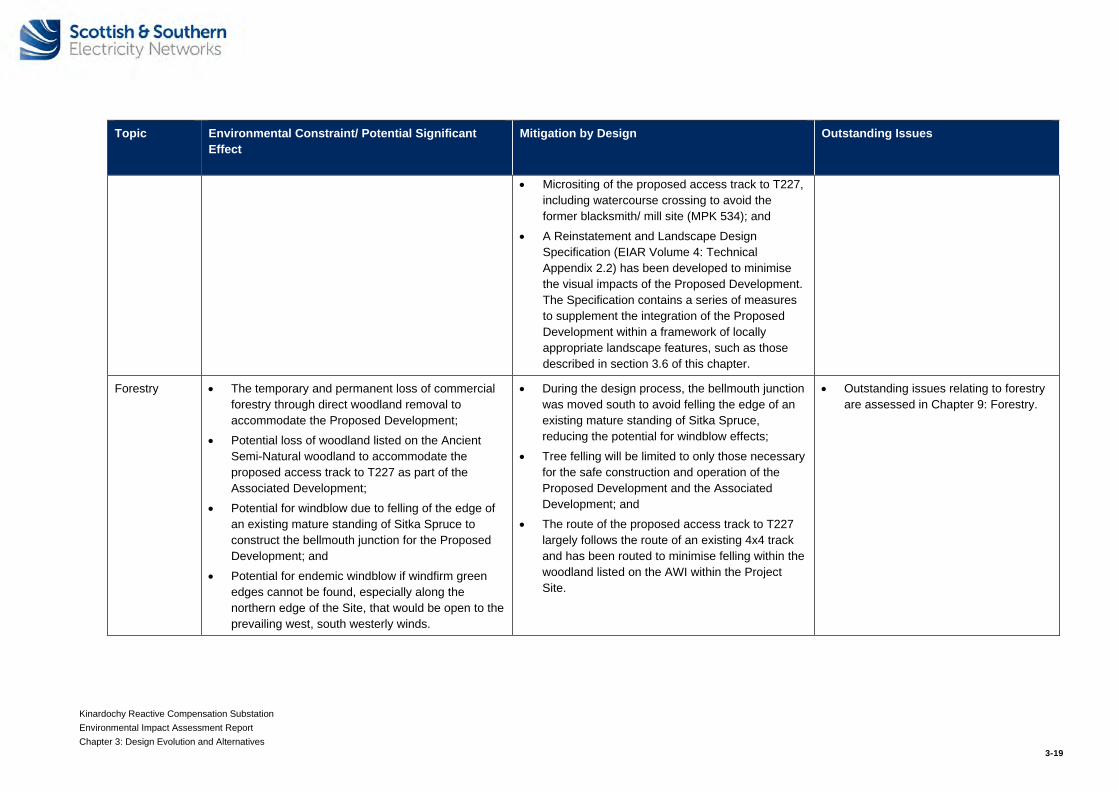
Kinardochy Reactive Compensation Substation Environmental Impact Assessment Report Chapter 3: Design Evolution and Alternatives 3-19
Topic Environmental Constraint/ Potential Significant Effect
Mitigation by Design Outstanding Issues
• Micrositing of the proposed access track to T227, including watercourse crossing to avoid the former blacksmith/ mill site (MPK 534); and
• A Reinstatement and Landscape Design Specification (EIAR Volume 4: Technical Appendix 2.2) has been developed to minimise the visual impacts of the Proposed Development. The Specification contains a series of measures to supplement the integration of the Proposed Development within a framework of locally appropriate landscape features, such as those described in section 3.6 of this chapter.
Forestry • The temporary and permanent loss of commercial forestry through direct woodland removal to accommodate the Proposed Development;
• Potential loss of woodland listed on the Ancient Semi-Natural woodland to accommodate the proposed access track to T227 as part of the Associated Development;
• Potential for windblow due to felling of the edge of an existing mature standing of Sitka Spruce to construct the bellmouth junction for the Proposed Development; and
• Potential for endemic windblow if windfirm green edges cannot be found, especially along the northern edge of the Site, that would be open to the prevailing west, south westerly winds.
• During the design process, the bellmouth junction was moved south to avoid felling the edge of an existing mature standing of Sitka Spruce, reducing the potential for windblow effects;
• Tree felling will be limited to only those necessary for the safe construction and operation of the Proposed Development and the Associated Development; and
• The route of the proposed access track to T227 largely follows the route of an existing 4x4 track and has been routed to minimise felling within the woodland listed on the AWI within the Project Site.
• Outstanding issues relating to forestry are assessed in Chapter 9: Forestry.
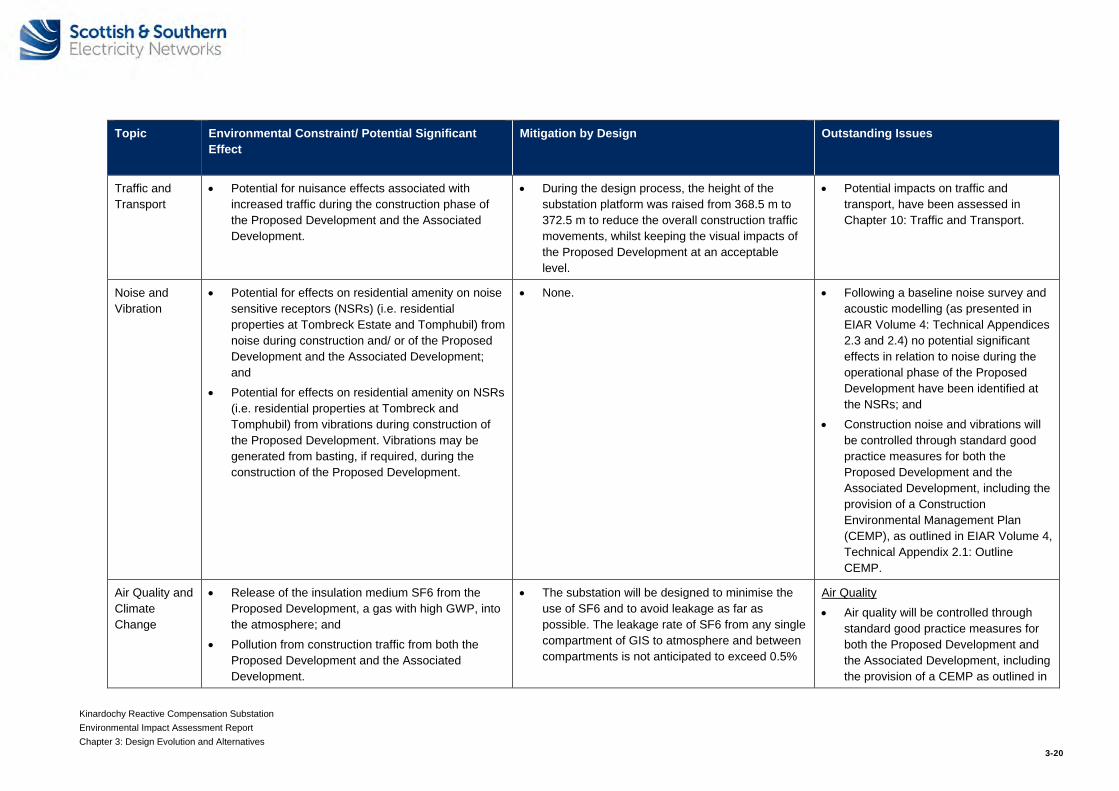
Kinardochy Reactive Compensation Substation Environmental Impact Assessment Report Chapter 3: Design Evolution and Alternatives 3-20
Topic Environmental Constraint/ Potential Significant Effect
Mitigation by Design Outstanding Issues
Traffic and Transport
• Potential for nuisance effects associated with increased traffic during the construction phase of the Proposed Development and the Associated Development.
• During the design process, the height of the substation platform was raised from 368.5 m to 372.5 m to reduce the overall construction traffic movements, whilst keeping the visual impacts of the Proposed Development at an acceptable level.
• Potential impacts on traffic and transport, have been assessed in Chapter 10: Traffic and Transport.
Noise and Vibration
• Potential for effects on residential amenity on noise sensitive receptors (NSRs) (i.e. residential properties at Tombreck Estate and Tomphubil) from noise during construction and/ or of the Proposed Development and the Associated Development; and
• Potential for effects on residential amenity on NSRs (i.e. residential properties at Tombreck and Tomphubil) from vibrations during construction of the Proposed Development. Vibrations may be generated from basting, if required, during the construction of the Proposed Development.
• None. • Following a baseline noise survey and acoustic modelling (as presented in EIAR Volume 4: Technical Appendices 2.3 and 2.4) no potential significant effects in relation to noise during the operational phase of the Proposed Development have been identified at the NSRs; and
• Construction noise and vibrations will be controlled through standard good practice measures for both the Proposed Development and the Associated Development, including the provision of a Construction Environmental Management Plan (CEMP), as outlined in EIAR Volume 4, Technical Appendix 2.1: Outline CEMP.
Air Quality and Climate Change
• Release of the insulation medium SF6 from the Proposed Development, a gas with high GWP, into the atmosphere; and
• Pollution from construction traffic from both the Proposed Development and the Associated Development.
• The substation will be designed to minimise the use of SF6 and to avoid leakage as far as possible. The leakage rate of SF6 from any single compartment of GIS to atmosphere and between compartments is not anticipated to exceed 0.5%
Air Quality • Air quality will be controlled through
standard good practice measures for both the Proposed Development and the Associated Development, including the provision of a CEMP as outlined in
Kinardochy Reactive Compensation Substation Environmental Impact Assessment Report Chapter 3: Design Evolution and Alternatives 3-21
Topic Environmental Constraint/ Potential Significant Effect
Mitigation by Design Outstanding Issues
• Release of carbon from loss of peatland and woodland.
per year for the service life of the equipment, in line with IEC 62271-203 specifications; and
• During the design process, the height of the substation platform was raised from 368.5 m to 372.5 m to reduce the overall construction traffic movements. This will reduce the amount of air pollution produced from construction traffic.
EIAR Volume 4, Technical Appendix 2.1: Outline CEMP;
• In accordance with the Applicants technical specifications, the GIS of the Proposed Development will have continuous online monitoring of SF6 installed during operation;
• Outstanding issues relating to traffic and transport, have been assessed in Chapter 10: Traffic and Transport;
• Following the implementation of the CEMP and other good practice measures, no significant air quality impacts are anticipated from either the Proposed Development or the Associated Development. Potential air quality impacts from either development have not considered further in this EIAR.
Climate Change • Potential impacts on climate change as
a result of loss of woodland are addressed in Chapter 9: Forestry.
• Potential impacts on climate change as a result of loss of peatland are addressed in Chapter 7: Hydrology, Hydrogeology, Geology and Soils;
• A Stage 1 PMP has been prepared for both the Proposed Development and the Associated Development (see
Kinardochy Reactive Compensation Substation Environmental Impact Assessment Report Chapter 3: Design Evolution and Alternatives 3-22
Topic Environmental Constraint/ Potential Significant Effect
Mitigation by Design Outstanding Issues
EIAR Volume 4, Technical Appendices 7.2 and 7.3) which documents outline measures to mitigate potential impacts on peat and carbon rich soils through the construction phase of both developments. These are live documents that will be updated further as the project progresses through detailed design and operation; and
• The Proposed Development and the Associated Development would contribute to providing renewable electricity, by facilitating the connection of several proposed and consented wind farms in the wider area into the national grid, in turn displacing emissions associated with fossil fuel-based electricity generation elsewhere.
Land Use and Amenity
• Loss of commercial forestry, the primary land use within the Project Site;
• Existing grid infrastructure, including four OHLs, within the Project Site;
• Potential adverse impacts on recreational brown trout fishing and wildlife watching on or surrounding Loch Kinardochy;
• Potential impacts on the setting of core paths within 3 km of the Project Site, including the Schiehallion Core Path (RANN/108);
• Potential impacts on caravan/ holiday parks within 3 km of the Project Site, including Glengoulandie
• The substation platform is to be constructed at 372.5 m AOD, below the existing ground level to reduce the overall height of the Proposed Development, including insulators, reducing any potential adverse effects on visual amenity from sensitive receptors, including residences and key recreational and transport routes/ locations;
• Tree felling during construction would be limited to only those necessary for the safe construction and operation of the Proposed Development and the Associated Development so that views of the
• Chapter 9: Forestry assesses the residual effects of the Proposed Development and the Associated Development on commercial forestry.
• Chapter 4: Landscape and Visual Amenity assesses the potential for the Proposed Development and the Associated Development to have adverse effects on visual amenity from sensitive receptors, including key recreational and transport routes/ locations and residential properties.

Kinardochy Reactive Compensation Substation Environmental Impact Assessment Report Chapter 3: Design Evolution and Alternatives 3-23
Topic Environmental Constraint/ Potential Significant Effect
Mitigation by Design Outstanding Issues
Camping & Caravanning Park and Tummel Valley Holiday Park;
• Potential amenity effects, including noise, vibration and visual amenity effects on nearby residences from the construction and operation of the Proposed Development and the Associated Development.
developments from sensitive receptors will continue to be screened by the existing forestry;
• A Reinstatement and Landscape Design Specification (EIAR Volume 4: Technical Appendix 2.2) has been developed to minimise the visual impacts of the Proposed Development. The Specification contains a series of measures to supplement the integration of the Proposed Development within a framework of locally appropriate landscape features, such as those described in section 3.6 of this chapter; and
• The Proposed Development and the Associated Development have been designed so that no construction work would be undertaken within 200 m of Loch Kinardochy or other recreational sites.
• Following a baseline noise survey and acoustic modelling (as presented in EIAR Volume 4: Technical Appendices 2.3 and 2.4) no potential significant effects in relation to noise have been identified at the nearby residential receptors during the operational phase of the Proposed Development; and
• Construction noise and vibrations for both the Proposed Development and the Associated Development will be controlled through standard good practice measures, including the provision of a CEMP, as outlined in EIAR Volume 4, Technical Appendix 2.1: Outline CEMP.
Population and Human Health
• For the purposes of this EIA, human receptors are considered in relation to air quality, water quality, noise disturbance, light disturbance, residential amenity, and electric and magnetic fields (EMFs)13.
• For air quality see ‘Air Quality and Climate Change’ above;
• For water quality see ‘Hydrology, Hydrogeology, Geology and Soils’ above;
• For noise disturbance see ‘ Noise and Vibration’ above: and
• For residential amenity see ‘Landscape and Visual Impact’ and ‘Land Use and Amenity’ above.
• Air quality will be controlled through standard good practice measures, including the provision of a CEMP, as outlined in EIAR Volume 4, Technical Appendix 2.1: Outline CEMP;
• In accordance with the Applicants technical specifications, the GIS will have continuous online monitoring of SF6 installed during operation;
13 EMFs arise from electric charges. Exposure guidelines have been developed by the International Commission on Non-Ionising Radiation Protection (ICNIRP) to ensure protection of human health in different situations, occupational exposure and public exposure.

Kinardochy Reactive Compensation Substation Environmental Impact Assessment Report Chapter 3: Design Evolution and Alternatives 3-24
Topic Environmental Constraint/ Potential Significant Effect
Mitigation by Design Outstanding Issues
• Potential impacts on water quality are assessed in Chapter 7: Hydrology, Hydrogeology, Geology and Soils;
• Following a baseline noise survey and acoustic modelling (as presented in EIAR Volume 4: Technical Appendices 2.3 and 2.4) no potential significant effects in relation to noise have been identified at the nearby residential receptors during the operational phase of the Proposed Development.
• Noise sources, including traffic, during the operational phase of the Associated Development would be limited to noise from maintenance activities;
• Construction noise for both the Proposed Development and the Associated Development will be controlled through standard good practice measures, including the provision of a CEMP, as outlined in EIAR Volume 4, Technical Appendix 2.1: Outline CEMP;
• Lighting requirements at the Proposed Development and the Associated Development are described in Tables 2.2 and 2.3 in Chapter 2: Development Description;
• Chapter 4: Landscape and Visual Amenity assesses the potential for the
Kinardochy Reactive Compensation Substation Environmental Impact Assessment Report Chapter 3: Design Evolution and Alternatives 3-25
Topic Environmental Constraint/ Potential Significant Effect
Mitigation by Design Outstanding Issues
Proposed Development to have adverse effects on visual amenity from sensitive receptors, including nearby residential properties;
• There is no potential for public or occupational exposure to EMFs above appropriate thresholds as a result of the Proposed Development or the Associated Development as described in Tables 2.2 and 2.3 in Chapter 2: Development Description;
Major Accidents and Disasters
• It is considered that the majority of major natural disasters are not of relevance to the Project Site, with the exception of vulnerability to flood risk and storm events.
• Resilience to relevant types of accident/ disaster would be incorporated into the substation design. The design would include consideration of substation structure and fire risk to reduce the risk of industrial accidents and disasters.
• The potential for significant adverse effects relating to flood risk are assessed in Chapter 7: Hydrology, Hydrogeology, Geology and Soils;
• The Applicant currently manages existing risk to industrial accidents through its operational management procedures and these would be applicable to the Proposed Development and the Associated Development during operation; and
• Routine maintenance inspections will be completed in order to ensure compliant operation of the Proposed Development and the Associated Development.
Material Assets
• Permanent and temporary loss of commercial forestry.
• Tree felling during construction would be limited to only those necessary for the safe construction
• Potential impacts on commercial forestry have been assessed in Chapter 9: Forestry.
Kinardochy Reactive Compensation Substation Environmental Impact Assessment Report Chapter 3: Design Evolution and Alternatives 3-26
Topic Environmental Constraint/ Potential Significant Effect
Mitigation by Design Outstanding Issues
and operation of the Proposed Development and the Associated Development.

Kinardochy Reactive Compensation Substation Environmental Impact Assessment Report Chapter 4: Landscape and Visual Impact 4-1
4. LANDSCAPE AND VISUAL IMPACT
4.1 Introduction This chapter considers the likely significant effects on landscape and visual amenity associated with the construction and operation of the Proposed Development. The likely significant effects on landscape and visual amenity associated with the construction and operation of the Associated Development will be considered as part of the cumulative assessment. As described in Chapter 2: Description of Development, neither the Proposed Development nor the Associated Development are likely to be decommissioned. If they were to be decommissioned the effects associated with the construction phase of the Proposed Development on landscape and visual amenity can be considered to be representative of reasonable worst-case decommissioning effects, therefore a separate assessment of the decommissioning phase of the Proposed Development and Associated Development has not been undertaken as part of this assessment.
The specific objectives of the chapter are to:
• describe the existing landscape and visual baseline context;
• describe the assessment methodology and significance criteria used in completing the impact assessment;
• describe the potential effects, including direct, indirect and cumulative effects arising in combination with, and addition to, the Associated Development;
• describe the mitigation measures proposed to address likely significant effects; and
• assess the residual effects remaining following the implementation of mitigation.
The assessment has been prepared by Ramboll UK Limited’s team of landscape architects. It has been technically reviewed by a Ramboll UK Ltd Chartered Landscape Architect with over 10 years of experience. This assessment has been undertaken in accord with the Guidelines for Landscape and Visual Impact Assessment, 3rd edition (GLVIA3)1.
The chapter is supported by a series of figures and visualisations, including:
• Figure 4.1: Landscape Character Types;
• Figure 4.2: Landscape Designations and Classifications;
• Figure 4.3: Recreational Routes;
• Figure 4.4a: Viewpoint Locations and ZTV;
• Figure 4.4b: Cumulative ZTV;
• Visualisation 4.1: Viewpoint 1 – B846 at Tomphubil;
• Visualisation 4.2: Viewpoint 2 – Tombreck Access;
• Visualisation 4.3: Viewpoint 3 – C450 Schiehallion Road (north);
• Visualisation 4.4: Viewpoint 4 – C450 Schiehallion Road (south) ; and
• Visualisation 4.5: Viewpoint 5 – Core Path DULL/ 147.
The assessment is also accompanied by the following Technical Appendices:
• Technical Appendix 1.1: Consultation Register
• Technical Appendix 2.2: Reinstatement and Landscape Design Specification; and
• Technical Appendix 4.1: Additional Photography.
2 .i.e. non designated landscapes such as Gardens and designed Landscapes and Wild Land Areas

Kinardochy Reactive Compensation Substation Environmental Impact Assessment Report Chapter 4: Landscape and Visual Impact 4-2
4.2 Scope of Assessment This chapter assesses the landscape and visual effects of the Proposed Development and considers effects on:
• Landscape Fabric;
• Landscape Character;
• Designated and Classified Landscapes2; and
• Visual Amenity.
Effects on landscape fabric occur when there is a physical change to components of the landscape such as the landform, land use or land cover. Effects on landscape character arise when there is a change to key characteristics of the landscape and its associated distinct and recognisable pattern of elements. Visual effects are a subset of landscape effects and comprise changes in views of the landscape and the overall effects on visual amenity.
Landscape and visual impacts may affect cultural heritage facets of the landscape, specifically on the setting of Gardens and designed Landscape (GDLs) and on listed buildings and ancient monuments. The landscape and Visual Assessment (LVIA) considers potential effects on the character and visitor experience of GDL’s, whilst effects on the specific historic aspects of GDLs, as well as integrity and fabric of other cultural artefacts are dealt with in Chapter 8: Archaeology and Cultural Heritage of the EIAR.
The chapter also considers the potential effects of the Associated Development, as described in Chapter 2: Description of Development, as a cumulative development to the Proposed Development. No other consented or proposed developments that could lead to significant cumulative effects have been identified within 5 km of the Site. As such no other cumulative developments should be considered in the EIA Report. The cumulative assessment captures the potential for additional, in combination and synergistic effects when considering the Proposed Development along with the Associated Development.
4.2.1 Guidance for the LVIA
The LVIA accords with guidance provided in:
• Landscape Institute and Institute of Environmental Management and Assessment: Guidance for Landscape and Visual Impact Assessment – Third Edition (2013)3;
• The Countryside Agency and Scottish Natural Heritage: Landscape Character Assessment (2002);
• Scottish Natural Heritage (SNH) and the Countryside Agency: Topic Paper 6: Techniques and Criteria for Judging Capacity and Sensitivity (2002); and
• Visual Representation of Development Proposals – Landscape Institute Technical Advice Note 06/19 (2019).
4.2.2 Consultation
Table 4.1: Consultation Responses summarises advice regarding the scope and approach to be adopted in the LVIA that was received during formal consultations with Perth and Kinross Council (PKC) in August 2019 and from PKC and NatureScot in the formal Scoping Opinion in October 2020. The table also provides details of how the matters raised by PKC have been addressed in the LVIA.
2 .i.e. non designated landscapes such as Gardens and designed Landscapes and Wild Land Areas 3 Landscape Institute and Institute of Environmental Management and Assessment (2013) Guidance for Landscape and Visual Impact Assessment – Third Edition.

Kinardochy Reactive Compensation Substation Environmental Impact Assessment Report Chapter 4: Landscape and Visual Impact 4-3
Table 4.1: Consultation Responses
Consultee and Date
Scoping / Other Consultation
Issue Raised Response / Action Taken
PKC 1 Aug 2019
Pre-app Scale, Design and Layout PKC suggest that the Proposed Development would be an industrial installation in a very rural location and on that basis will be out of context with surrounding landscape. Supporting justification will be required for this as well as mitigation of visual impact.
Issues relating to the scale and potential extent of landscape and visual effects attributable to the Proposed Development have been substantially addressed through careful siting, design and mitigation, as described in Chapter 3: Design Evolution and Alternatives, and additional landscape proposals to aid the assimilation of the Proposed Development into the surrounding landscape (see EIAR Volume 4: Technical Appendix 2.2: Reinstatement and Landscape Design Specification).
PKC 1 Aug 2019
Pre-app Residential and Leisure amenity PKC considered a key impact would be that of effects on the visual amenity of dwellings located south of Loch Kinardochy as well as across open space and tree cover that could affect amenity of wider area.
Anticipated losses of tree cover would be compensated for by replacement planting along the south, south east and north/ north west of the Proposed Development (see EIAR Volume 4: Technical Appendix 2.2: Reinstatement and Landscape Design Specification). This vegetation, coupled with proposed low screening mounding and selected colour of site elements is intended to reduce the visibility and prominence of the Proposed Development in views from residential properties location to the south and north, as well as the wider study area.
PKC 1 Aug 2019
Pre-app Landscape and Visual Impact Landscape and Visual Impact Assessment (LVIA) will be required due to proximity to sensitive receptors in the area such as those listed above. The scope of the assessment, including identification of assessment viewpoints should be agreed at an early stage with PKC.
The LVIA assessment has been carried out in accordance with relevant professional standards4, with reference to viewpoints and assessment scope agreed with the PKC.
4 Landscape Institute and Institute of Environmental Management and Assessment (2013) Guidance for Landscape and Visual Impact Assessment – Third Edition.
Kinardochy Reactive Compensation Substation Environmental Impact Assessment Report Chapter 4: Landscape and Visual Impact 4-4
Consultee and Date
Scoping / Other Consultation
Issue Raised Response / Action Taken
PKC 20 November 2019
LVA Viewpoint Consultation
Landscape and Visual – Viewpoints and Study Area Landscape and visual viewpoints and study area extent proposed by Ramboll in consultation with PKC. In response PKC stated they are comfortable with the 2 km study area and viewpoints proposed but would require an additional viewpoint from the core path to the southwest/ west of the Proposed Development.
An additional viewpoint has been added along the DULL/147 core path (276673, 754116) to the southwest/ west of the Proposed Development and is representative of walkers and ramblers within the area.
PKC Scoping Response
In their Scoping Opinion, PKC requested the following: • Review of NatureScot’s
response with regard to expanding the viewpoints beyond the 2km boundary. (see below)
• Please see response to
NatureScot’s scoping request below.
• An updated ZTV to be prepared and submitted within the EIA Report to take account of additional viewpoints and designations in the area which are in particular popular with walkers and climbers.
• An updated Zone of Theoretical Visibility (ZTV) has been prepared. Please see EIAR Volume 3a: Figures 4.4a and 4.4b.
• An understanding and assessment of the visual impact of the substation combined with the proposed electricity towers associated with Section 37 of the Electricity Act application will be required with the surrounding commercial forestry in and not in situ
• A cumulative assessment which considers the addition of the Associated Development to the Proposed Development is presented in Section 4.7.2 and 4.7.4. This assessment takes into account the removal of forestry as necessary.
NatureScot 20 October 2020
Scoping NatureScot suggested that the ZTV should be extended further than the 2 km study area to assist understanding why no viewpoints were included from the Loch Rannoch and Glen Lyon and Loch Tummel National Scenic Areas (NSAs) and the Breadalbane Wild Land Area (WLA) in order to support the conclusions drawn with respect of these sites. NatureScot requested that the ZTV be
The extent of the ZTVs shown in EIAR Volume 3a: Figure 4.4a and 4.4b has been increased to show the visibility coverage across Loch Tummel & Loch Rannoch and Glen Lyon NSAs and the Breadalbane Schiehallion WLA, which lie to the outer extent of LVIA study area, with marginal intervisibility with the Proposed Development.
Kinardochy Reactive Compensation Substation Environmental Impact Assessment Report Chapter 4: Landscape and Visual Impact 4-5
Consultee and Date
Scoping / Other Consultation
Issue Raised Response / Action Taken
extended to incorporate the summit of Schiehallion and the north shore of Loch Tummel.
A discussion of the outcomes of this review is presented in the paragraph below this table.
Expanded ZTV and Consideration of Additional Viewpoints
In accordance with the scoping response from NatureScot, a ZTV was prepared to show the theoretical visibility of the Proposed Development across a wider area extending past the study area, which shows the theoretical visibility across the Loch Rannoch and Glen Lyon and Loch Tummel NSAs and the Breadalbane – Schiehallion WLA. This is presented in EIAR Volume 3a: Figures 4.4a and 4.4b.
As indicated in EIAR Volume 3a: Figure 4.4a: Viewpoint Locations and ZTV, the ZTV indicates only marginal visibility of the substation from the upper elevations of site facing slopes of the Loch Rannoch and Glen Lyon NSA. From the Loch Tummel NSA, a slightly larger area of theoretical visibility is available, predominantly from the loch, from small areas of elevated land to the south and site facing slopes to the north west of the NSA. Given the increased distance between the Proposed Development and areas of visibility combined with the presence of forestry, woodland and other features within the intervening landscape not picked up by the ZTV analysis (such as local undulations in topography and built development) as well as implementation of the mitigation delivered by the Reinstatement and Landscape Design Specification actual visibility of the Proposed Development from within the NSAs would be substantially reduced from that indicated by the ZTV. The LVIA has addressed the effects on each of the NSAs as part of the landscape designations assessment, however no viewpoints have been included from these locations due to those reasons outlined above.
The Breadalbane Schiehallion WLA is located outwith the study area. Visitors to the WLA would be subject to limited visibility of the Proposed Development as indicated in EIAR Volume 3a: Figures 4.4a and 4.4b. Visibility is limited to steep site facing slopes at upper elevations within the WLA, and for short portions of two tracks to the south of the WLA. From these locations, views from within the WLA are expansive and extend across a wide, panoramic landscape which contains a complex and varied pattern of elements – both natural and manmade.
As noted previously, actual visibility of the Proposed Development from the NSAs and the WLA would be substantially reduced due to the filtering and screening provided by forestry, woodland and other features within the intervening landscape such as local undulations in topography not picked up by the ZTV. Additionally, screening and filtering provided by the Reinstatement and Landscape Design Specification would further contribute to reducing the effect of the Proposed Development and assimilating it within views across the wider landscape. This would also ensure that any impacts arising as a result of the rotational felling/ restocking of any intervening forestry are mitigated. Given the presence of existing OHL infrastructure in the landscape immediately surrounding the Site, it is considered unlikely that the Proposed Development would impact significantly upon the key wild land characteristics and qualities of the WLA. On this basis, a Wild Land Impact Assessment has not been included as part of the LVIA.
A panoramic photograph from the path to the summit of Schiehallion has been included in EIAR Volume 4: Technical Appendix 4.1 to support these conclusions (see Photograph 1). The photograph identifies the Site within the expansive view from this path. The existing Beauly–Denny Transmission Tower 230 (T230), located immediately the west of the Site, forms a minor feature within the large-scale view. Local topography would provide filtering of views of the substation platform, while proposed mitigation planting and embankment slopes would ensure that views of the upper elevations of the substation are screened or filtered in this long-distance view.
Kinardochy Reactive Compensation Substation Environmental Impact Assessment Report Chapter 4: Landscape and Visual Impact 4-6
A photograph has also been provided in EIAR Volume 4: Technical Appendix 4.1: Additional Photography from the summit of Creag Kynachan, a high point located to the north of the Site and to the west of the Loch Tummel NSA (see Photograph 2). This photograph indicates the Site is located behind a small rise in topography, which would predominantly screen the Proposed Development and, following implementation and maturation of proposed mitigation planting, would be assimilated within the view of the landscape. Towers associated with the Associated Development would be visible, within the context of existing transmission development which is present in the foreground of the view. Full details on the consultation responses are contained in EIAR Volume 4: Technical Appendix 1.1: Consultation Register.
4.2.3 Issues Scoped Out
As explained in Section 4.2.2 above, given potentially significant effects on the key characteristics of the Breadalbane – Schiehallion WLA are unlikely, a Wild Land Impact Assessment has not been carried out.
Similarly, the summits of surrounding hills and Munros such as Schiehallion and Ben Lawers are considered too distant (over 5.7 km and 20.2 km respectively) from the Proposed Development to be subject to likely significant effects and have therefore not been included in the assessment.
4.3 Assessment Methodology
4.3.1 Method of Baseline Characterisation
Extent of Study Area
The study area for the assessment comprised a 2 km radius area extending from the Site.
4.3.2 Desk Study
Initially, a desk study was undertaken to establish the baseline context of the Site. This included landscape receptors including:
• physical components of the landscape (i.e. landscape fabric) including topographical form, land cover and land use;
• landscape character of the area;
• designated and classified landscapes that indicate particular high value and sensitivity of the landscape; and
• visual elements and receptors/receptor locations were also identified including individual residential properties, transports routes and designated areas.
Landscape character types (LCTs) considered in the baseline and subsequent assessment are derived from the NatureScot Landscape Character Assessments (LCA’s) listed below:
• NatureScot - 2020 on-line database5; and
• NatureScot - The Tayside Landscape Character Assessment, No 122, 19996.
These studies have been considered and verified on-site, and for the purpose of the LVIA, their findings have been adopted as defining the baseline landscape character of the study area.
5Scottish Natural Heritage, (2020). Scottish Landscape Character Types Map and Descriptions. [online] Available at: https://www.nature.scot/professional-advice/landscape/landscape-character-assessment/scottish-landscape-character-types-map-and-descriptions [Last accessed 11 July 2020]. 6 Scottish Natural Heritage, (1999). The Tayside Landscape Character Assessment (No.122)
Kinardochy Reactive Compensation Substation Environmental Impact Assessment Report Chapter 4: Landscape and Visual Impact 4-7
4.3.3 Field Survey
Desktop findings were verified and augmented by targeted field reconnaissance during which all key sensitive receptor locations were visited. The field work was undertaken in July 2020.
The LVIA was informed by data and datasets gathered from the following sources:
• Ordinance Survey (OS) mapping (1:25,000 and 1:50,000 scale);
• OS Terrain 5 data;
• Field Reconnaissance/ field notes;
• Commercially available aerial photography; and
• Site photography.
4.3.4 Illustrative Materials
The LVIA is illustrated by a range of tools including Zone of Theoretical Visibility (ZTV) plans, photographs, wirelines and photomontages. All outputs have been prepared in accordance with the Landscape Institute (2019) Advice Note 06/2019: Visual Representation of Development Proposals7.
The ZTV is shown in EIAR Volume 3a: Figure 4.4a: Viewpoint Locations and ZTV which identifies areas from where there is potential visibility of the Proposed Development. The ZTVs are based on Ordnance Survey (OS) digital terrain data supplied as gridded height data at 5 m interval resolution. This data does not reflect the screening effect of vegetation or built structures and so the visibility shown on the ZTVs represents an unrealistic degree of visibility. Where the ZTV shows no visibility, it is predicted that the Proposed Development would not be visible due to the screening effect of topography.
The visualisations presented in Visualisations 4.1a – 4.5b show the effects arising from the Proposed Development and the Associated Development, in combination. A baseline photograph from each viewpoint location is provided, and then a photomontage of the construction stage, post construction stage (Year 1) and operational stage with established mitigation is presented for each view.
4.3.5 Criteria for Assessment of Effects
The aim of the landscape and visual impact assessment is to identify, predict and evaluate potential significant effects arising from the Proposed Development. Wherever possible, identified effects are quantified, but the nature of landscape and visual assessment requires interpretation by professional judgement. In order to provide a level of consistency to the assessment, landscape sensitive to the type of developments proposed, the prediction of magnitude of impact, and assessment of significance of the residual effects has been based on pre-defined criteria, with the levels of effects being determined by a comparison of the sensitivity of receptors and magnitude of impact arising from the Proposed Development.
4.3.6 Landscape Sensitivity
The sensitivity of the landscape to change is defined as high, medium and low based on professional interpretation of a combination of its susceptibility to change associated with the type of development proposed, and the value attributed to the landscape. The following parameters were therefore applied in determining the susceptibility of the landscape within the study area:
• Landscape quality;
• Existing land-use;
• The pattern and scale of the landscape;
7 https://landscapewpstorage01.blob.core.windows.net/www-landscapeinstitute-org/2019/09/LI_TGN-06-19_Visual_Representation.pdf

Kinardochy Reactive Compensation Substation Environmental Impact Assessment Report Chapter 4: Landscape and Visual Impact 4-8
• Visual enclosure/openness of views and distribution of visual receptors;
• The scope for mitigation, which would be in character with the existing landscape; and
• The degree to which the particular element or characterisation contribution to the landscape character and can be replaced or substitute.
In determining value, the LVIA uses, as its primary indicator, formal landscape designations. Where other clearly defined indicators were identified, these have been referred to.
4.3.7 Visual Sensitivity
Visual receptor sensitivity is also defined as high, medium or low based on an interpretation of a combination of parameters, and also relates to the susceptibility and value ascribed to visual receptors or receptor locations. The following criteria were utilised in determining viewpoint sensitivity:
• The land use or main activity at the viewpoint/ receptor location and receptors expectations;
• The frequency and duration of use of receptor location; and
• Key characteristics and visual elements, character and scenic quality of the intervening landscape and background to views.
In relation to land use at the viewpoint, visual sensitivity is defined in Table 4.2: Sensitivity in Relation to Receptor Type and Activity.
Table 4.2: Sensitivity in Relation to Receptor Type and Activity
Sensitivity
Receptor Type and Sensitivity
High • Tourists and those engaged in outdoor recreational activities for which the landscape and views form a key part of their experience, including hill walkers and visitors to formal vantage points;
• Passengers and tourists travelling on key routes; • Passengers on trains and ferries where visual amenity and scenic qualities form an
integral part of receptors experience and expectations; • Walkers on strategic recreational footpaths or on hills, cycle routes or right of way; • Visitors to landscape/ sites that have a strong physical, cultural or historic connection with
the land or a particular view; and • Residential receptors at individual dwellings and within settlements.
Medium • Local road users/ commuters who are generally travelling alone and/ or are focused on the road rather than the adjoining landscape.
Low • People engaged in outdoor sports or recreation (other than appreciation of the landscape); and
• Receptors in commercial and retail buildings, industrial complexes, and other location where people’s attention may be focused on their work or activity.
4.3.8 Criteria for Assessing the Magnitude of Impacts
The magnitude of impact arising from the Proposed Development may be described as Substantial, Medium, Low, Negligible or None based on the interpretation of a combination of largely quantifiable parameters, as follows:
• The distance of receptors from the Proposed Development;
• The duration of the predicted change and whether it is reversible;

Kinardochy Reactive Compensation Substation Environmental Impact Assessment Report Chapter 4: Landscape and Visual Impact 4-9
• The size and scale of the change anticipated;
• The geographical extent of the study area, landscape character unit, destination or route that would be affected;
• The angle of view in relation to the main receptor activity;
• The degree of contrast represented by the Proposed Development in the context of the baseline landscape or view;
• The background context to the Proposed Development; and
• The extent and nature of other built developments visible, including vertical elements.
Table 4.3: Magnitude of Impacts, provides a brief definition for different magnitudes of impact.
Table 4.3: Magnitude of Impacts
Magnitude
Definition
Substantial Total loss or considerable alteration/ interruption of key elements, features or characteristics of the landscape character and/ or composition of views resulting in a substantial change to baseline conditions.
Medium Notable partial loss or alteration to one or more key features or characteristics of the baseline, resulting in a prominent, but localised change within a broader unaltered context.
Low Discernible loss or alteration to one or more key elements, features or characteristics of the baseline conditions. Change arising from the loss/ alteration would be discernible but underlying landscape character or view composition would be broadly consistent with the baseline.
Negligible Very limited or imperceptible loss or alteration to one or more key elements/ characteristics of the baseline. Change may be barely discernible.
None No aspect of the Proposed Development would be discernible. The Proposed Development would result in no appreciable change to the landscape resource or view.
4.3.9 Criteria for Assessing Cumulative Effects
The assessment of effects arising from the Associated Development has been carried out using the same methodology as set out above. The study area used for the Associated Development was the same area as was used for the Proposed Development.
When considering the cumulative effects of the Associated Development along with the Proposed Development, the following definitions were used to define the magnitude of cumulative impact:
Table 4.4: Magnitude of Cumulative Impact
Magnitude Definition Substantial The Associated Development would represent a considerable or possibly fundamental
increase in the influence of electricity infrastructure on the character of the landscape and/or the composition of views.
Medium The Associated Development would represent a notable and possibly considerable increase in the influence of electricity infrastructure on the character of the landscape and/or the composition of views. Moderate cumulative impacts may, however, equate to a localised change within an otherwise unaltered context.
Low The Associated Development would represent a minor addition to the influence of electricity infrastructure on the character of the landscape and/or the composition of views. The change would be discernible, but the original baseline conditions would be largely unaltered.
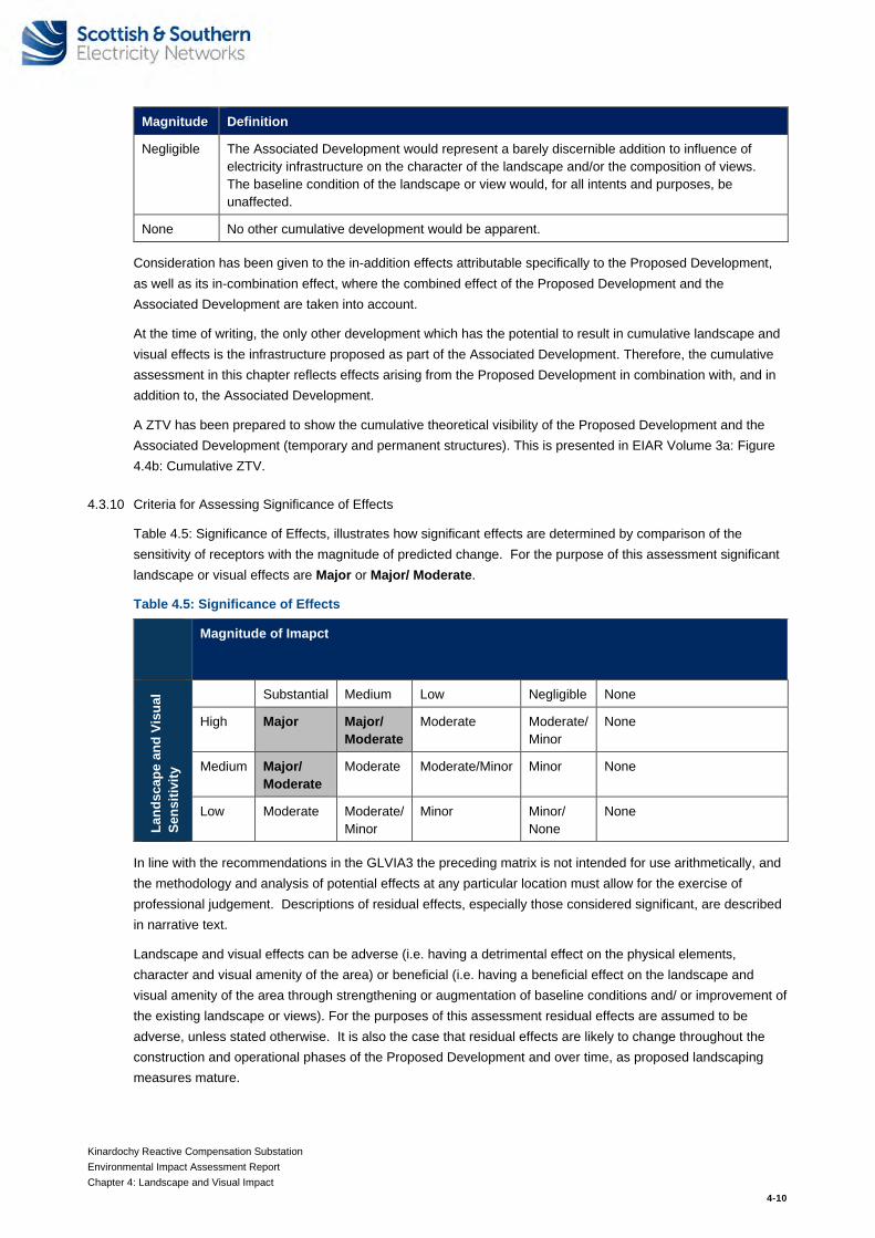
Kinardochy Reactive Compensation Substation Environmental Impact Assessment Report Chapter 4: Landscape and Visual Impact 4-10
Magnitude Definition Negligible The Associated Development would represent a barely discernible addition to influence of
electricity infrastructure on the character of the landscape and/or the composition of views. The baseline condition of the landscape or view would, for all intents and purposes, be unaffected.
None No other cumulative development would be apparent.
Consideration has been given to the in-addition effects attributable specifically to the Proposed Development, as well as its in-combination effect, where the combined effect of the Proposed Development and the Associated Development are taken into account.
At the time of writing, the only other development which has the potential to result in cumulative landscape and visual effects is the infrastructure proposed as part of the Associated Development. Therefore, the cumulative assessment in this chapter reflects effects arising from the Proposed Development in combination with, and in addition to, the Associated Development.
A ZTV has been prepared to show the cumulative theoretical visibility of the Proposed Development and the Associated Development (temporary and permanent structures). This is presented in EIAR Volume 3a: Figure 4.4b: Cumulative ZTV.
4.3.10 Criteria for Assessing Significance of Effects
Table 4.5: Significance of Effects, illustrates how significant effects are determined by comparison of the sensitivity of receptors with the magnitude of predicted change. For the purpose of this assessment significant landscape or visual effects are Major or Major/ Moderate.
Table 4.5: Significance of Effects
Magnitude of Imapct
Land
scap
e an
d Vi
sual
Se
nsiti
vity
Substantial Medium Low Negligible None
High Major Major/ Moderate
Moderate Moderate/ Minor
None
Medium Major/ Moderate
Moderate Moderate/Minor Minor None
Low Moderate Moderate/ Minor
Minor Minor/ None
None
In line with the recommendations in the GLVIA3 the preceding matrix is not intended for use arithmetically, and the methodology and analysis of potential effects at any particular location must allow for the exercise of professional judgement. Descriptions of residual effects, especially those considered significant, are described in narrative text.
Landscape and visual effects can be adverse (i.e. having a detrimental effect on the physical elements, character and visual amenity of the area) or beneficial (i.e. having a beneficial effect on the landscape and visual amenity of the area through strengthening or augmentation of baseline conditions and/ or improvement of the existing landscape or views). For the purposes of this assessment residual effects are assumed to be adverse, unless stated otherwise. It is also the case that residual effects are likely to change throughout the construction and operational phases of the Proposed Development and over time, as proposed landscaping measures mature.
Kinardochy Reactive Compensation Substation Environmental Impact Assessment Report Chapter 4: Landscape and Visual Impact 4-11
4.3.11 Limitations and Assumptions.
The LVIA has been prepared in accordance with current standards and guidance. Commercially obtained data utilised in the preparation of the LVIA has a number of inherent tolerances and limitations. Where this is relevant to the findings of the assessment it is stated.
The data utilised in completion of the LVIA has a number of inherent limitations related to data tolerances and levels of accuracy. However, these have been taken into account in the assessment.
4.3.12 Measurement
Unless stated otherwise, all measurements pertaining to the distance of receptors from the Project Site are based upon the outmost edge of the proposed substation or Associated Development rather than the nearest visible element or any other ancillary element of the Proposed Development. Where measurements pertain to Landscape Character Types (LCTs), designation and classifications, the measurement given relates to the nearest section of the LCT or designated/ classified area boundary to the outermost edge of the Proposed Development and Associated Development, which may not be subject to potential views of the Proposed Development or Associated Development. This is important because effects experienced within such areas may occur at a considerably greater distance, with corresponding consequences for the level of residual effect.
4.4 Baseline Conditions The Project Site is located 3 km south of the Village of Tummel Bridge, and 16 km west of the town of Pitlochry. The Project Site would be located within and adjacent to a topographical basin between Meall Damh to the east, and the foothills of Schiehallion, a popular Munro, to the west.
4.4.1 Topography
The Project Site is located within a gently sloping landform on the north eastern edge of Lock Kinardochy, which sits in a topographical basin within an undulating lowland landscape. The landform throughout the study area ranges in elevation from 364 m AOD and 787 m AOD, and comprises a mix of gently graded slopes, rolling hills and steep and craggy ridges. To the west of the Site, the landform rises out of the Loch Kinardochy basin to form the eastern foothills of Schiehallion. The prominent peak of Schiehallion is located 5.6 km west of the Site, outwith the study area.
4.4.2 Hydrological Features
Given the nature of topography, there are numerous watercourses which flow through the landscape of the study area. The key hydrological feature within the study area is Loch Kinardochy, located to the south of the Site. The loch is served by the Allt Gleann Gobhlandaigh burn which flows north, through Loch Kinardochy, before merging with the Allt Kinardochy burn and outfalling into Loch Tummel to the north. In the wider landscape of the study area, a number of small burns flow from the hills into Loch Tummel.
4.4.3 Landcover
To the north of the study area, the vegetation is comprised of semi-improved grassland and rough grassland, with small areas of heather moorland and a small area of ancient woodland. Young native shrubs and trees have begun to recolonise parts of the study area suggesting new change in forestry management practices. Vegetation cover throughout the central extent of the study area predominately comprise of coniferous forestry plantations interspersed by areas of rough grassland and open heather moorland. Felled forestry and forestry debris cover sections of the hillsides. To the south east and north west of the study area there are large geometric blocks of coniferous forestry. These are managed on a rotational basis with sections of rotational felling. In the higher ground within the study area, rough grassland and hillocks of heather appear to dominate the landcover.
Kinardochy Reactive Compensation Substation Environmental Impact Assessment Report Chapter 4: Landscape and Visual Impact 4-12
4.4.4 Land Use
Land use within the study area is predominately commercial forestry, with coniferous plantations located through the central and northern extents of the study area. In the north, the land use appears to be comprised of semi improved and rough pastoral grassland, generally used for grazing. In the west and east of the study area, large coniferous forestry plantations form a key feature within the landscape, forming part of the rotational felling cycle. Large areas of open heather moorland are situated throughout the south and east of the study area, used for rough grazing. Additionally, there are five operational transmission lines, as shown in EIAR Volume 3a: Figure 1.1: Site Location, which traverse northwards – southwards through the central extent of the study area, towards Tummel Bridge, including:
• The existing Beauly-Denny line, routed in a north to south direction along the western boundary of the Site (of the Proposed Development), to the west of the proposed substation platform. This OHL also crosses over the proposed access track to T227. The existing Beauly-Denny line will be modified as part of the proposed works for the Associated Development;
• An existing 132 kV OHL, routed in a north to south direction 120 m west of the Site at its closest point. This OHL will be modified as part of the proposed works for the Associated Development. This OHL is also located 0.1 km west of the proposed access track to T227;
• An existing 33 kV OHL, routed in a north to south direction, located 170 m west of the Site (of the Proposed Development) at its closest point. This OHL is also located 0.1 km west of the proposed access track to T227;
• An existing 33 kV OHL, routed in an east to west direction, located 250 m west of the Site (of the Proposed Development) at its closest point;
• An existing 132 kV OHL, routed in a north west to south east direction, along the eastern boundary of the Site (of the Proposed Development), parallel to the proposed access junction to the Site. This OHL also crosses over the proposed access track to T227;
• The existing Tummel Power Station is located 2.2 km north / north west of the Project Site at its closest point, the proposed access track to T227;
• The existing 275 kV Tummel Substation is located 2.5 km north west of the Project Site at its closest point, the proposed access track to T227; and
• The existing 132 kV Errochty Substation is located 2 km north of the Project Site at its closest point, the proposed access track to T227.
4.4.5 Landscape Character Types
There are three LCTs within the study area (see EIAR Volume 3a: Figure 4.1: Landscape Character Types). The 2020 Scottish Natural Heritage (SNH) Landscape Character Assessment (LCA) has been used for the purposes of this report as it provides material from the most up to date descriptions of the character of the landscape.
The study area contains the following LCTs:
• SNH 375 – Lower Upland Glens and Lochs LCT;
• SNH 376 – Summits and Plateaux Tayside LCT; and
• SNH 371 – Mid Upland Glens LCT
Both the Proposed Development and Associated Development are located on the merging boundary of the Lowland Upland Glens and Lochs LCT and the Summits and Plateaux Tayside LCT, as shown in EIAR Volume 3a: Figure 4.1: Landscape Character Types.
Kinardochy Reactive Compensation Substation Environmental Impact Assessment Report Chapter 4: Landscape and Visual Impact 4-13
The Lower Upland and Glens Loch LCT is confined to the area in and around Loch Tummel and is comprised of a large loch within a level floodplain, set within a broad valley. Although, this LCT shares similar characteristics with the Mid Upland Glens with Lochs, with the area surrounding Loch Tummel being subtly different, in part, due to the lower hills (Between 400 – 600 m, compared with 600 – 1000 m) and slightly shallower slopes. Within the study area, this LCT comprises craggy peaks, rounded hills, including Meall Damh to the east. The landcover within the LCT is typified by a patchwork of coniferous forestry at different stages of growth, which forms a key component of the landscape character, mostly occupying the upper slopes of the valley.
Settlement is sparse within the LCT, primarily concentrated along the lower slopes of the valley. There are a number of overhead transmission lines which traverse the LCT creating linear corridors through areas of coniferous forestry, further adding to the texture and pattern of the landscape and its managed and developed aspect. Furthermore, the LCT as it sits within the study area is traversed by the B846, which routes north – south and is the main transport route throughout the study area.
The existing character and condition of this landscape provides opportunities for the accommodation of a development of the type proposed using elements that are characteristic of the existing landscape (e.g. landform and forest cover) and is of medium sensitivity.
The Summits and Plateaux Tayside LCT comprises an area of upland which separates the principle glens in Tayside, north of the Highland Boundary Fault Line. It forms the some of the highest and remotest uplands found within western and northern Perth and Kinross. Within the study area the LCT forms an important scenic and dramatic backdrop to the lower glens and straths, with Schiehallion forming a focal point in views. The landcover within the LCT as it sits within the study area boundary is comprised of large-scale vegetation patterns, reflecting altitude and exposure, including heather, grassland, blanket bog plant communities. The landscape is generally managed as an open moorland and heather burn scars are visible across the hillsides. A number of high voltage transmission lines route north–south through the LCT within the study area and cut linear corridors through areas of coniferous forestry plantations. There is little to no settlement within the LCT, with minor tracks used for sporting, forestry and some recreational access, as well as newer more visible temporary tracks to transmission lines construction/ operational and some forestry operations.
This landscape is of a large scale. It is open and exposed and has a high sensitivity.
The Mid Upland Glens LCT is located within part of Tayside to the north of the Highland Boundary Fault Line. Glens, formed by the combination of glacial and river erosion, provide one of the principle structural elements in the landscape. The broad valley floor within the LCT is well defined, ranging between 0.5 km and 1 km in width. Valley floors a typically between 100 – 200 m and the enclosing slopes rise more gently to between 300 – 600 m. These summits are generally rounded in the east and craggier and more clearly defined in the west. The landcover of the LCT within the study area contain native oak and birch woodland on steeper valley slopes and on poorer land within the valley floor. The semi-natural birch and oak woodland makes a significant contribution to the landscape character, concentrated particularly on steeper valley slopes. There is additionally a significant amount of coniferous forestry vegetation, tending to be large in scale, occupying areas of the valley sides. Older plantations are generally less well integrated into the landscape, often comprising geometric blocks apparently unrelated to landform. An extensive amount of agricultural activity is concentrated within the valley floor. The lower slopes of the glens are more settled than the upland sections, although, still comparatively sparsely settled. It must be noted this LCT forms a small part of the LCTs within the study area and is heavily screened from the from the other LCTs by the intervening topography of Creag Kynachan.
The existing character of this landscape provides opportunities for the accommodation of a development of the type proposed using elements that are characteristic of the existing landscape (e.g. landform and forest cover) and is of medium sensitivity.
Kinardochy Reactive Compensation Substation Environmental Impact Assessment Report Chapter 4: Landscape and Visual Impact 4-14
4.4.6 Night Landscape Character
All three of the landscape character types considered are typified by an essentially dark rural aspect, subject to the influence of few artificial light sources. The main sources of artificial light are low lying and associated with scattered properties, steadings and vehicles on the local road network. Where lights do occur, they often form prominent focal points in the landscape. The night time character of the landscape within the Project Site is of a medium sensitivity.
4.4.7 Landscape Designations
The Loch Rannoch and Glen Lyon National Scenic Area (NSA) is located 1 km west/ southwest of the Project Site at its closest point (the proposed access track to T231) and 1.3 km west/ southwest of the Site. The Loch Tummel NSA is situated immediately east of the Project Site at its closest point, as shown in EIAR Volume 3a: Figure 4.2: Landscape Designations. In addition, a small section of the Schiehallion/ Breadalbane – Schiehallion WLA is located 2.7 km to the west/ southwest of the Project Site. These nationally important landscapes, for the purpose of this assessment, are judged to have a high sensitivity to the type of development proposed.
Loch Rannoch and Glen Lyon NSA
The NSA extends north incorporating Loch Rannoch, south just north of Loch Tay, west towards Meall Dubh and eastwards to Meall Crumach. The NSA special qualities8 are characterised by:
• Epitome of mountain grandeur of Highland Perthshire;
• A clear linkage of land use and landform;
• A combination of natural and cultural beauty;
• The great diversity of woodland;
• Secluded side glens and ancient shielings;
• The wild summits;
• Peacefulness and tranquillity;
• The long, narrow sinuous Glen Lyon;
• The great expanse of Loch Rannoch;
• The long, symmetric mass of Schiehallion; and
• The dominance of Ben Lawyers.
Loch Tummel NSA
Loch Tummel NSA: the western extent of this NSA is located within the study area, with the NSA encircling Loch Tummel, forming the main element within the NSA. Special qualities of the NSA’s9 of relevance to the LVIA are described as follows:
• A breathtakingly beautiful landscape, both lowland and highland;
• Loch Tummel, the heart of the NSA;
• Rich and varied woodlands;
• Peacefulness and tranquillity;
• The celebrated Queen’s view;
8 Scottish Natural Heritage Commissioned Report No. 374, (2010). The special qualities of the National Scenic Areas [online] Available at: <https://www.nature.scot/sites/default/files/2017-07/Publication%202010%20-%20SNH%20Commissioned%20Report%20374%20%20The%20Special%20Qualities%20of%20the%20National%20Scenic%20Areas.pdf> [Last accessed 25 April 2020]. 9 Scottish Natural Heritage, (2010), The special qualities of National Scenic Areas (Commissioned Report No. 374)
Kinardochy Reactive Compensation Substation Environmental Impact Assessment Report Chapter 4: Landscape and Visual Impact 4-15
• Spectacular and famous mountain gorge – The Pass of Killiecrankie; and
• The picturesque Linn of Tummel.
4.4.8 Visual Amenity
Settlements
Throughout the study area there are a number of scattered properties. The closest residential property is Tombreck farmhouse, located 900 m north of the Site. Existing coniferous forestry plantation are present to the south, east and west of the property, and screen the property from the local road network. Approximately 1.1 km south east of the Site is Tomphubil Lodge. Views from the lodge are restricted and constrained by dense coniferous forestry vegetation to the north.
White Bridge is an isolated residential property located 1.6 km south from the Site. The property is located within upper Glengoulandie and is surrounded on three sides by mature shelterbelts.
Braes of Foss is situated just adjacent to a minor road at 1.7 km west of the Site. Views from the property are orientated north–east along the small strath associated with the Allt Kynachan burn.
Additionally, to the north east beyond the Forestry and Land Scotland (FLS) commercial forestry plantations there are several more residential properties including two properties located at Foss Mill, 700 m north east of the Project Site (the proposed access track to T231). One of these properties has a southern aspect bounded by coniferous forestry. The second, larger property is surrounded by coniferous forestry with small breaches providing longer views.
For the purposes of this assessment, views from settlements are considered of high sensitivity.
Transport Routes
There are two main transportation routes which traverse the study area, following the valley floors. Views from these routes are generally contained by intervening topography, roadside vegetation, woodland and coniferous forestry vegetation, which foreshorten and channels views. These routes comprise the B846 and the C450 Schiehallion Road.
The B846 routes north–south through the study area between Aberfeldy and Tummel Bridge, passing directly to the east of the study area boundary. The route follows the valley floor, contained by the lower slopes of Meall Damh, Meall Odhar and Dun Coillich. Additionally, there is the Beauly-Denny line and two other 132 kV transmission lines which route adjacent to the route from the southern extent of the study area boundary. The route within the study area passes through a mosaic of heather moorland, commercial coniferous forestry plantations and a narrow section of ancient woodland. Roadside vegetation at the northern extents of this route restricts/ filters views whilst south of Tomphubil, the reduced frequency of roadside vegetation provides a more open aspect.
The C450 is one of the longest routes within the study area, routing from Loch Kinardochy northwards towards Kinloch Rannoch. The route is the main access for scattered rural residential properties, which are present within the surrounding landscape. Within the study area the route routes adjacent to the Beauly-Denny line, a 132 kV OHL and a 33 kV OHL. A private access track to Tombreck farmhouse abuts the minor road, where the route traverses underneath the 132 kV OHL above. The route winds through the terrain crossing the foothills of Schiehallion, and eventually following the southern shore of Loch Rannoch. The route cuts through the landscape covered by a mosaic of heather moorland, coniferous forestry plantations and forest regeneration. Throughout the study area, existing transmission pylons, post and wire fencing and roadside dwellings are inversible along the route.
Kinardochy Reactive Compensation Substation Environmental Impact Assessment Report Chapter 4: Landscape and Visual Impact 4-16
Tourists and passengers utilising road transport routes are considered to have a high sensitivity, while general road users are considered to have a medium sensitivity as they are more likely to be travelling alone and focused on road conditions rather than the adjoining landscape.
4.4.9 Recreational Routes
Locally there are a number of core paths which are identified within the PKC’s core plan adopted in December 201710. EIAR Volume 3a: Figure 4.3: Recreational Routes, indicates the location and extent of the Core Pathways within the study area. There are no formal recreational routes within the Site , with the closest being the B846 at White Bridge to Schiehallion (DULL/147), located 1.3 km south/south west of the Site at its closest point. This forms a 2.8 km link between the upper Glengoulandie, and the core path to Schiehallion. The route abuts the southern edge of the coniferous forestry plantation traversing the mid slopes of Dun Collich, a hill to the south of the Proposed Development and Associated Development.
Approximately 1.9 km west of the Site, Core Path RANN/108 – Schiehallion Core Path commences at the Braes of Foss car park. This core path is also the beginning of the recognised route to the summit of Schiehallion, the peak of which is located 5.7 km west of the Proposed Development and outwith the LVIA study area. From the car park the path runs along the edge of coniferous forestry plantations as it ascends up the lower ridges of Schiehallion, before exiting the study area in the north/ north west.
Walkers using core paths are considered to be of high sensitivity.
4.4.10 Representative Viewpoints
The location of each representative viewpoint (VP) is shown in EIAR Volume 3a: Figure 4.4.
Table 4.6: Representative Viewpoint Baseline View presents a description of the existing view from each VP.
Table 4.6: Representative Viewpoint Baseline View
Viewpoint Location
Baseline View Sensitivity
Viewpoint: 1 B846 at Tomphubil/ 277760, 754573
This viewpoint on the B846 at the junction to Tomphubil limekiln car park, 1.2 km SSW from the Site. Loch Kinardochy forms a focal point in the view. The foreground of the view comprises an area of low lying topography associated with Loch Kinardochy, with low ridges rising and views to distant hills. The ridge associated with Beinn a’ Chuallaich can be seen with distant views to hills above Gaick Forest. Landcover comprises a mosaic of wet grassland with heather to raised areas. Scattered birch, willow and spruce trees have colonised flatter areas. To the mid ground of the view commercial spruce and larch are evident. A minor road passes through the forestry. Grid infrastructure is a notable constituent of the view, including existing 275 kV and 132 kV line which extend above the skyline. Key views are to the north/ north west, towards Creag Kynachan with Loch Kinardochy forming a prominent landscape feature within the foreground. The area is characterised by undulating landform and dense evergreen coniferous forestry blocks.
Road users: Medium Recreational users: High
10 Perth and Kinross Council (2017) Pkc.gov.uk. 2020. Perth & Kinross Council - Core Paths Plan Interactive Map. [online] Available at: <https://www.pkc.gov.uk/corepathsmap> [Last accessed 28 April 2020].
Kinardochy Reactive Compensation Substation Environmental Impact Assessment Report Chapter 4: Landscape and Visual Impact 4-17
Viewpoint Location
Baseline View Sensitivity
Viewpoint: 2 Tombreck Access/ 276987, 755953
This viewpoint is located on the Tombreck access road, 150 m north/ north west of the Site. The viewpoint set amidst a gently undulating landform that forms a horizon in the middle ground and which is typified by a mosaic of heather moorland, rough grassland and coniferous forestry. The aspect is essentially open, but contains existing utility infrastructure, routing north–south, forming focal points within the landscape.
The view is intersected by grid infrastructure which extend above the canopy and skyline. Key views are to the north/ north east away from the Associated Development. The area immediately to the north is largely void of notable vegetation i.e. forestry or woodland and is comprised of rough grassland and heather moorland forming the lower part of the view.
Road users: Medium
Viewpoint: 3 C450 Schiehallion Road (north) 276528, 755709
This viewpoint is located on a minor road, 500 m west of the Site. Within the view from this location, topography is varied, with localised rounded hillocks visible in the foreground, including Tom an Aonaich. The land rises to form a ‘whale-back’, punctuated by the peaks of Meall Tairneachan and Farragon Hill which interrupt the otherwise gently graded horizon. In the background, long distance views of the hills above Loch Tummel are available. The foreground of the view is typified by a mosaic of heather moorland rough grassland and mire on lower terrain. Commercial conifer forest forms a backcloth of larch and spruce up to lower slopes of the hills beyond. The minor road winds through the landscape before disappearing in the middle distance. The 275 kV and 132 kV transmission lines pass across a large proportion of the view, and the towers form a dominant feature in the landscape. The key views are to the north from this location, towards Loch Tummel and the distant hills. The view to the north comprises low lying vegetation allowing for long distance views.
Road users: Medium
Viewpoint: 4 C450 Schiehallion Road (south) 277521, 754566
This viewpoint is located on a minor road, 1 km to the south of the Site. Scattered coniferous forestry and lochs are key elements in the view. Topography in the vicinity of the viewpoint is generally flat with some small hillocks apparent. Loch Kinardochy occupies a low point in the landscape and is enclosed by forested slopes. Beyond the forest the upper hills form a distant backdrop. The foreground consists of a mosaic of heather, mire and rough grassland punctuated by colonising birch, willow and spruce saplings. Coniferous forestry covers the middle distance. Some sections of forestry have been clear felled and is regenerating to rough grassland. Key views are to the north, over Loch Tummel and to some distant hills. The view comprises already existing OHL infrastructure, which comprise a 275 kV and 132 kV transmission route, with the steel lattice towers forming key elements in views.
Road users: Medium
Viewpoint: 5 This viewpoint is located on a core path (DULL107) linking White House to the recognised route to the summit of Schiehallion, 1.5 km
Recreational users: High
Kinardochy Reactive Compensation Substation Environmental Impact Assessment Report Chapter 4: Landscape and Visual Impact 4-18
Viewpoint Location
Baseline View Sensitivity
Core path DULL/147 276673, 754116
to the south west of the Site. The route is flanked on either side by dense coniferous forestry as it rises in elevation. The topography within the local area is characterised by gently undulating landform. Recent felling has taken place, which allows for panoramic views across Loch Kinardochy and further north. In the foreground the vegetation is comprised of heather moorland with some scattered pioneer tree species, mostly around small water courses. The middle ground view consists of dense blocks of coniferous forestry, with existing grid infrastructure punctuating above the canopies.
The background view is dominated by distant hills, including Beinn Dearg, Beinn Bhreac and An Sgarsoch. From this location clear and panoramic views are attainable north/north west/north east. Due to the existing coniferous forestry vegetation in the middle ground, any intervisibility with lower third of the Associate Development is predicted to be reduced.
4.4.11 Summary of Sensitive Receptors
Table 4.7: Summary of Sensitive Landscape and Visual Receptors, identifies the sensitive receptors within the study area, including both landscape and visual receptors. Additionally, the overall sensitivity of the receptor to change is indicated.
Table 4.7: Summary of Sensitive Landscape and Visual Receptors
Receptor Receptor Sensitivity
Landscape Fabric Medium
Landscape Character: SNH 375 – Lower Uplands Glens and Lochs LCT; and SNH376 – Summits and Plateaux Tayside LCT;
High
Landscape character: SNH 371 – Mid Upland Glens LCT
Medium
Landscape Designations: Loch Rannoch and Glen Lyon NSA; and Loch Tummel NSA
High
Residents of scattered properties High
Recreational users and walkers High
Tourists High
Road Users Medium
The Proposed Development is located within a largely rural landscape characterised by a low topographical basin with dense coniferous forestry and pasture bisected by existing grid infrastructure and local roads. The form of the landscape and prevalence of forest cover provides potential for screening/filtering of views of the Proposed Development from many of the sensitive neighbouring receptor locations.
Kinardochy Reactive Compensation Substation Environmental Impact Assessment Report Chapter 4: Landscape and Visual Impact 4-19
4.5 Assessment of Likely Effects The following section identifies the construction and operational impacts which are likely to arise as part of the Proposed Development, and that could lead to significant effects on the landscape and visual resource. It also takes into account those impacts arising from the Associated Development, and the potential for cumulative effects when considered in combination/ in addition to the Proposed Development.
Section 4.7 provides a full assessment of effects following the implementation of committed mitigation, as set out in Section 4.6.
4.5.1 Potential Construction Effects (The Proposed Development)
The construction phase of the Proposed Development would last approximately 26 months in duration, commencing in November 2021. The methods that would be utilised during the construction stage are described in Chapter 2: Development Description.
The impacts arising from the following elements and activities associated with the construction phase of the Proposed Development have the potential to result in significant effects on the landscape and visual amenity of the study area:
• The construction of a new site access track and bell mouth entrance;
• Removal of field boundaries, rough grassland, coniferous forestry and heather moorland vegetation and the alteration of the existing topography within the Site and incorporation of steep batters and mounding and areas of exposed earth that would contrast in form and colour to the existing landscape.
• Construction of temporary site compound incorporating site offices;
• Establishment of temporary stockpiles of felled trees adding to the complexity and disturbance of the Site;
• Establishment of temporary spoil heaps/ soil stockpiles that would add to the disturbance visible at the Site and detract from the rural aspect;
• Temporary structures such as cranes, site fencing, scaffolding (including any acoustic fencing), lighting columns, site offices and the movement of construction traffic have potential to add complexity and additional prominent vertical structures to the landscape and add to the prominence of existing grid infrastructure;
• Construction of substation and associated compound, incorporating several buildings to house grid infrastructure;
• HGV and abnormal load deliveries to site and movement of vehicles on site;
• Inclusion of lighting within the compound and at construction locations, on site vehicles and delivery vehicles, with resultant lighting impacts on the largely dark night character of the landscape;
• Removal of temporary structures and spoil heaps/soil stockpiles and reinstatement and landscaping works, which could begin the partial reversal and mitigation of construction impacts.
• Reinstatement work, including removal of temporary accommodation works; and
• Earth mound screening creation/ habitat enhancement works.
The majority of effects during this phase would concern disturbance of existing landcover within the Site and potential for long term change or loss of characteristic vegetation with consequent significant effects on the local character and amenity of the Site and the adjoining area. A large proportion of the construction effects would be managed through the good practice and careful construction and management regimes.
Significant effects are anticipated, primarily within the Site and host LCT. These would primarily be associated with the scale of construction work to build the construction compound and substation platform, and consequent loss of characteristic vegetation cover. Such activities would be largely reversible through reinstatement of vegetated areas outwith the substation area.

Kinardochy Reactive Compensation Substation Environmental Impact Assessment Report Chapter 4: Landscape and Visual Impact 4-20
4.5.2 Potential Cumulative Construction Effects (The Associated Development)
The following elements and activities associated with the construction phase of the Associated Development which have the potential to result in significant in-combination/ in addition cumulative construction effects on the landscape and visual amenity of the study area:
• Site clearance;
• excavation of the existing ground for tower construction;
• Installation of new tracks and the upgrading of the track leading to T227;
• reinstatement works;
• Loss of vegetation within the construction of Associated Development, and consequent construction of the towers; and
• Presence of construction activity (including movement) and construction equipment such as excavators, tractors, cranes and scaffold tunnels.
There is potential for significant cumulative effects within the Project Site and host LCT as a result of the use of large cranes to construct the proposed transmission towers in addition to the scale of construction work to build the construction compound and substation platform, and consequent loss of characteristic vegetation cover. Such activities would be largely reversible through reinstatement of vegetated areas outwith the substation area.
4.5.3 Potential Operational Effects (The Proposed Development)
The operational elements of the Proposed Development with the potential to significantly affect the landscape and visual amenity of the study area are:
• The presence of a new access road and associated junction and embankments (e.g. traffic signs, barriers and footways) into what is essentially a rural area;
• The permanent loss of landscape features such as scrub vegetation, areas of heather peatland, pastoral land and field boundaries;
• Permanent/ long-term alteration of the topography of the Site and immediate surroundings and establishment of uncharacteristic landforms;
• The addition of what may be considered anomalous features to the landscape, include site plant and structures, with potential to adversely affect both the character and amenity of the area; and
• Disturbance, movement and activity associated with maintenance activities.
Significant effects likely to arise during the operational period of the Proposed Development would result from the presence of the substation building, which represents the most visible aspect of the operational development, and the scale of the substation compound resulting in the permanent loss of landscape features.
4.5.4 Potential Cumulative Operational Effects (The Associated Development)
The following elements and activities associated with the operational phase of the Associated Development which have the potential to result in significant in-combination/ in addition cumulative effects on the landscape and visual amenity of the study area:
• Presence of additional OHL Infrastructure within the landscape; and
• Disturbance, movement and activity associated with maintenance activities.
Significant effects arising during the operational period of the Associated Development in addition to the Proposed Development would likely arise from the permanent new towers, which represent the most visible aspect of the Associated Development.
Kinardochy Reactive Compensation Substation Environmental Impact Assessment Report Chapter 4: Landscape and Visual Impact 4-21
4.6 Mitigation
4.6.1 Mitigation During Construction (The Proposed Development)
Mitigation through Design
A Reinstatement and Landscape Design Specification (See EIAR Volume 4: Technical Appendix 2.2) has been prepared in parallel with the design of the substation in order to mitigate the construction and operational impacts of the Proposed Development, ensuring that the operational development becomes assimilated with the adjoining landscape over time.
The specification incorporates site batters and earth mounds which would be covered with a suitable substrate recovered during construction operations in order to establish vegetation. These areas would be seeded and landscape features created to be reflective of woodland in the wider landscape. Proposed areas of woodland would screen/ filter any potential views of the Proposed Development for users of the B846, C450 Schiehallion Road and visual receptors within the wider landscape such as from nearby scattered properties including Tombreck and Braes Lodge.
The new woodland planting would consist predominantly of suitable locally native species, augmented with additional coniferous species to increase year-round screening of the Proposed Development and would be sourced locally or from a Scottish supplier. Species would be selected from Table 2.1: Species to be used in New Woodland Mitigation Planting (see Chapter 2: Development Description) and are intended to enhance biodiversity.
4.6.2 Mitigation During Construction (The Associated Development)
No additional mitigation measures above those embedded measures presented and Chapter 3: Design Evolution and Alternatives are proposed.
4.6.3 Mitigation During Operation (The Proposed Development)
No additional mitigation measures above those embedded measures presented in the Reinstatement and Landscape Design Specification (See EIAR Volume 4: Technical Appendix 2.2) and Chapter 3: Design Evolution and Alternatives are proposed.
4.6.4 Mitigation During Operation (The Associated Development)
No additional mitigation measures above those embedded measures presented in the Reinstatement and Landscape Design Specification (See EIAR Volume 4: Technical Appendix 2.2).
4.7 Assessment of Residual Effects
4.7.1 Residual Construction Effects (The Proposed Development)
Effects on Landscape Fabric
Construction of the Proposed Development would result in the direct and permanent loss of areas of heather moorland pastoral land and riparian habitat, as well as up to 7.61 ha of coniferous plantation (as detailed in Chapter 9: Forestry). These impacts would be offset, to a large extent, by the mitigation delivered by the Reinstatement and Landscape Design Specification (See EIAR Volume 4: Technical Appendix 2.2), which includes the establishment of new woodland, heathland, grassland, wetland and hedgerow habitats. Compensatory planting to mitigate for the loss of forestry and woodland is described in Chapter 9: Forestry.
The construction would also result in a considerable alteration to the landform within the Site, in order to create the proposed substation platform, construction compound and access track. This change to the baseline condition of the Site would be permanent.
Kinardochy Reactive Compensation Substation Environmental Impact Assessment Report Chapter 4: Landscape and Visual Impact 4-22
On the basis of the preceding analysis and the medium sensitivity of this landscape, the magnitude of the construction impact on the existing landscape fabric of the Site is expected to be Substantial and equate to a Major/Moderate (significant) effect. However, such effects would be of relatively short duration, localised and largely reversed in the short to medium-term following cessation of construction operations and maturation of the proposed landscaping proposals, as described in EIAR Volume 4: Technical Appendix 2.2 Reinstatement and Landscape Design Specification and as shown by the visualisations in EIAR Volume 3b: Visualisations 4.1 – 4.5.
Effects on Landscape Character
SNH 376: Summits and Plateaux Tayside LCT
Construction activities would introduce considerable disturbance - in the form of felling, cranes, lighting, site fencing and buildings as well and the movement of construction traffic (such as large earth-moving machinery) – into a landscape which is predominately still and quiet in character.
Other aspects of the construction phase would include the creation of new earth mounds, cuttings and an access road, which would lead to the direct loss of landscape features within the Summits and Plateaux Tayside LCT including coniferous forestry and small sections of riparian vegetation.
The creation of these more formal landscape features within the Summits and Plateaux Tayside LCT represent a Medium magnitude of impact on the character of the LCT within the immediate area of the Site, which would result in a temporary localised Major/Moderate (Significant) adverse effect on the local landscape character. It should be noted that such effects would be highly localised, affecting the Site itself and the landscape immediately surrounding it. The majority of this LCT would remain unaffected (or affected to a non-significant degree). Moreover, the effects would be effectively mitigated in the short to medium-term following cessation of construction operations and establishment of the proposed landscaping proposals.
SNH 375: Lower Uplands and Glens and Lochs LCT
The Lower Uplands and Glens and Loch LCT is located to the north of the Site and is comprised of Loch Tummel and its level floodplain, within a broad glen. The LCT has significant vegetation cover, comprising areas of coniferous forestry and broadleaved woodland. The combination of the steep topography of the glen and upland landscape in combination with the baseline landscape structure serves to create a heightened sense of enclosure in and around Loch Tummel.
Given this context, it is predicted the majority of construction activities associated with the Proposed Development would not be visible from this adjoining LCT. Where the Proposed Development is theoretically evident, across the south western edge of the LCT, actual views would be screened effectively by intervening landscape elements. The magnitude of impact would be none. Consequently, construction effects on this landscape would be None.
SNH 371: Mid Upland Glens LCT
The Mid Upland Glens LCT forms part of Tayside which lies on the northern side of the Highland Boundary Fault Line. The vegetation cover within the LCT is primarily made up of native oak and birch on steeper slopes, and within poorer land on the valley floor. Construction activities associated with the Proposed Development would theoretically visible in temporary views from elevated ridges along the south eastern edge of this LCT. The key qualities of the LCT are concentrated within the glen landscape, from which no views of the Proposed Development are available.
Given the limited duration and marginal visibility of the construction elements of the Proposed Development, the magnitude of impact on the character and qualities of the Mid Upland Glens LCT would be Negligible, equating to a temporary Minor localised adverse effect on the character of the landscape.
Kinardochy Reactive Compensation Substation Environmental Impact Assessment Report Chapter 4: Landscape and Visual Impact 4-23
Night Landscape Character
The night-time character of the LCTs are typified by an essentially dark rural aspect with the exception of a few artificial light sources from properties, and from vehicles moving through the landscape. The construction activities associated with the Proposed Development would introduce further artificial light into the landscape. This additional light would come from construction elements such as site office cabins, lighting towers, machinery and other pieces of equipment, and would be both static (from buildings) and moving (light from vehicles/ machinery).
Construction work will be undertaken during daytime periods only. Working hours are currently anticipated to be between 07:00am to 19:00pm, up to seven days a week, and lighting would only be used during hours of darkness within the working day. Lights would be turned off when the Site was closed. Any additional work outwith these hours would be agreed in advance with PKC.
The change in the night-time character would represent a Medium temporary magnitude of impact, and a Moderate adverse temporary effect on the landscape character in the area of the Site. However, these effects would be localised and temporary. Effects would be restricted to the Summits and Plateaux Tayside LCT, with other LCTs within the study area remaining unaffected. Additionally, these effects would cease following completion of construction.
Effects on Landscape Designations and Classifications
Loch Rannoch and Glen Lyon NSA
Due to the steep sided topography which characterises the landscape of the Loch Rannoch and Glen Lyon NSA, theoretical visibility of the Proposed Development is limited. The ZTV in EIAR Volume 3a: Figure 4.4a: Viewpoint Locations and ZTV indicates that theoretical visibility is restricted to the eastern edge of the designated area as it lies within the study area, and is predominantly across elevated, site facing slopes. Actual visibility would be further reduced due to the screening effects of intervening forestry and woodland. Where visible, the Proposed Development would be viewed from an elevated position within an expansive view that contains many features, including operational electricity infrastructure. The key scenic qualities of the NSA would remain unaffected by the Proposed Development. Consequently, a Negligible short-term magnitude of impact resulting in a Minor effect are anticipated on this landscape designation. Such effects would not be significant and would not affect the integrity of the designation.
Loch Tummel NSA
The Loch Tummel NSA is principally focused inwardly towards Loch Tummel. Views across the broader landscape from within the NSA are limited by topography and vegetation, including forestry and woodland. As it lies within the study area, the ZTV indicates views of the Proposed Development from elevated site facing slopes to the east of the Site. However much of these areas of visibility are covered in woodland or forestry and actual views would be much reduced. The main qualities of the NSA would remain unaffected by the construction of the Proposed Development. Consequently, construction activities associated with the Proposed Development would have no notable impact or effect upon the character of the Loch Tummel NSA. The magnitude of impact would be Negligible. The effect would be Minor.
The Proposed Development is located outwith any designated areas and therefore the construction of the substation would have no direct physical effect on designated landscapes. Whilst indirect effects are likely, primarily as a result of the presence of cranes and the installation of equipment, such effects would be localised and would be of a relatively short duration through the construction phase only. Consequently, such impacts are not considered to represent significant effects on the two designated landscapes within the study area.

Kinardochy Reactive Compensation Substation Environmental Impact Assessment Report Chapter 4: Landscape and Visual Impact 4-24
Effects on Visual Amenity
Scattered Properties
The ZTV indicates that theoretical views of the Proposed Development are only available for the property at Tomphubil Lodge, located to the south east of the Site. Actual views of the majority of construction activity from this property would be substantially screened by vegetation which surrounds the property, existing coniferous forestry in the intervening landscape, and by local topography not picked up by the ZTV (EIAR Volume 3b: Visualisation 4.1: Viewpoint 1). Where views do occur, they would be of the tops of site cranes and other tall plant which reaches above the screening provided by landform in the middle distance.
Given the temporary and short-term nature of the construction works and reversibility of the construction visual impacts, for properties where there are views of the works the magnitude of impact would be Low, equating to a Moderate temporary adverse effect (not significant). All other properties would experience no visual effects from the construction of the Proposed Development.
Transportation Routes
The B846 routes north along the eastern side of Loch Kinardochy. Road users would have glimpsed views of a small extent of construction works due to screening provided by intervening landscape features, with the greatest impact being caused by cranes and other tall plant which extends above topography in the middle distance. The impacts associated with the construction works would be most noticeable in views from a small section of the B846 to the south east of the Site, as the route increases in elevation. Given the temporary and reversible nature of the works, and the transient nature of road travel, the magnitude of impact is considered to be Negligible, equating to a temporary Minor adverse effect on users of the B846 transport route during the construction phase.
The C450 routes north west to the west of the Site. Any construction works would be seen briefly in fleeting views as the road routes westwards. The construction works in the west of the Site would be visible from a small section of the overall route. Given the overall temporary nature of the construction works and the reversibility of some of the construction impacts, the magnitude of impact in views from the road would be Low, resulting in a temporary Minor adverse effect on users of the C450 during the construction phase, which would not be significant.
Recreational Routes
There are three recreational routes that pass through the study area, shown in EIAR Volume 3a: Figure 4.3: Recreational Routes. These include DULL/146, RAN/108 and DULL/147, all of these routes are located to the west/south west of the Site. The ZTV indicates that there are no theoretical views of the Proposed Development from Core Paths DULL/146 and RAN/108 as they lie within the study area. Therefore, the magnitude of impact on these two paths would be None.
The ZTV indicates that users of the DULL/147 core path would experience some theoretical views of construction works as the path climbs the northern slopes of Dun Coillich, which would be most notable in views for users travelling east, towards the B846. However, as indicated in Visualisation 4.5: Viewpoint 5, existing local topography and forestry would screen the works in views from this path. Therefore, the magnitude of impact and resulting effect would be None.
4.7.2 Residual Cumulative Construction Effects (The Associated Development)
The following section presents the effects on landscape and visual receptors within the study area as a result of the construction of the Associated Development.
It then provides an assessment of the cumulative effects arising from the construction of the Associated Development in combination with the Proposed Development.
Kinardochy Reactive Compensation Substation Environmental Impact Assessment Report Chapter 4: Landscape and Visual Impact 4-25
Landscape Effects arising from the Construction of the Associated Development
Effects on Landscape Fabric
The construction of the Associated Development would result in the loss of heather moorland and rough grassland in areas associated with the Project Site. Areas of vegetation would be removed to allow for access to, construction of, and decommissioning of the proposed permanent (T230R, T231A and the 132 kV NeSTS tower) and temporary (Temp T1 and Temp T2) towers, to construct the permanent access track to T227 and the temporary access track to T231. A 0.2 ha area of woodland would be felled to facilitate construction works of the proposed permanent access track to T227, as detailed in Chapter 9: Forestry. A small area of heather moorland/ rough grassland would be temporarily disturbed for the temporary access track to T231. The Associated Development is located within an area where the landscape fabric has been historically disturbed as a result of ongoing forestry operations, construction and maintenance of operational electricity infrastructure and access.
It is considered that the impacts arising from the construction of the Associated Development on the fabric of the Project Site would be of Low magnitude, temporary and reversible (where not required for permanent works). Following the completion of the construction works, the disturbed ground would be restored however it is acknowledged that this would take time to re-establish to the original condition. The effect would be Minor.
Effects on Landscape Character
The Associated Development is predominantly located within the Summits and Plateaux – Tayside LCT, with a section of permanent access track located within an area of woodland in the Lower Upland Glens with Lochs LCT.
Construction works associated with the proposed permanent and temporary towers would be located within an area of landscape already disturbed by forestry operations and characterised by existing transmission line infrastructure. Given its position, effects on the character of the landscape would be greatest at the Project Site and its immediate surroundings, where the influence of the Associated Development is highly discernible, however due to the nature of topography, the presence of woodland and forestry across the wider LCT and the expansive character of the landscape at higher elevations, overall the Associated Development would result in a minor addition to the influence of electricity infrastructure on the character of the LCT, The magnitude of impact on the Summits and Plateaux – Tayside LCT would be locally Medium in the area surrounding the Associated Development, reducing to Low across the LCT overall. The effect would be Major-Moderate, reducing to Moderate overall.
The construction works associated with the proposed access track to T227 would permanently remove an area of woodland in the extreme west of the Lower Upland Glens with Lochs LCT. Construction works would be similar to those undertaken during normal forestry or farm access operations within the wider area of the LCT and would not appear out of character. Additionally, construction works for the access track would be largely screened by the surrounding area of woodland. The magnitude of impact on the Lower Upland Glens with Lochs LCT is considered to be Low. The effect would be Minor.
There would be no indirect effects on other LCTs within the study area.
Effects on Landscape Designations
The Associated Development is not located within a designated landscape and therefore the construction of the permanent and temporary towers and associated access tracks and construction compound would not have any direct effect on a designated landscape.
Whilst indirect effects arising as a result of construction works for the installation/ decommissioning of the towers could occur on the Loch Rannoch & Glen Lyon or Loch Tummel NSAs (as they lie within the study area), those effects would be highly localised and would be of a relatively short duration. Impacts would be further

Kinardochy Reactive Compensation Substation Environmental Impact Assessment Report Chapter 4: Landscape and Visual Impact 4-26
reduced due to woodland, forestry and local undulations in topography present within the intervening landscape, screening views and the existing context of transmission infrastructure in the area of the Project Site. The magnitude of impact would be Negligible. The effect would be Moderate/ Minor, and temporary. Consequently, such impacts are not considered to represent significant effects on either NSA.
Cumulative Landscape Effects arising from the Construction of the Associated Development in Addition to the Proposed Development
The Proposed and Associated Developments are located within an area of landscape which has been modified consistently over time by forestry and farming practices and by implementation of electricity infrastructure. It is considered that cumulative impact on landscape fabric arising from the construction of the Additional Development in addition to the Proposed Development would have a low magnitude of impact, which would be temporary and reversible (where not required for permanent works). The cumulative effect of construction of the Proposed Development and Associated Development on the fabric of the landscape within would be Moderate and, following the completion of the construction works, the disturbed landscape would be restored as part of the landscape design and these effects would reduce. Over time, cumulative construction effects would reduce to Minor as the landscape mitigation planting matures and the landscape recolonises.
With regards to cumulative construction effects on landscape character, the construction works associated with the Associated Development would be less than those arising as a result of the Proposed Development (see Section 4.7.1). Construction of the Associated Development would introduce construction machinery and activity over a greater area, adjacent to the Site. However, as all construction activity would be located within the same topographical basin, and works would be contained by existing woodland and areas of forestry, the additional influence of construction activities on the character of the wider landscape would be limited. Therefore, the cumulative magnitude of impact on the Summits and Plateaux – Tayside LCT arising from the addition of the Associated Development is considered to be locally Medium, reducing to Negligible across the wider LCT. The effect would be Major/ Moderate, reducing to Minor overall. There would be no cumulative construction effects on other LCTs within the study area.
Similarly, cumulative construction effects on the Loch Rannoch & Glen Lyon and Loch Tummel NSAs arising as a result of the construction of the Associated Development in addition to the Proposed Development would be minimal. Both developments are located within a relatively low part of the landscape and therefore construction activity (where visible) would sit low in the view and would be backclothed by topography. Existing forestry and woodland would screen a high degree of construction works on the ground, and it is anticipated that only larger equipment and machinery such as cranes would be noticeable, viewed within the context of existing electricity infrastructure. These would not impact upon the integrity of the designated areas. The magnitude of impact would be Negligible and short term. The effect would be Moderate/ Minor.
Visual Effects arising from the Construction of the Associated Development
Effects on views from Scattered Settlement
The construction of the Associated Development would be theoretically visible from properties at Tomphubil Lodge, Braes of Foss, Tombreck Farmhouse and from two properties located at Foss Mill. Views of construction works from the closest properties to the works, Tombreck Farmhouse and Tomphubil Lodge, would be screened at ground level by intervening forestry and woodland. Views of the tops of cranes, and the construction of the permanent and temporary towers would be available.
Similarly, theoretical views would be experienced at Braes of Foss and two isolated properties at Foss Mill. The use of cranes, and the construction of the new towers/ decommissioning of existing tower is likely to be the only part of the Associated Development theoretically visible. However, given the presence of intervening woodland and forestry, and local undulations in topography, it is considered unlikely that any views would actually be available. All ground works would be screened in views from these properties.
Kinardochy Reactive Compensation Substation Environmental Impact Assessment Report Chapter 4: Landscape and Visual Impact 4-27
For all properties located within the study area the magnitude of impact on views arising from the construction of the Associated Development would be Low and temporary. As such, residual effects are considered to be Moderate.
Effects on views from Transport Receptors
From the B846, views of construction works for the Associated Development would be glimpsed, fleeting and temporary, and largely confined to the section of road which passes along the southern edge of Loch Kinardochy. Existing forestry would provide screening of ground works. The tops of cranes and the construction of the permanent and temporary towers would be partially visible above the treeline. Activity in this area would be discernible however due to the fleeting nature of views from the road and the nature of road travel, it is considered that the magnitude of impact would be Negligible. As the road continues north, views of the construction site would be fully screened by roadside vegetation. The magnitude of impact would reduce to None. The effect would be Minor reducing to None.
Users along the C450 Schiehallion Road between Loch Kinardochy and Kinloch Rannoch would have direct views of the construction site for a short duration as the road passes the Associated Development site. Due to the lack of intervening landscape elements such as vegetation, topography and the built environment the construction activities and temporary towers would be highly visible over a short duration. The magnitude of impact would be locally High however, due to the transient nature of views from the road this impact would be of a short duration. Overall, the magnitude of impact on views from the C450 Schiehallion Road would be Low. Therefore, residual effects are considered to be locally Major/ Moderate, reducing to Minor overall.
Effects on views from Recreational Routes
Due to the extensive screening in views from the DULL/146, DULL/147 and RAN/108 core path by forestry and localised topography not picked up by the ZTV, the construction works associated with the Associated Development are unlikely to be visible from these paths. The effect would be None.
Cumulative Visual Effects arising from the Construction of the Associated Development in Addition to the Proposed Development
Due to the generally low-lying positions of visual receptors within the study area (scattered residential properties, the B846 and the C450 roads, and identified core paths), views of construction activity associated with the Proposed Development and the Associated Development would be limited to cranes and other tall machinery. Existing vegetation and topography would screen a high degree of views of ground level activity.
The cumulative construction activity would have limited effects on views from these receptors. In locations where receptors are looking towards the Project Site from a more elevated location, such as from Core Path DULL/ 147, the presence of forestry would continue to screen views of ground level construction activity at the Site (see EIAR Volume 3b: Visualisation 4.5: Viewpoint 5).
The magnitude of cumulative construction impacts on residential receptors is Low. The effect would be Moderate (temporary).
The magnitude of cumulative impact on users of the B846 would be Negligible. This is due to the level of screening achieved by intervening forestry and proposed planting, and the fleeting duration of the view for road users. The effect would be Minor. For users of the C450 Schiehallion Road, the magnitude of cumulative impact would be High for a short duration as the road user passes the Project Site directly. This impact would reduce quickly once the road user has passed the site, and the developments are no longer visible. The residual effect would be locally Major/ Moderate, reducing to Minor overall.
The magnitude of cumulative impact on recreational receptors would be None.

Kinardochy Reactive Compensation Substation Environmental Impact Assessment Report Chapter 4: Landscape and Visual Impact 4-28
4.7.3 Residual Operational Effects
Effects on Landscape Fabric
No additional adverse effects on the landscape fabric within the Site are anticipated following the completion of the construction phase. Moreover, once matured the landscaping proposals, as detailed the Reinstatement and Landscape Design Specification (see EIAR Volume 4: Technical Appendix 2.2), would compensate for earlier losses and would strengthen the structure and condition of the landscape within and immediately adjoining the Site. This, in turn would aid the gradual assimilation of the Site into the wider landscape.
The magnitude of impact on landscape fabric would be None.
Effects on Landscape Character
SNH 376: Summits and Plateaux Tayside LCT
The Proposed Development would increase the presence of major utility infrastructure within a localised part of the LCT, introducing a new substation into an area currently used for forestry operations. However, the impact of the Proposed Development on the character of the landscape would be lessened due to the existing context of high voltage overhead transmission lines which pass through the landscape in this area, adjacent to the Site.
The Site sits within a low point in the landscape and is surrounded by woodland and forestry. While it is considered that the Proposed Development would alter the character of the landscape within the immediate area, these impacts would reduce quickly with distance due to the screening and filtering provided by vegetation and topography in the wider area. The influence of the Proposed Development across the overall LCT would be limited. In addition, the Reinstatement and Landscape Design Specification (see EIAR Volume 4: Technical Appendix 2.2) contains a series of measures to supplement the integration of the Proposed Development within a framework of locally appropriate landscape features. This would ensure screening or filtering of views should forestry in the area be removed.
Consequently the magnitude of impact, as a result of the Proposed Development, on the character of the Summits and Plateaux Tayside LCT would be Medium in the local area and would reduce to Negligible on the wider LCT overall. The effect would be Major/ Moderate adverse (significant) within the area immediately surrounding the development site, however this would reduce quickly with distance to Minor overall.
SNH 375: Lower Uplands and Glens and Lochs LCT
Where visible, the Proposed Development would be experienced at distance, and in the context of the existing electricity transmission infrastructure, slightly extending the influence of electricity infrastructure across the landscape but not introducing a new or unfamiliar land use. High levels of woodland and forestry within the landscape would screen a high majority of the Site, and it is considered that actual views of the Proposed Development from the LCT would be glimpses at most. The impact of the Proposed Development would be further mitigated by the Reinstatement and Landscape Design Specification (see EIAR Volume 4: Technical Appendix 2.2), which proposes appropriate structure planting to align with the pattern of vegetation already present and – once mature – would further reduce the influence of the Proposed Development on the character of this adjacent LCT. Should forestry surrounding the Site be removed, the proposed structure planting and existing areas of woodland in the wider landscape surrounding the Site would continue to achieve this.
As such, the magnitude of impact on the character of the Lower Uplands and Glens and Loch LCT would be Negligible resulting in a Minor effect that would be not significant.
SNH 371: Mid Upland Glens LCT
The ZTV indicates very limited theoretical visibility of the Proposed Development from the Mid Upland Glens LCT. Actual views would be further reduced due to the presence of woodland and forestry in areas where visibility is theoretically available, which would screen views. The influence of the Proposed Development on
Kinardochy Reactive Compensation Substation Environmental Impact Assessment Report Chapter 4: Landscape and Visual Impact 4-29
the character of the LCT would be indiscernible. The magnitude of impact on the character of the landscape would be Negligible, resulting in effects that would be Minor and not significant.
Night Landscape Character
The night-time character of the Summit and Plateaux -Tayside LCT is generally typified by an essentially dark rural aspects, with the exception of small artificial light sources associated with scattered residential properties and vehicles travelling through the landscape.
Task lighting is proposed at the Site however would only be used in the event of a fault or when essential maintenance works are required during hours of darkness. The proposed lighting has been designed so that light is directed internally towards the Site and does not illuminate areas outwith the Site.
Lighting, when in use, would be discernible in views from the surrounding area however would be similar in character to existing lighting within the landscape, such as from residential properties and vehicles. The magnitude of impact arising from the occasional use of lighting would be Negligible. The effect would be Moderate/ Minor.
Effects on Landscape Designation and Classifications
Loch Rannoch and Glen Lyon NSA
Theoretical visibility of the Proposed Development from the Loch Rannoch and Glen Lyon NSA is limited to the north eastern flank of Schiehallon, as it faces the Site. The majority of the NSA has no views of the Proposed Development. Actual views of the Proposed Development would be reduced due to the presence of woodland and forestry in the intervening landscape which would screen or filter views of part or all of the Proposed Development. From elevated locations where the Proposed Development is visible, the view extends across an expansive landscape which is characterised by infrastructure (including electricity infrastructure), forestry and woodland plantations, road networks, settlement and more open, upland landscape. The Proposed Development would form a relatively small feature within this open and expansive view and would sit within a low point in the landscape, within the context of existing electricity infrastructure. The Proposed Development would not impact upon the integrity of the designation. Should forestry in the foreground of the view be felled, it is likely that the Proposed Development would be more discernible in the view however, the Reinstatement and Landscape Design Specification (see EIAR Volume 4: Technical Appendix 2.2) would ensure that these impacts are minimised, and the development is assimilated into its surroundings as far as practicable. The magnitude of impact would be Negligible. The effect would be Minor.
Loch Tummel NSA
The ZTV indicates small areas of the Loch Tummel NSA would have theoretical views of the Proposed Development from elevated site facing slopes located to the east of the Site. Much of these areas of visibility are covered in woodland or forestry and therefore actual views of the Proposed Development would be substantially reduced. Where views are available, the Proposed Development would be glimpsed amongst woodland with only parts of the overall development visible – it would not be viewed in its entirety. Consequently, it is considered that the Proposed Development would have no notable impact upon the defining qualities of the Loch Tummel NSA. The magnitude of impact would be Negligible. The effect would be Minor.
Effects on Visual Amenity
Scattered Properties
In views from residential properties located to the north and south of the Site, the Proposed Development would be largely screened or filtered by existing topography and woodland or coniferous forestry. The Proposed Development would be set low in the view, within a natural topographical basin which is largely surrounded by established woodland and commercial forestry. Where views are available, the Proposed Development would be seen at distances of greater than 1.2 km. The implementation of the Reinstatement and Landscape Design
Kinardochy Reactive Compensation Substation Environmental Impact Assessment Report Chapter 4: Landscape and Visual Impact 4-30
Specification (see EIAR Volume 4: Technical Appendix 2.2) would provide additional screening to further reduce the visibility of the Proposed Development and supplement any screening required due to the felling of forestry. The Reinstatement and Landscape Design Specification would also further aid the integration of the Proposed Development into the existing landscape.
The proposed mitigation specified in the Reinstatement and Landscape Design Specification would also create a new earth mound to the south/south west of the proposed substation. This has been designed to break up any views onto the substation from the closest scattered properties in the surrounding landscape. While the proposed substation would not be entirely screened, the proposed planting across the earth bund would guide views across the top of the proposed structure and provide an element of visual interest which would also filter views of the Proposed Development.
Immediately following construction, prior to the maturation of mitigation planting, the magnitude of impact would be Low in views from scattered properties within the surrounding areas. This would reduce to Negligible following the gradual maturation of the proposed planting. The effect would be Moderate, reducing to Moderate/ Minor adverse and not significant.
Transport Routes
North bound users on the B846 would have glimpsed and fleeting views of the Proposed Development as the road passes to the south and south east of Loch Kinardochy, due to a gap in roadside vegetation. From this location, and as the road gains elevation, the gap in vegetation provides a brief but clear view towards the Site. The top of the proposed substation building within the Site would be glimpsed behind the hillside to the west, however, would not form a key feature within views from the road and would not be sky lined (see EIAR Volume 3b: Visualisation 4.1: Viewpoint 1). The Proposed Development would be seen at a distance over 800 m, within the context of rolling hills, existing grid infrastructure and screened by vegetation. It would not form a prominent feature within views, nor would it vastly contrast with the existing elements within the landscape. As the route ascends further, it is heavily bordered by roadside trees and scrub, which restrict and obscure views over Loch Kinardochy and subsequently the Proposed Development. The magnitude of impact for road users along the B846 is Negligible/ None. The magnitude of impact would be Minor/ None.
For road users travelling north/north west along the C450 Schiehallion Road, the Proposed Development would appear briefly and obliquely to the east as the road routes north west. The Proposed Development would be largely screened from this location, as the development is sited within a topographical basin and proposed landscape mitigation would provide further screening, The upper extremities of the Proposed Development would rise above the landform in the foreground of the view, however these elements would lie below the skyline and be backclothed by vegetated slopes and coniferous forestry and would be seen within the context of existing grid infrastructure (see EIAR Volume 3b: Visualisation 4.3: Viewpoint 3).
Impacts for road users along the C450 Schiehallion Road would be considered to be Negligible. The magnitude of impact would be Minor.
Recreational Routes
Recreational routes that pass through the study area are shown in EIAR Volume 3a: Figure 4.3: Recreational Routes.
The ZTV indicates that there are no theoretical views of the Proposed Development from Core Paths DULL/146 and RAN/108 as they lie within the study area. Therefore, the magnitude of impact would be none.
The DULL/147 core path is located south west of the Site. The ZTV indicates that views of the Proposed Development would theoretically available from the middle section of the route. In recent years felling operations has removed coniferous forestry vegetation, opening up the views along the central section of the route. However, as indicated by EIAR Volume 3b: Visualisation 4.5 Viewpoint 5, views of the Proposed Development would remain screened by intervening vegetation, which would be strengthened by proposed
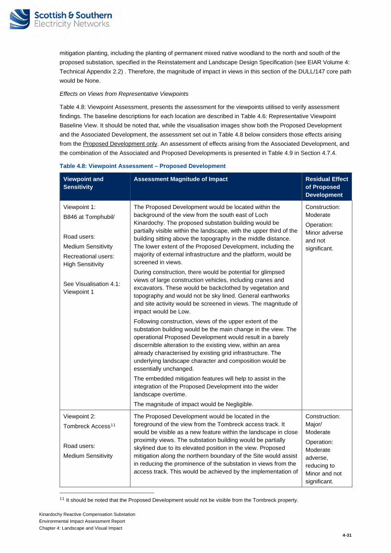
Kinardochy Reactive Compensation Substation Environmental Impact Assessment Report Chapter 4: Landscape and Visual Impact 4-31
mitigation planting, including the planting of permanent mixed native woodland to the north and south of the proposed substation, specified in the Reinstatement and Landscape Design Specification (see EIAR Volume 4: Technical Appendix 2.2) . Therefore, the magnitude of impact in views in this section of the DULL/147 core path would be None.
Effects on Views from Representative Viewpoints
Table 4.8: Viewpoint Assessment, presents the assessment for the viewpoints utilised to verify assessment findings. The baseline descriptions for each location are described in Table 4.6: Representative Viewpoint Baseline View. It should be noted that, while the visualisation images show both the Proposed Development and the Associated Development, the assessment set out in Table 4.8 below considers those effects arising from the Proposed Development only. An assessment of effects arising from the Associated Development, and the combination of the Associated and Proposed Developments is presented in Table 4.9 in Section 4.7.4.
Table 4.8: Viewpoint Assessment – Proposed Development
Viewpoint and Sensitivity
Assessment Magnitude of Impact Residual Effect of Proposed Development
Viewpoint 1: B846 at Tomphubil/ Road users: Medium Sensitivity Recreational users: High Sensitivity See Visualisation 4.1: Viewpoint 1
The Proposed Development would be located within the background of the view from the south east of Loch Kinardochy. The proposed substation building would be partially visible within the landscape, with the upper third of the building sitting above the topography in the middle distance. The lower extent of the Proposed Development, including the majority of external infrastructure and the platform, would be screened in views. During construction, there would be potential for glimpsed views of large construction vehicles, including cranes and excavators. These would be backclothed by vegetation and topography and would not be sky lined. General earthworks and site activity would be screened in views. The magnitude of impact would be Low. Following construction, views of the upper extent of the substation building would be the main change in the view. The operational Proposed Development would result in a barely discernible alteration to the existing view, within an area already characterised by existing grid infrastructure. The underlying landscape character and composition would be essentially unchanged. The embedded mitigation features will help to assist in the integration of the Proposed Development into the wider landscape overtime. The magnitude of impact would be Negligible.
Construction: Moderate Operation: Minor adverse and not significant.
Viewpoint 2: Tombreck Access11 Road users: Medium Sensitivity
The Proposed Development would be located in the foreground of the view from the Tombreck access track. It would be visible as a new feature within the landscape in close proximity views. The substation building would be partially skylined due to its elevated position in the view. Proposed mitigation along the northern boundary of the Site would assist in reducing the prominence of the substation in views from the access track. This would be achieved by the implementation of
Construction: Major/ Moderate Operation: Moderate adverse, reducing to Minor and not significant.
11 It should be noted that the Proposed Development would not be visible from the Tombreck property.
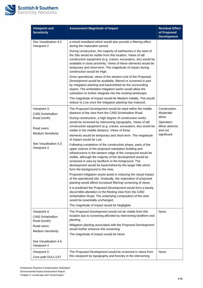
Kinardochy Reactive Compensation Substation Environmental Impact Assessment Report Chapter 4: Landscape and Visual Impact 4-32
Viewpoint and Sensitivity
Assessment Magnitude of Impact Residual Effect of Proposed Development
See Visualisation 4.2: Viewpoint 2
a mixed woodland which would also provide a filtering effect during the maturation period. During construction, the majority of earthworks in the west of the Site would be visible from this location. Views of tall construction equipment (e.g. cranes, excavators, etc) would be available in close proximity. Views of these elements would be temporary and short-term. The magnitude of impact during construction would be High. Once operational, views of the western end of the Proposed Development would be available, filtered or screened in part by mitigation planting and backclothed by the surrounding slopes. The embedded mitigation works would allow the substation to further integrate into the existing landscape. The magnitude of impact would be Medium initially. This would reduce to Low once the mitigation planting has matured.
Viewpoint 3: C450 Schiehallion Road (north) Road users: Medium Sensitivity See Visualisation 4.3: Viewpoint 3
The Proposed Development would be sited within the middle distance of the view from the C450 Schiehallion Road. During construction, a high degree of construction works would be screened by intervening topography. Views of tall construction equipment (e.g. cranes, excavators, etc) would be visible in the middle distance. Views of these elements would be temporary and short-term. The magnitude of impact would be Low. Following completion of the construction phase, parts of the upper extents of the proposed substation building and infrastructure in the western edge of the compound would be visible, although the majority of the development would be screened in view by landform in the foreground. The development would be backclothed by the larger hills which form the background to the view. Proposed mitigation would assist in reducing the visual impact of the operational site. Gradually, the maturation of proposed planting would afford increased filtering/ screening of views. It is predicted the Proposed Development would form a barely discernible alteration to the fleeting view from the C450 Schiehallion Road. The underlying composition of the view would be essentially unchanged. The magnitude of impact would be Negligible.
Construction: Moderate/ Minor Operation: Minor adverse and not significant.
Viewpoint 4: C450 Schiehallion Road (south) Road users: Medium Sensitivity See Visualisation 4.4: Viewpoint 4
The Proposed Development would not be visible from this location due to screening afforded by intervening landform and planting. Mitigation planting associated with the Proposed Development would further enhance this screening. The magnitude of impact would be None.
None.
Viewpoint 5: Core path DULL/147
The Proposed Development would be screened in views from this viewpoint by topography and forestry in the intervening
None.

Kinardochy Reactive Compensation Substation Environmental Impact Assessment Report Chapter 4: Landscape and Visual Impact 4-33
Viewpoint and Sensitivity
Assessment Magnitude of Impact Residual Effect of Proposed Development
Recreational users: High Sensitivity See Visualisation 4.5: Viewpoint 5
landscape. Mitigation planting associated with the Proposed Development would further enhance this screening. The magnitude of impact would be None.
4.7.4 Residual Cumulative Operational Effects (The Associated Development)
The following section presents the effects on landscape and visual receptors within the study area as a result of the operation of the Associated Development. It also provides an assessment of the cumulative effects arising from the operation of the Proposed Development in combination with the Associated Development.
Landscape Effects arising from the Operation of the Associated Development
Effects on Landscape Fabric
As the operation of the Associated Development would not require the disturbance of the landscape post-construction, no additional adverse effects on the landscape fabric within the Associated Development site are anticipated.
Effects on Landscape Character
The Associated Development would both directly and indirectly impact upon the landscape of the Lower Upland Glens with Lochs LCT and Summit and Plateaux Tayside LCT.
The Associated Development would be located within an area already characterised by forestry activity, existing overhead transmission lines and access works, and therefore it is considered that it would be consistent within the character of the baseline landscape within the local area. While the Associated Development would add to the assemblage of transmission line infrastructure within the landscape, impacts would be largely contained within the valley landscape, and the influence of the Associated Development out with the study area would be minimal. Following the removal of the temporary 275 kV diversion towers (lifetime of up to 3 years), this would contribute to a reduction of OHL infrastructure within the landscape.
The Associated Development would have a limited influence on the landscape of the Lower Upland Glens with Lochs LCT and the Summits and Plateaux Tayside LCT. It would not notably alter the current defining characteristics of either LCT.
Overall, the magnitude of impact caused by the Associated Development on the character of the Lower Upland Glens with Lochs LCT and Summit Plateaux Tayside LCT is considered to be Low. Impacts would be localised within the immediate area surrounding the permanent and temporary towers. Once the temporary towers are removed prior to commencement of the operation phase of the project, this impact would reduce further. The nature of the wider topography surrounding the Associated Development would contain the influence of the towers and access tracks on the overall character of the LCTs, with impacts limited to within the valley landscape only. Furthermore, as the landscape of the LCT extends west, north and east of the Associated Development, the magnitude of impact would quickly reduce to none within a small distance from the Project Site. Therefore, the residual effects on the Lower Upland Glens with Lochs LCT and Summit Plateaux Tayside LCT are considered to be Minor.
Kinardochy Reactive Compensation Substation Environmental Impact Assessment Report Chapter 4: Landscape and Visual Impact 4-34
Effects on Landscape Designations
The Associated Development is not located within a designated or classified landscape and therefore the operation of the permanent and temporary towers and associated access tracks would not have any direct physical effect on a designated or classified landscape.
Whilst indirect effects arising as a result of the presence of additional towers could occur on the Loch Rannoch & Glen Lyon NSA, or the Loch Tummel NSA, those effects would be highly localised. The Associated Development would be experienced within the context of existing OHL infrastructure and would not appear out of character in views from these designated areas. Impacts would be further reduced due to woodland and forestry present within the intervening landscape screening or filtering views. Consequently, such impacts are not considered to represent significant effects on either NSA. The magnitude of impact on both NSAs would be Negligible. The effect would be Minor.
Cumulative Landscape Effects arising from the Operation of the Associated Development in Addition to the Proposed Development
The Proposed Development is located directly adjacent to the Associated Development. The Associated Development would be located within an area already characterised by high voltage OHLs and essentially would be reconfiguring the location of existing development, albeit with new transmission towers of slightly different dimensions/ appearance.
It is considered that, overall, cumulative effects on the character of the landscape of the Summit and Plateaux LCT, and on other LCTs and Landscape Designations (Loch Rannoch and Glen Lyon NSA and Loch Tummel NSA) within the study area would be similar in nature to those residual effects assessed for the Proposed Development (see Section 4.7.3). Due to its size and scale, the key change in the landscape would arise from the operation of the Proposed Development. The addition of the Associated Development would cause a minor increase in the influence of electricity infrastructure on the character of the landscape in the immediate area.
These effects on the character of the Summit and Plateaux LCT would be localised and would reduce quickly over a short distance from the Project Site due to the presence of woodland, forestry and the screening/ filtering which will be achieve by the Reinstatement and Landscape Design Specification (see EIAR Volume 4: Technical Appendix 2.2). The magnitude of impact would be Low in the area surrounding the Project Site, reducing to Negligible overall. The effect would be Moderate, reducing to Minor overall.
Similarly, effects on other LCTs and the Landscape Designations within the study area would reflect those presented in Section 4.7.3. Cumulatively the developments would form a relatively small feature within an expansive view. The developments would sit low in the landscape and would be seen within the context of existing electricity infrastructure. Due to the Associated Development essentially reconfiguring existing infrastructure, the key change would be the introduction of the Proposed Development which would extend the presence of electricity infrastructure across a small area of landscape within the view. As noted in Section 4.7.3, the Proposed Development would not impact upon the integrity of the designation. The magnitude of impact would be Negligible. The effect on the would be Minor.
Visual Effects arising from the Operation of the Associated Development
Scattered Settlement
The Associated Development would be theoretically visible from Tombreck Farmhouse, Tomphubil Lodge, White Bridge, Braes of Foss and two isolated properties located at Foss Mill. The properties in closest proximity (Tombreck Farmhouse (650 m north) and Tomphubil Lodge (900 m south east) would experience views of the top extents of the two temporary and two permanent 275 kV towers of the Associated Development as they extend above forestry. The majority of the towers would be screened by intervening vegetation, thereby reducing the overall visual impact upon these properties.
Kinardochy Reactive Compensation Substation Environmental Impact Assessment Report Chapter 4: Landscape and Visual Impact 4-35
Given the increased distance from the Associated Development, the presence of existing OHL infrastructure, and the screening provided by intervening landscape features such as woodland and forestry, properties at White Bridge, Braes of Foss and the two properties at Foss Mill would experience very little notable impact on their existing view.
Therefore, the magnitude of impact on views from scattered residential properties within the study area are considered to be Low. As such, residual effects are considered to be Moderate and not significant.
Transport Receptors
Travelers on the B846 as it passes to the east of the study area, would have brief views of the Associated Development as the road passes to the south of Loch Kinardochy. From this location, the route provides fleeting/ glimpsed views of the Associated Development, with the view already characterised by existing transmission line infrastructure. The Associated Development would be seen across a small portion of the skyline at a distance of 800 m and within the context of rolling hills, existing grid infrastructure, and coniferous forestry vegetation. As the road continues east, it becomes heavily bordered by roadside trees and scrub, which restricts views over Loch Kinardochy and to the Associated Development. Therefore, the predicted impact on road users along the B846 is considered to be Negligible. Therefore, the residual effects are considered to be Minor, reducing to none.
Users along the C450 Schiehallion Road would have brief visibility of the Associated Development as the road passes to the west of the Project Site. Due to the lack of intervening landscape elements such as woodland and topography in this area, the Associated Development would be highly visible from a small section of the road in close proximity to the Project Site. Given the temporary nature of two of the proposed towers and with the existing context of existing transmission line infrastructure within the landscape, the overall magnitude of impact on users along the C450 Schiehallion Road is considered to be Medium/ Low. The residual effect is considered to be Minor.
Recreational Routes
The ZTV (EIAR Volume 3a: Figure 4.4b: Cumulative ZTV) indicates that there are no theoretical views of the Associated Development from Core Paths DULL/146 and RAN/108 as they lie within the study area. Therefore, the magnitude of impact on these two paths would be None.
Views of the Associated Development would be theoretically available for a short duration along the DULL/147 core path as the path climbs the northern slopes of Dun Coillich. However, as shown in EIAR Volume 3b: Visualisation 4.5: Viewpoint 5, due to screening provided by local topography and forestry, there would be no actual views of the transmission towers proposed as part of the Associated Development. Therefore, the effect would be None.
Cumulative Visual Effects arising from the Operation of the Associated Development in Addition to the Proposed Development
In views from the key visual receptors within the study area, such as scattered residential properties, the B846 and the C450 roads, and identified core paths, the notable impact on views is largely attributable to the new (permanent and temporary) transmission towers which form the Associated Development. This is due to the elevated position of these structures which extend into the skyline when viewed from the lower lying receptor locations.
The addition of the Associated Development to the Proposed Development would have minimal impacts on views from these low-lying receptors. In locations where receptors would look directly into the site, such as from the C450 Schiehallion Road, effects would predominantly be associated with the Associated Development. In locations where elevation is gained – such as from Core Path DULL/ 147 – local topography and the presence of forestry screens views to the Project Site for path users (see EIAR Volume 3b: Visualisation 4.5: Viewpoint 5).
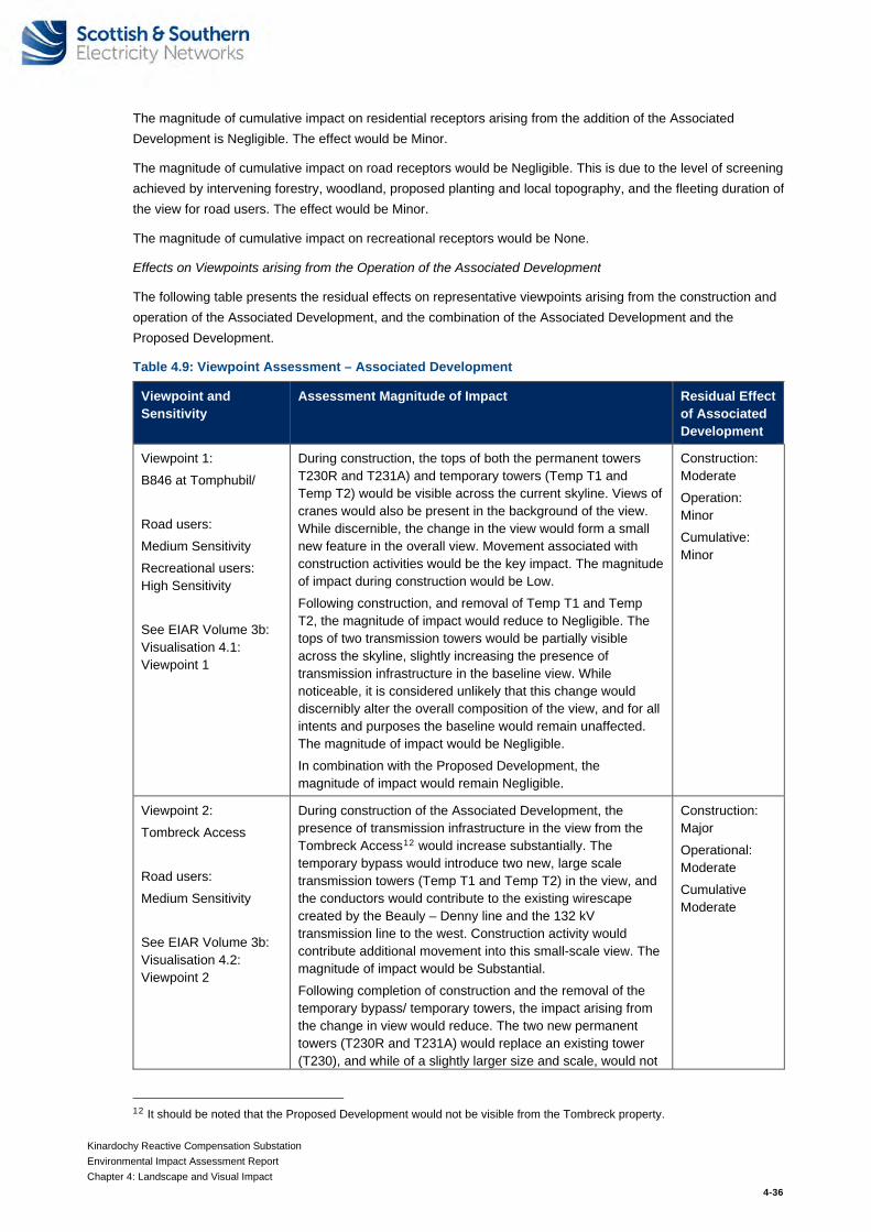
Kinardochy Reactive Compensation Substation Environmental Impact Assessment Report Chapter 4: Landscape and Visual Impact 4-36
The magnitude of cumulative impact on residential receptors arising from the addition of the Associated Development is Negligible. The effect would be Minor.
The magnitude of cumulative impact on road receptors would be Negligible. This is due to the level of screening achieved by intervening forestry, woodland, proposed planting and local topography, and the fleeting duration of the view for road users. The effect would be Minor.
The magnitude of cumulative impact on recreational receptors would be None.
Effects on Viewpoints arising from the Operation of the Associated Development
The following table presents the residual effects on representative viewpoints arising from the construction and operation of the Associated Development, and the combination of the Associated Development and the Proposed Development.
Table 4.9: Viewpoint Assessment – Associated Development
Viewpoint and Sensitivity
Assessment Magnitude of Impact Residual Effect of Associated Development
Viewpoint 1: B846 at Tomphubil/ Road users: Medium Sensitivity Recreational users: High Sensitivity See EIAR Volume 3b: Visualisation 4.1: Viewpoint 1
During construction, the tops of both the permanent towers T230R and T231A) and temporary towers (Temp T1 and Temp T2) would be visible across the current skyline. Views of cranes would also be present in the background of the view. While discernible, the change in the view would form a small new feature in the overall view. Movement associated with construction activities would be the key impact. The magnitude of impact during construction would be Low. Following construction, and removal of Temp T1 and Temp T2, the magnitude of impact would reduce to Negligible. The tops of two transmission towers would be partially visible across the skyline, slightly increasing the presence of transmission infrastructure in the baseline view. While noticeable, it is considered unlikely that this change would discernibly alter the overall composition of the view, and for all intents and purposes the baseline would remain unaffected. The magnitude of impact would be Negligible. In combination with the Proposed Development, the magnitude of impact would remain Negligible.
Construction: Moderate Operation: Minor Cumulative: Minor
Viewpoint 2: Tombreck Access Road users: Medium Sensitivity See EIAR Volume 3b: Visualisation 4.2: Viewpoint 2
During construction of the Associated Development, the presence of transmission infrastructure in the view from the Tombreck Access12 would increase substantially. The temporary bypass would introduce two new, large scale transmission towers (Temp T1 and Temp T2) in the view, and the conductors would contribute to the existing wirescape created by the Beauly – Denny line and the 132 kV transmission line to the west. Construction activity would contribute additional movement into this small-scale view. The magnitude of impact would be Substantial. Following completion of construction and the removal of the temporary bypass/ temporary towers, the impact arising from the change in view would reduce. The two new permanent towers (T230R and T231A) would replace an existing tower (T230), and while of a slightly larger size and scale, would not
Construction: Major Operational: Moderate Cumulative Moderate
12 It should be noted that the Proposed Development would not be visible from the Tombreck property.
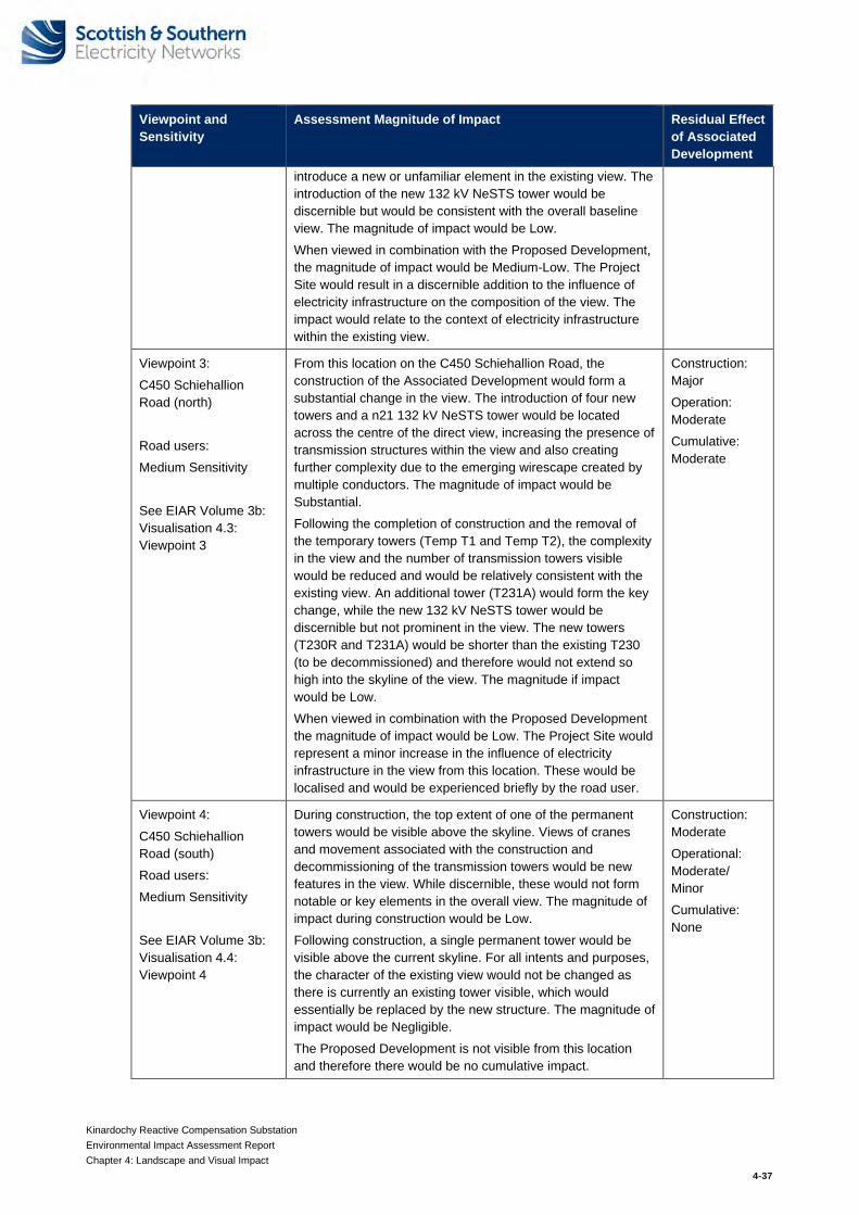
Kinardochy Reactive Compensation Substation Environmental Impact Assessment Report Chapter 4: Landscape and Visual Impact 4-37
Viewpoint and Sensitivity
Assessment Magnitude of Impact Residual Effect of Associated Development
introduce a new or unfamiliar element in the existing view. The introduction of the new 132 kV NeSTS tower would be discernible but would be consistent with the overall baseline view. The magnitude of impact would be Low. When viewed in combination with the Proposed Development, the magnitude of impact would be Medium-Low. The Project Site would result in a discernible addition to the influence of electricity infrastructure on the composition of the view. The impact would relate to the context of electricity infrastructure within the existing view.
Viewpoint 3: C450 Schiehallion Road (north) Road users: Medium Sensitivity See EIAR Volume 3b: Visualisation 4.3: Viewpoint 3
From this location on the C450 Schiehallion Road, the construction of the Associated Development would form a substantial change in the view. The introduction of four new towers and a n21 132 kV NeSTS tower would be located across the centre of the direct view, increasing the presence of transmission structures within the view and also creating further complexity due to the emerging wirescape created by multiple conductors. The magnitude of impact would be Substantial. Following the completion of construction and the removal of the temporary towers (Temp T1 and Temp T2), the complexity in the view and the number of transmission towers visible would be reduced and would be relatively consistent with the existing view. An additional tower (T231A) would form the key change, while the new 132 kV NeSTS tower would be discernible but not prominent in the view. The new towers (T230R and T231A) would be shorter than the existing T230 (to be decommissioned) and therefore would not extend so high into the skyline of the view. The magnitude if impact would be Low. When viewed in combination with the Proposed Development the magnitude of impact would be Low. The Project Site would represent a minor increase in the influence of electricity infrastructure in the view from this location. These would be localised and would be experienced briefly by the road user.
Construction: Major Operation: Moderate Cumulative: Moderate
Viewpoint 4: C450 Schiehallion Road (south) Road users: Medium Sensitivity See EIAR Volume 3b: Visualisation 4.4: Viewpoint 4
During construction, the top extent of one of the permanent towers would be visible above the skyline. Views of cranes and movement associated with the construction and decommissioning of the transmission towers would be new features in the view. While discernible, these would not form notable or key elements in the overall view. The magnitude of impact during construction would be Low. Following construction, a single permanent tower would be visible above the current skyline. For all intents and purposes, the character of the existing view would not be changed as there is currently an existing tower visible, which would essentially be replaced by the new structure. The magnitude of impact would be Negligible. The Proposed Development is not visible from this location and therefore there would be no cumulative impact.
Construction: Moderate Operational: Moderate/ Minor Cumulative: None
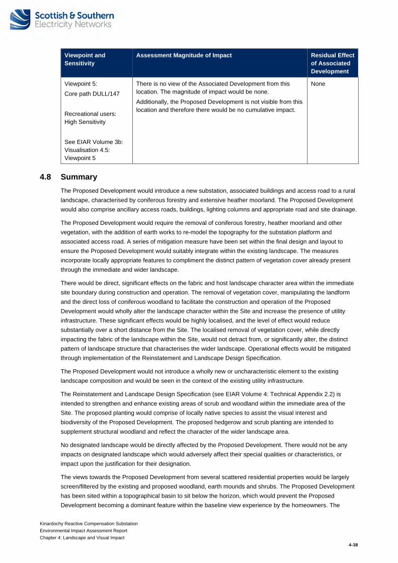
Kinardochy Reactive Compensation Substation Environmental Impact Assessment Report Chapter 4: Landscape and Visual Impact 4-38
Viewpoint and Sensitivity
Assessment Magnitude of Impact Residual Effect of Associated Development
Viewpoint 5: Core path DULL/147 Recreational users: High Sensitivity See EIAR Volume 3b: Visualisation 4.5: Viewpoint 5
There is no view of the Associated Development from this location. The magnitude of impact would be none. Additionally, the Proposed Development is not visible from this location and therefore there would be no cumulative impact.
None
4.8 Summary The Proposed Development would introduce a new substation, associated buildings and access road to a rural landscape, characterised by coniferous forestry and extensive heather moorland. The Proposed Development would also comprise ancillary access roads, buildings, lighting columns and appropriate road and site drainage.
The Proposed Development would require the removal of coniferous forestry, heather moorland and other vegetation, with the addition of earth works to re-model the topography for the substation platform and associated access road. A series of mitigation measure have been set within the final design and layout to ensure the Proposed Development would suitably integrate within the existing landscape. The measures incorporate locally appropriate features to compliment the distinct pattern of vegetation cover already present through the immediate and wider landscape.
There would be direct, significant effects on the fabric and host landscape character area within the immediate site boundary during construction and operation. The removal of vegetation cover, manipulating the landform and the direct loss of coniferous woodland to facilitate the construction and operation of the Proposed Development would wholly alter the landscape character within the Site and increase the presence of utility infrastructure. These significant effects would be highly localised, and the level of effect would reduce substantially over a short distance from the Site. The localised removal of vegetation cover, while directly impacting the fabric of the landscape within the Site, would not detract from, or significantly alter, the distinct pattern of landscape structure that characterises the wider landscape. Operational effects would be mitigated through implementation of the Reinstatement and Landscape Design Specification.
The Proposed Development would not introduce a wholly new or uncharacteristic element to the existing landscape composition and would be seen in the context of the existing utility infrastructure.
The Reinstatement and Landscape Design Specification (see EIAR Volume 4: Technical Appendix 2.2) is intended to strengthen and enhance existing areas of scrub and woodland within the immediate area of the Site. The proposed planting would comprise of locally native species to assist the visual interest and biodiversity of the Proposed Development. The proposed hedgerow and scrub planting are intended to supplement structural woodland and reflect the character of the wider landscape area.
No designated landscape would be directly affected by the Proposed Development. There would not be any impacts on designated landscape which would adversely affect their special qualities or characteristics, or impact upon the justification for their designation.
The views towards the Proposed Development from several scattered residential properties would be largely screen/filtered by the existing and proposed woodland, earth mounds and shrubs. The Proposed Development has been sited within a topographical basin to sit below the horizon, which would prevent the Proposed Development becoming a dominant feature within the baseline view experience by the homeowners. The
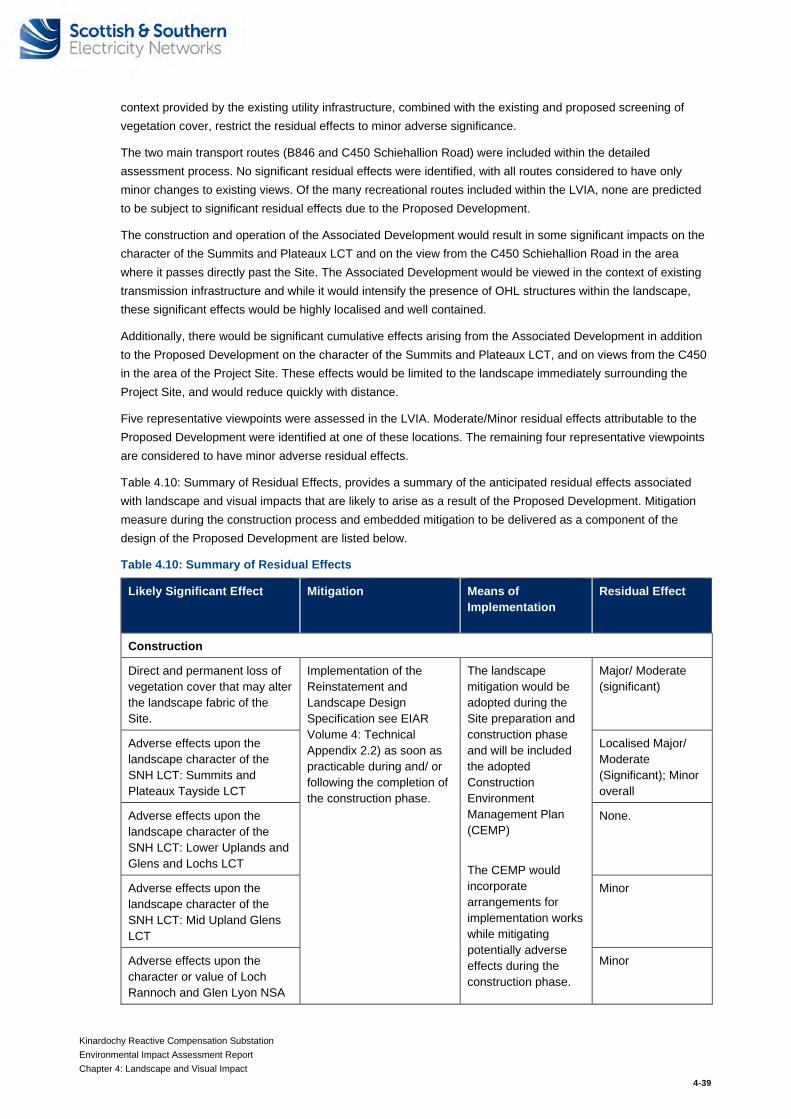
Kinardochy Reactive Compensation Substation Environmental Impact Assessment Report Chapter 4: Landscape and Visual Impact 4-39
context provided by the existing utility infrastructure, combined with the existing and proposed screening of vegetation cover, restrict the residual effects to minor adverse significance.
The two main transport routes (B846 and C450 Schiehallion Road) were included within the detailed assessment process. No significant residual effects were identified, with all routes considered to have only minor changes to existing views. Of the many recreational routes included within the LVIA, none are predicted to be subject to significant residual effects due to the Proposed Development.
The construction and operation of the Associated Development would result in some significant impacts on the character of the Summits and Plateaux LCT and on the view from the C450 Schiehallion Road in the area where it passes directly past the Site. The Associated Development would be viewed in the context of existing transmission infrastructure and while it would intensify the presence of OHL structures within the landscape, these significant effects would be highly localised and well contained.
Additionally, there would be significant cumulative effects arising from the Associated Development in addition to the Proposed Development on the character of the Summits and Plateaux LCT, and on views from the C450 in the area of the Project Site. These effects would be limited to the landscape immediately surrounding the Project Site, and would reduce quickly with distance.
Five representative viewpoints were assessed in the LVIA. Moderate/Minor residual effects attributable to the Proposed Development were identified at one of these locations. The remaining four representative viewpoints are considered to have minor adverse residual effects.
Table 4.10: Summary of Residual Effects, provides a summary of the anticipated residual effects associated with landscape and visual impacts that are likely to arise as a result of the Proposed Development. Mitigation measure during the construction process and embedded mitigation to be delivered as a component of the design of the Proposed Development are listed below.
Table 4.10: Summary of Residual Effects
Likely Significant Effect Mitigation Means of Implementation
Residual Effect
Construction
Direct and permanent loss of vegetation cover that may alter the landscape fabric of the Site.
Implementation of the Reinstatement and Landscape Design Specification see EIAR Volume 4: Technical Appendix 2.2) as soon as practicable during and/ or following the completion of the construction phase.
The landscape mitigation would be adopted during the Site preparation and construction phase and will be included the adopted Construction Environment Management Plan (CEMP) The CEMP would incorporate arrangements for implementation works while mitigating potentially adverse effects during the construction phase.
Major/ Moderate (significant)
Adverse effects upon the landscape character of the SNH LCT: Summits and Plateaux Tayside LCT
Localised Major/ Moderate (Significant); Minor overall
Adverse effects upon the landscape character of the SNH LCT: Lower Uplands and Glens and Lochs LCT
None.
Adverse effects upon the landscape character of the SNH LCT: Mid Upland Glens LCT
Minor
Adverse effects upon the character or value of Loch Rannoch and Glen Lyon NSA
Minor

Kinardochy Reactive Compensation Substation Environmental Impact Assessment Report Chapter 4: Landscape and Visual Impact 4-40
Likely Significant Effect Mitigation Means of Implementation
Residual Effect
Adverse effects upon the character or value of Loch Tummel NSA
Minor
Adverse effects upon the visual amenity of scattered properties
Moderate
Adverse effects upon the visual amenity of transportation routes
Minor
Adverse effects upon the visual amenity of recreational routes
None
Adverse effects upon the visual amenity of Viewpoint 1 -
Moderate
Adverse effects upon the visual amenity of Viewpoint 2 -
Major/ Moderate
Adverse effects upon the visual amenity of Viewpoint 3 -
Moderate/ Minor
Adverse effects upon the visual amenity of Viewpoint 4 -
None
Adverse effects upon the visual amenity of Viewpoint 5 -
None
Cumulative Construction
Associated Development
Direct and permanent loss of vegetation cover that may alter the landscape fabric of the Project Site.
Minor
Adverse effects upon the landscape character of the SNH LCT: Summits and Plateaux Tayside LCT
Localised Major/ Moderate; Moderate overall
Adverse effects upon the landscape character of the SNH LCT: Lower Uplands and Glens and Lochs LCT
Minor
Adverse effects upon the landscape character of the SNH LCT: Mid Upland Glens LCT
None
Adverse effects upon the character or value of Loch Rannoch and Glen Lyon NSA
Moderate/ Minor

Kinardochy Reactive Compensation Substation Environmental Impact Assessment Report Chapter 4: Landscape and Visual Impact 4-41
Likely Significant Effect Mitigation Means of Implementation
Residual Effect
Adverse effects upon the character or value of Loch Tummel NSA
Moderate/ Minor
Adverse effects upon the visual amenity of scattered properties
Moderate
Adverse effects upon the visual amenity of transportation routes
Locally Major/ Moderate; Minor overall
Adverse effects upon the visual amenity of recreational routes
None
Adverse effects upon the visual amenity of Viewpoint 1 -
Moderate
Adverse effects upon the visual amenity of Viewpoint 2 -
Major
Adverse effects upon the visual amenity of Viewpoint 3 -
Major
Adverse effects upon the visual amenity of Viewpoint 4 -
Moderate
Adverse effects upon the visual amenity of Viewpoint 5 -
None
Associated Development in Addition to the Proposed Development
Direct and permanent loss of vegetation cover that may alter the landscape fabric of the Project Site.
Implementation of the Reinstatement and Landscape Design Specification (see EIAR Volume 4: Technical Appendix 2.2) as soon as practicable during and/ or following the completion of the construction phase.
The landscape mitigation would be adopted during site preparation and construction phase and will be included the adopted Construction Environment Management Plan (CEMP) The CEMP would incorporate arrangements for implementation works while mitigating potentially adverse effects during the construction phase.
Moderate
Adverse effects upon the landscape character of the SNH LCT: Summits and Plateaux Tayside LCT
Major/ Moderate; Minor overall
Adverse effects upon the landscape character of the SNH LCT: Lower Uplands and Glens and Lochs LCT
None
Adverse effects upon the landscape character of the SNH LCT: Mid Upland Glens LCT
None
Adverse effects upon the character or value of Loch Rannoch and Glen Lyon NSA
Moderate/ Minor
Adverse effects upon the character or value of Loch Tummel NSA
Moderate/ Minor
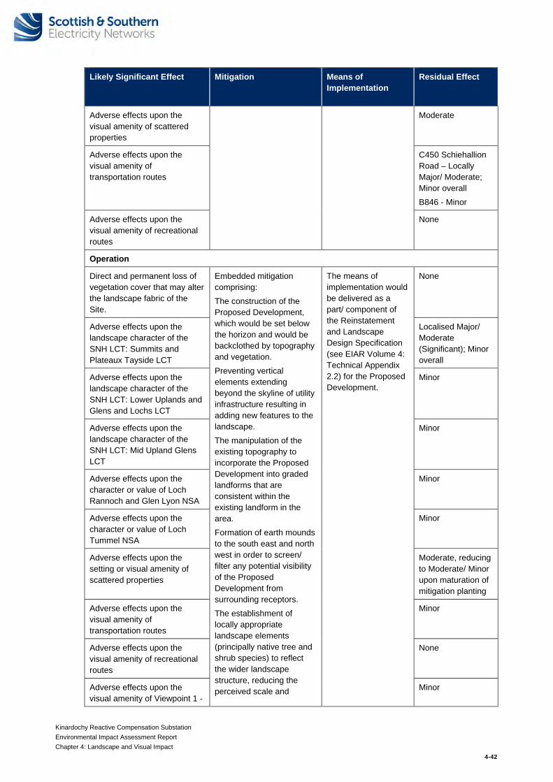
Kinardochy Reactive Compensation Substation Environmental Impact Assessment Report Chapter 4: Landscape and Visual Impact 4-42
Likely Significant Effect Mitigation Means of Implementation
Residual Effect
Adverse effects upon the visual amenity of scattered properties
Moderate
Adverse effects upon the visual amenity of transportation routes
C450 Schiehallion Road – Locally Major/ Moderate; Minor overall B846 - Minor
Adverse effects upon the visual amenity of recreational routes
None
Operation
Direct and permanent loss of vegetation cover that may alter the landscape fabric of the Site.
Embedded mitigation comprising: The construction of the Proposed Development, which would be set below the horizon and would be backclothed by topography and vegetation. Preventing vertical elements extending beyond the skyline of utility infrastructure resulting in adding new features to the landscape. The manipulation of the existing topography to incorporate the Proposed Development into graded landforms that are consistent within the existing landform in the area. Formation of earth mounds to the south east and north west in order to screen/ filter any potential visibility of the Proposed Development from surrounding receptors. The establishment of locally appropriate landscape elements (principally native tree and shrub species) to reflect the wider landscape structure, reducing the perceived scale and
The means of implementation would be delivered as a part/ component of the Reinstatement and Landscape Design Specification (see EIAR Volume 4: Technical Appendix 2.2) for the Proposed Development.
None
Adverse effects upon the landscape character of the SNH LCT: Summits and Plateaux Tayside LCT
Localised Major/ Moderate (Significant); Minor overall
Adverse effects upon the landscape character of the SNH LCT: Lower Uplands and Glens and Lochs LCT
Minor
Adverse effects upon the landscape character of the SNH LCT: Mid Upland Glens LCT
Minor
Adverse effects upon the character or value of Loch Rannoch and Glen Lyon NSA
Minor
Adverse effects upon the character or value of Loch Tummel NSA
Minor
Adverse effects upon the setting or visual amenity of scattered properties
Moderate, reducing to Moderate/ Minor upon maturation of mitigation planting
Adverse effects upon the visual amenity of transportation routes
Minor
Adverse effects upon the visual amenity of recreational routes
None
Adverse effects upon the visual amenity of Viewpoint 1 -
Minor
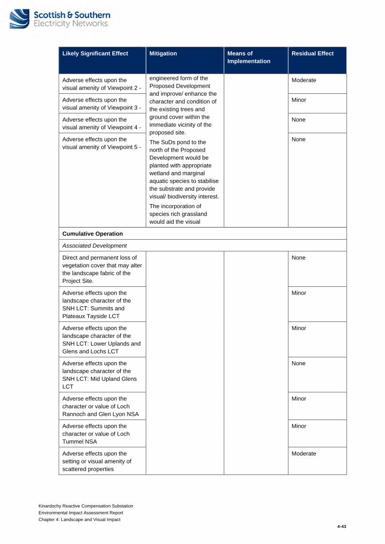
Kinardochy Reactive Compensation Substation Environmental Impact Assessment Report Chapter 4: Landscape and Visual Impact 4-43
Likely Significant Effect Mitigation Means of Implementation
Residual Effect
Adverse effects upon the visual amenity of Viewpoint 2 -
engineered form of the Proposed Development and improve/ enhance the character and condition of the existing trees and ground cover within the immediate vicinity of the proposed site. The SuDs pond to the north of the Proposed Development would be planted with appropriate wetland and marginal aquatic species to stabilise the substrate and provide visual/ biodiversity interest. The incorporation of species rich grassland would aid the visual
Moderate
Adverse effects upon the visual amenity of Viewpoint 3 -
Minor
Adverse effects upon the visual amenity of Viewpoint 4 -
None
Adverse effects upon the visual amenity of Viewpoint 5 -
None
Cumulative Operation
Associated Development
Direct and permanent loss of vegetation cover that may alter the landscape fabric of the Project Site.
None
Adverse effects upon the landscape character of the SNH LCT: Summits and Plateaux Tayside LCT
Minor
Adverse effects upon the landscape character of the SNH LCT: Lower Uplands and Glens and Lochs LCT
Minor
Adverse effects upon the landscape character of the SNH LCT: Mid Upland Glens LCT
None
Adverse effects upon the character or value of Loch Rannoch and Glen Lyon NSA
Minor
Adverse effects upon the character or value of Loch Tummel NSA
Minor
Adverse effects upon the setting or visual amenity of scattered properties
Moderate
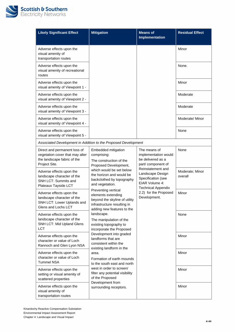
Kinardochy Reactive Compensation Substation Environmental Impact Assessment Report Chapter 4: Landscape and Visual Impact 4-44
Likely Significant Effect Mitigation Means of Implementation
Residual Effect
Adverse effects upon the visual amenity of transportation routes
Minor
Adverse effects upon the visual amenity of recreational routes
None.
Adverse effects upon the visual amenity of Viewpoint 1 -
Minor
Adverse effects upon the visual amenity of Viewpoint 2 -
Moderate
Adverse effects upon the visual amenity of Viewpoint 3 -
Moderate
Adverse effects upon the visual amenity of Viewpoint 4 -
Moderate/ Minor
Adverse effects upon the visual amenity of Viewpoint 5 -
None
Associated Development in Addition to the Proposed Development
Direct and permanent loss of vegetation cover that may alter the landscape fabric of the Project Site.
Embedded mitigation comprising: The construction of the Proposed Development, which would be set below the horizon and would be backclothed by topography and vegetation. Preventing vertical elements extending beyond the skyline of utility infrastructure resulting in adding new features to the landscape. The manipulation of the existing topography to incorporate the Proposed Development into graded landforms that are consistent within the existing landform in the area. Formation of earth mounds to the south east and north west in order to screen/ filter any potential visibility of the Proposed Development from surrounding receptors.
The means of implementation would be delivered as a part/ component of Reinstatement and Landscape Design Specification (see EIAR Volume 4: Technical Appendix 2.2) for the Proposed Development.
None
Adverse effects upon the landscape character of the SNH LCT: Summits and Plateaux Tayside LCT
Moderate; Minor overall
Adverse effects upon the landscape character of the SNH LCT: Lower Uplands and Glens and Lochs LCT
Minor
Adverse effects upon the landscape character of the SNH LCT: Mid Upland Glens LCT
None
Adverse effects upon the character or value of Loch Rannoch and Glen Lyon NSA
Minor
Adverse effects upon the character or value of Loch Tummel NSA
Minor
Adverse effects upon the setting or visual amenity of scattered properties
Minor
Adverse effects upon the visual amenity of transportation routes
Minor

Kinardochy Reactive Compensation Substation Environmental Impact Assessment Report Chapter 4: Landscape and Visual Impact 4-45
Likely Significant Effect Mitigation Means of Implementation
Residual Effect
Adverse effects upon the visual amenity of recreational routes
The establishment of locally appropriate landscape elements (principally native tree and shrub species) to reflect the wider landscape structure, reducing the perceived scale and engineered form of the Proposed Development and improve/ enhance the character and condition of the existing trees and ground cover within the immediate vicinity of the proposed site. The SuDs pond to the north of the Proposed Development would be planted with appropriate wetland and marginal aquatic species to stabilise the substrate and provide visual/ biodiversity interest. The incorporation of species rich grassland would aid the visual interest of the Project Site while enhancing biodiversity.
None.
Adverse effects upon the visual amenity of Viewpoint 1 -
Minor
Adverse effects upon the visual amenity of Viewpoint 2 -
Moderate
Adverse effects upon the visual amenity of Viewpoint 3 -
Moderate
Adverse effects upon the visual amenity of Viewpoint 4 -
None
Adverse effects upon the visual amenity of Viewpoint 5 -
None
Kinardochy Reactive Compensation Substation Environmental Impact Assessment Report Chapter 5: Ecology 5-1
5. ECOLOGY
5.1 Introduction This chapter considers the likely significant effects on ecology associated with the construction and operation of the Proposed Development. The likely significant effects on ecology associated with the construction and operation of the Associated Development will be considered as part of the cumulative assessment. As described in Chapter 2: Description of Development, neither the Proposed Development nor the Associated Development are likely to be decommissioned. If they were to be decommissioned the effects associated with the construction phase of the Proposed Development and the Associated Development on ecology can be considered to be representative of reasonable worst-case decommissioning effects, therefore a separate assessment of the decommissioning phase of the Proposed Development and Associated Development has not been undertaken as part of this assessment.
The specific objectives of the chapter are to:
• describe the ecology baseline;
• describe the assessment methodology and significance criteria used in completing the Ecological Impact Assessment (EcIA);
• describe the potential effects, including direct, indirect and cumulative effects;
• describe the mitigation measures proposed to address likely significant effects; and
• assess the residual effects remaining following the implementation of mitigation.
The assessment has been carried out by an MCIEEM certified, senior ecologist with Ramboll UK Ltd with seven and a half years of experience. This assessment has been undertaken following the Chartered Institute of Ecology and Environmental Management’s (CIEEM) guidance on undertaking Ecological Impact Assessments1.
The chapter is supported by:
• Figure 5.1: Ecology Study Areas;
• Figure 5.2: Ecological Designated Sites;
• Figure 5.3: Protected Species;
• Figure 5.4: Phase 1 Habitats; and
• Technical Appendix 5.1: Habitats Regulations Appraisal and Appropriate Assessment.
5.2 Scope of Assessment This chapter identifies the potential effects on non-avian ecology associated with the construction and operation of the Proposed Development. Where required, it also provides details of mitigation measures to address these potential impacts.
This chapter considers the potential for likely significant effects on:
• Protected sites;
• Habitats and Plants;
• Protected mammals;
• Reptiles;
• Amphibians;
• Fish; and
1 CIEEM (2018), Guidelines for Ecological Impact Assessment in the UK and Ireland: Terrestrial, Freshwater, Coastal and Marine. Chartered Institute of Ecology and Environmental Management, Winchester
Kinardochy Reactive Compensation Substation Environmental Impact Assessment Report Chapter 5: Ecology 5-2
• Invertebrates
The chapter also considers the potential effects of the Associated Development, as described in Chapter 2: Description of Development, as a cumulative development to the Proposed Development. No other consented or Proposed Developments that could lead to significant cumulative effects have been identified within 5 km of the Site. As such no other cumulative developments should be considered in the EIAR. The cumulative assessment captures the potential for additional, in combination and synergistic effects when considering the Proposed Development along with the Associated Development.
5.2.1 Consultation
Table 5.1: Consultation Responses summarises the consultation responses received regarding ecology and provides information on where and/or how they have been addressed in this assessment.
The following organisations made comment on Ecology:
• Perth and Kinross Council (PKC);
• NatureScot; and
• SEPA.
Table 5.1: Consultation Responses
Consultee and Date
Scoping / Other Consultation
Issue Raised Response / Action Taken
PKC, 01/08/2019
Pre-application Advice
Potential constraints: • Ancient Woodland; • Nationally important peatland within
site; • Potential groundwater vulnerability; • Protected species in surrounding area:
• Otter; • Red squirrel; • Pine marten; • Adder; • Badger; • Northern brown argus butterfly; • Water vole; and • Common frog.
These features are assessed in section 5.4: Baseline Conditions.
PKC, 01/08/2019
Pre-application Advice
Phase 1 Habitat survey with Protected Species Survey required.
Undertaken, as described in section 5.3.3 Field Survey.
PKC, 07/01/2020
Screening Potential impact on bio-diversity: • Forestry habitat; and • Known adders Vipera berus, pine
martens Martes martes, badger Meles meles and red squirrel Scurius vulgaris recorded on site.
Forestry habitat surveyed during the Phase 1 Habitats Survey, section 5.3.3 Field Survey. Protected species surveyed during the Protected Species Survey, section 5.3.3 Field Survey.
Kinardochy Reactive Compensation Substation Environmental Impact Assessment Report Chapter 5: Ecology 5-3
Consultee and Date
Scoping / Other Consultation
Issue Raised Response / Action Taken
Engineering works required to create a new platform for the new compound- significant effect on the local wildlife.
Impacts on local protected species, assessed in Section 5.4.1: Potential Construction Effects, are not considered to be significant.
Some pipes/cabling will be required, but these may be overhead as opposed to underground. Potential impact on hydrology, geology and habitats if underground cabling is required.
No underground cabling required as part of the Proposed Development or the Associated Development.
River Tay Catchment Area (for the SAC). Likely significant environmental effects if not mitigated and controlled.Fisheries - Loch Kinardochy is used for fishing.
Impacts on the River Tay SAC, as assessed in Section 5.5.1: Potential Construction Effects, are not considered significant under EIA Regulations. Likely Significant Effects (LSE), as described in EIAR Volume 4: Technical Appendix 5.1: Habitats Regulations Appraisal and Appropriate Assessment, have potential to exist and are assessed separately.
Protected Species - Adders, Pine Martens, Black Grouse, Badgers, Red Squirrels are all known to be present on the site. Potential to likely be significant. Full protected species surveys required.
Protected Species Surveys were undertaken as described in 5.3.3 Field Survey
NatureScot, 20/10/2020
Scoping Public Road Improvement works for abnormal load delivery: These need to be assessed within HRA/AA due to indirect risk of potential for risk of run-off on Keltneyburn SAC/SSSI and River Tay SAC.
Impacts on designated sites discussed in section 5.5.1 of this Chapter. It is understood that if further planning permission is required for the PRI work, these subsequent applications would also need to account for these potential impacts, in line with relevant regulations.
Kinardochy Reactive Compensation Substation Environmental Impact Assessment Report Chapter 5: Ecology 5-4
Consultee and Date
Scoping / Other Consultation
Issue Raised Response / Action Taken
HRA undertaken, see EIAR Volume 4: Technical Appendix 5.1: Habitats Regulations Appraisal and Appropriate Assessment. This includes potential impacts on Keltneyburn SAC.
SEPA, 21/10/2020
Scoping Groundwater Dependent Terrestrial Ecosystems (GWDTE) – Phase 1 habitat survey shows some areas of wet modified bog, semi-natural coniferous woodland and semi-natural broadleaf woodland; we would recommend that the track be micro-sited to avoid these or track to impact on only the edges of these habitats. There is an area of dry heath/acid grassland shown to be bisected by the track; could this be avoided or minimised by micro-siting to periphery without compromising more sensitive habitat? Is there an alternative for the temporary construction area to be in an area of shallower peat without compromising other sensitive habitat (and peat) such as within the forestry area? The temporary construction compound is to be reinstated post sub-station construction and details including monitoring should be provided.
GWDTE’s have been scoped out of this chapter as a review of terrain and hydrology has indicated the habitats to be surface water fed. An area of wet modified bog recorded next to Allt Kinardochy was assessed for its potential to be GWDTE but was subsequently considered to be surface water dependent. (Section 5.4.1: Habitats and Vegetation – Field Survey Results: Wet Modified Bog) The layout of the Proposed Development, including the proposed substation platform, the construction compound and the access track have been designed to avoid impacts on sensitive habitats as far as possible. Three different locations for the construction compound and laydown areas were considered during the design phase (as described in Chapter 3: Design Evolution and Site Alternatives), including within the existing plantation forestry immediately north of the Site. However due to the density of the forestry, it was not possible to
Kinardochy Reactive Compensation Substation Environmental Impact Assessment Report Chapter 5: Ecology 5-5
Consultee and Date
Scoping / Other Consultation
Issue Raised Response / Action Taken
undertake detailed ground investigation (GI) surveys in this area. Consequently, it could not be determined whether the ground conditions in this area were suitable for the construction of a construction compound. The location and layout of the proposed construction compound and laydown areas largely avoids sensitive habitats identified during phase 1 habitat surveys, including, blanket sphagnum bog, instead being placed on lower importance habitat of dry heath (Section 5.4.1: Habitats and Vegetation – Field Survey Results: Dry Acid Heath and Section 5.4.1: Habitats and Vegetation – Field Survey Results: Blanket Sphagnum Bog. Also described in Chapter 3: Design Evolution and Site Alternatives). The access track has been designed to avoid areas of blanket bog and an area of bog pool habitat, identified during the Phase 1 surveys.
PKC Biodiversity, 09/12/2020
Scoping PKC Biodiversity Officer notes that Juniper would make a positive contribution to biodiversity
Juniper has been included in the Draft Landscape Planting for the Proposed Development, as outlined EIAR Volume 4: Technical Appendix 2.2: Reinstatement and Landscape Design Specification.
Kinardochy Reactive Compensation Substation Environmental Impact Assessment Report Chapter 5: Ecology 5-6
Consultee and Date
Scoping / Other Consultation
Issue Raised Response / Action Taken
Planning permission would not be granted for development likely to have an adverse effect on protected species unless adverse effects can be mitigated.
Protected species surveys were undertaken for the Proposed Development and Associated Development. Potential impacts are discussed in Section 5.5.1 and mitigation proposed included in Sections 5.6.1 and 5.6.2 of this Chapter.
Full details on the consultation responses can be reviewed in EIAR Volume 4: Technical Appendix 1.1: Consultation Register.
5.2.2 Issues Scoped Out
The scope of this assessment takes account of the mitigation measures both incorporated into the design and those standard construction and decommissioning methods and practices incorporated into the Proposed Development, as described in Chapter 2: Proposed Development, and EIAR Volume 4: Technical Appendix 2.1: Outline Construction Environmental Management Plan. Table 5.2: Issues Scoped Out of EIA summarises the issues scoped out of the assessment.
Table 5.2: Issues Scoped Out of EIA
Potential Effect
Basis for Scoping Out
Designated sites (except River Tay SAC and Keltneyburn SAC)
There is no connectivity between the Proposed Development or Associated Development with any designated sites apart from the River Tay SAC and Keltneyburn SAC.
Operational effects No significant effects are predicted during the operational phase of the Proposed Development or the Associated Development. These impacts are limited to operational visits from maintenance staff and operational noise/disturbance.
5.3 Assessment Methodology
5.3.1 Method of Baseline Characterisation
Extent of Study Area
This ecological assessment focuses on the Site and appropriate buffer areas (collectively the 'study areas') which have been applied, these are shown on EIAR Volume 4, Figure 5.1: Ecology Study Areas. The ecology desk study area is defined as a 5 km buffer around the Site. The ecology field study area is defined as a buffer of up to 250 m around the infrastructure proposed at the time of survey. This allows information to be gathered on habitats and features up to 250 m from the Proposed Development, which is considered the limit for indirect
Kinardochy Reactive Compensation Substation Environmental Impact Assessment Report Chapter 5: Ecology 5-7
effects to occur on features such as Groundwater Dependent Terrestrial Ecosystems (GWDTE)2. As the proposed infrastructure changed, see Chapter 3: Design Evolutions and Alternatives, areas were added to the ecology field study area and further surveys undertaken.
5.3.2 Desk Study
NatureScot Sitelink3 was reviewed for information on protected sites within 5 km of the Site This resource maps the extent of protected sites and describes their designations in terms of qualifying species / or assemblages and habitats as well as reports on the conservation status of the sites with regard to their qualifying interests and outlining any pressures or factors impacting adversely on the sites.
In addition, distribution maps4 were reviewed to identify potential mammal species present in the area. The Site and a buffer of up to 5 km were searched.
5.3.3 Field Survey
Field surveys were undertaken on 4 October 2019 by Danny Oliver and Sarah Carruthers, both of Ramboll UK Ltd (Ramboll). Further surveys were undertaken on 30 April 2020 by Danny Oliver to cover the access track area and other habitats not previously surveyed. Further surveys were undertaken by Danny Oliver between 16 June 2020 and 8 July 2020 as Ecological Clerk of Works (ECoW) supporting the ground investigation (GI) surveys.
Plants and Habitats
A habitat surveys of all habitats within the ecology field study area to Phase 1 standard56 was undertaken. A survey to National Vegetation Classification7 (NVC) level was also undertaken on habitats considered to be of increased importance, such as wetlands and bog habitats. A Protected Species surveys was undertaken during both survey visits, looking for field signs of protected faunal species with the ecology field study area.
Protected Species
The field study area was also surveyed for its potential to support species protected by international and national legislation, such as Scottish wildcat Felis silvestris silvestris, badger Meles meles, otter Lutra lutra, water vole Arvicola amphibius, red squirrel Sciurus vulgaris and pine marten Martes martes. During these protected species surveys, incidental sightings of reptiles, amphibians and invertebrates of note would also be recorded, including sightings of adder or northern brown argus butterfly. The survey occurred alongside the Phase 1 habitat survey and searched for features that could support those species, as well as the following field signs:
Scottish Wildcat
The survey looked for the following field signs8:
2 SEPA Guidance Note 31, Guidance on Assessing the Impacts of Development Proposals on Groundwater Abstractions and Groundwater Dependent Terrestrial Ecosystems. Available at: http://www.sepa.org.uk/media/144266/lups-gu31-guidance-on-assessing-the-impacts-of-development-proposals-on-groundwater-abstractions-and-groundwater-dependent-terrestrial-ecosystems.pdf. [Last accessed 10/07/2020]. 3 Scottish Natural Heritage (2020), Sitelink, Available at: https://sitelink.nature.scot/map [Last accessed 10/07/2020] 4 Harris, S. and Yalden, D.W. Eds (2008), Mammals of the British Isles: Handbook, 4th Edition. The Mammal Society, Southampton. 5 JNCC (2010), Handbook for Phase 1 habitat survey – a technique for environmental audit. ISBN 0 86139 636 7 6 Phase 1 habitat survey is the standard baseline approach to mapping and describing such features. However, it has become increasingly outdated because it lacks the precision of the NVC to identify habitats/plant communities of relevance to modern legislation. The NVC communities within the habitat were therefore mapped and described according to British Plant Communities6 in accordance with the standard method (as outlined in the NVC Users Handbook6). This involves walking the site and mapping homogenous areas of vegetation (as defined by the NVC). 7 Rodwell, J.S. (1998), British Plant Communities. Cambridge University Press. 8 NatureScot (2018). Wildcat Survey Methods. NatureScot Guidance.

Kinardochy Reactive Compensation Substation Environmental Impact Assessment Report Chapter 5: Ecology 5-8
• Dens or resting places;
• Footprints and paths; and
• Foraging signs.
Badger
The survey looked for the following field signs9:
• Setts;
• Dung pits and latrines;
• Footprints and paths; and
• Foraging signs.
Any setts found were classified as either main, subsidiary or outlier and their level of usage indicated.
Otter
The otter survey involved a detailed search of all watercourses within the field study area according to best practice guidelines10. The field signs sought were:
• Holts;
• Couches;
• Spraints;
• Feeding remains; and
• Footprints and slides.
Water Vole
The water vole survey comprised a search of riparian and pond edge habitat for characteristic signs of activity. The survey assessed all watercourses and water bodies within the field study area and for a distance of 200 m up and downstream in accordance with good practice guidelines11. The signs sought were:
• Burrows;
• Droppings and latrines;
• Feeding stations; and
• Footprints and runs.
Red Squirrel
Survey methodology for red squirrel followed good practice guidelines12. The signs sought were:
• Dreys;
• Feeding signs; and
• Sightings.
9 Scottish Badgers, Badger Surveying, Available at: http://scottishbadgers.org.uk/badger-surveying.asp [Last accessed 1 October 2020] 10 Chanin, P. (2003), Monitoring the otter Lutra lutra, Conserving Natura 2000 Rivers Monitoring Series No 10, Peterborough: English Nature. 11 Strachan, R. (2012), Water Vole Conservation Handbook, Third Edition, Wildlife Conservation Research Unit. 12 Gurnell, J. et al (2001), Practical Techniques for Surveying and Monitoring Squirrels. Edinburgh: Forestry Commission.

Kinardochy Reactive Compensation Substation Environmental Impact Assessment Report Chapter 5: Ecology 5-9
Pine Marten
The pine marten13 survey involved a detailed search for the following field signs:
• Droppings;
• Footprints;
• Sightings;
• Scratch markings; and
• Used dens.
Bat Species
Each tree was assessed for its potential to support roosting bats and categorised dependent on the presence of features suitable to support bat roosts. The categories assigned were: High, Medium, Low and Negligible Potential for use by bats. Table 5.3: Bat Roost Potential Categories provides criteria for each of these categories14. The identified trees with BRP were inspected from the ground using binoculars.
Table 5.3: Bat Roost Potential Categories
Roost Potential
Description
High A tree with one or more potential roost site(s) that is obviously suitable for use by larger numbers of bats on a regular basis and potentially for longer periods of time due to their size, shelter, protection, conditions and surrounding habitat.
Medium A structure or tree with one or more potential roost site(s) that could be used by bats due to their size, shelter, protection, conditions and surrounding habitat but unlikely to support a roost of high conservation status.
Low A structure with one or more potential roost site(s) that could be used by individual bats opportunistically. However, these potential roost sites do not provide enough space, shelter, protection and / or suitable surrounding habitat to be used on a regular basis or by a large number of bats (i.e. unlikely to be suitable for hibernation or maternity). Trees of sufficient size and age to contain potential roost features but with none seen from the ground or features seen with very limited roosting potential.
Negligible Negligible potential for roosting and bats very unlikely to be present.
5.3.4 Criteria for Assessment of Effects
The importance of ecological interests at the Site is identified through a combination of statutory requirements and policy objectives for biodiversity. The value is expressed according to various characteristics such as their inclusion in citations for designated sites such as Special Areas of Conservation (SACs) or Sites of Special Scientific Interest (SSSI), or their inclusion on the Scottish Biodiversity List15, or rare and legally protected species. The ecological value of the feature is considered within a geographical context from International, National, Regional, County to Local. The impacts are then characterised by their direction, magnitude, extent, duration, reversibility, frequency and timing.
13 NatureScot. (2020), Standing Advice for Planning Consultations, Protected Species Pine Marten. Available at: https://www.nature.scot/sites/default/files/2020-06/Species%20Planning%20Advice%20-%20pine%20marten.pdf. [Last accessed 1 October 2020] 14 Collins, J. (ed.) (2016), Bat Surveys for Professional Ecologists: Good Practice Guidelines (3rd edn). The Bat Conservation Trust, London. ISBN-13 978-1-872745-96-1. 15 Scottish Biodiversity List. Available at: https://www.webarchive.org.uk/wayback/archive/20160402063428/http://www.gov.scot/Topics/Environment/Wildlife-Habitats/16118/Biodiversitylist/SBL [Last accessed: 1 October 2020]

Kinardochy Reactive Compensation Substation Environmental Impact Assessment Report Chapter 5: Ecology 5-10
The assessment presented here involves the following process:
• identification of the potential ecological impacts of the Proposed Development;
• defining the nature conservation value of the receptors present, incorporating conservation status where appropriate;
• characterising the likely impact including magnitude, extent, duration, reversibility, frequency and timing;
• based on the above information, a professional judgement is made as to whether the identified effect is significant in the context of the EIA Regulations;
• if a potential effect is determined to be likely and significant, mitigation measures are proposed to avoid, reduce, or compensate for the effect where possible and any necessary monitoring where required is specified; and
• residual effects after mitigation, compensation or enhancement are considered.
Criteria for Assessing the Sensitivity of Receptors
Habitats and species (i.e. ecological features) identified within the study area have been assigned a nature conservation value using the standard Chartered Institute of Ecology and Environmental Management (CIEEM) scale that classifies ecological features within a defined geographic context16. The classification uses recognised and published criteria1718, where the ecological features are assessed in relation to their size, diversity, naturalness, rarity, fragility, typicalness, connectivity with surroundings, intrinsic value, recorded history and potential value. Table 5.4: Geographic Conservation Importance describes the geographic frame of reference that has been used.
Table 5.4: : Geographic Conservation Importance
Importance Examples
International Internationally designated sites including Special Areas of Conservation (SAC), Ramsar sites, Biogenetic Reserves, World Heritage sites, Biosphere Reserves, candidate SACs and potential Ramsar sites; discrete areas which meet the published selection criteria for international designation but which are not themselves designated as such; or a viable area of a habitat type listed in Annex I of the Habitats Directive, or smaller areas which are essential to maintain the viability of a larger whole. Resident or regularly occurring populations of species which may be considered at an international level, such as European Protected Species (EPS), the loss of which would adversely affect the conservation status or distribution of the species at an international level; or where the population forms a critical part of a wider population; or the species is at a critical phase of its life cycle.
National Nationally designated sites including Sites of Special Scientific Interest (SSSI), National Nature Reserves (NNR), Marine Nature Reserves; discrete areas which meet the published selection criteria for national designation but which are not designated as such; or areas of a habitat type identified in the UK Post-2010 Biodiversity Framework19. Resident or regularly occurring populations of species which may be considered at the national level, such as species listed in Schedules 5 and 8 of the Wildlife and Countryside Act
16 CIEEM (2016), Guidelines for Ecological Impact Assessment in the UK and Ireland: Terrestrial, Freshwater and Coastal, 2nd edition. Chartered Institute of Ecology and Environmental Management, Winchester. 17 Ratcliffe, D.A. (1977), A Nature Conservation Review, Volume 1 The Selection of Biological Sites of National Importance to Nature Conservation in Britain. Cambridge University Press. 18 Wray, S., Wells, D., Long, E. and Mitchell-Jones, A. (2010), Valuing Bats in Ecological Impact Assessment. In Practice 70: 23-25. 19 JNCC and Defra (on behalf of the Four Countries’ Biodiversity Group). (2012), UK Post-2010 Biodiversity Framework. July 2012. Available at: http://jncc.defra.gov.uk/page-6189. [Last accessed: 23/06/20]
Kinardochy Reactive Compensation Substation Environmental Impact Assessment Report Chapter 5: Ecology 5-11
Importance Examples
19812021, the loss of which would adversely affect the conservation status or distribution of the species across Britain or Scotland; or where the population forms a critical part of a wider population; or the species is at a critical phase of its life cycle. Species listed in the Species Action Framework (SAF)22 and habitat defined as meeting NS definition of priority peatland23.
Regional Areas of a habitat type identified in the Regional BAP; viable areas of habitat identified as being of Regional value in the appropriate Natural Area Profile (or equivalent); or smaller areas of such habitat which are essential to maintain the viability of a larger whole. Resident or regularly occurring populations of species which may be considered at an international level, or at the national level, the loss of which would adversely affect the conservation status or distribution of the species across the region; or where the population forms a critical part of a wider population; or the species is at a critical phase of its life cycle.
County Designated nature conservation sites at the local authority level in Scotland including statutory Local Nature Reserves (LNR) and non-statutory Local Nature Conservation Sites; or discrete areas which meet the published selection criteria for designation but which are not designated as such. Resident or regularly occurring populations of species which may be considered at the local authority level, the loss of which would adversely affect the conservation status or distribution of the species across the local authority area.
Local Features of local value include areas of habitat or populations/communities of species considered to appreciably enrich the habitat resource within the immediate surrounding area, for example, species-rich hedgerows. Resident or regularly occurring populations of species which may be considered at an international level, or at the national level, the loss of which would adversely affect the conservation status or distribution of the species across the immediate surrounding area; or where the population forms a critical part of a wider population; or the species is at a critical phase of its life cycle.
Negligible Features that do not meet any of the criteria listed above. Features that are common in the area surrounding the Proposed Development.
A wide range of sources can be used to assign importance to ecological features, including legislation and policy. In the case of designated nature conservation sites, their importance reflects the geographic context of the designation. For example, sites designated as SACs are recognised as being of importance at an international level. Ecological features not included in legislation and policy may also be assigned importance due to, for example, local rarity or decline, or provision of a functional role for other ecological features. Professional judgement is used to assign such importance.
Criteria for Assessing the Magnitude of Change
The potential impacts upon ecological features have been considered in relation to the Proposed Development. The impacts have been assessed without consideration of any specific mitigation measures that might be employed. The assessment of likely ecological impacts has been made in relation to the baseline conditions of the study area. The likely impacts of the Proposed Developments activities upon ecological features have been characterised according to several variables detailed in Table 5.5: Impact Characterisation.
20 Available at: http://www.legislation.gov.uk/ukpga/1981/69/schedule/5. [Last Accessed: 23/06/20] 21 Available at: http://www.legislation.gov.uk/ukpga/1981/69/schedule/8. [Last Accessed: 23/06/20] 22 Gaywood MJ, Boon PJ, Thompson DBA, Strachan IM (eds). 2016. The Species Action Framework Handbook. Scottish Natural Heritage, Battleby, Perth 23 Priority peatland habitat is land covered by peat-forming vegetation or vegetation associated with peat formation.
Kinardochy Reactive Compensation Substation Environmental Impact Assessment Report Chapter 5: Ecology 5-12
Table 5.5: Impact Characterisation
Parameter Description
Direction Impacts are either adverse (negative) or beneficial (positive).
Magnitude This is defined as high, moderate, low or negligible, with these being classified using the following criteria: High: Total/near total loss of a population due to mortality or displacement or major reduction in the status or productivity24 of a population due to mortality or displacement or disturbance. Total/near total loss of a habitat. Moderate: Partial reduction in the status or productivity of a population due to mortality or displacement or disturbance. Partial loss of a habitat. Low: Small but discernible reduction in the status or productivity of a population due to mortality or displacement or disturbance. Small proportion of habitat lost. Negligible: Very slight reduction in the status or productivity of a population due to mortality or displacement or disturbance. Reduction barely discernible, approximating to the ‘no change’ situation. Slight loss of habitat that is barely discernible from the habitat resource as a whole.
Extent The area over which the impact occurs.
Duration The time for which the impact is expected to last prior to recovery of the ecological feature or replacement of the feature by similar resource (in terms of quality and/or quantity). This is expressed as a short-term, medium-term, or long-term effect relative to the ecological feature that is impacted.
Reversibility Irreversible impacts: permanent changes from which recovery is not possible within a reasonable time scale or for which there is no reasonable chance of action being taken to reverse it. Reversible impact: temporary changes in which spontaneous recovery is possible or for which effective mitigation (avoidance/cancellation/reduction of effect) or compensation (offset/recompense/offer benefit) is possible.
Frequency and Timing
The number of times an activity occurs will influence the resulting effect (if appropriate, described as low to high and quantified, where possible). The timing of an activity or change may result in an impact if it coincides with critical life-stages or seasons e.g. the badger breeding season.
The assessment only describes those characteristics relevant to understanding the ecological impact and determining the significance of the effect.
Criteria for Assessing Cumulative Effects
The Study Areas used for Proposed Development covered the Associated Development. The desk study area defined for the Proposed Development includes the Associated Development and the field survey area includes the Associated Development.
Field surveys were undertaken on 4 October 2019 by Danny Oliver and Sarah Carruthers, both of Ramboll UK Ltd (Ramboll). Further surveys were undertaken on 30 April 2020 by Danny Oliver and between 16 June 2020 and 8 July 2020 as Ecological Clerk of Works (ECoW) support for the ground investigation (GI) surveys. The survey of the proposed access track to Tower 227 (T227) and Tower 227 itself was undertaken on 29 July 2020 by Danny Oliver and Briony McIntosh.
24 Status is defined as the conservation status of the species and indicates whether the species is likely to become extinct in the near future. Productivity is defined as the rate of population growth.
Kinardochy Reactive Compensation Substation Environmental Impact Assessment Report Chapter 5: Ecology 5-13
The field surveys undertaken for the Associated Development were undertaken following the same methodologies as used for the Proposed Development, as described in Section 5.3.3.
Criteria for Assessing Significance
Significant effects are assessed with reference to the geographical importance of the ecological feature. However, the scale of significance of an effect may not be the same as the geographic context in which the feature is considered important. For example, a significant effect on a species protected by national legislation does not necessarily equate to a significant effect on its national population.
For the purposes of EcIA, apart from in exceptional circumstances, a significant effect, as defined by the EIA Regulations25 is only considered to be possible where the feature in question is considered to be of regional, national or international importance. That is not to say that impacts from the Proposed Development or Associated Development could not result in significant effects on features of county or local importance, simply that those effects are not likely to be significant under Environmental Impact Assessment (EIA) Regulations, unless the effect is likely to undermine biodiversity conservation objectives (such as local policies for no net loss) or biodiversity in general. Whether an effect at local or county importance is considered to be significant or not significant under the EIA Regulations is made clear in the impact assessment of each ecological feature.
In cases where features of local importance are adversely impacted resulting in a potential legal offence being committed, these impacts are considered to be significant. These situations would include the destruction of any active bird nests, which is illegal under the Wildlife and Countryside Act 198126.
Mitigation and/or compensation is proposed for all effects considered significant under the EIA Regulations. Where appropriate, as part of additional good practice, mitigation and/or compensation may be proposed for significant effects on features of county or local importance, or where required in relation to protected species where legislation may require actions to protect populations or individuals.
5.3.5 Limitations and Assumptions
It should be noted that the availability and quality of the data obtained during desk studies is reliant on third party responses and recorders. This varies from region to region and for different species groups. Furthermore, the comprehensiveness of data often depends on the level of coverage, the expertise and experience of the recorder and the submission of records to the local recorder.
The habitat and faunal surveys provide a snapshot of ecological conditions and do not record plants or animals that may be present in the study area at different times of the year. The absence of a particular species cannot definitely be confirmed by a lack of field signs and only concludes that an indication of its presence was not located during the survey effort. However, surveys for faunal species were undertaken during optimal periods for locating field signs.
Guidance documents published by NatureScot are used to determine disturbance distance for species where necessary. In reality, different individuals of a species may react to disturbance differently, meaning that some may habituate to noise, for example, over greater or shorter distances.
All ecological surveys are limited by factors which affect the presence of plants and animals such as the time of year and behaviour. The ecological surveys undertaken have not therefore produced a complete list of plants and animals and the absence of evidence of any particular species should not be taken as conclusive proof that the species is not present or that it would not be present in the future. However, the results of these surveys are considered to be robust and sufficient to undertake this assessment.
25 Available at: http://www.legislation.gov.uk/ssi/2017/101/contents/made, [Last Accessed: 23/06/20] 26 Available at: http://www.legislation.gov.uk/ukpga/1981/69/schedule/5. [Last Accessed: 23/06/20]
Kinardochy Reactive Compensation Substation Environmental Impact Assessment Report Chapter 5: Ecology 5-14
Therefore, whilst some limitations are inevitable, it is considered that there is sufficient information to enable an informed decision to be taken in relation to the identification and assessment of likely significant effects on ecological receptors.
5.4 Baseline Conditions This section details the results of the desk study and field surveys, providing the baseline conditions for the Project Site, and includes a review of:
• Statutory nature conservation designated sites (not including ornithology) within 5 km of the Site;
• Desk-based study results;
• Habitats and vegetation survey results; and
• Protected or notable species recorded during baseline surveys.
5.4.1 Current Baseline
Designated Sites
The designated sites that are classified for non-avian ecology features are listed in Table 5.6: Designated Sites. These features are shown on EIAR Volume 3a: Figure 5.2: Designated Sites.
Table 5.6: Designated Sites within 5 km of the Site
Designated Site Name
Distance from Project Site
Qualifying Feature Category
Qualifying Features (Ecological)
Status Connectivity with the Project Site
Dalcroy Promontory SSSI
Located approximately 1.4 km to the north of the Project Site at its closest point, the access track to T227 (part of the Associated Development). Impact pathway approximately 5.6 km, although this involves travelling upstream in Loch Tummel. The SSSI is located approximately 3 km north of the Proposed Development.
SSSI Designated for biological features, specifically pillwort Pilularia globulifera, a rare aquatic fern. Pillwort is an internationally threatened species in Europe and the UK holds a substantial proportion of the world population. This SSSI lies within the River Tay SAC.
Current No
River Tay SAC
Located approximately 1.3 km north
SAC River lamprey Lampetra fluviatilis, brook lamprey Lampetra planeri, otter,
Current Yes

Kinardochy Reactive Compensation Substation Environmental Impact Assessment Report Chapter 5: Ecology 5-15
Designated Site Name
Distance from Project Site
Qualifying Feature Category
Qualifying Features (Ecological)
Status Connectivity with the Project Site
of the Project Site at its closest point, the access track to T227 (part of the Associated Development). Impact pathway is approximately 4.3 km long, arising from where the access track crosses Allt Kinardochy. The SAC is located approximately 2.8 km north of the Proposed Development.
Atlantic salmon Salmo salar, Sea lamprey Petromyzon marinus and clear-water lakes or lochs with aquatic vegetation and poor to moderate nutrient levels
Keltneyburn SAC
Located approximately 3.2 km south of the Project Site, at its closest point, the access track to T231 (part of the Associated Development). Where road upgrades are required to accommodate the Proposed Development, this occurs adjacent to the SAC. The SAC is located approximately 3.7 km south of the Proposed Development.
SAC Mixed woodland on base-rich soils associated with rocky slopes
Current Yes
Kinardochy Reactive Compensation Substation Environmental Impact Assessment Report Chapter 5: Ecology 5-16
Designated Site Name
Distance from Project Site
Qualifying Feature Category
Qualifying Features (Ecological)
Status Connectivity with the Project Site
Schiehallion SSSI
Located approximately 1.7 km to the west of the Project Site at its closest point, the NeSTS tower (part of the (Associated Development). The SSSI is located approximately 1.9 km west of the Proposed Development.
SSSI Variety of upland habitats particularly the range and quality of upland habitats associated with Dalradian limestone,
Current No, too far away for direct or indirect impact.
Desk Study Results
Habitat connectivity with these designated areas exists for the River Tay SAC and for Keltneyburn SAC. The remaining sites are too far away for the extension of habitat effects.
The Screening request response from Perth and Kinross Council, dated 7 January 2020, highlighted the presence of the following species on the Site:
• Adder;
• Pine marten;
• Badger; and
• Red squirrel.
Habitats and Vegetation – Field Survey Results
The results of the Phase 1 Habitat surveys are shown on EIAR Volume 3a: Figure 5.3: Phase 1 Habitats. The dominant habitats within the study area are coniferous woodland plantation, acid dry heath and blanket bog. The habitats recorded on Project Site are described in more detail below.
Semi-Natural Broadleaved Woodland
A small area of semi-natural broadleaved woodland was recorded in the east of the Site and is crossed by the proposed access track. This woodland is very open with alder Alnus glutinosa and eared willow Salix auritus found over semi-improved neutral grassland species. The trees in the woodland are in poor condition, with stunted growth and trees rotting. There is little evidence of any natural regeneration.
This area is considered to be of local importance as it is poor condition and not regenerating.
The dominant habitat around the proposed access track to T227 is semi-natural broadleaved woodland. This woodland is dominated by silver birch Betula pendula over bracken Pteridium quilinium, with some mature hazel Corylus avellana, ash Fraxinus excelsior, alder Alnus glutinosa and sessile oak Quercus petrea. This habitat includes some mature trees with medium BRP which are within 10 m of the proposed access track to T227.
Kinardochy Reactive Compensation Substation Environmental Impact Assessment Report Chapter 5: Ecology 5-17
This area of woodland is considered to be ancient woodland and is therefore considered to be of regional importance.
Semi-Natural Coniferous Woodland
A small area of natural conifer regeneration was recorded next to Allt Kinardochy. Here Sitka spruce Picea sitchensis has naturally seeded over an area of dry heath.
This area is considered to be of negligible importance as it is a non-native species monoculture.
Plantation Coniferous Woodland
This is the largest habitat recorded on the Site, dominated by either Sitka spruce Picea sitchensis or larch Larix sp. These areas are managed as commercial forest plantation and are subject to a felling rotation.
These habitats are considered to be of negligible importance as they are monocultures of non-native species and the habitat is common in the surrounding area.
Semi-Improved Acid Grassland
Three areas of semi-improved acid grassland were recorded to the west of the Site. An area of wavy hair grass Deschampsia flexuosa and tufted hair grass Deschampsia cespitosa dominated grassland, with heather Calluna vulgaris, spear thistle Cirsium vulgare and soft rush Juncus effusus, is covered by the western edge of the substation platform. This habitat is natural regeneration over an area of felled conifer woodland.
Two other areas of sheep’s fescue Festuca ovina, mat-grass Nardus stricta and tufted hair grass grassland were recorded, one of which occurs around the base of Tower 231.
These areas are considered to be of local importance, as they are a common habitat in the surrounding area and are considered to be in poor condition, either from grazing or regenerating over felled woodland.
Semi-Improved Neutral Grassland
Two areas of semi-improved neutral grassland were recorded in the east of the Site. Both of these areas were recorded in the wayleave for the existing 132 kV OHL. The habitats are dominated by wavy hair grass, purple moor grass Molinia caerulea, soft rush and heather.
These habitats are considered to be of local importance as they are common in the surrounding area.
Two areas of semi-improved neutral grassland were recorded in the east of the field survey area for the Associated Development, one upon which the proposed permanent towers (T230R and T231A) would be built and from where the existing tower (T230) shall be decommissioned. The habitats are dominated by wavy hair grass, purple moor grass Molinia caerulea, soft rush and heather.
These habitats are considered to be of local importance as they are common in the surrounding area.
Improved Grassland
There is a small area of improved grassland to the north of the proposed access track to T227, where it meets the public road. This is a small field where perennial ryegrass Lolium perenne and crested dog’s tail Cynosurus cristatus are present beneath dominant creeping thistle Cirsium arvense.
This habitat is considered to be of negligible importance as it is poor condition (dominated by thistles) and has little ecological value.
Dry Acid Heath
One of the most common habitats on Site is dry acid heath. A large area of dry heath was recorded at the centre of the field study area, which is covered by the eastern edge of the substation platform, all of the temporary construction compound and laydown area and most of the access track. The main species recorded
Kinardochy Reactive Compensation Substation Environmental Impact Assessment Report Chapter 5: Ecology 5-18
in this habitat are heather, which is far and away the most dominant. Step moss Hylocomium slendens, bilberry Vaccinium myrtilis, rowan Sorbus aucuparia and Cladonia lichen sp.
The dry heath on the Site is considered to be of local importance as it is common in the surrounding area.
One of the most common habitats on Site is dry acid heath. A large area of dry heath was recorded to the west of the field study area for the Associated Development and to the west of the Proposed Development substation platform. The main species recorded in this habitat are heather, which is far and away the most dominant, step moss Hylocomium slendens, bilberry Vaccinium myrtilis, rowan Sorbus aucuparia and Cladonia lichen sp. are also present.
Dry heath was recorded in other locations across the Project Site, always as a heather monoculture. The proposed 132 kV NeSTS tower, Temp T1, the proposed temporary access track to Temp T2, the proposed OHL construction compound and the access track to Tower 231 are all located on this habitat.
The dry heath on Project Site is considered to be of local importance as it is common in the surrounding area.
Dry Heath/Acid Grassland Mosaic
Within the larger area of dry heath at the centre of the field study area, the tops of the hills phase into a dry heath/acid grassland mosaic. Here, the heather from the dry heath is co-dominant with wavy hair grass, tufted hair grass and tormentil Potentilla erecta.
This habitat is considered to be of local importance as it is common in the surrounding area.
Blanket Sphagnum Bog
Three areas of habitat classified as blanket sphagnum bog were recorded within the field study area. Each of these areas were surveyed to NVC standard.
Two areas of blanket bog were recorded in the centre of the field study area, one to the south of the substation platform and the other to the southeast of the laydown area, are both considered to be the NVC community M17a. M17 describes a Scirpus cespitosus – Eriophorum vaginatum blanket mire, with M17a being the Drosera rotundifolia – Sphagnum spp. sub-community. This is a functional blanket bog, with Sphagnum sp. present in good quantities and a lack of grazing pressure. This habitat is not a GWDTE.
The larger area of blanket bog to the west of the Project Site was identified as M18a. M18 describes an Erica tetralix – Sphagnum papillosum raised and blanket mire, with M18a being the Sphagnum magellanicum – Andromeda polifolia sub-community. This habitat is in good condition with little impact from grazing and compacting, a good quantity of Sphagnum sp. and M2 (Sphagnum cuspidatum/recurvum) bog pools. This is not a GWDTE. Temp T2 and the proposed access track to Temp T2 cross this habitat.
Blanket bog is a UK Biodiversity Action Plan (BAP) Priority Habitat and, as these examples are functional bogs in good condition, these habitats are considered to be of national importance.
Wet Modified Bog
An area of wet modified bog is located where Allt Kinardochy flows underneath the existing OHL at the east of Site. This habitat is crossed by the proposed access track. The habitat was surveyed to NVC standard.
This habitat is considered to be the NVC category M25a, with M25 describing a Molinia caerulea – Potentilla erecta mire and M25a being the Erica tetralix sub-community. This habitat is dominated by purple-moor grass Molinia caerulea, with heather Calluna vulgaris, cross-leaved heath Erica tetralix and soft rush Juncus effusus. Sharp-flowered rush Juncus acutiflorus, bog asphodel Narthecium ossifragum and sphagnum species are also present.
Kinardochy Reactive Compensation Substation Environmental Impact Assessment Report Chapter 5: Ecology 5-19
This habitat is not considered to be a GWDTE as it is surface water dependent, using Allt Kinardochy. This small area of modified bog is considered to be of local importance as it is not an active bog habitat and is of limited size.
An area of wet modified bog is located to the north of the woodland around T227 and the proposed access track to T227. This habitat is dominated by heather and deergrass Trichophorum cespitosum and is in poor condition, degraded by grazing.
This habitat is not considered to be a GWDTE as it is a rainwater dependent blanket bog that has been degraded. This small area of modified bog is considered to be of local importance as it is not an active bog habitat.
Protected or Notable Species – Field Survey Results
Proposed Development
The results of the protected species surveys are shown on EIAR Volume 3a: Figure 5.3: Protected Species. Five field signs of protected mammals were recorded during the field surveys, two pine marten scats, red squirrel feeding signs and two disused mammal burrows.
The pine marten scats (protected species signs 1 and 2) were recorded on the open moorland on mammal paths going form the moorland into the coniferous woodland. Red squirrel feeding signs (protected species sign 3) were recorded in the larch woodland to the south of the proposed substation platform. Pine marten and red squirrel are assumed to be present within the study area, although no dwelling locations were identified. Due to the dense woodland where the substation platform is due to be constructed, a thorough search for pine marten dens and red squirrel dreys was unable to be completed. There remains potential for a den or drey to be present within the coniferous woodland.
Two mammal burrows were recorded during the ECoW site visits (protected species signs 4 and 5). These were observed using camera traps and confirmed to not be in use. The burrows appear to have been dug by badgers judging by the shape, suggesting that badgers may use the site infrequently.
No field signs of wildcat, otter or water vole were recorded during the field surveys.
The Site is considered to be of low suitability for foraging bats, with the primary habitats present (dry heath and coniferous woodland) not providing suitable foraging habitats. The site is considered to provide suitable habitat for commuting bats, with woodland edges providing linear features for bats to commute across. No trees with BRP were identified on the Site.
No adders or northern brown argus butterflies were recorded on site during the Protected Species Surveys. Northern brown argus butterflies prefer unimproved grassland habitats, or sand dunes, quarries, coastal valleys or steep slopes. Their foodplants are common rock-rose Helianthemum nummularium27. These habitats and foodplants are not present within the ecology field survey area; the site is considered to be of poor suitability for northern brown argus butterflies. In the absence of bespoke reptile surveys, adder cannot be assumed to be absent from the ecology field survey area.
Associated Development
Four trees with BRP were recorded next to the proposed access track to T227.
The area surrounding the proposed access track to T227 is considered to be of low suitability for foraging bats, with the primary habitats present (dry heath and coniferous woodland) not providing suitable foraging habitats. The site is considered to provide suitable habitat for commuting bats, with woodland edges providing linear features for bats to commute across. Four trees with BRP were identified along proposed access track to T227,
27 Butterfly Conservation. Northern Brown Argus Factsheet. Available at: https://butterfly-conservation.org/sites/default/files/northern_brown_argus-psf.pdf [Last accessed 1 October 2020].

Kinardochy Reactive Compensation Substation Environmental Impact Assessment Report Chapter 5: Ecology 5-20
with each tree assessed to have medium BRP. These trees are considered to be of local importance, however if they are active bat roosts potential for significant impacts exists if the roosts are disturbed or destroyed.
Summary
The Project Site (Proposed Development and Associated Development) is considered to be of local importance for pine marten, red squirrel and badger as no inhabited dwelling sites were recorded.
5.4.2 Future Baseline
The future baseline of the ecological study area under the "do nothing" scenario is unlikely to change significantly in the absence of the Proposed Development or the Associated Development. The majority of the upland peatland habitats are modified by weather and animal erosion leading to extensive areas of peat hagging and bare peat. It is considered possible that the areas of blanket bog could continue to degrade, increasing the area of wet and dry modified bog.
The main factor dictating the species present is the land use of the habitats in the study area. The main land uses are upland grazing for sheep and moorland managed for hunting. Climate change may also have an effect on species distribution. The land use practices are expected to continue unchanged under the "do nothing" scenario. Therefore, the distribution of species present within the study area and the surrounding habitat is unlikely to change significantly in the future.
In the absence of the Proposed Development or the Associated Development, it is likely that the aquatic ecological features would generally remain as they are at present, although fisheries habitat quality and numbers and distribution of the aquatic ecology and fisheries species may fluctuate naturally.
Surrounding vegetation and habitat composition may fluctuate marginally in the long-term in line with increasing or decreasing grazing. Areas of commercial forestry would continue to mature until a time when it would be subject to a future felling plan, which may create temporary localised habitat changes until replanting and canopy closure.
The current baseline as defined above and the future baseline scenarios discussed are, on balance, considered a reasonable basis upon which to base the assessment, following review.
5.4.3 Summary of Sensitive Receptors
Scoped Out Receptors
With consideration of the desk-study and baseline data collected, several potential effects on ecological features can be scoped out of further assessment. This is based on the professional judgement of the authors and experience from other relevant projects and policy guidance or standards.
All designated sites except for the River Tay SAC and Keltneyburn SAC have been scoped out of this assessment as no impact pathways exist whereby impacts arising from the construction, operation or decommissioning of the Proposed Development could impact these designated sites. Dalcroy Promontory SSSI is located 1.4 km to the north of the Project Site. Due to their distance from construction activities, this site will not be considered further.
Further assessment of terrain and hydrology has indicated that the potential GWDTE habitats are more likely to be surface water fed than groundwater as the habitats are located within the valley of the watercourse. No further assessment of the hydrogeological impact on these habitats is considered necessary on this basis. Due to the absence of any GWDTE, these are no longer considered in this assessment.
As the Site is considered to be of low suitability for Northern brown argus butterflies, these are also no longer considered in this assessment.
Kinardochy Reactive Compensation Substation Environmental Impact Assessment Report Chapter 5: Ecology 5-21
It is also proposed that operational impacts are also scoped out of further assessment as no impacts on ecological features are anticipated during the operation phase of the Proposed Development. Operational impacts, such as disturbance, are not likely due to the low level of disturbance during the operation phase (occasional visits by staff for maintenance).
Scoped In Receptors
The assessment of likely effects is undertaken for those ‘scoped-in’ receptors of local, regional, national and international nature conservation value that are known to be present within the Project Site or surrounding area (as confirmed through survey results and consultations outlined above). These are summarised in Table 5.7: Summary of Sensitive Receptors.
Table 5.7: Summary of Sensitive Receptors
Receptor Sensitivity Justification
River Tay SAC and Keltneyburn SAC
International SACs are designated as internationally important sites for nature conservation.
Blanket bog National UK BAP Priority Habitat
Pine marten, red squirrel, badger and adder.
Local Present on Project Site (potentially in the case of adder), but no dwelling features recorded.
5.5 Assessment of Likely Significant Effects
5.5.1 Potential Construction Effects (The Proposed Development)
Designated Sites
No direct impacts within statutory designated nature conservation sites have been identified. However, construction of the Proposed Development and other associated works such as public road improvements are within the vicinity of tributaries of the River Tay SAC and the Keltneyburn SAC/SSSI could result in indirect impacts. This could occur where pollution or silt-laden run-off enters River Tay SAC via Allt Kinardochy or from the public road improvement impacting the adjacent Keltneyburn SAC. The impact on River Tay SAC would occur along a pathway approximately 4.3 km from where the access track crosses Allt Kinardochy to Loch Tummel. This could result in impacts on the SAC's qualifying species, including River lamprey Lampetra fluviatilis, Brook lamprey Lampetra planeri, Otter Lutra lutra, Atlantic salmon Salmo salar and Sea lamprey Petromyzon marinus. The impact on Keltneyburn SAC would be localised to where pollutants enter the SAC from the public road improvement work and impact the mixed woodland for which the SAC is designated. Although the magnitude, reversibility and duration of the effect would depend on the nature of the pollution or siltation event, in the absence of mitigation, these impacts have the potential to result in a significant adverse effect on a feature of international importance.
As a likely significant effect is predicted for the qualifying interests of the SAC, the local planning authority will be required to complete an Appropriate Assessment to determine if, having regard to the conservation objectives and following mitigation, there would be adverse effects on the integrity of the SAC. A separate assessment to support the Appropriate Assessment is included in EIAR Volume 4: Technical Appendix 5.1: Habitats Regulations Appraisal and Appropriate Assessment.
Kinardochy Reactive Compensation Substation Environmental Impact Assessment Report Chapter 5: Ecology 5-22
Habitats
Construction activities have the potential to degrade or destroy terrestrial habitat either directly through excavation, compaction, or modification (e.g. vegetation removal) or indirectly as a result of dewatering or from the accidental release of fuels, lubricants or other chemicals. The construction of the Proposed Development would cause permanent habitat loss. The loss of any habitat of local or lesser importance is not assessed28, with the only remaining habitat being blanket bog which is considered to be of national importance.
Indirect impacts on habitats are not considered possible. The blanket bog recorded on Site is located in a low lying basin and the construction of the substation, laydown area and access track would be sited above this meaning that no impacts on the water table are possible. Successful adherence with the Final CEMP and following of standard good practice construction methodologies would prevent any pollution impacts on habitats.
The design of the Proposed Development was altered as far as possible, following the phase 1 surveys to avoid areas of blanket bog. This process is described in Chapter 3: Design Evolutions and Alternatives. The shape of both the substation platform and of the construction compound and laydown areas have been adjusted to avoid any areas of blanket bog, while still providing enough space for each feature to function. Subsequently no direct impacts on blanket bogs are predicted from the construction of the Proposed Development.
Protected Species
No dwelling places of protected species were recorded during the field surveys, but field signs of pine marten, red squirrel and badger were recorded within the ecological survey area. Adder could also potentially be present. Direct impacts, such as the destruction of a protected dwelling place or the death of a protected animal from a construction vehicle, have potential to occur where new dwelling features built/dug between when the field survey was undertaken and when construction starts and if protected mammals are present on the Site. The effects on protected species would be permanent, with the magnitude depending on the number of features/individuals impacted. All four of these species are considered to be of local importance in this assessment. In the absence of mitigation and given the potential for an offence to be committed29 means that mitigation is required to prevent a significant effect.
Significant indirect impacts on protected mammal species or adder could occur. While disturbance (either visual or aural) from construction activities could occur, the protected species recorded on site are mobile and able to move away from this disturbance (and return following the cessation of the disturbance). The impact would be temporary, reversible and would not result in significant effects on the local distribution or abundance of the species present. Indirect impacts are possible where new protected mammal species dwelling locations are dug/built on site between the surveys being undertaken and construction work commencing. Effects would be short-term, but could constitute a legal offence30 and, therefore, are considered significant.
5.5.2 Potential Cumulative Construction Effects (The Associated Development)
Designated Sites
No direct impacts within statutory designated nature conservation sites have been identified. However, construction of the Associated Development is within the vicinity of tributaries of the River Tay SAC. This could
28 As is the case of all receptors except in the instance where an impact on a receptor of local importance would constitute an offence, as is the case with protected species on site. 29 On pine marten, potential offence under the Wildlife and Countryside Act 1981 and the Conservation (Natural Habitats, &c.) Regulations 1994; On red squirrel, potential offence under Wildlife and Countryside Act 1981; On badger, potential offence under the Protection of Badgers Act 1992 as amended by the Wildlife and Natural Environment (Scotland) Act 2011; and On adder, potential offence under Wildlife and Countryside Act 1981. 30 Not in the case of adder.
Kinardochy Reactive Compensation Substation Environmental Impact Assessment Report Chapter 5: Ecology 5-23
occur where pollution or silt-laden run-off enters River Tay SAC via Allt Kinardochy or from the public road improvement impacting the adjacent Keltneyburn SAC. The impact on River Tay SAC would occur along a pathway approximately 1.5 km from where the access track for T227 crosses Allt Kynachan, via a bridge to be constructed, to Loch Tummel. This could result in impacts on the SAC's qualifying species, including River lamprey Lampetra fluviatilis, Brook lamprey Lampetra planeri, Otter Lutra lutra, Atlantic salmon Salmo salar and Sea lamprey Petromyzon marinus. Although the magnitude, reversibility and duration of the effect would depend on the nature of the pollution or siltation event, in the absence of mitigation, these impacts have the potential to result in a significant adverse effect on a feature of international importance.
As a likely significant effect is predicted for the qualifying interests of the SAC, the local planning authority will be required to complete an Appropriate Assessment to determine if, having regard to the conservation objectives and following mitigation, there would be adverse effects on the integrity of the SAC. A separate assessment to support the Appropriate Assessment is included in EIAR Volume 4: Technical Appendix 5.1: Habitats Regulations Appraisal and Appropriate Assessment.
Habitats
Construction activities have the potential to degrade or destroy terrestrial habitat either directly through excavation, compaction, or modification (e.g. vegetation removal) or indirectly as a result of dewatering or from the accidental release of fuels, lubricants or other chemicals. The construction of the Associated Development would cause permanent habitat loss. The loss of any habitat of local or lesser importance is not assessed31, with the only remaining habitat being blanket bog which is considered to be of national importance.
Indirect impacts on habitats are not considered possible. The blanket bog recorded on the Project Site is located in a low-lying basin and the construction of the substation, laydown area and access track would be sited above this meaning that no impacts on the water table are possible. Successful adherence with the Final CEMP and following of standard good practice construction methodologies would prevent any pollution impacts on habitats.
Where the access track for T227 requires upgrading there is the potential that some mature sessile oak trees would need to be removed. Were a tree to be removed this could result in an adverse, long term, irreversible impact on a feature of regional importance. This has the potential to result in a significant effect.
Protected Species
No dwelling places of protected species were recorded during the field surveys, but field signs of pine marten, red squirrel and badger were recorded within the ecological survey area. Adder could also potentially be present. Direct impacts, such as the destruction of a protected dwelling place or the death of a protected animal from a construction vehicle, have potential to occur where new dwelling features built/dug between when the field survey was undertaken and when construction starts and if protected mammals are present on site. The effects on protected species would be permanent, with the magnitude depending on the number of features/individuals impacted. All four of these species are considered to be of local importance in this assessment. In the absence of mitigation and given the potential for an offence to be committed32 means that mitigation is required to prevent a significant effect.
Significant indirect impacts on protected mammal species or adder could occur. While disturbance (either visual or aural) from construction activities could occur, the protected species recorded on site are mobile and
31 As is the case of all receptors except in the instance where an impact on a receptor of local importance would constitute an offence, as is the case with protected species on site. 32 On pine marten, potential offence under the Wildlife and Countryside Act 1981 and the Conservation (Natural Habitats, &c.) Regulations 1994; On red squirrel, potential offence under Wildlife and Countryside Act 1981; On badger, potential offence under the Protection of Badgers Act 1992 as amended by the Wildlife and Natural Environment (Scotland) Act 2011; and On adder, potential offence under Wildlife and Countryside Act 1981.
Kinardochy Reactive Compensation Substation Environmental Impact Assessment Report Chapter 5: Ecology 5-24
able to move away from this disturbance (and return following the cessation of the disturbance). The impact would be temporary, reversible and would not result in significant effects on the local distribution or abundance of the species present. Indirect impacts are possible where new protected mammal species dwelling locations are dug/built on site between the surveys being undertaken and construction work commencing. Effects would be short-term, but could constitute a legal offence33 and, therefore, are considered significant.
Tree with BRP were identified approximately 10 m from the proposed access track for T227. If these were to be removed there is potential for adverse, permanent impacts on the bats using the roost. This would result in a legal offence being committed which would result in a significant effect.
Cumulative Effects – Combination of Proposed Development and Associated Development
There are no other potential effects that, when taken in combination from the Proposed Development and Associated Development, result in potential significant impacts. For both the Proposed Development and the Associated Development, impacts on designated sites, habitats and protected species are considered to present potentially significant impacts. These impacts in combination do not present a more significant impact.
5.6 Mitigation
5.6.1 Mitigation During Construction (The Proposed Development)
The Proposed Development includes a suite of good practice which will be set out in the Final CEMP (as outlined in EIAR Volume 4: Technical Appendix 2.1: Outline Construction Environmental Management Plan). The Final CEMP would be prepared following determination of the application and would include an outline of the proposed approach to construction methods and environmental protection during all aspects of the construction work, including details of ecological constraints and standard pollution prevention guidelines to ensure no water or air borne pollutants would reach ecological features, including the River Tay SAC and Keltneyburn SAC. The Final CEMP would also include procedures for surface water management during construction.
Measures included in the Final CEMP would mitigate the potential for any impacts on the River Tay SAC and Keltneyburn SAC. Mitigation measures would manage both the source of the potential impact (trapping any fuel spills to prevent them from leaving the site works etc.) and the impact pathway (avoiding construction works close to watercourses, appropriate design of watercourse crossings, ensuring access tracks do not act as channels for polluted water and ensuring pollution/sediment does not enter tributaries of the SAC).
It is noted that as a ‘large construction site’, the Proposed Development will be subject to regulation under the Water Environment (Controlled Activities) (Scotland) Regulations 2011 (as amended) (CAR) and will require a CAR licence to control surface discharges, known as a Construction Site Licence (CSL). The CSL will include a condition that a detailed Pollution Prevention Plan (PPP) be prepared in accordance with Scottish Environment Protection Agency (SEPA) guidance34 including details of how site run-off will be minimised, controlled and treated, maintenance and monitoring regimes and general site management measures to prevent pollution. It will be a requirement that the PPP is submitted for the approval of SEPA prior to work commencing.
Species Protection Plans (SPPs) would form part of the Final CEMP and would address the protected species known to be present in the study area and would provide details on the actions required if other species not recorded during surveys (such as badger or pine marten) are encountered during construction. The Applicant’s template SPPs are provided as an Annex A of EIAR Volume 4: Technical Appendix 2.1: Outline Construction Environmental Management Plan.
33 Not in the case of adder. 34 SEPA (2018) Supporting Guidance (WAT-SG-75) Sector Specific Guidance: Construction Sites, URL: https://www.sepa.org.uk/media/340359/wat-sg-75.pdf (accessed 0731032020)
Kinardochy Reactive Compensation Substation Environmental Impact Assessment Report Chapter 5: Ecology 5-25
Any excavations that remain uncovered overnight, where there would be the potential for mammals to become trapped, would have a slope at one end or mammal ramps deployed. This would prevent pine marten, badgers and other species from becoming trapped. These measures would be included in the SPPs within the Final CEMP. Additionally, all pipes would be capped, and chemicals stored securely.
A suitably qualified and experienced ECoW would be employed to input into the Final CEMP and oversee the implementation of surface water management and ecological mitigation measures during construction. The ECoW would undertake pre-construction checks for protected species, including in the coniferous forestry. This would include surveys of any watercrossing locations for any new protected species signs such as otter holts or couches or water vole burrows.
5.6.2 Mitigation During Construction (The Associated Development)
The Associated Development includes a suite of good practice which will be set out in the Final CEMP (as outlined in EIAR Volume 4: Technical Appendix 2.1: Outline Construction Environmental Management Plan). The project ECoW would oversee the implementation of the Final CEMP which would include the mitigation measures listed in Section 5.6.1.
Where access is required to the Temp T2, this would be taken using floating tracks to reduce impacts on blanket bog habitat. When plant is in position on blanket bog, place “nappies” below to catch potential leaking fluids and preventing them entering the bog water system. These would be detailed in the Final CEMP.
To avoid potential impacts on broadleaved woodland and ancient woodland it is proposed to microsite the proposed access track to T227 to avoid the need to remove trees, in line with a presumption against the removal of any trees. Any trees identified as requiring removal would be surveyed by ECoW for BRP. If required, inspections for bat presence within the trees would undertaken by licensed surveyors. No tree felling to be undertaken without approval from an ECoW.
The ECoW would also be responsible for the adherence with SPPs as part of the CEMP as described in section 5.6.1. The Applicant’s template SPPs are provided in Annex A of EIAR Volume 4: Technical Appendix 2.1: Outline Construction Environmental Management Plan.
5.7 Assessment of Residual Effects
5.7.1 Residual Construction Effects (The Proposed Development)
Following the successful adherence with the Final CEMP and specifically the proposed SPPs, impacts on the River Tay SAC and Keltneyburn SAC would be reduced in magnitude to negligible and duration to short-term. Subsequently no significant effects are predicted on the River Tay SAC or Keltneyburn SAC.
Following the successful adherence with the Final CEMP and specifically the proposed SPPs, impacts on pine marten, red squirrel, badger and adder would be reduced in magnitude to negligible and duration to short-term. Subsequently no significant impacts are predicted on protected species,
No other significant effects are predicted from the construction of the Proposed Development.
Residual Cumulative Construction Effects (The Associated Development)
The mitigation proposed above shall prevent significant effects from the Proposed Development and the Associated Development. It is considered that these effects, when taken in combination, would not result in a significant cumulative impact.
No other significant effects are predicted from the construction of the Associated Development, either on its own or in combination with the Proposed Development.
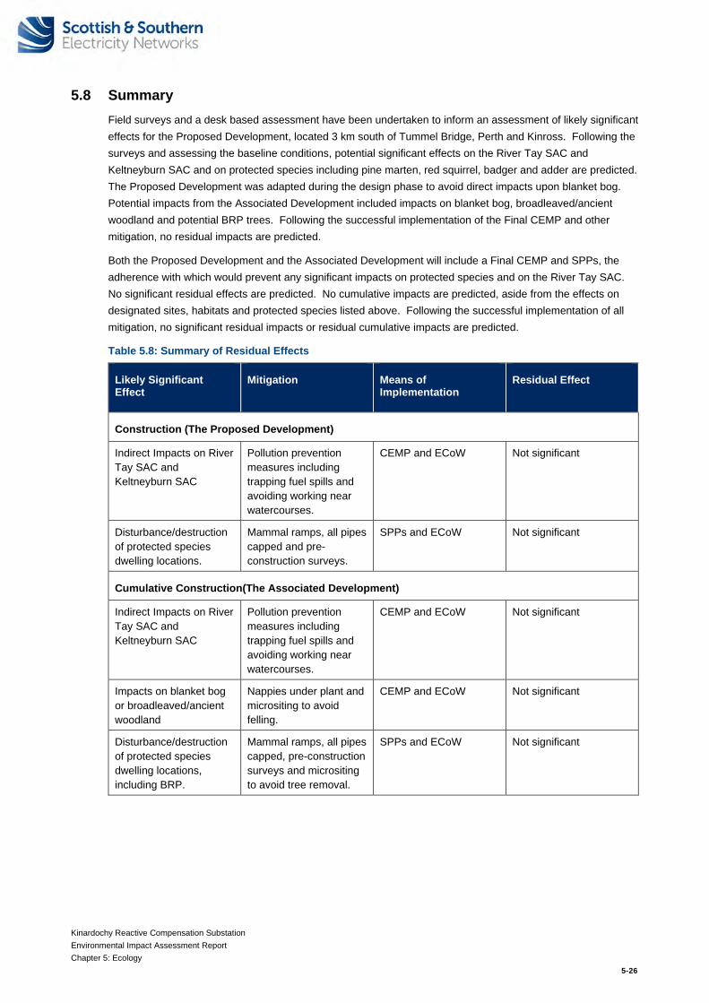
Kinardochy Reactive Compensation Substation Environmental Impact Assessment Report Chapter 5: Ecology 5-26
5.8 Summary Field surveys and a desk based assessment have been undertaken to inform an assessment of likely significant effects for the Proposed Development, located 3 km south of Tummel Bridge, Perth and Kinross. Following the surveys and assessing the baseline conditions, potential significant effects on the River Tay SAC and Keltneyburn SAC and on protected species including pine marten, red squirrel, badger and adder are predicted. The Proposed Development was adapted during the design phase to avoid direct impacts upon blanket bog. Potential impacts from the Associated Development included impacts on blanket bog, broadleaved/ancient woodland and potential BRP trees. Following the successful implementation of the Final CEMP and other mitigation, no residual impacts are predicted.
Both the Proposed Development and the Associated Development will include a Final CEMP and SPPs, the adherence with which would prevent any significant impacts on protected species and on the River Tay SAC. No significant residual effects are predicted. No cumulative impacts are predicted, aside from the effects on designated sites, habitats and protected species listed above. Following the successful implementation of all mitigation, no significant residual impacts or residual cumulative impacts are predicted.
Table 5.8: Summary of Residual Effects
Likely Significant Effect
Mitigation Means of Implementation
Residual Effect
Construction (The Proposed Development)
Indirect Impacts on River Tay SAC and Keltneyburn SAC
Pollution prevention measures including trapping fuel spills and avoiding working near watercourses.
CEMP and ECoW Not significant
Disturbance/destruction of protected species dwelling locations.
Mammal ramps, all pipes capped and pre-construction surveys.
SPPs and ECoW Not significant
Cumulative Construction(The Associated Development)
Indirect Impacts on River Tay SAC and Keltneyburn SAC
Pollution prevention measures including trapping fuel spills and avoiding working near watercourses.
CEMP and ECoW Not significant
Impacts on blanket bog or broadleaved/ancient woodland
Nappies under plant and micrositing to avoid felling.
CEMP and ECoW Not significant
Disturbance/destruction of protected species dwelling locations, including BRP.
Mammal ramps, all pipes capped, pre-construction surveys and micrositing to avoid tree removal.
SPPs and ECoW Not significant

Kinardochy Reactive Compensation Substation Environmental Impact Assessment Report Chapter 6: Ornithology 6-1
6. ORNITHOLOGY
6.1 Introduction
This chapter considers the likely significant effects on ornithology associated with the construction and operation of the Proposed Development. The likely significant effects on ecology associated with the construction and operation of the Associated Development will be considered as part of the cumulative assessment. As described in Chapter 2: Description of Development, neither the Proposed Development nor the Associated Development are likely to be decommissioned. If they were to be decommissioned the effects associated with the construction phase of the Proposed Development on ornithology can be considered to be representative of reasonable worst-case decommissioning effects, therefore a separate assessment of the decommissioning phase of the Proposed Development and Associated Development has not been undertaken as part of this assessment.
The specific objectives of the chapter are to:
• describe the ornithological baseline;
• describe the assessment methodology and significance criteria used in completing the impact assessment;
• describe the potential effects, including direct, indirect and cumulative effects;
• describe the mitigation measures proposed to address likely significant effects; and
• assess the residual effects remaining following the implementation of mitigation.
The assessment has been carried out by an MCIEEM certified senior ecologist with Ramboll UK ltd with eight years of experience. This assessment has been undertaken following the Chartered Institute of Ecology and Environmental Management’s (CIEEM) guidance on undertaking Ecological Impact Assessments1.
The chapter is supported by:
• Figure 6.1: Ornithological Study Areas;
• Figure 6.2: Ornithological Designated Sites; and
• Figure 6.3: Breeding Bird Survey Results;
6.2 Scope of Assessment
This chapter identifies the potential effects on ornithology associated with the construction and operation of the Proposed Development. Where required, it also provides details of mitigation measures to address these potential impacts.
This chapter considers the potential for likely significant effects on:
• Protected sites;
• direct loss of bird habitat through construction of the Proposed Development; and
• disturbance of birds during construction and operation of the Proposed Development (including displacement of flight activity through barrier effects).
Key target species for the assessment have been identified following NatureScot 20172 guidance using the following criteria:
1 CIEEM (2018), Guidelines for Ecological Impact Assessment in the UK and Ireland: Terrestrial, Freshwater, Coastal and Marine. Chartered Institute of Ecology and Environmental Management, Winchester 2 NatureScot (2017), Recommended bird survey methods to inform impact assessment of onshore wind farms. NatureScot Guidance.
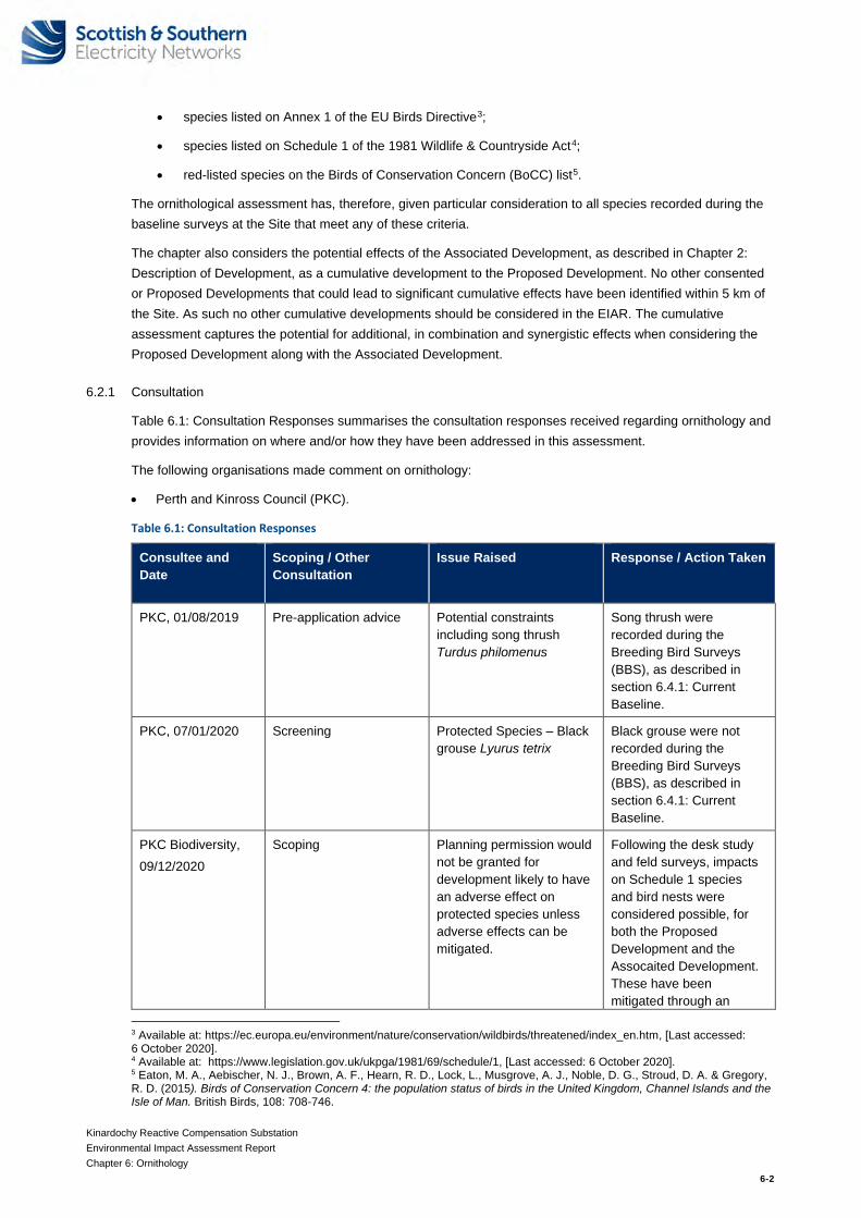
Kinardochy Reactive Compensation Substation Environmental Impact Assessment Report Chapter 6: Ornithology 6-2
• species listed on Annex 1 of the EU Birds Directive3;
• species listed on Schedule 1 of the 1981 Wildlife & Countryside Act4;
• red-listed species on the Birds of Conservation Concern (BoCC) list5.
The ornithological assessment has, therefore, given particular consideration to all species recorded during the baseline surveys at the Site that meet any of these criteria.
The chapter also considers the potential effects of the Associated Development, as described in Chapter 2: Description of Development, as a cumulative development to the Proposed Development. No other consented or Proposed Developments that could lead to significant cumulative effects have been identified within 5 km of the Site. As such no other cumulative developments should be considered in the EIAR. The cumulative assessment captures the potential for additional, in combination and synergistic effects when considering the Proposed Development along with the Associated Development.
6.2.1 Consultation
Table 6.1: Consultation Responses summarises the consultation responses received regarding ornithology and provides information on where and/or how they have been addressed in this assessment.
The following organisations made comment on ornithology:
• Perth and Kinross Council (PKC).
Table 6.1: Consultation Responses
Consultee and Date
Scoping / Other Consultation
Issue Raised Response / Action Taken
PKC, 01/08/2019 Pre-application advice Potential constraints including song thrush Turdus philomenus
Song thrush were recorded during the Breeding Bird Surveys (BBS), as described in section 6.4.1: Current Baseline.
PKC, 07/01/2020 Screening Protected Species – Black grouse Lyurus tetrix
Black grouse were not recorded during the Breeding Bird Surveys (BBS), as described in section 6.4.1: Current Baseline.
PKC Biodiversity, 09/12/2020
Scoping Planning permission would not be granted for development likely to have an adverse effect on protected species unless adverse effects can be mitigated.
Following the desk study and feld surveys, impacts on Schedule 1 species and bird nests were considered possible, for both the Proposed Development and the Assocaited Development. These have been mitigated through an
3 Available at: https://ec.europa.eu/environment/nature/conservation/wildbirds/threatened/index_en.htm, [Last accessed: 6 October 2020]. 4 Available at: https://www.legislation.gov.uk/ukpga/1981/69/schedule/1, [Last accessed: 6 October 2020]. 5 Eaton, M. A., Aebischer, N. J., Brown, A. F., Hearn, R. D., Lock, L., Musgrove, A. J., Noble, D. G., Stroud, D. A. & Gregory, R. D. (2015). Birds of Conservation Concern 4: the population status of birds in the United Kingdom, Channel Islands and the Isle of Man. British Birds, 108: 708-746.

Kinardochy Reactive Compensation Substation Environmental Impact Assessment Report Chapter 6: Ornithology 6-3
Consultee and Date
Scoping / Other Consultation
Issue Raised Response / Action Taken
ECoW following CEMP and potentially SPPs (Sections 6.6.1 and 6.6.2) and, subsequently, no significant residual impacts are predicted on protected species/features.
Full details on the consultation responses can be reviewed in EIAR Volume 4: Technical Appendix 1.1: Consultation Register.
6.2.2 Issues Scoped Out
The scope of this assessment takes account of the committed mitigation measures both incorporated into the design and those standard construction and decommissioning mitigation measures incorporated into the Proposed Development, as described in Chapter 2: Development Description, and outlined in EIAR Volume 4: Technical Appendix 2.1: Outline Construction Environmental Management Plan. Table 6.2: Issues Scoped Out of EIA summarises the issues scoped out of the assessment:
Table 6.2: Issues Scoped Out of EIA
Potential Effect
Basis for Scoping Out
Designated Sites There is no connectivity between the Proposed Development or the Associated Develooment with any sites designated for ornithological interests.
Operational Impacts No significant effects are predicted during the operational phase of the Proposed Development. These impacts are limited to operational visits from maintenance staff and operational noise/disturbance. No significant impacts from collision risk are predicted as the Associated Development shall be replacing an existing line, which birds would be habituated to.
6.3 Assessment Methodology
6.3.1 Method of Baseline Characterisation
Extent of Study Area
This ornithological assessment focuses on the Site and appropriate buffer areas (collectively the 'study areas') which have been applied. The ornithology desk study area is defined as a 10 km buffer around the Site to include designated sites from which birds may travel to use the Site. The ornithology field study area is defined as a buffer of up to 100 m around the infrastructure proposed at the time of survey. This allows any breeding birds that could be disturbed by the construction etc. to be identified.
6.3.2 Desk Study
NatureScot Sitelink6 was reviewed for information on protected sites within 10 km of the Site. This resource maps the extent of protected sites and describes their designations in terms of qualifying species/or
6 NatureScot (2020), Sitelink. Available at: https://sitelink.nature.scot/map [Last accessed 10/07/2020]

Kinardochy Reactive Compensation Substation Environmental Impact Assessment Report Chapter 6: Ornithology 6-4
assemblages and habitats as well as reports on the conservation status of the sites with regard to their qualifying interests and outlining any pressures or factors impacting adversely on the sites.
6.3.3 Field Survey
The Breeding Bird Survey (BBS) followed Common Bird Census methodology7 was adopted to survey for breeding birds. The surveys were undertaken early in the project development process and so were undertaken using a larger site boundary than is being used for the submission. The Proposed Development was surveyed three times on the following dates:
• 24 April 2019;
• 10 May 2019; and
• 16 July 2019.
When birds were observed or heard, their behaviour was recorded. Where this indicated territorial behaviour, e.g. singing, alarm calling, carrying food/nesting material, then it was interpreted to indicate a potential breeding territory. If territorial behaviour was recorded at the same location, by the same species on more than one survey visit, then it was considered to be a confirmed breeding territory. By combining the data and discounting records that were thought to be the same bird, the number of territories for each species could be estimated.
Ramboll ornithologists were also on site between 16 June 2020 and 8 July 2020 as Ecological Clerk of Works (ECoW) support for the ground investigation (GI) surveys, during which incidental, ornithological records were noted.
6.3.4 Criteria for Assessment of Effects
The importance of ecological interests at the Site is identified through a combination of statutory requirements and policy objectives for biodiversity. The value is expressed according to various characteristics such as their inclusion in citations for designated sites such as Special Protection Areas (SPA) or Sites of Special Scientific Interest (SSSI), or their inclusion on the Scottish Biodiversity List8, or rare and legally protected species. The ecological value of the feature is considered within a geographical context from International, National, Regional, County to Local. The impacts are then characterised by their direction, magnitude, extent, duration, reversibility, frequency and timing.
The assessment presented here involves the following process:
• identification of the potential ecological impacts of the Proposed Development;
• defining the nature conservation value of the receptors present, incorporating conservation status where appropriate;
• characterising the likely impact including magnitude, extent, duration, reversibility, frequency and timing;
• based on the above information, a professional judgement is made as to whether the identified effect is significant in the context of the EIA Regulations;
• if a potential effect is determined to be likely and significant, mitigation measures are proposed to avoid, reduce, or compensate for the effect where possible and any necessary monitoring where required is specified; and
• residual effects after mitigation, compensation or enhancement are considered.
7 Bibby, C. J., Burgess, N., Hill, D. & Mustoe, S.H. (2000). Bird Census Techniques (2nd edition). Academic Press. 8 Scottish Biodiversity List. Available at: https://www.webarchive.org.uk/wayback/archive/20160402063428/http://www.gov.scot/Topics/Environment/Wildlife-Habitats/16118/Biodiversitylist/SBL [Last accessed: 1 October 2020]
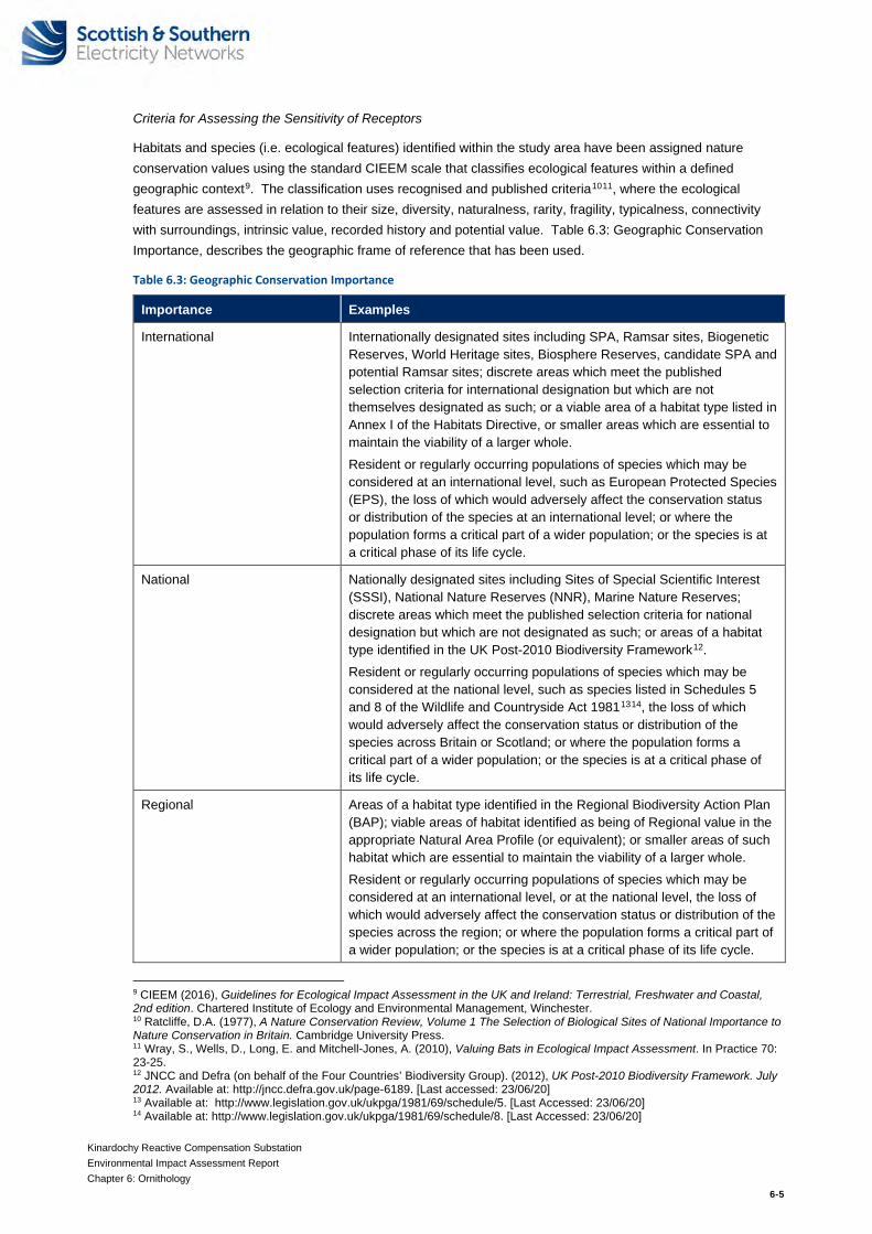
Kinardochy Reactive Compensation Substation Environmental Impact Assessment Report Chapter 6: Ornithology 6-5
Criteria for Assessing the Sensitivity of Receptors
Habitats and species (i.e. ecological features) identified within the study area have been assigned nature conservation values using the standard CIEEM scale that classifies ecological features within a defined geographic context9. The classification uses recognised and published criteria1011, where the ecological features are assessed in relation to their size, diversity, naturalness, rarity, fragility, typicalness, connectivity with surroundings, intrinsic value, recorded history and potential value. Table 6.3: Geographic Conservation Importance, describes the geographic frame of reference that has been used.
Table 6.3: Geographic Conservation Importance
Importance Examples
International Internationally designated sites including SPA, Ramsar sites, Biogenetic Reserves, World Heritage sites, Biosphere Reserves, candidate SPA and potential Ramsar sites; discrete areas which meet the published selection criteria for international designation but which are not themselves designated as such; or a viable area of a habitat type listed in Annex I of the Habitats Directive, or smaller areas which are essential to maintain the viability of a larger whole. Resident or regularly occurring populations of species which may be considered at an international level, such as European Protected Species (EPS), the loss of which would adversely affect the conservation status or distribution of the species at an international level; or where the population forms a critical part of a wider population; or the species is at a critical phase of its life cycle.
National Nationally designated sites including Sites of Special Scientific Interest (SSSI), National Nature Reserves (NNR), Marine Nature Reserves; discrete areas which meet the published selection criteria for national designation but which are not designated as such; or areas of a habitat type identified in the UK Post-2010 Biodiversity Framework12. Resident or regularly occurring populations of species which may be considered at the national level, such as species listed in Schedules 5 and 8 of the Wildlife and Countryside Act 19811314, the loss of which would adversely affect the conservation status or distribution of the species across Britain or Scotland; or where the population forms a critical part of a wider population; or the species is at a critical phase of its life cycle.
Regional Areas of a habitat type identified in the Regional Biodiversity Action Plan (BAP); viable areas of habitat identified as being of Regional value in the appropriate Natural Area Profile (or equivalent); or smaller areas of such habitat which are essential to maintain the viability of a larger whole. Resident or regularly occurring populations of species which may be considered at an international level, or at the national level, the loss of which would adversely affect the conservation status or distribution of the species across the region; or where the population forms a critical part of a wider population; or the species is at a critical phase of its life cycle.
9 CIEEM (2016), Guidelines for Ecological Impact Assessment in the UK and Ireland: Terrestrial, Freshwater and Coastal, 2nd edition. Chartered Institute of Ecology and Environmental Management, Winchester. 10 Ratcliffe, D.A. (1977), A Nature Conservation Review, Volume 1 The Selection of Biological Sites of National Importance to Nature Conservation in Britain. Cambridge University Press. 11 Wray, S., Wells, D., Long, E. and Mitchell-Jones, A. (2010), Valuing Bats in Ecological Impact Assessment. In Practice 70: 23-25. 12 JNCC and Defra (on behalf of the Four Countries’ Biodiversity Group). (2012), UK Post-2010 Biodiversity Framework. July 2012. Available at: http://jncc.defra.gov.uk/page-6189. [Last accessed: 23/06/20] 13 Available at: http://www.legislation.gov.uk/ukpga/1981/69/schedule/5. [Last Accessed: 23/06/20] 14 Available at: http://www.legislation.gov.uk/ukpga/1981/69/schedule/8. [Last Accessed: 23/06/20]

Kinardochy Reactive Compensation Substation Environmental Impact Assessment Report Chapter 6: Ornithology 6-6
Importance Examples
County Designated nature conservation sites at the local authority level in Scotland including statutory Local Nature Reserves (LNR) and non-statutory Local Nature Conservation Sites; or discrete areas which meet the published selection criteria for designation but which are not designated as such. Resident or regularly occurring populations of species which may be considered at the local authority level, the loss of which would adversely affect the conservation status or distribution of the species across the local authority area.
Local Features of local value include areas of habitat or populations/communities of species considered to appreciably enrich the habitat resource within the immediate surrounding area, for example, species-rich hedgerows. Resident or regularly occurring populations of species which may be considered at an international level, or at the national level, the loss of which would adversely affect the conservation status or distribution of the species across the immediate surrounding area; or where the population forms a critical part of a wider population; or the species is at a critical phase of its life cycle.
Negligible Features that do not meet any of the criteria listed above. Features that are common in the area surrounding the Proposed Development.
A wide range of sources can be used to assign importance to ecological features, including legislation and policy. In the case of designated nature conservation sites, their importance reflects the geographic context of the designation. For example, sites designated as SPAs are recognised as being of importance at an international level. Ecological features not included in legislation and policy may also be assigned importance due to, for example, local rarity or decline, or provision of a functional role for other ecological features. Professional judgement is used to assign such importance.
Criteria for Assessing the Magnitude of Change
The potential impacts upon ecological features have been considered in relation to the Proposed Development. The impacts have been assessed without consideration of any specific mitigation measures that might be employed. The assessment of likely ecological impacts has been made in relation to the baseline conditions of the study area. The likely impacts of the Proposed Developments activities upon ecological features have been characterised according to several variables detailed in Table 6.4: Impact Characterisation.
Table 6.4: Impact Characterisation
Parameter Description
Direction Impacts are either adverse (negative) or beneficial (positive).
Magnitude This is defined as high, moderate, low or negligible, with these being classified using the following criteria: High: Total/near total loss of a population due to mortality or displacement or major reduction in the status or productivity15 of a population due to mortality or displacement or disturbance. Total/near total loss of a habitat. Moderate: Partial reduction in the status or productivity of a population due to mortality or displacement or disturbance. Partial loss of a habitat.
15 Status is defined as the conservation status of the species and indicates whether the species is likely to become extinct in the near future. Productivity is defined as the rate of population growth.
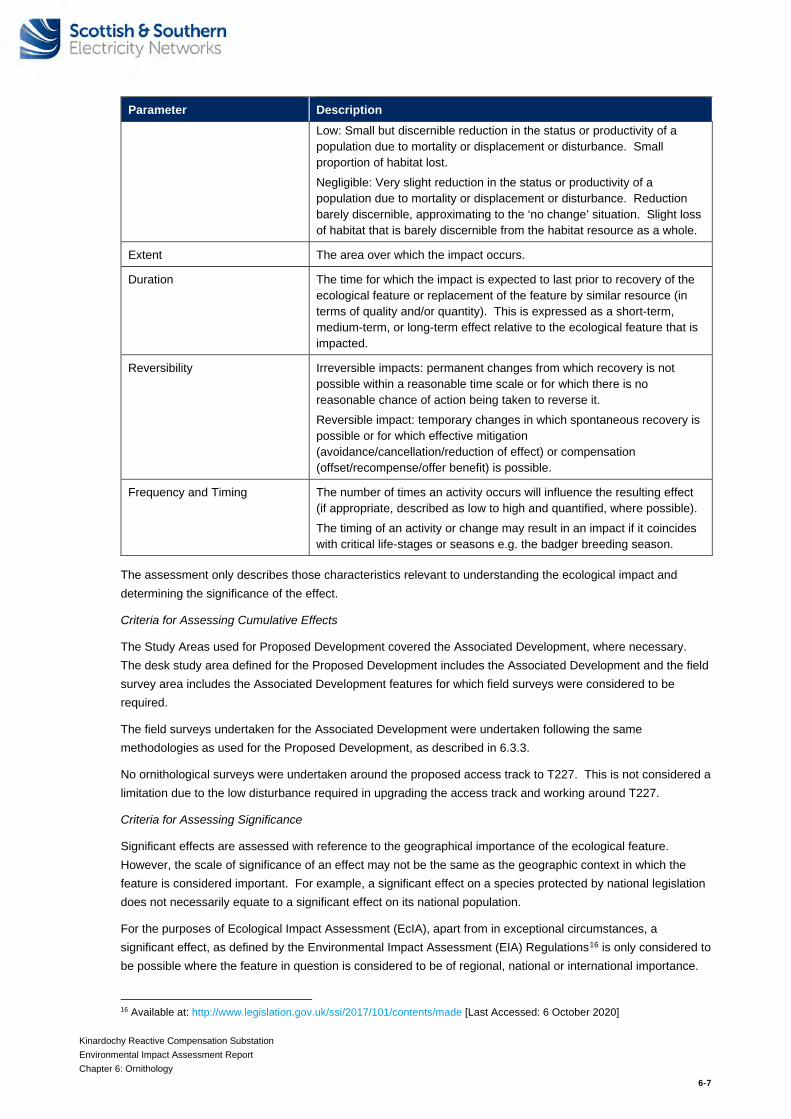
Kinardochy Reactive Compensation Substation Environmental Impact Assessment Report Chapter 6: Ornithology 6-7
Parameter Description Low: Small but discernible reduction in the status or productivity of a population due to mortality or displacement or disturbance. Small proportion of habitat lost. Negligible: Very slight reduction in the status or productivity of a population due to mortality or displacement or disturbance. Reduction barely discernible, approximating to the ‘no change’ situation. Slight loss of habitat that is barely discernible from the habitat resource as a whole.
Extent The area over which the impact occurs.
Duration The time for which the impact is expected to last prior to recovery of the ecological feature or replacement of the feature by similar resource (in terms of quality and/or quantity). This is expressed as a short-term, medium-term, or long-term effect relative to the ecological feature that is impacted.
Reversibility Irreversible impacts: permanent changes from which recovery is not possible within a reasonable time scale or for which there is no reasonable chance of action being taken to reverse it. Reversible impact: temporary changes in which spontaneous recovery is possible or for which effective mitigation (avoidance/cancellation/reduction of effect) or compensation (offset/recompense/offer benefit) is possible.
Frequency and Timing The number of times an activity occurs will influence the resulting effect (if appropriate, described as low to high and quantified, where possible). The timing of an activity or change may result in an impact if it coincides with critical life-stages or seasons e.g. the badger breeding season.
The assessment only describes those characteristics relevant to understanding the ecological impact and determining the significance of the effect.
Criteria for Assessing Cumulative Effects
The Study Areas used for Proposed Development covered the Associated Development, where necessary. The desk study area defined for the Proposed Development includes the Associated Development and the field survey area includes the Associated Development features for which field surveys were considered to be required.
The field surveys undertaken for the Associated Development were undertaken following the same methodologies as used for the Proposed Development, as described in 6.3.3.
No ornithological surveys were undertaken around the proposed access track to T227. This is not considered a limitation due to the low disturbance required in upgrading the access track and working around T227.
Criteria for Assessing Significance
Significant effects are assessed with reference to the geographical importance of the ecological feature. However, the scale of significance of an effect may not be the same as the geographic context in which the feature is considered important. For example, a significant effect on a species protected by national legislation does not necessarily equate to a significant effect on its national population.
For the purposes of Ecological Impact Assessment (EcIA), apart from in exceptional circumstances, a significant effect, as defined by the Environmental Impact Assessment (EIA) Regulations16 is only considered to be possible where the feature in question is considered to be of regional, national or international importance.
16 Available at: http://www.legislation.gov.uk/ssi/2017/101/contents/made [Last Accessed: 6 October 2020]
Kinardochy Reactive Compensation Substation Environmental Impact Assessment Report Chapter 6: Ornithology 6-8
That is not to say that impacts from the Proposed Development or Associated Development could not result in significant effects on features of county or local importance, simply that those effects are not likely to be significant under Environmental Impact Assessment (EIA) Regulations, unless the effect is likely to undermine biodiversity conservation objectives (such as local policies for no net loss) or biodiversity in general. Whether an effect at local or county importance is considered to be significant or not significant under the EIA Regulations is made clear in the impact assessment of each ecological feature.
In cases where features of local importance are adversely impacted resulting in a potential legal offence being committed, these impacts are considered to be significant. These situations would include the destruction of any active bird nests, which is illegal under the Wildlife and Countryside Act 198117.
Mitigation and/or compensation is proposed for all effects considered significant under the EIA Regulations. Where appropriate, as part of additional good practice, mitigation and/or compensation may be proposed for significant effects on features of county or local importance, or where required in relation to protected species where legislation may require actions to protect populations or individuals
6.3.5 Limitations and Assumptions
It should be noted that the availability and quality of the data obtained during desk studies is reliant on third party responses and recorders. This varies from region to region and for different species groups. Furthermore, the comprehensiveness of data often depends on the level of coverage, the expertise and experience of the recorder and the submission of records to the local recorder.
Guidance documents published by NatureScot are used to determine disturbance distance for species where necessary. In reality, different individuals of a species may react to disturbance differently, meaning that some may habituate to noise, for example, over greater or shorter distances.
All ornithological surveys are limited by factors which affect the presence of birds such as the time of year and behaviour. The ornithological surveys undertaken have not therefore been taken as conclusive proof that the species is not present or that it would not be present in the future. However, the results of these surveys are considered to be robust and sufficient to undertake this assessment.
Therefore, whilst some limitations are inevitable, it is considered that there is sufficient information to enable an informed decision to be taken in relation to the identification and assessment of likely significant effects on ornithological receptors.
6.4 Baseline Conditions
This section details the results of the desk study and field surveys, providing the baseline conditions for the Project Site, and includes a review of:
• Statutory nature conservation designated sites (for ornithology) within 10 km of the Site.
• Desk-based study results; and
• Breeding Bird Survey results.
6.4.1 Current Baseline
Designated Sites
The designated sites that are classified for ornithological features are listed in Table 6.5: Designated Sites within 10 km of the Site. These features are shown on EIAR Volume 3a: Figure 6.2: Designated Sites.
17 Available at: http://www.legislation.gov.uk/ukpga/1981/69/schedule/5. [Last Accessed: 23 June 2020]
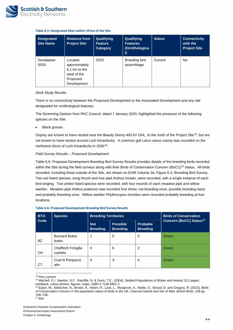
Kinardochy Reactive Compensation Substation Environmental Impact Assessment Report Chapter 6: Ornithology 6-9
Table 6.5: Designated Sites within 10 km of the Site
Designated Site Name
Distance from Project Site
Qualifying Feature Category
Qualifying Features (Ornithological)
Status Connectivity with the Project Site
Dunalastair SSSI
Located approximately 6.1 km to the west of the Proposed Development.
SSSI Breeding bird assemblage.
Current No
Desk Study Results
There is no connectivity between the Proposed Development or the Associated Development and any site designated for ornithological features.
The Screening Opinion from PKC Council, dated 7 January 2020, highlighted the presence of the following species on the Site:
• Black grouse.
Osprey are known to have nested near the Beauly Denny 400 kV OHL, to the north of the Project Site18, but are not known to have nested around Loch Kinardochy. A common gull Larus canus colony was recorded on the northwest shore of Loch Kinardochy in 200019.
Field Survey Results – Proposed Development
Table 6.6: Proposed Development Breeding Bird Survey Results provides details of the breeding birds recorded within the Site during the field surveys along with their Birds of Conservation Concern (BoCC)20 status. All birds recorded, including those outside of the Site, are shown on EIAR Volume 3a: Figure 6.3: Breeding Bird Survey. Two red listed species, song thrush and tree pipit Anthus trivialis, were recorded, with a single instance of each bird singing. Two amber listed species were recorded, with four records of each meadow pipit and willow warbler. Meadow pipit Anthus pratensis was recorded four times; not breeding once, possibly breeding twice and probably breeding once. Willow warbler Phylloscopus trochilus were recorded probably breeding at four locations.
Table 6.6: Proposed Development Breeding Bird Survey Results
BTO Code
Species Breeding Territories Birds of Conservation Concern (BoCC) Status21
Not Breeding
Possible Breeding
Probable Breeding
BZ Buzzard Buteo buteo
1 0 0 Green
CH Chaffinch Fringilla coelebs
0 6 2 Green
CT Coal tit Periparus ater
0 3 4 Green
18 Pers comms 19 Mitchell, P.I., Newton, S.F., Ratcliffe, N. & Dunn, T.E., (2004), Seabird Populations of Britain and Ireland, 511 pages, hardback, colour photos, figures, maps, ISBN 0 7136 6901 2 20 Eaton, M., Aebischer, N., Brown, A., Hearn, R., Lock, L., Musgrove, A., Noble, D., Stroud, D. and Gregory, R. (2015), Birds of Conservation Concern 4: the population status of birds in the UK, Channel Islands and Isle of Man. British Birds, 108 pp. 708–746. 21 Ibid
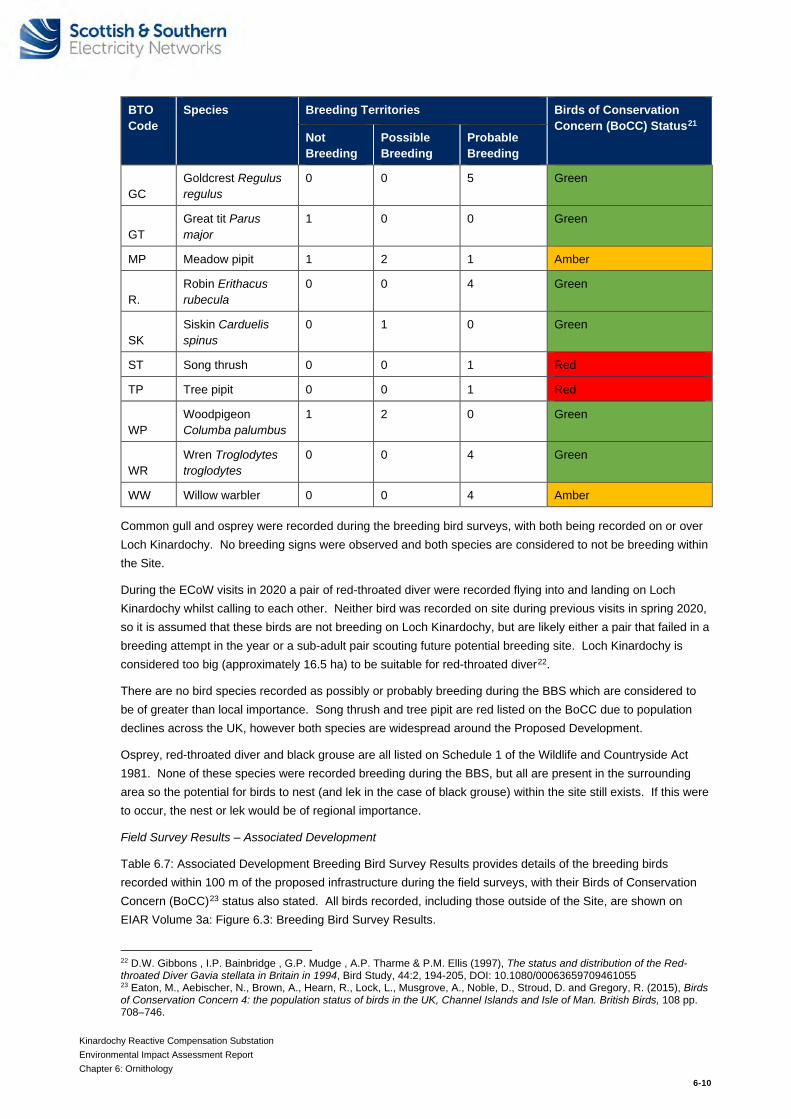
Kinardochy Reactive Compensation Substation Environmental Impact Assessment Report Chapter 6: Ornithology 6-10
BTO Code
Species Breeding Territories Birds of Conservation Concern (BoCC) Status21
Not Breeding
Possible Breeding
Probable Breeding
GC Goldcrest Regulus regulus
0 0 5 Green
GT Great tit Parus major
1 0 0 Green
MP Meadow pipit 1 2 1 Amber
R. Robin Erithacus rubecula
0 0 4 Green
SK Siskin Carduelis spinus
0 1 0 Green
ST Song thrush 0 0 1 Red
TP Tree pipit 0 0 1 Red
WP Woodpigeon Columba palumbus
1 2 0 Green
WR Wren Troglodytes troglodytes
0 0 4 Green
WW Willow warbler 0 0 4 Amber
Common gull and osprey were recorded during the breeding bird surveys, with both being recorded on or over Loch Kinardochy. No breeding signs were observed and both species are considered to not be breeding within the Site.
During the ECoW visits in 2020 a pair of red-throated diver were recorded flying into and landing on Loch Kinardochy whilst calling to each other. Neither bird was recorded on site during previous visits in spring 2020, so it is assumed that these birds are not breeding on Loch Kinardochy, but are likely either a pair that failed in a breeding attempt in the year or a sub-adult pair scouting future potential breeding site. Loch Kinardochy is considered too big (approximately 16.5 ha) to be suitable for red-throated diver22.
There are no bird species recorded as possibly or probably breeding during the BBS which are considered to be of greater than local importance. Song thrush and tree pipit are red listed on the BoCC due to population declines across the UK, however both species are widespread around the Proposed Development.
Osprey, red-throated diver and black grouse are all listed on Schedule 1 of the Wildlife and Countryside Act 1981. None of these species were recorded breeding during the BBS, but all are present in the surrounding area so the potential for birds to nest (and lek in the case of black grouse) within the site still exists. If this were to occur, the nest or lek would be of regional importance.
Field Survey Results – Associated Development
Table 6.7: Associated Development Breeding Bird Survey Results provides details of the breeding birds recorded within 100 m of the proposed infrastructure during the field surveys, with their Birds of Conservation Concern (BoCC)23 status also stated. All birds recorded, including those outside of the Site, are shown on EIAR Volume 3a: Figure 6.3: Breeding Bird Survey Results.
22 D.W. Gibbons , I.P. Bainbridge , G.P. Mudge , A.P. Tharme & P.M. Ellis (1997), The status and distribution of the Red-throated Diver Gavia stellata in Britain in 1994, Bird Study, 44:2, 194-205, DOI: 10.1080/00063659709461055 23 Eaton, M., Aebischer, N., Brown, A., Hearn, R., Lock, L., Musgrove, A., Noble, D., Stroud, D. and Gregory, R. (2015), Birds of Conservation Concern 4: the population status of birds in the UK, Channel Islands and Isle of Man. British Birds, 108 pp. 708–746.
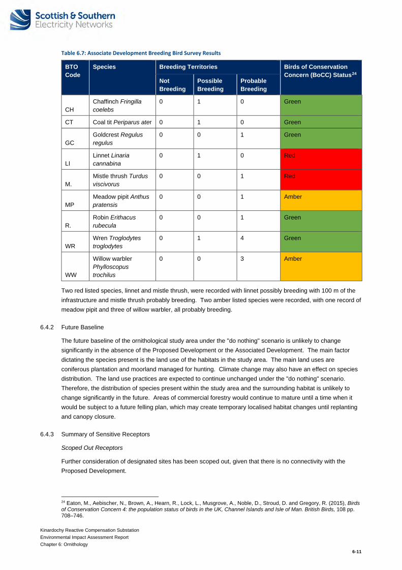
Kinardochy Reactive Compensation Substation Environmental Impact Assessment Report Chapter 6: Ornithology 6-11
Table 6.7: Associate Development Breeding Bird Survey Results
BTO Code
Species Breeding Territories Birds of Conservation Concern (BoCC) Status24
Not Breeding
Possible Breeding
Probable Breeding
CH Chaffinch Fringilla coelebs
0 1 0 Green
CT Coal tit Periparus ater 0 1 0 Green
GC Goldcrest Regulus regulus
0 0 1 Green
LI Linnet Linaria cannabina
0 1 0 Red
M. Mistle thrush Turdus viscivorus
0 0 1 Red
MP Meadow pipit Anthus pratensis
0 0 1 Amber
R. Robin Erithacus rubecula
0 0 1 Green
WR Wren Troglodytes troglodytes
0 1 4 Green
WW
Willow warbler Phylloscopus trochilus
0 0 3 Amber
Two red listed species, linnet and mistle thrush, were recorded with linnet possibly breeding with 100 m of the infrastructure and mistle thrush probably breeding. Two amber listed species were recorded, with one record of meadow pipit and three of willow warbler, all probably breeding.
6.4.2 Future Baseline
The future baseline of the ornithological study area under the "do nothing" scenario is unlikely to change significantly in the absence of the Proposed Development or the Associated Development. The main factor dictating the species present is the land use of the habitats in the study area. The main land uses are coniferous plantation and moorland managed for hunting. Climate change may also have an effect on species distribution. The land use practices are expected to continue unchanged under the "do nothing" scenario. Therefore, the distribution of species present within the study area and the surrounding habitat is unlikely to change significantly in the future. Areas of commercial forestry would continue to mature until a time when it would be subject to a future felling plan, which may create temporary localised habitat changes until replanting and canopy closure.
6.4.3 Summary of Sensitive Receptors
Scoped Out Receptors
Further consideration of designated sites has been scoped out, given that there is no connectivity with the Proposed Development.
24 Eaton, M., Aebischer, N., Brown, A., Hearn, R., Lock, L., Musgrove, A., Noble, D., Stroud, D. and Gregory, R. (2015), Birds of Conservation Concern 4: the population status of birds in the UK, Channel Islands and Isle of Man. British Birds, 108 pp. 708–746.
Kinardochy Reactive Compensation Substation Environmental Impact Assessment Report Chapter 6: Ornithology 6-12
Operational impacts have also been scoped out of further assessment as no impacts on ornithological receptors are anticipated during the operation phase of the Proposed Development. Operational impacts, disturbance and collision risk, are not likely due to the low level of disturbance during the operation phase (occasional visits by staff for maintenance) and the absence of any features likely to cause significant collision risk for birds (overhead line diversion to be assessed in a separate Environmental Appraisal).
In addition, no significant impacts from collision risk are predicted from the Associated Development as it shall be replacing an existing line, which birds would be habituated to. Flight activity of birds vulnerable to collision risk (geese and larger raptors) is considered to be small.
Scoped In Receptors
The assessment of likely effects is undertaken for those ‘scoped-in’ receptors of local, regional, national and international nature conservation value that are known to be present within the Site or surrounding area (as confirmed through survey results and consultations outlined above). These are summarised in Table 6.8: Summary of Sensitive Receptors.
Table 6.8: Summary of Sensitive Receptors
Receptor Sensitivity Justification
Schedule 1 bird nests (osprey and red-throated diver) or leks (black grouse)
Regional Potential to be present exists. Schedule 1 nests and leks have additional legal protections.
Other bird nests Local Suite of species present is of local importance as it is typical of the habitats present in this part of Scotland.
6.5 Assessment of Likely Significant Effects
6.5.1 Potential Construction Effects (The Proposed Development)
Schedule 1 Nests and Leks
During construction of the Proposed Development, nests of schedule 1 birds (osprey and red-throated diver) or leks of schedule 1 birds (black grouse) could be disturbed either visually or by loud noises. This impact has the potential to be an adverse, low magnitude, short-term, reversible, likely effect. The magnitude of the effect is dependent on the number of features disturbed, but is assumed to be low to account for a single feature being impacted. Impacts are short-term and reversible as birds would be able to build another nest and attempt to breed again or could lek from alternative locations. The extent of the impact would be wherever construction activities are required, such as at the construction compound and laydown areas. This impact has the potential to result in an effect on features of either local or regional importance. However, as all bird nests and leks are protected under the Wildlife and Countryside Act 1981, any destruction or disturbance (for schedule 1 species) would be a legal offence. Therefore, mitigation is considered to be required.
Other Bird Nests
During the construction of the Proposed Development, other bird nests could be destroyed directly by construction activities and some may be abandoned due to disturbance from construction vehicles. This impact has the potential to be an adverse, low magnitude, short-term, reversible, likely effect. The magnitude of the effect is dependent on the number of nests destroyed, but is assumed to be low to account for a single nest being impacted. Impacts are short-term and reversible as parent birds would be able to build another nest and attempt to breed again. The extent of the impact would be wherever construction activities are required, such
Kinardochy Reactive Compensation Substation Environmental Impact Assessment Report Chapter 6: Ornithology 6-13
as at the construction compound and laydown areas. This impact has the potential to result in an effect on features of either local or regional importance. However, as all bird nests are protected under the Wildlife and Countryside Act 1981, any destruction would be a legal offence. Therefore, mitigation is considered to be required in both instances.
6.5.2 Potential Cumulative Construction Effects (The Associated Development)
Schedule 1 Nests and Leks
During the construction of the Associated Development, nests of schedule 1 birds (osprey and red-throated diver) or leks of schedule 1 birds (black grouse) could be disturbed either visually or by loud noises. This impact has the potential to be an adverse, low magnitude, short-term, reversible, likely effect. The magnitude of the effect is dependent on the number of features disturbed, but is assumed to be low to account for a single feature being impacted. Impacts are short-term and reversible as birds would be able to build another nest and attempt to breed again or could lek from alternative locations. The extent of the impact would be wherever construction activities are required, such as at tower bases and construction compound and laydown areas. This impact has the potential to result in an effect on features of either local or regional importance. However, as all bird nests and leks are protected under the Wildlife and Countryside Act 1981, any destruction or disturbance (for schedule 1 species) would be a legal offence. Therefore, mitigation is considered to be required.
Other Bird Nests
During the construction of the Associated Development, nests could be destroyed directly by construction activities and some may be abandoned due to disturbance from construction vehicles. This impact has the potential to be an adverse, low magnitude, short-term, reversible, likely effect. The magnitude of the effect is dependent on the number of nests destroyed, but is assumed to be low to account for a single nest being impacted. Impacts are short-term and reversible as parent birds would be able to build another nest and attempt to breed again. The extent of the impact would be wherever construction activities are required, such as at tower bases and construction compound and laydown areas. This impact has the potential to result in an effect on features of either local or regional importance. However, as all bird nests are protected under the Wildlife and Countryside Act 1981, any destruction would be a legal offence. Therefore, mitigation is considered to be required in both instances.
Cumulative Effects – Combination of Proposed Development and Associated Development
There are no other potential effects that, when taken in combination from the Proposed Development and Associated Development, result in potential significant impacts. For both the Proposed Development and the Associated Development, impacts on Schedule 1 nests and leks and other bird nests are considered to present potentially significant impacts. These impacts in combination do not present a more significant impact.
6.6 Mitigation
6.6.1 Mitigation During Construction (The Proposed Development)
The project would employ an ECoW to watch over the construction phase and to ensure the adherence with the Final Construction Environmental Management Plan (CEMP) (as outlined in EIAR Volume 4: Technical Appendix 2.1: Outline CEMP). The Final CEMP would include measures such as pre-construction surveys for osprey, red-throated diver and black grouse. A Species Protection Plan (SPP) for birds has been prepared by the Applicant, which shall be followed to prevent construction impacts on these species. The SPP is provided in Annex A of EIAR Volume 4: Technical Appendix 2.1: Outline Construction Environmental Management Plan.

Kinardochy Reactive Compensation Substation Environmental Impact Assessment Report Chapter 6: Ornithology 6-14
The CEMP would detail how vegetation would be removed outside of bird breeding season (March-August)25. The following vegetation removal deterrence methods could be used:
• Iridescent tape across the construction areas prior to construction activities;
• Bird deterring machines which produce intermittent loud noises; and
• Walking of the cleared area by individuals on a regular basis to prevent birds settling and to monitor if any birds are settling to nests on areas close to the planned construction activity.
If vegetation clearance cannot be undertaken outside of the breeding bird season areas to be cleared would need to be surveyed by the ECoW to ensure no bird nests are present. If any are identified a suitable buffer around the nest would need to be established by the ECoW. This would need to be enforced until the nest has either failed or successfully fledged, with this being confirmed by ECoW.
6.6.2 Mitigation During Construction (The Associated Development)
The project ECoW would oversee the implementation of a CEMP which would include the mitigation measures listed in Section 6.6.1.
6.7 Assessment of Residual Effects
6.7.1 Residual Construction Effects
Following the successful adherence with the Final CEMP and the prevention measures listed above, the likelihood of any impacts on birds’ nests is considered very unlikely. Significant impacts on nesting birds are therefore not predicted from the Proposed Development.
6.7.2 Residual Cumulative Construction Effects
Following the successful adherence with the Final CEMP and the prevention measured listed above, the likelihood of any impacts on birds’ nests is considered very unlikely. Significant impacts on nesting birds are therefore not predicted from the Associated Development.
The mitigation proposed above shall prevent significant effects from the Proposed Development and the Associated Development. It is considered that these effects, when taken in combination, would not result in a significant cumulative impact.
6.8 Summary
Field surveys and a desk based assessment have been undertaken to inform an assessment of likely significant effects for the Proposed Development, located 3 km south of Tummel Bridge, Perth and Kinross. Following the surveys and assessing the baseline conditions no significant impacts on ornithology are predicted.
Potential impacts on bird nests, including schedule 1 bird nests, would be avoided through a combination of pre-construction surveys, clearing vegetation outside of the breeding season and nesting bird checks. These would be implemented by an ECoW, following the Final CEMP and potentially SPPs. No cumulative impacts are predicted, aside from effects on bird nests or Schedule 1 nests and leks. Following the successful implementation of all mitigation, no significant residual impacts or residual cumulative impacts are predicted.
25 UK Government Guidance (2015) Wild birds: surveys and mitigation for development projects. Relevant here as bird breeding season is suitably similar between Scotland and England. Available at: https://www.gov.uk/guidance/wild-birds-surveys-and-mitigation-for-development-projects, [Last Accessed: 19 October 2020]
Kinardochy Reactive Compensation Substation Environmental Impact Assessment Report Chapter 6: Ornithology 6-15
Table 6.9: Summary of Residual Effects
Likely Significant Effect
Mitigation Means of Implementation
Residual Effect
Construction (The Proposed Development)
Destruction or disturbance of bird nests (including schedule 1 nests) or black grouse leks.
Vegetation removal outside breeding bird season, pre-construction surveys for osprey, red-throated diver and black grouse.
CEMP and SPPs, enforced by an ECoW
Not significant
Cumulative Construction (The Associated Development)
Destruction or disturbance of bird nests (including schedule 1 nests) or black grouse leks.
Vegetation removal outside breeding bird season, pre-construction surveys for osprey, red-throated diver and black grouse.
CEMP and SPPs, enforced by an ECoW
Not significant

Kinardochy Reactive Compensation Substation Environmental Impact Assessment Report Chapter 7: Hydrology, Hydrogeology, Geology and Soils 7-1
7. HYDROLOGY, HYDROGEOLOGY, GEOLOGY AND SOILS
7.1 Introduction This chapter considers the likely significant effects on hydrology, hydrogeology, geology and soils associated with the construction and operation of the Proposed Development. The likely significant effects on hydrology, hydrogeology, geology and soils associated with the construction and operation of the Associated Development will be considered as part of the cumulative assessment. As described in Chapter 2: Description of Development, neither the Proposed Development nor the Associated Development are likely to be decommissioned. If they were to be decommissioned the effects associated with the construction phase of the proposed development on hydrology, hydrogeology, geology and soils can be considered to be representative of reasonable worst-case decommissioning effects, therefore a separate assessment of the decommissioning phase of the Proposed Development and Associated Development has not been undertaken.
The specific objectives of the chapter are to:
• describe the hydrology, hydrogeology, geology and soils baseline;
• describe the assessment methodology and significance criteria used in completing the impact assessment;
• describe the potential effects, including direct, indirect and cumulative effects;
• describe the mitigation measures proposed to address likely significant effects; and
• assess the residual effects remaining following the implementation of mitigation.
The assessment has been carried out and reviewed by appropriately qualified environmental consultants with over ten years’ experience in Environmental Impact Assessment and energy projects, including hydrology and peat assessments.
The chapter is supported by:
• Figure 7.1: Local Hydrology
• Figure 7.2: Bedrock Geology
• Figure 7.3: Drift Hydrology
• Figure 7.4: Soil Plan;
• Figure 7.5: Peatland Classification;
• Figure 7.6: Peat Depth;
• Figure 7.7: Groundwater Vulnerability;
• Figure 7.8: Private Water Supplies;
• Technical Appendix 7.1: Flood Risk and Drainage Impact Assessment;
• Technical Appendix 7.2: Stage 1 Peat Management Plan – The Proposed Development;
• Technical Appendix 7.3: Stage 1 Peat Management Plan – The Associated Development; and
• Technical Appendix 7.4: Water Crossing Assessment.
Figures 7.1 - 7.8 are referenced in the text where relevant.
7.2 Scope of Assessment This chapter considers the potential for likely significant effects on the following from the Proposed Development:
• Hydrology and Flood Risk;
• Private Water Supplies (PWS);
• Groundwater Dependent Terrestrial Ecosystems (GWDTE);

Kinardochy Reactive Compensation Substation Environmental Impact Assessment Report Chapter 7: Hydrology, Hydrogeology, Geology and Soils 7-2
• Hydrogeology; and
• Geology, Soils and Peat.
The chapter also considers the potential effects of the Associated Development, as described in Chapter 2: Description of Development, as a cumulative development to the Proposed Development. No other consented or proposed developments that could lead to significant cumulative effects have been identified within 5 km of the Site. As such no other cumulative developments should be considered in the EIA Report. The cumulative assessment captures the potential for additional, in combination and synergistic effects when considering the Proposed Development in combination with the Associated Development
7.2.1 Consultation
The scope of the assessment has been informed by consultation responses summarised in Table 7.1: Consultation Responses and the following guidelines/policies:
• Water Framework Directive (2000/60/CE) (WFD);
• EC Groundwater Directive (80/68/EEC);
• Water Environment and Water Services (Scotland) Act 2003 which is implemented through the Water Environment (Controlled Activities) (Scotland) Regulations 2011;
• Water Environment (Miscellaneous) (Scotland) Regulations 2017;
• Flood Risk Management (Scotland) Act 2009;
• Water Supply (Water Quality) (Scotland) Regulations 2001;
• Water Intended for Human Consumption (Private Supplies) (Scotland) Regulations 2017;
• Public Water Supplies (Scotland) Regulations 2014 (as amended 2017);
• Public and Private Water Supplies (Miscellaneous Amendments) (Scotland) Regulations 2015;
• Water Environment (Drinking Water Protected Areas) (Scotland) Order 2013;
• SEPA’s River Basin Management Plans (RBMP);
• SEPA’s Pollution Prevention Guidelines (PPGs);
• Groundwater Protection Policy for Scotland (SEPA Policy No. 19);
• Scottish Government (2012) River Crossings and Migratory Fish;
• Scottish Planning Policy 2010 (SPP);
• Scottish Government, Scottish Natural Heritage, SEPA (2017) Peatland Survey. Guidance on Developments on Peatland; and
• Perth and Kinross Council Local Development Plan (LDP) 2019.
The following organisations made comment on the Scoping Report issued in September 2020:
• Perth and Kinross Council (PKC);
• Scottish Water; and
• Scottish Environmental Protection Agency (SEPA).
Table 7.1: Consultation Responses summarises the consultation responses received regarding hydrology, hydrogeology, geology and soils and provides information on where and/or how they have been addressed in this assessment.
Kinardochy Reactive Compensation Substation Environmental Impact Assessment Report Chapter 7: Hydrology, Hydrogeology, Geology and Soils 7-3
Table 7.1: Consultation Responses
Consultee and Date
Scoping / Other Consultation
Issue Raised Response / Action Taken
PKC 1 Aug 2019
Pre-application consultation
Flood Risk (Loch and Surface) including Drainage Assessment.
A Flood Risk Assessment and Drainage Impact Assessment for the Proposed Development is provided in EIAR Volume 4: Technical Appendix 7.1: Flood Risk and Drainage Impact Assessment.
PKC 1 Aug 2019 Pre-application consultation
Ground Investigation Survey including peatland and groundwater.
Phase 1 peat surveys and ground investigation (GI) works undertaken have been and are detailed in this EIAR chapter. A Stage 1 Peat Management Plan (PMP) has also been prepared for both the Proposed Development and the Associated Development (See EIAR Volume 4: Technical Appendices 7.2 and 7.3).
PKC 17 Dec 2019
Screening Opinion Peatland disturbance and/or degradation leading to carbon release, damage to habitats and potential effects on land stability/hydrology.
Surveys to confirm extent of peat within the Site have been undertaken and are detailed in this EIAR chapter. An assessment of the potential effects of the Proposed Development on peat is included in this EIAR chapter and a Stage 1 PMP has been prepared for both the Proposed Development and the Associated Development (sees EIAR Volume 4: Technical Appendices 7.2 and 7.3).
PKC 7 Jan 2020
Screening Opinion The council has provided a list of potential significant effects which may need to be considered with regard to flooding & water. It was also suggested that there is a potential for construction related pollution and the production of waste to have an effect, particularly on the River Tay which is environmentally sensitive,
The potential effects listed by the council have been considered within this chapter. A Flood Risk Assessment and Drainage Impact Assessment for the Proposed Development is provided in EIAR Volume 4: Technical Appendix 7.1: Flood Risk and Drainage Impact Assessment. Appropriate pollution prevention measures will
Kinardochy Reactive Compensation Substation Environmental Impact Assessment Report Chapter 7: Hydrology, Hydrogeology, Geology and Soils 7-4
Consultee and Date
Scoping / Other Consultation
Issue Raised Response / Action Taken
if not controlled and mitigated via the CEMP.
be covered in the CEMP, which is outlined in EIAR Volume 4: Technical Appendix 2.1: Outline CEMP.
PKC 7 Jan 2020
Screening Opinion Some pipes/cabling will be required, but these may be overhead as opposed to underground. Potential impact on hydrology, geology and habitats if underground cabling is required.
It is not anticipated that underground cabling would be required as part of the Proposed Development or the Associated Development.
PKC 7 Jan 2020 Screening Opinion Foul drainage would be required to be to both SEPA and the Council’s standards, so the impact is expected to be low. No adverse impact on the River Tay SAC will be allowed.
A Flood Risk Assessment and Drainage Impact Assessment for the Proposed Development, including foul drainage, is provided in EIAR Volume 4: Technical Appendix 7.1: Flood Risk and Drainage Impact Assessment.
PKC 7 Jan 2020
Screening Opinion Potentially works requiring an authorisation under the Water Environment (Controlled Activities) (Scotland) Regulations 2005 (Depending on the level of works within the site which will directly affect the exiting watercourses).
Watercourse crossings, including at Alt Kinardochy and Allt Kynachan, will fall under Controlled Activities Regulations (CAR) and be designed to meet SEPA regulations. Further details are provided in EIAR Volume 4: Technical Appendix 7.4: Watercourse Crossing Assessment. There will be a permanent watercourse diversion as part of the Allt Kinardochy crossing. The diversion is shown in Technical Appendix 1: Flood Risk and Drainage Impact Assessment. Detailed engineering design of the diversion will be undertaken by the Contractor and the crossing and diversion will be designed to maintain the pre-development conveyance and flows.
PKC 7 Jan 2020
Screening Opinion Changes in waterbodies or the land surface affecting
A Flood Risk Assessment and Drainage Impact
Kinardochy Reactive Compensation Substation Environmental Impact Assessment Report Chapter 7: Hydrology, Hydrogeology, Geology and Soils 7-5
Consultee and Date
Scoping / Other Consultation
Issue Raised Response / Action Taken
drainage or run-off - potentially significant on the River Tay. Scale of development could result in increased surface water flood risk and fluvial flood risk. Flood Risk Assessment and SuDS required as part of the EIAR.
Assessment for the Proposed Development, including SuDS, is provided in EIAR Volume 4: Technical Appendix 7.1: Flood Risk and Drainage Impact Assessment.
PKC 7 Jan 2020
Screening Opinion Peat known within the Site. Fuller assessment will be required in a EIAR.
Surveys to confirm extent of peat within the Site have been undertaken and are detailed in this EIAR chapter. An assessment of the potential effects of the Proposed Development on peat is included in this EIAR chapter and a Stage 1 PMP has been prepared for both the Proposed Development and the Associated Development (sees EIAR Volume 4: Technical Appendices 7.2 and 7.3).
PKC / Scottish Water 9 Dec 2020
Scoping Opinion The Proposed Development falls within a drinking water catchment1 where a Scottish Water abstraction is located. Scottish Water abstractions are designated as Drinking Water Protected Areas (DWPA) under Article 7 of the WFD. The fact that this area is located within a drinking water catchment should be noted in the future documentation.
The potential effects of the Proposed Development and the Associated Development on the DWPA have been considered within Section 7.5.1 of this chapter. Appropriate mitigation measures have been considered within this chapter (Section 7.6.1) which would include the development of a site specific CEMP which would be written in accordance with the relevant best practice guidance on pollution prevention and mitigation, namely the SEPA Pollution Prevention Guidelines (PPG) and relevant
1 Drinking Water protected areas – Scotland river basin district: maps. DWPA – Scotland RBD – surface water – map 10 of 22. https://www.gov.scot/binaries/content/documents/govscot/publications/map/2014/03/drinking-water-protected-areas-scotland-river-basin-district-maps/documents/surface-water-maps/6819014e-5d6a-456b-8550-9d4716d5745c/6819014e-5d6a-456b-8550-9d4716d5745c/govscot%3Adocument/DWPA%2B-%2BScotland%2BRBD%2B-%2Bsurface%2Bwater%2B-%2Bmap%2B10%2Bof%2B22.pdf [Accessed Jan 2021].
Kinardochy Reactive Compensation Substation Environmental Impact Assessment Report Chapter 7: Hydrology, Hydrogeology, Geology and Soils 7-6
Consultee and Date
Scoping / Other Consultation
Issue Raised Response / Action Taken
construction and CIRIA guidance which would prevent impacts to the DWPA.
Scottish Water 9 Dec 2020
Scoping Opinion Scottish water note that anyone working on the Site should be made aware of the DWPA.
A commitment to include a toolbox talk on the DWPA for all site staff will be included in the CEMP for both the Proposed Development and the Associated Development, as noted in the Schedules of Mitigation for both developments (see EIAR Volume 5a and 5b).
PKC / SEPA 9 Dec 2020
Scoping Opinion The site should be assessed for flood risk from all sources in line with Scottish Planning Policy. If a flood risk is identified then a Flood Risk Assessment should be carried out following SEPA guidance.
A Flood Risk Assessment and Drainage Impact Assessment for the Proposed Development is provided in EIAR Volume 4: Technical Appendix 7.1: Flood Risk and Drainage Impact Assessment.
PKC / SEPA 9 Dec 2020
Scoping Opinion Part of the site is on peat and, as such, a comprehensive site-specific Peat Management Plan will be required with any planning application.
A Stage 1 Peat Management Plan is provided for both the Proposed Development and the Associated Development (see EIAR Volume 4: Technical Appendices 7.2 and 7.3).
PKC 9 Dec 2020 Scoping Opinion It is unlikely the Proposed Development will take place within 250 m of a groundwater supply source. The EIAR should provide evidence to confirm this is the case.
The presence of PWS, from both groundwater and surface water sources, and their potential connectivity with the Site is discussed in Section 7.4. No abstractions of groundwater for public water supply have been identified.
PKC 9 Dec 2020 Scoping Opinion Information on how the waterlogged areas of the Site will be managed, as well as any culverting/realignment of small watercourses on the
A Flood Risk Assessment and Drainage Impact Assessment for the Proposed Development is provided in EIAR Volume 4: Technical Appendix 7.1. Technical Appendix 7.4: Watercourse Crossing

Kinardochy Reactive Compensation Substation Environmental Impact Assessment Report Chapter 7: Hydrology, Hydrogeology, Geology and Soils 7-7
Consultee and Date
Scoping / Other Consultation
Issue Raised Response / Action Taken
site should be provided within the EIAR.
Assessment summarises the anticipated crossings and levels of authorisation required. Detailed engineering design of the watercourse realignment and crossings would be undertaken by the Contractor.
PKC 9 Dec 2020 Scoping Opinion It would be helpful to receive clarification on the length of the proposed access track within the application and EIAR.
The length of access track associated with the Proposed Development and Associated Development is clarified in Chapter 2: Development Description.
PKC 9 Dec 2020 Scoping Opinion Temporary watercourse diversions are referenced in the scoping report and that these may require authorisation from SEPA, and further details should be provided in the EIAR.
There will be a permanent watercourse diversion associated with the crossing point over the Allt Kinardochy, as shown in Technical Appendix 7.1: Flood Risk Assessment and Drainage Impact Assessment - Appendix 01: Drawings. Detailed engineering design of the watercourse diversion and crossing will be undertaken by the Contractor and would be designed in accordance with all SEPA and CIRIA regulations. The design will ensure the watercourse maintains the pre-development flow rates. During construction all mitigation measures as detailed in the CEMP and PPP will be adhered to.
PKC Biodiversity 18 Nov 2020
Scoping Opinion There is potential for pollution events to enter the Allt Kinardochy watercourse from where there is an impact pathway to the River Tay Special Area of Conservation. This impact pathway is approximately 4 km and this impact is considered indirect, adverse and unlikely.
The hydrological connectivity of the Allt Kinardochy with the River Tay SAC is noted in the baseline section. All relevant mitigation which will include appropriate pollution prevention measures are detailed in the mitigation section of this chapter and will
Kinardochy Reactive Compensation Substation Environmental Impact Assessment Report Chapter 7: Hydrology, Hydrogeology, Geology and Soils 7-8
Consultee and Date
Scoping / Other Consultation
Issue Raised Response / Action Taken
ensure there are no impacts to the SAC.
PKC Biodiversity 18th Nov 2020
Scoping Opinion Due to the presence of peatland and loss of woodland, climate change should be included in the EIA.
Addressed in Table 7.2.
Scottish Water 15 October 2020
Scoping Opinion Scottish Water will not accept any surface water connections into our combined sewer system unless permitted under limited exceptional circumstances.
As detailed in the Flood Risk Assessment and Drainage Impact Assessment (EIAR Volume 4: Technical Appendix 7.1), site foul flows from welfare facilities have been designed for discharge to land.
SEPA 21 October 2020
Scoping Opinion Groundwater Dependent Terrestrial Ecosystems – Phase 1 habitat survey shows some areas of wet modified bog, semi-natural coniferous woodland and semi-natural broadleaf woodland; we would recommend that the track be micro-sited to avoid these or track to impact on only the edges of these habitats. There is an area of dry heath/acid grassland shown to be bisected by the track; could this be avoided or minimised by micro-siting to periphery without compromising more sensitive habitat? Is there an alternative for the temporary construction area to be in an area of shallower peat without compromising other sensitive habitat (and peat) such as within the forestry area? The temporary construction compound is to be reinstated post sub-station construction and details including monitoring should be provided.
GWDTE’s have been scoped out of this chapter as a review of terrain and hydrology has indicated the habitats to be surface water fed (Chapter 5: Ecology and Table 7.2 of this chapter). The impact to habitats are covered in Chapter 5: Ecology. The layout of the Proposed Development, including the proposed substation platform, the construction compound and the access track have been designed to avoid impacts on sensitive habitats as far as possible, as described in Chapter 3: Design Evolution and Site Alternatives and Chapter 5: Ecology. Three different locations for the construction compound and laydown area were considered during the design phase (as described in Chapter 3: Design Evolution and Site Alternatives), including within the existing plantation forestry immediately north of the
Kinardochy Reactive Compensation Substation Environmental Impact Assessment Report Chapter 7: Hydrology, Hydrogeology, Geology and Soils 7-9
Consultee and Date
Scoping / Other Consultation
Issue Raised Response / Action Taken
Site. However due to the density of the forestry, it was not possible to undertake detailed ground investigation (GI) surveys in this area. Consequently, it could not be determined whether the ground conditions in this area were suitable for the construction of a construction compound. The location and layout of the proposed construction compound and laydown area largely avoids sensitive habitats identified during phase 1 habitat surveys (as described in Chapter 5: Ecology), including, blanket sphagnum bog (as described in Chapter 3: Design Evolution and Site Alternatives). The peat depths in the area of the proposed construction compound and laydown area is generally between 0-1.0 m thickness. The siting and geometry of the proposed construction compound has avoided the areas of deeper peat where practicable.
SEPA 21 October 2020
Scoping Opinion The following items are requested by SEPA:. –
Map and assessment of all engineering activities in or impacting on the water environment including proposed buffers, details of any flood risk assessment and details of any related CAR applications
Watercourse buffers for both the Proposed Development and the Associated Development are shown in EIAR Volume 3a: Figure 7.1: Local Hydrology. Further information on flood risk and potential CAR applications are provided in EIAR Volume 4: Technical Appendix 7.1: Flood Risk and Drainage Impact Assessment in relation to the Proposed Development. Potential CAR requirements for the
Kinardochy Reactive Compensation Substation Environmental Impact Assessment Report Chapter 7: Hydrology, Hydrogeology, Geology and Soils 7-10
Consultee and Date
Scoping / Other Consultation
Issue Raised Response / Action Taken
Proposed and Associated Development are also discussed in Technical Appendix 7.4: Watercourse Crossing Assessment.
Map and assessment of impacts upon Groundwater Dependent Terrestrial Ecosystems and buffers.
As stated in Chapter 5: Ecology, there is a small area of habitat which could have a potential to be a GWDTE along the banks of the Allt Kinardochy in the vicinity of the proposed access track to the proposed substation platform. However, further assessment of terrain and hydrology has indicated that, as the habitat is located within the valley of the watercourse, it is more likely to be surface water fed than groundwater.
Map and assessment of impacts upon groundwater abstractions and buffers.
There are no PWS within 250m of the Associated Development as shown in Figure 7.8.
Peat depth survey and table detailing re-use proposals.
Peat depths are presented in EIAR Volume 3a: Figure 7.6: Peat Depth.
Map and table detailing forest removal.
Forestry removal is covered in Chapter 9: Forestry.
Map and site layout of borrow pits.
No borrow pits are proposed as part of the Proposed Development or the Associated Development, as described in Chapter 2: Development Description.
Schedule of mitigation including pollution prevention measures.
Mitigation measures are provided in Table 7.8. EIAR Volumes 5a and 5b contain a schedule of mitigation for the Proposed Development and the Associated Development respectively.
Borrow pit site management plan of
No borrow pits are proposed as part of the Proposed Development or
Kinardochy Reactive Compensation Substation Environmental Impact Assessment Report Chapter 7: Hydrology, Hydrogeology, Geology and Soils 7-11
Consultee and Date
Scoping / Other Consultation
Issue Raised Response / Action Taken
pollution prevention measures
the Associated Development, as described in Chapter 2: Development Description.
Map of proposed waste water drainage layout.
Provided in EIAR Volume 4: Technical Appendix 7.1 for the Proposed Development. There is no foul drainage anticipated for the Associated Development.
Map of proposed surface water drainage layout.
Provided in EIAR Volume 4: Technical Appendix 7.1 for the Proposed Development. There is no surface water drainage anticipated for the Associated Development.
Map of proposed water abstractions including details of the proposed operating regime.
No water abstractions are proposed as part of the Proposed Development or the Associated Development.
Decommissioning statement.
A statement with regards to decommissioning is provided in Section 7.1 of the EIAR chapter. Further information on decommission is provided in Chapter 2: Development Description.
PKC Land Quality 10 December 2020
Scoping Opinion A review of the scoping report did not highlight any concerns regarding potential contamination issues. In addition a search of the historical mapping has not identified any potential sources of contamination likely to impact upon the Site and there is no further information held by the Authority to indicate that the application area has been affected by contamination. However, it shall be the responsibility of the Applicant to satisfy themselves that the ground conditions are suitable for the development for which
Noted. Additional ground investigation (GI) was undertaken in July 2020 by Energyline on behalf of the Applicant, as detailed in EIAR Volume 4: Technical Appendix 7.2 and 7.3. Further GI work will be undertaken prior to construction of the Proposed Development and the Associated Development commencing.

Kinardochy Reactive Compensation Substation Environmental Impact Assessment Report Chapter 7: Hydrology, Hydrogeology, Geology and Soils 7-12
Consultee and Date
Scoping / Other Consultation
Issue Raised Response / Action Taken
planning consent has been granted.
Full details on the consultation responses can be reviewed in EIAR Volume 4: Technical Appendix 1.1: Consultation Register.
7.2.2 Issues Scoped Out
The scope of this assessment takes account of the committed mitigation measures both incorporated into the design and those standard construction and decommissioning mitigation measures incorporated into the Proposed Development, as described in Chapter 2: Development Description, and EIAR Volume 4: Technical Appendix 2.1: Outline Construction Environmental Management Plan. Table 7.2: Issues Scoped Out of EIA summarises the issues scoped out of the assessment:
Table 7.2: Issues Scoped Out of EIA
Potential Effect
Basis for Scoping Out
GWDTE There is a small area of habitat which could have a potential to be a GWDTE along the banks of the Allt Kinardochy in the vicinity of the proposed access track. However, further assessment of terrain and hydrology has indicated that, as the habitat is located within the valley of the watercourse, it is more likely to be surface water fed than groundwater as stated in Chapter 5: Ecology. No further assessment of the hydrogeological impact on these habitats is considered necessary on this basis.
Climate Change Effects (as a result loss of peat or tree carbon storage)
The location of the Proposed Development has been selected to avoid impacts on deeper peat (see EIAR Volume 3a: Figure 7.6: Peat Depth), thereby avoiding significant loss of peat carbon. The platform for the substation is mainly within an area of forest or recently felled land. Available evidence indicates that following afforestation of peat soils, there is a loss of peat carbon and a gain in tree carbon2. It is noted that the forest ploughing, drainage and overplanting of the platform area is likely to have resulted in dry peat and significant decomposition, indicative of oxidation and a loss of carbon that would not have been the case without the afforestation. As such it is considered that an indirect effect on loss of carbon storage through peat disturbance by the Proposed Development is unlikely. Similarly the temporary construction compound is located on an area of dry dwarf shrub heath, a habitat type characterised by thin peat soils. The nature of the temporary works, the dry nature of the habitat and the proposed storage of the soils for reinstatement following construction means that loss of peat carbon is unlikely. While the Proposed Development will result in felling (as described in Chapter 9: Forestry) and a potential loss of future tree carbon sequestration in the footprint of the Site, the felling will only affect productive conifer forest which would, in the absence of the Proposed Development, be subject to periodic restructuring (including felling and
2 Douglas Campbell, Peter Robson Roxane Andersen, Russell Anderson, Steve Chapman, Neil Cowie, Ruth Gregg, Renée Hermans, Richard Payne, Mike Perks, Vicky West (2019) Peatlands and Forestry, IUCN UK Peatland Programme’s Commission of Inquiry on Peatlands.

Kinardochy Reactive Compensation Substation Environmental Impact Assessment Report Chapter 7: Hydrology, Hydrogeology, Geology and Soils 7-13
Potential Effect
Basis for Scoping Out
restocking). The Applicant will provide compensatory planting for the loss of woodland on the Site. Furthermore the land purchase area will ensure the long-term retention of forest on areas that would have previously been subject to periodic felling. As such, the climate change effect of the woodland strategy for the Proposed Development is considered to have a net benefit. The Associated Development, by necessity, requires a tower to be located within an area of blanket bog. It is noted that consideration will be given to using an alternative (e.g. piled) foundation strategy to minimise the need to disturb peat. Nevertheless, the strategy set out in the Peat Management Plan (EIAR Volume 4: Technical Appendix 7.3: Stage 1 Peat Management Plan – The Associated Development) will be to retain all peat on site, using it for backfilling and restoration of the working area following construction. The overall footprint of the Associated Development is considered to be negligible in the context of the surround peatland habitat resource, and therefore significant peat carbon loss is unlikely. In addition, the Proposed Development and Associated Development together will facilitate the connection of significant additional renewable energy generation to the National Electricity Transmission System. As such, a qualitative assessment of the climate change effect of the project concludes that, accounting for peat and tree carbon loss, embodied carbon in the construction materials, emissions during construction and balanced by facilitating additional renewable energy generation connections, there would be a net beneficial effect, making a significant contribution to meeting national commitments to achieving net zero carbon emissions. On this basis, no further quantitative assessment of climate change effects is proposed.
7.3 Assessment Methodology
7.3.1 Method of Baseline Characterisation
Extent of Study Area
The study area considered within this chapter initially extended to a 2 km radius from the Site boundary although hydrological issues are typically considered at a catchment scale and the study area has been extended to watercourses with downstream hydraulic connectivity with the Site.
7.3.2 Desk Study
The following baseline sources of information have been used to determine the baseline conditions of the Site:
• Ordnance Survey 1:10,000 scale mapping;
• SEPA River Basin Management Plan (RBMP) Water Environment Hub3;
• SEPA Flood Maps4;
• NatureScot Site Link5;
3 SEPA (2014), River Basin Management Plan. Water Environment Hub. Available at: https://www.sepa.org.uk/data-visualisation/water-environment-hub/ [last accessed April 2020] 4 SEPA (2014), SEPA Flood Maps 2014. Available at: http://map.sepa.org.uk/floodmap/map.htm [last accessed April 2020] 5 NatureScot (2020), Site Link map. Available at: https://sitelink.nature.scot/map [last accessed September 2020]
Kinardochy Reactive Compensation Substation Environmental Impact Assessment Report Chapter 7: Hydrology, Hydrogeology, Geology and Soils 7-14
• Hutton Institute National Soil Map of Scotland6 1:25,000 scale;
• Scotland’s Soils Carbon and Peatland Map 20167;
• British Geological Survey (BGS) Geology of Britain viewer8;
• Groundwater Vulnerability Map of Scotland;
• Hydro-geological Map of Scotland;
• Drinking Water Quality Regulator (DWQR9) for Private Water Supplies (PWS); and
• Scottish Government Drinking water protected areas – Scotland river basin district: maps1.
7.3.3 Field Survey
Peat
Peat depth surveys of the area were undertaken by SLR in 2016 and 2019.
Additional ground investigation (GI) was undertaken in July 2020 by Energyline, on behalf of the Applicant. The ground investigation predominantly comprised deep boreholes and trial pits to inform the design of the proposed development, but also included peat probing of the eastern extent of the proposed access track, where it would connect to the B846 road.
A Stage 1 Peat Management Plan (PMP) is provided as EIAR Volume 4: Technical Appendix 7.2.
Hydrology
A site visit conducted by Ramboll in April 2020 identified that much of the Site is drained by Allt Kinardochy, which flows north and is crossed by the proposed access track. This stream flows out of Loch Kinardochy, which lies to the south of the Proposed Development. A small, unnamed surface water drain flows into Allt Kinardochy from the north-west and drains the western section of the Site. There is a small, unnamed surface water drain that starts to the north of the Proposed Development and flows north-east. Upstream of this the ground is waterlogged, with pools of standing water observed in ditches between conifer rows. It is considered likely that some of the drains observed on Site were temporary features influenced by rainfall.
A watercourse crossing assessment which includes a figure of the proposed crossing locations, is provided as EIAR Volume 4: Technical Appendix 7.4.
7.3.4 Criteria for Assessment of Effects
Criteria for Assessing the Sensitivity of Receptors
Effects on water and geological resources are described as beneficial, neutral or adverse and are considered with reference to the value or sensitivity of the receptor, as described in Table 7.3: Sensitivity of Environmental Resource.
Table 7.3: Sensitivity of Environmental Resource
Sensitivity of Receptor
Definition Typical Criteria
High • International or national level of importance;
• High likelihood of fluvial flooding in the sub catchment – defined as 1:10 probability in a year;
6 Hutton Institute (2013), National Soil Map of Scotland. Available at: http://map.environment.gov.scot/Soil_maps/?layer=1 [last accessed April 2020] 7 Scottish Government (2016), SNH Carbon and Peatland Map 2016. Available at: http://map.environment.gov.scot/Soil_maps/?layer=10 [last accessed April 2020] 8 British Geological Survey (2020), Geology of Britain viewer. Available at: http://mapapps.bgs.ac.uk/geologyofbritain/home.html [last accessed April 2020] 9 Drinking Water Quality Regulator (2020). Available at: https://dwqr.scot/private-supply/ [last accessed April 2020]
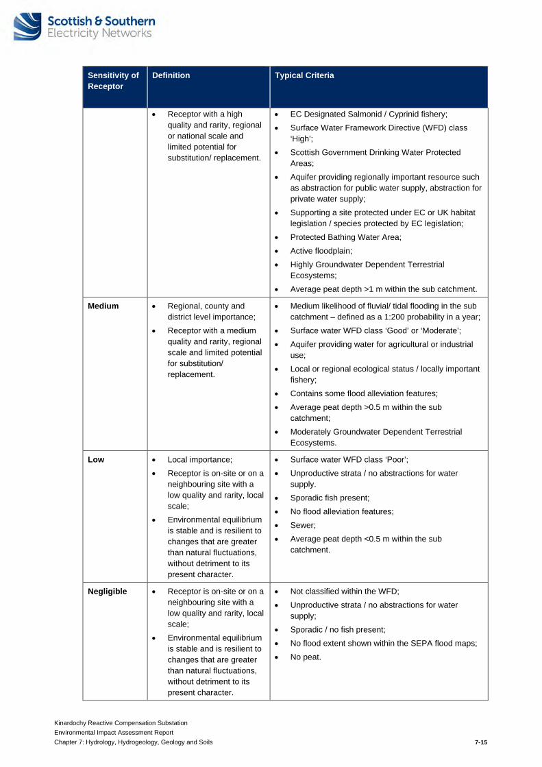
Kinardochy Reactive Compensation Substation Environmental Impact Assessment Report Chapter 7: Hydrology, Hydrogeology, Geology and Soils 7-15
Sensitivity of Receptor
Definition Typical Criteria
• Receptor with a high quality and rarity, regional or national scale and limited potential for substitution/ replacement.
• EC Designated Salmonid / Cyprinid fishery; • Surface Water Framework Directive (WFD) class
‘High’; • Scottish Government Drinking Water Protected
Areas; • Aquifer providing regionally important resource such
as abstraction for public water supply, abstraction for private water supply;
• Supporting a site protected under EC or UK habitat legislation / species protected by EC legislation;
• Protected Bathing Water Area; • Active floodplain; • Highly Groundwater Dependent Terrestrial
Ecosystems; • Average peat depth >1 m within the sub catchment.
Medium • Regional, county and district level importance;
• Receptor with a medium quality and rarity, regional scale and limited potential for substitution/ replacement.
• Medium likelihood of fluvial/ tidal flooding in the sub catchment – defined as a 1:200 probability in a year;
• Surface water WFD class ‘Good’ or ‘Moderate’; • Aquifer providing water for agricultural or industrial
use; • Local or regional ecological status / locally important
fishery; • Contains some flood alleviation features; • Average peat depth >0.5 m within the sub
catchment; • Moderately Groundwater Dependent Terrestrial
Ecosystems.
Low • Local importance; • Receptor is on-site or on a
neighbouring site with a low quality and rarity, local scale;
• Environmental equilibrium is stable and is resilient to changes that are greater than natural fluctuations, without detriment to its present character.
• Surface water WFD class ‘Poor’; • Unproductive strata / no abstractions for water
supply. • Sporadic fish present; • No flood alleviation features; • Sewer; • Average peat depth <0.5 m within the sub
catchment.
Negligible • Receptor is on-site or on a neighbouring site with a low quality and rarity, local scale;
• Environmental equilibrium is stable and is resilient to changes that are greater than natural fluctuations, without detriment to its present character.
• Not classified within the WFD; • Unproductive strata / no abstractions for water
supply; • Sporadic / no fish present; • No flood extent shown within the SEPA flood maps; • No peat.
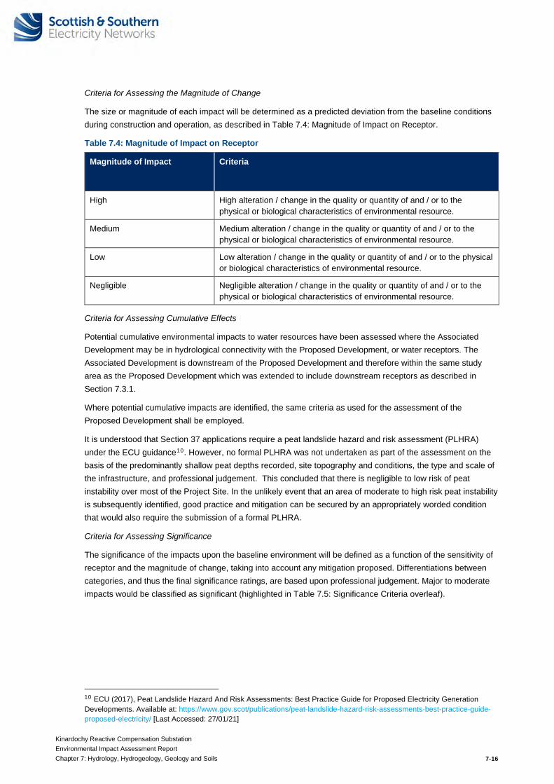
Kinardochy Reactive Compensation Substation Environmental Impact Assessment Report Chapter 7: Hydrology, Hydrogeology, Geology and Soils 7-16
Criteria for Assessing the Magnitude of Change
The size or magnitude of each impact will be determined as a predicted deviation from the baseline conditions during construction and operation, as described in Table 7.4: Magnitude of Impact on Receptor.
Table 7.4: Magnitude of Impact on Receptor
Magnitude of Impact Criteria
High High alteration / change in the quality or quantity of and / or to the physical or biological characteristics of environmental resource.
Medium Medium alteration / change in the quality or quantity of and / or to the physical or biological characteristics of environmental resource.
Low Low alteration / change in the quality or quantity of and / or to the physical or biological characteristics of environmental resource.
Negligible Negligible alteration / change in the quality or quantity of and / or to the physical or biological characteristics of environmental resource.
Criteria for Assessing Cumulative Effects
Potential cumulative environmental impacts to water resources have been assessed where the Associated Development may be in hydrological connectivity with the Proposed Development, or water receptors. The Associated Development is downstream of the Proposed Development and therefore within the same study area as the Proposed Development which was extended to include downstream receptors as described in Section 7.3.1.
Where potential cumulative impacts are identified, the same criteria as used for the assessment of the Proposed Development shall be employed.
It is understood that Section 37 applications require a peat landslide hazard and risk assessment (PLHRA) under the ECU guidance10. However, no formal PLHRA was not undertaken as part of the assessment on the basis of the predominantly shallow peat depths recorded, site topography and conditions, the type and scale of the infrastructure, and professional judgement. This concluded that there is negligible to low risk of peat instability over most of the Project Site. In the unlikely event that an area of moderate to high risk peat instability is subsequently identified, good practice and mitigation can be secured by an appropriately worded condition that would also require the submission of a formal PLHRA.
Criteria for Assessing Significance
The significance of the impacts upon the baseline environment will be defined as a function of the sensitivity of receptor and the magnitude of change, taking into account any mitigation proposed. Differentiations between categories, and thus the final significance ratings, are based upon professional judgement. Major to moderate impacts would be classified as significant (highlighted in Table 7.5: Significance Criteria overleaf).
10 ECU (2017), Peat Landslide Hazard And Risk Assessments: Best Practice Guide for Proposed Electricity Generation Developments. Available at: https://www.gov.scot/publications/peat-landslide-hazard-risk-assessments-best-practice-guide-proposed-electricity/ [Last Accessed: 27/01/21]
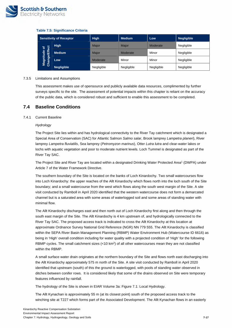
Kinardochy Reactive Compensation Substation Environmental Impact Assessment Report Chapter 7: Hydrology, Hydrogeology, Geology and Soils 7-17
Table 7.5: Significance Criteria
Sensitivity of Receptor High Medium Low Negligible M
agni
tude
of
Cha
nge/
Effe
ct High Major Major Moderate Negligible
Medium Major Moderate Minor Negligible
Low Moderate Minor Minor Negligible
Negligible Negligible Negligible Negligible Negligible
7.3.5 Limitations and Assumptions
This assessment makes use of opensource and publicly available data resources, complimented by further surveys specific to the site. The assessment of potential impacts within this chapter is reliant on the accuracy of the public data, which is considered robust and sufficient to enable this assessment to be completed.
7.4 Baseline Conditions
7.4.1 Current Baseline
Hydrology
The Project Site lies within and has hydrological connectivity to the River Tay catchment which is designated a Special Area of Conservation (SAC) for Atlantic Salmon Salmo salar, Brook lamprey Lampetra planeri), River lamprey Lampetra fluviatilis, Sea lamprey (Petromyzon marinus), Otter Lutra lutra and clear-water lakes or lochs with aquatic vegetation and poor to moderate nutrient levels. Loch Tummel is designated as part of the River Tay SAC.
The Project Site and River Tay are located within a designated Drinking Water Protected Area1 (DWPA) under Article 7 of the Water Framework Directive.
The southern boundary of the Site is located on the banks of Loch Kinardochy. Two small watercourses flow into Loch Kinardochy: the upper reaches of the Allt Kinardochy which flows north into the loch south of the Site boundary; and a small watercourse from the west which flows along the south west margin of the Site. A site visit conducted by Ramboll in April 2020 identified that the western watercourse does not form a demarcated channel but is a saturated area with some areas of waterlogged soil and some areas of standing water with minimal flow.
The Allt Kinardochy discharges east and then north out of Loch Kinardochy first along and then through the south east margin of the Site. The Allt Kinardochy is 4 km upstream of, and hydrologically connected to the River Tay SAC. The proposed access track is indicated to cross the Allt Kinardochy at this location at approximate Ordnance Survey National Grid Reference (NGR) NN 779 555. The Allt Kinardochy is classified within the SEPA River Basin Management Planning (RBMP) Water Environment Hub (Watercourse ID 6616) as being in ‘High’ overall condition including for water quality with a projected condition of ‘High’ for the following RBMP cycles. The small catchment sizes (<10 km2) of all other watercourses mean they are not classified within the RBMP.
A small surface water drain originates at the northern boundary of the Site and flows north east discharging into the Allt Kinardochy approximately 575 m north of the Site. A site visit conducted by Ramboll in April 2020 identified that upstream (south) of this the ground is waterlogged, with pools of standing water observed in ditches between conifer rows. It is considered likely that some of the drains observed on Site were temporary features influenced by rainfall.
The hydrology of the Site is shown in EIAR Volume 3a: Figure 7.1: Local Hydrology.
The Allt Kynachan is approximately 55 m (at its closest point) south of the proposed access track to the winching site at T227 which forms part of the Associated Development. The Allt Kynachan flows in an easterly

Kinardochy Reactive Compensation Substation Environmental Impact Assessment Report Chapter 7: Hydrology, Hydrogeology, Geology and Soils 7-18
direction to the south of the proposed access track to T227 and then north to discharge to Loch Tummel approximately 1.3 km north of T227 and the Associated Development. Allt Kynachan is classified within the SEPA RBMP Water Environment Hub (Watercourse ID 6617) as being in ‘High’ overall condition including for water quality with a projected condition of ‘High’ for the following RBMP cycles.
Surface water receptors at the Project Site are considered to be of a High sensitivity.
Surface Water Flood Risk
According to the online SEPA Flood Mapping a small area of the Site, in the vicinity of the proposed substation platform, is indicated to be at risk of surface water flooding, with further areas of surface water flood risk indicated along the northern and southern boundaries of the Site. A Flood Risk Assessment is provided in Technical Appendix 7.1: Flood Risk Assessment and Drainage Impact Assessment (EIAR Volume 4) and concluded with adequate design of drainage features there would be minimal risk of flooding to the Proposed Development.
The access track to the Proposed Development will cross the Allt Kinardochy and fall within the fluvial flood extent of the river according to the SEPA Flood Maps. Flood Risk has been assessed in further detail in Technical Appendix 7.1: Flood Risk and Drainage Impact Assessment (EIAR Volume 4) and with adequate crossing design is not considered significant.
The Associated Development does not lie within an area considered to be at risk of flooding from rivers or the sea. A very limited are of land in close proximity to the All Kynachan Burn at the proposed bridge crossing is shown to be within an area at ‘High’ likelihood of river flooding, these areas are considered to form part of the river channel. Detailed design of the bridge to cross the Ally Kynachan Burn, to be completed by contractors, shall include assessment of flood risk. Bridge design shall accommodate the peak flows associated with a 0.5% annual probability event (1 in 200 year) plus an allowance for future climate change and in accordance with the relevant best practice guidance, from SEPA and CIRIA. Isolated areas of the Project Site are shown by the SEPA Flood Maps to be at risk of surface water flooding, these are areas of surface water ponding on peat or very localised depressions.
Geology and Soils
According to the BGS8 the Project Site is underlain by the Schiehallion Quartzite Formation with a small zone of Pelite of the Blair Athol Dark Limestone and Dark Schist Formation at the eastern extent of the site (EIAR Volume 3a: Figure 7.2: Bedrock Geology). The proposed access track to T227 is underlain by bedrock of the Kynachan Psammite Formation. No overlying superficial deposits are mapped within the Site, with the exception of a small area of Diamicton Till at the eastern margin (EIAR Volume 3a: Figure 7.3: Drift Hydrology). This suggests that the solid geology within the Site is predominantly at, or close to the ground surface. Superficial deposits of peat underlie the Associated Development in the vicinity of the 132 kV diversion, and glacial deposits of diamicton, sand and gravel directly underlie the Associated Development access track to T227 (EIAR Volume 3a:Figure 7.3: Drift Hydrology).
Six borehole logs are available from the BGS website in the vicinity of the Project Site. The four boreholes to the south of the Project Site were sunk in October 2011. The borehole logs generally show sandy soil to a depth of 0.6-0.7 m, underlain by psammite. The two boreholes to the north were sunk in September and October 2011 show sandy gravel to a depth of approximately 0.9-1.2 m, underlain by schist.
The National Soil Map of Scotland6 illustrates that the area to the south of the Project Site is covered by Mineral gleys and to the north by humus-iron podzols (EIAR Volume 3a: Figure 7.4: Soil Plan). Immediately west and fringing the western margin of the Site is an area of Class 1 peat habitat, according to the SNH Carbon and Peatland mapping 2016, as shown in EIAR Volume 3a: Figure 7.5: Peatland Classification. Peat depth surveys of the area undertaken in both 2016 and 2019 measured peat depths approximately between 0.5 m and 1.5 m across the Project Site but up to >3 m near the south west corner of the proposed substation platform, as shown in EIAR Volume 3a: Figure 7.6: Peat Depth.
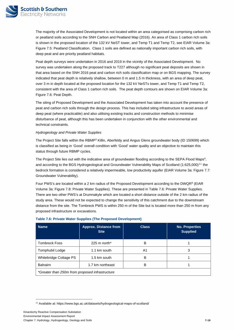
Kinardochy Reactive Compensation Substation Environmental Impact Assessment Report Chapter 7: Hydrology, Hydrogeology, Geology and Soils 7-19
The majority of the Associated Development is not located within an area categorised as comprising carbon rich or peatland soils according to the SNH Carbon and Peatland Map (2016). An area of Class 1 carbon rich soils is shown in the proposed location of the 132 kV NeST tower, and Temp T1 and Temp T2, see EIAR Volume 3a: Figure 7.5: Peatland Classification. Class 1 soils are defined as nationally important carbon rich soils, with deep peat and are priority peatland habitats.
Peat depth surveys were undertaken in 2016 and 2019 in the vicinity of the Associated Development. No survey was undertaken along the proposed track to T227 although no significant peat deposits are shown in that area based on the SNH 2016 peat and carbon rich soils classification map or on BGS mapping. The survey indicated that peat depth is relatively shallow, between 0 m and 1.5 m thickness, with an area of deep peat, over 3 m in depth located at the proposed location for the 132 kV NeSTs tower, and Temp T1 and Temp T2, consistent with the area of Class 1 carbon rich soils. The peat depth contours are shown on EIAR Volume 3a: Figure 7.6: Peat Depth.
The siting of Proposed Development and the Associated Development has taken into account the presence of peat and carbon rich soils through the design process. This has included siting infrastructure to avoid areas of deep peat (where practicable) and also utilising existing tracks and construction methods to minimise disturbance of peat, although this has been undertaken in conjunction with the other environmental and technical constraints.
Hydrogeology and Private Water Supplies
The Project Site falls within the RBMP3 Killin, Aberfeldy and Angus Glens groundwater body (ID 150699) which is classified as being in ‘Good’ overall condition with ‘Good’ water quality and an objective to maintain this status through future RBMP cycles.
The Project Site lies out with the indicative area of groundwater flooding according to the SEPA Flood Maps4, and according to the BGS Hydrogeological and Groundwater Vulnerability Maps of Scotland (1:625,000)11 the bedrock formation is considered a relatively impermeable, low productivity aquifer (EIAR Volume 3a: Figure 7.7: Groundwater Vulnerability).
Four PWS’s are located within a 2 km radius of the Proposed Development according to the DWQR9 (EIAR Volume 3a: Figure 7.8: Private Water Supplies). These are presented in Table 7.6: Private Water Supplies. There are two other PWS’s at Drumnakyle which are located a short distance outside of the 2 km radius of the study area. These would not be expected to change the sensitivity of this catchment due to the downstream distance from the site. The Tombreck PWS is within 250 m of the Site but is located more than 250 m from any proposed infrastructure or excavations.
Table 7.6: Private Water Supplies (The Proposed Development)
Name Approx. Distance from Site
Class No. Properties Supplied
Tombreck Foss 225 m north* B 1
Tomphubil Lodge 1.1 km south A1 3
Whitebridge Cottage PS 1.5 km south B 1
Balnairn 1.7 km northeast B 1
*Greater than 250m from proposed infrastructure
11 Available at: https://www.bgs.ac.uk/datasets/hydrogeological-maps-of-scotland/
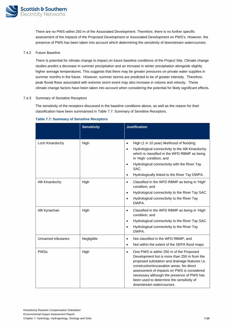
Kinardochy Reactive Compensation Substation Environmental Impact Assessment Report Chapter 7: Hydrology, Hydrogeology, Geology and Soils 7-20
There are no PWS within 250 m of the Associated Development. Therefore, there is no further specific assessment of the impacts of the Proposed Development or Associated Development on PWS’s. However, the presence of PWS has been taken into account which determining the sensitivity of downstream watercourses.
7.4.2 Future Baseline
There is potential for climate change to impact on future baseline conditions of the Project Site. Climate change studies predict a decrease in summer precipitation and an increase in winter precipitation alongside slightly higher average temperatures. This suggests that there may be greater pressures on private water supplies in summer months in the future. However, summer storms are predicted to be of greater intensity. Therefore, peak fluvial flows associated with extreme storm event may also increase in volume and velocity. These climate change factors have been taken into account when considering the potential for likely significant effects.
7.4.3 Summary of Sensitive Receptors
The sensitivity of the receptors discussed in the baseline conditions above, as well as the reason for their classification have been summarised in Table 7.7: Summary of Sensitive Receptors.
Table 7.7: Summary of Sensitive Receptors
Sensitivity Justification
Loch Kinardochy High • High (1 in 10 year) likelihood of flooding; • Hydrological connectivity to the Allt Kinardochy
which is classified in the WFD RBMP as being in ‘High’ condition; and
• Hydrological connectivity with the River Tay SAC.
• Hydrologically linked to the River Tay DWPA.
Allt Kinardochy High • Classified in the WFD RBMP as being in ‘High’ condition; and
• Hydrological connectivity to the River Tay SAC. • Hydrological connectivity to the River Tay
DWPA.
Allt Kynachan High • Classified in the WFD RBMP as being in ‘High’ condition; and
• Hydrological connectivity to the River Tay SAC. • Hydrological connectivity to the River Tay
DWPA.
Unnamed tributaries Negligible • Not classified in the WFD RBMP; and • Not within the extent of the SEPA flood maps.
PWSs High • One PWS is within 250 m of the Proposed Development but is more than 250 m from the proposed substation and drainage features i.e. construction/excavation areas. No direct assessment of impacts on PWS is considered necessary although the presence of PWS has been used to determine the sensitivity of downstream watercourses.
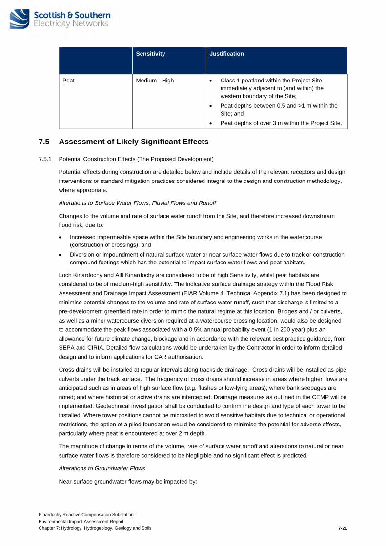
Kinardochy Reactive Compensation Substation Environmental Impact Assessment Report Chapter 7: Hydrology, Hydrogeology, Geology and Soils 7-21
Sensitivity Justification
Peat Medium - High • Class 1 peatland within the Project Site immediately adjacent to (and within) the western boundary of the Site;
• Peat depths between 0.5 and >1 m within the Site; and
• Peat depths of over 3 m within the Project Site.
7.5 Assessment of Likely Significant Effects
7.5.1 Potential Construction Effects (The Proposed Development)
Potential effects during construction are detailed below and include details of the relevant receptors and design interventions or standard mitigation practices considered integral to the design and construction methodology, where appropriate.
Alterations to Surface Water Flows, Fluvial Flows and Runoff
Changes to the volume and rate of surface water runoff from the Site, and therefore increased downstream flood risk, due to:
• Increased impermeable space within the Site boundary and engineering works in the watercourse (construction of crossings); and
• Diversion or impoundment of natural surface water or near surface water flows due to track or construction compound footings which has the potential to impact surface water flows and peat habitats.
Loch Kinardochy and Allt Kinardochy are considered to be of high Sensitivity, whilst peat habitats are considered to be of medium-high sensitivity. The indicative surface drainage strategy within the Flood Risk Assessment and Drainage Impact Assessment (EIAR Volume 4: Technical Appendix 7.1) has been designed to minimise potential changes to the volume and rate of surface water runoff, such that discharge is limited to a pre-development greenfield rate in order to mimic the natural regime at this location. Bridges and / or culverts, as well as a minor watercourse diversion required at a watercourse crossing location, would also be designed to accommodate the peak flows associated with a 0.5% annual probability event (1 in 200 year) plus an allowance for future climate change, blockage and in accordance with the relevant best practice guidance, from SEPA and CIRIA. Detailed flow calculations would be undertaken by the Contractor in order to inform detailed design and to inform applications for CAR authorisation.
Cross drains will be installed at regular intervals along trackside drainage. Cross drains will be installed as pipe culverts under the track surface. The frequency of cross drains should increase in areas where higher flows are anticipated such as in areas of high surface flow (e.g. flushes or low-lying areas); where bank seepages are noted; and where historical or active drains are intercepted. Drainage measures as outlined in the CEMP will be implemented. Geotechnical investigation shall be conducted to confirm the design and type of each tower to be installed. Where tower positions cannot be microsited to avoid sensitive habitats due to technical or operational restrictions, the option of a piled foundation would be considered to minimise the potential for adverse effects, particularly where peat is encountered at over 2 m depth.
The magnitude of change in terms of the volume, rate of surface water runoff and alterations to natural or near surface water flows is therefore considered to be Negligible and no significant effect is predicted.
Alterations to Groundwater Flows
Near-surface groundwater flows may be impacted by:

Kinardochy Reactive Compensation Substation Environmental Impact Assessment Report Chapter 7: Hydrology, Hydrogeology, Geology and Soils 7-22
• Localised modification of groundwater flows and the formation of preferential flow path for sub-surface flows; and
• Localised sub-surface draw down due to excavations and dewatering for footings.
Peat habitats are considered to be of Medium-High sensitivity however, implementation of cut off drains and dewatering control and distribution of surface water flows during construction; ensuring dewatering is carried out in accordance with the CEMP; and water discharged from dewatering shall be distributed to surrounding vegetated areas via settlement ponds means the magnitude of change is considered Negligible and therefore not significant.
Impacts to Water Quality
The quality of surface waters or groundwater including Loch Kinardochy and Allt Kinardochy which are within the DWPA, as well as downstream PWS could be impacted through:
• release of sediment or pollutants generated during excavation, earth moving and from temporary soil stockpiles;
• accidental spills or release of pollutants to watercourses or the ground; and
• direct discharge of untreated foul sewage from temporary welfare facilities to watercourses or to ground.
However, it is noted that the bedrock is considered a relatively impermeable, low productivity aquifer so a pathway via groundwater to downstream PWS is unlikely. Any surface water fed PWS are a sufficient distance downstream such that direct impacts are unlikely, although the presence of PWS has been used to determine the sensitivity of downstream watercourses.
As described in Chapter 2: Development Description, a site specific CEMP would be written in accordance with the relevant best practice guidance on pollution prevention and mitigation, namely the SEPA PPG and relevant construction and CIRIA guidance. The CEMP would set out the environmental management requirements and responsibilities incumbent upon the main contractor. The main contractor would be required to develop specific Environmental Management Plans (EMPs) which would include the methodologies and management measures to be employed in the construction of the Proposed Development. It is anticipated that foul sewage from temporary welfare facilities would be tanked for off-site removal.
Therefore, although the Loch Kinardochy, Allt Kinardochy and Tombreck PWS are considered to be of High Sensitivity, the magnitude of change is considered to be Negligible, as a result of the standard mitigation practice which would be set out in the CEMP, and no significant effect is predicted.
Sedimentation and Morphology
Impacts on morphology and sediment supply in watercourses including Loch Kinardochy and Allt Kinardochy which are part of the DWPA, as well as downstream PWS’s, could occur as a result of:
• Permanent diversion of watercourses (as shown in Technical Appendix 7.1: Flood Risk Assessment and Drainage Impact Assessment – Appendix 01);
• Direct impacts of engineering works on the water environment; and
• Construction of river crossings.
Any works taking place near watercourses i.e. construction of the proposed access track which will require the diversion and crossing of the Allt Kinardochy, will be undertaken in accordance with SEPA and CIRIA guidance and in line with the requirements of the CAR to prevent or reduce adverse effects to the watercourse as detailed in EIAR Volume 4: Technical Appendix 7.4: Watercourse Crossing Assessment and EIAR Volume 4: Technical Appendix 7.1: Flood Risk Assessment and Drainage Impact Assessment.
Although the Loch Kinardochy, Allt Kinardochy and Tombreck PWS are considered to be of High Sensitivity, the magnitude of change is considered to be Negligible as the works would need to comply with the requirements of the CAR and no significant effect is predicted.

Kinardochy Reactive Compensation Substation Environmental Impact Assessment Report Chapter 7: Hydrology, Hydrogeology, Geology and Soils 7-23
Soils
Changes to local soils and peat habitats could occur as a result of:
• Compaction of soils;
• Potential for increased erosion of peat soils through disturbance, either through direct disturbance or localised drying caused by infrastructure; and
• Loss of peatland habitats and carbon rich soils through excavations for infrastructure.
A Stage 1 PMP has been prepared for the Proposed Development (see EIAR Volume 4: Technical Appendix 7.2) which documents outline measures to mitigate potential impacts on peat and carbon rich soils through the construction phase. This is a live document that will be updated further as the project progresses through detailed design and operation. Peat habitats are considered to be of Medium or High sensitivity. The PMP would seek to ensure that any impacts on peat and carbon rich soils are reduced to a Low or Negligible magnitude, particularly with regard to any areas of deeper peat in the south-west corner of the Site, such that no significant effects are predicted.
7.5.2 Potential Cumulative Construction Effects (The Associated Development)
Consideration has been given to the potential for the construction of the Associated Development at the same time as the Proposed Development leading to cumulative:
• Alterations to surface water flows, fluvial flows and runoff;
• Alterations to groundwater flows;
• Impacts to water quality;
• Sedimentation and morphology; and
• Soils and carbon rich soils.
Disturbance to Peat
There is potential for impacts on deep peat from the construction of the two temporary towers, particularly Temp T2. Foundations and construction activities for the temporary towers could result in the excavation and disturbance of peat and carbon rich soils. Temp T2 is located in an area of peat in excess of 3 m depth. Deep peat is considered to be of Medium-High sensitivity.
Geotechnical investigation shall be conducted to confirm the design and type of each tower. Where tower positions cannot be microsited to avoid sensitive habitats due to technical or operational restrictions, the option of a piled foundation would be considered to minimise the potential for adverse effects, particularly where peat is encountered at over 2 m depth and the magnitude of change is potentially High, and a Major significant effect is predicted on peat resource.
Through embedded mitigation and good design as detailed in Section 7.5.1, the anticipated impacts of the Proposed Development on other receptors are considered not significant. The Associated Development would be constructed in accordance with the same good design practices, including appropriate design of watercourse crossings and mitigation measures and are therefore not anticipated to result in cumulatively significant effects. A Stage 1 PMP for the Associated Development has been prepared (see EIAR Volume 4: Technical Appendix 7.3).
7.5.3 Potential Operational Effects (The Proposed Development)
Potential effects during operation are detailed below, including the relevant receptor and relevant design interventions or standard mitigation practices considered integral to the design, where appropriate.

Kinardochy Reactive Compensation Substation Environmental Impact Assessment Report Chapter 7: Hydrology, Hydrogeology, Geology and Soils 7-24
Chemical Pollution
There is the potential for impacts from accidental spills or leakage of chemicals introduced to the Site, causing a release of pollutants to watercourses and water features such as the Loch Kinardochy and Allt Kinardochy which fall within the DWPA, as well downstream PWS during operations or any maintenance activities. These receptors are considered to be of High sensitivity.
With reference to CIRIA C753, post development surface water runoff generated by the Proposed Development will be assessed at a later design stage with reference to their respective Pollution Hazard Level.
It is anticipated that the SUDs features proposed will provide the required mitigation with regards to water quality; although full details and analysis would be provided at later design stages.
All attenuation features and full retention separators in the Proposed Development, in accordance with SSE’s guidelines, will be designed to accommodate the worst case of a 1 in 1000-year return period with no allowance for climate change or a 1 in 200-year return period with 35% allowance for climate change.
Although the Loch Kinardochy and the Allt Kinardochy are considered to be of High Sensitivity, the magnitude of change is considered to be Negligible and no significant effect is predicted.
Foul Water Discharge
There is the potential for impacts from pollution as a result of unmanaged foul flows from welfare facilities to watercourses and water features such as the Loch Kinardochy and Allt Kinardochy as well downstream PWS during operations or any maintenance activities. These receptors are considered to be of High sensitivity.
Connection to a public sewer is not viable due to the distance and elevation difference between the Site and the closest sewer and discharge to land is dependent on infiltration characteristics of the Site.
For a ‘population equivalent’ (p.e.) of 15 or less, SEPA consider sewage discharges to the water environment to be relatively low risk and requires only an application of a ‘registration’ under CAR. A p.e. of 3 has been assumed for the Proposed Development (Technical Appendix 7.1: Flood Risk Assessment and Drainage Impact Assessment (EIAR Volume 4).
A secondary treatment package is likely to be required to accept flows and it is currently proposed that treated effluent from the secondary treatment plant will be piped alongside the northern edge of the access track towards to a partial soakaway east of the construction compound.
Although the Loch Kinardochy, Allt Kinardochy and PWS’s are considered to be of High Sensitivity, with the treatment mechanisms in place, the magnitude of change is considered to be Negligible and no significant effect is predicted.
7.5.4 Potential Cumulative Operational Effects (The Associated Development)
Alterations to Surface Water Flows
Restriction or alteration to near-surface groundwater and surface water flows due to the installation of two permanent tower footings (T230R and T231A) could impact peat habitats which are of Medium-High sensitivity.
As only two additional permanent towers shall remain in-situ during the operational phase. Geotechnical investigation shall be conducted to confirm the design and type of each tower. Where tower positions cannot be microsited to avoid sensitive habitats due to technical or operational restrictions, the option of a piled foundation would be considered to minimise the potential for adverse effects, particularly where peat is encountered at over 2 m depth.
Increased rates of surface runoff and preferential routing of surface water flows towards the Allt Kynachan and downstream surface waters could occur due to:
• An increase in impermeable or engineered surface area on the proposed access track to T227; and

Kinardochy Reactive Compensation Substation Environmental Impact Assessment Report Chapter 7: Hydrology, Hydrogeology, Geology and Soils 7-25
• Surface water drainage measures for tracks.
However, maintenance of SuDS measures would be applied to all infrastructure and appropriate drainage design for tracks (as detailed in CEMP). Cross drains will be installed at regular intervals along trackside drainage. Cross drains will be installed as pipe culverts under the track surface. With these measures in place the magnitude of the effect as a result of the Associated Development is anticipated to be Negligible and the impact not significant. The cumulative effects of the Associated Development alongside the Proposed Development would also be considered to be Negligible and the impact not significant.
7.6 Mitigation
7.6.1 Mitigation During Construction (The Proposed Development)
Due to the proposed design interventions (primarily through the Flood Risk Assessment and Drainage Impact assessment) and standard mitigation practice (primarily to be set out in the CEMP and PMP), no significant effects have been identified and no further mitigation measures are considered necessary, beyond those already integral to the design and included within standard mitigation practise.
7.6.2 Mitigation During Construction (The Associated Development)
Due to considerations made in the design of the Associated Development, and the anticipated measures to be set out in the CEMP, no further mitigation is considered necessary.
The Stage 1 PMP for the Associated Development sets out good practice measures and specific mitigation measures to minimise the potential effects on peat and carbon rich soils. For example, the proposed access tracks located over deep peat (>1 m in depth) will be ‘floated’ to minimise the volume of excavated peat. If required, bog mats would be used to cross waterlogged areas or minor watercourses without causing damage to bank integrity or compaction of soils.
7.6.3 Mitigation During Operation (The Proposed Development)
Due to considerations made in the design of the Proposed Development, primarily relating to surface water drainage as set out in Technical Appendix 7.1: Flood Risk Assessment and Drainage Impact Assessment (Volume 4) and design of watercourse crossings as considered in Technical Appendix 7.3: Watercourse Crossing Assessment, no further mitigation is considered necessary. No requirement for additional mitigation for effects on soils has been identified.
7.6.4 Mitigation During Operation (The Associated Development)
No requirement for additional mitigation as a result of the cumulative consideration of the Associated Development has been identified.
7.7 Assessment of Residual Effects
7.7.1 Residual Construction Effects (The Proposed Development)
Given no significant construction effects are likely and no additional mitigation measures are proposed, residual effects during construction include:
• Loch Kinardochy is identified as being of ‘High’ sensitivity. The magnitude of the impacts on this receptor following mitigation are predicted to be ‘Negligible’ therefore the significance of effect is predicted to be ‘Negligible’.
• Allt Kinardochy is identified as being of ‘High’ sensitivity. The magnitude of the impacts, including the proposed crossing, on this receptor are predicted to be ‘Negligible’ therefore the significance of effect is predicted to be ‘Negligible’.
Kinardochy Reactive Compensation Substation Environmental Impact Assessment Report Chapter 7: Hydrology, Hydrogeology, Geology and Soils 7-26
• Minor watercourses which flow along the northern and southern boundary of the site are identified as being of ‘Negligible’ sensitivity. The magnitude of the impacts following mitigation are predicted to be ‘Negligible’, therefore the significance of effect is predicted to be ‘Negligible’.
• Peatland habitats will be disturbed during the construction phase. Peat is identified as being of ‘Medium-High’ sensitivity. The magnitude of the impacts on this receptor following mitigation are predicted to be ‘Negligible’ therefore the significance of effect on peat and carbon rich soils is predicted to be ‘Negligible’.
7.7.2 Residual Cumulative Construction Effects (The Associated Development)
Given no significant construction effects are likely and no additional mitigation measures are proposed, residual effects during construction of the Associated Development include:
• Loch Kinardochy is identified as being of ‘High’ sensitivity. The magnitude of the impacts on this receptor from the Proposed Development, when also considering the cumulative impact of the Associated Development, following mitigation are predicted to remain ‘Negligible’ therefore the significance of effect are predicted to be ‘Negligible’.
• Allt Kynachan is identified as being of ‘High’ sensitivity. The magnitude of the impacts, including the proposed crossing, on this receptor from the Proposed Development, when also considering the cumulative impact of the Associated Development, following mitigation are predicted to remain ‘Negligible’ therefore the significance of effect is predicted to be ‘Negligible’.
• The minor watercourse which flows east into Loch Kinardochy south of the temporary tower is identified as being of ‘Negligible’ sensitivity. The magnitude of the impacts of the Proposed Development, when also considering the cumulative impact of the Associated Development, following mitigation are predicted to remain ‘Negligible’, therefore the significance of effect is predicted to be ‘Negligible’. Peatland habitats will be disturbed during the construction phase. Peat is identified as being of ‘Medium-High’ sensitivity. The magnitude of the impacts on this receptor following mitigation are predicted to be ‘Negligible’ therefore the significance of effect on peat and carbon rich soils is predicted to be ‘Negligible’.
In summary, no residual significant potential impacts on geology, hydrology or hydrogeology as a result of the construction of the Associated Development have been identified. Impacts on water features such as the Loch Kinardochy and Allt Kynachan, as well as downstream PWS, are addressed through design interventions or standard mitigation practice such that the magnitude of the impact is predicted to be ‘Negligible’ when considering the cumulative effects of both the Proposed Development, and the Associated Development. Therefore, the overall significance of effect is predicted to be ‘Negligible’.
7.7.3 Residual Operation Effects (The Proposed Development)
No additional significant potential impacts on geology, hydrology or hydrogeology as a result of the operation of the Proposed Development have been identified. Impacts on water features such as the Loch Kinardochy and Allt Kinardochy, as well downstream PWS, are addressed through design interventions or standard mitigation practice such that the magnitude of the impact is predicted to be ‘Negligible’ therefore the significance of effect is predicted to be ‘Negligible’.
7.7.4 Residual Cumulative Operational Effects (The Associated Development)
No significant residual potential impacts on geology, hydrology or hydrogeology are identified as a result of the operation of the Proposed Development when also considering the Associated Development. Impacts on water features such as the Loch Kinardochy and Allt Kynachan, as well as downstream PWS, are addressed through design interventions or standard mitigation practice such that the magnitude of the impact is predicted to be ‘Negligible’ therefore the significance of effect is predicted to be ‘Negligible’.

Kinardochy Reactive Compensation Substation Environmental Impact Assessment Report Chapter 7: Hydrology, Hydrogeology, Geology and Soils 7-27
7.8 Summary A desk based assessment and field survey of the Proposed Development and Associated Development 3 km south of Tummel Bridge, Perth and Kinross has been undertaken. Following the proposed design interventions (primarily through the Flood Risk Assessment and Drainage Impact Assessment) and standard mitigation practice (primarily to be set out in the CEMP and PMP), no significant residual impacts resulting from the Proposed Development or Associated Development are considered to exist.
Table 7.8: Summary of Residual Effects
Likely Significant Effect Mitigation Means of Implementation
Residual Effect
Construction (The Proposed Development)
Changes to the volume and rate of surface water runoff from the Site, and therefore increased downstream flood risk, due to increased impermeable space within the Site boundary.
The indicative surface drainage strategy has been designed to minimise potential changes to the volume and rate of surface water runoff, such that discharge is limited to a pre-development greenfield rate in order to mimic the natural regime at this location.
Drainage Strategy
Not Significant
Impacts to the quality of surface waters or groundwater
The main contractor would be required to develop specific EMPs which would include the methodologies and management measures to be employed in the construction of the Proposed Development. It is anticipated that foul sewage from temporary welfare facilities would be to tank for off-site removal.
CEMP Not Significant
Impacts on morphology and sediment supply in watercourses
Any works taking place near watercourses i.e. construction of the proposed access track crossing over the Allt Kinardochy, will be undertaken in accordance with SEPA guidance and in line with the requirements of the CAR to prevent or reduce adverse effects to the watercourse
CEMP Not Significant
Changes to local soils and peat habitats
A Stage 1 PMP has been prepared, which documents outline measures to mitigate potential impacts on peat and carbon rich soils through the construction phase.
PMP and CEMP
Not Significant
Cumulative Construction (The Associated Development)
Changes to the volume and rate of surface water runoff from the Associated Development, and therefore increased downstream flood
The indicative surface drainage strategy has been designed to minimise potential changes to the volume and rate of surface water runoff, such that discharge is limited to a pre-development
Drainage Strategy
Not Significant
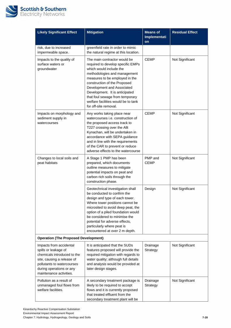
Kinardochy Reactive Compensation Substation Environmental Impact Assessment Report Chapter 7: Hydrology, Hydrogeology, Geology and Soils 7-28
Likely Significant Effect Mitigation Means of Implementation
Residual Effect
risk, due to increased impermeable space.
greenfield rate in order to mimic the natural regime at this location.
Impacts to the quality of surface waters or groundwater
The main contractor would be required to develop specific EMPs which would include the methodologies and management measures to be employed in the construction of the Proposed Development and Associated Development. It is anticipated that foul sewage from temporary welfare facilities would be to tank for off-site removal.
CEMP Not Significant
Impacts on morphology and sediment supply in watercourses
Any works taking place near watercourses i.e. construction of the proposed access track to T227 crossing over the Allt Kynachan, will be undertaken in accordance with SEPA guidance and in line with the requirements of the CAR to prevent or reduce adverse effects to the watercourse
CEMP Not Significant
Changes to local soils and peat habitats
A Stage 1 PMP has been prepared, which documents outline measures to mitigate potential impacts on peat and carbon rich soils through the construction phase.
PMP and CEMP
Not Significant
Geotechnical investigation shall be conducted to confirm the design and type of each tower. Where tower positions cannot be microsited to avoid deep peat, the option of a piled foundation would be considered to minimise the potential for adverse effects, particularly where peat is encountered at over 2 m depth.
Design Not Significant
Operation (The Proposed Development)
Impacts from accidental spills or leakage of chemicals introduced to the site, causing a release of pollutants to watercourses during operations or any maintenance activities.
It is anticipated that the SUDs features proposed will provide the required mitigation with regards to water quality; although full details and analysis would be provided at later design stages.
Drainage Strategy
Not Significant
Pollution as a result of unmanaged foul flows from welfare facilities.
A secondary treatment package is likely to be required to accept flows and it is currently proposed that treated effluent from the secondary treatment plant will be
Drainage Strategy
Not Significant

Kinardochy Reactive Compensation Substation Environmental Impact Assessment Report Chapter 7: Hydrology, Hydrogeology, Geology and Soils 7-29
Likely Significant Effect Mitigation Means of Implementation
Residual Effect
piped alongside the northern edge of the access track towards the Allt Kinardochy, which would have a permanent flow of sufficient rate to achieve necessary dilution.
Cumulative Operation (The Associated Development)
Restriction or alteration to near-surface groundwater and surface water flows due to the installation of two permanent tower footings (T230R and T231A).
Geotechnical investigation shall be conducted to confirm the design and type of each tower. Where tower positions cannot be microsited to avoid sensitive habitats due to technical or operational restrictions, the option of a piled foundation would be considered to minimise the potential for adverse effects, particularly where peat is encountered at over 2 m depth.
Design Not Significant
Increased rates of surface runoff and preferential routing of surface water flows due to: • An increase in
impermeable or engineered surface area on the proposed access track to T227.
• Surface water drainage measures for tracks.
Maintenance of SuDS measures applied to all infrastructure and appropriate drainage design for tracks (as detailed in CEMP). Cross drains will be installed at regular intervals along trackside drainage. Cross drains will be installed as pipe culverts under the track surface.
Drainage Strategy and CEMP
Not Significant

Kinardochy Reactive Compensation Substation and Associated Development Environmental Impact Assessment Report Chapter 8: Cultural Heritage and Archaeology 8-1
8. CULTURAL HERITAGE AND ARCHAEOLOGY
8.1 Introduction This chapter considers the likely significant effects on cultural heritage and archaeology associated with the construction and operation of the Proposed Development. The likely significant effects on cultural heritage and archaeology associated with the construction and operation of the Associated Development will be considered as part of the cumulative assessment. As described in Chapter 2: Description of Development, neither the Proposed Development nor the Associated Development are likely to be decommissioned. If they were to be decommissioned the effects associated with the construction phase of the Proposed Development on cultural heritage and archaeology can be considered to be representative of reasonable worst-case decommissioning effects, therefore a separate assessment of the decommissioning phase has not been undertaken as part of this assessment.
The specific objectives of the chapter are to:
• describe the cultural heritage and archaeology baseline;
• describe the assessment methodology and significance criteria used in completing the impact assessment;
• describe the potential effects, including direct, indirect and cumulative effects;
• describe the mitigation measures proposed to address likely significant effects; and
• assess the residual effects remaining following the implementation of mitigation.
The assessment has been carried out by CFA Archaeology Ltd (CFA), a Chartered Institute for Archaeologists' (CIfA) Registered Organisation (RO), based in Musselburgh, East Lothian with regional offices across the UK.
The chapter is supported by:
• Figure 8.1: Heritage Assets within the Inner Study Area;
• Figure 8.2: Designated Heritage Assets within the Outer Study Area and Substation Bare-Earth ZTV;
• Figure 8.3: Designated Heritage Assets within the Outer Study Area and Cumulative ZTV;
• Technical Appendix 8.1: Heritage Assets within the Inner Study Area; and
• Technical Appendix 8.2: Designated Heritage Assets within the Outer Study Area.
Figures 8.1 – 8.3 are referenced in the text where relevant.
8.2 Scope of Assessment This chapter considers the potential for likely significant effects on:
• heritage assets within the Inner Study Area arising from construction works of the Proposed Development;
• buried archaeological remains within the Inner Study Area arising from construction works of the Proposed Development; and
• designated heritage assets in the Outer Study Area arising from the introduction of the Proposed Development into their settings.
The chapter considers the potential effects of the Associated Development, as described in Chapter 2: Description of Development, as a cumulative development to the Proposed Development. No other consented or proposed developments that could lead to significant cumulative effects have been identified within 5 km of the Site. As such no other cumulative developments are considered in the EIAR. The cumulative assessment captures the potential for additional, in combination and synergistic effects when considering the Proposed Development along with the Associated Development.

Kinardochy Reactive Compensation Substation and Associated Development Environmental Impact Assessment Report Chapter 8: Cultural Heritage and Archaeology 8-2
8.2.1 Consultation
The scope of the assessment has been informed by consultation responses summarised in Table 8.1: Consultation Responses, and the following guidelines/policies:
• Scottish Planning Policy (2014)1 (SPP);
• Historic Environment Policy for Scotland (2019)2 (HEPS);
• TAYplan Strategic Development Plan (2016-36)3 Policy 9 (Managing TayPlan’s Assets) (Policy 9c: Safeguarding the integrity of natural and historic assets);
• Perth and Kinross Local Development Plan 2 (2019)4 (Policies 26-31 and Policy 39).
• Environmental Impact Assessment Handbook (2018)5;
• CIfA Standard and Guidance for Historic Environment Desk-Based Assessment (2018)6;
• HES Designation Policy and Selection Guidance (2019)7;
• Managing Change in the Historic Environment: Setting (2016)8;
• Planning Advice Note (PAN) 1/2013: Environmental Impact Assessment9 (PAN 1/2013); and
• Planning Advice Note 2/2011: Planning and Archaeology10 (PAN 2/2011).
The following organisations made comment on the Scoping Report in relation to cultural heritage and archaeology:
• Perth and Kinross Council (PKC);
• Perth and Kinross Heritage Trust (PKHT); and
• Historic Environment Scotland (HES).
Table 8.1: Consultation Responses summarises the consultation responses received regarding cultural heritage and archaeology and provides information on where and/or how they have been addressed in this assessment.
Table 8.1: Consultation Responses
Consultee and Date
Scoping / Other Consultation
Issue Raised Response / Action Taken
PKC 1 Aug 2019
Pre-application Advice Advised that there was known archaeology in the area surrounding the Proposed Development. Requested that an archaeological assessment should be carried out within the EIA.
Noted The assessment considered both potential direct effects and effects on setting on designated and non-designated heritage assets within the Inner and Outer Study Areas.
Recommended that communication should be
Noted
1 Scottish Government (2014), Scottish Planning Policy, Edinburgh 2 HES (2019), Historic Environment Policy for Scotland (HEPS), Edinburgh 3 TAYplan Strategic Development Planning Authority (2017), TAYplan Strategic Development Plan (2016-36), Dundee 4 Perth and Kinross Council (2019), Local Development Plan 2 (2019), Perth 5 SNH & Historic Environment Scotland (2018), Environmental Impact Assessment Handbook’ Edinburgh 6 Chartered Institute for Archaeologists (2014) [updated 2017], Standard and guidance for historic environment desk-based assessment, Reading 7 HES (2019), Designation Policy and Selection Guidance, Edinburgh 8 HES (2016), Managing Change in the Historic Environment – Setting, Edinburgh 9 Scottish Government (2013), Planning Advice Note (PAN) 1/2013: Environmental Impact Assessment, Edinburgh 10 Scottish Government (2011) Planning Advice Note (PAN) 2/2011: Planning and Archaeology, Edinburgh
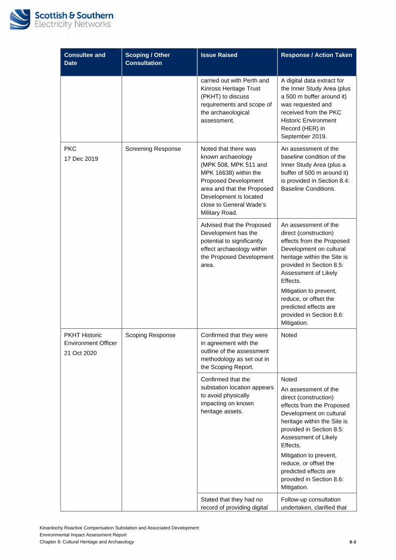
Kinardochy Reactive Compensation Substation and Associated Development Environmental Impact Assessment Report Chapter 8: Cultural Heritage and Archaeology 8-3
Consultee and Date
Scoping / Other Consultation
Issue Raised Response / Action Taken
carried out with Perth and Kinross Heritage Trust (PKHT) to discuss requirements and scope of the archaeological assessment.
A digital data extract for the Inner Study Area (plus a 500 m buffer around it) was requested and received from the PKC Historic Environment Record (HER) in September 2019.
PKC 17 Dec 2019
Screening Response Noted that there was known archaeology (MPK 508, MPK 511 and MPK 16638) within the Proposed Development area and that the Proposed Development is located close to General Wade’s Military Road.
An assessment of the baseline condition of the Inner Study Area (plus a buffer of 500 m around it) is provided in Section 8.4: Baseline Conditions.
Advised that the Proposed Development has the potential to significantly effect archaeology within the Proposed Development area.
An assessment of the direct (construction) effects from the Proposed Development on cultural heritage within the Site is provided in Section 8.5: Assessment of Likely Effects. Mitigation to prevent, reduce, or offset the predicted effects are provided in Section 8.6: Mitigation.
PKHT Historic Environment Officer 21 Oct 2020
Scoping Response Confirmed that they were in agreement with the outline of the assessment methodology as set out in the Scoping Report.
Noted
Confirmed that the substation location appears to avoid physically impacting on known heritage assets.
Noted An assessment of the direct (construction) effects from the Proposed Development on cultural heritage within the Site is provided in Section 8.5: Assessment of Likely Effects. Mitigation to prevent, reduce, or offset the predicted effects are provided in Section 8.6: Mitigation.
Stated that they had no record of providing digital
Follow-up consultation undertaken, clarified that
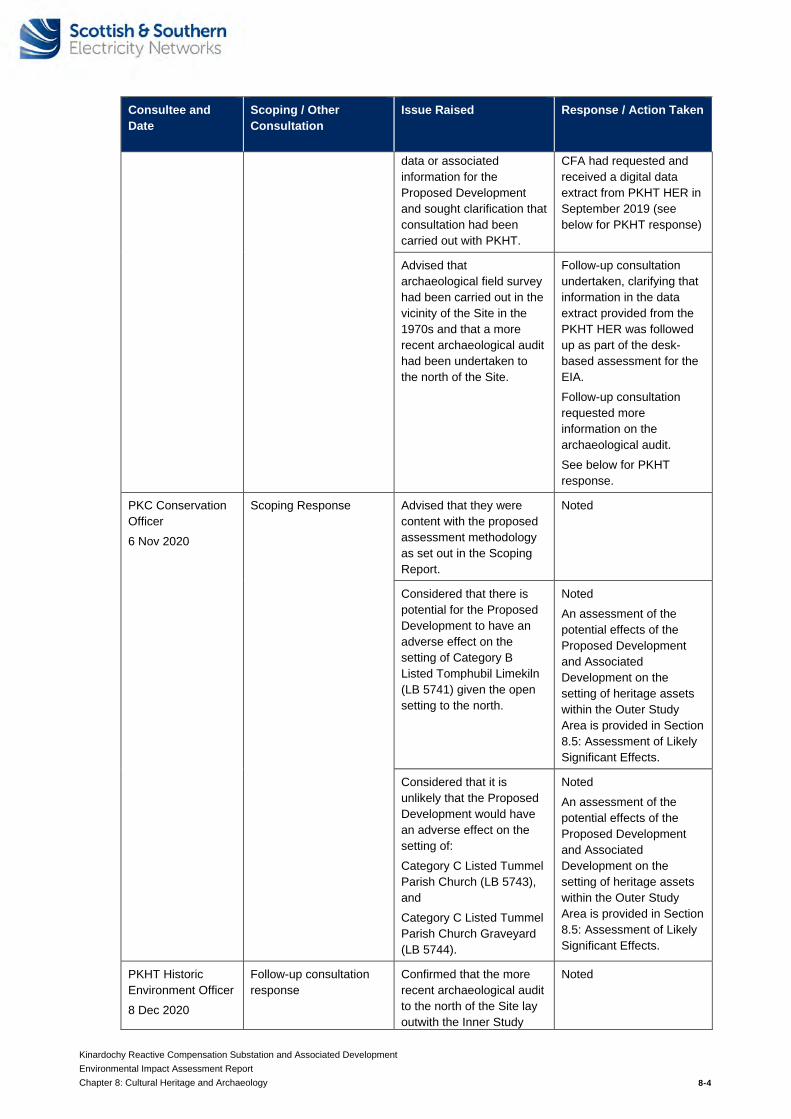
Kinardochy Reactive Compensation Substation and Associated Development Environmental Impact Assessment Report Chapter 8: Cultural Heritage and Archaeology 8-4
Consultee and Date
Scoping / Other Consultation
Issue Raised Response / Action Taken
data or associated information for the Proposed Development and sought clarification that consultation had been carried out with PKHT.
CFA had requested and received a digital data extract from PKHT HER in September 2019 (see below for PKHT response)
Advised that archaeological field survey had been carried out in the vicinity of the Site in the 1970s and that a more recent archaeological audit had been undertaken to the north of the Site.
Follow-up consultation undertaken, clarifying that information in the data extract provided from the PKHT HER was followed up as part of the desk-based assessment for the EIA. Follow-up consultation requested more information on the archaeological audit. See below for PKHT response.
PKC Conservation Officer 6 Nov 2020
Scoping Response Advised that they were content with the proposed assessment methodology as set out in the Scoping Report.
Noted
Considered that there is potential for the Proposed Development to have an adverse effect on the setting of Category B Listed Tomphubil Limekiln (LB 5741) given the open setting to the north.
Noted An assessment of the potential effects of the Proposed Development and Associated Development on the setting of heritage assets within the Outer Study Area is provided in Section 8.5: Assessment of Likely Significant Effects.
Considered that it is unlikely that the Proposed Development would have an adverse effect on the setting of: Category C Listed Tummel Parish Church (LB 5743), and Category C Listed Tummel Parish Church Graveyard (LB 5744).
Noted An assessment of the potential effects of the Proposed Development and Associated Development on the setting of heritage assets within the Outer Study Area is provided in Section 8.5: Assessment of Likely Significant Effects.
PKHT Historic Environment Officer 8 Dec 2020
Follow-up consultation response
Confirmed that the more recent archaeological audit to the north of the Site lay outwith the Inner Study
Noted

Kinardochy Reactive Compensation Substation and Associated Development Environmental Impact Assessment Report Chapter 8: Cultural Heritage and Archaeology 8-5
Consultee and Date
Scoping / Other Consultation
Issue Raised Response / Action Taken
Area and 500 m buffer employed for the cultural heritage and archaeological assessment.
HES 17 Dec 2020
Scoping Response Confirmed that there was one Scheduled Monument, Tom Chaiseil, Homestead (SM 13575) within the study area identified within the Scoping Report.
Noted
Advised that they were content with the conclusion presented in the Scoping Report, that given the nature and location of the Proposed Development and the 3 km distance to Tom Chaiseil Homestead (SM 13575) from the Proposed Development, a significant impact on the setting of the Scheduled Monument from the Proposed Development would be unlikely.
Noted An assessment of the potential effects of the Proposed Development and Associated Development on the setting of heritage assets within the Outer Study Area is provided in Section 8.5: Assessment of Likely Significant Effects.
Full details on the consultation responses can be reviewed in EIAR Volume 4: Technical Appendix 1.1: Consultation Register.
8.2.2 Issues Scoped Out
The scope of this assessment takes account of the committed mitigation measures both incorporated into the design and those standard construction and decommissioning mitigation measures incorporated into the Proposed Development, as described in Chapter 2: Proposed Development, and EIAR Volume 4: Technical Appendix 2.1: Outline Construction Environmental Management Plan. Table 8.2: Issues Scoped Out of EIA summarises the issues scoped out of the assessment.
Table 8.2: Issues Scoped Out of EIA
Potential Effect Basis for Scoping Out
Direct effects on heritage assets outwith the Project Site.
The design incorporates good practice guidance in relation to preservation of heritage assets. There are no proposals to upgrade any of the public road network and those heritage assets that lie outwith the Project Site would not be affected by construction works associated with the Proposed Development or Associated Development.
Disturbance from vibration, dewatering or changes in hydrology resulting in indirect
The design incorporates good practice guidance in relation to preservation of heritage assets.
Kinardochy Reactive Compensation Substation and Associated Development Environmental Impact Assessment Report Chapter 8: Cultural Heritage and Archaeology 8-6
Potential Effect Basis for Scoping Out
effects on cultural heritage assets.
There are no known heritage assets that would be directly affected by changes to the site hydrology resulting from changes to the current drainage regime.
Effects on the settings of designated heritage assets outwith the Outer Study Area.
There are no designated heritage assets beyond that distance that have settings that would be adversely affected by the Proposed Development or Associated Development.
8.3 Assessment Methodology
8.3.1 Method of Baseline Characterisation
Extent of Study Area
The following study areas have been used for the assessment:
• The Inner Study Area (EIAR Volume 3a: Figure 8.1: Heritage Assets within the Inner Study Area; EIAR Volume 4: Technical Appendix 8.1: Heritage Assets within the Inner Study Area): the Scoping Site boundary (as shown in Layout 3 in EIAR Volume 3a: Figure 3.4: Design Evolution) as identified in 2019 (plus a buffer of 500 m around it) has been used for the identification of heritage assets that could receive direct impacts arising from the construction of the Proposed Development (those within the Site), and to establish the archaeological potential of the area in general (recorded assets within 500 m of the Inner Study Area). The Inner Study Area was subject to a desk-based assessment and a reconnaissance field survey was carried out for the Scoping Site boundary;
• The temporary access corridor to Tower 227 formed the study area for the identification of heritage assets that could receive direct impacts arising from use of the existing access track in relation to the Associated Development (see EIAR Volume 3a: Figure 8.1: Heritage Assets within the Inner Study Area; EIAR Volume 4: Technical Appendix 8.1: Heritage Assets within the Inner Study Area); and
• The Outer Study Area (EIAR Volume 3a: Figure 8.2: Designated Heritage Assets within the Outer Study Area and the Bare-Earth ZTV, EIAR Volume 4: Technical Appendix 8.2: Designated Heritage Assets within the Outer Study Area): a wider study area, extending 3 km from the outer edge of the substation platform, has been used, in combination with the substation Zone of Theoretical Visibility (ZTV) for the identification of cultural heritage assets whose settings might be affected by the Proposed Development and Associated Development.
8.3.2 Desk Study
The following sources have been consulted to establish the current baseline:
• HES’s Spatial Warehouse Database11 for details of the locations and extents of Scheduled Monuments, Listed Buildings, Inventory Gardens and Designed Landscapes, Conservation Areas and Inventory Historic Battlefields;
• The PKHT Historic Environment Record (HER): for information on the character and condition of known archaeological sites and features within the Inner Study Area;
• National Record of the Historic Environment12 (NRHE): for any information additional to that provided in the HER;
11 Historic Environment Scotland Spatial Data Warehouse [online GIS downloader]. Available at: http://portal.historicenvironment.scot/spatialdownloads [Last accessed August 2020] 12 Historic Environment Scotland, Canmore [online]. Available at: http://pastmap.org.uk/ [Last accessed August 2020]

Kinardochy Reactive Compensation Substation and Associated Development Environmental Impact Assessment Report Chapter 8: Cultural Heritage and Archaeology 8-7
• Historic maps held by the Map Library of the National Library of Scotland13: to provide information on sites of potential archaeological significance and on historic land-use development;
• Bibliographic references were consulted where relevant to provide background and historical information; and,
• The Historic Land-Use Assessment Map for Scotland14 (HLA Map): for information on the historic land use character of the Inner Study Area.
8.3.3 Field Survey
A walkover field survey of the Scoping Site boundary was carried out in October 2019.
The aim of the survey was to:
• Assess the present baseline conditions of the heritage assets, identified through the desk study, that could be affected by the Proposed Development and Associated Development;
• Identify any further features of cultural heritage interest not detected through the desk study, that could be affected by the Proposed Development and Associated Development; and,
• Assess the potential for the site to contain currently unrecorded, buried archaeological remains in areas that could be affected by the Proposed Development and Associated Development.
No new heritage assets were identified, but the survey did find that the prehistoric archaeological remains recorded in the HER within the Scoping Site boundary have been adversely affected by commercial forestry operations.
8.3.4 Criteria for Assessment of Effects
The effects of the Proposed Development and Associated Development on heritage assets have been assessed on the basis of their type (direct effects, effects on setting and cumulative effects) and nature (adverse or beneficial). The assessment takes into account the value/sensitivity of the heritage asset and its setting (Table 8.3) and the magnitude of the predicted impact (Table 8.4). The assessment follows the approach set out in Annex 1 of the SNH/HES EIA Handbook (2018)15 and has been approved through scoping consultations (see Table 8.1):
• Adverse effects are those that detract from or reduce cultural significance or special interest of heritage assets; and
• Beneficial effects are those that preserve, enhance or better reveal the cultural significance or special interest of heritage assets.
Criteria for Assessing the Sensitivity of Receptors
Cultural heritage assets are given weight through the designation process16. Designation ensures that sites and places are recognised by law through the planning system and other regulatory processes. The level of protection and how a site or place is managed varies depending on the type of designation and its laws and policies.
Table 8.3: Sensitivity of Heritage Assets summarises the relative sensitivity of key cultural heritage assets (and their settings) relevant to the Proposed Development (excluding, in this instance, World Heritage Sites and Marine Resources).
13 Available at: https://maps.nls.uk/ [Last accessed September 2019] 14 Historic Environment Scotland, Historic Land-Use Assessment for Scotland (HLAMap) [online]. Available at: http://hlamap.org.uk/ (Last accessed August 2020) 15 SNH & Historic Environment Scotland (2018), Environmental Impact Assessment Handbook, Edinburgh 16 HES (2019), Designation Policy and Selection Guidance, Edinburgh
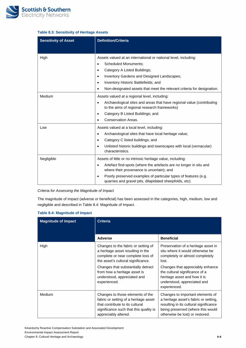
Kinardochy Reactive Compensation Substation and Associated Development Environmental Impact Assessment Report Chapter 8: Cultural Heritage and Archaeology 8-8
Table 8.3: Sensitivity of Heritage Assets
Sensitivity of Asset Definition/Criteria
High Assets valued at an international or national level, including: • Scheduled Monuments; • Category A Listed Buildings; • Inventory Gardens and Designed Landscapes; • Inventory Historic Battlefields; and • Non-designated assets that meet the relevant criteria for designation.
Medium Assets valued at a regional level, including: • Archaeological sites and areas that have regional value (contributing
to the aims of regional research frameworks) • Category B Listed Buildings; and • Conservation Areas.
Low Assets valued at a local level, including: • Archaeological sites that have local heritage value; • Category C listed buildings; and • Unlisted historic buildings and townscapes with local (vernacular)
characteristics.
Negligible Assets of little or no intrinsic heritage value, including: • Artefact find-spots (where the artefacts are no longer in situ and
where their provenance is uncertain); and • Poorly preserved examples of particular types of features (e.g.
quarries and gravel pits, dilapidated sheepfolds, etc).
Criteria for Assessing the Magnitude of Impact
The magnitude of impact (adverse or beneficial) has been assessed in the categories, high, medium, low and negligible and described in Table 8.4: Magnitude of Impact.
Table 8.4: Magnitude of Impact
Magnitude of Impact Criteria
Adverse Beneficial
High Changes to the fabric or setting of a heritage asset resulting in the complete or near complete loss of the asset’s cultural significance. Changes that substantially detract from how a heritage asset is understood, appreciated and experienced.
Preservation of a heritage asset in situ where it would otherwise be completely or almost completely lost. Changes that appreciably enhance the cultural significance of a heritage asset and how it is understood, appreciated and experienced.
Medium Changes to those elements of the fabric or setting of a heritage asset that contribute to its cultural significance such that this quality is appreciably altered.
Changes to important elements of a heritage asset’s fabric or setting, resulting in its cultural significance being preserved (where this would otherwise be lost) or restored.

Kinardochy Reactive Compensation Substation and Associated Development Environmental Impact Assessment Report Chapter 8: Cultural Heritage and Archaeology 8-9
Magnitude of Impact Criteria
Adverse Beneficial Changes that appreciably detract from how a heritage asset is understood, appreciated and experienced.
Changes that improve the way in which the heritage asset is understood, appreciated and experienced.
Low Changes to those elements of the fabric or setting of a heritage asset that contribute to its cultural significance such that this quality is slightly altered. Changes that slightly detract from how a heritage asset is understood, appreciated and experienced.
Changes that result in elements of a heritage asset’s fabric or setting detracting from its cultural significance being removed. Changes that result in a slight improvement in the way a heritage asset is understood, appreciated and experienced.
Negligible Changes to fabric or setting of a heritage asset that leave its cultural significance unchanged and do not affect how it is understood, appreciated and experienced.
Assessment of Setting Effects
HES’s guidance document, ‘Managing Change in the Historic Environment: Setting'17, notes that:
“Setting can be important to the way in which historic structures or places are understood, appreciated and experienced. It can often be integral to a historic asset’s cultural significance.”
“Setting often extends beyond the property boundary or ‘curtilage’ of an individual historic asset into a broader landscape context”.
The guidance also advises that:
“If proposed development is likely to affect the setting of a key historic asset, an objective written assessment should be prepared by the applicant to inform the decision-making process. The conclusions should take into account the significance of the asset and its setting and attempt to quantify the extent of any impact. The methodology and level of information should be tailored to the circumstances of each case”.
The guidance recommends that there are three stages in assessing the impact of a development on the setting of a historic asset or place:
• Stage 1: identify the historic assets that might be affected by the proposed development;
• Stage 2: define and analyse the setting by establishing how the surroundings contribute to the ways in which the historic asset or place is understood, appreciated and experienced; and
• Stage 3: evaluate the potential impact of the proposed changes on the setting, and the extent to which any negative impacts can be mitigated.
Following this approach, the Proposed Development ZTV has been used to identify those designated heritage assets from which there would be theoretical visibility of the Proposed Development.
Assessing Cumulative Effects
The assessment of cumulative effects on heritage assets has been based upon consideration of the effects of the Proposed Development on the settings of assets with statutory and non-statutory designations within 3 km
17 Historic Environment Scotland (2016), Managing Change in the Historic Environment – Setting, Edinburgh
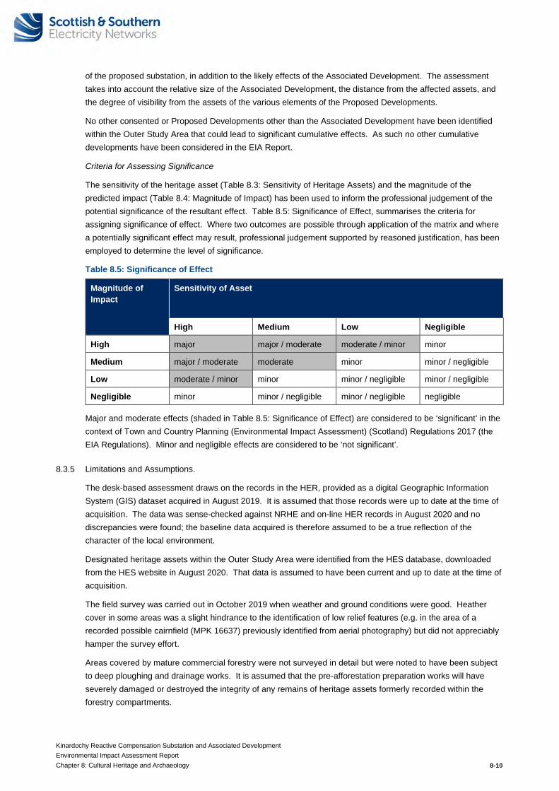
Kinardochy Reactive Compensation Substation and Associated Development Environmental Impact Assessment Report Chapter 8: Cultural Heritage and Archaeology 8-10
of the proposed substation, in addition to the likely effects of the Associated Development. The assessment takes into account the relative size of the Associated Development, the distance from the affected assets, and the degree of visibility from the assets of the various elements of the Proposed Developments.
No other consented or Proposed Developments other than the Associated Development have been identified within the Outer Study Area that could lead to significant cumulative effects. As such no other cumulative developments have been considered in the EIA Report.
Criteria for Assessing Significance
The sensitivity of the heritage asset (Table 8.3: Sensitivity of Heritage Assets) and the magnitude of the predicted impact (Table 8.4: Magnitude of Impact) has been used to inform the professional judgement of the potential significance of the resultant effect. Table 8.5: Significance of Effect, summarises the criteria for assigning significance of effect. Where two outcomes are possible through application of the matrix and where a potentially significant effect may result, professional judgement supported by reasoned justification, has been employed to determine the level of significance.
Table 8.5: Significance of Effect
Magnitude of Impact
Sensitivity of Asset
High Medium Low Negligible
High major major / moderate moderate / minor minor
Medium major / moderate moderate minor minor / negligible
Low moderate / minor minor minor / negligible minor / negligible
Negligible minor minor / negligible minor / negligible negligible
Major and moderate effects (shaded in Table 8.5: Significance of Effect) are considered to be ‘significant’ in the context of Town and Country Planning (Environmental Impact Assessment) (Scotland) Regulations 2017 (the EIA Regulations). Minor and negligible effects are considered to be ‘not significant’.
8.3.5 Limitations and Assumptions.
The desk-based assessment draws on the records in the HER, provided as a digital Geographic Information System (GIS) dataset acquired in August 2019. It is assumed that those records were up to date at the time of acquisition. The data was sense-checked against NRHE and on-line HER records in August 2020 and no discrepancies were found; the baseline data acquired is therefore assumed to be a true reflection of the character of the local environment.
Designated heritage assets within the Outer Study Area were identified from the HES database, downloaded from the HES website in August 2020. That data is assumed to have been current and up to date at the time of acquisition.
The field survey was carried out in October 2019 when weather and ground conditions were good. Heather cover in some areas was a slight hindrance to the identification of low relief features (e.g. in the area of a recorded possible cairnfield (MPK 16637) previously identified from aerial photography) but did not appreciably hamper the survey effort.
Areas covered by mature commercial forestry were not surveyed in detail but were noted to have been subject to deep ploughing and drainage works. It is assumed that the pre-afforestation preparation works will have severely damaged or destroyed the integrity of any remains of heritage assets formerly recorded within the forestry compartments.

Kinardochy Reactive Compensation Substation and Associated Development Environmental Impact Assessment Report Chapter 8: Cultural Heritage and Archaeology 8-11
8.4 Baseline Conditions
8.4.1 Inner Study Area
Baseline heritage assets within the Inner Study Area are presented in EIAR Volume 3a: Figure 8.1: Heritage Assets within the Inner Study Area, and described in detail in EIAR Volume 4: Technical Appendix 8.1: Heritage Assets within the Inner Study Area.
Prehistoric Period
The HER records two possible cairnfields (MPK 511 and MPK 16637) within the Inner Study Area. Both cairnfields are recorded in close proximity to the Project Site, but field survey found no remains of either: one (MPK 16637) is recorded in an area of extensive heather growth and the other (MPK 511) is recorded in what is now an area covered by commercial forestry plantation.
• The former cairnfield (MPK 16637), remains of which may yet survive within an area of mature heather cover, is assessed as potentially being of heritage value at the local level and low sensitivity.
• The former cairnfield (MPK 511), now covered by commercial forestry, is assessed as being of negligible heritage value and negligible sensitivity.
The HER records a hut circle, 11.5 m in diameter, and associated field system (MPK 508) within the Inner Study Area. The recorded location of the hut circle and field system is close to the Site but field survey found no remains, in what is now an area covered by commercial forestry plantation. The site of the former hut circle and field system, now covered by commercial forestry, is assessed as being of negligible heritage value and of negligible sensitivity.
A second field system (MPK 531) of unknown date is also recorded to the north east of the hut circle (MPK 508) described above, but field survey found no remains in what is now an area covered by commercial forestry plantation. The former field system, now covered by commercial forestry, is assessed as being of negligible heritage value and of negligible sensitivity.
A cup-marked stone (MPK 507), measuring 1.2 m x 0.6 m x 0.3 m high, and bearing at least twelve cup-marks, is recorded on the HER, to the north east of the Site in an area of improved fields. The cup-marked stone is assessed as being a heritage asset of value at the regional level and of medium sensitivity.
A possible prehistoric burial cairn (MPK 509), 10 m in diameter and 0.4 m high, is recorded within another, possibly prehistoric, field system consisting of several clearance cairns and lynchets. As a possible burial monument, potentially of Bronze Age date, the possible cairn is assessed as being a heritage asset of value at the regional level and of medium sensitivity.
Three possible hut platforms (MPK 525, MPK 526 & MPK 529) are recorded to the east of the Site, within commercial forestry next to the Allt Blair Rainich. Another possible hut circle (MPK 530) with associated field system is also recorded in the same area but in an area covered by commercial forestry plantation. The possible hut platforms and associated field system, now covered by commercial forestry, are assessed as being of negligible heritage value and of negligible sensitivity.
Two homesteads (MPK 532 & MPK 506) are recorded to the north of the Site, within an area of later post-medieval settlement. The first (MPK 532), is an oval enclosure measuring 17 m by 16 m and defined by a wall up to 0.75 m in height. The second (MPK 506) is 15.5 m west south west to east north east by 11 m transversely. As probable later prehistoric enclosed settlements the homesteads are assessed as being heritage assets of value at the regional level and of medium sensitivity.
Post Medieval Farmsteads
‘Allt Kinardochy’, to the north of the Site, in an area of improved land, is recorded as two separate entities in the HER (MPK 8848 and MPK 8849). The settlement is recorded on Roy’s ‘Military Survey of Scotland’ map (1747-55) as ‘Kinarthar’, shown as four buildings and three enclosures surrounded by areas of cultivation. As a well-
Kinardochy Reactive Compensation Substation and Associated Development Environmental Impact Assessment Report Chapter 8: Cultural Heritage and Archaeology 8-12
preserved, probable 18th century township of up to eleven buildings and associated enclosures, the settlement is assessed as being a heritage asset of value at the regional level and of medium sensitivity.
Three other farmsteads to the north of the Site - ‘Druimbhach’ (MPK 8846), ‘Ballantiuin’ (MPK 8847); and ‘Tombreck’ (19) (MPK 8855) - are recorded, to the west of ‘Allt Kinardochy’ (MPK 8848/MPK 8849) on the Ordnance Survey first edition map (1867) and are of at least early- to mid-19th century date. As smaller and less complex examples of post medieval settlement, these three farmsteads are assessed as being of heritage value at the local level and of low sensitivity.
To the west of ‘Kinardochy’ (MPK 8848/MPK 8849) there are the remains of a field system (MPK 16638) visible on modern aerial photography (Bing, 201918). As a complete and apparently well-preserved field system, potentially of 18th century date, it is assessed as being of heritage value at the local level and of low sensitivity.
A Shieling Hut (MPK 8842) is recorded on the Ordnance Survey first edition map (1867), adjacent to the road to the west of the Site. The site of the former possible shieling hut, which is likely to have been destroyed by road improvements, is assessed as being of negligible heritage value and of negligible sensitivity.
A blacksmith’s workshop and a mill (MPK 534) are recorded on the Ordnance Survey first edition map (1867) as two roofed buildings, two enclosures and an associated pond, adjacent to the B426 public road. The former blacksmith’s workshop was recorded as surviving in 1976 (Kenworthy, 197619). Any remains of the former blacksmith’s workshop and the mill that survive within the woodland adjacent to the site entrance are assessed as being of value at the local level and of low sensitivity.
A roughly semi-circular enclosure bank (CFA 001) is depicted on the Ordnance Survey first edition map (1867) on the western bank of the Allt Kynachan burn. The enclosure, which is evidently demarcating a field that is part of the Daloist Farm holding, is visible on modern aerial photographs (Google Earth) in what is now an area of mixed woodland. The enclosure is assessed as being of negligible heritage value and of negligible sensitivity.
Industrial
A well-preserved limekiln (LB 5741) and associated quarry lies to the south of the Site. The limekiln is a Category B Listed Building and is assessed as being a heritage asset of value at the regional level and of medium sensitivity.
Transport
The current B846 road, which runs along the eastern edge of the Site, overlies in part the route of a military road established in the early 18th century by General Wade. Some of the original military road alignment survives in places (MPK 7291, MPK 7326 and MPK 17871). The military road where it passes the Site, and where it is most likely to lie under the line of the modern road, is assessed to be a heritage asset of value at the local level and of low sensitivity.
A small modern road bridge (MPK 10023) carries the B846 over the Allt Blair Rainich at a location corresponding to an original Wade bridge. As a modern construction the bridge is assessed to be of negligible heritage value and to be of negligible sensitivity.
8.4.2 Historic Landscape Character
Data from HLAMap records that the ProjectSite lies within areas of Rough Grazing and Commercial Forestry Plantation. HLAMap also records that the area immediately to the north of the Site, concentrated around the Allt Kynachan watercourse, is an area of Medieval/Post-Medieval Settlement and Agriculture. This is supported by evidence from the Ordnance Survey first edition (1867) and second edition (1900) maps, which show several farms, many of which now survive as ruined buildings. One of the identified farmsteads, ‘Allt Kinardichy’
18 Bing Maps (2019), Available at: https://www.bing.com/maps [Last Accessed: 25/09/2020] 19 Kenworthy, J.B. (1978) Tummel Forest, DES (1978), 176.

Kinardochy Reactive Compensation Substation and Associated Development Environmental Impact Assessment Report Chapter 8: Cultural Heritage and Archaeology 8-13
(MPK 8848/MPK 8849), is recorded on Roy’s ‘Military Survey of Scotland’ map (1747-55), indicating occupation in the mid-18th century.
The evidence from desk-based research and field survey suggests that the Site, prior to its current land-use as commercial forestry, had been used as rough grazing since at least the mid-18th century. There are also records in the HER that show prehistoric occupation and activity within and around the Site, indicating appreciable time depth to the settlement history of the Site and its surroundings.
8.4.3 Archaeological Potential of the Project Site
The current land-use within the Project Site is dominated by commercial forestry, although there are areas of open ground dominated by heather cover. Existing overhead electricity transmission lines run through both the eastern and western areas of the Project Site (as shown in EIAR Volume 3a: Figure 8.1: Heritage Assets within the Inner Study Area).
A walkover survey did not reveal any previously unrecorded archaeological remains. Previously recorded prehistoric remains (MPK 508, MPK 511 and MPK 531), in close proximity to the Project Site, are likely to have been damaged or destroyed by commercial forestry and a previously recorded shieling hut (MPK 8842) is likely to have been destroyed by road improvement works. No visible remains of the previously recorded cairnfield (MPK 16637) were found, but the possibility that remains of the cairnfield are present cannot be ruled out entirely.
There are remains indicative of prehistoric settlement and post medieval farming close to the Project Site, but, at a low density. Taking into account the current land-use, the potential for discovering as yet unrecorded remains of prehistoric or later date within the Project Site is assessed as being low. The possibility of discoveries cannot however be ruled out entirely, and it remains possible that buried archaeological remains could survive, especially so in areas of open moorland within the Project Site (see below: paragraphs 8.5.1 (Potential Construction Effects) and paragraph 8.6.1 (Mitigation during Construction).
8.4.4 Outer Study Area
Baseline heritage assets within the Outer Study Area are presented on EIAR Volume 3a: Figure 8.2: Designated Heritage Assets within the Outer Study Area and Substation Bare-Earth ZTV, and listed in EIAR Volume 4: Technical Appendix 8.2: Heritage Assets within the Outer Study Area.
Within 3 km of the Proposed Development there are four designated heritage assets: one Scheduled Monument and three Listed Buildings. The closest designated heritage asset to the Proposed Development is the Tomphubil Limekiln (LB 5741), a Category B Listed Building, which lies around 1.2 km to the south east of the Proposed Development and stands alongside the B846.
The nearest Scheduled Monument to the Proposed Development is Tom Chaiseil, Homestead (SM 13575), a large, monumental roundhouse of Iron Age date. It lies around 2.5 km to the north east of the Proposed Development, within an area of commercial forestry.
Foss and Tummel Parish Church (LB 5743) and Graveyard (LB 5744) are both Category C Listed ecclesiastical buildings, still in use as such, and lie around 2.8 km to the north east of the Proposed Development.
8.4.5 Future Baseline
The future baseline, in the absence of the Proposed Development and Associated Development, is considered likely to remain the same as the current baseline. The known heritage assets are likely to remain in situ, and there remains potential for buried archaeological remains yet to be discovered within and around the Project Site.
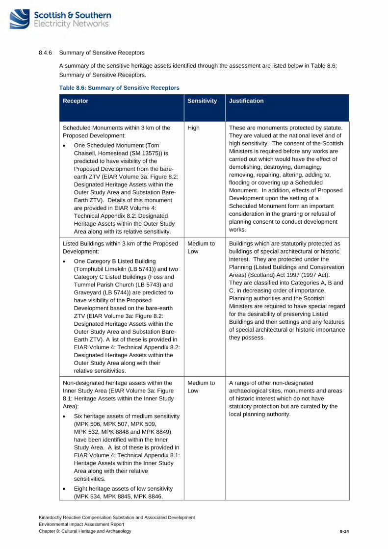
Kinardochy Reactive Compensation Substation and Associated Development Environmental Impact Assessment Report Chapter 8: Cultural Heritage and Archaeology 8-14
8.4.6 Summary of Sensitive Receptors
A summary of the sensitive heritage assets identified through the assessment are listed below in Table 8.6: Summary of Sensitive Receptors.
Table 8.6: Summary of Sensitive Receptors
Receptor Sensitivity Justification
Scheduled Monuments within 3 km of the Proposed Development: • One Scheduled Monument (Tom
Chaiseil, Homestead (SM 13575)) is predicted to have visibility of the Proposed Development from the bare-earth ZTV (EIAR Volume 3a: Figure 8.2: Designated Heritage Assets within the Outer Study Area and Substation Bare-Earth ZTV). Details of this monument are provided in EIAR Volume 4: Technical Appendix 8.2: Designated Heritage Assets within the Outer Study Area along with its relative sensitivity.
High These are monuments protected by statute. They are valued at the national level and of high sensitivity. The consent of the Scottish Ministers is required before any works are carried out which would have the effect of demolishing, destroying, damaging, removing, repairing, altering, adding to, flooding or covering up a Scheduled Monument. In addition, effects of Proposed Development upon the setting of a Scheduled Monument form an important consideration in the granting or refusal of planning consent to conduct development works.
Listed Buildings within 3 km of the Proposed Development: • One Category B Listed Building
(Tomphubil Limekiln (LB 5741)) and two Category C Listed Buildings (Foss and Tummel Parish Church (LB 5743) and Graveyard (LB 5744)) are predicted to have visibility of the Proposed Development based on the bare-earth ZTV (EIAR Volume 3a: Figure 8.2: Designated Heritage Assets within the Outer Study Area and Substation Bare-Earth ZTV). A list of these is provided in EIAR Volume 4: Technical Appendix 8.2: Designated Heritage Assets within the Outer Study Area along with their relative sensitivities.
Medium to Low
Buildings which are statutorily protected as buildings of special architectural or historic interest. They are protected under the Planning (Listed Buildings and Conservation Areas) (Scotland) Act 1997 (1997 Act). They are classified into Categories A, B and C, in decreasing order of importance. Planning authorities and the Scottish Ministers are required to have special regard for the desirability of preserving Listed Buildings and their settings and any features of special architectural or historic importance they possess.
Non-designated heritage assets within the Inner Study Area (EIAR Volume 3a: Figure 8.1: Heritage Assets within the Inner Study Area): • Six heritage assets of medium sensitivity
(MPK 506, MPK 507, MPK 509, MPK 532, MPK 8848 and MPK 8849) have been identified within the Inner Study Area. A list of these is provided in EIAR Volume 4: Technical Appendix 8.1: Heritage Assets within the Inner Study Area along with their relative sensitivities.
• Eight heritage assets of low sensitivity (MPK 534, MPK 8845, MPK 8846,
Medium to Low
A range of other non-designated archaeological sites, monuments and areas of historic interest which do not have statutory protection but are curated by the local planning authority.
Kinardochy Reactive Compensation Substation and Associated Development Environmental Impact Assessment Report Chapter 8: Cultural Heritage and Archaeology 8-15
Receptor Sensitivity Justification
MPK 8847, MPK 8855, MPK 16637, MPK 16638 and MPK 7291/MPK 7326 & MPK 17871) have been identified within the Inner Study Area. A list of these is provided in EIAR Volume 4: Technical Appendix 8.1: Heritage Assets within the Inner Study Area
8.5 Assessment of Likely Significant Effects
8.5.1 Potential Construction Effects (The Proposed Development)
Direct Effects
Any ground breaking activities associated with the construction of the Proposed Development, (such as those required for the construction of the proposed substation platform, access track, construction compound and laydown area, borrow pits, etc.) have the potential to disturb or destroy features of cultural heritage interest. Other construction activities, such as vehicle movements, materials storage, soil and overburden storage and landscaping also have the potential to cause permanent and irreversible effects on cultural heritage.
The layout of the Proposed Development, as described in Chapter 2: Development Description, and shown on EIAR Volume 3a: Figure 8.1: Heritage Assets within the Inner Study Area, has been designed to avoid the identified cultural heritage assets that lie in close proximity to the Site.
The Proposed Development could have a direct effect on one heritage asset, route of former military road (MPK 7236). The route of the former military road underlies the B846 where it passes the Site. No visible remains of the former military road were found to survive along this section of the present road. However, it is possible that buried remains may survive either below or alongside the present road surface and could potentially be exposed or disturbed by construction of the proposed entrance and access to the Site where it connects with the B846. Only a small section of the former military road could potentially be affected by construction works and it is assessed, that without mitigation, the predicted impact, on an asset of low sensitivity will be of no more than low magnitude overall (locally medium) resulting in an effect of minor significance overall (locally minor) (not significant). Mitigation to ensure that any remains that may be present are identified and recorded is set out below in Section 8.6: Mitigation.
Elsewhere within the Site, it has been assessed (paragraph 8.4.3) that there is a low potential for hitherto unknown buried archaeological remains to be present, but the possibility of buried remains of archaeological value being present cannot be ruled out.
Taking into account the assessed low to medium sensitivity of the known remains within the Inner Study Area, and assuming potential impacts of high magnitude, it is assessed that, without mitigation, any adverse direct effects on buried archaeological remains could be of moderate or major significance (significant in the context of the EIA regulations).
8.5.2 Potential Cumulative Construction Effects (The Associated Development)
Direct Effects
There is potential for direct impacts on the following three heritage assets (CFA 001, MPK 7291 and MPK 16637) to occur during the construction of the Associated Development:
• The route of the proposed access track to T227 cuts across the southern boundary of an enclosure (CFA 001). Upgrading works along the existing track could potentially affect a small section of any

Kinardochy Reactive Compensation Substation and Associated Development Environmental Impact Assessment Report Chapter 8: Cultural Heritage and Archaeology 8-16
undisturbed remains of the enclosure. It is assessed that, without mitigation the predicted effect, on an asset of negligible sensitivity, will be of low magnitude, resulting in an effect of minor significance (not significant).
• The Associated Development could have a direct effect on any surviving remains of the former military road (MPK 7291), which underlies the B846 where it passes the proposed entrance to the access track to T227. No visible remains of the former military road survive along this section of the present road but there is potential that buried remains may survive either below or alongside the present road and could potentially be exposed or disturbed by construction of the proposed new entrance to the existing access track leading to T227. Only a small section of the former military road could potentially be affected by construction works and it is assessed, that without mitigation, the predicted impact, on an asset of low sensitivity will be no more than of low magnitude overall (locally medium) resulting in an effect of minor significance overall (locally minor) (not significant).
• The recorded location of a cairnfield (MPK 16637) lies in close proximity to the Associated Works and construction of the proposed construction compound, proposed towers Temp T1 and Temp T2, T230R and T231A and proposed access tracks in these areas. Field survey found no remains of the cairnfield, but remains may yet survive within an area of mature heather cover. Work associated with the removal of the existing tower (T230) could potentially directly affect any surviving remains of the cairnfield that may be present within the working area around the tower. If remains of the cairnfield do survive and are encountered it is assessed, that without mitigation, the predicted impact on an asset of low sensitivity will be of medium magnitude, resulting in an effect of minor significance (not significant).
Mitigation to offset the potential effects identified above are set out below in Section 8.6: Mitigation.
Cumulative Effects
It is predicted that one heritage asset, route of the former military road (MPK 7291/MPK 7236), of low sensitivity, that will potentially be directly affected by the Proposed Development will also potentially be directly affected by the Associated Development.
Cumulative construction effects may arise where the route of the former military road passes the entrances to the Proposed Development and the access track to T227 for the Associated Development. Construction works in both these areas may potentially expose or disturb any surviving buried remains of the former military road. The cumulative effect during construction of the Proposed Development in addition to the effect from the Associated Development on the former military road will be of low magnitude overall. Only very short sections of the overall length of the former military road would be affected, resulting in a cumulative effect of no more than minor significance (not significant).
8.5.3 Potential Operational Effects (The Proposed Development)
Direct Effects
There are no identified assets likely to receive a direct effect arising from operation of the Proposed Development. This is due to the approach adopted in formulating the design and layout of the Proposed Development, i.e. avoidance, and because any maintenance works would be managed to recognise the presence of heritage assets and to avoid them.
Setting Effects
The Proposed Development could result in adverse effects on the setting of cultural heritage assets within the Outer Study Area, through the introduction of new, modern industrial features within their setting. Potential effects on the settings of heritage assets would however diminish with increasing distance from the Site. Based on the Proposed Development as described in Chapter 2: Development Description, it is considered that beyond 3 km, the Proposed Development would not appreciably alter features of the setting of the heritage

Kinardochy Reactive Compensation Substation and Associated Development Environmental Impact Assessment Report Chapter 8: Cultural Heritage and Archaeology 8-17
assets that contribute to their cultural significance, nor would it appreciably alter how a heritage asset is understood, appreciated and experienced.
No assets beyond 3 km from the Proposed Development have been identified by PKC or HES as requiring consideration for potential effects on their settings. EIAR Volume 4: Technical Appendix 8.2: Designated Heritage Assets within Outer Study Area (EIAR Volume 4), provides a list of those heritage assets from which there is some degree of predicted theoretical visibility of the Proposed Development (no matter how small) based on analysis of the proposed substation bare-earth ZTV. The ZTV takes no account of screening provided by forestry, woodland and hedgerows, or elements of the built environment, and so represents the theoretical, worst-case scenario. In practice, screening provided by forestry, woodland and hedgerows is likely to reduce or eliminate views of the Proposed Development from the locations of most designated heritage assets within the Outer Study Area; the exception being views from Tomphubil Limekiln (LB 5741).
The criteria detailed in Tables 8.3: Sensitivity of Heritage Assets, Table 8.4: Magnitude of Impact and Table 8.5: Significance of Effect have been used to assess the nature and magnitude of the effects described below.
Tom Chaiseil, Homestead (SM 13575)
This monument comprises the earthwork remains of a large monument roundhouse dating to the Iron Age period. It is visible as a roughly circular enclosure (16 m in diameter) defined by an intermittent stone bank. The monument stands in a small clearing at the edge of commercial forestry and is closely surrounded by trees; the forestry in which the monument stands screening views from and to the monument.
The ZTV (EIAR Volume 3a: Figure 8.2: Designated Heritage Assets within the Outer Study Area and Substation Bare-Earth ZTV) predicts that there would be bare-earth visibility of the Proposed Development from the homestead, in views to the south west; the Proposed Substation being visible c.2.5 km distant. The ZTV does not, however, take account of intervening trees, woodland and built environment which would largely screen views of the Proposed Development.
Overall, it is assessed that the introduction of the Proposed Development would have an impact of negligible magnitude on the baseline setting of Tom Chaiseil, Homestead, an asset of high sensitivity, and the effect is assessed as being of minor significance (not significant).
Tomphubil Limekiln (LB 5741)
This well-preserved large rubble-built limekiln stands just south of the B846 road and north of Tom Phobuill. The limekiln likely dates to the 19th century and is associated with former quarry workings that lie to the south of the kiln. The limekiln is a promoted visitors’ site with access being from a carpark area immediately to the west of the monument. An existing steel lattice 132 kV overhead transmission line tower lies c.50 m to the east of the limekiln. The limekiln has a localised setting and views from the limekiln are not an important contributor to the building’s cultural significance or special interest.
The ZTV (EIAR Volume 3a: Figure 8.2: Designated Heritage Assets within the Outer Study Area and Substation Bare-Earth ZTV) predicts that there would be bare-earth visibility of the Proposed Development from the limekiln, in views to the north west. The proposed substation would be around 2.5 km distant, seen on the opposite side of Loch Kinardochy and partially screened by existing commercial forestry. Visual screening of the Proposed Development would be provided by the proposed landscape design (as described in EIAR Volume 4: Technical Appendix 2.2: Reinstatement and Landscape Design Specification), including the construction of an earth mound to the south east of the substation and the replanting of existing commercial forestry to the south of the proposed substation with permanent mixed woodland, and these would reduce visibility of the proposed substation from the limekiln. Although the introduction of the Proposed Development would alter the landscape surroundings of the limekiln, it would remain possible for any visitor to understand and appreciate the localised setting of the limekiln and its association with related former quarry workings. As a result, the presence of the Proposed Development would not appreciably alter the way in which the limekiln and its setting are understood and experienced.
Kinardochy Reactive Compensation Substation and Associated Development Environmental Impact Assessment Report Chapter 8: Cultural Heritage and Archaeology 8-18
Overall, it is assessed that the Proposed Development would have an impact of no more than low magnitude on the setting of Tomphubil Limekiln, an asset of medium sensitivity, and the effect is assessed as being of minor significance (not significant).
Foss and Tummel Parish Church and Graveyard (LB 5743 & LB 5744)
Foss and Tummel Parish church and its associated graveyard stand immediately north of the Kirton public road and just north west of Kirkton schoolhouse, c.2 km south east of Tummel Bridge. The church dates to the mid-19th century and stands at the centre of a small graveyard which contains some earlier 18th century gravestones. The church is surrounded by farmland and the church and graveyard have a localised setting within the Allt Balnairn valley. Views towards the Proposed Development from the church and graveyard are screened by intervening commercial forestry and other woodland.
The ZTV (EIAR Volume 3a: Figure 8.2: Designated Heritage Assets within the Outer Study Area and Substation Bare-Earth ZTV) predicts that there would be bare-earth visibility of the Proposed Development from the church and its associated graveyard, in views to the south west; the proposed substation being visible c.2.8 km distant. The ZTV does not, however, take account of intervening trees, woodland and built environment which would largely screen views of the Proposed Development.
Overall, it is assessed that the introduction of the Proposed Development would have an impact of negligible magnitude on the baseline setting of Foss and Tummel Parish Church and Graveyard, an asset of low sensitivity, and the effect is assessed as being of negligible significance (not significant).
8.5.4 Potential Cumulative Operational Effects (The Associated Development)
Direct Effects: Associated Works
There are no identified heritage assets likely to receive a direct effect arising from operation of the Associated Development.
Setting Effects
The cumulative ZTV (EIAR Volume 3a: Figure 8.3: Designated Heritage Assets within the Outer Study Area and Cumulative ZTV) indicates that there would potentially be some degree of theoretical visibility of the Associated Development from four heritage assets, Tomphubil Limkiiln (LB 5741) and Tom Chaiseill, Homestead (SM 13575), within the Outer Study Area. Details of these are provided in Technical Appendix 8.2: Designated Heritage Assets within Outer Study Area (EIAR Volume 4). The ZTV takes no account of screening provided by forestry, woodland and hedgerows, or elements of the built environment, and so represents the theoretical worst-case scenario
The criteria detailed in Tables 8.3: Sensitivity of Heritage Assets, Table 8.4: Magnitude of Impact and Table 8.5: Significance of Effect have been used to assess the nature and magnitude of the effects described below.
Tom Chaiseill Homestead (SM 13575)
Details of this Scheduled Monument and its setting are provided above in Section 8.5.3: Potential Operational Effects, Setting Effects.
The ZTV (EIAR Volume 3a: Figure 8.2: Designated Heritage Assets within the Outer Study Area and Cumulative ZTV) predicts that there would be bare-earth visibility of the Associated Development from the homestead remains in views to the south west; the Associated Development being visible c.2.8 km distant. The ZTV does not, however take account of intervening trees, woodland and built environment which would largely screen views of the Associated Development.
Overall, it is assessed that the introduction of the Associated Development would have an impact of negligible magnitude on the baseline setting of Tom Chaiseil Homestead, an asset of high sensitivity, and the effect is assessed as being of minor significance (not significant).

Kinardochy Reactive Compensation Substation and Associated Development Environmental Impact Assessment Report Chapter 8: Cultural Heritage and Archaeology 8-19
Tomphubil Limekiln (LB 5741)
Details of this Category B Listed Building and its setting are provided above in Section 8.5.3: Potential Operational Effects, Setting Effects.
The cumulative ZTV (EIAR Volume 3a: Figure 8.2: Designated Heritage Assets within the Outer Study Area and Cumulative ZTV) predicts that there would be bare-earth visibility of the Associated Development from the limekiln in views to the north east; the Associated Development being visible c.1.5 km distant. The Associated Development would lead to a revised configuration of electricity towers being present to the north-west of the monument, including the presence of three new towers and the replacement and relocation of another tower.
Although the Associated Development would be visible in the wider landscape around the Limekiln it would remain possible for any visitor to understand its localised setting and its association with related former quarry workings. As a result, the presence of the Associated Development would not appreciably alter the way in which the limekiln and its setting are understood and experienced.
Overall, it is assessed that the Associated Development would have an impact of negligible magnitude on the setting of Tomphubil Limekiln, and asset of medium sensitivity, and the effect is assessed as being of negligible significance (not significant).
Foss and Tummel Parish Church and Graveyard (LB 5743 & LB 5744)
Details of these Category C Listed Building and their setting are provided above in Section 8.5.3: Potential Operational Effects, Setting Effects.
The ZTV (EIAR Volume 3a: Figure 8.2: Designated Heritage Assets within the Outer Study Area and Cumulative ZTV) predicts that there would be bare-earth visibility of the Associated Development from the parish church and its associated graveyard in views to the south west; the Associated Development being visible c.2.9 km distant. The ZTV does not, however take account of intervening trees, woodland and built environment which would largely screen views of the Associated Development.
Overall, it is assessed that the introduction of the Associated Development would have an impact of negligible magnitude on the baseline setting of Foss and Tummel Parish Church and Graveyard, assets of low sensitivity, and the effect is assessed as being of negligible significance (not significant).
Cumulative Effects
The assessment of cumulative effects on heritage assets has been based upon consideration of the effects of the Proposed Development on the settings of assets within 3 km of the proposed substation, in addition to the likely effects of the Associated Development.
The potential for cumulative effects has been appraised only in relation to those cultural heritage assets that might experience an indirect effect on their settings as a result of the presence of the Proposed Development: Tom Chaiseil Homestead (SM 13575); Tomphubil Limekiln (LB 5741); Foss and Tummel Parish Church (LB 5743) and associated Graveyard (LB 5744).
As part of the Associated Development, one existing electricity tower (275 kV steel lattice tower) would be removed and replaced with two new 275 kV steel lattice towers on a slightly different alignment. In addition, the existing 132 kV electricity line would be diverted, with the construction of one permanent 132 kV steel lattice tower (EIAR Volume 3a: Figure 8.2: Designated Heritage Assets within the Outer Study Area and Cumulative ZTV). The addition of the Associated Development to this existing infrastructure would result in no more than a slight detectable change within the settings of the assets listed above. As a result, it is assessed that the cumulative effect of the Proposed Development in addition to, and in combination with, the Associated Development on the setting of these heritage assets will be no greater than the effect of the Proposed Development alone; that is an impact of no more than a low magnitude, resulting in effects of minor significance (not significant).
Kinardochy Reactive Compensation Substation and Associated Development Environmental Impact Assessment Report Chapter 8: Cultural Heritage and Archaeology 8-20
8.6 Mitigation Standard / Good Practice Mitigation
Planning Advice Note 1/2013: Environmental Impact Assessment20 (PAN1/2013) describes mitigation as a hierarchy of measures: prevention, reduction, compensatory (offset) measures. Prevention and reduction measures can be achieved through design, whilst compensatory measures offset effects that have not been prevented or reduced.
Historic Environment Policy for Scotland21 (HEPS) requires the recognition, care and sustainable management of the historic environment and the emphasis in Planning Advice Note (PAN) 2/2011: Planning and Archaeology22 (PAN 2) is for the preservation of important remains in situ where practicable and by record where preservation is not possible.
All mitigation works adopted, including the specific measures set out below would take place prior to, or, where appropriate, during, construction of the Proposed Development. All works would be conducted by a professional archaeological organisation, and the scope of works would be detailed in one or more Written Scheme(s) of Investigation (WSI) developed in consultation with (and subject to the agreement of) PKHT, acting on behalf of PKC.
A range of measures have been applied as part of the iterative design process (Chapter 2: Development Description, Chapter 3: Site Alternatives and Design Elevation) or will be included in the Construction Environmental Management Plan (CEMP) (as outlined in EIAR Volume 4: Technical Appendix 2.1). These include:
• Appointment of an archaeological contractor who will act as an Archaeological Clerk of Works (ACoW) to advise on and, where necessary, oversee aspects of the construction phase archaeological mitigation work;
• Preparation of a Written Scheme of Investigation (WSI) to be submitted to the planning authority for approval prior to any construction works (including enabling works) commencing on site; and,
• Implementation of the scope of works outlined in WSI during the construction phase.
Written guidelines would be issued for use by all construction contractors, outlining the need to avoid causing unnecessary damage to known heritage assets. The guidelines would set out arrangements for calling upon retained professional support in the event that buried archaeological remains of potential archaeological interest (such as building remains, human remains, artefacts, etc.) should be discovered in areas not subject to archaeological monitoring. The guidelines would make clear the legal responsibilities placed upon those who disturb artefacts or human remains.
8.6.1 Mitigation During Construction (The Proposed Development)
Preservation in Situ
There are no known heritage assets within the Site where preservation in situ is required.
Watching Briefs
Based on the Proposed Development layout as described in Chapter 2: Development Description, and shown on EIAR Volume 3a: Figure 2.1a: Proposed Development Site Layout, watching briefs are proposed at the following locations:
• Site Entrance: where remains of the former, 18th century General Wade Military Road (MPK 7326) could be encountered during creation of the site entrance and access road;
20 Scottish Government (2013), Planning Advice Note (PAN) 1/2013: Environmental Impact Assessment, Edinburgh; 21 HES (2019), Historic Environment Policy for Scotland (HEPS), Edinburgh; 22 Scottish Government (2011), Planning Advice Note (PAN) 2/2011: Planning and Archaeology, Edinburgh;
Kinardochy Reactive Compensation Substation and Associated Development Environmental Impact Assessment Report Chapter 8: Cultural Heritage and Archaeology 8-21
• Substation Access Road: where buried archaeological remains could be encountered during topsoil stripping for creation of the substation access road where it passes through areas of currently undisturbed moorland;
• Construction Compound and Laydown Area: where buried archaeological remains could be encountered during topsoil stripping of currently undisturbed moorland for creation of the Laydown Area/Construction Compound; and
• Substation Platform: where buried archaeological remains could be encountered during topsoil stripping for creation of the Substation Platform outwith areas currently covered by commercial forestry.
If significant discoveries are made during archaeological watching briefs, and it is not possible to preserve the discovered remains in situ, provision would be made for the excavation where necessary, of any archaeological deposits encountered. The provision would include the consequent production of written reports, on the findings, with post-excavation analysis and publication of the results of the works, where appropriate.
8.6.2 Mitigation During Construction (The Associated Development)
Preservation in Situ
The remains of an enclosure (CFA 001), which lies just north of the existing access track to T227 will be avoided where possible. Where the enclosure cannot be avoided during any required upgrading of the existing track, disturbance to the enclosure bank will be kept to a minimum.
Watching Briefs
Based on the Associated Development layout as described in Chapter 2: Development Description and shown on EIAR Volume 3a: Figure 2.1b: Associated Development Site Layout, watching briefs are proposed at the following locations:
• Entrance to proposed access track to T227; where remains of the former, 18th century General Wade Military Road (MPK 7291) could be encountered during any upgrading required to the access track to T227.
• Construction Compound, Temp T1 and Temp T2, T230R and T231 and proposed access tracks in these areas, and removal of existing T230: where remains of cairnfield (MPK 16637) could be encountered during topsoil stripping for the construction of the Associated Development.
If significant discoveries are made during archaeological watching briefs, and it is not possible to preserve the discovered remains in situ, provision would be made for the excavation where necessary, of any archaeological deposits encountered. The provision would include the consequent production of written reports, on the findings, with post-excavation analysis and publication of the results of the works, where appropriate.
8.6.3 Mitigation During Operation (The Proposed Development)
No mitigation measures are required in relation to the operational phase of the Proposed Development.
8.6.4 Mitigation During Operation (The Associated Development)
No mitigation measures are required in relation to the operational phase of the Associated Development.
8.7 Assessment of Residual Effects
8.7.1 Residual Construction Effects (The Proposed Development)
Adoption of the monitoring measures set out in paragraph 8.6.1 (Mitigation during Construction) would ensure that any residual effects on potential buried remains that may survive in the site, resulting from their disturbance, would be of minor significance.
Kinardochy Reactive Compensation Substation and Associated Development Environmental Impact Assessment Report Chapter 8: Cultural Heritage and Archaeology 8-22
8.7.2 Residual Cumulative Construction Effects (The Associate Development)
For heritage assets within the Inner Study Area, implementation of the proposed programme of archaeological mitigation works set out above will minimise the likely construction effects of the Associated Development, including the potential cumulative effects. Taking the proposed mitigation into account, no significant residual cumulative effects are anticipated in relation to the heritage assets and the residual effect will be of minor significant (not significant)
8.7.3 Residual Operation Effects (The Proposed Development)
During its operational lifetime, the residual impacts of the Proposed Development on the settings of the heritage assets in the Outer Study Area would be the same as the predicted impacts. Two residual adverse effects of minor significance and two of negligible significance (not significant) are predicted that would last for the lifetime of the Proposed Development.
8.7.4 Residual Cumulative Operational Effects (The Associated Development)
During its operational lifetime, the residual impacts of the Associated Development on the settings of the heritage assets in the Outer Study Area would be the same as the predicted impacts. One residual effect of minor significance and three effects of negligible significance (not significant) are predicted that would last the lifetime of the Associated Development.
The residual cumulative operational effects on the setting of heritage assets arising from the Proposed Development in addition to, and in combination with, the Associated Development will be of no more than low magnitude and of minor significance (not significant).
8.8 Summary A desk-based assessment and field survey have been carried out to establish the archaeology and cultural heritage baseline within and in the vicinity of the Project Site. The assessment has been informed by comments and information provided by PKC and HES.
Twenty-five heritage assets were identified within the Inner Study Area (EIAR Volume 3a: Figure 8.1: Heritage Assets within the Inner Study Area and EIAR Volume 4: Technical Appendix 8.1 Heritage Assets within the Inner Study Area); none of the identified heritage assets lie within the Site. The majority of these are related to either prehistoric settlement or post medieval farming. Seven of the assets identified within the Inner Study Area are of medium sensitivity, eight are of low sensitivity and ten are assessed as being of negligible sensitivity.
Well-preserved prehistoric remains, including two homesteads, a cup-marked stone and a possible burial cairn are recorded within Inner Study Area, together with the remains of a well-preserved 18th century township. These are all assessed as being of value at the regional level and of medium sensitivity. The previously recorded prehistoric remains in closest proximity to the Project Site are likely to have been damaged or destroyed by commercial forestry activity and they are considered to be of negligible sensitivity.
An assessment of the identified cultural heritage assets, and consideration of the current and past land use within the Inner Study Area, suggests that there is a low probability of hitherto unidentified archaeological remains being present in the Project Site. However, the possibility of buried remains of archaeological interest, especially remains of prehistoric date, being present, cannot be ruled out.
Mitigation measures are proposed to offset or reduce the potential loss of the archaeological resource that is likely to occur as a result of the Proposed Development and Associated Development, and no significant residual effects are anticipated in relation to cultural heritage interest.
One Scheduled Monument, one Category B Listed Building and two Category C Listed Buildings have been identified within the Outer Study Area (EIAR Volume 3a: Figure 8.2: Designated Heritage Assets within the
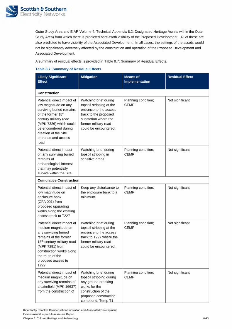
Kinardochy Reactive Compensation Substation and Associated Development Environmental Impact Assessment Report Chapter 8: Cultural Heritage and Archaeology 8-23
Outer Study Area and EIAR Volume 4: Technical Appendix 8.2: Designated Heritage Assets within the Outer Study Area) from which there is predicted bare-earth visibility of the Proposed Development. All of these are also predicted to have visibility of the Associated Development. In all cases, the settings of the assets would not be significantly adversely affected by the construction and operation of the Proposed Development and Associated Development.
A summary of residual effects is provided in Table 8.7: Summary of Residual Effects.
Table 8.7: Summary of Residual Effects
Likely Significant Effect
Mitigation Means of Implementation
Residual Effect
Construction
Potential direct impact of low magnitude on any surviving buried remains of the former 18th century military road (MPK 7326) which could be encountered during creation of the Site entrance and access road
Watching brief during topsoil stripping at the entrance to the access track to the proposed substation where the former military road could be encountered.
Planning condition; CEMP
Not significant
Potential direct impact on any surviving buried remains of archaeological interest that may potentially survive within the Site
Watching brief during topsoil stripping in sensitive areas.
Planning condition; CEMP
Not significant
Cumulative Construction
Potential direct impact of low magnitude on enclosure bank (CFA 001) from proposed upgrading works along the existing access track to T227
Keep any disturbance to the enclosure bank to a minimum.
Planning condition; CEMP
Not significant
Potential direct impact of medium magnitude on any surviving buried remains of the former 18th century military road (MPK 7291) from construction works along the route of the proposed access to T227
Watching brief during topsoil stripping at the entrance to the access track to T227 where the former military road could be encountered.
Planning condition; CEMP
Not significant
Potential direct impact of medium magnitude on any surviving remains of a cairnfield (MPK 16637) from the construction of
Watching brief during topsoil stripping during any ground breaking works for the construction of the proposed construction compound, Temp T1
Planning condition; CEMP
Not significant
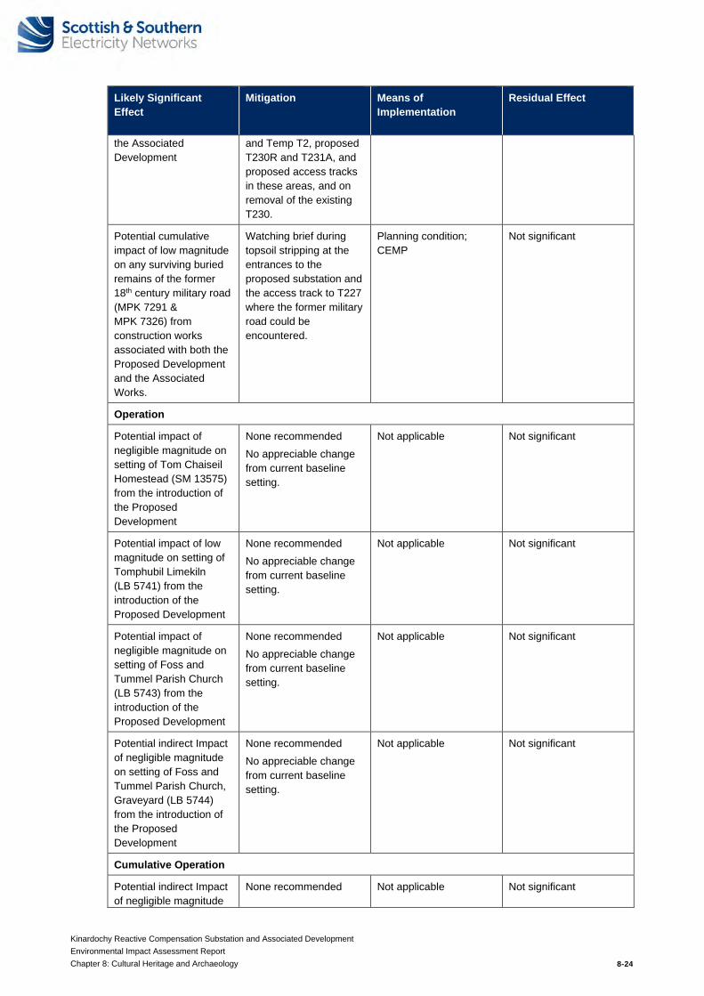
Kinardochy Reactive Compensation Substation and Associated Development Environmental Impact Assessment Report Chapter 8: Cultural Heritage and Archaeology 8-24
Likely Significant Effect
Mitigation Means of Implementation
Residual Effect
the Associated Development
and Temp T2, proposed T230R and T231A, and proposed access tracks in these areas, and on removal of the existing T230.
Potential cumulative impact of low magnitude on any surviving buried remains of the former 18th century military road (MPK 7291 & MPK 7326) from construction works associated with both the Proposed Development and the Associated Works.
Watching brief during topsoil stripping at the entrances to the proposed substation and the access track to T227 where the former military road could be encountered.
Planning condition; CEMP
Not significant
Operation
Potential impact of negligible magnitude on setting of Tom Chaiseil Homestead (SM 13575) from the introduction of the Proposed Development
None recommended No appreciable change from current baseline setting.
Not applicable Not significant
Potential impact of low magnitude on setting of Tomphubil Limekiln (LB 5741) from the introduction of the Proposed Development
None recommended No appreciable change from current baseline setting.
Not applicable Not significant
Potential impact of negligible magnitude on setting of Foss and Tummel Parish Church (LB 5743) from the introduction of the Proposed Development
None recommended No appreciable change from current baseline setting.
Not applicable Not significant
Potential indirect Impact of negligible magnitude on setting of Foss and Tummel Parish Church, Graveyard (LB 5744) from the introduction of the Proposed Development
None recommended No appreciable change from current baseline setting.
Not applicable Not significant
Cumulative Operation
Potential indirect Impact of negligible magnitude
None recommended Not applicable Not significant
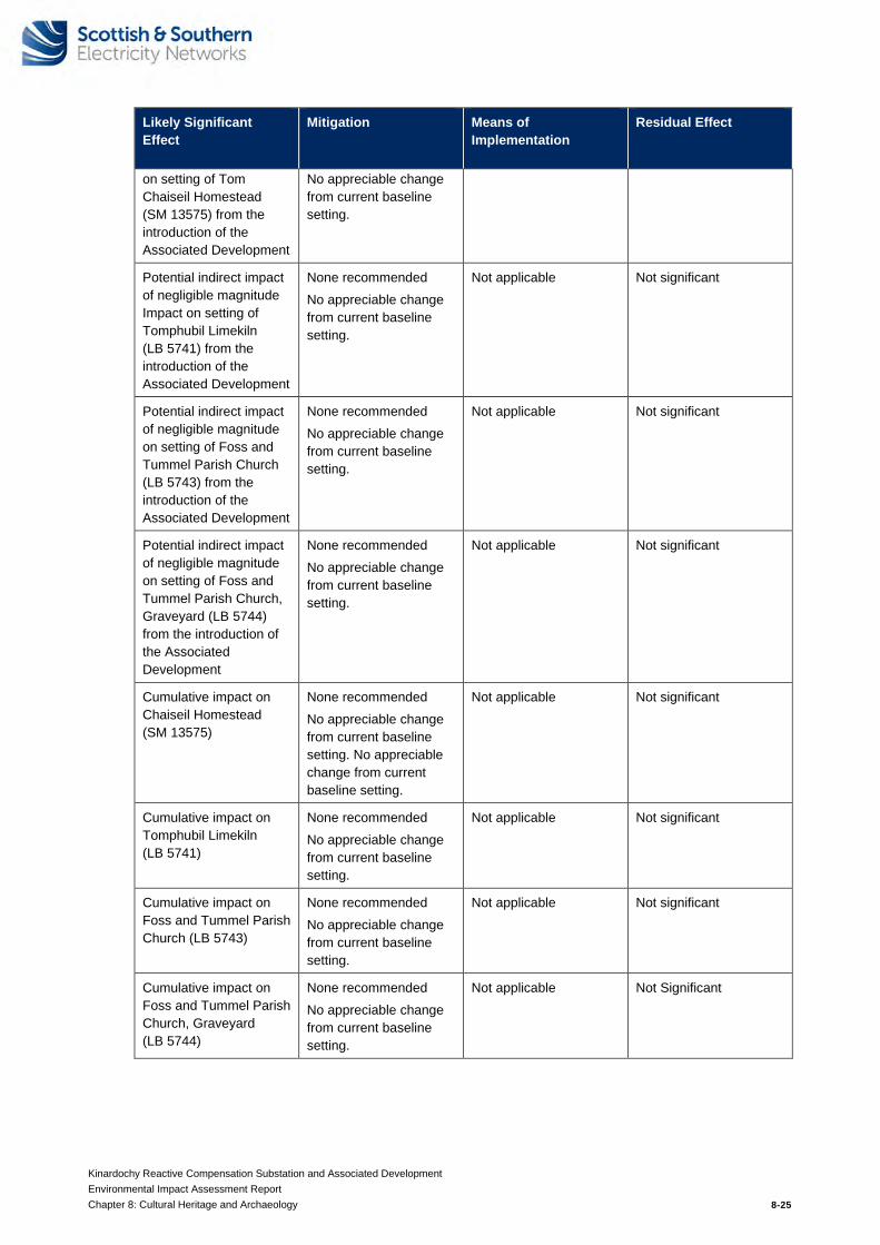
Kinardochy Reactive Compensation Substation and Associated Development Environmental Impact Assessment Report Chapter 8: Cultural Heritage and Archaeology 8-25
Likely Significant Effect
Mitigation Means of Implementation
Residual Effect
on setting of Tom Chaiseil Homestead (SM 13575) from the introduction of the Associated Development
No appreciable change from current baseline setting.
Potential indirect impact of negligible magnitude Impact on setting of Tomphubil Limekiln (LB 5741) from the introduction of the Associated Development
None recommended No appreciable change from current baseline setting.
Not applicable Not significant
Potential indirect impact of negligible magnitude on setting of Foss and Tummel Parish Church (LB 5743) from the introduction of the Associated Development
None recommended No appreciable change from current baseline setting.
Not applicable Not significant
Potential indirect impact of negligible magnitude on setting of Foss and Tummel Parish Church, Graveyard (LB 5744) from the introduction of the Associated Development
None recommended No appreciable change from current baseline setting.
Not applicable Not significant
Cumulative impact on Chaiseil Homestead (SM 13575)
None recommended No appreciable change from current baseline setting. No appreciable change from current baseline setting.
Not applicable Not significant
Cumulative impact on Tomphubil Limekiln (LB 5741)
None recommended No appreciable change from current baseline setting.
Not applicable Not significant
Cumulative impact on Foss and Tummel Parish Church (LB 5743)
None recommended No appreciable change from current baseline setting.
Not applicable Not significant
Cumulative impact on Foss and Tummel Parish Church, Graveyard (LB 5744)
None recommended No appreciable change from current baseline setting.
Not applicable Not Significant
Kinardochy Reactive Compensation Substation Environmental Impact Assessment Report Chapter 9: Forestry 9-1
9. FORESTRY
9.1 Introduction
This chapter considers the likely significant effects on forestry associated with the construction and operation of the Proposed Development. The likely significant effects on forestry associated with the construction and operation of the Associated Development will be considered as part of the cumulative assessment. As described in Chapter 2: Description of Development, neither the Proposed Development nor the Associated Development are likely to be decommissioned. If they were to be decommissioned the effects associated with the construction phase of the Proposed Development and Associated Development on forestry can be considered to be representative of reasonable worst-case decommissioning effects, therefore a separate assessment of the decommissioning phase of the Proposed Development and Associated Development has not been undertaken as part of this assessment.
The specific objectives of the chapter are to:
• describe the forestry baseline;
• describe the assessment methodology and significance criteria used in completing the impact assessment;
• describe the potential effects, including direct and indirect and cumulative effects;
• describe the mitigation measures proposed to address likely significant effects; and
• assess the residual effects remaining following the implementation of mitigation.
The assessment has been carried out by a forestry consultant from RTS Ltd. with over 20 years’ experience in the production of EIARs relating to forestry, predominately for utility projects including wind farms and overhead power lines.
The chapter is supported by:
• Figure 9.1: Study Areas;
• Figure 9.2: Land Use Current;
• Figure 9.3: FLS Felling Plan;
• Figure 9.4: FLS Restocking Plan;
• Figure 9.5: Temporary Tree Clearance Requirement;
• Figure 9.6: Permanent Tree Clearance Requirement;
• Figure 9.7: Compensatory Planting Plan; and
• Technical Appendix 9.1: Site Photographs.
These Figures and Technical Appendix are referenced in the text where relevant.
9.2 Scope of Assessment
On the basis of the desk based and field survey work undertaken, in combination with the professional judgement of the EIA team, experience from other relevant projects and policy guidance or standards, and feedback received from consultees, the following effects from the Proposed Development have been assessed in detail:
• Construction; long term loss of forest resource as a result of felling of trees within the Site for the construction; and
• Operation; effects on forest management.
The assessment is based on the Proposed Development as described in Chapter 2: Development Description and a review of the impact of this Proposed Development on the existing woodland at Kinardochy.
Kinardochy Reactive Compensation Substation Environmental Impact Assessment Report Chapter 9: Forestry 9-2
The chapter also considers the potential effects of the Associated Development, as described in Chapter 2: Description of Development, as a cumulative development. No other consented or proposed developments that could lead to significant cumulative effects have been identified within 5 km of the Site. As such no other cumulative developments are considered in the EIAR. The cumulative assessment captures the potential for additional, in combination and synergistic effects when considering the Proposed Development along with the Associated Development.
9.2.1 Consultation
The scope of the assessment has been informed by consultation responses summarised in Table 9.1: Consultation Responses and the following guidelines/ policies:
• FC (FLS) Technical paper 16 Designing Forest Edges to improve wind stability (1996);
• FISA guidance note 804 Electricity at Work: Forestry (August 2013);
• Electricity Association Engineering Recommendations G55/1 Safe Working in Proximity to Overhead Electric Lines (July 2000);
• Forestry Commission guidelines in the assessment of Yield class has been utilised to assess forest areas and establish the growth rates and productivity of the individual sites;
• The Scottish Government, (2009), Policy on the Control of Woodland Removal;
• The Scottish Government’s policy on control of woodland removal: implementation guidance (February 2019);
• Forestry and Land Management (Scotland) Act 2018;
• The Felling (Scotland) Regulations 2019;
• Scotland’s Forestry Strategy 2019-2029;
• Data from the SNH records on Ancient and Semi Natural Woodlands (ASNW);
• UK Forestry Standard 2017 1; and
• UK Woodland Assurance Standard 0F
1 1F
2
The following organisations made comment on Forestry:
• Perth and Kinross Council;
• SEPA; and
• Scottish Forestry.
Table 9.1: Consultation Responses summarises the consultation responses received in relation to forestry and provides information on where and/or how they have been addressed in this assessment.
Table 9.1: Consultation Responses
Consultee and Date
Scoping/ Other Consultation
Issue Raised Response/ Action Taken
PKC 1/7/2019
Screening Opinion
Production of waste-timber
The Proposed Development will aim to export timber using local public routes in consultation with the local Stirling and Tayside Timber Transport Group.
1 Forestry Commission (2017) The UK Forestry Standard Edinburgh [email protected] Available at: http://ukwas.org.uk/ (22/10/20) 2 Forestry Commission (2018) UK Woodland Assurance Standard Version 4 Edinburgh Available at: http://ukwas.org.uk/ (22/10/20)
Kinardochy Reactive Compensation Substation Environmental Impact Assessment Report Chapter 9: Forestry 9-3
Consultee and Date
Scoping/ Other Consultation
Issue Raised Response/ Action Taken
PKC 17/12/2019
Screening Opinion
Loss of Woodland/ Forestry
Loss of woodland and forestry as detailed in EIAR Volume 3a: Figures 9.5 and 9.6 and is addressed within Section 9.6: Mitigation, of this chapter.
PKC 17/12/2019
Screening Opinion
Impact on ancient woodland
The design of the Proposed Development has avoided any adverse effect on ancient woodland. See Chapter 3: Design Evolution and Alternatives.
PKC 17/12/2019
Screening Opinion
Impact of timber haulage on local roads
Addressed within Chapter 10: Traffic and Transport.
PKC 17/12/2019
Screening Opinion
Visual impact of forest loss
The visual impact of forestry loss is addressed within Chapter 4: Landscape and Visual Impact.
PKC (Biodiversity) 09/12/2020
Scoping Opinion Due to the presence of peatland and loss of woodland, it is recommended that climate change is included in the EIA.
Loss of woodland impact on climate from the Proposed Development and the Associated Development is addressed within the proposed mitigation (section 9.6) through the committed 9 ha of compensatory planting.
PKC (Biodiversity) 09/12/2020
Scoping Opinion PKC will apply the principles of the Scottish Government Policy on Control of Woodland Removal (CoWR) and there will be a presumption in favour of protecting woodland resources. Where the loss of woodland is unavoidable, mitigation measures in the form of compensatory planting will be required. Construction of the project requires removal of approximately 9.01 ha of woodland and in line with the Scottish Government’s Policy on CoWR, compensatory planting is required.
Section 9.6 of this chapter details the proposed compensatory planting which addresses this issue
PKC (Biodiversity) 09/12/2020
Scoping Opinion The proposed species mix of Scots pine, birch, rowan, hawthorn, grey willow and goat willow is welcomed as native species that will maximise the biodiversity value. Expanding Scots pine is a key action in the Woodland Action Plan
The project will continue to utilise these high valued biodiverse species as detailed in EIAR Volume 4: Technical Appendix 2.2: Reinstatement and Landscape Design Specification.
Kinardochy Reactive Compensation Substation Environmental Impact Assessment Report Chapter 9: Forestry 9-4
Consultee and Date
Scoping/ Other Consultation
Issue Raised Response/ Action Taken
within the Tayside Local Biodiversity Action Plan (LBAP) 2016-2026.
PKC (Biodiversity) 09/12/2020
Scoping Opinion Clarity is required on when compensatory planting will be carried out as it is mentioned that a restocking plan tying in with proposed felling in 2045 may be arranged with Forestry and Land Scotland. To compensate for lost habitat and lost connectivity, we would encourage replanting to take place as soon as possible.
It is anticipated that the compensatory replanting will occur in 2022
PKC (Biodiversity) 09/12/2020
Scoping Opinion PKC have records of juniper in the area which is listed on the Scottish Biodiversity List and Tayside LBAP as a priority species. Including juniper in compensatory planting would result in a positive contribution towards biodiversity.
Juniper will be included within the landscape planting onsite, as detailed in EIAR Volume 4: Technical Appendix 2.2: Reinstatement and Landscape Design Specification.
PKC (Biodiversity) 09/12/2020
Scoping Opinion Consultation of the PKC Forest and Woodland Strategy should be undertaken.
The PKC Forest and Woodland Strategy has been considered and the designed mitigation proposals incorporate the major objectives of the strategy.
SEPA 21/10/2020
Scoping Opinion A map and table detailing forest removal must be submitted in support of the application.
Temporary and permanent forest removal are illustrated in Figures 9.5 and 9.6 (EIAR Volume 3a) respectively. This information is also provided in Table 9.5 of this chapter.
SEPA 21/10/2020
Scoping Opinion Please note the detailed requirements in relation to forestry removal and waste as set out in Section 8 below. SEPA would look for information regarding approximate volumes of timber which will be removed from site and volumes, sizes of chips or brash and depths that will be re-used on site. Timber would not be viewed as waste but a product, however brash
In order to maximise the economic value from the standing trees, The Applicant’s appointed forestry contractor will identify trees that can provide the maximum amount of recoverable timber (typically trees over 7 cm diameter). The estimated volume of marketable timber is 3,000 tonnes, which can be broken down into approximately 700 tonnes of Sitka Spruce log, 50 tonnes of Larch Log and 2,250 tonnes of chip wood. These trees will be harvested by a purpose-built forest harvester or chainsaw operations for dispatch to the closest market to minimise timber haulage movements on the public road. The volume of HGV vehicle movements associated with timber haulage
Kinardochy Reactive Compensation Substation Environmental Impact Assessment Report Chapter 9: Forestry 9-5
Consultee and Date
Scoping/ Other Consultation
Issue Raised Response/ Action Taken
and wood chippings would be viewed as waste. We require that no waste wood is left on site. A Waste Management Exemption is required for any chipping of the wood.
is included within Chapter 10: Traffic and Transport. In addition to the removal of all commercial timber from the Project Site, there is an intention to harvest and remove the brash for use as biomass fuel. There is no intention to create woodchip during the tree clearance operations. Non-marketable forest products will arise out of the timber harvesting operation in the form of stumps, brash, and lop and top. Within areas of temporary tree clearance (see EIAR Volume 3a: Figure 9.5: Temporary Tree Clearance Requirement) the stumps and brash would be left in situ as per standard forestry practise for the benefit of the next crop rotation. Within areas of permanent tree clearance (see EIAR Volume 3a: Figure 9.6: Permanent Tree Clearance Requirement) the stumps, brash, and lop and top would be mulched and combined with the topsoil in order to facilitate the cut fill operations. The volume of the mulch is predicted to be negligible and as such not considered to have any adverse effect. The topsoil stripped in the cut/ fill operations will be stored temporarily for use in reinstatement of the Site. Notable environmental benefits of using non-marketable forest products (in the form of mulch) in reinstatement can be achieved by the incorporation of the plant matter into the topsoil so that it will assist with creating a suitable growing medium. This will be used for planting native trees and shrubs, as described in EIAR Volume 4: Technical Appendix 2.2: Reinstatement and Landscape Design Specification. Due to the proposal to replace non-native species (Sitka Spruce and Larch) with native species there will also be a net benefit to biodiversity within the local area.
SEPA 21/10/2020
Scoping Opinion SEPA request that a survey is carried out to ensure no trees have disease. The Applicant should refer to SEPA Guidance on disposal of trees and plants infected with specific plant diseases WST-G-037.
All proposed tree felling areas will be surveyed and any areas of diseased trees will be treated following best practice as per WST-G-037. At time of writing there is no evidence of Phytophthora ramorum (Larch Dieback disease) within the current areas to be felled within the Project Site. Should this be found, the appropriate Phyto-sanitation methods as provided by Scottish Forestry will be followed in the removal of such trees and
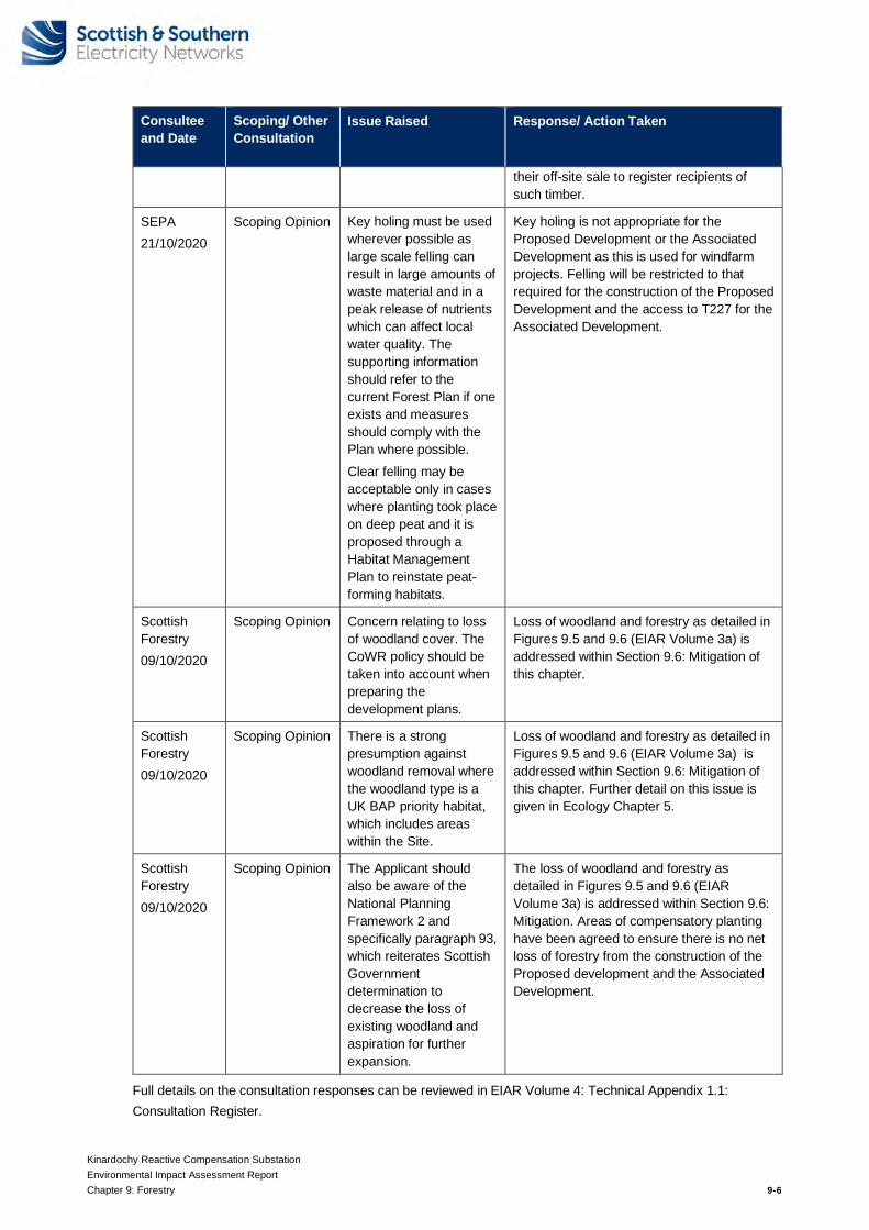
Kinardochy Reactive Compensation Substation Environmental Impact Assessment Report Chapter 9: Forestry 9-6
Consultee and Date
Scoping/ Other Consultation
Issue Raised Response/ Action Taken
their off-site sale to register recipients of such timber.
SEPA 21/10/2020
Scoping Opinion Key holing must be used wherever possible as large scale felling can result in large amounts of waste material and in a peak release of nutrients which can affect local water quality. The supporting information should refer to the current Forest Plan if one exists and measures should comply with the Plan where possible. Clear felling may be acceptable only in cases where planting took place on deep peat and it is proposed through a Habitat Management Plan to reinstate peat-forming habitats.
Key holing is not appropriate for the Proposed Development or the Associated Development as this is used for windfarm projects. Felling will be restricted to that required for the construction of the Proposed Development and the access to T227 for the Associated Development.
Scottish Forestry 09/10/2020
Scoping Opinion Concern relating to loss of woodland cover. The CoWR policy should be taken into account when preparing the development plans.
Loss of woodland and forestry as detailed in Figures 9.5 and 9.6 (EIAR Volume 3a) is addressed within Section 9.6: Mitigation of this chapter.
Scottish Forestry 09/10/2020
Scoping Opinion There is a strong presumption against woodland removal where the woodland type is a UK BAP priority habitat, which includes areas within the Site.
Loss of woodland and forestry as detailed in Figures 9.5 and 9.6 (EIAR Volume 3a) is addressed within Section 9.6: Mitigation of this chapter. Further detail on this issue is given in Ecology Chapter 5.
Scottish Forestry 09/10/2020
Scoping Opinion The Applicant should also be aware of the National Planning Framework 2 and specifically paragraph 93, which reiterates Scottish Government determination to decrease the loss of existing woodland and aspiration for further expansion.
The loss of woodland and forestry as detailed in Figures 9.5 and 9.6 (EIAR Volume 3a) is addressed within Section 9.6: Mitigation. Areas of compensatory planting have been agreed to ensure there is no net loss of forestry from the construction of the Proposed development and the Associated Development.
Full details on the consultation responses can be reviewed in EIAR Volume 4: Technical Appendix 1.1: Consultation Register.
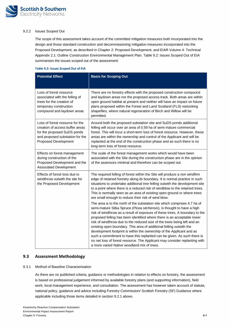
Kinardochy Reactive Compensation Substation Environmental Impact Assessment Report Chapter 9: Forestry 9-7
9.2.2 Issues Scoped Out
The scope of this assessment takes account of the committed mitigation measures both incorporated into the design and those standard construction and decommissioning mitigation measures incorporated into the Proposed Development, as described in Chapter 2: Proposed Development, and EIAR Volume 4: Technical Appendix 2.1: Outline Construction Environmental Management Plan. Table 9.2: Issues Scoped Out of EIA summarises the issues scoped out of the assessment:
Table 9.2: Issues Scoped Out of EIA
Potential Effect Basis for Scoping Out
Loss of forest resource associated with the felling of trees for the creation of temporary construction compound and laydown areas
There are no forestry effects with the proposed construction compound and laydown areas nor the proposed access track. Both areas are within open ground habitat at present and neither will have an impact on future plans proposed within the Forest and Land Scotland (FLS) restocking shapefiles, where natural regeneration of Birch and Willow will be permitted.
Loss of forest resource for the creation of access buffer areas for the proposed SuDS ponds and proposed substation for the Proposed Development
Around both the proposed substation site and SuDS ponds additional felling will occur over an area of 0.59 ha of semi mature commercial forest. This will incur a short-term loss of forest resource. However, these areas are within the ownership and control of the Applicant and will be replanted at the end of the construction phase and as such there is no long-term loss of forest resource.
Effects on forest management during construction of the Proposed Development and the Associated Development
The scale of the forest management works which would have been associated with the Site during the construction phase are in the opinion of the assessors minimal and therefore can be scoped out.
Effects of forest loss due to windthrow outwith the site for the Proposed Development
The required felling of forest within the Site will produce a non windfirm edge of retained forestry along its boundary. It is normal practice in such situations to undertake additional tree felling outwith the development site to a point where there is a reduced risk of windblow to the retained trees. This is normally seen as an area of existing open ground or where trees are small enough to reduce their risk of wind blow. The area is to the north of the substation site which comprises 4.7 ha of semi-mature Sitka Spruce (Picea sitchensis), is thought to have a high risk of windthrow as a result of exposure of these trees. A boundary to the proposed felling has been identified where there is an acceptable lower risk of windthrow due to the reduced size of the trees being left and an existing open boundary. This area of additional felling outwith the development footprint is within the ownership of the Applicant and as such a commitment to have this replanted can be given. As such there is no net loss of forest resource. The Applicant may consider replanting with a more varied Native woodland mix of trees.
9.3 Assessment Methodology
9.3.1 Method of Baseline Characterisation
As there are no published criteria, guidance or methodologies in relation to effects on forestry, the assessment is based on professional judgement informed by available forestry plans (and supporting information), field work, local management experience, and consultation. The assessment has however taken account of statute, national policy, guidance and advice including Forestry Commission/ Scottish Forestry (SF) Guidance where applicable including those items detailed in section 9.2.1 above.

Kinardochy Reactive Compensation Substation Environmental Impact Assessment Report Chapter 9: Forestry 9-8
Extent of Study Area
The study area for the Proposed Development, which includes both open land and existing forestry, is shown in EIAR Volume 3a, Figure 9.1: Study Areas. The Applicant has secured the purchase of this area with FLS. The existing forest areas outwith the development impact area but within the ownership of the Applicant will continue to be managed through a detailed Forest Management Plan (FMP) developed specifically for this area.
9.3.2 Desk Study
Desk based studies reviewing the forestry data available were undertaken using the following sources of information:
• Ordnance Survey maps at 1;25,000 and 1;50,000 scale;
• Aerial photography (dated 2017 and 2018);
• SNH, Ancient Woodland Inventory (ASNW 2000);
• SF, The Native Woodland Survey of Scotland (NWSS 2014);
• Forestry and Land Scotland (FLS), Land Management Plans, Compartment schedules and maps2F
3; and
• Forest Research, Forest GALES 2.5 model for predicting risk of windthrow3F
4 (“Forest GALES 2.5”).
9.3.3 Field Survey
Field surveys were undertaken between August 2019 and July 2020 to supplement and verify the desk-based studies, to further inform the assessment. The surveys comprised of walking (where forest density allowed) over the Site and the surrounding forest. Forest characteristics including forest type and detailed descriptions of the area, age, species mix and stocking density, together with area of proposed tree clearance required were noted. A general assessment of site conditions was undertaken to inform the prediction of the likely risk of windthrow to the trees outwith the Site. This risk of windthrow to retained trees outwith the Site was based on professional judgement and took into account the current forest, including an assessment of age, species and height of the trees. In addition, a range of site conditions were considered, including aspect, altitude and soil type. Reference was also made to the forest research wind risk calculating system Forest GALES 2.5.
9.3.4 Criteria for Assessment of Effects
The approach to assessing the significance of effects comprised the following stages:
• establish the existing conditions;
• identify likely forestry effects;
• assess whether each likely effect is adverse or beneficial in nature;
• assess the significance of the likely effect;
• where an effect is likely to be significant, identify measures to avoid, reduce or mitigate such significant effects; and
• assess the significance of the residual effect following application of the mitigation measures.
The significance of an effect on forestry derives from the combination of the sensitivity of the forestry and the extent/ degree of change to the forestry, i.e. the magnitude of effect.
3Forest and Land Scotland R Almond (2020) Land Management plan Braes of Foss Dunkeld FLS. Available at: FLS Tay offices https://forestryandland.gov.scot/what-we-do/planning 4 Forestry CommissionForest Research2015 Forest Gales 2.5 Available at: https://www.forestresearch.gov.uk/tools-and-resources/forest-planning-and-management-services/forestgales/latest-version-forestgales/

Kinardochy Reactive Compensation Substation Environmental Impact Assessment Report Chapter 9: Forestry 9-9
As there are no published criteria, guidance or methodologies in relation to the appraisal of sensitivity of effects on forestry, the assessment is based on professional judgement informed by available forestry plans (and supporting information), field work, local management experience and consultation.
Criteria for Assessing the Sensitivity of Receptors
Sensitivity; has been identified on the basis of the following categories:
• Highly sensitive areas of woodland are considered to be those that are:
• highly valued due to crop species and age, e.g. ASNW or NWSS;
• particularly rare or distinctive; and
• considered susceptible to small changes.
• Moderately sensitive areas of woodland are considered to be those that are:
• valued more locally; and
• are tolerant of moderate levels of change.
• Low sensitive areas of woodland are considered to be those that are:
• generally, more commonplace;
• considered potentially tolerant of noticeable change; and
• undergoing substantial development such that their character is one of change.
• None: areas of woodland that are:
• subject to no direct impact on the woodland area;
• tolerant of major changes, e.g. plantation forest where major structural changes are regular or planned as part of a normal felling cycle; and
• with no designations and considered of no ecological or landscape value.
The sensitivity of forestry management to the effects of the tree felling to accommodate the Proposed Development has been determined taking additional account of:
• forest productivity (in terms of, species and crop mixture);
• accessibility in terms of ground conditions;
• current management regime, including objectives of management, and size of management unit; and
• imposition of additional safety constraints in forest areas adjacent to the Site.
It should be noted that not all aspects noted above are required concurrently to define the sensitivity level, which is assigned based on professional judgement.
Criteria for Assessing the Magnitude of Change
The following criteria have been used to inform the assessment of magnitude of changes as a result of the Proposed Development:
• Major: a noticeable change to the woodland over a wide area or an intensive change over a limited area;
• Moderate: small changes to the woodland over a wide area or noticeable change over a limited area;
• Minor: very minor changes to the woodland over a wide area or minor changes over a limited area; and
• Negligible effectively no change.
Criteria for Assessing Cumulative Effects
The study area for the Associated Development, which is largely comprised of open land, is shown in EIAR Volume 3a, Figure 9.1: Study Areas.
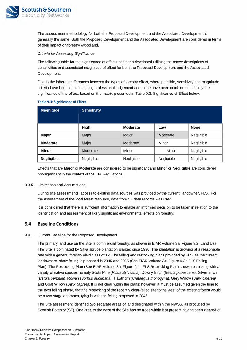
Kinardochy Reactive Compensation Substation Environmental Impact Assessment Report Chapter 9: Forestry 9-10
The assessment methodology for both the Proposed Development and the Associated Development is generally the same. Both the Proposed Development and the Associated Development are considered in terms of their impact on forestry /woodland.
Criteria for Assessing Significance
The following table for the significance of effects has been developed utilising the above descriptions of sensitivities and associated magnitude of effect for both the Proposed Development and the Associated Development.
Due to the inherent differences between the types of forestry effect, where possible, sensitivity and magnitude criteria have been identified using professional judgement and these have been combined to identify the significance of the effect, based on the matrix presented in Table 9.3: Significance of Effect below.
Table 9.3: Significance of Effect
Magnitude Sensitivity
High Moderate Low None
Major Major Major Moderate Negligible
Moderate Major Moderate Minor Negligible
Minor Moderate Minor Minor Negligible
Negligible Negligible Negligible Negligible Negligible
Effects that are Major or Moderate are considered to be significant and Minor or Negligible are considered not-significant in the context of the EIA Regulations.
9.3.5 Limitations and Assumptions.
During site assessments, access to existing data sources was provided by the current landowner, FLS. For the assessment of the local forest resource, data from SF data records was used.
It is considered that there is sufficient information to enable an informed decision to be taken in relation to the identification and assessment of likely significant environmental effects on forestry.
9.4 Baseline Conditions
9.4.1 Current Baseline for the Proposed Development
The primary land use on the Site is commercial forestry, as shown in EIAR Volume 3a: Figure 9.2: Land Use. The Site is dominated by Sitka spruce plantation planted circa 1990. The plantation is growing at a reasonable rate with a general forestry yield class of 12. The felling and restocking plans provided by FLS, as the current landowners, show felling is proposed in 2045 and 2055 (See EIAR Volume 3a: Figure 9.3 : FLS Felling Plan). The Restocking Plan (See EIAR Volume 3a: Figure 9.4 : FLS Restocking Plan) shows restocking with a variety of native species namely Scots Pine (Pinus Sylvestris), Downy Birch (Betula pubescens), Silver Birch (Betula pendula), Rowan (Sorbus aucuparia), Hawthorn (Crataegus monogyna), Grey Willow (Salix cinerea) and Goat Willow (Salix caprea). It is not clear within the plans; however, it must be assumed given the time to the next felling phase, that the restocking of the recently clear-felled site to the west of the existing forest would be a two-stage approach, tying in with the felling proposed in 2045.
The Site assessment identified two separate areas of land designated within the NWSS, as produced by Scottish Forestry (SF). One area to the west of the Site has no trees within it at present having been cleared of
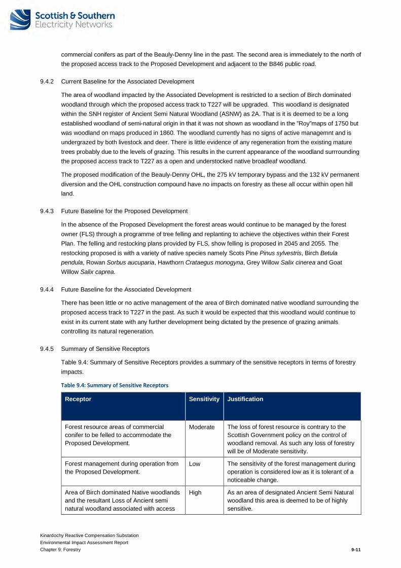
Kinardochy Reactive Compensation Substation Environmental Impact Assessment Report Chapter 9: Forestry 9-11
commercial conifers as part of the Beauly-Denny line in the past. The second area is immediately to the north of the proposed access track to the Proposed Development and adjacent to the B846 public road.
9.4.2 Current Baseline for the Associated Development
The area of woodland impacted by the Associated Development is restricted to a section of Birch dominated woodland through which the proposed access track to T227 will be upgraded. This woodland is designated within the SNH register of Ancient Semi Natural Woodland (ASNW) as 2A. That is it is deemed to be a long established woodland of semi-natural origin in that it was not shown as woodland in the ”Roy”maps of 1750 but was woodland on maps produced in 1860. The woodland currently has no signs of active managemnt and is undergrazed by both livestock and deer. There is little evidence of any regeneration from the existing mature trees probably due to the levels of grazing. This results in the current appearance of the woodland surrrounding the proposed access track to T227 as a open and understocked native broadleaf woodland.
The proposed modification of the Beauly-Denny OHL, the 275 kV temporary bypass and the 132 kV permanent diversion and the OHL construction compound have no impacts on forestry as these all occur within open hill land.
9.4.3 Future Baseline for the Proposed Development
In the absence of the Proposed Development the forest areas would continue to be managed by the forest owner (FLS) through a programme of tree felling and replanting to achieve the objectives within their Forest Plan. The felling and restocking plans provided by FLS, show felling is proposed in 2045 and 2055. The restocking proposed is with a variety of native species namely Scots Pine Pinus sylvestris, Birch Betula pendula, Rowan Sorbus aucuparia, Hawthorn Crataegus monogyna, Grey Willow Salix cinerea and Goat Willow Salix caprea.
9.4.4 Future Baseline for the Associated Development
There has been little or no active management of the area of Birch dominated native woodland surrounding the proposed access track to T227 in the past. As such it would be expected that this woodland would continue to exist in its current state with any further development being dictated by the presence of grazing animals controlling its natural regeneration.
9.4.5 Summary of Sensitive Receptors
Table 9.4: Summary of Sensitive Receptors provides a summary of the sensitive receptors in terms of forestry impacts.
Table 9.4: Summary of Sensitive Receptors
Receptor Sensitivity Justification
Forest resource areas of commercial conifer to be felled to accommodate the Proposed Development.
Moderate The loss of forest resource is contrary to the Scottish Government policy on the control of woodland removal. As such any loss of forestry will be of Moderate sensitivity.
Forest management during operation from the Proposed Development.
Low The sensitivity of the forest management during operation is considered low as it is tolerant of a noticeable change.
Area of Birch dominated Native woodlands and the resultant Loss of Ancient semi natural woodland associated with access
High As an area of designated Ancient Semi Natural woodland this area is deemed to be of highly sensitive.
Kinardochy Reactive Compensation Substation Environmental Impact Assessment Report Chapter 9: Forestry 9-12
Receptor Sensitivity Justification
road upgrade to Tower 227 for the Associated Development
9.5 Assessment of Likely Significant Effects
9.5.1 Potential Construction Effects (The Proposed Development)
Temporary / Short-Term Loss of Forest Resource
The Proposed Development would result in the short-term loss of 5.37 ha of forest resource, as illustrated in EIAR Volume 3a: Figure 9.5: Temporary Tree Clearance Requirement, which includes the construction area for the proposed substation platform, the temporary sedimentation pond for the construction compound and laydown areas and an area to the north of the substation platform to be felled to mitigate risk of windblow. The temporary felling would be comprised of 0.41 ha of larch, 4.91 ha of Sitka Spruce and 0.5 ha of broadleaves, as detailed in Table 9.5: Forest Removal for Proposed Development and Associated Development. The areas felled for these temporary substation construction works and the area felled to mitigate risk of windblow would be replanted and established as mixed species native woodland as detailed within the EIAR Volume 4: Technical Appendix 2.2: Reinstatement and Landscape Design Specification.
Table 9.5 Forest Removal for Proposed Development and Associated Development
Felling Species Proposed Development (PD) or Associated Development (AD)
Area [ha]
Planting Year
Yield Class
Temporary Larch PD 0.41 1980 10
Sitka Spruce PD 4.91 1980 18
Broadleaves (for proposed access track to substation)
PD 0.05 n/a n/a
Permanent Larch PD 0.83 1980 10
Sitka Spruce PD 6.74 1980 20
Broadleaves (for proposed access track to substation)
PD 0.04 n/a n/a
Broadleaves (for proposed access track to T227)
AD 0.20 n/a n/a
Long Term Loss of Forest Resource
The Proposed Development would result in the long-term loss of 7.57 ha of forest resource, as illustrated in EIAR Volume 3a: Figure 9.6: Permanent Tree Clearance Requirement, which includes 6.74 ha of Sitka spruce and a further 0.83 ha of Larch within the substation platform area, as detailed in Table 9.5: Forest Removal. In addition 0.04 ha of broadleaf woodland will be felled to allow for the construction of the proposed access track the substation, as detailed in Table 9.5: Forest Removal The Site will be kept clear of trees during construction and operation; therefore, the effect would be long-term but reversible on the basis that, if the Proposed Development were to be decommissioned in the future, the Site could be replanted.
The assessment of the effect of the Proposed Development on long-term loss of the forest resources is undertaken in the context of Scottish Government policy, detailed within Scotland’s Forestry Strategy 2019-2029. This includes a policy to increase new woodland planting across the country from the existing 10,000 ha
Kinardochy Reactive Compensation Substation Environmental Impact Assessment Report Chapter 9: Forestry 9-13
of new planting per annum up to 15,000 ha per annum. Therefore, the long-term removal of forestry within the Site conflicts with the woodland expansion objectives.
The Scottish Government policy on the control of woodland removal published in 20094F
5 along with updated Implementation Guidance published in 20195F
66F
i includes a presumption in favour of protecting Scotland’s woodland resources. Woodland removal should only be permitted where it would achieve significant and clearly defined additional public benefits. Where woodland removal is associated with development, compensatory planting may form part of the balancing exercise.
The sensitivity of the local forest resource is moderate, as the area is considered to be tolerant to moderate change. The likely magnitude of the effect is moderate in that it is an intensive change over a limited area. As such, the likely significance of the effect is considered to be moderate (significant in EIA terms).
9.5.2 Potential Cumulative Construction Effects (The Associated Development)
Loss of Broadleaf Woodland (Including Areas of ASNW)
The only cumulative loss of broadleaf woodland identified is as a result of the upgrade of the existing 4x4 access track to T227 as part of the Associated Development. EIAR Volume 4: Technical Appendix 9.1: Site Photographs provides representative photographs (taken July 2020) of the existing 4x4 access track to T227 and the current woodlands in this area.
The current access track to T227 is only suitable for 4x4 vehicles although some sections at the western end have been partially improved in recent years. The track is currently 2.5 m - 3.0 m in width and passes through the majority of the ASNW lightly wooded area without impacting on the existing trees. The location of the proposed access track to T227 and the associated ASNW is detailed within EIAR Volume 3a: Figure 9.6: Permanent Tree Clearance Requirement. The construction works required to upgrade the track would require some trees to be felled to near the crossing of the Allt Kynachan burn. At this point approximately 10 mixed species trees would require felling, including mature Alder, Ash and Birch. In addition, it is anticipated that within the first 200 m of the proposed access track to T227 leaving the B846, there would also be a requirement to fell approximately 20 birch trees within a dense stand of birch growing close to the track side. The total area of trees lost as a result of these works is assessed as 0.2 ha, as detailed in Table 9.5: Forest Removal.
The sensitivity of the receptor to this tree clearance is considered moderate and the magnitude of the change is minor. As such the significance of the effect is minor and in terms of EIA this is assessed as non-significant.
The permanent loss of 0.2 ha of native broadleaf trees to accommodate the Associated Development in combination with the permanent loss of 7.57 ha of commercial conifer forestry and 0.04 ha of native broadleaf trees to accommodate the Proposed Development, would result in a cumulative loss of 7.81 ha of forest resource. The sensitivity of the combined effects on loss of forest resource from the Proposed Development and the Associated Development is considered to be moderate and the magnitude of the effect is considered to be moderate. As such the significance of the effect is Moderate and in terms of the EIA this is assessed as being significant.
5 Forestry Commission Scotland (2009(, Scottish Government Policy on Control of Woodland removal 2009 Available at: https://forestry.gov.scot/support-regulations/control-of-woodland-removal Scottish Government Policy on Control of Woodland removal 2009 6 Scottish Government’s policy on control of woodland removal: implementation guidance 2019 Available on https://forestry.gov.scot/publications/349-scottish-government-s-policy-on-control-of-woodland-removal-implementation-guidance
Kinardochy Reactive Compensation Substation Environmental Impact Assessment Report Chapter 9: Forestry 9-14
9.5.3 Potential Operational Effects (The Proposed Development)
Effects on Forest Management
Future forest management effects during operation due to the Proposed Development include the requirement for the forest manager of the adjoining, retained forest areas to amend current objectives, plans and techniques for felling and restructuring the forest. This is achieved via the production of a Forest management plan. In particular, the effects assessed include those on future felling and restocking requirements, in land immediately adjacent to the substation and access road and the direct effect of the presence of the Proposed Development in terms of safe working restrictions within the forest. These effects have been assessed using professional judgement and vary according to the age and consequent level of forest management required for each site.
Operational effects of the felling required for the Proposed Development on forest management include:
• taking account of the weakened nature of the new edge of the crop;
• requirement to re-design felling coupes;
• amendments to harvesting techniques and extraction routes to take account of the presence of the Proposed Development;
• relocation of timber loading areas to avoid working adjacent to the Proposed Development and access road; and
• taking account of the presence of the Proposed Development during re-stocking which occurs after clear felling, and in certain areas restructuring, which may be necessary to take account of landscape design considerations (see EIAR Volume 4: Technical Appendix 2.2: Reinstatement and Landscape Design Specification).
The operational effects of the Proposed Development on forest management are assessed as being low in terms of sensitivity in that it is considered potentially tolerant of noticeable change and moderate in terms of magnitude in that this is a noticeable change over a limited area. As such the likely significance of this effect is considered to be minor and as such not significant.
9.5.4 Potential Cumulative Operational Effects (The Associated Development)
There are no operational effects from the Associated Development, either on its own or in combination with the Proposed Development.
9.6 Mitigation
In addition to the design mitigation detailed in Chapter 3: Design Evolution and Alternatives and those items addressed within the Construction Environmental Management Plan (CEMP) as outlined in EIAR Volume 4: Technical Appendix 2.1: Outline CEMP, forestry specific mitigation measures are outlined below.
9.6.1 Mitigation During Construction (The Proposed Development)
The primary mitigation for the loss of forest resource due to the Proposed Development is through compensatory planting of a forest area of equivalent size. This methodology is in keeping with the Scottish Government, (2009), Policy on the Control of Woodland Removal and the Scottish Government’s policy on control of woodland removal: implementation guidance (February 2019).
The Applicant has reached agreement with a local landowning charity (Highland Perthshire Communities Land Trust (HPCLT)) to undertake off-site compensatory native woodland planting of 9 ha within their landholding at Dun Coillich, 1.6 km south of the Site. The proposal will be to establish an upland oak/ birch woodland (NVC class W11) consisting of sessile and common oak, downy and silver birch, holly, aspen, rowan, hazel, hawthorn, and juniper. It is anticipated that planting will commence in October 2021 subject to funding,

Kinardochy Reactive Compensation Substation Environmental Impact Assessment Report Chapter 9: Forestry 9-15
permissions and agreements being in place. The compensatory planting site at Dun Coillich is detailed within EIAR Volume 3a: Figure 9.7: Compensatory Planting Plan.
The proposed tree protection measures include vole guards and canes. In addition, the Applicant will provide a pro rata payment for a new road side fence, maintenance of other deer fences and management of deer through deer stalking.
Species stocking for the proposed compensatory planting aims to achieve a final stocking density of 1600 stems per hectare at year five. To achieve this the proposed maintenance/ restocking includes:
• bracken/ weed clearance around trees;
• 5% restocking year 1 post planting;
• 5% restocking year 2 post planting; and
• Possible 5% restocking year 3 post planting.
The planning authority should note that HPCLT are approaching SF for grant funding for a larger area of new planting and natural regeneration at Dun Coillich. The above proposal for compensatory planting provided by the Applicant will not be included within the application for grant funding.
9.6.2 Mitigation During Construction (The Associated Development)
Routing of the upgraded track works will aim to minimise the required tree clearance. For those 30 trees which require to be felled the applicant has identified an off-site area for compensatory tree planting to mitigate this loss. The Applicant has reached agreement to deliver 9 ha of new native woodland planting within the Dun Coillich landholding, which is under the ownership of HPCLT. This area of compensatory planting will address the compensatory planting site at Dun Coillich is detailed within EIAR Volume 3a: Figure 9.7: Compensatory Planting Plan.
9.6.3 Mitigation During Operation (The Proposed Development)
No mitigation works regarding loss of forestry resource or forestry management during operation are required or proposed for the Proposed Development.
9.6.4 Mitigation During Operation (The Associated Development)
No mitigation works regarding loss of forestry resource or forestry management during operation are required or proposed for the Associated Development.
9.7 Assessment of Residual Effects
9.7.1 Residual Construction Effects (The Proposed Development)
Through the committed 9 ha of off-site compensatory planting at Dun Coillich, there is no net loss of forest resource due to the Proposed Development. As such the residual construction effect on loss of forest resource is none and not significant.
9.7.2 Residual Cumulative Construction Effects (The Associated Development)
Through the committed off site compensatory planting at Dun Coillich, there is no net loss of forest resource due to the Associated Development, either on its own or in combination with The Proposed Development. As such the residual cumulative construction effect on loss of forest resource is none and not significant.
9.7.3 Residual Operation Effects (The Proposed Development)
There are no significant residual operational effects for the Proposed Development.
Kinardochy Reactive Compensation Substation Environmental Impact Assessment Report Chapter 9: Forestry 9-16
9.7.4 Residual Operation Effects (The Associated Development)
There are no significant residual operational effects from the Associated Development, either on its own or in combination with the Proposed Development.
9.8 Summary
The Proposed Development will see the felling of 7.59 ha of commercial conifer forestry which will be a permanent loss of forest resource. In addition, the Associated Development will see the felling of 30 (0.2 ha) mixed native broadleaf trees. Both these losses will be mitigated in full by the agreement, with HPCLT, to undertake compensatory planting of an area of 9 ha of native woodland within the nearby Dun Coillich site. These impacts have all been fully assessed by the forestry consultant utilising the information gathered from site survey and documentation made available by the current forest owner (FLS).
Table 9.6: Summary of Residual Effects
Likely Significant Effect
Mitigation Means of Implementation
Residual Effect
Construction
Temporary loss of 5.37 ha forest resource from the construction of the Proposed Development.
On-site planting of mixed species native woodland
Reinstatement and Landscape Design (as detailed within the EIAR Volume 4: Technical Appendix 2.2)
Not significant
Permanent loss of 7.61 ha forest resource (7.57 ha loss of commercial conifer forestry and 0.04 ha loss of native broadleaf trees) from the construction of the Proposed Development.
Off-site compensatory planting
Agreement reached with HPCLT as owners of neighbouring Dun Coillich native woodland to undertake 9 ha of native woodland planting as compensatory planting for the long term loss of forest resource within the project
Not significant
Cumulative Construction
Permanent loss of 0.2 ha ASNW during the construction of the Associated Development, associated with upgrade of the access track to T227.
Off-site compensatory planting
Agreement reached with HPCLT as owners of neighbouring Dun Coillich native woodland to undertake 9 ha of native woodland planting as compensatory planting for the long term loss of forest resource within the project
Not significant
Cumulative permanent loss of 7.81 ha of forest resource from the Associated Development and the Proposed Development.
Off-site compensatory planting
Agreement reached with HPCLT as owners of neighbouring Dun Coillich native woodland to undertake 9 ha of native woodland planting as compensatory planting for the long term
No net loss of forest resource therefore not significant effect

Kinardochy Reactive Compensation Substation Environmental Impact Assessment Report Chapter 9: Forestry 9-17
Likely Significant Effect
Mitigation Means of Implementation
Residual Effect
loss of forest resource within the project
Operation
Effects on forest management
None proposed N/A Not significant
Cumulative Operation
None N/A N/A N/A

Kinardochy Reactive Compensation Substation Environmental Impact Assessment Report Chapter 10: Traffic and Transport 10-1
10. TRAFFIC AND TRANSPORT
10.1 Introduction This chapter considers the likely significant effects on transport and access matters associated with the construction and operation of the Proposed Development. The likely significant transport effects associated with the construction and operation of the Associated Development will be considered as part of the cumulative assessment. As described in Chapter 2: Description of Development, neither the Proposed Development nor the Associated Development are likely to be decommissioned. If they were to be decommissioned, a review at the future point in time will be undertaken although it is considered to have a lower impact than the construction phase due to differences in vehicle movements. As such a separate assessment of the decommissioning phase has not been undertaken as part of this assessment.
The specific objectives of the chapter are to:
• describe the study area access baseline;
• describe the assessment methodology and significance criteria used in completing the impact assessment;
• describe the potential effects, including direct, indirect and cumulative effects;
• describe the mitigation measures proposed to address likely significant effects; and
• assess the residual effects remaining following the implementation of mitigation.
The assessment has been carried out by a director at Pell Frischmann Consultants Limited, who has 25 years’ experience in transport planning.
The chapter is supported by:
• Technical Appendix 10.1:Transport Assessment.
10.2 Scope of Assessment A high-level overview of the effects of the traffic movements has been considered in accordance with Institute of Environmental Assessment (now Institute of Environmental Management and Assessment (IEMA)) Guidelines for the Environmental Assessment of Road Traffic. The document is referred to as the IEMA Guidelines in this chapter.
This chapter considers the potential for likely significant effects on:
• The existing baseline transport conditions of the study area surrounding the Site;
• The likely infrastructure requirements necessary to enable the Proposed Development;
• The likely effects and changes associated with the imposition of construction traffic on the local road network;
• What measures would be required to mitigate against any potential significant effects of the temporary construction traffic; and
• The likely traffic conditions during the operational phase of the Proposed Development.
The chapter considers the potential effects of the Associated Development, as described in Chapter 2: Description of Development, as a cumulative development to the Proposed Development. No other consented or Proposed Developments that could lead to significant cumulative effects have been identified within 5 km of the Site. As such no other cumulative developments have been considered in the EIA Report. The cumulative assessment captures the potential for additional, in combination and synergistic effects when considering the Proposed Development along with the Associated Development.

Kinardochy Reactive Compensation Substation Environmental Impact Assessment Report Chapter 10: Traffic and Transport 10-2
10.2.1 Consultation
The scope of the assessment has been informed by consultation responses summarised in Table 10.1 and the following guidelines/ policies:
• Institute of Environmental Assessment, Guidelines for the Environmental Assessment of Road Traffic (1993); and
• Institution of Environmental Management and Assessment (IEMA) ‘Guidelines for Environmental Impact Assessment’ (2005).
The following organisations made comment on transport matters:
• Nature Scot; and
• Perth and Kinross Council (PKC), Roads and Transport.
Table 10.1: Consultation Responses summarises the consultation responses received and provides information on where and/ or how they have been addressed in this assessment.
Table 10.1: Consultation Responses
Consultee and Date
Scoping/ Other Consultation
Issue Raised Response/ Action Taken
Nature Scot Scoping The assessment of the Abnormal Indivisible Load (AIL) deliveries associated with the Proposed Development need to be considered in the EIA.
The public road works required to enable AIL works will be confirmed once the exact physical dimensions of the loads have been established. A detailed design package including full engineering reviews, supported by appropriate ecological surveys will be prepared at that stage and can be secured by planning condition.
PKC Roads and Transport
Scoping A Transport Assessment (TA) is required
A TA has been prepared, see EIAR Volume 4: Technical Appendix 10.1: Transport Assessment.
A swept path assessment of the access junction should be prepared for the proposed AIL deliveries.
The Proposed Development access junction has been designed to accommodate all movements. A set of swept path drawings will be provided once the AIL components are confirmed. The requirement for the drawings can be secured by planning condition.
The junction visibility splays should be clear of obstructions greater than 1.05 m in height. The
The designs of the access junctions on the B846 (the Proposed Development access junction and the
Kinardochy Reactive Compensation Substation Environmental Impact Assessment Report Chapter 10: Traffic and Transport 10-3
Consultee and Date
Scoping/ Other Consultation
Issue Raised Response/ Action Taken
access track should not exceed 3% gradient for the first 15 m, the minimum distance of where an access gate could be provided.
access junction to Tower 227) accord with these requirements. The design of the temporary access junctions (the main Associated Development access junction and the access junction to Tower 231) on the Schiehallion Road will also comply with these requirements.
Detailed discussions with PKC will be required to review the AIL movements and their associated impact on structures. Detailed proposals will be required.
AIL works and weight reviews will be confirmed once the exact physical dimensions of the loads have been established. A detailed design package including full engineering reviews, supported by axle loads and gross weights will be prepared at that stage and can be secured by planning condition.
A Construction Traffic Management Plan (CTMP) will be required.
A framework CTMP is included in EIAR Volume 4: Technical Appendix 10.1: Transport Assessment. A fully developed CTMP will also be prepared by the Applicant’s Principal Contractor (PC) and can be provided to PKC prior to works commencing.
The TA should outline the transport implications of the construction and operation of the proposals.
EIAR Volume 4: Technical Appendix 10.1: Transport Assessment complies with this.
Full details on the consultation responses can be reviewed in EIAR Volume 4: Technical Appendix 1.1: Consultation Register.
10.2.2 Issues Scoped Out
The traffic effects during the operational phase of the Proposed Development are likely to be insignificant as expected traffic flows will be less than two vehicle movements per week, far below the recognised thresholds for triggering a formal transport assessment. As such, the effects during the construction phase are scoped out of the assessment.

Kinardochy Reactive Compensation Substation Environmental Impact Assessment Report Chapter 10: Traffic and Transport 10-4
10.3 Assessment Methodology
10.3.1 Method of Baseline Characterisation
Extent of Study Area
The study area includes local roads that are likely to experience increased traffic flows resulting from the Proposed Development. The geographic scope was determined through a review of Ordnance Survey (OS) plans and an assessment of the potential origin locations of construction staff and supply locations for construction materials.
Construction and operational traffic for the Proposed Development will access the Site via a new access junction off the western side of the B846. Temporary access for the peak Associated Development construction traffic will be taken from the unclassified Schiehallion Road, to the south west of the Proposed Development.
All construction traffic will access the Project Site from the south via the B846. No traffic will be allowed to access the Project Site from B846 to the north of the access junction to Tower T227.
Quarry and other bulk materials will access the Project Site from the A9 corridor to the east, with traffic using the A827 between Ballinluig and Aberfeldy and B846 from Aberfeldy to the Project Site. AIL traffic however cannot use this route and will instead access the Project Site from Ballinluig and then use the unclassified Weem Road to join the B746 on the north banks of the River Tay at Aberfeldy.
Construction staff will access the Project Site from the south, with staff being based either on the A9 corridor or within the Aberfeldy area.
The study area for this assessment is as follows:
• The A9 between Dunkeld and Pitlochry;
• The A827 between Ballinluig and Aberfeldy;
• The unclassified Weem Road;
• The B846 between Aberfeldy and the site access junction; and
• The Schiehallion Road from the B846 junction through to the temporary construction access junction.
10.3.2 Desk Study
The desk study included reviews and identification of the following:
• Relevant transport planning policy;
• Accident data;
• Sensitive locations;
• Any other traffic sensitive receptors in the area (core paths, routes, communities, etc.);
• OS plans; and
• Potential origin locations of construction staff and supply locations for construction materials to inform extent of local area roads network to be included in the assessment.
10.3.3 Field Survey
A site visit was undertaken in December 2020 to review the study area and confirm elements of the desk top review.
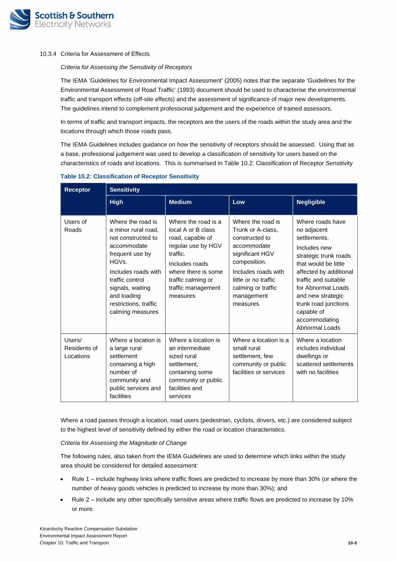
Kinardochy Reactive Compensation Substation Environmental Impact Assessment Report Chapter 10: Traffic and Transport 10-5
10.3.4 Criteria for Assessment of Effects
Criteria for Assessing the Sensitivity of Receptors
The IEMA ‘Guidelines for Environmental Impact Assessment’ (2005) notes that the separate ‘Guidelines for the Environmental Assessment of Road Traffic’ (1993) document should be used to characterise the environmental traffic and transport effects (off-site effects) and the assessment of significance of major new developments. The guidelines intend to complement professional judgement and the experience of trained assessors.
In terms of traffic and transport impacts, the receptors are the users of the roads within the study area and the locations through which those roads pass.
The IEMA Guidelines includes guidance on how the sensitivity of receptors should be assessed. Using that as a base, professional judgement was used to develop a classification of sensitivity for users based on the characteristics of roads and locations. This is summarised in Table 10.2: Classification of Receptor Sensitivity
Table 10.2: Classification of Receptor Sensitivity
Receptor Sensitivity
High Medium Low Negligible
Users of Roads
Where the road is a minor rural road, not constructed to accommodate frequent use by HGVs. Includes roads with traffic control signals, waiting and loading restrictions, traffic calming measures
Where the road is a local A or B class road, capable of regular use by HGV traffic. Includes roads where there is some traffic calming or traffic management measures
Where the road is Trunk or A-class, constructed to accommodate significant HGV composition. Includes roads with little or no traffic calming or traffic management measures
Where roads have no adjacent settlements. Includes new strategic trunk roads that would be little affected by additional traffic and suitable for Abnormal Loads and new strategic trunk road junctions capable of accommodating Abnormal Loads
Users/ Residents of Locations
Where a location is a large rural settlement containing a high number of community and public services and facilities
Where a location is an intermediate sized rural settlement, containing some community or public facilities and services
Where a location is a small rural settlement, few community or public facilities or services
Where a location includes individual dwellings or scattered settlements with no facilities
Where a road passes through a location, road users (pedestrian, cyclists, drivers, etc.) are considered subject to the highest level of sensitivity defined by either the road or location characteristics.
Criteria for Assessing the Magnitude of Change
The following rules, also taken from the IEMA Guidelines are used to determine which links within the study area should be considered for detailed assessment:
• Rule 1 – include highway links where traffic flows are predicted to increase by more than 30% (or where the number of heavy goods vehicles is predicted to increase by more than 30%); and
• Rule 2 – include any other specifically sensitive areas where traffic flows are predicted to increase by 10% or more.

Kinardochy Reactive Compensation Substation Environmental Impact Assessment Report Chapter 10: Traffic and Transport 10-6
The IEMA Guidelines identify the key impacts that are most important when assessing the magnitude of traffic impacts from an individual development: the impacts and levels of magnitude are discussed below:
• Severance – the IEMA Guidance states that, “severance is the perceived division that can occur within a community when it becomes separated by a major traffic artery.” Further, “Changes in traffic of 30%, 60% and 90% are regarded as producing ‘slight’, ‘moderate’ and ‘substantial’ [or minor, moderate and major] changes in severance respectively”. However, the Guidelines acknowledge that “the measurement and prediction of severance is extremely difficult”:
• Driver delay – the IEMA Guidelines note that these delays are only likely to be “significant [or major] when the traffic on the network surrounding the development is already at, or close to, the capacity of the system.”:
• Pedestrian delay – the delay to pedestrians, as with driver delay, is likely only to be major when the traffic on the network surrounding the development is already at, or close to, the capacity of the system. An increase in total traffic of approximately 30% can double the delay experienced by pedestrians attempting to cross the road and would be considered major;
• Pedestrian amenity – the IEMA Guidelines suggests that a tentative threshold for judging the significance of changes in pedestrian amenity would be where the traffic flow (or its lorry component) is halved or doubled. It is therefore considered that a change in the traffic flow of -50% or +100% would produce a major change in pedestrian amenity;
• Fear and intimidation – there are no commonly agreed thresholds for estimating levels of fear and intimidation, from known traffic and physical conditions. However, as the impact is considered to be sensitive to traffic flow, changes in traffic flow of 30%, 60% and 90% are regarded as producing minor, moderate and major changes respectively; and
• Accidents and safety – professional judgement would be used to assess the implications of local circumstances, or factors which may elevate or lessen risks of accidents.
While not specifically identified, as more vulnerable road user, cyclists are considered in similar terms to pedestrians.
Criteria for Assessing Cumulative Effects
The assessment methodology for both the Proposed Development and the Associated Development is generally the same. The Study Area used for the Proposed Development also covers the Associated Development
Other than the Associated Development, no further cumulative assessment has been undertaken.
Criteria for Assessing Significance
To determine the overall significance of effects, the results from the receptor sensitivity and magnitude of change assessments are correlated and classified using a scale set out in Table 2.4 of Volume 11, Section 2, Part 5 of the Design Manual for Roads and Bridges (DMRB) and summarised in Table 10.3: Classification of Receptor Sensitivity.
Table 10.3: Classification of Receptor Sensitivity
Receptor Sensitivity
Magnitude of Impacts
Major Moderate Minor Negligible
High Large Large/Moderate Moderate/Slight Slight
Medium Large/Moderate Moderate Slight Slight/Neutral
Low Moderate/Slight Slight Slight Slight/Neutral
Negligible Slight Slight Slight/Neutral Neutral

Kinardochy Reactive Compensation Substation Environmental Impact Assessment Report Chapter 10: Traffic and Transport 10-7
In terms of the EIA Regulations, effects would be considered significant where they are assessed to be large or moderate. Where an effect could be one of Large/Moderate or Moderate/Slight, professional judgement would be used to determine which option should be applicable.
10.3.5 Limitations and Assumptions.
The assessment is based upon average traffic flows in one-month periods. During the month, activities at the site may fluctuate between one day and another and it is not possible to fully develop a day by day traffic flow estimate as no Principal Contractor has been appointed and external factors can impact upon activities on a day by day basis (weather conditions, availability of materials, time of year, etc.).
10.4 Baseline Conditions
10.4.1 Current Baseline
It was not possible to collect recent traffic count data for the study area due to the impact of Covid-19. In order to assess the impact of construction traffic on the study area, traffic survey data was obtained for the A9, A827, Weem Road and B846 (in Aberfeldy) from the UK Government Department for Transport (DfT) database.
Traffic count data was not available for the B846 or Schiehallion Road from the DfT database. Neither Traffic Scotland or PKC holds any modern data for the road to the west of Dull or near the Site access junction.
A review of historic Traffic Scotland data revealed former Automatic Traffic Count (ATC) site located at Dull. Data from 1997 was obtained for a neural month and then factored to modern flows using National Road Traffic Forecast (NRTF) Central growth factors.
NRTF Central factors were used on the basis of traffic growth from the DfT database for a traffic count site located on the Fortingall Road to the west of the B846. This provided the ability to devise a growth factor from the year 2000 to a common base year to match the 2019 traffic flows from the other sources.
No traffic data for the Schiehallion Road exists. To provide a basis for the assessment we have assumed that this road would have 40% of the B846. This is based upon the class of the road, its uses and the areas that it serves.
Should the Proposed Development and Associated Development be consented, the Applicant has confirmed that they will introduce temporary ATC sites on the B846 and Schiehallion Road for the duration of the construction period and will share this data with PKC.
The count locations used in the assessment are:
• Site 1: A9 near Dowally;
• Site 2: A827 to west of Ballinluig;
• Site 3: A827 south of Little Ballinluig;
• Site 4: B846 in Aberfeldy;
• Site 5: Weem Road; and
• Site 6: B846 near Dull.
The traffic counters allowed the traffic flows to be split into vehicle classes and the data have been summarised into cars/ light goods vehicles (LGV) and heavy goods vehicles (HGVs) (all goods vehicles >3.5 tonnes gross maximum weight).
Table 10.4 summarises the 24-hour average daily traffic data collected at the count sites for 2020 traffic flows.
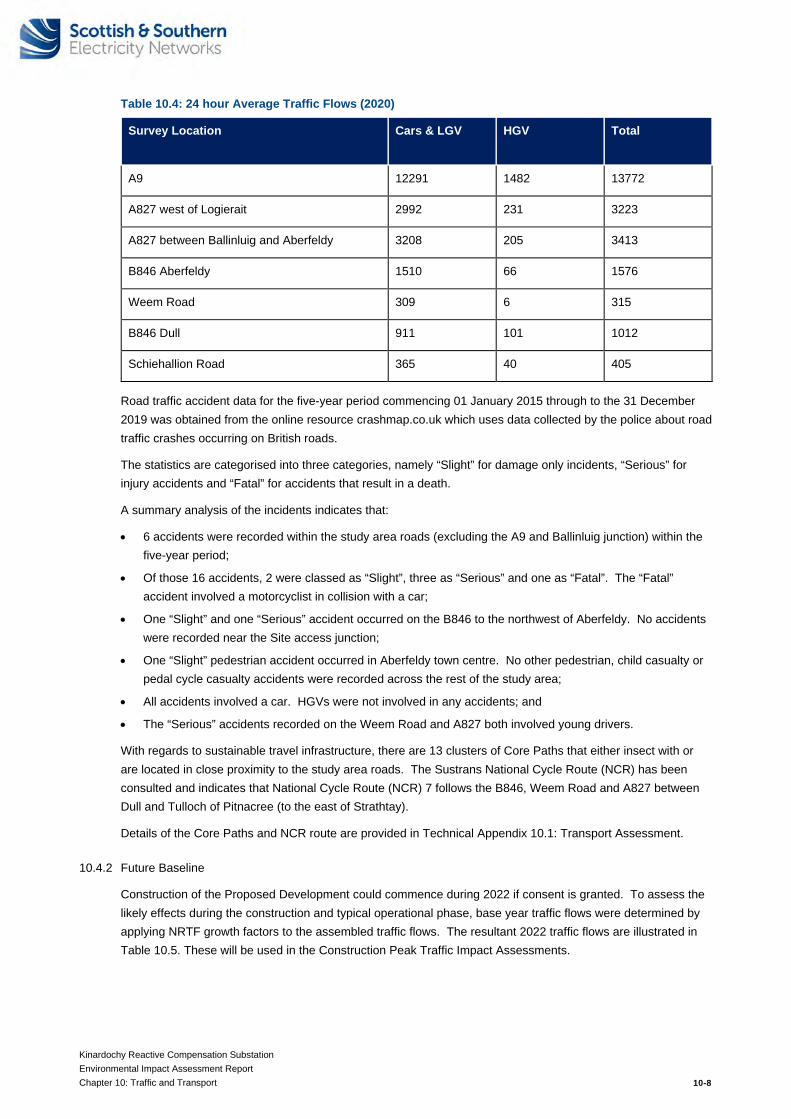
Kinardochy Reactive Compensation Substation Environmental Impact Assessment Report Chapter 10: Traffic and Transport 10-8
Table 10.4: 24 hour Average Traffic Flows (2020)
Survey Location Cars & LGV HGV Total
A9 12291 1482 13772
A827 west of Logierait 2992 231 3223
A827 between Ballinluig and Aberfeldy 3208 205 3413
B846 Aberfeldy 1510 66 1576
Weem Road 309 6 315
B846 Dull 911 101 1012
Schiehallion Road 365 40 405
Road traffic accident data for the five-year period commencing 01 January 2015 through to the 31 December 2019 was obtained from the online resource crashmap.co.uk which uses data collected by the police about road traffic crashes occurring on British roads.
The statistics are categorised into three categories, namely “Slight” for damage only incidents, “Serious” for injury accidents and “Fatal” for accidents that result in a death.
A summary analysis of the incidents indicates that:
• 6 accidents were recorded within the study area roads (excluding the A9 and Ballinluig junction) within the five-year period;
• Of those 16 accidents, 2 were classed as “Slight”, three as “Serious” and one as “Fatal”. The “Fatal” accident involved a motorcyclist in collision with a car;
• One “Slight” and one “Serious” accident occurred on the B846 to the northwest of Aberfeldy. No accidents were recorded near the Site access junction;
• One “Slight” pedestrian accident occurred in Aberfeldy town centre. No other pedestrian, child casualty or pedal cycle casualty accidents were recorded across the rest of the study area;
• All accidents involved a car. HGVs were not involved in any accidents; and
• The “Serious” accidents recorded on the Weem Road and A827 both involved young drivers.
With regards to sustainable travel infrastructure, there are 13 clusters of Core Paths that either insect with or are located in close proximity to the study area roads. The Sustrans National Cycle Route (NCR) has been consulted and indicates that National Cycle Route (NCR) 7 follows the B846, Weem Road and A827 between Dull and Tulloch of Pitnacree (to the east of Strathtay).
Details of the Core Paths and NCR route are provided in Technical Appendix 10.1: Transport Assessment.
10.4.2 Future Baseline
Construction of the Proposed Development could commence during 2022 if consent is granted. To assess the likely effects during the construction and typical operational phase, base year traffic flows were determined by applying NRTF growth factors to the assembled traffic flows. The resultant 2022 traffic flows are illustrated in Table 10.5. These will be used in the Construction Peak Traffic Impact Assessments.
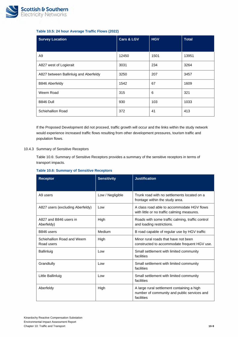
Kinardochy Reactive Compensation Substation Environmental Impact Assessment Report Chapter 10: Traffic and Transport 10-9
Table 10.5: 24 hour Average Traffic Flows (2022)
Survey Location Cars & LGV HGV Total
A9 12450 1501 13951
A827 west of Logierait 3031 234 3264
A827 between Ballinluig and Aberfeldy 3250 207 3457
B846 Aberfeldy 1542 67 1609
Weem Road 315 6 321
B846 Dull 930 103 1033
Schiehallion Road 372 41 413
If the Proposed Development did not proceed, traffic growth will occur and the links within the study network would experience increased traffic flows resulting from other development pressures, tourism traffic and population flows.
10.4.3 Summary of Sensitive Receptors
Table 10.6: Summary of Sensitive Receptors provides a summary of the sensitive receptors in terms of transport impacts.
Table 10.6: Summary of Sensitive Receptors
Receptor Sensitivity Justification
A9 users Low / Negligible Trunk road with no settlements located on a frontage within the study area.
A827 users (excluding Aberfeldy) Low A class road able to accommodate HGV flows with little or no traffic calming measures.
A827 and B846 users in Aberfeldy)
High Roads with some traffic calming, traffic control and loading restrictions.
B846 users Medium B road capable of regular use by HGV traffic
Schiehallion Road and Weem Road users
High Minor rural roads that have not been constructed to accommodate frequent HGV use.
Ballinluig Low Small settlement with limited community facilities
Grandtully Low Small settlement with limited community facilities
Little Ballinluig Low Small settlement with limited community facilities
Aberfeldy High A large rural settlement containing a high number of community and public services and facilities

Kinardochy Reactive Compensation Substation Environmental Impact Assessment Report Chapter 10: Traffic and Transport 10-10
Receptor Sensitivity Justification
Weem and Dull Low Small settlement with limited community facilities
10.5 Assessment of Likely Significant Effects The assessment is based upon the construction effects that may occur within the study area. In order to assess the effects, it is necessary to determine the likely traffic generation associated with the Proposed Development.
During the construction period, the following traffic will require access to the to the Project Site:
• Staff transport, in either cars or staff minibuses;
• Construction equipment and materials, deliveries of machinery and supplies such as concrete and crushed rock; and
• Abnormal loads associated with the Proposed Development.
Scottish & Southern Electricity Networks civil engineers have undertaken a preliminary design of the Proposed Development and Associated Development and have advised on likely traffic movements based upon their recent experience of similar developments and on bulk materials than need to be imported.
Peak traffic movements will occur during the import of material associated with the construction of the proposed substation platform. AIL component deliveries occur outwith the peak and as such are not included in the peak impact assessment.
Daily construction traffic estimates have been developed and are detailed in Table 10.7: Construction Traffic Effects.
Table 10.7: Construction Traffic Effects
Development Element Cars & LGV HGV Total
Proposed development peak construction traffic
60 54 114
Associated development peak construction traffic
10 24 34
Cumulative construction traffic 70 78 148
To distribute construction traffic to the network, it is assumed that all bulk deliveries will originate on the A9 corridor and will access the Project Site via the A827 and B846 via Aberfeldy. Staff working at the Project Site have been assumed to be part based in Aberfeldy (50%) and 50% on the A9 corridor.
10.5.1 Potential Construction Effects (The Proposed Development)
To estimate the total trips through the study area during the peak of the Proposed Development construction phase, traffic was distributed through the network and combined with the 2022 Baseline traffic data. The resulting figures were compared with the weekday 2022 Baseline traffic to provide a percentage change in movements.
The traffic movements for the Proposed Development are summarised in Table 10.8: Proposed Development Construction Traffic Movements.

Kinardochy Reactive Compensation Substation Environmental Impact Assessment Report Chapter 10: Traffic and Transport 10-11
Table 10.8: Proposed Development Construction Traffic Movements
Survey Location Cars and LGV
HGV Total Cars & LGV % Increase
HGV % Increase
Total % Increase
A9 12480 1555 14035 0.24% 3.60% 0.60%
A827 west of Logierait
3061 288 3348 0.99% 23.09% 2.57%
A827 between Ballinluig and Aberfeldy
3280 261 3541 0.92% 26.05% 2.43%
B846 Aberfeldy 1602 121 1723 3.89% 80.40% 7.09%
Weem Road 315 6 321 0.00% 0.00% 0.00%
B846 Dull 990 157 1147 6.45% 52.60% 11.03%
Schiehallion Road 372 41 413 0.00% 0.00% 0.00%
The total traffic movements are not predicted to increase by more than 30% on the study area network for the Proposed Development. In addition, the construction phase is transitory in nature and the peak of construction activities are short-lived.
The significance of the potential effects has been determined using the rules and thresholds discussed previously. Standard mitigation measures have been included and the effects adjusted accordingly. Table 10.9: Proposed Development Construction Phase Effects, summarises the significance of effects on receptors during the construction phase.
Table 10.9: Proposed Development Construction Phase Effects
Receptors Severance Driver Delay
Pedestrian Delay
Amenity Fear Accidents & Safety
B846 users in Aberfeldy
Moderate Slight Moderate Moderate Moderate Slight
B846 users Slight Slight Moderate Moderate Slight Slight
Residents in Aberfeldy Moderate Slight Moderate Moderate Moderate Slight
Residents in Weem and Dull
Slight Slight Slight Slight Slight Slight
The assessment of the Proposed Development significance suggests HGV flows in Aberfeldy and on the B846 are considered significant effects, prior to the application of specific mitigation measures.
It is worth noting that whilst the increase in HGV numbers is statistically high, in relative traffic number terms, the number of additional vehicles is low. It is also worth considering that the impacts relate solely to the peak of construction activities and that the construction period is short lived and the effects transitory in nature.
10.5.2 Potential Cumulative Construction Effects (The Associated Development)
The traffic impact for the Associated Development is summarised in Table 10.10: Associated Development Construction Traffic Movements.

Kinardochy Reactive Compensation Substation Environmental Impact Assessment Report Chapter 10: Traffic and Transport 10-12
Table 10.10: Associated Development Construction Traffic Movements
Survey Location Cars and LGV
HGV Total Cars & LGV % Increase
HGV % Increase
Total % Increase
A9 12455 1525 13980 0.04% 1.60% 0.21%
A827 west of Logierait 3036 258 3293 0.16% 10.26% 0.89%
A827 between Ballinluig and Aberfeldy
3255 231 3486 0.15% 11.58% 0.84%
B846 Aberfeldy 1552 91 1643 0.65% 35.73% 2.11%
Weem Road 315 6 321 0.00% 0.00% 0.00%
B846 Dull 940 127 1067 1.07% 23.38% 3.29%
Schiehallion Road 382 65 447 2.69% 58.45% 8.23%
The total traffic movements are not predicted to increase by more than 30% on the study area network for the Associated Development. In addition, the construction phase is transitory in nature and the peak of construction activities are short-lived.
The significance of the potential effects has been determined using the rules and thresholds discussed previously. Standard mitigation measures have been included and the effects adjusted accordingly. Table 10.11: Associated Development Construction Phase Effects, summarises the significance of effects on receptors during the construction phase.
Table 10.11: Associated Development Construction Phase Effects
Receptors Severance Driver Delay
Pedestrian Delay
Amenity Fear Accidents & Safety
B846 users in Aberfeldy
Slight Slight Moderate Moderate Slight Slight
Residents in Aberfeldy Slight Slight Moderate Moderate Slight Slight
Schiehallion Road users
Slight Slight Slight Slight Slight Slight
The assessment of the Associated Development significance suggests HGV flows in Aberfeldy and on the B846 are considered significant effects, prior to the application of specific mitigation measures.
It is worth noting that whilst the increase in HGV numbers is statistically high, in relative traffic number terms, the number of additional vehicles is low. It is also worth considering that the impacts relate solely to the peak of construction activities and that the construction period is short lived and the effects transitory in nature.
The cumulative assessment will be a combination of the Proposed Development and the Associated Development. The cumulative traffic movements in the study area are provided in Table 10.12: Cumulative Construction Traffic Movements.
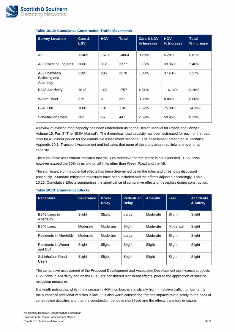
Kinardochy Reactive Compensation Substation Environmental Impact Assessment Report Chapter 10: Traffic and Transport 10-13
Table 10.12: Cumulative Construction Traffic Movements
Survey Location Cars & LGV
HGV Total Cars & LGV % Increase
HGV % Increase
Total % Increase
A9 12485 1579 14064 0.28% 5.20% 0.81%
A827 west of Logierait 3066 312 3377 1.15% 33.36% 3.46%
A827 between Ballinluig and Aberfeldy
3285 285 3570 1.08% 37.63% 3.27%
B846 Aberfeldy 1612 145 1757 4.54% 116.14% 9.20%
Weem Road 315 6 321 0.00% 0.00% 0.00%
B846 Dull 1000 181 1181 7.52% 75.98% 14.33%
Schiehallion Road 382 65 447 2.69% 58.45% 8.23%
A review of existing road capacity has been undertaken using the Design Manual for Roads and Bridges, Volume 15, Part 5 “The NESA Manual”. The theoretical road capacity has been estimated for each of the road links for a 12-hour period for the cumulative assessment scenario. The assessment presented in Technical Appendix 10.1: Transport Assessment and indicates that none of the study area road links are over or at capacity.
The cumulative assessment indicates that the 30% threshold for total traffic is not exceeded. HGV flows however exceed the 30% threshold on all links other than Weem Road and the A9.
The significance of the potential effects has been determined using the rules and thresholds discussed previously. Standard mitigation measures have been included and the effects adjusted accordingly. Table 10.13: Cumulative Effects summarises the significance of cumulative effects on receptors during construction.
Table 10.13: Cumulative Effects
Receptors Severance Driver Delay
Pedestrian Delay
Amenity Fear Accidents & Safety
B846 users in Aberfeldy
Slight Slight Large Moderate Slight Slight
B846 users Moderate Moderate Slight Moderate Moderate Slight
Residents in Aberfeldy Moderate Moderate Large Moderate Slight Slight
Residents in Weem and Dull
Slight Slight Slight Slight Slight Slight
Schiehallion Road Users
Slight Slight Slight Slight Slight Slight
The cumulative assessment of the Proposed Development and Associated Development significance suggests HGV flows in Aberfeldy and on the B846 are considered significant effects, prior to the application of specific mitigation measures.
It is worth noting that whilst the increase in HGV numbers is statistically high, in relative traffic number terms, the number of additional vehicles is low. It is also worth considering that the impacts relate solely to the peak of construction activities and that the construction period is short lived and the effects transitory in nature.

Kinardochy Reactive Compensation Substation Environmental Impact Assessment Report Chapter 10: Traffic and Transport 10-14
10.5.3 Potential Operational Effects (The Proposed Development)
It is predicted that during the operation of the Proposed Development there would be up to two vehicle movements per week for maintenance purposes. As such there is no significant effects associated with this phase.
10.5.4 Potential Cumulative Operational Effects (The Associated Development)
There are no cumulative operational effects associated with the combination of the Proposed Development along with the Associated Development. As such there is no significant effects associated with this phase.
10.6 Mitigation
10.6.1 Mitigation During Construction (The Proposed Development)
Construction Traffic Management Plan
The following measures would be implemented through a Construction Traffic Management Plan (CTMP) during the construction phase for the Proposed Development. The CTMP would be agreed with PKC and other affected stakeholders prior to construction works commencing:
• Pre-commencement discussion with PKC, the Applicant and the Principal contractor to agree programmes, permissions and detailed traffic management measures;
• Undertake a traffic count on the B846 near the Proposed Development access junction for the duration of the construction period;
• Consultation with PKC to identify if a temporary pedestrian crossing is required in Aberfeldy;
• Where possible the detailed design process would minimise the volume of material to be imported to Site to help reduce HGV numbers;
• A Site worker transport and travel arrangement plan, including transport modes to and from the worksite (including pick up and drop off times);
• An Abnormal Loads Transport Management Plan detailing the convoy management, signage, diversion and escorting strategy required;
• All materials delivery lorries (dry materials) should be sheeted to reduce dust and stop spillage on public roads;
• Specific training and disciplinary measures should be established to ensure the highest standards are maintained to prevent construction vehicles from carrying mud and debris onto the carriageway;
• A system to ensure loads remain on agreed routes and that no traffic proceeds north of the B846 access junction. This may include the use of unique vehicle identification numbers and tracking systems;
• Wheel cleaning facilities may be established at the Site entrance, depending the views of PKC;
• Construction working is likely to be during daytime periods only. Working hours are currently anticipated between 07.00 to 19.00 up to seven days a week. Any out of hours working would be agreed in advance with PKC;
• The Principal Contractor will ensure that all permits and notifications, including, as necessary, Temporary Traffic Regulation Orders (TTROs) are in place prior to any AIL movements and are applied for in sufficient time for review and approval and agreement with PKC;
• Appropriate traffic management measures would be put in place on the B846 and Weem Road to avoid conflict with general traffic, subject to the agreement of the Roads Authority. Typical measures would include HGV turning and crossing signs and/ or banksmen at the site access and warning signs;
• Provide construction updates on the project website and or a newsletter to be distributed to residents within an agreed distance of the Site;

Kinardochy Reactive Compensation Substation Environmental Impact Assessment Report Chapter 10: Traffic and Transport 10-15
• All drivers would be required to attend an induction to include:
• A toolbox talk safety briefing;
• The need for appropriate care and speed control;
• A briefing on driver speed reduction agreements (to slow site traffic at sensitive locations through the villages); and
• Identification of the required access routes and the controls to ensure no departure from these routes.
The CTMP will remain a live document and will be updated when necessary to ensure the highest standards of access and road safety.
Condition Survey
PKC may require an agreement to cover the cost of abnormal wear and tear on the local road network (B846 within 3 km of the Site access and on the Schiehallion Road).
Video footage of the pre-construction phase condition of the abnormal loads access route and the construction vehicles route would be recorded to provide a baseline of the state of the road prior to any construction work commencing. This baseline would inform any change in the road condition during the construction stage of the Proposed Development. Any necessary repairs would be coordinated with the Roads Authority. Any damage caused by traffic associated with the Proposed Development, during the construction period that would be hazardous to public traffic, would be repaired immediately.
Any damage to road infrastructure caused directly by construction traffic would be made good, and street furniture that is removed on a temporary basis would be fully reinstated.
There would be a regular road edge review and any debris and mud would be removed from the public carriageway to keep the road clean and safe during the initial months of construction activity, until the construction junction and immediate access track works are complete.
Abnormal Load Management Plan
There are a number of traffic management measures that could help reduce the effect of the abnormal load convoy.
The abnormal load delivery would be undertaken at appropriate times (to be discussed and agreed with the relevant roads authorities and police) with the aim to minimise the effect on the local road network. It is likely that the abnormal load convoy would travel in the early morning periods (where possible), before peak times while general construction traffic would generally avoid the morning and evening peak periods.
The majority of potential conflicts between construction traffic and other road users will occur with abnormal load traffic. General construction traffic is not likely to come into conflict with other road users as the vehicles are smaller and road users are generally more accustomed to them.
Potential conflicts between the abnormal loads and other road users can occur at a variety of locations and circumstances. The main potential conflicts are likely to occur:
• On the A872 and B846 where the loads may straddle the centre line, where fast moving oncoming traffic may be encountered, etc.;
• On the Weem Road, where a rolling road closure will be required given the narrow width of the existing road;
• Where traffic turns at a road junction, requiring other traffic to be restrained on other approach arms; and
• In locations where high speeds of general traffic are predicted.
Advance warning signs would be installed on the approaches to the affected road network. Information signage advising when the convoy is due to move would be set out across the network and an early engagement with residents will be undertaken to help reduce conflicts as far as possible.

Kinardochy Reactive Compensation Substation Environmental Impact Assessment Report Chapter 10: Traffic and Transport 10-16
The location and numbers of signs would be agreed post consent and would form part of the wider AIL Traffic Management Proposal for the Proposed Development.
The Abnormal Load Transport Management Plan would also include:
• Procedures for liaising with the emergency services to ensure that police, fire and ambulance vehicles are not impeded by the loads. This is normally undertaken by informing the emergency services of delivery times and dates and agreeing communication protocols and lay over areas to allow overtaking;
• A protocol for working with local businesses to ensure the construction traffic does not interfere with deliveries or normal business traffic; and
• Proposals to establish a construction liaison committee to ensure the smooth management of the project / public interface with the Applicant, the Principal Contractors, the local community, and if appropriate, the police forming the committee. This committee would form a means of communicating and updating on forthcoming activities and dealing with any potential issues arising.
Public Information
Information on the convoys would be provided to local media outlets such as local papers and local radio to help assist the public.
Information would relate to expected vehicle movements from the port of entry through to the Site access junction. This will assist residents becoming aware of the convoy movements and may help reduce any potential conflicts.
The Applicant would also ensure information was distributed through its communication team via the project website, local newsletters and social media.
Convoy System
A police escort would be required to facilitate the delivery of the predicted abnormal loads. The police escort would be further supplemented by a civilian pilot car to assist with the escort duty. It is proposed that an advance escort would warn oncoming vehicles ahead of the convoy, with one escort staying with the convoy at all times. The escorts and convoy would remain in radio contact at all times where possible.
The times in which the convoys would travel will need to be agreed with Police Scotland who have sole discretion on when loads can be moved.
10.6.2 Mitigation During Construction (The Associated Development)
The CTMP and works outlined for the Proposed Development will also apply to construction traffic associated with the Associated Development.
10.6.3 Mitigation During Operation (The Proposed Development)
In terms of the IEMA Guidelines, the small number of traffic movements and the associated percentage uplift over Baseline traffic movements associated with the Proposed Development during operation are not considered significant, therefore no mitigation measures are proposed.
10.6.4 Mitigation During Operation (The Associated Development)
In terms of the IEMA Guidelines, the small number of traffic movements and the associated percentage uplift over Baseline traffic movements associated with the Associated Development during operation are not considered significant, therefore no mitigation measures are proposed.

Kinardochy Reactive Compensation Substation Environmental Impact Assessment Report Chapter 10: Traffic and Transport 10-17
10.7 Assessment of Residual Effects
10.7.1 Residual Construction Effects (The Proposed Development)
This section considers the assessment of traffic effects following the incorporation of the mitigation measures identified above.
Table 10.14 summarises the assessment of residual effects identified in the evaluation with mitigation in place. No significant effects are predicted.
It should be borne in mind that the assessment has focussed on the peak in construction traffic activities and that the percentage increases noted are high, given the relatively low level of HGV traffic on the existing network.
The construction period is transitory in nature and all impacts will be short lived and temporary.
10.7.2 Residual Cumulative Construction Effects (The Associated Development)
The residual effects are detailed in Table 10.12. No significant effects are predicted.
10.7.3 Residual Operation Effects (The Proposed Development)
There are no significant residual operational effects for the Proposed Development.
10.7.4 Residual Cumulative Operational Effects (The Associated Development)
There are no significant residual operational effects for the Associated Development, either on its own or in combination with the Proposed Development. .
10.8 Summary The Proposed Development would lead to a temporary increase in traffic volumes on the study area road network during the construction phase. Traffic volumes would fall off considerably outside the peak period of construction.
No significant capacity issues are expected on any of the roads within the study area due to the additional construction traffic movements associated with the Proposed Development as background traffic movements are low, the links are of reasonable standard and appropriate mitigation is proposed.
A review of the road network has been undertaken to assess the feasibility of transporting substation equipment to the Site and no significant issues have been noted.
Traffic levels during the operational phase of Proposed Development would be one or two vehicles per week for maintenance purposes.
The movement of AIL traffic would require localised and temporary remedial works at a number of locations along the identified delivery route.
During the construction phase, the Proposed Development, Associated Development and the combined assessment scenario all result in significant effects in Aberfeldy. The application of mitigation measures will reduce the impact of the construction traffic flows, resulting in no significant residual effects. A summary of residual effects is detailed in Table 10.14.The are no long lasting individual or cumulative significant effects within the study network. Any impacts are short term and cease with the completion of construction works.
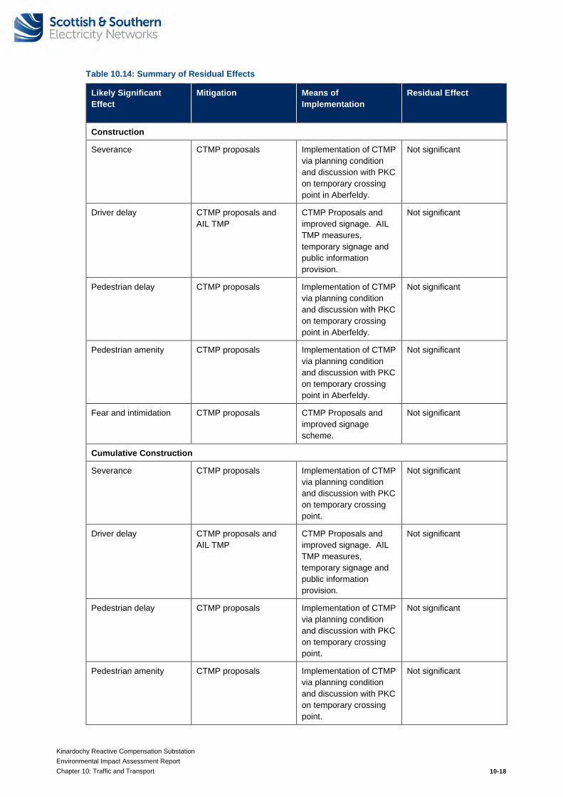
Kinardochy Reactive Compensation Substation Environmental Impact Assessment Report Chapter 10: Traffic and Transport 10-18
Table 10.14: Summary of Residual Effects
Likely Significant Effect
Mitigation Means of Implementation
Residual Effect
Construction
Severance CTMP proposals Implementation of CTMP via planning condition and discussion with PKC on temporary crossing point in Aberfeldy.
Not significant
Driver delay CTMP proposals and AIL TMP
CTMP Proposals and improved signage. AIL TMP measures, temporary signage and public information provision.
Not significant
Pedestrian delay CTMP proposals Implementation of CTMP via planning condition and discussion with PKC on temporary crossing point in Aberfeldy.
Not significant
Pedestrian amenity CTMP proposals Implementation of CTMP via planning condition and discussion with PKC on temporary crossing point in Aberfeldy.
Not significant
Fear and intimidation CTMP proposals CTMP Proposals and improved signage scheme.
Not significant
Cumulative Construction
Severance CTMP proposals Implementation of CTMP via planning condition and discussion with PKC on temporary crossing point.
Not significant
Driver delay CTMP proposals and AIL TMP
CTMP Proposals and improved signage. AIL TMP measures, temporary signage and public information provision.
Not significant
Pedestrian delay CTMP proposals Implementation of CTMP via planning condition and discussion with PKC on temporary crossing point.
Not significant
Pedestrian amenity CTMP proposals Implementation of CTMP via planning condition and discussion with PKC on temporary crossing point.
Not significant

Kinardochy Reactive Compensation Substation Environmental Impact Assessment Report Chapter 10: Traffic and Transport 10-19
Likely Significant Effect
Mitigation Means of Implementation
Residual Effect
Fear and intimidation CTMP proposals CTMP Proposals and improved signage scheme.
Not significant
Operation
None None None None
Cumulative Operation
None None None None