1 MANGALORE UNIVERSITY M.Sc. GEOGRAPHY Consolidated Course and Title Programme: M.Sc. in Geography Preface The Masters Programme hosted in the Department of Geography at Mangalore University is designed to reflect the knowledge of theories, concepts, techniques and technologies in human and physical aspects of geography. Geography is the study of physical environments and human habitats. It deals with people and places. It covers issues such as global warming and climate change, food and water resources, management of ecosystems, human modifications of land, regional economic disparities, and urban infrastructure from various theoretical positions. Both a physical and a social science, it provides a unique opportunity to obtain a broad exposure to modes of analyzing the many ecological and cultural problems of contemporary society. The department is based in the Faculty of Science, Technology and Education and offers degrees at the Masters (M.Sc.), and Research (Ph.D.) levels. OBTLE Abbreviations OBTLE - Outcome Based Teaching and Learning Education CL - Cognitive Level Re - Remember Un - Understand Ap - Apply An - Analyze Ev - Evaluate Cr - Create KC - Knowledge Category Fa - Factual Co – Conceptual Pr – Procedural Me - Meta Cognitive Programme Outcomes (POs) of Mangalore University for P.G. Programme PO1. Critical Thinking: Take informed actions after identifying the assumptions that frame our thinking and actions, checking out the degree to which these assumptions are accurate and valid, and looking at our ideas and decisions (intellectual, organizational, and personal) from different perspectives. PO2. Communication: Listen, read, comprehend, speak and write clearly and effectively in person and through electronic media in English/regional language/language of the discipline and exhibit sound domain knowledge including academic concepts and terminologies. PO3. Self-directed and Life-long Learning: Engage in independent and lifelong learning in the broadest context of socio-technological changes. PO4. Ethics: Understand different value systems including one‟s own, as also the moral dimensions of actions, and accept responsibility for it. General Structure of the M.Sc. Programme
Transcript
1
MANGALORE UNIVERSITY
M.Sc. GEOGRAPHY
Consolidated Course and Title Programme: M.Sc. in Geography
Preface The Masters Programme hosted in the Department of Geography at Mangalore University is
designed to reflect the knowledge of theories, concepts, techniques and technologies in human
and physical aspects of geography. Geography is the study of physical environments and human
habitats. It deals with people and places. It covers issues such as global warming and climate
change, food and water resources, management of ecosystems, human modifications of land,
regional economic disparities, and urban infrastructure from various theoretical positions. Both a
physical and a social science, it provides a unique opportunity to obtain a broad exposure to
modes of analyzing the many ecological and cultural problems of contemporary society. The
department is based in the Faculty of Science, Technology and Education and offers degrees at
the Masters (M.Sc.), and Research (Ph.D.) levels.
OBTLE Abbreviations
OBTLE - Outcome Based Teaching and Learning Education
CL - Cognitive Level
Re - Remember
Un - Understand
Ap - Apply
An - Analyze
Ev - Evaluate
Cr - Create
KC - Knowledge Category
Fa - Factual
Co – Conceptual
Pr – Procedural
Me - Meta Cognitive
Programme Outcomes (POs) of Mangalore University for P.G. Programme PO1. Critical Thinking: Take informed actions after identifying the assumptions that frame our
thinking and actions, checking out the degree to which these assumptions are accurate and valid,
and looking at our ideas and decisions (intellectual, organizational, and personal) from different
perspectives.
PO2. Communication: Listen, read, comprehend, speak and write clearly and effectively in
person and through electronic media in English/regional language/language of the discipline and
exhibit sound domain knowledge including academic concepts and terminologies.
PO3. Self-directed and Life-long Learning: Engage in independent and lifelong learning in the
broadest context of socio-technological changes.
PO4. Ethics: Understand different value systems including one‟s own, as also the moral
dimensions of actions, and accept responsibility for it.
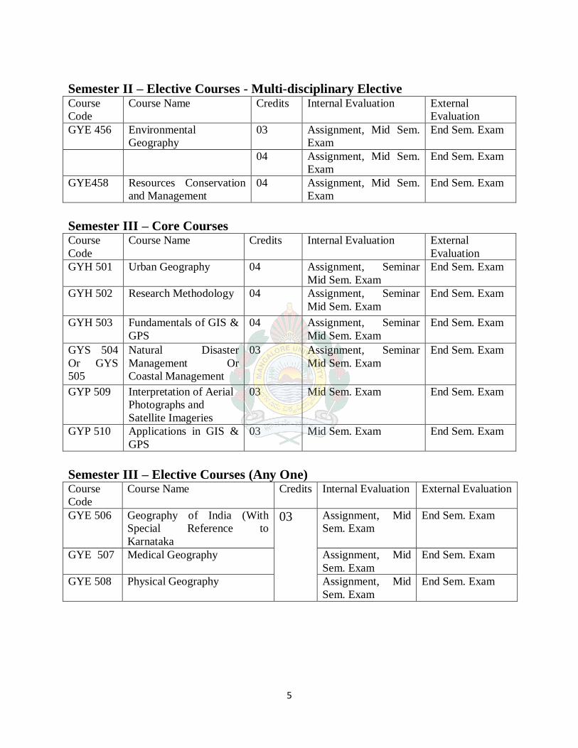
General Structure of the M.Sc. Programme
2
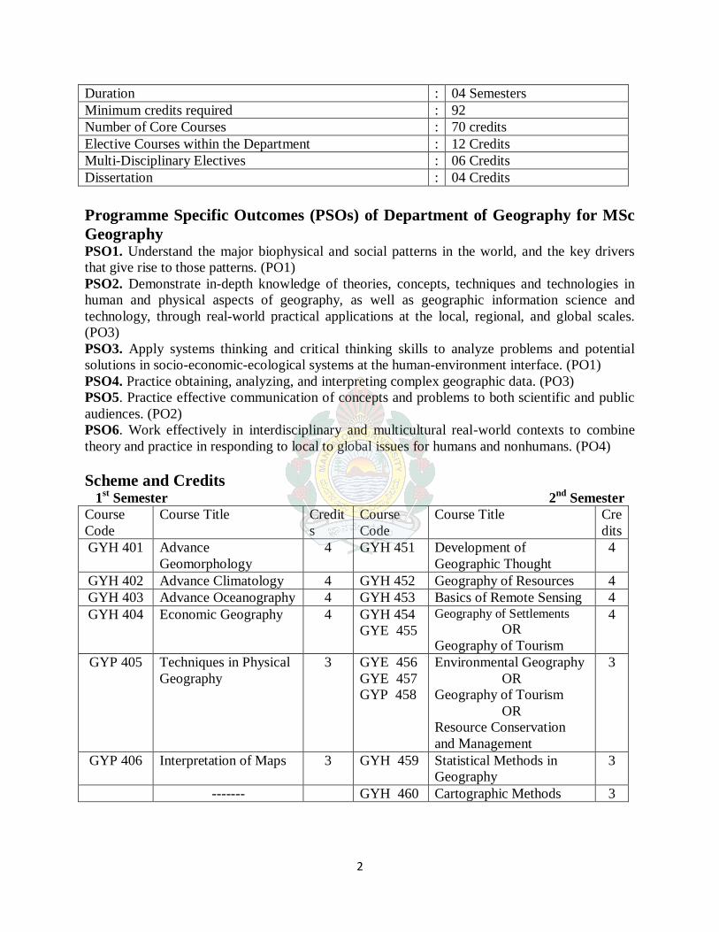
Duration : 04 Semesters
Minimum credits required : 92
Number of Core Courses : 70 credits
Elective Courses within the Department : 12 Credits
Multi-Disciplinary Electives : 06 Credits
Dissertation : 04 Credits
Programme Specific Outcomes (PSOs) of Department of Geography for MSc
Geography PSO1. Understand the major biophysical and social patterns in the world, and the key drivers
that give rise to those patterns. (PO1)
PSO2. Demonstrate in-depth knowledge of theories, concepts, techniques and technologies in
human and physical aspects of geography, as well as geographic information science and
technology, through real-world practical applications at the local, regional, and global scales.
(PO3)
PSO3. Apply systems thinking and critical thinking skills to analyze problems and potential
solutions in socio-economic-ecological systems at the human-environment interface. (PO1)
PSO4. Practice obtaining, analyzing, and interpreting complex geographic data. (PO3)
PSO5. Practice effective communication of concepts and problems to both scientific and public
audiences. (PO2)
PSO6. Work effectively in interdisciplinary and multicultural real-world contexts to combine
theory and practice in responding to local to global issues for humans and nonhumans. (PO4)
2. Bloom, A. L. (2002), „Geomorphology: A Systematic Analysis of Late Cenozoic
Landforms‟, Pearson Education Pvt. Ltd., and Singapore.
3. Chattopadhyay, S. 2017. Geomorphological Field Guide Book on Laterites and Backwaters
of Kerala (Edited by AmalKar). Indian Institute of Geomorphologists, Allahabad.
4. Chorley R. J, Schumm, S.A. and Sugden D.E. (1984): Geomorphology, Methuen, London.
5. Cooke, R. U. and Doornkamp, J.C., (1974). Geomorphology in Environmental
Douglas, J. and Spencer, I. (1985): Environmental Change and Tropical Geomorphology,
George Allen and Unwin, London.
6. Garner, H.F. (1974): Origin of Landscapes A synthesis in Geomorphology, Oxford
University Press, New Delhi.
7. Hart, M.G. (1986): Geomorphology: Pure and Applied, George Allen and Unwin, London.
8
8. John R.hails., 1977. “Applied Geomorphology” Elsevier Scientific publishing Company,
New York.
9. Nair, K. K(.2007) Quaternary geology and geomorphology of coastal plains of Kerala,
Geological Survey of India.
10. Prasannakumar,V.(2007)Geomorphology International Centre for Kerala Studies, University
of Kerala.
11. Sharma, H. S. (ed.) (1991): Indian Geomorphology, Concept, New Delhi.
12. Spark B.W. (1972) Geomorphology, Longman, New York.
13. Strahler A.H. and Strahler, A.N. (1998) Introducing Physical Geography, John Wiley and
Sons, Inc. New York.
14. Thornbury, W.D. (1960) Principles of Geomorphology”, John Wiley and Sons, New York.
9
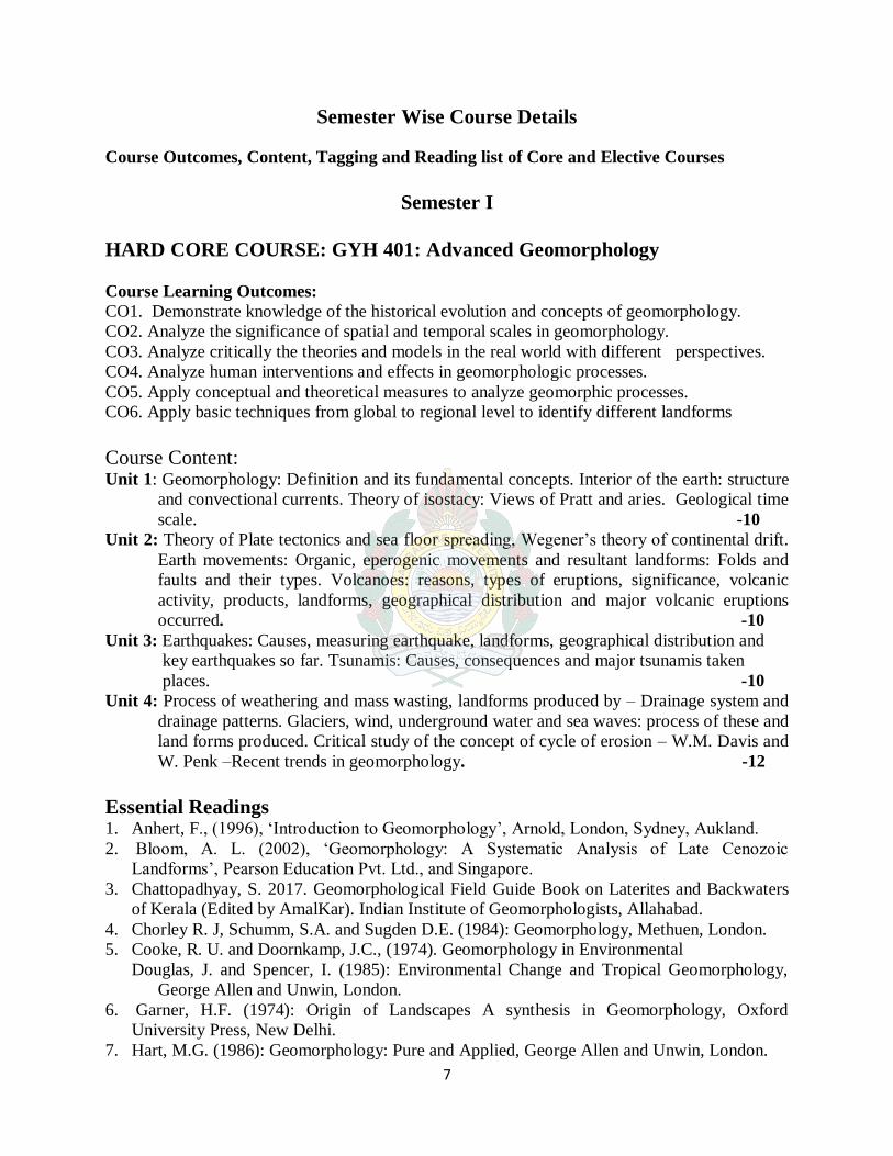
HARD CORE COURSE: GYH 402: Advanced Climatology Course Learning Outcome:
CO1. Understand the fundamentals climatology and climate change.
CO2. Evaluate climate change scenarios and their impacts
CO3. Analyses observed and projected trends and impacts of climate change.
CO4. Evaluate the whole framework of international negotiations on climate change with
reference to India‟s position
CO5. Demonstrate local specific adaptation and mitigation strategies to curb climate change
risk
Course Content: Unit 1: Definitions, nature, scope and content of climatology. Elements of weather and climate.
Origin, composition and structure of atmosphere. Temperature: Solar radiation
principles, solar budget, greenhouse effects, horizontal and vertical distribution of
temperature & inversion of temperature. Global warming and global cooling.
-12
Unit 2: Atmospheric pressure: Pressure gradient, CoriolisEffect, horizontal and vertical
distribution of air pressure and pressure belts. Winds: planetary, monsoons, local winds,
jet streams. Mechanism of monsoon. Humidity and precipitation. El-Nino and la Nina
phenomena, el-nino-southern oscillation (ENSO).
-12
Unit 3: Air masses: Definition, nature, source region, classification of air masses. Fronts -
frontogenesis and frontolysis, classification of fronts, frontal zones. Cyclones: types,
tropical cyclones-Origin, types and structure of tropical cyclone. Distribution of tropical
and temperate cyclones, features oftemperate cyclone, source region, and origin of
temperate cyclone. Polar front, study of weather disturbances through satellites.
-16
Unit 4: Classification of world climates: Koppen‟s & Thornthwaite classification. Changes in
world climate: Global warming, depletion of ozone layer & greenhouse effect. Weather
forecasting, problems and prospects of weather forecasting in India.
-14
Essential Readings
1. Adger, W. N. 2006. Vulnerability, Global Environmental Change, 16 (3), 268-281
2. Barros, Vicente R. (eds.), 2014. Climate Change 2014. Impacts, Adaptation and Vulnerability: Global
and Sectoral Aspects. Fifth Assessment Report of the Intergovernmental Panel on Climate Change (Part B; Regional Aspect), Cambridge University Press, New York.
3. Barry, R.G. and Chorley, R.J. 2003. Atmosphere, Weather and Climate, Routledge, London
4. Brewster, E. N. 2010. Climate Change Adaptation: Steps for a Vulnerable Planet, New York, Nova
Science 5. Critch field, H. J. 1983. General Climatology. Prentice Hall India Ltd (2010 Reprint)
6. IPCC, 2013. Climate Change 2013: The Physical Science Basis, the Fifth Assessment Report of the
Intergovernmental Panel on Climate Change [Stocker, T.F., D. Qin, G.-K. Plattner, M. Tignor, S.K. Allen, J. Boschung, A. Nauels, Y. Xia, V. Bex and P.M. Midgley (eds.)]. Cambridge University
Press, Cambridge, United Kingdom and New York, NY, USA,
7. John E Hobbs, 2016. Applied climatology: A study of Atmospheric Resources, Elsevier, London
8. Lal, D. S. 2003. Climatology, Allahabad: Sharda Pustak Bhawa 9. Oliver, J.E. 1993. Climatology: An Atmospheric Science, Pearson Education India, New Delhi
10. Trewartha G. T., 1980. An Introduction to Climate, McGraw Hill Company, New York.
10
HARD CORE COURSE: GYH 403: Advanced Oceanography
Course Learning Outcome:
CO1. Understand the fundamentals of oceanography and ocean floor.
CO2. Evaluate ocean relief of submarine and chemical properties.
CO3. To understand the movements and circulation of ocean water.
CO4. To understand and evaluate ocean deposits and its impact of human on the marine
environment.
Unit 1: Scope and Content of Oceanography: Configuration of Ocean Floor-
Continental Shelf, Slope, Ocean Plains and Ocean Deeps. -13
Unit2: Origin of Submarine: Relief-Submarine Relief of the Atlantic, the Pacific
and the Indian Ocean. Physical and Chemical Properties of Ocean waters:
Composition, Temperature and Salinity. -14
Unit 3: Movements and Circulation of Ocean Water: Waves, Tides, Currents and
their Effects. Coastal Ecology-Coastal Dunes and Mangroves. -13
Unit 4: Ocean Deposits: Types and Distribution, Coral Reefs: Origin, Types and
Theories of Origin of Coral Reefs (Darwin, Dally and Murray). Impact of
Humans on the Marine Environment. Recent Trends in Oceanography. -14
selected Indian Cities: Mumbai, Kolkata, Bangalore, Delhi, Chennai, Hyderabad, Pune,
Lucknow, Patna, Jaipur and Chandigarh. -13
References: 1. Hudson, F. S. (1976) Geography of Settlements, Macdonald, London. 2. Northam Ray, M. (1979). Urban Geography, John Wiley and Sons, New York.
waves and cold waves. Man induced hazards-Soil erosion, release of toxic chemicals, nuclear
explosion, population explosion and resultant environmental disasters. -15
Unit 2: Emerging approaches to Disaster management: (1) Pre-disaster stage (Preparedness)-
hazard zonation maps-predictability and forecasting warning, land use zoning, Information,
Education & Communication (IEC) Disaster resistance house construction, Population reduction
in vulnerable area and awareness. (2) Emergency Stage- Rescue training for search and operation
at national and regional level, ground management plan preparation, immediate relief,
Assessment surveys. (3) Post disaster stage rehabilitation – Political administrative aspects,
social aspect, economic aspect, cultural aspect and environmental aspects. -15
Unit 3: Natural Disaster mitigation: Relief measure, role of GIS in Relief measures, role of
GPS in search and rescue, role of Remote sensing in prediction of hazards and disasters,
measures of adjustment of natural hazards. -12
Unit 4: Disaster in Indian context: A regional survey of Land Subsidence, Coastal Disaster,
Cyclonic Disaster & Disaster in Hills, terror attacks, communal clashes, Remedial measures.
National and international policies for disaster management. - 12
References: 1. R.B. Singh (Ed) ,1990, Environmental Geography, Heritage Publishers New Delhi 2. Savinder Singh,1997, Environmental Geography, Prayag Pustak Bhawan. 3. Kates, B.I & White,1978, G.F The Environment as Hazards, oxford, New York. 4. R.B. Singh (Ed), 2000, Disaster Management, Rawat Publication, New Delhi. 5. H.K. Gupta (Ed), (2003), Disaster Management, Universities Press, India. 6. R.B. Singh, (1994), Space Technology for Disaster Mitigation in India (INCED), University
of Tokyo. 7. Dr. Satender, (2003), Disaster Management t in Hills, Concept Publishing Co., New Delhi. 8. A.S. Arya Action Plan For Earthquake, Disaster, Mitigation in V.K. Sharma (Ed) (1994),
Disaster Management IIPA Publication New Delhi. 9. R.K. Bhandani An overview on Natural & Man made Disaster & their Reduction ,CSIR,
New Delhi 10. M.C. Gupta, (2001), Manuals on Natural Disaster management in India, National Centre for
Disaster Management,IIPA, New Delhi.
30
SOFT COURSE: GYS 505: Coastal Management
Course Learning Outcomes:
CO1. Analyze critically the theories and models in the real world with different perspectives.
CO2. Analyze human interventions and effects in coastal area.
CO3. Apply conceptual and theoretical measures to coastal management
CO4. Apply basic techniques from global to regional level to identify the problems of coastal
area
Unit 1: Coastal Management: Physical Aspects: Definition of coastal zone and
related nomenclature. Coastal processes: Wave, tide and wind.Coastal currents and
cells. Coastal morpho dynamics: Micro, macro and biogenic forms. Systems of
change in coasts: cyclical and progressive. Classification of coasts based on
processes and sediment characteristics. -14
Unit 2:Coastal biogeography: Special reference to sea weeds, mangroves, dune
vegetation and corals,their ecological and economic significance. Natural coastal
hazards and their management: Sea level rise, erosion, sedimentation and tropical
cyclones. Techniques of monitoring changes in coastal processes and landforms.
-14
Unit 3: Coastal Management: Human Aspects:Coastal regulations with special
reference to India. Human utilization of coasts, environmental impacts and
management: Navigation, mining, fishing and fish-processing, off-shore oil
exploitation, reclamation and tourism. Coastal engineering and its impacts:
Ports and harbors, measures for prevention of erosionand sedimentation.
-14
Reference: 1. Bird, E.C.F. 2000. An Introduction to Coastal Geomorphology, John Wiley and Sons Ltd. New York:
340 p. [Topics 2.3, 4.4] 2. Carter, R.W.G. 1988. Coastal Environments: An Introduction to the Physical, Ecological and
Cultural Systems of Coastlines, Academic Press, London: 617p. [Topic 2.3]
3. Chow, V.T, Maidment, D.R. and Mays, L.W. 1988. Applied Hydrology, McGraw-Hill, New York:
572 p. [Topic 3.2] 4. Garrison, T. 1993. Oceanography: An Invitation to Marine Science, Wadsworth Pub. Co., Belmont:
540 p. [Topics 4.1, 4.2, 4.3]
5. Johnson, H.D. and Baldwin, C.T. 1996. „Shallow clastic seas.‟ In Reading H.G. (editor): Sedimentary Environments: Processes, Facies and Stratigraphy, 3rd edition, Blackwell Science Ltd. Oxford: pp
232–280. [Topic 2.3]
6. Knighton, D.1998: Fluvial Forms and Processes: A New Perspective, Arnold, London: 385p. [Topics
GYP 509: Interpretation of Aerial Photo and Satellite Imagery
Course learning outcomes:
CO1. Identify the difference between aerial photographs and satellite imaginary
CO2. Analyze methods interpreting aerial photographs and satellite imaginary
CO3. Analyze aerial photograph with stereoscope
CO4. Analyze satellite imaginary and produce different thematic maps.
Unit 1: Comparison of features in toposheets, aerial photographs and satellite
imageries. Determination of scales of aerial photographs. - 13
Unit 2: Procedure of taking aerial photographs, types of aerial photographs,
medium of aerial photographic interpretation, test for stereographic view.
- 14
Unit 3: Elements of aerial photographs, stereographic interpretation of aerial
photographs and manual preparation of land use maps. - 14
Unit 4: Interpretation of satellite imagery, identification of features through
signatures, color identifications. Preparation of thematic maps using the
satellite imagery. – 13
References:
1. Paul R. Wolf (1999) Elements of Photogrammetry, Mc. Grawhill, International Book Company,
New Delhi. 2. Averte and GL. Berrin (2001) Fundamentals of Remote Sensing and Aerial Photo interpretation,
McMillan, New York. 3. Singh and Sharma (2004) Introduction of Remote Sensing, Rawath Publications, New Delhi 4. George Joseph (2002) Fundamentals of Remote Sensing, University press Pvt. Ltd. Hyderabad-
29 5. A Verte and GL. Berrin (2001); Fundamentals of Remote Sensing and Aerial Photo
Interpretation, Mc. Millan, New York.
37
GYP 510: Applications of GIS & GPS
Course learning outcomes:
CO1. Define data structure in GIS
CO2. Analyze geographical change analysis using geo processing tool
CO3. Production of thematic maps in Arc GIS
CO4. Collecting points and tracking the routes in GPS
Unit 1: Identification of spatial data: Point, line and polygon features,
representation of spatial features: Raster and vector data model, data
structure. -13
Unit 2: Overlay analysis, change analysis and buffer analysis. Scanning,
integration of attribute data. Geographic analysis, digital terrain models-
Application. - 14
Unit 3: Introduction to arc-view, GIS software: Digitizing, attribute data editing,
query building and executing, typology, symbology and layout. Data
representation: Dot map, choro-pleth, located bar and pie maps. - 14
Unit 4: Introduction to GPS, finding latitude, longitude and altitude, tracking in
GPS, routing in GPS. -13
References:
1. Peter A. Burrough and Rachael A. McDonnell (1998) Principles of Geographic
Information systems, Oxford University Press, New York.
2. Aronoff S. (1989) Geographic Information System, A Management Perspective, WDL
Publications, Ottawa, Canada
3. Ian Heywood, Sarah Cornelius, Steve Carver (2003), An Introduction to Geographic
Information System, Pearson Education Ltd., India
4. Chrisman N.R. (1997) Exploring Geographic Information System, Wiley, New York. 5. www.gisdevelopment.net/tutorials/human008.html 6. www.gisloungue.com/remotesening.html.
38
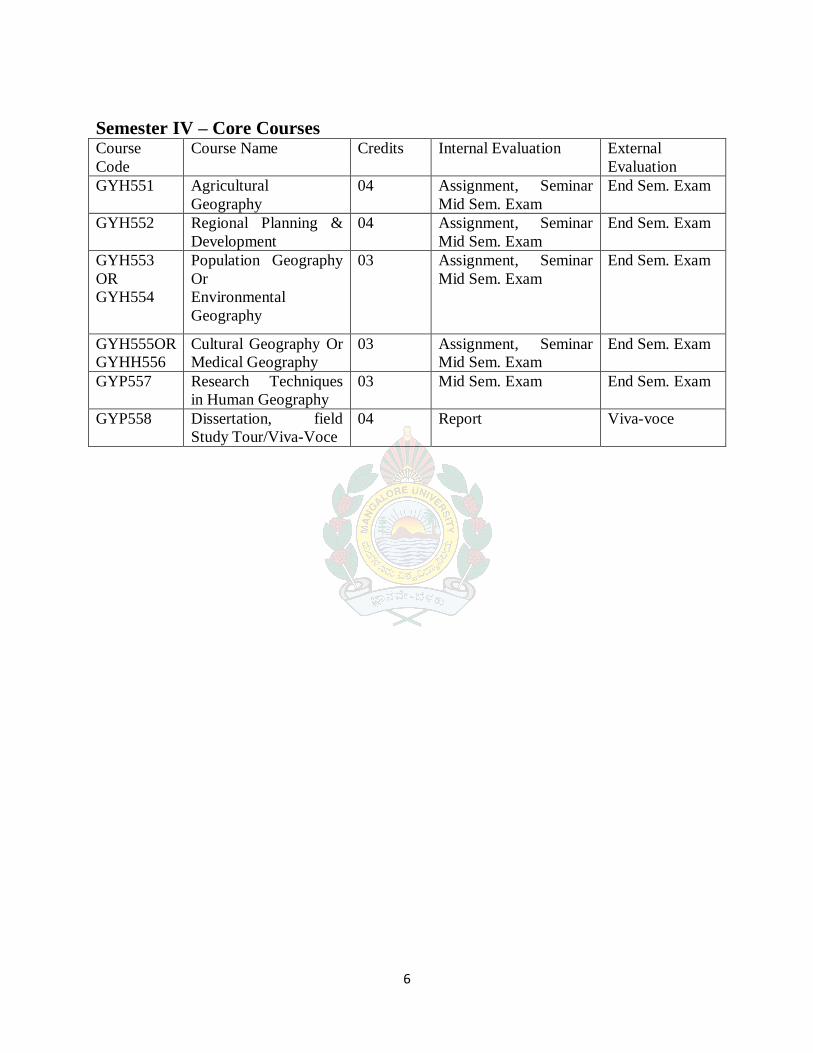
SEMESTER IV
HARD CORE COURSE GYH 551: Agricultural Geography
Course Learning Outcomes:
CO1. Understand the spatial distribution of agricultural phenomena.
CO2. Analyzing the agricultural practice and cultural development.
CO3. Evaluate the inter relationship between geographical knowledge and agricultural
practice in everyday living.
CO4. Evaluate the effects of agricultural policy measures in regional disparities.
CO5. Demonstrate the ability of analysing agricultural problems in their own perspective.
CO6. Demonstration of appreciation for the contribution of agricultural sector in the economic
development.
Course Content:
Unit1: Definition, nature, scope, and significance of agricultural geography; Origin & evolution
of agriculture, approaches: Commodity, systematic, regional and systems approaches.
–14
Unit 2: Determinants of agriculture: Physical, socio-economic, cultural, institutional,
technological and political. Land holding and land tenure systems, land use policy and planning,
irrigation and dry-farming, command area development. – 13
Unit 3: Measures of agriculture: Cropping pattern, crop combinations, crop diversification, and
intensity of cropping, degree of commercialization, agricultural efficiency and productivity,
HYV seeds. Classification of agriculture: Whitley‟s classification of world agriculture, Von-
Thunen‟s theory of agriculture and its relevant modifications, game theory & decision
making. Role of WTO in agriculture. – 14
Unit 4: Green revolution, white revolution, blue revolution, yellow revolution, horticulture&
New Delhi 2. Gupta C.B. (1979) An Introduction to Statistical Methods, Vikas Publishing House Pvt. Ltd.
New Delhi.
3. Murray R. 4. Toffee R. Transportation Geography, Prentice Hall Publication, New York.
45
GYP558: Dissertation, field Study Tour
Course Learning Outcomes
CO1: Design and execute a meaningful research project that demonstrates spatial thinking
CO2: Articulate research or project objectives and questions clearly and situate research within
an academic or Scholarly context
CO3: Understand the challenges of empirical geographical research
CO4: Able to deal with practical research problems
CO5: Narrate the research process clearly in the form of a formal multi-chapter master‟s
dissertation in a structured format.
CO6: Defend her/his thesis in any scholarly engagements
Unit 1: Methods of field investigation and its importance in geography. -14
Unit 2: Field work of different areas and levels (Micro-Meso-Macro). -13
Unit 3: Collection of field data, sampling methods and preparation of
questionnaires. -14
Unit 4: Data input, processing, representation, analysis and interpretation (Using
computer and GIS techniques) report writing. -13
Note:
1. Field study tour is a part of IV semester. Study tour is compulsory and to be
conducted between end of the III semester and in the beginning of the IV
semester for a duration of two weeks. Study tour report submission is
compulsory.
2. Viva-Voice based on dissertation and study tour report.
References:
1. Ahuja (2004) Research Methods, R.K. Books, New Delhi 2. Kothari (1990) Research Methodology – Wiley Eastern Ltd. New Delhi.
3. Gopal M.H. (1970) Introduction to Research Procedure in Social Science, Asia Publishing
House, Bombay. 4. Young Pauline V. (1980) Scientific Survey and Research, Prentice Hall, New Delhi.
5. Limb (2001) Quantitative Methodologies for Geographer R.K. Books, New Delhi. 6. Mishra R.P. (2001) Research Methods in Geography, R.K. Books, New Delhi. 7. Pal (2005). Computing Techniques in Geography, R.K. Books, New- Delhi.