Quaternary Science Reviews 24 (2005) 813–819 Multiproxy approach for the reconstruction of the glacial ocean surface (MARGO) Michal Kucera a, , Antoni Rosell-Mele´ b , Ralph Schneider c , Claire Waelbroeck d , Mara Weinelt e a Department of Geology, Royal Holloway University of London, Egham TW20 0EX, UK b ICREA and Institute of Environmental Science and Technology, Universitat Auto`noma de Barcelona, 08193 Bellaterra, Catalonia, Spain c De´partement de Ge´ologie et Oce´anographie, UMR5805-EPOC, CNRS/Universite´de Bordeaux1, 33405 Talence Cedex, France d Laboratoire des Sciences du Climat et de l’ Environnement, Laboratoire mixte CNRS-CEA, F-91198 Gif sur Yvette, France e Institute for Geosciences, University of Kiel, Olshausen Strasse 40, D-24098 Kiel, Germany Received 19 July 2004; accepted 23 July 2004 The oceans and the atmosphere are the two main reservoirs of greenhouse gases and latent heat on Earth. These reservoirs interact through the ocean surface, and the dynamics of this interaction is a major determinant of global climate. Accurate reconstructions of the physical state of the global ocean are therefore critical to the understanding of past climate changes. This is in turn required to assess the significance of instrumentally observed climate variability, and for the forcing and validation of global circulation models, which are used to predict future climate change. Systematic instrumental measurements of sea surface properties exist for only a few decades, with the longest regional records rarely extending beyond the 19th century. Yet, it is only with the aid of climate records spanning thousands of years and encompassing drama- tically different climatic states of the planet that one can truly understand the dynamics of the ocean–atmosphere interface and perform meaningful and useful tests of global climate models. Information on the state of the planet in the past, and the amplitude, frequency and mechanisms of its changes is of paramount importance to our society, as it is used to inform and guide long- term environmental policies and planning and to predict impact of climate change on land, our habitat. Any effort to provide past climate records of sufficient extent and time range will have to resort to the use of indirect information: proxies based on biological, chemical and physical signals preserved in ancient geological materials. In open-ocean settings, the organic ARTICLE IN PRESS 0277-3791/$ - see front matter r 2004 Elsevier Ltd. All rights reserved. doi:10.1016/j.quascirev.2004.07.017 Corresponding author. Tel.: +44-1784-443586; fax: +44-1784- 471780. E-mail address: [email protected] (M. Kucera).
Transcript
ARTICLE IN PRESS
0277-3791/$ - se
doi:10.1016/j.qu
�Correspond471780.
E-mail addr
Quaternary Science Reviews 24 (2005) 813–819
Multiproxy approach for the reconstruction of the glacial oceansurface (MARGO)
Michal Kuceraa,�, Antoni Rosell-Meleb, Ralph Schneiderc,Claire Waelbroeckd, Mara Weinelte
aDepartment of Geology, Royal Holloway University of London, Egham TW20 0EX, UKbICREA and Institute of Environmental Science and Technology, Universitat Autonoma de Barcelona, 08193 Bellaterra, Catalonia, Spain
cDepartement de Geologie et Oceanographie, UMR5805-EPOC, CNRS/Universite de Bordeaux1, 33405 Talence Cedex, FrancedLaboratoire des Sciences du Climat et de l’ Environnement, Laboratoire mixte CNRS-CEA, F-91198 Gif sur Yvette, France
eInstitute for Geosciences, University of Kiel, Olshausen Strasse 40, D-24098 Kiel, Germany
Received 19 July 2004; accepted 23 July 2004
The oceans and the atmosphere are the two mainreservoirs of greenhouse gases and latent heat on Earth.These reservoirs interact through the ocean surface, andthe dynamics of this interaction is a major determinantof global climate. Accurate reconstructions of thephysical state of the global ocean are therefore criticalto the understanding of past climate changes. This is inturn required to assess the significance of instrumentallyobserved climate variability, and for the forcing andvalidation of global circulation models, which are usedto predict future climate change.Systematic instrumental measurements of sea surface
properties exist for only a few decades, with the longest
e front matter r 2004 Elsevier Ltd. All rights reserved.
regional records rarely extending beyond the 19thcentury. Yet, it is only with the aid of climate recordsspanning thousands of years and encompassing drama-tically different climatic states of the planet that one cantruly understand the dynamics of the ocean–atmosphereinterface and perform meaningful and useful tests ofglobal climate models. Information on the state of theplanet in the past, and the amplitude, frequency andmechanisms of its changes is of paramount importanceto our society, as it is used to inform and guide long-term environmental policies and planning and to predictimpact of climate change on land, our habitat.Any effort to provide past climate records of sufficient
extent and time range will have to resort to the use ofindirect information: proxies based on biological,chemical and physical signals preserved in ancientgeological materials. In open-ocean settings, the organic
ARTICLE IN PRESSM. Kucera et al. / Quaternary Science Reviews 24 (2005) 813–819814
and mineral remains of marine microplankton in deep-sea sediments provide the most comprehensive source ofsuch proxies (Mix et al., 2001; Henderson, 2002).Unfortunately, it is scientifically and technically notpossible at present to aim to reconstruct a continuousrecord in space and time of past climate variation.Instead, a discrete and distinct time interval is needed tofocus research efforts of the scientific community. To beuseful for validation of climate models, this time intervalought to represent a period of climate markedlydifferent from that of today, yet not too distant fromthe present so that the basic assumptions and para-meters of the climate models need not be modified.With respect to past ocean surface conditions, parti-
cularly since the pioneering effort of the CLIMAP group(climate long-range investigation, mapping, and predic-tion; CLIMAP, 1976, 1981) which started 30 years ago,the time of the last glacial maximum (LGM) has servedas common target for climate modelling experiments andpalaeoenvironmental proxy reconstructions. The LGMinterval, around 21,000 years ago, represents the nearestof a series of past climatic extremes characterising thewaxing and waning of Quaternary ice ages and as suchserves as an excellent testing ground for assessment ofsensitivity of the Earth’s climatic system. Since theCLIMAP project conclusions were published, a largeamount of new sediment material has been recovered, itsage determined using ever-improving dating techniques,and its palaeoclimatic significance assessed with an ever-expanding battery of proxies. Yet, a global synthesis ofthis material is still lacking. In 1999, an internationalinitiative was launched by the scientific community, withthe aim to facilitate a new synthesis of the last ice ageEarth’s surface. The environmental processes of the iceage: land, ocean, glaciers (EPILOG) initiative com-menced by the IMAGES-PAGES program (the interna-tional marine past global changes study-past globalchanges; core project of the international geosphere-biosphere programme) provided an updated review of theprogress in palaeoclimatic reconstructions since CLI-MAP. It summarised the salient points and obstacles inthe way of a new synthesis, and set a series of benchmarksto allow a precise definition of the LGM chronozone(Mix et al., 2001).Following EPILOG, and with the above advance-
ments in mind, the MARGO working group waslaunched in September 2002, when 33 scientists from13 countries met at the Hanse Institute for AdvancedStudies in Delmenhorst, Germany, to initiate the‘‘multiproxy approach for the reconstruction of theglacial ocean surface’’ (MARGO). MARGO acts as anopen international project involving data gathering,sharing and harmonisation, with the aim of producing anew synthesis of sea-surface temperature (SST) and sea-ice extent of the glacial ocean. The overall MARGOobjective is to collate and harmonise all the available
proxy data and transfer function techniques, and placethem into a common framework for a multi-proxyglobal glacial ocean reconstruction. However, prior tothis global synthesis, huge efforts have been put bythe MARGO working group members into the assemblyof new regional or proxy-specific SST reconstructionswhich are reported in this volume or in recentlypublished studies, like the GLAMAP reconstruction(Sarnthein et al., 2003; and references therein) and theTEMPUS compilation (Rosell-Mele et al., 1998, 2004).The contributions presented in this issue form the firstphase of MARGO: (i) compilation of quality-assessedand harmonised proxy-specific calibration datasetsand LGM reconstructions, (ii) documentation of in-dividual proxies and techniques and (iii) an outline ofpossible methods of the presentation of the finalsynthesis.A selection of 8 papers out of 13 herein provides a
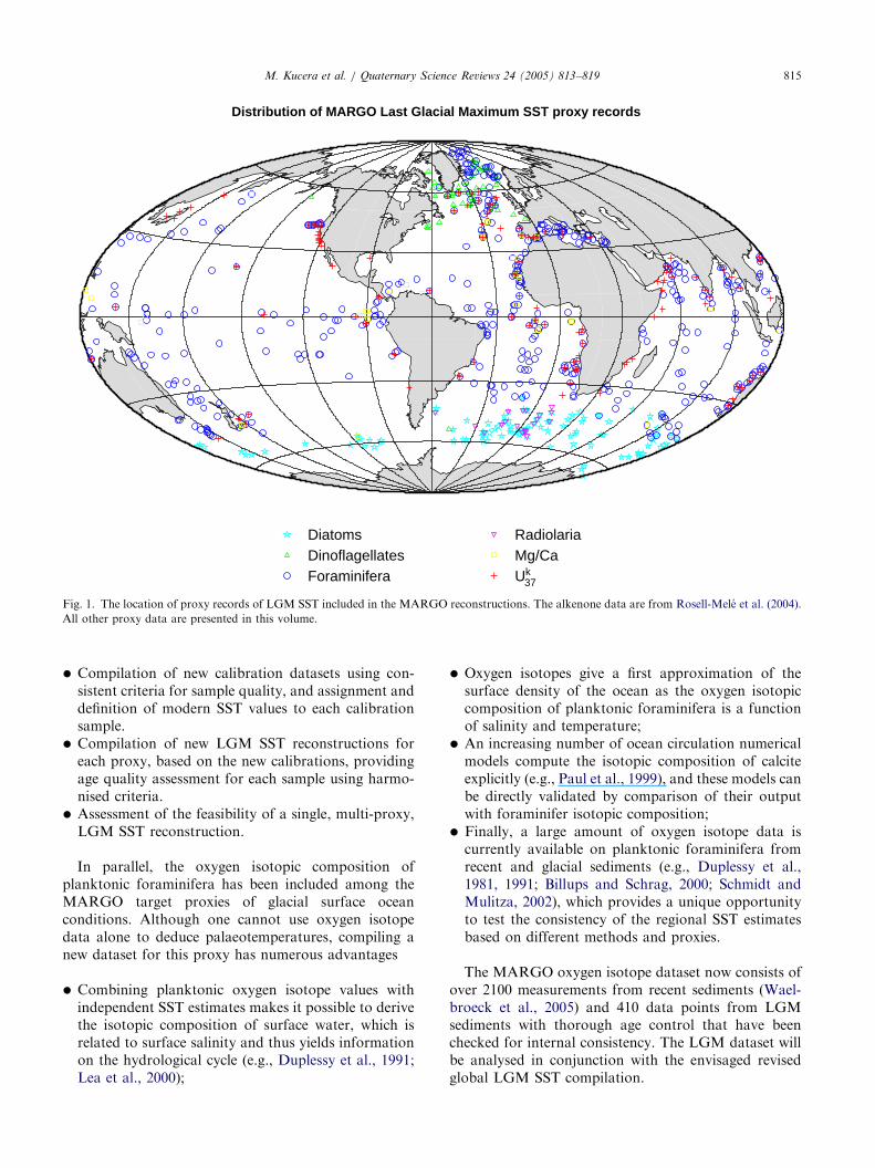
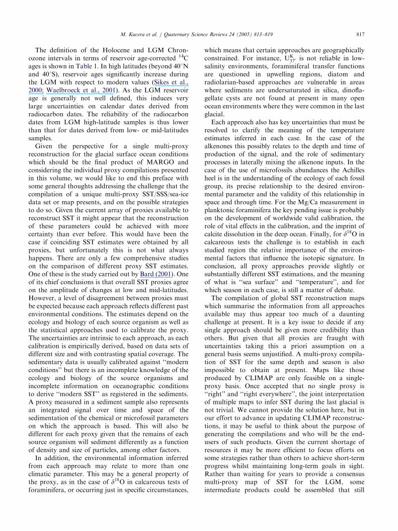
series of compilations for different SST proxies (Fig. 1),including Mg/Ca ratios of planktonic foraminifera(Barker et al., 2005; Meland et al., 2005) and varioustransfer function approaches based on census counts ofassemblages of planktonic foraminifera (Barrows andJuggins, 2005; Chen et al., 2005; Hayes et al., 2005;Kucera et al., 2005), diatoms and radiolaria (Gersondeet al., 2005) as well as dinoflagellate cysts (de Vernal etal. 2005). Moreover, a new Holocene oxygen isotopedata synthesis based on planktonic foraminifera ispresented (Waelbroeck et al., 2005) and a stimulatingcontribution by Morey et al. (2005) discusses thedistribution of planktonic foraminifer assemblages insurface sediments as a function of multiple environ-mental variables rather than exclusively related to SST.The series of papers addressing glacial surface oceanconditions is followed by a study describing thetermination of the last glacial period in the Pacific(Kiefer and Kienast, 2005) and this MARGO specialissue ends with two contributions dealing with the issuesof mapping techniques for sparsely and non-homoge-neously distributed proxy data (Schafer-Neth et al.,2005) as well as their comparison with results fromclimate model experiments (Paul and Schafer-Neth,2005).This preface briefly summarises the recommendations
and common standards agreed at two MARGO work-shops which form the innovative guidelines for the newcompilations presented herein, and which will serve asthe internationally agreed base for the overall multi-proxy synthesis of the last glacial SST reconstruction.For further information on the MARGO guidelines,their application to the new compilations and theindividual data sets the reader is referred to theMARGO website (http://www.pangaea.de/projects/MARGO) and to the individual articles in this volume.These guidelines evolved from the major aims ofMARGO, as formulated at the first meeting in 2002.
Distribution of MARGO Last Glacial Maximum SST proxy records
DiatomsDinoflagellatesForaminifera
RadiolariaMg/CaUk
37
Fig. 1. The location of proxy records of LGM SST included in the MARGO reconstructions. The alkenone data are from Rosell-Mele et al. (2004).
All other proxy data are presented in this volume.
M. Kucera et al. / Quaternary Science Reviews 24 (2005) 813–819 815
�
Compilation of new calibration datasets using con-sistent criteria for sample quality, and assignment anddefinition of modern SST values to each calibrationsample.
�
Compilation of new LGM SST reconstructions foreach proxy, based on the new calibrations, providingage quality assessment for each sample using harmo-nised criteria.
�
Assessment of the feasibility of a single, multi-proxy,LGM SST reconstruction.
In parallel, the oxygen isotopic composition ofplanktonic foraminifera has been included among theMARGO target proxies of glacial surface oceanconditions. Although one cannot use oxygen isotopedata alone to deduce palaeotemperatures, compiling anew dataset for this proxy has numerous advantages
�
Combining planktonic oxygen isotope values withindependent SST estimates makes it possible to derivethe isotopic composition of surface water, which isrelated to surface salinity and thus yields informationon the hydrological cycle (e.g., Duplessy et al., 1991;Lea et al., 2000);
�
Oxygen isotopes give a first approximation of thesurface density of the ocean as the oxygen isotopiccomposition of planktonic foraminifera is a functionof salinity and temperature;
�
An increasing number of ocean circulation numericalmodels compute the isotopic composition of calciteexplicitly (e.g., Paul et al., 1999), and these models canbe directly validated by comparison of their outputwith foraminifer isotopic composition;
�
Finally, a large amount of oxygen isotope data iscurrently available on planktonic foraminifera fromrecent and glacial sediments (e.g., Duplessy et al.,1981, 1991; Billups and Schrag, 2000; Schmidt andMulitza, 2002), which provides a unique opportunityto test the consistency of the regional SST estimatesbased on different methods and proxies.
The MARGO oxygen isotope dataset now consists ofover 2100 measurements from recent sediments (Wael-broeck et al., 2005) and 410 data points from LGMsediments with thorough age control that have beenchecked for internal consistency. The LGM dataset willbe analysed in conjunction with the envisaged revisedglobal LGM SST compilation.
M. Kucera et al. / Quaternary Science Reviews 24 (2005) 813–819816
According to the MARGO recommendations, seaso-nal SST reconstructions as well as annual temperaturesare provided wherever possible. This is the case with alltransfer function techniques using planktonic foramini-fera, dinoflagellate cysts, radiolarian and diatom assem-blages, while the geochemical SST reconstructionsprovide annual mean estimates (alkenones) or summerSST (Mg/Ca). To cater for a proper comparison ofsingle proxy reconstructions we agreed on common useof World Ocean Atlas version 2 (WOA, 1998; 11 gridversion) as modern reference and calibration data. TheWOA98 dataset has benefited from error reduction ascompared to previous versions while no significant newdata were included. Seasonal and/or annual tempera-tures for the sample sites were extracted for 10m waterdepth using a common data extraction tool (http://www.palmod.uni-bremen.de/~csn/woasample.html).For seasonal temperatures three-month averages ofJanuary–March (northern winter) and July–September(northern summer), and 12-months average for annualSST are used. Temperature at sample sites is computedas the area-weighted average of the four WOAtemperature points surrounding the sample location;WOA data points marked as land were omitted from theaveraging.Sea-ice extent is one of the most elusive properties of
the ocean in terms of the prospect of its accuratereconstruction from geological records, yet it is a crucialparameter of climate models and its knowledge isessential for assessment of the different oceanographicmechanisms that could be at play in a given region. TheMARGO group has, therefore, recommended thisvariable should be reconstructed as far as is possibleand encourage further research in this field. In this issue,Gersonde et al. (2005) present an updated reconstruc-tion of patterns of summer and winter sea-ice extent inthe Southern Ocean reconstructed from the distributionpatterns of diatom sea-ice indicator species. In theNorthern Hemisphere, deVernal et al. (2005) andKucera et al. (2005) produced updated estimates ofglacial sea-ice extent in the Nordic Seas based ondinocyst and planktonic foraminifer assemblages; bothindicated ice-free summers in the Norwegian Sea.MARGO adopted the same definition of the LGM
interval or chronozone as in Mix et al. (2001):19–23 cal kyr BP (ka). The definitions of the levels ofcertainty are identical as well:
Conversion of MARGO/EPILOG Holocene and LGM Chronozone
boundary ages using the INTCAL98 calibration curve from Stuiver et
� al. (1998)
Calendar age Reservoir age–corrected 14C age
2 ka70.1 kyr 2.05 14C kyrBP70.1 kyr
4 ka70.1 kyr 3.6 14CkyrBP70.1 kyr14
LGM Chronozone Level 1: Chronologic control basedeither on annually counted layers extending throughthe LGM chronozone, or two radiometric dateswithin the interval, such as U/Th dates or reservoir-corrected 14 C-yr dates adjusted to the calendar scaleusing the CALIB software (Stuiver et al., 1998).
19 ka70.1 kyr 15.9 CkyrBP70.35 kyr14
�
23 ka70.1 kyr 19.4 CkyrBP70.4 kyr
LGM Chronozone Level 2: Chronologic control basedon two bracketing radiometric dates of any kind
within the interval 12–30 ka (i.e., within marineoxygen-isotope stage 2), or by correlation of non-radiometric data to similar regional records that havebeen dated to match the level 1 protocol (for example,d18O stratigraphy).
�
LGM Chronozone Level 3: Chronologic control basedon other stratigraphic constraints (for example, aregional lithologic index such as %CaCO3) that arecorrelated to similar records dated elsewhere to matchthe level 2 protocol.
In addition, it was recommended to label sampleswith no stratigraphic control as level 4.
For the purpose of improved calibration of transferfunctions and calibration equations used in MARGOwith respect to WOA98, the MARGO working groupalso attempted to better constrain the quality of‘‘modern’’ or ‘‘core-top’’ samples. Therefore, the LateHolocene chronozone was defined in a similar way:0–4 cal kyr BP, with the following levels of certainty:
�
LH Chronozone Level 1, 0–2 ka: Chronologic controlbased either on annually counted layers covering thelast 2 ky, or one radiometric date (such as U/Th datesor reservoir-corrected 14 C-yr dates converted intocalendar age) within the interval 0–2 ka.
�
LH Chronozone Level 2, 0–4 ka: Chronologic controlbased on one radiometric date of any kind within theinterval 0–4 ka, or stained benthic foraminifera withsedimentation rate higher than 5 cm/ky.
�
LH Chronozone Level 3, 0–4 ka: Chronologic controlbased on one radiometric date of any kind within theinterval 4–8 ka or specific stratigraphic control (fore.g., % G. hirsuta left coiling) indicating that thesample belongs to the interval 0–4 ka.
�
LH Chronozone Level 4, 0–4 ka: Chronologic controlbased on other stratigraphic constraints (for e.g., d18Ostratigraphy, or a regional lithologic index such as%CaCO3) indicating that the sample belongs to theinterval 0–4 ka.
In addition, it was recommended to label sampleswith no stratigraphic control as Level 5, and to reportthe 0–4 ka and 0–2 ka intervals separately when Level 1is achieved.
ARTICLE IN PRESSM. Kucera et al. / Quaternary Science Reviews 24 (2005) 813–819 817
The definition of the Holocene and LGM Chron-ozone intervals in terms of reservoir age-corrected 14Cages is shown in Table 1. In high latitudes (beyond 401Nand 401S), reservoir ages significantly increase duringthe LGM with respect to modern values (Sikes et al.,2000; Waelbroeck et al., 2001). As the LGM reservoirage is generally not well defined, this induces verylarge uncertainties on calendar dates derived fromradiocarbon dates. The reliability of the radiocarbondates from LGM high-latitude samples is thus lowerthan that for dates derived from low- or mid-latitudessamples.Given the perspective for a single multi-proxy
reconstruction for the glacial surface ocean conditionswhich should be the final product of MARGO andconsidering the individual proxy compilations presentedin this volume, we would like to end this preface withsome general thoughts addressing the challenge that thecompilation of a unique multi-proxy SST/SSS/sea-icedata set or map presents, and on the possible strategiesto do so. Given the current array of proxies available toreconstruct SST it might appear that the reconstructionof these parameters could be achieved with morecertainty than ever before. This would have been thecase if coinciding SST estimates were obtained by allproxies, but unfortunately this is not what alwayshappens. There are only a few comprehensive studieson the comparison of different proxy SST estimates.One of these is the study carried out by Bard (2001). Oneof its chief conclusions is that overall SST proxies agreeon the amplitude of changes at low and mid-latitudes.However, a level of disagreement between proxies mustbe expected because each approach reflects different pastenvironmental conditions. The estimates depend on theecology and biology of each source organism as well asthe statistical approaches used to calibrate the proxy.The uncertainties are intrinsic to each approach, as eachcalibration is empirically derived, based on data sets ofdifferent size and with contrasting spatial coverage. Thesedimentary data is usually calibrated against ‘‘modernconditions’’ but there is an incomplete knowledge of theecology and biology of the source organisms andincomplete information on oceanographic conditionsto derive ‘‘modern SST’’ as registered in the sediments.A proxy measured in a sediment sample also representsan integrated signal over time and space of thesedimentation of the chemical or microfossil parameterson which the approach is based. This will also bedifferent for each proxy given that the remains of eachsource organism will sediment differently as a functionof density and size of particles, among other factors.In addition, the environmental information inferred
from each approach may relate to more than oneclimatic parameter. This may be a general property ofthe proxy, as in the case of d18O in calcareous tests offoraminifera, or occurring just in specific circumstances,
which means that certain approaches are geographicallyconstrained. For instance, UK
370 is not reliable in low-salinity environments, foraminiferal transfer functionsare questioned in upwelling regions, diatom andradiolarian-based approaches are vulnerable in areaswhere sediments are undersaturated in silica, dinofla-gellate cysts are not found at present in many openocean environments where they were common in the lastglacial.Each approach also has key uncertainties that must be
resolved to clarify the meaning of the temperatureestimates inferred in each case. In the case of thealkenones this possibly relates to the depth and time ofproduction of the signal, and the role of sedimentaryprocesses in laterally mixing the alkenone inputs. In thecase of the use of microfossils abundances the Achillesheel is in the understanding of the ecology of each fossilgroup, its precise relationship to the desired environ-mental parameter and the validity of this relationship inspace and through time. For the Mg/Ca measurement inplanktonic foraminifera the key pending issue is probablyon the development of worldwide valid calibration, therole of vital effects in the calibration, and the imprint ofcalcite dissolution in the deep ocean. Finally, for d18O incalcareous tests the challenge is to establish in eachstudied region the relative importance of the environ-mental factors that influence the isotopic signature. Inconclusion, all proxy approaches provide slightly orsubstantially different SST estimations, and the meaningof what is ‘‘sea surface’’ and ‘‘temperature’’, and forwhich season in each case, is still a matter of debate.The compilation of global SST reconstruction maps
which summarise the information from all approachesavailable may thus appear too much of a dauntingchallenge at present. It is a key issue to decide if anysingle approach should be given more credibility thanothers. But given that all proxies are fraught withuncertainties taking this a priori assumption on ageneral basis seems unjustified. A multi-proxy compila-tion of SST for the same depth and season is alsoimpossible to obtain at present. Maps like thoseproduced by CLIMAP are only feasible on a single-proxy basis. Once accepted that no single proxy is‘‘right’’ and ‘‘right everywhere’’, the joint interpretationof multiple maps to infer SST during the last glacial isnot trivial. We cannot provide the solution here, but inour effort to advance in updating CLIMAP reconstruc-tions, it may be useful to think about the purpose ofgenerating the compilations and who will be the end-users of such products. Given the current shortage ofresources it may be more efficient to focus efforts onsome strategies rather than others to achieve short-termprogress whilst maintaining long-term goals in sight.Rather than waiting for years to provide a consensusmulti-proxy map of SST for the LGM, someintermediate products could be assembled that still
ARTICLE IN PRESSM. Kucera et al. / Quaternary Science Reviews 24 (2005) 813–819818
represent a genuine advance in our understanding of theLGM climate, and be of use to the community. Forinstance, why is it necessary, in contrast to beingdesirable, to provide a single multi-proxy SST map? Ifmulti-proxy maps of SST cannot be derived, what couldstill be useful to advance our understanding of climatechange? If multiple maps are provided for differentapproaches, how may they be interpreted by differentusers?The second challenge in such an interdisciplinary
research field is the flow of information betweendifferent communities, such as data producers and userslike climate modellers. It is our perception that issuesthat may be taken for granted among some groups maybe ignored by others even if the general field of work isthe same, in our case climate research. Few individualswork in the transition between disciplines and the flowand processing of information between research areas isnot always smooth and unbiased by each individual’sperception. We decided to find out as objectively aspossible, as far as we were able to, the perception andopinion on some of the issues outlined above byconstructing a questionnaire directed to climate mod-ellers. Its aim was to dispel some doubts on how thepalaeo-maps were perceived, their possible uses, andobtain suggestions on how to provide useful mappingoutputs that would represent an improvement on thestate of the art and be valuable to other users than thosein the MARGO project. Of course, we all knew, orthought we knew, the answers to some issues, but theanswers were not always the same and were based onour restricted circle of contacts. The questionnaire waspublicised among the palaeoclimate modelling commu-nity and was returned by North American, Europeanand Japanese modellers from 11 groups, which representmore than half of the participants in the PalaeoclimateModelling Intercomparison Project (http://www-lsce.cea.fr/pmip2/). These groups are engaged in almost allcases in 3D general circulation modelling, and althoughthose that provided a reply identified themselves, it wasour commitment to maintain the anonymity of theparticipants. A summary and discussion of the results ofthe exercise are shown on the MARGO web site (http://www.pangaea.de/projects/MARGO). Perhaps, the key(and not unexpected) message that one can draw fromthe questionnaire replies is that palaeomaps will be moreuseful to modellers, the simpler they are in theirgraphical representations and the better explained theproxy approaches are. The former means that fancycoloured maps are good for wall displays and asteaching aids, but that raw and gridded data are moreuseful for science. The latter means that the betterdescribed the constraints in the interpretation of theproxies, and the advantages and shortcomings of eachapproach, are the better use will be made of the data bythose that need them.
Acknowledgements
First of all we would like to express our most sincerethanks to the contributors to this volume for theirtremendous efforts in assembling their databases intothe MARGO archive, for their contributions to thediscussions held at the two MARGO workshops, andfinally for their willingness to reassess all their data setsand reshape their compilations according to theMARGO guidelines which they agreed on beforehand.R.R.S greatly acknowledges the financial support by theIMAGES-PAGES program and the HANSE Wis-senschaftskolleg (HWK) at Delmenhorst to hold thefirst MARGO workshop at the HWK and also to theDEKLIM program of the BMBF Germany and theEuropean 5th framework projects (CESOP, EVR1-2001-40018, and MOTIF, EESD-ESD-3 (JO 2000/C324/09)) for data compilation into the PANGAEAarchive. A.R.-M. is grateful to the Fundacio Abertis andthe IMAGES-PAGES program for providing technicaland financial resources for the second MARGO work-shop at the castle de Castellet de Foix. Finally, we wouldlike to thank all reviewers who helped to profoundlyimprove the articles presented in this volume. Withouttheir willingness to provide timely reviews this volumewould not exist.
References
Bard, E., 2001. Comparison of alkenone estimates with other