Multiproxy record of late Quaternary climate change and MiddleStone Age human occupation at Wonderkrater, South Africa
Lucinda R. Backwell a, b, *, Terence S. McCarthy b, Lyn Wadley a, c, Zo€e Henderson d, f,Christine M. Steininger a, b, Bonita deKlerk a, Magali Barr�e g, Michel Lamothe g,Brian M. Chase h, i, Stephan Woodborne c, j, George J. Susino b, Marion K. Bamford a, b,Christine Sievers a, c, James S. Brink d, e, Lloyd Rossouw d, Luca Pollarolo c, Gary Trower a, b,Louis Scott k, Francesco d'Errico l, h
a Evolutionary Studies Institute, University of the Witwatersrand, Private Bag 3, Wits, 2050, Johannesburg, South Africab School of Geosciences, University of the Witwatersrand, Private Bag 3, Wits, 2050, Johannesburg, South Africac School of Geography, Archaeology and Environmental Science, University of the Witwatersrand, Private Bag 3, Wits, 2050, Johannesburg, South Africad National Museum, P.O. Box 266, Bloemfontein, 9300, South Africae Centre for Environmental Management, University of the Free State, P.O. Box 339, Bloemfontein, 9300, South Africaf Faculty of Humanities and Social Sciences, La Trobe University, Victoria, 3086, Australiag Laboratoire de luminescence Lux, D�epartement des sciences de la Terre et de l'atmosph�ere, Universit�e du Qu�ebec �a Montr�eal, C.P. 8888, Succ. Centre-Ville,Montr�eal, Qu�ebec, H3C 3P8, Canadah Institut des Sciences de l'Evolution de Montpellier, UMR 5554, Centre National de Recherche Scientifique/Universit�e Montpellier 2, Bat.22, CC061, PlaceEug�ene Bataillon, 34095, Montpellier Cedex 5, Francei Department of Archaeology, History, Cultural and Religious Studies, University of Bergen, Post Box 7805, 5020, Bergen, Norwayj iThemba Labs, University of the Witwatersrand, Private Bag 3, Wits, 2050, Johannesburg, South Africak Department of Plant Sciences, University of the Free State, P.O. Box 339, Bloemfontein, 9300, South Africal CNRS UMR 5199, PACEA, Universit�e Bordeaux 1, Avenue des Facult�es, F-33405, Talence, France
a r t i c l e i n f o
Article history:Received 30 September 2013Received in revised form8 June 2014Accepted 13 June 2014Available online
Here we provide a multiproxy record of climate change and human occupation at Wonderkrater, a springand peat mound site situated in the interior of southern Africa. Recently extracted sediment cores yieldeda number of Middle Stone Age (MSA) artefacts, prompting exploratory excavation of the sediments tounderstand better the geomorphology of the site, age of the sediments, cultural lithic sequence, vege-tation and faunal remains, and to try to establish whether human use of the site was to some extentclimatically driven. Excavations yielded late Pleistocene mammal fauna and flora, and three small MSAlithic assemblages with age estimates of 30 ka, >45 ka and 138.01 ± 7.7 ka. The upper layers comprisepeat that preserves macrobotanical and faunal remains, implying local fen conditions in Acacia savannawoodland at 12 ka. Below the upper peat layers, a 1 m-thick layer of white sand yielded two MSA lithicassemblages in association with faunal remains dated to between 30.8 ± 0.7 ka and >45 ka. Clay un-derlying the sand has an OSL age of 63.1 ± 5.8 ka, and sandy peat below it has an Infrared StimulatedLuminescence (IRSL) age of 70 ± 10 ka. Faunal remains in the lower sand levels, and dental stable carbonisotope analysis of herbivores, indicate a substantial grassland component in the landscape during lateMIS 3 (>45 ka). Charcoal, phytolith and pollen data show a change from moderately warm and dry grassysavanna woodland in the lower sand levels, to cooler and wetter grassland with woody shrubs in theuppermost levels by 30 ka. The conditions that resulted in the deposition of the sand also attractedpeople to the site, but whether it served as an oasis in an arid landscape, or was occupied during wetphases, is unclear. The composition of the lithic assemblages, which include many tools suitable forcutting, suggest that the peat mound may have been used as a place to harvest reeds, process plantmaterials and butcher animals that were either deliberately or accidentally trapped in mud or peat.
Climate change is hypothesized to have played a major role inearly human history, from short-term (Potts, 1998), extreme(Maslin and Christensen, 2007) and rapid change (Ziegler et al.,2013), to climatic variability (Trauth et al., 2009; Thomas et al.,2012), rapid increases in aridity (Vrba et al., 1995) and sea-levelfluctuations (Compton, 2011). Change in climate is also consid-ered to have affected the development of complex modern humanbehaviour, population expansion and dispersal (e.g. Lahr and Foley,1998; Mellars, 2006; Campisano and Feibel, 2007; Field et al., 2007;Hughes et al., 2007; Maslin and Christensen, 2007; Scholz et al.,2007). Major pulses in innovation have been linked with abruptclimate change towards humid conditions in southern Africa(Ziegler et al., 2013), but Chase (2010), Jacobs and Roberts (2009)and Mitchell (2008) propose that factors independent of climatewere responsible. Some of the earliest traces of complex behaviourare recorded at coastal MSA sites in South Africa, includingengraved artefacts (Henshilwood et al., 2002, 2009; Texier et al.,2010), ornamental shell beads (d'Errico et al., 2005), heat treat-ment of rocks as part of the knapping process (Brown et al., 2009;Mourre et al., 2010; Schmidt et al., 2013; Wadley, 2013) and evi-dence of complex hafting and hunting activities (Lombard, 2005,
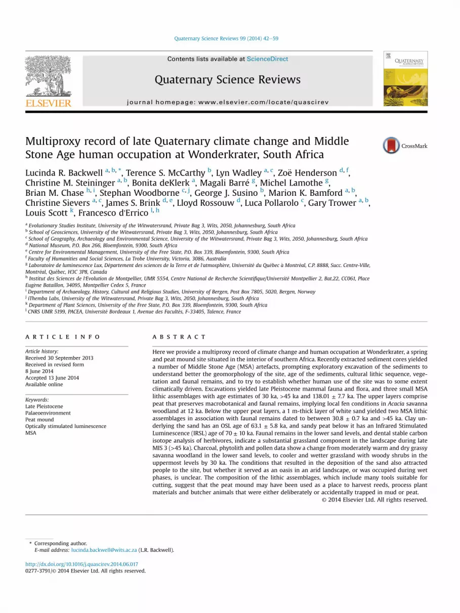
Fig. 1. Map of southern Africa showing the location of Wonder
2007; Backwell et al., 2008; Wadley et al., 2009; Lombard andPhillipson, 2010; Wadley, 2010; d'Errico et al., 2012a). Symbolicand abstract thought, planning, and technological innovationcertainly developed in Africa in MSA contexts, but the exact timingand geographic distribution of the emergence of complex humancognition, the mode and tempo of its evolution, and whether it isspecific to anatomically modern humans, is the subject of ongoingdebate (Mellars, 1991; Klein, 1995, 2000, 2001; McBrearty andBrooks, 2000; Wadley, 2001, 2013; Stringer, 2002; Backwell et al.,2008; d'Errico et al., 2009; d'Errico and Stringer, 2011). This ispartly because knowledge of African middle and late Pleistocenefossil hominins is limited by a small sample size, rendering theextent of their diversity, distribution, first and last appearances, andassociations with lithic industries and each other, unknown(Mitchell, 2008). It is thus difficult to assess the impact of climatechange on modern human evolution and dispersal when it is un-clear whether there was an accretional emergence of the modernhuman morphotype from an archaic ancestor with a pan-Africandistribution (Br€auer, 2008; Pearson, 2008), or whether there wasa more punctuated appearance, possibly a speciation event from ageographically-restricted subpopulation of archaic humans(Stringer, 2002). It is generally accepted that by 60 ka all people insouthern Africa were anatomically modern (McBrearty and Brooks,2000; Grün and Beaumont, 2001; Deacon andWurz, 2005; Mareanand Assefa, 2005).
krater in relation to other known Middle Stone Age sites.
Palaeoclimate records for sub-Saharan Africa are scarce, seldomwell dated, and often contradictory. There are problems withcorrelating terrestrial and marine records, and southern hemi-sphere climate data with those from northern latitudes, whichexperience different temperature regimes and monsoon patterns(Chase and Meadows, 2007; Maslin and Christensen, 2007; Gasseet al., 2008; Chase, 2010; Chase et al., 2010; Blome et al., 2012). Inaddition to the scant climate record, relatively few well-preservedMSA sites are reported for the interior of southern Africa. This isbelieved to be due to sampling bias (Mitchell, 2008), unfavourablepreservation conditions (Schiegl and Conard, 2006), and a lack ofhuman habitation due to adverse climatic conditions. It has beenproposed that periods of more arid climates may have pressed sub-continental African people to the coast, where evidence at anumber of cave sites shows that they exploited a wide range ofresources (e.g. Deacon and Deacon, 1999; Marean et al., 2007; Clarkand Plug, 2008; Marean, 2010a,b). In recent years nine MSA sites inthe subcontinent have been newly dated (Jacobs et al., 2008; Jacobsand Roberts, 2009), but unfortunately they are all coastal or near-coastal localities. The small number of post-200 ka sites that havebeen excavated in southern Africa, or dated using recent standards,together with a lack of coherence in hominin taxonomic attributionand regional palaeoenvironmental records, make it difficult toestablish whether sampling bias, erosion and destructive tapho-nomic processes, discontinuity in cultural transmission as aconsequence of population decrease and isolation linked to climatechange, or the behaviour of different hominins, account for whatappears at first glance to be a paucity of inland sites with evidence
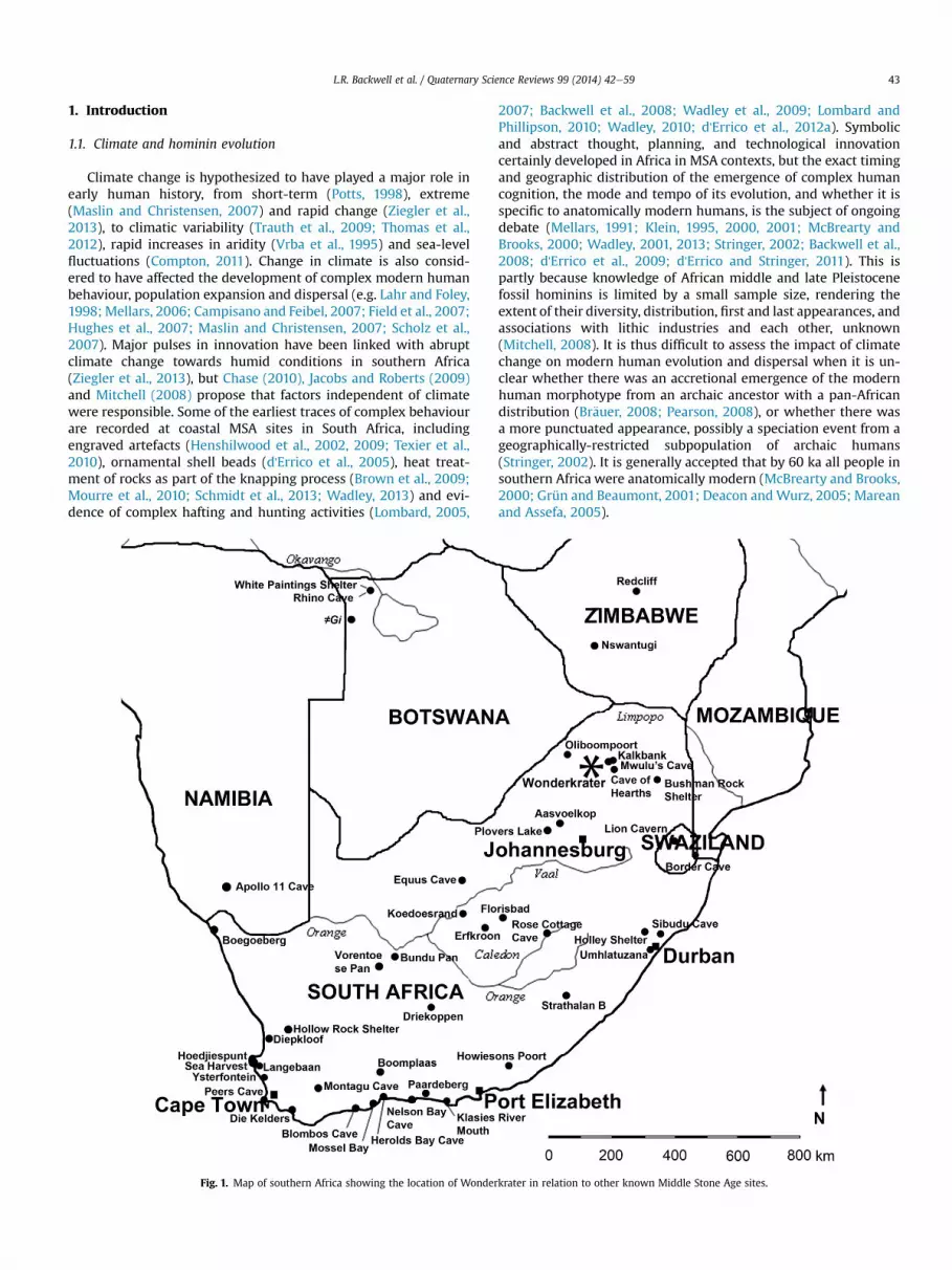
Fig. 2. Subsurface soil map of the site showing the position of excavation areas along the F-lclearly stratified margin, and D the medium-coarse sand surrounding the site (modified af
of cultural innovation. One of the problems highlighted by theabove review is the fact that there are very few terrestrial se-quences covering the Upper Pleistocene, and when available, theyare difficult to correlate with early human settlement patterns. Inthis respect the site of Wonderkrater represents an exception,featuring layers rich in modern and ancient organic material thatalternates with sand layers recording human use of the site. Scott'sdetailed palynological study of the pollen-rich peat deposits atWonderkrater has provided a record of the vegetation change, andby inference regional climate, in this area for the past ~34 ka andolder undated intervals (e.g. Scott and Vogel, 1983; Scott andThackeray, 1987; Scott, 1999; Scott et al., 2003). The aim of thisstudy is to understand better the geomorphology of the site, theprocesses that led to its formation, the chronology of the deposits,document environmental changes recorded in the sequence,characterize the human use of the area through an analysis of thecultural remains, and combine the results to produce a multiproxyrecord. Here we present the results of test excavations in differentareas of the site over three field seasons from 2005 to 2007.
1.2. The site
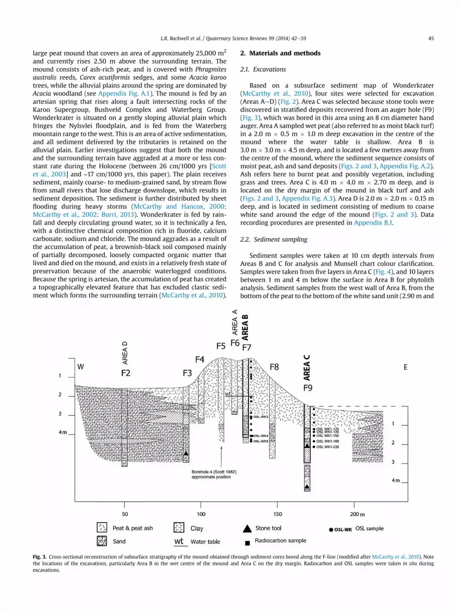
Located on the farm Driefontein in Limpopo Province, SouthAfrica (Fig. 1), at an altitude of ~1100 m above sea level, the site ofWonderkrater (24� 25080.60 S, 28�44062.60 E) is situated in a mixedbushveld environment (Low and Rebelo, 1996) that forms part ofthe current tropical savanna biome (Rutherford, 1997), receiving amean annual rainfall of approximately 630 mm. Wonderkrater is a
ine transect. Areas A and B sample black peat in the wet centre of the mound; C the dryter McCarthy et al., 2010). Cross reference to Fig. 3 for cross-section.
large peat mound that covers an area of approximately 25,000 m2
and currently rises 2.50 m above the surrounding terrain. Themound consists of ash-rich peat, and is covered with Phragmitesaustralis reeds, Carex acutiformis sedges, and some Acacia karootrees, while the alluvial plains around the spring are dominated byAcacia woodland (see Appendix Fig. A.1). The mound is fed by anartesian spring that rises along a fault intersecting rocks of theKaroo Supergroup, Bushveld Complex and Waterberg Group.Wonderkrater is situated on a gently sloping alluvial plain whichfringes the Nylsvlei floodplain, and is fed from the Waterbergmountain range to the west. This is an area of active sedimentation,and all sediment delivered by the tributaries is retained on thealluvial plain. Earlier investigations suggest that both the moundand the surrounding terrain have aggraded at a more or less con-stant rate during the Holocene (between 26 cm/1000 yrs [Scottet al., 2003] and ~17 cm/1000 yrs, this paper). The plain receivessediment, mainly coarse- to medium-grained sand, by stream flowfrom small rivers that lose discharge downslope, which results insediment deposition. The sediment is further distributed by sheetflooding during heavy storms (McCarthy and Hancox, 2000;McCarthy et al., 2002; Burri, 2013). Wonderkrater is fed by rain-fall and deeply circulating ground water, so it is technically a fen,with a distinctive chemical composition rich in fluoride, calciumcarbonate, sodium and chloride. The mound aggrades as a result ofthe accumulation of peat, a brownish-black soil composed mainlyof partially decomposed, loosely compacted organic matter thatlived and died on the mound, and exists in a relatively fresh state ofpreservation because of the anaerobic waterlogged conditions.Because the spring is artesian, the accumulation of peat has createda topographically elevated feature that has excluded clastic sedi-ment which forms the surrounding terrain (McCarthy et al., 2010).
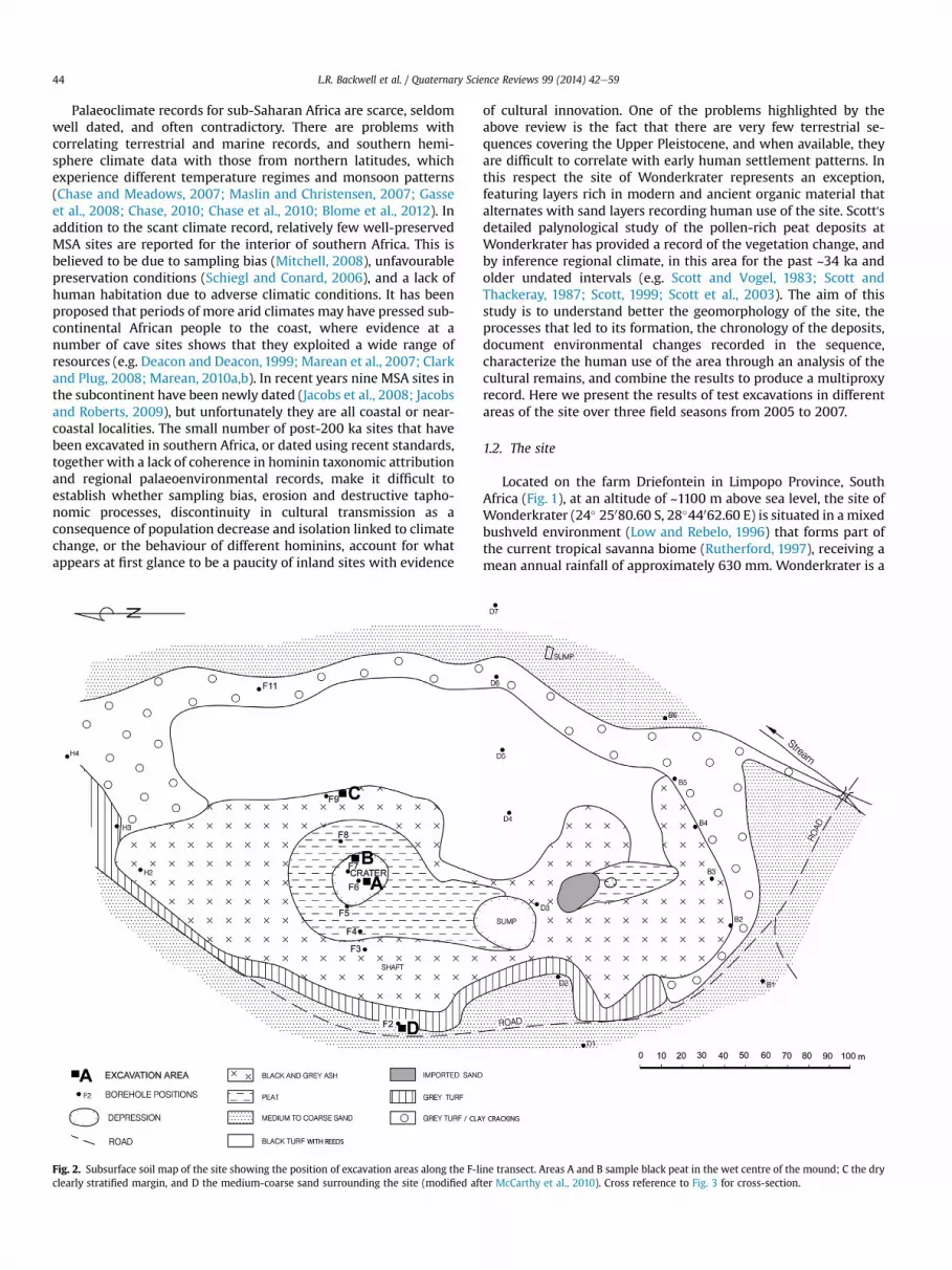
Fig. 3. Cross-sectional reconstruction of subsurface stratigraphy of the mound obtained throthe locations of the excavations, particularly Area B in the wet centre of the mound andexcavations.
2. Materials and methods
2.1. Excavations
Based on a subsurface sediment map of Wonderkrater(McCarthy et al., 2010), four sites were selected for excavation(Areas AeD) (Fig. 2). Area C was selected because stone tools werediscovered in stratified deposits recovered from an auger hole (F9)(Fig. 3), which was bored in this area using an 8 cm diameter handauger. Area A sampledwet peat (also referred to as moist black turf)in a 2.0 m � 0.5 m � 1.0 m deep excavation in the centre of themound where the water table is shallow. Area B is3.0 m � 3.0 m � 4.5 m deep, and is located a few metres away fromthe centre of the mound, where the sediment sequence consists ofmoist peat, ash and sand deposits (Figs. 2 and 3, Appendix Fig. A.2).Ash refers here to burnt peat and possibly vegetation, includinggrass and trees. Area C is 4.0 m � 4.0 m � 2.70 m deep, and islocated on the dry margin of the mound in black turf and ash(Figs. 2 and 3, Appendix Fig. A.3). Area D is 2.0 m � 2.0 m � 0.15 mdeep, and is located in sediment consisting of medium to coarsewhite sand around the edge of the mound (Figs. 2 and 3). Datarecording procedures are presented in Appendix B.1.
2.2. Sediment sampling
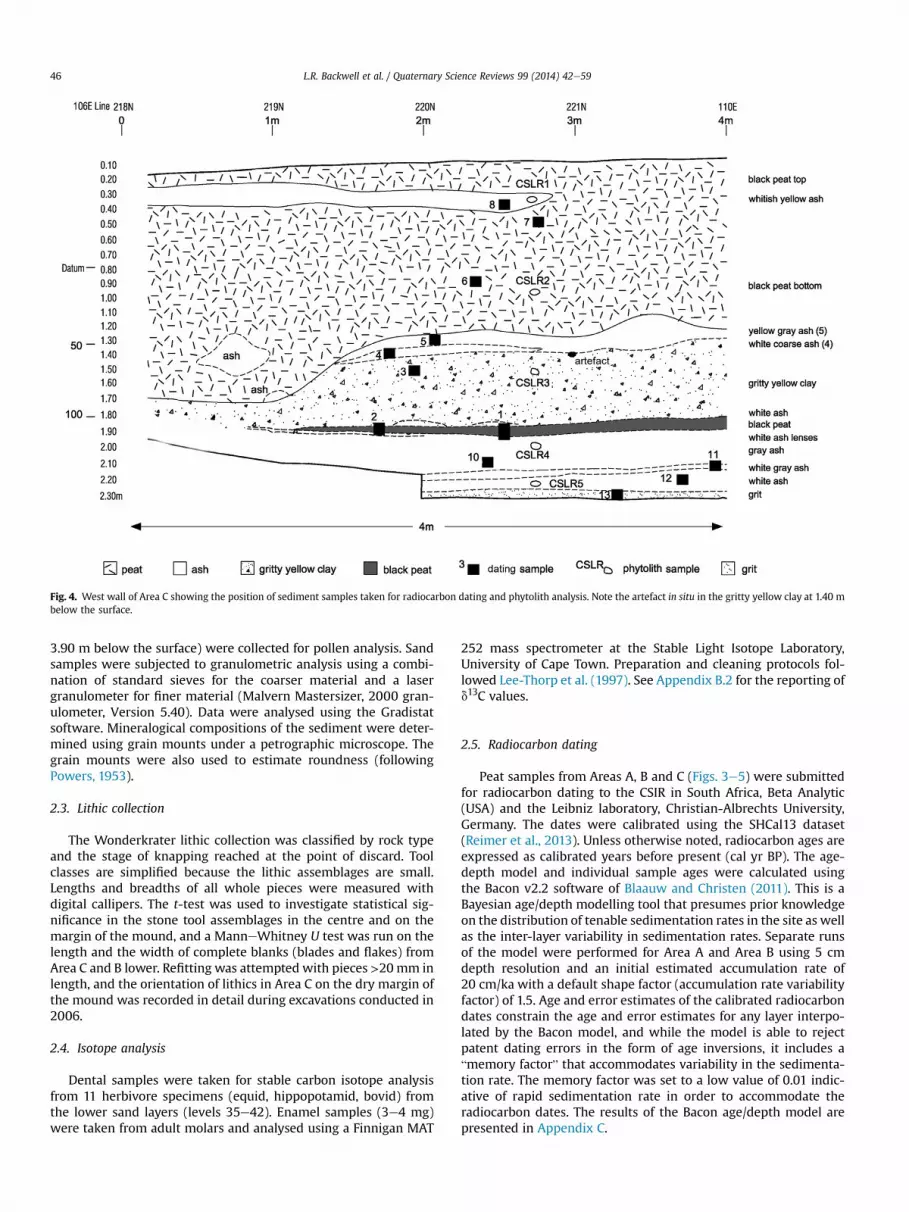
Sediment samples were taken at 10 cm depth intervals fromAreas B and C for analysis and Munsell chart colour clarification.Samples were taken from five layers in Area C (Fig. 4), and 10 layersbetween 1 m and 4 m below the surface in Area B for phytolithanalysis. Sediment samples from the west wall of Area B, from thebottom of the peat to the bottom of thewhite sand unit (2.90m and
ugh sediment cores bored along the F-line (modified after McCarthy et al., 2010). NoteArea C on the dry margin. Radiocarbon and OSL samples were taken in situ during
Fig. 4. West wall of Area C showing the position of sediment samples taken for radiocarbon dating and phytolith analysis. Note the artefact in situ in the gritty yellow clay at 1.40 mbelow the surface.
3.90 m below the surface) were collected for pollen analysis. Sandsamples were subjected to granulometric analysis using a combi-nation of standard sieves for the coarser material and a lasergranulometer for finer material (Malvern Mastersizer, 2000 gran-ulometer, Version 5.40). Data were analysed using the Gradistatsoftware. Mineralogical compositions of the sediment were deter-mined using grain mounts under a petrographic microscope. Thegrain mounts were also used to estimate roundness (followingPowers, 1953).
2.3. Lithic collection
The Wonderkrater lithic collection was classified by rock typeand the stage of knapping reached at the point of discard. Toolclasses are simplified because the lithic assemblages are small.Lengths and breadths of all whole pieces were measured withdigital callipers. The t-test was used to investigate statistical sig-nificance in the stone tool assemblages in the centre and on themargin of the mound, and a ManneWhitney U test was run on thelength and the width of complete blanks (blades and flakes) fromArea C and B lower. Refitting was attempted with pieces >20mm inlength, and the orientation of lithics in Area C on the dry margin ofthe mound was recorded in detail during excavations conducted in2006.
2.4. Isotope analysis
Dental samples were taken for stable carbon isotope analysisfrom 11 herbivore specimens (equid, hippopotamid, bovid) fromthe lower sand layers (levels 35e42). Enamel samples (3e4 mg)were taken from adult molars and analysed using a Finnigan MAT
252 mass spectrometer at the Stable Light Isotope Laboratory,University of Cape Town. Preparation and cleaning protocols fol-lowed Lee-Thorp et al. (1997). See Appendix B.2 for the reporting ofd13C values.
2.5. Radiocarbon dating
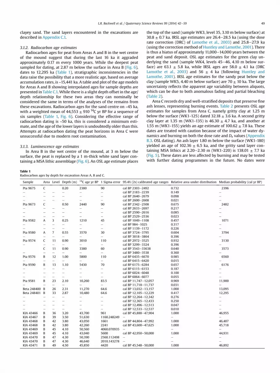
Peat samples from Areas A, B and C (Figs. 3e5) were submittedfor radiocarbon dating to the CSIR in South Africa, Beta Analytic(USA) and the Leibniz laboratory, Christian-Albrechts University,Germany. The dates were calibrated using the SHCal13 dataset(Reimer et al., 2013). Unless otherwise noted, radiocarbon ages areexpressed as calibrated years before present (cal yr BP). The age-depth model and individual sample ages were calculated usingthe Bacon v2.2 software of Blaauw and Christen (2011). This is aBayesian age/depth modelling tool that presumes prior knowledgeon the distribution of tenable sedimentation rates in the site as wellas the inter-layer variability in sedimentation rates. Separate runsof the model were performed for Area A and Area B using 5 cmdepth resolution and an initial estimated accumulation rate of20 cm/ka with a default shape factor (accumulation rate variabilityfactor) of 1.5. Age and error estimates of the calibrated radiocarbondates constrain the age and error estimates for any layer interpo-lated by the Bacon model, and while the model is able to rejectpatent dating errors in the form of age inversions, it includes a“memory factor” that accommodates variability in the sedimenta-tion rate. The memory factor was set to a low value of 0.01 indic-ative of rapid sedimentation rate in order to accommodate theradiocarbon dates. The results of the Bacon age/depth model arepresented in Appendix C.
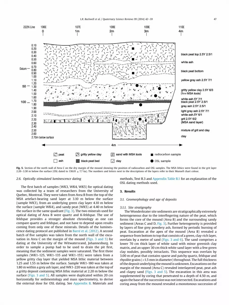
Fig. 5. Section of the north wall of Area C on the dry margin of the mound showing the position of radiocarbon and OSL samples. The MSA lithics were found in the grit layer2.20e3.30 m below the surface (OSL dated to 138.01 ± 7.7 ka). The numbers and letters next to the descriptions of the layers refer to their Munsell chart colour.
The first batch of samples (WK3, WK4, WK5) for optical datingwas collected by a team of researchers from the University ofQuebec, Montreal. They were taken from Area B from the top of theMSA artefact-bearing sand layer at 3.10 m below the surface(sample WK3), from an underlying green clay layer 4.10 m belowthe surface (sample WK4), and sandy peat (WK5) at 4.40 m belowthe surface in the same quadrant (Fig. 3). The two minerals used foroptical dating of Area B were quartz and K-feldspar. The use offeldspar provides a stronger absolute chronology as one cancompare quartz and feldspar, and not have to depend upon resultscoming from only one of these minerals. Details of the lumines-cence dating protocol are published in Barr�e et al. (2012). A secondbatch of five samples was taken from the north wall of the exca-vation in Area C on the margin of the mound (Figs. 3 and 5) fordating at the University of the Witwatersrand, Johannesburg. Inorder to sample a pump had to be used to drain the pit first,meaning that the sediment samples were saturated. The first threesamples (WK1-125, WK1-135 and WK1-155) were taken from ayellow gritty clay layer that yielded MSA lithic material between1.25 and 1.55 m below the surface. Sample WK1-180 was taken at1.80mwithin a grey ash layer, andWK1-220was taken at the top ofa gritty deposit containing MSA lithic material at 2.20 m below thesurface (Figs. 3 and 5). All samples were duplicated within 20 cmhorizontally for sedimentology and mass spectrometry, to derivethe external dose for OSL dating. See Appendix B. Materials and
methods, Text B.3 and Appendix Table B.1 for an explanation of theOSL dating methods used.
3. Results
3.1. Geomorphology and age of deposits
3.1.1. Site stratigraphyTheWonderkrater site sediments are stratigraphically extremely
heterogeneous due to the interfingering nature of the peat, whichforms the core of the mound (Area B) and the surrounding sandysediment (Areas C and D, Fig. 3). Further heterogeneity is providedby layers of fine grey powdery ash, formed by periodic burning ofpeat. Excavation at the apex of the mound (Area B) revealed asequence frombottom to top that consists of a green, clay-rich layer,overlain by a metre of sand (Figs. 3 and 6). The sand comprises alower 70 cm thick layer of white sand with minor greenish claymatrix, and an upper 30 cm thick white sand layer with a few greenclay nodules, possibly intraclasts. This sequence was overlain by3.00 m of peat that contains sparse and patchy quartz, feldspar andrhyolite grains (<1.5mm in diameter) throughout. The full thicknessof thedeposit underlying themound isunknown. Excavationson themargin of the mound (Area C) revealed interlayered peat, peat ashand clayey sand (Figs. 3 and 5). The excavation in this area wassupplemented by coring that penetrated to a depth of 4.50 m, andagain thebaseof the successionwasnot intersected. Excavations andcoring away from the mound revealed a monotonous succession of
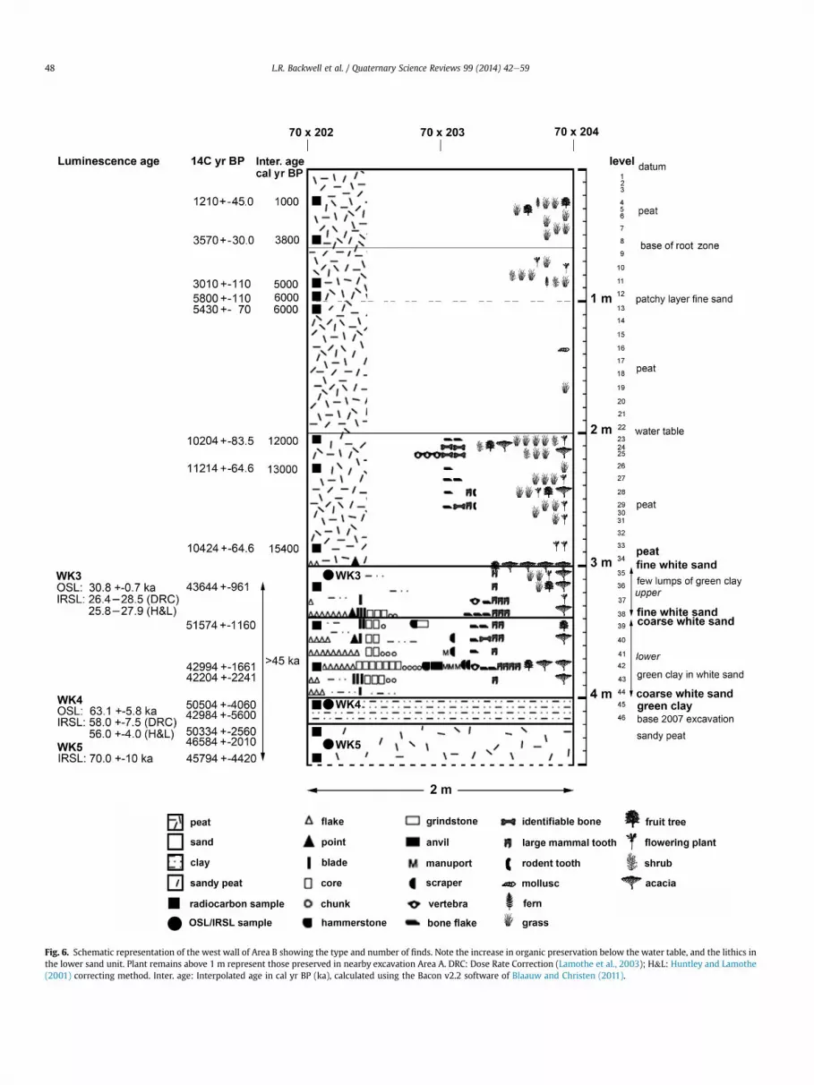
Fig. 6. Schematic representation of the west wall of Area B showing the type and number of finds. Note the increase in organic preservation below the water table, and the lithics inthe lower sand unit. Plant remains above 1 m represent those preserved in nearby excavation Area A. DRC: Dose Rate Correction (Lamothe et al., 2003); H&L: Huntley and Lamothe(2001) correcting method. Inter. age: Interpolated age in cal yr BP (ka), calculated using the Bacon v2.2 software of Blaauw and Christen (2011).
clayey sand. The sand layers encountered in the excavations aredescribed in Appendix C.1.
3.1.2. Radiocarbon age estimatesRadiocarbon ages for peat from Areas A and B in the wet centre
of the mound suggest that during the last 16 ka it aggradedapproximately 0.17 m every 1000 years. While the deepest peatsampled for dating, at 2.87 m below the surface in Area B (Fig. 6),dates to 12,295 ka (Table 1), stratigraphic inconsistencies in thedata raise the possibility that a more realistic age, based on averageaccumulation rates, is ~15,441 ka. A table and plot of the agemodelsfor Areas A and B showing interpolated ages for sample depths arepresented in Table C.1.While there is a slight depth offset in the age/depth relationship for these two areas they can nominally beconsidered the same in terms of the analyses of the remains fromthese excavations. Radiocarbon ages for the sand centre on ~45 ka,with a weighted mean of 44,553 ± 910 14C yr BP for a sequence ofsix samples (Table 1, Fig. 6). Considering the effective range ofradiocarbon dating is ~50 ka, this is considered a minimum esti-mate, and the age of the lower layers is undoubtedly older than this.Attempts at radiocarbon dating the peat horizons in Area C wereunsuccessful due to modern root contamination.
3.1.3. Luminescence age estimatesIn Area B in the wet centre of the mound, at 3 m below the
surface, the peat is replaced by a 1 m-thick white sand layer con-taining a MSA lithic assemblage (Fig. 6). An OSL age estimate places
Table 1Radiocarbon ages by depth for excavation Areas A, B and C.
Sample Area Level Depth (m) 14C age yr BP 1 Sigma error 95.4% (2s) calibr
Pta 9675 C 0.20 2380 90 cal BP 2303e249e e e e e e cal BP 2183e223e e e e e e cal BP 2640e267e e e e e e cal BP 2600e260Pta 9673 C 0.50 2440 90 cal BP 2342e250e e e e e e cal BP 2633e269e e e e e e cal BP 2590e261e e e e e e cal BP 2529e253Pta 9582 A 3 0.25 1210 45 cal BP 1049e110e e e e e e cal BP 984e1025e e e e e e cal BP 1139e117Pta 9580 A 7 0.55 3570 30 cal BP 3724e379e e e e e e cal BP 3818e386Pta 9574 C 11 0.90 3010 110 cal BP 2972e352e e e e e e cal BP 3299e332
C 11 0.90 3380 60 cal BP 3543e336e e e e e e cal BP 3480e353Pta 9576 B 12 1.00 5800 110 cal BP 6435e667e e e e e e cal BP 6415e642Pta 9590 B 13 1.10 5430 70 cal BP 6175e628e e e e e e cal BP 6115e615e e e e e e cal BP 6024e604e e e e e e cal BP 6064e607Pta 9581 B 23 2.10 10,260 83.5 cal BP 11,747e1e e e e e e cal BP 11,718e1Beta 248400 B 26 2.31 11,270 64.6 cal BP 13,032e1Beta 248401 B 33 2.87 10,480 64.6 cal BP 12,105e1e e e e e e cal BP 12,264e1e e e e e e cal BP 12,365e1e e e e e e cal BP 12,496e1e e e e e e cal BP 12,533e1KIA 43466 B 36 3.20 43,700 961 cal BP 45,888e4KIA 43467 B 39 3.50 51,630 1160.248249 e
KIA 43468 B 42 3.80 43,050 1661 cal BP 44,804e4KIA 43468 B 42 3.80 42,260 2241 cal BP 43,600e4KIA 43469 B 45 4.10 50,560 4060.070935 e
KIA 43469 B 45 4.10 43,040 5600 cal BP 42,950e5KIA 43470 B 47 4.30 50,390 2560.112498 e
KIA 43470 B 47 4.30 46,640 2010.143278 e
KIA 43471 B 49 4.50 45,850 4420 cal BP 45,548e5
the top of the sand (sample WK3, level 35, 3.10 m below surface) at30.8 ± 0.7 ka. IRSL age estimates are 26.4e28.5 ka (using the doserate correction (DRC) of Lamothe et al., 2003) and 25.8e27.9 ka(using the correctionmethod of Huntley and Lamothe, 2001). Thereis thus a hiatus of approximately 11,000e14,000 years between thepeat and sand deposit. OSL age estimates for the green clay un-derlying the sand (sample WK4, levels 45e46, 4.10 m below sur-face) are 63.1 ± 5.8 ka, while IRSL ages are 58.0 ± 4.1 ka (DRCLamothe et al., 2003) and 56 ± 4 ka (following Huntley andLamothe, 2001). IRSL age estimates for the sandy peat below theclay (sample WK5, 4.40 m below surface) are 70 ± 10 ka. The largeuncertainty reflects the apparent age variability between aliquots,which can be due to both anomalous fading and partial bleaching(Table 2).
Area C records dry andwell-stratified deposits that preserve fineash lenses, representing burning events. Table 2 presents OSL ageestimates for samples from Area C, namely gritty clay at 1.25 mbelow the surface (WK1-125) dated 32.18 ± 3.6 ka. A second grittyclay layer at 1.35 m (WK1-135) is 46.30 ± 4.7 ka, and another at1.55 m (WK1-155) yields an age estimate of 100.62 ± 7.8 ka. Thesedates are treated with caution because of the impact of water dy-namics and burning on both the dose rate and De values (AppendixB.3. OSL dating). An ash layer 1.80 m below the surface (WK1-180)yielded an age of 102.36 ± 6.5 ka, and the gritty sand layer con-taining MSA lithics at 2.20e2.30 m (WK1-220) is 138.01 ± 7.7 ka(Fig. 5). These dates are less affected by burning and may be testedwith further dating programmes in the future. No dates were
ated age ranges Relative area under distribution Median probability (cal yr BP)
2 0.732 23969 0.149 e
9 0.098 e
8 0.021 e
8 0.675 24827 0.217 e
6 0.085 e
6 0.023 e
8 0.457 10710.317 e
2 0.226 e
5 0.604 37944 0.396 e
5 0.932 31304 0.396 e
38 0.640 35738 0.360 e
0 0.985 65600 0.015 e
4 0.657 61763 0.187 e
8 0.100 e
7 0.055 e
2,057 0.969 11,9001,737 0.031 e
3,157 1.000 13,0952,229 0.417 12,2952,342 0.276 e
2,433 0.250 e
2,513 0.047 e
2,537 0.010 e
7,904 1.000 46,955e e
7,992 1.000 46,4077,625 1.000 45,718
e e
0,000 1.000 44,931e e
e e
0,000 1.000 46,892
Table 2Age estimates for optically dated samples from excavation Areas B and C.
Depth(m)
Area Soil type Sampleno.
Optical dating method
OSL IRSL (DRC) IRSL (H&L)
3.10 B Sand WK3 30.8 ± 0.7 26.4e28.5 25.8e27.94.10 B Clay WK4 63.1 ± 5.8 58 ± 4.1 56 ± 4.04.40 B Sandy peat WK5 e 70 ± 10.0 >Range1.25 C Gritty clay WK1-125 32.18 ± 3.6 e e
1.35 C Gritty clay WK1-135 46.30 ± 4.7 e e
1.55 C Gritty clay WK1-155 100.62 ± 7.8 e e
1.80 C Ash WK1-180 102.36 ± 6.5 e e
2.20 C Grit/sand WK1-220 138.01 ± 7.7 e e
OSL ages from Area C are based on a minimum age model.DRC: Dose Rate Correction (Lamothe et al., 2003); H&L: Huntley and Lamothe (2001)correction method.For WK5: Large uncertainty due to variability related to both fading and partialbleaching.>Range: Natural luminescence beyond linear laboratory growth curve, thus Huntleyand Lamothe (2001) not applicable.
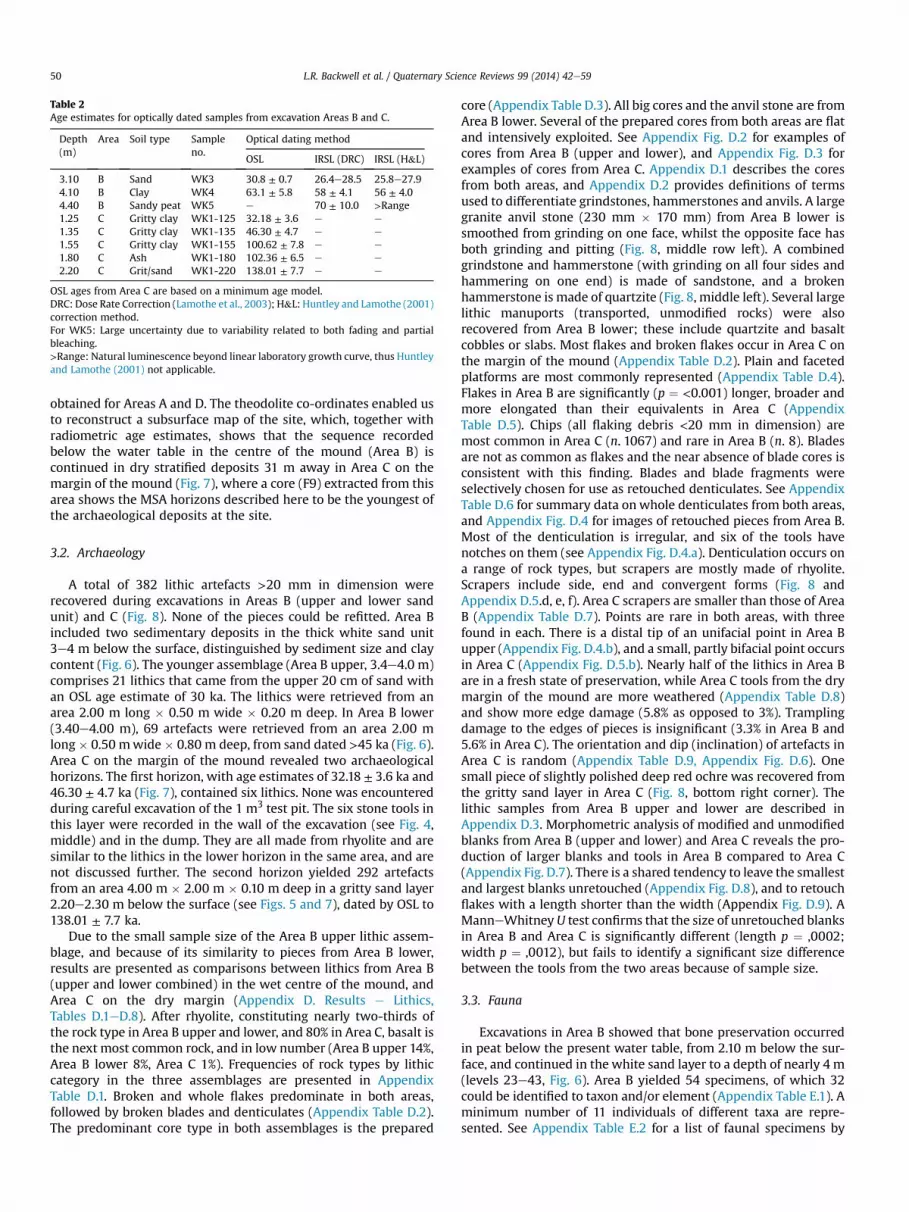
obtained for Areas A and D. The theodolite co-ordinates enabled usto reconstruct a subsurface map of the site, which, together withradiometric age estimates, shows that the sequence recordedbelow the water table in the centre of the mound (Area B) iscontinued in dry stratified deposits 31 m away in Area C on themargin of the mound (Fig. 7), where a core (F9) extracted from thisarea shows the MSA horizons described here to be the youngest ofthe archaeological deposits at the site.
3.2. Archaeology
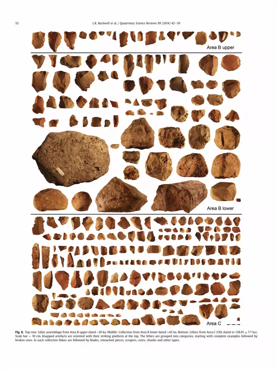
A total of 382 lithic artefacts >20 mm in dimension wererecovered during excavations in Areas B (upper and lower sandunit) and C (Fig. 8). None of the pieces could be refitted. Area Bincluded two sedimentary deposits in the thick white sand unit3e4 m below the surface, distinguished by sediment size and claycontent (Fig. 6). The younger assemblage (Area B upper, 3.4e4.0 m)comprises 21 lithics that came from the upper 20 cm of sand withan OSL age estimate of 30 ka. The lithics were retrieved from anarea 2.00 m long � 0.50 m wide � 0.20 m deep. In Area B lower(3.40e4.00 m), 69 artefacts were retrieved from an area 2.00 mlong � 0.50 mwide � 0.80 m deep, from sand dated >45 ka (Fig. 6).Area C on the margin of the mound revealed two archaeologicalhorizons. The first horizon, with age estimates of 32.18 ± 3.6 ka and46.30 ± 4.7 ka (Fig. 7), contained six lithics. None was encounteredduring careful excavation of the 1 m3 test pit. The six stone tools inthis layer were recorded in the wall of the excavation (see Fig. 4,middle) and in the dump. They are all made from rhyolite and aresimilar to the lithics in the lower horizon in the same area, and arenot discussed further. The second horizon yielded 292 artefactsfrom an area 4.00 m � 2.00 m � 0.10 m deep in a gritty sand layer2.20e2.30 m below the surface (see Figs. 5 and 7), dated by OSL to138.01 ± 7.7 ka.
Due to the small sample size of the Area B upper lithic assem-blage, and because of its similarity to pieces from Area B lower,results are presented as comparisons between lithics from Area B(upper and lower combined) in the wet centre of the mound, andArea C on the dry margin (Appendix D. Results e Lithics,Tables D.1eD.8). After rhyolite, constituting nearly two-thirds ofthe rock type in Area B upper and lower, and 80% in Area C, basalt isthe next most common rock, and in low number (Area B upper 14%,Area B lower 8%, Area C 1%). Frequencies of rock types by lithiccategory in the three assemblages are presented in AppendixTable D.1. Broken and whole flakes predominate in both areas,followed by broken blades and denticulates (Appendix Table D.2).The predominant core type in both assemblages is the prepared
core (Appendix Table D.3). All big cores and the anvil stone are fromArea B lower. Several of the prepared cores from both areas are flatand intensively exploited. See Appendix Fig. D.2 for examples ofcores from Area B (upper and lower), and Appendix Fig. D.3 forexamples of cores from Area C. Appendix D.1 describes the coresfrom both areas, and Appendix D.2 provides definitions of termsused to differentiate grindstones, hammerstones and anvils. A largegranite anvil stone (230 mm � 170 mm) from Area B lower issmoothed from grinding on one face, whilst the opposite face hasboth grinding and pitting (Fig. 8, middle row left). A combinedgrindstone and hammerstone (with grinding on all four sides andhammering on one end) is made of sandstone, and a brokenhammerstone is made of quartzite (Fig. 8, middle left). Several largelithic manuports (transported, unmodified rocks) were alsorecovered from Area B lower; these include quartzite and basaltcobbles or slabs. Most flakes and broken flakes occur in Area C onthe margin of the mound (Appendix Table D.2). Plain and facetedplatforms are most commonly represented (Appendix Table D.4).Flakes in Area B are significantly (p ¼ <0.001) longer, broader andmore elongated than their equivalents in Area C (AppendixTable D.5). Chips (all flaking debris <20 mm in dimension) aremost common in Area C (n. 1067) and rare in Area B (n. 8). Bladesare not as common as flakes and the near absence of blade cores isconsistent with this finding. Blades and blade fragments wereselectively chosen for use as retouched denticulates. See AppendixTable D.6 for summary data onwhole denticulates from both areas,and Appendix Fig. D.4 for images of retouched pieces from Area B.Most of the denticulation is irregular, and six of the tools havenotches on them (see Appendix Fig. D.4.a). Denticulation occurs ona range of rock types, but scrapers are mostly made of rhyolite.Scrapers include side, end and convergent forms (Fig. 8 andAppendix D.5.d, e, f). Area C scrapers are smaller than those of AreaB (Appendix Table D.7). Points are rare in both areas, with threefound in each. There is a distal tip of an unifacial point in Area Bupper (Appendix Fig. D.4.b), and a small, partly bifacial point occursin Area C (Appendix Fig. D.5.b). Nearly half of the lithics in Area Bare in a fresh state of preservation, while Area C tools from the drymargin of the mound are more weathered (Appendix Table D.8)and show more edge damage (5.8% as opposed to 3%). Tramplingdamage to the edges of pieces is insignificant (3.3% in Area B and5.6% in Area C). The orientation and dip (inclination) of artefacts inArea C is random (Appendix Table D.9, Appendix Fig. D.6). Onesmall piece of slightly polished deep red ochre was recovered fromthe gritty sand layer in Area C (Fig. 8, bottom right corner). Thelithic samples from Area B upper and lower are described inAppendix D.3. Morphometric analysis of modified and unmodifiedblanks from Area B (upper and lower) and Area C reveals the pro-duction of larger blanks and tools in Area B compared to Area C(Appendix Fig. D.7). There is a shared tendency to leave the smallestand largest blanks unretouched (Appendix Fig. D.8), and to retouchflakes with a length shorter than the width (Appendix Fig. D.9). AManneWhitney U test confirms that the size of unretouched blanksin Area B and Area C is significantly different (length p ¼ ,0002;width p ¼ ,0012), but fails to identify a significant size differencebetween the tools from the two areas because of sample size.
3.3. Fauna
Excavations in Area B showed that bone preservation occurredin peat below the present water table, from 2.10 m below the sur-face, and continued in the white sand layer to a depth of nearly 4 m(levels 23e43, Fig. 6). Area B yielded 54 specimens, of which 32could be identified to taxon and/or element (Appendix Table E.1). Aminimum number of 11 individuals of different taxa are repre-sented. See Appendix Table E.2 for a list of faunal specimens by
Fig. 7. Schematic diagram of stratigraphic columns of excavated Area B in the wet centre of the mound at an elevation of 2.50 m above the surrounding terrain, and Area C on thedry margin 31 m away. Note how deposits absent in Area C are represented in Area B from ~1 to 3 m below the surface. Layers with MSA stone tools are represented as 1e5 in bolditalics. Numbers in parentheses are the mean grain size and standard deviation.
taxon. Complete specimens are well-preserved, but fragmentedteeth and bones are water worn. Of the bone specimens in the pre-Holocene peat levels, fivewere identified as fresh and eight showedpre-depositional weathering stage 1 (following Behrensmeyer,1978). Possible carnivore gnawing was observed on two pieces,and four possible coprolites were recovered. Of the bone specimensfound in the MSA sand layer, one could be identified as fresh andfour showed weathering stage 1. Possible carnivore gnawing wasobserved on four pieces and two showed traces of burning. Noevidence of butchering in the form of cut or impact marks wasobserved on the faunal remains. The fauna is described in AppendixE.1 and shown in Appendix Figs E.1 and E.2. The d13C values arepresented in Appendix Table E.3 and Appendix Fig. E.3, and indicate
savanna environment in the area during late marine OxygenIsotope Stage (MIS) 3.
3.4. Flora
Plant remains in the form of charcoal and fruiting structures,which were retrieved from Areas A and B, are presented inAppendix Table F.1. The results of charcoal analysis are discussed inAppendix F.1, and fruits and seeds are discussed in Appendix F.2. Aprovisional examination of pollen from the west wall of Area B,levels 33e43, between 2.90 m and 3.90 m below the surface(bottom of the peat to the bottom of the white sand unit, see Fig. 6),suggests two vegetation phases. Apart from abundant grass, sedge,
Fig. 8. Top row: Lithic assemblage from Area B upper dated ~30 ka. Middle: Collection from Area B lower dated >45 ka. Bottom: Lithics from Area C (OSL dated to 138.01 ± 7.7 ka).Scale bar ¼ 10 cm. Knapped artefacts are oriented with their striking platform at the top. The lithics are grouped into categories, starting with complete examples followed bybroken ones. In each collection flakes are followed by blades, retouched pieces, scrapers, cores, chunks and other types.
Typha and other local elements, the lower part of the white sandbetween 3.70 m and 3.90 m (levels 41e43), aged >45 ka, containsAsteraceae with some woodland types: Tarchonanthus, Cappar-idaceae, Combretaceae, Peltophorum, Mimosoideae, etc., suggestingrelatively warm dry savanna vegetation. Above this, from 2.90 m to3.60 m (levels 33e40), grass pollen, aquatics, semi aquatics andAsteraceae persist, but the latter began to include more Stoebe andArtemisia types. Together with Ericaceae, Passerina, yellow wood(Podocarpus) and wild olive (Olea) pollen, they indicate somewhatcooler and wetter conditions by 30 ka. Phytolith analysis, whichfocused mainly on sedge and grass phytoliths because they providethemost direct evidence of C4/C3 or xeric/mesic conditions in termsof the phytolith signal, show that large sedge-type, as well asbulliform-shaped grass phytoliths are the most abundant elementsin the upper peat-rich sections. Trapeziform short cell phytoliths,associated with relatively cool winter rainfall conditions occurmore frequently in the sand unit between 3.00m and 4.00m belowthe surface in levels 33e44, aged ~30 to >45 ka (Fig. 6). C4 grassesadapted to warm summer rainfall climates in southern Africa,represented by saddle, cross and associated bilobate short cellphytoliths (Rossouw, 2009) are absent from the sand levels, sup-porting cooler conditions between 30 and >45 ka.
4. Discussion
4.1. Geomorphology and age
Considering the potential for younger carbon contamination inthe peat sequence from rootlet penetration into underlying layersduring peat formation, we feel that the timing of the events andtrends described for this site should be treated as best estimatesonly. Radiocarbon ages obtained through this study indicate asignificantly slower accumulation rate compared to those previ-ously reported from cores by Scott et al. (2003). This is likely theresult of varying accumulation rates across the spring mound. Thedepth of the sand level with MSA artefacts in the excavation in thecentre of themoundwas found to be 1.35m lower than in sedimentcores extracted from a nearby part of the mound two years later.This is most likely due to expansion and contraction of the springand peat mound during wet and dry phases, as reported byAlmendinger et al. (1986), as the water table in this study plottedhalf a metre lower than the level reported byMcCarthy et al. (2010).Excavations were always conducted during dry winter months,while coring took place amid the heavy rains of summer when thepeat was swollen.Whether wet or dry, the site stratigraphy remainsthe same.
Excavations revealed a geological event or process in the strat-igraphic sequence in the form of a 1 m-thick sand layer, comprisingtwo depositional events. The top of the sand has an age of 30 ka.Radiocarbon ages for the rest of the sand are centred on 45 ka,which is interpreted as a minimum age estimation. The age of thewhite sand is bracketed by the luminescence dates from the top ofthe layer, and the dates for the underlying clay layer, placing theperiod of sand deposition in the age range c. 60 kae30 ka. Theactual time span of sand deposition is unknown and further agecontrol will be required to determine this. The poorly sorted natureof the sediment, its angularity and fresh state would appear toreflect deposition during flash flooding, but with the data availableit cannot be determined if these sediments reflect a durable long-term change in mean environmental conditions or single events.The conditions that resulted in the deposition of the sand alsoattracted people to the site, but whether it served as an oasis in anarid landscape, or was visited during wet phases, remains unclear.
The use of intercalated sand layers in the peat as climatic in-dicators is clearly problematic. The mound and the surrounding
piedmont have aggraded more or less in concert (McCarthy et al.,2010) and for much of the time, the peat mound formed a topo-graphically positive feature, thus confining sand deposition to theperiphery. Apart from the tiny quartz, feldspar and rhyolite grainsup to 1.5 mm in diameter dispersed throughout the peat e whichwere probably incorporated through transportation by animalsrather than wind, considering that the mean grain size of wind-blown Kalahari sand is 0.2 mm e the incursion of sand layers intothe mound could be caused by a number of factors. For example,prolonged drought may have greatly reduced artesian flow into themound, resulting in subsidence and possibly burning of the peat,thus allowing the surrounding sediment to encroach partially orcompletely over the mound. Another possibility is a shift in theposition of the spring due, for example, to an earthquake or toclogging of the sub-surface flow path by precipitation of minerals.The original mound may have been thus isolated from its watersupply, resulting in shrinkage and sediment invasion, with themound position moving elsewhere in the area.
4.2. Stone tools
Although small, the Wonderkrater lithic collection includes awide range of products frequently found in a knapping sequence:unmodified blocks, chunks, chips (knapping products <20 mm),cores, whole flakes and blades, broken flakes and blades, andseveral classes of retouched tools. There is a high percentage ofprepared cores, flakes with convergent flake scars and facetedplatforms, so knapping that took place at the site was not expe-dient. If it had been so, we should expect to find many more casualcores than is the case. Denticulates and scrapers are the mostcommonly represented retouched tools. Denticulates and bladesseem suitable knives for cutting hide, flesh and sinews during thedismembering of animals. However, blade-shaped denticulatesmay also have been used at the site to cut reeds and grasses thatmay have served a number of purposes, such as creating screens forshelter, bedding or shafts for composite weapons. Scrapers aretraditionally thought to imply hide-working, which would be ex-pected at a site where carcasses are processed. The Wonderkraterscrapers are so varied in form, however, that a variety of tasks couldbe implied. Large manuports, the hammerstone and the anvil occurin Area B lower in the wet centre of the mound. The anvil may havebeen part of the tool knapping process and this could explain thepitted surface on one side of the block. Smoothing and grinding ispresent on the opposite face and this could be accounted for by arange of activities, some of which might be associated withbutchery, such as bone breakage and pounding on an anvil, and theprocessing of plant foods. Notwithstanding the presence of coresand large knapping products, there are hardly any chips in Area B.Most chips (82%) are in the older Area C where there are alsosmaller knapping products and cores. This suggests that littlewinnowing occurred here, and that most knapping, and activitiesthat required the use of denticulates and scrapers, took place on themargin of the mound. Most lithics in Area C on the margin areweathered, indicating that they were exposed on the surface forsome time. Only half the lithics in Area B are weathered, most likelybecause the artefacts were covered by sand soon after they wereabandoned. Trampling damage to the edges of pieces is insignifi-cant (3.3% in Area B and 5.6% in Area C). The composition of theassemblage and randomly aligned positions of lithics greater than20 mm in Area C, also seem to indicate relatively little disturbance.Refitted artefacts are a good indicator that sediments are in situ, butrefitting was unsuccessful, possibly due to the small sample size.The rarity of retouched points, which are generally considered to bethe tips of hunting spears, implies that the spring mound was not ahunting venue. The composition of the lithic assemblages, rich in
cutting tools, suggests that the site was a place primarily used forprocessing animals that were deliberately or accidentally trappedinmud or peat (Weigelt, 1989). Peoplemay also have visited the siteto exploit other resources, such as birds, amphibians, reptiles,edible and medicinal plants, and plants used for shelters, tools andbedding. Such resources are utilised bymodern San communities atsimilar sites (Cowley, 1968; Seiner and Esche, 1977; van Wyk andGericke, 2000). Of the numerous resources available at Wonder-krater, Citrullus lanatus (tsamma melons) and Phragmites reeds,now shown to have grown on the mound in deposits dated >45 ka,were no doubt of particular interest to hunteregatherers. Reeds area common organic component of traditional San material culture(Lee and DeVore, 1976; Marshall, 1976; Silberbauer, 1981; Wanless,2007), recently shown to be in place by 44 ka at Border Cave, on theKwaZulu-Natal north coast of South Africa (d'Errico et al., 2012b).Most cores are of the prepared core type, and the morphologies ofthe scrapers, denticulates and retouched pieces confirm a MSAindustry throughout the sequence, with no significant technolog-ical difference between the lithic assemblages in Area B upper(30 ka), Area B lower (>45 ka) and Area C (138.01 ± 7.7 ka). Thedifferences recorded in the lithics from Area B in the wet centre ofthe mound, and those from Area C on the dry margin, may reflectdiverse activities and thus functions in different parts of the site,cultural differences, or both. An argument in favour of function issupported by the fact that, in spite of using the same strategy in thechoice of the blanks, artisans from Area B in the wet centre of themound wished to produce tools that are much bigger than thosefrom Area C.
Area C on the margin of Wonderkrater has a basal age of 138 kaago, placing it in late MIS 6. Assemblages dating to MIS 6 have beenfound in other South African sites such as Florisbad (top of Peat IIwith an age of 133.0± 31.0 ka) (Grün et al., 1996), Border Cave (Grünet al., 2003), Bundu Farm (Kiberd, 2006), Pinnacle Point 13 B(Jacobs, 2010), Wonderwerk (Beaumont and Vogel, 2006), andYsterfontein 1 (Halkett et al., 2003; Avery et al., 2008). Wurz (2013)suggests that no spatial or chronological patterns can be recognizedin the MSA prior to MIS 5, 130 ka ago. It is therefore not surprisingthat the Wonderkrater 138 ka assemblage cannot be matched withcontemporary assemblages. The ‘Pietersburg’ techno-complex iswell-represented in the northern part of South Africa, for exampleat Cave of Hearths (Sinclair, 2009), but there are no clear linksbetween Pietersburg technology and that from Wonderkrater. InVolman's (1984) numerical classification system for South Africathe earliest phase is MSA 1, in which denticulates are prominent.Denticulates are a typological feature in Ysterfontein 1, in theearliest Klasies River assemblage (Wurz, 2002) and also atWonderkrater.
Southern African sites with ages more recent than about 58 kahave been informally assigned to the post-Howiesons Poort (post-HP). At Apollo 11, Namibia, the immediate post-HP layer (calledMSA Complex 4) contains blades, triangular flakes and only rareretouched tools, including some unifacial points and scrapers(Wendt, 1976; Vogelsang, 1996; Jacobs et al., 2008). Several West-ern Cape sites have post-HP assemblages. The Klasies sequencecontains large blades and “knives” that comprise flat retouch onblades (Wurz, 2002), at Klein Kliphuis unifacial points are common(Jacobs et al., 2008), while at Diepkloof Rock Shelter there areunifacial points together with scrapers and denticulates(Parkington, 2006; Porraz et al., 2013). Farther east, the coastal siteof Die Kelders contains blades, but little retouch (Thackeray, 2000).The post-HP lithic assemblages from Rose Cottage Cave, easternFree State, contain unifacial points and Levallois and bipolarreduction strategies (Villa and Lenoir, 2006; Soriano et al., 2007). AtNtloana Tsoana, Lesotho, formal tools, which account for only 0.6%of the entire assemblage, are dominated by unifacial points, knives
and scrapers, and the assemblage shows clear parallels with RoseCottage. At Sehonghong, also in Lesotho, scrapers are the mostcommon tool type (Jacobs et al., 2008). At Border Cave, the post-HPassemblages from layer 2WA contain blades (Beaumont et al., 1978;Villa et al., 2012), while the prolific Sibudu assemblage has unifacialpoints (Villa et al., 2005; Wadley, 2005). Mwulu's Cave (Tobias,1949), is another MSA site close to Wonderkrater. Wonderkraterlacks the bifacial points of Mwulu's Cave, but contains similarscrapers. Unfortunately Mwulu's is also undated.
MSA assemblages continue late in the South African sites ofSibudu (Wadley, 2005), Rose Cottage Cave (Wadley and Vogel,1991; Wadley, 1993, 1997; Clark, 1997a,b; Valladas et al., 2005),Florisbad (Kuman et al., 1999), Strathalan Cave B (Opperman andHeydenrych, 1990), Driekoppen Shelter (Wallsmith, 1990), High-lands Rock Shelter (Deacon, 1976), Boomplaas (Deacon, 1995),Umhlatuzana (Kaplan, 1990; Lombard and Phillipson, 2010) andGrassridge (Opperman, 1987). MSA tools also seem to continue lateat Sehonghong in Lesotho (Carter et al., 1988; Mitchell, 1994), atSibebe, Swaziland (Price-Williams, 1981), and Apollo 11, Namibia(Wendt, 1976). At Sehonghong and at Rose Cottage a variety ofscrapers has been found together with several unifacial points, butthere are low frequencies of formal tools, as at Strathalan Cave B(Opperman and Heydenrych, 1990). The youngest MSA layer atBoomplaas, dated by radiocarbon on charcoal to c. 36,600 ka(Deacon, 1979, 1995), has many long blades like the ones at High-lands (Volman, 1981, 1984). South-western Namibian final MSAsites also have few formal tools and an apparent lack of standard-ization among other lithics (Vogelsang, 1996). The presence atSibudu, Shongweni and Umhlatuzana of some backed tools in thefinal MSA is noteworthy and may represent a local tradition(Wadley, 2005). TheWonderkrater Area B upper (~30 ka) and lower(>45 ka) lithic assemblage also cannot easily be matched to otherlate or final MSA assemblages described from a variety of sites insouthern Africa, but this is not surprising since late MSA assem-blage are highly variable (Wadley, 2005). Florisbad is an open-airspring site like Wonderkrater and its MSA horizon is a Last Inter-glacial human occupation in primary context, on a palaeo-surfacethat records directly associated lithic and subsistence remains(Brink and Henderson, 2001). The uppermost MSA levels may becontemporary with the Wonderkrater Area B occupation. TheWonderkrater Area B MSA assemblages correspond temporallymost closely to Unit E at Florisbad (Kuman et al., 1999: 1418), butdoes not readily match it. This is the final MSA unit at Florisbad,which predates the c. 22e13.5 ka hiatus in the cultural sequence. Itcontained 116 decayed artefacts, three or four triangular flakes andten faceted striking platforms. The two spring sites, althoughgeographically far apart, seem to have encouraged the same type ofexistence, even though their technologies are not really compara-ble. Research on societal responses to prolonged drought, identifieswater availability as the key environmental determinant for life insemi-arid regions (DeMenocal, 2001). The importance of water tothe survival of people inhabiting a semi-arid environment isdocumented by Lee (1968) in his ethnographic account of Bushmenhunter-gatherer subsistence. This work also highlights the impor-tance of plant foods, which constitute 60e80% of the diet, withnutritious and calorie-rich mongongo nuts providing half of thevegetable diet. While the mongongo nut is drought resistant, pro-longed millennial scale drought would destroy mongongo forests,with devastating effects to those dependent upon them as a pre-dictable, abundant and sedentary food source. In this regard,environmental stress, a decline in the number and diversity ofinland fauna, and the growth of carbohydrate-rich corms else-where, likely led late Pleistocene hunter-gatherers in southern Af-rica to migrate to other areas. This is particularly likely for peopleliving in the Wonderkrater area, considering that fruiting trees,
including frost-tender marulas provide most of the wild plant foodavailable to people in a savanna environment (Wadley,1993).Whilethe effect of climate change on MSA human demographics andbehaviour is unclear, the lack of Later Stone Age artefacts in theoverlying warm and wet Holocene peat deposits at Wonderkrater,at a timewhen there was a dramatic increase in LSA sites in the restof southern Africa (Deacon and Thackeray,1984), suggests a distinctchoice by LSA people to adapt socially and culturally to otherbiomes.
4.3. Fauna
Excavations at Wonderkrater yielded a relatively diverse Flo-risian fauna (Klein, 1984a). The bone surfaces appear fresh orslightly weathered, indicating that they were buried quite rapidly.Several key faunal indicators aid in the interpretation of environ-mental conditions at the site at the time of MSA human occupation(~30 to >45 ka). The Syncerus antiquus (African long-horned buf-falo) and Megalotragus priscus (resembling wildebeest) indicatehighly productive grasslands (Brink and Lee-Thorp, 1992; Brink,2005; Codron et al., 2008), while the d13C values indicate grasslandand at least some C3 woody vegetation in the area during late OIS 3.There are three extinct taxa in the faunal assemblage, S. antiquus inthe upper white sand layer dated ~30 ka, and Equus capensis (Capezebra) and M. priscus in the lower sand unit, dated >45 ka. Thesetaxa form part of a range of large mammals that went extinct be-tween 12 ka and ~0.8 ka (Klein, 1980, 1984b; Brink, 2005; Barnosky,2008), and they are absent at Wonderkrater after 30 ka, as are signsof human occupation. The presence of Diceros bicornis (black rhino)in younger peat deposits (12e15 ka) indicates some bush or lowtree cover at this time. Even though the fauna and lithics werefound in association in the saturated sand layer 2.00e3.00 m belowthe surface in Area B, the fossils record no evidence of butchering.On the one hand, this may be because the animals are representedmostly by teeth and distal limbs, elements that often do not pre-serve evidence of butchering activities (Enloe, 1993; Fisher, 1995;Thompson and Henshilwood, 2011). On the other hand, the rhinomight not have been processed by humans, who performed othertasks at the site.
4.4. Flora
4.4.1. Fruits and seedsThe cf. Vahlia capensis fruits and cf. Xyris capensis flowers
confirm the presence of moist conditions (Pooley,1998), in this caseprobably a fen, between ~1500 ka and 5500 ka. The Acacia seeds, cf.Searsia fruit and C. lanatus (watermelon) seed suggest sandygrassland interspersed with woody plants (Meeuse, 1962; Smit,1999) at ~12 ka. The oldest seed, recovered from 16 ka peat de-posits, is Acacia cf. nilotica. A. nilotica has a wide habitat tolerance,but is generally absent fromwatercourses (Smit, 1999; 57) and thusis likely to have been growing beyond the fen, possibly in Acaciawoodland similar to the present day environment (AppendixFig. A.1).
4.4.2. Pollen and microscopic charcoalProvisionally, the pollen sequence observed in Area B through
excavations between 2.90 m and 3.90 m below the surface (aboveand including the 1 m-thick sand unit) appears to follow thetransition in Scott's Borehole 4 in Zones W2 to W4 (Scott, 1982,1999), but this correlation should be confirmed by more pollencounts from this excavation. Based on the different dating results,including the Bayesian age modelling (Appendix Fig. C.1), thetransition suggests that the MSA experienced a marked change inclimate from moderately warm and dry conditions with savanna
woodland vegetation (>40 ka, 3.70e3.90 m or levels 41e43) to cooland wet conditions with grassland that included woody shrubs~30 ka (3.00e3.40m or levels 35e38). The charcoal pieces are likelyto represent more local elements, whereas the pollen represents amixture of local and long-distance wind transported elements.Microscopic charcoal in the pollen preparations of Scott's Borehole4, which is an indication of burning, seems to suggest moderatelyincreased fire frequency as conditions cooled during this transition(Borehole 4, Zones W2e3), reaching higher values during thecoolest phase (Borehole 3 and 4, Zone W4) (Scott, 2002), but thisshould be confirmed by charcoal counts from Area B. The new datesfor the fossil and bone rich levels in Area B seem to support thesuggestion (Scott, 1982, 1999; Scott et al., 2003) that the oldest ofthe radiocarbon dates in Borehole 4 (c. 34,400 yr BP, un-calibrated)is a minimum age estimate.
4.4.3. Grass phytolithsRelatively cool growing conditions for grasses occurred in the
region ~30 ka, as evidenced by the predominance of trapeziformshort cell phytoliths in the sand layers, normally found in rela-tively cool, winter rainfall areas and environments with relativelymoist, edaphic conditions (Rossouw, 2009). Their occurrence inthe record could be attributed solely to the local edaphic sur-roundings at the spring, but the marked paucity of characteristicC4 phytolith types, such as saddle and long-necked bilobates,adapted to warm summer rainfall climates, supports a cool andmoist late MSA climatic interpretation. A shift towards predomi-nantly bulliform phytoliths in the peat deposits above 3 m in-dicates a marked change in climatic conditions. The formation ofsilicified bulliform cells is attributed to grasses growing underconditions of increased transpiration or stress caused by a lack ofwater, leading to silica saturation and deposition (Bremond et al.,2005). An overall predominance of bulliform phytoliths in the peatdeposits thus indicates relatively warmer conditions and increaseddrought stress over the last ~14,000 years relative to the period>30 ka.
4.4.4. CharcoalIn the first 85 cm below the surface in the wet centre of the
mound, Phragmites sp. charcoal is abundant; grass occurs as well,but there is no dicotyledonous wood. The abundance and domi-nance of Phragmites in the upper peat levels (<6 ka) indicates apermanent wetland. Appendix Table F.1 details the plant remainspreserved by depth in the centre of the mound. From 2.10 to2.40 m (~12e13 ka), woody Diospyros austro-africana charcoal isfound sporadically amongst the Phragmites and grass charcoaldominated assemblage, perhaps indicating fluctuating wetter anddrier periods that correspond to rapid climate shifts in the interiorduring the terminal Pleistocene (Holmgren et al., 2003; Truc et al.,2013). Schotia brachypetala, found in the upper white sand levelsat 3.00 m below the surface in levels 34e36, dated ~30 ka,generally inhabit quite wet areas, including the region aroundWonderkrater today. Unlike in the Holocene levels, the woodlandcomponent during this time is much greater than the rarePhragmites and grass. This implies, in accordance with the pollenand phytolith data, moist conditions at c. 30 ka. Charcoal from thebasal white sand levels (>45 ka) does not include any grass, and isrepresented by Acacia and Combretum trees, common in wood-land, wooded grassland and bushland, supporting pollen evidenceof warm savanna vegetation.
5. Conclusion
A suite of absolute and relative ages for sediments containinglate Pleistocene fauna and flora, and evidence of human activity
during MIS 3e1, and MIS 6, has been obtained for Wonderkrater.The lower peat layers, dated 12e16 ka, preserve a rich Florisianfauna and flora indicative of local fen conditions in moderatelywarm grassy woodland immediately prior to the megafaunalextinction in southern Africa. Below the peat a unit of coarse whitesand was encountered, the top of which dates to 30 ka, evidencinga hiatus of ~11e14 ka between the peat and sand deposits, aperiod that includes the Last Glacial Maximum. The sand unitcomprises two sedimentary events or processes; the upper sandlayer has an OSL age estimate of 30 ka, and the lower a weightedmean age of 45 ka. Both layers contain late MSA lithics and a largemammal fauna. The Damaliscus, Megalotragus and Equus in thelower sand layer point to a substantial grassland component in thelandscape >45 ka, while charcoal, phytolith and pollen data showa change from moderately warm and dry grassy savanna wood-land in the lower sand levels to cooler and wetter grassland withwoody shrubs in the younger levels by 30 ka. Because the lowerpart of the white sand layer has not yielded finite dates, there is apossibility that a second hiatus of 12e18 ka occurs between theolder MSA sand layer with a weighted mean age estimate of>45 ka, and the organic-rich clay deposit underlying it, aged70 ± 10 ka. Hiatuses need explaining, and until corroborative dataare available we speculate that they may correspond to cold, dryand possibly windy periods, when the mound was deflated andsubject to repeated erosion. Three small MSA lithic assemblageswith age estimates of 30 ka, >45 ka and 138.01 ± 7.7 ka have beenretrieved. The depth of the cultural sequence is unknown, but asubsurface sedimentary core from the margin of the peat moundshows the sand layers containing the three MSA assemblagesdescribed here to be the youngest archaeological deposits at thesite.
Cave sites have been preferentially studied over open air sites,which suffer the effects of erosion and a range of destructivetaphonomic processes, presenting problems with dating, associa-tion and representation. Unlike open air sites that generally serveda specific short-lived subsistence-related function, cave sites havethe potential to preserve a range of manifestations of differentaspects of daily life over a significant period of time. The dataderived from open air and cave contexts are thus hardly compa-rable. Apart from symbolic items that may have been lost, onewould not expect to find evidence of symbolic behaviour in thecontext of a carcass processing site, just as one would not expectthe distribution of MSA sites to fall within the borders of moderngeopolitical divisions. Few MSA sites in caves or rock shelters arerecorded for Namibia and Botswana (Lane et al., 1998), but weknow that the land surface is littered with in situ MSA and olderartefact knapping sites. Of the few rock shelter sites studied,Apollo 11 in Namibia has yielded the oldest art mobilier, and WhitePaintings Rockshelter in Botswana has recently produced ancientbone arrow points, OSL dated from their association with sedi-ments to between 35 and 37 ka (Robbins et al., 2012). Until now,the disparate record of ancient bone arrow points was restricted toa few near-coastal or coastal cave sites. Good examples of inno-vative material culture are recorded at five inland sites (Wonder-werk, Apollo 11, Sibudu, Cave of Hearths and Bushman RockShelter), so we know that complex human cognition was wide-spread. Wonderkrater can now be added to the list of MIS 6 sitesrecording the use of ochre. Until such time that more MSA sites inthe interior are excavated and properly dated, the deficiency indata available on inland MSA populations will continue to hindermeaningful comparison between the cultural technology andcognitive abilities of contemporaneous coastal or near-coastaldwellers, and render attempts at identifying the geographic ortaxonomic origin(s) of innovative technology and complex humancognition biased.
Acknowledgements
This research was conducted with a SAHRA permit (No. 80/05/05/017/51). We thank the land owner Dr. Walter Ward and his farmmanager Sakkie Kekana for their hospitality during our field trips.We are grateful to the excavators: Abel Dichakane, Thabiso Boleme,Frans Mokgotso, Thys Uys, Jens Kriek, Sharon Holt, Shiona Moodley,Chriselle Koortzen, Gerda Coetzee, Vanessa Crawford and Karenvan Ryneveld from the National Museum, Bloemfontein, and LucyPereira, Shazhaadee Karodia, Luke Norton, and Arthur Baloyi(postgraduate students, Bernard Price Institute for PalaeontologicalResearch, University of theWitwatersrand). Frank Pienaar, surveyorat the time with ASTRATA now OPTRON GEOMATICS South Africa,with the assistance of John Kretzen kindly established the globalposition of the site. Special thanks to Ashley Nicolas and Braam vanWyk, Hugh Glen and Rene Glen for help with the fruit and floweridentifications, and Matt Kitching and Rhod McRae-Samuel forlogistical support. This research was funded by grants (2005e2010)to LRB from the National Research Foundation (NRF) ThuthukaWomen in Science programme (TTK 2005071400004), theUniversity Research Council at the University of theWitwatersrand,the Cultural Service of the French Embassy in South Africa, andPalaeontology Scientific Trust. FD acknowledges support from theEuropean Research Council (FP7/2007/2013, TRACSYMBOLS249587) and the Projet Origines III funded by R�egion Aquitaine.Brian M. Chase acknowledges support from the European ResearchCouncil (ERC) under the European Union's Seventh FrameworkProgramme (FP7/2007-2013)/ERC Starting Grant “HYRAX”, grantagreement no. 258657. Luminescence research in the Lux Montr�eallaboratory was supported by the Natural Sciences and EngineeringResearch Council of Canada (NSERC).
Appendix A. Supplementary data
Supplementary data related to this article can be found at http://dx.doi.org/10.1016/j.quascirev.2014.06.017.
References
Almendinger, J.C., Almendinger, J.E., Glaser, P.H., 1986. Topographic fluctuationsacross a spring fen and raised bog in the Lost River Peatland, northern Min-nesota. J. Ecol. 74, 393e401.
Avery, G., Halkett, D., Orton, J., Steele, T., Tusenius, M., Klein, R., 2008. The Yster-fontein 1 Middle Stone Age Rock Shelter and the evolution of coastal foraging.S. Afr. Archaeol. Soc. Goodwin Ser. 10, 66e89.
Backwell, L.R., d'Errico, F., Wadley, L., 2008. Middle Stone Age bone tools from theHP layers, Sibudu Cave, South Africa. J. Archaeol. Sci. 35 (6), 1566e1580.
Barnosky, A.D., 2008. Megafauna biomass tradeoff as a driver of Quaternary andfuture extinctions. Proc. Natl. Acad. Sci. U. S. A. 105, 11543e11548.
Barr�e, M., Lamothe, M., Backwell, L.R., McCarthy, T., 2012. Optical dating of quartzand feldspars: a comparative study fromWonderkrater, a Middle Stone Age sitein South Africa. Quat. Geochronol. 10, 374e379.
Beaumont, P.B., Vogel, J.C., 2006. On a timescale for the past million years of humanhistory in central South Africa. S. Afr. J. Sci. 102, 217e228.
Beaumont, P.B., de Villiers, H., Vogel, J.C., 1978. Modern man in sub-Saharan Africaprior to 49 000 years B.P.: a review and evaluation with particular reference toBorder Cave. S. Afr. J. Sci. 74, 409e419.
Behrensmeyer, A.K., 1978. Taphonomic and ecologic information from boneweathering. Paleobiology 4 (2), 150e162.
Blaauw, M., Christen, J.A., 2011. Flexible paleoclimate age-depth models using anautoregressive gamma process. Bayesian Anal. 6, 457e474.
Blome, M.W., Cohen, A.S., Tryon, C.A., Brooks, A.S., Russell, J., 2012. The environ-mental context for the origins of modern human diversity: a synthesis ofregional variability in African climate 150,000e30,000 years ago. J. Hum. Evol.62 (5), 563e592.
Br€auer, G., 2008. The origin of modern anatomy: by speciation or intraspecificevolution? Evol. Anthropol. 17, 22e37.
Bremond, L., Alexandre, A., Peyron, O., Guiot, J., 2005. Grass water stress estimatedfrom phytoliths in West Africa. J. Biogeogr. 32, 311e327.
Brink, J.S., 2005. The Evolution of the Black Wildebeest (Connochaetes gnou) andModern Large Mammal Faunas of Central Southern Africa (PhD. thesis). Univ. ofStellenbosch, South Africa.
Brink, J.S., Henderson, Z.L., 2001. A high-resolution last interglacial MSA horizon atFlorisbad in the context of other open-air occurrences in the central interior ofsouthern Africa: an interim statement. In: Conard, N. (Ed.), Middle Palaeolithicand Middle Stone Age Settlement Systems. Kerns Verlag, Tuebingen, pp. 1e20.
Brink, J.S., Lee-Thorp, J.A., 1992. The feeding niche of an extinct springbok, Anti-dorcas bondi (Antilopini, Bovidae), and its palaeoenvironmental meaning. S. Afr.J. Sci. 88, 227e229.
Brown, K.S., Marean, C.W., Herries, A.I.R., Jacobs, Z., Tribolo, C., Braun, D.,Roberts, D.L., Meyer, M.C., Bernatchez, J., 2009. Fire as an engineering tool ofmodern humans. Science 325, 859e862.
Burri, N., 2013. Depositional Slope Surface of the Western Margin of the Nylsvlei,South Africa: Active Piedmont Aggradation and Sedimentation Processes (MScdissertation). Univ. of the Witwatersrand.
Campisano, C.J., Feibel, C.S., 2007. Connecting local environmental sequences toglobal climate patterns: evidence from the hominin-bearing Hadar Formation,Ethiopia. J. Hum. Evol. 53, 515e527.
Carter, P.L., Mitchell, P.J., Vinnicombe, P., 1988. Sehonghong: the Middle and LaterStone Age Industrial Sequence at a Lesotho Rockshelter. Oxford. In: BritishArchaeological Reports Series 406.
Chase, B.M., 2010. South African palaeoenvironments during marine oxygen isotopestage 4: a context for the HP and Still Bay industries. J. Archaeol. Sci. 37,1359e1366.
Chase, B.M., Meadows, M.E., 2007. Late Quaternary dynamics of southern Africa'swinter rainfall zone. Earth-Sci. Rev. 84 (3e4), 103e138.
Chase, B., Meadows, M.E., Carr, A.S., Reimer, P., 2010. Evidence for progressive Ho-locene aridification in southern Africa recorded in Namibian hyrax middens:implications for African Monsoon dynamics and the “African Humid Period”.Quat. Res. 74, 36e45.
Clark, A.M.B., 1997a. The MSA/LSA transition in southern Africa: new technologicalevidence from Rose Cottage Cave. S. Afr. Archaeol. Bull. 52 (166), 113e121.
Clark, A.M.B., 1997b. The Final Middle Stone Age at Rose Cottage cave: a distinctindustry in the Basutolian ecozone. S. Afr. J. Sci. 93 (10), 449e458.
Clark, J., Plug, I., 2008. Animal exploitation strategies during the South AfricanMiddle Stone Age: HP and post-HP fauna from Sibudu Cave. J. Hum. Evol. 54,886e898.
Codron, D., Brink, J.S., Rossouw, L., Clauss, M., 2008. The evolution of ecologicalspecialization in southern African ungulates: competition e or physical envi-ronmental turnover? Oikos 117, 344e353.
Compton, J.S., 2011. Pleistocene sea-level fluctuations and human evolution on thesouthern coastal plain of South Africa. Quat. Sci. Rev. 30, 506e527.
Cowley, C., 1968. Fabled Tribe: a Journey to Discover the River Bushmen of theOkavango Swamps. Longmans, London.
Deacon, H.J.,1976.WhereHunters Gathered: a Study of Holocene Stone Age People inthe Eastern Cape. South African Archaeological Society, Claremont, South Africa.
Deacon, H.J., 1979. Excavations at Boomplaas Cave: a sequence through the UpperPleistocene and Holocene in South Africa. World Archaeol. 10, 241e257.
Deacon, H.J., 1995. Two Late Pleistocene-Holocene archaeological depositories fromthe southern Cape, South Africa. S. Afr. Archaeol. Bull. 50, 121e131.
Deacon, H.J., Thackeray, J.F., 1984. Late Pleistocene environmental changes andimplications for the archaeological record in southern Africa. In: Vogel, J.C. (Ed.),Late Cainozoic Palaeoclimates of the Southern Hemisphere. Balkema, Rotter-dam, pp. 375e390.
Deacon, H.J., Deacon, J., 1999. Human Beginnings in South Africa. Uncovering theSecrets of the Stone Age. David Philip Publishers, Cape Town.
Deacon, H.J., Wurz, S., 2005. A Late Pleistocene archive of life at the coast, KlasiesRiver. In: Stahl, A.B. (Ed.), African Archaeology. Blackwell Publishing, Oxford,pp. 130e149.
DeMenocal, P.B., 2001. Cultural responses to climate change during the late Holo-cene. Science 292, 667e673.
d'Errico, F., Stringer, C., 2011. Evolution, revolution or saltation scenario for theemergence of modern cultures? Philos. Trans. R. Soc. Lond. 366, 1060e1069.
d'Errico, F., Henshilwood, C., Vanhaeren, M., Van Niekerk, K., 2005. Nassariuskraussianus shell beads from Blombos Cave: evidence for symbolic behaviour inthe Middle Stone Age. J. Hum. Evol. 48, 3e24.
d'Errico, F., Vanhaeren, M., Barton, N., Bouzouggar, A., Mienis, H., Richter, D.,Hublin, J.-J., Shannon, P., McPherron, P.S., Lozouet, P., 2009. Additional evidenceon the use of personal ornaments in the Middle Paleolithic of North Africa. Proc.Natl. Acad. Sci. U. S. A. 107 (3), 1023e1028.
d'Errico, F., Backwell, L.R., Wadley, L., 2012a. Indentifying regional variability inMiddle Stone Age bone technology. The case of Sibudu Cave. J. Archaeol. Sci. 39,2479e2495.
d'Errico, F., Backwell, L.R., Villa, P., Degano, I., Lucejko, J., Bamford, M., Higham, T.,Colombini, M.P., Beaumont, P., 2012b. Early evidence of San material culturerepresented by organic artifacts from Border Cave, South Africa. Proc. Natl.Acad. Sci. U. S. A. 109 (33), 13214e13219.
Enloe, J.G., 1993. Ethnoarchaeology of marrow cracking: implications for therecognition of prehistoric subsistence organization. In: Hudson, J. (Ed.), FromBones to Behaviour: Ethnoarchaeological and Experimental Contributions tothe Interpretation of Faunal Remains. Center for Archaeological Investigations,Occasional Paper No. 21. Southern Illinois Univ., Chicago.
Field, J.S., Petraglia, M.D., Lahr, M.M., 2007. The southern dispersal hypothesis andthe South Asian archaeological record: examination of dispersal routes throughGIS analysis. J. Anthropol. Archaeol. 26 (1), 88e108.
Fisher, J.W., 1995. Bone surface modification in zooarchaeology. J. Archaeol. MethodTheory 2 (1), 7e68.
Gasse, F., Chalie, F., Vincens, A., Williams, M., Williamson, D., 2008. Climatic patternsin equatorial and southern Africa from 30,000 to 10,000 years ago recon-structed from terrestrial and near-shore proxy data. Quat. Sci. Rev. 27,2316e2340.
Grün, R., Brink, J.S., Spooner, N.A., Taylor, L., Stringer, C.B., Franciscus, R.G.,Murray, A.S., 1996. Direct dating of Florisbad hominid. Nature 382, 500e501.
Grün, R., Beaumont, P.B., 2001. Border Cave revisited: a revised ESR chronology.J. Hum. Evol. 40, 457e482.
Grün, R., Beaumont, P.B., Tobias, P.V., Eggins, S.M., 2003. On the age of the BorderCave 5 human mandible. J. Hum. Evol. 45, 155e167.
Halkett, D., Hart, T., Yates, R., Volman, T.P., Parkington, J.E., Orton, J., Klein, R., CruzUribe, K., Avery, G., 2003. First excavation of intact Middle Stone Age layers atYsterfontein, Western Cape Province, South Africa: implications for MiddleStone Age ecology. J. Archaeol. Sci. 30, 955e971.
Henshilwood, C.S., d'Errico, F., Yates, R., Jacobs, Z., Tribolo, C., Duller, G.A.T.,Mercier, N., Sealy, J.C., Valladas, H., Watts, I., Wintle, A.G., 2002. Emergence ofmodern human behaviour: Middle Stone Age engravings from South Africa.Science 295, 1278e1280.
Henshilwood, C.S., d'Errico, F., Watts, I., 2009. Engraved ochres from the MiddleStone Age levels at Blombos Cave, South Africa. J. Hum. Evol. 57, 27e47.
Holmgren, K., Lee-Thorp, J.A., Cooper, G.R.J., Lundblad, K., Partridge, T.C., Scott, L.,Sithaldeen, R., Talma, A.S., Tyson, P.D., 2003. Persistent millennial-scale climaticvariability over the past 25,000 years in southern Africa. Quat. Sci. Rev. 22,2311e2326.
Hughes, J.K., Haywood, A., Mithen, S.J., Sellwood, B.W., Valdes, P.J., 2007. Investi-gating early hominin dispersal patterns: developing a framework for climatedata integration. J. Hum. Evol. 53, 455e474.
Huntley, D.J., Lamothe, M., 2001. Ubiquity of anomalous fading in K-feldspars andthe measurement and correction for it in optical dating. Can. J. Earth Sci. 38 (7),1093e1106.
Jacobs, Z., 2010. An OSL chronology for the sedimentary deposits from PinnaclePoint Cave 13B. A punctuated presence. J. Hum. Evol. 59, 289e305.
Jacobs, Z., Roberts, R.G., Galbraith, R.F., Deacon, H.J., Grün, R., Mackay, A., Mitchell, P.,Vogelsang, R., Wadley, L., 2008. Ages for the Middle Stone Age of southernAfrica: implications for human behavior and dispersal. Science 322 (5902),733e735.
Jacobs, Z., Roberts, R.G., 2009. Catalysts for Stone Age innovations: what might havetriggered two short-lived bursts of technological and behavioural innovation insouthern Africa during the Middle Stone Age? Commun. Integr. Biol. 2 (2),191e193.
Kaplan, J., 1990. The Umhlatuzana Rock Shelter sequence: 100,000 years of StoneAge history. Natal. Mus. J. Human. 2, 1e94.
Kiberd, P., 2006. Bundu Farm: a report on archaeological and palaeoenvironmentalassemblages from a pan site in Bushmanland, Northern Cape, South Africa.S. Afr. Archaeol. Bull. 61, 189e201.
Klein, R.G., 1980. Environmental and ecological implications of large mammals fromUpper Pleistocene and Holocene sites in southern Africa. Ann. S. Afr. Mus. 81,223e283.
Klein, R.G., 1984a. The large mammals of southern Africa. In: Klein, R.G. (Ed.),Southern African Prehistory and Palaeoenvironments. A.A. Balkema,Netherlands, pp. 107e146.
Klein, R.G., 1984b. Mammalian extinctions and Stone Age people in Africa. In:Martin, P.S., Klein, R.G. (Eds.), Quaternary Extinctions: a Prehistoric Revolution.Univ. of Arizona Press, pp. 553e573.
Klein, R.G., 1995. Anatomy, behaviour, and modern human origins. J. World Prehist.9, 167e198.
Klein, R.G., 2000. Archaeology and the evolution of human behaviour. Evol.Anthropol. 9, 17e36.
Klein, R.G., 2001. Southern Africa and modern human origins. J. Anthropol. Res. 57,1e16.
Kuman, K., Inbar, M., Clarke, R.J., 1999. Palaeoenvironments and cultural sequence ofthe Florisbad Middle Stone Age hominid site, South Africa. J. Archaeol. Sci. 26,1409e1425.
Lamothe, M., Auclair, M., Hamzaoui, C., Huot, S., 2003. Towards a prediction of long-term anomalous fading of feldspar IRSL. Radiat. Meas. 37, 493e498.
Lahr, M.M., Foley, R.A., 1998. Towards a theory of modern human origins: geogra-phy, demography, and diversity in recent human evolution. Yearb. Phys.Anthropol. 41, 137e176.
Lane, P.J., Reid, A., Segobye, A. (Eds.), 1998. Ditswa Mmung. The Archaeology ofBotswana. Pula Press and Botswana Society.
Lee, R.B., 1968. What hunters do for a living, or, how tomake out on scarce resources.In: Lee, R.B., DeVore, I. (Eds.), Man the Hunter. Aldine, Chicago, pp. 30e48.
Lee, R., DeVore, I., 1976. Kalahari Hunter-Gatherers: Studies of the !Kung San andTheir Neighbors. Harvard Univ. Press, Cambridge MA.
Lee-Thorp, J.A., Manning, L., Sponheimer, M., 1997. Exploring problems and op-portunities offered by down-scaling sample sizes for carbon isotope analyses offossils. Bull. Soc. Geol. Fr. 168, 767e773.
Lombard, M., 2005. Evidence of hunting and hafting during the Middle Stone Age atSibudu Cave, KwaZulu-Natal, South Africa: a multianalytical approach. J. Hum.Evol. 48, 279e300.
Lombard, M., 2007. Finding resolution for the HP through the microscope: micro-residue analysis of segments from Sibudu Cave, South Africa. J. Archaeol. Sci.35 (1), 26e41.
Lombard, M., Phillipson, L., 2010. Indications of bow and stone-tipped arrow use 64000 years ago in KwaZulu-Natal, South Africa. Antiquity 84, 635e648.
Low, A.B., Rebelo, A.G. (Eds.), 1996. Vegetation of South Africa, Lesotho andSwaziland. A Companion to the Vegetation Map of South Africa, Lesotho andSwaziland. Department of Environmental Affairs and Tourism, Pretoria.
Marean, C.W., 2010a. Coastal South Africa and the co-evolution of the modernhuman lineage and the coastal adaptation. In: Bicho, N., Haws, J.A., Davis, L.G.(Eds.), Trekking the Shore: Changing Coastlines and the Antiquity of CoastalSettlement. Springer, New York.
Marean, C.W., 2010b. Pinnacle Point Cave 13B (Western Cape Province, South Africa)in context: the Cape Floral Kingdom, shellfish, and modern human origins.J. Hum. Evol. 59, 425e443.
Marean, C.W., Assefa, Z., 2005. The Middle and Upper Pleistocene African record forthe biological and behavioural origins of modern humans. In: Stahl, A.B. (Ed.),African Archaeology. Bodmin, Blackwell, pp. 93e129.
Marean, C.W., Bar-Matthews, M., Bernatchez, J., Fisher, E., Goldberg, P., Herries, A.,Jacobs, Z., Jerardino, A., Karkanas, P., Minichillo, T., Nilssen, P.J., Thompson, E.,Watts, I., Williams, H.M., 2007. Early human use of marine resources andpigment in South Africa during the Middle Pleistocene. Nature 449, 905e908.
Marshall, L., 1976. The !Kung of Nyae Nyae. Harvard Univ. Press, Cambridge, MA.Maslin, M.A., Christensen, B., 2007. Tectonics, orbital forcing, global climate change,
and human evolution in Africa: introduction to the African paleoclimate specialvolume. J. Hum. Evol. 53 (5), 443e454.
McBrearty, S., Brooks, A., 2000. The revolution that wasn't: a new interpretation ofthe origin of modern human behaviour. J. Hum. Evol. 39, 453e563.
McCarthy, T.S., Hancox, P.J., 2000. Wetlands. In: Partridge, T.C., Maud, R.R. (Eds.), TheCenozoic Geology of Southern Africa. Oxford Monographs on Geology andGeophysics No. 40, pp. 218e235.
McCarthy, T.S., Smith, N.D., Ellery, W.N., Gumbricht, T., 2002. The Okavango Deltasemi-arid alluvial fan sedimentation related to incipient rifting. In:Renaut, R.W., Ashley, G.M. (Eds.), Sedimentation in Continental Rifts, SEPMSpecial Publication 73, pp. 179e193.
McCarthy, T.S., Ellery, W.N., Backwell, L.R., Marren, P., de Klerk, B., Tooth, S.,Brandt, D., Woodborne, S., 2010. The character, origin and palaeoenvironmentalsignificance of the Wonderkrater spring mound, South Africa. J. Afr. Earth Sci.58, 115e126.
Meeuse, A.D.J., 1962. The Cucurbitaceae of Southern Africa. Bothalia 8, 54e59.Mellars, P., 1991. Cognitive changes and the emergence of modern humans in
Europe. Camb. Archaeol. J. 1, 63e76.Mellars, P., 2006. Why did modern human populations disperse from Africa ca.
60,000 years ago? A new model. Proc. Natl. Acad. Sci. U. S. A. 103 (25),9381e9386.
Mitchell, P.J., 1994. Understanding the MSA/LSA transition: the pre-20,000 BP as-semblages from new excavations at Sehonghong Rock Shelter, Lesotho. S. Afr.Field Archaeol. 3, 15e25.
Mitchell, P.J., 2008. The First Africans: African Archaeology from the Earliest Tool-makers to Most Recent Foragers. Cambridge Univ. Press, Cambridge.
Mourre, V., Villa, P., Henshilwood, C.S., 2010. Early use of pressure flaking on lithicartifacts from Blombos Cave, South Africa. Science 330, 659e662.
Opperman, H., 1987. The Later Stone Age of the Drakensberg Range and its Foothills.Oxford. In: British Archaeological Reports International Series 339.
Opperman, H., Heydenrych, B., 1990. A 22 000 year-old Middle Stone Age camp sitewith plant food remains from the North-Eastern Cape. S. Afr. Archaeol. Bull. 45(152), 93e99.
Pearson, O.M., 2008. Statistical and biological definitions of “anatomically modern”humans: suggestions for a unified approach to modern morphology. Evol.Anthropol. 17, 38e48.
Pooley, E., 1998. A Field Guide to Wild Flowers of KwaZulu-Natal and the EasternRegion. Natal Floral Publications Trust, Durban.
Porraz, G., Parkington, J.E., Rigaud, J.P., Miller, C.E., Poggenpoel, C., Tribolo, C.,Archer, W., Texier, P.-J., 2013. The MSA sequence of Diepkloof and the history ofsouthernAfrican LatePleistocenepopulations. J. Archaeol. Sci. 40 (9), 3542e3552.
Potts, R., 1998. Environmental hypothesis of hominin evolution. Yearb. Phys.Anthropol. 41, 93e136.
Powers, M.C., 1953. A new roundness scale for sedimentary particles. J. Sediment.Petrol. 23, 117e119.
Price-Williams, D., 1981. A preliminary report on recent excavations of Middle andLate Stone Age levels at Sibebe Shelter, North-West Swaziland. S. Afr. Archaeol.Bull. 36, 22e28.
Reimer, P.J., Bard, E., Bayliss, A., Beck, J.W., Blackwell, P.G., Ramsey, C.B., Buck, C.E.,Cheng, H., Edwards, R.L., Friedrich, M., Grootes, P.M., Guilderson, T.P.,Haflidason, H., Hajdas, I., Hatte, C., Heaton, T.J., Hoffmann, D.L., Hogg, A.G.,Hughen, K.A., Kaiser, K.F., Kromer, B., Manning, S.W., Niu, M., Reimer, R.W.,Richards, D.A., Scott, E.M., Southon, J.R., Staff, R.A., Turney, C.S.M., van derPlicht, J., 2013. IntCal13 and Marine13 radiocarbon age calibration curves0e50,000 years cal BP. Radiocarbon 55 (4), 1869e1887.
Robbins, L.H., Campbell, A.C., Brook, G.A., Murphy, M.L., Hitchcock, R.K., 2012. Theantiquity of the bow and arrow in the Kalahari Desert: bone points from WhitePaintings Rock Shelter, Botswana. J. Afr. Archaeol. 10 (1), 7e20.
Rossouw, L., 2009. The Application of Fossil Grass Phytoliths in the Reconstructionof Palaeoenvironments in the Central Interior of Southern Africa (PhD thesis).Department of Plant Sciences, Univ. of the Free State.
Rutherford, M.C., 1997. Categorization of biomes. In: Cowling, R.M.,Richardson, D.M., Pierce, S.M. (Eds.), Vegetation of Southern Africa. CambridgeUniv. Press, pp. 91e98.
Schiegl, S., Conard,N.J., 2006. TheMiddle StoneAge sediments at Sibudu: results fromFTIR spectroscopy and microscopic analyses. In: Wadley, L., Whitelaw, G. (Eds.),Middle Stone Age Research at Sibudu Cave. S. Afr. Human. 18 (1), 149e172.
Schmidt, P., Porraz, G., Slodczyk, A., Bellot-Gurlet, L., Archer, W., Miller, C.E., 2013.Heat treatment in the South African Middle Stone Age: temperature inducedtransformations of silcrete and their technological implications. J. Archaeol. Sci.40 (9), 3519e3531.
Scholz, C.A., Johnson, T.C., Cohen, A.S., King, J.W., Peck, J.A., Overpeck, J.T.,Talbot, M.R., Brown, E.T., Kalindekafe, L., Amoako, P.Y.O., Lyons, R.P.,Shanahan, T.M., Castaneda, I.S., Heil, C.W., Forman, S.I., McHargue, I.R.,Beuning, K.R., Gomez, J., Pierson, J., 2007. East African megadroughts between135 and 75 thousand years ago and bearing on early-modern human origins.Proc. Natl. Acad. Sci. U. S. A. 104, 16416e16421.
Scott, L., 1982. A Late Quaternary pollen record from the Transvaal bushveld, SouthAfrica. Quat. Res. 17, 339e370.
Scott, L., 1999. The vegetation history and climate in the Savanna Biome, SouthAfrica, since 190 000 ka: a comparison of pollen data from the Tswaing Crater(the Pretoria saltpan) and Wonderkrater. Quat. Int. 57e58, 215e223.
Scott, L., 2002. Microscopic charcoal in sediments and Late Quaternary fire historyof the grassland and savanna regions in Africa. J. Quat. Sci. 17 (1), 77e86.
Scott, L., Vogel, J.C., 1983. Late Quaternary pollen profile from the Transvaal high-veld, South Africa. S. Afr. J. Sci. 79, 266e272.
Scott, L., Thackeray, J.F., 1987. Multivariate analysis of Late Pleistocene and Holocenepollen spectra fromWonderkrater, Transvaal, South Africa. S. Afr. J. Sci. 83, 93e98.
Scott, L., Holmgren, K., Talma, A.S., Woodborne, S., Vogel, J.C., 2003. Age interpre-tation of the Wonderkrater spring sediments and vegetation change in theSavanna Biome, Limpopo Province, South Africa. S. Afr. J. Sci. 99, 484e488.
Seiner, F., Esche, H.V., 1977. Die Buschmanner des Okavango and Sambesigebietesder Nord-Kalahari. Botsw. Notes Rec. 9, 31e36.
Silberbauer, G.B., 1981. Hunter and Habitat in the Central Kalahari Desert. Cam-bridge Univ. Press.
Sinclair, A., 2009. The MSA stone tool assemblage from the Cave of Hearths, Beds 4-9. In: McNabb, J., Sinclair, A. (Eds.), The Cave of Hearths: Makapan MiddlePleistocene Research Project: Field Research by Anthony Sinclair and PatrickQuinney, 1996-2001. Archaeopress, pp. 105e137.
Smit, N., 1999. Guide to the Acacias of South Africa. Briza, Pretoria.Soriano, S., Villa, P., Wadley, L., 2007. Blade technology and tool forms in the Middle
Stone Age of South Africa: the HP and post-HP at Rose Cottage Cave. J. Archaeol.Sci. 34 (5), 681e703.
Stringer, C., 2002. Modern human origins: progress and prospects. Philos. Trans. R.Soc. Lond. 357, 563e579.
Texier, P.-J., Porraz, G., Parkington, J., Rigaud, J.-P., Poggenpoel, C., Miller, C.,Tribolo, C., Cartwright, C., Coudenneau, A., Klein, R., Steele, T., Verna, C., 2010. HPtradition of engraving ostrich eggshell containers dated to 60,000 years ago atDiepkloof Rock Shelter, South Africa. Proc. Natl. Acad. Sci. U. S. A. 107 (14),6180e6185.
Thackeray, A.I., 2000. Middle Stone Age artifacts from the 1993 and 1995 excava-tions of Die Kelders Cave 1, South Africa. J. Hum. Evol. 38, 147e168.
Thomas, D.S.G., Burrough, S.L., Parker, A.G., 2012. Extreme events as drivers of earlyhuman behaviour in Africa? The case for variability, not catastrophic drought.J. Quat. Sci. 27 (1), 7e12.
Thompson, J.C., Henshilwood, C.S., 2011. Taphonomic analysis of the Middle StoneAge larger mammal faunal assemblage from Blombos Cave, southern Cape,South Africa. J. Hum. Evol. 60, 745e767.
Tobias, P.V., 1949. The excavation of Mwulu's cave, Potgietersrust District. S. Afr.Archaeol. Bull. 4 (13), 2e13.
Trauth, M.H., Larrasoa~na, J.C., Mudelsee, M., 2009. Trends, rhythms and events inPlio-Pleistocene African climate. Quat. Sci. Rev. 28, 399e411.
Truc, L., Chevalier, M., Favier, C., Cheddadi, R., Meadows, M.E., Scott, L., Carr, A.S.,Smith, G.F., Chase, B.M., 2013. Quantification of climate change for the last20,000 years from Wonderkrater, South Africa: implications for the long-termdynamics of the Intertropical Convergence Zone. Palaeogeogr. Palaeoclimatol.Palaeoecol. 386, 575e587.
Valladas, H., Wadley, L., Mercier, N., Froget, L., Tribolo, C., Reyss, J.L., Joron, J.L., 2005.Thermoluminescence dating on burnt lithics in Middle Stone Age layers at RoseCottage Cave. S. Afr. J. Sci. 101, 169e174.
van Wyk, B.-E., Gericke, N., 2000. People's Plants: a Guide to Useful Plants ofSouthern Africa. Briza Publications, South Africa.
Villa, P., Lenoir, M., 2006. Hunting weapons of the Middle Stone Age and the MiddlePalaeolithic: spear points from Sibudu, Rose Cottage and Bouheben. S. Afr.Human. 18 (1), 89e122.
Villa, P., Delagnes, A., Wadley, L., 2005. A late Middle Stone Age artefact assemblagefrom Sibudu (KwaZulu-Natal): comparisons with the European Middle Palae-olithic. J. Archaeol. Sci. 32, 399e422.
Villa, P., Soriano, S., Tsanova, T., Higham, T., d'Errico, F., Backwell, L.R., Lucejko, J.,Beaumont, P., 2012. Border Cave and the beginning of the Later Stone Age inSouth Africa. Proc. Natl. Acad. Sci. U. S. A. 109 (33), 13208e13213.
Vogelsang, R., 1996. The Middle Stone Age in south-western Namibia. In: Pwiti, G.,Soper, R. (Eds.), Aspects of African Archaeology. Univ. of Zimbabwe Press,Harare, pp. 207e211.
Volman, T.P., 1981. The Middle Stone Age in the Southern Cape (PhD. thesis). Univ. ofChicago.
Volman, T.P., 1984. Early prehistory of southern Africa. In: Klein, R.G. (Ed.), SouthernAfrican Prehistory and Paleoenvironments. A.A. Balkema, Netherlands,pp. 169e220.
Vrba, E.S., Denton, G.H., Partridge, T.C., Burckle, L.H. (Eds.), 1995. Paleoclimateand Evolution, with Emphasis on Human Origins. Yale Univ. Press, NewHaven.
Wadley, L., 1993. The Pleistocene Later Stone Age south of the Limpopo River.J. World Prehist. 7 (3), 243e296.
Wadley, L., 1997. Rose Cottage Cave: archaeological work 1987e1997. S. Afr. J. Sci. 93,439e444.
Wadley, L., 2001. What is cultural modernity? A general view and a South Africanperspective from Rose Cottage Cave. Camb. Archaeol. J. 11, 201e221.
Wadley, L., 2005. A typological study of the Final Middle Stone Age stone tools fromSibudu Cave, KwaZulu-Natal. S. Afr. Archaeol. Bull. 60 (182), 51e63.
Wadley, L., 2010. Were snares and traps used in the Middle Stone Age and does itmatter? A review and a case study from Sibudu, South Africa. J. Hum. Evol. 58(2), 179e192.
Wadley, L., 2013. Recognizing complex cognition through innovative technology inStone Age and Palaeolithic sites. Camb. Archaeol. J. 23 (2), 163e183.
Wadley, L., Vogel, J.C., 1991. New dates from Rose Cottage Cave, Ladybrand, easternOrange Free State. S. Afr. J. Sci. 87, 605e608.
Wadley, L., Hodgskiss, T., Grant, M., 2009. Implications for complex cognition fromthe hafting of tools with compound adhesives in the Middle Stone Age, SouthAfrica. Proc. Natl. Acad. Sci. U. S. A. 106 (24), 9590e9594.
Wallsmith, D., 1990. Driekoppen: a Middle Stone Age rockshelter. Nyame Akuma 33,13e16.
Wanless, A., 2007. The Silence of Colonial Melancholy: the Fourie Collection ofKhoisan Ethnologica (PhD thesis). Univ. of the Witwatersrand.
Weigelt, J., 1989. Recent Vertebrate Carcasses and Their Paleobiological Implica-tions. University of Chicago Press, Chicago, Illionois.
Wendt, W.E., 1976. ‘Art mobilier’ from the Apollo 11 Cave, South West Africa:Africa's oldest dated works of art. S. Afr. Archaeol. Bull. 31, 5e11.
Wurz, S., 2002. Variability in the Middle Stone Age lithic sequence, 115,000e60,000years ago at Klasies River, South Africa. J. Archaeol. Sci. 29, 1001e1015.
Wurz, S., 2013. Technological trends in the Middle Stone Age of South Africa be-tween MIS 7 and MIS 3. Curr. Anthropol. 54 (Suppl. 8), S305eS319.
Ziegler, M., Simon, M.H., Hall, I.R., Barker, S., Stringer, C., Zahn, R., 2013. Develop-ment of Middle Stone Age innovation linked to rapid climate change. Nat.Commun. 4, 1905.