Quaternary International 92 (2002) 5–23 Quaternary stratigraphic stacking patterns on the continental shelves of the southern Iberian Peninsula: their relationship with global climate and palaeoceanographic changes F.J. Hern ! andez-Molina a, *, L. Somoza b , J.T. Vazquez a , F. Lobo c , M.C. Fern ! andez-Puga b , E. Llave b , V. D ! ıaz-del R ! ıo d a DpTo. de Geociencias Marinas Y O.T., facultad de Ciencias del Mar, Univ. de Vigo, 36200 Vigo, Spain b Geolog ! ıa Marina, Instituto Tecnol ! ogico Geominero de Espa * na, Rios Rosas, 23, 28003 Madrid, Spain c CISCOMAR-Universidade de Algarve, AU.16 de Junho, s/n, 8700-311 Olh * ao, Portugal d Instituto Espa * nol de Oceanografia, c/Puerto pesqueo s/n, 29640 Fuengirola c M! alagal, Spain Abstract A Quaternary stratigraphic stacking pattern on the continental shelves of the southern Iberian Peninsula has been determined by analysing and comparing a dense network of low-, medium-, high- and very high-resolution mono-channel and multi-channel reflection seismic lines and well-log data. Four major low-resolution depositional sequences related to a 3rd-order cycle at 1.4– 1.6 Ma have been recognised in the Pliocene–Quaternary sedimentary record (M/P1, P2, P3/Q-I and Q-II). They are separated by four discontinuities corresponding to the most drastic changes in climate and palaeoceanography affecting the Atlantic and Mediterranean linkage, and especially to the most prominent sea-level falls in the Messinian (M) at 5.5 Ma, in the Lower Pliocene at 4.2 Ma in the Upper Pliocene at 2.4 Ma and in the Mid-Pleistocene at 900–920 ka (MPR). These major sequences were built up by asymmetrical sea-level cycles. The regressive and lowstand system tracts are the best-developed deposits, controlling the main progradation of the shelf basinwards as well. The Quaternary shelf stratigraphy can be divided into asymmetric 3rd-order sequences of 800 ka (Q-I and Q-II), and into 4th-order asymmetric sequences of approximately 400 ka (Q1–Q4), 200 ka (A–H) and 100 ka. On low-, medium- and high-resolution seismics, the overall architectural stacking of the shelf shows a change after the MPR discontinuity, characterised by well-differentiated sequences of shelf-break wedges with progradational sigmoid configurations, assumed to be related to approximately 100 ka sea-level cycles. This change in the configuration of the shelf wedges during the Quaternary is attributed to the onset of the 100 ka eccentricity orbital cycles, which abruptly increased the amplitude of sea-level variations (100–120 m) during the last 900–920 ka. r 2002 Elsevier Science Ltd and INQUA. All rights reserved. 1. Introduction Detailed studies of the Quaternary stratigraphy of continental shelves are frequently carried out using high- resolution, low-penetration seismic reflection profiles and short cores, which make it possible to analyse sedimentary facies and date them accurately. These studies have led to important advances in our knowl- edge about the influence of sea level and climate on stratigraphic changes, especially during the Late Pleis- tocene–Holocene, since this methodology cannot pro- vide information about older sediments. A global Quaternary continental shelf chronostratigraphy has, therefore, yet to be defined. The reasons for this include methodological limitations, a loss in the resolution of the stratigraphic record before the Late Pleistocene, and a focus until now on the interpretation of the pre- Quaternary sedimentary record of slope and deep-basin realms. In order to increase our data on the Quaternary stratigraphic record of continental shelves, it seems necessary to use a broader method, operating at different temporal scales. In the present paper, we have analysed the Quaternary stratigraphic stacking pattern of the shelves off the southern Iberian Peninsula (Fig. 1), focusing on the following points: (1) the relationship between Quaternary stratigraphy and the oxygen- isotope stratigraphy and major eustatic events; (2) a stratigraphic characterisation of the Quaternary bound- ary (QB); (3) the timing and mechanism of the morphological development of the continental shelves; *Corresponding author. Tel.: +34-986-814017; fax: +34-986- 812556. E-mail address: [email protected] (F.J. Hern ! andez-Molina). 1040-6182/02/$ - see front matter r 2002 Elsevier Science Ltd and INQUA. All rights reserved. PII:S1040-6182(01)00111-2
Transcript
Quaternary International 92 (2002) 5–23
Quaternary stratigraphic stacking patterns on the continental shelvesof the southern Iberian Peninsula: their relationship with global
climate and palaeoceanographic changes
F.J. Hern!andez-Molinaa,*, L. Somozab, J.T. Vazqueza, F. Loboc, M.C. Fern!andez-Pugab,E. Llaveb, V. D!ıaz-del R!ıod
aDpTo. de Geociencias Marinas Y O.T., facultad de Ciencias del Mar, Univ. de Vigo, 36200 Vigo, SpainbGeolog!ıa Marina, Instituto Tecnol !ogico Geominero de Espa *na, Rios Rosas, 23, 28003 Madrid, Spain
cCISCOMAR-Universidade de Algarve, AU.16 de Junho, s/n, 8700-311 Olh *ao, Portugald Instituto Espa *nol de Oceanografia, c/Puerto pesqueo s/n, 29640 Fuengirola c M !alagal, Spain
Abstract
A Quaternary stratigraphic stacking pattern on the continental shelves of the southern Iberian Peninsula has been determined by
analysing and comparing a dense network of low-, medium-, high- and very high-resolution mono-channel and multi-channel
reflection seismic lines and well-log data. Four major low-resolution depositional sequences related to a 3rd-order cycle at 1.4–
1.6Ma have been recognised in the Pliocene–Quaternary sedimentary record (M/P1, P2, P3/Q-I and Q-II). They are separated by
four discontinuities corresponding to the most drastic changes in climate and palaeoceanography affecting the Atlantic and
Mediterranean linkage, and especially to the most prominent sea-level falls in the Messinian (M) at 5.5Ma, in the Lower Pliocene at
4.2Ma in the Upper Pliocene at 2.4Ma and in the Mid-Pleistocene at 900–920 ka (MPR). These major sequences were built up by
asymmetrical sea-level cycles. The regressive and lowstand system tracts are the best-developed deposits, controlling the main
progradation of the shelf basinwards as well. The Quaternary shelf stratigraphy can be divided into asymmetric 3rd-order sequences
of 800 ka (Q-I and Q-II), and into 4th-order asymmetric sequences of approximately 400 ka (Q1–Q4), 200 ka (A–H) and 100 ka. On
low-, medium- and high-resolution seismics, the overall architectural stacking of the shelf shows a change after the MPR
discontinuity, characterised by well-differentiated sequences of shelf-break wedges with progradational sigmoid configurations,
assumed to be related to approximately 100 ka sea-level cycles. This change in the configuration of the shelf wedges during the
Quaternary is attributed to the onset of the 100 ka eccentricity orbital cycles, which abruptly increased the amplitude of sea-level
variations (100–120m) during the last 900–920 ka. r 2002 Elsevier Science Ltd and INQUA. All rights reserved.
1. Introduction
Detailed studies of the Quaternary stratigraphy ofcontinental shelves are frequently carried out using high-resolution, low-penetration seismic reflection profilesand short cores, which make it possible to analysesedimentary facies and date them accurately. Thesestudies have led to important advances in our knowl-edge about the influence of sea level and climate onstratigraphic changes, especially during the Late Pleis-tocene–Holocene, since this methodology cannot pro-vide information about older sediments. A globalQuaternary continental shelf chronostratigraphy has,
therefore, yet to be defined. The reasons for this includemethodological limitations, a loss in the resolution ofthe stratigraphic record before the Late Pleistocene, anda focus until now on the interpretation of the pre-Quaternary sedimentary record of slope and deep-basinrealms. In order to increase our data on the Quaternarystratigraphic record of continental shelves, it seemsnecessary to use a broader method, operating atdifferent temporal scales. In the present paper, we haveanalysed the Quaternary stratigraphic stacking patternof the shelves off the southern Iberian Peninsula (Fig. 1),focusing on the following points: (1) the relationshipbetween Quaternary stratigraphy and the oxygen-isotope stratigraphy and major eustatic events; (2) astratigraphic characterisation of the Quaternary bound-ary (QB); (3) the timing and mechanism of themorphological development of the continental shelves;
1040-6182/02/$ - see front matter r 2002 Elsevier Science Ltd and INQUA. All rights reserved.
PII: S 1 0 4 0 - 6 1 8 2 ( 0 1 ) 0 0 1 1 1 - 2
and (4) the role played by climatic/eustatic variationscontrolling the structuring of the shelves.The Pliocene–Quaternary chronostratigraphy has
been closely linked to the oxygen-isotope stratigraphy,which provides approximate ages for the interglacial/glacial stages, and has been used as an approximateestimator of eustatic changes (Martison et al., 1987;Shackleton, 1987; Thunell et al., 1991; Zazo, 1999).During the last 5Ma, there have been significantchanges in global climatic systems and palaeoceano-graphic and sea-level conditions (Thunell et al., 1991;Droxler et al., 1999). In our latitudes (36–371N), marineisotope stages (MIS) and continental data record aclimatic trend, from relatively warm global climatesduring the early Pliocene to the generally cooler climatesduring the Pliocene–Pleistocene (Thunell et al., 1991;Poore and Sloan, 1996). The Lower Pliocene (5–3.5Ma)was dominated by warm subtropical–tropical climates,and the variability in global climatic systems wasapparently controlled by high-amplitude precessionalclimatic fluctuations of about 20 ka, modulated by low-frequency eccentricity cycles of about 400 ka (Thunell
et al., 1991; Clemens and Tiedemann, 1997). In termsof sea-level changes, at the end of the Messinian(Latest Miocene), a marked fall in sea level took placeat 5.5Ma. During the Lower Pliocene the sea level roseuntil 4.2Ma, when another global sea-level fall oc-curred, started a new eustatic rise (Haq et al., 1987;Alonso and Maldonado, 1992). Later, a drastic changein global climatic systems occurred during the LatePliocene, from 3.5 to 1.6Ma, related to the onset of theperiodic growth and decay of large continental ice sheetsin the Northern Hemisphere. The cooling associatedwith this climatic change began at 3Ma (Shackleton andOpdyke, 1977; Keigwin, 1986), but more dramaticglobal cooling took place later at 2.4Ma (Shackletonet al., 1984; Raymo et al., 1989). This profound changein the global climate had a major impact on the localclimatic, sea-level and hydrodynamic conditions of theMediterranean region, triggering a major drop in sealevel (Lowrie, 1986; Haq et al., 1987).The Pliocene/QB was established by the International
Commission on Stratigraphy (ICS) and the Interna-tional Geological Congress (IGC), first at 1.6Ma in
36º N
37º N
8º W9º W 7º W 5º W 4 W 3º W 2º W6º W
30003000
Cádiz
Gibraltar
MOROCCO
IBERIAN PENINSULA
Málaga
Faro
A
Site 979
Site 978Site 976
DSDP 121
Atlantida D1
C1
GYE1
G1
Nep-1Nep-2
MPC-1
B3B1
36º N
37º N
8º W9º W 7º W 5º W 4 W 3º W 2º W6º W
Cádiz
Gibraltar
MOROCCO
IBERIAN PENINSULA
Fig. 3
Fig. 5 Fig. 6 Fig. 8
Fig. 4
Málaga
Faro
Tangier
ATLANTIC OCEAN
Gulf of Cadiz
AlmeríaFig. 7
Huelva
Alboran SeaGulf ofCadiz
Huelva
Almería
Tangier
G1
Alb-A1 And-A1
Alboran Sea
20002000
10001000
100100
500500
100100500500
30003000
20002000
10001000
100100
500500
100100500500
500500 10001000
500500 100100 10001000
500500
50050010001000
10001000
500500
500500 10001000
500500 100
100 10001000
10001000500500
50050010001000
500500
Alboran Island
100100
ATLANTIC OCEAN
(a)
(b)
Fig. 1. General sketch of the Iberian continental shelves of the Gulf of Cadiz and the Alboran Sea. (a) MCS profile network. Location of the cores is
given. (b) Middle-, high- and very high-resolution seismic profile network. Depth in metres.
F.J. Hern !andez-Molina et al. / Quaternary International 92 (2002) 5–236
1948 and later at 1.8Ma in 1984; however, the estimateddating of this boundary remains controversial (Morri-son and Kukla, 1998). The QB is not sufficiently wellmarked by globally recognisable stratigraphic criteria tobecome a practical worldwide boundary. Many geolo-gists consider the QB to be determined by the first majorcontinental glaciation in the Northern Hemisphere(Beard et al., 1982), although this event occurred at2.4Ma. As a result, the INQUA resolved, in 1995, to fixthe QB at between 2.4 and 2.5Ma (MIS 100/101) as atrue global climato-stratigraphic boundary (Morrisonand Kukla, 1998).The Quaternary has been characterised by highly
significant climatic changes. Glacial/interglacial varia-tions during the last 2.4Ma, until 900/920 ka (UpperPliocene–Mid-Pleistocene), were dominated by 41 kaobliquity cycles, but 100 ka eccentricity cycles becamedominant during the Brunhes chron after 900/920 ka(MIS 22/23). This important change in the climatictrend within the Quaternary in known as the‘Mid-Pleistocene Revolution’ (MPR) (Shackleton andOpdyke, 1973; Shackleton et al., 1990; Berger and Wefer,1992; Berger et al., 1994; Howard, 1997; Mudelsee andStattegger, 1997; Paillard, 1998; Loutre and Berger,1999). Coinciding with this change to longer glacial/interglacial cycles, an increase in the amplitude of thesecycles has also been determined, with this intensificationof glacial episodes marking the beginning of the so-called ‘Glacial Pleistocene’ (Thunell et al., 1991). Inaddition, a major sea-level drop has also been recordedduring the MPR (Lowrie, 1986; Haq et al., 1987). Fromthe MPR to the present, climatic and glacio-eustaticfluctuations have been determined mainly by cyclesof approximately 100 and 20 ka. Obliquity cycles ofapproximately 40 ka seem to have played a minor roleduring this interval. Thus, before the MPR, sea-levelfluctuations had smaller amplitudes (around 50m) and alower frequency, but after the MPR, sea-level fluctua-tions ranged up to 120–150m (Lowrie, 1986) and werealso characterised by marked asymmetry (Hern!andez-Molina et al., 2000). This global change in the climatetrend during the Mid-Pleistocene has been reported inthe Mediterranean region by Pierre et al. (1999) andGrafenstein et al. (1999). After the MPR, the period of420–360ka (MIS 11/12) underwent the most severecooling and warming conditions of the last half-millionyears. MIS 11 was the longest and warmest interglacialinterval, and the sea-level highstand was about +20mabove the present (Howard, 1997; Hearty et al., 1999).During the interglacial MIS 9 and MIS substage 5e, sealevel was similar to the present (MIS 1), but during theinterglacials MIS 19, 15, 13 and 7, the sea level did notreach its present position (Zazo, 1999).The climatic, sea-level and stratigraphic changes
throughout the Late Pleistocene–Holocene are wellknown (Shackleton and Opdyke, 1973; Shackleton,
1987). Climatic changes were controlled by the last100 ka cycle, but were modulated by the 22–23 kaprecession cycles (MIS substages, 5d to 2). In addition,during the last 80 ka of this period, very high-frequencyclimate and sea-level changes related to the Heinrichevents (10–15 ka), P cycles (4.5 ka). Dansgaard–Oesch-ger oscillations, and h pulses (2300–970 yr) and c cycles(700–500 yr) appear to have been important, as inferredby their deep-sea-core signatures (Heinrich, 1988; Bondet al., 1993; Dansgaard et al., 1993; Bond and Lotti,1995; Mayewski et al., 1996). These cycles are alsorecognised by the sedimentary cyclicity in shelf, deltaicand coastal deposits during the Late Pleistocene andHolocene (e.g. Fairbridge, 1987, 1997; Swift et al., 1991;Hern!andez-Molina et al., 1994, 1996, 2000; Zazo et al.,1994, 1996; Lowrie and Hamiter, 1995; Somoza et al.,1997, 1998).
2. Geological framework and oceanographic setting
The present study was carried out on the Iberiancontinental shelves of the Gulf of Cadiz and the AlboranSea, bounded to the north by the Iberian Peninsula andto the south by Africa and connected through the Straitsof Gibraltar (Fig. 1). These two areas display differentphysiographic and sedimentary signatures. The Gulf ofCadiz has a wide, smooth shelf and slope and a highsediment supply. In contrast, the northern shelf of theAlboran Sea is very narrow with a low sediment supply,but has a very steep shelf and slope gradient.
2.1. Geological framework
The Gulf of Cadiz, located in the eastern sector ofthe central North Atlantic, is concave in shape, with aNW–SE orientation (Roberts, 1970; Malod, 1982). Thephysiographic profile of the margin includes a wide shelf(30–40 km) with a sea-floor slope of 0.2–0.321, a shelf-break located at a water depth of between 140 and120m, and a smooth continental slope, with sea-floorgradients of 1.51 in the upper part and 0.5–11 in themiddle and lower parts (Baraza et al., 1999). On theeastern side of the Straits of Gibraltar lies the AlboranSea basin, at the western edge of the Mediterranean Sea(Fig. 1). It is arc-shaped, and characterised generallyby a complex physiography related to its tectonichistory. The Spanish margin has a very narrow, steepshelf (5–10 km) up to the shelf-break at 110–120m waterdepth, which establishes the boundary, with a shelfgradient of 0.5–0.71 and a slope of 2.31 (Ercilla et al.,1992; Hern!andez-Molina, 1993; Hern!andez-Molinaet al., 1994).The study area is located in the transitional zone
between the Gloria transform zone, which is theAfrican–Eurasian plate boundary in the Atlantic realm,
F.J. Hern !andez-Molina et al. / Quaternary International 92 (2002) 5–23 7
and the westernmost part of the Alpine–Mediterraneanorogenic belt, represented by the Gibraltar Arc, thewestern front of the Betic-Rif collisional orogen (Fig. 1).Kinematic studies of the African and Eurasian plates(Dewey et al., 1989; Olivet, 1996) show that the area wassituated in a north to south convergence setting from theLate Cretaceous to the Late Miocene (Tortonian). Fromthe Late Miocene to the present, the convergencebetween Africa and Eurasia changed to a transpressivenorthwest–southeast regime (Argus et al., 1989). Theevolution of the Gulf of Cadiz is marked by threesuccessive phases (Maldonado et al., 1999): (1) thedevelopment of a passive margin of Mesozoic age,related to the opening of the North Atlantic; (2) theoccurrence of a compressional regime during the LateEocene to Early Miocene, related to the closure of theTethys Alpine Sea; and (3) the Miocene foredeepevolution, associated with the formation of the Betic-Rif orogen and the opening of the Western Mediterra-nean basin. This stage was characterised by the collisionof the Betic-Rif accretionary front with the passivemargins of the Iberian Peninsula and Africa, whichinvolved the emplacement of a large olistostromic bodyon the Gulf of Cadiz margin during the MiddleMiocene. Since the Late Tortonian, the onset of obliqueconvergence caused the gravitational acceleration of thedismantling of the collisional front, resolved by anextensional collapse and the progressive emplacement ofthe olistostromic body in the eastern Gulf of Cadiz(Maldonado et al., 1999). At the end of the LowerPliocene, subsidence decreased, and the margin evolvedto more stable conditions during the Upper Pliocene andQuaternary (Maldonado et al., 1999).The Alboran Sea basin originated during the Mio-
cene, due to two successive episodes of rifting (Comaset al., 1992). Its formation and later evolution are closelyrelated to the development of the Betic-Rif orogen andto the oceanic spreading of the Western Mediterraneanbasin. The structures affecting the Upper Miocene toQuaternary units have been interpreted as obliquestrike-slip faults (Woodside and Maldonado, 1992).Very recent studies reveal a significant change in thesubsidence pattern trend at 2.5Ma (Late Pliocene), fromuplifting to rapid subsidence due to a contractivereorganisation of the basin. However, at 1.7Ma themargin probably became more stable, remaining soduring the Quaternary (Comas et al., 1999; Rodriguez-Fernandez et al., 1999). The Neogene–Quaternaryinfilling of the Alboran Sea basin was deposited over afaulted basement called the Alboran Domain (Comaset al., 1999).There are a number of studies in the literature
focusing on Pliocene–Quaternary sedimentary architec-ture in the Gulf of Cadiz (Mougenot, 1988; Nelson et al.,1993; Riaza and Martinez del Olmo, 1996; Maldonadoet al., 1999) and in the Alboran Sea (Alonso and
Maldonado, 1992; Campillo et al., 1992; Ercilla et al.,1992; Jurado and Comas, 1992; Estrada et al., 1997;Comas et al., 1992, 1999; Alonso et al., 1999). The LatePleistocene–Holocene stratigraphy has been charac-terised by different authors (Hern!andez-Molina et al.,1994, 1996, 2000; Somoza et al., 1997; Lobo et al., 1999;Rodero et al., 1999). The Pliocene to Pleistocene in theGulf of Cadiz is characterised by progradation of asiliciclastic coastal wedge from the fluvial systems thatdeveloped in the ancient Guadalquivir foreland basinand, simultaneously, by progradation of a mid-slopecontourite drift from the Guadalquivir margin to theAlgarve margin due to the influence of Mediterraneanoutflow water (MOW). In the Alboran Sea, thePliocene–Pleistocene is marked by (a) the opening ofthe Straits of Gibraltar during the Messinian, (b) thetilting of continental margins to the inner part of thebasin, (c) the subsiding pulse in the Upper Pliocene and(d) the amplification of sea-level fluctuations throughthe Straits. In both areas, the Lower Pliocene sedimen-tary record reveals major aggradational depositionalunits, which are mainly composed of deep-marinehemipelagic and pelagic clays. The Late Pliocenesedimentary record is represented by a seismic unit withparallel and discontinuous reflectors related to a fallingsea-level, characterised by sands with a suite of erosionalevents, high-energy channelised turbidites, bottomcurrents, debris flows and hemipelagic settling processesrecorded in the Alboran Sea, and sand and claycontourites and hemipelagic clays in the Gulf of Cadiz.During the Quaternary, the sedimentary sequences werecontrolled by fluctuating sea level, and formation ofshelf-margin deltas and slope wedges took place duringregressive and lowstand intervals (Somoza et al., 1997;Rodero et al., 1999; Hern!andez-Molina et al., 2000).
2.2. Oceanographic setting
Circulation patterns of the present-day Gulf of Cadizand Alboran Sea are characterised by very strongoceanographic dynamics controlled by the exchange ofwater masses through the Straits of Gibraltar (Fig. 2).This exchange is determined by the MOW near thebottom and Atlantic inflow (AI) water at the surface.MOW is typified by highly saline and warm waters,whereas AI is a turbulent, less saline cool-water mass.The Straits of Gibraltar have controlled the watermasses dynamics over time, modulating the horizontalwater changes and amplifying Quaternary high-fre-quency sea-level changes.MOW comprises of two different water masses that
join in the Straits of Gibraltar (Fig. 2): Mediterraneanintermediate water (MIW) and Mediterranean deepwater (MDW). MIW travels from the Western Medi-terranean basin towards the Straits of Gibraltar throughthe Alboran Sea, and from its bifurcation near Alboran
F.J. Hern !andez-Molina et al. / Quaternary International 92 (2002) 5–238
Island it flows around the base of the Spanishcontinental margin with a variable velocity of about5–10 cm/s. MDW moves with a velocity of about 2 cm/saround the base of the African slope before coming uptowards the sill of the Straits of Gibraltar (W .ust, 1961;Lacombe and Tchernia, 1972; Millot, 1987; Parrilla andKinder, 1987; Perkins et al., 1990). MOW goes throughthe Straits of Gibraltar at a water depth of 200m belowAI, with a peak velocity of approximately 200 cm/s.After passing through the Straits of Gibraltar, MOWturns northwards in the Gulf of Cadiz, constitutinga strong contour current moving at a water depth of300–1500m around the Spanish slope (Fig. 2), where itdivides into several branches lower down due to theinfluence of several deep submarine canyons and valleys(Madelain, 1970; Caralp, 1988; Ochoa and Bray, 1990;Nelson et al., 1993, 1999; Beringer and Price, 1999). Theinteraction of MOW with the slope generates a series ofcontouritic sedimentary bodies and channels controlledby the westward and northward decrease in velocity(Gonthier et al., 1984; Nelson et al., 1993, 1999). In theGulf of Cadiz (Fig. 2), Atlantic surficial water (ASW), ata depth 0–100m, and North Atlantic surficial water(NASW), at 100–700m, move towards the SE andcontrol present-day sedimentary dynamics (Gascard andRichez, 1984; Caralp, 1988, 1992; Ochoa and Bray,1990). The water masses that constitute AI enter theAlboran Sea through the Straits of Gibraltar, overMOW, with variable thickness and a velocity sometimessurpassing 1m/s (Lacombe and Richez, 1982; Parrillaand Kinder, 1987; Garrett et al., 1990). After its
entrance into the Alboran Sea, the AI constitutes a‘jet’ that is deflected towards the NE, forming ananticyclonic gyre in the western Alboran Sea. This gyremoves along the Spanish margin and interacts with thesea bottom of the shelf and slope (Lanoix, 1974; Cheneyand Doblar, 1982; Bucca and Kinder, 1984; Cano andGarc!ıa, 1991). In addition, ASW generates anotheranticyclonic gyre in the eastern Alboran Sea (Millot,1987; Herburn and La Violette, 1990; Perkins et al.,1990).This general circulation pattern started to develop
after the opening of the Straits of Gibraltar during theMessinian (Nelson et al., 1993). During the LowerPliocene, an estuarine-type water-mass exchange devel-oped between the Atlantic and Mediterranean (inflow ofAtlantic intermediate water and outflow of Mediterra-nean surface water), indicating a positive water balance,and therefore much more humid conditions in theMediterranean region that at present (Thunell et al.,1991). The global cooling at 2.4Ma triggered a shift tomore arid conditions in the Mediterranean region,resulting in the establishment of a negative waterbalance, and, consequently, of an anti-estuarine water-mass exchange between the Mediterranean and theAtlantic similar to the present-day situation (Loubere,1987; Thunell et al., 1991). Since 2.4Ma, the water-massexchange has undergone significant variations in rela-tion to climatic and sea-level changes (Huang andStanley, 1972; Diester-Hass, 1973; Grousset et al., 1988;Vergnaud-Grazzini et al., 1989; Caralp, 1988, 1992;Nelson et al., 1993).
Fig. 2. General circulation patterns of water masses in the Gulf of Cadiz and the Alboran Sea (modified from Hern!andez-Molina, 1993). Depth in
metres.
F.J. Hern !andez-Molina et al. / Quaternary International 92 (2002) 5–23 9
3. Methodology
3.1. Database
In the present study, we have used a broad databasecomprising (Fig. 1a and b): (1) bathymetric andgeomorphological data; (2) seismic data; and (3) coredata from oil companies, DSDP 121, and from ODPLeg 161. The continental shelves of the southern IberianPeninsula have been explored by oil companies, thusproviding a dense network of multi-channel seismic(MCS) profiles in the Gulf of Cadiz (Delaplanche et al.,1982; Mart!ınez del Olmo et al., 1984; Riaza andMart!ınez del Olmo, 1996) and in the Alboran Sea(Comas et al., 1992, 1999; V!azquez et al., 1995; Vegaset al., 1997). We used low-resolution MCS profiles formoil companies (at 4–6 s two way travel time (TWTT)record length) for the study of the Pliocene–quaternarysedimentary record (Fig. 1a). Since 1989, medium-,high- and very high-resolution seismic profiles havebeen obtained during several cruises supported bySpanish research council projects (Fig. 1b). The med-ium-resolution seismic profiles of Sparker (3000, 4000and 7500 J) and Airgun recordings at 2, 1 and 0.5 sTWTT have been used for the study of the Pleistocenesedimentary record. High-resolution seismic lines em-ploying Geopulse (300 J) and Uniboom sources record-ing up to 250ms TWTT, and very high-resolutionseismic profiles using a 3.5 kHz mud penetrator sourceup to 100ms TWTT, have been used for the study of theLate Pleistocene–Holocene record (Fig. 1b).The correlation of 8 well-logs drilled on the shelf of
the Gulf of Cadiz (Maldonado et al., 1999) and 9 well-logs obtained on the slope and shelf of the Alboran Sea(Comas et al., 1999; Zahn et al., 1999) with MCS,Airgun and Sparker seismic lines have made it possibleto establish the thickness, lithology, sedimentary facies,and age of the seismo-depositional units.
3.2. Interpretation
The seismic data were interpreted in four steps: (1)seismic units on the shelf and upper slope were identifiedby studying seismic facies; (2) sequence stratigraphicanalysis was conducted; (3) a detailed correlationbetween seismic profiles and cores enabled us to identifythe following stratigraphic boundaries: the Messiniandiscontinuity, the Lower and Upper Pliocene, thePliocene–Pleistocene, and the Lower and Middle Pleis-tocene; and (4) the correlation between seismic units anddiscontinuity ages and the Pliocene–Quaternary isotopicstratigraphy, by considering relative sea level andregional palaeoceanographic changes.In order to clarify the terminology we have used in the
present paper related to the depositional sequences(DS), it is important to keep in mind that Pliocene–
Quaternary stratigraphic analysis has been carried outby determining DS at different scales. Table 1 isimportant to clarify the terms and scales of the DS.During the MCS surveys, two types of low-resolutiondepositional sequences (LDS) were determined: major
LDS and minor LDS. In the medium-resolution seismicprofiles, three types of medium-resolution depositionalsequences (MDS) have been recognised: major MDS,middle MDS and minor MDS. Moreover, the high-resolution and very high-resolution seismic profilescharacteristically have high- and very high-resolutiondepositional sequences. In the sequence stratigraphicanalysis, we consider the lowstand system tracts (LST),the transgressive system tract (TST) and the highstandsystem tract (HST), but we have also incorporated theregressive system tract (RST), because it is particularlyrelevant in the Quaternary record (Hern!andez-Molinaet al., 2000). The RST+LST and TST+HST areconsidered jointly in our analysis, since the boundarybetween them is difficult to establish. We interpreted theRST+LST as a reflective progradational sedimentarybody with a sigmoidal-to-oblique internal configurationand an external wedge shape. The TST+HST isinterpreted as an aggradational sedimentary body withparallel and weak internal configuration with laminar orlensoidal external shapes.
4. Seismic stratigraphy analysis
Stratigraphic structuring has been recognised bymeans of seismic analysis of MCS, medium- and high-resolution seismic profiles (Table 1).
4.1. Pliocene–Quaternary LDS
4.1.1. Major low-resolution depositional sequences
Four major LDS have been recognised in thePliocene–Quaternary sedimentary record through theanalysis of MCS profiles: M/P1, P2, P3/Q-I and Q-II(Table 1; Figs. 3–5). They are bounded by four notablediscontinuities related to the most relevant sea-levelfalls: the Late Messinian discontinuity (M), LowerPliocene discontinuity (LPR) the Upper Plioceneregional discontinuity (UPR) and the Mid-Pleistoceneregional discontinuity (MPR). Each of these major LDScomprises two pairs of deposits: the TST+HST and theRST+LST. All of these major LDS are asymmetrical,because the RST+LST represent approximately 60% ofthe thickness of each sequence. LDS P3/Q-I and Q-IIshow greater stratigraphic resolution in the MCS lines(Figs. 6–8).Seismic and core correlation determined an estimated
Late Messinian to Lower Pliocene age for the majorLDS M/P1 bounded by the LPR at its top, and theupper Lower Pliocene and Upper Pliocene for the major
F.J. Hern !andez-Molina et al. / Quaternary International 92 (2002) 5–2310
LDS P2 (Figs. 3–5). The upper boundary of the majorLDS P2 is UPR, which is the most prominentdiscontinuity after M. It is a high-amplitude erosionalregional discontinuity throughout the shelf, slope andbasin domains in the Gulf of Cadiz and Alboran Sea(Table 1). The major LDS P3/Q-I correlates with theLate Pliocene (P3) and the Pleistocene (Q-I). The upperboundary of this major LDS is another high-amplituderegional discontinuity previously defined as the MPR byHern!andez-Molina et al. (1998). This stratigraphicsurface is the most evident regional discontinuity inthe Quaternary record on the continental margins andbasins of the Gulf of Cadiz and Alboran Sea. It has beenrecognised by MCS and medium-resolution seismics.The major LDS Q-II correlates with the Mid-Pleisto-cene–Holocene, and the upper boundary is the present-day sea bottom (Table 1; Figs. 3–5).The major LDS conditioned the build-up of the
continental margins. The first evidence of the existenceof a physiographic profile similar to the present-dayshelf profile lies within the M/P1 (Fig. 3), conditioned bythe development of RST+LST during the Lower
Pliocene. However, the stacking patterns of the majorLDS are slightly different in each area. These sequencesin the Gulf of Cadiz determined the build-up of theshelf and upper slope and show an aggradationalstacking pattern for the Lower Pliocene, but a dis-tinctive progradational stacking pattern from the LatePliocene to the present (P2, P3/Q-I and Q-II). Thethickness of each LDS is about 500–550ms, and thethickness of each pair of deposits is also relativelyhomogeneous. The TST+HST ensembles inside eachLDS are approximately 230–250ms thick, and theRST+LST are about 300–350ms. However, theRST+LST of the last major LDS (Q-II) is incomplete,and it is thinner than the previous one, approximately250ms (Fig. 3).The major LDS in the Alboran Sea conditioned the
build-up of the upper and middle slope, and they arearranged in a slightly different stacking pattern (Figs. 4and 5). M/P1, P2, and the lower part of P3/Q-I (Plioceneto Lower Pleistocene) show an aggradational stackingpattern, but the upper parts of P3/Q-I and Q-II (LowerPleistocene to present) show an progradational stacking
Table 1
Chronostratigraphy of the different orders of DS for the Pliocene, and especially for the Quaternary: (i) Hern!andez-Molina et al., 1994; (ii)
Somoza et al., 1997; (iii) Hern!andez-Molina et al., 2000
F.J. Hern !andez-Molina et al. / Quaternary International 92 (2002) 5–23 11
pattern. The thickness of each LDS is approximately250–300ms, and the thickness of each deposit isrelatively homogeneous. The TST+HST is around50–70ms, and the RST+LST is around 200–240ms.However, the RST+LST of the last major LDS isaround 170ms thick (Fig. 4).
4.1.2. Minor low-resolution depositional sequences
Five minor LDS have been determined in the MCSprofiles: P2-I, P2-II, P3, Q-I and Q-II (Table 1). In theAlboran Sea, the LDS P2 comprises two minor LDS,P2-I and P2-II, but these sequences were not discernedin the Gulf of Cadiz.The major LDS P3/Q-I comprises two minor LDS, P3
(upper part of the Late Pliocene) and Q-I (Early andMid-Pleistocene). The boundary between these top LDS
represents a downlap surface but not an erosional,high-amplitude regional discontinuity, such as the UPRor MPR discontinuities (Figs. 6–8). In the Gulf ofCadiz, the thickness of P3 and Q-I are approximately230 and 300–400ms, respectively. In the Alboran Sea,P3 and Q-I are approximately 100 and 250ms thick,respectively.
4.2. Medium-resolution depositional sequences
4.2.1. Major medium-resolution depositional sequences
The Quaternary shelf stratigraphy was resolvedusing low- and medium-resolution seismics. It ischaracterised by four major MDS, termed Q1–Q4(Table 1; Figs. 5–7). The major MDS Q2 is separatedfrom the major MDS Q3 by the MPR discontinuity.
Fig. 3. Uninterpreted and interpreted medium-resolution seismic profile of low resolution (Multi-channel at 4 s TWTT record length) on two
different scales of the Gulf of Cadiz shelf. Note the stratigraphic position of the UPR andMPR discontinuities and the major LDS (M/P1, P2, P3/Q-I
and Q-II) stacking pattern. Aggradational unit between B–C, F–G and G–H is noted. (a)RST+LST, and (b)TST+HST. M=Messinian
discontinuity. See Fig. 1a for location.
F.J. Hern !andez-Molina et al. / Quaternary International 92 (2002) 5–2312
Each of these major MDS comprises two pairs ofdeposits: a TST+HST and a RST+LST. All of thesesequences are more clearly asymmetrical than the LDS,since the RST+LST represents approximately 65–80%of the thickness of each sequence.The major DS Q1, Q2, and Q4 show a progradational
stacking pattern seawards, but Q3 has an aggradationalstacking pattern. Therefore, Q2 progrades seawardsaway from Q1, and Q4 progrades seawards with respect
to Q3 (Figs. 5–7). The thickness of each major MDSis approximately 150–170ms in the Gulf of Cadiz, andthe TST+HST within each sequence is approxi-mately 60–70ms, while the RST+LST is 100–150ms.In the Alboran Sea, the thickness of each majorMDS is about 120–130ms, but the thickness of eachpair of deposits is relatively homogeneous: theTST+HST is approximately 40ms and the RST+LSTis 70–100ms.
Fig. 4. Uninterpreted and interpreted low-resolution seismic profile (Multi-channel at 5 s TWTT record length) on two different scales of the
Alboran Sea shelf. Note the stratigraphic position of the UPR and MPR discontinuities and the major LDS (M/P1, P2, P3/Q-I and Q-II) stacking
pattern. (a) RST+LST, and (b) TST+HST. M=Messinian discontinuity. See Fig. 1a for location.
F.J. Hern !andez-Molina et al. / Quaternary International 92 (2002) 5–23 13
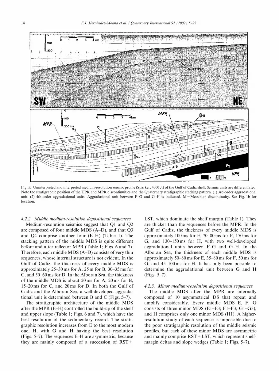
Medium-resolution seismics suggest that Q1 and Q2are composed of four middle MDS (A–D), and that Q3and Q4 comprise another four (E–H) (Table 1). Thestacking pattern of the middle MDS is quite differentbefore and after reflector MPR (Table 1; Figs. 6 and 7).Therefore, each middle MDS (A–D) consists of very thinsequences, whose internal structure is not evident. In theGulf of Cadiz, the thickness of every middle MDS isapproximately 25–30ms for A, 25m for B, 30–35ms forC, and 50–60ms for D. In the Alboran Sea, the thicknessof the middle MDS is about 20ms for A, 20ms for B,15–20ms for C, and 20ms for D. In both the Gulf ofCadiz and the Alboran Sea, a well-developed aggrada-tional unit is determined between B and C (Figs. 5–7).The stratigraphic architecture of the middle MDS
after the MPR (E–H) controlled the build-up of the shelfand upper slope (Table 1; Figs. 6 and 7), which have thebest resolution of the sedimentary record. The strati-graphic resolution increases from E to the most modernone, H, with G and H having the best resolution(Figs. 5–7). The sequences E–H are asymmetric, becausethey are mainly composed of a succession of RST+
LST, which dominate the shelf margin (Table 1). Theyare thicker than the sequences before the MPR. In theGulf of Cadiz, the thickness of every middle MDS isapproximately 100ms for E, 70–80ms for F, 150ms forG, and 130–150ms for H, with two well-developedaggradational units between F–G and G–H. In theAlboran Sea, the thickness of each middle MDS isapproximately 50–80ms for E, 35–80ms for F, 50ms forG, and 45–100ms for H. It has only been possible todetermine the aggradational unit between G and H(Figs. 5–7).
4.2.3. Minor medium-resolution depositional sequences
The middle MDS after the MPR are internallycomposed of 10 asymmetrical DS that repeat andamplify considerably. Every middle MDS E, F, Gconsists of three minor MDS (E1–E3; F1–F3; G1–G3),and H comprises only one minor MDS (H1). A higher-resolution study of each sequence is impossible due tothe poor stratigraphic resolution of the middle seismicprofiles, but each of these minor MDS are asymmetricand mainly comprise RST+LST, which represent shelf-margin deltas and slope wedges (Table 1; Figs. 5–7).
Fig. 5. Uninterpreted and interpreted medium-resolution seismic profile (Sparker, 4000 J.) of the Gulf of Cadiz shelf. Seismic units are differentiated.
Note the stratigraphic position of the UPR and MPR discontinuities and the Quaternary stratigraphic stacking pattern. (1) 3rd-order aggradational
unit; (2) 4th-order aggradational units. Aggradational unit between F–G and G–H is indicated. M=Messinian discontinuity. See Fig. 1b for
location.
F.J. Hern !andez-Molina et al. / Quaternary International 92 (2002) 5–2314
4.3. High- and very high-resolution depositional
sequences
The last minor MDS (H1) presents the higheststratigraphic resolution in the medium-resolution seis-mics. High and very high depositional sequences havebeen recognised by high- and very high-resolutionseismic profiles made with Geopulse, Uniboom and3.5 kHz sources (Figs. 6 and 7). See Somoza et al. (1997)and Hern!andez-Molina et al. (2000) for descriptions ofthe sequence stratigraphy.
5. Quaternary stratigraphy: a complex stacking pattern
controlled by climatic changes and modulated by tectonics
5.1. Chronologic framework of the sequences
Seismic and sequence stratigraphy analyses have beencorrelated with the sedimentary facies and age of theunits using the core data, with the main aim being tocorrelate the significant discontinuities with the Plio-cene–Quaternary isotopic stratigraphy, relative sea leveland regional palaeoceanographic changes. On the basis
Fig. 6. Uninterpreted and interpreted medium-resolution seismic profile (Sparker, 7500 J.) of the Alboran Sea shelf. Seismic units are differentiated.
Note the stratigraphic position of the UPR and MPR discontinuities and the Quaternary stratigraphic stacking pattern. (1) 3rd-order aggradational
unit; (2) 4th-order aggradational units. See Fig. 1b for location.
F.J. Hern !andez-Molina et al. / Quaternary International 92 (2002) 5–23 15
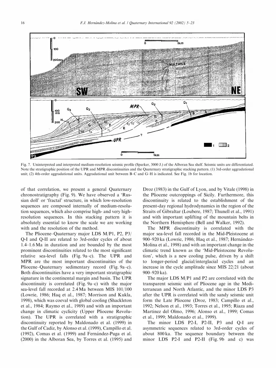
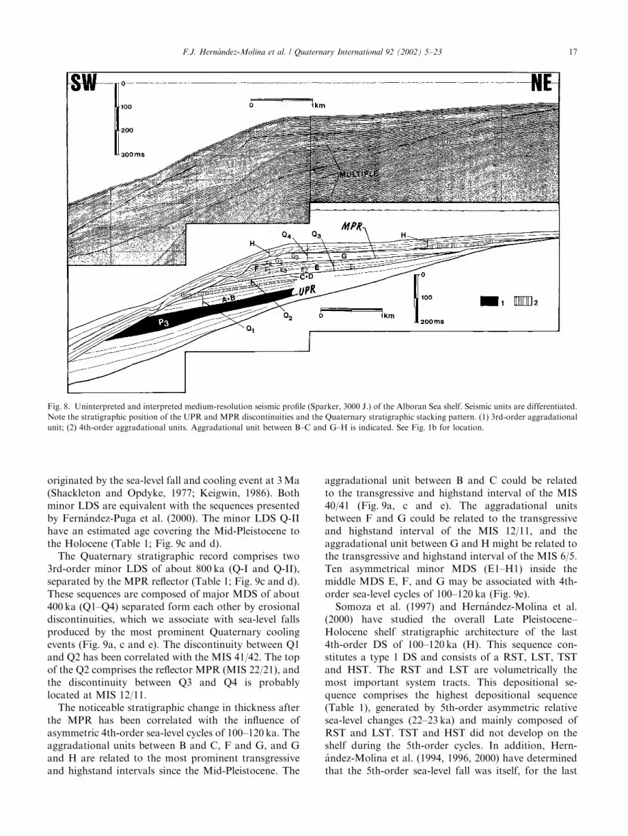
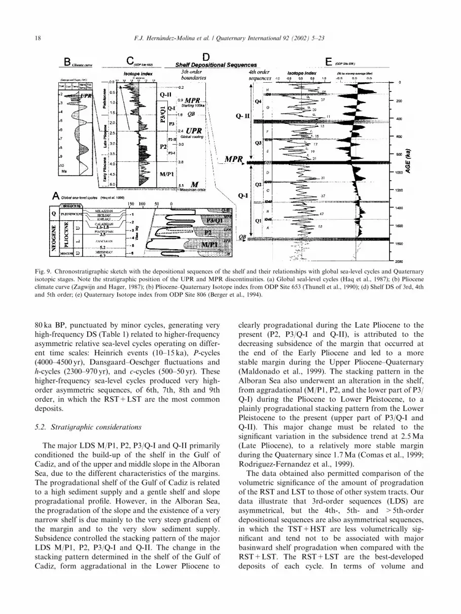
of that correlation, we present a general Quaternarychronostratigraphy (Fig. 9). We have observed a ‘Rus-sian doll’ or ‘fractal’ structure, in which low-resolutionsequences are composed internally of medium-resolu-tion sequences, which also comprise high- and very high-resolution sequences. In this stacking pattern it isabsolutely essential to know the scale we are workingwith and the resolution of the method.The Pliocene–Quaternary major LDS M/P1, P2, P3/
Q-I and Q-II are related to 3rd-order cycles of about1.4–1.6Ma in duration and are bounded by the mostprominent discontinuities related to the most significantrelative sea-level falls (Fig. 9a–c). The UPR andMPR are the most important discontinuities of thePliocene–Quaternary sedimentary record (Fig. 9a–c).Both discontinuities have a very important stratigraphicsignature in the continental margin and basin. The UPRdiscontinuity is correlated (Fig. 9a–c) with the majorsea-level fall recorded at 2.4Ma between MIS 101/100(Lowrie, 1986; Haq et al., 1987; Morrison and Kukla,1998), which was coeval with global cooling (Shackletonet al., 1984; Raymo et al., 1989) and with an importantchange in climatic cyclicity (Upper Pliocene Revolu-tion). The UPR is correlated with a stratigraphicdiscontinuity reported by Maldonado et al. (1999) inthe Gulf of Cadiz, by Alonso et al. (1999), Campillo et al.(1992), Comas et al. (1999) and Fern!andez-Puga et al.(2000) in the Alboran Sea, by Torres et al. (1995) and
Droz (1983) in the Gulf of Lyon, and by Vitale (1998) inthe Pliocene outcroppings of Sicily. Furthermore, thisdiscontinuity is related to the establishment of thepresent-day regional hydrodynamics in the region of theStraits of Gibraltar (Loubere, 1987; Thunell et al., 1991)and with important uplifting of the mountain belts inthe Northern Hemisphere (Bell and Walker, 1992).The MPR discontinuity is correlated with the
major sea-level fall recorded in the Mid-Pleistocene at900–920 ka (Lowrie, 1986; Haq et al., 1987; Hern!andez-Molina et al., 1998) and with an important change in theclimatic trend known as the ‘Mid-Pleistocene Revolu-tion’, which is a new cooling pulse, driven by a shiftto longer-period glacial/interglacial cycles and anincrease in the cycle amplitude since MIS 22/21 (about900–920 ka).The major LDS M/P1 and P2 are correlated with the
transparent seismic unit of Pliocene age in the Medi-terranean and North Atlantic, and the minor LDS P3after the UPR is correlated with the sandy seismic unitform the Late Pliocene (Droz, 1983; Campillo et al.,1992; Nelson et al., 1993; Torres et al., 1995; Riaza andMartinez del Olmo, 1996; Alonso et al., 1999; Comaset al., 1999; Maldonado et al., 1999).The minor LDS P2-I, P2-II, P3 and Q-I are
asymmetric sequences related to 3rd-order cycles ofabout 800 ka. The sequence boundary between theminor LDS P2-I and P2-II (Fig. 9b and c) was
Fig. 7. Uninterpreted and interpreted medium-resolution seismic profile (Sparker, 3000 J.) of the Alboran Sea shelf. Seismic units are differentiated.
Note the stratigraphic position of the UPR and MPR discontinuities and the Quaternary stratigraphic stacking pattern. (1) 3rd-order aggradational
unit; (2) 4th-order aggradational units. Aggradational unit between B–C and G–H is indicated. See Fig. 1b for location.
F.J. Hern !andez-Molina et al. / Quaternary International 92 (2002) 5–2316
originated by the sea-level fall and cooling event at 3Ma(Shackleton and Opdyke, 1977; Keigwin, 1986). Bothminor LDS are equivalent with the sequences presentedby Fern!andez-Puga et al. (2000). The minor LDS Q-IIhave an estimated age covering the Mid-Pleistocene tothe Holocene (Table 1; Fig. 9c and d).The Quaternary stratigraphic record comprises two
3rd-order minor LDS of about 800 ka (Q-I and Q-II),separated by the MPR reflector (Table 1; Fig. 9c and d).These sequences are composed of major MDS of about400 ka (Q1–Q4) separated form each other by erosionaldiscontinuities, which we associate with sea-level fallsproduced by the most prominent Quaternary coolingevents (Fig. 9a, c and e). The discontinuity between Q1and Q2 has been correlated with the MIS 41/42. The topof the Q2 comprises the reflector MPR (MIS 22/21), andthe discontinuity between Q3 and Q4 is probablylocated at MIS 12/11.The noticeable stratigraphic change in thickness after
the MPR has been correlated with the influence ofasymmetric 4th-order sea-level cycles of 100–120 ka. Theaggradational units between B and C, F and G, and Gand H are related to the most prominent transgressiveand highstand intervals since the Mid-Pleistocene. The
aggradational unit between B and C could be relatedto the transgressive and highstand interval of the MIS40/41 (Fig. 9a, c and e). The aggradational unitsbetween F and G could be related to the transgressiveand highstand interval of the MIS 12/11, and theaggradational unit between G and H might be related tothe transgressive and highstand interval of the MIS 6/5.Ten asymmetrical minor MDS (E1–H1) inside themiddle MDS E, F, and G may be associated with 4th-order sea-level cycles of 100–120 ka (Fig. 9e).Somoza et al. (1997) and Hern!andez-Molina et al.
(2000) have studied the overall Late Pleistocene–Holocene shelf stratigraphic architecture of the last4th-order DS of 100–120 ka (H). This sequence con-stitutes a type 1 DS and consists of a RST, LST, TSTand HST. The RST and LST are volumetrically themost important system tracts. This depositional se-quence comprises the highest depositional sequence(Table 1), generated by 5th-order asymmetric relativesea-level changes (22–23 ka) and mainly composed ofRST and LST. TST and HST did not develop on theshelf during the 5th-order cycles. In addition, Hern-!andez-Molina et al. (1994, 1996, 2000) have determinedthat the 5th-order sea-level fall was itself, for the last
Fig. 8. Uninterpreted and interpreted medium-resolution seismic profile (Sparker, 3000 J.) of the Alboran Sea shelf. Seismic units are differentiated.
Note the stratigraphic position of the UPR and MPR discontinuities and the Quaternary stratigraphic stacking pattern. (1) 3rd-order aggradational
unit; (2) 4th-order aggradational units. Aggradational unit between B–C and G–H is indicated. See Fig. 1b for location.
F.J. Hern !andez-Molina et al. / Quaternary International 92 (2002) 5–23 17
80 ka BP, punctuated by minor cycles, generating veryhigh-frequency DS (Table 1) related to higher-frequencyasymmetric relative sea-level cycles operating on differ-ent time scales: Heinrich events (10–15 ka), P-cycles(4000–4500 yr), Dansgaard–Oeschger fluctuations andh-cycles (2300–970 yr), and c-cycles (500–50 yr). Thesehigher-frequency sea-level cycles produced very high-order asymmetric sequences, of 6th, 7th, 8th and 9thorder, in which the RST+LST are the most commondeposits.
5.2. Stratigraphic considerations
The major LDS M/P1, P2, P3/Q-I and Q-II primarilyconditioned the build-up of the shelf in the Gulf ofCadiz, and of the upper and middle slope in the AlboranSea, due to the different characteristics of the margins.The progradational shelf of the Gulf of Cadiz is relatedto a high sediment supply and a gentle shelf and slopeprogradational profile. However, in the Alboran Sea,the progradation of the slope and the existence of a verynarrow shelf is due mainly to the very steep gradient ofthe margin and to the very slow sediment supply.Subsidence controlled the stacking pattern of the majorLDS M/P1, P2, P3/Q-I and Q-II. The change in thestacking pattern determined in the shelf of the Gulf ofCadiz, form aggradational in the Lower Pliocene to
clearly progradational during the Late Pliocene to thepresent (P2, P3/Q-I and Q-II), is attributed to thedecreasing subsidence of the margin that occurred atthe end of the Early Pliocene and led to a morestable margin during the Upper Pliocene–Quaternary(Maldonado et al., 1999). The stacking pattern in theAlboran Sea also underwent an alteration in the shelf,from aggradational (M/P1, P2, and the lower part of P3/Q-I) during the Pliocene to Lower Pleistocene, to aplainly progradational stacking pattern from the LowerPleistocene to the present (upper part of P3/Q-I andQ-II). This major change must be related to thesignificant variation in the subsidence trend at 2.5Ma(Late Pliocene), to a relatively more stable marginduring the Quaternary since 1.7Ma (Comas et al., 1999;Rodriguez-Fernandez et al., 1999).The data obtained also permitted comparison of the
volumetric significance of the amount of progradationof the RST and LST to those of other system tracts. Ourdata illustrate that 3rd-order sequences (LDS) areasymmetrical, but the 4th-, 5th- and >5th-orderdepositional sequences are also asymmetrical sequences,in which the TST+HST are less volumetrically sig-nificant and tend not to be associated with majorbasinward shelf progradation when compared with theRST+LST. The RST+LST are the best-developeddeposits of each cycle. In terms of volume and
Fig. 9. Chronostratigraphic sketch with the depositional sequences of the shelf and their relationships with global sea-level cycles and Quaternary
isotopic stages. Note the stratigraphic position of the UPR and MPR discontinuities. (a) Global seal-level cycles (Haq et al., 1987); (b) Pliocene
climate curve (Zagwijn and Hager, 1987); (b) Pliocene–Quaternary Isotope index from ODP Site 653 (Thunell et al., 1990); (d) Shelf DS of 3rd, 4th
and 5th order; (e) Quaternary Isotope index from ODP Site 806 (Berger et al., 1994).
F.J. Hern !andez-Molina et al. / Quaternary International 92 (2002) 5–2318
basinward progradation of the shelf margin, theRST+LST deposited during falling sea-level andlowstand sea-level positions dominate the Pliocene,Pleistocene and Late Pleistocene–Holocene stratigraphy.The stratigraphic architecture of the sequences haspreviously been determined for the Late Pleistocene(Hern!andez-Molina et al., 2000), but based onthe present work it could be extended to the entirePliocene–Quaternary sedimentary record at differenttemporal scales. The greater importance of theRST+LST in comparison to the poorly developedTST+HST reflects the effect of the asymmetric glacio-eustatic sea-level cycles, which are characterised byrapid rises and long gradual falls, separated by shorthigh- and lowstand conditions. In both study areas,the first deposits showing a shelf profile equivalent to thepresent shelf from a morphological point of view can bedetermined in the RST+LST of the M/P1 DS, at theend of the Lower Pliocene. In addition, it should benoted that all of the morphological shelves determinedsince the Early Pliocene are, in fact, relict shelves andrepresent the relict depositional equilibrium profilerelated to the lowest position of the sea level in eachcycle.The boundary between the minor LDS P3 and Q-I is
most likely the QB, but this surface does not have thesame stratigraphic signature as the erosional regionaldiscontinuities UPR and MPR (Figs. 6–8). Therefore,we believe that this boundary does not represent asignificant 3rd-order stratigraphic boundary, but it doessupport the older age for the QB at 2.4Ma proposed byMorrison and Kukla (1998) as a true stratigraphicboundary.The Quaternary progradational stacking pattern
shown by the major MDS Q1 and Q2 can be explainedif Q2 developed in the regressive and lowstand positionof the 3rd-order cycle (800 ka) before the MPR (Fig. 9e).The aggradational stacking pattern of Q3 is attributedto its generation during the transgressive interval of that3rd-order cycle (Q-II) between the MIS 22 and 12(Fig. 9e) rather than the transgressive trend of the 3rd-order cycle of 1.5–1.6Ma. The progradational stackingpattern of Q4 with respect to Q3 could be due to the factthat Q4 was generated during the regressive andlowstand positions of the 3rd-order cycle (800 ka)(Fig. 9e).The middle MDS (A–H) are related to asymmetric
4th-order sea-level cycles of 200 ka. The internalstacking pattern of A–D is most probably dominatedby the 41 ka obliquity cycles, which generated sea-levelfluctuations of small amplitude (approximately 50m),developing sequences 20–50m thick. After the MPR, themiddle MDS (E–H) reflects the influence of asymmetric4th-order sea-level cycles of 100–120 ka, and theinfluence of the climatic/eustatic fluctuations generatedby eccentricity cycles that repeat and amplify consider-
ably during the last 920 ka. These cycles seem to haveplayed a dominant role in determining the structuring ofthe continental shelves from the Mid-Pleistocene to thepresent, generating sequences approximately 70–150mthick. The MPR represents an erosional discontinuitythroughout the margin during the sea-level fall and onthe slope and in the deep basin due to palaeoceano-graphic change, which could indicate an importantstratigraphic break. The absence of an aggradationalunit between F and G in the Alboran Sea shelf(Figs. 6–8) could be explained by the following possibi-lities: (1) the existence of uplifting, compensatingfor the effect of the eustatic sea-level rise andhighstand coeval with the MIS 12/11 (Fig. 8); (2)increased erosion after MIS 12/11 throughout themargin and basin due to the sea-level fall, whose effectwas increased by the uplift tectonics of the margin andpalaeoceanographic changes in the deep basin (Fig. 8);or (3) both possibilities.The stratigraphic resolution increases from the Lower
Pliocene to the Late Pleistocene–Holocene, which isevidence for the major LDS to minor MDS. Thisincrease in the resolution can be explained by theclimatic/eustatic fluctuations, which increase from 20 ka(5–2.4Ma), to approximately 40 ka (2.4 to 900–920 ka)and then to approximately 100 ka (during the last900–920 ka).
6. Conclusions
Based on the seismic and sequence stratigraphicanalysis from the Pliocene–Quaternary of the southernIberian shelves, the following main conclusions havebeen drawn:
1. Four major low-resolution depositional sequences(major LDS) have been recognised by MCS profilesin the Pliocene–Quaternary sedimentary record(M/P1, P2, P3/Q-I and Q-II) related to 3rd-ordercycles of about 1.4–1.6Ma duration. They areseparated by four discontinuities associated with themost prominent sea-level falls: in the Late Messiniandiscontinuity (M) at 5.5Ma; in the Lower Pliocene at4.2Ma (LPR); in the Upper Pliocene at 2.4Ma(UPR); and approximately 900–920 ka in the Mid–Pleistocene (MPR).
2. These four major LDS are asymmetrical, with theregressive and lowstand system tracts being the best-developed deposits of each sequence, and control themajor basinward progradation of the shelf in theGulf of Cadiz and the slope in the Alboran Sea.
3. The Quaternary Boundary is not a prominent enoughdiscontinuity to be a practical 3rd-order regionalboundary without the same stratigraphic signature asthe UPR or MPR discontinuities.
F.J. Hern !andez-Molina et al. / Quaternary International 92 (2002) 5–23 19
4. The Quaternary stratigraphic stacking patterncould be divided into two minor resolution deposi-tional sequences (minor LDS) of 3rd order, ofapproximately 800 ka (Q-I and Q-II) and separatedby the MPR. These sequences are divided intofour major medium-resolution depositional se-quences (major MDS) of 4th order, of approximately400Ka (Q1–Q4), bounding each other via erosionaldiscontinuities that we have correlated with sea-levelfalls produced by the most prominent cooling events.Q1 and Q2 are composed of four middle MDS(A–D), and Q3 and Q4 by another four (E–H).Each of these asymmetric sequences is relatedto an asymmetric 4th-order cycle about 200 ka induration.
5. A stratigraphic change has been determined after theMPR discontinuity. The sequences E–H are intern-ally composed of 10 asymmetrical minor MDS,related to the influence of asymmetric 4th-order sea-level cycles of 100–120 ka. The influence of theclimatic/eustatic fluctuations generated by eccentri-city cycles that have repeated and amplified consider-ably during the last 900–920 ka seem to have played adominant role in determining the structuring of thecontinental shelf from the Mid-Pleistocene to thepresent.
6. A shelf equivalent to the present shelf from amorphological point of view can be determined sincethe end of the Lower Pliocene, and all of themorphological shelves recognised since then representrelict depositional equilibrium profiles related to thelowest sea level.
7. Stratigrapic resolution increases from the LowerPliocene to the Late Pleistocene–Holocene. Thischange in the resolution can be observed with thesame method at different scales, and can be explainedby climatic/eustatic fluctuations increasing from theLower Pliocene (20 ka cycles) to the Mid-Pleistocene(100–120 ka cycles).
Acknowledgements
This research has been supported by projects DGI-CYT PB94-1090-C03 and CICYT MAR-98-0209 ofthe Spanish Research Programme, and also by aSpanish–Portuguese scientific co-operation agreement.The Geological Survey of Spain (ITGE), the Oceano-graphic Institute of Spain (IEO), the AndalusianRegional Government, the University of Cadiz, theUniversity of Huelva, and the University of the Algarve(Portugal) have also been involved in this research.REPSOL Exploration is thanked for permission to usethe MCS profiles. We are particularly grateful to GeorgePostma, Allen Lowrie and Wyss Yim whose commentshelped to improve this paper. Delories Dunn de Ayuso
and Christine Laurin revised the English version of thetext. This paper is a contribution of IGCP Project no.396 ‘Continental Shelves in the Quaternary’, and IGCPproject no. Y 64 ‘‘continental shelves during the lastglacial cycle’’.
References
Alonso, B., Maldonado, A., 1992. Pliocene–Quaternary margin
growth pattern in a complex tectonic setting: northeastern Alboran
Sea. Geo-Marine Letters 12, 137–143.
Alonso, B., Ercilla, G., Mart!ınez-Ruiz, F., Braraza, J., Galimont, A.,
1999. Pliocene–Pleistocene sedimentary facies at site 976: deposi-
tional history in the northwestern Alboran Sea. In: Zahn, R.,
Comas, M.C., Klaus, A. (Eds.), Proceedings of the Ocean Drilling
Program, Scientific Results., Vol. 161. Texas A & M University,
Austin, TX, pp. 57–68.
Argus, D.F., Gordon, R.G., DeMets, C., Stein, S., 1989. Closure of the
Africa-Eurasia-north America plate motion circuit and tectonics of
the Gloria Fault. Journal of Geophysical Research 94 (B5),