64
Stroud Local Cycling & Walking Infrastructure Plan March 2022
| Date post: | 02-May-2023 |
| Category: |
Documents |
| Upload: | khangminh22 |
| View: | 0 times |
| Download: | 0 times |
Stroud Local Cycling & Walking Infrastructure Plan
March 2022
Page 2 of 64
Contents
Chapter Page
1. Scope 4
1.1. Purpose of this report 4
1.2. Study area 4
2. Background Information 6
2.1. Policy context 6
2.2. Planned changes 10
3. Existing Cycling & Walking Networks 12
4. Cycling Travel Patterns 14
4.1. Existing cycle use 14
4.2. Future cycle use potential 16
5. Network Planning for Cycling 18
5.1. Trip generators 18
5.2. Route selection 19
5.3. Cycling network map 27
6. Network Planning for Walking 28
6.1. Trip generators 28
6.2. Core walking zones / key walking routes 29
6.3. Walking Network Map 32
7. Programme of Cycle Infrastructure Improvements 35
7.1. Cycling network - indicative facilities and improvements 35
7.2. Priority routes – recommended improvements 41
7.3. Cost estimate 48
8. Programme of Walking Infrastructure Improvements 51
8.1. Walking network - indicative facilities and improvements 51
Appendix A: Route Selection Tool scores 62

Page 3 of 64
Tables Table 5-1 - Stakeholder input to cycle network development 24
Table 5-2 - Alternative route option decisions 29
Table 7-1 – Indicative cycle facility for LCWIP Cycling Network 46
Table 7-2 - Indicative cost estimates (selected routes) 56
Table 7-3 - Indicative cost estimates - full calculation 57
Figures Figure 1-1 – Stroud LCWIP study area 6
Figure 2-1 – Countywide strategy cycleway 8
Figure 2-2 – Strategic transport priorities: Severn Vale 10
Figure 2-3 – Stroud District Local Plan policies map 11
Figure 3-1 – Stroud area cycle network 13
Figure 3-2 – Public Rights of Way in Stroud area 14
Figure 4-1 – Cycle to work mode share across Gloucestershire (2011 Census) 15
Figure 4-2 – Percentage of commuters that travel to work by bicycle (2011 Census) 15
Figure 4-3 – Propensity to Cycle Tool (2011 Census baseline) 16
Figure 4-4 – Propensity to Cycle Tool (Go Dutch scenario) cycling potential 18
Figure 4-5 – Propensity to Cycle Tool (E-bike scenario) cycling potential 18
Figure 5-1 - Key origins and destinations 19
Figure 5-2 – Cycle desire lines 20
Figure 5-3 – Desire lines categorised 21
Figure 5-4 - Draft cycle network 23
Figure 5-5 – Stroud Cycling Network Map (overview) 31
Figure 5-6 – Stroud Cycling Network Map (detail) 31
Figure 6-1 - Key origins and destinations 33
Figure 6-2 – Draft Core Walking Zones and Key Walking Routes 35
Figure 7-1 - Indicative cycle facility for LCWIP Cycling Network – overview 44
Figure 7-2 - Indicative cycle facility for LCWIP Cycling Network - detail 44
Figure 7-3 - Proposed infrastructure improvements - Route 1.1/1.2 (Part 1 of 2) 50
Figure 7-4 - Proposed infrastructure improvements - Route 1.1/1.2 (Part 2 of 2) 51
Figure 7-5 - Proposed infrastructure improvements - Route 2 52
Figure 7-6 - Proposed infrastructure improvements - Route 3 53
Figure 7-7 - Proposed infrastructure improvements - Route 4 & 1.2 / 5 54
Page 4 of 64
1. Scope
1.1. Purpose of this report
This document is the first iteration of Gloucestershire County Council’s (GCC) Local Cycling and Walking Infrastructure Plan (LCWIP)1 for the town of Stroud and the surrounding area, including Stonehouse.
The creation of an LCWIP is a strategic process for identifying cycling and walking improvements required at a local level. LCWIPs enable a long-term approach to developing local cycling and walking networks, ideally over a 10-year period, and form a vital part of the Government’s strategy to increase the number of trips made on foot or by cycle. The LCWIP will be periodically reviewed to ensure it reflects developments in trip patterns and as the local networks improve.
By taking a strategic approach to improving conditions for cycling and walking, LCWIPs will assist local authorities to:
• identify cycling and walking infrastructure improvements for future investment in the short, medium and long term;
• ensure that consideration is given to cycling and walking within both local planning and transport policies and strategies; and
• make the case for future funding for walking and cycling infrastructure.
The key outputs of LCWIPs are:
• a network plan for walking and cycling which identifies preferred routes and core zones for further development;
• a prioritised programme of infrastructure improvements for future investment; and
• a report which sets out the underlying analysis carried out and provides a narrative which supports the identified improvements and network.
While the preparation of LCWIPs is non-mandatory, local authorities that have plans will be well placed to make the case for future investment. It is GCC’s long-term aim to produce a set of LCWIPs based on the Gloucestershire Local Transport Plan’s Connecting Places Strategy areas.
Gloucestershire is serious about increasing the number of trips made by walking and cycling. It is important to move away from a culture where the car is the dominant mode of transport towards one where the car is one transport choice within a range of realistic travel options. It is GCC’s view that this is an essential component of creating better places and improving the quality of people’s lives.
Getting more people walking and cycling is fundamental to GCC achieving its vision to be a carbon neutral county by 20502. The Government’s transport decarbonisation plan policy paper3 cites cycling and walking as “the ultimate forms of zero GHG emission transport” and references the important role of LCWIPs in developing a package of measures to support walking and cycling to tackle the climate change emergency.
Through the LCWIP process GCC continue to engage with a variety of stakeholders to attempt to fully understand the range of barriers people have to walking and cycling and what changes can be made to improve the quality of environment to enable more people to walk and cycle.
1.2. Study area
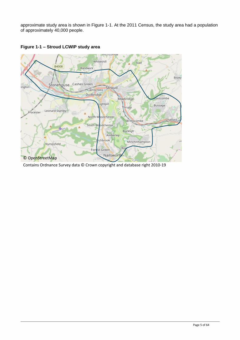
The scope of this LCWIP is the Stroud area, encompassing the towns of Stroud, Stonehouse and Nailsworth, and surrounding areas including the A419 corridor to Brimscombe and Chalford. The
1 Technical guidance outlining the process for Local Authorities to produce a LCWIP is available from the Department for Transport: https://assets.publishing.service.gov.uk/government/uploads/system/uploads/attachment_data/file/607016/cycl ing-walking-infrastructure-technical-guidance.pdf 2 Gloucestershire’s Climate Change Strategy, Dec 2019 https://www.gloucestershire.gov.uk/media/2094404/gloucestershire-climate-change-strategy.pdf 3 Decarbonising Transport, Setting the Challenge, March 2020 https://www.gov.uk/government/publications/creating-
the-transport-decarbonisation-plan
Page 5 of 64
approximate study area is shown in Figure 1-1. At the 2011 Census, the study area had a population of approximately 40,000 people.
Figure 1-1 – Stroud LCWIP study area
© OpenStreetMap
Contains Ordnance Survey data © Crown copyright and database right 2010-19

Page 6 of 64
2. Background Information
2.1. Policy context
This section summarises the key messages within relevant policy documents at national and local levels that relate to walking and cycling.
2.1.1. Cycling and Walking Infrastructure Strategy
The Cycling and Walking Infrastructure Strategy (CWIS)4 was launched by the Department for Transport in 2017 for the period to 2040. The CWIS outlines the Government’s ambition “to make cycling and walking a natural choice for shorter journeys, or as part of a longer journey” through delivering better safety, better mobility and better streets for walking and cycling.
In addition to the overall ambitions to 2040, the CWIS sets out targets to be met by 2025:
• “We aim to double cycling, where cycling activity is measured as the estimated total number of cycle stages made each year, from 0.8 billion stages in 2013 to 1.6 billion stages in 2025.
• We aim to increase walking activity, where walking activity is measured as the total number of walking stages per person per year, to 300 stages per person per year in 2025.
• We will increase the percentage of children aged 5 to 10 that usually walk to school from 49% in 2014 to 55% in 2025.”
The guidance on the preparation of LCWIPs was published in partnership with the CWIS, to assist in achieving the CWIS’ ambition through supporting local delivery partners to identify and deliver individual and tailored interventions fit for their own local areas.
2.1.2. Gear Change
Gear Change5 was launched in July 2020 and describes the vision to make England a great walking and cycling nation. It presents the case for a step-change in cycling and walking in coming years.
Gear Change’s vision is: “England will be a great walking and cycling nation. Places will be truly walkable. A travel revolution in our streets, towns and communities will have made cycling a mass form of transit. Cycling and walking will be the natural first choice for many journeys with half of all journeys in towns and cities being cycled or walked by 2030”.
In order to deliver this vision, Gear Change intends to ensure active travel is embedded in wider policy making to encourage and empower local authorities to take bold decisions. Four themes have been developed in order to set out the actions required at all levels of Government to make this a reality:
1. Better streets for cycling and people; 2. Putting cycling and walking at the heart of transport, place making and health policy; 3. Empowering and encouraging local authorities; and 4. We will enable people to cycle and protect them when they cycle.
Gear Change includes 22 summary principles to help practitioners deliver high quality infrastructure based on the lessons learned from cycle infrastructure delivered to date. It also highlights the importance of high-quality stakeholder engagement practices, with proposals and maps/drawings needing to be clear, detailed and unambiguous, as well as frank about the disadvantages, to build trust and discourage misrepresentation.
4 Cycling and walking investment strategy, April 2017 https://www.gov.uk/government/publications/cycling-and-walking-
investment-strategy 5 Gear change: a bold vision for cycling and walking, July 2020 https://www.gov.uk/government/publications/cycling-
and-walking-plan-for-england
Page 7 of 64
2.1.3. Local Transport Note 1/20 – Cycle Infrastructure Design
Local Transport Note (LTN) 1/206 was released concurrent to Gear Change. Gear Change refers to LTN 1/20 in relation to funding, stating that the Department for Transport will not fund schemes that do not meet the new standards and principles set out in LTN 1/20.
LTN 1/20 is a design focussed document that provides guidance and good practice for the design of cycle infrastructure. It builds upon the 22 summary principles set out in Gear Change and is a step change in terms of cycle design guidance, aiming for a “national default position where high quality cycle infrastructure is provided”.
LTN 1/20 outlines five core design principles – essential requirements to achieve more people travelling by cycle or on foot, based on best practice both internationally and across the UK. It states that networks and routes should be coherent, direct, safe, comfortable and attractive. Designers should always aim to provide infrastructure which meets these principles and therefore caters for the broadest range of people. Inclusive design and accessible infrastructure are also key priorities which run throughout LTN 1/20.
2.1.4. Gloucestershire Local Transport Plan
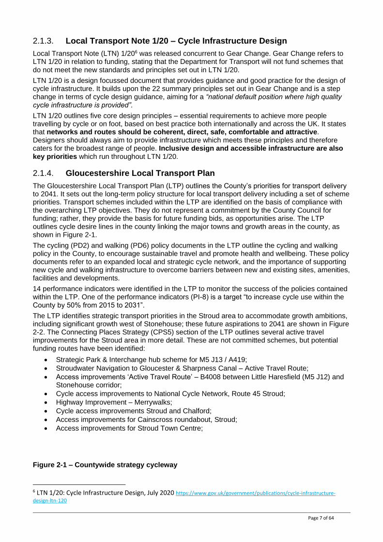
The Gloucestershire Local Transport Plan (LTP) outlines the County’s priorities for transport delivery to 2041. It sets out the long-term policy structure for local transport delivery including a set of scheme priorities. Transport schemes included within the LTP are identified on the basis of compliance with the overarching LTP objectives. They do not represent a commitment by the County Council for funding; rather, they provide the basis for future funding bids, as opportunities arise. The LTP outlines cycle desire lines in the county linking the major towns and growth areas in the county, as shown in Figure 2-1.
The cycling (PD2) and walking (PD6) policy documents in the LTP outline the cycling and walking policy in the County, to encourage sustainable travel and promote health and wellbeing. These policy documents refer to an expanded local and strategic cycle network, and the importance of supporting new cycle and walking infrastructure to overcome barriers between new and existing sites, amenities, facilities and developments.
14 performance indicators were identified in the LTP to monitor the success of the policies contained within the LTP. One of the performance indicators (PI-8) is a target “to increase cycle use within the County by 50% from 2015 to 2031”.
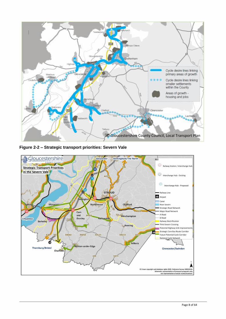
The LTP identifies strategic transport priorities in the Stroud area to accommodate growth ambitions, including significant growth west of Stonehouse; these future aspirations to 2041 are shown in Figure 2-2. The Connecting Places Strategy (CPS5) section of the LTP outlines several active travel improvements for the Stroud area in more detail. These are not committed schemes, but potential funding routes have been identified:
• Strategic Park & Interchange hub scheme for M5 J13 / A419;
• Stroudwater Navigation to Gloucester & Sharpness Canal – Active Travel Route;
• Access improvements ‘Active Travel Route’ – B4008 between Little Haresfield (M5 J12) and Stonehouse corridor;
• Cycle access improvements to National Cycle Network, Route 45 Stroud;
• Highway Improvement – Merrywalks;
• Cycle access improvements Stroud and Chalford;
• Access improvements for Cainscross roundabout, Stroud;
• Access improvements for Stroud Town Centre;
Figure 2-1 – Countywide strategy cycleway
6 LTN 1/20: Cycle Infrastructure Design, July 2020 https://www.gov.uk/government/publications/cycle-infrastructure-
design-ltn-120
Page 8 of 64
Figure 2-2 – Strategic transport priorities: Severn Vale
© Gloucestershire County Council, Local Transport Plan
Page 9 of 64
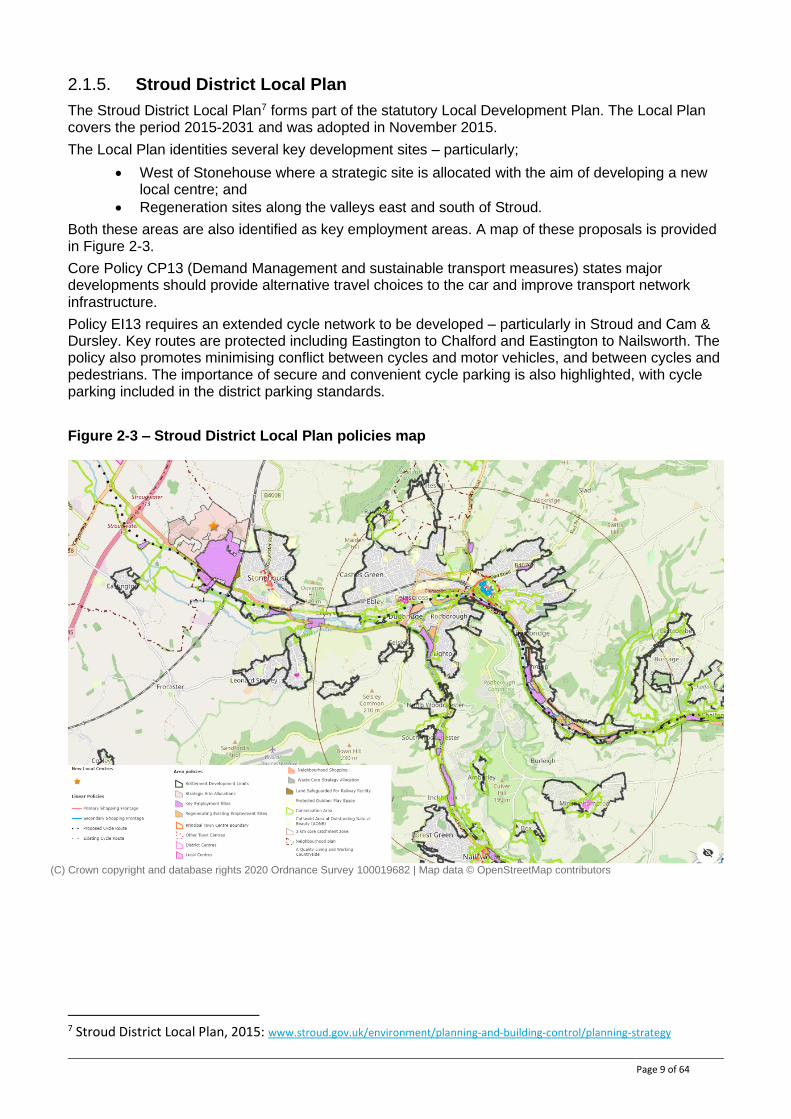
2.1.5. Stroud District Local Plan
The Stroud District Local Plan7 forms part of the statutory Local Development Plan. The Local Plan covers the period 2015-2031 and was adopted in November 2015.
The Local Plan identities several key development sites – particularly;
• West of Stonehouse where a strategic site is allocated with the aim of developing a new local centre; and
• Regeneration sites along the valleys east and south of Stroud.
Both these areas are also identified as key employment areas. A map of these proposals is provided in Figure 2-3.
Core Policy CP13 (Demand Management and sustainable transport measures) states major developments should provide alternative travel choices to the car and improve transport network infrastructure.
Policy EI13 requires an extended cycle network to be developed – particularly in Stroud and Cam & Dursley. Key routes are protected including Eastington to Chalford and Eastington to Nailsworth. The policy also promotes minimising conflict between cycles and motor vehicles, and between cycles and pedestrians. The importance of secure and convenient cycle parking is also highlighted, with cycle parking included in the district parking standards.
Figure 2-3 – Stroud District Local Plan policies map
7 Stroud District Local Plan, 2015: www.stroud.gov.uk/environment/planning-and-building-control/planning-strategy
(C) Crown copyright and database rights 2020 Ordnance Survey 100019682 | Map data © OpenStreetMap contributors

Page 10 of 64
2.2. Planned changes
2.2.1. Key development sites
2.2.1.1. West of Stonehouse strategic site allocation
The Local Plan identifies a strategic site, West of Stonehouse, which is planned to comprise;
● 1350 dwellings;
● 10 hectares of B1, B2 and B8 employment land;
● A new local centre and 2-form entry primary school.
Masterplans for plots within the site are required to ensure cycle and pedestrian routes will be provided through the development to Stroudwater Industrial Estate and Oldends Lane and footpaths will link the development to the surrounding rural network. Contributions will be made to ensure the canal towpath between Eastington and Stonehouse can accommodate the predicted increase in usage.
Page 11 of 64
2.2.3. Planned transport schemes
2.2.3.1. Stroudwater Navigation Canal restoration
Restoration of the Stroudwater Navigation has been a key priority for Stound District Council over many years. Recent funding announcements8 mean a key missing link will be delivered, joining Chipmans Platt (Easington) to the Gloucester to Sharpness Canal, at Saul Junction. The restoration works are planned to include the establishment of a new Public Right of Way (towpath) along the new canal section providing a new link and route across the A38 and M5.
Stroud District Council are also seeking to develop a Canal Strategy. This will set out a whole corridor vision for the future regeneration and active use of the canals running through Stroud District. The strategy will also identify key projects and tasks which can be developed into a subsequent Action Plan by the Council, to deliver the strategy.
2.2.3.2. Stonehouse-Standish-Hardwicke Route (not planned but in development)
Standish Parish Council are promoting a scheme to develop an off-road multi-user route parallel to the B4008 between Stonehouse and Hardwicke. This corridor is a key link highlighted in the draft Local Transport Plan, joining the Stroud area network to Gloucester whilst avoiding the need to go up and over the Cotswold escarpment. An alignment that seeks to upgrade existing bridleways is identified in the Parish’s ‘Safe and Sustainable Travel in Standish’ (2017)9 policy paper, and is included in the emerging Neighbourhood Development Plan.
No design work has been carried out on this route.
2.2.3.3. Golden Valley Route (not planned but in development)
Stroud Town Council commissioned an ‘Inspiration Study’ in 201910 so set out a vision to improve the comfort and attractiveness for walking and cycling on the A419 corridor between Stroud and Chalford. The study proposed options to provide a fully segregated footway and cycle track along the route, as well as downgrading the status of the A419 within the road network.
Feasibility assessments of the proposed route have not been completed, but with a number of key development and employment sites along the Golden Valley, provision of high-quality active travel infrastructure is a key priority.
8 Lottery bid success will make Stroud and Stonehouse canal towns after 70-year break | Stroud District Council 9 Safe and Sustainable Travel in Standish 2017 - Standishvillage.co.uk 10 https://www.stroudtown.gov.uk/uploads/golden-valley-route-inspiration-study.pdf
Page 12 of 64
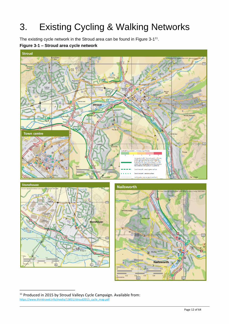
3. Existing Cycling & Walking Networks The existing cycle network in the Stroud area can be found in Figure 3-111.
Figure 3-1 – Stroud area cycle network
11 Produced in 2015 by Stroud Valleys Cycle Campaign. Available from: https://www.thinktravel.info/media/13831/stroud2015_cycle_map.pdf
Page 13 of 64
National Cycle Network Route 45 follows a disused railway track through the study area providing an attractive link between Stonehouse, Dudbridge and Nailsworth. Other dedicated off-road links comprise a further link on a disused railway providing a link from NCN 45 towards Stroud Town Centre (although this is not well connected to the wider network) and a short route through Stratford Park, Stroud. There are sections of on-road cycle lanes throughout the study area but generally there are not well-connected high-quality cycle facilities.
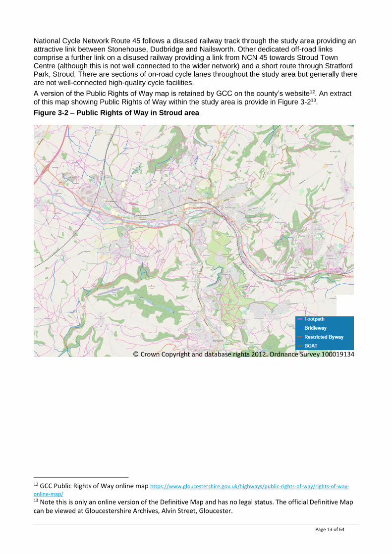
A version of the Public Rights of Way map is retained by GCC on the county’s website12. An extract of this map showing Public Rights of Way within the study area is provide in Figure 3-213.
Figure 3-2 – Public Rights of Way in Stroud area
12 GCC Public Rights of Way online map https://www.gloucestershire.gov.uk/highways/public-rights-of-way/rights-of-way-
online-map/ 13 Note this is only an online version of the Definitive Map and has no legal status. The official Definitive Map can be viewed at Gloucestershire Archives, Alvin Street, Gloucester.
© Crown Copyright and database rights 2012. Ordnance Survey 100019134
Page 14 of 64
4. Cycling Travel Patterns
4.1. Existing cycle use
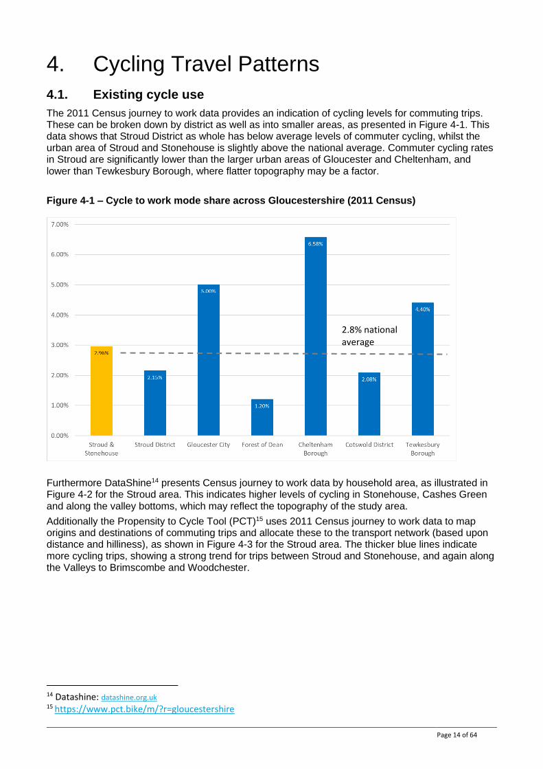
The 2011 Census journey to work data provides an indication of cycling levels for commuting trips. These can be broken down by district as well as into smaller areas, as presented in Figure 4-1. This data shows that Stroud District as whole has below average levels of commuter cycling, whilst the urban area of Stroud and Stonehouse is slightly above the national average. Commuter cycling rates in Stroud are significantly lower than the larger urban areas of Gloucester and Cheltenham, and lower than Tewkesbury Borough, where flatter topography may be a factor.
Figure 4-1 – Cycle to work mode share across Gloucestershire (2011 Census)
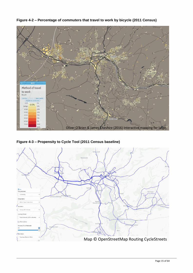
Furthermore DataShine14 presents Census journey to work data by household area, as illustrated in Figure 4-2 for the Stroud area. This indicates higher levels of cycling in Stonehouse, Cashes Green and along the valley bottoms, which may reflect the topography of the study area.
Additionally the Propensity to Cycle Tool (PCT)15 uses 2011 Census journey to work data to map origins and destinations of commuting trips and allocate these to the transport network (based upon distance and hilliness), as shown in Figure 4-3 for the Stroud area. The thicker blue lines indicate more cycling trips, showing a strong trend for trips between Stroud and Stonehouse, and again along the Valleys to Brimscombe and Woodchester.
14 Datashine: datashine.org.uk 15 https://www.pct.bike/m/?r=gloucestershire
2.8% national average
Page 15 of 64
Figure 4-2 – Percentage of commuters that travel to work by bicycle (2011 Census)
Figure 4-3 – Propensity to Cycle Tool (2011 Census baseline)
Map © OpenStreetMap Routing CycleStreets
Oliver O'Brien & James Cheshire (2016) Interactive mapping for large, open demographic data sets using familiar geographical features, Journal of Maps, 12:4, 676-683 DOI: 10.1080/17445647.2015.1060183
Page 16 of 64
4.2. Future cycle use potential
As well as mapping baseline data from the 2011 Census, the Propensity to Cycle Tool can assist in understanding the potential demand change for cycling under a variety of scenarios. Through these scenarios, the PCT can provide an indication of the most promising routes with regard to potential cycle growth. These scenarios consider the removal of different infrastructural, cultural and technological barriers that currently prevent cycling being the natural mode of choice for trips of short to medium distances. The PCT guidance stresses that these are not predictions of the future, but snapshots indicating how the spatial distribution of cycling may shift as cycling grows based on current travel patterns. The four scenarios the PCT provides are:
● Government target (near market): a doubling of cycle trips by 2025. Note that this is not uniform, with a greater increase in areas with many existing short, flat trips but a low current level of cycling.
● Government target (gender equality): female cycle user numbers increase to equal levels of male cycle users, with the greatest impact where cycling is most gender unequal.
● Go Dutch: the increase in cycle users if England had the same infrastructure and cycling culture as the Netherlands but retained the hilliness and commuter distance patterns.
● E-bikes: an extension of the Dutch scenario, estimates how much more likely it was that a given commute trip would be cycled by E-bike owners versus cyclists in general – with hilliness less of a factor in trip choices.
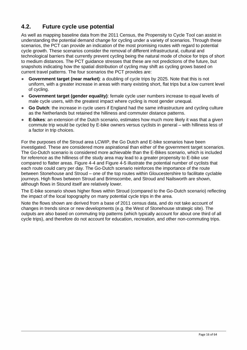
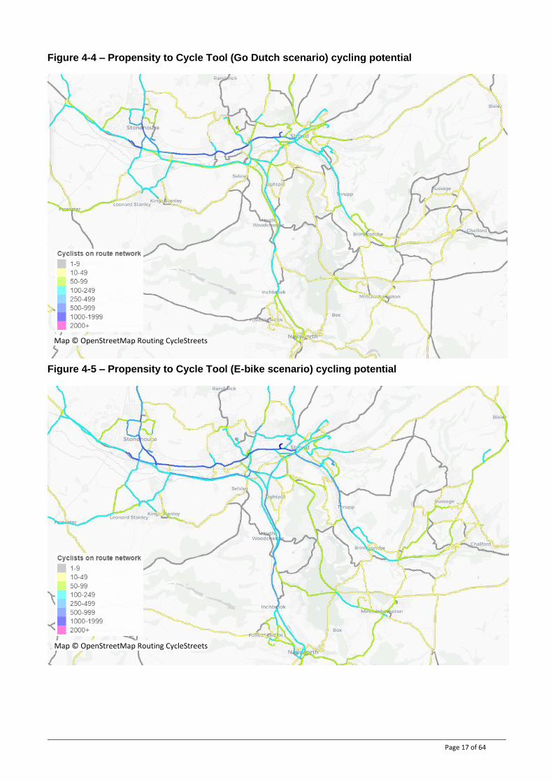
For the purposes of the Stroud area LCWIP, the Go Dutch and E-bike scenarios have been investigated. These are considered more aspirational than either of the government target scenarios. The Go-Dutch scenario is considered more achievable than the E-Bikes scenario, which is included for reference as the hilliness of the study area may lead to a greater propensity to E-bike use compared to flatter areas. Figure 4-4 and Figure 4-5 illustrate the potential number of cyclists that each route could carry per day. The Go-Dutch scenario reinforces the importance of the route between Stonehouse and Stroud – one of the top routes within Gloucestershire to facilitate cyclable journeys. High flows between Stroud and Brimscombe, and Stroud and Nailsworth are shown, although flows in Stound itself are relatively lower.
The E-bike scenario shows higher flows within Stroud (compared to the Go-Dutch scenario) reflecting the impact of the local topography on many potential cycle trips in the area.
Note the flows shown are derived from a base of 2011 census data, and do not take account of changes in trends since or new developments (e.g. the West of Stonehouse strategic site). The outputs are also based on commuting trip patterns (which typically account for about one third of all cycle trips), and therefore do not account for education, recreation, and other non-commuting trips.
Page 17 of 64
Figure 4-4 – Propensity to Cycle Tool (Go Dutch scenario) cycling potential
Figure 4-5 – Propensity to Cycle Tool (E-bike scenario) cycling potential
Map © OpenStreetMap Routing CycleStreets
Map © OpenStreetMap Routing CycleStreets
Page 18 of 64
5. Network Planning for Cycling This section describes how the routes included in this LCWIP were identified and chosen. It should be noted that the LCWIP sets out routes that should be high-quality well-connected cycle routes in order to provide a network of direct, convenient, safe and attractive routes to all existing and potential users. These routes are not necessarily the best available existing routes – the purpose of this plan is to identify the necessary infrastructure improvements to make these routes the best available.
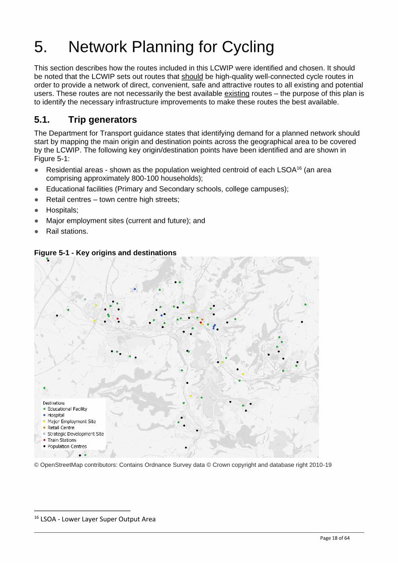
5.1. Trip generators
The Department for Transport guidance states that identifying demand for a planned network should start by mapping the main origin and destination points across the geographical area to be covered by the LCWIP. The following key origin/destination points have been identified and are shown in Figure 5-1:
● Residential areas - shown as the population weighted centroid of each LSOA16 (an area comprising approximately 800-100 households);
● Educational facilities (Primary and Secondary schools, college campuses);
● Retail centres – town centre high streets;
● Hospitals;
● Major employment sites (current and future); and
● Rail stations.
Figure 5-1 - Key origins and destinations
© OpenStreetMap contributors: Contains Ordnance Survey data © Crown copyright and database right 2010-19
16 LSOA - Lower Layer Super Output Area
Page 19 of 64
5.2. Route selection
5.2.1. Desire lines and draft network
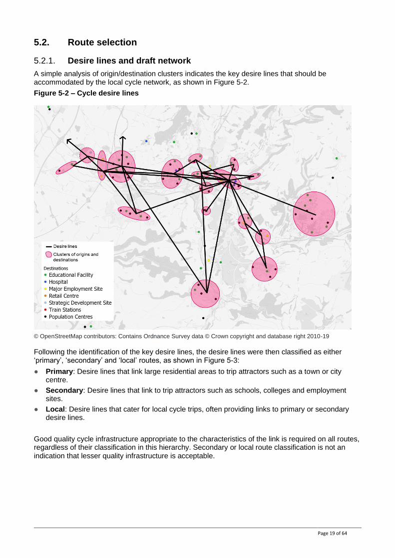
A simple analysis of origin/destination clusters indicates the key desire lines that should be accommodated by the local cycle network, as shown in Figure 5-2.
Figure 5-2 – Cycle desire lines
© OpenStreetMap contributors: Contains Ordnance Survey data © Crown copyright and database right 2010-19
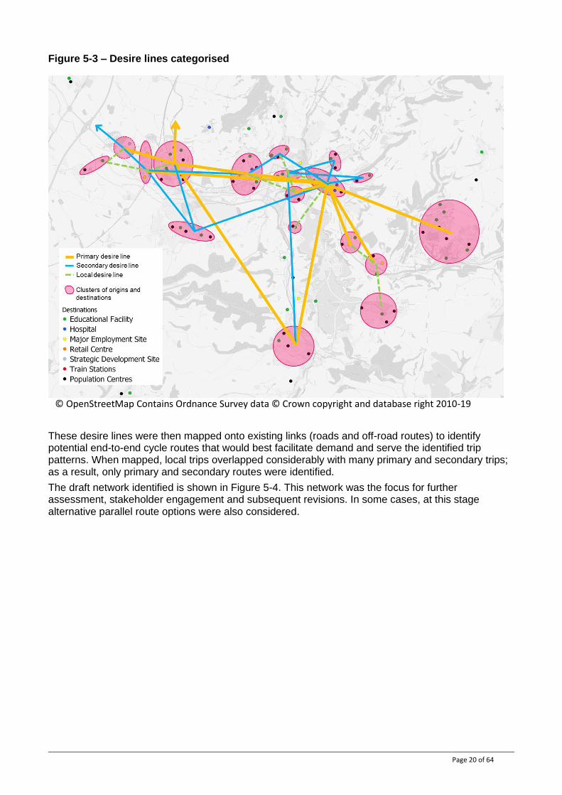
Following the identification of the key desire lines, the desire lines were then classified as either ‘primary’, ‘secondary’ and ‘local’ routes, as shown in Figure 5-3:
● Primary: Desire lines that link large residential areas to trip attractors such as a town or city centre.
● Secondary: Desire lines that link to trip attractors such as schools, colleges and employment sites.
● Local: Desire lines that cater for local cycle trips, often providing links to primary or secondary desire lines.
Good quality cycle infrastructure appropriate to the characteristics of the link is required on all routes, regardless of their classification in this hierarchy. Secondary or local route classification is not an indication that lesser quality infrastructure is acceptable.
Page 20 of 64
Figure 5-3 – Desire lines categorised
These desire lines were then mapped onto existing links (roads and off-road routes) to identify potential end-to-end cycle routes that would best facilitate demand and serve the identified trip patterns. When mapped, local trips overlapped considerably with many primary and secondary trips; as a result, only primary and secondary routes were identified.
The draft network identified is shown in Figure 5-4. This network was the focus for further assessment, stakeholder engagement and subsequent revisions. In some cases, at this stage alternative parallel route options were also considered.
© OpenStreetMap Contains Ordnance Survey data © Crown copyright and database right 2010-19
Page 21 of 64
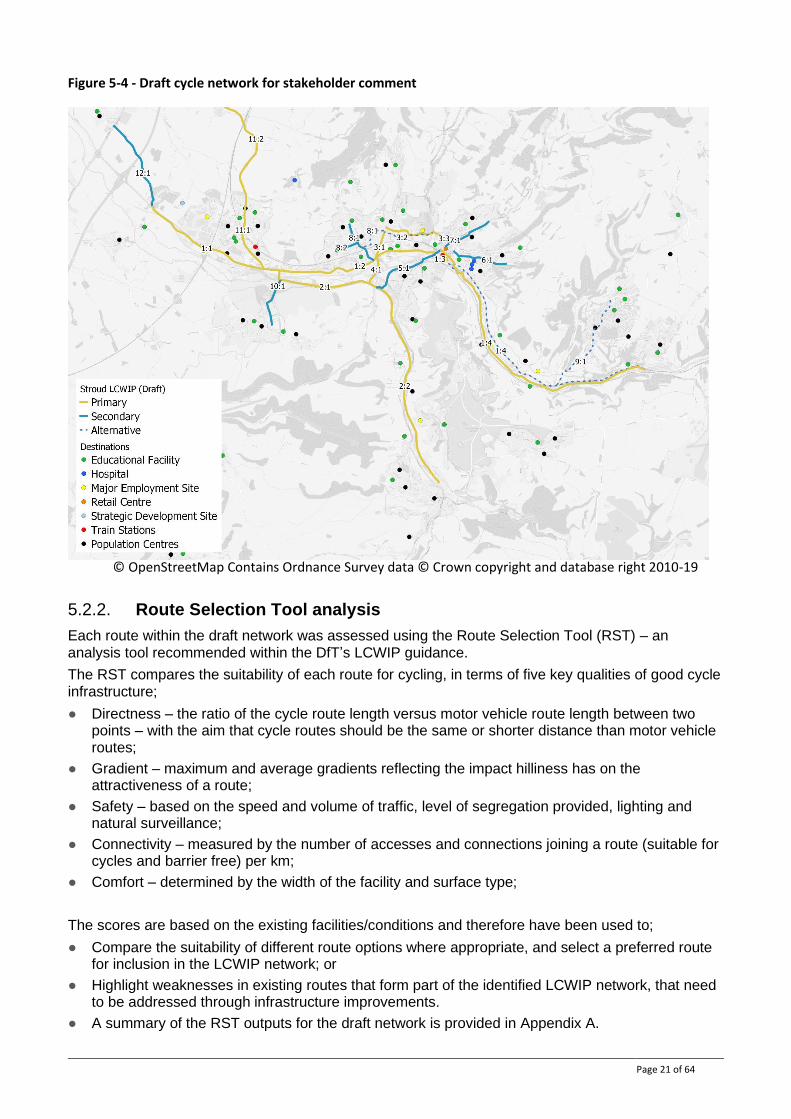
Figure 5-4 - Draft cycle network for stakeholder comment
5.2.2. Route Selection Tool analysis
Each route within the draft network was assessed using the Route Selection Tool (RST) – an analysis tool recommended within the DfT’s LCWIP guidance.
The RST compares the suitability of each route for cycling, in terms of five key qualities of good cycle infrastructure;
● Directness – the ratio of the cycle route length versus motor vehicle route length between two points – with the aim that cycle routes should be the same or shorter distance than motor vehicle routes;
● Gradient – maximum and average gradients reflecting the impact hilliness has on the attractiveness of a route;
● Safety – based on the speed and volume of traffic, level of segregation provided, lighting and natural surveillance;
● Connectivity – measured by the number of accesses and connections joining a route (suitable for cycles and barrier free) per km;
● Comfort – determined by the width of the facility and surface type;
The scores are based on the existing facilities/conditions and therefore have been used to;
● Compare the suitability of different route options where appropriate, and select a preferred route for inclusion in the LCWIP network; or
● Highlight weaknesses in existing routes that form part of the identified LCWIP network, that need to be addressed through infrastructure improvements.
● A summary of the RST outputs for the draft network is provided in Appendix A.
© OpenStreetMap Contains Ordnance Survey data © Crown copyright and database right 2010-19
Page 22 of 64
5.2.3. Stakeholder involvement
Local stakeholders were invited to take part in developing the LCWIP network by;
● Making recommendations for routes and commenting on the draft network identified;
● Highlighting key issues experienced on the existing networks;
● Identifying improvement needed to serve local needs.
Stakeholder input was captured through a dedicated website sharing the draft networks and RST analysis in map format. Stakeholders invited to participate in the consultation included:
● Local County, District and Town/Parish Council members and officers;
● Active travel user groups/charities;
● Representatives of vulnerable users (Age UK, RNIB etc.).
A summary of the input received is provided in Table 5-1.
Table 5-1 - Stakeholder input to cycle network development
Route Route section
Summary of stakeholder feedback Action / Outcome
General Comments
n/a - Better segregation for pedestrians from cycles is required to improve walking environment in the town. - Ensure walking routes link and make use of existing footpath networks /PROW. - Consider needs of other path users- particularly horses. - Local cycle routes need to link to wider inter-urban routes.
n/a
1 – Stonehouse to Chalford
1.1: West of Stonehouse
-Utility alignment should follow A419. Parallel towpath not adequate for non-leisure journeys. -Existing cycle route is dis-jointed with inconsistent facilities and multiple road crossings. -Recent capacity scheme has worsened the route for cycles, in particular at: -Horsetrough Roundabout - dedicated left turn lane; -Bridgend Signals - removal of single stage crossing; -Oldends Lane Roundabout - Off-road route with multiple side road crossings; -Old Weighbridge - narrowed due to (temporary) road closure.
Retained as a primary route – parallel to A419 and not on the canal towpath. Selected as a key route to consider in more detail and identify potential improvements (Section 7.2). - Works underway to review the roundabout and the dedicated left turn - Works to be undertaken to reintroduce in November 2021
1.2: Stonehouse to Stroud (Ebley Road)
-Ebley Road alignment is correct utility route. -Particular issues at: -Ebley Road - vehicle speed and safety of on-carriageway route. Surface condition;
Retained as a primary route. Selected as a key route to consider in more detail and identify potential improvements (Section 7.2).
Page 23 of 64
-Cainscross Roundabout; -Cainscross Road - disjointed cycle lanes (Note EATF2 bid); - Merrywalks - segregation/crossing to Stroud town centre.
1.3: Stroud Town Centre
-Utility alignment should follow town centre option. - Parallel canal towpath not adequate for non-leisure journeys. - Ensure alignment ties in with section 1.4. -Note temporary London Road closure - long term impact.
Retained as a primary route. Re-aligned to follow the town centre one-way system and London Road – to tie in with A419 route rather than canal towpath.
1.4: Stroud to Chalford (A419 Golden Valley Route)
-Canal towpath is not adequate to accommodate cycle trips - too narrow/constrained. - A parallel solution on A419 (1.4 alternative) is required - realign to A419. - Note Stroud Town Councils Golden Valley Inspiration Study (Witteveen and Bos). -Note aspiration for Brimscombe Port development and provided links to Stroud.
Retained as a primary route. Option to develop A419 route selected over improvements to the Canal towpath.
2 – Stonehouse to Nailsworth
2.1 - Stonehouse to Stroud NCN
-Not a convenient route between Stroud and Stonehouse - too indirect. -Part of a good link between Nailsworth and Stonehouse - dependant on improved links at either end.
Retained as a primary route but Route 1.2 is the key focus for trips between Stroud and Stonehouse. Improved links to Stroud are required (See Routes 4 & 5). Selected as a key route to consider in more detail and identify potential improvements (Section 7.2).
2.2 - Stroud to Nailsworth NCN
-Attractive link between Nailsworth and Stroud - but poorly connected at each end, particularly to Stroud (see Route 5.1).
Retained as a primary route. Improved links to Stroud are required (See Routes 4 & 5). Selected as a key route to consider in more detail and identify potential improvements (Section 7.2).
3 – Cainscross to Stroud via Paganhill
3.1 – Paganhill Lane
-Key link serving local schools. -Constrained by on-street parking. -Provides local access so should be classified as secondary route.
Reclassified as a secondary route.
3.2 – Paganhill to Stratford Park
-Key link serving local schools and leisure centre. -Stratford Road alignment is constrained by width and on-street parking. -Highlighted parallel route is less direct but given challenges on Stratford Road may provide a more appropriate route for younger
Reclassified as a secondary route. Both alignments (Stratford Road and parallel route) to be included in the network as they offer different opportunities. Option to realign the parallel route to use the Stratford Park access road has been
Page 24 of 64
cyclists (close to schools/leisure centre). -Parallel route could be realigned to follow leisure centre access and route via north of college. -Provides local access so should be classified as secondary route.
investigated on site and discounted – route remains on Jack Russel Close. Selected as a key route to consider in more detail and identify potential improvements (Section 7.2).
3.3 – Beeches Green
-Key link into Stroud town centre - few alternatives. -Provides key link between college, leisure centre and into town centre.
Retained as a primary route. Selected as a key route to consider in more detail and identify potential improvements (Section 7.2).
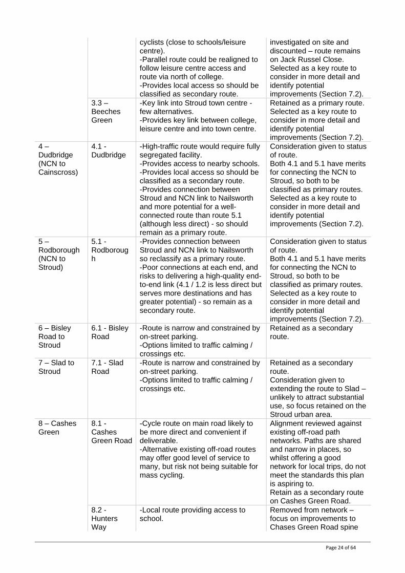
4 – Dudbridge (NCN to Cainscross)
4.1 - Dudbridge
-High-traffic route would require fully segregated facility. -Provides access to nearby schools. -Provides local access so should be classified as a secondary route. -Provides connection between Stroud and NCN link to Nailsworth and more potential for a well-connected route than route 5.1 (although less direct) - so should remain as a primary route.
Consideration given to status of route. Both 4.1 and 5.1 have merits for connecting the NCN to Stroud, so both to be classified as primary routes. Selected as a key route to consider in more detail and identify potential improvements (Section 7.2).
5 – Rodborough (NCN to Stroud)
5.1 - Rodborough
-Provides connection between Stroud and NCN link to Nailsworth so reclassify as a primary route. -Poor connections at each end, and risks to delivering a high-quality end-to-end link (4.1 / 1.2 is less direct but serves more destinations and has greater potential) - so remain as a secondary route.
Consideration given to status of route. Both 4.1 and 5.1 have merits for connecting the NCN to Stroud, so both to be classified as primary routes. Selected as a key route to consider in more detail and identify potential improvements (Section 7.2).
6 – Bisley Road to Stroud
6.1 - Bisley Road
-Route is narrow and constrained by on-street parking. -Options limited to traffic calming / crossings etc.
Retained as a secondary route.
7 – Slad to Stroud
7.1 - Slad Road
-Route is narrow and constrained by on-street parking. -Options limited to traffic calming / crossings etc.
Retained as a secondary route. Consideration given to extending the route to Slad – unlikely to attract substantial use, so focus retained on the Stroud urban area.
8 – Cashes Green
8.1 - Cashes Green Road
-Cycle route on main road likely to be more direct and convenient if deliverable. -Alternative existing off-road routes may offer good level of service to many, but risk not being suitable for mass cycling.
Alignment reviewed against existing off-road path networks. Paths are shared and narrow in places, so whilst offering a good network for local trips, do not meet the standards this plan is aspiring to. Retain as a secondary route on Cashes Green Road.
8.2 - Hunters Way
-Local route providing access to school.
Removed from network – focus on improvements to Chases Green Road spine
Page 25 of 64
as minor roads are generally suitable for cycling.
9 – Brimscombe to Bussage
9.1 - Brimscombe to Bussage
-Route requires a full site assessment to verify an end-to-end connection is viable. -Steep route providing an alternative to Toadsmoor Road. -Provides a connection to large local population. - Similar link between Brimscombe and Minchinhampton required.
Retain as an aspiration for a secondary route to provide a connection to Bussage. Add aspiration for a secondary route to Minchinhampton. Note that final alignment and feasibility of route is subject to a full site assessment.
10 – Kings Stanley to Ebley
10.1– Kings Stanley to Ebley
-Utility alignment should stay on highway and serve local residential areas.
Retained as a secondary route. An alternative off-carriageway route following the Cotswold Way was considered and discounted due to poor connectivity to local users.
11 – Stonehouse to Hardwick (Gloucester)
11.1 – Stonehouse High Street
-Recent capacity scheme has worsened the route for cycles at Horsetrough Roundabout. -Potential to improve traffic calming / seek cycle facilities either side of town centre.
Re-classified as a primary route forming part of a link between Stroud and Gloucester.
11.2 - Stonehouse to Quedgeley
-Key link to enable a mode shift between Stonehouse/Stroud and Gloucester. -Potentially viable off-road route being developed by Standish Parish Council.
Re-classified as a primary route forming part of a link between Stroud and Gloucester. Realigned to follow the off-road route parallel to B4008 as it offers more opportunity to provide an attractive route.
12 – Stonehouse to Whitminster
12.1 – Stonehouse to Whitminster
-Canal restoration may offer more attractive route than Grove Lane. -Review vs FGR stadium outline plans.
Restored canal alignment included as a parallel secondary route as it will offer a good quality leisure route. Grove Lane retained as it links West of Stonehouse strategic site to A38 and Gloucester.
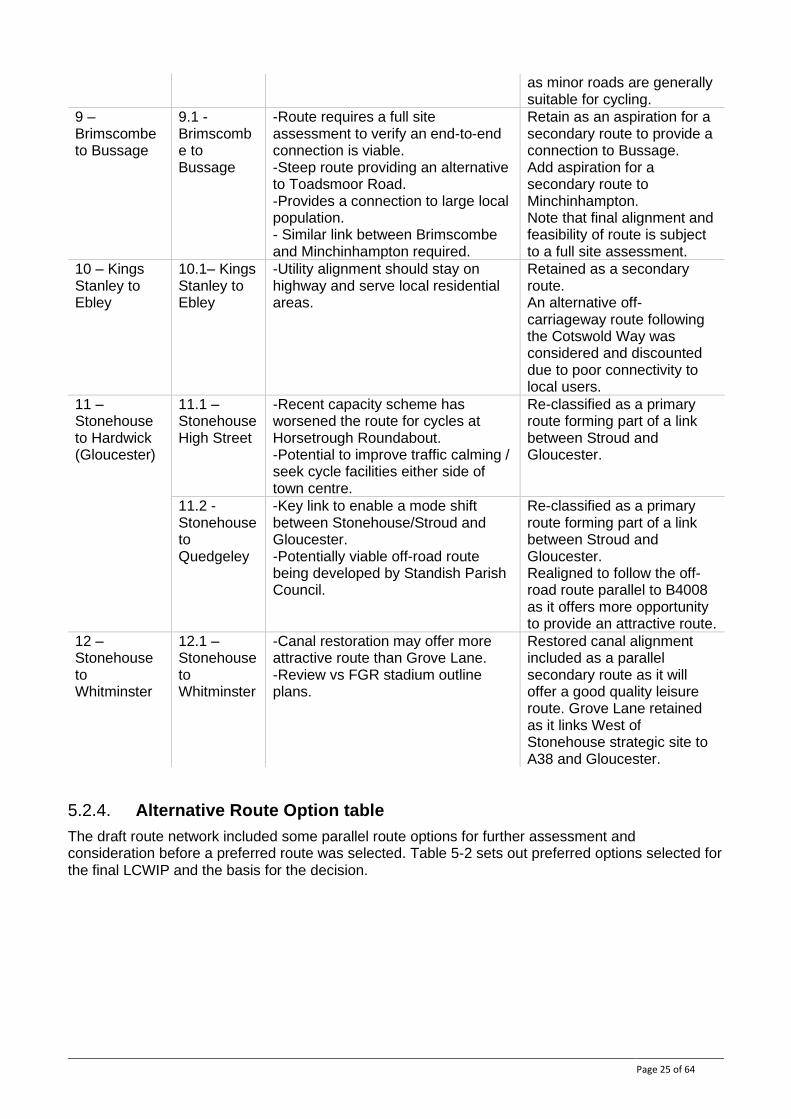
5.2.4. Alternative Route Option table
The draft route network included some parallel route options for further assessment and consideration before a preferred route was selected. Table 5-2 sets out preferred options selected for the final LCWIP and the basis for the decision.
Page 26 of 64
Table 5-2 - Alternative route option decisions
Route Section Option 1 Option 2 Preferred option
Route 1.4 – Stroud to Chalford
Canal towpath – off-road quiet route, shared with pedestrians.
A419 – heavily trafficked strategic route with potential constraints to achieving a segregated cycle route.
Option 2 - A419. The Canal towpath is an adequate leisure route but too narrow to facilitate mass cycling and cannot be upgraded to an adequate quality. It is a well-used pedestrian route, leading to unacceptable conflict with pedestrians. The A419 route is also constrained, and a fully segregated route will require investment. However, it has greater potential to provide a direct, high-quality route. The proposed Brimscombe Port development could become a hub with onward links to Minchinhampton, Bussage and Chalford.
Route 4.1 and Route 5.1 - NCN railway path to Stroud town centre
Route 4.1 Dudbridge Road linking to Cainscross Road – a longer distance but potential for a direct, high quality route.
Route 5.1 Off-road path following dis-used railway line around Rodborough.
Include both options. Route 4.1 With improvements, Dudbridge Road can provide a higher quality continuous, convenient link. Route 5.1 around Rodborough can be improved but will include the stepped section at Dudbridge Road, and narrow path through Dudbridge Meadow. Therefore, both routes have merits and may be preferred by different users.
Route 3.3 – Stratford Park to Paganhill
Option 1 – on-road route along Stratford Road
Option 2 – Parallel route on quiet roads / off-road paths
Include both options. Stratford Road is more direct but is narrow and there are challenges to delivering a fully segregated facility. The parallel route with improvements can provide a good quality link that may provide more attractive cycling, particularly for children travelling to nearby schools.
Route 12 – Chipmans Platt roundabout to Gloucester-Sharpness Canal (Saul)
Option 1 – on-road route via Grove Lane (Whitminster)
Option 2 – Restored canal towpath
Include both options. Option 1 uses high-speed rural routes which will be a barrier to many cyclists but provides a fast direct link to onward networks. The restored canal towpath can provide an adequate off-road link to onward long-distance/ leisure routes of a similar quality.
Page 27 of 64
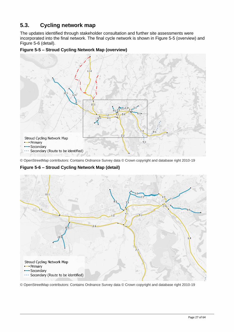
5.3. Cycling network map
The updates identified through stakeholder consultation and further site assessments were incorporated into the final network. The final cycle network is shown in Figure 5-5 (overview) and Figure 5-6 (detail).
Figure 5-5 – Stroud Cycling Network Map (overview)
© OpenStreetMap contributors: Contains Ordnance Survey data © Crown copyright and database right 2010-19
Figure 5-6 – Stroud Cycling Network Map (detail)
© OpenStreetMap contributors: Contains Ordnance Survey data © Crown copyright and database right 2010-19
Page 28 of 64
6. Network Planning for Walking This section describes how the routes included in this LCWIP were identified and chosen. It should be noted that the LCWIP sets out routes that should be high-quality well-connected walking routes (and any necessary infrastructure improvements) – not necessarily the best available existing routes.
6.1. Trip generators
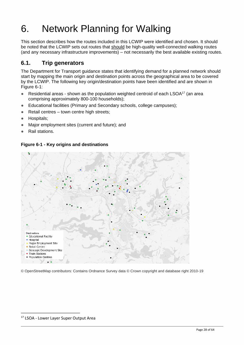
The Department for Transport guidance states that identifying demand for a planned network should start by mapping the main origin and destination points across the geographical area to be covered by the LCWIP. The following key origin/destination points have been identified and are shown in Figure 6-1:
● Residential areas - shown as the population weighted centroid of each LSOA17 (an area comprising approximately 800-100 households);
● Educational facilities (Primary and Secondary schools, college campuses);
● Retail centres – town centre high streets;
● Hospitals;
● Major employment sites (current and future); and
● Rail stations.
Figure 6-1 - Key origins and destinations
© OpenStreetMap contributors: Contains Ordnance Survey data © Crown copyright and database right 2010-19
17 LSOA - Lower Layer Super Output Area
Page 29 of 64
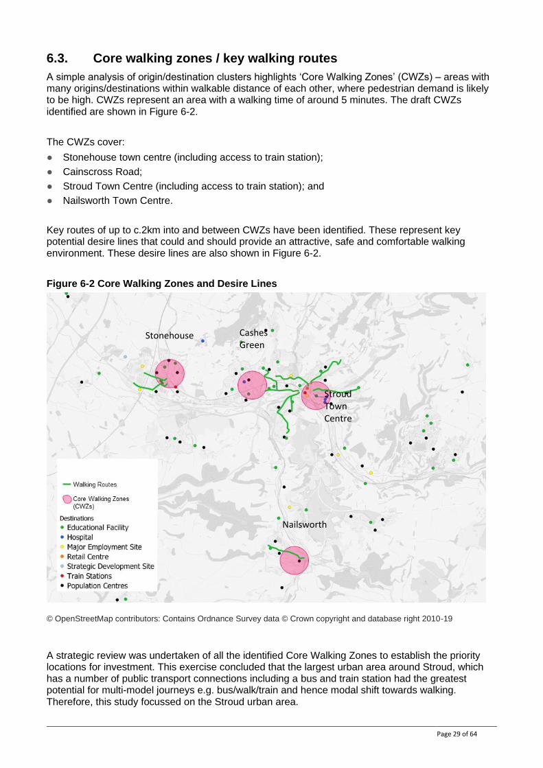
6.3. Core walking zones / key walking routes
A simple analysis of origin/destination clusters highlights ‘Core Walking Zones’ (CWZs) – areas with many origins/destinations within walkable distance of each other, where pedestrian demand is likely to be high. CWZs represent an area with a walking time of around 5 minutes. The draft CWZs identified are shown in Figure 6-2.
The CWZs cover:
● Stonehouse town centre (including access to train station);
● Cainscross Road;
● Stroud Town Centre (including access to train station); and
● Nailsworth Town Centre.
Key routes of up to c.2km into and between CWZs have been identified. These represent key potential desire lines that could and should provide an attractive, safe and comfortable walking environment. These desire lines are also shown in Figure 6-2.
Figure 6-2 Core Walking Zones and Desire Lines
© OpenStreetMap contributors: Contains Ordnance Survey data © Crown copyright and database right 2010-19
A strategic review was undertaken of all the identified Core Walking Zones to establish the priority locations for investment. This exercise concluded that the largest urban area around Stroud, which has a number of public transport connections including a bus and train station had the greatest potential for multi-model journeys e.g. bus/walk/train and hence modal shift towards walking. Therefore, this study focussed on the Stroud urban area.
Stonehouse
Stroud Town Centre
Cashes Green
Nailsworth
Page 30 of 64
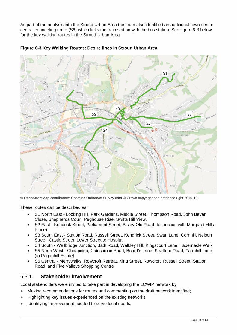
As part of the analysis into the Stroud Urban Area the team also identified an additional town-centre central connecting route (S6) which links the train station with the bus station. See figure 6-3 below for the key walking routes in the Stroud Urban Area.
Figure 6-3 Key Walking Routes: Desire lines in Stroud Urban Area
© OpenStreetMap contributors: Contains Ordnance Survey data © Crown copyright and database right 2010-19
These routes can be described as:
• S1 North East - Locking Hill, Park Gardens, Middle Street, Thompson Road, John Bevan Close, Shepherds Court, Peghouse Rise, Swifts Hill View.
• S2 East - Kendrick Street, Parliament Street, Bisley Old Road (to junction with Margaret Hills Place)
• S3 South East - Station Road, Russell Street, Kendrick Street, Swan Lane, Cornhill, Nelson Street, Castle Street, Lower Street to Hospital
• S4 South - Wallbridge Junction, Bath Road, Walkley Hill, Kingscourt Lane, Tabernacle Walk
• S5 North West - Cheapside, Cainscross Road, Beard’s Lane, Stratford Road, Farmhill Lane (to Paganhill Estate)
• S6 Central - Merrywalks, Rowcroft Retreat, King Street, Rowcroft, Russell Street, Station Road, and Five Valleys Shopping Centre
6.3.1. Stakeholder involvement
Local stakeholders were invited to take part in developing the LCWIP network by:
● Making recommendations for routes and commenting on the draft network identified;
● Highlighting key issues experienced on the existing networks;
● Identifying improvement needed to serve local needs.
Page 31 of 64
Stakeholder input was captured through a dedicated website sharing the draft networks in map format. Stakeholders invited to participate in the consultation included:
● Local County, District and Town/Parish Council members and officers;
● Active travel user groups/charities;
● Representatives of vulnerable users (Age UK, RNIB etc.).
A summary of the input received is provided in Table 6-1, below.
Table 6-1 Stakeholder input to walking network development
Route Route section Summary of stakeholder feedback Action / Outcome
All All Better segregation for pedestrians from cycles is required to improve walking environment in the town.
Improve segregation for pedestrians from cycles.
Canal Corridor
Gloucester to Sharpness
Sustrans are looking to review NCN route 41 with the potential to utilise the canal more significantly all the way down the canal corridor to Sharpness. The canal corridor is seen by partners as priority route for investment.
Add canal corridor as a secondary route from Gloucester to Sharpness, linking to the Stroudwater canal route 11.2 at Saul junction.
All PROW PROW have not been identified. Ensure walking route link and make use of existing footpath networks /PROW.
All NA Horses are not considered. Consider needs of other path users - particularly horses.
All Few walking routes serve schools. Extend walking routes to schools in future.
6.3.2. Community Engagement and User Experience Research
In addition to the targeted stakeholder engagement undertaken as part of this study, the team also drew on other relevant and contemporary studies to help inform decision-making and prioritisation of routes. This included the ‘Street Spaces’ study undertaken by Stroud Town Council which included a spatial analysis of the town-centre and an extensive community engagement and research exercise with a wide-range of users to explore the walking and cycling experience of the town-centre. This included:
● a ‘pop-up’ street stall event attended by more than 60 people
● an engagement website which received more than 350 visitors and 200 contributions
● research interviews with dementia carers, cycle commuters, the Chair of Stroud Chamber of Commerce, Gloucestershire community rail partnership, Ticket Office at Stroud Station, Stroud Preservation Trust and a Bike Delivery Company and Visit Gloucestershire
● Focus group with Stroud Town and 5 Valleys Youth Forum
The key findings arising from this study included:
Page 32 of 64
● Large-scale road infrastructure encircles much of the town-centre creating a barrier to walking to/from the town-centre
● Lack of connectivity of quality walking routes to/from the town-centre
● Poor sense of arrival and legibility (including for example, around Merrywalks bus station)
● Poor pedestrian links / junctions within the town-centre due to poor visibility and car dominated spaces (including for example around Russell / Rowcroft / King Street) where improved provision to make crossing easier would enhance the walking experience
6.3.3. Walking Route Assessment Tool analysis
The roads and paths used to form a route along each of the desire lines were identified and then assessed for the possibility of audit. The routes were partially identified through feedback from stakeholders but were also influenced by the footway hierarchy as well as a desktop analysis of the most direct route.
The Walking Route Audit Tool (WRAT) recommended in the DfT guidance was used to assess the current condition and suitability of the routes. The WRAT uses a range of criteria, looking at the attractiveness, comfort, directness, safety and coherence of the routes. Each criterion is looked at in detail and scored between 0 and 2 for poor, adequate or good provision. An overall score of 70% is considered a minimum level of adequate provision.
The scores are based on the existing facilities/conditions and therefore have been used to:
● Compare the suitability of different route options where appropriate, and select a preferred route for inclusion in the LCWIP network; or
● Highlight weaknesses in existing routes that form part of the identified LCWIP network, that need to be addressed through infrastructure improvements.
A summary of the WRAT outputs for the draft network is provided in Appendix A.
6.4. Walking Network Map
Drawing on the findings from the Walking Route Audit tool analysis as well as feedback from stakeholders, the identified routes within the Stroud Urban Area were rationalised and prioritised. The priority routes were selected based on which had the greatest potential to achieve modal shift towards walking because they connected with a high number of key origins and destinations, including public transport interchanges.
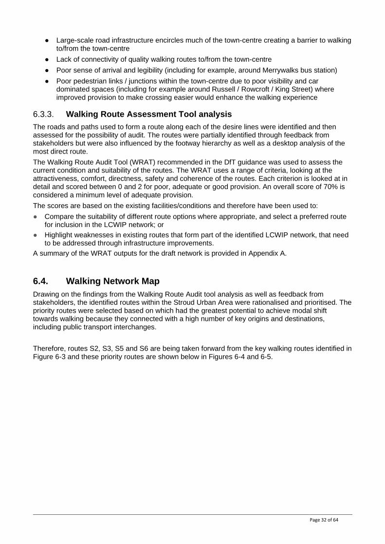
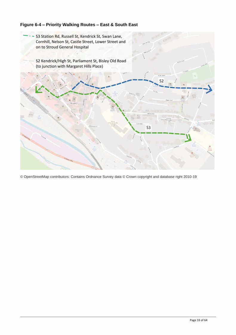
Therefore, routes S2, S3, S5 and S6 are being taken forward from the key walking routes identified in Figure 6-3 and these priority routes are shown below in Figures 6-4 and 6-5.
Page 33 of 64
Figure 6-4 – Priority Walking Routes – East & South East
© OpenStreetMap contributors: Contains Ordnance Survey data © Crown copyright and database right 2010-19
S3 Station Rd, Russell St, Kendrick St, Swan Lane, Cornhill, Nelson St, Castle Street, Lower Street and on to Stroud General Hospital
S2 Kendrick/High St, Parliament St, Bisley Old Road (to junction with Margaret Hills Place)
Page 34 of 64
Figure 6-5 –Key Walking Routes – Central & North West
© OpenStreetMap contributors: Contains Ordnance Survey data © Crown copyright and database right 2010-19
These four key walking routes are taken forward in Chapter 8 for further analysis for developing proposals and costings.
S5 Railway station, car park, Cheapside, Rowcroft j/w Cheapside, Cainscross Road and on to the north-west
S6 Bus Stops at Merrywalks, Rowcroft Retreat, King Street, Rowcroft, Russel Street, Five Valleys Shopping Centre
Page 35 of 64
7. Programme of Cycle Infrastructure Improvements
Nearly all the routes identified in the Stroud Cycling Network Map require infrastructure improvements to enhance the quality and attractiveness of the routes to existing and potential cyclists. Such improvements should provide a network that reflects the standards and expectations set out in LTN 1/20 Cycle Infrastructure Design. This section sets out indicative cycle facilities for the identified network and high-level risks to their delivery. Some key routes have been considered in more detail and more specific proposed improvements are set out below.
Infrastructure improvements will be delivered over time on an incremental basis as opportunities and funding arise. This Programme of Cycling Infrastructure Improvements will also evolve over time with more details added across the network as feasibility investigations are progressed.
7.1. Cycling network - indicative facilities and improvements
The proposed network identifies the routes and links that should best accommodate cycle trips within the area, in order to provide direct, convenient, and safe access by cycle. In nearly all cases, improvements are required on these routes to make them suitable to enable mass-cycling and as a result they are not necessarily the best available existing routes.
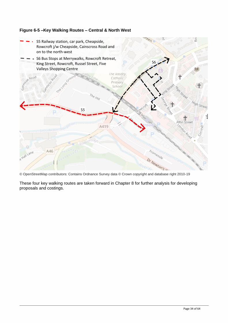
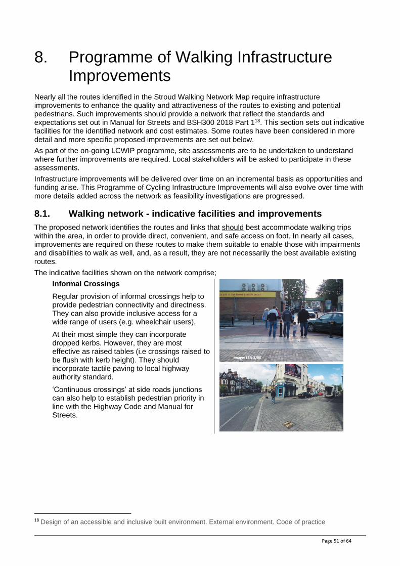
The indicative facilities shown on the network comprise;
Segregated 2-way cycle track Fully segregated from motor vehicles and pedestrians. Facility can be;
• Online – generally alongside a road, or
• Offline - on a separate alignment away from roads (e.g. a rural multi-user path).
Segregated 1-way cycle track Cycle track adjacent to a road with kerbed segregation from motor vehicles and pedestrians.
Online 2-way cycle track (Image: LTN 1/20)
Stepped cycle track (Image: LTN 1/20)
Offline 2-way cycle track (Image: LTN 1/20)
Fully segregated cycle track (Image: LTN 1/20)
Page 36 of 64
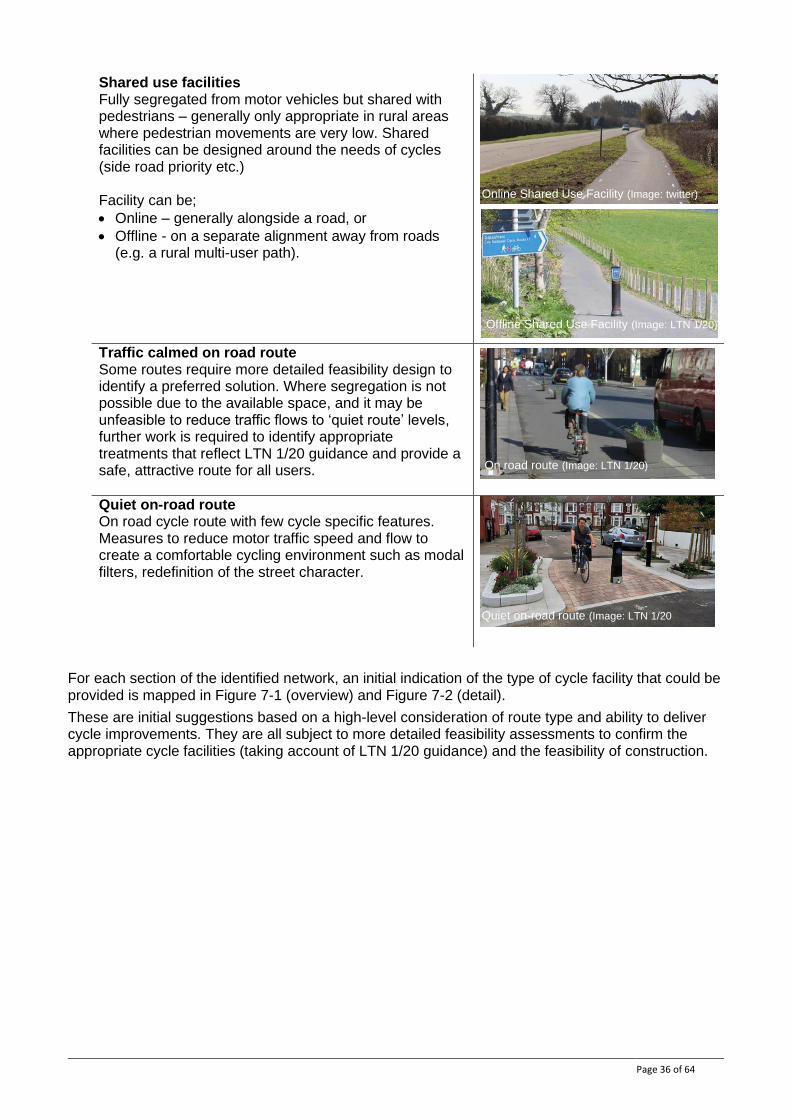
Shared use facilities Fully segregated from motor vehicles but shared with pedestrians – generally only appropriate in rural areas where pedestrian movements are very low. Shared facilities can be designed around the needs of cycles (side road priority etc.) Facility can be;
• Online – generally alongside a road, or
• Offline - on a separate alignment away from roads (e.g. a rural multi-user path).
Traffic calmed on road route Some routes require more detailed feasibility design to identify a preferred solution. Where segregation is not possible due to the available space, and it may be unfeasible to reduce traffic flows to ‘quiet route’ levels, further work is required to identify appropriate treatments that reflect LTN 1/20 guidance and provide a safe, attractive route for all users.
Quiet on-road route On road cycle route with few cycle specific features. Measures to reduce motor traffic speed and flow to create a comfortable cycling environment such as modal filters, redefinition of the street character.
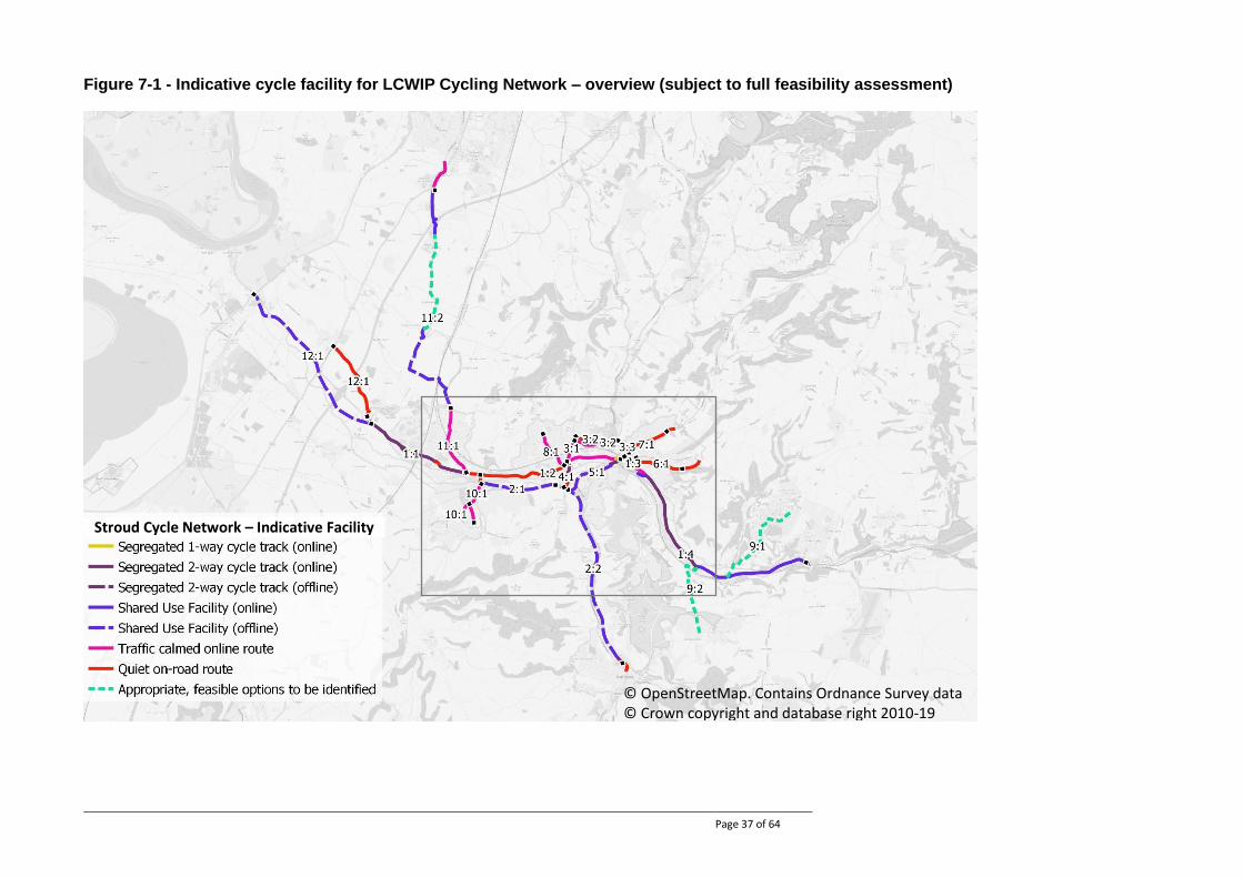
For each section of the identified network, an initial indication of the type of cycle facility that could be provided is mapped in Figure 7-1 (overview) and Figure 7-2 (detail).
These are initial suggestions based on a high-level consideration of route type and ability to deliver cycle improvements. They are all subject to more detailed feasibility assessments to confirm the appropriate cycle facilities (taking account of LTN 1/20 guidance) and the feasibility of construction.
Quiet on-road route (Image: LTN 1/20
Offline Shared Use Facility (Image: LTN 1/20)
Online Shared Use Facility (Image: twitter)
On road route (Image: LTN 1/20)
Page 37 of 64
Figure 7-1 - Indicative cycle facility for LCWIP Cycling Network – overview (subject to full feasibility assessment)
© OpenStreetMap. Contains Ordnance Survey data © Crown copyright and database right 2010-19
Stroud Cycle Network – Indicative Facility

Page 38 of 64
Figure 7-2 - Indicative cycle facility for LCWIP Cycling Network - detail (subject to full feasibility assessment)
© OpenStreetMap Contains Ordnance Survey data © Crown copyright and database right 2010-19
Stroud Cycle Network – Indicative Facility
Page 39 of 64
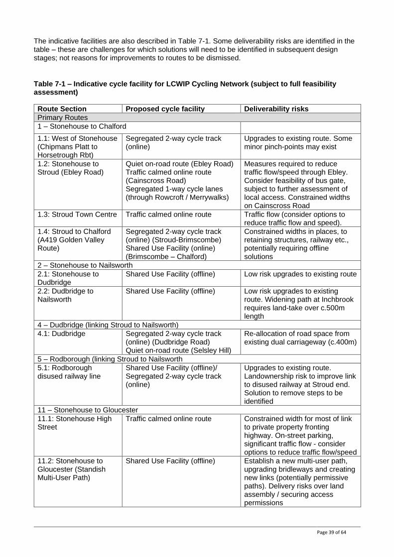
The indicative facilities are also described in Table 7-1. Some deliverability risks are identified in the table – these are challenges for which solutions will need to be identified in subsequent design stages; not reasons for improvements to routes to be dismissed.
Table 7-1 – Indicative cycle facility for LCWIP Cycling Network (subject to full feasibility assessment)
Route Section Proposed cycle facility Deliverability risks
Primary Routes
1 – Stonehouse to Chalford
1.1: West of Stonehouse (Chipmans Platt to Horsetrough Rbt)
Segregated 2-way cycle track (online)
Upgrades to existing route. Some minor pinch-points may exist
1.2: Stonehouse to Stroud (Ebley Road)
Quiet on-road route (Ebley Road) Traffic calmed online route (Cainscross Road) Segregated 1-way cycle lanes (through Rowcroft / Merrywalks)
Measures required to reduce traffic flow/speed through Ebley. Consider feasibility of bus gate, subject to further assessment of local access. Constrained widths on Cainscross Road
1.3: Stroud Town Centre Traffic calmed online route Traffic flow (consider options to reduce traffic flow and speed).
1.4: Stroud to Chalford (A419 Golden Valley Route)
Segregated 2-way cycle track (online) (Stroud-Brimscombe) Shared Use Facility (online) (Brimscombe – Chalford)
Constrained widths in places, to retaining structures, railway etc., potentially requiring offline solutions
2 – Stonehouse to Nailsworth
2.1: Stonehouse to Dudbridge
Shared Use Facility (offline) Low risk upgrades to existing route
2.2: Dudbridge to Nailsworth
Shared Use Facility (offline) Low risk upgrades to existing route. Widening path at Inchbrook requires land-take over c.500m length
4 – Dudbridge (linking Stroud to Nailsworth)
4.1: Dudbridge Segregated 2-way cycle track (online) (Dudbridge Road) Quiet on-road route (Selsley Hill)
Re-allocation of road space from existing dual carriageway (c.400m)
5 – Rodborough (linking Stroud to Nailsworth
5.1: Rodborough disused railway line
Shared Use Facility (offline)/ Segregated 2-way cycle track (online)
Upgrades to existing route. Landownership risk to improve link to disused railway at Stroud end. Solution to remove steps to be identified
11 – Stonehouse to Gloucester
11.1: Stonehouse High Street
Traffic calmed online route Constrained width for most of link to private property fronting highway. On-street parking, significant traffic flow - consider options to reduce traffic flow/speed
11.2: Stonehouse to Gloucester (Standish Multi-User Path)
Shared Use Facility (offline)
Establish a new multi-user path, upgrading bridleways and creating new links (potentially permissive paths). Delivery risks over land assembly / securing access permissions
Page 40 of 64
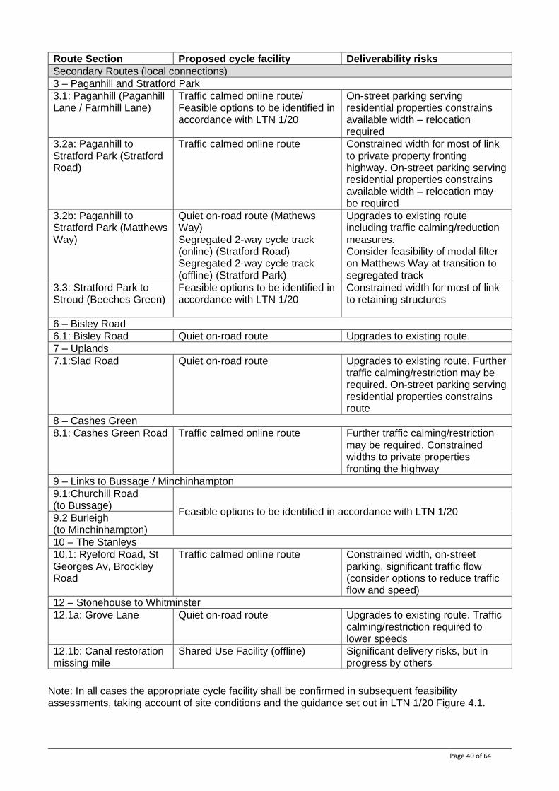
Route Section Proposed cycle facility Deliverability risks
Secondary Routes (local connections)
3 – Paganhill and Stratford Park
3.1: Paganhill (Paganhill Lane / Farmhill Lane)
Traffic calmed online route/ Feasible options to be identified in accordance with LTN 1/20
On-street parking serving residential properties constrains available width – relocation required
3.2a: Paganhill to Stratford Park (Stratford Road)
Traffic calmed online route Constrained width for most of link to private property fronting highway. On-street parking serving residential properties constrains available width – relocation may be required
3.2b: Paganhill to Stratford Park (Matthews Way)
Quiet on-road route (Mathews Way) Segregated 2-way cycle track (online) (Stratford Road) Segregated 2-way cycle track (offline) (Stratford Park)
Upgrades to existing route including traffic calming/reduction measures. Consider feasibility of modal filter on Matthews Way at transition to segregated track
3.3: Stratford Park to Stroud (Beeches Green)
Feasible options to be identified in accordance with LTN 1/20
Constrained width for most of link to retaining structures
6 – Bisley Road
6.1: Bisley Road Quiet on-road route Upgrades to existing route.
7 – Uplands
7.1:Slad Road Quiet on-road route Upgrades to existing route. Further traffic calming/restriction may be required. On-street parking serving residential properties constrains route
8 – Cashes Green
8.1: Cashes Green Road Traffic calmed online route Further traffic calming/restriction may be required. Constrained widths to private properties fronting the highway
9 – Links to Bussage / Minchinhampton
9.1:Churchill Road (to Bussage)
Feasible options to be identified in accordance with LTN 1/20 9.2 Burleigh (to Minchinhampton)
10 – The Stanleys
10.1: Ryeford Road, St Georges Av, Brockley Road
Traffic calmed online route Constrained width, on-street parking, significant traffic flow (consider options to reduce traffic flow and speed)
12 – Stonehouse to Whitminster
12.1a: Grove Lane Quiet on-road route Upgrades to existing route. Traffic calming/restriction required to lower speeds
12.1b: Canal restoration missing mile
Shared Use Facility (offline) Significant delivery risks, but in progress by others
Note: In all cases the appropriate cycle facility shall be confirmed in subsequent feasibility assessments, taking account of site conditions and the guidance set out in LTN 1/20 Figure 4.1.
Page 41 of 64
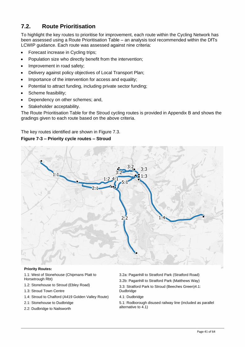
7.2. Route Prioritisation
To highlight the key routes to prioritise for improvement, each route within the Cycling Network has been assessed using a Route Prioritisation Table – an analysis tool recommended within the DfTs LCWIP guidance. Each route was assessed against nine criteria:
• Forecast increase in Cycling trips;
• Population size who directly benefit from the intervention;
• Improvement in road safety;
• Delivery against policy objectives of Local Transport Plan;
• Importance of the intervention for access and equality;
• Potential to attract funding, including private sector funding;
• Scheme feasibility;
• Dependency on other schemes; and,
• Stakeholder acceptability.
The Route Prioritisation Table for the Stroud cycling routes is provided in Appendix B and shows the gradings given to each route based on the above criteria.
The key routes identified are shown in Figure 7.3.
Figure 7-3 – Priority cycle routes – Stroud
Priority Routes:
1.1: West of Stonehouse (Chipmans Platt to Horsetrough Rbt)
1.2: Stonehouse to Stroud (Ebley Road)
1.3: Stroud Town Centre
1.4: Stroud to Chalford (A419 Golden Valley Route)
2.1: Stonehouse to Dudbridge
2.2: Dudbridge to Nailsworth
3.2a: Paganhill to Stratford Park (Stratford Road)
3.2b: Paganhill to Stratford Park (Matthews Way)
3.3: Stratford Park to Stroud (Beeches Green)4.1:
Dudbridge
4.1: Dudbridge
5.1: Rodborough disused railway line (included as parallel alternative to 4.1)
Page 42 of 64
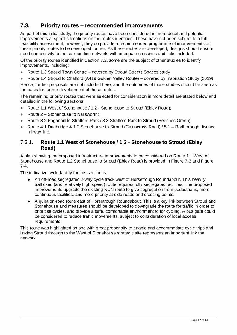
7.3. Priority routes – recommended improvements
As part of this initial study, the priority routes have been considered in more detail and potential improvements at specific locations on the routes identified. These have not been subject to a full feasibility assessment; however, they do provide a recommended programme of improvements on these priority routes to be developed further. As these routes are developed, designs should ensure good connectivity to the surrounding network, with adequate crossings and links included.
Of the priority routes identified in Section 7.2, some are the subject of other studies to identify improvements, including;
● Route 1.3 Stroud Town Centre – covered by Stroud Streets Spaces study
● Route 1.4 Stroud to Chalford (A419 Golden Valley Route) – covered by Inspiration Study (2019)
Hence, further proposals are not included here, and the outcomes of those studies should be seen as the basis for further development of those routes.
The remaining priority routes that were selected for consideration in more detail are stated below and detailed in the following sections;
● Route 1.1 West of Stonehouse / 1.2 - Stonehouse to Stroud (Ebley Road);
● Route 2 – Stonehouse to Nailsworth;
● Route 3.2 Paganhill to Stratford Park / 3.3 Stratford Park to Stroud (Beeches Green);
● Route 4.1 Dudbridge & 1.2 Stonehouse to Stroud (Cainscross Road) / 5.1 – Rodborough disused railway line.
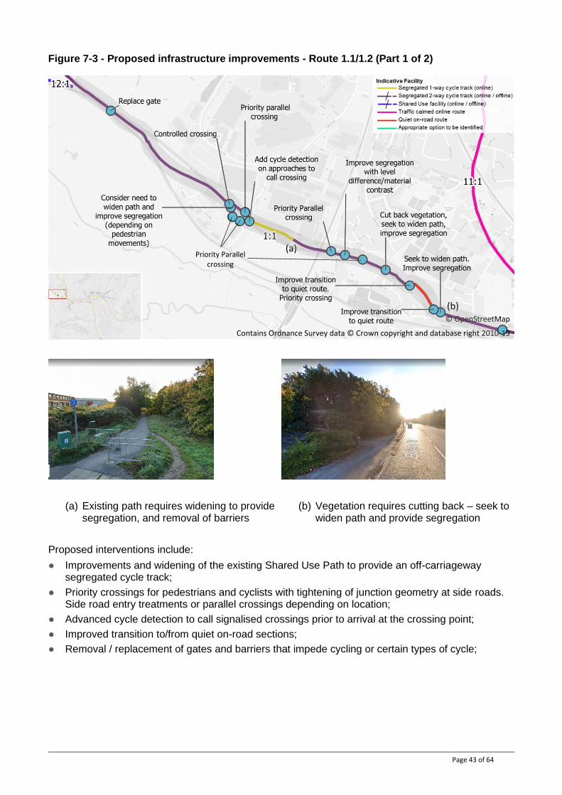
7.3.1. Route 1.1 West of Stonehouse / 1.2 - Stonehouse to Stroud (Ebley Road)
A plan showing the proposed infrastructure improvements to be considered on Route 1.1 West of Stonehouse and Route 1.2 Stonehouse to Stroud (Ebley Road) is provided in Figure 7-3 and Figure 7-4.
The indicative cycle facility for this section is:
● An off-road segregated 2-way cycle track west of Horsetrough Roundabout. This heavily trafficked (and relatively high speed) route requires fully segregated facilities. The proposed improvements upgrade the existing NCN route to give segregation from pedestrians, more continuous facilities, and more priority at side roads and crossing points.
● A quiet on-road route east of Horsetrough Roundabout. This is a key link between Stroud and Stonehouse and measures should be developed to downgrade the route for traffic in order to prioritise cycles, and provide a safe, comfortable environment to for cycling. A bus gate could be considered to reduce traffic movements, subject to consideration of local access requirements.
This route was highlighted as one with great propensity to enable and accommodate cycle trips and linking Stroud through to the West of Stonehouse strategic site represents an important link the network.
Page 43 of 64
Figure 7-3 - Proposed infrastructure improvements - Route 1.1/1.2 (Part 1 of 2)
(a) Existing path requires widening to provide segregation, and removal of barriers
(b) Vegetation requires cutting back – seek to widen path and provide segregation
Proposed interventions include:
● Improvements and widening of the existing Shared Use Path to provide an off-carriageway segregated cycle track;
● Priority crossings for pedestrians and cyclists with tightening of junction geometry at side roads. Side road entry treatments or parallel crossings depending on location;
● Advanced cycle detection to call signalised crossings prior to arrival at the crossing point;
● Improved transition to/from quiet on-road sections;
● Removal / replacement of gates and barriers that impede cycling or certain types of cycle;
(a)
(b) © OpenStreetMap
Contains Ordnance Survey data © Crown copyright and database right 2010-19
Priority Parallel crossing
Page 44 of 64
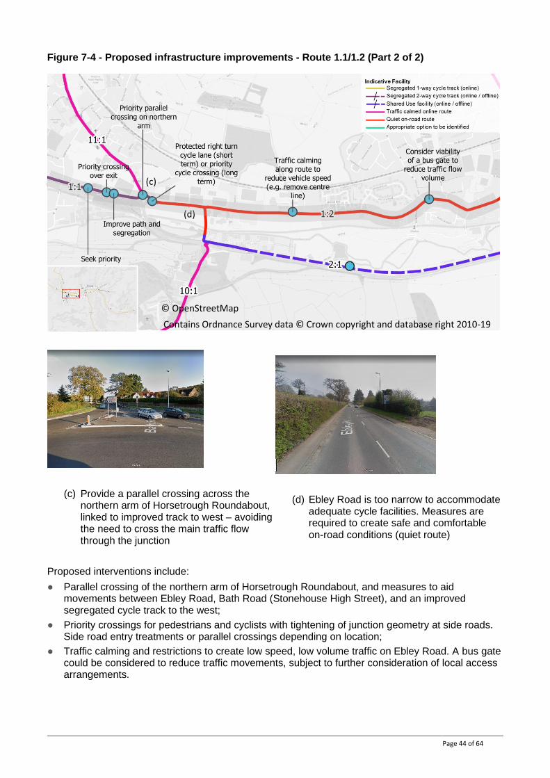
Figure 7-4 - Proposed infrastructure improvements - Route 1.1/1.2 (Part 2 of 2)
(c) Provide a parallel crossing across the northern arm of Horsetrough Roundabout, linked to improved track to west – avoiding the need to cross the main traffic flow through the junction
(d) Ebley Road is too narrow to accommodate adequate cycle facilities. Measures are required to create safe and comfortable on-road conditions (quiet route)
Proposed interventions include:
● Parallel crossing of the northern arm of Horsetrough Roundabout, and measures to aid movements between Ebley Road, Bath Road (Stonehouse High Street), and an improved segregated cycle track to the west;
● Priority crossings for pedestrians and cyclists with tightening of junction geometry at side roads. Side road entry treatments or parallel crossings depending on location;
● Traffic calming and restrictions to create low speed, low volume traffic on Ebley Road. A bus gate could be considered to reduce traffic movements, subject to further consideration of local access arrangements.
(c)
(d)
© OpenStreetMap
Contains Ordnance Survey data © Crown copyright and database right 2010-19
Page 45 of 64
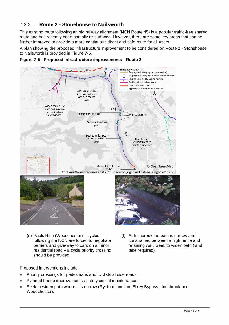
7.3.2. Route 2 - Stonehouse to Nailsworth
This existing route following an old railway alignment (NCN Route 45) is a popular traffic-free shared route and has recently been partially re-surfaced. However, there are some key areas that can be further improved to provide a more continuous direct and safe route for all users.
A plan showing the proposed infrastructure improvement to be considered on Route 2 - Stonehouse to Nailsworth is provided in Figure 7-5.
Figure 7-5 - Proposed infrastructure improvements - Route 2
(e) Pauls Rise (Woodchester) – cycles following the NCN are forced to negotiate barriers and give-way to cars on a minor residential road – a cycle priority crossing should be provided.
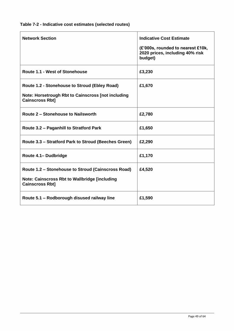
(f) At Inchbrook the path is narrow and constrained between a high fence and retaining wall. Seek to widen path (land take required).
Proposed interventions include:
● Priority crossings for pedestrians and cyclists at side roads;
● Planned bridge improvements / safety critical maintenance;
● Seek to widen path where it is narrow (Ryeford junction, Ebley Bypass, Inchbrook and Woodchester).
(e)
(f)
© OpenStreetMap
Contains Ordnance Survey data © Crown copyright and database right 2010-19

Page 46 of 64
7.3.3. Route 3.2 Paganhill to Stratford Park / 3.3 Stratford Park to Stroud (Beeches Green)
This route provides an important link between Stroud, Stratford Park, Stroud College, Paganhill and local schools. Parallel routes are proposed – a traffic calmed Stratford Road, and an off-road option that may be more suitable for younger cyclists.
A plan showing the proposed infrastructure improvements to be considered on Route 3.2 Paganhill to Stratford Park / 3.3 Stratford Park to Stroud (Beeches Green) is provided in Figure 7-6.
Figure 7-6 - Proposed infrastructure improvements - Route 3
(g) Stratford Park entrance – provide a parallel priority crossing, linking improved segregated tracks on either side
(h) Stratford Road is constrained – traffic calming will improve cycling conditions but a segregated online facility may not be feasible
Proposed interventions include:
● Improvements to existing routes to provide an off-carriageway segregated cycle track parallel to Stratford Road, with a quiet route section on Matthews Way (including a modal filter);
● Priority crossings for pedestrians and cyclists with tightening of junction geometry at side roads. Side road entry treatments or parallel crossings depending on location;
● Explore options to provide segregated facilities or alternate good quality LTN 1/20 design along Beeches Green, requiring some reallocation of road space;
● Replacement of Merrywalks roundabout to provide segregated cycle and walking routes through the junction.
(g)
(h)
Priority over side road
© OpenStreetMap Contains Ordnance Survey data © Crown copyright and database right 2010-19
Page 47 of 64
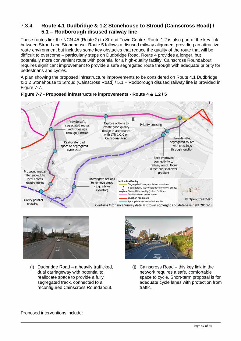
7.3.4. Route 4.1 Dudbridge & 1.2 Stonehouse to Stroud (Cainscross Road) / 5.1 – Rodborough disused railway line
These routes link the NCN 45 (Route 2) to Stroud Town Centre. Route 1.2 is also part of the key link between Stroud and Stonehouse. Route 5 follows a disused railway alignment providing an attractive route environment but includes some key obstacles that reduce the quality of the route that will be difficult to overcome – particularly steps on Dudbridge Road. Route 4 provides a longer, but potentially more convenient route with potential for a high-quality facility. Cainscross Roundabout requires significant improvement to provide a safe segregated route through with adequate priority for pedestrians and cycles.
A plan showing the proposed infrastructure improvements to be considered on Route 4.1 Dudbridge & 1.2 Stonehouse to Stroud (Cainscross Road) / 5.1 – Rodborough disused railway line is provided in Figure 7-7.
Figure 7-7 - Proposed infrastructure improvements - Route 4 & 1.2 / 5
(i) Dudbridge Road – a heavily trafficked, dual carriageway with potential to reallocate space to provide a fully segregated track, connected to a reconfigured Cainscross Roundabout.
(j) Cainscross Road – this key link in the network requires a safe, comfortable space to cycle. Short-term proposal is for adequate cycle lanes with protection from traffic.
Proposed interventions include:
(j)
(i)
© OpenStreetMap
Contains Ordnance Survey data © Crown copyright and database right 2010-19
Page 48 of 64
● Reallocate road space to provide a two-way segregated cycle track on Dudbridge Road;
● A solution to replace the or provide an alternative to the steps at Dudbridge Road – further feasibility work required to identify a preferred option (e.g. elevator, extended ramp)
● Reconfigure Cainscross Roundabout to provide safe, segregated pedestrian and cycle route through the junction;
● Explore options to create good quality design in accordance with LTN 1/20 on Cainscross Road.
7.4. Cost estimate
Indicative cost estimates have been calculated for the proposed interventions set out for the selected routes in Section 7.2. These are based on typical unit / per km rates for similar facilities and do not take account on any particular site characteristics. A risk budget of 40% has been included – appropriate for this stage of scheme development with many unknowns in terms of site condition, potential impact on utilities etc. Scheme costs will be refined as designs and options are developed in more detail, and site-specific costs are understood.
A summary of the indicative cost estimates per corridor are shown in Table 7-2 . The full calculations are provided in Table 7-3.
Page 49 of 64
Table 7-2 - Indicative cost estimates (selected routes)
Network Section Indicative Cost Estimate
(£’000s, rounded to nearest £10k, 2020 prices, including 40% risk budget)
Route 1.1 - West of Stonehouse £3,230
Route 1.2 - Stonehouse to Stroud (Ebley Road)
Note: Horsetrough Rbt to Cainscross [not including Cainscross Rbt]
£1,670
Route 2 – Stonehouse to Nailsworth £2,780
Route 3.2 – Paganhill to Stratford Park £1,650
Route 3.3 – Stratford Park to Stroud (Beeches Green) £2,290
Route 4.1– Dudbridge £1,170
Route 1.2 – Stonehouse to Stroud (Cainscross Road)
Note: Cainscross Rbt to Wallbridge [including Cainscross Rbt]
£4,520
Route 5.1 – Rodborough disused railway line £1,590
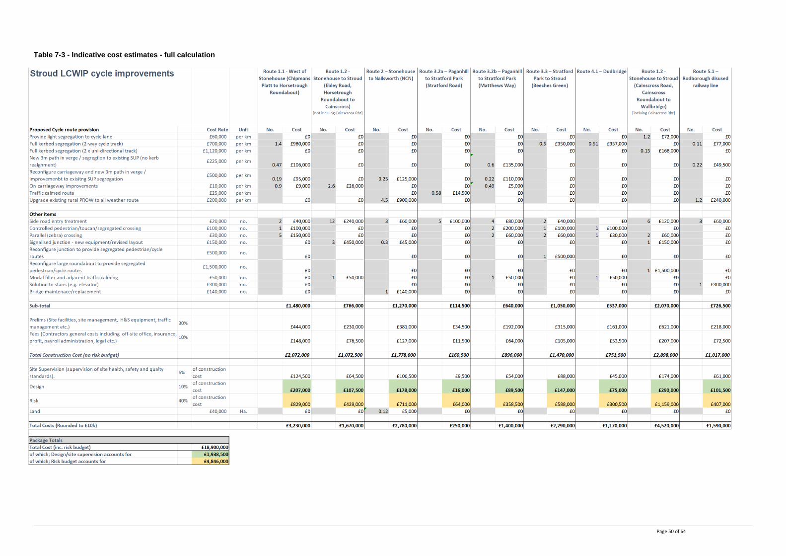
Page 50 of 64
Table 7-3 - Indicative cost estimates - full calculation
Page 51 of 64
8. Programme of Walking Infrastructure Improvements
Nearly all the routes identified in the Stroud Walking Network Map require infrastructure improvements to enhance the quality and attractiveness of the routes to existing and potential pedestrians. Such improvements should provide a network that reflect the standards and expectations set out in Manual for Streets and BSH300 2018 Part 118. This section sets out indicative facilities for the identified network and cost estimates. Some routes have been considered in more detail and more specific proposed improvements are set out below.
As part of the on-going LCWIP programme, site assessments are to be undertaken to understand where further improvements are required. Local stakeholders will be asked to participate in these assessments.
Infrastructure improvements will be delivered over time on an incremental basis as opportunities and funding arise. This Programme of Cycling Infrastructure Improvements will also evolve over time with more details added across the network as feasibility investigations are progressed.
8.1. Walking network - indicative facilities and improvements
The proposed network identifies the routes and links that should best accommodate walking trips within the area, in order to provide direct, convenient, and safe access on foot. In nearly all cases, improvements are required on these routes to make them suitable to enable those with impairments and disabilities to walk as well, and, as a result, they are not necessarily the best available existing routes.
The indicative facilities shown on the network comprise;
Informal Crossings
Regular provision of informal crossings help to provide pedestrian connectivity and directness. They can also provide inclusive access for a wide range of users (e.g. wheelchair users).
At their most simple they can incorporate dropped kerbs. However, they are most effective as raised tables (i.e crossings raised to be flush with kerb height). They should incorporate tactile paving to local highway authority standard.
‘Continuous crossings’ at side roads junctions can also help to establish pedestrian priority in line with the Highway Code and Manual for Streets.
18 Design of an accessible and inclusive built environment. External environment. Code of practice
Image: LTN 3/08
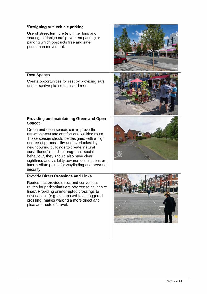
Page 52 of 64
‘Designing out’ vehicle parking
Use of street furniture (e.g. litter bins and seating to ‘design out’ pavement parking or parking which obstructs free and safe pedestrian movement.
Rest Spaces
Create opportunities for rest by providing safe and attractive places to sit and rest.
Providing and maintaining Green and Open Spaces
Green and open spaces can improve the attractiveness and comfort of a walking route. These spaces should be designed with a high degree of permeability and overlooked by neighbouring buildings to create ‘natural surveillance’ and discourage anti-social behaviour, they should also have clear sightlines and visibility towards destinations or intermediate points for wayfinding and personal security.
Provide Direct Crossings and Links
Routes that provide direct and convenient routes for pedestrians are referred to as ‘desire lines’. Providing uninterrupted crossings to destinations (e.g. as opposed to a staggered crossing) makes walking a more direct and pleasant mode of travel.
Wakefield.gov
Tewkesbury © Google 2021
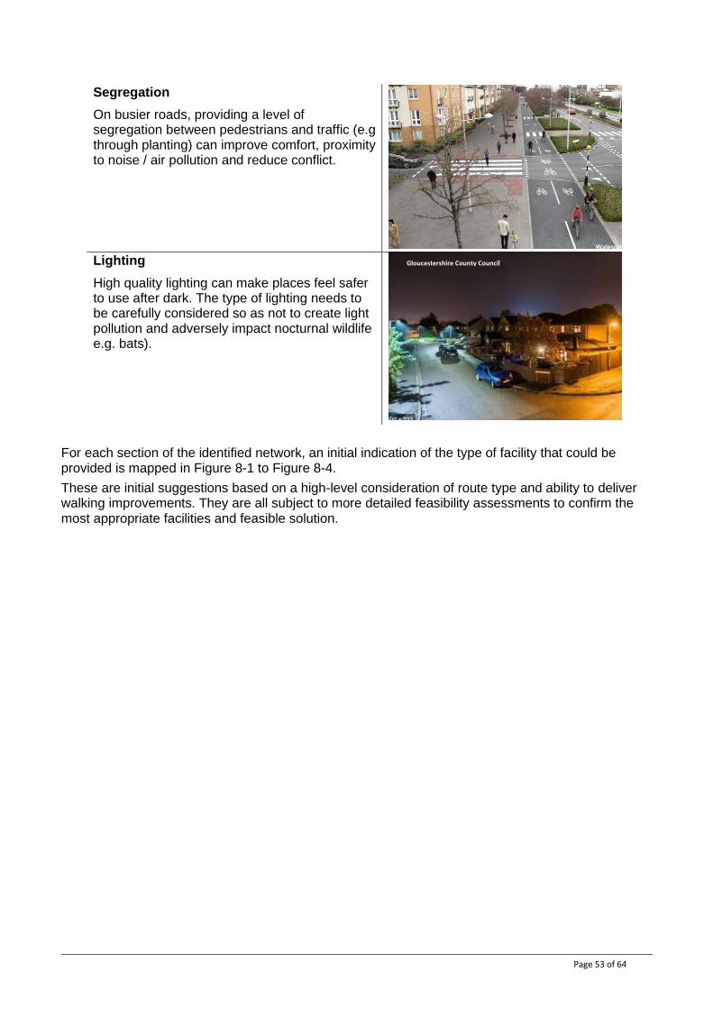
Page 53 of 64
Segregation
On busier roads, providing a level of segregation between pedestrians and traffic (e.g through planting) can improve comfort, proximity to noise / air pollution and reduce conflict.
Lighting
High quality lighting can make places feel safer to use after dark. The type of lighting needs to be carefully considered so as not to create light pollution and adversely impact nocturnal wildlife e.g. bats).
For each section of the identified network, an initial indication of the type of facility that could be provided is mapped in Figure 8-1 to Figure 8-4.
These are initial suggestions based on a high-level consideration of route type and ability to deliver walking improvements. They are all subject to more detailed feasibility assessments to confirm the most appropriate facilities and feasible solution.
Walesonline.co.uk Gloucestershire County Council
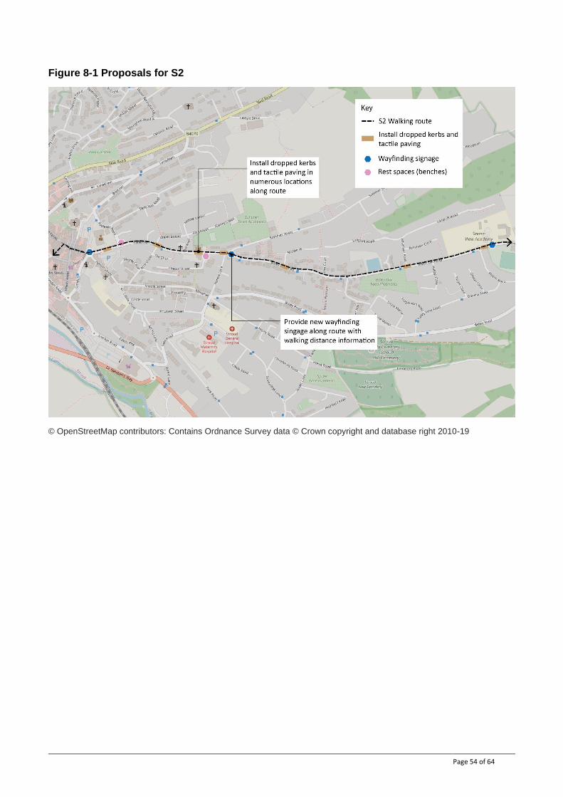
Page 54 of 64
Figure 8-1 Proposals for S2
© OpenStreetMap contributors: Contains Ordnance Survey data © Crown copyright and database right 2010-19
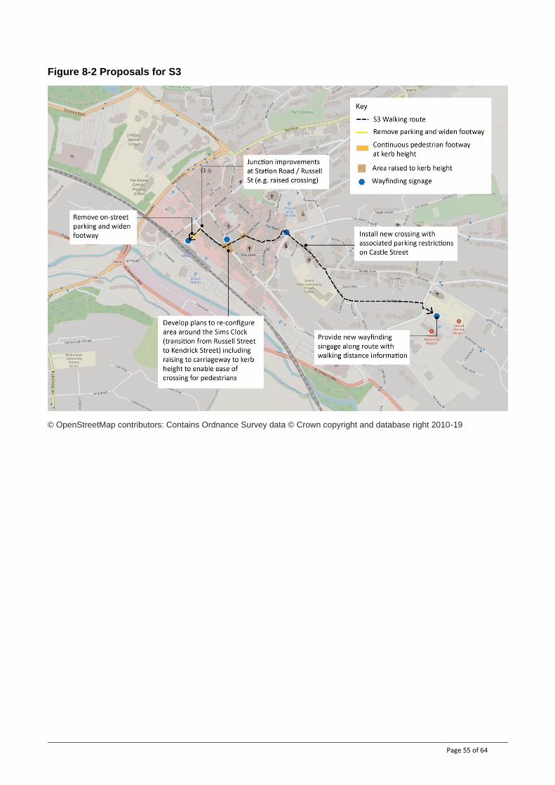
Page 55 of 64
Figure 8-2 Proposals for S3
© OpenStreetMap contributors: Contains Ordnance Survey data © Crown copyright and database right 2010-19
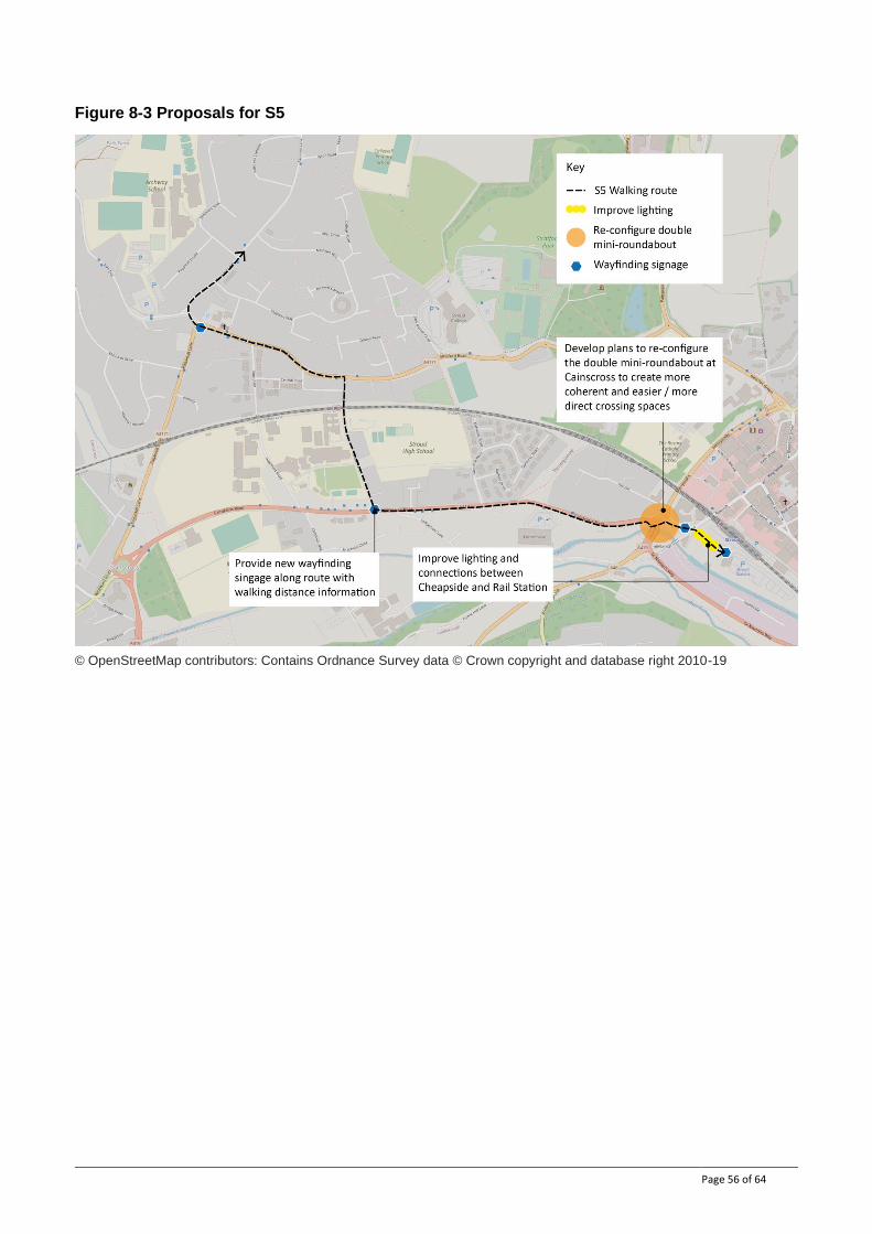
Page 56 of 64
Figure 8-3 Proposals for S5
© OpenStreetMap contributors: Contains Ordnance Survey data © Crown copyright and database right 2010-19
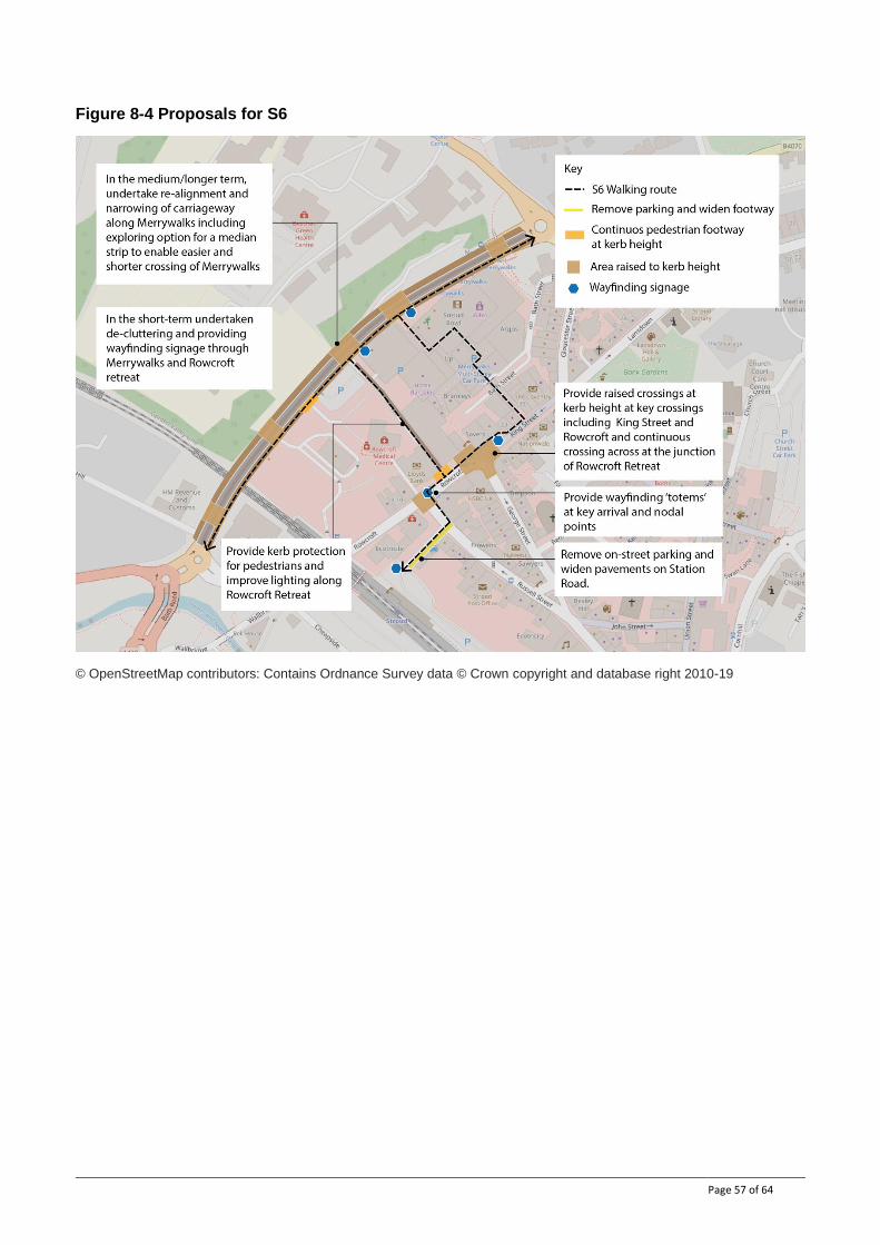
Page 57 of 64
Figure 8-4 Proposals for S6
© OpenStreetMap contributors: Contains Ordnance Survey data © Crown copyright and database right 2010-19
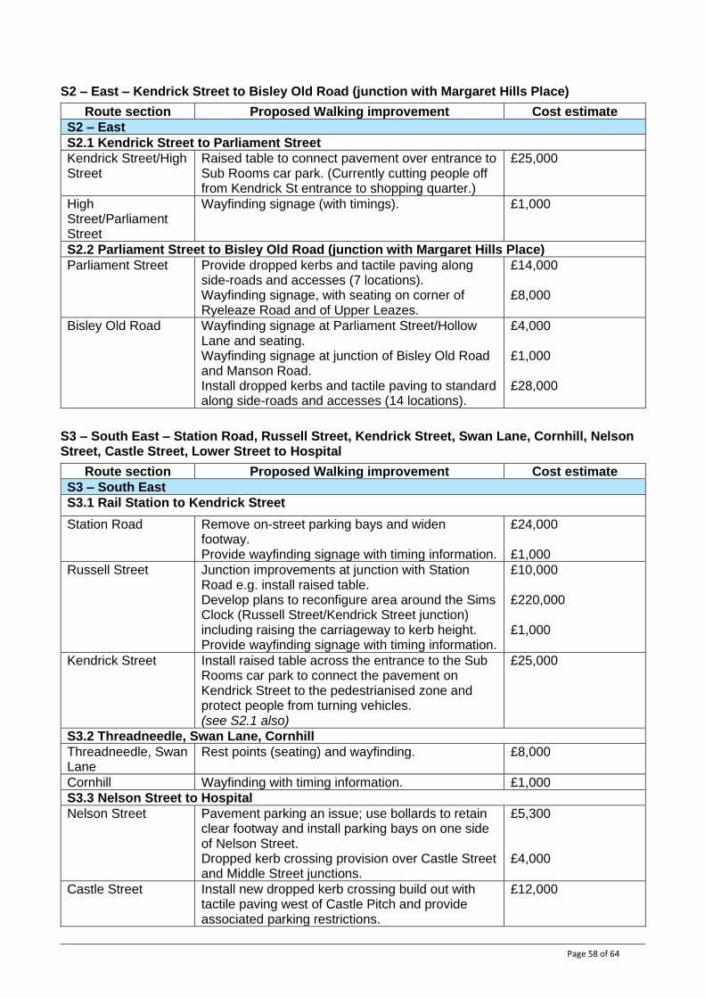
Page 58 of 64
S2 – East – Kendrick Street to Bisley Old Road (junction with Margaret Hills Place)
Route section Proposed Walking improvement Cost estimate
S2 – East
S2.1 Kendrick Street to Parliament Street
Kendrick Street/High Street
Raised table to connect pavement over entrance to Sub Rooms car park. (Currently cutting people off from Kendrick St entrance to shopping quarter.)
£25,000
High Street/Parliament Street
Wayfinding signage (with timings). £1,000
S2.2 Parliament Street to Bisley Old Road (junction with Margaret Hills Place)
Parliament Street Provide dropped kerbs and tactile paving along side-roads and accesses (7 locations). Wayfinding signage, with seating on corner of Ryeleaze Road and of Upper Leazes.
£14,000 £8,000
Bisley Old Road Wayfinding signage at Parliament Street/Hollow Lane and seating. Wayfinding signage at junction of Bisley Old Road and Manson Road. Install dropped kerbs and tactile paving to standard along side-roads and accesses (14 locations).
£4,000 £1,000 £28,000
S3 – South East – Station Road, Russell Street, Kendrick Street, Swan Lane, Cornhill, Nelson Street, Castle Street, Lower Street to Hospital
Route section Proposed Walking improvement Cost estimate
S3 – South East
S3.1 Rail Station to Kendrick Street
Station Road Remove on-street parking bays and widen footway. Provide wayfinding signage with timing information.
£24,000 £1,000
Russell Street Junction improvements at junction with Station Road e.g. install raised table. Develop plans to reconfigure area around the Sims Clock (Russell Street/Kendrick Street junction) including raising the carriageway to kerb height. Provide wayfinding signage with timing information.
£10,000 £220,000 £1,000
Kendrick Street Install raised table across the entrance to the Sub Rooms car park to connect the pavement on Kendrick Street to the pedestrianised zone and protect people from turning vehicles. (see S2.1 also)
£25,000
S3.2 Threadneedle, Swan Lane, Cornhill
Threadneedle, Swan Lane
Rest points (seating) and wayfinding. £8,000
Cornhill Wayfinding with timing information. £1,000
S3.3 Nelson Street to Hospital
Nelson Street Pavement parking an issue; use bollards to retain clear footway and install parking bays on one side of Nelson Street. Dropped kerb crossing provision over Castle Street and Middle Street junctions.
£5,300 £4,000
Castle Street Install new dropped kerb crossing build out with tactile paving west of Castle Pitch and provide associated parking restrictions.
£12,000
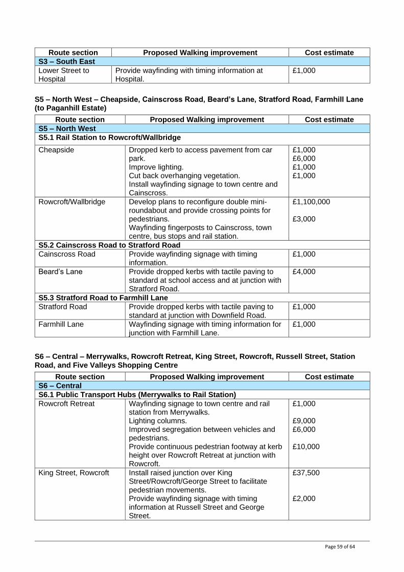
Page 59 of 64
Route section Proposed Walking improvement Cost estimate
S3 – South East
Lower Street to Hospital
Provide wayfinding with timing information at Hospital.
£1,000
S5 – North West – Cheapside, Cainscross Road, Beard’s Lane, Stratford Road, Farmhill Lane (to Paganhill Estate)
Route section Proposed Walking improvement Cost estimate
S5 – North West
S5.1 Rail Station to Rowcroft/Wallbridge
Cheapside Dropped kerb to access pavement from car park. Improve lighting. Cut back overhanging vegetation. Install wayfinding signage to town centre and Cainscross.
£1,000 £6,000 £1,000 £1,000
Rowcroft/Wallbridge Develop plans to reconfigure double mini-roundabout and provide crossing points for pedestrians. Wayfinding fingerposts to Cainscross, town centre, bus stops and rail station.
£1,100,000 £3,000
S5.2 Cainscross Road to Stratford Road
Cainscross Road Provide wayfinding signage with timing information.
£1,000
Beard’s Lane Provide dropped kerbs with tactile paving to standard at school access and at junction with Stratford Road.
£4,000
S5.3 Stratford Road to Farmhill Lane
Stratford Road Provide dropped kerbs with tactile paving to standard at junction with Downfield Road.
£1,000
Farmhill Lane Wayfinding signage with timing information for junction with Farmhill Lane.
£1,000
S6 – Central – Merrywalks, Rowcroft Retreat, King Street, Rowcroft, Russell Street, Station Road, and Five Valleys Shopping Centre
Route section Proposed Walking improvement Cost estimate
S6 – Central
S6.1 Public Transport Hubs (Merrywalks to Rail Station)
Rowcroft Retreat Wayfinding signage to town centre and rail station from Merrywalks. Lighting columns. Improved segregation between vehicles and pedestrians. Provide continuous pedestrian footway at kerb height over Rowcroft Retreat at junction with Rowcroft.
£1,000 £9,000 £6,000 £10,000
King Street, Rowcroft Install raised junction over King Street/Rowcroft/George Street to facilitate pedestrian movements. Provide wayfinding signage with timing information at Russell Street and George Street.
£37,500 £2,000
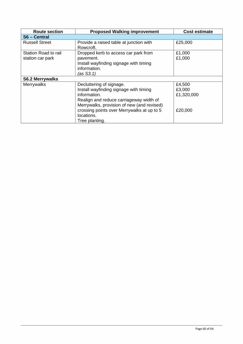
Page 60 of 64
Route section Proposed Walking improvement Cost estimate
S6 – Central
Russell Street Provide a raised table at junction with Rowcroft.
£25,000
Station Road to rail station car park
Dropped kerb to access car park from pavement. Install wayfinding signage with timing information. (as S3.1)
£1,000 £1,000
S6.2 Merrywalks
Merrywalks Decluttering of signage. Install wayfinding signage with timing information. Realign and reduce carriageway width of Merrywalks, provision of new (and revised) crossing points over Merrywalks at up to 5 locations. Tree planting.
£4,500 £3,000 £1,320,000 £20,000
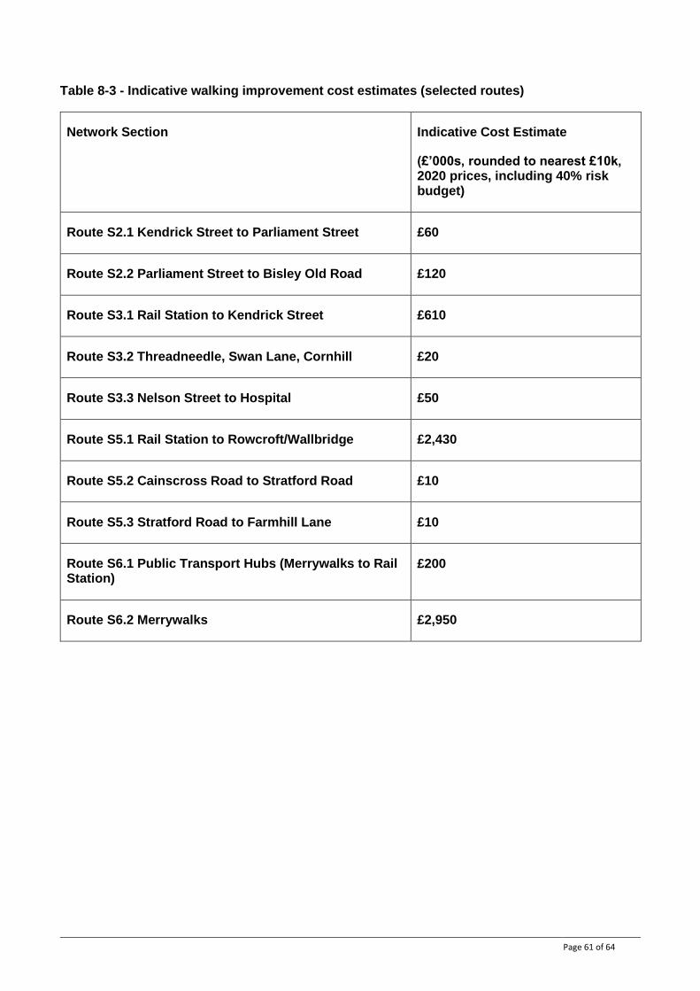
Page 61 of 64
Table 8-3 - Indicative walking improvement cost estimates (selected routes)
Network Section Indicative Cost Estimate
(£’000s, rounded to nearest £10k, 2020 prices, including 40% risk budget)
Route S2.1 Kendrick Street to Parliament Street £60
Route S2.2 Parliament Street to Bisley Old Road £120
Route S3.1 Rail Station to Kendrick Street £610
Route S3.2 Threadneedle, Swan Lane, Cornhill £20
Route S3.3 Nelson Street to Hospital £50
Route S5.1 Rail Station to Rowcroft/Wallbridge £2,430
Route S5.2 Cainscross Road to Stratford Road £10
Route S5.3 Stratford Road to Farmhill Lane £10
Route S6.1 Public Transport Hubs (Merrywalks to Rail Station)
£200
Route S6.2 Merrywalks £2,950

Page 62 of 64
Appendix A: Route Selection Tool scores
Each route within the draft network was assessed using the Route Selection Tool (RST) – an analysis tool recommended within the DfTs LCWIP guidance.
The RST compares the suitability of each route for cycling, in terms of five key qualities of good cycle infrastructure;
● Directness – the ratio of the cycle route length versus motor vehicle route length between two points – with the aim that cycle routes should be the same or shorter distance than motor vehicle routes;
● Gradient – maximum and average gradients reflecting the impact hilliness has on the attractiveness of a route;
● Safety – based on the speed and volume of traffic, level of segregation provided, lighting and natural surveillance;
● Connectivity – measured by the number of access and connections joining a route (suitable for cycles and barrier free) per km;
● Comfort – determined by the width of the facility and surface type;
The scores are based on the existing facilities/conditions and therefore have been used to;
● Compare the suitability of different route options where appropriate, and select a preferred route for inclusion in the LCWIP network; or
● Highlight weaknesses in existing routes that form part of the identified LCWIP network, that need to be addressed through infrastructure improvements.

Page 63 of 64
Appendix B: Cycle Route Prioritisation
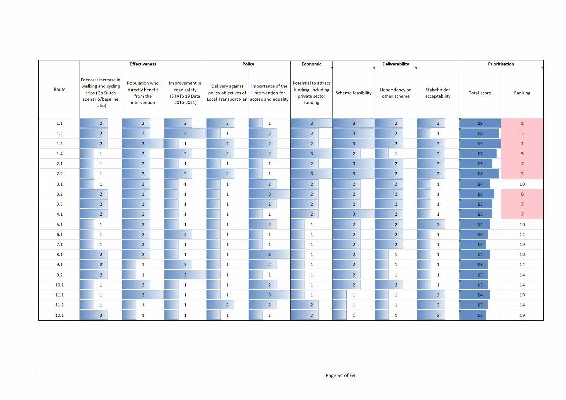
Page 64 of 64


