Šúr, a former late-glacial and Holocene lake at the westernmost margin of the Carpathians Šúr – zaniklé pozdně glaciální a holocenní jezero na nejzápadnějším okraji Karpat Libor P e t r 1,2 , Pavla Ž á č k o v á 2 , Tomáš Matys G r y g a r 3 , Anna P í š k o v á 3 , Marek K ř í ž e k 4 & Václav T r e m l 4 Dedicated to Kamil Rybníček and Eliška Rybníčková on the occasion of their 80th birthdays 1 Department of Botany and Zoology, Faculty of Science, Masaryk University, Kotlářská 2, CZ-61137 Brno, Czech Republic, e-mail: [email protected]; 2 Department of Botany, Faculty of Sciences, Charles University, Benátská 2, CZ-128 01, Praha, Czech Republic; 3 Institute of Inorganic Chemistry ASCR v. v. i., Husinec-Řež 1001, CZ-250 68 Řež, Czech Republic; 4 Department of Physical Geography and Geoecology, Faculty of Sciences Charles University, Albertov 6, CZ-12801, Czech Republic Petr L., Žáčková P., Grygar T. M., Píšková A., Křížek M. & Treml V. (2013): Šúr, a former late-gla- cial and Holocene lake at the westernmost margin of the Carpathians. – Preslia 85: 239–263. There is a unique palaeolimnological record of the late-glacial and Holocene periods in the former lake Šúr near Bratislava in western Slovakia. The aim of this study was to reconstruct the develop- ment of the environment in the locality of the lake, including the gradual infilling of the lake. We reconstructed the development of the lake environment by combining results of a geochemical anal- ysis with analyses of diatoms and plant macrofossils. We also carried out a pollen analysis to assess the changes in the surrounding terrestrial vegetation. The results reveal how the character of the lake has changed over time. At the peak of the glacial period, water flowed through the lake and depos- ited sand there. Later on the flow of water through the lake ceased and a vast oligotrophic lake devel- oped. During the Holocene, the lake gradually became eutrophic. The pollen record contains evi- dence of the occurrence of woody species of broad-leaved forest in the late-glacial period in the Carpathians and of the expansion of mixed forests of Fagus and Carpinus in the Holocene around 4500 BP. The development of the vegetation in the locality of lake Šúr is more similar to that at localities in Hungary than those situated north and west of the Western Carpathians. K e y w o r d s: geochemistry, geomorphology, multi-proxyreconstruction,Pannonia, palaeobotany, palaeolimnology Introduction There are specific geological, geomorphological and climatic conditions, and a high diver- sity of vegetation in the contact zone between the Carpathian and Pannonian phyto- geographic regions (Meusel et al. 1992). The western margin of this region is important in terms of the florogenesis of central Europe, in particular as a migratory route and the pres- ence there of glacial refugia for plants (Taberlet et al. 1998, Hewitt 1999). The key period for the development of the current vegetation in the Western Carpathians is the late-glacial period and the early Holocene, when forest trees migrated from glacial refugia and, con- versely, species of open habitats barely survived (Ložek 1973, Lang 1994). The human influence on the distribution and species composition of vegetation gradually increased Preslia 85: 239–263, 2013 239
Transcript
Šúr, a former late-glacial and Holocene lake at the westernmost marginof the Carpathians
Šúr – zaniklé pozdně glaciální a holocenní jezero na nejzápadnějším okraji Karpat
Libor P e t r1,2, Pavla Ž á č k o v á2, Tomáš Matys G r y g a r3, Anna P í š k o v á3,Marek K ř í ž e k4 & Václav T r e m l4
D e d i c a t e d t o K a m i l R y b n í č e k a n d E l i š k a R y b n í č k o v á o n t h e o c c a s i o n o f t h e i r8 0 t h b i r t h d a y s
1Department of Botany and Zoology, Faculty of Science, Masaryk University, Kotlářská 2,CZ-61137 Brno, Czech Republic, e-mail: [email protected]; 2Department of Botany,Faculty of Sciences, Charles University, Benátská 2, CZ-128 01, Praha, Czech Republic;3Institute of Inorganic Chemistry ASCR v. v. i., Husinec-Řež 1001, CZ-250 68 Řež, CzechRepublic; 4Department of Physical Geography and Geoecology, Faculty of SciencesCharles University, Albertov 6, CZ-12801, Czech Republic
Petr L., Žáčková P., Grygar T. M., Píšková A., Křížek M. & Treml V. (2013): Šúr, a former late-gla-cial and Holocene lake at the westernmost margin of the Carpathians. – Preslia 85: 239–263.
There is a unique palaeolimnological record of the late-glacial and Holocene periods in the formerlake Šúr near Bratislava in western Slovakia. The aim of this study was to reconstruct the develop-ment of the environment in the locality of the lake, including the gradual infilling of the lake. Wereconstructed the development of the lake environment by combining results of a geochemical anal-ysis with analyses of diatoms and plant macrofossils. We also carried out a pollen analysis to assessthe changes in the surrounding terrestrial vegetation. The results reveal how the character of the lakehas changed over time. At the peak of the glacial period, water flowed through the lake and depos-ited sand there. Later on the flow of water through the lake ceased and a vast oligotrophic lake devel-oped. During the Holocene, the lake gradually became eutrophic. The pollen record contains evi-dence of the occurrence of woody species of broad-leaved forest in the late-glacial period in theCarpathians and of the expansion of mixed forests of Fagus and Carpinus in the Holocene around4500 BP. The development of the vegetation in the locality of lake Šúr is more similar to that atlocalities in Hungary than those situated north and west of the Western Carpathians.
K e y w o r d s: geochemistry, geomorphology, multi-proxy reconstruction, Pannonia, palaeobotany,palaeolimnology
Introduction
There are specific geological, geomorphological and climatic conditions, and a high diver-sity of vegetation in the contact zone between the Carpathian and Pannonian phyto-geographic regions (Meusel et al. 1992). The western margin of this region is important interms of the florogenesis of central Europe, in particular as a migratory route and the pres-ence there of glacial refugia for plants (Taberlet et al. 1998, Hewitt 1999). The key periodfor the development of the current vegetation in the Western Carpathians is the late-glacialperiod and the early Holocene, when forest trees migrated from glacial refugia and, con-versely, species of open habitats barely survived (Ložek 1973, Lang 1994). The humaninfluence on the distribution and species composition of vegetation gradually increased
Preslia 85: 239–263, 2013 239
towards the end of the Holocene (Lang 1994). One way to reconstruct vegetation develop-ment in that period is to carry out a palaeoecological analysis of natural archives. Thesearchives are mostly represented by peat bogs, fens and lake sediments. A lake environmentmay remain stable with continuous sedimentation (Cohen 2003) if the lake is deep andthere is no through-flow of water. In addition, sediments in such lakes provide large quan-tities of palaeoecological proxy data, which facilitates the cross-verification of results (e.g.the multi-proxy approach). Lake sediments, therefore, provide a unique palaeoecologicalrecord not only of the lake environment but also of its surroundings. Research on lakesediments requires the use of a combination of approaches ranging from palaeobotany,sedimentology, geomorphology, geophysics to geochemistry (Bristow & Jol 2003, Hub-bard & Glasser 2005). Only in this way is it possible to reconstruct the changes in the lakeenvironment in detail and correlate them with climate changes, vegetation and the effect ofhuman activity on the landscape.
Holocene lakes in Europe occur mainly in regions affected by the last glaciation, be itcontinental or local mountain glaciation (Ehlers et al. 2011). This is why lakes are rela-tively rare in the unglaciated part of central Europe. In the Western Carpathians andPannonian Lowland, lake sediments collected in the Tisicum region (Magyari et al. 2008,Sümegi et al. 2011), around Lake Balaton (Medzihradszky 2005) and north of theCarpathians in Poland (Obidowicz 1996) have been analysed. In Slovakia, very few lakesediments have been studied (Buczkó et al. 2009), with the exception of the High Tatras(Rybníčková & Rybníček 2006). In southern Moravia, the former lakes Vracov(Rybníčková & Rybníček 1972, Svobodová 1997) and Čejč (Břízová 2009) have beenstudied.
Palynological localities in the Western Carpathians occur mainly in the northern part, inthe region of Orava and the Podtatranská kotlina basin (Buczkó et al. 2009). The currentfragmentary palynological evidence presumes a continuous existence of a coniferous taigain the area of the Spišská kotlina basin, which is documented from the full glacial (siteŠafárka; Jankovská et al. 2002, Jankovská & Pokorný 2008) to the late-glacial period andthe Holocene (site Sivárňa; Jankovská 1988a, 2008). There are comparable records frommalacozoological localities in the same region (Farkašovo site; Ložek 2005), which showa combination of species typical of forest communities in a glacial environment. From thewestern edge of the Carpathians there are records from several areas around springs ofHolocene age (Rybníček & Rybníčková 2008). Records of the development of vegetationin the Holocene from the western-Pannonian lowlands (Slovakia) are mostly of older age.Kripell (1963, 1986) analysed two pollen profiles from the Záhorská nížina lowlands(Cerové – Lieskové, Zelienka), which contain a record of the entire Holocene. For thesouth-eastern edge of the Danubian lowlands the profiles collected at Pusté Úľjany(Krippel 1965, 1986) and Šúr (Kinzler 1936), were analysed by the author. These profileshave not been radiocarbon dated, but indicate a predominance of conifers in the glacialperiod, of broad-leaved woody species in the early Holocene and the effect of humanactivity in the late Holocene. Lastly, there are studies of palaeomeanders of the riversDanube and Váh on Žitný ostrov island (Pišút et al. 2010), which are dated to the late Holo-cene. It is Šúr, which thanks to its area and environment appears to be a suitable locality forstudying the palaeoenvironment, the results of which potentially could complete thepalaeoecological record for this area.
240 Preslia 85: 239–263, 2013
The aim of the present study is a revision of the previous results for Šúr, where Kinzler(1936) studied a profile named “Pállfi major”. The specific objectives were to: (i) ascertainthe changes in vegetation that occurred in the late Pleistocene and beginning of the Holo-cene, (ii) determine the development of the environment in the lake basin, (iii) compare theresults with those from localities situated further south in the Danube and Tisza river bas-ins and north of the Carpathian arc, and (iv) revise previous findings and date the mostimportant environmental changes.
Study area and present day environment
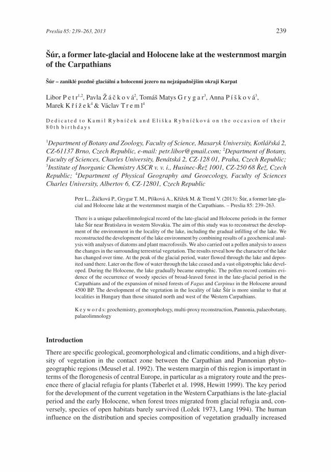
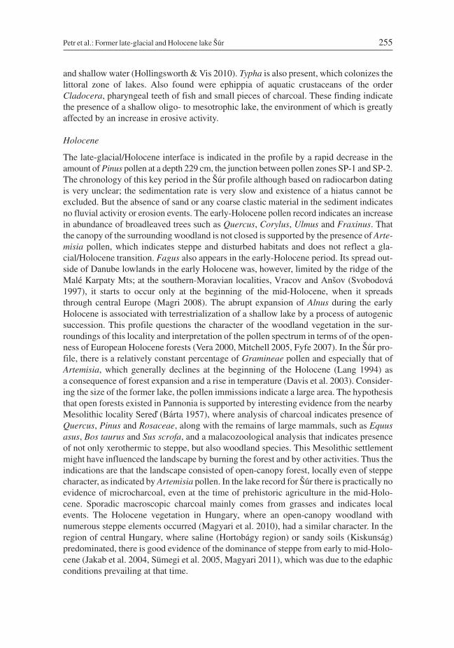
The present day nature reserve Šúr is located in the Danubian Lowland below the south-eastern slope of the Malé Karpaty Mts, approximately 6 km north-east of Bratislava,Slovakia (Fig. 1). In the north, the basin is delimited by the channeled watercourse of theriver Čierná voda, in the south and west by the Šúrský canal and in the east by an Upper-Pleistocene fluvial accumulation terrace (Geological map of Slovakia 1:50,000, 44-22).The fen covering the basin is a north-western sloping plain between 128 and 130 m a.s.l.The dimensions of the basin are approximately 4.3 and 2.8 km, from north-to-south andeast-to-west, respectively. In this area are Pleistocene and Holocene sediments (gravelsand sands of accumulation terraces and organic humolites) overlying neogenous (Panno-nian and Sarmatian) deposits (Maheľ 1986). In the north-west, the basin is permeated by
Petr et al.: Former late-glacial and Holocene lake Šúr 241
Fig. 1. – Map of the Šúr National Nature Reserve showing the locations of the profiles obtained using ground pen-etrating radar and coring, and a description of present-day vegetation cover.
alluvial fans of proluvial sediments extending outwards from the valleys of the MaléKarpaty Mts (Urbánek 1966, Lukniš 1977). This area was drained in the 20th century(Puchmajerová 1948), which resulted in an unbalanced water regime. The entire basin hasa high groundwater table, which is indicated by the extensive pools that cover most of thebasin during spring snow melt. The mean annual temperature is 10.3 °C, and mean annualprecipitation 657 mm (Dohnal 1965).
The vegetation at Šúr lake is highly diverse (Majzlan & Vidlička 2010), ranging fromaquatic communities to xerothermic woodland (Füry 2010). Dominant in the Šúr reserveis tall-trunk alder carr (association Carici elongatae-Alnetum glutinosae). As the water isstagnant for part of the year the Alnus glutinosa trees growing there have prop roots.Meadow and reed vegetation surrounds the carr. Waterlogged meadows occur at the north-western edge of this locality. The communities of the alliance Magnocaricion elatae thereare associated with the formation of organic sediments and creation of characteristic hum-mocks. Communities belonging to the alliance Phragmition occur in the areas that are reg-ularly flooded and have replaced the original alder woodland. Current aquatic vegetationis limited to an artificial water reservoir (Šúrsky rybník) at the south-western edge of thislocality, and isolated pools. The so-called Pannonian wood in the vicinity of the village ofČerná voda is a sunny oak-hornbeam forest with a xerothermic to halophilous character.Intensive grazing in this woodland in the past has had a marked effect on its character.Markedly halophilous vegetation with species such as Tripolium pannonicum, Eryngiumplanum, Artemisia santonicum subsp. patens, Bupleurum tenuissimum or Plantagomaritima is present in part of the Pannonian wood.
Methods
Coring and description of the sediment
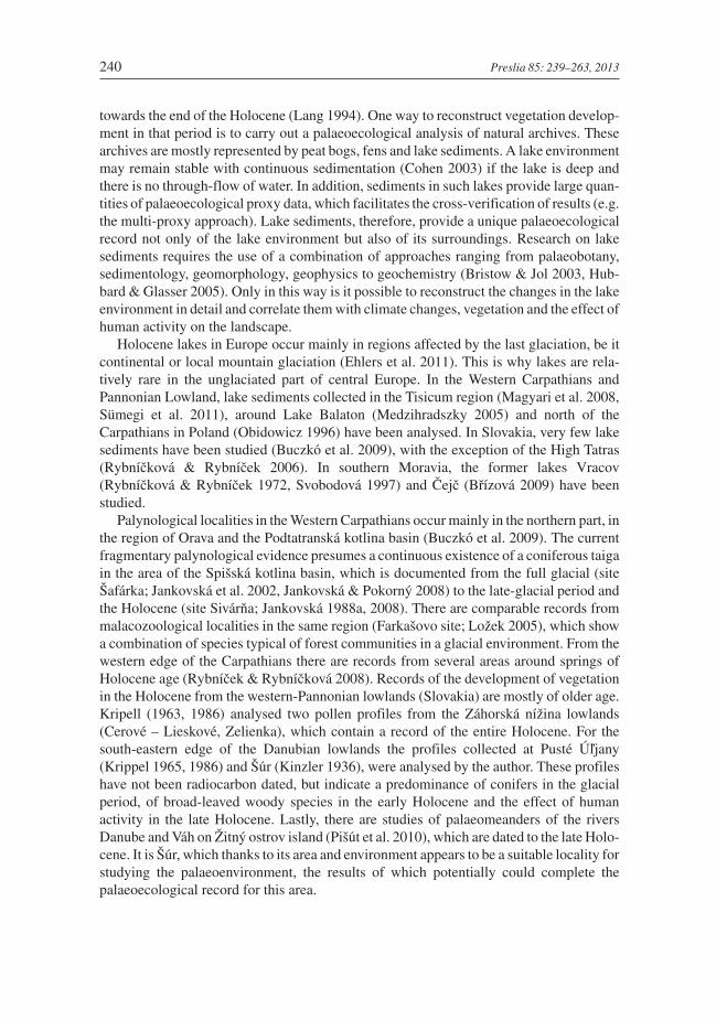
In order to ascertain the extent and spatial deposition of the different types of sediment,ground penetrating radar profiles (total length of 2100 m) of the basin were produced (Fig. 1).To do this we used ground penetrating radar (GPR), RAMAC, with a shielded Malå250 MHz antenna. Profile lines were calibrated using regular hand-punched probes atintervals of approximately 120 m. The material from each probe was always described onthe spot in terms of its spatial deposition, colour and granularity. The profile for thepalaeoecological analysis was collected (based on results of GPR profiling examining thethickness and spatial deposition of sediments and considering the accessibility of thelocality) at the south-eastern edge of the basin (48°13.893' N, 17°14.156' E, 129 m a.s.l.).The main aim was to sample the limnic sediment in that part of the lake basin furthest fromthe influx of sediments from the surrounding landscape. The profile was sampled using anEijkelkamp peat sampler (uncompressed cores, 5 cm in diameter and 50 cm long) fromtwo parallel boreholes in order to collect sufficient material for both a pollen andmacrofossil analyses. For the profile studied, basic characteristics were determined, whichdescribe the amount of organic and mineral components in the sediment and its chemicalcomposition.
The percentage in terms of weight of organic matter in each core was determined bymeans of loss-on-ignition (LOI). The LOI analysis (550 °C) was carried out according toHeiri et al. (2001) and Holliday (2004). The temperature used for drying was 105 °C for
242 Preslia 85: 239–263, 2013
Petr et al.: Former late-glacial and Holocene lake Šúr 243
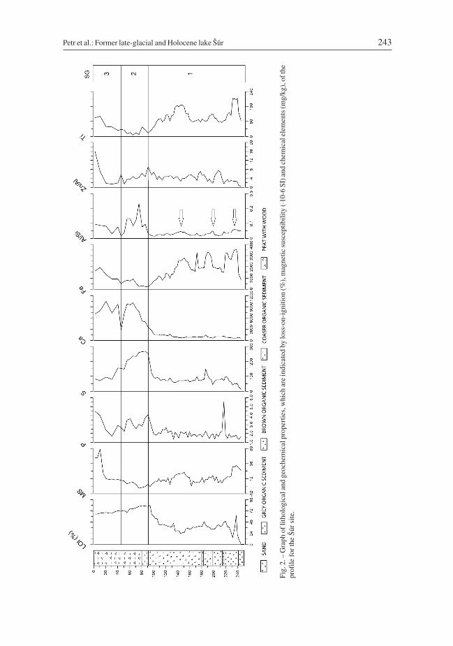
Fig.
2.–
Gra
phof
litho
logi
cala
ndge
oche
mic
alpr
oper
ties,
whi
char
ein
dica
ted
bylo
ss-o
n-ig
nitio
n(%
),m
agne
ticsu
scep
tibili
ty(·
10-6
SI)a
ndch
emic
alel
emen
ts(m
g/kg
),of
the
prof
ilefo
rth
eŠú
rsi
te.
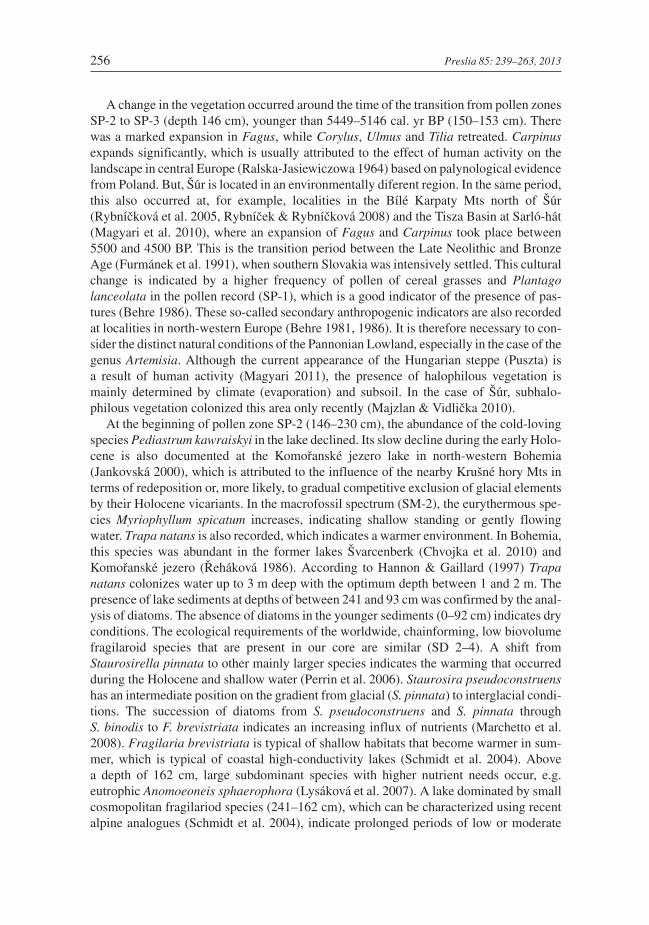
24 hours, and the duration of the combustion was 3 hours (Heiri et al. 2001). LOI of sedi-ments indicates the percentage of organic material (Fig. 2).
Magnetic susceptibility (MS) was determined using a Kappabridge KLY-2 device(Agico, Czech Republic). The results were normalized to get mass-specific magnetic sus-ceptibility in m3·kg–1·10–9. Magnetic susceptibility provides information about import ofclastic sediments eroded in the catchment area or sediment input by overland flow duringfloods and mass movements from adjacent sides of valleys in the Malé Karpaty Mts(Karlén & Matthews 1992, Shakesby et al. 2007) (Fig. 2).
244 Preslia 85: 239–263, 2013
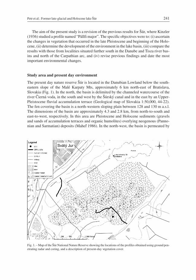
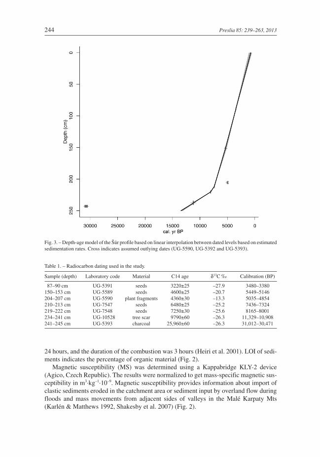
Fig. 3. – Depth-age model of the Šúr profile based on linear interpolation between dated levels based on estimatedsedimentation rates. Cross indicates assumed outlying dates (UG-5590, UG-5392 and UG-5393).
Table 1. – Radiocarbon dating used in the study.
Sample (depth) Laboratory code Material C14 age δ13C ‰ Calibration (BP)
87–90 cm UG-5391 seeds 3220±25 –27.9 3480–3380150–153 cm UG-5589 seeds 4600±25 –20.7 5449–5146204–207 cm UG-5590 plant fragments 4360±30 –13.3 5035–4854210–213 cm UG-7547 seeds 6480±25 –25.2 7436–7324219–222 cm UG-7548 seeds 7250±30 –25.6 8165–8001234–241 cm UG-10528 tree scar 9790±60 –26.3 11,329–10,908241–245 cm UG-5393 charcoal 25,960±60 –26.3 31,012–30,471
X-ray fluorescence analysis (EDXRF) of geochemical properties of rocks and soilswas carried out using a PANalytical MiniPal4.0 spectrometer with a Peltier-cooled silicondrift energy-dispersive detector. The ground samples were analysed after pouring intomeasuring cells with a Mylar foil bottom. The analyses were not calibrated andrecalculated in terms of the content of particular elements. Measurements in counts persecond (c.p.s.) were plotted, and only their relative changes were evaluated in terms oflithofacial or geochemical changes in the sediments (Grygar et al. 2010). In addition,EDXRF unequivocally identified the increase in regional industrial contamination duringthe 20th century (Grygar et al. 2010).
AMS radiocarbon dating was done by the Center for Applied Isotope Studies, Univer-sity of Georgia. The quoted uncalibrated dates are given in radiocarbon years before 1950(years BP). The error is quoted as one standard deviation and reflects both statistical andexperimental errors. The date was corrected for isotope fractionation. The radiocarboncalibration program OxCal v. 4.1.7 (Bronk Ramsey 2009) and the calibration data set ofIntCal09 (Reimer et al. 2009) were used for data calibration. Plant macrofossils and char-coal fragments were used for the dating (Table 1). A “classic” age-depth model based onlinear interpolation between dated levels was applied to determine accumulation rates.The model was constructed using clam software (Blaauw 2010), with three datesconsidered as outliers (Fig. 3).
Palaeoecological analysis
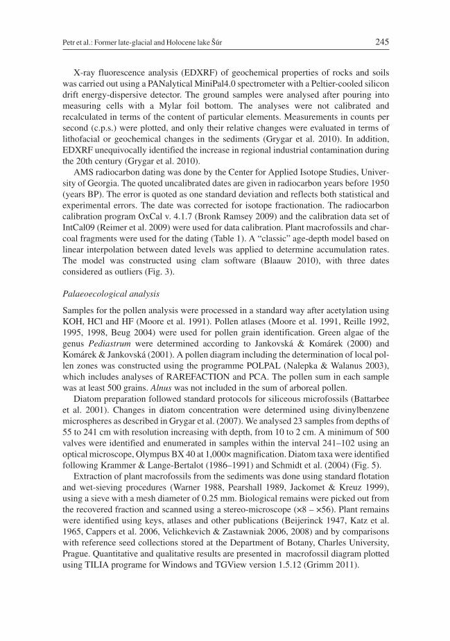
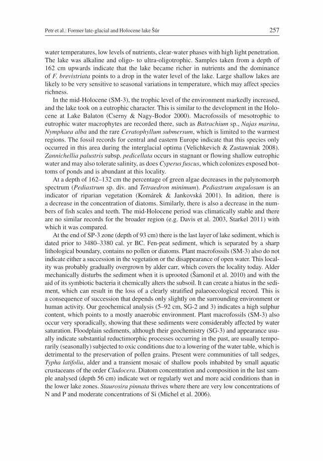
Samples for the pollen analysis were processed in a standard way after acetylation usingKOH, HCl and HF (Moore et al. 1991). Pollen atlases (Moore et al. 1991, Reille 1992,1995, 1998, Beug 2004) were used for pollen grain identification. Green algae of thegenus Pediastrum were determined according to Jankovská & Komárek (2000) andKomárek & Jankovská (2001). A pollen diagram including the determination of local pol-len zones was constructed using the programme POLPAL (Nalepka & Walanus 2003),which includes analyses of RAREFACTION and PCA. The pollen sum in each samplewas at least 500 grains. Alnus was not included in the sum of arboreal pollen.
Diatom preparation followed standard protocols for siliceous microfossils (Battarbeeet al. 2001). Changes in diatom concentration were determined using divinylbenzenemicrospheres as described in Grygar et al. (2007). We analysed 23 samples from depths of55 to 241 cm with resolution increasing with depth, from 10 to 2 cm. A minimum of 500valves were identified and enumerated in samples within the interval 241–102 using anoptical microscope, Olympus BX 40 at 1,000× magnification. Diatom taxa were identifiedfollowing Krammer & Lange-Bertalot (1986–1991) and Schmidt et al. (2004) (Fig. 5).
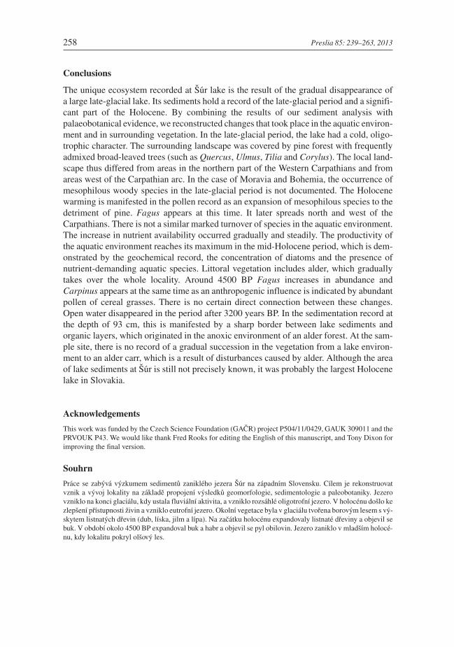
Extraction of plant macrofossils from the sediments was done using standard flotationand wet-sieving procedures (Warner 1988, Pearshall 1989, Jackomet & Kreuz 1999),using a sieve with a mesh diameter of 0.25 mm. Biological remains were picked out fromthe recovered fraction and scanned using a stereo-microscope (×8 – ×56). Plant remainswere identified using keys, atlases and other publications (Beijerinck 1947, Katz et al.1965, Cappers et al. 2006, Velichkevich & Zastawniak 2006, 2008) and by comparisonswith reference seed collections stored at the Department of Botany, Charles University,Prague. Quantitative and qualitative results are presented in macrofossil diagram plottedusing TILIA programe for Windows and TGView version 1.5.12 (Grimm 2011).
Petr et al.: Former late-glacial and Holocene lake Šúr 245
246 Preslia 85: 239–263, 2013
Fig.
4.–
Polle
ndi
agra
mof
sele
cted
polle
nty
pes
and
occu
rren
ceof
spec
ies
ofgr
een
alga
eat
the
Šúr
site
.Abs
olut
eva
lues
in50
mL
ofse
dim
enta
regi
ven.
Petr et al.: Former late-glacial and Holocene lake Šúr 247
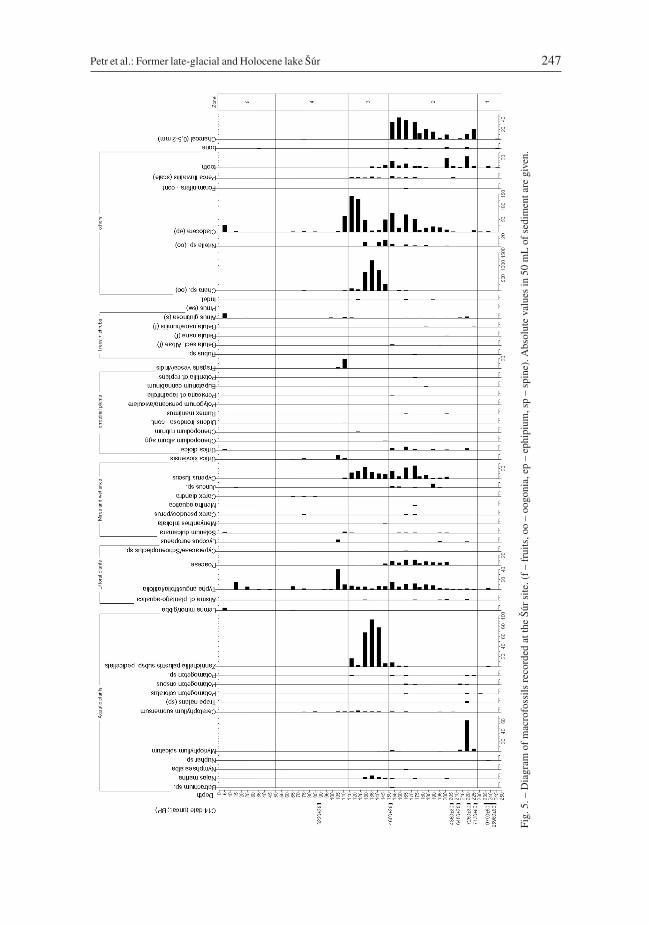
Fig.
5.–
Dia
gram
ofm
acro
foss
ilsre
cord
edat
the
Šúr
site
.(f
–fr
uits
,oo
–oo
goni
a,ep
–ep
hipi
um,s
p–
spin
e).A
bsol
ute
valu
esin
50m
Lof
sedi
men
tare
give
n.
Results
Sedimentary settings
The entire basin is covered with fen in different stages of degradation (thickness of 50–150cm). At the edges of the basin, however, the fen is covered by a layer that contains mineralsoil. Below this layer there are horizontal and subhorizontal layers that vary in thicknessfrom one locality to another. Layered diffractions on the radargrams form simple layersthat are parallel or corrugated. These layers correspond to the stratified structure of gravel,sand, silt and loam laminated into thin to thick layers. In the western part of the basin, thereis an increase in the proportion of finer-grained fractions containing loams, the thicknessof sandy layers is reduced and their number becomes more variable.
Based on the above the sedimentation in the basin occurred periodically and each wascharacterized by a different sedimentation process, which corresponds with a lake envi-ronment and an environment with through-flowing water, indicated by layers of badlysorted sand. There is also an apparent difference in development between the eastern andwestern part of the basin. In the western part, there is a greater influx of material from thearea of the Malé Karpaty Mts.
248 Preslia 85: 239–263, 2013
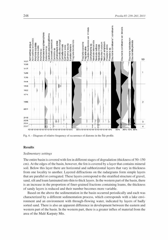
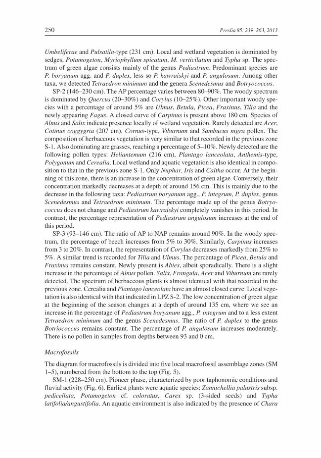
Fig. 6. – Diagram of relative frequency of occurrence of diatoms in the Šúr profile.
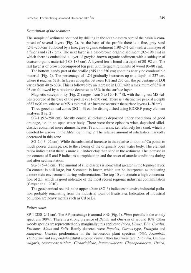
Description of the sediment
The sample of sediment obtained by drilling in the south-eastern part of the basin is com-posed of several layers (Fig. 2). At the base of the profile there is a fine, grey sand(241–250 cm) followed by a fine, grey organic sediment (198–241 cm) with a thin layer ofa finer sand (217 cm). The next layer is a pale-brown organic sediment (92–198 cm) inwhich there is embedded a layer of greyish-brown organic sediment with a sublayer ofcoarser organic material (180–183 cm). A layered fen is found at a depth of 80–92 cm. Thelast layer is of brown decomposed fen peat with frequent remnants of wood (0–80 cm).
The bottom, sandy part of the profile (245 and 250 cm) contains nearly no combustiblematerial (Fig. 2). The percentage of LOI gradually increases up to a depth of 237 cm,where it reaches 62%. In layers at depths between 102 and 237 cm, the percentage of LOIvaries from 40 to 60%. This is followed by an increase in LOI, with a maximum of 83% at93 cm followed by a moderate decrease to 65% in the surface layer.
Magnetic susceptibility (Fig. 2) ranges from 5 to 120·10–6 SI, with the highest MS val-ues recorded at the base of the profile (231–250 cm). There is a distinctive peak at a depthof 87 to 90 cm, otherwise MS is minimal. An increase occurs in the surface layers (1–20 cm).
Three geochemical zones (SG 1–3) can be distinguished using EDXRF proxy elementanalyses (Fig. 2).
SG-1 (92–250 cm). Mostly coarse siliciclastics deposited under conditions of gooddrainage, i.e. in an open water body. There were three episodes when deposited silici-clastics contained more alumosilicates, Ti and minerals, i.e. relatively less sand, which isdenoted by arrows in the Al/Si log in Fig. 2. The relative amount of siliclastics markedlydecreased in this zone
SG-2 (43–92 cm). While the substantial increase in the relative amount of Ca points tomuch poorer drainage, i.e. to the closing of the originally open water body. The elementratios indicate that there is more silt and/or clay than sand in the sediment. The increase inthe content of S and P indicates eutrophication and the onset of anoxic conditions duringand after sedimentation.
SG-3 (5–43 cm). The amount of siliciclastics is somewhat greater in the topmost layer,Ca content is still large, but S content is lower, which can be interpreted as indicatinga more oxic environment during sedimentation. The top 10 cm contain a high concentra-tion of Zn, which is good indicator of the most recent regional industrial contamination(Grygar et al. 2010).
The geochemical record in the upper 40 cm (SG-3) indicates intensive industrial pollu-tion probably emanating from the industrial town of Bratislava. Indicators of industrialpollution are heavy metals such as Cd or Bi.
Pollen zones
SP-1 (230–241 cm). The AP percentage is around 90% (Fig. 4). Pinus prevails in the woodyspectrum (90%). There is a strong presence of Betula and Quercus of around 10%. Otherwoody species are represented only marginally; this applies to Picea, Ulmus, Tilia, Corylus,Fraxinus, Alnus and Salix. Rarely detected were Populus, Cornus-type, Frangula andJuniperus. Grasses predominate in the herbaceous plant spectrum (5%). Artemisia,Thalictrum and Filipendula exhibit a closed curve. Other taxa were rare: Labiatea, Callunavulgaris, Asteraceae subfam. Cichorioideae, Ranunculaceae, Chenopodiaceae, Urtica,
Petr et al.: Former late-glacial and Holocene lake Šúr 249
Umbeliferae and Pulsatila-type (231 cm). Local and wetland vegetation is dominated bysedges, Potamogeton, Myriophyllum spicatum, M. verticilatum and Typha sp. The spec-trum of green algae consists mainly of the genus Pediastrum. Predominant species areP. boryanum agg. and P. duplex, less so P. kawraiskyi and P. angulosum. Among othertaxa, we detected Tetraedron minimum and the genera Scenedesmus and Botryococcos.
SP-2 (146–230 cm). The AP percentage varies between 80–90%. The woody spectrumis dominated by Quercus (20–30%) and Corylus (10–25%). Other important woody spe-cies with a percentage of around 5% are Ulmus, Betula, Picea, Fraxinus, Tilia and thenewly appearing Fagus. A closed curve of Carpinus is present above 180 cm. Species ofAlnus and Salix indicate presence locally of wetland vegetation. Rarely detected are Acer,Cotinus coggygria (207 cm), Cornus-type, Viburnum and Sambucus nigra pollen. Thecomposition of herbaceous vegetation is very similar to that recorded in the previous zoneS-1. Also dominating are grasses, reaching a percentage of 5–10%. Newly detected are thefollowing pollen types: Heliantemum (216 cm), Plantago lanceolata, Anthemis-type,Polygonum and Cerealia. Local wetland and aquatic vegetation is also identical in compo-sition to that in the previous zone S-1. Only Nuphar, Iris and Caltha occur. At the begin-ning of this zone, there is an increase in the concentration of green algae. Conversely, theirconcentration markedly decreases at a depth of around 156 cm. This is mainly due to thedecrease in the following taxa: Pediastrum boryanum agg., P. integrum, P. duplex, genusScenedesmus and Tetraedrom minimum. The percentage made up of the genus Botryo-coccus does not change and Pediastrum kawraiskyi completely vanishes in this period. Incontrast, the percentage representation of Pediastrum angulosum increases at the end ofthis period.
SP-3 (93–146 cm). The ratio of AP to NAP remains around 90%. In the woody spec-trum, the percentage of beech increases from 5% to 30%. Similarly, Carpinus increasesfrom 3 to 20%. In contrast, the representation of Corylus decreases markedly from 25% to5%. A similar trend is recorded for Tilia and Ulmus. The percentage of Picea, Betula andFraxinus remains constant. Newly present is Abies, albeit sporadically. There is a slightincrease in the percentage of Alnus pollen. Salix, Frangula, Acer and Viburnum are rarelydetected. The spectrum of herbaceous plants is almost identical with that recorded in theprevious zone. Cerealia and Plantago lanceolata have an almost closed curve. Local vege-tation is also identical with that indicated in LPZ S-2. The low concentration of green algaeat the beginning of the season changes at a depth of around 135 cm, where we see anincrease in the percentage of Pediastrum boryanum agg., P. integrum and to a less extentTetraedron minimum and the genus Scenedesmus. The ratio of P. duplex to the genusBotriococcus remains constant. The percentage of P. angulosum increases moderately.There is no pollen in samples from depths between 93 and 0 cm.
Macrofossils
The diagram for macrofossils is divided into five local macrofossil assemblage zones (SM1–5), numbered from the bottom to the top (Fig. 5).
SM-1 (228–250 cm). Pioneer phase, characterized by poor taphonomic conditions andfluvial activity (Fig. 6). Earliest plants were aquatic species: Zannichellia palustris subsp.pedicellata, Potamogeton cf. coloratus, Carex sp. (3-sided seeds) and Typhalatifolia/angustifolia. An aquatic environment is also indicated by the presence of Chara
250 Preslia 85: 239–263, 2013
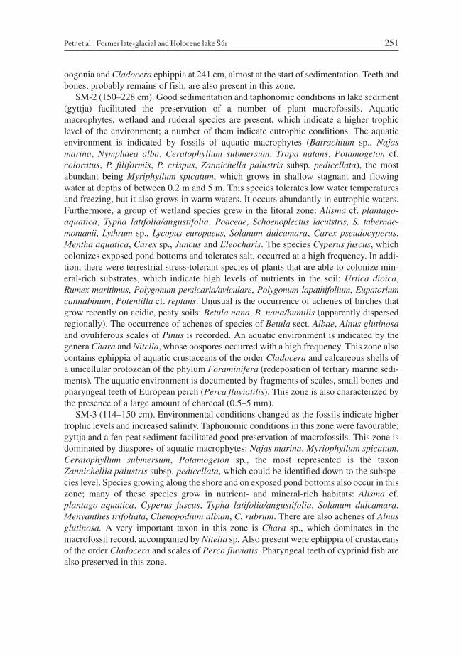
oogonia and Cladocera ephippia at 241 cm, almost at the start of sedimentation. Teeth andbones, probably remains of fish, are also present in this zone.
SM-2 (150–228 cm). Good sedimentation and taphonomic conditions in lake sediment(gyttja) facilitated the preservation of a number of plant macrofossils. Aquaticmacrophytes, wetland and ruderal species are present, which indicate a higher trophiclevel of the environment; a number of them indicate eutrophic conditions. The aquaticenvironment is indicated by fossils of aquatic macrophytes (Batrachium sp., Najasmarina, Nymphaea alba, Ceratophyllum submersum, Trapa natans, Potamogeton cf.coloratus, P. filiformis, P. crispus, Zannichella palustris subsp. pedicellata), the mostabundant being Myriphyllum spicatum, which grows in shallow stagnant and flowingwater at depths of between 0.2 m and 5 m. This species tolerates low water temperaturesand freezing, but it also grows in warm waters. It occurs abundantly in eutrophic waters.Furthermore, a group of wetland species grew in the litoral zone: Alisma cf. plantago-aquatica, Typha latifolia/angustifolia, Poaceae, Schoenoplectus lacutstris, S. tabernae-montanii, Lythrum sp., Lycopus europaeus, Solanum dulcamara, Carex pseudocyperus,Mentha aquatica, Carex sp., Juncus and Eleocharis. The species Cyperus fuscus, whichcolonizes exposed pond bottoms and tolerates salt, occurred at a high frequency. In addi-tion, there were terrestrial stress-tolerant species of plants that are able to colonize min-eral-rich substrates, which indicate high levels of nutrients in the soil: Urtica dioica,Rumex maritimus, Polygonum persicaria/aviculare, Polygonum lapathifolium, Eupatoriumcannabinum, Potentilla cf. reptans. Unusual is the occurrence of achenes of birches thatgrow recently on acidic, peaty soils: Betula nana, B. nana/humilis (apparently dispersedregionally). The occurrence of achenes of species of Betula sect. Albae, Alnus glutinosaand ovuliferous scales of Pinus is recorded. An aquatic environment is indicated by thegenera Chara and Nitella, whose oospores occurred with a high frequency. This zone alsocontains ephippia of aquatic crustaceans of the order Cladocera and calcareous shells ofa unicellular protozoan of the phylum Foraminifera (redeposition of tertiary marine sedi-ments). The aquatic environment is documented by fragments of scales, small bones andpharyngeal teeth of European perch (Perca fluviatilis). This zone is also characterized bythe presence of a large amount of charcoal (0.5–5 mm).
SM-3 (114–150 cm). Environmental conditions changed as the fossils indicate highertrophic levels and increased salinity. Taphonomic conditions in this zone were favourable;gyttja and a fen peat sediment facilitated good preservation of macrofossils. This zone isdominated by diaspores of aquatic macrophytes: Najas marina, Myriophyllum spicatum,Ceratophyllum submersum, Potamogeton sp., the most represented is the taxonZannichellia palustris subsp. pedicellata, which could be identified down to the subspe-cies level. Species growing along the shore and on exposed pond bottoms also occur in thiszone; many of these species grow in nutrient- and mineral-rich habitats: Alisma cf.plantago-aquatica, Cyperus fuscus, Typha latifolia/angustifolia, Solanum dulcamara,Menyanthes trifoliata, Chenopodium album, C. rubrum. There are also achenes of Alnusglutinosa. A very important taxon in this zone is Chara sp., which dominates in themacrofossil record, accompanied by Nitella sp. Also present were ephippia of crustaceansof the order Cladocera and scales of Perca fluviatis. Pharyngeal teeth of cyprinid fish arealso preserved in this zone.
Petr et al.: Former late-glacial and Holocene lake Šúr 251
SM-4 (10–114 cm). There are no fossils indicating the presence of a lake but many indi-cating an inundated alder wetland with a high water table and periodically occurringpools. Aquatic species of vascular macrophytes in this zone were represented only byCeratophyllum submersum and Lemna minor/gibba. Algae of the genus Chara and crusta-ceans of the order Cladocera, too, confirm the presence of open water. Dominant areTypha latifolia/angustifolia accompanied by other littoral species: Lycopus europaeus,Solanum dulcamara, Urtica dioica, Carex pseudocyperus, Carex diandra and C. vulpina .Exposed bottoms of periodic pools were colonized by Cyperus fuscus. Another speciesthat occurred was Urtica kioviensis, a continental taxon growing at the edges of pools.Achenes of Alnus glutinosa are rare but suggest the presence of an alder carr. The occur-rence of Bidens frondosa at this depth indicates possible contamination. Terrestrial light-loving species are represented by Fragaria vesca and F. viridis. Also present are fishbones and charcoal (0.5–2 mm).
SM-5 (0–10 cm; surface sample) contains a record of current vegetation. There aremacroremains of aquatic plants: Lemna minor/gibba (seeds) and ephippia of crustaceansof the order Cladocera. Alder carr species are represented by Solanum dulcamara (seed),Carex sp., Urtica dioica (nutlet) and Alnus glutinosa (fruit).
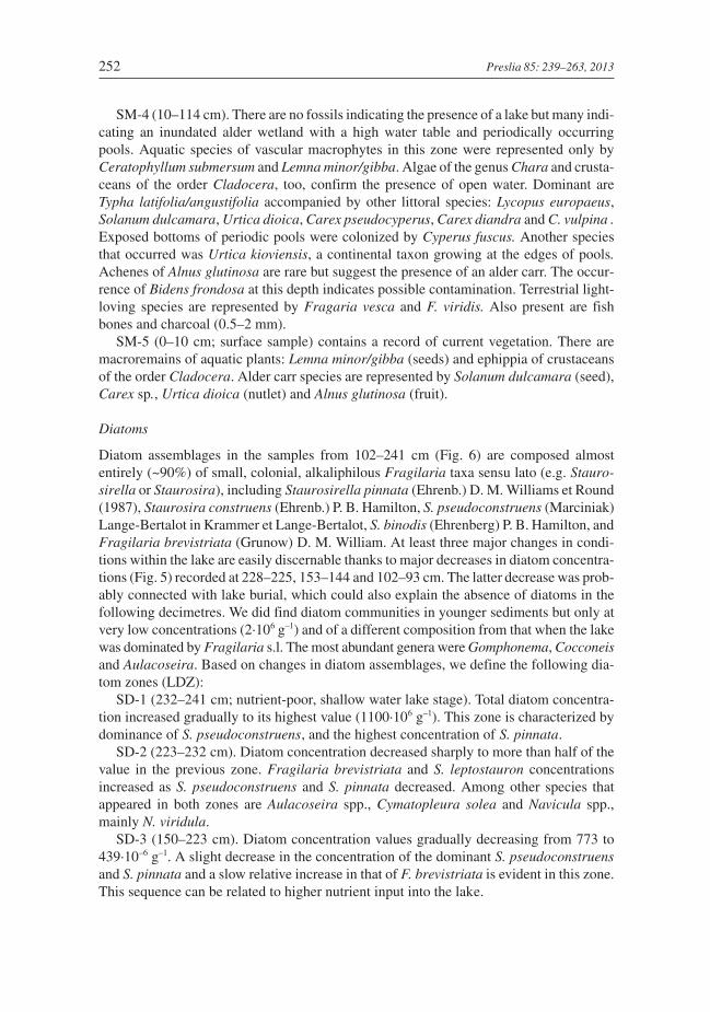
Diatoms
Diatom assemblages in the samples from 102–241 cm (Fig. 6) are composed almostentirely (~90%) of small, colonial, alkaliphilous Fragilaria taxa sensu lato (e.g. Stauro-sirella or Staurosira), including Staurosirella pinnata (Ehrenb.) D. M. Williams et Round(1987), Staurosira construens (Ehrenb.) P. B. Hamilton, S. pseudoconstruens (Marciniak)Lange-Bertalot in Krammer et Lange-Bertalot, S. binodis (Ehrenberg) P. B. Hamilton, andFragilaria brevistriata (Grunow) D. M. William. At least three major changes in condi-tions within the lake are easily discernable thanks to major decreases in diatom concentra-tions (Fig. 5) recorded at 228–225, 153–144 and 102–93 cm. The latter decrease was prob-ably connected with lake burial, which could also explain the absence of diatoms in thefollowing decimetres. We did find diatom communities in younger sediments but only atvery low concentrations (2·106 g–1) and of a different composition from that when the lakewas dominated by Fragilaria s.l. The most abundant genera were Gomphonema, Cocconeisand Aulacoseira. Based on changes in diatom assemblages, we define the following dia-tom zones (LDZ):
SD-1 (232–241 cm; nutrient-poor, shallow water lake stage). Total diatom concentra-tion increased gradually to its highest value (1100·106 g–1). This zone is characterized bydominance of S. pseudoconstruens, and the highest concentration of S. pinnata.
SD-2 (223–232 cm). Diatom concentration decreased sharply to more than half of thevalue in the previous zone. Fragilaria brevistriata and S. leptostauron concentrationsincreased as S. pseudoconstruens and S. pinnata decreased. Among other species thatappeared in both zones are Aulacoseira spp., Cymatopleura solea and Navicula spp.,mainly N. viridula.
SD-3 (150–223 cm). Diatom concentration values gradually decreasing from 773 to439·10–6 g–1. A slight decrease in the concentration of the dominant S. pseudoconstruensand S. pinnata and a slow relative increase in that of F. brevistriata is evident in this zone.This sequence can be related to higher nutrient input into the lake.
252 Preslia 85: 239–263, 2013
Sample at 153 cm is unique in containing the lowest concentration of diatoms and a rel-atively high concentration of diatom species other than Fragilaria s.l., mainly planktonicAulacoseira spp. and the large Cymbella ehrenbergii. Diatom species composition indi-cates mainly an aquatic environment.
SD-4 (102–150 cm) zone represents eutrophic water body with a low water level. Afterthe maximum in S. binodis, which is recorded at the beginning of this zone, F. brevistriatabecame dominant, which dwells in eutrophic and alkaline waters. The end of the zone isdominated by other species, most commonly Amphora veneta and Cocconeis placentula.Other present taxa are e.g. Neidium ampliatum, Gomphonema and Pinnularia spp. thatregularly occur in wet and moist conditions (Van Dam et al. 1994).
Discussion
Last glacial period
The lake basin studied is part of a neotectonically active (Ruszkiczay-Rüdiger et al. 2005)subsidence depression bordering the eastern foothills of the Malé Karpaty Mts (Maglay1999). The distinct character of sedimentation in the western part of the basin revealed bythe ground penetrating radar (Fig. 1) and the punched probes suggests transport of mate-rial from the Malé Karpaty Mts, which is documented also by morphologically conspicu-ous alluvial fans (Urbánek 1966) extending into the basin. The detailed development ofthe Danube river basin around Bratislava is known only for the late Holocene (Pišút 2002,Lehotský et al. 2010). It is therefore a question of whether the layer of well-sorted sand(241–250 cm) was deposited by fluvial activity of the Danube river (Gábris 1994, Gábris& Nádor 2007) or is material carried down from the Malé Karpaty Mts. Evidence of mica,pine bark and charcoal, which was used for radiocarbon dating, indicates transport bywater, not aeolian activities. Considering the short distance to the slopes of the MaléKarpaty Mts, the sand from the latter area would not be well sorted. In any case, significantneotectonic activity took place in this region during the Pleistocene (Nádor et al. 2003,Gábris & Nádor 2007). It coincided with glacial climate changes, which influenced notonly the river regime (imbalanced water flow), behaviour (fluvial activity, branching) andthe paths of watercourses but also their erosive activity such as changing longitudinal pro-file, water content and vegetation (Vandenberghe 2003). These changes are reflected in thevariable sedimentary record at Šúr. The underlying fluvial sand (241–250 cm) containscarbonified pieces of wood and pine bark dated to 31,012–30,471 BP at a depth of241–245 cm. Further numerous pieces of charcoal found in fluvial sand correspond withan increased incidence of fires in cold periods of the last glacial period (Daniau et al. 2010)and more intense erosion (sensu Vandenberghe 2003). During the full-glacial period therewas a through-flow basin with sand sedimentation at this locality.
The pollen zone SP-1 (230–241 cm) based on biostratigraphy (dominance of Pinus)and the prediction of the depth-age model is of late-glacial age. Localities situated in theTisza basin in the late-glacial period (Willis et al. 1995, Jakab et al. 2009, Magyari et al.2010) have pollen spectra similar to those in our zone SP-1. Besides the prevalence ofpine, mesophilous deciduous woody species are represented (Corylus, Quercus, Ulmusand Tilia). These broad-leaved woody species survived the Last Glacial Maximum in theTisza river basin (Willis et al. 1995, 2000, Willis & Andel 2004). Also significant is the
Petr et al.: Former late-glacial and Holocene lake Šúr 253
palaeoecological record of the glacial period (47,000±2300 uncal. yr BP to 25,050±530uncal. yr BP) at the nearby palaeolithic locality Dzeravá skála cave (Kaminská et al. 2005).This consists of charcoal assemblages dominated by Pinus, Betula, Salix and Picea, andless frequent occurrences of Larix, Corylus, Fagus and Ulmus (Hajnalová & Hajnalová2005). The profile also contains skeletal material of small woodland mammals (Horáček2005). Layers corresponding to the LGM and late-glacial period, however, also containarchaeobotanical material from the Late Neolithic (Eneolithic) period (Hajnalová &Hajnalová 2005), so they can hardly be interpreted as unequivocal evidence of the exis-tence of deciduous woodland communities in the Malé Karpaty Mts during the glacialperiod. Direct evidence of the survival of mesotrophic woody species during the late-gla-cial is missing also in the intermountain basins in northern Slovakia (Jankovská 1988a,Jankovská & Pokorný 2008). The sporadic presence of their pollen is probably a result oftheir long-distance transport (Jankovská 1988a). At Šúr, by contrast, the percentage ofpollen of deciduous woody species is high, which indicates their presence locally in thelate-glacial period. The discovery of Betula nana at Šúr (SM-1, depth of 228 cm), which istoday extinct in Slovakia (Hendrych 1998), suggests a wider distribution of boreal andalpine species in the glacial period. In addition, there are tundra plants, such as Dryasoctopetala, Betula humilis and B. nana, in the basal fen peat layers in Lake Balaton(Cserny & Nagy-Bodor 2000, 2005). This together with pollen evidence of Artemisia andPulsatilla (231 cm) in the Šúr profile reveals there were both steppe and tundra speciespresent in the glacial period.
During the late-glacial period the lake was oligotrophic. The low percentage of greenalgae in the palynomorph spectrum at a depth of 231–241 cm (SP-1) most likely indicatesan oligotrophic environment and a colder climate than a lower water level in the lake. Alsodetected is the cold-tolerant species, Pediastrum kawraisky, which today is distributed innorth-eastern Europe (Komárek & Jankovská 2001). Pediastrum kawraisky is alsorecorded in the late-glacial period at similar localities, such as the Komořanské jezero lake(Jankovská 1988b, 2000) and the Czech Cretaceous Basin in central Bohemia (Losert1940, Petr 2005). Diatom assemblages from zone SD-1 (232–241 cm) corespond withlate-glacial conditions. Records of the recent occurrence of small fragilaroid species ofdiatoms are for Arctic lakes (e.g. Guilizzoni et al. 2006, Antoniades et al. 2007, Ilyashuk etal. 2009) and those in mountainous regions (Schmidt et al. 2004). These lakes are usuallysmall (up to 1 km) and oligotrophic. Considering the local conditions at each site, theselakes could have formed at different periods. It is likely, however, that the conditions dur-ing the late-glacial period in central Europe were ideal for the formation of these lakes.Cosmopolitan fragilariod species might therefore be used as a biostratigraphical marker insmall areas of central Europe. We compared the results of our analysis with those from twoother sites: former lake “Velanská cesta” in southern Bohemia (Bešta et al. 2009) anda buried lake in the floodplain of the Morava river near the village of Rohatec in southernMoravia (A. Píšková, unpublished results). Both these lake sediments contain a phasedominated by small Fragilaria taxa, namely Staurosirella pinnata, Staurosira construensand S. pseudoconstruens, all of which are associated mainly with the late-glacial period.The concentration of plant macrofossils is low (zone SM-1, 228–250 cm) and correspondswith an aquatic environment. A limnic environment is documented by the macrophytespecies Nuphar sp. and Zannichellia palustris subsp. pedicellata, which tolerate water ofhigh salinity, and Potamogeton cf. coloratus, which occurs in clean, more likely stagnant
254 Preslia 85: 239–263, 2013
and shallow water (Hollingsworth & Vis 2010). Typha is also present, which colonizes thelittoral zone of lakes. Also found were ephippia of aquatic crustaceans of the orderCladocera, pharyngeal teeth of fish and small pieces of charcoal. These finding indicatethe presence of a shallow oligo- to mesotrophic lake, the environment of which is greatlyaffected by an increase in erosive activity.
Holocene
The late-glacial/Holocene interface is indicated in the profile by a rapid decrease in theamount of Pinus pollen at a depth 229 cm, the junction between pollen zones SP-1 and SP-2.The chronology of this key period in the Šúr profile although based on radiocarbon datingis very unclear; the sedimentation rate is very slow and existence of a hiatus cannot beexcluded. But the absence of sand or any coarse clastic material in the sediment indicatesno fluvial activity or erosion events. The early-Holocene pollen record indicates an increasein abundance of broadleaved trees such as Quercus, Corylus, Ulmus and Fraxinus. Thatthe canopy of the surrounding woodland is not closed is supported by the presence of Arte-misia pollen, which indicates steppe and disturbed habitats and does not reflect a gla-cial/Holocene transition. Fagus also appears in the early-Holocene period. Its spread out-side of Danube lowlands in the early Holocene was, however, limited by the ridge of theMalé Karpaty Mts; at the southern-Moravian localities, Vracov and Anšov (Svobodová1997), it starts to occur only at the beginning of the mid-Holocene, when it spreadsthrough central Europe (Magri 2008). The abrupt expansion of Alnus during the earlyHolocene is associated with terrestrialization of a shallow lake by a process of autogenicsuccession. This profile questions the character of the woodland vegetation in the sur-roundings of this locality and interpretation of the pollen spectrum in terms of of the open-ness of European Holocene forests (Vera 2000, Mitchell 2005, Fyfe 2007). In the Šúr pro-file, there is a relatively constant percentage of Gramineae pollen and especially that ofArtemisia, which generally declines at the beginning of the Holocene (Lang 1994) asa consequence of forest expansion and a rise in temperature (Davis et al. 2003). Consider-ing the size of the former lake, the pollen immissions indicate a large area. The hypothesisthat open forests existed in Pannonia is supported by interesting evidence from the nearbyMesolithic locality Sereď (Bárta 1957), where analysis of charcoal indicates presence ofQuercus, Pinus and Rosaceae, along with the remains of large mammals, such as Equusasus, Bos taurus and Sus scrofa, and a malacozoological analysis that indicates presenceof not only xerothermic to steppe, but also woodland species. This Mesolithic settlementmight have influenced the landscape by burning the forest and by other activities. Thus theindications are that the landscape consisted of open-canopy forest, locally even of steppecharacter, as indicated by Artemisia pollen. In the lake record for Šúr there is practically noevidence of microcharcoal, even at the time of prehistoric agriculture in the mid-Holo-cene. Sporadic macroscopic charcoal mainly comes from grasses and indicates localevents. The Holocene vegetation in Hungary, where an open-canopy woodland withnumerous steppe elements occurred (Magyari et al. 2010), had a similar character. In theregion of central Hungary, where saline (Hortobágy region) or sandy soils (Kiskunság)predominated, there is good evidence of the dominance of steppe from early to mid-Holo-cene (Jakab et al. 2004, Sümegi et al. 2005, Magyari 2011), which was due to the edaphicconditions prevailing at that time.
Petr et al.: Former late-glacial and Holocene lake Šúr 255
A change in the vegetation occurred around the time of the transition from pollen zonesSP-2 to SP-3 (depth 146 cm), younger than 5449–5146 cal. yr BP (150–153 cm). Therewas a marked expansion in Fagus, while Corylus, Ulmus and Tilia retreated. Carpinusexpands significantly, which is usually attributed to the effect of human activity on thelandscape in central Europe (Ralska-Jasiewiczowa 1964) based on palynological evidencefrom Poland. But, Šúr is located in an environmentally diferent region. In the same period,this also occurred at, for example, localities in the Bílé Karpaty Mts north of Šúr(Rybníčková et al. 2005, Rybníček & Rybníčková 2008) and the Tisza Basin at Sarló-hát(Magyari et al. 2010), where an expansion of Fagus and Carpinus took place between5500 and 4500 BP. This is the transition period between the Late Neolithic and BronzeAge (Furmánek et al. 1991), when southern Slovakia was intensively settled. This culturalchange is indicated by a higher frequency of pollen of cereal grasses and Plantagolanceolata in the pollen record (SP-1), which is a good indicator of the presence of pas-tures (Behre 1986). These so-called secondary anthropogenic indicators are also recordedat localities in north-western Europe (Behre 1981, 1986). It is therefore necessary to con-sider the distinct natural conditions of the Pannonian Lowland, especially in the case of thegenus Artemisia. Although the current appearance of the Hungarian steppe (Puszta) isa result of human activity (Magyari 2011), the presence of halophilous vegetation ismainly determined by climate (evaporation) and subsoil. In the case of Šúr, subhalo-philous vegetation colonized this area only recently (Majzlan & Vidlička 2010).
At the beginning of pollen zone SP-2 (146–230 cm), the abundance of the cold-lovingspecies Pediastrum kawraiskyi in the lake declined. Its slow decline during the early Holo-cene is also documented at the Komořanské jezero lake in north-western Bohemia(Jankovská 2000), which is attributed to the influence of the nearby Krušné hory Mts interms of redeposition or, more likely, to gradual competitive exclusion of glacial elementsby their Holocene vicariants. In the macrofossil spectrum (SM-2), the eurythermous spe-cies Myriophyllum spicatum increases, indicating shallow standing or gently flowingwater. Trapa natans is also recorded, which indicates a warmer environment. In Bohemia,this species was abundant in the former lakes Švarcenberk (Chvojka et al. 2010) andKomořanské jezero (Řeháková 1986). According to Hannon & Gaillard (1997) Trapanatans colonizes water up to 3 m deep with the optimum depth between 1 and 2 m. Thepresence of lake sediments at depths of between 241 and 93 cm was confirmed by the anal-ysis of diatoms. The absence of diatoms in the younger sediments (0–92 cm) indicates dryconditions. The ecological requirements of the worldwide, chainforming, low biovolumefragilaroid species that are present in our core are similar (SD 2–4). A shift fromStaurosirella pinnata to other mainly larger species indicates the warming that occurredduring the Holocene and shallow water (Perrin et al. 2006). Staurosira pseudoconstruenshas an intermediate position on the gradient from glacial (S. pinnata) to interglacial condi-tions. The succession of diatoms from S. pseudoconstruens and S. pinnata throughS. binodis to F. brevistriata indicates an increasing influx of nutrients (Marchetto et al.2008). Fragilaria brevistriata is typical of shallow habitats that become warmer in sum-mer, which is typical of coastal high-conductivity lakes (Schmidt et al. 2004). Abovea depth of 162 cm, large subdominant species with higher nutrient needs occur, e.g.eutrophic Anomoeoneis sphaerophora (Lysáková et al. 2007). A lake dominated by smallcosmopolitan fragilariod species (241–162 cm), which can be characterized using recentalpine analogues (Schmidt et al. 2004), indicate prolonged periods of low or moderate
256 Preslia 85: 239–263, 2013
water temperatures, low levels of nutrients, clear-water phases with high light penetration.The lake was alkaline and oligo- to ultra-oligotrophic. Samples taken from a depth of162 cm upwards indicate that the lake became richer in nutrients and the dominanceof F. brevistriata points to a drop in the water level of the lake. Large shallow lakes arelikely to be very sensitive to seasonal variations in temperature, which may affect speciesrichness.
In the mid-Holocene (SM-3), the trophic level of the environment markedly increased,and the lake took on a eutrophic character. This is similar to the development in the Holo-cene at Lake Balaton (Cserny & Nagy-Bodor 2000). Macrofossils of mesotrophic toeutrophic water macrophytes are recorded there, such as Batrachium sp., Najas marina,Nymphaea alba and the rare Ceratophyllum submersum, which is limited to the warmestregions. The fossil records for central and eastern Europe indicate that this species onlyoccurred in this area during the interglacial optima (Velichkevich & Zastawniak 2008).Zannichellia palustris subsp. pedicellata occurs in stagnant or flowing shallow eutrophicwater and may also tolerate salinity, as does Cyperus fuscus, which colonizes exposed bot-toms of ponds and is abundant at this locality.
At a depth of 162–132 cm the percentage of green algae decreases in the palynomorphspectrum (Pediastrum sp. div. and Tetraedron minimum). Pediastrum angulosum is anindicator of riparian vegetation (Komárek & Jankovská 2001). In adition, there isa decrease in the concentration of diatoms. Similarly, there is also a decrease in the num-bers of fish scales and teeth. The mid-Holocene period was climatically stable and thereare no similar records for the broader region (e.g. Davis et al. 2003, Starkel 2011) withwhich it was compared.
At the end of SP-3 zone (depth of 93 cm) there is the last layer of lake sediment, which isdated prior to 3480–3380 cal. yr BC. Fen-peat sediment, which is separated by a sharplithological boundary, contains no pollen or diatoms. Plant macrofossils (SM-3) also do notindicate either a succession in the vegetation or the disappearance of open water. This local-ity was probably gradually overgrown by alder carr, which covers the locality today. Aldermechanically disturbs the sediment when it is uprooted (Šamonil et al. 2010) and with theaid of its symbiotic bacteria it chemically alters the subsoil. It can create a hiatus in the sedi-ment, which can result in the loss of a clearly stratified palaeoecological record. This isa consequence of succession that depends only slightly on the surrounding environment orhuman activity. Our geochemical analysis (5–92 cm, SG-2 and 3) indicates a high sulphurcontent, which points to a mostly anaerobic environment. Plant macrofossils (SM-3) alsooccur very sporadically, showing that these sediments were considerably affected by watersaturation. Floodplain sediments, although their geochemistry (SG-3) and appearance usu-ally indicate substantial reductimorphic processes occurring in the past, are usually tempo-rarily (seasonally) subjected to oxic conditions due to a lowering of the water table, which isdetrimental to the preservation of pollen grains. Present were communities of tall sedges,Typha latifolia, alder and a transient mosaic of shallow pools inhabited by small aquaticcrustaceans of the order Cladocera. Diatom concentration and composition in the last sam-ple analysed (depth 56 cm) indicate wet or regularly wet and more acid conditions than inthe lower lake zones. Staurosira pinnata thrives where there are very low concentrations ofN and P and moderate concentrations of Si (Michel et al. 2006).
Petr et al.: Former late-glacial and Holocene lake Šúr 257
Conclusions
The unique ecosystem recorded at Šúr lake is the result of the gradual disappearance ofa large late-glacial lake. Its sediments hold a record of the late-glacial period and a signifi-cant part of the Holocene. By combining the results of our sediment analysis withpalaeobotanical evidence, we reconstructed changes that took place in the aquatic environ-ment and in surrounding vegetation. In the late-glacial period, the lake had a cold, oligo-trophic character. The surrounding landscape was covered by pine forest with frequentlyadmixed broad-leaved trees (such as Quercus, Ulmus, Tilia and Corylus). The local land-scape thus differed from areas in the northern part of the Western Carpathians and fromareas west of the Carpathian arc. In the case of Moravia and Bohemia, the occurrence ofmesophilous woody species in the late-glacial period is not documented. The Holocenewarming is manifested in the pollen record as an expansion of mesophilous species to thedetriment of pine. Fagus appears at this time. It later spreads north and west of theCarpathians. There is not a similar marked turnover of species in the aquatic environment.The increase in nutrient availability occurred gradually and steadily. The productivity ofthe aquatic environment reaches its maximum in the mid-Holocene period, which is dem-onstrated by the geochemical record, the concentration of diatoms and the presence ofnutrient-demanding aquatic species. Littoral vegetation includes alder, which graduallytakes over the whole locality. Around 4500 BP Fagus increases in abundance andCarpinus appears at the same time as an anthropogenic influence is indicated by abundantpollen of cereal grasses. There is no certain direct connection between these changes.Open water disappeared in the period after 3200 years BP. In the sedimentation record atthe depth of 93 cm, this is manifested by a sharp border between lake sediments andorganic layers, which originated in the anoxic environment of an alder forest. At the sam-ple site, there is no record of a gradual succession in the vegetation from a lake environ-ment to an alder carr, which is a result of disturbances caused by alder. Although the areaof lake sediments at Šúr is still not precisely known, it was probably the largest Holocenelake in Slovakia.
Acknowledgements
This work was funded by the Czech Science Foundation (GAČR) project P504/11/0429, GAUK 309011 and thePRVOUK P43. We would like thank Fred Rooks for editing the English of this manuscript, and Tony Dixon forimproving the final version.
Souhrn
Práce se zabývá výzkumem sedimentů zaniklého jezera Šúr na západním Slovensku. Cílem je rekonstruovatvznik a vývoj lokality na základě propojení výsledků geomorfologie, sedimentologie a paleobotaniky. Jezerovzniklo na konci glaciálu, kdy ustala fluviální aktivita, a vzniklo rozsáhlé oligotrofní jezero. V holocénu došlo kezlepšení přístupnosti živin a vzniklo eutrofní jezero. Okolní vegetace byla v glaciálu tvořena borovým lesem s vý-skytem listnatých dřevin (dub, líska, jilm a lípa). Na začátku holocénu expandovaly listnaté dřeviny a objevil sebuk. V období okolo 4500 BP expandoval buk a habr a objevil se pyl obilovin. Jezero zaniklo v mladším holocé-nu, kdy lokalitu pokryl olšový les.
258 Preslia 85: 239–263, 2013
References
Antoniades D., Crawley C., Douglas M. S. V., Pienitz R., Andersen D., Doran P. T., Hawes I., Pollard W. & Vin-cent W. (2007): Abrupt environmental change in Canada’s northernmost lake inferred from fossil diatom andpigment stratigraphy. – Geophys. Res. Lett. 34: L18708.
Bárta J. (1957): Pleistocénne piesočné duny při Seredi a ich paleolitické a mezolitické osídlenie [Pleistocene sanddune near Sereď and their palaeolithic and Mesolithic settlement]. – Slov. Archeol. 5: 5–72.
Battarbee R. W., Carvalho L., Jones V. J., Flower R. J., Cameron N. G., Bennion H. & Juggins S. (2001): Dia-toms. – In: Smol J. P., Birks H. J. B. & Last W. M. (eds), Tracking environmental change using lake sedi-ments.Vol. 3, Terrestrial, algal, and siliceous indicators, p. 155–202, Kluwer Academic Publishers,Dordrecht.
Behre K.-E. (1981): The interpretation of anthropogenic indicators in pollen diagrams. – Pollen et Spores 23:225–45.
Behre K.-E. (1986): Anthropogenic indicators in pollen diagrams. – A. A. Balkema, Rotterdam.Beijerinck W. (1947): Zadenatlas der Nederlandsche Flora [Seeds atlas of Nederland flora]. – H. Veenman and
Zonen, Wageningen.Bešta T., Šafránková J., Pouzar M., Novák J. & Nováková K. (2009): Late Pleistocene-Early Holocene transition
recorded in the sediments of a former shallow lake in the Czech Republic. – Hydrobiologia 631: 107–120.Beug H. J. (2004): Leitfaden der Pollenbestimmung für Mittelereuropa und angrenzende Gebiete. – Verlag Dr.
Fridrich Pfeil, München.Blaauw M. (2010): Methods and code for “classical“ age-modelling of radiocarbon sequences. – Quat. Geochronol.
5: 512–518.Bristow C. S. & Jol H. M. (2003): Ground penetrating radar in sediments. – Geological Society, London.Břízová E. (2009): Quaternary environmental history of the Čejčské Lake [S. Moravia, Czech Republic]. – Bull.
Geosci. 84: 637–652.Bronk Ramsey C. (2009): Bayesian analysis of radiocarbon dates. – Radiocarbon 51: 337–360.Buczkó K., Magyari E. K., Bitušík P. & Wacnik A. (2009): Review of dated Late Quaternary palaeolimnological
records in the Carpathian Region, east-central Europe. – Hydrobiologia 631: 3–28.Cappers R. T. J., Bekker R. M. & Jans J. E. A. (2006): Digital seed atlas of the Netherlands. – Groningen Archaeo-
logical Studies 3, Barkhuis/Groningen University Library, Groningen.Chvojka O., Pokorný P., Šída P., Žáčková P., Kuneš P., Světlík I. & Veselý J. (2010): Palaeoenvironmental
research of the Schwarzenberg Lake, southern Bohemia, and exploratory excavations of this key Mesolithicarchaeological area. – Pam. Archeol. 101: 5–38.
Cohen A. S. (2003): Paleolimnology: the history and evolution of lake systems. – Oxford University Press,Oxford.
Cserny T. & Nagy-Bodor E. (2000): Limnogeological investigations on Lake Balaton. – In: Gierlowski-KordeschE. & Kelts K. (eds), Lake basins through space and time, p. 605–618, AAPG Studies in Geology 46, Ameri-can Association of Petroleum Geologists, Tulsa.
Cserny T. & Nagy-Bodor E. (2005): Late Holocene geohistory of the Hungarian part of the Eastern Alpine fore-land in the light of recent research. – Antaeus 28: 155–174.
Daniau A.-L., Harrison S. P. & Bartelein P. J. (2010): Fire regimes during the Last Glacial. – Quat. Sci. Rev. 29:2918–2930.
Davis B. A. S., Brewer S., Stevenson A. C. & Guiot J. (2003): The temperature of Europe during the Holocenereconstructed from pollen data. – Quat. Sci. Rev. 22: 1701–1716.
Dohnal Z. (1965): Československá rašeliniště a slatiniště [Czechoslovakian peats and mires]. – Mír, Praha.Ehlers J., Gibbard P. L. & Hughes P. D. (2011): Quaternary glaciations: extent and chronology. – Elsevier,
Oxford.Furmánek V., Veliačik L. & Vladár J. (1991): Slovensko v dobe bronzovej [Slovakia in the Bronz Age]. – Veda,
Bratislava.Füry D. (2010): Vegetačné pomery PR Šúr [Vegetation condition in the Šúr nature reserve]. – In: Majzlan O. &
Vidlička Ľ. (eds), Príroda rezervacie Šúr [The nature of the Šúr reserve], p. 15–23, Ústav zoologie SAV,Bratislava.
Fyfe R. M. (2007): The importance of local-scale openness within regions dominated by closed woodland. – J.Quat. Sci. 22: 571–578.
Gábris G. (1994): Pleistocene evolution of the Danube in the Carpathian Basin. – Terra Nova 6: 495–501.
Petr et al.: Former late-glacial and Holocene lake Šúr 259
Gábris G. & Nádor A. (2007): Long-term fluvial archives in Hungary: response of the Danube and Tisza rivers totectonic movements and climatic changes during the Quaternary: a review and new synthesis. – Quat. Sci.Rev. 26: 2758–2782.
Grimm E. C. (2011): TGView version 1.5.12. – Illinois State Museum, Research and Collections Center,Springfield.
Grygar T., Bláhová A., Hradil D., Bezdicka P., Kadlec J., Schnab P., Swan G. & Oberhänsl H. (2007): Lake Baikalclimatic record between 310 and 50 ky BP: Interplay between diatoms, watershed weathering and orbitalforcing. – Palaeogeogr. Palaeoclimatol. Palaeoecol. 250: 50–67.
Grygar T., Světlík I., Lisá L., Koptíková L., Bajer A., Wray D. S., Ettler V., Mihaljevič M., Nováková T., KoubováM., Novák J., Máčka Z. & Smetana M. (2010): Geochemical tools for the stratigraphic correlation offloodplain deposits of the Morava River in Strážnické Pomoraví, Czech Republic from the last millennium. –Catena 80: 106–121.
Guilizzoni P., Marchetto A., Lami A., Brauer A., Vigliotti L., Musazzi S., Langone L., Manca M., Lucchini F.,Calanchi N., Dinelli E. & Mordenti A. (2006): Records of environmental and climatic changes during the lateHolocene from Svalbard: palaeolimnology of Kongressvatnet. – J. Paleolimnol. 36: 325–351.
Hajnalová M. & Hajnalová E. (2005): The plant macro-remains from Dzeravá skala cave: the environment andplant foods exploited by hunter-gatherers. – In: Kaminská L., Kozlowski K. & Svoboda J. (eds), Dzeraváskala: Pleistocene environments and archaeology of the Dzeravá skala cave, Lesser Carpathians, p. 91–136,Polish Academy of Arts and Sciences, Kraków.
Hannon G. E. & Gaillard M.-J. (1997): The plant macrofossil record of past lake-level changes. – J. Paleolimnol.18: 15–28.
Heiri O., Lotter A. F. & Lemecke G. (2001): Loss on ignition as a method for estimating organic and carbonatecontent in sediments: reproducibility and comparanility of results. – J. Paleolimnol. 25: 101–110.
Hendrych R. (1998): Betula nana, zaniklý i zapomenutý druh Slovenska? [Betula nana: extinct and forgotten spe-cies in Slovakia?]. – Zpr. Čes. Bot. Společ. 33: 169–175.
Hewitt G. M. (1999): Post-glacial re-colonization of European biota. – Biol. J. Linn. Soc. 68: 87–112.Holliday V. T. (2004): Soils in archaeological research. – Oxford University Press, Oxford.Hollingsworth E. K. & Vis M. L. (2010): The spatial heterogeneity of diatoms in eight southeastern Ohio streams:
how far does a single riffle reach? – Hydrobiologia 651: 173–184.Horáček I. (2005): Small vertebrates in the Weichselian series in Dzeravá skala Cave: list of the samples and
a brief summary. – In: Kaminská L., Kozlowski K. & Svoboda J. (eds), Dzeravá skala: Pleistocene environ-ments and archaeology of the Dzeravá skala cave, Lesser Carpathians, p. 157–167, Polish Academy of Artsand Sciences, Kraków.
Hubbard B. & Glasser N. (2005): Field techniques in glaciology and glacial geomorphology. – Wiley, Chichester.Ilyashuk B., Gobet E., Heiri O., Lotter A. F., van Leeuwen J. F. N., van der Knaap W. O., Ilyashuk E., Oberli F. &
Ammann B. (2009): Lateglacial environmental and climatic changes at the Maloja Pass, Central Swiss Alps,as recorded by chironomids and pollen. – Quat. Sci. Rev. 28: 1340–1353.
Jackomet S. & Kreuz A. (1999): Archäobotanik. Aufgaben, Methoden und Ergebnisse vegetations- und agrar-geschichtlicher Forschung. – UTB Stuttgart.
Jakab G., Majkut P., Juhász I., Gulyás S., Sümegi P. & Törőcsik T. (2009:) Palaeoclimatic signals andanthropogenic disturbances from the peatbog at Nagybárkány (N Hungary). – Hydrobiologia 631: 87–106.
Jakab G., Sümegi P. & Magyari E. (2004): A new paleobotanical method for the description of Late Quaternaryorganic sediments (Mire-development pathways and palaeoclimatic records from S Hungary). – Acta Geol.Hung. 47: 1–37.
Jankovská V. (1988a): A reconstruction of Late-Glacial and Early-Holocene evolution of forest vegetation in thePoprad basin, Czechoslovakia. – Folia Geobot. Phytotax. 23: 303–320.
Jankovská V. (1988b): Palynologische Erforschung archäologischer Proben aus dem Komořanské jezero-See beiMost (NW-Böhmen). – Folia Geobot. Phytotax. 23: 45–78.
Jankovská V. (2000): Komořanské jezero lake (CZ, NW Bohemia): a unique natural archive. – Geolines11:115–117.
Jankovská V. (2008): Slovenské a moravské Karpaty v poslední době ledové – ostrov „sibiřské tajgy“ v Evropě[Slovakia and Moravinan Carpathians in last ice age: an island of “Siberian tajga” in Europe]. – Phytopedon7: 122–130.
Jankovská V. & Komárek J. (2000): Indicative value of Pediastrum and other coccal green algae in palaeoecol-ogy. – Folia Geobot. 35: 59–82.
Jankovská V. & Pokorný P. (2008): Forest vegetation of the last full-glacial period in the Western Carpathians(Slovakia and Czech Republic). – Preslia 80: 307–324.
260 Preslia 85: 239–263, 2013
Jankovská V., Chromý P. & Nižnianská M. (2002): Šafárka: first palaeobotanical data of Last Glacial vegetationand landscape in West Carpathians (Slovakia). – Acta Paleobot. 42: 39–50.
Kaminská Ľ., Kozłowski J. K. & Svoboda J. (eds) (2005): Pleistocene environments and archaeology of theDzeravá skala cave, Leser Carpathians, Slovakia. – Polish Academy of Arts and Sciences, Kraków.
Karlén W. & Matthews J. A. (1992): Reconstructing Holocene glacier variations from glacier lake sediments:studies from Nordvestlandet and Jostedalsbreen-Jotunheimen, southern Norway. – Geografiska Annaler 74:327–348.
Katz N. J., Katz S. V. & Kipiani M. G. (1965): Atlas and keys of fruits and seeds occurring in the quaternarydeposits of the SSSR. – Nauka, Moscow.
Kinzler O. (1936): Pollenanalytische Untersuchung von Mooren des westlichen pannonischen Beckens. – Beih.Bot. Centralbl. 54: 515–546.
Komárek J. & Jankovská V. (2001): Review of the green algal genus Pediastrum; implication for pollen-analyti-cal research. – Bibliotheca Phycologica 108: 1–127.
Krammer K. & Lange-Bertalot H. (1986–1991): Bacillariophyceae, Parts 1–4. – In: Ettl H., Gerloff J., Heynig H.& Mollenhauer D. (eds), Süßwasserflora von Mitteleuropa, G. Fischer, Stuttgart & New York.
Krippel E. (1963): Postglacial Entwicklung der Vegetation des nördlichen Teils der Donauebene. – Biológia 18:730–741.
Krippel E. (1965): Postglaciálny vývoj lesov Záhorskej nížiny: historicko-geobotanická štúdia [Post-glacialdevelopment of forests in the Záhorie Lowland: a historical-botany study]. – Vydavateľstvo SAV, Bratislava.
Krippel E. (1986): Postglaciálny vývoj vegetácie Slovenska [Postglacial development of vegetation on Slova-kia]. – Vydavateľstvo SAV, Bratislava.
Lang G. (1994): Quartäre Vegetationgeschichte Europas: Metoden und Ergebnisse. – Gustav Fischer Verlag,Jena.
Lehotský M., Novotný J., Szmańda J. & Grešková A. (2010): A suburban inter-dike river reach of a large river:modern morphological and sedimentary changes (the Bratislava reach of the Danube River, Slovakia). – Geo-morphology 117: 298–308.
Losert H. (1940): Beiträge zur spät- und nacheiszeitlichen Vegetationsgeschichte Innerböhmens. III. DasSpätgazial von Lissa-Hrabanov. – Beih. Bot. Centralbl. 60B: 415–436.
Ložek V. (1973): Příroda ve čtvrtohorách [Nature in Quaternary]. – Academia, Praha.Ložek V. (2005): Last Glacial paleoenviroments of the Western Carpathians in the light of fossil malacofauna. –
Antropozoikum 26: 73–84.Lukniš M. (1977): Geografia krajiny Jura pri Bratislave [Landscape geography oh the Júr close to Bratislava]. –
UK, Bratislava.Lysáková M., Kitner M. & Poulíčková A. (2007): The epipelic algae of fishponds of Central and Northern
Moravia (The Czech Republic). – Fottea 7: 69–75.Maglay J. (1999): Neotektonická mapa Slovenska (1:500 000) [Neotectonic map of Slovakia]. – Geologický
ústav Dionýza Štúra, Bratislava.Magri D. (2008): Patterns of post-glacial spread and the extent of glacial refugia of European beech (Fagus
sylvatica). – J. Biogeogr. 35:450–463.Magyari E. K. (2011): Late Quaternary vegetation history in the Hortobágy steppe and middle Tisza floodplain,
NE Hungary. – Stud. Bot. Hung. 42: 185–203.Magyari E. K., Chapman J. C., Passmore D. G., Allen J. R. M., Huntley J. P. & Huntley B. (2010): Holocene per-
sistence of wooded steppe in Great Hungarian Plain. – J. Biogeogr. 37: 915–935.Magyari E. K., Jakab G., Sümegy P. & Szöör Gy. (2008): Holocene vegetation dynamics in the Bereg Plain, NE
Hungary: the Báb-tava pollen and plant macrofossil record. – Acta Geogr. Debrecina 42: 1–16.Maheľ M. (1986): Geologická stavba československých Karpát/Paleoalpínske jednotky 1 [Geological structure
of Czechoslovakian Carpathians / Forealpine units 1]. – Veda, Bratislava.Majzlan O. & Vidlička Ľ. (2010): História vzniku Šúru a jeho ochrana [History of origin of Šúr and thein protec-
tion]. – In: Majzlan O. & Vidlička Ľ. (eds), Príroda rezervacie Šúr [Nature of the Šúr nature Reserve], p. 9–15,Ústav zoologie SAV, Bratislava.
Marchetto A., Colombaroli D. & Tinner W. (2008): Diatom response to mid-Holocene climate change in Lago diMassaciuccoli (Tuscany, Italy). – J. Paleolimnol. 40: 235–245.
Medzihradszky Z. (2005): Holocene vegetation history and human aktivity in the Kis-Balaton area, Western Hun-gary. – Studia Bot. Hung. 36: 77–100.
Meusel H., Jäger E. & Weinert E. (1992): Vergleichende Chorologie der Zentraleuropäischen Flora. – GustavFischer, Jena.
Petr et al.: Former late-glacial and Holocene lake Šúr 261
Michel T. J., Saros J. E., Interlandi S. J. & Wolfe A. P. (2006): Resource requirements of four freshwater diatomtaxa determined by in situ growth bioassays using natural populations from alpine lakes. – Hydrobiologia568: 235–243.
Mitchell F. J. G. (2005): How open were European primeval forests? Hypothesis testing using palaeoecologicaldata. – J. Ecol. 93: 168–177.
Moore P. D., Webb J. A. & Collinson M. E. (1991): Pollen analysis. – Blackwell Science, Oxford.Nádor A., Lantos M., Tóth-Makk Á. & Thamó-Bozsó E. (2003): Milankovitch-scale multi-proxy records from
fluvial sediments of the last 2.6 Ma, Pannonian Basin, Hungary. – Quat. Sci. Rev. 22: 2157–2175.Nalepka D. & Walanus A. (2003): Data processing in polen analysis. – Acta Palaeobot. 43:125–134.Obidowicz A. (1996): A Late Glacial-Holocene history of the formation of vegetation belts in the Tatra Moun-
tains. – Acta Palaeobot. 36: 159–206.Pearshall D. M. (1989): Paleoethnobotany: a handbook of procedures. – Academic Press, San Diego.Perrin C. J., Rosenau M. L., Brock T. S. & Ashley K. I. (2006): Restoration of a reservoir fishery via
biomanipulation and nutrient addition. – N. Am. J. Fish. Manage. 26: 391–407.Petr L. (2005): Vývoj vegetace pozdního glaciálu a raného holocénu v centrální části české kotliny [Late Glacial
and Holocene vegetation development in central part of Bohemian Basin]. – MSc. thesis, Charles University,Prague.
Pišút P. (2002): Channel evolution of the pre-channelized Danube River in Bratislava, Slovakia (1712–1886). –Earth Surface Processes and Landforms 27: 369–390.
Pišút P., Břízová E., Čejka T. & Pipík R. (2010): Paleofloristic and paleofaunistic analysis of Dudváh Riveroxbow and its implication for Late Holocene palaeoenvironmental development of the Žitný ostrov Island(SW Slovakia). – Geologica Carpathica 61: 513–533.
Puchmajerová M. (1948): Výzkum rašelinišť na Slovensku [Research on peatbogs in Slovakia]. – Příroda 41–46.Ralska-Jasiewiczowa M. (1964): Correlation between the Holocene history of the Carpinus betulus and prehis-
toric settlement in North Poland. – Acta Soc. Bot. Polon. 33: 461–468.Řeháková Z. (1986): The Postglacial history of diatom-bearing sediment of the former Lake Komořany (North-
West Bohemia). – Antropozoikum 17: 3–68.Reille M. (1992): Pollen et spores d’Europe et d’Afrique du nord. – Laboratorie de botanique historique et
palynologie, Marseille.Reille M. (1995): Pollen et spores d’Europe et d’Afrique du nord. Suppl. 1. – Laboratorie de botanique historique
et palynologie, Marseille.Reille M. (1998): Pollen et spores d’Europe et d’Afrique du nord. Suppl. 2. – Laboratorie de botanique historique
et palynologie, Marseille.Reimer P. J., Baillie M. G. L., Bard E., Bayliss A., Beck J. W., Blackwell P. G., Bronk Ramsey C., Buck C. E.,
Burr G. S., Edwards R. L., Friedrich M., Grootes P. M., Guilderson T. P., Hajdas I., Heaton T. J., Hogg A. G.,Hughen K. A., Kaiser K. F., Kromer B., McCormac F. G., Manning S. W., Reimer R. W., Richards D. A.,Southon J. R., Talamo S., Turney C. S. M., van der Plicht J. & Weyhenmeyer C. E. (2009): IntCal09 andMarine09 radiocarbon age calibration curves, 0–50,000 years cal BP. – Radiocarbon 51: 1111–1150.
Ruszkiczay-Rüdiger Z., Fodor L., Bada G., Leél-Össy Sz., Horváth E. & Dunai T. J. (2005): Quantification ofQuaternary vertical movements in the Central Pannonian Basin: a review of chronologic data along the Dan-ube River, Hungary. – Tectonophysics 410: 157–172.
Rybníček K. & Rybníčková E. (2008): Upper Holocene dry land vegetation in the Moravian-Slovakian border-land (Czech and Slovak Republics). – Veget. Hist. Archaeobot. 17: 701–711.
Rybníčková E. & Rybníček K. (1972): Erste Ergebnisse paläogeobotanischer Untersuchungen des Moores beiVracov, Südmähren. – Folia Geobot. Phytotax. 7: 285–308.
Rybníčková E. & Rybníček K. (2006): Pollen and macroscopic analyses of sediments from two lakes in the HighTatra mountains, Slovakia. – Veget. Hist. Archaeobot. 26: 345–356.
Rybníčková E., Hájková P. & Rybníček K. (2005): The origin and development of spring fen vegetations and eco-systems – palaeobotanical results. – In: Poulíčková A., Hájek M. & Rybníček K. (eds), Ecology and palaeoec-ology of springs fens of the West Carpathians, p. 29–57, Palacký University, Olomouc.
Šamonil P., Král K. & Hort L. (2010): The role of tree uprooting in soil formation: a critical literature review. –Geoderma 157: 65–79.
Schmidt R., Kamenik C., Lange-Bertalot H. & Klee R. (2004): Fragilaria and Staurosira (Bacillariophyceae)from sediment surfaces of 40 lakes in the Austrian Alps in relation to environmental variables, and theirpotential for paleoclimatology. – J. Limnol. 63:171–189.
Shakesby R. A., Smith J. G., Matthews J. A., Winkler S., Dresser P. Q., Bakke J., Dahl S. O., Lie Ø. & Nesje A.(2007): Reconstruction of Holocene glacier history from distal sources: glaciofluvial stream-bank mires and
262 Preslia 85: 239–263, 2013
the glaciolacustrine sediment core near Sota Sćter, Breheimen, southern Norway. – The Holocene 17:729–745.
Starkel L. (2011): Present-day events and the evaluation of Holocene palaeoclimatic proxy data. – Quat. Intern.229: 2–7.
Sümegi P., Bodor E. & Töröcsik T. (2005): The origins of alkalisation in the Hortobágy region in the light of thepalaeoenvironmental studies at Zám-Halasfenék. – In: Gál E., Juhász I. & Sümegi P. (eds), Environmentalarchaeology in north-eastern Hungary, Varia Archaeologica Hungarica 19: 115–126, Archaeological Instituteof the Hungarian Academy of Sciences, Budapest.
Sümegi P., Molnár M., Jakab G., Persaits G. & Majkut P. (2011): Radiocarbon-dated paleoenvironmental changeson a lake and peat sediment sequence from the central Great Hungarian Plain (Central Europe) during the last25,000 years. – Radiocarbon 53: 85–97.
Svobodová H. (1997): Die Entwicklung der Vegetation in Südmähren (Tschechien) während des Spätglazials undHolozäns: eine palynologische Studie. – Verh Zool.-Bot.-Ges. Österr. 134: 317–356.
Taberlet P., Fumagalli L., Wust-Saucy A. G. & Cosson J. F. (1998): Comparative phylogeography and postglacialcolonization routes in Europe. – Mol. Ecol. 7: 453–464.
Urbánek J. (1966): Malé Karpaty a priľahlá časť podunajském nížiny v oblasti Jur-Pezinok [Small Carpathiansand adjacent part of Danube lowlands of Jur-Pezinok area]. – Geographica 1, Vydavateľstvo SAV, Bratislava.
Van Dam H., Mertens A. & Sinkelda J. (1994): A coded checklist and ecological indicator values of freshwaterdiatoms from the Netherlands. – Netherl. J. Aquat. Ecol. 28: 117–133.
Vandenberghe J. (2003): Climate forcing of fluvial system development: an evolution of ideas. – Quat. Sci. Rev.22: 2053–2060.
Velichkevich F. Yu. & Zastawniak E. (2006): Atlas of the Pleistocene vascular plant macrofossil of Central andEastern Europe, Part 1. Pteridophytes and monocotyledons. – W. Szafer Institute of Botany, Polish Academyof Science, Kraków.
Velichkevich F. Yu. & Zastawniak E. (2008): Atlas of the Pleistocene vascular plant macrofossil of Central andEastern Europe, Part 1. Herbaceous dicotyledons. – W. Szafer Institute of Botany, Polish Academy of Sci-ence, Kraków.
Vera F. W. M. (2000): Grazing ecology and forest history. – CAB International Publishing, Wallingford.Warner B. (1988): Methods in Quaternary ecology 3. Plant macrofossils. – Geosci. Canada 15: 121–129.Willis K. J. & van Andel T. H. (2004): Trees or no trees? The environments of central and eastern Europe during
the last glaciations. – Quat. Sci. Rev. 23: 2369–2387.Willis K. J., Rudner Z. E. & Sümegi P. (2000): Full-glacial forest of Central and South Eastern Europe. – Quat.
Res. 53: 203–213.Willis K. J., Sümegi P., Braun M. & Tóth A. (1995): The Late Quaternary environmental history of Bátorligert, N.
E. Hungary. – Palaeogeogr. Palaeoclimatol. Palaeoecol. 118: 25–47.
Received 21 March 2013Revision received 2 July 2013
Accepted 18 July 2013
Petr et al.: Former late-glacial and Holocene lake Šúr 263