The Sundarbans The Sundarbans A World Heritage Site and Its Management A World Heritage Site and Its Management Dr. M. Shahidul Islam Professor Department of Geography and Environment University of Dhaka [email protected][email protected]-------------------------------------------------------------------------- -------------------------------------------------------------------------- Presented in a seminar on ”Coal energy in Bangladesh: Impact on Water and Climate” Presented in a seminar on ”Coal energy in Bangladesh: Impact on Water and Climate” 2-3 May, 2015 BRAC Inn, 3 May, 2015 BRAC Inn, Mohakhali Mohakhali, Dhaka , Dhaka
Transcript
The SundarbansThe SundarbansA World Heritage Site and Its Management A World Heritage Site and Its Management
----------------------------------------------------------------------------------------------------------------------------------------------------Presented in a seminar on ”Coal energy in Bangladesh: Impact on Water and Climate”Presented in a seminar on ”Coal energy in Bangladesh: Impact on Water and Climate”
22--3 May, 2015 BRAC Inn, 3 May, 2015 BRAC Inn, MohakhaliMohakhali, Dhaka, Dhaka
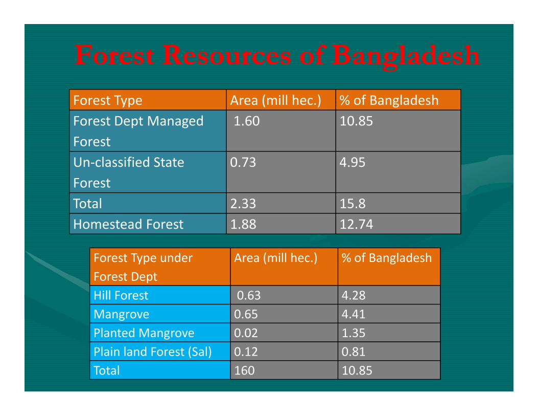
Forest Resources of BangladeshForest Resources of Bangladesh
Forest Type Area (mill hec.) % of Bangladesh
Forest Dept Managed
Forest
1.60 10.85
Un-classified State
Forest
0.73 4.95
Total 2.33 15.8Total 2.33 15.8
Homestead Forest 1.88 12.74
Forest Type under
Forest Dept
Area (mill hec.) % of Bangladesh
Hill Forest 0.63 4.28
Mangrove 0.65 4.41
Planted Mangrove 0.02 1.35
Plain land Forest (Sal) 0.12 0.81
Total 160 10.85
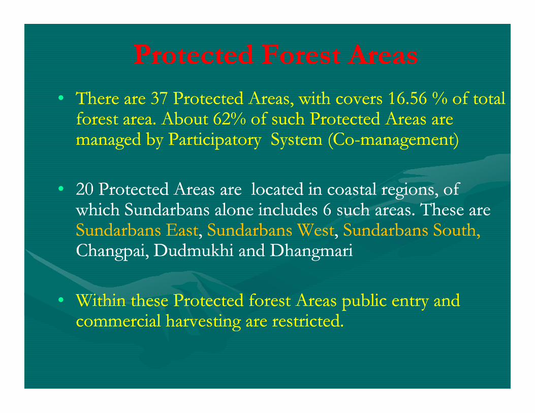
•• There are 37 Protected Areas, with covers 16.56 % of total There are 37 Protected Areas, with covers 16.56 % of total forest area. About 62% of such Protected Areas are forest area. About 62% of such Protected Areas are managed by Participatory System (Comanaged by Participatory System (Co--management)management)
•• 20 Protected Areas are located in coastal regions, of 20 Protected Areas are located in coastal regions, of which Sundarbans alone includes 6 such areas. These are which Sundarbans alone includes 6 such areas. These are
Protected Forest AreasProtected Forest Areas
which Sundarbans alone includes 6 such areas. These are which Sundarbans alone includes 6 such areas. These are Sundarbans EastSundarbans East, , Sundarbans WestSundarbans West, , Sundarbans South, Sundarbans South, ChangpaiChangpai, , DudmukhiDudmukhi and and DhangmariDhangmari
•• Within these Protected forest Areas public entry and Within these Protected forest Areas public entry and commercial harvesting are restricted. commercial harvesting are restricted.
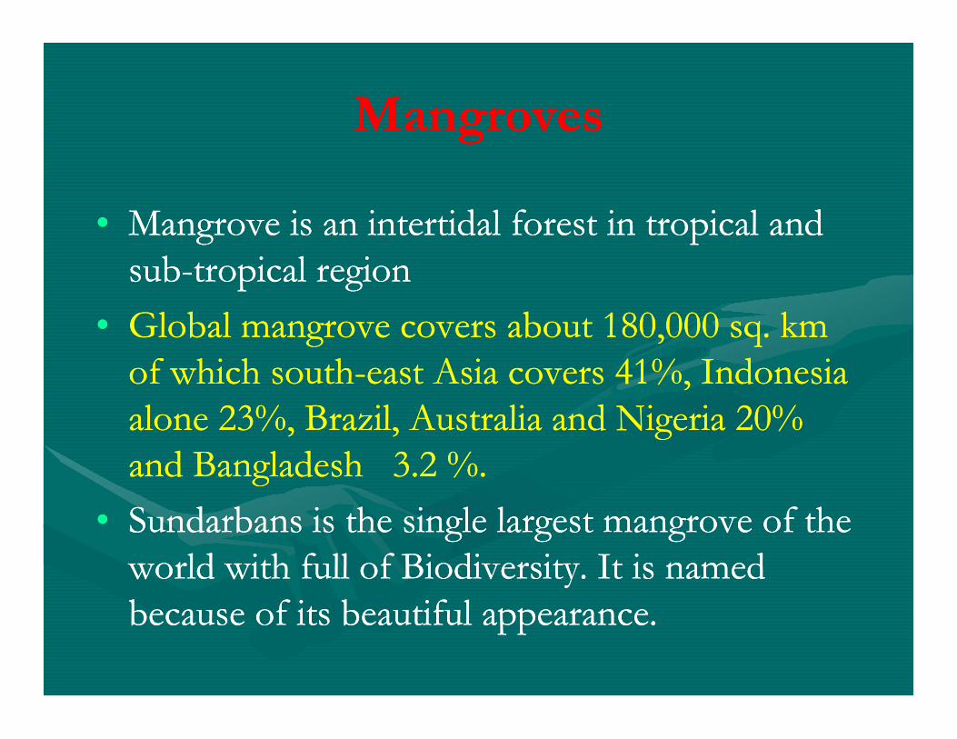
MangrovesMangroves
•• Mangrove is an intertidal forest in tropical and Mangrove is an intertidal forest in tropical and subsub--tropical regiontropical region
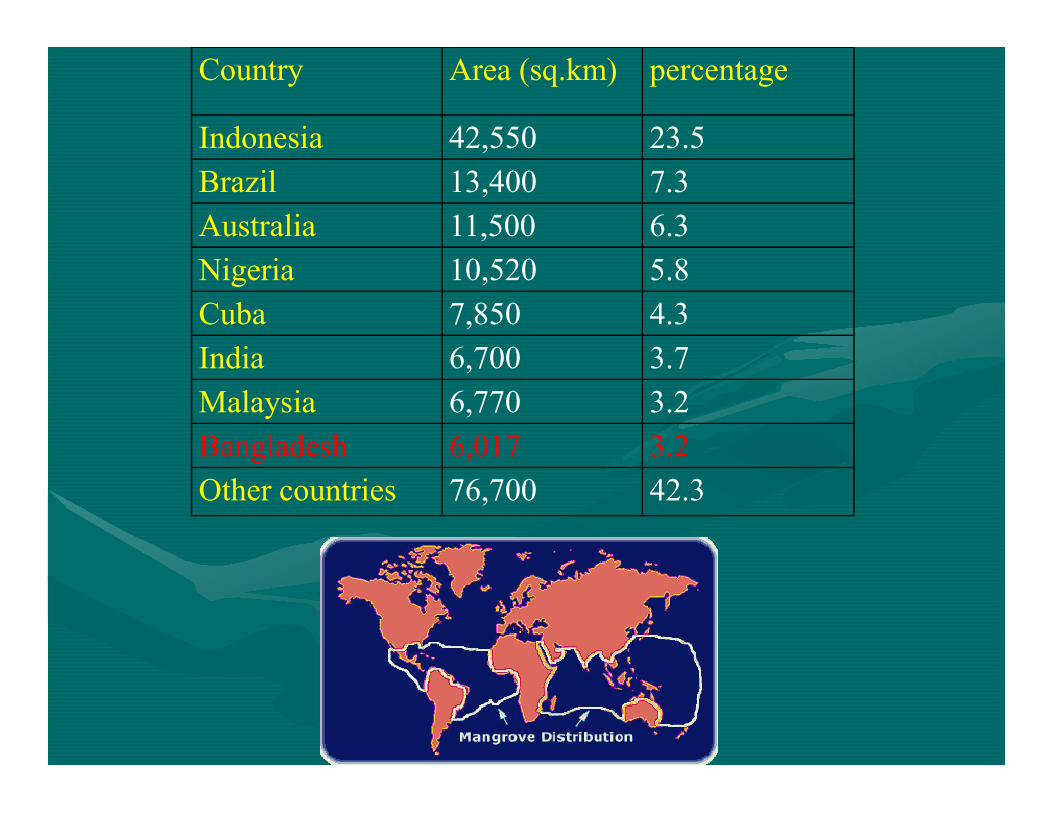
•• Global mangrove covers about 180,000 sq. km Global mangrove covers about 180,000 sq. km of which southof which south--east Asia covers 41%, Indonesia east Asia covers 41%, Indonesia of which southof which south--east Asia covers 41%, Indonesia east Asia covers 41%, Indonesia alone 23%, Brazil, Australia and Nigeria 20% alone 23%, Brazil, Australia and Nigeria 20% and Bangladesh 3.2 %.and Bangladesh 3.2 %.
•• Sundarbans is the single largest mangrove of the Sundarbans is the single largest mangrove of the world with full of Biodiversity. It is named world with full of Biodiversity. It is named because of its beautiful appearance. because of its beautiful appearance.
Country Area (sq.km) percentage
Indonesia 42,550 23.5
Brazil 13,400 7.3
Australia 11,500 6.3
Nigeria 10,520 5.8
Cuba 7,850 4.3
India 6,700 3.7
Malaysia 6,770 3.2Malaysia 6,770 3.2
Bangladesh 6,017 3.2
Other countries 76,700 42.3
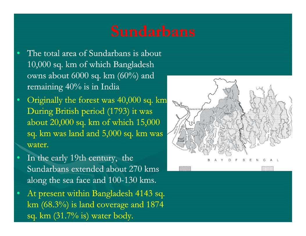
SundarbansSundarbans•• The total area of Sundarbans is about The total area of Sundarbans is about
10,000 sq. km of which Bangladesh 10,000 sq. km of which Bangladesh owns about 6000 sq. km (60%) and owns about 6000 sq. km (60%) and remaining 40% is in Indiaremaining 40% is in India
•• Originally the forest was 40,000 sq. km. Originally the forest was 40,000 sq. km. During British period (1793) it was During British period (1793) it was about 20,000 sq. km of which 15,000 about 20,000 sq. km of which 15,000 about 20,000 sq. km of which 15,000 about 20,000 sq. km of which 15,000 sq. km was land and 5,000 sq. km was sq. km was land and 5,000 sq. km was water. water.
•• In the early 19th century, the In the early 19th century, the Sundarbans extended about 270 Sundarbans extended about 270 kmskmsalong the sea face and 100along the sea face and 100--130 130 kmskms. .
•• At present within Bangladesh 4143 sq. At present within Bangladesh 4143 sq. km (68.3%) is land coverage and 1874 km (68.3%) is land coverage and 1874 sq. km (31.7% is) water body. sq. km (31.7% is) water body.
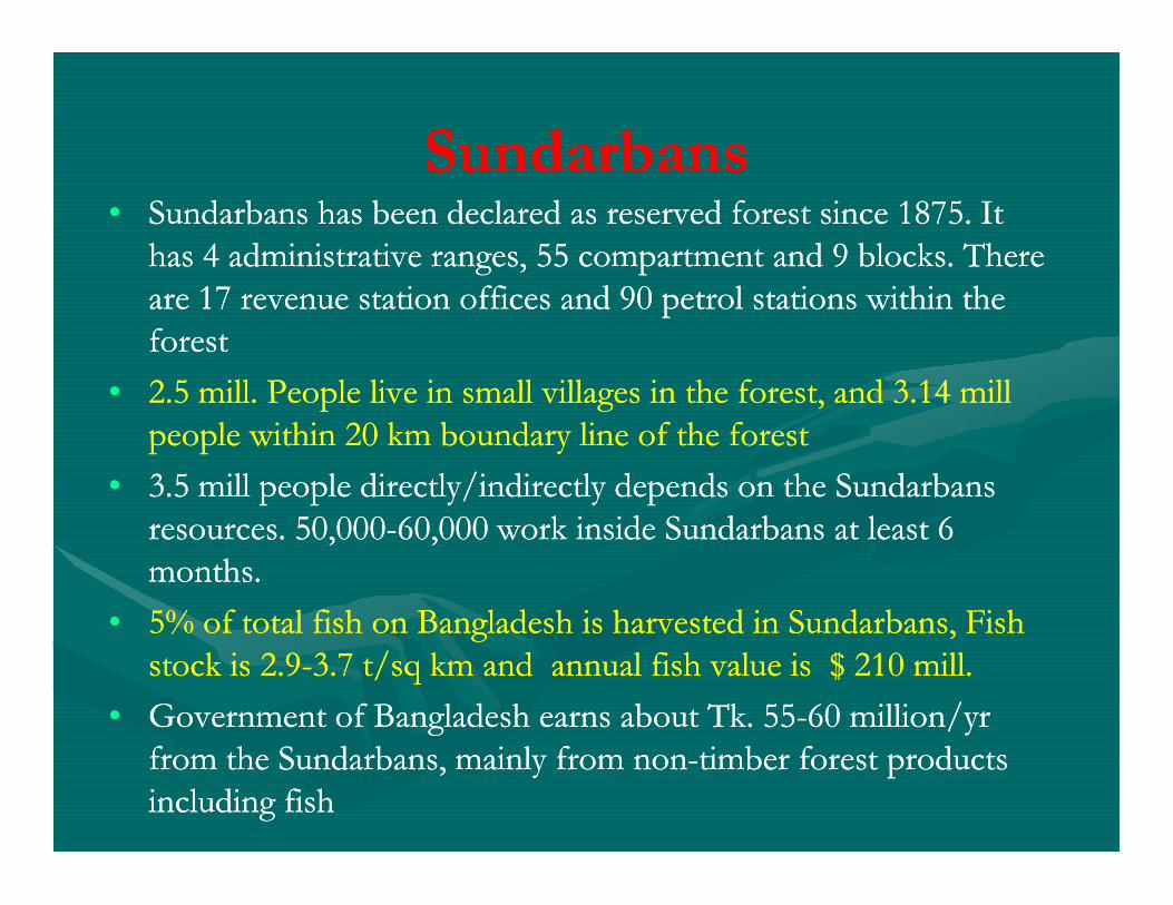
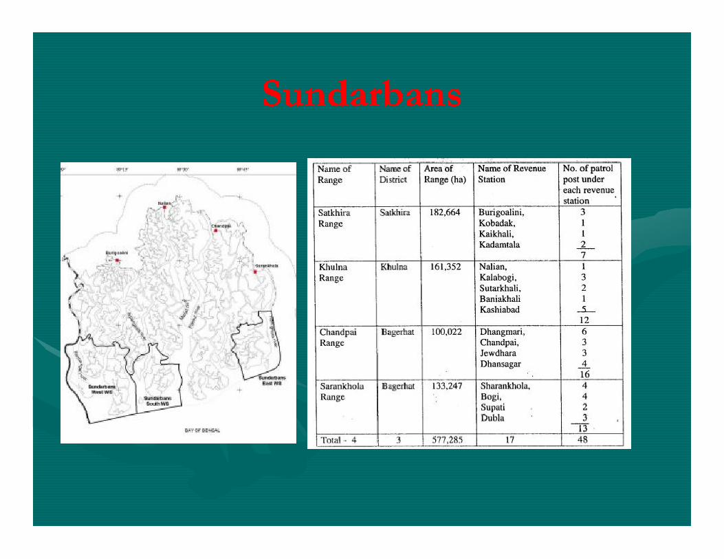
SundarbansSundarbans•• Sundarbans has been declared as reserved forest since 1875. It Sundarbans has been declared as reserved forest since 1875. It
has 4 administrative ranges, 55 compartment and 9 blocks. There has 4 administrative ranges, 55 compartment and 9 blocks. There are 17 revenue station offices and 90 petrol stations within the are 17 revenue station offices and 90 petrol stations within the forestforest
•• 2.5 mill. People live in small villages in the forest, and 3.14 mill 2.5 mill. People live in small villages in the forest, and 3.14 mill people within 20 km boundary line of the forestpeople within 20 km boundary line of the forestpeople within 20 km boundary line of the forestpeople within 20 km boundary line of the forest
•• 3.5 mill people directly/indirectly depends on the Sundarbans 3.5 mill people directly/indirectly depends on the Sundarbans resources. 50,000resources. 50,000--60,000 work inside Sundarbans at least 6 60,000 work inside Sundarbans at least 6 months.months.
•• 5% of total fish on Bangladesh is harvested in Sundarbans, Fish 5% of total fish on Bangladesh is harvested in Sundarbans, Fish stock is 2.9stock is 2.9--3.7 t/sq km and annual fish value is $ 210 mill.3.7 t/sq km and annual fish value is $ 210 mill.
•• Government of Bangladesh earns about Tk. 55Government of Bangladesh earns about Tk. 55--60 million/yr 60 million/yr from the Sundarbans, mainly from nonfrom the Sundarbans, mainly from non--timber forest products timber forest products including fishincluding fish
SundarbansSundarbans
Natural Setting:Natural Setting: Land FormLand Form
•• The elevation of the forest is 0.9The elevation of the forest is 0.9--2.11m from MSL, with a maximum 2.11m from MSL, with a maximum elevation of 10 m. elevation of 10 m.
•• Dunes, mudflats, back Dunes, mudflats, back ––swamps, chards and beaches are the common swamps, chards and beaches are the common landform in the Sundarbans.landform in the Sundarbans.
•• Most of the soil derived from alluvial source are Most of the soil derived from alluvial source are azonalazonal, horizons are , horizons are not well developed. Soils are mostly not well developed. Soils are mostly siltysilty--clay loam. The clay varies clay loam. The clay varies not well developed. Soils are mostly not well developed. Soils are mostly siltysilty--clay loam. The clay varies clay loam. The clay varies from 24 to 44%. Sand from 8 to 30% and silt from 40 to 60%. from 24 to 44%. Sand from 8 to 30% and silt from 40 to 60%.
•• In the eastern part surface soil is soft and fertile, but in the west it is In the eastern part surface soil is soft and fertile, but in the west it is harder and less suitable for plant growth. harder and less suitable for plant growth.
•• Throughout the Forest soils pH range between 7.0 and 8.0. Organic Throughout the Forest soils pH range between 7.0 and 8.0. Organic matter range from 0.8 to 3.3% in the top layer and 0.2 t o 2.9% matter range from 0.8 to 3.3% in the top layer and 0.2 t o 2.9% in bottom layerin bottom layer. .
•• Subtropical monsoon, annual rainfall 1600Subtropical monsoon, annual rainfall 1600-- 1800 mm. 74% 1800 mm. 74% rainfall during Monsoon and 80 rainy days annually.rainfall during Monsoon and 80 rainy days annually.
•• High Temperature and Humidity (>80%) throughout the year. High Temperature and Humidity (>80%) throughout the year. Winter Temp 4oC, Summer 43oC and Monsoon 320C. Winter Temp 4oC, Summer 43oC and Monsoon 320C.
Natural Setting: Natural Setting: ClimateClimate
Winter Temp 4oC, Summer 43oC and Monsoon 320C. Winter Temp 4oC, Summer 43oC and Monsoon 320C. Recently Tem gradually increasing. Recently Tem gradually increasing.
•• During day season evaporation is higher than precipitation.During day season evaporation is higher than precipitation.
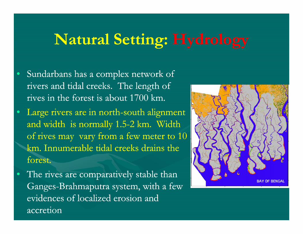
•• Sundarbans has a complex network of Sundarbans has a complex network of rivers and tidal creeks. The length of rivers and tidal creeks. The length of rives in the forest is about 1700 km.rives in the forest is about 1700 km.
•• Large rivers are in northLarge rivers are in north--south alignment south alignment
•• Large rivers are in northLarge rivers are in north--south alignment south alignment and width is normally 1.5and width is normally 1.5--2 km. Width 2 km. Width of rives may vary from a few meter to 10 of rives may vary from a few meter to 10 km. Innumerable tidal creeks drains the km. Innumerable tidal creeks drains the forest. forest.
•• The rives are comparatively stable than The rives are comparatively stable than GangesGanges--Brahmaputra system, with a few Brahmaputra system, with a few evidences of localized erosion and evidences of localized erosion and accretionaccretion
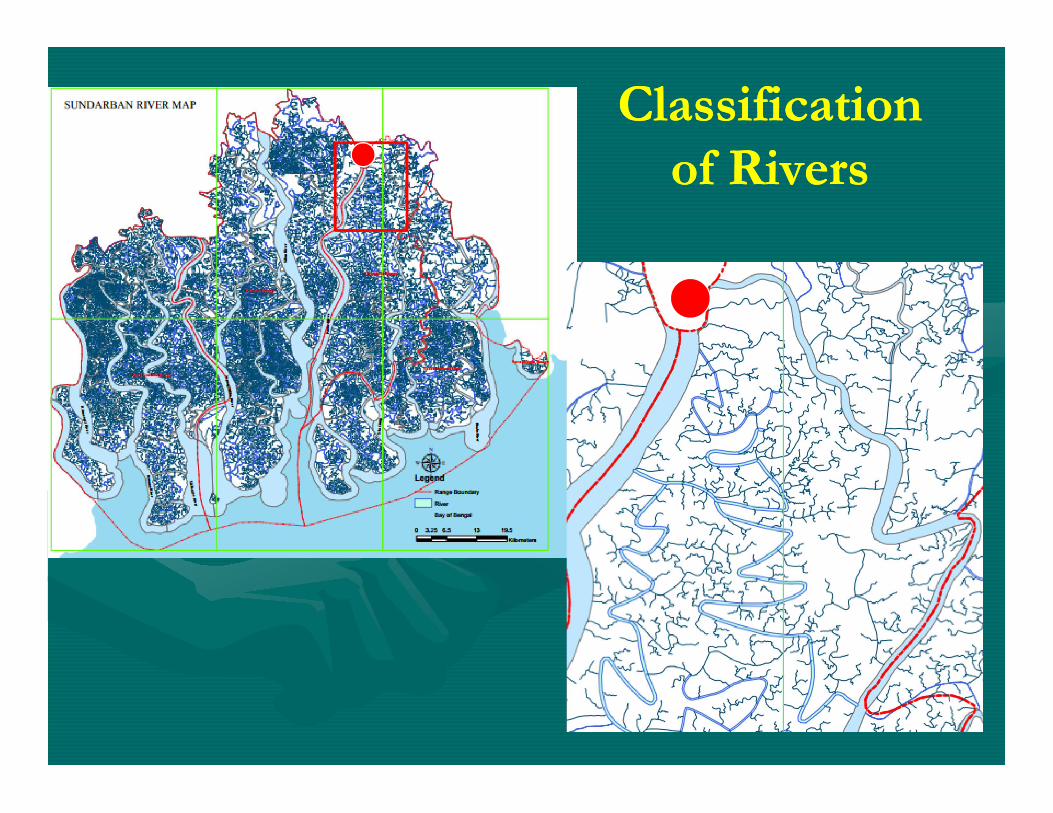
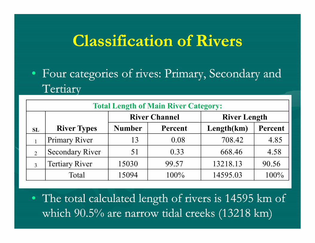
Classification Classification of Riversof Rivers
Classification of RiversClassification of Rivers
•• Four categories of rives: Primary, Secondary and Four categories of rives: Primary, Secondary and TertiaryTertiary
Total Length of Main River Category:
River Channel River Length
•• The total calculated length of rivers is 14595 km of The total calculated length of rivers is 14595 km of which 90.5% are narrow tidal creeks (13218 km) which 90.5% are narrow tidal creeks (13218 km)
SL River Types Number Percent Length(km) Percent
1 Primary River 13 0.08 708.42 4.85
2 Secondary River 51 0.33 668.46 4.58
3 Tertiary River 15030 99.57 13218.13 90.56
Total 15094 100% 14595.03 100%
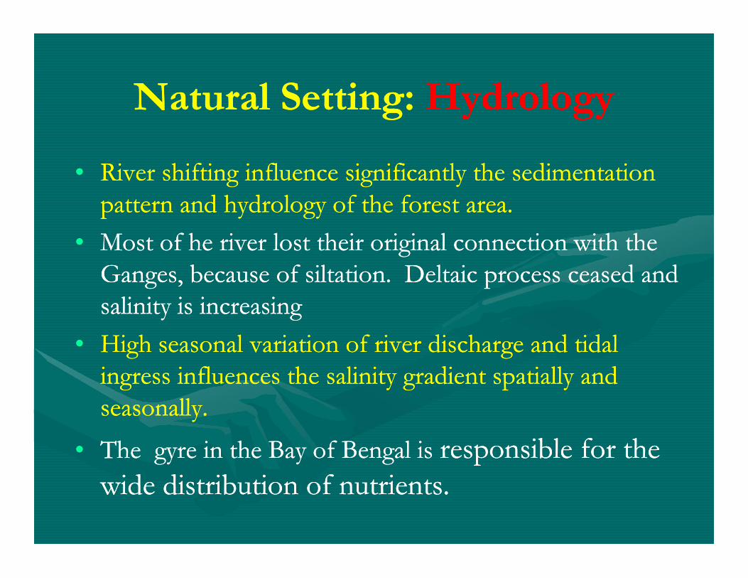
•• River shifting influence significantly the sedimentation River shifting influence significantly the sedimentation pattern and hydrology of the forest area. pattern and hydrology of the forest area.
•• Most of he river lost their original connection with the Most of he river lost their original connection with the Ganges, because of siltation. Deltaic process ceased and Ganges, because of siltation. Deltaic process ceased and
Ganges, because of siltation. Deltaic process ceased and Ganges, because of siltation. Deltaic process ceased and salinity is increasingsalinity is increasing
•• High seasonal variation of river discharge and tidal High seasonal variation of river discharge and tidal ingress influences the salinity gradient spatially and ingress influences the salinity gradient spatially and seasonally. seasonally.
•• The gyre in the Bay of Bengal is The gyre in the Bay of Bengal is responsible for the responsible for the wide distribution of nutrients.wide distribution of nutrients.
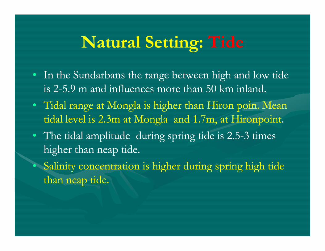
•• In the Sundarbans the range between high and low tide In the Sundarbans the range between high and low tide is 2is 2--5.9 m and influences more than 50 km inland.5.9 m and influences more than 50 km inland.
•• Tidal range at Tidal range at MonglaMongla is higher than is higher than HironHiron poinpoin. Mean . Mean tidal level is 2.3m at tidal level is 2.3m at MonglaMongla and 1.7m, at and 1.7m, at HironpointHironpoint..
Natural Setting: Natural Setting: TideTide
tidal level is 2.3m at tidal level is 2.3m at MonglaMongla and 1.7m, at and 1.7m, at HironpointHironpoint..
•• The tidal amplitude during spring tide is 2.5The tidal amplitude during spring tide is 2.5--3 times 3 times higher than neap tide. higher than neap tide.
•• Salinity concentration is higher during spring high tide Salinity concentration is higher during spring high tide than neap tide. than neap tide.
Natural Setting: Natural Setting: TideTide
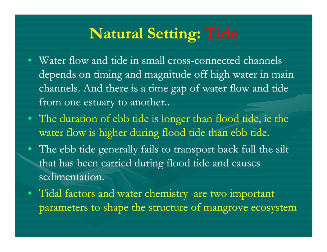
•• Water flow and tide in small crossWater flow and tide in small cross--connected channels connected channels depends on timing and magnitude off high water in main depends on timing and magnitude off high water in main channels. And there is a time gap of water flow and tide channels. And there is a time gap of water flow and tide from one estuary to another..from one estuary to another..
•• The duration of ebb tide is longer than flood tide, The duration of ebb tide is longer than flood tide, ieie the the water flow is higher during flood tide than ebb tide. water flow is higher during flood tide than ebb tide.
•• The ebb tide generally fails to transport back full the silt The ebb tide generally fails to transport back full the silt that has been carried during flood tide and causes that has been carried during flood tide and causes sedimentation. sedimentation.
•• Tidal factors and water chemistry are two important Tidal factors and water chemistry are two important parameters to shape the structure of mangrove ecosystem parameters to shape the structure of mangrove ecosystem
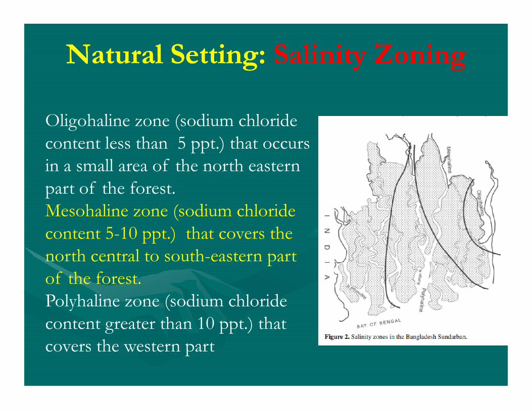
Oligohaline zone (sodium chloride content less than 5 ppt.) that occurs in a small area of the north eastern part of the forest.Mesohaline zone (sodium chloride
Mesohaline zone (sodium chloride content 5-10 ppt.) that covers the north central to south-eastern part of the forest.Polyhaline zone (sodium chloride content greater than 10 ppt.) that covers the western part
Human Interventions and Salinity
• Withdrawal of freshwater at Farakka point has increased the water salinity and has accelerated siltation on river beds.
• Same also true for construction of Dams and Barrage in • Same also true for construction of Dams and Barrage in west Bengal, eg Damodor valley.
• Poldering in coastal area also has adversely affected to salinity and siltation of the forest area.
• More than 125 polders have been constructed in the south-west region along the upper catchment
area of the Sundarbans rivers.
Sundarbans: Sundarbans: BiodiversityBiodiversity•• Floristic Composition: Floristic Composition: Out of 50 true mangroves, Out of 50 true mangroves,
Sundarbans alone includes 35 species. There are 334 Sundarbans alone includes 35 species. There are 334 species of flora (mangroves and associates)species of flora (mangroves and associates)
•• Faunal Composition: Faunal Composition: 426 species of wildlife, 49 species 426 species of wildlife, 49 species of mammals, 315 species of birds, 50 species of reptiles, of mammals, 315 species of birds, 50 species of reptiles, of mammals, 315 species of birds, 50 species of reptiles, of mammals, 315 species of birds, 50 species of reptiles, 95 sp of water fowl and 8 species of amphibians. 95 sp of water fowl and 8 species of amphibians.
•• Fish Diversity: Fish Diversity: 53 pelagic and 124 53 pelagic and 124 demarsaldemarsal species, of species, of which 120 sp are commercial catches. 24 sp of shrimp, 8 which 120 sp are commercial catches. 24 sp of shrimp, 8 sp of lobster, 8 sp of mollusk and 7 sp of crabsp of lobster, 8 sp of mollusk and 7 sp of crab
•• Microbial DiversityMicrobial Diversity: Rich in algae, phytoplankton, : Rich in algae, phytoplankton, zooplankton, bacteria, fungi zooplankton, bacteria, fungi
Sundarbans: Sundarbans: BiodiversityBiodiversity
•• CharacterisedCharacterised by thick vegetation, dominated by by thick vegetation, dominated by mangrove tree species such as mangrove tree species such as sundarisundari, , gewagewa and and keorakeora, mixed with o , mixed with o gorangoran, , pasurpasur, , kankrakankra, , baenbaen, , dhundaldhundal, and palms such as , and palms such as golpatagolpata and and hantalhantal..
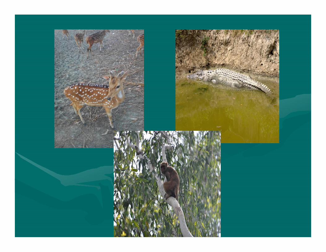
•• Common fauna are Royal Bengal tiger, Spotted Deer, Common fauna are Royal Bengal tiger, Spotted Deer, •• Common fauna are Royal Bengal tiger, Spotted Deer, Common fauna are Royal Bengal tiger, Spotted Deer, Rhesus Monkey, Estuarine Crocodile, and LizardRhesus Monkey, Estuarine Crocodile, and Lizard
•• A variety of nonA variety of non--timber forest products such as timber forest products such as honey, wax, medicinal plants and honey, wax, medicinal plants and golpatagolpata
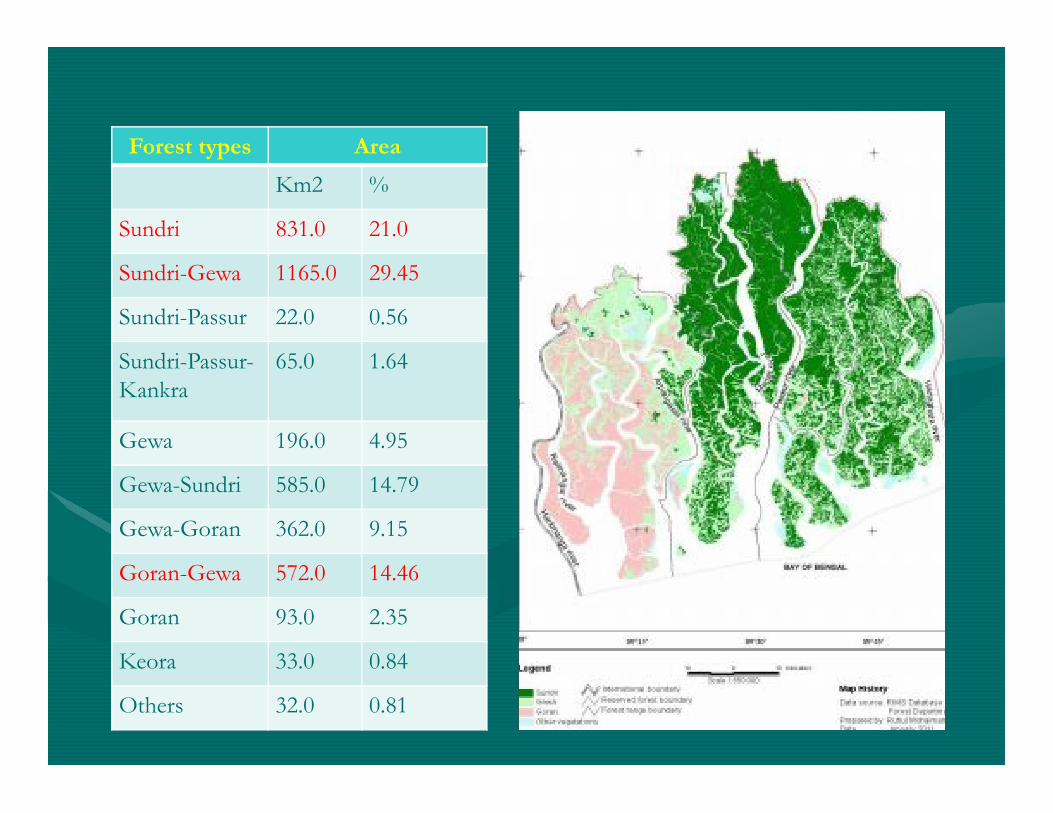
Forest types Area
Km2 %
Sundri 831.0 21.0
Sundri-Gewa 1165.0 29.45
Sundri-Passur 22.0 0.56
Sundri-Passur-Kankra
65.0 1.64
Gewa 196.0 4.95
Gewa-Sundri 585.0 14.79
Gewa-Goran 362.0 9.15
Goran-Gewa 572.0 14.46
Goran 93.0 2.35
Keora 33.0 0.84
Others 32.0 0.81
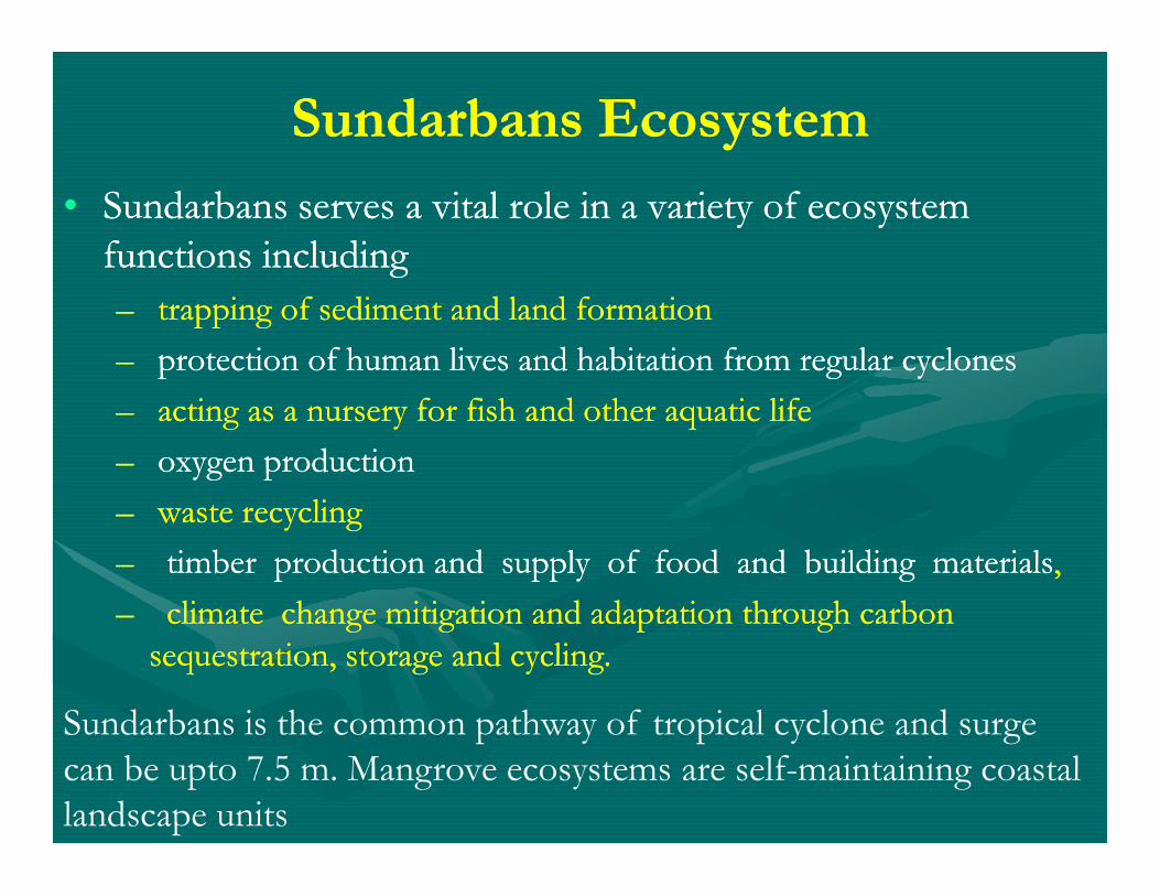
Sundarbans EcosystemSundarbans Ecosystem
•• Sundarbans serves a vital role in a variety of ecosystem Sundarbans serves a vital role in a variety of ecosystem functions including functions including
–– trapping of sediment and land formationtrapping of sediment and land formation
–– protection of human lives and habitation from regular cyclonesprotection of human lives and habitation from regular cyclones
–– acting as a nursery for fish and other aquatic lifeacting as a nursery for fish and other aquatic life
–– oxygen productionoxygen production–– oxygen productionoxygen production
–– waste recycling waste recycling
–– timber production and supply of food and building materialstimber production and supply of food and building materials, ,
–– climate change mitigation and adaptation through carbon climate change mitigation and adaptation through carbon sequestration, storage and cycling. sequestration, storage and cycling.
Sundarbans is the common pathway of tropical cyclone and surge can be upto 7.5 m. Mangrove ecosystems are self-maintaining coastal landscape units
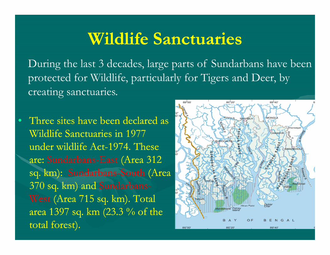
Wildlife SanctuariesWildlife Sanctuaries
•• Three sites have been declared as Three sites have been declared as
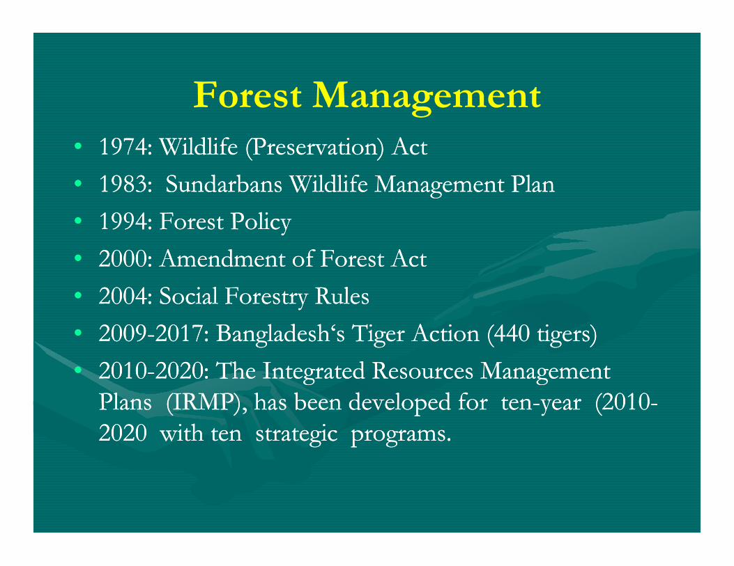
During the last 3 decades, large parts of Sundarbans have been protected for Wildlife, particularly for Tigers and Deer, by creating sanctuaries.
Wildlife Sanctuaries in 1977 Wildlife Sanctuaries in 1977 under wildlife Actunder wildlife Act--1974. These 1974. These are: are: SundarbansSundarbans--EastEast (Area 312 (Area 312 sq. km): sq. km): SundarbansSundarbans--SouthSouth (Area (Area 370 sq. km) and 370 sq. km) and SundarbansSundarbans--WestWest (Area 715 sq. km). Total (Area 715 sq. km). Total area 1397 sq. km (23.3 % of the area 1397 sq. km (23.3 % of the total forest). total forest).
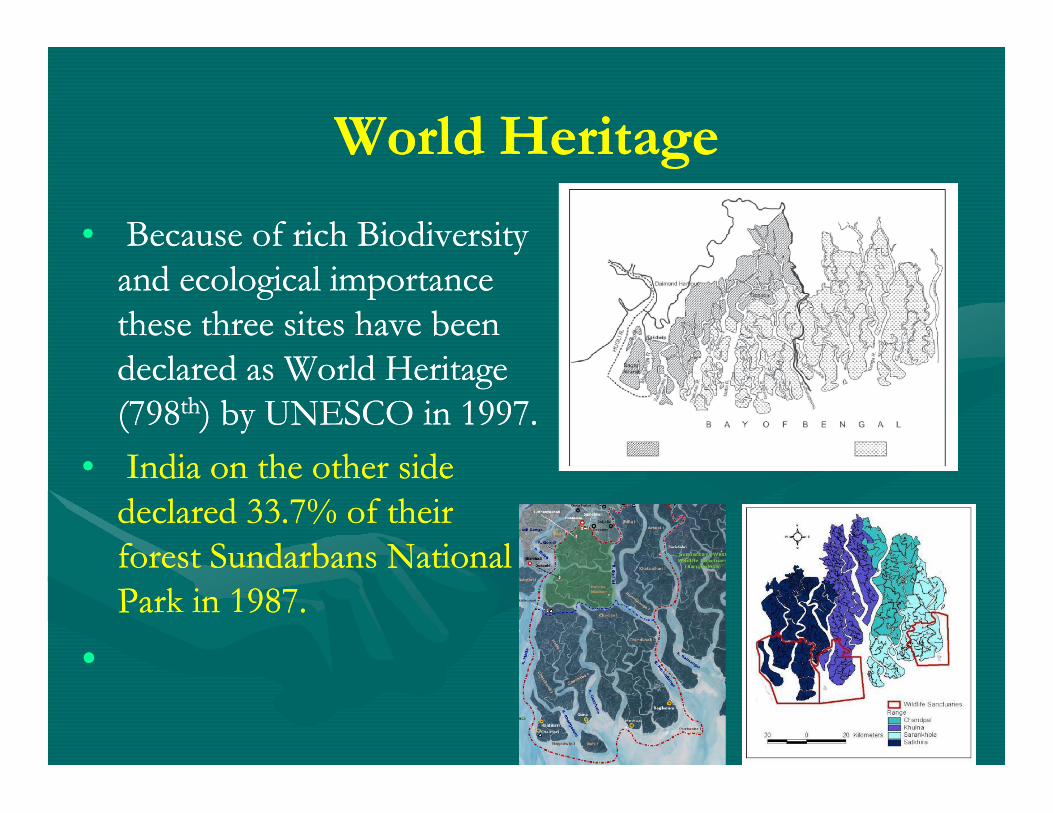
World HeritageWorld Heritage
•• Because of rich Biodiversity Because of rich Biodiversity and ecological importance and ecological importance these three sites have been these three sites have been declared as World Heritage declared as World Heritage (798(798thth) by UNESCO in 1997.) by UNESCO in 1997.(798(798thth) by UNESCO in 1997.) by UNESCO in 1997.
•• India on the other side India on the other side declared 33.7% of their declared 33.7% of their forest Sundarbans National forest Sundarbans National Park in 1987.Park in 1987.
••
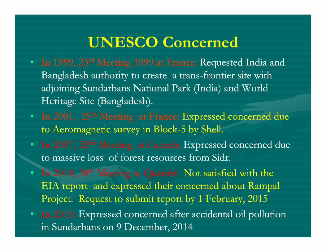
UNESCO Concerned•• In 1999, 23In 1999, 23rdrd Meeting 1999 at France: Meeting 1999 at France: Requested India and Requested India and
Bangladesh authority to create a transBangladesh authority to create a trans--frontier site with frontier site with adjoining Sundarbans National Park (India) and World adjoining Sundarbans National Park (India) and World Heritage Site (Bangladesh).Heritage Site (Bangladesh).
•• In 2001, 25In 2001, 25thth Meeting at France: Meeting at France: Expressed concerned due Expressed concerned due to Aeromagnetic survey in Blockto Aeromagnetic survey in Block--5 by Shell. 5 by Shell. to Aeromagnetic survey in Blockto Aeromagnetic survey in Block--5 by Shell. 5 by Shell.
•• In 2007, 32In 2007, 32ndnd Meeting at Canada: Meeting at Canada: Expressed concerned due Expressed concerned due to massive loss of forest resources from to massive loss of forest resources from SidrSidr..
•• In 2014, 38In 2014, 38thth Meeting at Quarter: Meeting at Quarter: Not satisfied with the Not satisfied with the EIA report and expressed their concerned about EIA report and expressed their concerned about RampalRampalProject. Request to submit report by 1 February, 2015Project. Request to submit report by 1 February, 2015
•• In 2015: In 2015: Expressed concerned after accidental oil pollution Expressed concerned after accidental oil pollution in Sundarbans on 9 December, 2014in Sundarbans on 9 December, 2014
Sundarbans ECA
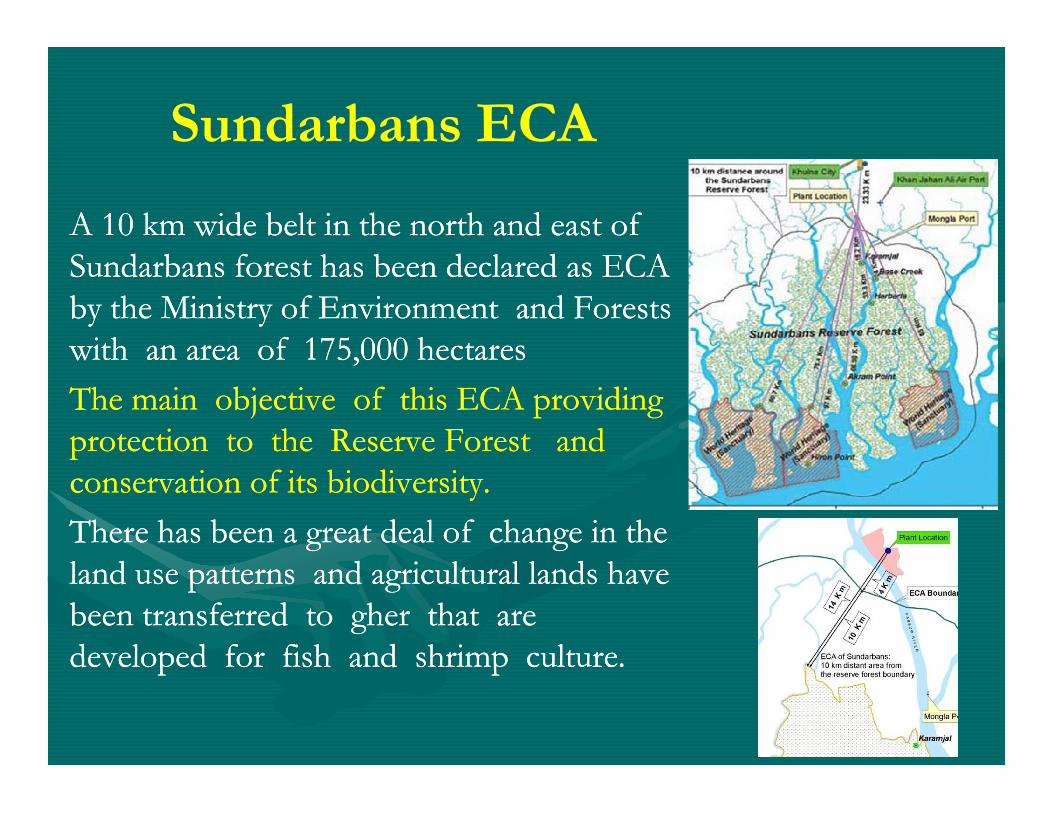
A 10 km wide belt in the north and east of A 10 km wide belt in the north and east of Sundarbans forest has been declared as ECA Sundarbans forest has been declared as ECA by the Ministry of Environment and Forests by the Ministry of Environment and Forests with an area of 175,000 hectareswith an area of 175,000 hectares
The main objective of this ECA providing The main objective of this ECA providing The main objective of this ECA providing The main objective of this ECA providing protection to the Reserve Forest and protection to the Reserve Forest and conservation of its biodiversity. conservation of its biodiversity.
There has been a great deal of change in the There has been a great deal of change in the land use patterns and agricultural lands have land use patterns and agricultural lands have been transferred to been transferred to ghergher that are that are developed for fish and shrimp culture. developed for fish and shrimp culture.
History of Forest Management•• The history of the Sundarbans dates back to 12The history of the Sundarbans dates back to 12thth century. During century. During
the the MughalMughal period (12 to 15th century) Raja period (12 to 15th century) Raja BasantaBasanta RaiRai took took refuge in the Sundarbans from the advancing armies of the refuge in the Sundarbans from the advancing armies of the MughalMughal Emperor Akbar. Emperor Akbar.
•• Many of the buildings built by Many of the buildings built by MughalMughal later fell to the hands later fell to the hands of Portuguese pirates, salt smugglers and dacoits in the of Portuguese pirates, salt smugglers and dacoits in the of Portuguese pirates, salt smugglers and dacoits in the of Portuguese pirates, salt smugglers and dacoits in the 17th century. 17th century.
•• End of 18End of 18thth century British Govt. brought Sundarbans under century British Govt. brought Sundarbans under Government control and they promoted deliberate conversion to Government control and they promoted deliberate conversion to agricultural land.agricultural land.
•• By 1870 about 3000 sq. km forest had been cleaned. In 1878 the By 1870 about 3000 sq. km forest had been cleaned. In 1878 the forest was declared as Reserved Forest. forest was declared as Reserved Forest.
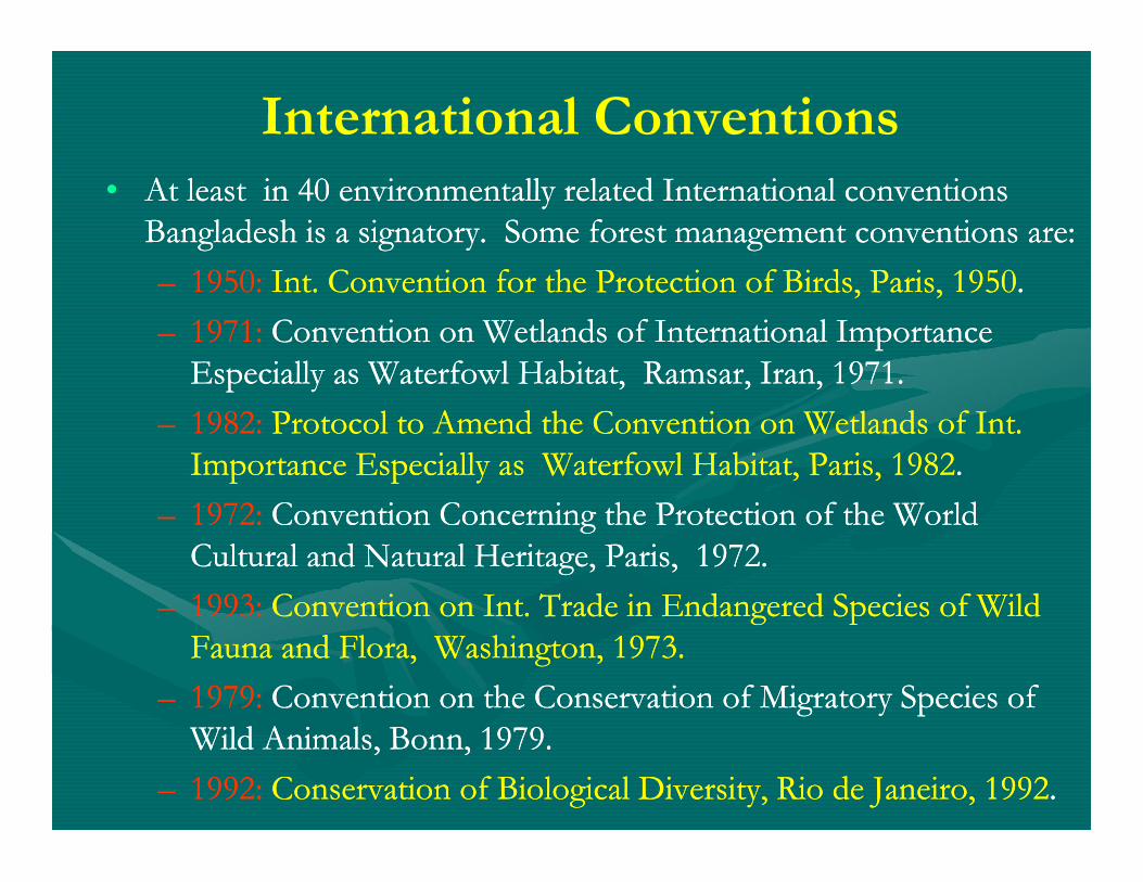
International Conventions•• At least in 40 environmentally related International conventions At least in 40 environmentally related International conventions
Bangladesh is a signatory. Some forest management conventions are:Bangladesh is a signatory. Some forest management conventions are:
–– 1950: 1950: Int. Convention for the Protection of Birds, Paris, 1950Int. Convention for the Protection of Birds, Paris, 1950. .
–– 1971: 1971: Convention on Wetlands of International Importance Convention on Wetlands of International Importance Especially as Waterfowl Habitat, Especially as Waterfowl Habitat, RamsarRamsar, Iran, 1971. , Iran, 1971.
–– 1982: 1982: Protocol to Amend the Convention on Wetlands of Int. Protocol to Amend the Convention on Wetlands of Int. –– 1982: 1982: Protocol to Amend the Convention on Wetlands of Int. Protocol to Amend the Convention on Wetlands of Int. Importance Especially as Waterfowl Habitat, Paris, 1982Importance Especially as Waterfowl Habitat, Paris, 1982. .
–– 1972: 1972: Convention Concerning the Protection of the World Convention Concerning the Protection of the World Cultural and Natural Heritage, Paris, 1972. Cultural and Natural Heritage, Paris, 1972.
–– 1993: 1993: Convention on Int. Trade in Endangered Species of Wild Convention on Int. Trade in Endangered Species of Wild Fauna and Flora, Washington, 1973. Fauna and Flora, Washington, 1973.
–– 1979: 1979: Convention on the Conservation of Migratory Species of Convention on the Conservation of Migratory Species of Wild Animals, Bonn, 1979. Wild Animals, Bonn, 1979.
–– 1992: 1992: Conservation of Biological Diversity, Rio de Janeiro, 1992Conservation of Biological Diversity, Rio de Janeiro, 1992. .
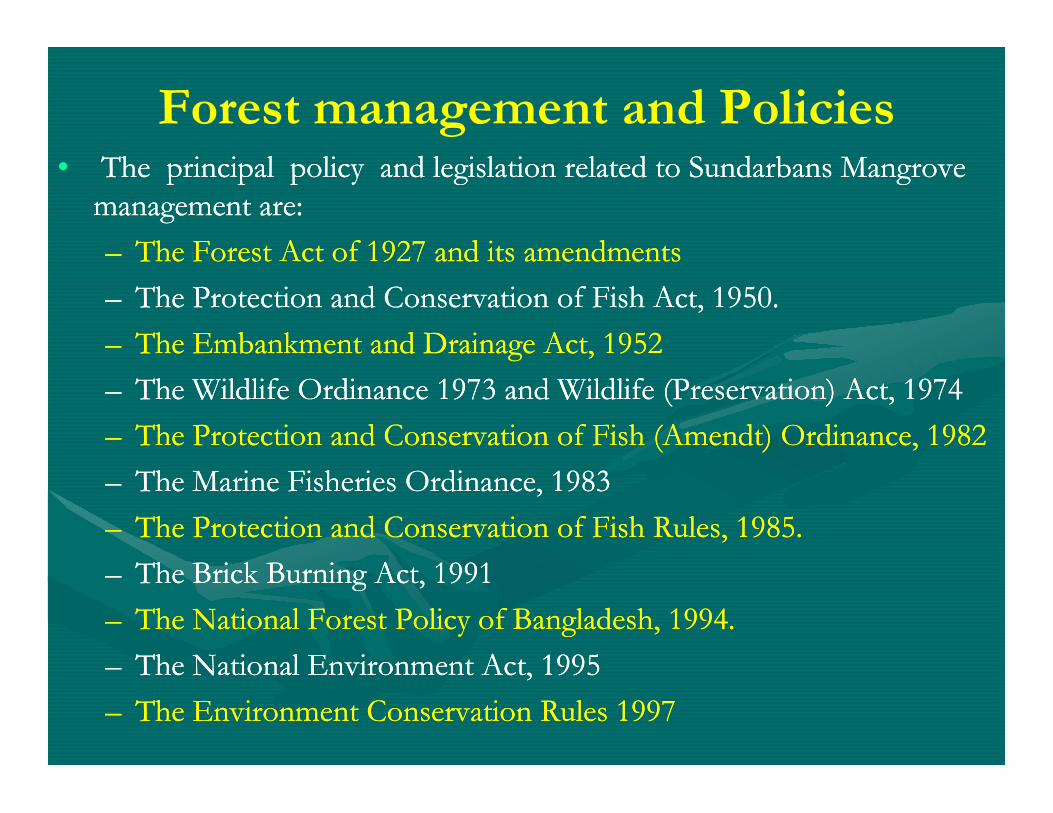
Forest management and Policies•• The principal policy and legislation related to Sundarbans Mangrove The principal policy and legislation related to Sundarbans Mangrove
management are:management are:
–– The Forest Act of 1927 and its amendmentsThe Forest Act of 1927 and its amendments
–– The Protection and Conservation of Fish Act, 1950.The Protection and Conservation of Fish Act, 1950.
–– The Embankment and Drainage Act, 1952The Embankment and Drainage Act, 1952
–– The Wildlife Ordinance 1973 and Wildlife (Preservation) Act, 1974The Wildlife Ordinance 1973 and Wildlife (Preservation) Act, 1974–– The Wildlife Ordinance 1973 and Wildlife (Preservation) Act, 1974The Wildlife Ordinance 1973 and Wildlife (Preservation) Act, 1974
–– The Protection and Conservation of Fish (The Protection and Conservation of Fish (AmendtAmendt) Ordinance, 1982) Ordinance, 1982
–– The Marine Fisheries Ordinance, 1983The Marine Fisheries Ordinance, 1983
–– The Protection and Conservation of Fish Rules, 1985.The Protection and Conservation of Fish Rules, 1985.
–– The Brick Burning Act, 1991The Brick Burning Act, 1991
–– The National Forest Policy of Bangladesh, 1994.The National Forest Policy of Bangladesh, 1994.
–– The National Environment Act, 1995The National Environment Act, 1995
–– The Environment Conservation Rules 1997The Environment Conservation Rules 1997
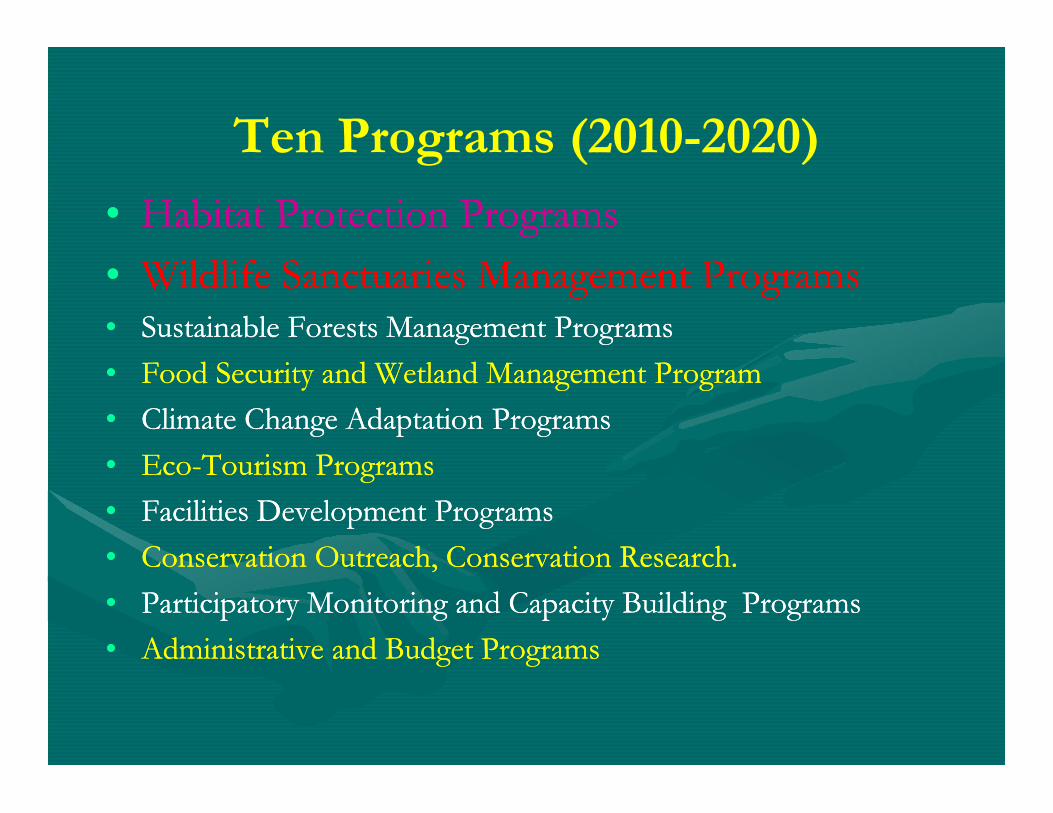
•• 20102010--2020: The Integrated Resources Management 2020: The Integrated Resources Management Plans (IRMP), has been developed for tenPlans (IRMP), has been developed for ten--year (2010year (2010--2020 with ten strategic programs. 2020 with ten strategic programs.
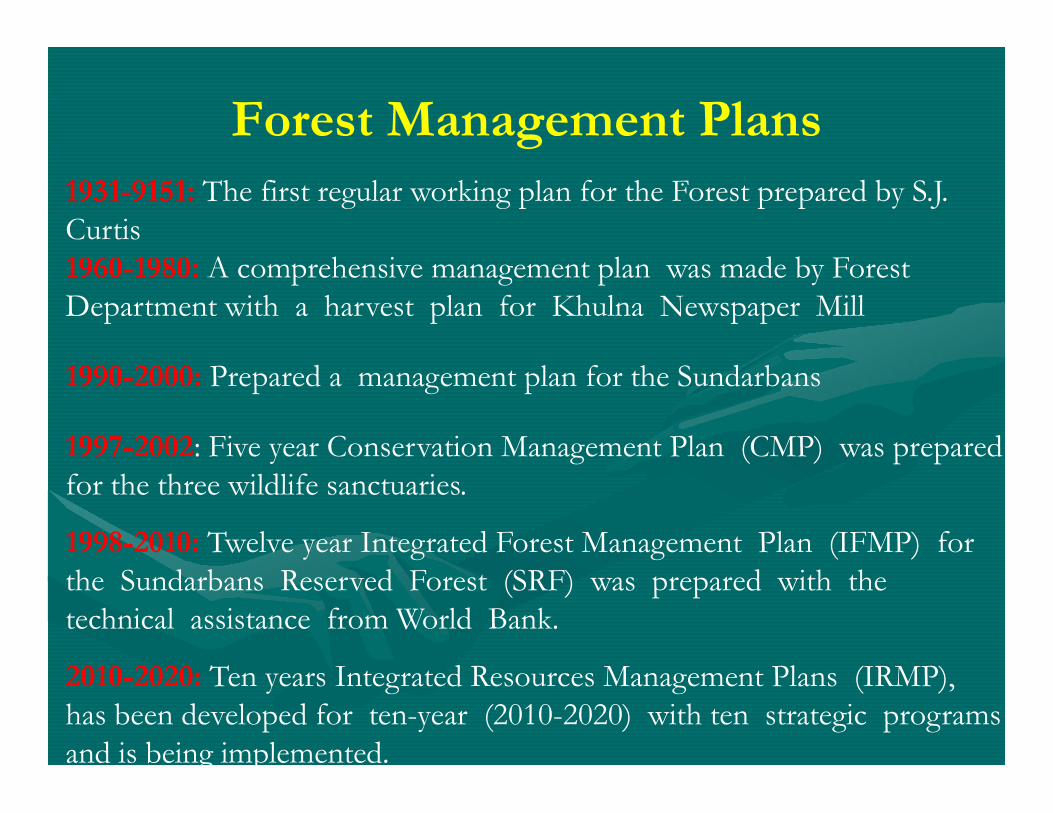
Forest Management Plans1931-9151: The first regular working plan for the Forest prepared by S.J. Curtis1960-1980: A comprehensive management plan was made by Forest Department with a harvest plan for Khulna Newspaper Mill
1990-2000: Prepared a management plan for the Sundarbans
.
1997-2002: Five year Conservation Management Plan (CMP) was prepared for the three wildlife sanctuaries.
1998-2010: Twelve year Integrated Forest Management Plan (IFMP) for the Sundarbans Reserved Forest (SRF) was prepared with the technical assistance from World Bank.
2010-2020: Ten years Integrated Resources Management Plans (IRMP), has been developed for ten-year (2010-2020) with ten strategic programs and is being implemented.
Principle of Forest Management
•• Since 1974 the emphasis of forests management has Since 1974 the emphasis of forests management has gradually shifted from gradually shifted from
–– timber production to ecological requirementstimber production to ecological requirements
–– conservation of biological diversityconservation of biological diversity
–– meeting meeting bonafidebonafide subsistence consumption needs subsistence consumption needs of local people of local people
–– climate change mitigation and adaptation functionsclimate change mitigation and adaptation functions
–– services of forestsservices of forests..
–– CoCo--management systemmanagement system
Management Program (2010-2020)
•• Main objectives of the sanctuaries management Main objectives of the sanctuaries management program are toprogram are to
–– co co --manage the three wildlife sanctuaries in as manage the three wildlife sanctuaries in as natural ecosystem and undisturbed condition natural ecosystem and undisturbed condition natural ecosystem and undisturbed condition natural ecosystem and undisturbed condition
–– provide effective protection to wildlife and aquatic provide effective protection to wildlife and aquatic resources resources
–– maintain and develop good quality forest cover maintain and develop good quality forest cover
–– shift use of resources by local people to buffer shift use of resources by local people to buffer zone zone
–– regulate high impact visitor.regulate high impact visitor.
Co-Management Syatem
•• CoCo--management refers to sharing of responsibilities established management refers to sharing of responsibilities established through formation of Cothrough formation of Co--management Councils and management Councils and committee (CMC). committee (CMC).
•• CMC perform activities of Protected Forest Area under the CMC perform activities of Protected Forest Area under the guidance of council and approved by FD.guidance of council and approved by FD.
•• People (30People (30--100) of the adjacent villages organized to form 100) of the adjacent villages organized to form with 1/3 female memberswith 1/3 female members
•• The CoThe Co--management system in which 50% of revenue back to management system in which 50% of revenue back to CMC to bear recurring expenditure of management. CCMC to bear recurring expenditure of management. C
•• CoCo--management is the main principle of natural resources management is the main principle of natural resources management as per new Wildlife (Preservation and security) management as per new Wildlife (Preservation and security) act 2012.. CMC is empowered to collect revenue on behalf of act 2012.. CMC is empowered to collect revenue on behalf of forest department.forest department.
•• Participatory Monitoring and Capacity Building Programs Participatory Monitoring and Capacity Building Programs
•• Administrative and Budget ProgramsAdministrative and Budget Programs
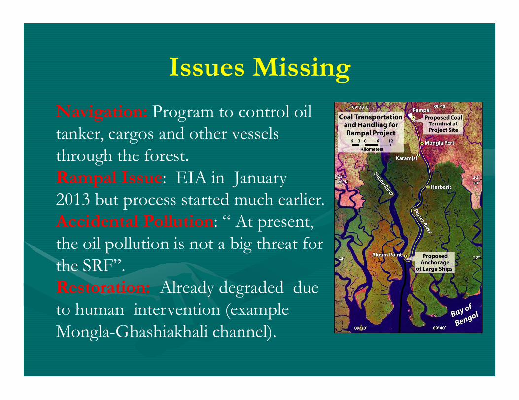
Issues Missing
Navigation: Program to control oil tanker, cargos and other vessels through the forest. Rampal Issue: EIA in January 2013 but process started much earlier.2013 but process started much earlier.Accidental Pollution: “ At present, the oil pollution is not a big threat for the SRF”.Restoration: Already degraded due to human intervention (example Mongla-Ghashiakhali channel).
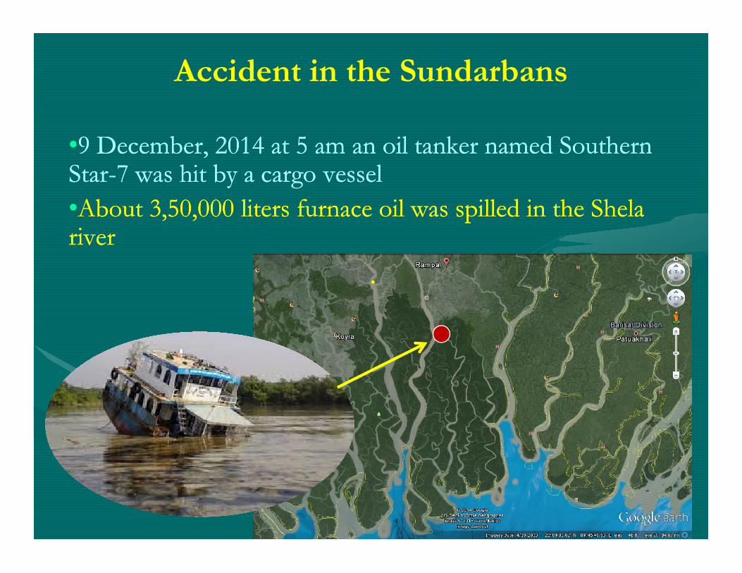
Accident in the Sundarbans
••9 December, 2014 at 5 am an oil tanker named Southern 9 December, 2014 at 5 am an oil tanker named Southern StarStar--7 was hit by a cargo vessel 7 was hit by a cargo vessel
••About 3,50,000 liters furnace oil was spilled in the About 3,50,000 liters furnace oil was spilled in the ShelaShelariverriver
. . . .
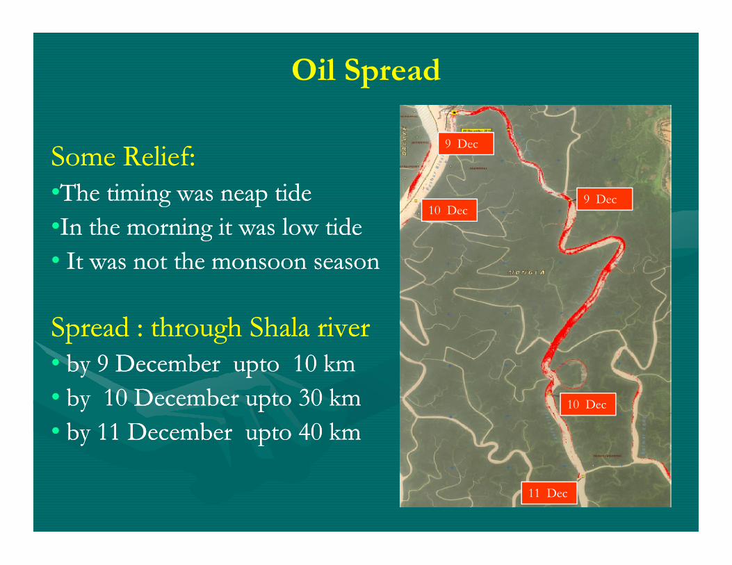
Oil Spread
9 Dec
9 Dec10 Dec
Some Relief:Some Relief:••The timing was neap tideThe timing was neap tide
••In the morning it was low tideIn the morning it was low tide
•• It was not the monsoon seasonIt was not the monsoon season
10 Dec
11 Dec
Spread : Spread : through through ShalaShala riverriver•• by 9 December by 9 December uptoupto 10 km10 km
•• by 10 December by 10 December uptoupto 30 km30 km
•• by 11 December by 11 December uptoupto 40 km 40 km
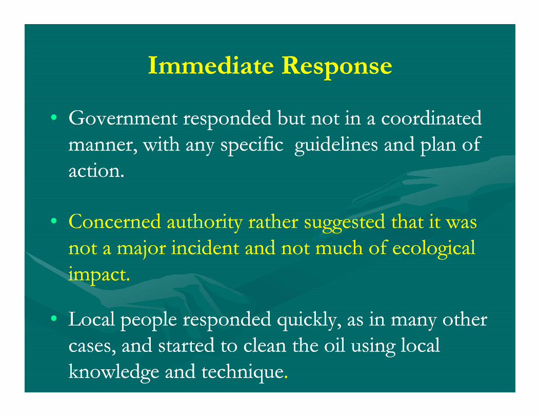
Immediate ResponseImmediate Response
•• Government responded but not in a coordinated Government responded but not in a coordinated manner, with any specific guidelines and plan of manner, with any specific guidelines and plan of action.action.
•• Concerned authority rather suggested that it was Concerned authority rather suggested that it was not a major incident and not much of ecological not a major incident and not much of ecological impact.impact.
•• Local people responded quickly, as in many other Local people responded quickly, as in many other cases, and started to clean the oil using local cases, and started to clean the oil using local knowledge and techniqueknowledge and technique. .
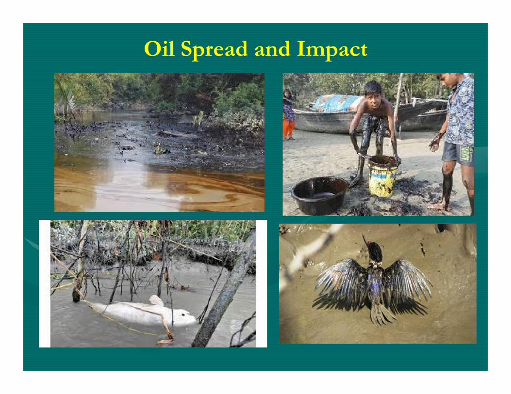
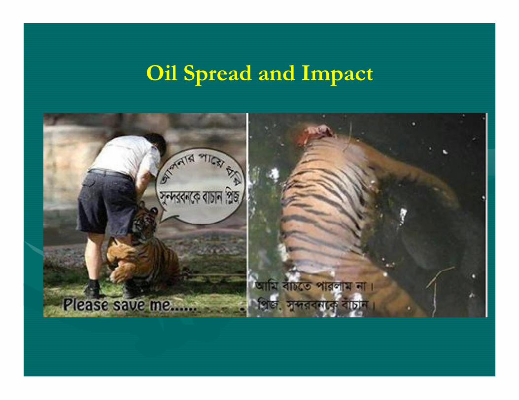
Oil Spread and Impact
Oil Spread and Impact
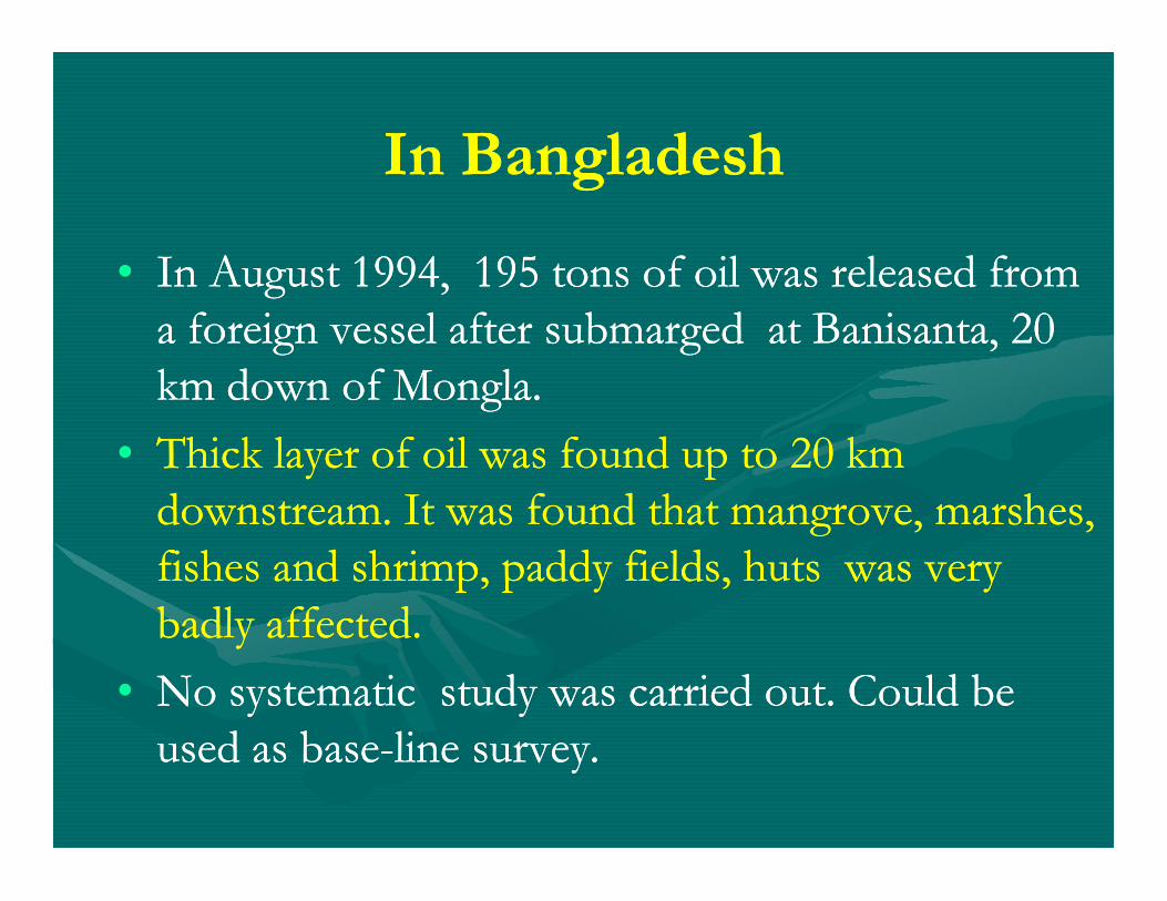
In BangladeshIn Bangladesh
•• In August 1994, 195 tons of oil was released from In August 1994, 195 tons of oil was released from a foreign vessel after a foreign vessel after submargedsubmarged at at BanisantaBanisanta, 20 , 20 km down of km down of MonglaMongla. .
•• Thick layer of oil was found up to 20 km Thick layer of oil was found up to 20 km •• Thick layer of oil was found up to 20 km Thick layer of oil was found up to 20 km downstream. It was found that mangrove, marshes, downstream. It was found that mangrove, marshes, fishes and shrimp, paddy fields, huts was very fishes and shrimp, paddy fields, huts was very badly affected.badly affected.
•• No systematic study was carried out. Could be No systematic study was carried out. Could be used as baseused as base--line survey. line survey.
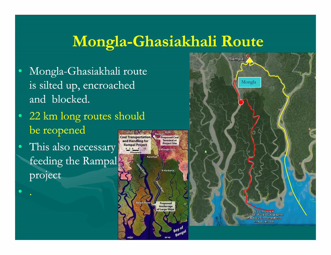
MonglaMongla--GhasiakhaliGhasiakhali RouteRoute
Mongla
•• MonglaMongla--GhasiakhaliGhasiakhali route route is silted up, encroached is silted up, encroached and blocked.and blocked.
•• 22 km long routes should 22 km long routes should be reopened be reopened be reopened be reopened
•• This also necessary for This also necessary for feeding the feeding the RampalRampalprojectproject
•• . .
•• Coastal policy is the only policy that singly deals with Coastal policy is the only policy that singly deals with coastal issues. coastal issues.
•• This is basically a proThis is basically a pro--development policy and the goal development policy and the goal is to reduce poverty and use of coastal resourcesis to reduce poverty and use of coastal resources
ConclusionConclusion
is to reduce poverty and use of coastal resourcesis to reduce poverty and use of coastal resources
•• It has been mentioned that measures will be taken to It has been mentioned that measures will be taken to protect coastal environment during natural disaster, but protect coastal environment during natural disaster, but nothing has been made about mannothing has been made about man--induced disaster.induced disaster.
•• This policy is missing on issues of Navigation through This policy is missing on issues of Navigation through Sundarbans Forest and Accidental Pollution. Sundarbans Forest and Accidental Pollution.
•• However, However, at least we have some documents as at least we have some documents as tools for ecological management of Sundarbans. tools for ecological management of Sundarbans.
•• But, But, in the fieldin the field--level such tools do not reflect level such tools do not reflect the sign of good and effective applications.the sign of good and effective applications.the sign of good and effective applications.the sign of good and effective applications.
•• WhichWhich, reflects the overall lack of good, reflects the overall lack of good--governance, at least in the fieldgovernance, at least in the field--level implication level implication of projects/plans. of projects/plans.