

Chapter 3: Affected Environment and Environmental Consequences
3-1
3 AFFECTED ENVIRONMENT AND ENVIRONMENTAL CONSEQUENCES The affected environment section provides a baseline of information from which to analyze and
compare the effects of the alternatives. The analysis of environmental consequences is based
on a thorough review of relevant scientific information, an evaluation of proposed and industry
practices, and results from on-site surveys and studies. Each resource area discussion includes
information on the data reviewed, how each data source was collected, and the geographic
limits of the review. Most resources are described for the area in and around the Continental
Mine permit boundary, but some may cover larger areas relevant to the potential for impacts.
With several narrow exceptions, an environmental review conducted under MEPA “may not
include a review of actual or potential impacts beyond Montana borders. The environmental
review may not include actual or potential impacts that are regional, national, or global in
nature” (75-1-201(2)(a), MCA).
3.1 LOCATION DESCRIPTION AND STUDY AREA The permit footprint of the Continental Mine facilities, including the YDTI and Berkley Pit, is
approximately 4.9 miles long by 2.8 miles wide at the furthest points and covers approximately
5,890 acres of which approximately 4,632 acres are currently disturbed (WESTECH 2018a). The
mine permit area is adjacent to the city of Butte and near the intersection of Interstates 15 and
90 (Figure 1.3-1). As mentioned previously, the Continental Mine is part of the Butte Mining
District and is located within Operable Units subject to Superfund oversight (See Sections 1.3
and 1.5).
In order to maintain consistency with the proposed amendment application materials, maps
and figures related to the Continental Mine presented in this EIS reference the site coordinate
system known as the Anaconda Mine Grid established by the ACM in 1957. The Anaconda Mine
Grid is based on a vertical datum established in 1915. Elevations in this EIS are generally stated
in Anaconda Mine Grid coordinates with respect to the ACM Vertical Datum, which is typically
52.6 feet higher than the U.S. Geological Survey (USGS) datum (slight variations in the elevation
correction factor occur around the mine). Information on areas outside of the mine or provided
by sources other than MR are presented in the USGS datum or elevation above mean sea level
(AMSL).
The YDTI is located in the upper portion of the Silver Bow Creek drainage in steep mountainous
terrain (Figure 1.3-1). The impoundment is bounded to the east by the East Ridge or Rampart
Mountain, to the west by the relatively low-lying West Ridge, and to the north by the Silver
Bow Creek and Yankee Doodle Creek headwaters. South of the YDTI are historic and current
mining facilities including the Berkeley Pit, Continental Pit, MR processing facilities, and the HsB
Water Treatment Plant.
Elevations in and around the YDTI range from about 6,340 feet AMSL at the current tailings
pond, to over 7,800 feet on Rampart Mountain to the east. The elevation of the West Ridge
ranges from approximately 6,470 to 6,550 feet AMSL. Daily precipitation data are available

Chapter 3: Affected Environment and Environmental Consequences
3-2
from the Bert Mooney Airport weather station (USC00241320), located approximately six miles
south of the YDTI at an elevation of 5,600 feet AMSL, about 800 feet lower than the
impoundment. For the period 1990 through 2016, annual precipitation averaged 12.8 inches
per year, ranging from 8.63 inches in 2000 to 19.96 inches in 1997 (Figure 3.1-1) (Montana
Resources 2018b). Schafer (2016) developed an adjustment factor for the Bert Mooney Airport
precipitation data to address the higher elevation YDTI. Based on this adjustment, annual
precipitation in the YDTI and West Ridge area is estimated to be 15.9 inches per year (Montana
Resources 2018b).
Figure 3.1-1. Annual precipitation for the period of record 1990 to 2016 as measured at the Bert Mooney
Airport Weather Station (USC00241320), Butte Montana.
3.2 ISSUES CONSIDERED BUT NOT STUDIED IN DETAIL The interdisciplinary team reviewed resource areas and associated issues and determined there
would be no impacts or minimal impacts to several resources. Therefore, these resources will
not be analyzed in detail in the EIS. Table 3.2-1 lists resources that were eliminated from
detailed analysis and the rationale for why they will not be analyzed in detail.
Table 3.2-1 Resources Eliminated from Detailed Analysis for the YDTI Expansion
Resource Determination Rationale
Environmental Justice Not Present Impacts would not be disproportionally high or adverse. No alternative considered in this analysis resulted in any identifiable impacts or issues specific to any minority or low-

Chapter 3: Affected Environment and Environmental Consequences
3-3
Table 3.2-1 Resources Eliminated from Detailed Analysis for the YDTI Expansion
Resource Determination Rationale
income population or community as defined in Executive Order 12898. The number of people in Silver Bow County living in poverty in 2017 was 15.5 percent and the minority populations were 10.6 percent (US Census Bureau 2018) .
Land Use Negligible Impacts All of the lands affected by the proposed amendment are held privately by MR. There is no public access to the site, nor would there be access in the absence of the mine activity.
Paleontological Not present No paleontological resources have been found in over 100 years of mining, nor would these resources be expected to occur within the prevalent intrusive igneous rocks.
Recreation Negligible impacts The Continental mine and MR’s surface facilities including the YDTI would not affect recreational access or opportunities in the area. Vehicle and public access is already restricted within the mine. Access to areas surrounding the mine would not be affected.
Safety No impacts The Continental Mine and MR is regulated by MSHA. This issue was not analyzed as it is outside of the scope of MEPA review.
Transportation No Impacts Transportation effects are not expected because the proposed amendment would not affect the total employment by MR nor would it affect transportation of mine inputs or outputs.
Species listed under the Endangered Species Act (ESA)
No impacts Individual grizzly bear (Ursus arctos) (threatened), Canada lynx (Lynx canadensis) (threatened), or wolverine (Gulo gulo) (proposed threatened) could occasionally move through the area during exploratory or dispersal movements but none are expected to be permanent residents.

Chapter 3: Affected Environment and Environmental Consequences
3-4
Table 3.2-1 Resources Eliminated from Detailed Analysis for the YDTI Expansion
Resource Determination Rationale
Wetlands and Waters of the US
No Impacts A Jurisdictionality Determination was completed by the US Army Corps of Engineers (USACE) for the waterways tributary to the YDTI. The waters were determined to be isolated, non-jurisdictional waterways because they lack a connection with a water of the US (USACE 2018).
Wastes (Hazardous or Solid)
No Impacts Spill plans are in place.
Impacts are analyzed at a level commensurate with the likelihood that a resource would be
affected. Where impacts would occur, the duration is quantified as follows:
• Short-term: Impacts that would not last longer than the life of the project, including
final reclamation.
• Long-term: Impacts that would remain or occur following project completion.
The intensity of the impacts is evaluated using the following categories:
• No impact: No change from current conditions, the issue should be dismissed from
detailed consideration.
• Negligible—An adverse or beneficial effect would occur but would be at the lowest
levels of detection.
• Minor—The effect would be noticeable but would be relatively small and would not
affect the function or integrity of the resource.
• Moderate—The effect would be easily identifiable and would influence the function or
integrity of the resource.
3.3 GEOLOGY AND MINERALS The Proposed Action and project alternatives have the potential to affect geology and minerals
in the Project area. This section provides a description of the general and YDTI-specific geologic
setting and affected environment, as well as a discussion of environmental consequences
related to geology and minerals.
The Butte Mining District, located near the southern portion of the Boulder Batholith, covers an
area of approximately 25 square miles (Czehura 2006). Large quantities of copper, silver, gold,
manganese, zinc, lead, and molybdenum have been mined from underground mines and the
Berkeley Pit. Although large-scale underground mining has ceased in the District, current

Chapter 3: Affected Environment and Environmental Consequences
3-5
operations at the Continental Mine continue to develop a 500 million-ton geologic resource.
(Czehura 2006).
3.3.1 Analysis Methods
Analysis Area
The geology analysis area is confined to the MR mine permit boundary and the proposed
amendment boundary.
Methods of Analysis
The full site characterization report (Knight Piesold 2017a) is presented in the Design Document and is summarized in part below. The site characterization report describes:
• The physiography, site geology, and known faults in the vicinity of the YDTI;
• The properties and distribution of surficial material (alluvium) underlying the YDTI;
• The geotechnical and hydrogeological conditions along the West Ridge;
• The foundation conditions for the existing rockfill embankment;
• The geotechnical properties and hydrogeological conditions for the existing rockfill embankment;
• The geotechnical properties and hydrogeological conditions of the tailings contained in the YDTI; and
• The instrumentation monitoring network. Along with the site characterization report, information used in the analysis of the existing
geologic conditions and environmental concerns was found in the proposed amendment to
Operating Permits 00030 and 00030A and accompanying documentation (Montana Resources
2018b). MR completed a geotechnical and hydrogeological site investigation program
throughout 2015 and 2016 to support the design and permitting of increased storage capacity
within the YDTI (Montana Resources 2018b). The findings of this site investigation work were
integrated with previous site investigation work completed during the design and construction
of the YDTI between 1962 and the present.
3.3.2 Affected Environment The geology of Butte has been described in numerous publications and is summarized in MR’s
mine operations plan (Montana Resources 2018a), the proposed amendment (Montana
Resources 2018b), and the YDTI Site Characterization Report (Knight Piesold 2017a). Three
geologic units are present within the mine permit area and include 1) granitic bedrock
associated with the Boulder Batholith, 2) Lowland Creek Volcanics (LCV), and 3) unconsolidated
valley fill deposits. A general description of the geologic units and structures in the vicinity of
the YDTI is summarized below.
Geologic Setting and Formations
The local geology is dominated by the Butte Quartz Monzonite (BQM) phase of the Boulder
Batholith. The BQM is a hard, crystalline granitic bedrock with very low primary porosity and

Chapter 3: Affected Environment and Environmental Consequences
3-6
permeability. It consists of medium grained hornblende-biotite-quartz monzonite, forming the
oldest and most common rock type in the district (Houston 2001). The aplite and granoaplite
units identified on Figure 3.3-1 are cogenetic (formed at the same time) sills and dikes intruded
into the BQM. These units are typically very hard and subject to fracturing which can lead to
enhanced ground water flow through these features.
The Boulder Batholith bedrock is mechanically homogeneous where intact, but jointing has
created dominant planes of weakness that control rock behavior near the surface. The
dominant joint sets are vertical and north-south trending, but other orientations exist
(Montana Bureau of Mines and Geology 2009). A summary of geologic map units found in the
project area is shown in Table 3.3-1. A geologic map of the YDTI and immediately surrounding
the proposed amendment area is shown on Figure 3.3-1.
A distinct zone of highly weathered and altered bedrock occupies the upper few feet to tens of
feet of BQM through most of the study area. The weathered bedrock typically consists of
relatively fresh, quartz-rich BQM clasts within an iron stained matrix of weathered and altered
plagioclase and potassium feldspar minerals (Knight Piesold 2017a).
Tertiary Lowland Creek Volcanics (LCV) unconformably overlie BQM just north and west of the
project area (Figure 3.3-1). LCV units present in the general area include the Basal Unit (Tlt)
comprised of a basal ash tuff and detritus-rich conglomerate, and an overlying quartz-latite
welded ash-flow tuff (Tlw). The LCV deposits are up to 700 meters thick north of the YDTI
(Houston 2001). The LCV typically are not considered to be significant water-bearing units due
to their general lack of primary porosity.
Quaternary unconsolidated alluvium and colluvium material occurs within drainage bottoms
and on some hillslopes between ridge outcrops of BQM. Alluvial deposits within Silver Bow and
Yankee Doodle creeks upstream of the YDTI are thin and narrow in lateral extent and are not
considered to be significant water-bearing units. Beneath the YDTI however, these
unconsolidated deposits reach thicknesses of 40 feet or more along the east side of the
impoundment beneath the tailings.
Table 3.3-1 Summary of Geologic Map Units Listed from Youngest to Oldest for the Area near the Yankee
Doodle Tailings Impoundment, Butte, Montana
Formation Lithology Period
Alluvium of modern channels and flood plains
Unconsolidated deposits of alluvium and colluvium; dense silty sand; silt and sand, up to cobble-size materials.
Quaternary
Lowland Creek Volcanics (LCV)
Includes Basal Unit (Tlt) comprised of a basal ash tuff and detritus-rich
Early Tertiary 48 to 50 m.y.

Chapter 3: Affected Environment and Environmental Consequences
3-7
Table 3.3-1 Summary of Geologic Map Units Listed from Youngest to Oldest for the Area near the Yankee
Doodle Tailings Impoundment, Butte, Montana
Formation Lithology Period
conglomerate, and an overlying quartz-latite welded ash flow tuff (Tlw).
Butte Quartz Monzonite (BQM)
Medium-grained hornblende-biotite quartz monzonite
Late Cretaceous 68 to 78 m.y.
m.y.= million years
Source: (Houston 2001)
Figure 3.3-1. Geologic map of the YDTI and area immediately surrounding the site.

Chapter 3: Affected Environment and Environmental Consequences
3-8
Geologic Structure
Numerous geologic faults are found throughout Silver Bow County, some of which date back to
Precambrian time. Faults located close to the proposed amendment area are shown on Figure
3.3-1. Most faults have seen little to no movement for hundreds of millions of years. However,
a few faults have exhibited evidence of movement more recently and could be considered to
have the potential for movement again. The faults demonstrating more recent movement
generally trend northeast and displace Quaternary sediments (Knight Piesold 2017a). These
recent faults typically cut the north-south trending Rocker Fault and possibly the Continental
Fault and are associated with the broad northeast-southwest belt of faults associated with the
Great Falls Tectonic Zone (Knight Piesold 2017a). The faults that created Rampart Mountain, Elk
Park, and the East Ridge include the Continental Fault, Klepper Fault, and the East Ridge Fault
and generally strike in a north-south direction (Montana Bureau of Mines and Geology 2009).
All three are normal faults. The Continental Fault and Klepper Fault intersect the Continental Pit
located south of the YDTI. The Continental Fault runs along the eastern edge of the YDTI below
the North-South Embankment. These and other faults were included in the seismic hazard
source models completed for the YDTI design documents (Knight Piesold 2018c)
Important to the YDTI geologic evaluation is the presence of two east-west trending geologic
structures (lineaments) within the bedrock and traced through the area of the West
Embankment. BQM has a low primary porosity and permeability with ground water flow
controlled by secondary features such as fractures, joint sets, mineralized veins, and faults. The
location of these structures is relevant to understanding ground water flow along the west side
of YDTI.
Lineament 1
Lineament 1 is the northern most lineament identified on Figure 3.3-1. It extends from the
northwest portion of the YDTI (where an east-west oriented fault has previously been
identified), westward to the head of Bull Run Creek drainage. Based on the east-west trending
fault previously mapped in the northwest portion of the impoundment, and its general
alignment with the head of Bull Run Creek drainage, it appears likely that the fault extends
westward through the West Ridge.
Besides the mapped fault on the east end and the aligned drainage on the west end of the
apparent lineament, other indications of a cross-ridge bedrock structure include a topographic
low or saddle where the lineament crosses the ridge crest, and “gray decomposed clay” noted
in a well log from a private water well located near the westward lineament projection
(Montana Resources 2018b). A low point or saddle in a ridge line typically indicates an area of
increased bedrock erodibility, caused either by a change in lithology or the presence of a
bedrock structure. Lacking a change in lithology in the immediate area, the topographic saddle
may indicate a structural feature trending through the area (Montana Resources 2018b). In
addition, ground water level monitoring conducted during the West Ridge evaluation shows
that ground water levels are shallower and have significantly greater seasonal fluctuation north

Chapter 3: Affected Environment and Environmental Consequences
3-9
of Lineament 1 than to the south. These water level trends are consistent with the presence of
a low permeability geologic structure coinciding with Lineament 1 and restricting southward
ground water flow.
Lineament 2
Lineament 2 extends from the west impoundment abutment westward to the head of Oro Fino
Gulch drainage. Lineament 2 is located south of Lineament 1 and also trends northeast to
southwest as shown on Figure 3.3-1. Although no fault or other significant bedrock structures
are identified on the geologic maps in this area, the strong linear pattern of upper Oro Fino
Gulch drainage suggests the drainage pattern may be structurally controlled. The drainage is
oriented approximately North 50° East, which closely parallels the general northeast-southwest
trending fault set present in the impoundment area (Montana Resources 2018b). In addition,
the alluvium deposit that is mapped in a linear orientation extending northeast beneath the
YDTI tends to agree with a structural control of the pre-YDTI drainage.
Numerous other structures of varying size and characteristics have been identified through the
West Ridge hydrologic evaluation as well as prior regional studies. For the West Ridge
hydrogeology, potentially significant features include aplite dikes, which tend to fracture under
stress and could act as potential conduits, and numerous, predominantly east-west oriented
shear zones. The shear zones are typically associated with moderately to highly altered bedrock
envelopes which restrict ground water flow (Montana Resources 2018b).
Mining and Mineral Development
The Continental orebody is being mined by ongoing operations at the Continental Pit. The
locations of the mine permit boundary and associated facilities are shown on Figure 3.3-2.
Continental Pit
In the Continental area, 160 to 200 feet of Leached Cap and overburden overlie a massive
copper-molybdenum orebody bounded on the west by the Continental Fault and on the east by
the Klepper Fault. The deposit is a typical porphyry copper system except that the enriched
zone is less pronounced than is commonly observed. Continental Primary Zone copper occurs
as chalcopyrite in interlacing veinlet swarms and as disseminations in the BQM. Continental
Primary Zone molybdenum occurs in younger subparallel veinlet swarms and slicks that offset
the early copper veinlets. More recent mesothermal (moderate temperature and pressure)
veins overprint the early mineralization, but these contain mostly iron, lead, and zinc.
Continental Primary Zone copper immediately below the Leached Cap is weakly enriched by
surface weathering where secondary chalcocite occurs as coatings on pyrite and chalcopyrite
(Montana Resources 2018a).

Chapter 3: Affected Environment and Environmental Consequences
3-10
Source: (Montana Resources 2018a)
Figure 3.3-2. Montana Resources Mine complex and general location.
Central Zone
The Central Zone orebody is situated between the Berkeley Pit and the Continental Pit and is
bounded on the east by the Continental Fault. This major, north-south trending basin and range
fault dips steeply to the west and offsets the Continental orebody by some 3,500 feet.
Porphyry-style mineralization has been intercepted in the hanging wall of the Continental Fault
at that depth and mapped in underground workings at elevations of 2,000 feet AMSL, beneath

Chapter 3: Affected Environment and Environmental Consequences
3-11
the bottom of the Berkeley Pit. As in the Berkeley Pit and in the Continental Pit, mesothermal
veins overprint the early mineralization. In localized areas, shear couples have developed
“horsetail ore zones” of minor importance compared to those along the Leonard-Belmont axis
that were exploited by underground mining and ultimately mined out in the Berkeley Pit
(Montana Resources 2018a).
Ore and Pit Rock
Ore from the Continental Pit is geochemically different when compared to Berkeley Pit ore.
Continental Pit ore consists of lower copper and higher molybdenum grades, lower pyrite
content, and higher calcite content. Berkeley Pit deposit ore consisted of higher-grade metals,
higher sulfide content, and lower carbonate content (Montana Resources 2018a).
Approximately 296 million tons of waste material will be mined through the planned mine life
with the majority of rock comprised of Continental Primary Zone waste (163 million tons) and
Continental Leached Cap material (63 million tons). A significant amount of material in the rock
disposal sites will also be re-located (31 million tons). The leached cap along with the 6 million
tons of alluvium represent an important resource that will be used in dam construction and
reclamation of the mine facilities. Most of this leached cap and alluvium material will be mined
in two phases, including 2016 to 2020 and again from 2025 to 2030. Most material to be mined
near the end of mine life will be Continental Primary Zone waste (Montana Resources 2018a).
3.3.3 Environmental Consequences This section presents environmental consequences associated with the Proposed Action and
other alternatives. Consequences unique to each alternative are discussed under separate
headings.
No Action Alternative
Under the No Action Alternative, the proposed Amendment would not be approved and MR
would continue to operate under its existing operating permits. Mining would continue until
approximately 2022 when the YDTI would reach capacity. During this time, mining at the
Continental Pit would continue, ore processing would continue at the MR Concentrator, tailings
would continue to be pumped into the YDTI, and waste rock would continue to be placed on
the approved waste rock storage sites. Reclamation would begin following mining and include
incremental dewatering of the tailings, development of beach and Transition Zones, and a
reduction in the size of the supernatant pond. Impacts to the geology and mineral resources
would not change from what has been previously permitted for the mine, such as removal of
ore and rock from the Continental Pit and placement of tailings in the YDTI to the currently
approved elevation.
Proposed Action
Under the Proposed Action, the crest elevation of the West Embankment would be increased to
6,450 feet, with a proposed maximum water surface elevation for the supernatant pond of
approximately 6,428 feet. Mining would continue until the YDTI reaches a pool elevation of
Chapter 3: Affected Environment and Environmental Consequences
3-12
6,428 feet. During mining, tailings would continue to be deposited in the YDTI and waste rock
would continue to be placed on the YDTI embankment. Once the YDTI embankment crest
elevation is raised to an elevation of 6,450 feet, waste rock that would not be needed for the
YDTI embankment would be stored in the North RDS and the Great Northern RDS (Montana
Resources 2018b).
Disturbance to the West Embankment geology and minerals during construction as part of the
Proposed Action would occur. Surficial alluvium would be buried beneath the tailings as the
supernatant pond size increases to the north. Drainages entering the pond would also be
impacted by sediment and pond water. Mining would continue to remove rock from the
Continental Pit, but the footprint (disturbed acres) would not change. Impacts to the
geotechnical and hydrogeological conditions along the West Ridge and of the tailings contained
in the YDTI, and the foundation conditions for the existing rockfill embankment, are described
in Sections 3.4.3, 3.5.3, and 3.6.3.
Accelerated Drawdown at Closure Alternative
No aspect of the Accelerated Drawdown at Closure Alternative would affect the amount or
extent of excavation at the Continental Pit or the design or placement of materials along the
embankments. If water is diverted to the Continental Pit for storage, it would occur after
mining has ended. The impacts to the geology resources under this alternative would be similar
to the Proposed Action, except for the potential reduction in time for reclamation to be
completed.
Elimination of West Embankment Drain Pumpback at Closure
No aspect of the Elimination of the WED Drain Pumpback Alternative would affect the amount
or extent of excavation at the Continental Pit or the design or placement of materials along the
embankments. If water is diverted to the Continental Pit for storage, it would occur after
mining has ended. The impacts to the geology resources under this alternative would be similar
to the Proposed Action, except for the timing of the reclamation.
Alternative Capping Methods
No aspect of the Alternative Capping Methods Alternative would affect the amount or extent of
excavation at the Continental Pit or the design or placement of materials along the
embankments. The impacts to the geology resources under this alternative would be identical
to the Proposed Action, except for the potential reduction in time for reclamation.
3.4 GEOTECHNICAL ENGINEERING The Proposed Action and project alternatives have the potential to affect geotechnical design
and stability of YDTI. This section provides a description of the affected environment in relation
to the YDTI, as well as a discussion of environmental consequences related to its development.
The technical aspects of the YDTI design for geotechnical considerations were reviewed and
accepted by the IRP, with the results of their review documented within their final report (IRP

Chapter 3: Affected Environment and Environmental Consequences
3-13
2017) and updated report (IRP 2018). The IRP was involved with the review of the YDTI
embankments design throughout the design process, that included detailed reviews of each
component of the design. The IRP’s final report addresses each component of the design
individually, and provides an overview of the regulatory requirements, their assessment and
observations of the design, and their concurrence with each design component. The IRP states
that they agree with the analysis provided by KP and Hydrometrics and that the design was
reviewed in accordance with the regulatory requirements outlined in 82-4-377, MCA. As stated
by the IRP, “In the view of the Independent Review Panel, the design document for expansion
of the Yankee Doodle Tailings Impoundment addresses all MCA requirements. Based on the
selection of the appropriate parameters and sound technical evaluations, the IRP accept the
adequacy of this design” (IRP 2017). The following summary is provided for informational
purposes only.
3.4.1 Analysis Methods
Analysis Area
The analysis area for geotechnical engineering includes the YDTI storage facility embankment
and impoundment, the waste rock storage areas, and adjacent improvements and undeveloped
land in the MR permit area.
Information Sources
Information used in the analysis of the existing geotechnical engineering conditions and
environmental concerns was found in the proposed amendment to Operating Permits 00030
and 00030A.
Methods of Analysis
The primary requirements for the design and evaluation of tailings dams in Montana have been
set forth in 82-4-375 through 82-4-381, MCA. These statutes require that any modifications or
design for tailings dam storage facilities as defined in 82-4-303, MCA be completed by an EOR.
The EOR must have at least 10 years of direct experience with the design and construction of
tailings storage facilities. The design must be reviewed by an IRP consisting of three
independent review engineers who are experts in the design and construction of tailings
storage facilities. The IRP is charged with reviewing the design document, underlying analysis,
and assumptions including the practical application of current technology within the design.
The detailed level of design and review required for applicable tailings storage facilities in
Montana is intended to provide for the design, operation, monitoring, and closure of tailings
storage facilities such that they (a) meet state-of-practice engineering design standards, (b) use
applicable, appropriate, and current technologies and techniques that are practicable given
site-specific conditions and concerns, and (c) provide for the protection of human health and
the environment. The primary intent of the legislation is to provide for expert design and
review of the tailings storage facility to limit the risk of failure. The results of the IRP review can
be found within their final report (IRP 2017).

Chapter 3: Affected Environment and Environmental Consequences
3-14
Geotechnical engineering concerns were analyzed to assess the stability of the existing YDTI
storage facility embankment and waste RDS under both static and seismic loading conditions.
Computer software included SLOPE/W, a subset of the Geostudio software platform developed
by Geo-Slope International Ltd. and was used to estimate the stability that would result from
increasing the height of the YDTI embankment. This computer program provided an estimate
for a factor of safety against a large-scale failure of the upstream and downstream
embankments during operation, closure and equilibrium conditions. The minimum factor of
safety of 1.5 for both operational and post-closure conditions used in the analysis is consistent
with stability objectives required by Montana legislation and accepted at other large-scale
mining operations.
3.4.2 Affected Environment
This section describes the affected environment in terms of geotechnical engineering concerns
for the YDTI and waste rock storage areas.
YDTI and Embankments
The YDTI and its embankments are currently permitted to cover a total of 2,295 acres and the
YDTI is designed to contain approximately 750.2 million cubic yards of tailings. The YDTI
embankment was originally constructed in 1963 to facilitate mining operations from the
Berkeley Pit. The YDTI embankment has been expanded since that time to an elevation of 6,405
feet with waste rock from the Berkeley Pit (1963 to 1982) and from the Continental Pit (1986 to
current). A plan view showing the current layout of the YDTI facility is shown on Figure 3.4-1.
The YDTI embankment consists of a valley-fill impoundment created by dumping waste rock
from the mining process in 30 to 100-foot lifts to form the free-draining embankment fill. The
waste rock lifts were typically traffic compacted with haul trucks to consolidate the material.
The embankment has been modified to incorporate a zone of fine-grained alluvial material on
the upstream face of the dam to limit tailings migration into the embankment fill (Knight
Piesold 2017a). For discussion purposes, MR has delineated the YDTI embankment into three
segments, as follows (Figure 3.4-1):
• North-South Embankment - Located at the base of Rampart Mountain and forms the
eastern portion of the YDTI embankment. The North-South Embankment is
approximately 7,300 feet long and is oriented north to south and forms the eastern
boundary of the MR mine site. The current crest elevation of the North-South
Embankment is approximately 6,400 feet (Montana Resources 2018b).
• East-West Embankment - The East-West Embankment is approximately 4,800 feet long,
is oriented east to west, and forms the southern and southwestern limb of the YDTI. The
current crest elevation of the East-West Embankment is approximately 6,400 feet. The
East-West Embankment is constructed upstream of Horseshoe Bend and the Berkeley
Pit (Montana Resources 2018b).
• West Embankment – The West Embankment is approximately 7,000 feet long and is
oriented north to south along the western side of the YDTI. The current crest elevation

Chapter 3: Affected Environment and Environmental Consequences
3-15
of the West Embankment is approximately 6,405 feet. The West Embankment is
constructed along the West Ridge area between Moulton Road and the tailings
impoundment (Montana Resources 2018b).
Source: Knight Piesold, Ltd.
Figure 3.4-1. Current YDTI facility layout.

Chapter 3: Affected Environment and Environmental Consequences
3-16
Historically, tailings have been discharged at a single discharge point located at the center of
the East-West Embankment. Tailings are combined with water at the mill to form a slurry,
which is then pumped via a pipeline to the YDTI. Coarse solids settle out first to form beaches,
and the finer tailings fraction settles toward the center and northern end of the tailings storage
facility. The practice of discharging at a single location was recently changed to a multiple
discharge point system at various points around the impoundment to facilitate the reclamation
process and improve the stability of the YDTI embankments. The multiple point discharge
system was implemented to provide a larger tailings beach area that increases the distance
between the embankment and the supernatant pond. The increased distance results in
developing a larger dry beach between the embankment and pond that limits the risk of failure
of the embankment, as water directly against the embankment can lead to failures. This change
was made to produce a more stable tailings mass suitable for reclamation following the
completion of mining (Montana Resources 2018b).
Waste Rock Disposal Sites (RDS)
The primary waste RDS lay to the south and west of the YDTI facility. The existing waste RDS
were originally designed to be constructed using 50-foot lifts. There have been no waste RDS
slope stability problems to date.
3.4.3 Environmental Consequences This section presents environmental consequences associated with the Proposed Action and
other alternatives. Consequences unique to each alternative are discussed under separate
headings.
No Action Alternative
Under the No Action Alternative, operations at the mine would continue until the YDTI reaches
a full pool elevation of 6,360 feet, per the current mine permits. During this period, tailings
would continue to be deposited in the YDTI and waste rock would continue to be placed on the
approved waste rock storage sites.
YDTI and Embankments
After mining operations cease, the downstream slope of the existing embankment would be
regraded to a 2.7H:1V slope or greater except for the area near the Precipitation Plant. The
slope in this area would be reclaimed by covering the steep slopes with a coarse rockfill-
material consisting of 18-inch minus riprap that would be a durable and non-acid generating
rock, sourced from off site. The remainder of the embankment slopes would be capped with a
20-inch thick alluvial material and revegetated (Montana Resources 2018a).
The resulting impoundment would consist of a tailings beach, seasonal Transition Zone, and
remnant pond. The tailings beach would be reclaimed by covering the beach areas that are
susceptible to erosion and blowing dust with a 6-inch thick layer of rock. The entire beach
would be reclaimed with the placement of a 28-inch thick alluvial material cap and revegetated.
Reclamation of the Transition Zone and remnant pond would include a partial wet closure with

Chapter 3: Affected Environment and Environmental Consequences
3-17
a seasonal Transition Zone that would be periodically inundated with seasonal water level
fluctuations and an open water area (pond) (Montana Resources 2018a). Under the No Action
Alternative, there would be no adverse impacts to the YDTI facility or to embankment stability.
Waste Rock Disposal Sites
Under the No Action Alternative, the waste rock generated from approved mining activities
would be added to either the existing waste RDS or, more likely, added as a buttress against the
downstream slope of the YDTI. Adding material as a buttress against the downstream slope of
the YDTI would act to increase the stability of the YDTI embankment.
After mining operations cease, the existing waste RDS would be reclaimed using methods
included in the approved operating permit. These methods would include reducing the slopes
to no steeper than 2.7H:1V, regrading to keep water from ponding on the RDS, constructing
benches or runoff collection ditches at 100-foot interval on regraded slopes, placement of 20
inches of alluvial material on the slopes and 28 inches of alluvial material on the tops and
benches, placement of organic matter and/or topsoil at a rate of 23 tons per acre, and
revegetation of the sites (Montana Resources 2018a).
Under the No Action Alternative, there would be no geotechnically adverse impacts to the YDTI,
the embankment, or the RDS areas’ stability.
Proposed Action
Under the Proposed Action, the crest elevation of the West Embankment would be increased to
6,450 feet, with a proposed maximum water surface elevation of 6,428 feet. The primary
purpose of the Proposed Action is to increase YDTI West Embankment height to facilitate
continued mining operations at the Continental Pit. Under the Proposed Action, mining would
continue until the YDTI reaches a pool elevation of 6,428 feet. During mining, tailings would
continue to be deposited in the YDTI and waste rock would continue to be placed on the YDTI
embankment. Once the YDTI embankment crest elevation is raised to 6,450 feet, waste rock
that would not be needed for the YDTI embankment would be stored in the North RDS and the
Great Northern RDS (Montana Resources 2018b).
YDTI Facility and Embankments
The crest elevation of the YDTI West Embankment would be raised incrementally using similar
techniques, equipment, and construction methodologies previously evaluated and permitted.
Waste rock from the Continental Pit would be transported with haul trucks and dumped to
construct most of the embankment. The proposed YDTI embankment construction would be
performed during ongoing mining operations. The proposed increase in the crest elevation of
the West Embankment to 6,450 feet is scheduled for completion within approximately four
years. As discussed previously, the YDTI embankment is divided into three segments that
include the North-South Embankment, the East-West Embankment, and the West
Embankment. A description of the recent and proposed modifications to each of these
embankment segments to support the Proposed Action is as follows:

Chapter 3: Affected Environment and Environmental Consequences
3-18
• North-South Embankment: This portion of the embankment is currently permitted with
a crest elevation of 6,450 feet (Figure 3.4-2). The most recent 50-foot raise to an
elevation of approximately 6,400 feet was performed by downstream construction
method where rockfill was added to the downstream face of the embankment. The
downstream construction method consists of the placement of the initial embankment
in upstream areas with subsequent lifts placed on the downstream slope. The upstream
slope has been constructed at the angle of repose (natural slope of the material after
dumping) of the waste rock material (about 1.3H:1V). The downstream slope has been
constructed to a slope of approximately 2H:1V and the crest has a minimum width of
230 feet (KP 2017b). No additional increase to the crest elevation (above what is
permitted) would be included in the Proposed Action.
Source: (Knight Piesold 2017b)
Figure 3.4-2. North-South embankment section.
• East-West Embankment: This portion of the embankment is currently permitted to
an elevation of 6,450 feet (Figure 3.4-3). The most recent 50-foot raise was
performed by the centerline construction method where rockfill was added to the
upstream and downstream faces to an elevation of approximately 6,400 feet. The
upstream slope, downstream slope, and crest width are the same as the North-
South Embankment (Knight Piesold 2017b). No increase to the crest elevation
(above what is permitted) would be included in the Proposed Action.

Chapter 3: Affected Environment and Environmental Consequences
3-19
Source: (Knight Piesold 2017b)
Figure 3.4-3. East-West embankment section.
• West Embankment: This portion of the embankment is currently permitted to an
elevation of 6,405 feet. The proposed embankment raise would be performed in a
single 45-foot lift. The upstream slope would be constructed at the angle of repose
of the waste rock material (about 1.3H:1V) and the downstream slope would be
3H:1V, or flatter. The minimum crest width would be 230 feet and alluvial material
would be placed on the upstream face (Zone F on Figure 3.4-4) to limit tailings
migration into the rockfill. The West Embankment includes a design feature to
manage ground water levels in the embankment through the construction of the
West Embankment Drain (WED). The WED is a gravity-control subsurface seepage
collection drain located at the upstream toe of the West Embankment that is
intended to intercept seepage flow that may migrate west of the YDTI. The WED is
approximately 7,000 feet long and extends nearly the entire length of the West
Embankment. The drain directs the gravity flow of intercepted seepage from the
YDTI to a lined extraction pond where it will be pumped back into the YDTI, if
necessary. The WED generally consists of a subsurface aggregate filter drain
underlain with a non-woven geotextile material capable of collecting up to 4,500
gpm. The WED was constructed with multiple redundant features including a
secondary extraction basin, drain pods, and secondary seepage collection drains to
serve as a backup for seepage collection in the event that the WED is not effective
(Knight Piesold 2017b). The West Embankment configuration is shown on Figure 3.4-
4.

Chapter 3: Affected Environment and Environmental Consequences
3-20
Source: (Knight Piesold 2017b)
Figure 3.4-4. West embankment section.
The proposed West Embankment raise would comprise the following rockfill zones that are
shown on the Figures 3.4-2 through 3.4-4:
• Zone U material would be waste rock hauled from the Continental Pit. This material
would be free-draining to facilitate water movement through this zone. The material
would be hauled from the Continental Pit and end-dumped by 240-ton haul trucks.
As this material is placed (50-foot lifts), finer-grained materials would be expected to
accumulate near the top of the lifts while cobbles and boulders roll down the slope
and accumulate at the toe.
• Zone F material would be an alluvial material placed along the upstream face of the
embankment to prevent migration of the tailings in the impoundment into the Zone
U rockfill.
• Zone D1 material would be rockfill used to construct the downstream portion of the
West Embankment to limit horizontal migration and allow seepage water to collect
within the WED. The Zone D1 material would be made up of rock with a relatively
low acid potential (AP).
• Zone D2 material would be an alluvial material placed on the downstream slope of
the West Embankment to facilitate runoff of surface water around the West
Embankment. The alluvial material would be finer grained material that would act to
discourage the migration of surface water into the West Embankment.
• Zone 3A material would be a rockfill material placed along the toe of the
downstream slope of the West Embankment to facilitate the infiltration of runoff to
the toe of the embankment.

Chapter 3: Affected Environment and Environmental Consequences
3-21
Engineering Assessment
Knight Piesold Ltd. (KP) performed an evaluation of the proposed West Embankment geometry
to assess the foundation and embankment stability, the potential for overtopping of the
embankment crest, and the potential for internal erosion and/or piping within the
embankment.
The slope stability evaluation was performed on four segments of the West Embankment. The
most critical slip planes that represent the weakest portions of the embankment were found for
both the upstream and downstream slopes. Material properties for the various portions of the
embankment were selected based on past site investigations. Various material strengths were
selected for portions of the foundation and the embankment based on industry standard design
criteria. Analyses were performed to determine an estimate of the embankment crest
settlement and deformation during the Maximum Credible Earthquake (MCE) condition. The
seismic hazard analysis used a magnitude 6.5 earthquake on the Richter scale as the MCE
The results of the stability evaluation showed that the weakest portion of the embankment
would occur through the downstream embankment rockfill. However, the results showed that
the proposed YDTI embankment would be stable, with a factor of safety of 2.0 or greater, which
exceeds the legislative requirement of having a factor of safety of 1.5 or greater for normal
operations. The stability evaluation showed that the factor of safety values for the upstream
cases would typically be more than 5.0 for normal operations.
The analysis of the liquefaction potential that could occur during earthquake conditions showed
that, although saturation of a portion of the tailings could occur, the rockfill surcharge from the
embankment would effectively mitigate any potential movement of this material. The impact of
earthquake-induced strength loss would be largest in the upstream portion of the
embankment. However, the factor of safety in the upstream embankment even during the MCE
exceeds 3.0 and the embankment would be stable. The evaluation also considered the potential
for continuous layers of saturated overburden and rockfill in the base of the embankment with
lower strength materials, which indicated that the embankment would remain stable under
these conditions. The earthquake deformation analysis showed that the maximum
embankment deformation caused by an earthquake would be within design tolerance for the
proposed YDTI embankment. The results of the stability evaluation suggest that the continued
expansion of the YDTI West Embankment pursuant to the proposed embankment design
criteria to an elevation of 6,450 feet would not reduce the stability of the embankment (Knight
Piesold 2018c). Table 3.4-1 provides a summary of the risk ratings, by failure mode, and the
design criteria for risk management related to the proposed YDTI embankment work.
One of the primary takeaways from the stability evaluation was the need to develop larger
drained tailings beaches that push the supernatant pond (water lying above deposited tailings)
as far to the north away from the embankments as possible. The drained tailings beaches would

Chapter 3: Affected Environment and Environmental Consequences
3-22
reduce the pore pressures within this material to increase stability. Strategic placement of the
excess rockfill material generated from mining operations along the downstream slopes would
provide for increased stability both during operations and through equilibrium conditions.
The post-closure pond would be positioned at the furthest north portion of the YDTI. The
maximum available pond storage of the post-closure pond would be 26,000 acre-feet, which is
controlled by the elevation of the closure spillway.
Table 3.4-1 Summary of Risk Ratings by Failure Mode, and Design Criteria for Risk Management
Failure Mode Loading
Condition
Likelihood
Consequences Risk Management Design Criteria Probability of Loading Conditions
Probability of
Coincident Failure
Foundation and Slope Instability
Normal Operating Conditions
Likely Very Low Moderate
-Maintain overall downstream embankment slope angles of 2H:1V or flatter; -Maintain minimum embankment crest width of 200 feet; -Monitor pore pressures/water levels.
Earthquake Events
Very Rare Very Low Moderate to
Major
Flood Events Very Rare Very Low Moderate to Catastrophic
Overtopping
Normal Operating Conditions
Certain Not Credible -
-Maintain ≥ 15 feet of elevational difference between tailings discharge and pond; -Maintain minimum freeboard above tailings discharge ≥ 5 feet; -Operate tailings and reclaim pipelines at design flow rates and pressures; -Construct spillway channel at 6430-foot elevation at closure.
Pipeline Rupture
Likely Not Credible -
Earthquake Events
Very Rare Very Low Moderate to
Major
Flood Events
Unlikely Very Low Catastrophic
Very Rare Very Low Catastrophic
Internal Erosion and
Piping
Normal Operating Conditions
Certain Not Credible -
-Face upstream slope of embankment with alluvium to limit tailings migration; -Maintain pond elevation ≥ 15 feet below tailings discharge elevation5; -Keep pond more than 200 feet
Tailings Stream Leakage
Likely Moderate Minor to
Moderate

Chapter 3: Affected Environment and Environmental Consequences
3-23
Table 3.4-1 Summary of Risk Ratings by Failure Mode, and Design Criteria for Risk Management
Failure Mode Loading
Condition
Likelihood
Consequences Risk Management Design Criteria Probability of Loading Conditions
Probability of
Coincident Failure
Earthquake Events
Very Rare Very Low Minor to
Moderate
from embankment during operations by managing spigotting; -No ponded water within 800 feet of the embankment following closure. Monitor pore pressure/water levels.
Flood Events
Unlikely Low Catastrophic
Very Rare Moderate Catastrophic
Source: (Montana Resources 2018b)
The stability evaluation suggested that the impacts from internal erosion and/or piping could
be primarily mitigated through construction of a free-draining embankment. The free-draining
embankment would allow seepage water to move through the embankment without building
up head pressure, which would decrease the saturation of the embankment (keeping materials
drier) and increases the embankment stability. The evaluation also showed that internal
erosion and piping would be limited by reducing the amount of seepage from the
impoundment area by maintaining a pond elevation of greater than or equal to 15 feet below
the tailings discharge, keeping the pond area more than 200 feet from the embankment during
operations, lining the upstream face of the embankment slope with alluvial material to limit
tailings migration, and pushing the pond edge back greater than 800 feet away from the
embankment following closure (Knight Piesold 2018c).
The technical evaluation showed that effects from overtopping could be mitigated by
maintaining greater than or equal to 15 feet of elevation difference between the tailings
discharge and the pond water level, maintaining a minimum freeboard of 5 feet above the
tailings discharge, and providing for an emergency spillway at closure. A closure spillway would
be constructed to provide for dam safety (preventing overtopping) at equilibrium conditions.
The closure spillway is designed to flow only in extreme runoff conditions. The closure spillway
would have an invert elevation of 6,430 feet. The maximum supernatant pond elevation is
6,428 feet, which provides for the storage of approximately 26,000 acre-feet of water between
the pond water surface elevation and the crest of the closure spillway. Thus, the closure
spillway would only spill during an extreme runoff event.
The sequence of storm events required to activate spillway discharge would need to generate a
runoff volume larger than 26,000 acre-ft, which is equivalent to a 1 in 1,000 year 30-day storm
event and the post-closure Probable Maximum Flood (PMF) event occurring consecutively

Chapter 3: Affected Environment and Environmental Consequences
3-24
(Knight Piesold 2018b). The PMF was determined to be a combination of the 24-hour probable
maximum precipitation (PMP) amount and the complete melt of a 1 in 100-year snowpack, in
addition to the full failure of the upstream Moulton reservoirs. The calculated PMF runoff
volume equates to 19,000 acre-feet. The spillway would not be required to discharge the PMF
event, but only if an additional rainfall event were to immediately occur. The spillway is sized
with sufficient capacity to pass flows from storms exceeding the 1 in 1,000 year, 24-hour rainfall
event. The start of the closure spillway at the upstream end would be cut into bedrock to
promote stability and would extend past the toe of the North RDS to a point where the
regraded topography would flow to the Continental Pit (Knight Piesold 2018a). The Continental
Pit (when no longer pumped to allow mining) will eventually contain a larger pit lake, which will
need to be pumped/managed for water level compliance (below 5,410 feet AMSL or 5,460.4
feet ACM) and water treatment under BMFOU. The closure spillway would be approximately
13,000 feet in length, as shown on Figure 3.4-5.
The equilibrium volume of the post-closure pond would be approximately 1,000 acre-feet at an
elevation of 6,363 feet. The post-closure pond elevation would fluctuate annually depending on
precipitation amounts and runoff to the pond (Knight Piesold 2017b).
The technical aspects of the YDTI design for geotechnical considerations were reviewed and
accepted by the IRP, with the results of their review documented within their final report (IRP
2017). The IRP was involved with the review of the YDTI Embankments design throughout the
design process, that included detailed reviews of each component of the design. The IRP’s final
report addresses each component of the design individually, and provides an overview of the
regulatory requirements, their assessment and observations of the design, and their
concurrence with each design component. The IRP states that they agree with the analysis
provided by KP and Hydrometrics and that the design was reviewed in accordance with the
regulatory requirements outlined in 82-4-377, MCA. As stated by the IRP, “In the view of the
Independent Review Panel, the design document for expansion of the Yankee Doodle Tailings
Impoundment addresses all MCA requirements. Based on the selection of the appropriate
parameters and sound technical evaluations, the IRP accept the adequacy of this design” (IRP
2017).
Reclamation of the YDTI Embankment would generally follow the currently approved YDTI
reclamation plan. The face of the North-South Embankment would be covered by the North
RDS. Swales would be constructed every 100 feet along the regraded West Embankment
downstream slopes and would consist of grass-lined swales in the upper reaches that would
transition to riprap-lined ditches and plunge pools in the lower reaches. The function of the
swales would be to facilitate the transport of runoff water in a non-erosive manner. Final
grading of the downstream North-South and East-West Embankment slopes would result in a
slope of 2.7H:1V, except for the East-West Embankment just upstream of the Precipitation
Plant that would be constructed to a 2H:1V slope.

Chapter 3: Affected Environment and Environmental Consequences
3-25
Source: (Montana Resources 2018b)

Chapter 3: Affected Environment and Environmental Consequences
3-26
Figure 3.4-5. Proposed YDTI closure spillway location and alignment.
The West Embankment downstream slope would be constructed at a 3H:1V slope with the
exception of a small area near the WED extraction pond that would be constructed to a 2.5H:1V
slope. The minimum embankment crest width would be 200 feet, and an access road would be
retained along the crest for post-closure use. The West Embankment downstream slope would
be capped with 6 inches of soil placed over 36 inches of non-acid generating alluvial material.
The East-West Embankment downstream slope would be capped with 20 inches of alluvial
material on the 2.7H:1V slopes and 36 inches on the 2H:1V slopes. The embankment crest
would be capped with 28 inches of alluvial material or suitable leached cap from mining
operations (Knight Piesold 2017a).
The final YDTI impoundment area under the Proposed Action would increase from 1,598 acres
to 1,804 acres. This alternative provides for a larger beach area and smaller pond area. The
total beach area (beach and Transition Zone) is proposed to be approximately 1,342 acres,
which is 304 acres larger than under the No Action Alternative. The beach area would be
covered with a total of 28 inches of alluvial material with the top 6 inches amended as
necessary to be an approved soil material to promote the growth of revegetation and limit
percolation through the tailings. The final beach configuration would slope away from the
embankment north toward the final pond. Final surface shaping may be necessary to account
for material settling (Knight Piesold 2017a).
Based on this analysis, no adverse geotechnical impacts from the YDTI expansion under the
Proposed Action are anticipated.
Waste Rock Disposal Sites
Waste rock that would not be needed for construction of the YDTI embankment would be used
to construct access ramps and/or the North RDS and Great Northern RDS. The North RDS would
be constructed adjacent to the North-South Embankment to overlay existing leach dumps and
facilitate ramp construction to the new embankment crest. The current projection for the
amount of waste rock to be placed in the North RDS is approximately 140 million tons. Figure
3.4-6 shows the location and configuration of the North RDS (MR 2018).
Additional waste rock generated from mining activities would be placed in the existing Great
Northern RDS. It is anticipated that approximately 15 million tons of waste rock would be
added to the existing Great Northern RDS. No new disturbance would result from adding waste
rock to the Great Northern RDS as the additional material would be added on top of the
existing RDS and slightly to the east, on previously disturbed ground (Montana Resources
2018b). The proposed expansion of the Great Northern RDS is shown on Figure 3.4-6.
After mining operations cease, the waste RDS would be reclaimed as described in the No Action
Alternative. Based on past experience with waste RDS in this area, no adverse geotechnical
impacts are anticipated.

Chapter 3: Affected Environment and Environmental Consequences
3-27
Source: (Montana Resources 2018b)
Figure 3.4-6. Proposed expansion of the YDTI.
Accelerated Drawdown at Closure Alternative
Accelerating the drawdown of the supernatant pond at closure would allow surface
reclamation to happen sooner than under the Proposed Action (see Section 2.5.5). Water
contained within the YDTI under the Proposed Action would be allowed to passively drain
through the embankment to the HsB Water Treatment Plant. Additionally, water collected
within the WED would be pumped back up into the YDTI. Water pumped from the YDTI under
this alternative would need to be stored and managed elsewhere on the site, possibly in the

Chapter 3: Affected Environment and Environmental Consequences
3-28
Continental Pit, or treated directly, prior to off-site discharge. Discussions and coordination
with all parties in the 2002 Consent Decree would be needed to review the options and
feasibility for handling and treating this water, the potential use of existing or upgraded water
treatment facilities and infrastructure, and to amend their agreement accordingly. This
alternative is contingent upon storage or treatment of the water pumped during accelerated
drawdown. No matter which facility might potentially treat the water, it would need to meet
DEQ water quality criteria and final off-site discharge performance standards as described in
the 2002 Consent Decree prior to discharge (Consent Decree for the Butte Mine Flooding Site
2002).
YDTI and Embankments
The impacts of the Accelerated Drawdown at Closure Alternative to the YDTI facility and
embankment would be the same as under the Proposed Action.
Waste Rock Disposal Sites
The impacts of the Accelerated Drawdown at Closure Alternative to the waste RDS would be
the same as under the Proposed Action.
Elimination of West Embankment Drain Pumpback at Closure
This alternative is similar to the Accelerated Drawdown at Closure Alternative but would only
include elimination of the WED pumpback to the YDTI at Closure. The Proposed Action would
include pumping water collected from the WED at the Extraction Pond back into the YDTI until
hydraulic head in the YDTI declines below the WED invert elevation, which is anticipated to be
approximately 20 years. Under the Elimination of WED Pumpback at Closure Alternative, water
contained in the tailings slurry would no longer be an input to YDTI when mining and milling
cease. Approximately 22 MGD of water would no longer be available to be pumped into the
tailings impoundment. Water in the tailings pond would continue to seep through the
impoundment and discharge at Horseshoe Bend, to then be managed and treated under
BMFOU remedial plans. Under the Elimination of WED Pumpback at Closure Alternative,
seepage collected in the WED Extraction Pond would not be pumped back to the tailings pond.
Instead, the seepage water in the WED Extraction Pond would be diverted away from the YDTI
to be stored elsewhere on-site or treated prior to discharge, whether by pumping or by gravity
drainage.
YDTI and Embankments
The impacts of the Elimination of West Embankment Drain Pumpback at Closure Alternative to
the YDTI facility and embankment would be the same as under the Proposed Action.
Waste Rock Disposal Sites
The impacts of the Elimination of West Embankment Drain Pumpback at Closure Alternative to
the waste RDS would be the same as under the Proposed Action.

Chapter 3: Affected Environment and Environmental Consequences
3-29
Alternative Capping Materials
This alternative would provide for the mining of alluvium from the mine site, transport of the
alluvial material to the mill, processing of the alluvial material to a specified size and water
content, and then pumping the modified alluvial material through any one of the three tailings
lines to the YDTI for discharge through the multiple discharge line system to cover the tailings
beach. The Proposed Action would provide for the physical placement of the cap with
equipment, requiring the tailings beach to be dewatered and stable enough to allow equipment
access. This alternative provides for the hydraulic placement of approximately 6 inches of
capping material immediately following mining and at an earlier date than the Proposed Action.
The remainder of the 28-inch cap would be placed with equipment consistent with the
Proposed Action.
YDTI and Embankment
The impacts of the Alternative Capping Materials Alternative to the YDTI facility and
embankment would be the same as under the Proposed Action.
Waste Rock Disposal Sites
The impacts of the Alternative Capping Materials Alternative to the waste RDS would be the
same as under the Proposed Action.
3.5 SOILS AND RECLAMATION The baseline study methods and results for the Proposed Action are described in the following
sections. The regulatory framework for federal and state requirements is identified.
3.5.1 Analysis Methods
The soils area included as part of the YDTI Proposed amendment was surveyed and described
by WESTECH Environmental Services, Inc. and included in Appendix A-4 of the proposed
amendment (Montana Resources 2018b). Soil profile descriptions and soils sampling were
completed in October 2015. Soils scientists traversed the study area on foot and placed soil
sample sites in representative areas, based on geomorphic and topographic position, slope
gradient, slope exposure, and vegetation community. Shovels and hand augers were used to
excavate soils to a depth of 60 inches or to auger refusal (usually due to bedrock). Soil
characteristics such as the depth and thickness of soil horizons and dominant characteristics
were described at each site. The extent of each soil type was mapped in the field on aerial
photo base maps. These data were then digitized in GIS to establish the boundaries and
acreages of each soils mapping unit. Physical and chemical soil properties were determined
using a combination of field-based and laboratory analyses. The latter were conducted by
Energy Laboratories of Helena, Montana, using standard protocols and analytical methods. The
study area for the soils survey is shown on Figure 3.5-1.
3.5.2 Affected Environment YDTI was originally constructed in the 1960s for the Anaconda Copper Mine's operations.
Tailings from ore processing have been deposited in the YDTI since its construction in the

Chapter 3: Affected Environment and Environmental Consequences
3-30
1960s, and more recently under Operating Permits issued by DEQ. The tailings impoundment is
located north of the mining operation and consists of the embankment, impoundment (tailings
and open water components), discharge and pumpback systems, and related infrastructure.
Existing facilities including the Continental Pit, Butte Concentrator, Precipitation Plant, leaching
facilities, and other rock disposal sites are not the subject of this proposed amendment and will
continue to operate as previously permitted.
General Soil Types
Soils are predominantly coarse-grained, reflecting their derivation from granitic parent
material. Steep slopes and high coarse fragment content are the two primary factors that may
limit salvage and reclamation potential of some soils; these and other factors such as topsoil
depth, soil texture and organic matter content are considered when developing guidelines for
soil salvage plans for future disturbances.
The area is located on the Boulder Batholith at elevations between approximately 6,300 and
7,600 feet above mean sea level. Soils in the area are predominantly shallow soils formed on
steep slopes and ridges. Moderately deep to deep soils are located in some of the larger swales
and along drainage features. Gravel-to boulder-sized coarse fragments are common in soil
profiles throughout the area. Extensive areas of exposed bedrock are also common. In general,
the soils are well drained and have low moisture holding capacity. This is particularly true of
shallow soils where coarse sands and weathered bedrock are near the surface. Deeper soils are
more likely to have loamy soil textures, with moderate drainage and moisture holding capacity.
These deeper soils typically formed as a result of alluvial deposition on top of granitic colluvium
or residuum (Montana Resources 2018b).
Soils within the study area are heavily influenced by their granitic parent material, typically
exhibiting characteristics such as coarse textures, slightly acidic pH, and widespread distribution
of coarse fragments. Soils along the eastern portion of the study area are on slopes exceeding
50 percent and consist of very shallow soils between large areas of rock outcrop. The northern
and western portions of the study area have rolling hills with scattered alluvium-influenced soils
in depressions, with some steep slopes dominated by shallow soils between granite outcrops.
Coarse fragments ranging in size from large boulders and stones to smaller cobbles and gravels
are common in most soil types, with the exception of deep, alluvial soils (Montana Resources
2018b).
The topsoil horizons in most area soils have loamy or sandy loam textures and organic matter
concentrations in excess of 2 percent, to a depth of about 6 inches. Deep, alluvial soils such as
Silas, Pitchstone, and Peeler soil types exhibit greater topsoil depths averaging 8 to 12 inches. In
all soil types, subsoil horizons typically exhibit coarse sandy loam soil textures and organic
matter content of less than 1 percent.

Chapter 3: Affected Environment and Environmental Consequences
3-31
Source: (Montana Resources 2018b)
Figure 3.5-1. Soils survey study area completed for YDTI Proposed amendment.

Chapter 3: Affected Environment and Environmental Consequences
3-32
Soil Descriptions
Soil map units identified in WESTECH’s soil survey are described below. The variable
topography and resulting diversity of soil depths and development within the study area result
in some soil map units that are complexes of multiple soil series. Some map units depict non-
soil areas such as rock outcrops or open water. The acreage of mapped soil units within the
YDTI baseline study area completed in 2015 is provided in Table 3.5-1. A soils map for the area
in the vicinity of the YDTI is shown on Figure 3.5-2.
BoPe-c : Bobowic-Peeler sandy loams, 15 – 35 percent slopes
These soils consist of moderately deep to deep soils that formed in swales, toe slopes and
depressions on granitic hills and slopes. Bobowic soils are moderately deep to bedrock and
commonly exhibit soil textures of sandy loams or coarse sandy loams. These soils formed in
colluvium or residuum from granite bedrock and contain between 20 – 50 percent coarse
fragments. Peeler soils are deep, with overall depths to parent material in excess of 40 inches,
loamy soil textures and coarse fragment contents less than 30 percent.
Other soils in this map unit include Pitchstone soils that formed in alluvial deposits on north-
facing slopes. Stecum and Zonite soils are present on slopes and hills along the edges of swales
and surface depressions; these soils are described below for the ZoSt-e map unit.
CpRj-c : Caseypeak-Rockerjohn coarse sandy loams, 15 – 35 percent slopes
Soils in this map unit consist of alternating shallow Caseypeak soils and deep Rockerjohn soils
on undulating hills. Caseypeak soils are located on south-facing hills, ridges and convex slopes.
Rockerjohn soils are found on north-facing slopes and depositional areas such as swales and
toeslopes. Both of these soils are derived from granitic parent materials, although Rockerjohn
soils are influenced by alluvial deposits overlying the granitic bedrock or colluvium. Coarse
fragments are prevalent in these soils and range from a maximum of 30 percent in Rockerjohn
soils to greater than 60 percent in Caseypeak soils.
Other soils in the map unit include Bobowic and Peeler soils, which are granitic-derived soils
found on swales, slopes, and small terraces.

Chapter 3: Affected Environment and Environmental Consequences
3-33
Table 3.5-1 Acreage of Mapped Soil Units Within the YDTI Baseline Study Area Completed in 2015
Map Unit
Symbol-
Slope Class
Map Unit Name
Slopea (%) Soil Salvage
(in)
Components and Proportions (%)
Acres in
Study Area
Percent of Study
Area
BoPe-c Bobowic-Peeler sandy
loams
15-35 36
Bobowic 40% / Peeler 40% / Pitchstone 10%
/Stecum 5% / Zonite 5% 122.0 7.3
CpRj-c Caseypeak-Rockerjohn
coarse sandy loams
15-35 24
Caseypeak 60% / Rockerjohn 30% / Bobowic 5%
/Peeler 5% 205.5 12.4
CpZo-d Caseypeak-Zonite
shallow coarse sandy
loams
35-50
12
Caseypeak 40% / Zonite 45% / Stecum 10% /
Rock Outcrop 5% 322.6 19.4
Si-b Silas loams 8-15 48 Silas 80% / Peeler 10% / Pitchstone 10% 19.3 1.2
TuBo-c Tuggle-Bobowic sandy
loams
15-35 36
Tuggle 50% / Bobowic 40% / Caseypeak 5%
/Stecum 5% 111.7 6.7
TuBo-d Tuggle-Bobowic sandy
loams – steep
35-50 12
Tuggle 60% / Bobowic 20% / Caseypeak 10%
/Stecum 5% / Rock Outcrop 5% 164.6 9.9
ZoSt-e Zonite-Stecum rocky
loams – very steep
50+ 0
Zonite 60% / Stecum 30% / Rock Outcrop 10% 325.2 19.6
RO Rock Outcrop NA 0 Rock Outcrop 80% / Zonite 10% / Caseypeak 10% 370.8 22.3
DL Disturbed Land NA 0 Disturbed Land 100% 20.1 1.2
Total 1,662.0 100
Source: (Montana Resources 2018b)
aSlope Classes: a = 0-8%, b = 8-15%, c = 15-35%, d = 35-50%, e = 50+%

Chapter 3: Affected Environment and Environmental Consequences
3-34
Source: (Montana Resources 2018b)
Figure 3.5-2. Soils map for the area in the vicinity of the Proposed Action.
CpZo-d : Caseypeak-Zonite shallow coarse sandy loams, 35 - 50 percent slopes
This map unit contains shallow, coarse-textured soils that formed in granite residuum and
colluvium. These soils are located on hills, slopes, and ridges associated with granite spires and
exposures of decomposed granite. Zonite soils occupy the ridges and steep slopes while
Caseypeak soils are most commonly found on terraces and hills. Coarse fragments are

Chapter 3: Affected Environment and Environmental Consequences
3-35
commonly in excess of 60 percent in both of these soils and consist of gravels, cobbles, stones,
and boulders.
Other soils in the map unit include Stecum soils in swales, depressions, and toeslopes. Rock
outcrops occur on the tops of hills, ridges, and slopes, and as collections of large dislodged
boulders at the base of slopes.
Si-b : Silas loams, 8 - 15 percent slopes
Silas soils are very deep soils that formed in alluvial deposits on terraces and depressions within
relatively broad drainages and floodplains. Silas soils typically exhibit loam and silt loam
textures in both topsoil and subsoil horizons. These soils contain relatively few, small-diameter
coarse fragments within the soil profile and contain some widely scattered boulders and
stones.
Other soils in this map unit include the more coarsely textured Peeler and Pitchstone soils along
toeslopes at the edges of floodplains and drainages.
TuBo-c : Tuggle-Bobowic sandy loams, 15 – 35 percent slopes
Soils in this map unit include shallow, dark Tuggle soils located on slopes and hills in a complex
with the slightly deeper Bobowic soils located on toeslopes and swales. Both of these soils
formed in granite residuum or colluvium and exhibit coarse sandy textures with gravels and
cobbles. Contact with lithic or paralithic granitic bedrock is typically between 10 to 20 inches in
Tuggle soils and 20 to 40 inches in Bobowic soils.
Other soils in the map unit include Caseypeak and Stecum soils, which are both found on slopes
and hills near granitic rock outcrops or colluvial deposits, such as large boulders.
TuBo-d : Tuggle-Bobowic sandy loams - steep, 35 - 50 percent slopes
Soils in this map unit are similar to the TuBo-c map unit; however, this map unit represents
steeper slopes, shallower soils and higher rock content. The dominant soils are Tuggle soils on
slopes and hills and Bobowic soils on toeslopes and swales. These soils formed in granite
residuum or colluvium and exhibit coarse sandy textures and coarse fragments in sub-surface
horizons. Coarse fragments of all size classes are common in these soils, with total coarse
fragment content ranging from 15 to 60 percent. Contact with lithic or paralithic granitic
bedrock is typically between 10 to 20 inches in Tuggle soils and 20 to 40 inches in Bobowic soils.
Other soils in the map unit include Caseypeak and Stecum soils, which are both found on slopes
and hills near granitic rock outcrops or colluvial deposits, such as large boulders.

Chapter 3: Affected Environment and Environmental Consequences
3-36
ZoSt-e : Zonite-Stecum shallow, skeletal sandy loams – very steep, greater than 50 percent
slopes
This map unit represents the very steep slopes and mountains on the eastern portion of the
study area. Zonite soils are very shallow and consist of coarse sandy loams and weathered
parent material from granitic residuum on ridges and slopes. Stecum soils are slightly deeper
soils, also consisting of coarse sands and gravels that formed in granitic residuum and colluvium
on concave slopes. Coarse fragments are prevalent in these soils, ranging from 40 to 100
percent. Depth to bedrock is typically 5 to 10 inches in Zonite soils and 20 to 40 inches in
Stecum soils.
Rock outcrops are common in this map unit, consisting of lithic bedrock outcrops as well as
large boulder colluvium that has dislodged from bedrock outcrops.
DL: Disturbed Lands
This map unit denotes areas of prior disturbance that remain in use as part of mining
operations or road construction.
RO: Rock Outcrop
These areas are dominated by outcrops of granitic bedrock, exposures of weathered bedrock
ridges or concentrations of dislodged boulder- and stone-sized colluvium. Small areas of Zonite
or Caseypeak soils can occur around outcrops and other rock deposits.
SS: Soil Stockpile
This map unit designates areas that currently hold salvaged topsoil or subsoil.
Soil Protection
Prior to permanent reclamation, a 6-inch layer of suitable rocky material (rockfill cap) will be
placed, as necessary, over tailings beach surface areas that are susceptible to wind erosion and
erodibility. Placement will occur soon after the deposition of tailings and water into the
impoundment has stopped.
Suitability for Reclamation
Soils within the proposed amendment disturbance area will be salvaged and stockpiled, or
directly hauled and replaced on sites that have been prepared for reclamation (such as the
West Embankment downstream face). Soil salvage depths were derived from data collected as
part of the soil inventory (Montana Resources 2018b) . Soil salvage depths were determined in
consideration of soil horizons with organic matter in excess of 1 percent, coarse fragment
content less than 50 percent by volume, and depth to bedrock. Other considerations included
soil texture, salvage restrictions on slopes greater than 2H:1V, and geographical grouping of
soils to facilitate effective salvage.

Chapter 3: Affected Environment and Environmental Consequences
3-37
Soils will be salvaged in a single lift following vegetation clearing and prior to major surface-
disturbing activities. Soil will not be salvaged from soil storage areas. Soils will be protected
using salvage techniques and timing that minimize erosion, contamination, degradation, and
compaction.
Soil salvage depths range from 0 inches in soils on steep slopes and ridges dominated by
bedrock outcrops, to 48 inches in depositional areas such as alluvial plains and broad swales.
Estimated soil stockpile volumes include a 12 percent swell factor. Actual salvage volumes will
vary due to the presence of large coarse fragments and intermittent rock outcrops within many
salvage areas. Limitations imposed by coarse fragments and bedrock will be most evident in
shallow to moderately deep soils on ridges, slopes, and in incised drainages.
Physical and Chemical Properties
Soil physical properties indicate a soil’s mineral composition and how the material may interact
with water and the measured chemical characteristics. Physical properties can create
complications in the reclaimed surface and are measured to avoid salvaging soils that contain
extreme properties of saturation percent, texture, or rock fragment content. Slope and organic
matter are not used to exclude a soil from salvage; however, they are useful for planning
salvage strategy.
Saturation percentage indicates water retention and can be looked at with the chemical
properties to determine a soil’s tendency toward unsuitability. Textural classes can indicate
water availability problems that might occur during the wet or dry season. Rock fragment
content would limit plant growth; however, it could be good for shrubs by reducing
competition with cool season grasses.
Thirty-five sample sites were evaluated during the soil survey traverse completed by WESTECH
(Montana Resources 2018b). Field data collected from test pits and soil horizons included color,
texture, structure, percent of coarse fragments, presence of roots, and potential to effervesce.
Soil characteristics are described above.
Sixty-nine samples from 21 of the 35 sample sites were collected from the test pits and
submitted to a certified laboratory for analysis of percent fragments, texture, pH, organic
matter, and nitrates. Laboratory results reported pH ranging from 4.7 to 7.3. Organic matter
content was relatively low in the 1 to 3 percentage range, but up to 5 to 6 percent at a few
locations. A complete description of physical and chemical characteristics of the soils associated
with the proposed amendment area is found the baseline soils survey report (Montana
Resources 2018b).
In general, area soils are predominantly coarse-grained, reflecting their derivation from granitic
parent material. Steep slopes and high coarse fragment content are the two primary factors
that may limit salvage and reclamation potential of some soils in the study area. These and
other factors such as topsoil depth, soil texture, and organic matter content will be considered
when developing soil salvage plans for future disturbances within the study area.

Chapter 3: Affected Environment and Environmental Consequences
3-38
Prime Farmland
There is no prime farmland within the project boundary.
3.5.3 Environmental Consequences
This section evaluates the potential effects of the Proposed Action and alternatives on the soils
which may influence the effectiveness of soil salvage or use of a soil for reclamation purposes.
The two primary factors influencing the salvage and reclamation potential of soils include slope
and coarse fragment content. Other less influential considerations include organic matter
content and soil texture.
No Action Alternative
Impacts to native soils include soil salvage and stockpiling ahead of construction and tailings
inundation. The No Action Alternative affects no new soil. Current permits allow for mining, and
thus soil salvage and stockpiling, to continue into approximately 2022. At that time, closure and
reclamation would occur.
Proposed Action
The purpose of this Proposed Action is to raise the elevation of the West Embankment to 6,450
feet to match the presently permitted elevations of the North-South and East-West
Embankments and extend the northern boundary of the impoundment to allow for continued
operation of the Continental Mine. Impacts to the native soils include soil salvage and
stockpiling ahead of construction and tailings inundation. Approximately 85 acres of the 1,662
total acres in the YDTI baseline study area will be disturbed (Montana Resources 2018b). Soil
mapping units acreage affected by the Proposed Action and limitations for potential salvage
within the baseline soils study area are provided in Table 3.5-3.
Table 3.5-3 Summary of Soil Map Unit Disturbance Acreages and Potential Soil Salvage Limitations
Soil Map Unit
Symbola
Map Unit Name Potential Salvage
Limitations
Total
Disturbance
Per Soil Map
Unit BoPe-c Bobowic-Peeler
sandy loams
Steep slopes, coarse
fragment content
7.3
CpRj-c Caseypeak-
Rockerjohn coarse
sandy loams
Steep slopes, coarse
fragment content
15.6
Si-b Silas loams NA 10.2
TuBo-c Tuggle-Bobowic
sandy loams
Steep slopes, coarse
fragment content
14.0
TuBo-d Tuggle-Bobowic
sandy loams
Steep slopes, coarse
fragment content
11.9

Chapter 3: Affected Environment and Environmental Consequences
3-39
Table 3.5-3 Summary of Soil Map Unit Disturbance Acreages and Potential Soil Salvage Limitations
Soil Map Unit
Symbola
Map Unit Name Potential Salvage
Limitations
Total
Disturbance
Per Soil Map
Unit ZoSt-e Zonite-Stecum rocky
loams
Extremely steep slopes,
coarse fragment
content
0.1
RO Rock Outcrop NA 23.0
SS Soil Stockpilesb NA NA
DL Disturbed Land NA 3.3
TOTAL 85.4
Source: (Montana Resources 2018b)
aSee Soils Baseline Inventory (Appendix A-4).
bSoil will not be salvaged in soil storage areas (total of 13.3 acres).
NOTE: Some totals are not exact due to rounding.
NA Not applicable
Reclamation of the YDTI would be essentially the same as previously permitted. The
reclamation plan includes grading, capping, and revegetation of the embankment and beach;
and wet closure of the open water component and associated facilities. Pertinent proposed
changes to reclamation would include:
• Additional reclaimed embankment acreage;
• Concurrent reclamation of the West Embankment from the bottom up;
• Additional reclaimed impoundment area acreage;
• Revised post-closure topography;
• Additional required quantities of reclamation capping material;
• Revised revegetation mixtures;
• Modified reclamation schedule;
• Interim and/or permanent reclamation of long-term monitoring sites previously
permitted under Exploration License 00711; and
• Updated post-operation management and monitoring plans.
The reclamation plan for the YDTI system describes post-closure land use, summarizes existing
reclamation assumptions contained in DEQ's 5-year bond review (DEQ 2015), and identifies
procedures to reclaim new or altered facility components. Only YDTI facilities that are within
the scope of the Proposed Action are addressed in this EIS.

Chapter 3: Affected Environment and Environmental Consequences
3-40
The currently permitted reclamation design for the YDTI includes the embankment, beach, and
a wet closure pond. MR is not proposing to change the basic reclamation design and retains
these three basic components incorporating reclamation assumptions from DEQ's 2015 bond
calculations. This plan references the reclamation overview report prepared for MR by Knight
Piesold (Knight Piesold 2018b).
Post-closure land uses would include watershed protection and wildlife habitat. In addition to
these land uses, the post-closure YDTI will be within the BMFOU boundary and subject to any
land management conditions of that program.
A partial wet closure scenario would be planned for the northern portion of the tailings
impoundment, consisting of a pond and adjacent area that would be periodically inundated
with seasonal pond water level fluctuations.
Reclamation capping materials include alluvium, leached cap, and soil. In 2002, MR developed
capping recommendations for the Woodville Dump, which were adopted in DEQ's 5-year bond
assumptions (see Section 9.0 of MR's Operations Plan). MR would use non-acid producing
alluvium or leached cap, or, if suitable alluvium or leached cap is not available when needed,
lime-amended alluvium or leached cap would be used. For the most part, redistribution depths
and material testing would not change from assumptions in the 2015 bond calculations.
Changes under the Proposed Action include:
• Additional capping material would be needed due to an increase in the disturbance
area;
• Capping material would be placed concurrently with lift completion on the West
Embankment;
• Additional capping material stockpile locations are identified;
• Reclamation capping material would be stockpiled for the YDTI Transition Zone to cover
the exposed beach area as the post-closure pond recedes; and
• Soil previously salvaged and stockpiled and soil to be salvaged would be used for
reclamation of a portion of the YDTI disturbance area.
Capping would be distributed on the 3H:1V portion of the West Embankment concurrently with
lift completion. Six inches of soil would be placed over 36 inches of non-acid generating
alluvium. The topsoil volume needed for resoiling the slope to the 6,450-foot elevation is
estimated to be approximately 19,000 cubic yards.
The East-West Embankment face would be capped with 20 inches of alluvium on the 2.7H:1V
slopes and 36 inches on the 2H:1V slopes. Alluvium would be amended as necessary to support
revegetation based on laboratory test results at the time of reclamation.
The embankment crest would be capped with 28 inches of suitable or amended alluvium unless
mine rock scheduling allows the direct-haul of the final 28 inches of the crest to be constructed
of suitable leached cap.

Chapter 3: Affected Environment and Environmental Consequences
3-41
Raising the YDTI West Embankment elevation to 6,450 feet is projected to increase the beach
area (internal extent of the YDTI not including the embankment footprints) by about 13 percent
- from 1,598 acres to approximately 1,804 acres. The proposed design at closure would produce
a larger beach area and smaller pond area compared to the No Action Alternative. The total
tailings beach area is projected to be approximately 1,342 (beach and Transition Zone) acres at
closure in 2031 under the Proposed Action Alternative, which would be approximately 304
acres greater than the tailings beach under the No Action Alternative. The volume of the
closure pond under the Proposed Action would be approximately 15,000 acre-feet compared to
approximately 20,000 acre-feet under the No Action Alternative.
If acidic conditions were to develop after closure, lime would be added to maintain alkaline
conditions. An estimated five-thousand tons of lime would be needed over the 30-year post-
closure period, or about 150 tons per year. If the closure pond begins to degrade in water
quality, the WED discharge into the pond would be limed in a mix box prior to discharge into
the pond.
The tailings Transition Zone would be exposed as water levels drop. Subaqueous coversoil
material placement is not proposed under this alternative, so coversoil would be placed
incrementally on exposed beach as the water level drops. A 6-inch cover of rock, leached cap,
or similar material would be placed as necessary for dust control concurrently with beach
exposure. Alluvium would be spread to a depth of 28 inches as pond levels drop. The ability to
place this material would be dependent on a sufficient area being available and equipment
being able to operate on the surface. Beach and Transition Zone areas would need to settle and
consolidate before they could support large equipment, which may require several years during
which the areas would remain exposed.
Roads not necessary for post-closure management and monitoring would be reclaimed.
Reclamation would consist of grading to blend into adjacent areas, ripping compacted surfaces,
capping with 24 inches of alluvium, and revegetating. Stable road cuts in rock would not be
graded. Grading would be conducted to minimize surface flow over fill slopes, and with non-
noxious, nonflammable, noncombustible solids. Access roads associated with long-term
monitoring sites in the proposed amendment area would be used for operational and post-
closure monitoring of wells and drillholes. As such, these roads would be long-term features
that have been graded and stabilized per ARM 17.24.104 and would be seeded using the road
seed mix. Once all wells and drillholes have been plugged, and well pads graded and stabilized,
access roads would be reclaimed per ARM 17.24.107(3) by grading to a stable slope
approximating original contours, ripping compacted surfaces, installing drainage structures as
necessary, and seeding the sites using the Road seed mix. Reclaimed roads would be closed to
access using locked gates, Kelly humps, dips, or other effective methods.
Previous YDTI development resulted in salvage of about 275,000 cubic yards of soil currently
stored in the Moulton Road and Bumtown stockpiles (Montana Resources 2018b). About
67,000 cubic yards are yet to be salvaged from the Amendment 9 disturbance area.

Chapter 3: Affected Environment and Environmental Consequences
3-42
Additionally, about 267,000 cubic yards of soil would be salvaged from the new disturbance
area. This total of about 609,000 cubic yards would be used primarily for reclamation of the
West Embankment and a portion of the beach.
Soil Amendments
No changes to the use of amendments described in the approved permit conditions are
proposed, except that they may not be necessary on sites where soil is respread, depending on
the outcome of soil tests. Where indicated by sampling and testing, MR would utilize lime,
organic matter, and fertilizer to support revegetation. MR has developed seed mixes
emphasizing species that are adapted to expected capping material chemical and physical
properties.
Reclamation activities would be completed not more than two years after closure in 2031 or
upon abandonment of the operation, with the exception of 1) the pond, spillway, and WED
Extraction Pond, which would remain after closure, 2) the YDTI Transition Zone, which would be
reclaimed incrementally over an estimated 40-year period following closure, and 3) long-term
monitoring sites (monitoring wells, drillholes, pads, and associated access roads) which would
be permanently reclaimed at such time as the rest of the mine is determined by DEQ to be fully
reclaimed.
Accelerated Drawdown Alternative
The soils and the reclamation methods and procedures under this alternative are identical to
the Proposed Action, except for the timing of the reclamation. Using drawdown rates between
16.35 MGD and 10 MGD, the pond could be reduced to the estimated equilibrium volume of
1,000 acre-feet in one year or less. Lower pumping rates may be utilized to balance the timeline
of pond level reduction with the feasibility of reclaiming the exposed tailings surfaces. In
comparison, the pond would take approximately 30 years to drain to equilibrium levels under
the Proposed Action Alternative, which relies on evaporation and seepage to Horseshoe Bend
to remove water from the facility.
Reducing the time required to consolidate the tailings with the Accelerated Drawdown at
Closure Alternative would allow access and reclamation at YDTI to occur sooner. The Proposed
Action indicates approximately 30- to 40-year period following closure before reclamation of
the tailings can be completed. Based on additional information provided by Montana
Resources, the top 10 to 20 feet of tailings near the margin of the supernatant pond would
likely consolidate in less than 1 year following rapid dewatering. It may take an additional 2 to 3
years of air-drying and freeze-thaw consolidation to develop a surface that would enable
surficial tailings to become trafficable. In addition,2 to 5 years may be required for very fine-
grained slime tailings to consolidate and develop into a trafficable surface to facilitate capping
(Knight Piesold 2019c).
Considering the rate of initial beach reclamation in the Proposed Action (1,122 acres in the first
5 years), consolidation of the tailings seems to be the limiting step for completing reclamation

Chapter 3: Affected Environment and Environmental Consequences
3-43
and not the equipment or soil placement rates. Therefore, rapidly drawing down the pond
within 1 year following closure would expose an additional 365 acres of Transition Zone. This
would allow the drying and consolidation process to commence while reclamation is performed
on other areas of the beach that are already dry and accessible to equipment. The next phase
of sequential reclamation on the exposed Transition Zone could begin as soon as 5 to 9 years
after closure, shortly after the initial beach area is completed.
Elimination of West Embankment Drain Pumpback at Closure
The soils and the reclamation methods and procedures under this alternative are identical to
the Proposed Action, except for the timing of the reclamation. The Elimination of WED
Pumpback at Closure Alternative would eliminate adding approximately 84.1 million gallons per
year of collected seepage water into the tailings impoundment and allow for reclamation of the
facility to occur at a faster rate. Proposed capping materials and the methods of reclamation
would not change, but it would be possible to cap the gradually exposed Transition Zone area
approximately 7 years sooner than reclamation under the Proposed Action.
Alternative Capping Methods
This alternative would not allow for even placement of the alluvial material. By trying to place
the alluvial material via the eight discharge locations, the material would segregate during the
discharge process. Uniform distribution of well-graded material necessary for minimizing
infiltration and providing an acceptable surface for revegetation would be compromised.
However, this alternative only involves initial placement of 6-inchs of the total reclamation
cover. An additional 22-inches of material would be placed over this layer via conventional
means before final revegetation occurs.
3.6 GROUND AND SURFACE WATER RESOURCES This section summarizes the regulatory framework, describes the affected surface water and
ground water environments in detail, and presents a discussion of primary impacts to surface
water and ground water resources in the area surrounding the Continental Mine for the
proposed alternatives. The regulatory framework for water resources in Montana includes, but
is not limited to:
• The Federal Clean Water Act
• The Montana Water Quality Act (75‐5‐101, et seq., MCA)
• Nondegradation Rules (ARM 17.30.701, et seq.)
• Montana Metal Mine Reclamation Act (82-4-301, et seq., MCA)
• Montana Pollutant Discharge Elimination System (MPDES)
• Montana Nonpoint Source Management Plan
• CERCLA
In the case of the BMFOU, the 2002 Consent Decree may supersede other Montana rules and
regulations.

Chapter 3: Affected Environment and Environmental Consequences
3-44
The Federal Clean Water Act provides for the maintenance and restoration of the physical,
chemical and biological integrity of the Nation’s water (33 USC 1251 et seq.). The USEPA
delegated most of the implementation of the Clean Water Act (CWA) to the State of Montana.
Designated beneficial uses of Montana’s state waters include recreation, water supply,
fisheries, aquatic life, and wildlife.
DEQ may not approve a reclamation plan unless it provides sufficient measures to prevent the
pollution of water. In addition, the reclamation bond that a mine operation must submit before
DEQ issues a permit or approves a permit amendment must be sufficient to ensure compliance
with the Montana Water Quality Act (WQA), which provides a regulatory framework for
protecting, maintaining, restoring and improving the quality of water for beneficial uses.
Pursuant to the WQA, DEQ has developed water quality classifications and standards, as well as
a permit system to control discharges into state waters. Mining operations must comply with
Montana’s regulations and standards for surface water and ground water. Some of the more
pertinent state laws and administrative rules related to surface and ground water resources are
briefly summarized above.
3.6.1 Analysis Methods
Analysis methods for understanding the existing surface water and ground water environments
at the Continental Mine included review of the proposed operating permit amendment and
supporting documentation provided by MR, including the hydrologic baseline study conducted
by Hydrometrics, Inc. (Hydrometrics, Inc. 2018a). Specifically, the primary resources reviewed
and relied upon for this section include:
• Montana Resources Application to Amend Operating Permits 00030 and 00030A to
Continue Operations at the Continental Mine, Revised May 2018 (Montana Resources
2018b)
• Water Management Report Rev. 3, prepared for MR by Knight Piesold Consulting Ltd.
(March 14, 2018) (Knight Piesold 2018a)
• Baseline Hydrology Report for the Yankee Doodle Tailings Impoundment (Hydrometrics,
Inc. 2018a).
3.6.2 Affected Environment The affected environment includes both ground water and surface water resources on and
around the Continental Mine permit area. The YDTI is located in mountainous terrain of the
upper Silver Bow Creek drainage. The YDTI is bounded to the north by the Silver Bow Creek and
Yankee Doodle Creek headwaters, to the east by the East Ridge (Rampart Mountain), and to the
west by the West Ridge (Figure 3.6-1). The following sections describe the affected
environment for surface water and ground water.

Chapter 3: Affected Environment and Environmental Consequences
3-45
Figure 3.6-1. Hydrologic features and subbasins near the Continental Mine.
Surface Water
The YDTI is a valley-fill style impoundment that was constructed in 1963 for tailings storage. The
YDTI intercepts surface flows from portions of Silver Bow Creek, Yankee Doodle Creek, Dixie
Creek, and an unnamed tributary drainage to the north. Other streams in the area include Bull
Run Creek and Oro Fino/Beef Straight Gulch, which are located to the west of the YDTI but are
separated from the YDTI catchment by the West Ridge (Figure 3.6-1). All of these streams are
perennial, with the exception of Oro Fino Gulch, which is classified as intermittent. Two on-
stream reservoirs, Moulton Reservoir #1 and #2, are located on the upper reaches of Yankee

Chapter 3: Affected Environment and Environmental Consequences
3-46
Doodle Creek above the YDTI and supply water to the Butte/Silver Bow municipal water system.
A limited number of secondary surface water features are also present in the YDTI catchment,
including springs, seeps, and minor ephemeral drainages (Hydrometrics, Inc. 2018a).
The current YDTI tailings pond level is 6,340 feet, equating to a volume of about 25,000 acre-
feet. Current inflows to the YDTI include precipitation, runoff from the contributing catchments,
and water in tailings slurry. Outflows include evaporation, losses to tailings voids, seepage
losses from the impoundment, and reclaim water used at the mill. Seepage through the south
embankment is captured and treated at the HsB Water Treatment Plant. Along with 14,000
GPM of reclaim water pumped from the YDTI, treated Horseshoe Bend seepage is circulated
through the mill before returning to the YDTI as tailings slurry (Montana Resources 2018b)
(Hydrometrics, Inc. 2018a).
A surface water monitoring program was undertaken to characterize baseline hydrologic
conditions on area streams, the YDTI pond, and selected springs and seeps in the vicinity of the
YDTI. Surface monitoring points are shown on Figure 3.6-2. Surface water monitoring began in
the West Ridge area in 2012 and the northern drainages were incorporated into the program in
2015. Baseline data from the monitoring program was supplemented by data collected from
MR’s operational monitoring program.
Surface water flow was measured at various points (including springs) in the major drainages
surrounding the YDTI. Measurement locations and flow summaries are shown on Figure 3.6-2.
Both the highest and lowest stream flows were reported on Yankee Doodle Creek (1,102 GPM
and 0.12 GPM). Minimum flows on other streams ranged from about 1 to 35 GPM and
maximum flows ranged from about 35 to 162 GPM.
Surface water quality was sampled at selected sites shown on Figure 3.6-2, including on
streams and from two locations on the YDTI. Field parameters were recorded and laboratory
analyses were completed for major ion concentrations, total recoverable metals, and dissolved
aluminum. A summary of surface water field parameter and common ion results by drainage is
shown in Table 3.6-1 and a summary of dissolved metals concentrations is shown in Table 3.6-
2.
For the most part, surface water chemical compositions are unremarkable and are classified as
either calcium sulfate type, calcium bicarbonate type, or on a continuum between the two
types. Oro Fino Gulch and several sites between the YDTI and the West Ridge (“WRS-” prefixes
in Figure 3.6-2) had somewhat elevated total dissolved solids (TDS) and common ion
concentrations compared to the other monitored drainages, which may be related to ground
water contributions to these surface waters (Hydrometrics, Inc. 2018a).
At the request of DEQ, MR compared surface water quality to water quality standards at a
limited number of sites upstream of the YDTI. This evaluation was intended to characterize
surface water quality above the YDTI in areas near but not directly affected by mine operations.
The evaluation consisted of comparing results from Silver Bow Creek site SBC-1, Yankee Doodle

Chapter 3: Affected Environment and Environmental Consequences
3-47
Creek site YDC-1, and Dixie Creek site DC-1 to the lowest applicable Montana numeric surface
water quality standard. Results from a total of 29 samples collected at these sites from 2012 to
2016 were evaluated. A total of eight water quality standard exceedances were identified in 5
of the samples, with all exceedances occurring in either 2013 or 2014. Specifically,
concentrations of thallium, cadmium, copper, and selenium were identified in excess of either
the human health standard or the chronic and/or acute aquatic standards set forth in DEQ
Circular DEQ-7 (DEQ 2017). As these exceedances were detected upgradient of the mine, they
are likely indicative of the natural water quality associated with mineralized bedrock.
Source: Baseline Hydrology Report (Hydrometrics, Inc. 2018a)
Figure 3.6-2. Map showing surface water monitoring sites and flow measurement summaries.

Chapter 3: Affected Environment and Environmental Consequences
3-48
Table 3.6-1 Summary of Baseline Surface Water Monitoring Results by Drainage for the YDTI Proposed
Amendment Area
Source: Adapted from Baseline Hydrology Report Table 3-5 (Hydrometrics, Inc. 2018a)

Chapter 3: Affected Environment and Environmental Consequences
3-49
A limited review of metals data summarized in Table 3.6-2 and in Appendix B of the Baseline
Hydrology Report (Hydrometrics, Inc. 2018a) suggests that some other instances of Human
Health Standard or aquatic standard exceedances were recorded during the baseline
monitoring period. Notably, concentrations of arsenic in excess of the Human Health Standard
was detected in all the basins and with relatively high frequency. However, there are no
documented instances of MR operations leading to water quality standards being exceeded
outside of their permit boundary.
Table 3.6-2 Summary of Selected Total Recoverable Metals Concentrationsa by Drainage
Constituents (DEQ Human Health Standard, Chronic Aquatic Standard (mg/l))
Drainage Name Arsenic (0.01, 0.15)b
Copper (1.3, 0.00285)
Manganese (NE)
Molybdenum (NE)
Strontium (4.0, NE)
Zinc (7.4, 0.037)
WRS sites (east of West Ridge)
0.010–0.040 0.002–0.714 0.071–1.27 <0.001–0.006 0.15–0.36 <0.008–1.05
Oro Fino Gulch 0.002–0.078 <0.001–0.007 0.01-21.7 <0.001–0.0069 0.33–0.83 <0.008–0.042
Bull Run Creek 0.007–0.079 0.002–0.084 0.008–0.74 0.0003–0.0071 0.10–0.68 <0.008–0.099
Drainages North of YDTI
(Silver Bow, Dixie, Yankee
Doodle & Unnamed Trib.)
0.001–0.031 <0.001–0.026 0.007–0.17 0.0009–0.0059 0.057–0.255 <0.008 or <0.01
Source: Baseline Hydrology Report (Hydrometrics, Inc. 2018a). Notes: a-All concentrations in milligrams per liter (mg/l). b-DEQ Human Health Standard, Chronic Aquatic Standard (mg/l) (DEQ 2017) shown in parenthesis beneath constituent name for general reference. Copper and zinc Chronic Aquatic Standards are for 25 mg/l hardness; values reported in table would require hardness correction for meaningful comparison to these standards. -NE=not established.
Water quality in the YDTI supernatant pond is characterized in an attachment to the Water
Management Report (Knight Piesold 2018a). This characterization relied on samples collected
biannually from 2002 through 2014 from site WQ-9A, located near the reclaim water pump
station. Characteristics of YDTI supernatant pond water quality include:
• High hardness, with a median hardness of 1,065 mg/l;
• A pH ranging from 7.7 to 11 with a median of 10 and alkalinity ranging from 20 mg/l to
134 mg/l with a median of 40 mg/l;
• High TDS, with a median of 1,706 mg/l;
• Elevated concentrations of some common ions compared to local surface waters,
namely potassium, sodium, calcium, magnesium, sulfate, and chloride;
• Calcium and sulfate as dominant ions, averaging 403 mg/l and 1,080 mg/l, respectively;

Chapter 3: Affected Environment and Environmental Consequences
3-50
• Moderate total phosphorus and low to moderate nitrogen-based nutrient
concentrations; and
• Detection of aluminum, cadmium, copper, iron, lead, manganese, nickel, selenium,
silicon, and strontium metals in most samples. These metals were generally present at
concentrations similar to local surface water. However, nickel and strontium
concentrations tended to be uniformly higher in the supernatant pond than in other
surface waters, and iron and zinc concentrations were in some cases higher in the
supernatant pond compared to surface waters.
Ground Water
Ground water baseline investigations and monitoring for the Amendment Application were
undertaken by MR beginning in 2012. Activities included installation of 24 ground water
monitoring wells around the YDTI (19 located in the West Ridge area), installation of 19 bedrock
boreholes, installation of 73 piezometers, a residential well inventory, ground water level
monitoring, aquifer testing, and ground water quality monitoring in project monitoring wells
and nearby domestic water supply wells (Hydrometrics, Inc. 2018a). The ground water
monitoring network is shown on Figure 3.6-3. The remainder of this section will present
existing ground water conditions in terms of the hydrogeologic setting, ground water levels,
flow, quality, and a conceptual model as reported in MR’s Baseline Hydrology Report.
Hydrogeologic Setting
Ground water hydrogeology at and around the YDTI is influenced by structurally complex
fractured bedrock geology that underlies the area. The YDTI area is dominated by the Butte
Quartz Monzonite (BQM), a granite-like bedrock unit with very low primary porosity but
substantial secondary porosity in the form of fractures and other structural (deformation-
related) features. Other units present in the area include Lowland Creek Volcanics and
unconsolidated alluvium and colluvium, although these units play comparatively minor roles in
YDTI area hydrogeology. In the West Ridge area, MR differentiated a main bedrock ground
water system and a deep isolated fracture ground water system (both BQM-hosted)
(Hydrometrics, Inc. 2018a).
Ground Water Levels and Flow
Under present hydrogeologic conditions, ground water to the east, north, and west of the YDTI
flows towards the impoundment, affecting hydrodynamic containment of the YDTI supernatant
pond. At the south end of the impoundment, ground water flows south and away from the
impoundment, manifesting as springs and seeps in the Horseshoe Bend area, which are
captured and treated. Together, the YDTI-directed ground water flow from the west, north, and
east, along with capture and treatment in the Horseshoe Bend area, results in complete
containment of the YDTI supernatant pond under current conditions.
Ground water levels around the West Ridge were identified as an important control on
hydrologic containment of YDTI pond seepage, and therefore received substantial attention

Chapter 3: Affected Environment and Environmental Consequences
3-51
during the baseline investigation. The West Ridge is a ground water divide, so ground water on
the west side of the ridge flows to the west, whereas groundwater on the east side of the ridge
flows towards the YDTI, helping to contain pond seepage. Ground water levels beneath the
West Ridge are highest at its northern and southern ends and lowest in between, forming a
comparatively low ground water elevation saddle near the middle of the West Ridge. Seasonal
ground water level fluctuations of 3.5 to 20 feet were observed during 2016 and 2017 in West
Ridge area wells.
To the east and north of the YDTI, ground water flows through low-permeability BQM bedrock
towards the YDTI at variable but relatively steep gradients ranging between 0.05 to 0.2
feet/foot.
Vertical hydraulic gradients were examined using pairs of wells with different screened
intervals. Paired wells were located at six locations in the West Ridge area. Observed gradients
ranged from downward to neutral (0 to -0.29 feet/foot). Some wells exhibited apparent
seasonal variation over the three measurements collected, with gradients typically higher in the
spring than in the fall. Hydraulic heads in the shallow bedrock ground water system are typically
higher than those in the deep fracture system, suggesting a downward gradient toward the
deep fracture system.
Aquifer Testing
Aquifer testing was conducted on wells completed in the fractured bedrock aquifer in the West
Ridge area to characterize physical properties of the aquifer. Constant rate aquifer tests on
wells MW15-01, MW15-02, and MW12-18 resulted in estimated hydraulic conductivities of 0.03
to 1.39 feet/day. Tests on seven additional West Ridge area wells yielded similar estimated
hydraulic conductivities ranging from 0.07 to 1.62 feet/day. A 14-day variable-rate pumping test
was also conducted by pumping MW16-02D (completed in the deep fracture system) and
monitoring 14 surrounding wells and angled boreholes, resulting in estimated hydraulic
conductivity of 0.4 to 1.2 feet/day and storage coefficients of 8.0x10⁻⁴ to 1.7x10⁻⁵
(Hydrometrics, Inc. 2018a).
Results of the West Ridge aquifer testing program indicate that the deep fracture system had
the overall highest permeability, the bulk BQM bedrock an intermediate permeability, and
altered shear zones the lowest permeability, each separated by about one order of magnitude.
The deep fracture system appeared to have some indirect connectivity to the main bedrock
system, as evidenced by delayed responses during the long-term test. Taken together, the West
Ridge bedrock aquifer system was determined to be a semi-confined double-porosity system
(Hydrometrics, Inc. 2018a). Essentially this means that water can move through the rock via
cracks or through the structure (pore space) of the rock itself and that the water level in the
aquifer is near the top boundary of the aquifer.

Chapter 3: Affected Environment and Environmental Consequences
3-52
Source: Baseline Hydrology Report (Hydrometrics, Inc. 2018a)
Figure 3.6-3. Ground water monitoring network.

Chapter 3: Affected Environment and Environmental Consequences
3-53
Infiltration tests indicated a hydraulic conductivity of unconsolidated alluvium and colluvium is
on the order of 3 to 50 feet/day. Hydraulic conductivity of tailings material was estimated
based on soil behavior and pore pressure dissipation, and ranged from 0.17 to 0.3 feet/day for
sands and 0.0009 to 0.0026 feet/day for fine-grained slimes (Montana Resources 2018b,
Hydrometrics, Inc. 2018a)
Ground Water Quality
Baseline ground water conditions were documented from 2012 to 2016 with samples from 21
monitoring wells and 28 domestic wells located in and around the Proposed amendment area,
primarily for the purpose of comparison to future ground water quality as the tailings pond
level rises. Major ion and general characteristics of ground water in the Proposed amendment
area, and particularly the West Ridge are summarized as follows:
• West Ridge area wells had low to moderate TDS and major ion concentrations (calcium,
magnesium, sodium, potassium, bicarbonate, chloride, and sulfate). TDS averaged
approximately 220 mg/l for both monitoring and domestic wells. Specific conductance
averaged 329 and 325 µmhos/cm for monitoring and domestic wells, respectively.
• Calcium is the dominant cation in area ground water. Ground water in the majority of
wells was classified as calcium-bicarbonate type, with a minority of wells falling under
the calcium-sulfate classification.
• Overall average pH of monitoring wells was 7.4, with average pH of individual wells
ranging from 6.1 to 8.4. Overall average pH of domestic wells was 7.4, with individual
well averages of 6.2 to 8.3.
• Major ions, pH, and TDS varied little with seasons and over the baseline monitoring
period.
• Sulfate and TDS concentrations tend to be higher at the south end of the West Ridge,
where ground water tends towards calcium-bicarbonate-sulfate type. Still, sulfate and
TDS concentrations in the pond are substantially higher than in these ground water
samples. Specifically, the YDTI pond has elevated sulfate and TDS concentrations
(typically 1,080 mg/l and 1,706 mg/l, respectively; Section 3.6.2.1) and calcium-sulfate
type water.
Major ion and general chemistry of ground water was distinct compared to YDTI pond water,
which had an average pH of 10.2, an average specific conductance of 2,141 µmhos/cm, and is
classified as calcium-sulfate type. Furthermore, the calcium-bicarbonate classification and
average TDS of YDTI-area ground water is consistent with published data on regional ground
water, suggesting that the baseline water quality data provide a reasonable representation of
local ground water characteristics (Hydrometrics, Inc. 2018a).
Dissolved metals in baseline ground water samples were particularly low considering the
proximity to mineralized bedrock and the YDTI. Dissolved metals baseline results included:

Chapter 3: Affected Environment and Environmental Consequences
3-54
• Molybdenum, rubidium, strontium, and uranium were the most commonly detected
metals, present in over 95 percent of all ground water samples, and 100 percent of
domestic well samples. Arsenic was detected in 80 percent of monitoring well samples
and 99 percent of domestic well samples.
• Average concentrations of commonly detected metals in monitoring wells were 0.0038
mg/l for molybdenum, 0.0012 mg/l for rubidium, 0.22 mg/l for strontium, and 0.0133
mg/l for uranium.
• Average concentrations of these metals in domestic wells were 0.0037 mg/l for
molybdenum, 0.0010 mg/l for rubidium, 0.39 mg/l for strontium, and 0.0199 mg/l for
uranium.
• Strontium concentrations did not exceed the DEQ-7 Human Health Standard (HHS; 4
mg/l) but uranium concentrations exceeded the HHS of 0.03 mg/l in 19 of 98 domestic
well samples.
• Arsenic and antimony concentrations also exceeded DEQ-7 HHS in some samples.
Arsenic concentrations in 14 monitoring well samples and 38 domestic wells samples
exceeded the HHS of 0.010 mg/l. Antimony exceeded the HHS of 0.006 mg/l in 4
domestic well samples.
• Lithium, silver, and vanadium were not detected in any samples.
• Concentrations of other metals were generally low.
Four chemical constituents were identified as possible indicators of potential YDTI tailings pond
leakage in the future: sulfate, fluoride, rubidium, and tungsten. Concentrations of these
constituents in the YDTI supernatant pond are one or more orders of magnitude higher than in
surrounding ground water and surface waters. Potassium and sodium are also potentially useful
parameters for distinguishing YDTI pond water from ground water.
3.6.3 Environmental Consequences
This section presents environmental consequences associated with the project alternatives.
Consequences unique to each alternative are discussed under separate headings. The
alternatives do not affect water resources during mine operations. Thus, this section focuses on
how each alternative will affect water resources during the closure and post-closure periods.
As part of the EIS process, technical memoranda have been prepared that evaluate potential
impacts to ground water and surface water resources under different alternatives in detail.
Specifically, these memoranda are:
• West Embankment Ground Water Contaminant Review Technical Memorandum for the
Proposed Amendment to Permits 00030 and 00030A for the Continental Mine: Changing
Operations at the Yankee Doodle Tailings Impoundment (HydroSolutions Inc 2018a)
• Closure Pond Water Balance and Quality Impacts Technical Memorandum for the
Proposed Amendment to Permits 00030 and 00030A for the Continental Mine: Changing
Operations at the Yankee Doodle Tailings Impoundment (HydroSolutions Inc 2018b)

Chapter 3: Affected Environment and Environmental Consequences
3-55
These memoranda are part of the Administrative Record for this EIS. The following impacts
analysis draws upon the conclusions of these memoranda. For a detailed treatment of the
technical foundations of the following impacts analysis, the reader is directed to these
memoranda.
No Action Alternative
Under the No Action Alternative, mining would continue under the current operating plan into
approximately 2022, at which point reclamation activities would commence. As discussed in the
technical memorandum (HydroSolutions Inc 2018b), MR presented limited results of a water
balance model run for this scenario but did not present water quality model results specific to
the No Action Alternative.
Ground Water
Under the No Action Alternative, ground water quality impacts to the west, north, and east of
the YDTI will continue to be mitigated by limiting the tailings pond elevation to ensure the
existing YDTI-directed ground water gradient remains in place. Water quality monitoring
indicates that this YDTI-directed ground water gradient has effectively contained supernatant
pond water in the YDTI. Additionally, the West Embankment Drain (WED; Section 2.3.3), which
has already been constructed, will capture seepage and some ground water from the YDTI in
the West Ridge area, further ensuring West Ridge area seepage containment.
Under the No Action Alternative, pumpback of WED water after closure was not anticipated
(DEQ 2014). Poor quality seepage emanating in the Horseshoe Bend area to the south of the
YDTI will continue to be collected and treated at the HsB Water Treatment Plant, per current
operating practices and through post-closure under the requirements of BMFOU.
Surface Water
Water balance modeling presented by MR indicates that under the No Action Alternative,
following completion of mining operations, the YDTI supernatant pond volume will decrease
and reach an equilibrium volume approximately seven years later than the timeframe predicted
under the Proposed Action. The pond volume, approximately 37 years after closure, is
predicted to be approximately 1,000 acre-feet under average climate conditions, and in the
long-term may range up to approximately 2,500 acre-feet under wet climate conditions. (Knight
Piesold 2018d, HydroSolutions Inc 2018b).
MR’s water quality model was not specifically run for the No Action Alternative; however, the
Technical Memorandum concluded that the initial iteration of the MR water quality model
(Schafer Limited LLC 2017) provided an indication of potential water quality under this
alternative (HydroSolutions Inc 2018b). Specifically, the lack of ongoing WED pumpback to the
supernatant pond under the No Action Alternative reduces the likelihood of adversely
impacting the supernatant pond with poor-quality WED water. This is borne out in the initial
water quality model (Schafer Limited LLC 2017), which concluded that the supernatant pond
water’s chemical composition should be similar to local surface runoff within about 20 years of

Chapter 3: Affected Environment and Environmental Consequences
3-56
closure without WED pumpback occurring (Schafer Limited LLC 2017). Thus, under the No
Action Alternative, MR’s water quality modeling suggests supernatant pond water quality could
approximate natural conditions more rapidly than under most other alternatives.
Proposed Action
Under the Proposed Action, YDTI closure would be initiated in 2031. MR has proposed
extensive ground water management mitigations as well as water balance and water quality
modeling results for the Proposed Action, which are discussed in the following sections.
Ground Water
Prior to closure, the supernatant pond water level will have surpassed the ground water
elevation of about 6,380 feet at the West Ridge ground water depression (Hydrometrics, Inc.
2018a). Without mitigation, this elevated supernatant pond level could lead to a loss of
hydrodynamic containment of the pond water, and seepage of supernatant pond water away
from the YDTI and into the local ground water system.
Therefore, MR has proposed several mitigation measures to ensure continued hydrodynamic
containment of supernatant pond seepage. These mitigation measures are discussed in detail in
(Hydrometrics, Inc. 2018a, Knight Piesold 2017a, Montana Resources 2018b, HydroSolutions Inc
2018a), and are summarized as follows:
• Operation of a subsurface seepage interceptor drain under the West Ridge area called
the West Embankment Drain (WED). The purpose of the WED will be to lower ground
water elevations immediately adjacent to the YDTI in the West Ridge area in order to
maintain a hydraulic gradient from the West Ridge towards the YDTI and to collect and
convey seepage from the YDTI. The ground water component of flow in the WED is
anticipated to be 60 GPM (Hydrometrics, Inc. 2018b).
• Conservative design of the WED including a drain capable of conveying 4,500 GPM, a
lined extraction pond, an extraction basin, and “pod” locations where additional
contingency pumps can be installed if unanticipated flows are encountered in the WED.
Excluding the capacity of the pod locations, the system will have a pumping capacity of
9,000 GPM, approximately twice the maximum seepage rates observed at Horseshoe
Bend.
• Design of the West Embankment was optimized to promote drainage of pond seepage
into the WED.
• A time lag between installation of the WED and the supernatant pond filling to a critical
elevation above West Ridge ground water elevations will allow for a period of time to
assess the performance of the WED and make modifications if necessary, before
hydrodynamic containment at the West Ridge becomes a concern.
• Deposition of the tailings beach in a way that “pushes” the supernatant pond
approximately 3,500 feet away from the West Embankment would maximize the

Chapter 3: Affected Environment and Environmental Consequences
3-57
resistance to seepage between the supernatant pond and the depressed ground water
levels at the West Ridge.
• The potential for “augmented recharge” of West Ridge aquifers: Tests conducted
indicated that water levels in the West Ridge aquifer could be raised by injecting water
at low rates. This approach could be used to augment the hydrodynamic containment
affected by the WED if an (unanticipated) need were to arise.
• Ongoing water quality monitoring in the West Ridge area and around the YDTI would
focus on indicator parameters associated with YDTI water but not local ground water.
Evaluation in the West Embankment Technical Memorandum determined that despite a lack of
operational data with an elevated supernatant pond level, the conservative nature of the West
Embankment Drain design coupled with the contingency plans in place resulted in a prudent
strategy for maintaining hydrodynamic containment of the YDTI along the West Ridge
(HydroSolutions Inc 2018a).
Ultimately, due to the mitigations proposed, the Proposed Action is not anticipated to impact
area ground water quality compared to existing conditions. Furthermore, impacts to ground
water elevations outside the immediate YDTI area are anticipated to be minimal because the
WED is only expected to intercept existing ground water flows that were already discharging to
the YDTI.
Surface Water
MR’s water balance model predicts that under average climate conditions, the supernatant
pond will reach an equilibrium volume of about 1,000 acre-feet. The rate and trajectory of
supernatant pond drawdown would be generally similar between the Proposed Action and the
No Action alternatives. Pond volumes under different climatic scenarios are presented in
greater detail in MR’s modeling report and in the Water Balance and Quality Technical
Memorandum (Knight Piesold 2018d, HydroSolutions Inc 2018b).
Water quality modeling indicates that during post-closure, supernatant pond water quality is
largely dependent on whether seepage collected by the WED and pumped back into the
supernatant pond becomes acidified or remains alkaline (Schafer Limited LLC 2018,
HydroSolutions Inc 2018b). However, MR’s operating permit states that “If acidic conditions
were to develop [in the WED or in the supernatant pond] after closure, lime would be added to
maintain alkaline conditions and low metals” (Montana Resources 2018b). Thus, the possibility
of supernatant pond acidification during closure raised by the water quality model is addressed
by MR’s commitment to control the pond water chemistry through the application of lime.
Based on the modeled “worse case” seepage chemistry, MR estimates approximately 150 tons
of lime would need to be added to the YDTI per year during the 30-year post-closure period
(Schafer Limited LLC 2018). For perspective, a typical hopper railcar can carry approximately
100 tons of material.

Chapter 3: Affected Environment and Environmental Consequences
3-58
Accelerated Drawdown Alternative
Reclamation under this alternative would be similar to that described under the Proposed
Action but would increase the YDTI supernatant pond drawdown rate in comparison to the
Proposed Action. The water pumped from the YDTI would be treated and discharged or stored
in the Continental Pit. In either case, the water would be managed in accordance with the 2002
BMFOU Consent Decree (see Section 1.3.3.1).
Ground Water
Under this alternative, protection of West Ridge ground water from YDTI seepage would still
require the WED as in the Proposed Action; however, the WED would need to function for a
shorter time. Faster reduction in the supernatant pond volume would result in lowering the
pond below the critical West Ridge ground water elevation sooner than under the Proposed
Action. Once below the critical West Ridge ground water elevation, the WED would no longer
be necessary to maintain hydrodynamic control of YDTI seepage and seepage rates would
decline until the hydraulic head in the YDTI is the below the invert elevation for the drain. The
previous West Ridge ground water gradients toward the YDTI would likely be re-established.
Surface Water
The MR water balance model was not run for this scenario, although estimates of the
timeframe for accelerated drawdown are presented on Table 2.5-2 of this document (Knight
Piesold 2019c). Generally speaking, this alternative has the potential to substantially expedite
drawdown of the supernatant pond and shorten the time required for it to reach its equilibrium
volume compared to the Proposed Action.
Shortening the lifecycle of the supernatant pond would allow more rapid placement of cover
material, thus reducing infiltration and possibly reducing the risk of continued tailings
acidification compared to the Proposed Action. Furthermore, faster pond drawdown would
lead to a faster reduction in seepage to the WED, which would reduce the input of potentially
poor-quality pumpback water to the pond. Improved supernatant pond water quality would
likely require the addition of less or no lime as compared to the Proposed Action.
Elimination of West Embankment Drain Pumpback at Closure
The ultimate result of this alternative would be to accelerate the drawdown of the supernatant
pond, a similar effect to the Accelerated Drawdown Alternative, although achieved by a
different mechanism (elimination of WED pumpback). Reclamation under this alternative would
occur similarly to reclamation for the Proposed Action and Accelerated Drawdown Alternative.
Under the Elimination of West Embankment Drain Pumpback at Closure Alternative, the YDTI
supernatant pond is anticipated to reach equilibrium approximately 7 years faster than under
the Proposed Action Alternative (Knight Piesold 2018d), as detailed in Section 2.6.3. This time
to equilibrium would be faster than the Proposed Action but slower than the Accelerated
Drawdown Alternative. The water would be managed in a manner in compliance with the 2002
Consent Decree. The Consent Decree would ensure the water would meet applicable water

Chapter 3: Affected Environment and Environmental Consequences
3-59
quality and quantity criteria if the water were to be discharged off-site. On-site storage of the
water in the Continental Pit would also have to be approved within the framework of the
Consent Decree process.
Ground Water
Operation of the WED for hydrodynamic containment would still be required under this
alternative as described in the Proposed Action; however, under this alternative it would not be
grouted and would continue to maintain hydrodynamic containment of the YDTI seepage.
Impacts to ground water under this alternative would thus be similar to those described for the
Proposed Action, but shorter in duration, as described for the Accelerated Drawdown
Alternative.
Surface Water
A water balance model was run that partially accounts for this alternative. Specifically, the
initial water balance modeling effort did not account for an estimated 60 GPM of WED ground
water seepage being pumped back into the supernatant pond (Knight Piesold 2018a). This, in
effect, is equivalent to modeling a partial elimination of WED pumpback (specifically,
elimination of 60 GPM of WED pumpback). Groundwater seepage makes up a little more than a
third of the overall WED pumpback volume at closure (estimated to be 160 GPM (Schafer
Limited LLC 2018)), so this model result in all likelihood underestimates the rate at which the
supernatant pond would contract under this alternative.
Depending on the amount of make-up water required by the Mill during mine operations, this
model predicts a supernatant pond volume of approximately 1,000 acre-feet with 2 MGD of
make-up water 30 years after mine closure. The equilibrium pond volume is estimated to be
approximately 1,000 acre-feet and will be reached 7 years earlier under this alternative than
under the Proposed Action (Knight Piesold 2018d). With respect to water quality, expediting
supernatant pond drawdown would have the same benefits described for the Accelerated
Drawdown Alternative.
Alternative Capping Methods
This alternative differs from Accelerated Drawdown and the Elimination of WED Pumpback at
Closure Alternatives in that it does not attempt to expedite reclamation by means of altering
the water balance. Use of water from the YDTI to make slurry and return it back to the YDTI
beach would maintain a closed loop system, meaning impacts to the water balance and pond
chemistry would likely be minimal.
Ground Water
In order to mitigate potential impacts to ground water, operation of the WED to collect seepage
would be required under this alternative as described for the Proposed Action, but it would not
be pumped back to the YDTI.

Chapter 3: Affected Environment and Environmental Consequences
3-60
Surface Water
Processing, transport, and placement of the alluvial cap slurry material is not anticipated to
require water from an external source (make-up water) for the mill (Section 2.7). Since all
tailings processing and slurry water can be sourced from the supernatant pond, a closed loop
can be maintained (excepting minor losses anticipated at the mill), which would likely result in a
similar or slightly expedited supernatant pond drawdown profile compared to the Proposed
Action.
If cap particle distribution and other issues could be adequately controlled resulting in a
consistent, low permeability cap, the additional capping proposed under this alternative could
theoretically reduce or stop tailings acidification that may occur under other alternatives.
However, MR’s stated intent to control supernatant pond alkalinity through application of lime,
if needed (Montana Resources 2018b), limits the utility of this alternative from a water quality
perspective.
3.7 VEGETATION AND WETLANDS This section describes the vegetation, wetlands, and ecological conditions within the
Continental Mine permit boundary and the vegetation survey area (Figure 3.5-1). The baseline
information, coupled with a review of reclamation literature, is used to quantify potential
impacts of the alternatives and implications for reclamation plans related to the vegetation
resources in the area.
3.7.1 Analysis Methods The majority of lands within the Continental Mine permit boundary is actively mined or used for
mine-related activities such as water treatment, equipment storage and maintenance, and
material processing. The area affected by the proposed amendment is limited to a fringe along
the northern perimeter of permit 00030A (Figure 1.3-1). Pedestrian vegetation surveys were
conducted in 2011 and 2015 as part of the permit amendment application studies (WESTECH
2017a). The survey areas for vegetation, wetlands, and soils were the same (Figure 3.5-1)
(WESTECH 2017a). This EIS relies on the data collected in those surveys, electronic searches of
the Montana Natural Resources Information System (NRIS) and the Montana Natural Heritage
Program (MNHP), and a windshield survey of the site conducted on October 4, 2018 during the
site tour.
Vegetation Classification
Pedestrian surveys of the inventory area were completed during the periods September 22-23
and October 5-14, 2011 and October 15-20, 2015 (WESTECH 2017a). Biologists surveyed the
study area on foot, noting vegetation types on 1 inch = 500 feet aerial photo base maps and
listing plant species that occurred in each type encountered. Species not recognized in the field
were collected for identification in the office. Potential habitat for plant Species of Concern
(SOC) was searched more intensively than areas with low potential to harbor SOC. Noxious

Chapter 3: Affected Environment and Environmental Consequences
3-61
weeds listed by Montana were noted on field maps as they were encountered. Photos were
taken using digital cameras.
Vegetation classification was based generally on (Culwell, et al. 1987) the classification of
Montana vegetation types developed for the MNHP. Vegetation community types were defined
by, and named for, dominant and co-dominant plant groups or species.
Special Status Species and Noxious Weeds
Special status plant species are afforded additional levels of protection through law, regulation,
or policy by state and federal agencies. Special status species are identified based upon agency
reviews of their known occurrences, changes in historic range, and potential threats to
persistence such as competition with invasive species, reduction in available habitat, or large
disturbance events.
Identified species are ranked by state (Montana Fish, Wildlife and Parks) or federal (US Fish and
Wildlife Service) regulatory agencies. Special status plant species were researched based on
their presence on current lists of species pursuant to Section 7 of the Endangered Species Act
(ESA) and Montana’s list of species of concern.
Weeds are classified as “noxious” by the Montana Department of Agriculture as described in
the Montana County Weed Control Act. There are currently (effective February 2017) 35
noxious weeds in Montana that are divided into four categories based on management
objectives (Montana Department of Agriculture 2017). The four categories are:
• Priority 1A: weeds not present in Montana; eradication required if detected;
• Priority 1B: weeds with limited presence in Montana; eradication or containment and
education required;
• Priority 2A: weeds common in isolated areas; eradication or containment required
where less abundant, under prioritization by local weed districts; and
• Priority 2B: weeds abundant and widespread in many counties; eradication or
containment required where less abundant, under prioritization by local weed districts.
A fifth category of Priority 3 plants was created in 2010. Priority 3 plants are regulated plants,
but not Montana-listed noxious weeds. MR has a Weed Control Plan on-file with the Butte
Silver-Bow Weed Control District.
Wetland Methods
WESTECH (2016a) conducted wetland surveys and delineations in 2015 as part of the
vegetation survey referenced above. MR subsequently conducted a wetland delineation of the
area after the embankment expansion approved under Amendment 9 to Permit 00030A. The
wetlands and waterbodies survey area boundary was identical to the soils and vegetation
survey areas (Figure 3.5-1) (WESTECH 2016a). However, the wetland field surveys focused on
areas with potential for wetlands and waterbodies based on review of high-resolution aerial

Chapter 3: Affected Environment and Environmental Consequences
3-62
photos and publicly available survey records such as the National Wetlands Inventory (NWI).
The wetland delineation followed the methods prescribed in the 1987 US Army Corps of
Engineers (USACE) Manual that identifies wetlands based on vegetation, soils, and supporting
hydrology (WTI 2003) and the (USACE 2010).
Under the authority of Section 404 of the Clean Water Act, USACE permits are required for the
discharge of fill material into waters of the United States. Waters of the US include the area
below the ordinary high-water mark of stream channels and lakes or ponds connected to the
tributary system, and wetlands adjacent to these waters. Isolated waters and wetlands, as well
as man-made channels and ditches, may be waters of the U. S. in certain circumstances, which
must be determined on a case-by-case basis. The USACE reviews wetland surveys and makes a
determination as to whether a wetland or waterway is connected to or influenced by a water of
the US This jurisdictional determination or “JD” identifies whether a project will be subject to
requirements under Section 404. The 2018 JD for the YDTI area is described in Section 3.7.2.8.
3.7.2 Affected Environment The vegetation study area is located in the Middle Rockies Level III Ecoregion at elevations
between approximately 6,300 and 7,600 feet AMSL. The majority of the mine permit area falls
within the Dry Intermontane Sagebrush Valley Level IV Ecoregion (17aa) and the proposed
amendment expansion of the YDTI extends into the Boulder Batholith portion of the Elkhorn
Mountains-Boulder Batholith Level IV Ecoregion (17ai) as described by Woods et al. (Woods, et
al. 2002, Plant Maps 2018). Ecoregions are areas where ecosystems and the type, quality, and
quantity, of environmental resources, including the vegetation, are generally similar.
Ecoregions are delineated based on similar geologic, climatic, and biological characteristics.
WESTECH (2017a) assessed the vegetation communities in and around the proposed
amendment area. The major vegetation communities recorded included deciduous forest,
coniferous forest, sage-shrublands, grasslands, willow-alder, and wet meadows. Potential
natural vegetation within the area along the north and eastern edges of the permit boundary is
coniferous forest dominated by Douglas-fir (Pseudotsuga menziesii) on lower, drier slopes or
subalpine fir (Abies lasiocarpa) on higher, mesic (moderately wetted) slopes and drainages
(WESTECH 2017a). The summaries below are excerpted from the WESTECH (2017a) Baseline
Vegetation Survey.
Deciduous Forest
Quaking aspen (Populus tremuloides) forest occurs on variable slopes and aspects throughout
the study area. Canopy cover measures how much of an area a plant’s branches and leaves
cover or shade the ground beneath. Aspen stand canopy cover varied from approximately 15
percent in relatively open stands with stunted trees, to approximately 65 percent in dense
stands with more robust trees. Diameter at breast height (dbh) of the trees observed typically
varied from four to eight inches.

Chapter 3: Affected Environment and Environmental Consequences
3-63
Understory cover varies with site conditions. Primary shrub species in the vegetation survey
area include common juniper (Juniperus communis), Canada buffaloberry (Shepherdia
canadensis), and bitterbrush (Purshia tridentata). Primary herbaceous species include pinegrass
(Calamagrostis rubescens), Kentucky bluegrass (Poa pratensis), Sandberg’s bluegrass (Poa
secunda), elk sedge (Carex geyeri), bluebunch wheatgrass (Agropyron spicatum), Richardson’s
needlegrass (Stipa richardsonii), and numerous forbs.
As vegetation communities mature, the species composition of an area can change as one
community replaces another in response to changing canopy cover (affecting sunlight
availability) and soil conditions. This is called “succession”. Most aspen stands included at least
one species of seedling or sapling conifer present such as Douglas-fir, lodgepole pine (Pinus
contorta), or Engelmann spruce (Picea engelmannii), indicating that the forest succession would
likely lead to more conifer-dominant forest.
Coniferous Forest
Coniferous forest was observed primarily on north, east, and west-facing slopes, and this
vegetation community was most extensive on the eastern portion of the study area on steep
slopes above the tailings impoundment (WESTECH 2017a). Scattered, smaller stands were
present north and west of the YDTI. Douglas-fir and lodgepole pine were more common in this
vegetation type. Engelmann spruce was a minor component in some areas, with greater
abundance in drainage bottoms and on slopes with higher moisture content due to aspect
and/or soil type. Tree size and density varied considerably in this type throughout the study
area, although most stands appeared immature.
Higher elevation lodgepole pine stands included an understory dominated by grouse
whortleberry (Vaccinium scoparium). Pinegrass and/or elk sedge were also common understory
dominants on drier sites.
Grasslands
Grassland communities occurred within quaking aspen stands, intermixed with sagebrush
stands, and along ridge-tops. Most grassland types within the study area have been invaded by
non-native grasses and forbs such as Canada bluegrass (Poa compressa), Kentucky bluegrass,
and spotted knapweed (Centaruea maculosa). These non-native species are often the dominant
species within grasslands below about 6,600 feet AMSL. The level of non-native species
indicates a greater level of past disturbance such as logging. Grassland types above 6,600 feet
elevation were more typically dominated by native species such as bluebunch wheatgrass or
muttongrass (Poa fendleriana). Some small areas are dominated by rough fescue (Festuca
campestris), primarily on cooler aspects and in areas with deeper soils. Associated native
grasses that occur within each type include Richardson’s needlegrass, prairie junegrass
(Koeleria macrantha), and Sandberg’s bluegrass. Forbs are common in the grassland type.
Scattered rubber rabbitbrush (Chrysothamnus nauseosus) and common juniper occur within
most grasslands.

Chapter 3: Affected Environment and Environmental Consequences
3-64
Sagebrush-Shrubland
Mountain big sagebrush (Artemisia tridentata ssp. vaseyana) was observed interspersed with
grasslands in relatively small areas within the vegetation study area. Sagebrush shrubland
occurred primarily on ridges, in swales, and on slopes with a generally south-facing aspect. Soils
were typically deeper and more well-developed than in adjacent grassland or aspen stands.
Sagebrush canopy cover was generally high (40 to 60 percent) with understory composition
varying with site conditions. Bluebunch wheatgrass was observed on drier sites, while
muttongrass occurred on more mesic sites. Kentucky bluegrass and Canada bluegrass are also
common herbaceous associates within sagebrush stands. Forb diversity is relatively high and
includes species such as Virginia strawberry (Fragaria virginiana), yarrow (Achillea millefolium),
Missouri goldenrod (Solidago missouriensis), and sulphur-flower buckwheat (Eriogonum
umbellatum).
Riparian and Wet Meadow Areas
The three perennial streams that flow into the YDTI had associated riparian vegetation. The
willow-alder community was observed in association with perennial streams, intermittent
drainages, and sidehill seeps within the study area. This type often forms a mosaic with the wet
meadow type. Woody vegetation was dominated by Bebb willow (Salix bebbiana), thinleaf
alder (Alnus incana) and Geyer willow (S. geyeriana), with occasional sandbar willow (S. exigua)
and Booth willow (S. boothii).
Quaking aspen typically occurred as a forested fringe around the margins of some stands and
was only occasionally found growing within the interior of riparian or wetter areas. Other
common shrubs within the type include northern black currant (Ribes hudsonianum), Wood’s
rose (Rosa woodsii), and red osier dogwood (Cornus sericea). The herbaceous plants recorded
in and around the willow-alder community included several wetland-adapted species such as
rushes (Juncus spp.) and sedges (Carex spp.). Wet meadows were interspersed within the
willow/alder type and as larger mosaics apart. Many wet meadows were located near old
beaver ponds but also occurred within, and adjacent to, drainage bottoms, streams, and seeps.
A full list of all species recorded in the vegetation survey area can be found in the Appendix A-3
of the Amendment Application (Montana Resources 2018b).
Weeds and Invasive Plants
The 2011 and 2015 WESTECH surveys observed occurrences of four noxious weed species,
spotted knapweed (Centaurea maculosa), Dalmatian toadflax (Linaria dalmatica), yellow
toadflax or butter-and-eggs (Linaria vulgaris), and Canada thistle (Cirsium arvense), and one
regulated plant, cheatgrass (Bromus tectorum) (WESTECH 2017a). The four state-listed weed
species are all classified as Priority 2B on the Montana Noxious Weeds List. Priority 2B noxious
weeds are weeds that are abundant in Montana and widespread in many counties. These
weeds are capable of rapid spread and render land unfit or greatly limit beneficial uses.
Management criteria requires containment and suppression where 2B species are abundant

Chapter 3: Affected Environment and Environmental Consequences
3-65
and widespread, and eradication or containment, prevention, and education where less
abundant. Management would be prioritized by the local weed district.
Cheatgrass is managed as a regulated plant (Priority 3) and as such it may not be intentionally
spread or sold (except as a contaminant in agricultural products such as non-certified feed).
Cheatgrass has the potential to have significant negative effects on native vegetation
communities because of its invasive spread and the way that it can intensify grassland fire when
it becomes widespread.
Spotted knapweed occurred throughout much of the study area; it was particularly common in
grassland, disturbed areas, and sagebrush shrubland but also occurred in more open forest
stands, in rocky areas, and on disturbed sites with bare soil (WESTECH 2017a). Dalmatian
toadflax and yellow toadflax were more restricted within the vegetation study area. Dalmatian
toadflax occurred primarily near roads and other disturbed areas, while yellow toadflax was
widely scattered (WESTECH 2017a). Canada thistle was observed at isolated areas within a few
forested types but was most common within and adjacent to wetlands. Cheatgrass was
observed in limited areas, primarily within grassland and sagebrush shrubland vegetation types.
Disturbed Areas
Overall, the entire permit footprint of the Continental Mine facilities, including the YDTI and
Berkley Pit, is approximately 4.9 miles long by 2.8 miles wide at the furthest points and totals
approximately 5,890 acres of which approximately 4,632 acres are currently disturbed
(WESTECH 2018a).
Disturbed areas include the YDTI embankment, waste rock dump, roads and associated
facilities, topsoil stripping and storage areas, reclaimed sites, and the impoundment itself. Most
disturbed areas do not support vegetation and were not included in the vegetation surveys.
However, the reclaimed area is dominated by intermediate wheatgrass (Agropyron
intermedium), spotted knapweed, and sheep fescue (Festuca ovina). Widely scattered quaking
aspen and lodgepole pine occur on portions of the waste rock dump and within some areas of
older disturbance.
Wetlands
A wetland delineation and waterbody survey of the survey area identified 24.1 acres of
wetlands and ponded areas, and 11,408 linear feet of stream within the survey boundary
(Figure 3.5-1) (WESTECH 2016a, USACE 2018, WESTECH 2018a). Streams in the survey area are
relatively small; most are perennial and all flow into the YDTI (See also Section 3.6). Wetland
areas within the survey area were found primarily in drainages and swales, at hillside seeps,
and in or near disturbed areas along the west side of the tailings pond. A few recently formed
ponds were surveyed on disturbed ground along the western and southwestern margin of the
YDTI (WESTECH 2016a). These ponds have unconsolidated bottoms and would not be
considered wetlands because they do not support wetland soils or vegetation as they are a
result of recent excavation in uplands.

Chapter 3: Affected Environment and Environmental Consequences
3-66
The wetlands identified in the survey area were found almost exclusively outside of the
proposed expansion of Permit 00030A at elevations well above the proposed full pool YDTI
water surface of 6,428 feet (WESTECH 2016a). The majority were vegetated wetlands
dominated by palustrine emergent (grassy or herbaceous marsh-type) or palustrine scrub-shrub
(marsh-type wetlands with shrubs present) vegetation (WESTECH 2016a). No forested wetlands
were observed, although some wetlands had minor tree cover along the margins.
Streams and wetlands in the YDTI area have been isolated from the remainder of Silver Bow
Creek and other waters since mining the Berkeley Pit began in 1955. The YDTI embankment and
other mining facilities create a physical barrier of about two miles between the wetlands and
streams within the survey area and any other waterbody. Consequently, there is no physical or
hydrologic connection between the wetlands and streams above the YDTI and any downstream
waterbody. Therefore, the USACE determined that the wetlands that would be impacted by the
Proposed Action would not be considered jurisdictional under the Clean Water Act (USACE
2018).
Based on the submitted report and mapping, and on-site reviews, the USACE completed an
approved JD. It was determined that the aquatic resources within the defined study area (3.1
acres of pond, 21 acres of wetland, and 11,408 linear feet of stream channel), are isolated, non-
jurisdictional waters (USACE 2018). Discharges of dredged or fill material into non-jurisdictional
waters do not require authorization from the USACE; therefore, the activities in the proposed
amendment would not require such authorization.
Special Status Species
Only one Montana plant SOC was identified as having potential to occur in the vicinity of the
YDTI (MNHP 2018b). Dense-leaf draba (Draba densifolia) is a mat-forming perennial with leaf
rosettes at the ends of numerous rootcrown branches, which are clothed with old leaf bases. It
is adapted to arid conditions and is generally found on gravelly, open soil of rocky slopes and
exposed ridges in the montane to alpine zones. No occurrences of dense-leaf draba were found
during the 2011 or the 2015 vegetation survey. Areas identified as potential habitat were
searched more intensively for this species, but none were observed. Table 3.7-1 presents a
summary of vegetation community characteristics described in WESTECH 2017a.

Chapter 3: Affected Environment and Environmental Consequences
3-67
Table 3.7-1 Summary of Acreage and Percent Cover for Vegetation Community Types within the Vegetation Baseline Survey Area and the
Proposed Disturbed Area
Code from
Exhibit 1
(Appendix A-
3)
Vegetation Community Type
Acres in
Vegetation
Study Area
Percent
Cover in
Vegetation
Study Area
Acres in
Proposed
Amendment
Disturbance
Area
Percent Cover in
Proposed Amendment
Disturbance Area
GR Grassland 55.4 4.4 2.7 2.7
DF Deciduous Forest 132.1 10.5 69.0 70
CF Coniferous Forest 301.9 24 0.6 <1
D-CF Deciduous-Coniferous Forest 264.2 21 12.0 12.2
S-G Sagebrush-Shrublands 402.5 32 5.6 5.7
WA Willow-Alder 52.8 4.2 4.2 4.3
WM Wet Meadow 49.1 3.9 1.3 1.3
Subtotal (not disturbed) 1,258 100
D Disturbed/ Open Ground 4,632 74.1 3.3 3.3
Total Acresa 5,890 100% 98.7 100%
Source: (WESTECH 2017a, WESTECH 2018a)
a. Total acreage in the permit and disturbance areas is slightly less (<1 percent difference) than reported in the amendment application due to rounding
and polygon overlap.

Chapter 3: Affected Environment and Environmental Consequences
3-68
3.7.3 Environmental Consequences
The reclamation plan states that the post-closure land uses for the areas to be reclaimed are
watershed protection and wildlife habitat. The revegetation plan is integral to both land uses.
The seed mixes and planting described in the reclamation portions of the current operations
plan and the proposed amendment include locally prevalent and native plants with a
predominance of herbaceous (grassland) plants and some forbs and shrubs. This vegetation
composition would change the character of the wildlife habitat from the mix of deciduous
forest and grassland that was present historically (pre-YDTI) and currently along the northern
edge of the YDTI. However, it would also vegetate the lands exposed as the YDTI recedes and
the large, currently open water area shrinks to the equilibrium pond. Vegetating the area would
secure soils in place, reduce erosion potential, and decrease airborne dust, which would protect
the watershed. This EIS is focused on the lands subject to the proposed amendment and
discussion of the larger areas to be reclaimed after closure is limited to the cumulative effects
analysis in Chapter 4.
No Action Alternative
Under the No Action Alternative, the permit amendment would not be approved, and ongoing
land uses would continue. Impacts to vegetation directly related to the proposed amendment
would not occur under this alternative.
Proposed Action
Under the Proposed Action, as the pond fills to the increased capacity, it would extend the
northern boundary of the tailings pond to an elevation of 6,428 feet. The total permitted area
would increase by about 237 acres. However, the disturbance area within Operating Permit
00030A would only increase by about 99 acres to accommodate increased tailings storage,
construction, topsoil storage, roads, and monitoring wells. As the tailings pond fills to the
higher elevation, water would inundate shoreline acres and riparian areas near the mouths of
the three tributary streams. The inundation would replace shoreline habitat with open water
and would likely displace vegetation. Figure 3.7-1 illustrates the approximate shape and
location of the area that would be inundated when the YDTI reaches the proposed full pool
level for the portion of the YDTI shoreline between the mouths of Yankee Doodle and Silver
Bow creeks. This provides a better frame of reference for the impacts discussion of the habitat
and lands that would be affected.
Most of the area that would be directly affected by the proposed disturbance is forested (Table
3.7-1). Approximately 82 percent of the 99 acres is classified as either deciduous or mixed
coniferous-deciduous forest. Inundation would cause many of these trees to die off because
the soils around their root systems would be saturated with water, and these species are not
adapted to long-term anaerobic (low oxygen) soil conditions. Most trees can survive a few days
of flooding during the growing season, but they cannot adapt to consistent inundation (Jackson
2004). Damage is generally greater for trees with standing water around them than trees in

Chapter 3: Affected Environment and Environmental Consequences
3-69
saturated (wet) soil. Damage is also greater on trees where the foliage (leaves) is submerged
and tends to increase as more foliage is covered with water (Jackson 2004).
Figure 3.7-1. Illustration of the areas to be inundated as the pool level rises in the YDTI from the 6,405-foot contour line to the proposed full pool level of 6,430 feet. The orange shaded
area would gradually be covered by water as the YDTI approaches full pool.
Riparian-adapted species such as quaking aspen, willow, and alder; and more vigorous, mature
trees may survive, particularly those nearest to the new shoreline area where water is shallow
or only seasonally present. However, areas where water accumulates at depth, essentially areas
farther from the new shoreline, are likely to experience vegetation die off for the duration of
the project.
The other vegetation types present in the proposed disturbance areas (Table 3.7-1) such as
grassland and sage-shrubland are classified as upland plants. Upland plants are adapted to well-
drained soils and typically cannot persist in consistently or seasonally saturated soils (Lichvar, et
al. 2012). Upland plants would also experience die off for the duration of the project if their
surrounding soils are inundated. Areas where the inundation would recede after reclamation
would be able to support reseeding and tree planting once the soils dry out after closure.
(6,375ft)

Chapter 3: Affected Environment and Environmental Consequences
3-70
Transition Zone and Beach Area
The Transition Zone, or area exposed as the pond retreats after closure, would be reclaimed
and reseeded as the surface conditions allow. These areas are currently open water and do not
support vegetation. The proposed amendment estimates that the pond water level would drop
approximately two feet per year after closure, but would be variable with changing annual
runoff, pond surface area, and other factors influencing the annual water budget.
The rate of water level drop in conjunction with slope in the pond area would likely preclude
establishment of a broad wetland zone along the Transition Zone edge. Some wetland
vegetation may naturally establish temporarily; however, water level drop would result in a
fairly rapid conversion of any narrow wetland zone to upland vegetation. The expanding beach
zone would be revegetated with upland species. The proposed species mix includes native and
locally prevalent herbaceous species and some forbs and shrubs such as sagebrush (Artemesia
trdentata), yarrow (Achillea millefolium), and silver buffaloberry (Shepherdia argentea) which
would provide high-quality wildlife habitat once established. Wetland plants would be likely to
invade the equilibrium remnant pond perimeter since wetland species are present in upstream
drainages and beaver ponds.
Soil Stockpiles, Rock Dumps, and Temporary Roads
Other aspects of the proposed amendment such as changes to the size and extent of the West
Embankment and the rock dumps would not affect existing vegetation as these areas are not
currently vegetated. Reclamation methods for the North RDS and Great Northern RDS would
not change substantially from methods for other previously permitted rock disposal sites
(Montana Resources 2018b). The reclamation plan for these areas would not differ from that
under the No Action except that it would be initiated nine years later if the proposed
amendment is approved.
In order to reduce short-term erosion and sedimentation, certain disturbances such as soil
stockpiles and road cut and fill slopes may be temporarily stabilized with an interim
revegetation mixture, a cover crop, soil binder and/or mulch (Montana Resources 2018b). Sites
to be stabilized prior to final reclamation may also include areas subject to extreme wind or
water erosion that cannot be permanently revegetated due to seasonal considerations, delays
in reclamation scheduling, or during construction shutdowns.
Wetlands
As noted above, the wetlands identified in the baseline surveys were predominately located
outside of the area that would be affected by the YDTI expansion. The wetland report identified
24.1 acres of wetlands and 11,000 feet of stream channel in the survey area (Figure 3.51)
(WESTECH 2016a). WESTECH’s analysis found that approximately 4.6 acres of willow-grey alder
wetland near the Bumtown Road would be filled as part of the West Embankment work, and no
portion of the stream channels would be filled under the Proposed Action (Beaver 2018).

Chapter 3: Affected Environment and Environmental Consequences
3-71
The remaining 19.5 acres of wetlands are located at elevations above 6,450 feet (WESTECH
2016a). Because of their location with respect to the YDTI, changes in its pool level would be
unlikely to affect the supporting hydrology of the remaining 19.5 acres of wetlands, and the
potential for impacts to these wetlands would be negligible. In conclusion, the Proposed Action
would remove approximately 4.6 acres of wetlands for the term of the project.
In addition, the USACE jurisdictionality determination regarding all of the wetlands and
waterbodies in the wetland survey area was that these are not Waters of the US because they
lack a connection to a traditionally navigable water (USACE 2018). Therefore, they are not
subject to regulation under the Clean Water Act.
Accelerated Drawdown Alternative
The Accelerated Drawdown Alternative has the potential to reduce the total time to complete
reclamation of the YDTI area by as much as 20 to 30 years (Table 2.8-1). The final reseeding and
vegetation reestablishment plan would not be altered, but establishing vegetation decades
sooner after closure would allow a greater level of vegetation succession to occur than under
the Proposed Action. The reestablishment of vegetation is integral to the post-closure land uses
identified, namely wildlife habitat and watershed protection. This alternative may allow these
land uses to be achieved as much as two to three decades sooner, which may be substantial in
terms of vegetation succession, overall land appearance, and wildlife use.
No aspect of this alternative would affect the extent of the areas to be inundated. Therefore,
the potential for primary impacts to vegetation would be the same as described for the
Proposed Action, but because reseeding and vegetation reestablishment would be initiated
sooner under this alternative, the time when areas would be useable as wildlife habitat would
also occur much sooner.
Elimination of West Embankment Drain Pumpback at Closure
Although the Elimination of the WED Pumpback at Closure Alternative has the potential to
reduce the total time to complete reclamation of the YDTI area by approximately 7 years, the
final reseeding and vegetation reestablishment plan would not be altered. No aspect of this
alternative would affect the extent of the areas to be inundated. Therefore, the potential for
primary impacts to vegetation would be the same as described for the Proposed Action, but
because reseeding and vegetation reestablishment would be initiated sooner, the time when
areas would be useable as wildlife habitat would also occur sooner. However, the amount of
time gained under the Elimination of the WED Pumpback would be substantially less than what
would be predicted under the Accelerated Drawdown Alternative.
Alternative Capping Methods
Although the Alternative Capping Methods Alternative has the potential to reduce the total
time to complete reclamation of the YDTI area by approximately 2 years, the final reseeding
and vegetation reestablishment plan would not be altered. No aspect of this alternative would

Chapter 3: Affected Environment and Environmental Consequences
3-72
affect the extent of the areas to be inundated. Therefore, the potential for primary impacts to
vegetation would be the same as described for the Proposed Action, but because reseeding and
vegetation reestablishment would be initiated sooner, the time when areas would be useable
as wildlife habitat would also occur sooner. However, the amount of time gained under the
Alternative Capping Methods Alternative would be substantially less than what would be
predicted under the Accelerated Drawdown Alternative.
3.8 WILDLIFE This section describes applicable wildlife regulations, the affected environment, and the
evaluation of potential impacts on wildlife within the wildlife study area (WSA). The WSA
includes the Amendment application area and a one-mile buffer (Figure 3.8-1). The regulatory
framework protecting wildlife resources in Montana includes both state and federal laws and is
described below.
3.8.1 Federal Regulations
Endangered Species Act (ESA)
The ESA directs the US Fish and Wildlife Service (USFWS) to identify and protect endangered
and threatened species and their critical habitat, and to provide a means to conserve their
ecosystems. Among its other provisions, the ESA requires the USFWS to assess civil and criminal
penalties for violations of the ESA or its regulations. Section 9 of the ESA prohibits take of
federally listed species. Take is defined as “harass, harm, pursue, hunt, shoot, wound, kill, trap,
capture, or collect, or attempt to engage in any such conduct” (16 U.S.C. 1532). The term
“harm” includes significant habitat alteration which kills or injures fish or wildlife by significantly
impairing essential behavioral patterns, including breeding, feeding, or sheltering (50 CFR 17.3).
Migratory Bird Treaty Act (MBTA)
The MBTA is the cornerstone of migratory bird conservation and protection in the United
States. The statute’s language states that a “taking” or possession (permanent or temporary) of
a protected species, in the absence of a USFWS permit or regulatory authorization, is a
violation. The MBTA states, “Unless and except as permitted by regulations … it shall be
unlawful at any time, by any means or in any manner, to pursue, hunt, take, capture, kill …
possess, offer for sale, sell … purchase … ship, export, import … transport or cause to be
transported … any migratory bird, any part, nest, or eggs of any such bird …” (16 U.S.C. 703).
The word “take” is defined by regulation as “to pursue, hunt, shoot, wound, kill, trap, capture,
or collect, or attempt to pursue, hunt, shoot, wound, kill, trap, capture, or collect” (50 CFR
10.12). The USFWS maintains a list of all species protected by the MBTA at 50 CFR 10.13. This
list includes over one thousand species of migratory birds, including eagles and other raptors,
waterfowl, shorebirds, seabirds, wading birds, and passerines.

Chapter 3: Affected Environment and Environmental Consequences
3-73
Source: WESTECH 2017b
Figure 3.8-1. The Wildlife Study Area for the Montana Resources Baseline Fish and Wildlife Study
Bald and Golden Eagle Protection Act (BGEPA)
Under authority of the BGEPA (16 U.S.C. 668–668d) bald eagles and golden eagles are afforded
additional legal protection. The BGEPA prohibits the take, sale, purchase, barter, offer of sale,
purchase, or barter, transport, export or import, at any time or in any manner of any bald or

Chapter 3: Affected Environment and Environmental Consequences
3-74
golden eagle, alive or dead, or any part, nest, or egg thereof (16 U.S.C. 668). The BGEPA also
defines take to include “pursue, shoot, shoot at, poison, wound, kill, capture, trap, collect,
molest, or disturb,” 16 U.S.C. 668c, and includes criminal and civil penalties for violating the
statute. The term “disturb” is defined as agitating or bothering an eagle to a degree that causes,
or is likely to cause, injury to an eagle, or either a decrease in productivity or nest abandonment
by substantially interfering with normal breeding, feeding, or sheltering behavior (50 CFR 22.3).
State Management
Montana Fish, Wildlife and Parks (MFWP) sets the state policies for the protection and
management of the state’s wildlife (game and non-game, 87-1-301, MCA). MFWP and the
MNHP identify species of concern based on their vulnerability to extinction in Montana.
3.8.2 Analysis Methods
The affected environment for wildlife is described primarily using the following sources:
• Montana Resources Application to Amend Operating Permits 00030 and 00030A to Continue Operations at the Continental Mine (MR 2018a; revised May 2018) including:
o Appendix A-2-Baseline Fish and Wildlife Survey; Montana Resources
Yankee Doodle Tailings Impoundment; Application to Amend Operating Permits
00030 and 00030A (WESTECH 2017b), and
o Appendix A-3-Baseline Vegetation Survey; Montana Resources Yankee Doodle
Tailings Impoundment; Application to Amend Operating Permits 00030 and
00030A (WESTECH 2017a)
• Montana Natural Heritage Database Search (October 2018; MNHP 2018a)
• USFWS Information for Planning and Consultation (IPaC) search (October 2018; (USFWS 2018a))
• USFWS Endangered Species in Silver Bow and Jefferson counties database search (October 2018; (USFWS 2018b)).
3.8.3 Affected Environment
Elevation in the WSA ranges from 5,762 to 7,784 feet AMSL. Deciduous forest dominated by
quaking aspen is the dominant vegetation type followed by deciduous-coniferous forest
(quaking aspen, lodgepole pine), and Douglas fir (see Section 3.7). Table 3.7-1 shows the
acreage of each vegetation type that would be disturbed by the Proposed Action.
Aquatic habitat in the WSA includes open water (provided by the northern portions of the
tailings impoundment) and perennial or intermittent streams (Silver Bow, Dixie, and Yankee
Doodle creeks). Beaver (Castor canadensis) dams, both active and inactive, provide pond
habitat in the drainages, and beaver have been observed in the YDTI pond (W. Jepson, Pers.
com. 2019). Waterfowl such as Canada goose (Branta canadensis), mallard (Anas
platyrhynchos), and American coot (Fulica americana) were observed in the aquatic habitat, as
well as raccoon (Procyon lotor) and mule deer (Odocoileus hemionus). Rock outcrops occur
throughout the Proposed amendment area providing habitat for small mammals such as

Chapter 3: Affected Environment and Environmental Consequences
3-75
golden-mantled ground squirrel (Callospermophilus lateralis), red squirrel (Tamiasciurus
hudsonicus), and chipmunk (Tamias spp.). There are no outcrops of suitable size for nesting
raptors (WESTECH 2017b).
In August, September, and October 2011 and October 2015, WESTECH (2017b) conducted
wildlife surveys in the Proposed amendment area and slightly beyond. Forty-four wildlife
species were recorded by direct sight or by sign (tracks, scats, feathers, and/or hair). All of the
species recorded during the reconnaissance would be considered seasonal or year-long
residents of the area except one immature golden eagle (Aquila chrysaetos) that was probably
a migrant (2011 record). More intensive surveys were conducted in the Proposed amendment
area in the 1970s and 1990s, also by WESTECH, during times that included migration periods.
These earlier surveys provide contextual information on wildlife presence and movements.
When these results were added to the 2011 and 2015 surveys, a total of 80 wildlife species (2
amphibians, 0 reptiles, 21 mammals, and 57 birds) have been recorded in the vicinity of the
proposed amendment area.
Special Status Species
Federally Listed Species
The proposed amendment area is not within any federally designated critical habitat (USFWS
2018a). One threatened species (grizzly bear [Ursus arctos horribilis]) has been confirmed in the
WSA. Canada lynx (Lynx canadensis, threatened) and wolverine (Gulo gulo luscus, proposed
threatened) may occur within the WSA based on habitat, range, and occurrence records
(USFWS 2018a, MNHP 2018b). The species descriptions below provide more detail.
Canada lynx
The lynx is a medium-sized cat with long legs, large, well-furred paws, long tufts on the ears,
and a short, black-tipped tail. The distribution of lynx in North America is closely associated
with the distribution of North American boreal forest. Within these general forest types, prime
habitat where lynx are most likely to persist are areas that receive deep snow and have high-
density populations of snowshoe hares (Lepus americanus), the principal prey of lynx. Canada
Lynx west of the Continental Divide generally occur in subalpine forests between 4,000 and
7,050 feet elevation in stands composed of pure lodgepole pine but also mixed stands of
subalpine fir (Abies lasiocarpa), lodgepole pine, Douglas fir, grand fir (Abies grandis), western
larch (Larix occidentalis), and hardwoods (Ruediger and et al. 2000).
MNHP has no records of Canada lynx from the WSA, but they do have observations from Silver
Bow County. In the winter of 2017-2018, MFWP had a confirmed photo of a lynx from the north
end of the Pintler Mountains, about 15-20 air miles from the WSA (V. Boccadori pers. comm.).
Lynx have home range sizes large enough that they could travel to the WSA from where they
were photographed (V. Boccadori pers. comm.). The USFWS Information for Planning and
Consultation (IPaC) system identifies lynx as a species potentially affected by activities in the

Chapter 3: Affected Environment and Environmental Consequences
3-76
WSA area (USFWS 2018a). Transient lynx may occasionally move through the WSA but the area
is not considered to have resident lynx (Zelinack 2019).
Grizzly bear
Adult grizzly bears weigh from 400 to 1,500 pounds and their coloring ranges from blond to
deep brown or black depending on geographic area. The grizzly has a large hump over the
shoulders, a large head, and concave facial profile. Grizzly bears are habitat generalists but in
Montana primarily use meadows, seeps, riparian zones, mixed shrub fields, closed timber, open
timber, sidehill parks, snow chutes, and alpine slabrock habitats.
Until recently, grizzly bears were not known from Silver Bow County (where the proposed
amendment is) but only from the northern part of neighboring Jefferson County (MNHP 2018b,
USFWS 2018a). The WSA includes a small section of Jefferson County across the Continental
Divide. However, the range of the grizzly bear is expanding into Silver Bow County (V. Boccadori
pers. comm.). In 2017 there was a confirmed grizzly bear sighting (tracks) at YDTI along with
concurrent confirmed tracks a few miles west at Rocker, and to the east at Elk Park (Boccadori
2018).
Wolverine
The wolverine resembles a small bear with a bushy tail. It has a round, broad head, short,
rounded ears, and small eyes. Males can weigh up to 40 pounds, and females up to 26 pounds
(USFWS 2018a). Wolverines are limited to alpine tundra, and boreal and mountain forests
(primarily coniferous) in the western mountains, especially large wilderness areas. However,
dispersing individuals have been found far outside of usual habitats. In the Northern Rocky
Mountains, wolverines are associated with fir, pine, and larch, and also use aspen stands and
cottonwoods in riparian areas (MNHP 2018b).
In addition to being proposed for listing by the USFWS as threatened, wolverine are also a
Montana SOC. Wolverines have been confirmed in Silver Bow County within the past 15 years
(MNHP 2018b). MNHP identifies the WSA as a “confirmed area of occupancy” for wolverine
(MNHP 2018a). This determination is supported by “recent (post-1980), nearby (within 10
kilometers) observations of adults or juveniles” (MNHP 2018a). The wolverine was considered a
species potentially affected by activities within the WSA by the USFWS Information for Planning
and Consultation (IPaC, USFWS 2018a). In the winter of 2017-2018 MFWP confirmed photos of
wolverine from the north end of the Pintler Mountains, about 15-20 air miles from the WSA (V.
Boccadori pers. comm.2018). Wolverines have home range sizes large enough that they could
travel to the WSA from where they were photographed (V. Boccadori pers. comm.2018).
Montana State Species of Concern
Table 3.8-1 lists Montana SOC not already discussed under federally listed species that have
been documented in the WSA or may occur based on habitat (WESTECH 2017b, MNHP 2018a,
MNHP 2018b, USFWS 2018a). Species of Concern are native animals breeding in the state that
are considered to be at risk due to declining population trends, threats to their habitats, and/or

Chapter 3: Affected Environment and Environmental Consequences
3-77
restricted distribution. Designation as a Montana SOC is not a statutory or regulatory
classification; the designation is intended to help resource managers make proactive decisions
regarding species conservation and data collection priorities.
Table 3.8-1 also indicates if bird species that are protected by the federal MBTA, BGEPA, or are
listed on the USFWS Birds of Conservation Concern (BCC) list (species that without additional
conservation actions are likely to become candidates for listing under the federal ESA).
Three mammal species, 10 avian species, and one amphibian Species of Concern have been
documented or may occur in the proposed amendment area (Table 3.8-1; (WESTECH 2017b,
MNHP 2018a, USFWS 2018a).
Big Game
MFWP ranks most of the WSA as highest value class, primarily because of big game winter
habitat (MNHP 2018a) . Evidence of elk (Cervus canadensis) was found throughout the WSA in
2011 and 2015, with areas east of Yankee Doodle Creek having more sign (WESTECH 2017b).
Previously rare, moose (Alces americanus) were considered relatively common in the WSA by
1998 (WESTECH 2017b). Evidence of moose was found throughout the WSA and the area is
considered moose winter range. Mule deer (Odocoileus hemionus) are also considered common
in the WSA and were recorded in all habitats (WESTECH 2017b). While considered winter range,
WESTECH found mule deer to be more common in other seasons. Black bear (Ursus
americanus) sign was also recorded throughout the WSA.
Raptors
Raptors were not common in the WSA on the surveys conducted by WESTECH (2017a) in all
years (1970s, 1990s, 2011, and 2015). Most raptors recorded were considered migrants as they
were reported outside of the nesting season. No raptor nests were found inside MR claim
blocks.

Chapter 3: Affected Environment and Environmental Consequences
3-78
Table 3.8-1 Special Status Species with Potential to Occur in the Wildlife Study Area (WSA)
Common Name Scientific Name Status
Habitat Requirements/Potential to Occur in WSA USFWSa Montanab
Mammals
Preble’s shrew Sorex preblei None SOC Sagebrush-grassland habitats. Not documented in WSA, but suitable
habitat present.
Hoary bat Lasiurus cinereus None SOC Forested areas in summer. Not documented in WSA, but suitable habitat
present. Documented 6-7 miles from WSA.
Little brown myotis Myotis lucifugus None SOC Habitat generalist. Not documented in WSA, but suitable habitat present.
Birds
Northern goshawk Accipiter gentilis MBTA SOC
Mature, large-tract conifer forests with a high canopy cover (69%),
relatively steep slope (21%), and little to sparse undergrowth. Not
documented in WSA but suitable habitat present.
Golden eagle Aquila chrysaetos BGEPA;
MBTA; BCC SOC
Uses cliffs and large trees, occasionally power poles for nesting, and
hunts over prairie and open woodlands. One migrant recorded in WSA
but suitable nesting habitat not present.
Great gray owl Strix nebulosa MBTA SOC Lodgepole pine/Douglas fir forest. Not documented in WSA, but
documented within 5 miles and suitable habitat present.
Olive-sided flycatcher Contopus cooperi MBTA, BCC SOC
Post-fire habitat, forest openings (clear cuts and other disturbed forested
habitat), and forest edges near natural meadows, wetlands, or canyons.
Not documented in WSA but habitat may be present.

Chapter 3: Affected Environment and Environmental Consequences
3-79
Table 3.8-1 Special Status Species with Potential to Occur in the Wildlife Study Area (WSA)
Common Name Scientific Name Status
Habitat Requirements/Potential to Occur in WSA USFWSa Montanab
Clark’s nutcracker Nucifraga columbiana MBTA SOC Conifer forest. Documented in the WSA and many records in the vicinity.
Veery Catharus fuscescens MBTA SOC Willow thickets and cottonwood stands along streams and lakes. Not
documented in WSA, but marginal nesting habitat present.
Green-tailed towhee Pipilo chlorurus MBTA SOC
Typically occurs along the ecotone, or edge, of sagebrush communities
and other mixed-species shrub communities. Not documented in WSA
but marginal nesting habitat occurs.
Brewer’s sparrow Spizella breweri MBTA,
BCC SOC
Sagebrush averaging 16 inches high. Possible but not likely in WSA –
patch sizes of sagebrush are likely too small.
Cassin's finch Haemorhous cassinii MBTA, BCC SOC Every forest type, especially drier coniferous forests. Not documented in
WSA but marginal nesting habitat present.
Evening grosbeak Coccothraustes
vespertinus MBTA SOC
Mixed-conifer, spruce-fir, and deciduous forests. Not documented in
WSA but marginal nesting habitat present.
Reptiles and Amphibians
Western toad Anaxyrus boreas None SOC Ponds, reservoirs, streams, marshes, lake shores, potholes, wet
meadows, and marshes. Documented in WSA.
Source: WESTECH 2017b, MNHP 2018a, USFWS 2018a.
a. BGEPA: Bald and Golden Eagle Protection Act; MBTA: Migratory Bird Treaty Act; BCC: Birds of Conservation Concern.
b. SOC: Species of Concern

Chapter 3: Affected Environment and Environmental Consequences
3-80
3.8.4 Environmental Consequences
No Action Alternative
Under the No Action Alternative, the permit amendment would not be approved and the
tailings storage capacity in the YDTI would remain unchanged, the northern boundary of the
YDTI would not be expanded, disturbed acreage would not be increased, and revisions to the
existing reclamation and closure plans would not be necessary. MR mining operations would
continue through 2022 as currently permitted, but not beyond.
Impacts to wildlife resources under the No Action Alternative are those that are ongoing from
activities approved under the existing permits. Haul truck traffic occurs 7 days per week, 24
hours per day, 365 days per year (Montana Resources 2018a). There is an ongoing risk of
roadkill from existing construction traffic. Wildlife in the vicinity of the mine are currently
affected by light, noise, and general activity from the mine. Because this level of disturbance
has been occurring for years (construction of the YDTI began in 1963), wildlife distribution has
likely been altered over time and wildlife that have not been displaced and are using the area
have likely become acclimated to the disturbance levels.
Proposed Action
The Proposed Action would raise the West Embankment, thus extending the northern
boundary of the impoundment to allow continued tailings deposition and extend operations at
the Continental Mine until the year 2031. Disturbed land within Operating Permit 00030A
would increase by about 99 acres to accommodate increased tailings storage, construction,
topsoil storage, roads, and monitoring wells. The Proposed Action would increase the YDTI
acreage from 2,177 acres to 2,295 acres (118 acres) (See Section 2.4.2 and Table 2.4-1). These
areas encompass the impoundment and include the beach, Transition Zone, and the
embankments. Reclamation under the Proposed Action would produce a 13 percent larger
impoundment area, a larger beach area, and a smaller pond area than under the No Action
Alternative (Knight Piesold 2018b).
The primary impact to wildlife from the Proposed Action would be the habitat loss associated
with the 99 acres inundated by the expanded YDTI (Table 3.7-1). The greatest habitat loss
would be the deciduous forest habitat type (69 acres). Wildlife species using this habitat are
diverse and include western toad (Anaxyrus boreas, a Montana Species of Concern), mountain
cottontail (Sylvilagus nuttallii), chipmunks (Tamias spp.), porcupine (Erithizon dorsatum), game
species (mule deer, moose, elk, ruffed grouse [Bonasa umbellus]) and a variety of birds, most of
which are protected under the MBTA. Habitat loss would occur gradually until 2031 as the YDTI
expands to its full pool level. During reclamation, wildlife may be able to occupy the disturbed
areas. At the completion of reclamation, grassland, wetland, and open water pond habitats
would be available to wildlife, but the loss of forest and shrublands would be permanent.
Wildlife species that would benefit from the reclaimed habitats include Columbia spotted frog
(Rana luteiventris), northern pocket gopher (Thomomys talpoides), American crow (Corvus

Chapter 3: Affected Environment and Environmental Consequences
3-81
brachyrhynchos), mountain bluebird (Sialia currucoides), and brewer’s blackbird (Euphagus
cyanocephalus).
The Proposed Action would not likely adversely affect the federally listed species that could use
the WSA. Canada lynx, grizzly bear, and wolverine would only occasionally wander through the
WSA, if at all, and could avoid the areas of disturbance. The WSA does not provide prime
habitat for these species.
The Proposed Action would prolong the period local wildlife would be subject to disturbance
and displacement from mine activities (by an estimated 9 years under current production
levels). Under the Proposed Action, pond equilibrium (when reclamation is considered
complete) would occur from 30 to 40 years after closure (Knight Piesold 2019c). The Proposed
Action would not likely cause population-level effects for any wildlife species but would cause
local impacts through the loss of habitat and temporary displacement.
Accelerated Drawdown Alternative
The Accelerated Drawdown Alternative would have the same primary impacts to wildlife as
described for the Proposed Action during operations. The difference would be that based on
the tailings surface consolidation modeling, reclamation of the YDTI Transition Zone could begin
between 5 to 9 years after closure rather than 30 to 40 years as anticipated under the Proposed
Action (Knight Piesold 2019c). This represents a substantial reduction in the time to reclamation
and vegetation reestablishment in the Transition Zone. Therefore, the temporal impact of
wildlife disturbance from reclamation activities would be less and the reclaimed habitat would
be available sooner.
Elimination of West Embankment Drain Pumpback at Closure
The Elimination of West Embankment Drain Pumpback at Closure Alternative would have the
same primary impacts to wildlife as described for the Proposed Action during operations. The
difference is it would be possible to cap the gradually exposed Transition Zone area
approximately 7 years sooner than reclamation under the Proposed Action. Therefore, the
amount of time that wildlife would continue to be disturbed or avoid the area because of
reclamation activities would be shortened by the same amount. Reclamation could begin
approximately 23 to 33 year after closure as compared with 30 to 40 years under the Proposed
Action. In contrast, the reclamation schedule under the Accelerated Drawdown Alternative
could begin as soon as 5 to 9 years after closure.
Alternative Capping Methods
The Alternative Capping Methods Alternative would have the same primary impacts to wildlife
as described for the Proposed Action. The difference is the YDTI may be reclaimed as much as 2
years sooner than under the Proposed Action. If reclaimed sooner, the temporal impact of
wildlife disturbance from reclamation activities would be less.

Chapter 3: Affected Environment and Environmental Consequences
3-82
3.9 AQUATICS The information provided is focused on data most relevant to assessing and addressing the
likely impacts of the alternatives being considered on the aquatic species inhabiting the
watershed that flows into the YDTI. The area of analysis for aquatic resources includes the Silver
Bow Creek- Berkeley Pit watershed upstream of the YDTI (Figure 3.6-1). The YDTI and the
waters contained within it are not included because the water is not capable of supporting
aquatic species present in the tributaries such as trout or freshwater macroinvertebrates. In
addition, the USACE found that the waters upstream of the YDTI area have no surface
connection with the lower watershed and have been disconnected for many years (USACE
2018).
3.9.1 Analysis Methods
In addition to the field survey described below, the MNHP, the USFWS, MFWP’s Fisheries
Information System (FishMT), and the DEQ Ecological Data Application System (EDAS)
databases were queried for information on special status species, prior surveys, and results
from the general area.
No fisheries sampling was conducted as part of the baseline wildlife surveys. No
macroinvertebrate samples were conducted, nor were any publicly available macroinvertebrate
sampling data available. Therefore, the assessment of fisheries habitat was based on FishMT
queries, consultation with MFWP biologists, and professional evaluation of the material
presented in the vegetation, wetland, and wildlife surveys.
3.9.2 Affected Environment
Three perennial creeks contribute water to the YDTI: Yankee Doodle Creek, Silver Bow Creek,
Dixie Creek (Figure 3.6-1). A smaller ephemeral unnamed tributary drains a watershed just
under 400 acres between the Yankee Doodle Creek and Dixie Creek watersheds. Historically,
these drainages converged to form Silver Bow Creek until sometime between 1966 and 1970,
when rising waters retained by the YDTI inundated the confluence at a point now buried
beneath the impoundment (WESTECH 2018a). This EIS will focus on the waters that flow into
the YDTI because no waterways currently flow out of the YDTI or connect to waterways
downstream of the YDTI (USACE 2018). Therefore, the environment that would be affected by
the Proposed Action or alternatives would be limited to the mouths of tributaries that would be
inundated and any effects that would be perceptible upstream of the mouths.
Water Quality Related to Aquatic Resources
Detailed information on the physical properties and water quality of these creeks is presented
in Section 3.6 Surface and Ground Water. This section will focus on the biological systems in
these creeks including fisheries and will limit repetition of water quality and stream
characteristics to information relevant to the biological function of the streams.
Aspects of the water quality in the YDTI relevant to aquatic life include the overall pH, which
ranges from 9.5 to 10.5; the TDS levels, which range between 1,890 and 2,040 mg/L; and the

Chapter 3: Affected Environment and Environmental Consequences
3-83
conductivity (SC), which ranges from 2,079 to 2,317 µS/cm (Table 3.6-1). Although these
parameters do not exceed lethal limits for trout or macroinvertebrates, the tributary waters
discussed below (Drainages North of YDTI in Table 3.6-1) often display readings as much as 90
percent lower than those measured in water in the YDTI (Hickman and Raleigh 1982). As an
example, Specific Conductance (SC) which measures the ions in water (usually salts), ranges
from 100 to 300 µS/cm in the tributaries and from 2,079 to 2,317 µS/cm in the YDTI. Rainbow
trout (Oncorhynchus mykiss) have been shown to actively avoid waters with SC values of 645 to
688 µS/cm (Little, Wells and Clafee 2006). Freshwater organisms are particularly affected by
waters with higher SC than their blood or bodily fluids as this affects their ability to maintain
their internal water balance. Fish and other aquatic life that live in freshwater (low-
conductivity) are hyperosmotic, which means these organisms maintain higher internal ionic
concentrations than the surrounding freshwater (Fondriest Environmental 2016). In addition,
the high conductivity of the waters in the YDTI may also reduce the total dissolved oxygen
available (Fondriest Environmental 2016). Although some tolerant species may be able to exist
there, it is highly likely that most fish and macroinvertebrates would avoid the waters in the
YDTI for these reasons.
Yankee Doodle Creek
Yankee Doodle Creek drains the largest watershed in the affected area. The total length of
Yankee Doodle Creek is about 5.4 miles long, with about 2.3 miles flowing from downstream of
Moulton Reservoir #1 to the YDTI (MFWP 2018a). The channel is very high gradient with steep
slopes on either bank and large cobble and boulder substrate (WESTECH 2018a). Channel width
is three to five feet immediately upstream of the YDTI.
Based on seasonal flow measurements recorded each spring and fall from 2015 through 2017,
the Yankee Doodle Creek flow immediately upstream of the YDTI has ranged from less than 0.1
cubic foot per second (cfs) to 2.45 cfs (WESTECH 2018a).
Vegetation along Yankee Doodle Creek is typically dominated by deciduous/ coniferous forest
including quaking aspen and lodgepole pine. The wetland delineation and waterbody survey
(WESTECH 2016) identified limited willow/gray alder wetland communities along portions of
Yankee Doodle Creek within the wildlife study area. Based on aerial photography, more
extensive willow/gray alder communities occur farther upstream on Yankee Doodle Creek.
Dixie Creek
Dixie Creek flows perennially, but the 2015 to 2017 seasonally measured flows peaked at about
0.77 cfs (WESTECH 2018a). Channel width is two to five feet immediately upstream of the YDTI.
The wetted width of Dixie Creek is typically one to two feet or less at the confluence with the
YDTI. Wetland communities identified in the wetland delineation and waterbody survey were
emergent plants, primarily beaked sedge (Carex utriculata) communities (WESTECH 2018a). The
low flow and small size of Dixie Creek would limit its potential as fisheries habitat.

Chapter 3: Affected Environment and Environmental Consequences
3-84
Upper Silver Bow Creek
The headwaters of Silver Bow Creek above the YDTI are isolated from the portion of Silver Bow
Creek tributary to the Clark Fork River. Although FishMT includes data on this lower portion, no
publicly available fisheries data exist for the portion included in the affected environment
relevant to this EIS (MFWP 2018b). Perennial flow in Silver Bow Creek typically begins about
3,000 feet upstream (north) of the YDTI. The flow steadily increases as the stream descends to
the impoundment with seasonally measured flows peaking at about 0.3 cfs (WESTECH 2018a).
Channel width is five to fifteen feet immediately upstream of the YDTI. The wetted width of the
creek is typically one to three feet wide at the confluence with the YDTI. Given the low amount
of flow and lack of connection with other surface waters, it is unlikely that this portion of Silver
Bow Creek supports trout species. Smaller sculpin may persist.
Similar to Yankee Doodle Creek, vegetation along Silver Bow Creek is typically dominated by
quaking aspen and lodgepole pine.
Special Status Species: Westslope Cutthroat Trout
The Westslope Cutthroat Trout (Oncorhynchus clarki lewisii) is one of two subspecies of native
cutthroat found in Montana. Together, they have been designated Montana's state fish. The
Westslope Cutthroat Trout's historical range was all of Montana west of the Continental Divide
as well as the upper Missouri River drainage. This fish has been seriously reduced in its range by
two primary factors: hybridization with Rainbow (Oncorhynchus mykiss) and/or Yellowstone
Cutthroat Trout (O. clarki bouvieri), and habitat loss and degradation (MNHP 2018b).
MFWP surveyed Yankee Doodle Creek above and below Moulton Reservoir #2 in 2014. Species
encountered included Westslope Cutthroat Trout (Oncorhynchus clarki lewisii) above the
reservoir and Brook Trout (Salvelinus fontinalis) and Slimy Sculpin (Cottus cognatus) below the
reservoir (MFWP 2018a). MFWP fisheries biologist noted that the Westslope Cutthroat Trout
collected in Yankee Doodle Creek appeared to be hybridized (Lindstom, J. Pers. Comm., October
30, 2018). (Lindstrom 2018). As noted in Section 3.6, the streams tributary to the YDTI are
isolated from any downstream waters; therefore, the fish inhabiting Yankee Doodle Creek are
year-round residents and reproduce solely within the creek. The waters in the YDTI would not
be hospitable to trout because of the alkaline pH, elevated SC and TDS, lack of food sources
(macroinvertebrates), and lack of cover.
3.9.3 Environmental Consequences
No Action Alternative
Under the No Action Alternative, the permit amendment would not be approved, and ongoing
land uses would continue. Tributary streams would not be affected beyond the level of YDTI
increase that has already been permitted. Impacts to aquatic resources directly related to the
proposed amendment would not occur under this alternative.

Chapter 3: Affected Environment and Environmental Consequences
3-85
Proposed Action
Under the Proposed Action, as the YDTI fills to the increased capacity, it would extend the
northern boundary of the tailings pond to an elevation of 6,428 feet. The total permitted area
would increase by about 237 acres. However, the disturbed areas within Operating Permit
00030A would only increase by about 99 acres to accommodate increased tailings storage,
construction, topsoil storage, roads, and monitoring wells. As the YDTI fills, it would inundate
shoreline acres and riparian areas near the mouths of the three tributary streams.
A GIS was used to model the water levels in the YDTI using the information in the amendment
application. The predicted amount of each stream channel inundated by raising the YDTI
embankments as measured from water levels on October 28, 2017 is listed in Table 3.9-1.
Table 3.9-1 Approximate lengths of stream channel that would be inundated by the proposed water
level increase in the YDTI at maximum pool (6,428 feet)
Waterbody Approximate Measure (feet)
Approximate Measure (miles)
Percent of total Stream Length
Yankee Doodle Creek 226 0.04 <1
Dixie Creek 121 0.02 < 1
Silver Bow 312 0.06 <1
Totals 659 0.12 NA
The water quality in the YDTI would not be expected to change during operations. The higher
fill level is meant to accommodate more tailings, but MR would monitor acidity in the YDTI and
add lime to maintain the attributes and water chemistry of the waters used to move the tailings
to the YDTI. Therefore, the Proposed Action would not change water quality conditions to allow
resident fish from Yankee Doodle Creek to use the YDTI pond. Reducing the total length of
habitat in Yankee Doodle Creek would potentially reduce the total number of fish in the creek
and may impact individuals. However, a loss of <1 percent of the length is not likely to have
long-term effects on the population of hybridized Westslope Cutthroat Trout.
Macroinvertebrates that live in the lower reaches would be likely to be displaced as inundation
changes the habitat from creek bottom to lakeshore and the hospitable waters of the creeks
are replaced by YDTI waters.
Dixie Creek and the upper reaches of Silver Bow Creek are unlikely to support fish because of
their flow rates and channel characteristics. Therefore, the inundation of their mouths is not
likely to affect any fish, but it would affect macroinvertebrate populations in the lower reaches.
No macroinvertebrate sampling has occurred in the three tributary creeks, so it is not possible
to assess species or community specific potential impacts. However, the most likely response
would be for macroinvertebrates to move upstream into acceptable habitat as inundation
progresses. Instream habitat availability is not likely to limit the number or composition of
macroinvertebrates present (Whitmore, et al. 2017). Again, the short stream lengths affected,

Chapter 3: Affected Environment and Environmental Consequences
3-86
the rate of the water rise, and the availability of adjacent, more hospitable habitat would all
reduce the overall effect on the macroinvertebrate and fish communities.
Accelerated Drawdown Alternative
Although the Accelerated Drawdown Alternative has the potential to reduce the total time to
complete reclamation of the YDTI area, the water management plan would not be altered in a
way that would affect the final pond volume (estimated at approximately 1,000 acre-feet) or
pool level (estimated at 6,362 to 6,364 feet). Therefore, the potential for primary impacts to
aquatics would be the same as described for the Proposed Action.
Elimination of West Embankment Drain Pumpback at Closure
Although the Elimination of WED Drain Pumpback at Closure Alternative has the potential to
reduce the total time to complete reclamation of the YDTI area, the water management plan
would not be altered in a way that would affect the final pond volume or pool level. Therefore,
the potential for primary impacts to aquatics would be the same as described for the Proposed
Action.
Alternative Capping Methods
Although the Alternative Capping Methods Alternative has the potential to reduce the total
time to complete reclamation of the YDTI area, the water management plan would not be
altered in a way that would affect the final pond volume or pool level. Therefore, the potential
for primary impacts to aquatics would be the same as described for the Proposed Action.
3.10 CULTURAL RESOURCES This section addresses potential impacts to known cultural resources within the proposed MR
YDTI permit boundary (Figure 1.3-1). Cultural resources consist of locations and remnants of
prehistoric and historic human activity, occupation, or use. Cultural resources encompass a
wide range of human use sites that contain features, structures, objects, surface, or buried
cultural remains, and/or landscapes that may have important archaeological and historic value.
These include prehistoric and historic Native American campsites and properties of religious,
ceremonial, and cultural significance, including Traditional Cultural Properties (TCPs), that might
still be recognized by tribal communities today.
Under guidelines of the National Register of Historic Places (NRHP), typically applied to evaluate
the significance of cultural resources, any site of human activity older than 50 years may be
considered as a potential cultural resource. Historic properties that meet the criteria for
significance and maintain sufficient integrity are considered to be eligible for listing on the
NRHP, and therefore are considered significant resources that warrant special consideration
and historic preservation efforts.
This assessment was prepared to fulfill the requirements of MEPA and MMRA, with the State of
Montana DEQ acting as lead agency. Since this proposed amendment would only involve
private land and would not require federal permits or approvals, federal cultural resource

Chapter 3: Affected Environment and Environmental Consequences
3-87
protection legislation relating to the consideration of historic properties, including Section 106
and Section 110 of the National Historic Preservation Act (NHPA), would not apply. Similarly,
since state lands would not be impacted under this proposed amendment, the guidelines of the
Montana Antiquities Act would not be applicable. Nonetheless, as a state agency, DEQ is
required to consult with the Montana State Historic Preservation Office (SHPO) under MEPA
considering its efforts to assess impacts to historic properties. The SHPO issues guidance for
conducting cultural resource investigations based on the requirements of NEPA and NHPA
(SHPO Planning Bulletin 2). Therefore, the terminology and guidelines established by SHPO are
adhered to for investigations administered by state agencies that do not fall under the direct
auspice of federal or state cultural resource protection legislation.
3.10.1 Overview and Study Area
The purpose of this section is to identify and assess impacts to cultural resources from the
proposed amendment to Operating Permits 00030 and 00030A. The Proposed Action would
authorize the disturbance of approximately 99 additional acres adjacent to the YDTI and would
expand the permitted area designated in the existing operating permits. The area of potential
effect (APE) for cultural resource consideration is the expanded permit boundary of
approximately 237 acres, which includes the enlarged disturbance area.
3.10.2 Analysis Methods A Cultural Resource Information System (CRIS) search was conducted at the Montana SHPO on
October 26, 2018 (Phair 2018). The search identified 20 previously recorded cultural resources
within a broad search area surrounding the proposed amendment area. Using GIS shapefiles of
the revised operating permit boundary and SHPO site location GIS data, a total of ten
documented cultural resources were found to be recorded within the revised 237-acre
operating permit boundary. In addition, one previous cultural resource inventory has been
conducted in the permit area (Ferguson 2012). A discussion and evaluation of the cultural
resource survey and affected cultural resource sites follows.
Field Surveys
In 2012, MR funded an intensive cultural resource inventory by GCM Services to support
Amendment 9 to Operating Permit 00030A that was approved by DEQ on February 17, 2015
(Ferguson 2012). The survey covered an irregularly shaped 1,400-acre parcel of MR land that
extended north and west of the current YDTI, generally below the 6,600-foot contour interval
on the north, to a point east of the discharge station on the east, and west to the property
boundary roughly following Moulton Road. Field survey was conducted by pedestrian transects
following the contour terrain. At the time of the survey, the reservoir shoreline was at
approximately 6,200 feet. The 2012 cultural resource inventory covered the entire land area
under consideration for the Proposed Action.
The GCM Services inventory recorded twenty cultural resources and 65 Minimal-Activity-Loci
(MALs). A MAL is a small site of minimal human use that typically contains few if any artifacts
and little to no information about its period of use or function. The vast majority of cultural

Chapter 3: Affected Environment and Environmental Consequences
3-88
resources and MALs documented during the survey were associated with historic mineral
prospecting activities dating from the late 1870s through the 1930s. Cultural resources that
were recorded as MALs primarily consist of isolated prospect excavations such as trenches,
small adits, pits, and undeveloped claim markers. Mining sites that were concentrated,
extensive, or associated with structural remains were documented on Montana CRIS forms and
issued a SHPO trinomial site number. In addition to the mining features, two prehistoric lithic
scatters were documented by GCM Services.
Of the 20 properties recorded during the 2012 cultural resource inventory, only the W.A. Clark
Municipal Waterline (24SB940), an 1880s water system pipeline, was recommended as eligible
for NRHP listing. The cultural resource survey was completed in a manner that satisfies the
Secretary of Interior’s standards for Archaeology and Historic Preservation (48 FR 44716) and
state of Montana Cultural Resource Inventory Guidelines (Rennie 2002). DEQ submitted the
GCM inventory report to the SHPO for compliance review on January 2, 2019. The SHPO
concurred with DEQ’s determination that expansion of the YDTI will have No Adverse Effect on
site 24SB940 and that the proposed permit amendment will not impact significant cultural
resources (Strait 2019).
3.10.3 Affected Environment
The Butte area has been a nationally recognized center of hard rock mining operations since the
mid-1870s when silver mines were developed in the local vicinity. Expanding from a small
mining camp in the mid-1860s, Butte grew quickly as a mining center due to the abundance and
high quality of the rich silver and copper ore veins in the Boulder Batholith formation. By the
1870s a large influx of miners arrived attracted by work opportunities available at the large
underground mines operating on what became known as the “Richest Hill on Earth.” As the
town expanded, a mixed community of immigrants including Irish, Eastern European, Italian,
and Chinese settled the area and gave Butte a reputation as a wide-open and diverse town.
By 1879, local mining magnate William A. Clark erected Butte’s first smelter to process ore
thereby facilitating a rapid expansion of copper mining. At about the same time, Marcus Daly
established the Amalgamated Copper Mining Company ACM. In 1881, the Utah and Northern
Railroad arrived in Butte connecting it with major industrial centers thereby allowing improved
access to heavy mining machinery to expand underground mining to an industrial scale. By the
late 1880s, Butte had a population of 25,000, became the largest city in Montana, and was the
largest producer of copper in North America. In 1899, Daly’s ACM controlled all mining
operations in Butte (Montana Resources 2012a). As a growing and active mining community,
and with the consolidation of mining resource ownership by ACM, Butte became a center for
labor disputes between the large mining corporation and miners’ unions adding to its rich,
colorful, and sometimes violent history through the turn of the 20th century.
From the early to mid-20th century, mining in Butte transitioned to open pit mining as it was
more economical and less dangerous than underground mining. Mining operations by ACM
began at the Berkeley Pit in July of 1955. ACM merged with AR in 1977, and open pit mining at

Chapter 3: Affected Environment and Environmental Consequences
3-89
the Berkeley Pit continued until its closure in 1982. Over that time, it swallowed several historic
Butte neighborhoods and it currently is one of the largest open mining pits of its kind, one mile
long by half a mile wide and over 1,780 feet deep. The MR property under consideration is
located approximately 2.65 miles north of the Berkeley Pit. The gulches and hills surrounding
the MR YDTI contain abundant evidence of Butte’s past mining history in the form of mineral
testing trenches, pits, adits and associated features and structures.
Documented Cultural Resources
This section discusses the known cultural resources located within the MR YDTI amended
permit boundary. Table 3.10-1 provides a summary of previously recorded cultural resources
identified in the SHPO records search. Ten cultural resources have been recorded in the area.
Nine of these sites consist of small mining operations that contain pit and trench features,
structural remains and/or historic debris scatters associated with Butte’s mining history. Similar
mineral exploration sites are ubiquitous throughout the landscape in and around the MR
property. According to the GCM Services evaluation and assessment, these sites offer no
significant information value, contain few artifacts, and lack historic context. As such, the sites
are recommended to be ineligible for listing on the NRHP.
The W.A. Clark water pipeline (24SB940), a historic municipal waterline, was recommended as
eligible for NRHP listing for its contribution to community development and as an example of
engineering and design technology of the period (Ferguson 2012). This buried linear site was
originally built by mining magnate William A. Clark in the 1880s to supplement the municipal
water supply of Walkerville and for industrial mining purposes. Water from Moulton Reservoir
was piped through 17,200 feet of 16-inch steel pipe and 5,700 feet of wooden pipe wrapped
with steel wire to residential Butte. The total length of the pipeline segment that lies within the
project area is about 3,200 feet. The pipeline intersects the permit boundary in two places. The
first intersection point runs for approximately 720 feet and the second location for a distance of
approximately 2,500 feet, both following along the northern boundary of the amended permit
area.
The segment of 24SB940 observed in Yankee Doodle Canyon includes 16-inch steel pipe and 12-
inch diameter wood pipe. The pipeline contours from the northern property boundary near
Yankee Doodle Creek at about 6,530 feet and drops to about 6,490 feet near Moulton Road.
Where exposed, the pipe below the canyon maintains its original construction features, a 12-
inch diameter pipeline made of wood staves wrapped with a coil of heavy gauge wire. The
pipeline grade is about 8 feet wide, was clearly dug by hand, and includes spans of carefully
stacked rockwork and possibly some boring through rock outcrops within the Yankee Doodle
Canyon.

Chapter 3: Affected Environment and Environmental Consequences
3-90
Table 3.10-1 Summary of Previously Recorded Cultural Resources Identified in the SHPO Cultural
Resources Inventory Records Search
Site Number Description GCM Services Recommended NRHP Eligibility
24BS931 Little Dixie and Carpathia Lodes Not Eligible
24BS933 Beehive Lode Not Eligible
24BS934 Bluebird Lode 1 Not Eligible
24BS935 North Star Lode Not Eligible
24BS938 Bluebird Lode II Not Eligible
24BS940 W.A. Clark Water Pipeline Eligible under Criteria A and C
24BS942 J356 Prospect Cluster Not Eligible
24SB943 Bumtown Not Eligible
24SB944 J413 Trenches and Prospects Not Eligible
24SB945 J508 Dump and Prospects Not Eligible
In places, subsequent replacement pipe line has crossed the original route and disturbed the
integrity of the older pipeline. The pipeline route is overlain by subsequent pipelines conveying
water from Moulton Reservoir to a Water Treatment Plant for the city of Butte. Evidence of a
second, more or less parallel pipeline was observed in places, and may represent subsequent
upgrades to the system or a replacement. The pipeline grade has been impacted and becomes
hard to discern as it nears Moulton Road and it may be destroyed in this area. Given the
structural changes and replacement of the original steel-wrapped wooden pipeline with steel
and PVC pipe construction materials, the historic integrity of the pipeline has been impacted.
3.10.4 Environmental Consequences For the purpose of assessing environmental consequences, it is typically the case that only
“historic properties”, that is, cultural resources determined to be eligible for listing on the
NRHP, are evaluated for impacts. Cultural resources that have been determined ineligible for
NRHP listing are normally eliminated from the assessment of effect. Impacts to NRHP-eligible
historic properties are typically evaluated by applying the criteria of “adverse effect” as
outlined in Section 106 of the NHPA. Actions that directly or indirectly impact the historical
integrity of historic properties are considered to be an “adverse effect.” Actions that would
minimally impact a site’s historic integrity, or would avoid impacts altogether, would be
classified as “no adverse effect” or “no effect”, respectively. There is no record of SHPO review
and consensus to the determinations of eligibility provided in the GCM Services inventory
report (Murdo 2018).
Based on the results of cultural resource investigations and the recommendations provided by
GCM Services, nine of the ten cultural resources documented in the proposed MR YTI amended
boundary are ineligible for NRHP listing because they lack sufficient historical integrity and the
significance necessary to warrant further historic preservation efforts. One site, the W.A. Clark
Waterline (24SB940), was recommended eligible for listing on the NRHP by GCM Services

Chapter 3: Affected Environment and Environmental Consequences
3-91
(Ferguson, 2012:6-53). For an analysis of environmental consequences for the Proposed Action,
cultural resources located within the MR YDTI permit boundary expansion area will be
evaluated based solely upon GCM Services’ inventory report recommendations, and these
findings will form the basis for the environmental consequences analysis for each of the
alternatives.
No Action Alternative
Under this alternative, the mine would continue to operate within the existing Operating
Permit 00030 and 00030A boundary. There would be no additional impacts or effects to
cultural resources.
Proposed Action
Based on current available information about the Proposed Action to raise the elevation of
west embankment of the YDTI from 6,405 to 6,450 and to extend the northern boundary of the
tailings pond from 6,375 to the 6,428-foot elevation contour, the action would have no
significant impact to the nine cultural resources determined to be ineligible for NRHP listing.
The W.C. Clark pipeline (24SB940), that is mostly buried but exposed in some areas, runs along
the northernmost perimeter of the permit boundary. The Proposed Action would have “no
effect” on site 24SB940 as it lies outside of the West Embankment construction zone and sits at
an elevation of from 50 to 80 feet higher than the YDTI’s proposed maximum water level and
modification zone. Exposed areas of the pipeline that maintain historic integrity should be
avoided as sites for rock disposal, reclamation material stockpiles and roads. Under these
conditions, the Proposed Action would result in no significant impacts to cultural resources.
Accelerated Drawdown Alternative
The consequences for the Accelerated Drawdown Alternative would be the same as for the
Proposed Action. There would be no significant impacts to cultural resources under this
alternative.
Elimination of West Embankment Drain Pumpback at Closure
The consequences for the Elimination of WED Pumpback at Closure Alternative would be the
same as for the Proposed Action. There would be no significant impacts to cultural resources
under this alternative.
Alternative Capping Methods
The consequences for the Alternative Capping Methods Alternative would be the same as for
the Proposed Action. There would be no significant impacts to cultural resources under this
alternative.
3.11 SOCIOECONOMICS This section presents the existing conditions and potential impacts of each alternative to the
socioeconomics of the ROI, Silver Bow County, Montana.

Chapter 3: Affected Environment and Environmental Consequences
3-92
3.11.1 Analysis Methods
Most of the information in this section was sourced from the MR Amendment Application
Appendix A-5 (WESTECH 2017c) and updated from the original sources as available. WESTECH
(2017c) collected data from federal and state sources, including the US Office of Management
and Budget, US Census Bureau (USCB), US Bureau of Labor Statistics (USBLS), US Bureau of
Economic Analysis (USBEA), Montana Department of Labor & Industry (MDLI), University of
Montana’s Bureau of Business and Economic Research, and the Butte-Silver Bow Government.
This information was collected for Silver Bow County, which was considered the region of
influence (ROI) for socioeconomic resources including population, employment, and income.
Because there would be no changes in mine employment as a result of the Proposed Action,
housing, schools, and government and community services were not addressed.
3.11.2 Affected Environment
Population
The Butte area has been a nationally recognized center of hard rock mining operations since the
mid-1870s when silver mines were developed in the local vicinity. In the second half of the 19th
century, there was a huge influx of Euro-Americans, attracted by gold, silver, and copper. Silver
Bow County population peaked around 1920, but Butte remained the largest city in Montana
until World War II. Butte is now Montana’s fifth-largest city, and Silver Bow County is the eighth
largest county in terms of population (USCB 2015 as cited in WESTECH 2017c).
The estimated population in Silver Bow County in 2017 was 34,602 a 1.1 percent increase since
2010 (US Census Bureau 2018). This compares to a population increase in the State of Montana
of 6.2 percent and a national population increase over the same time period of 5.5 percent (US
Census Bureau 2018). Essentially, the population of Silver Bow County has remained stable
since about 1990. The City of Butte accounts for 98 percent of the population of the county
(WESTECH 2017c).
The Silver Bow County population in 2017 was nearly 94 percent white, somewhat less diverse
than the State of Montana and substantially less diverse than the United States as a whole
(Table 3.11-1). The percentage of persons of Hispanic or Latino origin was slightly higher than in
the State of Montana, but considerably lower than in the United States overall.
Table 3.11-1 Ethnicity and Income Characteristics for Silver Bow County, Montana, and the United States
in 2017
Ethnicity Silver Bow
County Montana
United States
White alone, percent 93.8% 89.1% 76.6%
Black or African American alone, percent 0.7% 0.6% 13.4%
American Indian and Alaska Native alone, percent 2.3% 6.7% 1.3%

Chapter 3: Affected Environment and Environmental Consequences
3-93
Table 3.11-1 Ethnicity and Income Characteristics for Silver Bow County, Montana, and the United States
in 2017
Ethnicity Silver Bow
County Montana
United States
Asian alone, percent 0.8% 0.8% 5.8%
Native Hawaiian and Other Pacific Islander alone, percent
0.1% 0.1% 0.2%
Two or More Races, percent 2.3% 2.8% 2.7%
Hispanic or Latino, percent 4.4% 3.8% 18.1%
White alone, not Hispanic or Latino, percent 90.4% 86.2% 60.7%
Income Silver Bow
County Montana
United States
Median household income in 2016 dollars $39,580 $48,380 $55,322
Per capita income in past 12 months (2012-2016) in 2016 dollars.
$25,583 $27,309 $29,829
Percent of persons in poverty 15.5% 12.5% 12.3%
Source: (US Census Bureau 2018)
Household income measures the income of all persons living in a household, whether related or
not. The ROI’s median household income in 2017 was 72 percent of the United States median
and 82 percent of the overall Montana value (US Census Bureau 2018). Per capita income (PCI)
is the total personal income of an area divided by that area’s population. The ROI’s per capita
income of $25,583 represented 86 percent of the United States PCI and 94 percent of
Montana’s PCI (US Census Bureau 2018). With 15.5 percent of its population below the poverty
level, Silver Bow County has higher rates of poverty than Montana (12.5 percent) and the
United States (12.3 percent) (US Census Bureau 2018).
Employment
Employment (the number of jobs) within the ROI has remained fairly steady from 2014 to 2017,
with 15,751 jobs in 2017 representing less than a one percent increase over 2014 statistics
(USBLS 2018).
The USBEA and MDLI reports employment by industrial sector; these data allow an
understanding of an area’s economic diversity and its ability to withstand downturns in any one
sector. Table 3.11-2 illustrates the employment and average pay by industry in Silver Bow
County (WESTECH 2017c). The sector of natural resources and mining is the highest paid in the
county.

Chapter 3: Affected Environment and Environmental Consequences
3-94
Table 3.11-2 Silver Bow County Employment and Average Pay by Industry Sector, 2013
Industry Employment Average Annual Pay
Trade, transportation and utilities 3,506 $40,045
Education and health services 3,470 $35,312
Leisure and hospitality 2,274 $13,525
Professional and business services 1,260 $49,000
Manufacturing 672 $53,357
Other services 495 n/a
Construction 495 $40,364
Financial activities 465 $40,045
Natural resources and mining 460 $84,878
Information 241 $40,000
Source: (WESTECH 2017c)
The top private employers in Silver Bow County by size class are shown on Table 3.11-3.
Montana Resources is in the second largest size class (MDLI 2018), currently employing 364
people (McGivern 2018).
Table 3.11-3 Top 20 Private Employers in Silver Bow County, 2017
Business Name Type of Service No. Employees
Northwestern Energy Utilities 500-999
Acadia Montana Health Services 250-499
Advanced Silicon Materials Manufacturing 250-499
St. James Healthcare Health Services 250-499
Montana Resources Mining 250-499
Town Pump Retail/Fuel Services 250-499
Wal-Mart Retail 250-499
Aware Inc. Human Services 100-249
BSW Rehabilitation Facility Retail/Human Services 100-249
Community Counseling & Correctional Service Adult Social Services 100-249
Community Health Center Health Services 100-249
Easter Seals – Goodwill Human Services 100-249
Fairmont Hot Springs Resort Hospitality 100-249
Lady of the Rockies Rehab and Living Center Health Services 100-249
Montana Independent Living Project Social Services 100-249

Chapter 3: Affected Environment and Environmental Consequences
3-95
Table 3.11-3 Top 20 Private Employers in Silver Bow County, 2017
Business Name Type of Service No. Employees
Montana Precision Products Manufacturing 100-249
Safeway Retail 100-249
Butte Adult Mental Health Center Mental Health Services 50-99
Human Resources Council Dist XII (Headstart) Human Resources 50-99
McDonalds Hospitality 50-99
Tax Revenue and Community Contributions
MR’s tax contribution to the State of Montana and Silver Bow County is shown in Table 3.11-4.
Because MR is one of the Washington Companies, profits made by Montana Resources
contribute to the Dennis and Phyllis Washington Foundation, a major philanthropic
organization. Since April 2017, the Foundation contributed over $4 million to the community
(McGivern 2018).
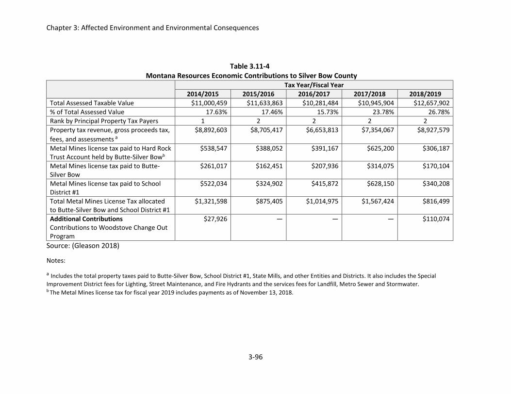
Chapter 3: Affected Environment and Environmental Consequences
3-96
Table 3.11-4 Montana Resources Economic Contributions to Silver Bow County
Tax Year/Fiscal Year
2014/2015 2015/2016 2016/2017 2017/2018 2018/2019
Total Assessed Taxable Value $11,000,459 $11,633,863 $10,281,484 $10,945,904 $12,657,902
% of Total Assessed Value 17.63% 17.46% 15.73% 23.78% 26.78%
Rank by Principal Property Tax Payers 1 2 2 2 2
Property tax revenue, gross proceeds tax,
fees, and assessments a
$8,892,603 $8,705,417 $6,653,813 $7,354,067 $8,927,579
Metal Mines license tax paid to Hard Rock Trust Account held by Butte-Silver Bowb
$538,547 $388,052 $391,167 $625,200 $306,187
Metal Mines license tax paid to Butte-Silver Bow
$261,017 $162,451 $207,936 $314,075 $170,104
Metal Mines license tax paid to School District #1
$522,034 $324,902 $415,872 $628,150 $340,208
Total Metal Mines License Tax allocated to Butte-Silver Bow and School District #1
$1,321,598 $875,405 $1,014,975 $1,567,424 $816,499
Additional Contributions Contributions to Woodstove Change Out Program
$27,926 — — — $110,074
Source: (Gleason 2018)
Notes:
a Includes the total property taxes paid to Butte-Silver Bow, School District #1, State Mills, and other Entities and Districts. It also includes the Special
Improvement District fees for Lighting, Street Maintenance, and Fire Hydrants and the services fees for Landfill, Metro Sewer and Stormwater. b The Metal Mines license tax for fiscal year 2019 includes payments as of November 13, 2018.

Chapter 3: Affected Environment and Environmental Consequences
3-97
3.11.3 Environmental Consequences
No Action Alternative
The No Action Alternative assumes that MR would continue all activities approved under its
current permit; therefore, the No Action Alternative is a “status quo” approach. Impacts to
overall socioeconomic conditions in the area would be minimal and short term under the No
Action Alternative. If all of the 364 jobs at MR ended at mine closure, that would represent a 2
percent reduction in the context of the county employment of 15,750 jobs. However, MR
currently supports approximately 364 of the 460 natural resources and mining jobs in Silver
Bow County (Table 3.11-2). Under the No Action Alternative, mine is projected to cease mining
operations in 2022. Although MR has not projected changes to employment during reclamation
and after reclamation is complete, it is likely that some mine-related jobs would be eliminated
or revised.
Proposed Action
The Proposed Action would allow the mine to operate for another nine years beyond 2022.
Therefore, the jobs provided by MR would be available for this time period. No new jobs would
be created by the Proposed Action, and the Proposed Action would not affect housing
vacancies or school or infrastructure capacity. The state and county would benefit from tax
revenue derived from MR beyond 2022. It can be assumed (although not known for certain)
that the philanthropic giving to the ROI by the Dennis and Phyllis Washington Foundation would
continue. Essentially, the status-quo would be maintained under the Proposed Action for an
additional nine years. Although MR has not projected changes to employment during
reclamation and after reclamation is complete, it is likely that some mine-related jobs would be
eliminated or revised.
Accelerated Drawdown Alternative
The socioeconomic impacts from the Accelerated Drawdown Alternative would be similar to
those under the Proposed Action during operations. Because reclamation would be completed
more quickly under the Accelerated Drawdown Alternative, jobs created or positions converted
as result of reclamation would end sooner than under the Proposed Action.
Elimination of West Embankment Drain Pumpback at Closure
The socioeconomic impacts from the Elimination of WED Pumpback at Closure Alternative
would be similar to those under the Proposed Action during operations. Reclamation under the
Elimination of WED Alternative would be completed in a time frame between the Proposed
Action and the Accelerated Drawdown alternatives. Therefore, jobs created as result of
reclamation would end sooner than under the Proposed Action but would be in place longer
than under the Accelerated Drawdown Alternative.
Alternative Capping Methods
The socioeconomic impacts from the Alternative Capping Methods Alternative would be similar
to those under the Proposed Action during operations. Reclamation may be completed more

Chapter 3: Affected Environment and Environmental Consequences
3-98
quickly than under the Proposed Action. If so, jobs created as result of reclamation would end
sooner than under the Proposed Action.
3.12 LAND USE The following sections present a brief discussion of land uses of the Continental Mine permit
area. The amendment application provides additional land use information including history of
use in the permit area.
3.12.1 Analysis Methods
The MR operating permit, and various on-line databases were reviewed to evaluate land use at
and near the Continental Mine. Figure 3.12-1 presents a map of land ownership.
3.12.2 Affected Environment
Land use involves the management and modification of natural environments into built or
manipulated environments such as settlements, arable fields, pastures, and managed woods.
Land Ownership and Use
The lands that would be added to the permit area are currently undeveloped and their use is
best characterized as wildlife habitat adjacent to industrial and residential use. The areas to the
west of the Moulton Reservoir Road which provides public access to lands closest to the permit
area is a mix of private acreages with dispersed homes and some US Forest Service lands. The
general character of the lands adjacent to the southern mine permit boundary is urban, while
the remaining three sides are primarily rural. There are no agricultural lands adjacent to the
mine permit area.
MR owns approximately 8,070 acres of land in and around the current mine permit boundary.
Approximately 5,800 acres of MR lands fall within the current mine permit boundary and the
proposed expansion (Figure 3.12-1). Lands within Permit 00030 are either actively mined or
part of the industrial facilities that the mine operates. Lands within Permit 00030A are also
predominantly actively used for mining and associated work, but some of the lands fall along
the shore of the YDTI are largely undeveloped.

Chapter 3: Affected Environment and Environmental Consequences
3-99
Figure 3.12-1 Map showing land ownership for the area near the Continental Mine and the Butte Mine Flooding Operable Unit, Silver Bow County, Montana.
3.12.3 Environmental Consequences Post-closure land uses would include watershed protection and wildlife habitat. In addition to
these land uses, the post-closure YDTI will be within the BMFOU boundary and subject to any
land management conditions of that program. The vegetation composition planned for
reclamation would change the character of the wildlife habitat from the mix of deciduous forest
and grassland what was present historically (pre-YDTI) and currently along the northern edge of
the YDTI. However, it would also vegetate the lands exposed as the YDTI recedes and the large,

Chapter 3: Affected Environment and Environmental Consequences
3-100
currently open water area shrinks to the equilibrium pond. Vegetating the area would secure
soils in place, reduce erosion potential, and decrease airborne dust, which would protect the
watershed. This EIS is focused on the lands subject to the proposed amendment and discussion
of the larger areas to be reclaimed after closure is limited to the cumulative effects analysis in
Chapter 4.
No Action Alternative
The No Action Alternative assumes that MR would continue all activities approved under its
current permit; therefore, the No Action Alternative is a “status quo” approach. Impacts to land
use and ownership in the area would be negligible under the No Action Alternative.
Proposed Action
Under the Proposed Action, the total permit area would be increased by 237 acres. However,
only 99 of those acres would be disturbed. Therefore, changes in land use would be limited to
these 99 acres. MR owns all lands within the current permit boundary and the lands to be
added to it under the proposed amendment. The area proposed for addition is adjacent to
active mine operations in the YDTI. The lands that would be inundated by the increased YDTI
capacity are currently undeveloped. The predominant use of this land is as wildlife habitat. The
primary impact of the Proposed Action would be the conversion of the 99 acres from wildlife
habitat to use in the mine activities until after closure and final reclamation.
Although there are also some proposed changes to land use for Permit 00030, that permit area
is currently industrial. The proposed amendment may change the specific use of a site, but it
would not change the general classification or potential use. Land use within permit 00030
would remain industrial. Some of these areas would continue to be used for post-closure
administration and BMFOU related management for the foreseeable future (Montana
Resources 2018b).
Accelerated Drawdown Alternative
No aspect of the Accelerated Drawdown at Closure Alternative would affect the amount or
extent of disturbance to lands or the design or attributes of the proposed land uses. The
impacts to land use under this alternative would be identical to the Proposed Action, except for
the potential reduction in time for reclamation. The reestablishment of vegetation is integral to
the post-closure land uses identified, namely wildlife habitat and watershed protection. This
alternative may allow these land uses to be achieved as much as two to three decades sooner,
which may be substantial in terms of vegetation succession, overall land appearance, and
wildlife use.
Elimination of West Embankment Drain Pumpback at Closure
No aspect of the Elimination of WED Pumpback at Closure Alternative would affect the amount
or extent of disturbance to lands or the design or attributes of the proposed land uses. The
impacts to land use under this alternative would be identical to the Proposed Action, except for

Chapter 3: Affected Environment and Environmental Consequences
3-101
the potential reduction in time for reclamation of approximately 7 years. If this alternative
expedites reclamation, then lands would be useable as wildlife habitat sooner.
Alternative Capping Methods
No aspect of the Alternative Capping Methods Alternative would affect the amount or extent of
disturbance to lands or the design or attributes of the proposed land uses. The impacts to land
use under this alternative would be identical to the Proposed Action, except for the potential
two- year reduction in time for reclamation. If this alternative expedites reclamation, then lands
would be useable as wildlife habitat sooner.
3.13 VISUAL RESOURCES Visual resources are the visible physical features on a landscape such as geologic features,
water, structures, vegetation, or other natural or cultural features. These components
contribute to the overall scenic and aesthetic quality of a landscape.
3.13.1 Analysis Methods In 2018, WESTECH Environmental Services prepared a visual resource assessment for the MR
Application to Amend Operating Permits 00030 and 00030A (WESTECH 2016b). The study
defined the existing landscape character, scenic integrity, landscape visibility, and modeled
anticipated visual changes that would result from the Proposed Action. Those findings are
summarized below and form the basis of the visual resource analysis.
The objective of the visual resources approach is to identify and describe important visual
resources that may be affected by proposed activities. Visual resources include landscapes that
are visible to the public during activities such as travel, daily activities, or recreation.
Other sources of information reviewed:
• USGS Topographic Maps
• Google Earth Imagery
• Field visit
3.13.2 Affected Environment
The area of impact for the Proposed Action lies within the Middle Rockies Ecoregion, an
ecoregion characterized by steep, high elevation mountains and intermontane valleys that
covers much of central North America. More specifically, the area of impact is located on the
southern part of the Boulder Mountains and just west of the Continental Divide in Silver Bow
County, Montana. The typical vegetative landcover in this region is coniferous forest with a
mosaic of riparian species. However, the area of impact has minimal coniferous forest cover
due to significant impacts of historic and ongoing mining activities. Currently, sparse quaking
aspen, conifers and bare mineral soils dominate the area, resulting in a distinct landscape
character dominated by mining impacts.

Chapter 3: Affected Environment and Environmental Consequences
3-102
Scenic integrity of a landscape indicates whether a visual landscape is perceived by an average
viewer as whole or intact. A high degree of integrity is typified by an ecologically intact and
largely undisturbed natural landscape, while a low degree of integrity is associated with
unnatural cultural alterations of the landscape. The scenic integrity of the area of impact is
considered low due to significant effects from historical and current mining activity and the
presence of multiple public and private roads and fences (WESTECH 2018b). The current visual
setting for the area is illustrated in Figure 3.13-1.
Figure 3.13-1. Current visual setting of the West Embankment of YDTI from Moulton Reservoir Road.
3.13.3 Environmental Consequences
No Action Alternative
Under the No Action Alternative, the YDTI would not be expanded and the West Embankment
elevation would remain unchanged. Similarly, the Great Northern RDS would not be expanded
and the Northern RDS would not be constructed. The No Action Alternative would result in
unchanged and unaffected visual resources and landscape.
Proposed Action
The primary components of the Proposed Action that may affect visual resources are discussed
below.

Chapter 3: Affected Environment and Environmental Consequences
3-103
The raising of the West Embankment from 6,405 to 6,450 feet elevation is one component of
the Proposed Action that would impact visual resources. However, in terms of landscape
visibility, the YDTI and particularly its West Embankment occupy a topographic depression
surrounded by rolling hills on all sides. This topographic configuration limits the visibility of the
area of impacts to the public. The Moulton Reservoir Road offers the only public access that has
views of the area of impact. The WESTECH (2018b) visual resource analysis focused on the
Moulton Reservoir Road and established four viewpoints along its length to assess the visibility
of the area of impact. All four viewpoints established offered only partial and short duration
views of the West Embankment (WESTECH 2018b) The distance zones associated with the
viewpoints fall largely within the foreground (within ½ mile from viewer) and middle
foreground (up to 4 miles from viewer) classification. Three other viewpoints were established
outside of Moulton Reservoir Road to assess the visual impacts to the landscape from
prominent public viewing areas. These were the Granite Mountain Memorial, the Interstate 15
Scenic Overlook and the Top of the World trailhead. The West Embankment was not visible
from any of these three viewpoints (Figure 3.13-2) (WESTECH 2018b).
Figure 3.13-2 Change to the visual setting from raising of West Embankment, viewed from Moulton Reservoir Road.
A second component of the Proposed Action would involve the creation of soil stockpiles for
the planned reclamation and revegetation of the YDTI. Since 2015, these have been placed
along the Moulton Reservoir Road and they serve to minimize foreground views of the West
Embankment to the public. These stockpiles would be contoured and revegetated as part of the

Chapter 3: Affected Environment and Environmental Consequences
3-104
Proposed Action, which would mitigate visual impacts in terms of line, form, texture and color
to make their appearance more closely aligned to the natural character of the surrounding
landscape.
A final component of the Proposed Action would be the construction of the Northern RDS and
expansion of the existing Great Northern RDS. The North RDS would be developed on the
northeast facing downhill slope of the North-South Embankment of the YDTI and would overlay
existing leach dumps. The existing Great Northern RDS would be expanded to accommodate
additional waste rock not used in the Northern RDS or construction of the West Embankment.
Both RDS features would be visible from points south of the YDTI unlike the West Embankment.
Prominent public viewing areas include but are not limited to the Granite Mountain Memorial,
Top of the World Trailhead and Continental Drive to the south.
The foreground and middle foreground views from these areas are dominated by large scale
mining related features that provide pronounced visual contrast compared to the background
views of Rampart Mountain and the Boulder Range (Figures 3.13-3 and 3.13-4). As such, the
expansion of the Great Northern RDS and construction of the Northern RDS represent only an
incremental increase to the existing visual impacts from mining activity. The planned
reclamation and revegetation of the Embankments and RDS features following mine closure
would mitigate the minor visual impacts caused by their expansion.
The visual impacts that would result from the Proposed Action would not be significant or
lasting. Instead, the impacts represent incremental increases to existing visual impacts from the
current YDTI and Great Northern RDS. The Northern RDS would similarly represent only an
incremental increase to the visual impacts already in place from the North-South Embankment,
as it will be constructed on its downward slope. These minor visual impacts are occurring in an
area with low scenic integrity resulting from current and historic mining activity, so they would
provide little additional visual contrast to a landscape that is already dominated by mining
impacts. Finally, the planned reclamation and revegetation of the surface of these features
following mine closure would mitigate the visual impacts caused by their expansion. The
mitigation would alter the appearance of these features in terms of line, form, texture and
color to more closely match the natural character of the surrounding landscape. Therefore, the
Proposed Action would only cause minor and temporary impacts to visual resources in the
landscape.

Chapter 3: Affected Environment and Environmental Consequences
3-105
Figure 3.13-3 Views of Great Northern RDS from Continental Drive via Google Street View.
Figure 3.13-4 Views of North-South Embankment and Great Northern RDS from Granite Mountain Memorial via Google Street View.

Chapter 3: Affected Environment and Environmental Consequences
3-106
Accelerated Drawdown Alternative
The Accelerated Drawdown Alternative only deviates from the Proposed Action in the timing of
closure and reclamation. As such, the impacts to visual resources would be the same as
discussed in the Proposed Action.
Elimination of West Embankment Drain Pumpback at Closure
The Elimination of West Embankment Drain Pumpback at Closure only deviates from the
Proposed Action in the timing of closure and reclamation. As such, the impacts to visual
resources would be the same as discussed in the Proposed Action.
Alternative Capping Methods
The Alternative Capping Methods Alternative only deviates from the Proposed Action in the timing of closure and reclamation. As such, the impacts to visual resources would be the same as discussed in the Proposed Action.
3.14 NOISE Noise is generally defined as unwanted sound, and can be intermittent or continuous, steady or
impulsive, stationary or transient. Noise levels heard by humans and animals are dependent on
several variables, including distance and ground cover between the source and receiver and
atmospheric conditions. Perception of noise is affected by intensity, frequency, pitch, and
duration.
3.14.1 Analysis Methods Noise levels are quantified using units of decibels (dB). Humans typically have reduced hearing
sensitivity at low frequencies compared with their response at high frequencies. The “A-
weighting” of noise levels, or A-weighted decibels (dBA), closely correlates to the frequency
response of normal human hearing (250 to 4,000 hertz [Hz]). Noise levels typically decrease by
approximately 6 dBA every time the distance between the source and receptor is doubled,
depending on the characteristics of the source and the conditions over the path that the noise
travels. The reduction in noise levels can be increased if a solid barrier or natural topography
blocks the line of sight between the source and receptor.
For environmental noise studies, noise levels are typically described using A-weighted
equivalent noise levels, Leq, during a certain time period. The Leq metric is useful because it uses
a single number, similar to an average, to describe the constantly fluctuating instantaneous
noise levels at a receptor location.
The 90th percentile-exceeded noise level, L90, is typically considered the ambient noise level.
The L90 is a single number that represents the noise level exceeded during 90 percent of a
measurement period. Therefore, it is also an indication of the residual noise level and among
the lowest noise levels during a measurement period. It typically does not include the influence
of discrete noises of short duration, such as dog barks, backup alarms, vehicle pass-bys, a single
blast, etc. If a continuous noise is audible at a measurement location, such as an engine,

Chapter 3: Affected Environment and Environmental Consequences
3-107
typically it is that noise that determines the L90 of a measurement period even though other
noise sources may be briefly audible and occasionally louder than the equipment. The Lmax
metric denotes the maximum instantaneous sound level recorded during a measurement
period.
The day-night average noise level, Ldn, is a single number descriptor that represents the
constantly varying sound level during a continuous 24-hour period. The Ldn can be determined
using 24 consecutive one–hour Leq noise levels or estimated using measured Leq noise levels
during shorter time periods. The Ldn includes a 10-decibel penalty that is added to noises that
occur during the nighttime hours between 10:00 p.m. and 7:00 a.m., to account for people’s
higher sensitivity to noise at night when the background noise level is typically low.
3.14.2 Affected Environment
Existing man-made noise sources near the residential structures within the West Ridge area,
the residential structures nearest to the proposed Amendment area, include intermittent traffic
on Moulton Road, large diesel-powered equipment working the existing YDTI operations,
residential activities, dogs, and aircraft flyovers. Natural sound sources include wind, wildlife,
birds, insects, and precipitation. As shown on Figure 3.14-1, there are 12 rural single-family
residences located adjacent to Moulton Road, at areas southwest, west, and north of the West
Embankment. Moulton Road is generally located on top of a ridge, with the West Embankment
east and topographically downgradient (20 to 80 feet lower) than the residences.
In December 2015, a baseline noise study was completed to measure noise levels at one
location east of Moulton Road (Figure 3.14-1). The location was selected to be close to the
residence nearest to the West Embankment of the YDTI (R9) and within direct line of sight of
the impoundment.

Chapter 3: Affected Environment and Environmental Consequences
3-108
Source: Big Sky Acoustics, 2018
Figure 3.14-1. 2015 Noise Measurement Location and Residences Along Moulton Road.

Chapter 3: Affected Environment and Environmental Consequences
3-109
Over the 96-hour study period, the 1-hour Leq ranged from 21 to 47 dBA, the one-hour L90
ranged from 18 to 39 dBA, and the calculated Ldn was 44 dBA. The measured Leq, L90 and Ldn noise
levels were found to be typical for lightly-populated rural areas (Harris 1998). Additional details
of the noise study are included in the report completed by Big Sky Acoustics (2018).
In July 2017, noise level measurements were conducted for the Applicant’s loaded and
unloaded haul trucks as they passed by on a dirt haul road and also when dumping a load. The
noise level study was conducted in accordance with methods described in the study completed
by Big Sky Acoustics (2018). The measured noise levels were Lmax 84 dBA at 50 feet for the haul
truck pass-by and Leq 72 dBA at 130 feet for the load dumping operation. The 2-minute load
dumping operation included the haul truck backing up, raising the bed, slowly pulling forward
to spread material as it falls out of the bed, lowering the bed, and pulling away from the dump
area.
Current noise levels were predicted for each of the 12 residences (Figure 3.14-1) using the
Cadna-A Version 2017 noise prediction software from DataKustik. The model used noise level
measurements from the July 2017 noise study and the following assumptions:
Existing Ambient Noise Levels: Day/Night Average: Ldn 44 dBA Nighttime Leq 26 dBA
Haul Trucks: Transport soil to the West Embankment and soil stockpiles Average speed 25 mph Pass-by frequency every 3 minutes Operating Hours 24 hours/day, 365 days/year
The results of the model are presented in Table 3.14-1 and show that the predicted noise levels
are near the Ldn and Leq background noise levels of 44 dBA and 26 dBA, respectively.

Chapter 3: Affected Environment and Environmental Consequences
3-110
Table 3.14-1 Current Noise Predictions at 12 Residential Receptors near the Continental Mine
Residential
Receptora Predicted 2018 Ldn (dBA) Predicted 2018 Leq (dBA)
R1 39 32
R2 41 34
R3 42 35
R4 43 36
R5 44 37
R6 44 37
R7 45 38
R8 45 38
R9 44 37
R10 45 38
R11 35 28
R12 45 38
a Residential receptors as labeled on Figure 3.14-1
3.14.3 Environmental Consequences
No Action Alternative
Under the No Action Alternative, noise levels similar to those measured in July 2017 and
estimated in the noise model (Table 3.14-1) would continue while noise impacts would not
occur on the additional acreage that would be disturbed under the Proposed Action or other
action alternatives. Currently approved operations and associated noise impacts would
continue under Operating Permits 00030 and 00030A.
Proposed Action
To evaluate noise impacts, a significance criterion was developed based on existing federal,
state, and county noise regulations, ordinances and guidelines. Table 3.14-2 lists the identified
applicable noise guidelines.
The Federal Transit Administration (FTA) has developed guidelines for assessing short-term (1-
hour) and long-term (8-hours) construction activities. Assessment of construction noise
includes evaluating the existing ambient noise environment, the absolute noise levels due to

Chapter 3: Affected Environment and Environmental Consequences
3-111
construction activities, the duration of construction, and the noise-sensitivity of the adjacent
land use. Table 3.14-3 summarizes the FTA construction noise guidelines at adjacent land uses.
Table 3.14-2 Project Noise Regulations and Guidance
Regulatory Authority Regulations and Guidelines Citation
Environmental Protection Agency
Outdoor day-night average noise level (Ldn) less than or equal to 55 dBA are sufficient to protect public health and welfare in residential areas and other places where quiet is a basis for use.
Noise Control Act of 1972, 42 U.S.C § 4901 et
seq.
State of Montana and Butte-Silver Bow County
Every motor vehicle shall at all times be equipped with a muffler in good working order and in constant operation to prevent excessive or unusual noise.
61-9-403, MCA Code of Ordinances
10.64.100
State of Montana A person may not operate a motor vehicle with an exhaust system that emits a noise in excess of 95 dB, as measured by the Society of Automotive Engineers’ standard j1169 (May 1998).
69-9-435, MCA
Sources: B-SBC 2018, USEPA1978, MCA 2017
Table 3.14-3 FTA Construction Noise Guidelines
Adjacent Land Use
Short Duration Noise Guidelines (1-hour)
Moderate Duration Noise Guidelines (8-hours)
Daytime Leq Nighttime Leq Daytime Leq Nighttime Leq Residential 90 dBA 80 dBA 80 dBA 70 dBA
Commercial 100 dBA 100 dBA 85 dBA 85 dBA
Industrial 100 dBA 100 dBA 90 dBA 90 dBA
Noise impacts were assessed by comparing background noise levels with projected noise levels.
The noise level predictions for the Proposed Action were calculated using the noise model
described above in Section 3.14.2. Assumptions used for the model were as follows:
Equipment and Noise Level (Lmax at 50 feet in dBA): Caterpillar 793 Haul Truck 240-ton 84 dBA Crawler Dozer 85 dBA Motor Grader 85 dBA Water Truck 88 dBA

Chapter 3: Affected Environment and Environmental Consequences
3-112
Westbank Embankment/Stockpile Construction Haul truck load dumping operation 2 minutes Haul truck dumping noise level Leq 72 dBA at 130 feet 1-2 crawler dozers, motor graders, and/or road water trucks also operating simultaneously, as needed Westbank Embankment construction 50-foot lifts Stockpile construction concurrent, as warranted Operating Hours 24 hours/day, 365 days/year
The model determined that under the Proposed Action the Ldn noise levels at the residences
would increase 0 to 6 dBA and the Leq would increase 0 to 8 dBA. The highest increase in noise
would be at residence (R9), located closest to the West Embankment, and residence (R10),
located closest to the soil stockpile. The model confirmed that none of the modeled noise levels
at the residences would exceed the USEPA Ldn 55 dBA guideline or the FTA Leq 90 dBA nighttime
guideline. Noise predictions are presented in Table 3.14-4.
Table 3.14-4 Amendment Design Year Noise Predictions at 12 Residential Receptors near the Continental
Mine. Residential Receptor Predicted 2022 Ldn (dBA) Predicted 2022 Leq (dBA)
R1 46 33
R2 46 36
R3 47 37
R4 48 38
R5 48 39
R6 49 39
R7 50 41
R8 50 42
R9 52 44
R10 54 46
R11 45 33
R12 48 39
Based on the results of the model potential noise impacts are expected to be minimal since the
predicted noise levels would be below the USEPA and FTA guidelines. Table 3.14-4 shows that
at residence R10, the noise levels would be close to the Ldn guideline. Since this residence is
near the soil stockpile it is likely that noise impacts should be short-term. These stockpiles
would be comprised of salvaged soil that would comply with the mitigation measures described
in the Reclamation Plan.
Following construction of the West Embankment to the 6,450-foot elevation, noise levels may
increase due to the decrease in topographic relief (i.e., the West Embankment would be close

Chapter 3: Affected Environment and Environmental Consequences
3-113
to the same elevation as Moulton Road). The increase in noise levels would persist through the
life of the YDTI.
Accelerated Drawdown at Closure
The impacts on noise from accelerated drawdown at closure would not be appreciably different
than those from the Proposed Action and would not exceed USEPA or FTA guidelines.
Elimination of West Embankment Drain Pumpback at Closure
The impacts on noise from Elimination of West Embankment Drain Pumpback at Closure would
not be appreciably different than those from the Proposed Action and would not exceed USEPA
or FTA guidelines.
Alternative Capping Methods
The impacts on noise from Alternative Capping Methods would not be appreciably different
than those from the Proposed Action and would not exceed USEPA or FTA guidelines.
3.15 AIR QUALITY The Proposed Action would occur under a Montana Air Quality Permit (MAQP) #1749-12 issued
by DEQ’s Air Resources Management Bureau on January 8, 2004 (DEQ 2004). Sources of
potential air quality impacts exist at the mine site where a majority of the activities occur.
3.15.1 Analysis Methods Analysis methods for understanding the existing air quality within the mine permit as well as
regional air quality environments at the Continental Mine included review of the proposed
operating permit amendment and supporting documentation provided by MR. Specifically, the
primary resources reviewed and relied upon for this section include:
• Proposed Amendment to Operating Permits 00030 and 00030A to Continue Operations
at the Continental Mine, Revised May 2018 (Montana Resources 2018b)
• Montana Resources Continental Mine Operation Plan, Revised February 2018 (Montana
Resources 2018a)
• Air Quality Permit #1749-12, January 8, 2004 (DEQ 2004)
• Montana Resource’s 2017 Emission Inventory Detail, Airs Number 093-0009 (DEQ Air
Resources Management Bureau 2017)
• Butte Montana PM 2.5 Source Apportionment Research Studies, 2013 and 2014 (Ward
2013, Ward 2014)
• An Assessment of Ambient Particulates in Butte, Montana, 2014 (Ganesan 2014)
The air quality of a region is primarily controlled by the type, magnitude and distribution of
pollutants and may be affected by regional climate. Transport of pollutants from their source
areas are affected by topography and meteorology.

Chapter 3: Affected Environment and Environmental Consequences
3-114
The primary indicator for air quality management of dust includes particulate matter less than
10 microns in size (PM10) and particulate matter less than 2.5 microns in size (PM2.5) from
fugitive road dust and construction activities. The most common sources for particulate matter
are fly ash, carbon black soot, smoke, and fugitive dust from unpaved roads and construction
sites (DEQ 2018).
The amount of particulate dust associated with vehicle travel and construction activities varies.
For vehicle travel, particulate dust generation varies with the length of travel on unpaved roads,
size and type of vehicle/equipment, number of vehicles/equipment, silt content of the road bed
as a source of particulate matter, vehicle speed, local weather as it relates to precipitation and
evaporation, and duration of the operation. Both source control and work practices can limit
dust emissions from disturbed soils and unpaved roads. Dust abatement operations such as
fugitive dust control on material transfer, and stabilization of stockpiles or disturbed soils, dust
suppression agents for road surfaces and disturbed areas including tailings, and controlling
speed of vehicle/equipment travel, can greatly decrease the generation of particulate matter.
Ultimately, dust particles could contribute to water quality in conjunction with storm water
erosion through depositional loading of sediment over the long-term.
The amounts of carbon dioxide (CO2), nitrogen dioxide (NO2), and methane (CH4) emitted from
ore haul trucks and mine related traffic emissions are regulated. The USEPA regulates emission
for on-road and non-road vehicles and engines by regulating fuel and sets emission standards
on the amount of pollution a vehicle or engine can emit. This ensures that the vehicles meet
federal and corporate average fuel economy standards (USEPA 2017); therefore, on-road and
non-road vehicle related engine emissions are expected to meet regulations and were not
addressed further in this evaluation.
Spatial Boundary
Air quality for the project area was described as part of the MAQP #1749-12 and MR’s proposed
operating permit amendment application which incorporates regional climate and areas of
concern, emission sources, types (fugitive or point source), quantities, and a projected ambient
air quality analysis. According to the permit, Butte is a secondary nonattainment area for total
suspended particles (TSP) and a Group 1 nonattainment area for PM10. (Nonattainment refers
to areas that have not met National Air Quality Standards). Ongoing monitoring is performed at
the Greeley School for TSP. Based on this, the spatial boundary is considered to be the regional
air quality within and near the nonattainment area.
Temporal Boundary
The temporal boundary for the Proposed Action includes the construction of the dam raise,
followed by reclamation of the constructed and material borrow areas. The temporal boundary
extends through the completion of closure activities. Final closure activities include the
reclamation of the Transition Zone and Northern Pond Perimeter. They are expected to
continue incrementally for an estimated 40 years following the end of mining.

Chapter 3: Affected Environment and Environmental Consequences
3-115
Methods
Emission factors are used to estimate emissions from sources based on measurable parameters
for each activity. Control efficiencies for emissions are either included in the factor or are
presented as a control efficiency. USEPA provides sources for these factors as well as
procedures to develop site specific emission factors. Specific sources of emission factors and
control efficiencies related to the activities at MR are detailed below.
USEPA’s AP-42 document is a compilation of emission factor information for quantification of
emissions from fugitive particulate matter. Chapter 11, Mineral Products Industry, includes a
compilation of emission factors related to mining activities. The details were used to estimate
the magnitude of particulate matter emissions from selected sources and activities (USEPA
2018b).
The AP-42 equations used to estimate quantity of particulate emissions per vehicle mile
traveled on unpaved roads include information from Chapter 13, Miscellaneous Sources.
Referenced equation estimate emissions for vehicles traveling on unpaved surfaces at industrial
sites. The AP-42 equations used to estimate fugitive emissions from aggregate handling and
storage piles related to road construction activities were obtained from 13.2.4 11/06,
Aggregate Handling and Storage Piles. The AP-42 equations were used to estimate fugitive
emissions from wind erosion include factors from 13.2.5 11/06, Industrial Wind Erosion.
USEPA’s Factor Information Retrieval (FIRE) Data System provided additional emission factors
recommended by the USEPA (USEPA 2016).
The permit and reported emission inventories include all mining and operation emissions in the
mine permit area. The emission factors were derived using the USEPA’s AP-42 equations
referenced above, USEPA FIRE Data System, site specific information at the mine site, and are
summarized in the current permit (MAQP #1749-12) and annual emission inventories.
Additional information was also referenced from the permit.
The USEPA regulates diesel engine emission under the Clean Air Act (CAA) for on-road and non-
road vehicles, such as locomotives, and engines by regulating fuel and sets emission standards
on the amount of pollution a vehicle or engine can emit (USEPA 2017). This ensures that the
vehicles meet federal emission standards; therefore, on-road and non-road vehicle related
engine emissions are expected to meet regulations and were not addressed in this evaluation.
3.15.2 Affected Environment
Topography
Dispersion of air contaminants is highly dependent upon topography. The Continental Mine is
located in Silver Bow County, Montana which is dissected by the Continental Divide, with the
northern half of the project draining to the western side of the Divide and the southwestern
and southeastern side of the project draining to the eastern side of the Divide.

Chapter 3: Affected Environment and Environmental Consequences
3-116
According to the MR Amendment Applications, elevations in and around the YDTI range from
about 6,340 feet, the current tailings pond level, to over 7,800 feet on Rampart Mountain to
the east and to the north. The local terrain is characterized by abundant granitic outcrops with
the dominant vegetation types including quaking aspen, sagebrush, grassland and lodgepole
pine. The impoundment is bordered to the west by a relatively low elevation ridge referred to
as the West Ridge, with elevations ranging from about 6,470 to 6,550 feet based on the
Anaconda Copper Company (ACC) vertical datum. The West Ridge is of particular interest in the
baseline investigations since the lower topographic elevations, and corresponding ground
water levels, represent the lowest natural hydrologic barrier to potential uncontrolled seepage
from the YDTI. The east flank of the ridge slopes relatively steeply towards the impoundment
while the west flank slopes more gently for approximately five miles to Browns Gulch. Moulton
Reservoir Road trends generally north-south along the ridge crest with a number of private
residences located along the west flank of the ridge (Montana Resources 2018b)
Climate and Meteorology
Dispersion of air contaminants is highly dependent upon climate, wind speed, and atmospheric
stability. Climate in this area is generally characterized by milder winters and cooler summers in
comparison to the remainder of the State. This can be manifested in a shorter growing season,
with more cloudiness and humidity.
Historical climate data was summarized from the Butte Bert Mooney Airport weather station
(USC00241320), located approximately six miles south of the YDTI at elevation 5,600 feet,
about 800 feet lower than the impoundment. The mean daily temperature for the project site
was estimated to be 39° Fahrenheit (F), with an extreme high of 104° F and an extreme low of -
63° F. Highest temperatures generally occur between July and August, and lowest temperatures
typically occur between December and February (Knight Piesold 2018a). Average temperatures
range from a minimum of 7.4° F in January to a maximum of 79.9° F in July (Western Regional
Climate Center 2016).
Daily precipitation data are also available from the Bert Mooney Airport weather station
(USC00241320). For the period 1990 through 2016, annual precipitation averaged 12.8 inches
per year, ranging from 8.63 inches in 2000 to 19.96 inches in 1997 as shown in Figure 3.1-1
earlier (Montana Resources 2018b). Schafer (2016) developed an adjustment factor for the Bert
Mooney Airport precipitation data to address the higher elevation YDTI. Based on this
adjustment, annual precipitation in the YDTI and West Ridge area is estimated to be 15.9 inches
per year (Montana Resources 2018b).
Compilation of hourly data from the KBTM weather station at the Butte Bert Mooney Airport
from 1992 through 2002 indicated the primary prevailing wind direction to be from the south
with a north wind occurring in late spring and summer (Western Regional Climate Center 2018).
Average wind speeds were compiled from data obtained from 2001 through 2011 at the same
location. Data indicated that average wind speed at the airport ranged from 4.1 to 6.7 miles per

Chapter 3: Affected Environment and Environmental Consequences
3-117
hour with an average of 5.4 miles per hour. The highest average speeds were reported for
March through June (Western Regional Climate Center 2018).
All major drainages within the analysis area for this project are subject to temperature
inversions which trap air and reduce smoke dispersal. Temperature inversions can occur at any
time during the year, but are most common in the fall and winter. Generally, emission dispersal
within the analysis area is very high due to the mountainous terrain and high wind velocities.
Valley locations in and adjacent to Butte have the greatest potential for cumulative
concentrations of urban, industrial, and transportation emissions because up-valley winds
during the daytime and down-valley winds (cold air drainage) at night can dominate wind
direction and speed more than the overall prevailing winds.
In addition to reported climate data, MR operates a meteorological station to collect climate
data for planning purposes.
Existing Air Quality
Sources of Regional Pollution
Butte is a secondary nonattainment area for Total Suspended Particulate and a Group 1
nonattainment area for PM10. The extent of the PM-10 nonattainment area is show on Figure
3.15-1 below. DEQ maintains an air monitoring station for particulate matter at the Greeley
School located approximately 0.2 miles south of the permit area’s southern perimeter. This
monitoring site is show below on Figure 3.15-1 as the Greeley School Monitoring Station. The
data collected is used to monitor compliance with the local nonattainment area and provide
information for public health protection plans during periods of poor air quality and to monitor
compliance with NAAQS. Historically, MR had conducted air monitoring in the area of the mine;
however, as of March 5, 2002, MR was no longer required to conduct this monitoring. DEQ has
indicated that if conditions change, MR may be required to resume monitoring efforts and
modify their appropriate control plans (DEQ 2004).

Chapter 3: Affected Environment and Environmental Consequences
3-118
Figure 3.15-1. Butte PM-10 Nonattainment Area.
The mine site has an air quality permit through DEQ. The permit covers fugitive emissions,
those which could not reasonably pass through a stack, chimney vent, or other functionally-
equivalent opening (40 CFR Sections 70.2 and 71.2), and point source emissions, those that are
released from a single point.
Fugitive emissions evaluated for the air quality permit included the following: drilling, blasting,
travel (transport) of ore trucks, front end loader, loading, unloading, wind erosion, crushing,
and drying. The facility’s potential to emit (PTE) is less than 100 tons per year for any pollutant,
is less than 10 tons per year for any one hazardous air pollutant (HAP) and less than 25 tons per

Chapter 3: Affected Environment and Environmental Consequences
3-119
year of all HAPs, and not an USEPA designated Title V source; therefore, DEQ has determined
MR is a minor source of emissions. The PSD program does not apply to MR because it is not
listed as a major stationary source under PSD regulations.
The State Implementation Plan (SIP) has been developed in response to TSP emissions in the
Butte nonattainment area. The plan applies to MR since it has the potential emissions of PM
and PM10 greater than 25 tons per year (TPY). DEQ evaluated PM10 emissions using EPA-
approved chemical mass balance computer models to demonstrate compliance with standards
if MR allowable emissions were limited, and if controls were implemented to other sources.
DEQ concluded that the current air quality permitting action would not result in an increase in
Montana Resources’ ambient impact. Further, they determined that the permitting action
would not cause or contribute to a violation of the ambient standards.
2017 Emission Inventory
MR is required to provide data such as production, disturbed acreage, vehicle miles traveled,
and holes drilled to quantify emissions for compliance evaluation with annual, seasonal, and
daily emission limits. The Emission Inventory Detail for 2017 was reviewed for the annual
emission summary (DEQ Air Resources Management Bureau 2017).
For 2017, MR’s facility had reported emissions of 1,981 tons per year of particulate matter with
660 tons per year of the particulate matter as PM10. Of this total, material handling accounted
for 11 percent of the PM10 emissions. Transport of material with haul trucks accounted for 39
percent and fugitive dust from disturbed areas accounted for 15 percent of the PM10 emissions.
Of those disturbed areas, the dry tailings area in the impoundment accounted for 0.07 percent
(0.475 tons per year) of the PM10 emissions.
Sources of Regional Pollution – Dispersion Study
Due to the elevated PM in the Butte area, several studies have been completed to understand
the trend of PM10 and PM2.5. PM10 data was evaluated from 1993 through 2013. Modelling had
concluded that wood smoke likely from forest fires was the major source of ambient PM2.5
during summer months and contributing as much as 72 percent of the PM2.5. Apportionment
determined the remaining contributions were from street/road dust (11.1 percent), secondary
sulfate (7.8 percent), ammonium nitrate (1.3 percent) and automobile exhaust at 1.3 percent.
Approximately 2.4 percent could not be definitively attributed to a specific source (Ward 2014).
Modeling of winter sources for PM2.5 also concluded that wood smoke was the primary
contributor as high as 51.8 percent with other secondary sources similar to the summer study
detailed above (Ward 2013).
Other monitoring sites were evaluated across the Butte Valley. The study indicated that during
winter months, PM2.5 levels at the Greeley School could be twice as high as the average from
other valley monitoring locations. The predominant wind direction influencing PM2.5
concentrations at the Greeley School site was from the southeast and east, while the other

Chapter 3: Affected Environment and Environmental Consequences
3-120
valley sites were different at each site. Metal content from the Greeley site was compared to a
background site located in Sieben Flats near Helena and indicated no major differences
(Ganesan 2014).
Mitigations
For the air quality resource, all activities must be in compliance with the current air quality
permit (MAQP #1749-12) and ambient air quality standards. The air quality permit outlines
requirements for compliance. Specific mitigations are required for permit compliance and
include water and chemical suppressants to control fugitive emissions to ensure compliance
with opacity standards. MR must maintain wet tailings for dust control. MR must also
implement engine controls to reduce particulate matter from engine exhaust. For fugitive dust,
the permit includes conditions limiting the facility’s emissions.
The permit also requires annual emission reporting. Production/activity reports based on onsite
activities and approved emission factors are submitted by MR to complete annual emission
reporting. This reporting ensures compliance with annual, seasonal and daily emission limits.
As part of the Butte SIP for complying with the CAA, MR is required to prepare and implement
an approved dust control plan (DCP) to reduced particulate matter emissions. The DCP is
included as part of MR’s mine permit. The DCP outlines procedures to control dust by interim
dust control measures, interim reclamation, weather monitoring and forecasting to avoid
planning activities during dry or windy periods (Montana Resources 2018a).
If measures of the DCP are not followed or inadequate for the site activities, enforcement
action would be implemented to correct the response. Also, monitoring at the Greeley School
provides ongoing monitoring of particulate matter in the area. Should elevated levels of
particulate matter be reported, DEQ can identify sources and apply mitigations to achieve
ambient air quality. If particulate matter increases, additional air quality monitoring
requirements may be required by MR (DEQ 2004).
According to the air quality permit, If conditions of the tailings pond change, MR would have to
develop a long-term fugitive dust control plan for the tailings pond and would still comply with
all statutes and rules of the Clean Air Act of Montana and specifically with AMR 17.8.308
Particulate Matter, Airborne (ARM 17.8.749) (DEQ 2004).
Table 3.15-1 presents mitigations implemented at the mine to control fugitive dust emissions
during various activities.

Chapter 3: Affected Environment and Environmental Consequences
3-121
Monitoring
DEQ maintains an air monitoring station for particulate matter station at the Greeley School
located approximately 0.2 miles south of the MR’s southern perimeter. MR is no longer
required to monitor air quality in the mine area. However, if conditions change, MR may be
required to resume monitoring efforts and modify their DCP. The air quality permit requires
monitoring of the tailings pond and road opacities and monitoring of weather for forecasting to
plan activities which may increase dust emissions.
Table 3.15-1 Mitigation Measures for Fugitive Dust
Control Measure Activity Source
Interim Dust Control Wet tailings and roadway MAQP #1749-12 DCP
Annual application of chemical dust suppressants to roadways
MAQP #1749-12
Conducting visual observations of the YDTI beach condition multiple times per day
DCP
Interim Reclamation Placing a 6-inch thick rockfill cap over areas where equipment can operate
DCP
Placing reclamation capping material and revegetating the transition zone as areas become available for reclamation
DCP
Maintaining and utilizing the Terramac® to apply dust suppressant
DCP
Dust Prone Activity Planning
Manipulating tailings discharge lines to maintain wetted conditions of the tailings to the greatest extent possible
DCP
Evaluating the effectiveness of control measures
DCP
Maintaining a weather station and professional meteorologist to forecast weather for activity planning
DCP
Activity Planning Using most recent past weather conditions at the site and the future predicted conditions to evaluate the likelihood of a dust event
DCP
Final Reclamation Emplacement of a 28-inch thick amended alluvium cap and revegetating
Permit Amendment Application &
Continental Mine Operations Plan

Chapter 3: Affected Environment and Environmental Consequences
3-122
3.15.3 Environmental Consequences
No Action Alternative
Under the No Action Alternative, MR would continue to operate under existing operating
permits. Mitigations for air quality are outlined in the current air quality permit, the DCP, and
the operating permit. These control measures and activities are detailed in Table 3.15-1.
For final reclamation, tailings closure includes dewatering of the tailings impoundment which
would incrementally increase the tailings beach or dry area. This would create a Transition Zone
which would retain water, and a reduction in the supernatant pond resulting in a partial wet
closure. The Transition Zone would be comprised of subaqueous tailings slimes, rather than the
coarser materials found in the beach tailings. Slimes are composed of finer silt and clay particles
while the beach is comprised of sand like particles. As the dewatering transitions, the slimes
closest to the supernatant pond would remain saturated with water due to their inherent
moisture holding capacity while the slimes nearest the beach would “crust” over as they dry.
The beach, Transition Zone, and water level would be monitored to assess dusting potential,
and if dust is detected, MR would be required to implement its DCP. The tailings beach areas
susceptible to wind erosion would be covered after cessation of operations with 6-inch rock,
leached cap, or similar material. Permanent reclamation of the tailings beach includes
emplacement of a 28-inch thick amended alluvium cap followed by revegetation.
Current dust control mitigations are expected to meet requirements of the current air quality
permit which is expected to protect ambient air quality conditions. These mitigations include
water and chemical dust suppressants for fugitive dust control, limiting vehicle engines and
speed, and capping of long-term sources of fugitive dust.
Ongoing monitoring of onsite conditions and local climate conditions consistent with the DCP
would provide opportunities to plan proposed work and mitigations. Ongoing regional
monitoring by DEQ would assure compliance with the existing air quality permit and
compliance with ambient air quality standards. Should unacceptable impacts be discovered by
monitoring, MR is required to update and modify its DCP to achieve compliance and may have
to resume ambient air monitoring.
Proposed Action
The Proposed Action activities are consistent with current activities on the site and will include
existing equipment. As a result, no significant increase in emissions is expected. However, MR
would be required to modify their air quality permit if an emission increase would exceed the
de-minimus threshold of 5 TPY of a regulated pollutant. Such an exceedance is unlikely based
on review of the proposed activities. Regular emission inventories would quantify emissions to
achieve compliance with annual, seasonal, and daily emission limits. Continued monitoring at
the Greeley School would evaluate regional compliance with ambient air quality standards for
PM10.

Chapter 3: Affected Environment and Environmental Consequences
3-123
West Embankment Raise Construction and Operations
No significant changes in operations are anticipated with the construction of the West
Embankment raise or continued processing of ore. Construction of the embankment from
waste rock and associated site modifications will be accomplished through the use of MR’s
existing equipment fleet. Current mitigations for fugitive dust from vehicles, material handling,
and disturbed areas would remain in place. Emission reporting and monitoring outlined in the
permit and DCP would be in effect along with DEQ’s regional air monitoring at the Greeley
School to ensure compliance with the existing air quality permit.
Tailings Management
Tailings would continue to be discharged to the YDTI under the Proposed Action. However,
additional mitigation measures have been proposed in the amendment application regarding
tailings disposal and reclamation.
Tailings would continue to be discharged to the YDTI under the Proposed Action. However,
additional mitigation measures have been proposed in the Amendment regarding tailings
disposal and reclamation.
To achieve the geotechnical objectives for beach development, enhance embankment stability,
and limit the potential for internal erosion, the practice of inundation of tailings beaches with
water to manage wind-blown dusting will be phased out. The potential for tailings dusting will
be managed through the use of multiple discharge points or by other means to wet the beach
by recycling water within the mine area during critical periods. Accessible areas prone to
fugitive dust will be temporarily reclaimed with a 6-inch rock cap or use of a Terramac® to apply
chemical dust suppressants.
Tailings Reclamation
For final reclamation of the YDTI to begin in 2031, a beach, Transition Zone, and an equilibrium
pond volume of approximately 1,000 acre-feet will be created by 2060. The Transition Zone will
be created as the pond recedes during drawdown and will be comprised of subaqueous tailings
slimes as opposed to the coarser beach tailings. The slimes are comprised of much finer
particles (primarily silt and clay) compared to the predominantly sandy beach (Montana
Resources 2018).
The slimes, comprised of approximately 72 percent silt and clay compared to approximately
20.7 percent silt and clay for the beach, will tend to form a crust as drying occurs. The slimes
closest to the receding pond will remain saturated due to greater moisture holding capacity.
The combination of crusting and the saturated zone near the pond will reduce the probability of
dust originating from the Transition Zone (Montana Resources Revised February 2018). MR has
noted that the sandier areas of the beach outside of the Transition Zone have been the most
prone to fugitive dust as the areas of the Transition Zone are comprised of finer material that
tends to retain moisture.

Chapter 3: Affected Environment and Environmental Consequences
3-124
As areas become accessible during reclamation, further mitigations would include the
placement of a 6-inch thick rockfill cap over areas to facilitate equipment operation, placement
of capping material, and revegetating the Transition Zone. Other areas could be controlled by
maintaining and using rubber wheeled equipment to apply dust suppressant as needed.
Long-term dust control would be achieved at closure through reclamation by capping with a 28-
inch thick amended alluvial cap and revegetation of the tailings beach and an established
wetland zone on the Transition Zone.
Proposed dust control mitigations are expected to meet requirements of the current air quality
permit and protect ambient air quality conditions. Mitigations would include water and
chemical dust suppressants for fugitive dust control, controlling vehicle engines and speed, and
capping of long-term sources of fugitive dust.
Ongoing observations of onsite conditions and monitoring and forecasting of local climate
conditions consistent with the DCP would provide opportunities to plan proposed work and
mitigations for dust control. Ongoing regional monitoring by DEQ would ensure compliance
with the air quality permit and ambient air quality standards. Should unacceptable impacts be
determined by monitoring, MR is required to update and modify the DCP to achieve compliance
and may have to resume ambient air monitoring.
With the Proposed Action, impacts are expected to be minimal, but risk to potential long-term
dust generation would be greater than the No Action Alternative due to longer mine operation.
Existing air quality impacts would continue until the site is reclaimed. Any changes to existing
air quality would be regulated under current air quality rules and regulations. After
reclamation, the site would have little potential to contribute to air quality degradation. Any
additional dust created by expansion of the impoundment and additional beach area would be
minimal.
Accelerated Drawdown Alternative
This alternative would result in accelerated tailings dewatering in comparison to the Proposed
Action. Areas of the Transition Zone would be exposed sooner, making them available for
reclamation within five to nine years, which could expedite closure activities of the YDTI. Similar
mitigations would be implemented to reclaim the tailings beach and Transition Zone, but at an
expedited schedule. Overall, no changes in mitigations would be anticipated as a result of
accelerated tailings dewatering.
Proposed reclamation for this alternative would occur similarly to that of the Proposed Action,
but on an accelerated timeline. Existing dust control mitigation measures outlined for the
Proposed Action would be adequate to control dust generation for the accelerated drawdown
scenarios. Should unacceptable impacts be discovered by monitoring, MR is required to update
and modify its DCP to achieve compliance and may have to resume ambient air monitoring.

Chapter 3: Affected Environment and Environmental Consequences
3-125
With the Accelerated Drawdown Alternative, drawdown and reclamation are accelerated, and
the risk for potential long-term dust generation would be lessened for reclamation with respect
to the Proposed Action.
Elimination of West Embankment Drain Pumpback at Closure
This alternative would eliminate the WED seepage pumpback to the YDTI and the seepage
water would be treated and managed in accordance with the 2002 BMFOU Consent Decree
(See Section 1.3.3.1). The result of this action would be similar to the Accelerated Drawdown
Alternative, by exposing the transition areas of the pond sooner as drawdown progresses,
which could expedite closure activities of the YDTI. Similar mitigations would be implemented
to reclaim the tailings beach and Transition Zone, but reclamation could begin as much as seven
years sooner than under the Proposed Action. Overall, no changes in mitigations would be
anticipated as a result of accelerated tailings dewatering.
Proposed reclamation for this alternative would occur similarly to reclamation associated with
the Proposed Action but would occur on an accelerated timeline. Existing dust control
mitigation measures outlined for the Proposed Action would be adequate to control dust
generation for the Accelerated Drawdown and the Elimination of West Embankment Drain
Pumpback at Closure Alternatives. Should unacceptable impacts be discovered by monitoring,
MR is required to update and modify its DCP to achieve compliance and may have to resume
ambient air monitoring.
Alternative Capping Methods
The Proposed Action already incorporates multiple tailings discharge scenarios. However,
capping with inert material through a modified alluvium run through the mill could expedite the
initial capping phase of closure by placing an initial cap across areas of the tailings not
accessible by equipment. Due to the hydraulic placement of the cap, less dust control
mitigation may be necessary if timely and uniform cover of the modified alluvial cap is
achieved. However, little is known as to the placement efficiency and particle distribution from
the hydraulically deposited cap. If segregation of materials occur, inconsistent capping depth
may result, and areas prone to excessive draining or water accumulation may hinder
revegetation efforts for long-term dust control.
The reclamation for this alternative would differ slightly from the Proposed Action by
hydraulically placing modified alluvial material as an initial cap for the YDTI for dust control in
areas prone to dust generation with the remainder of the 28-inch cap placed by equipment. For
the capping alternative, existing dust control mitigation measures outlined for the Proposed
Action would be implemented during initial capping and final reclamation to control dust
generation. Should unacceptable impacts be discovered by monitoring, MR is required to
update and modify its DCP to achieve compliance and may have to resume ambient air
monitoring.

Chapter 3: Affected Environment and Environmental Consequences
3-126
Risk for short-term intensity of dust generation during the initial reclamation phase would be
lessened for the capping alternative with respect to the Proposed Action. However, long-term
impacts would remain since final reclamation would only occur as available tailings beach is
exposed during the YDTI drawdown over the next 30 to 40 years. However, limiting material
segregation with hydraulic deposition of the cap is essential in achieving short-term
reclamation goals for dust control. If the cap thickness covers all areas and achieves uniform
particle distribution for minimization of short-term dust generation could occur until final
reclamation is completed.

Chapter 4: Cumulative, Unavoidable, Irreversible and Irretrievable, and Secondary Impacts
4-1
4 CUMULATIVE, UNAVOIDABLE, IRREVERSIBLE AND IRRETRIEVABLE,
AND SECONDARY IMPACTS
4.1 RELATED FUTURE ACTIONS MEPA requires that the Proposed Action be evaluated collectively with other past and present
actions related to the Proposed Action by location or generic type (ARM 17.4.603(7)). Related
future actions must also be considered when these actions are under concurrent evaluation by
any state agency through pre-impact statement studies, separate impact statement
evaluations, or permit processing procedures. At the time of publication of this EIS, the
following projects and actions would be considered related future actions.
• Continued management of the BMFOU;
• The pilot study of the Berkeley Pit Water Treatment Plant (described below); and
• Continued monitoring and management of water by USEPA under CERCLA.
Possible projects managed by other local, state, and federal agencies were also researched for
the area in and around the proposed amendment. The US Forest Service manages substantial
acreage near the current mine permit boundary (Figure 3.12-1). A search of the Beaverhead-
Deerlodge National Forest Projects pages for 2018 found one project related to cross-country
ski trail grooming near Moulton Reservoir #1. This project would not affect resources in the
area near the proposed amendment, and no other proposed changes to land use on Forest
Service-managed lands near the proposed amendment area are currently under consideration.
Butte-Silver Bow City-County is coordinating with the Forest Service on this and other
recreational trail development and maintenance activities near the Moulton Reservoir (BSB
2017).
No other local, state, or federal actions with the potential to affect the area in or around the
proposed amendment to the MR operating permits were identified as being under review at
the time of publication of this EIS.
Berkeley Pit Water Treatment Pilot Study
MR and Atlantic Richfield plan to initiate a temporary pilot project in 2019 to control the rate of
water level rise in the Berkeley Pit, monitor responses at points of compliance, treat Berkeley
Pit water, and test water treatment options for discharge to Silver Bow Creek (Montana
Resources 2018a). The pilot project is anticipated to operate for 2 to 4 years. The objectives of
the proposed Pilot Project are described as follows:
• Berkeley Pit Inflow Control - The Pilot Project will evaluate the effectiveness of
controlling the Berkeley Pit water level rise by removing water directly from the Pit and
conveying Pit water into MR’s Precipitation Plan for copper removal, if desired; running
it through the HsB Water Treatment Plant, and then utilized in MR’s milling operations.
The flow rate will be approximately 3 MGD. All water run through the mill will be
conveyed back to the YDTI. A component of the Pilot Project will be to evaluate the

Chapter 4: Cumulative, Unavoidable, Irreversible and Irretrievable, and Secondary Impacts
4-2
ability of the HsB Water Treatment Plant to treat Berkeley Pit water after it is routed
through MR's precipitation plant for copper recovery.
• Points of Compliance (POCs) Connectivity - The Pilot Project will evaluate the hydraulic
connectivity of the Berkeley Pit water to the outlying POCs by monitoring the impact of
the Pilot Project on slowing, or stopping, the rise of groundwater in the outlying POCs.
• Off-Site Discharge - The Pilot Project will test different off-site discharge scenarios using
existing, new, and temporary discharge infrastructure over a period of 2-4 years,
treating varying water flow rates and qualities, and discharging during varying seasonal
fluctuations of the receiving water. Approximately 7 MGD of YDTI supernatant pond
water will be conveyed through the return water line into the Pilot Project polishing
plant.
• Yankee Doodle Tailings Impoundment (YDTI) Treatment - The Pilot Project will update
information previously learned from 1996 to 2000 concerning the capability of the
supernatant pond at YDTI to act as a component of the remedy to directly treat the HSB
seepage water. Approximately 5 MGD of HsB seepage will be returned to YDTI. Lime will
be added via super-charging the tailings line and blending with HsB seep water prior to
discharge into YDTI.
• Industrial Re-use of Berkeley Pit Water - The Pilot Project will test the feasibility of using
3 MGD of water from the Berkeley Pit in the mill and ultimately to YDTI, similar to what
is currently happening with treated Horseshoe Bend water. This will test the ability of
the active mining operation to accept treated water into the future, potentially
minimizing offsite discharge requirements while holding the water level in the Berkeley
Pit steady.
• Active Mine Water Reduction Effort - Consistent with the recommendation of the YDTI
EOR, MR is currently reducing the volume of water stored in the YDTI to the minimum
amount needed for efficient mining operations of approximately 15,000 acre-feet.
4.2 CUMULATIVE IMPACTS Cumulative impacts include the collective impacts of the human environment of the Proposed
Action or any alternative under consideration in conjunction with other past, present, and
future actions related to the alternative by location or generic type (75-1-220 (4), MCA).
Cumulative impacts can result from individual actions that are minor, but, when combined over
time with other actions, become significant. Related future actions must be considered when
these actions are under concurrent consideration by any agency through pre-impact statement
studies, separate impact statement evaluations, or permit processing procedures (75-1-208
(11), MCA). Cumulative impacts are assessed using resource specific spatial boundaries and
often attempt to characterize trends over time scales appropriate to the alternatives being

Chapter 4: Cumulative, Unavoidable, Irreversible and Irretrievable, and Secondary Impacts
4-3
evaluated. Cumulative impacts can only be assessed for resources that are likely to experience
primary or secondary impacts due to an alternative.
4.2.1 Geology and Minerals
The cumulative effects area for geology and minerals is the area contained within the mine
permit boundary. This area encompasses the Berkeley Pit area, the Continental Mine, and the
YDTI and has a substantial amount of disturbance area associated with past and present mining
activities. Actions considered in the cumulative effects analysis include continued operation of
the Continental Mine and actions related to the BMFOU management under Superfund. The
potential for cumulative impacts to geology and minerals exists under the action alternatives.
These potential impacts are discussed in the following section.
No Action Alternative
Under the No Action Alternative, there would be no cumulative impacts to geology or minerals
since the expansion of the YDTI would not occur. Mining at the Continental Pit would continue
until tailings storage capacity is no longer available in the YDTI, approximately 2022, and
reclamation of the mine facilities would begin. Disturbance associated with mining would
conclude. Specifically, with no additional mining and expansion of the Continental Mine,
geologic material would remain in the open pit.
Proposed Action
Under the Proposed Action, ore extraction would continue until 2031 and the depth of the
Continental Pit would increase during mining. The bottom of the Continental Pit was approved
to an elevation of 4,720 feet, ACM datum, in the D-East Pushback Amendment in 2013. Based
on current mine design planning for the Proposed Action, the extended timeframe for mining
operations in the Continental Pit would lower the bottom elevation to 4,900 feet in year 2031.
This would deepen portions of the Continental Pit that are already disturbed within Permits
00030A and 00041, and it would not expand the footprint of the pit or the permit boundaries.
Mining below that depth, presumably beyond 2031, would be contingent upon MR developing
additional tailings disposal capacity and amending the operating permits accordingly.
The expansion of the YDTI under the Proposed Action would be necessary to store the
additional tailings generated from mining at the Continental Pit and ore processing. The
impacts to geology from mining would involve removal of geologic material from the
Continental Pit, placement of waste rock in the West Embankment or Rock Disposal Sites, and
salvaged soils placed in soil stockpile sites. Continued mining would affect the minerals
available in and around the Continental Mine. The cumulative impact to minerals and geology
when combined with the past and future extraction of ore and waste rock materials from the
Continental Pit would be minimal.
Accelerated Drawdown at Closure Alternative
The Accelerated Drawdown at Closure Alternative does not specifically address geology and
minerals, so there would be no change to the cumulative impacts described for the Proposed

Chapter 4: Cumulative, Unavoidable, Irreversible and Irretrievable, and Secondary Impacts
4-4
Action. If the YDTI water is diverted into and stored in the Continental Pit, then future access to
additional exploration and mining in flooded areas would be affected. The decision to begin
diverting water into the Continental pit would be made following a decision that no further
mining would occur (at least in the near term). If, after 2031, MR discontinues dewatering of
the Continental Pit and no tailings storage expansion plan is under review or approved,
reclamation activities would commence.
Elimination of West Embankment Drain Pumpback at Closure
The Elimination of WED Pumpback at Closure Alternative does not specifically address geology
and minerals, so there would be no change to the cumulative impacts described for the
Proposed Action. If the YDTI water is diverted into and stored in the Continental Pit, then future
access to additional exploration and mining in flooded areas would be affected. The decision to
begin diverting water into the Continental Pit would be made following a decision that no
further mining would occur (at least in the near term). If, after 2031, MR discontinues
dewatering of the Continental Pit and no tailings storage expansion plan is under review or
approved, reclamation activities would commence.
Alternative Capping Methods
The Alternative Capping Methods Alternative is meant to accelerate the reclamation, control
fugitive dust from the tailings, and potentially reduce the overall reclamation schedule. The
Alternative Capping Methods does not specifically address geology and minerals, so there
would be no change to the cumulative impacts described for the Proposed Action. The Central
Zone alluvium and colluvium material excavated and proposed for capping as part of the
Proposed Action would be the same material used for this Alternative Capping Method. No
additional volume of material would be excavated.
4.2.2 Geotechnical Stability The cumulative effects area for geotechnical stability is the area within the Silver Bow Creek
watershed downhill of the impoundment. This area includes the Continental Mine, the Berkeley
Pit, and the area of Butte downstream of the YDTI. Actions considered in the cumulative
adverse impacts analysis include the continued operation of MR within the Continental Mine,
use of the YDTI until the end of mining, and consideration for the construction of rockfill
surcharge adjacent to the East-West Embankment between 2014 and 2017. The surcharge, or
rockfill placed on top of tailings to improve consolidation, increased the stability of the
embankment in preparation for the proposed embankment raise. Other considerations include
actions related to post-mining management of water from the YDTI as well as the level of
development and human activity downstream of the YDTI.
No Action Alternative
Under the No Action Alternative, the permit amendment would not be approved and the YDTI
West Embankment would not be raised 45 feet. The YDTI Embankment would not be affected
and the No Action Alternative would not have any cumulative effects on the geotechnical
stability of the YDTI Embankment.

Chapter 4: Cumulative, Unavoidable, Irreversible and Irretrievable, and Secondary Impacts
4-5
Proposed Action
Under the Proposed Action, the YDTI West Embankment would be raised 50 feet and a North
RDS would be added as a buttress to the downstream side of the North-South Embankment.
The estimated factor of safety values resulting from increasing the embankment height and the
construction of the North RDS would decrease steadily from completion of the West
Embankment construction through the end of mining, due to increasing tailings volume and
water in the YDTI. However, the safety values would far exceed the statutory design
requirements, as shown on Figure 4.2-1. The stability of the embankment would remain well
above statutory design requirements as a result of the addition of the North RDS as a buttress
to the downstream North-South Embankment and from maintaining the embankment stability
through the management of the embankment slopes and top width (See Section 3.3,
Geotechnical Engineering). Therefore, there would be no cumulative adverse effects related to
geotechnical engineering from the Proposed Action.
Source: Knight Piesold (2018)
Figure 4.2-1. Estimated YDTI Factor of Safety Values resulting from the action alternatives, from 2014 through the end of mining.
Accelerated Drawdown at Closure Alternative
The Accelerated Drawdown at Closure Alternative could substantially reduce the time
necessary to reach equilibrium conditions in the YDTI. The Accelerated Drawdown at Closure
Alternative would reduce the water levels within the YDTI from near the maximum pool
elevation of 6,428 feet to near the equilibrium pool elevation of approximately 6,363 feet
within a short timeframe dependent upon pumping rates and drawdown. The accelerated
drawdown in the pool water levels would act to reduce the overall weight acting against the
embankment. The YDTI embankments would not experience any changes in factor of safety due

Chapter 4: Cumulative, Unavoidable, Irreversible and Irretrievable, and Secondary Impacts
4-6
to the accelerated drawdown, as the tailings mass immediately adjacent to the embankment
would remain in place against the upstream face of the embankment. This alternative would
not result in significant cumulative effects to the geotechnical stability of the YDTI
Embankment. Therefore, the cumulative effects from this alternative would be the same as for
the Proposed Action.
Elimination of West Embankment Drain Pumpback at Closure Alternative
The Elimination of the WED Pumpback at Closure Alternative would result in a reduction in the
time to complete reclamation of the YDTI area due to a reduction in the amount of water
within the YDTI by 7 years. Under this alternative, the geotechnical stability of the YDTI
Embankment would not be significantly reduced and it would not result in additional
cumulative effects to the geotechnical stability of the embankment. Therefore, the cumulative
effects from this alternative would be the same as for the Proposed Action.
Alternative Capping Methods
The Alternative Capping Methods Alternative would also result in a reduction in the time to
complete reclamation of the YDTI area. Under this alternative, the geotechnical stability of the
YDTI Embankment would not be significantly reduced and it would not result in additional
cumulative effects to the geotechnical stability of the embankment. Therefore, the cumulative
effects from this alternative would be the same as for the Proposed Action.
4.2.3 Soils and Reclamation
The cumulative effects area for soils and reclamation is the area contained within the mine
permit boundary and is the same area identified for geology and minerals. This area includes
the Berkeley Pit area, the Continental Mine, and the YDTI and has a substantial amount of
disturbance area associated with past and present mining activities.
None of the EIS alternatives have cumulative impacts related to soils and reclamation. Soil
salvage and replacement is an ongoing process for the current mining effort. All of the
proposed alternatives include stripping an additional 85.4 acres (Table 3.5-3), totaling 267,100
cubic yards, and replacing the same soil on mine site areas requiring reclamation or in
stockpiles (Montana Resources 2018b). Reclamation timing differs among the alternatives.
No Action Alternative
Under the No Action Alternative, mining would be limited to what is currently permitted, and
there would be no expansion of the YDTI. Soils are already stockpiled as part of the existing
mining operation. Reclamation would be anticipated to begin approximately 2022. MR would
reclaim existing disturbance with the existing stockpiled soils. Therefore, there would be no
additional cumulative effects to soils for this alternative.
Proposed Action
The cumulative impacts under the Proposed Action would include impacts to the native soils
including soil salvage and stockpiling ahead of construction and tailings inundation Under the
Proposed Action, the YDTI would be increased from its currently permitted acreage and

Chapter 4: Cumulative, Unavoidable, Irreversible and Irretrievable, and Secondary Impacts
4-7
includes an additional 85.4 acres of soil disturbance (Table 3.5-3). and would generate an
additional 267,100 cubic yards of salvaged soil to be used for future reclamation. This additional
area would accommodate increased tailings storage, West Embankment construction, topsoil
storage, roads, and monitoring wells. Associated facilities include a new RDS and addition to an
existing RDS, soil and alluvium stockpiles, access roads, and new long-term monitoring sites are
proposed within the existing disturbed areas.
Reclamation of the YDTI would be essentially the same as previously permitted under the No
Action Alternative. The reclamation plan includes grading, capping, and revegetation of the
embankment and beach; and wet closure of the open water component with a pond. The loss
of additional acreage until reclamation is completed would not substantially change the
character of the area near the active mine. Therefore, the cumulative impacts to soil and
reclamation within the mine permit boundary would be temporary and would be mitigated by
the reclamation plan. Therefore, the cumulative impacts under the Proposed Alternative are
considered the same as the No Action Alternative.
Accelerated Drawdown at Closure Alternative
The Accelerated Drawdown at Closure Alternative would pump water directly from the YDTI
and substantially reduce reclamation time. This alternative would have the same impacted
area, quantity of stockpiled soils, similar supporting facilities and the same reclamation
approach as described under the Proposed Action The only change to soil and reclamation
would be in the time to complete reclamation compared to the Proposed Action. The
cumulative impacts for this alternative are also considered temporary and would be mitigated
by the reclamation plan. Therefore, the cumulative impacts under the Accelerated Drawdown
at Closure Alternative are considered the same as the Proposed Action.
Elimination of West Embankment Drain Pumpback at Closure
The Elimination of WED Pumpback Alternative reduces water input back to YDTI, which would
speed up reclamation activities at the facility. Substantially less water would be collected in the
WED and diverted away from the YDTI when compared to the volume of water in the pool.
However, eliminating pumping water from the WED would still allow for some level of reducing
drawdown time in the pond. This alternative is the same as the Proposed Action in terms of
proposed acres of additional disturbance volume of stockpiled soils, supporting facilities and
the reclamation approach. The cumulative impacts for this alternative would also be considered
temporary and be the same as the Proposed Action.
Alternative Capping Methods Alternative
The Alternative Capping Methods Alternative would accelerate the reclamation timetable and
control fugitive dust from the tailings prior to complete reclamation. The cumulative impacts
for this alternative would be the same as the Proposed Action in terms of proposed acres of
additional disturbance and the reclamation approach.

Chapter 4: Cumulative, Unavoidable, Irreversible and Irretrievable, and Secondary Impacts
4-8
Under the Proposed Action, capping materials cannot be placed with trucks until the beach
surface is dried and accessible by mechanical equipment. The Alternative Capping Methods
Alternative would place subsoil via pumping the material through the mill using reclaimed
water from the YDTI. Pumping the material would occur immediately after closure because the
mill would need to remain functioning. Segregation of the alluvium material would likely occur
since coarse- and fine-grained material will not be distributed evenly when discharged. Special
handling may need to take place with dozers and trucks once the beach dries out in order to
remix the segregated materials and construct a suitable seed bed prior to final topsoiling.
4.2.4 Ground and Surface Water Resources The cumulative effects area for ground water and surface water resources is the BMFOU. The
BMFOU is an EPA-managed Superfund operable unit that encompasses the YDTI and its
contributing watersheds to the north, the MR mine site including the HsB Water Treatment
Plant, the Continental Pit, and the Berkeley Pit, and flooded historic mine workings beneath the
city of Butte.
No Action Alternative
Under the No Action Alternative, there would be no cumulative impacts to ground water in the
BMFOU because existing inward-directed ground water gradients towards the YDTI pond would
be preserved. These inward gradients would maintain hydrodynamic containment of the YDTI
pond, thus preserving existing ground water quality around the YDTI.
Cumulative impacts to surface water in the BMFOU associated with active mine operations
would be minimal. During current operations, YDTI seepage collected at Horseshoe Bend is
captured, treated, used in the mill, and returned to the YDTI pond in the form of tailings slurry.
This closed-loop system negates the need for off-site discharge of YDTI seepage.
However, a pilot study treatment test of indeterminate length is scheduled to begin at the HsB
Water Treatment Plant by early 2019 (See Section 4.1). During this test, seepage at Horseshoe
Bend will be returned to the supernatant pond with minimal lime treatment (Montana
Resources and Atlantic Richfield Company 2018). Similar direct pumpback of Horseshoe Bend
seepage occurred between approximately 1996 to 2000. During this period, concentrations of
TDS, sulfate, metals, and other constituents increased in the supernatant pond but returned to
near previous concentrations after pumpback ceased and mining operations began again and
established basic pH conditions (Schafer Limited LLC 2018). Another component of the pilot
study is the treatment of Berkeley Pit water at the existing HsB Water Treatment Plant and
incorporating that water into the milling and tailings slurry circuit.
During the Superfund pilot test, it is anticipated that supernatant pond water quality will
undergo a degradation similar to that observed during 1996 to 2000. Specifically, geochemical
modeling conducted in support of the pilot test predicts an increase in supernatant pond
aluminum concentrations from 60 µg/l to 2,200 µg/l and an increase in pond TDS from 2,080

Chapter 4: Cumulative, Unavoidable, Irreversible and Irretrievable, and Secondary Impacts
4-9
mg/l to 2,200 mg/l (Wood 2018). Following the pilot test, recovery to previous pond water
quality is anticipated, as long as alkaline conditions are maintained in the pond, whether
through continued addition of high pH tailings or lime.
Following mine closure, cumulative impacts to BMFOU surface water and treatment
infrastructure could increase, depending on the duration and results of pilot scale treatment
testing. After closure in the absence of the pilot study, YDTI seepage at Horseshoe Bend would
need to be captured, treated and discharged according to BMFOU remedial plans, but water in
the supernatant pond would not be recirculated to the mill. Treatment and discharge of water
from the mine site would need to meet performance standards outlined in the 2002 Consent
Decree for BMFOU.
Proposed Action
Cumulative impacts to ground water are not anticipated, because engineered mitigations
incorporated into the Proposed Action will alleviate direct impacts as discussed in Section 3.6.3.
Cumulative impacts to surface water will be similar to those described for the No Action
Alternative, although in some cases, the timing and duration will differ.
Cumulative impacts associated with the Superfund pilot study treatment test will have the
same timing as described for the No Action Alternative (Section 4.2.4.1), although the duration
of the pilot study has not been fully determined. With or without the pilot study occurring
during the extended mine operation period, a portion of the YDTI supernatant pond water
would be routed to the mill, supplanting the need for the BMFOU to manage this water.
Similarly, Horseshoe Bend seepage will be kept in a closed loop on the mine site, either treated
at the HsB Water Treatment Plant and used at the mill or pumped directly back to the YDTI
during the pilot test. Thus, cumulative impacts to the BMFOU in the form of Horseshoe Bend
seepage management and the potential future handling of some YDTI water will be deferred for
approximately 10 years longer than under the No Action Alternative due to the longer period of
mine operation.
However, following mine closure in 2031, cumulative impacts to BMFOU surface water and
treatment infrastructure could increase, depending on the duration and results of pilot scale
treatment testing as described in Section 4.2.4.1. Additionally, under the Proposed Action, an
emergency spillway for the YDTI is proposed to be constructed following mine closure. The
spillway would discharge water from the YDTI to the Continental Pit in the event that a highly
unlikely sequence of storms caused the supernatant pond to rise above the 6,428-foot
elevation (ACM datum). The spillway is proposed for emergency purposes only and is not likely
to ever be used (Montana Resources 2018b). Still, the possibility of YDTI spillage entering the
Continental Pit would mean that additional chemical loads and water volume could be released
to an area that is managed by the BMFOU. Like the Berkeley Pit, the water that collects in the
post-closure Continental Pit must be maintained below an elevation of 5,410 feet (USGS datum)
(5,460.4 ACM datum) and treated prior to off-site discharge under Superfund. Emergency

Chapter 4: Cumulative, Unavoidable, Irreversible and Irretrievable, and Secondary Impacts
4-10
discharge from the spillway could have a cumulative effect on the BMFOU water management
obligations.
The available storage capacity for water in the Continental Pit below the critical water level was
analyzed and described in detail in Section 2.5.2.2. In addition to the potential spillway
discharge, the storm events that would contribute to an increased tailings pond volume
(triggering spillway discharge) would also add water directly to the Continental Pit, which has a
footprint of approximately 1,000 acres. The precipitation to the pit would include a 1 in 1,000
year, 30-day rainfall event, the 24-hour PMP, and the melting of a 1 in 100 year snowpack, but
not the release of water from Moulton Reservoirs, considered as part of the PMF to be
contained by the YDTI. These storm events, and the subsequent 1 in 1,000 year, 24-hour rainfall
event that would trigger spillway discharge, would fill approximately 9.3 percent of total
capacity below the critical water level. This rapid increase in inflow would shorten the time to
reach the critical water level by approximately 13 years.
Accelerated Drawdown at Closure Alternative
The Accelerated Drawdown at Closure Alternative would generally have similar cumulative
impacts as the Proposed Action alternative. However, for the period of accelerated drawdown
that is necessary to achieve the equilibrium pond volume, there would be a greater impact on
the BMFOU due to the need to store or treat and discharge the water pumped from the
supernatant pond. The potential storage or treatment options for this water would need to be
evaluated and approved by BMFOU parties. The potential impact to water storage capacity in
the Continental Pit below the critical water level is described in Section 2.5.2.2. The addition of
high-pH YDTI water to the Continental Pit would raise the pH and alkalinity of the initial pit lake
and would flood exposed mineral surfaces, lowering the potential for sulfide oxidation and acid
generation.
If the BMFOU parties agreed to discharge water off-site, all water would be treated to meet
discharge performance standards for water quality and flow rate from the 2002 Consent
Decree. The rate of discharge to Silver Bow Creek would vary in proportion to seasonal changes
in natural streamflow.
The need to store or treat the drawdown water during this time would potentially alter the
existing water volume and contaminant loading that the BMFOU parties must treat. Although
more water may require management under Superfund at an earlier date, the expedited
drawdown of the supernatant pond to the equilibrium volume (approximately 1,000 acre-feet)
would reduce the reservoir available for seepage to Horseshoe Bend and the WED, and thus the
duration of elevated flows, and would result in a lower likelihood of a spillway event that leads
to discharge of pond water directly to the Continental Pit.
Elimination of West Embankment Drain Pumpback at Closure
Elimination of WED Pumpback at Closure would result in a faster supernatant pond drawdown
than the Proposed Action, but a slower drawdown than the Accelerated Drawdown at Closure

Chapter 4: Cumulative, Unavoidable, Irreversible and Irretrievable, and Secondary Impacts
4-11
Alternative. The cumulative impacts would be most similar to the Accelerated Drawdown at
Closure Alternative. The water captured by the WED would not be returned to the supernatant
pond, so it would need to be diverted to a storage or treatment facility prior to any off-site
discharge. The potential storage or treatment options for this water would need to be
evaluated by BMFOU parties. Based upon the predicted sources and rates of seepage into the
WED (160 gpm) (Schafer Limited LLC 2018), the volume of water from the WED would be
substantially less than the excess pond water removed by accelerated drawdown, resulting in a
smaller magnitude of cumulative impacts to the BMFOU water management. The potential
impact to water storage capacity in the Continental Pit below the critical water level is
described in Section 2.6.2. To preclude acidification of the Continental Pit lake, WED seepage
would be amended with lime if necessary to neutralize acidity before being stored in the pit.
Alternative Capping Methods
Cumulative impacts associated with the Alternative Capping Methods Alternative would be the
same as under the Proposed Action. No makeup water from outside the YDTI system would be
required to process and transport the cap material slurry. Therefore, no changes to post-
closure water management would be required and cumulative impacts to water resources
would be the same as under the Proposed Action.
4.2.5 Vegetation and Wetlands The cumulative effects area for vegetation and wetlands is the Silver Bow Creek watershed. This
area encompasses the Berkeley Pit area and the Continental Mine and has vegetative cover
similar and connected to that represented in the proposed Permit 00030A expansion. Related
future actions considered in the cumulative effects analysis include continued operation of the
Continental Mine, actions related to the BMFOU management under Superfund, any relevant
management of the adjacent Forest Service lands, and the current and expected level of
residential development in and around the proposed permit amendment area.
No Action Alternative
Under the No Action Alternative, the permit amendment would not be approved, and ongoing
land uses would continue. The No Action Alternative would not have any direct effect on
vegetation or wetlands; therefore, it would not contribute to cumulative effects to vegetation
or wetlands due to mining in the watershed.
Proposed Action
The amount of acreage that would be converted from forest and shrublands to open or shallow
water under the Proposed Action would not substantially alter the vegetation community in the
Silver Bow Creek watershed. The 4,632 mine-affected acres in the watershed would remain
unvegetated until closure and reclamation are completed. The incremental loss of
approximately 99 additional acres of forest and shrubland until reclamation is completed would
not substantially change the overall vegetation community or character of the area near the
active mine. Therefore, the cumulative impacts to vegetation and wetlands in the Silver Bow
Creek watershed would be minimal.

Chapter 4: Cumulative, Unavoidable, Irreversible and Irretrievable, and Secondary Impacts
4-12
Accelerated Drawdown at Closure Alternative
Although no aspect of this alternative would affect the extent of the areas to be inundated by
YDTI water or disturbed, the reestablishment of vegetation is integral to the post-closure land
uses identified, namely wildlife habitat and watershed protection. The Accelerated Drawdown
at Closure Alternative may allow these land uses to be achieved as much as two to three
decades sooner, which may be substantial in terms of vegetation succession, overall land
appearance, and wildlife use. The final reseeding and vegetation reestablishment design would
not be altered from the Proposed Action. Because of the potential reduction in time to
reclamation of the Transition Zone, the potential for cumulative impacts to vegetation and
wetlands would be reduced in comparison to the Proposed Action.
Elimination of West Embankment Drain Pumpback at Closure
Although the Elimination of the WED Pumpback at Closure Alternative has the potential to
reduce the total time to complete reclamation of the YDTI area by approximately 7 years, the
final reseeding and vegetation reestablishment plan would not be altered. No aspect of this
alternative would affect the extent of the areas to be inundated by the tailings pond expansion
or disturbed by mine activities. Therefore, the potential for cumulative impacts to vegetation
and wetlands would be the same as described for the Proposed Action.
Alternative Capping Methods
Although the Alternative Capping Methods Alternative may reduce the total time to complete
reclamation of the YDTI area by approximately 2 years, the final reseeding and vegetation
reestablishment plan would not be altered. No aspect of this alternative would affect the
extent of the areas to be inundated by the tailings pond expansion or disturbed by mine
activities. Therefore, the potential for cumulative impacts to vegetation and wetlands would be
the same as described for the Proposed Action.
4.2.6 Wildlife The cumulative effects area for wildlife is the existing mine permit area and the BMFOU area
(Figure 1.3-2). Actions considered in the cumulative effects analysis include continued
operation of the Continental Mine, actions related to the BMFOU management under
Superfund, and the current level of residential development in and around the proposed permit
amendment area. A search of the Beaverhead-Deerlodge National Forest Projects pages for
2018 found one project related to cross-country ski trail grooming near Moulton Reservoir #1,
and no other proposed changes to land use with the potential to affect wildlife in the
cumulative effects area on Forest Service-managed lands are currently under consideration.
No Action Alternative
Under the No Action Alternative, the permit amendment would not be approved and the
tailings storage capacity in the YDTI would remain unchanged, the northern boundary of the
YDTI would not be expanded, disturbed acreage would not be increased, and revisions to the
existing reclamation and closure plans would not be necessary. Because there are no primary
impacts to wildlife from the No Action Alternative, there would be no cumulative effects.

Chapter 4: Cumulative, Unavoidable, Irreversible and Irretrievable, and Secondary Impacts
4-13
Proposed Action
Under the Proposed Action, the primary impact to wildlife would be the habitat loss associated
with the 99 acres inundated by the expanded YDTI, with the greatest habitat loss in the
deciduous forest habitat type. Additional habitat losses could occur in the cumulative effects
area if residential development increases, and any such losses would contribute to the losses
caused by the Proposed Action. Under the Proposed Action, reclamation would begin in 2031
and be completed in 2060. Therefore, wildlife habitat loss and associated cumulative effects
would last 30 years or more but would not be permanent. The species that would benefit or
lose from this change are described in Section 3.8.
The Moulton Cross-Country Ski Trail grooming proposed by the Forest Service has been ongoing
for the past 30 years (USFS 2017). Any disturbance effects to wildlife from grooming and human
use of the area could contribute to disturbance effects from the Proposed Action. However, this
disturbance would be seasonally limited and wildlife in the cumulative effects area have likely
acclimated to this activity.
Accelerated Drawdown at Closure Alternative
The cumulative effects to wildlife under the Accelerated Drawdown Alternative would be
similar to those described for the Proposed Action. However, the Accelerated Drawdown
Alternative has the potential to reduce the total time to complete reclamation of the YDTI area.
If reclamation was completed more quickly, the temporal impact of habitat loss would be less
under the Accelerated Drawdown Alternative than under the Proposed Action.
Elimination of West Embankment Drain Pumpback at Closure
The cumulative effects to wildlife under the Elimination of WED Pumpback at Closure
Alternative would be similar to those described for the Proposed Action. However, the
Elimination of WED Pumpback at Closure Alternative has the potential to reduce the total time
to complete reclamation of the YDTI area. If reclamation was completed more quickly, the
temporal impact of habitat loss would be less under the Elimination of WED Pumpback at
Closure Alternative than under the Proposed Action.
Alternative Capping Methods
The cumulative effects to wildlife under the Alternative Capping Methods Alternative would be
similar to those described for the Proposed Action. However, the Alternative Capping Methods
Alternative has the potential to reduce the total time to complete reclamation of the YDTI area.
If reclamation was completed more quickly, the temporal impact of habitat loss would be less
under the Alternative Capping Methods Alternative than under the Proposed Action.
4.2.7 Aquatics The cumulative effects area for aquatics is the Silver Bow Creek watershed upstream of where
the tributary streams enter the YDTI. The YDTI and the watershed below the YDTI are
disconnected from Silver Bow Creek (USACE 2018) and are not considered habitable by aquatic
life. The lower Silver Bow Creek watershed encompasses the Berkeley Pit area and the

Chapter 4: Cumulative, Unavoidable, Irreversible and Irretrievable, and Secondary Impacts
4-14
Continental Mine and is hydrologically (via ground water) connected to the area in the
proposed Permit 00030A expansion, but there is no aquatic life in these areas because of the
contaminated waters. Actions considered in the cumulative effects analysis include continued
operation of the Continental Mine, actions related to the BMFOU management under
Superfund, uses on the adjacent Forest Service Lands, and the current level of residential
development in and around the proposed permit amendment area. A search of the
Beaverhead-Deerlodge National Forest Projects pages for 2018 found one project related to
cross-country ski trail grooming near Moulton Reservoir #1. This project would not affect
waters in the cumulative effects area, and no other proposed changes to land use with the
potential to affect waterbodies in the Silver Bow Creek watershed on Forest Service-managed
lands are currently under consideration.
No Action Alternative
Under the No Action Alternative, the permit amendment would not be approved, and ongoing
land uses would continue. Tributary streams would not be affected beyond the level of YDTI
increase that has already been permitted. Cumulative impacts to aquatic resources related to
the incremental changes to the watershed due to the No Action Alternative would be
negligible. The closed-loop system currently used for water management negates the need for
off-site discharge of YDTI seepage (See Section 4.2.4.1). Since this management system would
continue under the No Action Alternative, there would be no effect on the BMFOU water
management.
Proposed Action
The potential effects on aquatics from the Proposed Action relate to the total length of the
streams tributary to the YDTI that would be inundated and a small loss of habitat for fish and
other aquatic organisms inhabiting the lower reaches of those streams. In the context of the
BMFOU and the long-term loss of connectivity between these headwater reaches and the rest
of the Silver Bow Creek watershed, this incremental loss of habitat would not substantially alter
conditions for the Westslope Cutthroat Trout or other aquatic organism residents. No other
land use changes with the potential to affect waterbodies in this watershed were identified.
Therefore, the potential for the Proposed Action to contribute to cumulative impacts of mine
activity on aquatic resources would be minimal.
Accelerated Drawdown at Closure Alternative
Although the Accelerated Drawdown at Closure Alternative has the potential to reduce the
total time to complete reclamation of the YDTI area, no other aspect of the Proposed Action
would be altered. No aspect of this alternative would affect the extent of the tributary streams
to be affected or the duration of the inundation of the mouths of the tributaries. Therefore, the
potential for cumulative impacts to aquatic resources would be the same as described for the
Proposed Action.

Chapter 4: Cumulative, Unavoidable, Irreversible and Irretrievable, and Secondary Impacts
4-15
Elimination of West Embankment Drain Pumpback at Closure
Although the Elimination of the WED Pumpback at Closure Alternative has the potential to
reduce the total time to complete reclamation of the YDTI area, no other aspect of the
Proposed Action would be altered. No aspect of this alternative would affect the extent of the
tributary streams to be affected or the duration of the inundation of the mouths of the
tributaries. Therefore, the potential for cumulative impacts to aquatic resources would be the
same as described for the Proposed Action.
Alternative Capping Methods
Although the Alternative Capping Methods Alternative has the potential to reduce the total
time to complete reclamation of the YDTI area, no other aspect of the Proposed Action would
be altered. No aspect of this alternative would affect the extent of the tributary streams to be
affected or the duration of the inundation of the mouths of the tributaries. Therefore, the
potential for cumulative impacts to aquatic resources would be the same as described for the
Proposed Action.
4.2.8 Cultural Resources The cumulative impact area for cultural resources is the currently permitted YDTI shoreline
boundary, plus the proposed expansion area boundary of approximately 237 acres. A cultural
resource inventory of the project area identified nine historic mining properties that were
assessed to be ineligible for listing on the NRHP and one potentially NRHP-eligible cultural
resource, the W.A. Clark Water Pipeline, Site 24SB940. The historical significance and integrity
of the W.A. Clark pipeline has been diminished by section replacements, grade impacts, and
successive new pipeline construction effects. Site 24SB940 is outside of the area of disturbance
as described in the Proposed Action; therefore, it would not be impacted by any of the
alternatives. As such, none of the proposed EIS alternatives would have an adverse effect on
significant historical properties.
No Action Alternative
Under the No Action Alternative, ongoing land uses would continue and there would be no
cumulative impacts to significant cultural resources within the expanded YDTI project area.
Proposed Action
The Proposed Action would not impact historical properties and there would be no cumulative
impacts to significant cultural resources within the proposed expanded YDTI project area.
Accelerated Drawdown at Closure Alternative
Cumulative impacts under the Accelerated Drawdown Alternative would be the same as the
Proposed Action. There would be no cumulative impacts to significant cultural resources within
the proposed expanded YDTI permit area.

Chapter 4: Cumulative, Unavoidable, Irreversible and Irretrievable, and Secondary Impacts
4-16
Elimination of West Embankment Drain Pumpback at Closure
Cumulative impacts under the Elimination of WED Pumpback at Closure Alternative would be
the same as the Proposed Action. There would be no cumulative impacts to significant cultural
resources within the proposed expanded YDTI permit area.
Alternative Capping Methods
Cumulative impacts under the Alternative Capping Methods Alternative would be the same as
the Proposed Action. There would be no cumulative impacts to significant cultural resources
within the expanded YDTI permit area.
4.2.9 Socioeconomics
The cumulative effects area for socioeconomics is the Butte-Silver Bow City County area.
No Action Alternative
Under the No Action Alternative, a status quo approach would be maintained. The No Action
Alternative would have no cumulative effects because there are no related future actions that,
when combined with the primary or secondary socioeconomic effects of the No Action
Alternative, would have a cumulative effect. The primary socioeconomic effects of the No
Action are described in the Environmental Consequences section (3.11.3) and in the Secondary
Impacts section (4.5.8).
Proposed Action
As under the No Action Alternative, there would be no cumulative socioeconomic effects from
implementation of the Proposed Action.
Accelerated Drawdown Alternative
As under the No Action Alternative, there would be no cumulative socioeconomic effects from
implementation of the Accelerated Drawdown Alternative.
Elimination of West Embankment Drain Pumpback at Closure
As under the No Action Alternative, there would be no cumulative socioeconomic effects from
implementation of the Elimination of WED Pumpback at Closure Alternative.
Alternative Capping Methods
As under the No Action Alternative, there would be no cumulative socioeconomic effects from
implementation of the Alternative Capping Methods Alternative.
4.2.10 Land Use
The cumulative effects area for land use is the area in the Silver Bow Creek watershed. This area
encompasses the Berkeley Pit area and the Continental Mine and has vegetative cover and
associated land uses similar to that represented in the proposed expansion of Permit 00030A.
Related future actions considered in the cumulative effects analysis include continued
operation of the Continental Mine, actions related to the BMFOU management under
Superfund, uses on the adjacent Forest Service Lands, and the current level of residential
development in and around the proposed permit amendment area. A search of the

Chapter 4: Cumulative, Unavoidable, Irreversible and Irretrievable, and Secondary Impacts
4-17
Beaverhead-Deerlodge National Forest Projects pages for 2018 found one project related to
cross-country ski trail grooming near Moulton Reservoir #1, and no other proposed changes to
land use for the Forest Service-managed lands are currently under consideration.
No Action Alternative
Under the No Action Alternative, the permit amendment would not be approved, and ongoing
land uses would continue. The No Action Alternative would not have any direct effect on the
mosaic of land uses; therefore, it would not contribute to cumulative effects to land uses in the
watershed.
Proposed Action
The amount of acreage that would be converted from forest to open or shallow water under
the Proposed Action would not substantially alter the vegetation community or the types and
character of land uses in the Silver Bow Creek watershed. Mine-affected acres in the watershed
would remain as industrial sites until closure and reclamation are completed. The loss of
approximately 99 additional acres of forest and shrubland wildlife habitat until reclamation is
completed would not substantially change the overall mosaic of land uses in the area near the
active mine. The total mine permit area covers 5,890 acres and approximately 4,632 acres is
currently disturbed and being used for mining (Table 3.7-1). The proposed disturbance of 99
acres would alter approximately 1.7 percent of the total mine permit area. No other substantial
changes in land use were identified for the cumulative effects area. Therefore, the cumulative
impacts to land uses in the Silver Bow Creek watershed due to the Proposed Action would be
negligible.
Accelerated Drawdown at Closure Alternative
Although the Accelerated Drawdown at Closure Alternative has the potential to reduce the
total time to complete reclamation of the YDTI area by as much as 20 to 30 years, the final
reseeding and vegetation reestablishment plan would not be altered. The reestablishment of
vegetation is integral to the post-closure land uses identified, namely wildlife habitat and
watershed protection. This alternative may allow these land uses to be achieved as much as
two to three decades sooner, which may be substantial in terms of vegetation succession,
overall land appearance, and wildlife use. Although it would affect the reclamation timeline, no
aspect of this alternative would affect the extent of the lands to be affected. Therefore, the
potential for cumulative impacts to land use would be the same as described for the Proposed
Action.
Elimination of West Embankment Drain Pumpback at Closure
Although the Elimination of the WED Pumpback at Closure Alternative has the potential to
reduce the total time to complete reclamation of the YDTI area by as much as 7 years, the final
reseeding and vegetation reestablishment plan would not be altered. The reestablishment of
vegetation is integral to the post-closure land uses identified, namely wildlife habitat and
watershed protection. No aspect of this alternative would affect the extent of the lands to be

Chapter 4: Cumulative, Unavoidable, Irreversible and Irretrievable, and Secondary Impacts
4-18
affected. Therefore, the potential for cumulative impacts to land use would be the same as
described for the Proposed Action.
Alternative Capping Methods
Although the Alternative Capping Methods Alternative has the potential to reduce the total
time to complete reclamation of the YDTI area, the final reseeding and vegetation
reestablishment plan would not be altered. The reestablishment of vegetation is integral to the
post-closure land uses identified, namely wildlife habitat and watershed protection. No aspect
of this alternative would affect the extent of the lands to be affected. Therefore, the potential
for cumulative impacts to land use would be the same as described for the Proposed Action.
4.2.11 Visual Resources The cumulative effects area for visual resources is focused on lands within the permit boundary
surrounding the YDTI, the proposed permit expansion area, and the rock waste sites. Actions
considered include the raising of the West Embankment to 6,450’ and potentially the other
Embankments to their currently permitted elevation of 6,450’, soil stockpiling, expansion of the
Great Northern RDS, construction of the Northern RDS and the reclamation of the YDTI after
mine closure. This area has low scenic integrity due to historic and ongoing mining activity. The
West Embankment of the YDTI has only limited public viewing potential due its position in a
topographic depression and limited public access. However, the Great Northern and Northern
RDS would be visible from several public places that include but are not limited to: the Top of
the World Trailhead, the Granite Mountain Memorial to the west and from various points along
Continental Drive to the south.
No Action Alternative
Under the No Action Alternative, the West Embankment would not be raised, the Great
Northern RDS would not be expanded and Northern RDS would not be constructed.
Reclamation would proceed as outlined in the existing Operating Permits 00030 and 00030A.
The No Action Alternative would result in unchanged and unaffected visual resources and
landscape.
Proposed Action
Under the Proposed Action, the West Embankment would be raised to 6,450’, other
Embankments may be raised to their currently permitted elevation of 6,450’, soil stockpiling
would continue, the Great Northern RDS would be expanded, the Northern RDS would be
constructed and the reclamation would proceed later than under the No Action Alternative.
Neither the raising of the Embankments, construction or expansion of the RDS, or the later
reclamation of the YDTI would have significant cumulative impacts to visual resources. They
represent only an incremental increase to existing visual impacts from mining activity and
contribute little additional visual contrast to a landscape already dominated by mining related
features. Additionally, these minor impacts are occurring in an area with low existing scenic
integrity to begin with. Finally, the reclamation of the YDTI and RDS features following mine
closure would lessen the minor impacts their expansion would have on visual resources.

Chapter 4: Cumulative, Unavoidable, Irreversible and Irretrievable, and Secondary Impacts
4-19
Therefore, the Proposed Action would have no significant cumulative impacts to visual
resources.
Accelerated Drawdown Alternative
Under the Accelerated Drawdown Alternative, reclamation of the YDTI would occur at a faster
rate, but the potential for cumulative impacts to visual resources would remain the same as
described under the Proposed Action.
Elimination of West Embankment Drain Pumpback at Closure
Under the Elimination of WED Pumpback at Closure Alternative, reclamation of the YDTI would
occur at a faster rate but the potential for cumulative impacts to visual resources would remain
the same as described under the Proposed Action.
Alternative Capping Methods
Under the Alternative Capping Methods Alternative, reclamation of the YDTI would occur at a
faster rate but the potential for cumulative impacts to visual resources would remain the same
as described under the Proposed Action.
4.2.12 Noise The cumulative effects area for noise is the area contained within the mine permit boundary
and the West Ridge area, which was used for the noise assessment in the Affected Environment
and Environmental Consequences (Section 3.14.2).
No Action Alternative
Under the No Action Alternative, the proposed amendment would not be approved, and
existing noise levels would not change. The No Action Alternative would not have any direct
impact on noise levels; therefore, it would not contribute to cumulative noise effects within the
cumulative noise study area.
Proposed Action
Under the Proposed Action, Ldn noise levels at the residences in the West Ridge area would
increase between 0 and 6 dBA and the Leq would increase between 0 and 8 dBA. Following the
50-foot height increase of the West Embankment, noise levels would likely increase due to the
decrease in topographic relief. These noise levels would persist through the life of the YDTI. No
other substantial non-project related sources of noise were identified for the cumulative noise
study area. Therefore, the cumulative noise effects due to the Proposed Action would be
negligible.
Accelerated Drawdown Alternative
Although the Accelerated Drawdown Alternative has the potential to reduce the total time to
complete reclamation of the YDTI area, the noise levels associated with increasing the
embankment height would not be altered. Therefore, the cumulative noise effects from the
Accelerated Drawdown Alternative would be the same as described for the Proposed Action.

Chapter 4: Cumulative, Unavoidable, Irreversible and Irretrievable, and Secondary Impacts
4-20
Elimination of West Embankment Drain Pumpback at Closure
Although the Elimination of WED Pumpback at Closure Alternative has the potential to reduce
the total time to complete reclamation of the YDTI area, the noise levels associated with
increasing the embankment height would not be altered. Therefore, the cumulative noise
effects from the Elimination of WED Pumpback at Closure Alternative would be the same as
described for the Proposed Action.
Alternative Capping Methods
Although the Alternative Capping Methods Alternative has the potential to reduce the total
time to complete reclamation of the YDTI area, the noise levels associated with increasing the
embankment height would not be altered. Therefore, the cumulative noise effects from the
Alternative Capping Methods Alternative would be the same as described for the Proposed
Action.
4.2.13 Air Quality
The cumulative effects area for air quality encompasses the areas within the mine permit
boundary and the Butte PM-10 Nonattainment Area (Figure 3.15-1). The mine permit boundary
encompasses the Berkeley Pit area, the Continental Mine, and the YDTI. The northern portion
of the nonattainment area overlaps the Berkeley Pit and the Continental Mine and includes
portions of the YDTI as depicted on Figure 3.15-1.
No Action
Under the No Action Alternative, mining would continue into approximately 2022. Cumulative
impacts to air quality are expected to be minimal, mitigated by the current air quality rules and
regulations which are enforced under the air permit.
Proposed Action
Under the Proposed Action, mining would continue into approximately 2031. Therefore,
cumulative impacts from fugitive dust may increase, but the incremental increase in activity
would not cause or contribute to a violation of ambient air quality standards.
Accelerated Drawdown at Closure Alternative
Under this alternative, mining would continue for a longer duration than the No Action, but
time needed to complete reclamation would decrease in comparison to the Proposed Action.
The decrease in the duration of reclamation activity would be expected to minimize the
potential for fugitive dust and longer-term air quality impacts. Therefore, the potential
cumulative impacts would decrease in comparison to the Proposed Action.
Elimination of West Embankment Drain Pumpback at Closure
Under this alternative, mining would continue for a longer duration than the No Action. The
time needed to complete reclamation would decrease by up to seven years in comparison to
the Proposed Action but not as quickly as proposed in the Accelerated Drawdown at Closure
Alternative. The decrease in the duration of reclamation activity in comparison to the Proposed
Action is expected to minimize the potential for fugitive dust and longer-term air quality

Chapter 4: Cumulative, Unavoidable, Irreversible and Irretrievable, and Secondary Impacts
4-21
impacts. Therefore, the potential cumulative impacts would be less in comparison to the
Proposed Action.
Alternative Capping Methods
Under the Alternative Capping Methods Alternative, mining would continue for a longer
duration than the No Action. Following the cessation of mining, capping material would be
pumped onto the YDTI in areas susceptible to dust generation immediately following milling
operations. The time needed to complete initial reclamation would decrease in comparison to
the Proposed Action but the duration until final reclamation would remain unchanged. Final
reclamation would be dependent upon the rate of drawdown exposing tailings beach areas
available for reclamation as the equilibrium pond recedes over the next 30 to 40 years. The
decrease in the duration of initial reclamation time in comparison to the Proposed Action is
expected to minimize the potential for short-term intensity of air quality impacts from fugitive
dust. Therefore, the potential cumulative impacts to air quality would decrease in comparison
to the Proposed Action.
4.3 UNAVOIDABLE ADVERSE IMPACTS Unavoidable adverse impacts are those environmental consequences of an action alternative
that cannot be avoided, either by changing the nature of the action or through mitigation.
4.3.1 Geology and Minerals
No Action Alternative
Under the No Action Alternative, there are no unavoidable adverse impacts to geology and
minerals. If this expansion is not permitted, MR would continue mining until the end of the
currently permitted mine and then reclamation would commence. Existing stockpiles and
capping materials to be salvaged from the mine will be utilized for reclamation at the end of
mining operations. Although most alluvium and leached cap to be mined in the near term in the
Continental Pit would be used for embankment construction, reserves of alluvium in the
Central Zone would be available for reclamation. This alluvium reserve is abundant and
adequate for reclamation of mine components (Montana Resources 2018a).
Proposed Action
Under the Proposed Action, the capacity of YDTI would be increased to store additional tailings
generated from mining at the Continental Pit. The unavoidable impact to geology and minerals
is the additional surface disturbance and increase in size and depth of the Continental Pit due
to the removal of waste rock and ore. Continued mining would result in additional tailings
stored in the YDTI and inundation of the surficial geology and soils in the footprint of the
expanding impoundment.
Similar to the No Action Alternative, existing stockpiles and capping materials to be salvaged
from the mine will be utilized for reclamation at the end of mining operations. Although most

Chapter 4: Cumulative, Unavoidable, Irreversible and Irretrievable, and Secondary Impacts
4-22
alluvium and leached cap to be mined in the near term in the Continental Pit would be used for
embankment construction, reserves of alluvium in the Central Zone would be available for
reclamation. Under the Proposed Action, the increase in the size of the mine and mine
components would require additional material for reclamation when compared to the No
Action Alternative. The alluvium reserve is abundant and adequate for reclamation of mine
components (Montana Resources 2018a).
Accelerated Drawdown at Closure Alternative
The Accelerated Drawdown at Closure Alternative is the same as the Proposed Action in terms
of unavoidable impact to geology and minerals. However, if the excess supernatant pond water
is removed from the YDTI and stored in the Continental Pit, then impacts to access the pit
bottom for additional exploration and mining would be unavoidable.
Similar to the No Action Alternative, existing stockpiles and capping materials to be salvaged
from the mine, along with reserves of alluvium from the Central Zone, would be adequate for
reclamation of mine components (Montana Resources 2018a).
Elimination of West Embankment Drain Pumpback at Closure
Elimination of WED Pumpback Alternative is the same as the Proposed Action in terms of
unavoidable impact to geology and minerals. However, if the WED seepage water is diverted
and stored in the Continental Pit, then impacts to access for additional exploration and mining
would be unavoidable.
Similar to the No Action Alternative, existing stockpiles and capping materials to be salvaged
from the mine, along with reserves of alluvium from the Central Zone, would be adequate for
reclamation of mine components (Montana Resources 2018a).
Alternative Capping Methods
The Alternative Capping Methods Alternative would accelerate the reclamation of the YDTI and
reduce the overall reclamation schedule. This alternative is the same as the Proposed Action in
terms of unavoidable impact to geology and minerals.
Similar to the No Action Alternative, existing stockpiles and capping materials to be salvaged
from the mine, along with reserves of alluvium from the Central Zone, would be adequate for
reclamation of mine components (Montana Resources 2018a).
4.3.2 Geotechnical Stability
Unavoidable adverse impacts for the geotechnical stability of the YDTI Embankment would
relate to the overall stability of the embankment over time due to continued mining operations
from the Continental Mine. Considerations for unavoidable adverse impacts include the
continued operation of MR within the Continental Mine, the use of the YDTI until the end of
mining, and the construction of rockfill surcharge adjacent to the East-West Embankment from
2014-2017. The surcharge, or rockfill placed on top of tailings to improve consolidation,
increased the stability of the embankment in preparation for the proposed embankment raise.

Chapter 4: Cumulative, Unavoidable, Irreversible and Irretrievable, and Secondary Impacts
4-23
Other considerations include actions related to post-mining management of water from the
YDTI as well as the level of development and human activity downstream of the YDTI.
No Action Alternative
Under the No Action Alternative, the permit amendment would not be approved and the YDTI
West Embankment would not be raised to an elevation of 6,450 feet. The YDTI Embankment
would not be affected and the No Action Alternative would not have any unavoidable adverse
effects on the geotechnical stability of the embankment.
Proposed Action
Under the Proposed Action, the YDTI Embankment would be raised to an elevation of 6,450
feet and a North RDS would be added as a buttress to the downstream side of the North-South
Embankment. The estimated factor of safety values resulting from increasing the embankment
height and the construction of the North RDS would decrease steadily from completion of the
West Embankment construction through end of mining. This decrease in safety values would
result from the increase in tailings volume and water in the YDTI but the values would far
exceed the statutory design requirements, as shown on Figure 4.2-1. The stability of the
embankment would be maintained above regulatory requirements through the addition of the
North RDS as a buttress to the downstream North- South Embankment and through the
management of the embankment slopes and top width (see the discussion in Section 3.3,
Geotechnical Engineering). With these design elements, there would be no unavoidable
adverse effects related to geotechnical engineering from the Proposed Action.
Accelerated Drawdown at Closure Alternative
The Accelerated Drawdown at Closure Alternative could significantly reduce the time necessary
to reach equilibrium conditions in the YDTI. The Accelerated Drawdown at Closure Alternative
would reduce the water levels within the YDTI from near the maximum pool elevation of 6,428
feet in elevation to near the equilibrium pool elevation more quickly than under the No Action
and Proposed Action Alternatives. The accelerated drawdown in the pool water levels within
the YDTI would act to reduce the overall weight acting against the embankment. The YDTI
Embankment would not experience any changes in factor of safety due to the accelerated
drawdown, as the tailings mass immediately adjacent to the embankment would remain in
place against the upstream face of the embankment. This alternative would not result in
unavoidable adverse impacts to the geotechnical stability of the YDTI Embankment. Therefore,
the unavoidable adverse impacts from this alternative would be the same as for the Proposed
Action.
Elimination of West Embankment Drain Pumpback at Closure
The Elimination of the WED Pumpback at Closure would result in a reduction of approximately
7 years in the time to complete reclamation of the YDTI area due to a reduction in the amount
of water within the YDTI. Under this alternative, the geotechnical stability of the YDTI
Embankment would not be reduced. Therefore, the unavoidable adverse impacts from this
alternative would be the same as for the Proposed Action.

Chapter 4: Cumulative, Unavoidable, Irreversible and Irretrievable, and Secondary Impacts
4-24
Alternative Capping Methods
The Alternative Capping Methods Alternative would also result in an approximate2 year
reduction in the time to complete reclamation of the YDTI area. Under this alternative, the
geotechnical stability of the YDTI Embankment would not be reduced. Therefore, the
unavoidable adverse impacts from this alternative would be the same as for the Proposed
Action.
4.3.3 Soils and Reclamation
No Action Alternative
Under the No Action Alternative, there are no unavoidable adverse impacts to soils or
reclamation. MR would continue mining until the end of the currently permitted mine life and
then reclaim existing disturbance with the stockpiled soils without additional disturbance.
Proposed Action
Under the Proposed Action, the YDTI would be increased in size. This would necessitate
additional acres being disturbed and ultimately reclaimed. The unavoidable impact is the
additional surface disturbance under the Proposed Action to support mine activities including
85.4 acres of soil disturbance (Table 3.5-3). All available soil or growth medium would be
removed prior to commencing construction activities on new areas. The Proposed Action would
generate an additional 267,100 cubic yards of soil and replace the same soil on mine site areas
requiring reclamation or store in stockpiles (Montana Resources 2018b). Salvaged stockpiled
soil would be stored until such time that reclamation could be initiated, and soil replaced onto
disturbed areas.
New areas cleared of vegetation would be susceptible to soil erosion from wind and water.
Erosion of soil would also occur as a result of soil removal and storage during mine operations
and soil exposure during respreading and stabilization. Soil erosion on disturbed areas would
likely occur until vegetation is established and surfaces are protected from erosive forces.
Although completely eliminating erosion is unavoidable, best management practices (BMP)
would be implemented to minimize negative impacts from erosion.
Accelerated Drawdown at Closure Alternative
This Accelerated Drawdown at Closure Alternative is the same as the Proposed Action in terms
of proposed acres of additional disturbance and reclamation approach. Therefore, there would
be no difference in unavoidable impacts as compared to the Proposed Action.
Elimination of West Embankment Drain Pumpback at Closure
This Elimination of WED Pumpback Alternative reduces water input back to YDTI, which would
speed up reclamation activities at the facility. This Alternative is the same as the Proposed
Action in terms of proposed acres of additional disturbance and reclamation approach.
Therefore, there would be no difference in unavoidable impacts as compared to the Proposed
Action.

Chapter 4: Cumulative, Unavoidable, Irreversible and Irretrievable, and Secondary Impacts
4-25
Alternative Capping Methods
This Alternative Capping Methods Alternative is meant to accelerate the reclamation and
reduce the overall reclamation schedule. This alternative is the same as the Proposed Action in
terms of proposed acres of additional disturbance and reclamation approach. The only change
to soil and reclamation would be in the timing compared to the Proposed Action. Therefore,
there would be no difference in unavoidable impacts as compared to the Proposed Action.
4.3.4 Ground and Surface Water Resources
No Action Alternative
Under the No Action Alternative, mine operations and reclamation would continue as presently
permitted. There would not be any unavoidable impacts on ground water resources due to the
prevailing YDTI-directed hydraulic gradient. For surface water, the only unavoidable impact is
the necessity that Horseshoe Bend seepage be continually managed and treated under
Superfund for as long as seepage occurs.
Proposed Action
Compared to the No Action Alternative, there would be no additional unavoidable adverse
impacts to ground water or surface water resources, because the main effect of the Proposed
Action would be only to extend the duration of mining and reclamation.
Accelerated Drawdown at Closure Alternative
This alternative differs from the Proposed Action mainly in that it expedites drawdown of the
supernatant pond, which does not alter the potential for unavoidable impacts to surface or
ground water. Thus, as with the No Action and Proposed Action alternatives, the necessity of
continuing treatment of Horseshoe Bend seepage is the only anticipated unavoidable impact.
Elimination of West Embankment Drain Pumpback at Closure
This alternative is similar to the Accelerated Drawdown at Closure Alternative. Thus, other than
those noted in Section 4.3.4.3, no unavoidable adverse impacts to water resources are
anticipated.
Alternative Capping Methods
The necessity of continuing treatment of Horseshoe Bend water is the only anticipated
unavoidable impact. Therefore, unavoidable impacts under the Alternative Capping Methods
Alternative are the same as for the other alternatives.
4.3.5 Vegetation and Wetlands
No Action Alternative
Under the No Action Alternative, the permit amendment would not be approved, and ongoing
land uses would continue. The No Action Alternative would not have any direct effect on
vegetation or wetlands; therefore, it would not have any unavoidable adverse effects to
vegetation or wetlands.

Chapter 4: Cumulative, Unavoidable, Irreversible and Irretrievable, and Secondary Impacts
4-26
Proposed Action
The inundation of approximately 99 acres of vegetated lands is a necessary component of the
expansion of the YDTI (Figure 3.7-1). Therefore, this impact would be unavoidable under the
Proposed Action. At closure, dewatering would reverse the inundation and reclamation would
reestablish vegetation on the amended tailings surfaces. The post-closure land uses are
identified as wildlife habitat and watershed protection and are supported by a detailed
revegetation plan. Therefore, the unavoidable impacts would be temporary and would be
mitigated by the reclamation plan. Revegetated habitats would be predominately grassland
instead of the forested types currently present and reestablishment of premining vegetation
composition would be subject to natural vegetation succession.
Accelerated Drawdown at Closure Alternative
Although the Accelerated Drawdown at Closure Alternative has the potential to reduce the
total time to complete reclamation of the YDTI area, the final reseeding and vegetation
reestablishment plan would not be altered. No aspect of this alternative would affect the
extent of the areas to be inundated. The reduced time for reclamation would reduce the overall
duration of the adverse impacts, but it would not circumvent them. Therefore, the potential for
unavoidable adverse impacts to vegetation would be the same as described for the Proposed
Action.
Elimination of West Embankment Drain Pumpback at Closure
Although the Elimination of the WED Pumpback at Closure Alternative has the potential to
reduce the total time to complete reclamation of the YDTI area, the final reseeding and
vegetation reestablishment plan would not be altered. No aspect of this alternative would
affect the extent of the areas to be inundated. Therefore, the potential for unavoidable adverse
impacts to vegetation would be the same as described for the Proposed Action.
Alternative Capping Methods
Although the Alternative Capping Methods Alternative has the potential to reduce the total
time to complete reclamation of the YDTI area, the final reseeding and vegetation
reestablishment plan would not be altered. No aspect of this alternative would affect the
extent of the areas to be inundated. Therefore, the potential for unavoidable adverse impacts
to vegetation would be the same as described for the Proposed Action.
4.3.6 Wildlife
No Action Alternative
Under the No Action Alternative, there would be no unavoidable adverse impacts because
there would be no primary impacts to wildlife.
Proposed Action
The inundation of approximately 99 acres of vegetated lands is a necessary component of the
expansion of the YDTI. Therefore, this impact would be unavoidable under the Proposed Action.
At closure, dewatering would reverse the inundation and reclamation would reestablish

Chapter 4: Cumulative, Unavoidable, Irreversible and Irretrievable, and Secondary Impacts
4-27
vegetation on the amended tailings surfaces. The post-closure land uses are identified as
wildlife habitat and watershed protection and are supported by a detailed revegetation plan.
However, the habitat types inundated would not be restored. Therefore, the unavoidable
impacts would be the temporary loss of wildlife habitat while the mine is active, and the long-
term or permanent loss of certain habitat types, especially deciduous forested habitat. The
species that would benefit or lose from this change are described in Section 3.8.
Accelerated Drawdown Alternative
The unavoidable impacts under the Accelerated Drawdown Alternative are similar to those
described under the Proposed Action. The Accelerated Drawdown Alternative has the potential
to reduce the total time to complete reclamation of the YDTI area. Based on the tailings surface
consolidation modeling, reclamation of the YDTI Transition Zone could begin between 5 to 9
years after closure rather than 30 to 40 years as anticipated under the Proposed Action. If so,
the unavoidable impact from habitat loss would be of shorter duration than under the
Proposed Action.
Elimination of West Embankment Drain Pumpback at Closure
The unavoidable adverse impacts to wildlife under the Elimination of WED Pumpback at Closure
Alternative would be similar to those described for the Proposed Action. The Elimination of the
WED Pumpback at Closure Alternative has the potential to reduce the total time to complete
reclamation of the YDTI area by as much as 7 years. If so, the unavoidable impact from habitat
loss would be of shorter duration than under the Proposed Action.
Alternative Capping Methods
The unavoidable adverse impacts to wildlife under the Alternative Capping Methods Alternative
would be similar to those described under the Proposed Action. The Alternative Capping
Methods Alternative has the potential to reduce the total time to complete reclamation of the
YDTI area by as much as 2 years. If so, the unavoidable impact from habitat loss would be of
shorter duration than under the Proposed Action.
4.3.7 Aquatics
No Action Alternative
There would be no unavoidable adverse impacts to aquatic resources under the No Action
Alternative because disturbance of these resources would not occur, as described in Section
3.9.3.
Proposed Action
The potential unavoidable effects on aquatics from the Proposed Action relate to the length of
the streams tributary to the YDTI that would be inundated as the YDTI expands. These impacts
would be unavoidable because the water level in the YDTI would rise as part of its function to
accommodate the additional tailings. Approximately 0.04 miles of Yankee Doodle Creek, 0.02

Chapter 4: Cumulative, Unavoidable, Irreversible and Irretrievable, and Secondary Impacts
4-28
miles of Dixie Creek, and 0.06 miles of upper Silver Bow Creek would be converted to standing
water (Table 3.9-1). Since the water quality in the YDTI is inhospitable to fish and
macroinvertebrates (Section 3.9.2), this would constitute a small loss of habitat for fish and
other aquatic organisms inhabiting the lower reaches of those streams. The filling of the YDTI
would make the duration of the loss of these reaches extend through closure as the shoreline
at closure would be maintained at about 6,428 feet (Montana Resources 2018b). The
reclamation plan states that the pond would decrease in size as the tailings dry, and the final
expected pond elevation would be around 67 feet lower at 6,363 feet. As the pond edge
recedes, the streams may reestablish some of the channel length and maintain a connection to
the pond. However, the pond water quality is not expected to improve from what is currently
present for many years after closure (Section 3.6.2).
Accelerated Drawdown at Closure Alternative
Although the Accelerated Drawdown at Closure Alternative has the potential to reduce the
total time to complete reclamation of the YDTI area by as much as 20 to 30 years, the final
reclamation plan would not be altered. No aspect of this alternative would affect the extent of
the stream channels to be inundated. Therefore, the potential for unavoidable adverse impacts
to aquatics would be the same as described for the Proposed Action.
Elimination of West Embankment Drain Pumpback at Closure
Although the Elimination of the WED Pumpback at Closure Alternative has the potential to
reduce the total time to complete reclamation of the YDTI area by as much as 7 years, the final
reclamation plan would not be altered. No aspect of this alternative would affect the extent of
the stream channels to be inundated. Therefore, the potential for unavoidable adverse impacts
to aquatics would be the same as described for the Proposed Action.
Alternative Capping Methods
Although the Alternative Capping Methods Alternative has the potential to reduce the total
time to complete reclamation of the YDTI area by as much as 2 years, the final reclamation plan
would not be altered. No aspect of this alternative would affect the extent of the stream
channels to be inundated. Therefore, the potential for unavoidable adverse impacts to aquatics
would be the same as described for the Proposed Action.
4.3.8 Cultural Resources The project area of potential effect and cultural resource conditions considered for unavoidable
adverse impacts would be the same as described in the Cultural Resources Cumulative Impacts
(Section 4.2.8) of this EIS.
No Action Alternative
Under the No Action Alternative, ongoing land uses would continue and there would be no
unavoidable adverse impacts to significant cultural resources within the proposed expanded
YDTI area.

Chapter 4: Cumulative, Unavoidable, Irreversible and Irretrievable, and Secondary Impacts
4-29
Proposed Action
The Proposed Action would not impact historical properties and there would be no unavoidable
adverse impacts to significant cultural resources within the proposed expanded YDTI area.
Accelerated Drawdown Alternative
Unavoidable adverse impacts under the Accelerated Drawdown Alternative would be the same
as the Proposed Action. There would be no unavoidable adverse impacts to significant cultural
resources within the proposed expanded YDTI area.
Elimination of West Embankment Drain Pumpback at Closure
Unavoidable adverse impacts under the Elimination of WED Pumpback at Closure Alternative
would be the same as the Proposed Action. There would be no unavoidable adverse impacts to
significant cultural resources within the proposed expanded YDTI area.
Alternative Capping Methods
Unavoidable adverse impacts under the Alternative Capping Methods Alternative would be the
same as the Proposed Action. There would be no unavoidable adverse impacts to significant
cultural resources within the proposed expanded YDTI area.
4.3.9 Socioeconomics
No Action Alternative
Under the No Action Alternative unavoidable adverse impacts would be the loss of some of the
approximately 364 jobs at mine closure (Year 2022). Although MR has not projected changes to
employment during reclamation and after reclamation is complete, it is likely that some mine-
related jobs would be eliminated or revised. The loss of tax revenue to Silver Bow County and
to the Hard Rock Trust Account at mine closure would also be unavoidable.
Proposed Action
Under the Proposed Action, the loss of jobs and tax revenue at mine closure would be delayed
for approximately nine years beyond the No Action Alternative, but losses would still be
unavoidable. Therefore, the economic impact to the ROI would be less severe than under the
No Action Alternative.
Accelerated Drawdown Alternative
Under the Accelerated Drawdown Alternative, the unavoidable adverse impacts would be
similar to the Proposed Action. The Accelerated Drawdown Alternative has the potential to
complete reclamation as much as 20 to 30 years sooner than under the Proposed Action. If
reclamation were completed more quickly, any jobs associated with reclamation would be likely
to end sooner than under the Proposed Action.
Elimination of West Embankment Drain Pumpback at Closure
The unavoidable adverse impacts associated with the Elimination of WED Pumpback at Closure
Alternative would be similar to that described under the Proposed Action. The Elimination of
the WED Pumpback at Closure Alternative has the potential to complete reclamation as much

Chapter 4: Cumulative, Unavoidable, Irreversible and Irretrievable, and Secondary Impacts
4-30
as 7 years sooner than under the Proposed Action. If reclamation were completed more
quickly, any jobs associated with reclamation would be likely to end sooner than under the
Proposed Action.
Alternative Capping Methods
Under the Alternative Capping Methods Alternative, the unavoidable adverse impacts would be
similar to that described under the Accelerated Drawdown Alternative. The Alternative Capping
Methods Alternative has the potential to complete reclamation as much as 2 years sooner than
under the Proposed Action. If reclamation were completed more quickly, any jobs associated
with reclamation would be likely to end sooner than under the Proposed Action.
4.3.10 Land Use
No Action Alternative
Under the No Action Alternative, the permit amendment would not be approved, and ongoing
land uses would continue. The No Action Alternative would not have any direct effect on land
uses in the area; therefore, it would not have any unavoidable adverse effects on land use
within the existing permit boundary.
Proposed Action
The inundation of approximately 99 acres of vegetated lands is a necessary component of the
expansion of the YDTI. Therefore, this impact would be unavoidable under the Proposed Action.
At closure, dewatering would reverse the inundation and reclamation would reestablish
vegetation on the amended tailings surfaces. The final pond size would be reduced from the
maximum of 26,000 acre-feet at post-closure to approximately 1,000 acre-feet. Therefore, the
total land area covered by open water would also decrease. The post-closure land uses are
identified as wildlife habitat and watershed protection and are supported by a detailed
revegetation plan. Therefore, the unavoidable impacts to land use would be temporary and
would be mitigated by the reclamation plan.
Accelerated Drawdown at Closure Alternative
Although the Accelerated Drawdown at Closure Alternative has the potential to reduce the
total time to complete reclamation of the YDTI area by as much as 20 to 30 years, the final
reseeding and vegetation reestablishment design would not be altered. No aspect of this
alternative would affect the extent of the areas to be inundated or the final size of the pond
after closure. Therefore, the potential for unavoidable adverse impacts to land use during
operations would be the same as described for the Proposed Action. The reestablishment of
vegetation is integral to the post-closure land uses identified, namely wildlife habitat and
watershed protection. This alternative may allow these land uses to be achieved as much as
two to three decades sooner, which may be substantial in terms of vegetation succession,
overall land appearance, and wildlife use.

Chapter 4: Cumulative, Unavoidable, Irreversible and Irretrievable, and Secondary Impacts
4-31
Elimination of West Embankment Drain Pumpback at Closure
Although the Elimination of the WED Pumpback at Closure Alternative has the potential to
reduce the total time to complete reclamation of the YDTI area by as much as 7 years, the final
reseeding and vegetation reestablishment plan would not be altered. No aspect of this
alternative would affect the extent of the areas to be inundated or the final size of the pond
after closure. Therefore, the potential for unavoidable adverse impacts to land use would be
the same as described for the Proposed Action.
Alternative Capping Methods
Although the Alternative Capping Methods Alternative has the potential to reduce the total
time to complete reclamation of the YDTI area by as much as 2 years, the final reseeding and
vegetation reestablishment plan would not be altered. No aspect of this alternative would
affect the extent of the areas to be inundated or the final size of the pond after closure.
Therefore, the potential for unavoidable adverse impacts to land use would be the same as
described for the Proposed Action.
4.3.11 Visual Resources
No Action Alternative
Under the No Action Alternative, the West Embankment would not be raised, the Great
Northern RDS would not be expanded and the Northern RDS would not be constructed.
Reclamation would proceed as outlined in the existing Operating Permits 00030 and 00030A.
The No Action Alternative would result in unchanged and unaffected visual resources and
landscape.
Proposed Action
Under the Proposed Action, the West Embankment would be raised to 6,450’, other
Embankments may be raised to their currently permitted elevation of 6,450’, soil stockpiling
would continue, the Great Northern RDS would be expanded, the Northern RDS would be
constructed and the reclamation would proceed later than under the No Action Alternative.
These actions would have minor unavoidable impacts to visual resources. However, they
represent only an incremental increase to existing visual impacts from mining activity and
would contribute little additional visual contrast to a landscape already dominated by mining
related features. Additionally, these minor unavoidable impacts are occurring in an area with
low existing scenic integrity. Finally, the reclamation of the YDTI and RDS features following
mine closure would lessen the minor impacts their expansion would have on visual resources.
Therefore, the Proposed Action would have no significant unavoidable adverse impacts to
visual resources.
Accelerated Drawdown Alternative
Under the Accelerated Drawdown Alternative, reclamation of the YDTI would occur at a faster
rate but the potential unavoidable adverse impacts would remain the same as described in the
Proposed Action.

Chapter 4: Cumulative, Unavoidable, Irreversible and Irretrievable, and Secondary Impacts
4-32
Elimination of West Embankment Drain Pumpback at Closure
Under the Elimination of WED Pumpback at Closure Alternative, reclamation of the YDTI would
occur at a faster rate but the potential for unavoidable adverse impacts would remain the same
as described in the Proposed Action.
Alternative Capping Methods
Under the Alternative Capping Methods Alternative, reclamation of the YDTI would occur at a
faster rate but the potential for unavoidable adverse impacts would remain the same as
described in the Proposed Action.
4.3.12 Noise
No Action
Under the No Action Alternative, the proposed amendment would not be approved, and
existing noise levels would not change. The No Action Alternative would not have any direct
effect on noise levels in the area; therefore, it would not contribute to unavoidable adverse
effects on noise within the noise study area (permit boundary and West Ridge area).
Proposed Action
Under the Proposed Action, Ldn noise levels at the residences in the West Ridge area would
increase between 0 and 6 dBA and the Leq would increase between 0 and 8 dBA. Following the
50-foot height increase of the West Embankment, noise levels would likely increase due to the
decrease in topographic relief. These noise levels would persist through the life of the YDTI. The
unavoidable adverse effects from noise would occur at residences, where noise levels would
increase.
Accelerated Drawdown Alternative
Although the Accelerated Drawdown Alternative has the potential to reduce the total time to
complete reclamation of the YDTI area by as much as 20 to 30 years, the noise levels associated
with increasing the embankment height and during reclamation activities would not be altered.
Therefore, the potential for unavoidable adverse effects from noise would be the same as
described for the Proposed Action, but the total duration of these effects may be reduced.
Elimination of West Embankment Drain Pumpback at Closure
Although the Elimination of WED Pumpback at Closure Alternative has the potential to reduce
the total time to complete reclamation of the YDTI area by as much as 7 years, the noise levels
associated with increasing the embankment height and during reclamation activities would not
be altered. Therefore, the potential for unavoidable adverse effects from noise would be the
same as described for the Proposed Action.
Alternative Capping Methods
Although the Alternative Capping Methods Alternative has the potential to reduce the total
time to complete reclamation of the YDTI area by as much as 2 years, the noise levels
associated with increasing the embankment height and during reclamation activities would not

Chapter 4: Cumulative, Unavoidable, Irreversible and Irretrievable, and Secondary Impacts
4-33
be altered. Therefore, the potential for unavoidable adverse effects from noise would be the
same as described for the Proposed Action.
4.3.13 Air Quality
No Action Alternative
Under the No Action Alternative, mining would continue. This activity does impact regional air
quality and the impacts are unavoidable. However, air quality impacts are expected to be minor
and would still meet ambient air quality standards.
Proposed Action
The Proposed Action would not increase the intensity of fugitive dust, but would increase the
timeframe of dust generation by increasing the duration of mining activity. However minor,
these impacts from fugitive dust would be unavoidable. MR would continue to implement its
dust management plan to minimize these effects.
Accelerated Drawdown at Closure Alternative
This alternative would not increase the intensity of fugitive dust but could reduce the period of
time dust is generated during reclamation with respect to the Proposed Action since
reclamation would be completed as much as 20 to 30 years sooner. However minor, these
impacts from fugitive dust would be unavoidable.
Elimination of West Embankment Drain Pumpback at Closure
This alternative would not increase the intensity of fugitive dust but could reduce the period of
time dust is generated during reclamation by as much as 7 years. The elimination of the WED
pumpback at closure following mining would accelerate drawdown and expedite access of
heavy machinery on the YDTI for final reclamation. However, dust control measures would still
be necessary prior to complete reclamation. However minor, these impacts from fugitive dust
would be unavoidable.
Alternative Capping Methods
This alternative could decrease the short-term intensity of fugitive dust during initial
reclamation by as much as 2 years but would not reduce the period of time dust may be
generated until final reclamation is completed. The addition of alluvial capping material placed
on the beach area immediately following mining would expedite access of heavy machinery on
the YDTI. However, dust control measures would still be necessary prior to the completion of
final reclamation as the equilibrium pond recedes over the next 30 to 40 years. However minor,
these impacts from fugitive dust would be unavoidable.
4.4 IRREVERSIBLE AND IRRETRIEVABLE COMMITMENT OF RESOURCES An irreversible or irretrievable commitment of resources refers to impacts on or losses to
resources that cannot be recovered or reversed. Examples include permanent conversion of
wetlands, loss of agricultural production, or changes in socioeconomic conditions. The term

Chapter 4: Cumulative, Unavoidable, Irreversible and Irretrievable, and Secondary Impacts
4-34
“irreversible” describes the loss of future options. It applies usually to the impacts of use of
nonrenewable resources, such as minerals or cultural resources, or to those factors, such as soil
productivity, that are renewable only over long periods. As an example, once ore is mined from
a mineral deposit, it cannot be replaced.
Irretrievable is a term that applies to loss of production, harvest, or use of natural resources. As
an example, grazing lands taken out of production while the land is used for a different purpose
are lost irretrievably even if only temporarily. The production lost is irretrievable, but the action
is not irreversible if the lands can be returned to their prior use.
4.4.1 Geology and Minerals
No Action Alternative
There would be irreversible and irretrievable commitments of mineral resources under the No
Action Alternative because mining would continue until 2022. Therefore, there would be an
irreversible removal of minerals from the Continental Pit. The removal of these minerals would
be part of the function of the mine.
Proposed Action
Under the Proposed Action, the YDTI would be expanded from its currently permitted acreage
and mining at the Continental Pit would continue beyond 2022 to approximately 2031
(Montana Resources 2018b). Therefore, there would be an additional period of irreversible
removal of minerals from the Continental Pit as compared to the No Action Alternative. The
removal of these minerals would result from mining operations.
Accelerated Drawdown at Closure Alternative
Under the Accelerated Drawdown at Closure Alternative, the irreversible mineral extraction
would be identical to the Proposed Action. If the YDTI water is diverted into and stored in the
Continental Pit, then access to additional exploration and mining would be irretrievably
affected unless the stored water was removed from the pit and either treated and discharged
off-site, or pumped back to the YDTI.
Elimination of West Embankment Drain Pumpback at Closure
Under the Elimination of WED Pumpback Alternative at Closure the irreversible mineral
extraction would be identical to the Proposed Action. If the WED seepage water is diverted into
and stored in the Continental Pit, then access to additional exploration and mining would be
irretrievably affected unless the stored water could be removed from the pit.
Alternative Capping Methods
Under the Alternative Capping Methods Alternative, the irreversible and irretrievable mineral
extraction would be identical to the Proposed Action.

Chapter 4: Cumulative, Unavoidable, Irreversible and Irretrievable, and Secondary Impacts
4-35
4.4.2 Geotechnical Stability
No Action Alternative
Under the No Action Alternative, the permit amendment would not be approved and the YDTI
Embankment would not be raised 50 feet. The YDTI Embankment would not be affected and
the No Action Alternative would have no irreversible or irretrievable effects on the geotechnical
stability of the embankment.
Proposed Action
Under the Proposed Action, the YDTI Embankment would be raised 45 feet to provide
additional storage capacity within the YDTI for tailings and water. None of the alternatives
would result in irreversible or irretrievable commitment of resources related to the
geotechnical stability of the YDTI as this is not a non-renewable resource.
Other Action Alternatives
No aspect of the Accelerated Drawdown at Closure, the Elimination of WED Pumpback
Alternative at Closure, or the Alternative Capping Methods Alternative would affect
geotechnical stability of the embankment. Therefore, there would be no irreversible or
irretrievable commitment of resources related to the geotechnical stability of the YDTI.
4.4.3 Soils and Reclamation
No Action Alternative
Under the No Action Alternative, there would be minimal irretrievable impacts to soils. MR
would continue mining until the end of the currently permitted mine life and then reclaim
existing disturbance with the existing soils without additional disturbance. However minor,
some soils would be irretrievably displaced or removed from the area due to wind and water
erosion during the mining, soil stockpiling, and reclamation activities. BMPs and other
established soil management procedures would minimize these effects.
Soil disturbance and salvage would not be considered irreversible as reclamation activities
would redistribute stockpiled soils and restore soil productivity to levels supportive of the post-
closure land uses described in the reclamation plan.
Proposed Action
Under the Proposed Action, the YDTI would be increased from its currently permitted acreage
and result in an irretrievable loss of approximately 85.4 acres due to expansion.
The irretrievable commitment of soil resources means all available soil or growth medium
would be removed (salvaged) prior to commencing construction activities on new areas. The
Proposed Action would generate an additional 267,100 cubic yards of salvaged soil. The soil
salvage is not irreversible as salvaged stockpiled soil would be stored until such time that
reclamation would be initiated when soil would be replaced onto disturbed areas. Soil

Chapter 4: Cumulative, Unavoidable, Irreversible and Irretrievable, and Secondary Impacts
4-36
productivity would be restored to levels supportive of the post-closure land uses described in
the reclamation plan
Accelerated Drawdown at Closure Alternative
This Accelerated Drawdown at Closure Alternative would be the same as the Proposed Action in
terms of proposed acres of additional disturbance and reclamation approach. Under this
Alternative, the irreversible and irretrievable soil salvage and replacement effects would be
identical to the Proposed Action, except for the reduction in reclamation timing. Since
reclamation would begin sooner, the duration of the irretrievable commitment of soil resources
would be shorter.
Elimination of West Embankment Drain Pumpback at Closure
This Elimination of WED Pumpback Alternative reduces water input back to YDTI, which would
speed up reclamation activities at the facility. This alternative would be the same as the
Proposed Action in terms of proposed acres of additional disturbance and reclamation
approach. Under this alternative, the irreversible and irretrievable soil salvage and replacement
effects would be identical to the Proposed Action, except for the reclamation timing. Since
reclamation would begin sooner, the duration of the irretrievable commitment of soil resources
would be shorter.
Alternative Capping Methods
This Alternative Capping Methods Alternative is meant to reduce the overall time to complete
reclamation. This alternative is the same as the Proposed Action in terms of proposed acres of
additional disturbance and the same in terms of reclamation approach. The only change to soil
and reclamation would be in the timing compared to the Proposed Action. Under this
alternative, the irreversible and irretrievable soil salvage and replacement effects would be
identical to the Proposed Action. This alternative would speed up reclamation by allowing
access to the beach area sooner than the Proposed Action.
4.4.4 Ground and Surface Water Resources
No Action Alternative
Continuing operation of the mine and YDTI pond would lead to the ongoing irretrievable loss of
water through pond evaporation (1 MGD) and to storage in tailings voids (4.5 MGD) during
mine operations (Montana Resources 2018b). These losses would decrease following mine
closure in 2022, because the size of the pond would decrease and new tailings would not
continue to be added after this time. However, assuming an equilibrium pond volume of 1,000
acre-feet, the evaporative loss of water would continue into the future, albeit at a lower rate
than during operations. Groundwater is anticipated to remain unaffected.

Chapter 4: Cumulative, Unavoidable, Irreversible and Irretrievable, and Secondary Impacts
4-37
Proposed Action
Irreversible and irretrievable commitments of water resources under the Proposed Action
would be similar to those under the No Action Alternative, although supernatant pond
equilibrium is predicted to be reached sooner under the Proposed Action (Knight Piesold
2018d). However, the additional tailings volume that would be added to the pond during the
period of extended mining would likely increase the amount of water lost to storage in tailings
voids compared to the No Action Alternative. Irretrievable evaporative losses would continue
for as long as a reclamation pond exists.
Accelerated Drawdown at Closure Alternative
Irreversible and irretrievable commitments of water resources under the Accelerated
Drawdown at Closure Alternative would be similar to those under the Proposed Action. This
alternative reduces the duration of supernatant pond drawdown to its equilibrium volume of
1,000 acre-feet, which would likely moderately reduce the amount of irretrievable evaporative
losses from the pond compared to the Proposed Action.
Elimination of West Embankment Drain Pumpback at Closure
Irreversible and irretrievable commitments of water resources under this alternative would be
similar to those described for the Accelerated Drawdown at Closure Alternative. Irreversible
evaporative losses would occur from the supernatant pond but would decrease as the pond
area is reduced. However, irretrievable evaporative losses would continue for as long as a
reclamation pond exists.
Alternative Capping Methods
Irreversible and irretrievable commitments of water resources under the Alternative Capping
Methods Alternative would be similar to those under the Proposed Action and would be related
to the irretrievable loss of water to evaporation and storage in tailings pore space.
4.4.5 Vegetation and Wetlands
No Action Alternative
There would be no irreversible or irretrievable impacts to vegetation resources under the No
Action Alternative because disturbance of these resources beyond what has already been
permitted would not occur, as described in Section 3.7.3.
Proposed Action
Under the Proposed Action there would be an irretrievable loss of approximately 99 acres of
forested land and shrublands due to inundation as the YDTI level rises. The trees and shrubs are
likely to die off if inundated for extended periods and would be lost for the duration of the
project and until vegetation is reestablished through reclamation. The land would be returned
to predominately grassland types of vegetated cover, so the loss is not irreversible, but
reestablishing trees would take years and would only occur through natural vegetation
succession. As stated in the reclamation plan there are suitable seed sources nearby on

Chapter 4: Cumulative, Unavoidable, Irreversible and Irretrievable, and Secondary Impacts
4-38
undisturbed lands that would augment the replanting and reseeding and make reestablishment
of pre-mining vegetation communities likely over the decades after closure. However, the
reseeding plan would shift the vegetation composition on those 99 acres from forested to
grassland (see Table 3.7-1) and any return to the current composition would be dependent on
vegetation succession.
Accelerated Drawdown at Closure Alternative
The Accelerated Drawdown at Closure Alternative would reduce the total time to dewater the
tailings to the point where reclamation and reseeding could begin. Therefore, vegetation may
be able to become reestablished as much as two to three decades sooner than under the
Proposed Action. The exact reduction would depend on the rate of drawdown realized and how
that affects reclamation progress. The extent and intensity of irretrievable losses would be the
same as under the Proposed Action, but the duration of the loss may be shorter. Similar to the
Proposed Action, no irreversible impacts to vegetation would occur.
Elimination of West Embankment Drain Pumpback at Closure
The Elimination of the WED Pumpback Drain at Closure Alternative would reduce the total time
to dewater the tailings to the point where reclamation and reseeding could begin. Therefore,
vegetation may be able to become reestablished a few years sooner than under the Proposed
Action. The exact reduction would depend on how much of a reduction in total volume of the
YDTI can be achieved by eliminating the WED pumpback and how that affects the surface
conditions necessary for reclamation progress. The extent and intensity of irretrievable losses
would be the same as under the Proposed Action, but the duration of the loss may be shorter.
Similar to the Proposed Action, no irreversible impacts to vegetation would occur.
Alternative Capping Methods
Similar to the previous two alternatives, the Alternative Capping Methods Alternative would
reduce the overall time to reclamation initiation. Therefore, vegetation may be able to become
reestablished as much as 2 years sooner than under the Proposed Action. The exact reduction
would depend on how the tailings placement would affect the surface conditions necessary for
reclamation progress. The extent and intensity of irretrievable losses would be the same as
under the Proposed Action, but the duration of the loss may be shorter. Similar to the Proposed
Action, no irreversible impacts to vegetation would occur.
4.4.6 Wildlife
No Action Alternative
Under the No Action Alternative, there would be no irreversible or irretrievable impacts to
wildlife because the permit amendment would not be approved, and the impacts described
under the action alternatives would not occur.

Chapter 4: Cumulative, Unavoidable, Irreversible and Irretrievable, and Secondary Impacts
4-39
Proposed Action
Under the Proposed Action, the loss of wildlife productivity on the 99 acres inundated by the
YDTI from 2031 to 2060 (when reclamation is projected to be complete) would be irretrievable.
As the YDTI is filled and expanded, there would be a gradual habitat loss from 2022 to 2031.
Wildlife productivity from the habitat types inundated and not reclaimed to the same habitat
value would be irretrievable and possibly irreversible if habitat conditions, such as forest
succession type, are not supported by favorable hydrologic conditions and soil conditions.
Section 3.8 describes which species would benefit from this change and which species would
lose habitat.
Accelerated Drawdown Alternative
Under the Accelerated Drawdown Alternative, the irreversible and irretrievable impacts would
be similar to those described under the Proposed Action. Irretrievable impacts would be
shorter duration if the increased drawdown allows reclamation to be completed sooner.
Elimination of West Embankment Drain Pumpback at Closure
Under the Elimination of WED Pumpback at Closure Alternative the irreversible and
irretrievable impacts would be similar to those described under the Proposed Action.
Alternative Capping Methods
Under the Alternative Capping Methods Alternative the irreversible and irretrievable impacts
would be similar to those described under the Proposed Action. Irretrievable impacts would be
slightly shorter duration if reclamation was completed sooner.
4.4.7 Aquatics
No Action Alternative
There would be no irreversible or irretrievable impacts to aquatic resources under the No
Action Alternative because disturbance of these resources would not occur beyond what has
already been permitted, as described in Section 3.9.3.
Proposed Action
Under the Proposed Action there would be an irretrievable loss of 0.28 miles of Yankee Doodle
Creek, 0.18 miles of Dixie Creek, and 0.36 miles of upper Silver Bow Creek as they would be
converted to standing water as the YDTI expands (Table 3.9-1). Since the water quality in the
YDTI is inhospitable to fish and macroinvertebrates (Section 3.9.2), this would constitute a small
loss of habitat for fish and other aquatic organisms inhabiting the lower reaches of those
streams. The filling of the YDTI would make the loss of these reaches essentially permanent as
the shoreline at closure would equilibrate at about 6,363 feet (Montana Resources 2018b). The
reclamation plan states that the pond would decrease in size as the tailings dry, and the final
expected pond elevation would be around 67 feet lower at 6,363 feet. As the pond edge
recedes, the streams may reestablish some of the channel length and maintain a connection to

Chapter 4: Cumulative, Unavoidable, Irreversible and Irretrievable, and Secondary Impacts
4-40
the pond. However, the pond water quality is not expected to improve from what is currently
present (Section 3.6.2).
The channel habitat at each stream mouth would be likely to fill in as finer materials are
deposited during inundation and would be lost for the duration of the project. Although the
loss would not be irreversible, there is no plan to restore the stream channel.
Accelerated Drawdown Alternative
Under the Accelerated Drawdown Alternative, the irretrievable impacts would be similar to
those described under the Proposed Action. Irretrievable impacts would be shorter in duration
if reclamation was completed sooner.
Elimination of West Embankment Drain Pumpback at Closure
Under the Elimination of WED Pumpback at Closure Alternative the irretrievable impacts would
be similar to those described under the Proposed Action. Irretrievable impacts would be slightly
shorter in duration if reclamation was completed sooner.
Alternative Capping Methods
Under the Alternative Capping Methods Alternative the irretrievable impacts would be similar
to those described under the Proposed Action. Irretrievable impacts would be slightly shorter in
duration if reclamation was completed sooner.
4.4.8 Cultural Resources
No Action Alternative
Under the No Action Alternative, ongoing land uses would continue and there would be no
irreversible or irretrievable impacts to significant cultural resources within the proposed
expanded YDTI area.
Proposed Action
The Proposed Action would not impact historical properties and there would be no irreversible
and irretrievable Impacts to significant cultural resources within the proposed expanded YDTI
area.
Accelerated Drawdown Alternative
Irreversible and irretrievable impacts under the Accelerated Drawdown Alternative would be
the same as the Proposed Action. There would be no irreversible and irretrievable Impacts to
significant cultural resources within the proposed expanded YDTI area.
Elimination of West Embankment Drain Pumpback at Closure
Irreversible and irretrievable impacts under the Elimination of WED Pumpback at Closure
Alternative would be the same as the Proposed Action. There would be no irreversible and
irretrievable impacts to significant cultural resources within the proposed expanded YDTI area.

Chapter 4: Cumulative, Unavoidable, Irreversible and Irretrievable, and Secondary Impacts
4-41
Alternative Capping Methods
Irreversible and irretrievable impacts under the Alternative Capping Methods Alternative would
be the same as the Proposed Action. There would be no irreversible and irretrievable impacts
to significant cultural resources within the proposed expanded YDTI area.
4.4.9 Socioeconomics
No Action Alternative
There would be no irreversible commitments of socioeconomic resources under the No Action
Alternative. The loss of some portion of the 364 jobs in 2022 under the No Action Alternative
would be irretrievable to the ROI until those individuals found other employment. Jobs in
natural resources and mining have the highest annual pay in the ROI and jobs at MR account for
almost 80 percent of the natural resources and mining jobs. It would therefore be difficult for
people to find comparable work in the ROI and the adverse effects could extend for years into
the future. MR has paid the largest or second largest percentage of the total property taxes to
Silver Bow County over the past five years. When the mine closes, tax revenue would be
significantly less and contributions to the Hard Rock Trust Account would end (D. Gleason; pers.
comm. 2018). Both of these losses would represent irretrievable commitments of economic
resources, at least in the short term.
Proposed Action
Under the Proposed Action there would be no irreversible socioeconomic impacts. The
irretrievable commitments associated with the loss of some portion of the 364 jobs and
reduction in tax revenue would occur later than under the No Action Alternative, in 2031, at the
proposed time of mine closure. Therefore, the Proposed Action would have some short-term
socioeconomic benefits compared to the No Action Alternative.
Accelerated Drawdown Alternative
Under the Accelerated Drawdown Alternative there would be no irreversible socioeconomic
impacts. The irretrievable commitments associated with the loss of some portion of the 364
jobs and reduction in tax revenue would be intermediate to the Proposed Action and the No
Action alternatives, assuming reclamation would be completed more quickly under this
alternative.
Elimination of West Embankment Drain Pumpback at Closure
Under the Elimination of WED Pumpback at Closure Alternative there would be no irreversible
socioeconomic impacts. The irretrievable commitments associated with the loss of some
portion of the 364 jobs and reduction in tax revenue would be intermediate to the Proposed
Action and the No Action alternatives, assuming reclamation would be completed more quickly
under this alternative.

Chapter 4: Cumulative, Unavoidable, Irreversible and Irretrievable, and Secondary Impacts
4-42
Alternative Capping Methods
Under the Alternative Capping Methods Alternative there would be no irreversible
socioeconomic impacts. The irretrievable commitments associated with the loss of some
portion of the 364 jobs and reduction in tax revenue would be intermediate to the Proposed
Action and the No Action alternatives, assuming reclamation would be completed more quickly
under this alternative.
4.4.10 Land Use
No Action Alternative
There would be no irreversible or irretrievable impacts to land use under the No Action because
changes in land use beyond what has already been permitted would not occur, as described in
Section 3.12.3. The post-closure land uses included in the reclamation plan would be the same
for any alternative, wildlife habitat and watershed protection.
Proposed Action
Under the Proposed Action there would be an irretrievable loss of approximately 99 acres of
forested and shrublands due to inundation as the YDTI level rises. The conversion to open
water would persist for the duration of the project and until vegetation is reestablished through
reclamation. The land would be revegetated to grassland types of vegetated cover, so the loss
of use would not be irreversible, but reestablishing wildlife habitat similar to premining
conditions may take several decades. As stated in the reclamation plan, there are suitable seed
sources nearby on undisturbed lands that would augment the replanting and reseeding and
make reestablishment of premining vegetation communities likely.
Accelerated Drawdown at Closure Alternative
The Accelerated Drawdown at Closure Alternative would reduce the total time to dewater the
tailings to the point where reclamation and reseeding could begin. Therefore, vegetation and
functional land uses may be able to become reestablished as much as two to three decades
sooner than under the Proposed Action. The exact reduction would depend on the rate of
drawdown realized and how that affects reclamation progress. The extent and intensity of
irretrievable losses would be the same as under the Proposed Action, but the duration of the
loss may be shorter. Similar to the Proposed Action, no irreversible impacts to land use would
occur.
Elimination of West Embankment Drain Pumpback at Closure
The Elimination of the WED Pumpback Drain at Closure Alternative would reduce the total time
to dewater the tailings to the point where reclamation and reseeding could begin. Therefore,
vegetation and functional land use may be able to become reestablished a few years sooner
than under the Proposed Action. The exact reduction would depend on how much of a
reduction in total volume of the YDTI can be achieved by eliminating the WED pumpback and
how that affects the surface conditions necessary for reclamation progress. The extent and

Chapter 4: Cumulative, Unavoidable, Irreversible and Irretrievable, and Secondary Impacts
4-43
intensity of irretrievable losses would be the same as under the Proposed Action, but the
duration of the loss may be shorter. Similar to the Proposed Action, no irreversible impacts to
land use would occur.
Alternative Capping Methods
Similar to the previous two alternatives, the Alternative Capping Methods Alternative would
reduce the overall time to reclamation initiation. Therefore, vegetation and functional land use
may be able to become reestablished as much as 2 years sooner than under the Proposed
Action. The exact reduction would depend on how the tailings placement would affect the
surface conditions necessary for reclamation progress. The extent and intensity of irretrievable
losses would be the same as under the Proposed Action, but the duration of the loss may be
shorter. Similar to the Proposed Action, no irreversible impacts to land use would occur.
4.4.11 Visual Resources
No Action Alternative
Under the No Action Alternative, the West Embankment would not be raised, the Great
Northern RDS would not be expanded and the Northern RDS would not be constructed.
Reclamation would proceed as outlined in the existing Operating Permits 00030 and 00030A.
The No Action Alternative would result in unchanged and unaffected visual resources and
landscape.
Proposed Action
Under the Proposed Action, the West Embankment would be raised to 6,450’, other
Embankments may be raised to their currently permitted elevation of 6,450’, soil stockpiling
would continue, the Great Northern RDS would be expanded, the Northern RDS would be
constructed and the reclamation would proceed later than under the No Action Alternative.
There would be no irreversible or irretrievable loss to visual resources from any of these
actions. The reclamation and revegetation activities proposed for the YDTI and RDS features
represent a mitigation to the incremental increase in visual resource impacts caused by their
expansion. As such, the Proposed Action would have no irreversible or irretrievable impacts to
visual resources.
Accelerated Drawdown Alternative
Under the Accelerated Drawdown Alternative, reclamation of the YDTI would occur at a faster
rate, but the lack of irreversible or irretrievable impacts would remain the same as described
under the Proposed Action.
Elimination of West Embankment Drain Pumpback at Closure
Under the Elimination of WED Pumpback at Closure Alternative, reclamation of the YDTI would
occur at a faster rate, but the lack of irreversible or irretrievable impacts would remain the
same as described under the Proposed Action.

Chapter 4: Cumulative, Unavoidable, Irreversible and Irretrievable, and Secondary Impacts
4-44
Alternative Capping Methods
Under the Alternative Capping Methods Alternative, reclamation of the YDTI would occur at a
faster rate, but the lack of irreversible or irretrievable impacts would remain the same as
described under the Proposed Action.
4.4.12 Noise
There would not be any irreversible or irretrievable impacts to noise, since noise is not a non-
renewable resource and would not affect the lands.
4.4.13 Air Quality
No Action Alternative
There are irreversible or irretrievable commitment of air quality resources related to the No
Action Alternative since mining would continue. However, actions that would contribute to the
deposition of fugitive dust are mitigated by the current air quality rules and regulations and are
expected to be minor.
Proposed Action
Under the Proposed Action, mining would continue into approximately 2031. Expanding the
timeframe for reclamation of the YDTI to occur, generation of fugitive dust would increase. Air
quality would be mitigated under the current air quality rules and regulations. However minor,
the effects from the generation and deposition of fugitive dust would be irreversible.
Accelerated Drawdown at Closure Alternative
This alternative would not increase the intensity of fugitive dust but would reduce the
timeframe for dust generation in comparison to the Proposed Action. Reclamation of the YDTI
would be able to begin sooner. However minor, the effects from the generation and deposition
of fugitive dust would be irreversible.
Elimination of West Embankment Drain Pumpback at Closure
This alternative would not increase the intensity of fugitive dust but could reduce the
timeframe of dust generation potential with respect to the Proposed Action. Reclamation of the
YDTI would be able to begin sooner. Minor effects from the generation and deposition of
fugitive dust would be irreversible.
Alternative Capping Methods
This alternative could decrease the intensity of fugitive dust in the short-term during initial
reclamation but would not reduce the timeframe of dust generation potential with respect to
the Proposed Action. Installation of the partial cap immediately following mining would help
expediate access of machinery onto the beach area. However, dust control measures would still
be necessary prior to completion of final reclamation as the equilibrium pond recedes over the
next 30 to 40 years. Any effects from the generation and deposition of fugitive dust would be
minor but irreversible.

Chapter 4: Cumulative, Unavoidable, Irreversible and Irretrievable, and Secondary Impacts
4-45
4.5 SECONDARY IMPACTS Secondary impacts to the human environment are indirectly related to the agency action, i.e.,
they are induced by a primary impact and occur at a later time or distance from the triggering
action. For example, a possible secondary impact of establishing settling ponds to capture
surface runoff water from the road would be changes in vegetation down gradient from the
ponds due to increased seepage.
4.5.1 Geology and Minerals
No Action Alternative
Under the No Action Alternative, current mining would continue until 2022 when current
capacity of the YDTI is reached. Reclamation would occur under the current permitted
schedule. Mineral development would proceed as permitted. Therefore, there are no additional
secondary impacts to geology and minerals under this alternative.
Proposed Action
Under the Proposed Action, the YDTI would be increased from its currently permitted acreage.
No secondary impacts to geology and minerals are anticipated because the disturbed geology
would be confined to the Continental Pit. Excavation would not affect geologic or mineral
resources beyond the actively mined area.
Accelerated Drawdown at Closure Alternative
No secondary impacts are anticipated from the Accelerated Drawdown at Closure Alternative
because the area of disturbed geology and the proposed reclamation plan would be the same
as the Proposed Action. However, if water is diverted to and stored in the Continental Pit,
access to future exploration and mining in flooded areas would be impacted.
Elimination of West Embankment Drain Pumpback at Closure
No secondary impacts are anticipated from the Elimination of WED Pumpback at Closure
Alternative because the area of disturbed geology and the proposed reclamation plan would be
the same as the Proposed Action. However, if water is diverted to and stored in the Continental
Pit, access to future exploration and mining in flooded areas would be impacted.
Alternative Capping Methods
Under the Alternative Capping Methods Alternative, no secondary impacts to geology and
minerals are anticipated because the area of disturbed geology would be confined to the
Continental Pit. Reclamation would not affect geologic or mineral resources beyond the actively
mined area.
4.5.2 Geotechnical Stability
Under the Proposed Action and other alternatives, the YDTI Embankment would be raised 45
feet to provide additional storage capacity within the YDTI for tailings and water. None of the

Chapter 4: Cumulative, Unavoidable, Irreversible and Irretrievable, and Secondary Impacts
4-46
alternatives, including the No Action, would result in secondary impacts related to the
geotechnical stability of the YDTI.
4.5.3 Soils and Reclamation
No Action Alternative
Under the No Action Alternative, MR would continue mining until the end of the currently
permitted mine life and then reclaim existing disturbance with the existing soils without
additional disturbance. No secondary impacts to soils beyond what have already been
permitted would occur.
Proposed Action
Under the Proposed Action, the capacity of the YDTI would increase from its currently
permitted area and an additional 85.4 acres of soil disturbance would occur. Erosion potential
increases as soils are moved and BMPs would be implemented to minimize secondary impacts
to soils during reclamation.
Accelerated Drawdown at Closure Alternative
The Accelerated Drawdown at Closure Alternative would be the same as the Proposed Action in
terms of proposed acres of additional disturbance and reclamation approach. The only change
to soil and reclamation would be in the timing compared to the Proposed Action. Topsoil would
spend less time in stockpile prior to placement and revegetation.
Elimination of West Embankment Drain Pumpback at Closure
The Elimination of WED Pumpback Alternative reduces water input back to YDTI, which would
speed up reclamation activities. The secondary impacts of this alternative would be similar to
the Proposed Action, except that stockpiled topsoil would spend less time exposed to the
weather prior to placement and revegetation. Accelerated drawdown would allow surface
reclamation to occur sooner.
Alternative Capping Methods
The Alternative Capping Method Alternative would accelerate the reclamation of the beach and
reduce the overall reclamation schedule. This alternative would be the same as the Proposed
Action in terms of proposed acres of additional disturbance and reclamation approach. The only
change to soil and reclamation would be in the timing compared to the Proposed Action.
Alluvium would be placed in advance of final capping, with the potential to reduce fugitive dust.
The secondary impacts of this alternative are similar to the Proposed Action.
4.5.4 Ground and Surface Water Resources
No Action Alternative
Under the No Action alternative, mining and water management would continue as currently
permitted. Impacts to water resources would be similar to existing impacts and would not lead

Chapter 4: Cumulative, Unavoidable, Irreversible and Irretrievable, and Secondary Impacts
4-47
to any new secondary impacts because YDTI water is either maintained in a closed-loop system
or impacted seepage is captured and treated.
Proposed Action
No secondary impacts are anticipated under the Proposed Action. Any impacted seepage would
be collected either in the WED or at Horseshoe Bend and pumped back to the YDTI or treated
and released under BMFOU remedial actions, respectively.
Accelerated Drawdown at Closure Alternative
A secondary impact to the Accelerated Drawdown at Closure Alternative arises from this
alternative’s water management needs. Water would be collected and either stored on-site
prior to treatment or treated and discharged. If on-site storage is needed, water may be
diverted into the Continental Pit. The impacts of storing water in the Continental Pit include
reducing the estimated time for it to reach its critical level from 137 to 112 years and increasing
the pH of the initial Continental Pit lake, as discussed in Section 2.5.2.2.
If water was to be treated and discharged, MR would need to coordinate with parties in the
2002 Consent Decree to review the options and feasibility for handling and treating this water,
the potential use of existing or upgraded water treatment facilities and infrastructure, and to
amend their agreement accordingly. Any discharged water would need to meet water quality
criteria and final off-site discharge performance standards as described in the 2002 Consent
Decree prior to discharge (Consent Decree for the Butte Mine Flooding Site 2002).
Elimination of West Embankment Drain Pumpback at Closure
A secondary impact to the WED Pumpback at Closure Alternative would be the additional
amount of water diverted into the Continental Pit, if the WED seepage is not directly treated at
a BMFOU facility. The increase in volume would be much less than what is anticipated from the
Accelerated Drawdown at Closure Alternative, with the best estimate of WED influx following
mine closure being 160 GPM (Schafer Limited LLC 2018).
Seepage collected in the WED drain would be redirected by pumping or gravity away from the
YDTI and would not be pumped back into the pond. Less water would be available to seep from
the YDTI and the pond would reach equilibrium sooner. In addition, a shortening of the
reclamation timeframe by approximately 7 years would occur as a result of this alternative (see
Section 2.6.5).
Alternative Capping Methods
No secondary impacts are anticipated under the Alternative Capping Methods for the same
reasons described under the Proposed Action.

Chapter 4: Cumulative, Unavoidable, Irreversible and Irretrievable, and Secondary Impacts
4-48
4.5.5 Vegetation and Wetlands
No Action Alternative
Under the No Action Alternative, the permit amendment would not be approved, and ongoing
land uses would continue. Impacts to vegetation related to the proposed amendment would
not occur under this alternative.
Proposed Action
Under the Proposed Action, as the YDTI pond fills to the increased capacity, it would extend the
northern boundary of the tailings pond to an elevation of approximately 6,428 feet. The total
permitted area would increase by about 237 acres. As the tailings pond fills to the higher
elevation, water would inundate shoreline acres and riparian areas near the mouths of the
three tributary streams. The inundation would replace shoreline habitat with open water and
would likely displace vegetation as described in Section 3.7.3. The open water expansion would
directly affect vegetation by flooding the plants. However, the water present would also move
the edge of seasonally saturated soils uphill as well. This increase in soil moisture may affect the
composition and density of vegetation in the areas adjacent to the YDTI. Essentially, the change
in soil moisture would shift the vegetation communities upslope. As an example, an area of
emergent (shallow water) wetland near the current shore might gradually colonize new shallow
water habitat as the shoreline moves northward. The plants in the pre-expansion wetland may
die off as the water level rises, but their seeds would be more likely to thrive in newly
established shoreline areas.
The extent of this shift would be affected by local soil conditions, slope aspect, and shading.
Areas with established vegetation may see slow changes as conditions gradually displace
previously dominant vegetation. Some vegetation such as larger, mature trees may be able to
persist in these altered conditions. The change would be gradual as the YDTI’s northern
shoreline expands over several years. At closure and drawdown, the water level and inundation
would recede and the reclamation plan would be initiated. Some of the upland shift in
vegetation would gradually revert to pre-inundation species composition. Again, the shift would
be gradual, be subject to the rate of dewatering, and would affect annual species and less
mature trees and shrubs to a greater extent. None of these changes would affect the long-term
vegetation on a landscape scale.
The reclamation plan would favor herbaceous species for initial planting with some forbs and
shrubs where conditions would support these types (Montana Resources 2018b). Current
grassland habitat patches adjacent to the impoundment are comparatively small and
intermixed with sagebrush and aspen habitats; consequently, reclaimed areas may provide
larger, more contiguous blocks of grassland than are presently available (Montana Resources
2018b). Over time, tree species present in adjacent areas would likely colonize reclaimed areas
where conditions are favorable. All areas disturbed within the proposed amendment area
would be revegetated to meet county standards for noxious weed control which should
minimize long-term weed establishment after closure.

Chapter 4: Cumulative, Unavoidable, Irreversible and Irretrievable, and Secondary Impacts
4-49
Accelerated Drawdown at Closure Alternative
The Accelerated Drawdown at Closure Alternative has the potential to reduce the total time to
complete reclamation of the YDTI area by as much as 20 to 30 years. The final reseeding and
vegetation reestablishment plan would not be altered, but the reestablishment of vegetation is
integral to the post-closure land uses identified, namely wildlife habitat and watershed
protection. This alternative may allow these land uses to be achieved as much as two to three
decades sooner, which may be substantial in terms of vegetation succession, overall land
appearance, and wildlife use. No aspect of this alternative would affect the extent of the areas
to be inundated or how far upslope the changes in soil moisture may persist. Therefore, the
potential for these secondary impacts to vegetation would be the same as described for the
Proposed Action.
Elimination of West Embankment Drain Pumpback at Closure
Although the Elimination of the WED Pumpback at Closure Alternative has the potential to
reduce the total time to complete reclamation of the YDTI area by as much as 7 years, the final
reseeding and vegetation reestablishment plan would not be altered. No aspect of this
alternative would affect the extent of the areas to be inundated or how far upslope the changes
in soil moisture may persist. Therefore, the potential for secondary impacts to vegetation
would be the same as described for the Proposed Action.
Alternative Capping Methods
Although the Alternative Capping Methods Alternative has the potential to reduce the total
time to complete reclamation of the YDTI area by as much as 2 years, the final reseeding and
vegetation reestablishment plan would not be altered. No aspect of this alternative would
affect the extent of the areas to be inundated or how far upslope the changes in soil moisture
may persist. Therefore, the potential for secondary impacts to vegetation would be the same as
described for the Proposed Action.
4.5.6 Wildlife
No Action Alternative
Under the No Action Alternative, the permit amendment would not be approved, and ongoing
land uses would continue. Impacts to wildlife related to the proposed amendment would not
occur under this alternative.
Proposed Action
Under the Proposed Action, the impacts resulting from the 99-acre habitat loss, even if
temporary, would result in a reduced carrying capacity of the YDTI area for all wildlife species.
There would be a short-term decrease in wildlife populations, especially those that are less
mobile or have smaller home ranges (e.g., small mammals, amphibians). However, because the
loss would occur gradually, individuals would have some ability to adapt. The vegetation
changes discussed in Section 4.5.5 would result in changes in wildlife habitat, benefiting some

Chapter 4: Cumulative, Unavoidable, Irreversible and Irretrievable, and Secondary Impacts
4-50
species but detrimental to others (see Section 3.8). Following reclamation, shrubs and trees
would gradually become reestablished on the reclaimed land, but the loss of habitat currently
there would persist for years.
Elevated noise levels that would persist throughout the life of the mine under the Proposed
Action may have secondary impacts on wildlife (Section 4.5.12.2). Areas with higher noise levels
would be avoided by wildlife and could affect some individuals during certain times of year
(e.g., breeding season for birds). Noise effects, however, are expected to be minimal (Section
3.14.3.2).
Accelerated Drawdown Alternative
Under the Accelerated Drawdown Alternative the secondary impacts to wildlife would be
similar to those described under the Proposed Action. As noted in Section 4.5.5, The
reestablishment of vegetation is integral to the post-closure land uses identified, namely
wildlife habitat and watershed protection. This alternative’s effect on reclamation timing may
allow these land uses to be achieved as much as two to three decades sooner, which may be
substantial in terms of vegetation succession, overall land appearance, and wildlife use.
Elimination of West Embankment Drain Pumpback at Closure
Under the Elimination of WED Pumpback at Closure Alternative the secondary impacts to
wildlife would be similar to those described under the Proposed Action.
Alternative Capping Methods
Under the Alternative Capping Methods Alternative the secondary impacts to wildlife would be
similar to those described under the Proposed Action.
4.5.7 Aquatics
No Action Alternative
There would be no secondary impacts to aquatic resources under the No Action Alternative
because disturbance of these resources beyond what has already been permitted would not
occur, as described in Sections 3.9.3.
Proposed Action
Secondary impacts to aquatics would be minimal and would result from the changes in
instream conditions both upstream of the inundated mouths of the three tributary streams
during operation and after closure and reclamation is complete. The inundation of the mouths
of the tributaries would shift this transitional habitat upstream. The level of secondary impact is
expected to be minimal as the fish and other aquatic organisms present would easily move
upstream. Macroinvertebrates are also capable of shifting their habitat use over short time
frames because of their relatively short reproductive cycles and terrestrial life stages.
The changes to the tributary mouth habitat are expected to be permanent because the
reclamation plan and post-closure pond management would not restore the stream channels

Chapter 4: Cumulative, Unavoidable, Irreversible and Irretrievable, and Secondary Impacts
4-51
(Montana Resources 2018b). The inundated reaches would be likely to infill with fine
sediments. The flow regimes of these creeks may not be large enough to scour channels in the
sediments after the pond edges recede. As noted earlier, the level of impact to the fishery in
Yankee Doodle Creek is expected to be minor given the fish population present (MFWP 2018a).
Neither Dixie nor the upper section of Silver Bow Creek have been shown to support fish
populations (MFWP 2018b). Therefore, secondary impacts to aquatic organisms in these two
creeks would be likely to be negligible.
The reclamation plan states that, “overall, pond water quality should reflect chemistry of
upstream water sources (Yankee Doodle, Silver Bow, and Dixie creeks) within a few decades
following closure.” If water quality does approach levels present in the tributary streams, then
fish may use the approximately 1,000-acre feet pond as habitat at that time. However, it is not
possible to know when water quality would become suitable or if other aspects such as
temperature in a shallow pond might limit the utility of the pond as habitat.
Accelerated Drawdown at Closure Alternative
Under the Accelerated Drawdown Alternative the secondary impacts to aquatics would be
similar to those described under the Proposed Action.
Elimination of West Embankment Drain Pumpback at Closure
Under the Elimination of WED Pumpback at Closure Alternative the secondary impacts to
aquatics would be similar to those described under the Proposed Action.
Alternative Capping Methods
Under the Alternative Capping Methods Alternative the secondary impacts to aquatics would
be similar to those described under the Proposed Action.
4.5.8 Cultural Resources
No Action Alternative
Under the No Action Alternative, ongoing land uses would continue and there would be no
secondary impacts to significant cultural resources within the expanded YDTI project area.
Proposed Action
The Proposed Action would not impact historical properties and there would be no secondary
impacts to significant cultural resources within the proposed expanded YDTI area.
Accelerated Drawdown Alternative
Secondary impacts under the Accelerated Drawdown Alternative would be the same as the
Proposed Action. There would be no secondary impacts to significant cultural resources within
the proposed expanded YDTI area.

Chapter 4: Cumulative, Unavoidable, Irreversible and Irretrievable, and Secondary Impacts
4-52
Elimination of West Embankment Drain Pumpback at Closure
Secondary impacts under the Elimination of the WED Pumpback at Closure Alternative would
be the same as the Proposed Action. There would be no secondary Impacts to significant
cultural resources within the proposed expanded YDTI area.
Alternative Capping Methods
Secondary impacts under the Alternative Capping Methods Alternative would be the same as
the Proposed Action. There would be no secondary Impacts to significant cultural resources
within the proposed expanded YDTI area.
4.5.9 Socioeconomics
Under all alternatives, adverse secondary impacts would occur when the mine closes and some
portion of the 364 high paying jobs are lost. Tax revenues associated with metals production
would end as would MR’s contribution to the Hard Rock Trust Account. The secondary impacts
include loss of associated spending by MR employees in the ROI, loss of the revenue from the
Hard Rock Trust Account that is allocated to School District No. 1, and impacts to the County
when the tax revenue from MR is significantly reduced. These impacts vary by alternative with
the action alternatives providing clear secondary socioeconomic benefits over the No Action
Alternative.
No Action Alternative
Under the No Action Alternative the adverse secondary impacts mentioned above would occur
sooner than under the action alternatives. The exact magnitude of these impacts is not known,
but would be likely to be substantive in the ROI because of the relatively high wages paid by MR
and because MR has recently been the second highest tax payer in Silver Bow County (Table
3.11-4).
Proposed Action
Under the Proposed Action, there would be beneficial secondary impacts from nine more years
of employment for approximately 364 people at MR and nine more years of tax revenue to
Silver Bow County (as compared to the No Action Alternative).
Accelerated Drawdown Alternative
Secondary impacts from the Accelerated Drawdown Alternative would be intermediate to the
No Action and the Proposed Action alternatives if reclamation were completed more quickly
under this alternative.
Elimination of West Embankment Drain Pumpback at Closure
Secondary beneficial impacts from the Elimination of WED Pumpback at Closure Alternative
would be intermediate to the No Action and the Proposed Action alternatives if reclamation
were completed more quickly under this alternative.

Chapter 4: Cumulative, Unavoidable, Irreversible and Irretrievable, and Secondary Impacts
4-53
Alternative Capping Methods
Secondary impacts from the Alternative Capping Methods Alternative would be intermediate
between the No Action and the Proposed Action alternatives if reclamation were completed
more quickly under this alternative.
4.5.10 Land Use
No Action Alternative
Under the No Action Alternative, the permit amendment would not be approved, and ongoing
land uses would continue. The No Action Alternative would not have any direct effect on the
mosaic of land uses; therefore, it would not have any secondary effects to land uses in the
watershed.
Proposed Action
The amount of acreage that would be converted from forest to open or shallow water under
the Proposed Action would not substantially alter the vegetation community or the types and
character of land uses in the Silver Bow Creek watershed. Mine-affected acres in the watershed
would remain as industrial sites until closure and reclamation are completed. The secondary
vegetation changes described in Section 4.5.5 would not affect the current use of these lands as
they are undeveloped. Therefore, the secondary impacts to land uses in the Silver Bow Creek
watershed due to the Proposed Action would be negligible.
Accelerated Drawdown at Closure Alternative
Although the Accelerated Drawdown at Closure Alternative has the potential to reduce the
total time to complete reclamation of the YDTI area, the final reseeding and vegetation
reestablishment plan would not be altered. No aspect of this alternative would affect the
extent of the lands to be affected. Therefore, the potential for secondary impacts to land use
due to operations would be the same as described for the Proposed Action. As noted in Section
4.5.5, The reestablishment of vegetation is integral to the post-closure land uses identified,
namely wildlife habitat and watershed protection. This alternative’s effect on reclamation
timing may allow these land uses to be achieved as much as two to three decades sooner,
which may be substantial in terms of vegetation succession, overall land appearance, and
wildlife use.
Elimination of West Embankment Drain Pumpback at Closure
Although the Elimination of the WED Pumpback at Closure Alternative has the potential to
reduce the total time to complete reclamation of the YDTI area by as much as 7 years, the final
reseeding and vegetation reestablishment plan would not be altered. No aspect of this
alternative would affect the extent of the lands to be affected. Therefore, the potential for
secondary impacts to land use would be the same as described for the Proposed Action.

Chapter 4: Cumulative, Unavoidable, Irreversible and Irretrievable, and Secondary Impacts
4-54
Alternative Capping Methods
Although the Alternative Capping Methods Alternative has the potential to reduce the total
time to complete reclamation of the YDTI area by as much as 2 years, the final reseeding and
vegetation reestablishment plan would not be altered. Therefore, the potential for secondary
impacts to land use would be the same as described for the Proposed Action.
4.5.11 Visual Resources
No Action Alternative
Under the No Action Alternative, the West Embankment would not be raised, the Great
Northern RDS would not be expanded and the Northern RDS would not be constructed.
Reclamation would proceed as outlined in the existing Operating Permits 00030 and 00030A.
The No Action Alternative would result in unchanged and unaffected visual resources and
landscape.
Proposed Action
Under the Proposed Action, the West Embankment would be raised to 6,450 feet, other
Embankments may be raised to their currently permitted elevation of 6,450 feet, soil
stockpiling would continue, the Great Northern RDS would be expanded, the Northern RDS
would be constructed and the reclamation would proceed later than under the No Action
Alternative. The raising of the West Embankment, expansion of Great Northern RDS and
construction of Northern RDS represent only incremental increases to existing direct impacts.
Reclamation and revegetation activities proposed would mitigate the direct impacts and there
would be no anticipated secondary impacts following this. Therefore, the Proposed Action
would have no secondary impacts to visual resources.
Accelerated Drawdown Alternative
Under the Accelerated Drawdown Alternative, reclamation of the YDTI would occur at a faster
rate but the potential for secondary impacts would remain the same as described in the
Proposed Action.
Elimination of West Embankment Drain Pumpback at Closure
Under the Elimination of WED Pumpback at Closure Alternative, reclamation of the YDTI would
occur at a faster rate but the potential for secondary impacts would remain the same as
described in the Proposed Action.
Alternative Capping Methods
Under the Alternative Capping Methods Alternative, reclamation of the YDTI would occur at a
faster rate but the potential for secondary impacts would remain the same as described in the
Proposed Action.

Chapter 4: Cumulative, Unavoidable, Irreversible and Irretrievable, and Secondary Impacts
4-55
4.5.12 Noise
Under the No Action Alternative, the proposed amendment would not be approved, and
existing noise levels would not change. The No Action Alternative would not have any direct
effect on noise levels in the area; therefore, it would not contribute to secondary impacts.
Proposed Action
Elevated noise levels associated with the Proposed Action would have secondary impacts on
wildlife. Areas with higher noise levels would be avoided by wildlife and could potentially affect
winter habitats.
Accelerated Drawdown Alternative
Although the Accelerated Drawdown Alternative has the potential to reduce the total time to
complete reclamation of the YDTI area, the noise levels associated with increasing the
embankment height would not be altered. Therefore, the secondary impacts from noise would
be the same as described for the Proposed Action.
Elimination of West Embankment Drain Pumpback at Closure
Although the Elimination of WED Pumpback at Closure Alternative has the potential to reduce
the total time to complete reclamation of the YDTI area, the noise levels associated with
increasing the embankment height would not be altered. Therefore, the secondary impacts
from noise would be the same as described for the Proposed Action.
Alternative Capping Methods
Although the Alternative Capping Methods Alternative has the potential to reduce the total
time to complete reclamation of the YDTI area, the noise levels associated with increasing the
embankment height would not be altered. Therefore, the secondary impacts from noise would
be the same as described for the Proposed Action.
4.5.13 Air Quality
No Action Alternative
Under the No Action Alternative, mining would continue, but air quality impacts are expected
to be minimal, mitigated by the current air quality rules and regulations, and would not
contribute to a violation of ambient standards. With the No Action Alternative, air quality
would remain essentially unchanged and would not be indirectly affected by ore hauling or
other mine-related, traffic, or reclamation activities.
Proposed Action
Secondary impacts from the Proposed Action would not result in an increase in the intensity of
fugitive dust emissions in the area with respect to the No Action Alternative but would increase
the duration of potential impacts. However, secondary impacts in the area as a result of the
Proposed Action are expected to be minor and within the air quality permit requirements.

Chapter 4: Cumulative, Unavoidable, Irreversible and Irretrievable, and Secondary Impacts
4-56
Accelerated Drawdown at Closure Alternative
This alternative would not increase the intensity of air quality impacts but would reduce the
duration of impacts with respect to the Proposed Action. Reclamation would begin sooner and
reduce the time frame material in the impoundment is available for wind erosion. However,
secondary impacts in the area as a result of this alternative are expected to be minor and within
the air quality permit requirements.
Elimination of West Embankment Drain Pumpback at Closure
This alternative would not increase the intensity of air quality impacts but would reduce the
duration of impacts with respect to the Proposed Action. Reclamation would begin sooner and
reduce the time frame material in the impoundment is available for wind erosion. However,
secondary impacts in the area as a result of this alternative are expected to be minor and within
the air quality permit requirements.
Alternative Capping Methods
This alternative could decrease the intensity of short-term air quality impacts during the initial
reclamation but would not reduce the duration of impacts with respect to the Proposed Action.
Reclamation would begin sooner by hydraulically placing an initial cap in areas that would not
be accessible with mechanized equipment. This would reduce the short-term time frame
material in the impoundment is available for wind erosion during initial reclamation. However,
dust control measures would still be necessary prior to completion of final reclamation as the
equilibrium pond recedes over the next 30 to 40 years. Consequently, secondary impacts in the
area as a result of this alternative are expected to be minor.

Chapter 5: Comparison of Alternatives
5-1
5 COMPARISON OF ALTERNATIVES Tables 5.1-1, 5.1-2, and 5.1-3 summarize and compare the potential primary, secondary, and
cumulative impacts on natural, cultural, and human resources associated with the alternatives.
Primary impacts are described fully in Chapter 3; secondary and cumulative impacts are
discussed in Chapter 4.

Chapter 5: Comparison of Alternatives
5-2
Page left blank for double-sided printing

Chapter 5: Comparison of Alternatives
5-3
5.1 COMPARISON OF ALTERNATIVES The following tables summarize the substantive impacts identified in Chapters 3 and 4 of the DEIS for each of the alternatives. This is meant to facilitate a comparison based on the impacts most likely to occur or those that
would have the potential to affect some aspect of the human environment in a substantial way. The full discussion of all potential impacts is contained in Chapters 3 and 4 in the resource-specific subsections.
Table 5.1-1 Summary of the Primary Impacts of the No Action, Proposed Action, and other Alternatives organized by Resource Area.
No Action Proposed Action Accelerated Drawdown at Closure Elimination of West Embankment Drain Pumpback at Closure
Alternative Capping Methods
Geology and Minerals No impacts. Disturbance to the geology of the West Embankment area would occur. Supernatant pond area would increase to the north. Drainages entering the pond would be impacted by sediment and pond water.
The impacts to the geology resources under this alternative would be identical to the Proposed Action, except for the potential reduction in time for reclamation.
The impacts to the geology resources under this alternative would be identical to the Proposed Action, except for the timing of the reclamation.
The impacts to the geology resources under this alternative would be identical to the Proposed Action, except for the potential reduction in time for reclamation.
Geotechnical Stability No impacts. A slight decrease in the calculated Factor of Safety values as a result of increasing the height of the West Embankment by 45 feet and from increasing the storage of tailings materials and process water.
Primary impacts would be identical to the Proposed Action. Reduction in the impounded water volume may relieve weight on the embankment.
Primary impacts would be identical to the Proposed Action. Reduction in the impounded water volume may relieve weight on the embankment.
Primary impacts would be identical to the Proposed Action
Soils and Reclamation No impacts. Impacts to the native soils include soil salvage and stockpiling ahead of construction and tailings inundation. The disturbed area within Operating Permit 00030A would increase by about 99 acres to accommodate increased tailings storage, West Embankment construction, topsoil storage, roads, and monitoring wells. Associated facilities, including a new RDS, an addition to an existing RDS, soil and alluvium stockpiles, access roads, and long-term monitoring sites are proposed within existing disturbed areas. Reclamation of the YDTI would be essentially the same as previously permitted. The reclamation plan includes grading, capping, and revegetation of the embankment and beach; and wet closure of the open water component with a pond volume smaller than the operation condition; and grading, capping, and revegetation of associated facilities.
The soils and the reclamation methods and procedures under this alternative are identical to the Proposed Action, except for the timing of the reclamation.
The soils and the reclamation methods and procedures under this alternative are identical to the Proposed Action, except for the timing of the reclamation.
This alternative would not allow for even placement of the alluvial material; material would segregate during the discharge process. Methods to prevent segregation of alluvial material would need to be developed to make this a viable alternative with respect to its potential impacts on soil resources and reclamation success.

Chapter 5: Comparison of Alternatives
5-4
Table 5.1-1 Summary of the Primary Impacts of the No Action, Proposed Action, and other Alternatives organized by Resource Area.
No Action Proposed Action Accelerated Drawdown at Closure Elimination of West Embankment Drain Pumpback at Closure
Alternative Capping Methods
Surface and Ground Water No impacts to ground water are anticipated. Water balance modeling indicates following completion of mining operations, the supernatant pond volume will reach an equilibrium volume about seven years later than under the Proposed Action. The supernatant pond water’s chemical composition is forecast to be similar to local surface runoff within about 20 years of closure.
No impacts to ground water are anticipated because of natural conditions and engineered mitigation measures, primarily the WED, which are intended to maintain hydrodynamic containment of YDTI seepage. The pumpback of WED seepage to the supernatant pond is predicted to occur for 20 years until the saturated elevation within the facility is below the invert elevation of the WED. Under average climate conditions, the supernatant pond will reach an equilibrium volume of approximately 1,000 acre-feet. MR will maintain alkaline conditions in the YDTI pond during operations and with the addition of lime following closure, if needed.
Drawdown of the supernatant pond to the equilibrium volume would occur over about 1 to 16 years (Table 2.5-2) as opposed to over 30 years in the Proposed Action and No Action alternatives. Pumpback of seepage collected in the WED would cease sooner because the pond will be rapidly drawn below the critical level, potentially reducing or eliminating the need for lime to maintain alkaline pond conditions.
This alternative would reduce impacts in the same manner as the Accelerated Drawdown at Closure alternative, except pond drawdown would take longer.
No impacts to ground water quality are anticipated. Water for milling and slurry transport would be sourced from the supernatant pond, so a closed loop system would be maintained, which would result in a similar supernatant pond drawdown profile as under the Proposed Action. The additional capping proposed could theoretically reduce or stop tailings acidification that may occur under other alternatives, although MR has already committed under the Proposed Action to maintain alkaline pond conditions using lime if needed.
Vegetation and Wetlands No Impacts Conversion of up to approximately 99 acres of forested and shrublands to open water for the duration of the project due to inundation.
Primary impacts would be identical to the Proposed Action.
Primary impacts would be identical to the Proposed Action.
Primary impacts would be identical to the Proposed Action.
Wildlife No Impacts Habitat loss (especially deciduous forest) associated with the 99 additional acres inundated.
Primary impacts would be similar to the Proposed Action; possibly of shorter duration.
Primary impacts would be identical to the Proposed Action.
Primary impacts would be identical to the Proposed Action; possibly of shorter duration.
Aquatics No impacts Loss of short sections (<0.1 mile each) of lower channel for three tributary streams. Possible reduction in habitat for fish in Yankee Doodle Creek. Loss of instream habitat for macroinvertebrates for the duration of the project.
Primary impacts would be identical to the Proposed Action.
Primary impacts would be identical to the Proposed Action.
Primary impacts would be identical to the Proposed Action.
Cultural Resources No Impacts No impacts to significant cultural resources
Primary impacts would be identical to the Proposed Action.
Primary impacts would be identical to the Proposed Action.
Primary impacts would be identical to the Proposed Action.
Socioeconomics No Impacts Beneficial impact of jobs and tax revenue for longer duration
Primary impacts would be identical to the Proposed Action.
Primary impacts would be identical to the Proposed Action.
Primary impacts would be identical to the Proposed Action.
Land Use No Impacts Temporary change of land use for 99 additional acres that are new disturbance until reclamation is completed.
Primary impacts would be identical to the Proposed Action.
Primary impacts would be identical to the Proposed Action.
Primary impacts would be identical to the Proposed Action.
Visual Resources No significant impacts No significant impacts No significant impacts No significant impacts No significant impacts

Chapter 5: Comparison of Alternatives
5-5
Table 5.1-1 Summary of the Primary Impacts of the No Action, Proposed Action, and other Alternatives organized by Resource Area.
No Action Proposed Action Accelerated Drawdown at Closure Elimination of West Embankment Drain Pumpback at Closure
Alternative Capping Methods
Noise No Impacts Increase noise levels at residences in the West Ridge area.
Primary impacts would be identical to the Proposed Action
Primary impacts would be identical to the Proposed Action
Primary impacts would be identical to the Proposed Action
Air Quality Minor primary impacts meeting ambient air quality standards
Minor primary impacts with no increase in ambient air impacts, but the potential for long term impacts is increased with respect to the No Action
Minor primary impacts with no increase in ambient air impacts, but the potential long-term impacts are decreased in comparison to Proposed Action, due to reduced reclamation timeline
Minor primary impacts with no increase in ambient air impacts, but the potential long-term impacts are decreased in comparison to Proposed Action
Minor primary impacts with no increase in ambient air impacts, but the potential short-term impacts are decreased in comparison to Proposed Action
The following table is a summary of the secondary impacts discussions in Section 4.5. Please see the resource specific subsections for more details on the rationale for these impacts.
Table 5.1-2 Summary of the Secondary Impacts of the No Action, Proposed Action, and other Alternatives organized by Resource Area.
No Action Proposed Action Accelerated Drawdown at Closure Elimination of West Embankment Drain Pumpback at Closure
Alternative Capping Methods
Geology and Minerals No Secondary Impacts No Secondary Impacts No Secondary Impacts No Secondary Impacts No Secondary Impacts
Geotechnical Stability No Secondary Impacts No Secondary Impacts No Secondary Impacts No Secondary Impacts No Secondary Impacts
Soils and Reclamation No Secondary Impacts Secondary impacts similar to impacts associated with the No Action Alternative except for potential erosion due to the addition of 85.4 acres of soil salvaged.
Secondary impacts of this Alternative are similar to the Proposed Action except that topsoil would spend less time in a stockpile prior to placement and revegetation.
Secondary impacts of this Alternative are similar to the Proposed Action except that topsoil would spend less time in a stockpile prior to placement and revegetation.
Secondary impacts similar to the Proposed Action. The potential for reducing wind erosion would be possible. The addition of extra water to move the capping materials into place may have the opposite effect of speeding the reclamation effort and slow the reclamation process due to the extra water being added.
Surface and Ground Water No Secondary Impacts No Secondary Impacts Management of water pumped from the YDTI under this alternative may lead to secondary impacts. If water drawn from the YDTI is stored in the Continental Pit, the estimated time for the Continental Pit to reach its critical level could change from 137 to 110 years. Additionally, the reclamation timeframe would be reduced under this alternative.
If WED pumpback water is diverted and stored in the Continental Pit under this alternative, the timeframe for the Continental Pit to reach its critical level will be reduced, although less so compared to the Accelerated Drawdown at Closure alternative because a smaller volume of YDTI water would ultimately be stored. The reclamation timeframe would also be reduced under this alternative.
No Secondary Impacts

Chapter 5: Comparison of Alternatives
5-6
Table 5.1-2 Summary of the Secondary Impacts of the No Action, Proposed Action, and other Alternatives organized by Resource Area.
No Action Proposed Action Accelerated Drawdown at Closure Elimination of West Embankment Drain Pumpback at Closure
Alternative Capping Methods
Vegetation and Wetlands No Secondary Impacts Changes to vegetation in areas inundated or adjacent to the inundated areas due to soil moisture and changing conditions.
Secondary impacts would be similar to the Proposed Action. Time to total reclamation may be reduced by as much as 20 to 30 years if the tailings consolidates as modeled. This would allow more rapid reseeding and replanting which may be substantial in terms of vegetation succession, overall land appearance, and wildlife use.
Secondary impacts would be similar to the Proposed Action. Time to total reclamation may be reduced by as much as 7 years if the tailings dry sooner and allow more rapid reseeding and replanting.
Secondary impacts would be similar to the Proposed Action. Time to total reclamation may be reduced if the tailings dry sooner and allow more rapid reseeding and replanting.
Wildlife No Secondary Impacts Temporary reduced carrying capacity for some wildlife species. Disturbance from elevated noise levels.
Secondary impacts would be similar to the Proposed Action. However, this alternative may allow post-closure land uses to be achieved as much as two to three decades sooner, which may be substantial in terms of vegetation succession, overall land appearance, and wildlife use.
Secondary impacts would be similar to the Proposed Action.
Secondary impacts would be similar to the Proposed Action.
Aquatics No Secondary Impacts Changes in the tributary channel conditions adjacent to inundated area.
Secondary impacts would be identical to the Proposed Action.
Secondary impacts would be identical to the Proposed Action.
Secondary impacts would be identical to the Proposed Action.
Cultural Resources No Secondary Impacts No Secondary Impacts No Secondary Impacts No Secondary Impacts No Secondary Impacts
Socioeconomics No Secondary Impacts Beneficial effect from MR jobs and tax revenue for longer duration
Secondary impacts would be similar to the Proposed Action.
Secondary impacts would be similar to the Proposed Action.
Secondary impacts would be similar to the Proposed Action.
Land Use No Secondary Impacts Negligible effects from vegetation shifts
Secondary impacts would be identical to the Proposed Action.
Secondary impacts would be identical to the Proposed Action.
Secondary impacts would be identical to the Proposed Action.
Visual Resources No Secondary Impacts No significant impacts No significant impacts No significant impacts No significant impacts
Noise No Secondary Impacts Wildlife avoidance of area, including winter habitats.
Secondary impacts would be identical to the Proposed Action. However, this alternative may allow post-closure land uses to be achieved as much as two to three decades sooner, which may be substantial in terms of vegetation succession, overall land appearance, and wildlife use.
Secondary impacts would be identical to the Proposed Action.
Secondary impacts would be identical to the Proposed Action.
Air Quality Minor secondary impacts Minor secondary impacts with an increase in potential for long term secondary impacts with respect to the No Action
Minor secondary impacts with a decrease in potential long term secondary impacts with respect to the Proposed Action
Minor secondary impacts with a decrease in potential long term secondary impacts with respect to the Proposed Action
Minor secondary impacts with a decrease in potential short term secondary impacts with respect to the Proposed Action

Chapter 5: Comparison of Alternatives
5-7
The following table is a summary of the cumulative impacts discussions in Section 4.2. Please see the resource specific subsections for more details on the rationale for these impacts.
Table 5.1-3 Summary of the Cumulative Impacts of the No Action, Proposed Action, and other Alternatives organized by Resource Area.
No Action Proposed Action Accelerated Drawdown at Closure Elimination of West Embankment Drain Pumpback at Closure
Alternative Capping Methods
Geology and Minerals No cumulative impacts Continued mining would remove the minerals available in and around the Continental Mine. The cumulative impact to minerals and geology when combined with the past and future activity in the area would be measurable, but these impacts would not be considered adverse as the removal of minerals is part of the purpose and need of the Proposed Action.
Cumulative impacts would be identical to the Proposed Action
Cumulative impacts would be identical to the Proposed Action
Cumulative impacts would be identical to the Proposed Action
Geotechnical Stability No cumulative impacts A slight decrease in the calculated Factor of Safety values as a result of increasing the height of embankment by 45 feet and from increasing the storage of tailings materials and process water.
Cumulative impacts would be identical to the Proposed Action
Cumulative impacts would be identical to the Proposed Action
Cumulative impacts would be identical to the Proposed Action
Soils and Reclamation No cumulative impacts No cumulative impacts to soil and reclamation.
The only change to soil and reclamation would be in the timing compared to the Proposed Action. No cumulative impacts to soil and reclamation.
The only change to soil and reclamation would be in the timing compared to the Proposed Action. No cumulative impacts to soil and reclamation.
The only change to soil and reclamation would be in the timing compared to the Proposed Action. No cumulative impacts to soil and reclamation.
Surface and Ground Water There would be no cumulative impacts to ground water. During operations, a Superfund-managed pilot-scale treatment test at HsB Water Treatment Plant will require pumpback of minimally treated Horseshoe Bend seepage into the supernatant pond. This may lead to temporary increases in TDS, sulfate, and other constituents in the supernatant pond. Following closure, cumulative impacts to the BMFOU would increase because the YDTI supernatant pond and Horseshoe Bend seepage would no longer be managed in a closed-loop by MR. Rather, the seepage would become the responsibility of the BMFOU to
There would be no cumulative impacts to ground water due to proposed strategies for hydrodynamic containment. During operations, cumulative effects will be the same as for the No Action Alternative, including the effect of the Superfund pilot-scale treatment project. Closure-related cumulative effects to the BMFOU will be deferred by about 10 years compared to the No Action Alternative because mine operations will keep Horseshoe Bend seepage in a closed loop during the extended life of the mine. After closure, cumulative effects will be the same as under the No Action alternative, with the addition of the
Cumulative impacts would be similar to those anticipated for the Proposed Action except that they will differ during the accelerated drawdown period. During this time, excess water could potentially be stored in the Continental Pit, or a BMFOU treatment facility would directly receive water from the supernatant pond, which would result in a large volume of water and chemical load requiring treatment sooner compared to the No Action and Proposed Action alternatives.
Cumulative effects would be similar to those anticipated for the Accelerated Drawdown at Closure Alternative except that potential BMFOU facilities would receive WED seepage flow, at a lower rate than the Accelerated Drawdown scenario, and for a longer period of time.
Cumulative impacts associated with the Alternative Capping Methods Alternative would be the same as under the Proposed Action. No makeup water from outside the YDTI system would be required to process and transport the cap material slurry. Therefore, no changes to post-closure water management would be required.

Chapter 5: Comparison of Alternatives
5-8
Table 5.1-3 Summary of the Cumulative Impacts of the No Action, Proposed Action, and other Alternatives organized by Resource Area.
No Action Proposed Action Accelerated Drawdown at Closure Elimination of West Embankment Drain Pumpback at Closure
Alternative Capping Methods
manage, resulting in increased water volume and chemical constituent loading to the BMFOU.
possibility that water from the YDTI could end up in the Continental Pit via a proposed emergency spillway.
Vegetation and Wetlands No cumulative impacts Minor changes in vegetation composition and mosaic in the context of the surrounding mined area. Cumulative impacts would be negligible.
Cumulative impacts would be similar to the Proposed Action
Cumulative impacts would be similar to the Proposed Action
Cumulative impacts would be similar to the Proposed Action
Wildlife No cumulative impacts Minor additional cumulative habitat losses if additional residential development in cumulative effects area
Cumulative impacts would be similar to the Proposed Action
Cumulative impacts would be similar to the Proposed Action
Cumulative impacts would be similar to the Proposed Action
Aquatics No cumulative impacts Minor additional changes to aquatic habitat in the mouths of the tributary streams. In the context of the Silver Bow Creek watershed, these impacts are negligible.
Cumulative impacts would be similar to the Proposed Action
Cumulative impacts would be similar to the Proposed Action
Cumulative impacts would be similar to the Proposed Action
Cultural Resources No cumulative impacts No cumulative impacts Cumulative impacts would be identical to the Proposed Action
Cumulative impacts would be identical to the Proposed Action
Cumulative impacts would be identical to the Proposed Action
Socioeconomics No cumulative impacts No cumulative impacts Cumulative impacts would be identical to the Proposed Action
Cumulative impacts would be identical to the Proposed Action
Cumulative impacts would be identical to the Proposed Action
Land Use No cumulative impacts No cumulative impacts Cumulative impacts would be identical to the Proposed Action
Cumulative impacts would be identical to the Proposed Action
Cumulative impacts would be identical to the Proposed Action
Visual Resources No cumulative impacts No cumulative impacts Cumulative impacts would be identical to the Proposed Action
Cumulative impacts would be identical to the Proposed Action
Cumulative impacts would be identical to the Proposed Action
Noise No cumulative impacts No cumulative impacts Cumulative impacts would be identical to the Proposed Action
Cumulative impacts would be identical to the Proposed Action
Cumulative impacts would be identical to the Proposed Action
Air Quality Minor cumulative impacts Minor cumulative impacts with an increase in potential for cumulative impacts with respect to the No Action
Minor cumulative impacts with a decrease in potential for cumulative impacts with respect to the Proposed Action
Minor cumulative impacts with a decrease in potential for cumulative impacts with respect to the Proposed Action
Minor cumulative impacts with a decrease in potential for cumulative impacts with respect to the Proposed Action

Chapter 6: Consultation and Coordination
6-1
6 CONSULTATION AND COORDINATION
DEQ consulted the following agencies during the development of this EIS:
Agency Individual Title Date
US EPA Nikia Greene Remedial Project Manager November 8, 2018
DEQ Daryl Reed Superfund Project Manager September 25 and October 22, 2018 and
January 9, 2019
DEQ Craig Henrikson Air Quality Engineer October 2, 2018
Montana Department of Fish, Wildlife, and Parks
Jason Lindstrom Fisheries Biologist, Region 2 October 30, 2018
Montana Department of Fish, Wildlife, and Parks
Vanna Boccadori Wildlife Biologist, Region 2 November 9, December 11,
2018
City-County of Butte Silver Bow
Danette Gleason Finance and Budget Director November 8, 9, 13, 23,
2018
MT Department of Labor and Industry
Chris Bradley Economist November 1, 2018
DEQ James Strait Archaeologist October 11, 2018
State Historic Preservation Office
Damon Murdo Cultural Records Manager October 30, 2018
State Historic Preservation Office
Michelle Phair Cultural Records Assistant October 26, 2018
October 30, 2018
State Historic Preservation Office
Stan Wilmoth State Archaeologist January 4, 2019
US Fish and Wildlife Service
Jim Zelinack Wildlife Biologist February 7, 2019

Chapter 7: List of Preparers
7-1
7 LIST OF PREPARERS
Resource Area DEQ Specialist
Cultural James Strait
Engineering Charles Freshman
Geology/Geochemistry Garrett Smith
Ground water Wayne Jepson
MEPA Coordinator Craig Jones
Permit Coordinator Herb Rolfes
Socioeconomics Jeff Blend
Soils and Reclamation John Koerth
Surface Water Garrett Smith/Wayne Jepson
Vegetation John Koerth
Wetlands John Koerth
Wildlife John Koerth/Craig Jones
Visual Craig Jones
Land Use Craig Jones
Noise Craig Jones
Air Quality Craig Henrikson
Legal Counsel Ed Hayes
Consultant Team: HydroSolutions
Cultural Dave Schwab
Geology Dave Donohue; Bill Maehl
Ground water Mike Meredith
Reviewer Dave Donohue; Pam Spinelli

Chapter 7: List of Preparers
7-2
Consultant Team: HydroSolutions
Socioeconomics Pam Spinelli
Geotechnical Stability Shawn Higley
Soils and Reclamation Shane Bofto; Bill Maehl
Surface Water Mike Meredith
Vegetation Leanne Roulson
Wetlands Leanne Roulson
Wildlife Pam Spinelli
Visual Resources Alex Schwab
Noise Beth Kelly
Air Quality Shane Bofto

Chapter 8: Glossary and Acronyms
8-1
8 GLOSSARY AND ACRONYMS
8.1 LIST OF ACRONYMS AND SYMBOLS
Symbol/ Acronym Definition
Ldn Day-night average noise level
Leq Equivalent noise level
Lmax Maximum noise level
L50 50th percentile-exceeded noise level
L90 90th percentile-exceeded noise level
% Percent
˚F Degrees Fahrenheit
< Less than
> Greater than
ACM Anaconda Copper Mining Company, part of the Amalgamated Copper Company
ac-ft Acre-feet
AMSL Above mean sea level
APE Acid Potential
APE Area of Potential Effects
ARM Atlantic Richfield Company
ARM Administrative Rules of Montana
BACT Best Available Control Technology
BGEPA Bald and Golden Eagle Protection Act
BAMAOU Butte Active Mine Area Operable Unit
BCC Birds of Conservation Concern (USFWS)
BMFOU Butte Mine Flooding Operable Unit
BMP Best Management Practice
BPSOU Butte Priority Soils Operable Unit
BQM Butte Quartz Monzonite
CAA Clean Air Act
CD Consent Decree
CDP Census Designated Place
CERCLA Comprehensive Environmental Response, Compensation and Liability Act
CFR Code of Federal Regulations
Cfs Cubic feet per second (referring to water flow)

Chapter 8: Glossary and Acronyms
8-2
Symbol/ Acronym Definition
CRABS Cultural Resource Annotated Bibliography System
CWA Clean Water Act
CWL Critical Water Levels
CRIS Cultural Resource Inventory System
dB Decibels
dBA A-weighted decibels
Dbh Diameter at breast height
DCP Dust Control Plan
DEQ Department of Environmental Quality
DNRC Department of Natural Resources and Conservation
EA Environmental Assessment
EC Electrical Conductivity
EDAS Ecological Data Application System
EIS Environmental Impact Statement
EO Executive Order
EOR Engineer of Record
EPA U.S. Environmental Protection Agency
EQC Environmental Quality Council
ESA Endangered Species Act
ESD Explanation of Significant Differences
FAR Functional at Risk
FIRE USEPA’s Factor Information Retrieval Data System
FishMT Montana Fisheries Information System
FTA Federal Transit Administration
GIS Geographic Information System
gpm Gallons per minute
GPS Global Positioning System
GWIC Groundwater Information Center
HAP Hazardous Air Pollutant
HDS High Density Sludge
HHS Human Health Standard
HsB Horseshoe Bend
H:V Horizontal to vertical ratio
Hz Hertz
IDT Interdisciplinary Team
IPaC Information for Planning and Consultation (USFWS)
IRP Independent Review Panel

Chapter 8: Glossary and Acronyms
8-3
Symbol/ Acronym Definition
JD Jurisdictional Determination
Kf Soil Erodibility Factor
KP Knight Piesold
kg Kilogram
kV Kilovolts
LCV Lowland Creek Volcanics
MAAQS Montana Ambient Air Quality Standards
MAL Minimal-Activiy Loci
MAQP Montana Air Quality Permit
MBMG Montana Bureau of Mines and Geology
MBTA Migratory Bird Treaty Act
MCA Montana Code Annotated
MCE Maximum Credible Earthquake
MCL Maximum Contaminant Level
MDLI Montana Department of Labor & Industry
MDT Montana Department of Transportation
MEPA Montana Environmental Policy Act
MFWP Montana Fish, Wildlife, and Parks
MGD Million gallons per day (flow rate)
mg/L Milligrams per liter (concentration)
MMRA Metal Mine Reclamation Act
MNHP Montana Natural Heritage Program
MOU Memorandum of Understanding
MP Milepost
MPDES Montana Pollution Discharge Elimination System
mph Miles per hour
MR Montana Resources LLP
MRI Montana Resources Inc.
MSHA Mine Safety and Health Administration
MWQA Montana Water Quality Act
NAAQS National Ambient Air Quality Standards
NEPA National Environmental Policy Act
NHPA National Historic Preservation Act
NOI Notice of Intent
NOT Notice of Termination
NPDES National Pollutant Discharge Elimination System
NPL National Priorities List (under Superfund)
NRCS USDA Natural Resources Conservation Service

Chapter 8: Glossary and Acronyms
8-4
Symbol/ Acronym Definition
NRHP National Register of Historic Places
NRIS Natural Resource Inventory System
NWI National Wetland Inventory
OU Operable Unit
PCI Per capita income
PM10 Particulate Matter <10 microns
PMF Probable Maximum Flood
PMP Probable Maximum Precipitation
PMT Post Mining Topography
POC Points of Compliance
PRP Potentially Responsible Parties
PSD Prevention of Significant Deterioration
PTE Potential to Emit
RDS Rock Disposal Sites
ROD Record of Decision
ROI Region of Influence
ROW Right-of-way
SAR Sodium Adsorption Ratio
SC Specific conductance (µS/cm)
SHPO State Historic Preservation Office
SIP State Implementation Plan
SOC Species of Concern
sp. or spp. One or more species of a given genus
SSTOU Streamside Tailings Operable Unit
SWPPP Storm Water Pollution Prevention Plan
TCP Traditional Cultural Properties
TDS Total Dissolved Solids
TES Threatened, Endangered and Sensitive
TMDL Total Maximum Daily Load
TPY Tons per Year
TSP Total Suspended Particles
USBEA United States Bureau of Economic Analysis
USBLS United States Bureau of Labor Statistics
US CB United States Census Bureau
USACE US Army Corps of Engineers
USFS U.S. Forest Service
USFWS U.S. Fish & Wildlife Service
USGS U.S. Geological Survey

Chapter 8: Glossary and Acronyms
8-5
Symbol/ Acronym Definition
VOC Volatile Organic Compounds
WED West Embankment Drain
WQA Montana Water Quality Act
WSA Wildlife Study Area
YDTI Yankee Doodle Tailings Impoundment
8.2 GLOSSARY
Term Definition
active mining area Areas in a mining operation where mining is taking place or areas where mining is complete and reclamation activities are taking place.
air pollutant
Any substance in air that could, in high enough concentration, harm animals, humans, vegetation, and/or materials. Such pollutants may be present as solid particles, liquid droplets, or gases. Air pollutants fall into two main groups: (1) those emitted from identifiable sources and, (2) those formed in the air by interaction between other pollutants.
air quality A measure of the health-related and visual characteristics of the air, often derived from quantitative measurements of the concentrations of specific injurious or contaminating substances.
alkalinity The extent to which water or soil contains soluble mineral salts.
alluvium Unconsolidated material that is deposited by flowing water.
alternative
A MEPA term that refers to a way of achieving the same purpose and need for a project that is different from the recommended proposal; alternatives should be studied, developed, and described to address any proposal which involves unresolved conflicts concerning different uses of available resources. Analysis scenarios presented in a comparative form, to facilitate a sharp definition of the issues resulting in a basis for evaluation among options by the decision maker and the public.
ambient Surrounding, existing. Of the environment surrounding a body, encompassing on all sides. Most commonly applied to air quality and noise.
analysis area The geographical area being targeted in the analysis as related to the area of the proposed project.
annuals Plants that complete their life cycle and die in one year or less.

Chapter 8: Glossary and Acronyms
8-6
Term Definition
aquifer A water-bearing geological formation capable of yielding water in sufficient quantity to constitute a usable supply.
attainment area
An area that the U.S. Environmental Protection Agency has designated as being in compliance with one or more of the National Ambient Air Quality Standards (NAAQS) for sulfur dioxide, nitrogen dioxide, carbon monoxide, ozone, lead, and particulate matter. An area may be in attainment for some pollutants but not for others.
backfilling and grading The operation of refilling an excavation and finishing the surface.
Bald and Golden Eagle Protection Act
An act enacted in 1940 that prohibits “take” of a bald or golden eagle without a permit from the Secretary of the Interior. “Take” is defined as “take, possesses, sell, purchase, barter, offer to sell, export, or import, at any time or in any manner, any bald eagle … [or any golden eagle], alive or dead, or any part, nest, or egg thereof.”
base flow
Sustained flow of a stream in the absence of direct runoff. It includes natural and human-induced streamflows. Natural base flow is sustained largely by groundwater discharges.
baseline The existing conditions against which impacts of the alternatives are compared.
Best Management Practices
Structural, non-structural, and managerial techniques that are recognized to be the most effective and practicable means to reduce or prevent water pollution.
biodiversity A term that describes the variety of life-forms, the ecological role they perform, and the genetic diversity they contain.
blasting The act of removing, opening, or forming by or as if by an explosive.
bond release
Return of a performance bond to the mine operator after the regulatory agency has inspected and evaluated the completed reclamation operations and determined that all regulatory requirements have been satisfied.
cone of depression
occurs in an aquifer when groundwater is pumped from a well. In an unconfined aquifer (water table), this is an actual depression of the water levels. In confined aquifers (artesian), the cone of depression is a reduction in the pressure head surrounding the pumped well.
confluence The point where two streams meet.
corridor A defined tract of land, usually linear. Can also refer to lands through which a species must travel to reach habitat suitable for reproduction and other life-sustaining needs.
criteria air contaminant (CAC) (or criteria air pollutant)
A set of air pollutants that cause smog, acid rain, and other health hazards. They are typically products of fossil-fuel combustion and are emitted from many sources in industry, mining, transportation, electricity generation, and agriculture. The following six CACs were the first set of pollutants recognized by USEPA as needing standards

Chapter 8: Glossary and Acronyms
8-7
Term Definition
on a national level: particulate matter, nitrogen oxides, ozone, carbon monoxide, sulfur oxides, and lead.
criteria pollutant
An air pollutant that is regulated by the National Ambient Air Quality Standards (NAAQS). Criteria pollutants include sulfur dioxide, nitrogen dioxide, carbon monoxide, ozone, lead, and two size classes of particulate matter, less than 10 micrometers (0.0004 inch) in aerodynamic diameter, and less than 2.5 micrometers (0.0001 inch) in aerodynamic diameter. Pollutants may be added to, or removed from, the list of criteria pollutants as more information becomes available. Note: Sometimes pollutants regulated by state laws also are called criteria pollutants.
cumulative impact
The impact on the environment which results from the incremental impact of the action when added to other past, present, and reasonably foreseeable future actions regardless of what agency or person undertakes such other actions. Cumulative impacts can result from individually minor but collectively significant actions taking place over a period of time.
Day-night average noise level (Ldn)
A noise metric that represents the constantly varying sound level during a continuous 24-hour period.
dBA or decibels A scale
A logarithmic unit for measuring sound intensity, using the decibel A-weighted scale, which approximates the sound levels heard by the human ear at moderate sound levels, with a 10-decibel increase being a doubling in sound loudness.
degradation
A process by which the quality of water in the natural environment is lowered. When used specifically in regard to DEQ’s nondegradation rules, this term can relate to a reduction in quantity as well.
dilution The reduction of a concentration of a substance in air or water.
disturbed area An area where vegetation, topsoil, or overburden is removed or upon which topsoil, spoil, and processed waste is placed as a result of mining.
downgradient The direction that ground water flows, which is from areas of high ground water levels to areas of low ground water levels.
drilling The act of boring or driving a hole into something solid.
effluent Waste liquid discharge.
embankment a wall or bank of earth or stone built to prevent flooding of an area or to impound water.
emergent As described for vegetation, plants that have roots below and foliage or stems that extend above water such as rushes, cattails, or sedges.

Chapter 8: Glossary and Acronyms
8-8
Term Definition
emission Effluent discharged into the atmosphere, usually specified by mass per unit time, and considered when analyzing air quality.
emissions inventory An emission inventory is an accounting of the amount of pollutants discharged into the atmosphere.
endangered species
Any species of plant or animal that is in danger of extinction throughout all or a significant portion of its range. Endangered species are identified by the Secretary of the Interior in accordance with the 1973 Endangered Species Act.
Endangered Species Act
An act of Congress, enacted in 1973, to protect and recover threatened or endangered plant or animal species and their habitats. The Secretary of the Interior, in accordance with the act, identifies or lists the species as “threatened” or “endangered.”
Environmental Assessment (EA)
A concise public document that an agency prepares under the Montana Environmental Policy Act to provide sufficient evidence and analysis to determine whether a proposed action requires preparation of an Environmental Impact Statement (EIS) or whether a Finding of No Significant Impact can be issued. An EA must include brief discussions on the need for the proposal, the alternatives, the environmental impacts of the proposed action and alternatives, and a list of agencies and persons consulted.
environmental consequences
Environmental effects of project alternatives, including the proposed action, which cannot be avoided; the relationship between short-term uses of the human environment, and any irreversible or irretrievable commitments of resources which would be involved if the proposal should be implemented.
Environmental Impact Statement (EIS)
A document prepared to analyze the impacts on the environment of a proposed action and released to the public for review and comment. An EIS must meet the requirements of MEPA, CEQ, and the directives of the agency responsible for the proposed action.
ephemeral stream A stream that flows only as a direct response to rainfall or snowmelt events, having no baseflow from ground water.
Equivalent noise level (Leq)
An environmental noise metric, similar to an average, to describe the constantly fluctuating instantaneous noise levels at a location.
evaporation The physical process by which a liquid is transformed to a gaseous state.
fault A fracture or fracture zone where there has been displacement of the sides relative to one another.
forb Any herbaceous plant, usually broadleaved, that is not a grass or grass-like plant.
fugitive emissions 1. Emissions that do not pass through a stack, vent, chimney, or similar opening where they could be captured by a control device. 2. Any air pollutant emitted to the atmosphere other than from a

Chapter 8: Glossary and Acronyms
8-9
Term Definition
stack. Sources of fugitive emissions include pumps; valves; flanges; seals; area sources such as ponds, lagoons, landfills, piles of stored material (e.g., ore); and road construction areas or other areas where earthwork is occurring.
genus A group of related species used in the classification of organisms (plural = genera).
habituate Become accustomed to.
hanging wall The side of a non-vertical fault which occurs above the fault plane.
hardness A measure of the amount of calcium and magnesium dissolved in the water.
Hazardous Air Pollutants pollutants which are not covered by NAAQS and which may, at
hazardous air pollutants (HAPs)
Air pollutants not covered by the National Ambient Air Quality Standards (NAAQS) but which may present a threat of adverse human health effects or adverse environmental effects. Those specifically listed in 40 CFR 61.01 are asbestos, benzene, beryllium, coke oven emissions, inorganic arsenic, mercury, radionuclides, and vinyl chloride. More broadly, HAPs are any of the 189 pollutants listed in or pursuant to section 112(b) of the Clean Air Act. Very generally, HAPs are any air pollutants that may realistically be expected to pose a threat to human health or welfare.
haze A form of air pollution caused when sunlight encounters tiny pollution particles in the air, which reduce the clarity and color of what we see, and particularly during humid conditions.
heavy metals Metallic elements with high molecular weights, generally toxic in low concentrations to plants and animals.
highwall The face of exposed overburden and mineral in surface mining operations or for entry to underground mining operations.
historic properties Cultural resources that are listed on or eligible for listing on the NRHP.
home range An area in which an individual animal spends most of its time doing normal activities.
horsetail ore zones Ore present in fractures which diverge from a major fracture.
hybrid, hybridized An individual that is a mix of closely related species. More common in plants and aquatic vertebrates.
hydraulic conductivity The rate of flow of water through geologic material.
hydraulic head A specific measurement of liquid pressure above a geodetic datum.
hydric soil A soil that formed under conditions of saturation, flooding, or ponding long enough during the growing season to develop anaerobic conditions in the upper part.
hydrophytic Growing either partly or totally submerged in water. Plants that are capable of growing under such conditions.
impoundment a body of water confined within an enclosure, as a reservoir.

Chapter 8: Glossary and Acronyms
8-10
Term Definition
incised Having a margin that is deeply and sharply notched.
intermittent stream A stream or reach of stream that is below the local water table for at least some of the year, and obtains its flow from both surface runoff and ground water discharge.
inundate To flood or cover with water.
jurisdictional wetland Wetlands or other waters that are subject to federal control are referred to as “jurisdictional waters” because they are within the regulatory jurisdiction of federal law such as the Clean Water Act.
L50 (50th percentile-exceeded noise level )
A noise metric that represents the single noise level exceeded during 50 percent of a measurement period. The L50 is the median noise level during a period of time.
L90 (90th percentile-exceeded noise level)
A noise metric that represents the noise level exceeded during 90 percent of a measurement period, and is typically considered the ambient noise level.
land use The activities and inputs undertaken in a certain land cover type, or the way in which land is managed (e.g., grazing pastures, managed forests).
land-use change Change in the use of land by humans that may result in a change in land cover.
leach To drain away from a material by the action of percolating liquid, espcially water.
leached cap A leach cap is rock which used to carry mineralized ore, but has since been depleted due to weathering.
life-of-mine Length of time after permitting during which minerals are extracted and mine-related activities can occur.
lineaments
a linear feature in a landscape which is an expression of an underlying geological structure such as a fault. Typically a lineament will appear as a fault-aligned valley, a series of fault or fold-aligned hills, a straight coastline or indeed a combination of these features
lithology The structure and composition of a rock formation.
loading The quantity of material or chemicals entering the environment, such as a receiving water body
long-term effect
A change in a resource or its condition that does not immediately return the resource to pre-mine condition, appearance, or productivity; long-term impacts would apply to changes in condition that continue beyond the bond liability period but would be expected to eventually return to pre-mine condition, or as required under the Surface Mining Control and Reclamation Act (SMCRA).
macroinvertebrates Small animals without backbones that are visible without a microscope (e.g., insects, small crustaceans, and worms).

Chapter 8: Glossary and Acronyms
8-11
Term Definition
macrophytes Plants visible to the unaided eye. In terms of plants found in wetlands, macrophytes are the conspicuous multicellular plants.
mainstem The primary channel in a stream or river.
Maximum noise level (Lmax)
A noise metric denotes the maximum instantaneous sound level recorded during a measurement period.
mean The average number of a set of values. The sum of the values divided by the count of values.
mean annual high water
The annual flood is defined as the highest instantaneous peak flow each year at a gage site on a river. Therefore, the mean annual high water is the arithmetic average of all the annual flood levels for the gage period of record or other specified time interval.
median A numerical value in the midpoint of a range of values with half the value points above and half the points below.
mesic Having intermediate or moderate moisture or temperature; or reference to organisms adapted to moderate climates.
metric A value calculated from existing data and used for summarization purposes.
Migratory Bird Treaty Act
Enacted in 1918 between the United States and several other countries. The act forbids any person without a permit to “pursue, hunt, take, capture, kill, attempt to take, capture or kill, possess, offer for sale, sell, offer to purchase, purchase, deliver for shipment, ship, cause to be shipped, deliver for transportation, transport, cause to be transported, carry, or cause to be carried by any means whatever, receive for shipment, transportation or carriage, or export, at any time, or in any manner, any migratory bird, included in the terms of this Convention…for the protection of migratory birds…or any part, nest, or egg of any such bird.”
mitigation An action to avoid, minimize, reduce, eliminate, replace, or rectify the impact of a management practice.
Montana Natural Heritage Program
The Montana Natural Heritage Program provides information on Montana’s species and habitats, emphasizing those of conservation concern.
National Ambient Air Quality Standards (NAAQS)
The allowable concentrations of air pollutants in the ambient (public outdoor) air. National ambient air quality standards are based on the air quality
National Emissions Standards for Air Quality
Emissions standards set by the Environmental Protection Agency for air
neutralization
A neutralization reaction is a chemical reaction between an acid and a base which produces a more neutral solution (closer to a pH of 7). The final pH depends on the strength of the acid and base in the reaction. At the end of a neutralization reaction in water, no excess hydrogen or hydroxide ions remain.

Chapter 8: Glossary and Acronyms
8-12
Term Definition
No Action Alternative
A MEPA term that refers to the alternative in which the proposed action is not taken . For many actions, the No Action Alternative represents a scenario in which current conditions and trends are projected into the future without another proposed action, such as updating a land management plan. In other cases, the No Action Alternative represents the future in which the action does not take place and the project is not implemented.
nonattainment area
An area that the U.S. Environmental Protection Agency has designated as not meeting (i.e., not being in attainment of) one or more of the National Ambient Air Quality Standards (NAAQS) for sulfur dioxide, nitrogen dioxide, carbon monoxide, ozone, lead, and particulate matter. An area may be in attainment for some pollutants, but not for others.
noxious weed
Any exotic plant species established or that may be introduced in the state that may render land unfit for agriculture, forestry, livestock, wildlife, or other beneficial uses, or that may harm native plant communities.
opportunistic species A species that can adapt to, and take advantage of, a variety of habitats or situations. This ability provides a benefit to the species in its distribution, numbers, and survival during changing conditions.
open pit mine method of mining, usually for metallic ores, in which the waste and ore are completely removed from the sides and bottom of a pit which gradually becomes an large, canyonlike depression.
orthophoto An aerial photograph or image geometrically corrected ("orthorectified") such that the scale is uniform: the photo has the same lack of distortion as a map.
overburden Geologic material of any nature that overlies a deposit of ore or coal, excluding topsoil.
particulate matter (pm)
A complex mixture of extremely small particles and liquid droplets that get into the air. Once inhaled, these particles can affect the heart and lungs and cause serious health effects. PM10 includes only those particles equal to or less than 10 micrometers (0.0004 inch) in aerodynamic diameter; PM2.5 includes only those particles equal to or less than 2.5 aerodynamic micrometers (0.0001 inch) in diameter.
peak flow The maximum flow of a stream in a specified period of time.
perennial stream A stream or reach of a stream that flows continuously during all of the year as a result of ground water discharge or surface runoff.
perennials Plants that live longer than 2 years.
permafrost Ground (soil, rock, or sediment) that remains frozen for more than two consecutive years.
permeable Allowing the passage of fluids.

Chapter 8: Glossary and Acronyms
8-13
Term Definition
pH
A method of expressing the acidity or basicity of a solution; the pH scale runs from 0 to 14, with a value of 7 indicating a neutral solution. Values greater than 7 indicate basic or alkaline solutions, and those below 7 indicate acidic solutions.
piezometer A small well used to measure the ground water surface.
placer mining A method of using water to excavate, transport, concentrate, and recover heavy minerals from alluvial (stream) or placer (sand or gravel) deposits
population A collection of individuals that share a common gene pool. In this document, local population refers to those breeding individuals within the analysis area.
postmining land use The specific use or management-related activity to which a disturbed area is restored after completion of mining and reclamation.
postmining topography The relief and contour of the land that remains after backfilling of the mine pit, grading, and recontouring have been completed.
potentiometric surface
A hypothetical surface representing the level to which groundwater would rise if not trapped in a confined aquifer (an aquifer in which the water is under pressure because of an impermeable layer above it that keeps it from seeking its level)
precipitate A substance that falls out of solution, usually in response to a chemical reaction.
prevention of significant deterioration (of air quality) (PSD)
Regulations established to prevent significant deterioration of air quality in areas that already meet NAAQS. Specific details of PSD are found in 40 CFR 51.166.
primary impact An impact caused by an action and that occurs at the same time and place as the action. Also referred to as a "direct" impact.
prime farmland Land that (a) meets the criteria for prime farmland prescribed by the United States Secretary of Agriculture in the Federal Register and (b) historically has been used for intensive agricultural purposes.
Proposed Action
A MEPA term referring to a plan that contains sufficient details about the intended actions to be taken, or that will result, to allow alternatives to be developed and its environmental impacts analyzed.
public health The science of protecting the safety and improving the health of communities through education, policy making and research for disease and injury prevention.
Q100 The flow estimated for the 100-year flood of a stream or river, or a flood event that has a one percent probability of occurring in any given year.
raptors Birds of prey (e.g., hawks, owls, vultures, eagles)

Chapter 8: Glossary and Acronyms
8-14
Term Definition
reclamation
Per MMRA at ARM, 17.24.102, reclamation means the return of lands disturbed by mining or mining-related activities to an approved postmining land use which has stability and utility comparable to that of the premining landscape except for rock faces and open pits which may not be feasible to reclaim to this standard.
recontouring The movement of quantities of earth, usually by mechanical means, to reconfigure the relief and contour of the land.
regeneration Regrowth of a tree crop or other vegetation, whether by natural or artificial means.
regional haze
Visibility impairment that is caused by the emission of air pollutants from numerous sources located over a wide geographic area. Such sources include, but are not limited to, major and minor stationary sources, mobile sources, and area sources. (40 CFR 51.301)
revegetation Plant growth that replaces original ground cover following land disturbance.
riparian areas
Areas with distinct resource values and characteristics that comprise an aquatic ecosystem, and adjacent upland areas that have direct relationships with the aquatic system. This includes floodplains, wetlands, and lake shores.
ripped Torn, split apart, or opened.
scenic integrity the degree of intactness and wholeness of the landscape character. Inventoried scenic integrity levels reflect current conditions of scenic resources.
secondary impact An impact caused by an action but that occurs later in time (reasonably foreseeable) or farther away in distance.
sedge A grass-like plant, often associated with moist or wet environments.
sediment-control pond/sediment trap
A sediment-control structure, including a barrier, dam, or excavation depression, that slows down runoff water to allow sediment to settle out.
seep A place where ground water flows slowly out of the ground.
seismic Of or produced by earthquakes. Of or relating to an earth vibration caused by something else (e.g., an explosion).
sensitive species
Those species, plant and animal, identified by the Montana Natural Heritage Program for which population viability is a concern, as evidenced by (1) significant current or predicted downward trends in population numbers or density or (2) significant current or predicted downward trends in habitat capability that would reduce a species’ existing distribution.
smelter A site where the process of applying heat to ore in order to extract out a base metal occurs. Smelting is a form of extractive metallurgy

Chapter 8: Glossary and Acronyms
8-15
Term Definition
sodium adsorption ratio (SAR)
A relation between soluble sodium and soluble divalent cations that can be used to predict the exchangeable sodium percentage of soil equilibrated with a given solution.
soil erodibility A measure of the inherent susceptibility of a soil to erosion, without regard to topography, vegetation cover, management, or weather conditions.
soil pH The negative logarithm of the hydrogen ion activity of a soil. The degree of acidity or alkalinity.
soil texture Soil textural units are based on the relative proportions of sand, silt, and clay.
spillway A water conveyance meant to allow excess water to drain from an impoundment or pond so that the waterbody does not overflow.
spoil Overburden that has been removed during surface or underground mining operations.
spring A localized point of discharge where ground water emerges onto the land or into a surface water body.
stratigraphy The arrangement of strata (layers).
subpopulation A well-defined set of interacting individuals that comprise a portion of a larger, interbreeding population.
Superfund US federal government program designed to fund the cleanup of toxic wastes, administered by USEPA under the Comprehensive Environmental Response, Compensation and Liability Act
supernatant The liquid lying above a solid residue after crystallization, precipitation, centrifugation, or other process.
sustainability The ability of a population to maintain a relatively stable population size over time.
tailings waste left over after certain processes, such as from an ore-crushing plant or mill.
tailings pond
Tailing ponds are areas of refused mining tailings where the waterborne refuse material is pumped into a pond to allow the sedimentation (meaning separation) of solids from the water. The pond is generally impounded with a dam, and known as tailings impoundments or tailings dams
taxonomic level A hierarchical defined group of organisms such as genus, species, or family.
threatened species
Any species likely to become an endangered species within the foreseeable future throughout all or a significant portion of its range, as identified by the Secretary of the Interior in accordance with the 1973 Endangered Species Act.
total dissolved solids A measure of the amount of material dissolved in water (mostly inorganic salts).

Chapter 8: Glossary and Acronyms
8-16
Term Definition
total maximum daily load
is a regulatory term in the U.S. Clean Water Act, describing a plan for restoring impaired waters that identifies the maximum amount of a pollutant that a body of water can receive while still meeting water quality standards
total suspended solids A measure of the amount of undissolved particles suspended in water.
toxic parameter A chemical that has an immediate, deleterious effect on the metabolism of a living organism.
transect A line, strip, or series of plots from which biological samples, such as vegetation, are taken.
tributary A stream that flows into a larger water body.
trigger value A value listed in DEQ Circular WQB-7 for a toxic parameter, used to determine if proposed activities will cause degradation.
unconsolidated deposits Sediment not cemented together, containing sand, silt, clay, and organic material.
upgradient The direction from which ground water flows.
viability
Ability of a population to maintain sufficient size so that it persists over time in spite of normal fluctuations in numbers; usually expressed as a probability of maintaining a specific population for a specific period.
viewshed The portion of the surrounding landscape that is visible from a single observation point or set of points.
visibility
The distance to which an observer can distinguish objects from their background. The determinants of visibility include the characteristics of the target object (shape, size, color, and pattern), the angle and intensity of sunlight, the observer’s eyesight, and any screening present between the viewer and the object (i.e., vegetation, landform, even pollution such as regional haze).
water of the U.S.
Waters including : all interstate waters use din interstate or foregin commerce, tributaries of these, territorial seas at the high-tide mark, and wetlands adjacent to all of these.
watershed
The lands drained by a system of connected drainages. The area of land where all of the water that falls in it and drains off of it goes to a common outlet.
wetlands
Areas that are inundated or saturated by surface or ground water for a sufficient duration and frequency to support a prevalence of vegetation typically adapted for such conditions and that exhibit characteristics of saturated soils.

Chapter 9: Response to Comments
9-1
9 RESPONSE TO COMMENTS
This chapter will be completed in the Final EIS.

Chapter 9: Response to Comments
9-2
Page left blank for double-sided printing

Chapter 10: References
10-1
10 REFERENCES Beaver, John, interview by L. Roulson. 2018. Wetlands and Vegetation Specialist, WESTECH
Environmental (December 12).
Boccadori, V., interview by P. Spinelli. 2018. Widlife Biologist, Montana Department of Fish,
Wildlife and Parks (November).
BSB. 2017. "City County of Butte Silver Bow." City-County of Butte-Silver Bow, Montana
Approved Operating and Capitol Budget Fiscal Year 2017-2018. August 14. Accessed
November 18, 2018.
https://www.co.silverbow.mt.us/DocumentCenter/View/10219/FY-2018-Performance-
Budget .
Consent Decree for the Butte Mine Flooding Site. 2002. (US District Court, District of Montana,
Butte Division).
Culwell, L.D., K L Scow, L A Larsen, and A Kratz. 1987. Guide to the natural vegetation of
Montana. Unpublished draft report for the Montana Natural Heritage Program.
Unpublished, Helena: Montana Natrual Heritage Program.
Czehura, Steve J. 2006. "Butte - A World Class Ore Deposit." SME Annual Meeting and Exhibit &
7th ICARD. S. Louis, Missouri.
DEQ. 2017. Air Quality Facility Information. May 22. Accessed May 22, 2017.
https://svc.mt.gov/deq/dst/#/app/airfac/results/county/BIG%2520HORN/0/0.
—. 2016. "Air Quality Monitoring Network Plan." May. Accessed May 22, 2017.
https://deq.mt.gov/Portals/112/Air/AirMonitoring/Documents/2016_NETWORK_PLAN_
FINAL.pdf.
—. 2017. Air Quality Nonattainment Information. Accessed May 22, 2017.
http://deq.mt.gov/Air/airquality/Planning/airnonattainment.
DEQ Air Resources Management Bureau. 2017. Emission Inventory Detail, Airs Number 093-
0009. Helena : DEQ.
DEQ. 2014. Amendment 9 Deficiency Letter . Helena: Montana Department of Environmental
Quality.
—. 2018. Citizens' Guide to Air Quality in Montana. October 2. Accessed May 22, 2017.
http://deq.mt.gov/Air/airmonitoring/citguide/understanding.
DEQ. 2017. DEQ-7: Montana Numeric Water Quality Standards. Helena: Montana Department
of Environmental Quality.

Chapter 10: References
10-2
DEQ. 2015. Expanded Checklist Environmental Assessment: Montana Resources Yankee Doodle
Tailings Pond Expansion and Embankment Raise. Expanded Checklist Environmental
Assessment, Helena: Montana Department of Environmental Quality.
—. 2004. "Montana Air Quality Permit #1749-12." January 8. Accessed May 23, 2017.
https://deq.mt.gov/Portals/112/Air/AirQuality/Documents/ARMPermits/1749-12.pdf.
DEQ. 2015. Montana Resources Operating Permit #00030, 00030A, 00041, 00108
Comprehensive 5-Year Bond Review. March 2015. Helena: Montana Department of
Environmental Quality.
DEQ. 1998. Soil, Overburden and Regraded Spoil Guidelines, December 1994. Helena: Montana
Department of Environmental Quality.
DNRC. 2017. Montana DNRC. Accessed June 19, 2017. http://dnrc.mt.gov/licenses-and-
permits/stream-permitting.
EQC. 2015. "A Guide to the Montana Environmental Policy Act." Montana State Legislature:
Reference Resources. June. Accessed November 18, 2018.
https://leg.mt.gov/content/Publications/Environmental/2015-mepa-handbook-
reprint.pdf.
Ferguson, David. 2012. A Class III Cultural Resource Inventory of Montana Resources Land North
and West of the Yankee Doodle Tailing Pond, Silver Bow County, Montana. Unpublished
report . Class III Survey, Butte, Montana: GSM Services.
Fondriest Environmental. 2016. "Conductivity, salinity, and total dissolved solids."
Fundamentals of Environmental Measurements: Parameters. Accessed December 7,
2018. https://www.fondriest.com/environmental-measurements/parameters/water-
quality/conductivity-salinity-tds/#.
Ganesan, K. 2014. An Assessment of Ambient Particulates in Butte, Montnana. Butte: Energy
and Environemntal Research & Technology, LLC.
Gleason, D., interview by P. Spinelli. 2018. Finance & Budget Director, The City-County of Butte-
Silver Bow (November 13).
Hickman, T, and R F Raleigh. 1982. "Habitat Suitability Index Models: Cutthroat Trout." US Fish
and Wildlife Biological Services Division. Accessed November 8, 2018.
https://www.nwrc.usgs.gov/wdb/pub/hsi/hsi-005.pdf .
Houston, R. 2001. Geology and structural history of the Butte district, Montana. unpublished
Masters thesis, Corvallis, Oregon; Oregon State University.

Chapter 10: References
10-3
Hydrometrics, Inc. 2018a. "Baseline Hydrology Report for the Yankee Doodle Tailings
Impoundment Amendment to Operating Permits 00030 and 00030A." Unpublished
report prepared for Montana Resources, LLP August 2017, revised January 2018.
Hydrometrics, Inc. 2018b. "West Ridge Groundwater Contribution to West Embankment Drain
Flow." Unpublished Memorandum from Bob Anderson (Hydrometrics) to Mark
Thompson (Montana Resources).
HydroSolutions Inc. 2018b. Closure Pond Water Balance and Quality Impacts Technical
Memorandum for the proposed Amendment to Permits 00030 and 00030A for the
Continental Mine: Changing Operations at the Yankee Dodle Tailings Impoundment.
Helena: Montana Department of Environmental Quality.
HydroSolutions Inc. 2018a. West Embankment Ground Water Containment Review Technical
Memorandum for the Proposed Amendment to Permits 00030 and 00030A for the
Continental Mine: Changing Operations at the Yankee Doodle Tailings Impoundment.
Helena: Montana Department of Environmetnal Quality.
IRP. 2018. "Report of the Independent Review Panel, Design Document for Expansion of Yankee
Doodle Tailings Impoundment, Update Number 1; Montana Resources, LLP, Butte,
Montana."
IRP. 2017. "Report of the Independent Review Panel; Design Document for Expansion of Yankee
Doodle Tailings Impoundment, Montana Resources, LLP, Butte, Montana." Unpublished
report.
Jackson, Marcus. 2004. "Management Guide for Flooding Damage." Forest Health Protection
and State Forestry Organizations. March. Accessed November 9, 2018.
https://www.fs.usda.gov/Internet/FSE_DOCUMENTS/stelprdb5187438.pdf.
Knight Piesold. 2018a. "Montana Resources LLP. Water Management Report. Yankee Doodle
Tailings Impoundment."
Knight Piesold. 2017b. "Montana Resources LLP. West Embankment Drain Design Report.
Yankee Doodle Tailings Impoundment."
Knight Piesold. 2018b. "Montana Resources LLP. Yankee Doodle Tailings Impoundment.
Reclamation Overview."
Knight Piesold. 2017a. "Montana Resources LLP. Yankee Doodle Tailings Impoundment. Site
Characterization Report. Rev 2."
Knight Piesold. 2017c. "Montana Resources, LLP. Yankee Doodle Tailings Impoundment.
Alternatives Assessment."

Chapter 10: References
10-4
Knight Piesold. 2018c. "Stability Assessment Report. Montana Resources LLP. Yankee Doodle
Tailings Impoundment."
Knight Piesold. 2019a. "Technical Memorandum. Revision A. (January 30, 2019) Montana
Resources. LLP. Yankee Doodle Tailings Impoundment. Pond Volume Versus
Impoundment Area. Closure Surface Modelled With 25,000 AC-FT Pond and Without
Amendment." Technical Memorandum.
Knight Piesold. 2019b. "Technical Memorandum. Revision B. (February 8, 2019) Montana
Resources. LLP. Yankee Doodle Tailings Impoundment. Pond Volume Versus
Impoundment Area. Closure Surface Modelled With 25,000 AC-FT Pond." Technical
Memorandum.
Knight Piesold. 2018d. "Updated YDTI Water Balance with West Ridge Groundwater Flux to the
West Embankment Drain." Unpublished letter report prepared for Montana Resources
LLP.
Knight Piesold. 2019c. "Yankee Doodle Tailings Impoundment, tailings consolidation and
trafficability following closure." Memorandum to Mark Thompson, Montana Resources,
LLP. February 7.
Lichvar, Robert, Norman C Melvin, Mary L Butterwick, and William N Kirchner. 2012. "US Fish
and Wildlfie Service, National Wetlands Inventory Documents Search Engine." National
Wetlands Plant List Indicator Rating Definitions, ERDC/CRREL TN-12-1. July. Accessed
November 9, 2018. https://www.fws.gov/wetlands/documents/national-wetland-plant-
list-indicator-rating-definitions.pdf.
Lindstrom, Jason, interview by L. Roulson. 2018. Fisheries Biologist, Montana Fish Wildlife and
Parks (October 30).
Little, Edward, Jason B. Wells, and Robin D. Clafee. 2006. Behavioral avoidance/ attractance
response of Rainbow Trout to fire-retardant chemicals. CERC Ecology Branch Fire
Chemical Report, Missoula, Montana: USDA Forest Service.
Loomis, Tom. date unknown. "Butte, Montana - The Richest Hill on Earth. The Butte Mining
District, Butte, Montana. A Summary of the History, Geology, and Minerals."
www.dakotamatrix.com/content/butte-mineral-specimens.
MBMG. 2012. "Butte Mine Flooding Operable Unit Water-Level Monitoring and Water Quality
Sampling 2011 Consent Decree Update." Montana Bureau of Mines and Geology.
November. Accessed November 21, 2018. http://mbmg.mtech.edu/pdf-open-
files/mbmg671_2011bmfReport.pdf.
—. 2017. Water Quality Standards. June 9.
http://mbmggwic.mtech.edu/sqlserver/v11/help/reports/WQStandards.asp.

Chapter 10: References
10-5
McGivern, Mike. 2018. Letter to Craig Jones, Montana DEQ. (October 12).
MDLI. 2018. "Montana labor market information. ." Montana Department of Labor and
Industry. Accessed November 14, 2018. http://lmi.mt.gov/Local-Area-Profiles. .
MFWP. 2018b. "FishMT." Waterbody Information for Silver Bow Creek. Accessed November 1,
2018. https://myfwp.mt.gov/fishMT/waterbody/55329.
—. 2018a. "FishMT." Waterbody report for Yankee Doodle Creek. Accessed October 25, 2018.
https://myfwp.mt.gov/fishMT/waterbody/57773.
MNHP. 2018a. Montana Natural Heritage Database Search for the Montana Resources
Ammendment Applicaiton. October 2018. Helena: Montana Natural Heritage Program.
—. 2018b. "Montana Natural Heritage Program: Field Guide." Custom Field Guide from
http://mtnhp.org/MapViewer for YDTI Amenedment Area Query. Accessed October 24,
2018. http://mtnhp.org/MapViewer.
Montana Bureau of Mines and Geology . 2009. "Geologic Map and Geohazard Assessment of
Silver Bow County, Montana. ." MBMG Open-File report 585.
Montana Department of Agriculture. 2017. "Montana Department of Agriculture: Noxious
Weeds." 2017 Noxious Weed List. February. Accessed October 29, 2018.
https://agr.mt.gov/Portals/168/Documents/Weeds/2017%20Noxious%20Weed%20List.
pdf.
Montana Resources and Atlantic Richfield Company. 2018. "Letter regarding Berkeley Pit and
Discharge Pilot Project." Butte: Montana Resources and Atlantic Richfield Company,
January 25.
Montana Resources. 2018b. Montana Resources Amendment to Operating Permits 00030 and
00030A to Continue Operations at the Continental Mine, September 2017, Revised May
2018. Butte: Montana Resources, LLP.
Montana Resources. 2018a. Montana Resources Continental Mine Operations Plan. February
2017; Revised February 2018. Butte: Montana Resources, LLP.
Montana Resources, LLP. 2017. "Report of the Independent Review Panel, Design Document for
Expansion of Yankee Doodle Tailings Impoundment." November 20.
Murdo, Damon, interview by D. Schwab. 2018. Montana SHPO (October 30).
Phair, Michelle. 2018. "Silver Bow County File Search, October 26, 2018."
Plant Maps. 2018. Interactive Montana Ecoregions Level IV Map. Accessed October 29, 2018.
https://www.plantmaps.com/interactive-montana-ecoregions-l4-map.php.

Chapter 10: References
10-6
Rennie, Patrick. 2002. Guidelines for Conducting Cultural/Paleontological Resources Inventory
Work on Montana State Lands. . Helena: Montana Department of Natural Resources
and Conservation .
Ruediger, B., and et al. 2000. Canada lynx conservation assessment and strategy, 2nd edition.
Forest Service Publicaiton #R1-00-53, Missoula, Montana: USDA Forest Service, USDI
Fish and Wildlife Service, USDI Bureau of Land Management, and USDI National Park
Service. .
Schafer Limited LLC. 2017. "Mass Load Model of Yankee Doodle Tailings Pond." Unpublished
memorandum submitted to Mark Thompson, Montana Resources LLC. May 17.
Schafer Limited LLC. 2018. "Phase 2 Mass Load Model of Yankee Doodle Tailings Pond."
Unpublished memorandum submitted to Mark Thompson, Montana Resources LLC.
May 25.
Strait, James. 2019. Letter from DEQ to Mark Baumler, Montana SHPO, January 2, 2019. SHPO
review #2019010303 by Stan Wilmoth, response submitted on January 4, 2019. SHPO
Concurrence Letter, Helena: Montana Department of Environmental Quality.
US Census Bureau. 2018. "Quick facts, Silver Bow County, Montana 2017." US Census Bureau.
Accessed October 12, 2018.
https://www.census.gov/quickfacts/fact/table/silverbowcountymontana,US/PST045217
.
USACE. 2018. Approved Jurisdictional Determination for Montana Resources Yankee Doodle
Tailings Impoundment System. Corps No. NWO-2011-02509-MTM.
https://www.nwo.usace.army.mil/Missions/Regulatory-
Program/Montana/Jurisdictional-Determination/ , Missoula, Montana: US Army Corps
of Engineers, Omaha District.
—. 2010. "Final Regional Supplement to the USACE Manual: Western Mountains, Valleys, and
Coast Region (Version 2.0)." US Army Corps of Engineers Wetland Regulatory Assistance
Program. May. Accessed October 2018.
https://www.nrcs.usda.gov/Internet/FSE_DOCUMENTS/stelprdb1046494.pdf.
USDA. 2017. National Soil Survey Handbook. Lincoln: March.
USEPA. 2018b. Air Emissions Factors and Quantification, AP-42: Compilation of Air Emission
Factors. August 1. Accessed May 22, 2017. https://www.epa.gov/air-emissions-factors-
and-quantification/ap-42-compilation-air-emission-factors.
USEPA and DEQ. 2001. Decision document regarding deferral by EPA to State authority for the
Butte Active Mining Area Operable Unit, Silver Bow Creek/ Butte area (Butte portion)
NPL site. Decision Document, Helena, Montana: US Environmental Protection Agency.

Chapter 10: References
10-7
USEPA and DEQ. 2002. Explanation of significant differences: Butte mine flooding operable unit
Silver Bow Creek/ Butte area NPL site. Silver Bow County, Montana. Helena: US
Environmental Protection Agency.
USEPA. 2017. Emission Standards Reference Guide for On-road and Nonroad Vehicle and
Engines. May 17. Accessed May 25, 2017. https://www.epa.gov/emission-standards-
reference-guide/basic-information-about-emission-standards-reference-guide-road.
USEPA. 1994. EPA Superfund Record of Decision: Silver Bow Creek/Butte Area. EPA ID:
MTD980502777. Helena: US Environmental Protection Agency, region VIII.
USEPA. 2016. Fourth Five-Year Review Report for the Silver Bow Creek/ Butte Area Superfund
Site (EPA ID MT 980502777). Five-Year Review Report, Denver, CO: US Environmental
Protection Agency, Region 8.
—. 2018a. Superfund Site: Silver Bow Creek Butte Area, Butte, Montana. October 12.
https://cumulis.epa.gov/supercpad/SiteProfiles/index.cfm?fuseaction=second.Cleanup
&id=0800416#bkground.
—. 2016. WebFIRE. July 13. https://www3.epa.gov/ttnchie1/webfire/index.html.
USFWS. 2018b. "USFWS Endangered Species ." USFWS Endangered Species in Silver Bow and
Jefferson counties. . October 23. Accessed October 29, 2018.
https://www.fws.gov/montanafieldoffice/Endangered_Species/Listed_Species/countylis
t.pdf.
—. 2018a. "USFWS Information for Planning and Consultation (IPaC) search for Montana
Resources Amendment Application." USFWS IPaC search for Montana Resources
Amendment Application . Accessed October 28, 2018. https://ecos.fws.gov/ipac/.
Ward, T.J. 2013. Butte, Montana PM2.5 Source Apportionment Research Study. Missoula:
University of Montana.
Ward, T.J. 2014. Butte, Montana PM2.5 Source Apportionment Research Study, Summer 2013.
Missoula: University of Montana.
WESTECH. 2017b. Appendix A-2: Baseline Fish and Wildlife Survey survey for Montana
Resources Yankee Doodle Tailings Impoundment Amendment to Operating Permits
00030 and 00030A. Helena, Montana.: WESTECH Environemtnal Services, Inc.
WESTECH. 2017a. Appendix A-3: Baseline vegetation survey for Montana Resources Yankee
Doodle Tailings Impoundment Amendment to Operating Permits 00030 and 00030A.
Helena, Montana.: WESTECH Environmental Services, Inc.

Chapter 10: References
10-8
WESTECH. 2017c. Appendix A-5. Baseline Socioeconomics Survey. Montana Resources Yankee
Doodle Tailings Impoundment Amendment to Operating Permits 00030 and 00030A.
Butte, Montana.: Montana Resources, LLP.
WESTECH. 2016b. Baseline Visual Resource Assessment Montana Resources Yankee Doddle
Tailings Impoundment System Silver Bow County Montana. Appendix A-6 to the MR
Resources Amendment Application. Helena, Montana: WESTECH Environmental
Services, Inc.
WESTECH. 2016a. Baseline wetland delineation and waterbody survey. Montana Resources
Yankee Doodle Tailings Impoundment System, Siverl Bow County, Montana. Wetland
Delineation, Helena: WESTECH Environmental Services, Inc.
WESTECH. 2018a. Supporting Information for a Jurisdictional Determination of Potential Waters
Associated with Raising the West Embankment of the Yankee Doodle Tailings
Impoundment to 6,450 feet, Continental Mine, Butte, MT. Wetland Delineation, Helena,
Montana: WESTECH Environmental Services, Inc.
WESTECH. 2018b. Visual Resource Assessment Montana Resources Yankee Doddle Tailings
Impoundment West Embankment Silver Bow County Montana.. MR Resources
Amendment Application. Helena, Montana: WESTECH Environmental Services.
Western Regional Climate Center. 2017. Sheridan Field Stn, Wyoming (488160), Period of
Record Monthly Climate Summary. Accessed May 22, 2017.
http://www.wrcc.dri.edu/cgi-bin/cliMAIN.pl?wyshfs.
Whitmore, M.M., C. A. Murphy, B Johnson, I Arismendi, and S L Johnson. 2017. "Littoral benthic
macroinvertebrate response to water‐levelfluctuations in three reservoirs of the
Willamette River Basin,Oregon." River Research and Applications 1052-1059.
Wood. 2018. Draft Discharge System Work Plan: Berkeley Pit and Discharge Pilot Project Silver
Bow Creek/Bute Area NPL Site Butte Mine Flooding Operable Unit Butte, Montana.
Unpublished report prepared for Atlantic Richfield Company, Denver: Wood
Environment & Infrastructure Solutions, Inc.
Woods, Alan, James M. Omernik, John A. Nesser, J. Sheldon, J. A. Comstock, and Sandra H
Azevedo. 2002. "nris.mt.gov." Ecoregions of Montana, 2nd edition (color poster with
map, descriptive text, summary tables, and photographs). Map scale 1:1,500,000.
Accessed October 29, 2018.
http://nris.mt.gov/gis/gisdatalib/downloads/ecoreg_2002.pdf.
WTI. 2003. Field Guide for Wetland Delineation (1987 Corps of Engineers Manual). Glenwood,
New Mexico: Wetland Training Institute.
Zelinack, Jim, interview by P. Spinelli. 2019. Wildlife Biologist, US Fish and Wildlife Service
Ecological Field Services, Helena, MT (February 7).

Chapter 10: References
10-9


