

Visual Information Systems Pr. Robert Laurini
Chapter VIII: Virtual 3D Cities 1
Chapter VIII
Virtual 3D Cities
Virtual 3D Cities
• 8.1 – Introduction
• 8.2 – CityGML
• 8.3 – Google Earth
• 8.4 – Virtual Earth
• 8.5 – Conclusions
8.1 – Introduction
• 3D Visualization of cities• Languages such as CityGML• New projects covering the whole earth
– Google Earth– Microsoft’s Virtual Earth
• Global vision and local search • Integration of data coming from different
sources
Components
• Modeling of buildings and human artifacts
• Modeling of terrains
• Modeling of urban furniture

Visual Information Systems Pr. Robert Laurini
Chapter VIII: Virtual 3D Cities 2
Berlin Heidelberg
Potential applications
• Simulation of urban noise, air pollution• Simulation of floods• Simulation of natural and technological hazard
consequences• Comparison of real building heights and
maximum authorized heights• Visual impact of a new project• Checking declaration for local taxes• Etc.
Others applications
• Geomarketing: visual impact of advertising• Real estate agencies: give an idea of the vicinity• Tourism: landmarks to visit• Mobile phone: location of hotspots (intervisibility)• Solar panels: optimal location• Helicopters: places to land• History and archaeology: modeling cities in
previous centuries/millennia• Etc.

Visual Information Systems Pr. Robert Laurini
Chapter VIII: Virtual 3D Cities 3
Polyhedron
1-1
2-2
2-2
4-N
3-N
3-N
Polyhedron Face
Vertex Edge
Examples
Californian suburbs Reconstitution of Pompei

Visual Information Systems Pr. Robert Laurini
Chapter VIII: Virtual 3D Cities 4
Roof models 8.2 – CityGML
• German initiative
• Extension of GML
• Objective: 3D virtual city modeling
CityGML objects
• Natural terrain
• Buildings, constructions,
• Bridges, tunnels, walls
• Excavations, streets, transports, railways,
• Water bodies, vegetation
• Traffic lights
• Urban furniture
Examples of CityGML objects
Terrain VegetationBuilding
Land use GroupingsWater bodiesUrban furniture
Transport network
Visual Information Systems Pr. Robert Laurini
Chapter VIII: Virtual 3D Cities 5
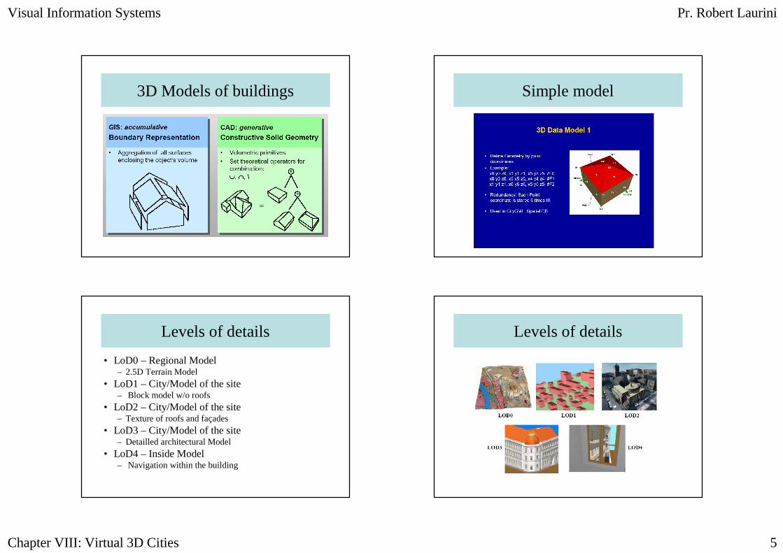
3D Models of buildings Simple model
Levels of details
• LoD0 – Regional Model – 2.5D Terrain Model
• LoD1 – City/Model of the site– Block model w/o roofs
• LoD2 – City/Model of the site– Texture of roofs and façades
• LoD3 – City/Model of the site– Detailled architectural Model
• LoD4 – Inside Model– Navigation within the building
Levels of details
Visual Information Systems Pr. Robert Laurini
Chapter VIII: Virtual 3D Cities 6
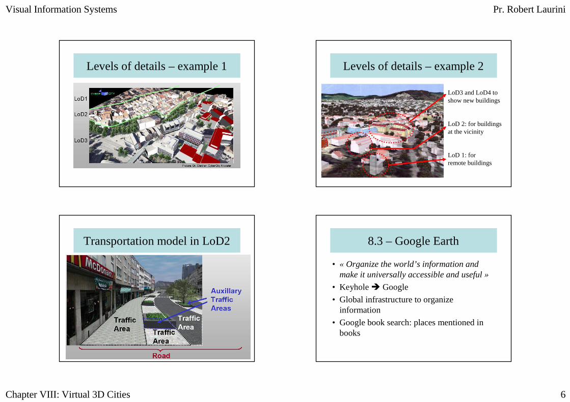
Levels of details – example 1 Levels of details – example 2
LoD3 and LoD4 toshow new buildings
LoD 2: for buildings at the vicinity
LoD 1: forremote buildings
Transportation model in LoD2 8.3 – Google Earth
• « Organize the world’s information and make it universally accessible and useful »
• Keyhole � Google
• Global infrastructure to organize information
• Google book search: places mentioned in books

Visual Information Systems Pr. Robert Laurini
Chapter VIII: Virtual 3D Cities 7
Google Maps/Earth
• http://maps.google.com/help/maps/streetview/index.html
• http://www.youtube.com/watch?v=MGfozDZDSI8
• http://www.youtube.com/watch?v=fHkXYaRP0ls
• http://video.google.com/videoplay?docid=-3097896187368461444&q=%22google+earth%22&total=11996&start=0&num=10&so=0&type=search&plindex=3
8.3 – Microsoft’s Virtual Earth
• « Mind-expanding »• Vexcel� Microsoft
• Global infrastructur for geo-referenced applications
• Orthorectified aerial photos (pixel = 15cm)• Bird’s eye• Buildings with textures• Augmented reality
Microsoft
• Virtual Earth:– http://maps.live.com/
– http://www.metacafe.com/fplayer/496241/flying_in_virtual_earth.swf
– http://www.metacafe.com/watch/511066/boston_virtual_real_estate_viewing/
• Demo– http://imagine-
windowslive.com/minisites/livemaps/default.aspx

Visual Information Systems Pr. Robert Laurini
Chapter VIII: Virtual 3D Cities 8
Baltimore
Comparison
• http://www.metacafe.com/watch/496217/google_and_virtual_earth_city_by_city/
Seattle (Virtual Earth)

Visual Information Systems Pr. Robert Laurini
Chapter VIII: Virtual 3D Cities 9
Seattle (Google Earth) 8.4 – Conclusions
• Importance of 3D visualization
• Existing 3D applications
• CityGML
• Use of photogrammetry
• Quest for realism
That’s all Folks!!


