

1
Adaptation Planning for the Coastal Sector
Rosa T. Perez, Ph. D. / PhilippinesAsian Regional Workshop on Adaptation
Beijing, 11 – 14 April 2007

2
Outline of Presentation• Introduction• Adaptation• Assessment tools for the Coastal
Sector• Adaptation- Philippine Case: Flood
Hazard Preparedness and Early Warning
• Conclusion

3
Climate Influences Key Processes in Coastal Regions
• Sea level• Precipitation patterns and
associated effects on freshwater, nutrient, and sediment flow
• Ocean temperature• Circulation patterns• Frequency, track and intensity
of coastal storms• Levels of atmospheric CO2
and ocean acidification
4
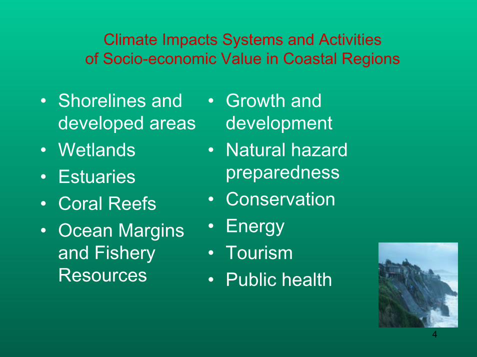
Climate Impacts Systems and Activitiesof Socio-economic Value in Coastal Regions
• Shorelines and developed areas
• Wetlands• Estuaries• Coral Reefs• Ocean Margins
and Fishery Resources
• Growth and development
• Natural hazard preparedness
• Conservation• Energy• Tourism• Public health

5
Why Adapt ?
If we were to stabilize theconcentrations of all GHG and aerosols at present levels…..
The rise in global mean temperature following the stabilization of greenhouse gas concentrations at present day level
Even if we would succeed in stabilizing GHG atmospheric concentration at present levels, adaptation is needed.

6
Adaptation: What is that?
• Process to reduce adverse effects and to take advantage of the opportunities (Burton, 1992)
• Adjustments to enhance the viability of social and economic activities and to reduce vulnerability to CCVE (Smit, 1993)
• Any adjustment, whether passive, reactive or anticipatory proposed to ameliorate the anticipated adverse consequences associated with climate change (Stakhiv, 1993)

7
Characterizing Adaptation (1)
Short term <====> Long termTactical <======> StrategicInstantaneous <=> CumulativeContingency < ==>Routine
Temporal Scope
Anticipatory <===> ResponsiveProactive <=====> ReactiveEx ante <======> Ex post
Timing
Autonomous <==> PlannedSpontaneous <==> PurposefulAutomatic <====> IntentionalNatural <======> PolicyPassive <=====> Active / Strategic
Purposefulness
Examples of Terms UsedGeneral Contributing Concepts or Attributes

8
Characterizing Adaptation (2)
Local experiences Donor / Demand -driven options
Available experts Others
Level of Knowledge
Cost Effectiveness Efficiency Implementability Equity
Performance
Structural Legal Institutional Financial Technological
Forms
Retreat Accommodate ProtectPrevent Tolerate Spread
Change Restore
Functions/Effects
Localized <===> WidespreadSpatial Scope
Examples of Terms UsedGeneral Contributing Concepts or Attributes

9
Assessment Tools in Coastal Sector
• IPCC Common Methodology• UNEP Handbook Methodology• Decision Support Models: COSMO (COastal
zone Simulation MOdel)• The South Pacific Island Methodology (SPIM)• RamCo and ISLAND MODEL• Dynamic Interactive Vulnerability Assessment
(DIVA)• Shoreline Management Planning (SMP)
Compendium on methods and tools to evaluate impacts of, vulnerability and adaptation to climate change (UNFCCC,2004)

10
Adaptation in the coastal sector: Flood hazard preparedness
Philippine Case Study: Community-Based Flood Early Warning System
(CBFEWS)

11
Exposure and SensitivityPast Flood Damage(1970- 2002)
-
1,000
2,000
3,000
4,000
5,000
6,000
1970
1971
1972
1973
1974
1975
1976
1977
1978
1979
1980
1981
1982
1983
1984
1985
1986
1987
1988
1989
1990
1991
1992
1993
1994
1995
1996
1997
1998
1999
2000
2001
2002
year
pers
on
s
0
5,000
10,000
15,000
20,000
25,000
30,000
Mpe
sos
DEAD DEADAVERAGE
PROPERTIES(INFRASTRUCTURE,AGRICULTURE AND PRIVATE PROP)
PROPERTIES(INFRASTRUCTURE,AGRICULTURE AND PRIVATE PROP)AVERAGE
• Tropical cyclones
• ITCZ• Southwest
monsoon
• NE monsoon• Thunderstorms• Easterly waves
• Cold front

12
Operational Hydrological Service(PAGASA Flood Forecasting Branch)

13
Community-Based Flood Early Warning Systems (CBFEWS)

14
CBFEWS
• A people-oriented non-structural flood mitigation measure/ flood disaster management program at the municipal –barangay (village) level
• Empower individuals and communities threatened by hazards to act in sufficient timeand in an appropriate manner so as to reduce the possibility of personal injury, loss of life, damage to property and environment, and loss of livelihood
15
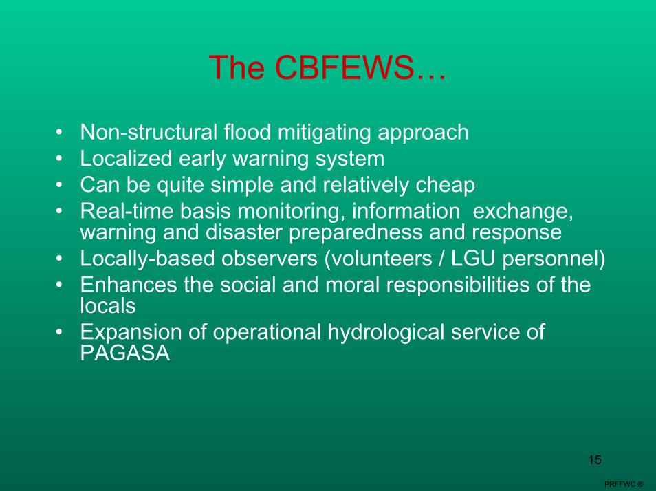
The CBFEWS…
• Non-structural flood mitigating approach• Localized early warning system• Can be quite simple and relatively cheap• Real-time basis monitoring, information exchange,
warning and disaster preparedness and response• Locally-based observers (volunteers / LGU personnel)• Enhances the social and moral responsibilities of the
locals• Expansion of operational hydrological service of
PAGASA
PRFFWC ®

16
Pampanga river basin (Pampanga, Nueva Ecija and Bulacan)
Agno river basin (Beguet, Pangasinan & Tarlac)
Surigao del Sur
Zamboanga del Sibuguey
Phase 1 (UNDP)
Antique
Cagayan river basin(Cagayan, Isabela and Nueva Viscaya)
Surigao del NorteTelemetered
Phase 2 (UNDP)
Bicol river basin (Camarines Sur, Camarines Norte & small part of Albay)
Leyte Island (Leyte & So Leyte)
N & E Samar
Nueva Viscaya
Aurora
Bohol
Abra river basin (Abra & Ilocos Sur)
Areas of CBFEWS

17
Challenges to CBFWS
• Deciding to do a CBFEWS
• Operation and maintenance of EWS
• Communication and dissemination

18
CBFFWS: Activities1. Coordination with LGUs and concerned
agencies2. Conduct survey of sites (including
evacuation sites, storm surge shelter)3. Fabrication and installation of monitoring
facilities (rainfall and water level)4. Signing of MOA / training of observers
(LGUs, volunteers)5. Approval of a local ordinance for the
maintenance of CBFFWS 6. Implementation / testing / dry run / drill7. Information, education and communications8. Calibration / updating (after each event,
Cut out pattern made of cardboard Cut out pattern made of cardboard
resetting of threshold, if needed)

19
Signing of MOA
Consultation with LGUs
OJT on Rainfall Observation
Installation of waterlevel gauge
Site surveyInstallation of rain gaugeTraining of observers

20
Monitoring Rain and Water Level
Rain gauges
Staff gauges
Flood Marker
What time…? Start of floodingPeakSubsiding of flood

21
•Flood hazard mapping
•Flood vulnerability mapping
Mapping

22
Legislative Support (Dumangas, Iloilo)
Ordinance No. 2005-01 entitled: “AN ORDINANCE PROVIDING AN ANNUAL APPROPRIATION FOR THE MAINTENANCE AND OTHER OPERATIONAL EXPENSES OF THE COMMUNITY-BASED FLOOD AND DROUGHT FORECASTING AND WARNING SYSTEM IN DUMANGAS”

23
Communications
◄◄
PDCC RDCCFlood info
WarningPhase1 - READYREADY2 - Get SET3 - GO
Wea
ther
Upd
ate
/ Inf
o
Dat
a / F
lood
A
dvis
ory
/W
arni
ng
Target Community
Disaster Operation Center
(DOC)Municipal Hall
Communication of Warning1 - MDCC2 – BDCC3 – Local
Volunteers
Weather Update / Info
BatingawSitio/PurokLeadersWater Level
Observers
PAGASA- Field Station
RR Observers
Flood Advisory
Data/Rainfall
ObservationWeatherUpdate/Info
Weather
Update/Info
BandilloMegaphone w/sirenChurch Bells
River Observation1 – Color2 – Speed of Flow3- Sound4 – Presence of
Debris
Data/Rainfall
Observation
Legend: ◄ Information starts here in case of large-scalesystem (Ex. typhoon and monsoon).
Information starts here in case of local/ small-scale system (Ex. Thunderstorm and ITCZ).
◄◄
◄◄◄
Evacuation Center
◄◄
PDCC RDCCFlood info
WarningPhase1 - READYREADY2 - Get SET3 - GO
Wea
ther
Upd
ate
/ Inf
o
Dat
a / F
lood
A
dvis
ory
/W
arni
ng
Target Community
Disaster Operation Center
(DOC)Municipal Hall
Communication of Warning1 - MDCC2 – BDCC3 – Local
Volunteers
Weather Update / Info
BatingawSitio/PurokLeadersWater Level
Observers
PAGASA- Field Station
RR Observers
Flood Advisory
Data/Rainfall
ObservationWeatherUpdate/Info
Weather
Update/Info
BandilloMegaphone w/sirenChurch Bells
River Observation1 – Color2 – Speed of Flow3- Sound4 – Presence of
Debris
Data/Rainfall
Observation
Legend: ◄ Information starts here in case of large-scalesystem (Ex. typhoon and monsoon).
Information starts here in case of local/ small-scale system (Ex. Thunderstorm and ITCZ).
◄◄
Legend: ◄ Information starts here in case of large-scalesystem (Ex. typhoon and monsoon).
Information starts here in case of local/ small-scale system (Ex. Thunderstorm and ITCZ).
◄◄
◄◄◄
Evacuation Center
24
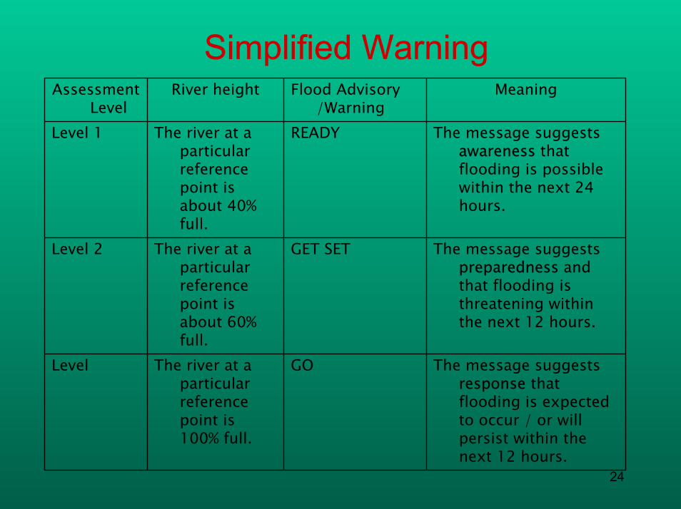
Simplified Warning
The message suggests response that flooding is expected to occur / or will persist within the next 12 hours.
GOThe river at a particular reference point is 100% full.
Level
The message suggests preparedness andthat flooding is threatening within the next 12 hours.
GET SETThe river at a particular reference point is about 60% full.
Level 2
The message suggests awareness that flooding is possible within the next 24 hours.
READYThe river at a particular reference point is about 40% full.
Level 1
MeaningFlood Advisory /Warning
River heightAssessment Level

25
Conclusions: Some lessons learned in CBFEWS
• Genuine grass roots demand • Technical knowledge merge with
indigenous knowledge in a socio-culturally appropriate manner
• Sustained investment (both time and financial) of all stakeholders at multiple levels before, during and upon completion of the project cycle
26
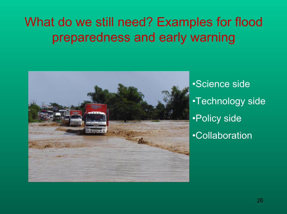
What do we still need? Examples for flood preparedness and early warning
•Science side
•Technology side
•Policy side
•Collaboration

27
What do we need? Science side
• Reduce uncertainty in climate modeling• Develop a dynamic approach using coupled
atmospheric and hydrologic models to improve understanding of processes (Kingston 2006)
• Develop new methods to evaluate social and economic impacts
• Quantify potential damages as a result of changing climate regimes and sea level using spatially-explicit GIS-based models

28
Implications of climate change for the hydrological cycle Adapted from Handley 2004
Reservoirs Surface
Inter-basin transfer
Through flowInfiltration
EvapotranspirationPrecipitation
Surface ru
noffSurface runoff
BMPsHomes & factories
Sewage works Ground
Waste water treatment Leakage
Abstraction Percolation
Groundwater flow
River outfallsMarine outfalls
Est
uarie
s
Oce
ans
Soils Rivers
Spring Increase Spring DecreaseSummer Increase Summer Decrease

29
What do we need? Technology side
• Living with floods (floating homes)• Others

30
What do we need? Policy side
• Implement proactive flood management strategies as oppose to flood control
• Introduce a river basin approach (up <==>down)
• Integrate flood management into land use planning
• Make space for water

31
What do we need? Collaboration
• Better communication between scientific community and various stakeholders
• Regional collaboration – using a common flood management protoco
• Flood adaptation technologies• Implement an action plan

32

33


