

AKEF for DirectGeo-Referencing of a
TLS-based MSS
Jens-Andre Paffenholz,Hamza Alkhatib,
Hansjorg Kutterer
Concept and Strategy
AEKF
Summary and futurework
Adaptive Extended Kalman Filter forGeo-Referencing of a TLS-based
Multi-Sensor-SystemTS 3D - Model Building and Data Analysis, Tuesday, 13 April 2010
Jens-Andre Paffenholz Hamza Alkhatib Hansjorg Kutterer
Geodetic InstituteLeibniz Universitat Hannover
XXIV FIG International CongressFacing the Challenges - Building the Capacity
Sydney, Australia 11-16 April, 2010
1 / 15
AKEF for DirectGeo-Referencing of a
TLS-based MSS
Jens-Andre Paffenholz,Hamza Alkhatib,
Hansjorg Kutterer
Concept and Strategy
AEKF
Summary and futurework
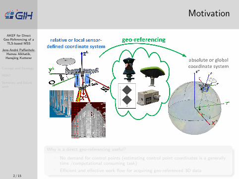
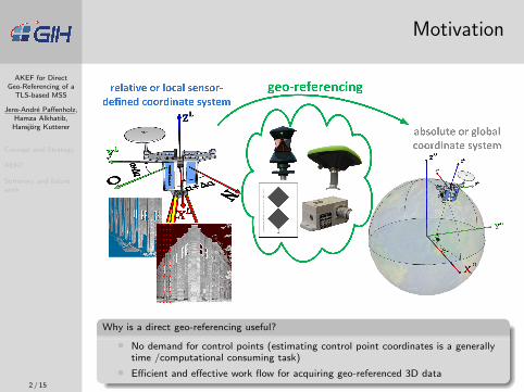
Motivation
Why is a direct geo-referencing useful?
• No demand for control points (estimating control point coordinates is a generallytime /computational consuming task)
• Efficient and effective work flow for acquiring geo-referenced 3D data2 / 15
AKEF for DirectGeo-Referencing of a
TLS-based MSS
Jens-Andre Paffenholz,Hamza Alkhatib,
Hansjorg Kutterer
Concept and Strategy
AEKF
Summary and futurework
Motivation
Why is a direct geo-referencing useful?
• No demand for control points (estimating control point coordinates is a generallytime /computational consuming task)
• Efficient and effective work flow for acquiring geo-referenced 3D data2 / 15

AKEF for DirectGeo-Referencing of a
TLS-based MSS
Jens-Andre Paffenholz,Hamza Alkhatib,
Hansjorg Kutterer
Concept and Strategy
AEKF
Summary and futurework
Outline
1 Concept and strategy for the direct geo-referencing of static 3Dlaser scans
Observation concept for the transformation elementsTLS-based MSS @GIHPresent strategy for the direct geo-referencing procedure
2 Adaptive extended Kalman filter approach for directgeo-referencing purposes
Present filter setup: state vector and equation of motionGNSS tracking resultsComparison of tracking approaches
3 Summary and future work
3 / 15
AKEF for DirectGeo-Referencing of a
TLS-based MSS
Jens-Andre Paffenholz,Hamza Alkhatib,
Hansjorg Kutterer
Concept and Strategy
Concept
TLS-based MSS @GIH
Strategy
AEKF
Summary and futurework
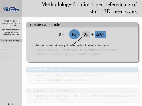
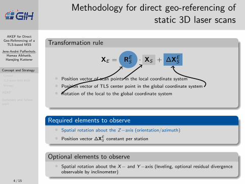
Methodology for direct geo-referencing ofstatic 3D laser scans
Transformation rule
XE = RES · XS + ∆XE
S
• Position vector of scan points in the local coordinate system
• Position vector of TLS center point in the global coordinate system
• Rotation of the local to the global coordinate system
Required elements to observe
• Spatial rotation about the Z−axis (orientation/azimuth)
• Position vector ∆XES constant per station
Optional elements to observe
• Spatial rotation about the X− and Y−axis (leveling, optional residual divergenceobservable by inclinometer)
4 / 15

AKEF for DirectGeo-Referencing of a
TLS-based MSS
Jens-Andre Paffenholz,Hamza Alkhatib,
Hansjorg Kutterer
Concept and Strategy
Concept
TLS-based MSS @GIH
Strategy
AEKF
Summary and futurework
Methodology for direct geo-referencing ofstatic 3D laser scans
Transformation rule
XE = RES · XS + ∆XE
S
• Position vector of scan points in the local coordinate system
• Position vector of TLS center point in the global coordinate system
• Rotation of the local to the global coordinate system
Required elements to observe
• Spatial rotation about the Z−axis (orientation/azimuth)
• Position vector ∆XES constant per station
Optional elements to observe
• Spatial rotation about the X− and Y−axis (leveling, optional residual divergenceobservable by inclinometer)
4 / 15

AKEF for DirectGeo-Referencing of a
TLS-based MSS
Jens-Andre Paffenholz,Hamza Alkhatib,
Hansjorg Kutterer
Concept and Strategy
Concept
TLS-based MSS @GIH
Strategy
AEKF
Summary and futurework
Observation concept for the transformationelements
Terrestrial laser scanner(TLS) with integratedgeo-referencing
• Using only a minimum numberof additional sensors with anadequate data rate
• Estimating the laser scannerposition and orientation directly
• Undisturbed operation of thelaser scanner
• Using the vertical axis rotationof the laser scanner as timereference
• Working without geo-referencedcontrol points
Commercial products
5 / 15

AKEF for DirectGeo-Referencing of a
TLS-based MSS
Jens-Andre Paffenholz,Hamza Alkhatib,
Hansjorg Kutterer
Concept and Strategy
Concept
TLS-based MSS @GIH
Strategy
AEKF
Summary and futurework
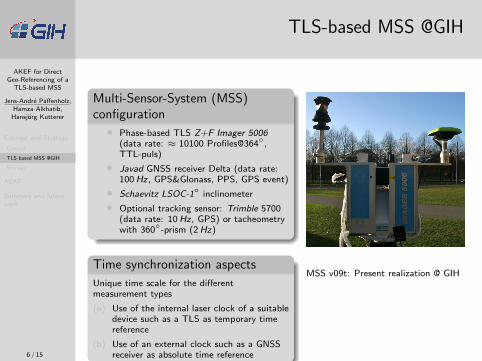
TLS-based MSS @GIH
Multi-Sensor-System (MSS)configuration
• Phase-based TLS Z+F Imager 5006(data rate: ≈ 10100 Profiles@364◦,TTL-puls)
• Javad GNSS receiver Delta (data rate:100 Hz, GPS&Glonass, PPS, GPS event)
• Schaevitz LSOC-1◦ inclinometer
• Optional tracking sensor: Trimble 5700(data rate: 10 Hz, GPS) or tacheometrywith 360◦-prism (2 Hz)
Time synchronization aspects
Unique time scale for the differentmeasurement types
(a) Use of the internal laser clock of a suitabledevice such as a TLS as temporary timereference
(b) Use of an external clock such as a GNSSreceiver as absolute time reference
MSS v09t: Present realization @ GIH
6 / 15
AKEF for DirectGeo-Referencing of a
TLS-based MSS
Jens-Andre Paffenholz,Hamza Alkhatib,
Hansjorg Kutterer
Concept and Strategy
Concept
TLS-based MSS @GIH
Strategy
AEKF
Summary and futurework
TLS-based MSS @GIH
Multi-Sensor-System (MSS)configuration
• Phase-based TLS Z+F Imager 5006(data rate: ≈ 10100 Profiles@364◦,TTL-puls)
• Javad GNSS receiver Delta (data rate:100 Hz, GPS&Glonass, PPS, GPS event)
• Schaevitz LSOC-1◦ inclinometer
• Optional tracking sensor: Trimble 5700(data rate: 10 Hz, GPS) or tacheometrywith 360◦-prism (2 Hz)
Time synchronization aspects
Unique time scale for the differentmeasurement types
(a) Use of the internal laser clock of a suitabledevice such as a TLS as temporary timereference
(b) Use of an external clock such as a GNSSreceiver as absolute time reference
MSS v09t: Present realization @ GIH
6 / 15
AKEF for DirectGeo-Referencing of a
TLS-based MSS
Jens-Andre Paffenholz,Hamza Alkhatib,
Hansjorg Kutterer
Concept and Strategy
Concept
TLS-based MSS @GIH
Strategy
AEKF
Summary and futurework
Present strategy for the direct geo-referencingprocedure
1 Data acquisitionIndividual data pre-processing for each sensor type of theMSS
• 3D laser scan• Inclinometer measurements• GNSS data processing
2 Data synchronizationIntroduction of GPS time as unique time reference in the MSS
3 Data fusionInterpolation of measured data for each scan profile
4 Adaptive extended Kalman filteringEstimation of transformation parameters for the MSS
5 Result visualization and applying the transformationparameters to the scan dataNext step in the ongoing work:
=⇒ Transformation of at least two different laser scanner stationsfrom the same scene
7 / 15

AKEF for DirectGeo-Referencing of a
TLS-based MSS
Jens-Andre Paffenholz,Hamza Alkhatib,
Hansjorg Kutterer
Concept and Strategy
AEKF
Filter setup
GNSS tracking results
Comparison of trackingapproaches
Summary and futurework
Overview Kalman filter
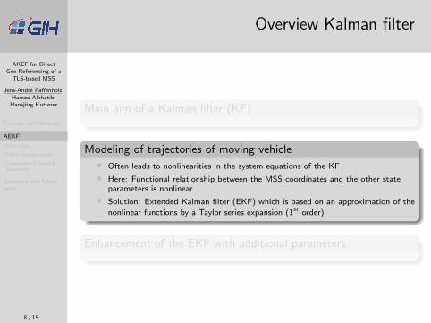
Main aim of a Kalman filter (KF)
• Optimal combination of a given physical information for a system and externalobservations of its state
• State estimation only optimal in case of linear state space systems
Modeling of trajectories of moving vehicle
Enhancement of the EKF with additional parameters
8 / 15
AKEF for DirectGeo-Referencing of a
TLS-based MSS
Jens-Andre Paffenholz,Hamza Alkhatib,
Hansjorg Kutterer
Concept and Strategy
AEKF
Filter setup
GNSS tracking results
Comparison of trackingapproaches
Summary and futurework
Overview Kalman filter
Main aim of a Kalman filter (KF)
Modeling of trajectories of moving vehicle
• Often leads to nonlinearities in the system equations of the KF
• Here: Functional relationship between the MSS coordinates and the other stateparameters is nonlinear
• Solution: Extended Kalman filter (EKF) which is based on an approximation of the
nonlinear functions by a Taylor series expansion (1st order)
Enhancement of the EKF with additional parameters
8 / 15
AKEF for DirectGeo-Referencing of a
TLS-based MSS
Jens-Andre Paffenholz,Hamza Alkhatib,
Hansjorg Kutterer
Concept and Strategy
AEKF
Filter setup
GNSS tracking results
Comparison of trackingapproaches
Summary and futurework
Overview Kalman filter
Main aim of a Kalman filter (KF)
Modeling of trajectories of moving vehicle
Enhancement of the EKF with additional parameters
• Additional parameters are time invariant, system specific parameters with wellknown initial values
• Why?
• Improvement of the filtering by adaption of the dynamic model
• Brings the model closer to reality
=⇒ EKF with adaptive parameters (AEKF); also well known as dual estimation
8 / 15

AKEF for DirectGeo-Referencing of a
TLS-based MSS
Jens-Andre Paffenholz,Hamza Alkhatib,
Hansjorg Kutterer
Concept and Strategy
AEKF
Filter setup
GNSS tracking results
Comparison of trackingapproaches
Summary and futurework
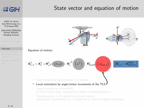
State vector and equation of motion
State vector: Xk =[
XGk α
LScan,k β
LScan,k γ
LScan,k rk ϕk sltd,k
]T
Equation of motion:
XGk+1 = XG
k + RGαG (λ,ϕ) · Rα
G
L
(α
G)· RL
ScanN
(α
LScan,k
)·[XL
k+1 − XGNSSScanN,k
]
• Disoriented local step between two epochs
• Local orientation by angle/motor increments of the TLS
• Global orientation of the MSS(a priori initial value computed by means of global positions)
• Transformation to the global coordinate system(geographic coordinates (λ,ϕ) computed by means of global positions)
9 / 15

AKEF for DirectGeo-Referencing of a
TLS-based MSS
Jens-Andre Paffenholz,Hamza Alkhatib,
Hansjorg Kutterer
Concept and Strategy
AEKF
Filter setup
GNSS tracking results
Comparison of trackingapproaches
Summary and futurework
State vector and equation of motion
Equation of motion:
XGk+1 = XG
k + RGαG (λ,ϕ) · Rα
G
L
(α
G)· RL
ScanN
(α
LScan,k
)·[XL
k+1 − XGNSSScanN,k
]
• Disoriented local step between two epochs
• Local orientation by angle/motor increments of the TLS
• Global orientation of the MSS(a priori initial value computed by means of global positions)
• Transformation to the global coordinate system(geographic coordinates (λ,ϕ) computed by means of global positions)
9 / 15
AKEF for DirectGeo-Referencing of a
TLS-based MSS
Jens-Andre Paffenholz,Hamza Alkhatib,
Hansjorg Kutterer
Concept and Strategy
AEKF
Filter setup
GNSS tracking results
Comparison of trackingapproaches
Summary and futurework
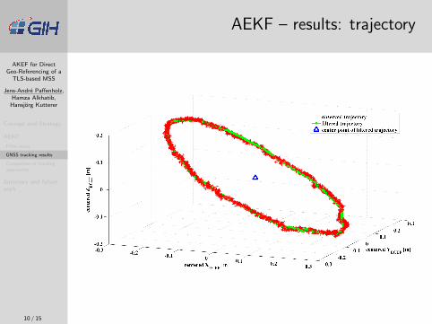
AEKF – results: trajectory
10 / 15
AKEF for DirectGeo-Referencing of a
TLS-based MSS
Jens-Andre Paffenholz,Hamza Alkhatib,
Hansjorg Kutterer
Concept and Strategy
AEKF
Filter setup
GNSS tracking results
Comparison of trackingapproaches
Summary and futurework
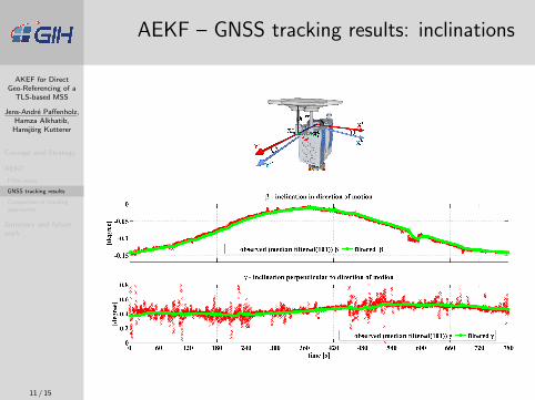
AEKF – GNSS tracking results: inclinations
11 / 15

AKEF for DirectGeo-Referencing of a
TLS-based MSS
Jens-Andre Paffenholz,Hamza Alkhatib,
Hansjorg Kutterer
Concept and Strategy
AEKF
Filter setup
GNSS tracking results
Comparison of trackingapproaches
Summary and futurework
AEKF – GNSS tracking results: azimuth
Determination of the final global azimuth
• Calculation of geodetic azimuth (αGk ) for each epoch k ∈ {1 . . . n} between
filtered trajectory and calculated center point =⇒ αG =
1
n
n∑k=1
(α
Gk
)• Metric uncertainty of ≈ 1 cm for the global azimuth calculation @35 m
12 / 15
AKEF for DirectGeo-Referencing of a
TLS-based MSS
Jens-Andre Paffenholz,Hamza Alkhatib,
Hansjorg Kutterer
Concept and Strategy
AEKF
Filter setup
GNSS tracking results
Comparison of trackingapproaches
Summary and futurework
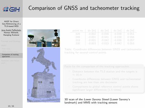
Comparison of GNSS and tacheometer tracking
point no dx [m] dy [m] dz [m] ds [m]328 -0.002 -0.034 -0.038 0.051348 -0.001 -0.041 -0.038 0.056318 -0.001 -0.042 -0.038 0.057330 -0.003 -0.033 0.042 0.053
Table: Coordinate differences between GNSS and tacheometertracking for several control points
Facts for the comparison of the tracking approaches
• Distance between the TLS station and the targets is≈ 16 m
• Coordinate differences between GNSS and tacheometertracking are less than one decimeter
• Comparisons to global reference control points showssignificant larger differences (1.5 times)
3D scan of the Lower Saxony Steed (Lower Saxony’slandmark) and MMS with tracking sensors
13 / 15

AKEF for DirectGeo-Referencing of a
TLS-based MSS
Jens-Andre Paffenholz,Hamza Alkhatib,
Hansjorg Kutterer
Concept and Strategy
AEKF
Filter setup
GNSS tracking results
Comparison of trackingapproaches
Summary and futurework
Comparison of GNSS and tacheometer tracking
point no dx [m] dy [m] dz [m] ds [m]328 -0.002 -0.034 -0.038 0.051348 -0.001 -0.041 -0.038 0.056318 -0.001 -0.042 -0.038 0.057330 -0.003 -0.033 0.042 0.053
Table: Coordinate differences between GNSS and tacheometertracking for several control points
Facts for the comparison of the tracking approaches
• Distance between the TLS station and the targets is≈ 16 m
• Coordinate differences between GNSS and tacheometertracking are less than one decimeter
• Comparisons to global reference control points showssignificant larger differences (1.5 times)
3D scan of the Lower Saxony Steed (Lower Saxony’slandmark) and MMS with tracking sensors
13 / 15
AKEF for DirectGeo-Referencing of a
TLS-based MSS
Jens-Andre Paffenholz,Hamza Alkhatib,
Hansjorg Kutterer
Concept and Strategy
AEKF
Summary and futurework
Summary and future work
Summary
• Direct geo-referencing method for static terrestrial 3D laser scans
• Transformation parameters estimation by an AEKF approach
Future work• Tailored data aggregation step to smooth high frequency trajectory positions to the
TLS data rate
• Improvement of the prediction method for lower position data acquisition rates(collocation)
• Improvement of the stochastic model to gain better understanding of the processnoise (=⇒ variance component estimation)
14 / 15

AKEF for DirectGeo-Referencing of a
TLS-based MSS
Jens-Andre Paffenholz,Hamza Alkhatib,
Hansjorg Kutterer
Concept and Strategy
AEKF
Summary and futurework
Contact
Thank you for your attention!
Dipl.-Ing. Jens-Andre PaffenholzDr.-Ing. Hamza AlkhatibProf. Dr.-Ing. Hansjorg KuttererEngineering Geodesy and Geodetic Data AnalysisGeodetic InstituteLeibniz Universitat HannoverNienburger Str. 1, 30167 HannoverGERMANY
[email protected]@[email protected]
www.gih.uni-hannover.de
15 / 15


