

TARMAC LTD Killerby Sand and Gravel Quarry, Killerby, North Yorkshire
1
Appendix 7.3
Killerby Prospect Fieldwalking Evaluation
Archaeological Research Services Ltd Dr Clive Waddington, Jim Brightman and Jessika Shakarian
TARMAC LTD Killerby Sand and Gravel Quarry, Killerby, North Yorkshire
2
Killerby Prospect Fieldwalking Evaluation Introduction 7.3.1 This report presents the results of a fieldwalking study of the Killerby Prospect at the request of Tarmac Northern. It forms part of a suite of evaluation studies aimed at establishing the potential impact of the proposed development on the historic environment. Phase 1 of the archaeological work comprised an in‐depth desk‐based assessment and the evaluation works form Phase 2. No fieldwalking had been undertaken in the area of the proposed development or its hinterland before and so the results reported here add considerably to the archaeological data available for this part of North Yorkshire. The methodology follows that set out in the Scheme of Evaluation (Appendix 7.2). Once the finds were washed, dried and placed in individual labeled bags the entire assemblage was analysed and catalogued by a finds specialist (Clive Waddington) with the results input into a spreadsheet. The spreadsheet contains 2234 records with the following data recorded: find number, field, material, colour, provenance, type (general), type (specific), place in the core reduction sequence (for lithics), period, length (mm), width (mm) and depth (mm) and a column for additional notes. The spreadsheet is available to consult as part of the archive. 7.3.2 The fieldwalking component of the evaluation work was undertaken in order to acquire information on the likely location of any buried remains as well as to obtain a record of the archaeology that survives within the ploughzone in the form of artefact scatters. The spatial data for each find discovered has been input into a geographical information system (GIS) and this has provided an opportunity to link archaeological results with specific geomorphological landforms that have been mapped as part of the Phase 1 Assessment, as well as the field within which they were found. 7.3.3 The fieldwalking results are concerned primarily with chipped stone (lithics) artefact scatters as these form by far the vast majority of the finds. Out of a total 2234 surface finds 2015 (90.2%) are lithics, 131 are pottery sherds (5.9%), 16 are pieces of tile, 59 are clay pipe fragments (2.6%) together with a coarse stone (sandstone) rubbing stone, piece of slag, a silver medieval penny from the reign of Edward I, one metal washer and 8 fragments of oyster shell which could potentially indicate an old Postglacial lake level collected from Field 11. All the pottery consisted of small sherds, most of which were body and rim sherds with only the occasional fragment of base and handle. 7.3.4 The ceramic finds all date from the Roman period or later. There are a few possible sherds of Roman ceramic from Fields 1, 2 and 3 although the material is small and very abraded and this attribution is not certain in all cases. It is worth noting that Fields 1, 2 and 3 all lie on the west side of the development area closest
TARMAC LTD Killerby Sand and Gravel Quarry, Killerby, North Yorkshire
3
to the line of the Roman Road Dere Street (now the A1 trunk road) and all but on to the lane known as Low Street. This is perhaps significant as the name ‘Street’ is a toponym of Roman origin. There is therefore a hint that some Roman occupation may have occurred on the areas of flat ground in the western margins of the Phase 1 and Phase 2 areas. Most of the ceramics are, however, medieval and post‐medieval in date and could result from manuring and/or the disposal of refuse around farming settlements. The largest quantity of ceramics, mostly medieval and post‐medieval in date, was recovered from Field 7 which forms part of the flood plain of the river Swale. As this ground would have been perennially flooded and wet, broken ceramics may have been intentionally added to the soil to assist with drainage and breaking the soil up. This would allow this ground to either be sown as water meadow or be brought into cultivation, presumably during medieval and post‐medieval times.
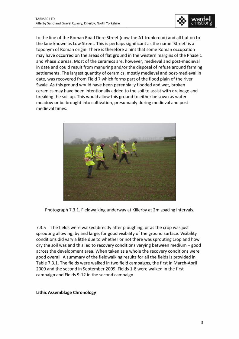
Photograph 7.3.1. Fieldwalking underway at Killerby at 2m spacing intervals. 7.3.5 The fields were walked directly after ploughing, or as the crop was just sprouting allowing, by and large, for good visibility of the ground surface. Visibility conditions did vary a little due to whether or not there was sprouting crop and how dry the soil was and this led to recovery conditions varying between medium – good across the development area. When taken as a whole the recovery conditions were good overall. A summary of the fieldwalking results for all the fields is provided in Table 7.3.1. The fields were walked in two field campaigns, the first in March‐April 2009 and the second in September 2009. Fields 1‐8 were walked in the first campaign and Fields 9‐12 in the second campaign. Lithic Assemblage Chronology
TARMAC LTD Killerby Sand and Gravel Quarry, Killerby, North Yorkshire
4
7.3.6 Surface lithic scatter assemblages are typically characterised by their lack of dating control with usually only a small fraction of the material collected being chronologically diagnostic. Furthermore, this lack of temporal integrity is compounded by diagnostic lithics being only datable to very broad time periods which usually span several millennia rather than just a few centuries. Therefore, although a high proportion of the artefacts are diagnostic, they were only able to be ascribed to periods such as ‘Mesolithic’ or ‘Neolithic’ and this means the chronology of the lithic scatter assemblage remains coarse‐grained. The type of patterning that is represented by fieldwalking data is frequently the sum of past human behaviour over a long period rather than simply the reflection of a short‐lived event or occupation, although occasionally discrete assemblages do occur. However, such discrete assemblages can only usually be confirmed by recourse to excavation. Most fieldwalking assemblages tend to be an accumulation of material formed over a sustained period as a result of multiple human activities over time. In this sense fieldwalking assemblages often represent a form of archaeological palimpsest providing a view of, often, repetitious human behaviour over the longue durée. However, because there are generally few datable artefacts, and those that can be dated are only specific to a broad period, the archaeological palimpsest can only be divided up into very broad time slices. This has important consequences as it predicates, to some extent, the sort of questions that can be asked of the data and the sort of inferences that can be reasonably made. Therefore, questions which require detailed chronological information are often unable to be satisfactorily answered. This means that for the most part the sort of information that can be gained from surface lithic assemblages is pitched at the scale of long‐term history rather than that of short term events. Accordingly it is the broad patterns produced by these largely cumulative records which can provide useful and pertinent insights, particularly within the context of a landscape‐scale evaluation study. 7.3.7 Given the caveats discussed above the lithic assemblage from Killerby is remarkable in that the assemblage is almost entirely Lateglacial‐Early Holocene in date. There is a single bifacially worked arrowhead that is probably Neolithic from Field 1, two thumbnail scrapers from Fields 9 and 10 respectively that are probably Beaker period, and around half a dozen pieces of poorly chipped nodular flint flakes that could be Early Bronze Age. The rest of the material is all consistent with a Lateglacial‐Early Holocene context indicative of Late Upper Palaeolithic and, for the most part, Mesolithic populations. Given that this early material accounts for over 99% of the assemblage the fieldwalking data from this study is a little unusual in that it allows for an informed discussion of the material as a whole in relation to Lateglacial and Early Holocene human use of this area; one which was no doubt linked to the wetlands that studded this area making it an attractive locale for hunter‐gatherer groups. 7.3.8 There are some possible Late Upper Palaeolithic pieces in the assemblage as indicated by the larger size of some of the blades and their degree of patination. There are some possible ‘palaeoliths’ which can be identified on account of their
TARMAC LTD Killerby Sand and Gravel Quarry, Killerby, North Yorkshire
5
smoothing and abrasion subsequent to their being initially chipped, suggesting they have been moved within a sediment body, due to ice or water action, before being laid down within the sands and gravel deposits. This is of considerable interest as it suggests a much longer time‐depth to human occupation in the north than has previously been thought, as there are very few Late Upper Palaeolithic sites known north of the cave sites in the Yorkshire Dales. The recent discovery of an indisputable Late Upper Palaeolithic lithic scatter at Biggar in the Scottish Borders (Saville et al. 2007) supports the view that Late Upper Palaeolithic populations occupied northern Britain. As much of the worked material from Killerby is made from the locally available chert that occurs as pebbles in the fluvio‐glacial deposits, and much of the material is heavily patinated, there are few classic examples of Late Upper Palaeoltihic pieces, and so it is more difficult to be absolutely certain of a Late Glacial attribution for this material, however, the intention of producing large blade tools from the chert is consistent with a Late Upper Palaeolithic date for some of the assemblage. Some of these pieces are composite tools, but many have abrupt retouch to form end scrapers and others have oblique truncations. Furthermore, because of the constraints enforced on the knapper by the raw material itself, being generally more coarse, pebbly and harder than flint, the chipping of this material had to inevitably involve an opportunistic approach so as to make the best out of what any given pebble could offer. Consequently the chances of discovering classic Late Upper Palaeolithic type fossils is limited and we should not expect to find the textbook examples that are better known from the flint‐rich areas of England further to the south. This does not mean to say though that Late Upper Palaeolithic material is not present in the north as has often been thought to be the case. An important opportunity offered by further archaeological mitigation at Killerby is the chance to find Late Upper Palaeolithic lithic material in association with datable deposits, particularly in the case of the peat deposit in Field 14 (sediment core KB8) which has been dated to the Windermere Interstadial c. 12500 BC (see Appendix 7.6). 7.3.9 Most of the assemblage is considered to be of Mesolithic date and artefacts made from chert and flint can be identified that belong, typologically, to both the Early and Later Mesolithic. A total of 628 lithics could be characterised as Mesolithic representing 31.2% of the total assemblage. Diagnostic microliths, microburins, scrapers and cores are common throughout the assemblage showing that the Killerby area was a highly attractive locale for hunter‐gatherer groups who chipped stone to make and curate tools, used processing tools such as scrapers close to where chipping activities took place and used projectile points close to the wetland edges. 7.3.10 Two definite and one possible gun flint represent early modern pieces of flintwork and could have resulted from hunting episodes or the activities of game keepers in the 18th‐19th Centuries.
TARMAC LTD Killerby Sand and Gravel Quarry, Killerby, North Yorkshire
6
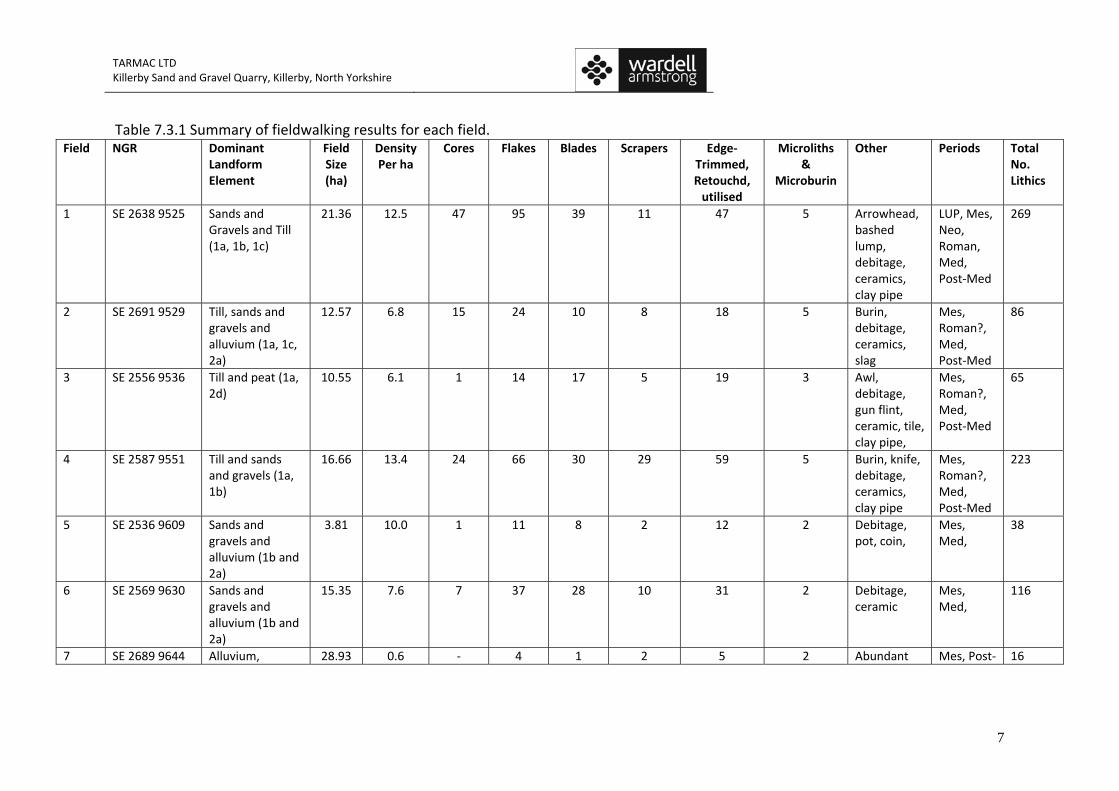
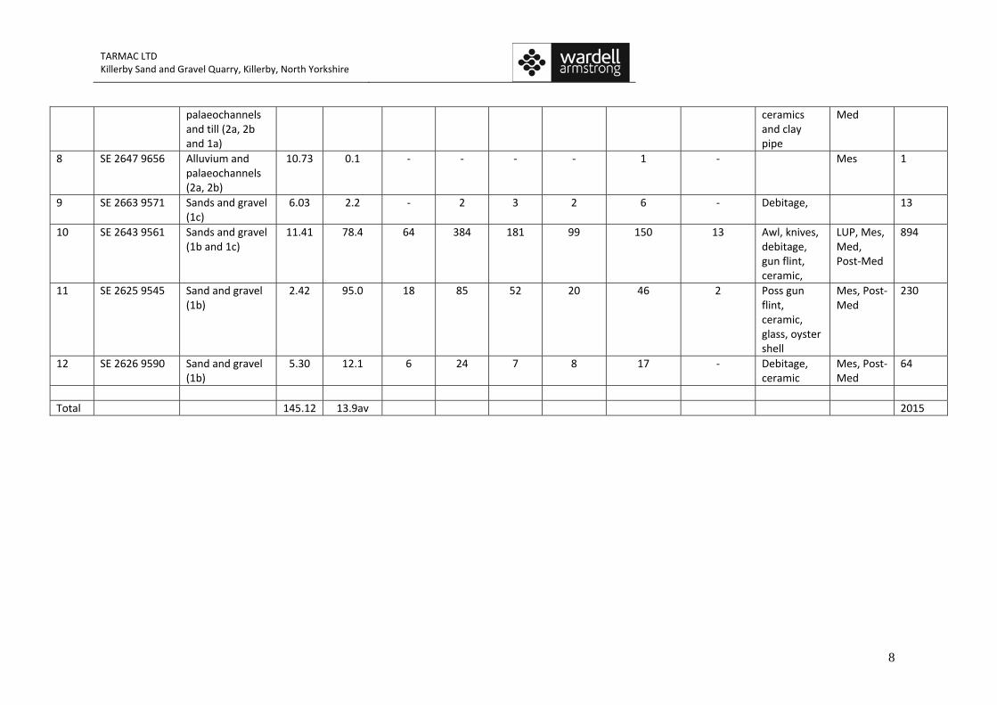
Distribution and Density 7.3.11 A total of 12 fields were walked as part of this study covering a total area of 145.12 hectares. All the fieldwalking was undertaken at 2m intervals providing 100% surface coverage on the basis that each walker observes the field surface 1m either side of themselves as they walk across the field. Table 7.3.1 below includes a density per hectare statistic for each field walked which is calculated by dividing the number of lithics recovered by the number of hectares walked. This statistic is useful as it allows surface densities from all fields within this study to be compared, as well as allowing for comparison to be made with other similar studies. When averaged overall the lithic density per hectare for the study area a whole is 13.9 per hectare which is high when compared with comparable studies that have taken place in North‐East England (see Table 7.3.2). 7.3.12 Table 7.3.1 below summarises the results for each field providing spatial information, density counts, chronological associations and a broad summary of the artefact types found, whilst Figure 7.3.1 shows the distribution of findspots across the proposed development area. The lithic densities from this study have a vast range varying from 0.1 per ha in Field 8 to a massive 95.0 per ha in Field 11 and 78.4 in Field 10. However, seven of the fields produced counts of between 6 and 14 lithics per ha, which is still relatively high in relation to other regional studies (see Table 7.3.2), whilst Fields 7, 8 and 9 which are low lying and perennially flooded have very low counts varying between 0.1 and 2.2 lithics per hectare.
TARMAC LTD Killerby Sand and Gravel Quarry, Killerby, North Yorkshire
7
Table 7.3.1 Summary of fieldwalking results for each field. Field NGR Dominant
Landform Element
Field Size (ha)
Density Per ha
Cores Flakes Blades Scrapers Edge‐Trimmed, Retouchd, utilised
Microliths &
Microburin
Other Periods Total No. Lithics
1 SE 2638 9525 Sands and Gravels and Till (1a, 1b, 1c)
21.36 12.5 47 95 39 11 47 5 Arrowhead, bashed lump, debitage, ceramics, clay pipe
LUP, Mes, Neo, Roman, Med, Post‐Med
269
2 SE 2691 9529 Till, sands and gravels and alluvium (1a, 1c, 2a)
12.57 6.8 15 24 10 8 18 5 Burin, debitage, ceramics, slag
Mes, Roman?, Med, Post‐Med
86
3 SE 2556 9536 Till and peat (1a, 2d)
10.55 6.1 1 14 17 5 19 3 Awl, debitage, gun flint, ceramic, tile, clay pipe,
Mes, Roman?, Med, Post‐Med
65
4 SE 2587 9551 Till and sands and gravels (1a, 1b)
16.66 13.4 24 66 30 29 59 5 Burin, knife, debitage, ceramics, clay pipe
Mes, Roman?, Med, Post‐Med
223
5 SE 2536 9609 Sands and gravels and alluvium (1b and 2a)
3.81 10.0 1 11 8 2 12 2 Debitage, pot, coin,
Mes, Med,
38
6 SE 2569 9630 Sands and gravels and alluvium (1b and 2a)
15.35 7.6 7 37 28 10 31 2 Debitage, ceramic
Mes, Med,
116
7 SE 2689 9644 Alluvium, 28.93 0.6 ‐ 4 1 2 5 2 Abundant Mes, Post‐ 16
TARMAC LTD Killerby Sand and Gravel Quarry, Killerby, North Yorkshire
8
palaeochannels and till (2a, 2b and 1a)
ceramics and clay pipe
Med
8 SE 2647 9656 Alluvium and palaeochannels (2a, 2b)
10.73 0.1 ‐ ‐ ‐ ‐ 1 ‐ Mes 1
9 SE 2663 9571 Sands and gravel (1c)
6.03 2.2 ‐ 2 3 2 6 ‐ Debitage, 13
10 SE 2643 9561 Sands and gravel (1b and 1c)
11.41 78.4 64 384 181 99 150 13 Awl, knives, debitage, gun flint, ceramic,
LUP, Mes, Med, Post‐Med
894
11 SE 2625 9545 Sand and gravel (1b)
2.42 95.0 18 85 52 20 46 2 Poss gun flint, ceramic, glass, oyster shell
Mes, Post‐Med
230
12 SE 2626 9590 Sand and gravel (1b)
5.30 12.1 6 24 7 8 17 ‐ Debitage, ceramic
Mes, Post‐Med
64
Total 145.12 13.9av 2015
!
!!
!
!!!!
!
!
!
!!!
!!!
!
!!
!
!!!!!!!
!!!!!!!!!!!!!!!!! !!
!!!!!!!!!
!!
!!!!
!
!
!
!
!
!
!!!!
!!!!!!!!!!!!!!
!!!!! !
!!
!
!
!
!
!!
!
!!
!
!
!!!
!
!
!
!!!
!!
!!
!!!!!
!!!!
!!
!
!
!
!!!!! !
!
!!
!
!!! !
!
!!!
!
!!
!
!
!!
!!!!!! !
!!!
!!
!!
!!!
!
!
!!!!
!
!!!
!!!
!
!
!!
!
!
!
!
!
!
!!
!
!
!!!
!
!
!
!
!
!!
!!!!!
!
!
!
!
!
!
!!
!
!!!!!!!
!
!! !!
!!
!
!!
!
!
!!!
!
!!
!
!!
!!!!
!
!
!
!
!
!!
!
!! !
!!!!!!!
!
!
!!!!
!!!
!!!
! !
!
!!
!! ! !!
!!!!
!!
!!!
!!!
!!
!!!
!!!!!!
!!!!!!!
!!!!!
!!
!
!
!!
!
!!!
!!!!
!!
!
!
!!
!
!!!!!!
!!!!!!
!
!!!
!!!!!!!
!
!
! !
!
!!!!
!!! !!
!
!!
! !!!!
!
!
!! !
!!
!!
!!
!
!!
!!
!!!!
!
!
!!!!!
!!!!!!!! ! !!
!
!
!
!
!!!!
!!!!
!!!
!!!!
! !
!
! !! !
!!!!
! !!!
!
!!!
!
!
! !
!!
!
!!!!
!!
!!!!
!!! !!!
!!
!!!!
!!
!!
!
!!
!!!
!!!
!!
!!
!
!
!
!!
!
!!!!!
!!!!
!!
!
!!
!
!!
!!!!!
!!!
!
!
!!
!
!!!!!!!
!!!
!
!!!!!
!!
!
!!!
!
!!
!!!!!
!
!!!!!!
!
!
!!
!!
!
!
!!
!
!!
!!
!
!!
!!
!!!!
!!
!
!
!
!!!!!
!
!!
!
!!
!
!!
! !
!
!
!
! !
!!!!
!!!
!!!!!!!
!!!!
!
!!
!!
!
!
!
!!!
!
!
!
!
! !
!!
!!!
!
!!
! !
!
!!!
!!
!
!
!!
!
!
!
!
!
!
!
!
!
!
!!
!
!
!!
!
!!
!
!!!!
!
!
!
!!!!
!!
!
!!!
!
!
!
!!
!!
!!
!!!!!!!!
!!!!!!!!
!!!!!!!!!!!!!!
!!!!!
!!!! !
!
!
!!
!
!
!
!!
!!!!!!
!
!!!!
!!!!!!
!!!!
!
!!!!
!!
!
!!!
!! !
!!
!
!!!!
!
!!
!!!
!
!
!!!
!
!!!!
!!
!
!
!
!!
!
!
!!
!!
!
!
!
!
!!!
!
!
!
!
!
!
!!
!
!
!!
!!
!
!
!
!
!
!
!!!!
!
!!
!!!!!!
!
!!!
!!
!!!!!!
!!!
!! !
!
!
!!!
!
!!
!!
!
!!
!!! !
!!!
!
!!!!!
!
!!
!
!
! !!!
!
!!!!!
!
!
!!
!!!!
!
!! !!!!!!
!!
!!!!!!!
!!
!
!!!
!!!
!!
!
!!
!
!!
!!
!!!!!!
!!
!!!!
!!
!
!!
!
!
!
!!
!!!
!
!
!
!!!
!!
!!
!!!!!
!
!!!!
!!!!!
!
!
!
!!!
!!!
!!!
!!!!
!!!!
!!!
!!!!
!!!!!!!!!
!!
!!
!
!!!!!!! !
!!!!
!
!
!!!
!!!!!!!
!!
!
! !!
!!!
!
!!! !! !!!!!!!!
!
!!!!
!!!!
!!!!!!!!!!!!!
!!!
!!
!!!!!
!!!
!!!
!!
!!!!!!!!
!!!!!!!!
!!!!!!!!!!!!!!!!!!!
!!!!!!!!!!!!!
!!!!!!!!!!!!
!
!
!!!!!!! !
!!!!!!!!
!!
!
! !!!
!!!
!!!!!!!!!
!!!!!!!!!! !!
!!!!!!!
!!!!!!!
!!!!!
!!!!!!
!!!
!!!!!
!
!
!
!!
!!!
!!
!!
!!
!
!
!
!!
!
!
!!
!!!!
! !!
!!
!!!!
!!!
!!!
!!
!!
!
!!! !
!!!!
!
!!!
!!
!!!!!!
!!
!!!
!!!!
!!
!
!!!
!!!!! !!!!
!!!
!
!!!!!!
!
!!!!!!!!!!!!!!!!!!!
!!!!!!!!!!!!!
!!!!!!!
!
!!
!! !!!!
!!!!!!!
!!!!!!!
!
!!!!!!
!!
!
!!!!
!!!!!!!!!!!!!!!!!!!!!!!!!!!
!!!!!!!!!!!!!!!!!!!!!!!
!!!!!!
!!!!!!!
!!!!!!!
!!!!!!!!!!!!!!!!
!!!!
!!!!!!
!
! !!!!!!!
!!!!!!!!!!!!!!!!
!
!!!!
!!!!!
!!!!!!
!!!!!!!!!
!!!!!!!!!
!!
!!
!!!
!!!!!!!
!!
!!!!!!!
!!!!!!!
!!!
!!!!!!!!!
!!!!!!
!! !!
!!!!!!!
!!!
!!!!!!!!!!!!!!!!
!!!!!
!!!!!!!!!!!!
!
!!!!!!!!!!
!!
!
!!!!
!!!!!!!!
!!!!
!
!!!!!!!!!!
!!!!!!!
!!!!!!!
!!!!!!!!!
!!!!!!!!!!
!!!!!!!!!
!!!!!!
!!!!!
!
!!!!!
!!!
!!!!!!!!!!
!!!!!
!!
!!!!!!!!!!!!!!!!!!!
!!!!!!!!!!!!!!!!!!!!
!!!!!
!!
!!!!!!!!
!!
!!!!!!!!!!
!!!
!!!!!!!!!!!!!!!!
!!!!!!!!!!!!!!!!!
!!!!!!
!!!!!!!!!!!!!!!!!!!!!!
!!!!!!!!!!
!!!!!!!!!!!!
!!!!!!
!!!!!!!!!!!!!!!!!!!!!!!!!!!!
!!!!!
!!!!
!
!!!!
!
!
!!
!
!!
!!!!!!!!!
!!!!!!!!! !!!
!!!!!!!!!!!!!!!
!!!!!!!!!!!!!!!!!!!!!!!!!
!!!!!!!!
!
!!!!
!!!!!!!!!!!!!!!!!!!!!!!!!!
!!!!!!!! !
!!!!!!!!!!!!!!!
!!!!!!
!!!!!
!!!!
!!
!!!!!!!!!!!
!!!
!!!!!!!!!!!
!!!!!
!!
!!!!
!
!
!!
!
!
!!!
! !
!
!
!!!
!
!
! !!!
!
!
!!
!
!
!
!!!!!!
! !
!!
!!
!
!
!
!
! !
!
Field 5
Field 6
Field 4
Field 7
Field 13
Field 9
Field 15
Field 10
Field 1 Field 2
Field 11
Field 12
Field 8
Field 14
Field 3
Fig. 7.3.1Fields evaluated by fieldwalking and location of all findspots
Project name: KillerbyProject Code: KILL08Drawing reference: DBARepFig/01Date: 09/08Drawn by: JSScale: 1: 10000 at A4
Illustration by ARS Ltd© ARS Ltd
Ordnance Survey data© Crown copyright, all rights reserved,reproduced with permission.License No. 100045420
¬0 250 500125
m
495000
496000
497000
426000
427000
Fieldwalked Areas
Phase 3Phase 4
Phase 1
Phase 2
Fieldwalking findspots!
TARMAC LTD Killerby Sand and Gravel Quarry, Killerby, North Yorkshire
10
Project/Location Average
Adjusted (100%) density per ha.
Reference
Coastal Surveys
Maiden’s Hall, Northumberland coast 51.8 Waddington 2001a East Durham and Cleveland Coast 13.0 Haselgrove and Healey 1992, 6 Howick, Northumberland coast 11.9 Waddington 2007 Middle Warren, Durham coast 11.8 Waddington 1996, 5 Turning the Tide, Durham Coast 10.9 Waddington 1998
Inland Surveys
Till‐Tweed 11.3 Passmore and Waddington 2009 Lower Tyne Valley 10.0 (calculated from) Tolan‐Smith 1997, 82 Milfield Basin, Northumberland 4.9 Waddington 2001b Middle Tees Valley 3.1 Haselgrove and Healey 1992, 14 East Durham Plateau 0.6 Haselgrove and Healey 1992, 4 Tees Lowlands 0.3 Haselgrove and Healey 1992, 13 Wear Lowlands 0.3 Haselgrove and Healey 1992, 3
Table 7.3.2 Comparative table showing lithic densities per hectare from other fieldwalking studies in North‐East England. 7.3.13 Considering densities by landform unit is also instructive. Table 7.3.3 shows the lithic counts per hectare across the main five landform units that comprised the fieldwalked area. It is immediately apparent that the alluvial and palaeochannel surfaces have produced extremely low densities reflecting the lack of potential for early prehistoric remains to survive on these surfaces. In contrast there are fairly high counts for the areas of Till and River Terrace sands and gravels reflecting the use of these areas by early prehistoric groups. Significantly though, the areas of Glaciofluvial sheet (also containing sands and gravels) reveals a distinct and clearly much higher density of early prehistoric activity on these surfaces indicating what appears to be a preference for these areas by hunter‐gatherer groups. On the basis of the fieldwalking results it can therefore be inferred that these areas are the most likely surfaces where any structural remains dating to this period may survive. The areas of peat which were mapped during the fieldwalking study are the remnants of infilled ice‐wastage features and include enclosed basins and kettle holes. The coring and dating of these peats (see Appendix 7.6) has shown that several of them (KB 2, 3, 5 and 8) contain sediments that date to the Late Upper Palaeolithic and Mesolithic periods and thus correspond with the date range of the surface lithic assemblage. Although the peats were generally well humified, the preservation potential within these peats has been demonstrated by the discovery of animal bones, some of which had been butchered using flint tools, and radiocarbon dated to the Mesolithic and
TARMAC LTD Killerby Sand and Gravel Quarry, Killerby, North Yorkshire
11
Beaker periods after the cutting of an evaluation trench in Field 3 during previous evaluation works for the A1 upgrade (see Appendix 7.1 and Speed 2007a). These areas of peat can therefore also be highlighted as priority areas for archaeological recording as well as for their potential to provide palaeoenvironmental data relating to human use of the landscape (see Appendix 7.6). Lanform Area (ha) No Lithics Density per hectare 1a Till 39.16 400 10.2 1b Glaciofluvial 36.25 1357 37.4 1c River Terrace 20.97 170 8.1 2a Alluvium 38.85 59 1.5 2b Palaeochannels 9.90 9 0.9 Unattributed 14 ‐
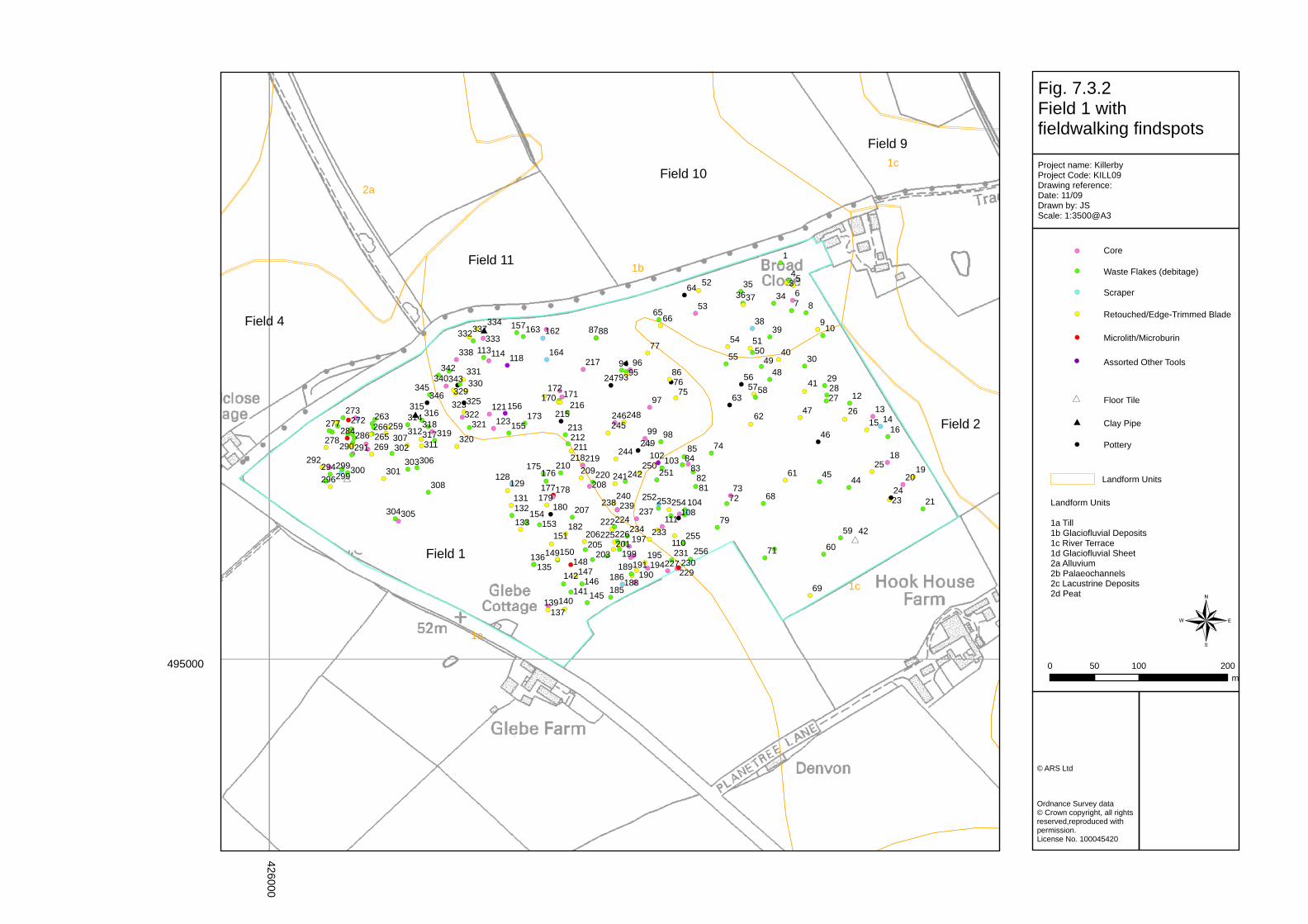
Table 7.3.3 Tabulation of lithic densities by lanform units. Field 1 7.3.14 Field 1 was located south of the access track to Broad Close Farm and covered an area of approximately 21 ha (Figure 7.3.2). The elevation of the field varied between 40m‐55m OD. The geomorphology of the field consists of a mixture of lacustrine clays (2c) in the south‐east and till (1a) in the north‐west resulting in a mixture of sediment types. These included poorly sorted sands, gravels, silts and clays. The field is undulating, particularly at its northern end, but was flatter at its eastern end. The field rose to a slight ridge that ran across the field on a north‐south axis. A prominent depression is located in the field immediately adjacent to the farm track and local opinion is that it is a bomb crater. The only other option is that it is a kettle‐hole type feature. The feature was cored to test whether it could be a kettle hole feature as part of this evaluation but no sediments consistent with it having formed as a kettle hole were discovered and so, given that it is on the flight path to the runway of RAF Catterick, it is considered most likely to be the remnants of a bomb crater, possibly dropped by an allied plane in order to dispose of its unspent payload prior to landing.
TARMAC LTD Killerby Sand and Gravel Quarry, Killerby, North Yorkshire
12
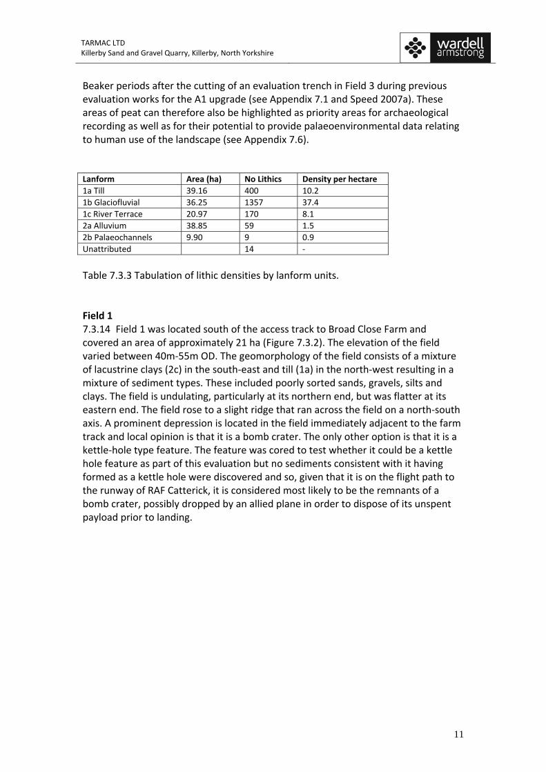
Photograph 7.3.2 Possible bomb crater visible in Field 1 (scale = 2m). 7.3.15 The field was walked under sprouting crop conditions making visibility generally good but medium in places and poor in localized patches. The field has a long history of having been ploughed for cultivation. A total of 269 chipped stone artefacts were recovered from the surface together with 15 sherds of pottery, two clay pipe fragments and a sandstone object that has probably been used as a rubbing tool. The ceramics include a sherd of Roman mortaria (mixing bowl) and medieval and post‐medieval pottery. 7.3.16 There is one bifacially worked arrowhead segment that is likely to be of Neolithic date (Photograph 7.3.3), but all the other chronologically diagnostic material is of Mesolithic, and in some cases perhaps Late Upper Palaeolithic, date. Of the chipped stone material 72 are made from flint and 195 from chert, whilst there is also one retouched blade made from a tuff‐like material. There are a wide range of lithic tools present on the surface of Field 1 (see Table 7.3.1) including scrapers, edge‐trimmed, retouched and utilised blades and flakes, microliths and a notched blade. There is also a significant quantity of cores accounting for 17.4% of the chipped stone from this field together with debitage. This range of material suggests that tool production, re‐tooling and processing activities took place in this area, which are activities consistent with the local availability of raw material acquisition and working, as well as tasks typically associated with residential sites. There is a marked absence of finds running along the western boundary of the field suggesting that this area may have been disturbed in the past resulting in the removal of this earlier material. There is a cluster of cores running north‐west to south‐east across the central area of this field whilst the scrapers and edge trimmed blades and flakes are fairly evenly spread across the central area of the field with lower densities beyond.
TARMAC LTD Killerby Sand and Gravel Quarry, Killerby, North Yorkshire
13
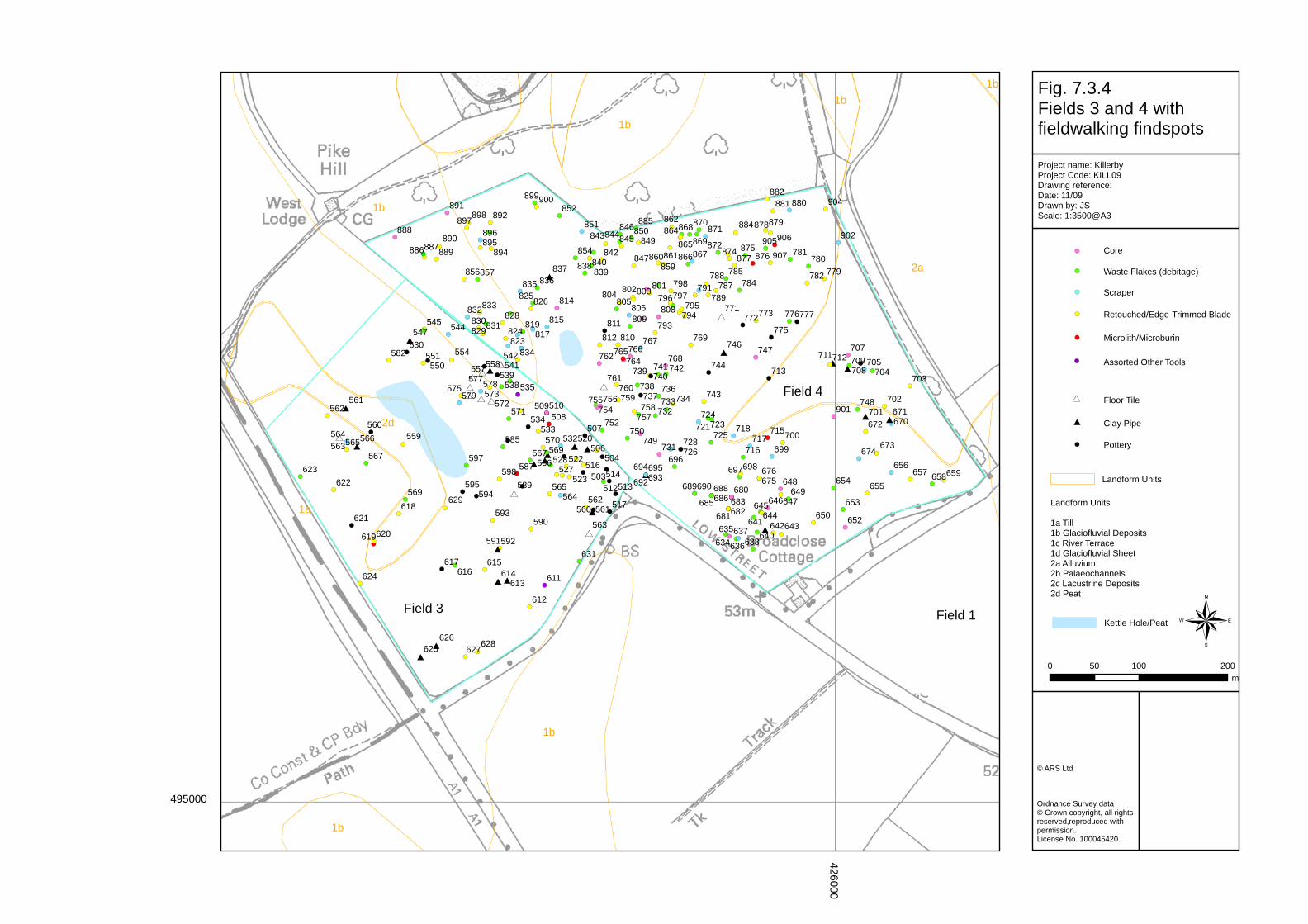
Photograph 7.3.3 The broken leaf‐shaped arrowhead from Field 1 of likely Neolithic date. Field 2 7.3.17 Field 2 was located behind Broad Close Farm and covered an area of around 12.5 hectares (Figure 7.3.3). The elevation of the field varied between 40m‐55m OD. The geomorphology consisted of till (1a), river terrace sands and gravels (1c) and alluvium (2a). The field was gently undulating with the highest point at the east end which sloped downhill to the west where it flattened out. The base of the slope was much stonier with far fewer finds. The sprouting crop in the field was dense in places making visibility poor in some places. 7.3.18 A wide variety of tool types were retrieved from this field including 15 cores, most of which were of platform or irregular types for the production of blade blanks, together with one prismatic core. The cores were of typical Mesolithic type with most having been fashioned for microblade production and a vague cluster can be noted in the centre of the field (Figure 7.3.3). In addition there are 16 edge‐trimmed blades and flakes, the main cluster of which can be identified towards the southern end of the field (see Figure 7.3.3) and a second smaller cluster in the north‐easternmost corner of the field. The scrapers have a similar distribution coincident with that of the edge‐trimmed blades and flakes. A small cluster of microliths and a possible microburin can be noted around the margins of the alluvial area of the field on its western side. This distribution is of interest as it is suggests a degree of zonation of activity across this area with tasks associated with residential sites situated on the higher and flatter areas, with hunting tools on the margin of wetland, and stone tool production and chipping taking place close to where the processing tools were being discarded in what were presumably settlement locales. Field 3 7.3.19 Field 3 was located to the immediate east of the A1 trunk road and covered an area of 10.55ha (Figure 7.3.4). The elevation of the field varied between 40m‐55m
TARMAC LTD Killerby Sand and Gravel Quarry, Killerby, North Yorkshire
14
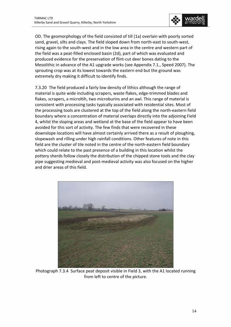
OD. The geomorphology of the field consisted of till (1a) overlain with poorly sorted sand, gravel, silts and clays. The field sloped down from north‐east to south‐west, rising again to the south‐west and in the low area in the centre and western part of the field was a peat‐filled enclosed basin (2d), part of which was evaluated and produced evidence for the preservation of flint‐cut deer bones dating to the Mesolithic in advance of the A1 upgrade works (see Appendix 7.1., Speed 2007). The sprouting crop was at its lowest towards the eastern end but the ground was extremely dry making it difficult to identify finds. 7.3.20 The field produced a fairly low density of lithics although the range of material is quite wide including scrapers, waste flakes, edge‐trimmed blades and flakes, scrapers, a microltih, two microburins and an awl. This range of material is consistent with processing tasks typically associated with residential sites. Most of the processing tools are clustered at the top of the field along the north‐eastern field boundary where a concentration of material overlaps directly into the adjoining Field 4, whilst the sloping areas and wetland at the base of the field appear to have been avoided for this sort of activity. The few finds that were recovered in these downslope locations will have almost certainly arrived there as a result of ploughing, slopewash and rilling under high rainfall conditions. Other features of note in this field are the cluster of tile noted in the centre of the north‐eastern field boundary which could relate to the past presence of a building in this location whilst the pottery sherds follow closely the distribution of the chipped stone tools and the clay pipe suggesting medieval and post‐medieval activity was also focused on the higher and drier areas of this field.
Photograph 7.3.4 Surface peat deposit visible in Field 3, with the A1 located running
from left to centre of the picture.
TARMAC LTD Killerby Sand and Gravel Quarry, Killerby, North Yorkshire
15
Field 4 7.3.21 Field 4 was located to the north‐east of Field 3 and ran down to the access track to Killerby Hall (Figure 7.3.4). The field measured just short of 17 hectares and had an elevation of 45m‐55m OD. The landform units comprising the field consisted of till (1a), glaciofluvial deposits (1b) and alluvium (2a) accounting for the hummocky terrain. The field was undulating with a pronounced steep slope running down from broadly south‐west to north‐east. The lowest point of the field was in the south‐east corner. A small peat‐filled kettle hole was located on the top of the ridge which Field 4 shares with the north‐eastern part of Field 3. The crop was just sprouting so the visibility was good in this field, although the ground was very dry which made it more difficult to spot lithic artefacts. 7.3.22 With a lithic density per hectare of 13.4 this is quite a high count and given that there are parts of the field where there are few finds, on the alluvial area for example, the density elsewhere on the field is in fact higher with an obvious clustering of the material along the fairly flat top of the ridge. The range of material is diverse including cores and waste flakes as well as 52 edge‐trimmed blades and flakes, 29 scrapers, three microliths and two microburins, together with an awl, knife and a burin. One of the microliths is an oblique ‘broad blade’ form characteristic of the Early Mesolithic whilst another is ‘narrow blade’ and of backed blade form usually associated with the Late Mesolithic.
TARMAC LTD Killerby Sand and Gravel Quarry, Killerby, North Yorkshire
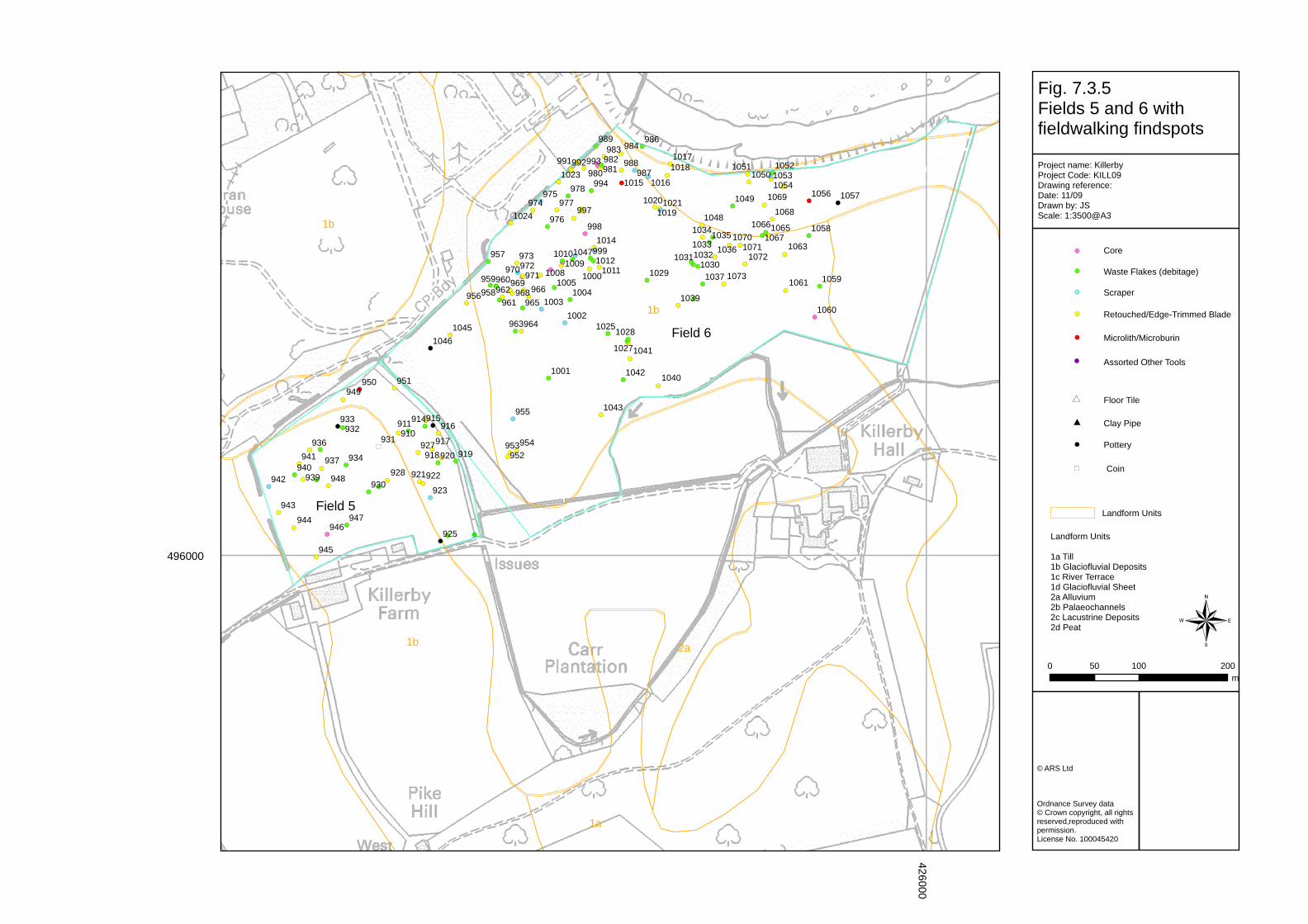
16
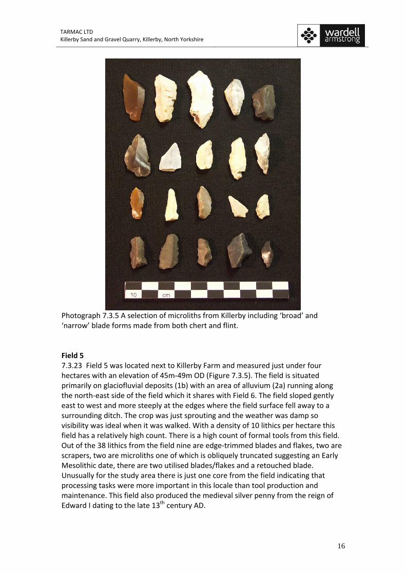
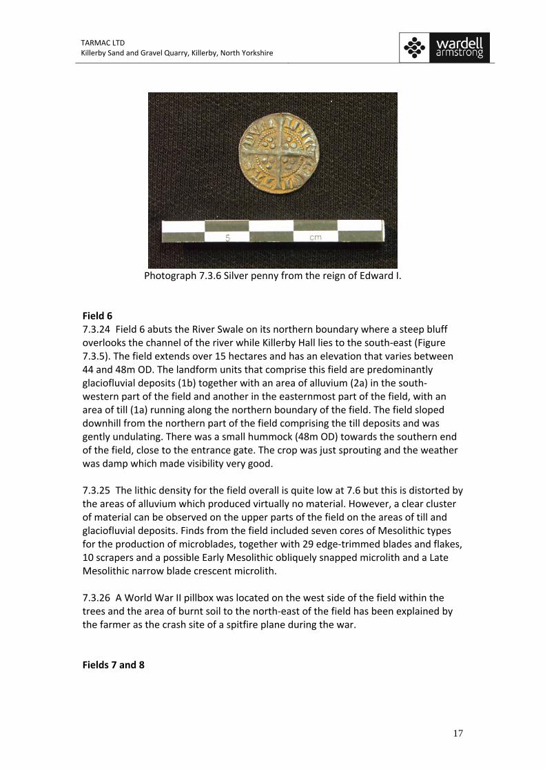
Photograph 7.3.5 A selection of microliths from Killerby including ‘broad’ and ‘narrow’ blade forms made from both chert and flint. Field 5 7.3.23 Field 5 was located next to Killerby Farm and measured just under four hectares with an elevation of 45m‐49m OD (Figure 7.3.5). The field is situated primarily on glaciofluvial deposits (1b) with an area of alluvium (2a) running along the north‐east side of the field which it shares with Field 6. The field sloped gently east to west and more steeply at the edges where the field surface fell away to a surrounding ditch. The crop was just sprouting and the weather was damp so visibility was ideal when it was walked. With a density of 10 lithics per hectare this field has a relatively high count. There is a high count of formal tools from this field. Out of the 38 lithics from the field nine are edge‐trimmed blades and flakes, two are scrapers, two are microliths one of which is obliquely truncated suggesting an Early Mesolithic date, there are two utilised blades/flakes and a retouched blade. Unusually for the study area there is just one core from the field indicating that processing tasks were more important in this locale than tool production and maintenance. This field also produced the medieval silver penny from the reign of Edward I dating to the late 13th century AD.
TARMAC LTD Killerby Sand and Gravel Quarry, Killerby, North Yorkshire
17
Photograph 7.3.6 Silver penny from the reign of Edward I.
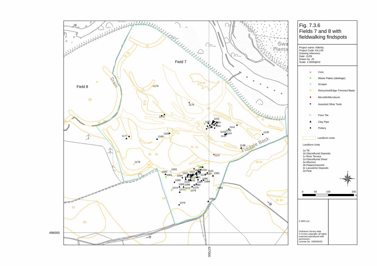
Field 6 7.3.24 Field 6 abuts the River Swale on its northern boundary where a steep bluff overlooks the channel of the river while Killerby Hall lies to the south‐east (Figure 7.3.5). The field extends over 15 hectares and has an elevation that varies between 44 and 48m OD. The landform units that comprise this field are predominantly glaciofluvial deposits (1b) together with an area of alluvium (2a) in the south‐western part of the field and another in the easternmost part of the field, with an area of till (1a) running along the northern boundary of the field. The field sloped downhill from the northern part of the field comprising the till deposits and was gently undulating. There was a small hummock (48m OD) towards the southern end of the field, close to the entrance gate. The crop was just sprouting and the weather was damp which made visibility very good. 7.3.25 The lithic density for the field overall is quite low at 7.6 but this is distorted by the areas of alluvium which produced virtually no material. However, a clear cluster of material can be observed on the upper parts of the field on the areas of till and glaciofluvial deposits. Finds from the field included seven cores of Mesolithic types for the production of microblades, together with 29 edge‐trimmed blades and flakes, 10 scrapers and a possible Early Mesolithic obliquely snapped microlith and a Late Mesolithic narrow blade crescent microlith. 7.3.26 A World War II pillbox was located on the west side of the field within the trees and the area of burnt soil to the north‐east of the field has been explained by the farmer as the crash site of a spitfire plane during the war. Fields 7 and 8
TARMAC LTD Killerby Sand and Gravel Quarry, Killerby, North Yorkshire
18
7.3.27 Fields 7 and 8 which form the proposed Phase 3 development area extend over an area of approximately 29 ha and 11 ha respectively and were separated by a hedge line that follows an old meander belt of the river Swale. The modern course of the river now lies to the north of the fields being separated from them by a modern flood relief bank (Figure 7.3.6). The fields are for the most part flat and lie at an elevation of 40m OD and comprise alluvium (2a) with areas of palaeochannel belts (2b) crossing the surface. The exception to this is the southernmost extension of Field 7 which is raised up several metres higher than the rest of the field and is comprised of till (1a). It is no coincidence that the majority of the finds from this field are clustered on the raised till terrace which would have formed a dry area overlooking the perennial wetland of the alluvial floodplain of a fast‐flowing and relatively high energy river in its middle courses. The crop was just sprouting and visibility was good. 7.3.28 There were two concentrations of post‐medieval finds, one on the alluvium and one on the till. The lithics were concentrated on the till as well with a few having been moved downslope on to the alluvium as a result of plough and sheetwash action. It is interesting to note that the microliths were located on the alluvial areas, and although these may have been washed in with floodwaters it is interesting that the other microliths from the study have shown a tendency to be clustered on or at the edge the alluvial areas indicating the use of hunting weapons close to wetland areas, presumably associated with the taking of fish, fowl and perhaps animals drinking at the waters edge. Field 8 produced a single edge‐trimmed flint tool. Field 9 7.3.29 Field 9 was located directly north of Broad Close Farm and extended over 6 hectares and had an elevation ranging between 42m‐44m OD. The landform units of the field comprised primarily river terrace sands and gravels (1c) with a small patch of till (1a) in the north‐westernmost corner and two small patches of alluvium (2a) in the north‐easternmost corner and east side of the field respectively. The field gently undulated becoming slightly raised towards the farm track to the south. The field was stonier towards the higher ground and relatively clear elsewhere of stones. The soil became darker and richer towards the north‐east corner where it graded into alluvial and peat deposits that continued in to the adjoining field. The field had only just been sown with crop making surface visibility very good. Very few finds were made in this field signaling what appears to be a genuine lack of activity in this area. Four edge‐trimmed tools and a scraper were found at the north end of the field whilst a single scraper and edge‐trimmed tool were found at the south end of the field. One of the scrapers was a classic ‘thumbnail’ scraper typical of the Beaker period (c.2400‐1800 cal BC).
TARMAC LTD Killerby Sand and Gravel Quarry, Killerby, North Yorkshire
19
Photograph 7.3.7 Two thumbnail scrapers of Beaker period date from Killerby.
Field 10 7.3.30 Field 10 was located to the immediate west of Field 9 and extended over 11 ha and had an elevation ranging between 42m‐46m OD (Figure 7.3.7). The field sloped gently downwards from the track in the south to the fence line with Field 12 in the north whilst it sloped more steeply towards the old wetland situated half way along the western side of the field. 7.3.31 This field produced by far the largest number of lithics in the study area with 894 chipped stone pieces recovered. This gave the field a density statistic of 78.4 per hectare which is very high by any measure and this is despite the density of finds dropping off in the area of the wetland and the area of river terrace (1c). The range of tools discovered on this field is highly varied and included 57 cores of various Mesolithic types including platform, multi‐platform and irregular microblade cores, 129 edge‐trimmed tools, 13 microliths including Early Mesolithic oblique types and Late Mesolithic scalene triangle forms, 99 scrapers, 21 retouched and utilised pieces, two knives, one awl and a gun flint. These are very high percentages of tools and indicate that processing tasks usually associated with residential occupation took place across the relatively flat surface of the glaciofluvial deposits together with stone tool production and maintenance. The presence of a substantial number of microliths indicates that hunting weapons were made and perhaps used across this area. With areas of ancient wetland lying to the east and west of this raised, flat and free draining area it is perhaps not surprising that this locale appears to have formed a residential focus for hunter‐gatherer groups during the Lateglacial and Early Holocene. Although it has a long history of being ploughed, Field 10 was clearly a focus for occupation by Mesolithic and possibly Late Upper Palaeolithic groups, and therefore if any structural features were constructed to accompany this occupation that extended beyond the topsoil horizon and into the underlying sediment such features have the potential to survive in this area.
TARMAC LTD Killerby Sand and Gravel Quarry, Killerby, North Yorkshire
20
Photograph 7.3.8 Selection of edge‐trimmed blades from Killerby.
Field 11 7.3.32 Field 11 was located to the immediate west of Field 10 and forms a continuation of the same landform (Figure 7.3.7). It comprises glaciofluvial deposits (1b) that slope down towards the old wetland characterized as alluvial deposits (2a) with peats (2d) inset within them. A cluster of oyster shells were observed running along a contour on a sloping part of the field surface and this mirrors the discovery of oyster shells strung out along the contour that defines the ancient shoreline of the glacial ‘Lake Ewart’ in the Milfield Basin in Northumberland (Passmore and Waddington 2009). It is possible therefore that these calcareous shells date back to the time when a glacial lake or wetland occupied the subsequently alluviated area at the lower margins of this and the adjoining field. 7.3.33 Although the area of this field is small, just short of 2.5 ha, the number of lithics recovered is high resulting in this field having the largest density count of 95 per hectare. The pattern and variation of material continues on from that in Field 10 and clearly forms an extension of this wider distribution. The assemblage includes 18 cores of mostly platform type, 43 edge‐trimmed tools, 20 scrapers, two microliths, two retouched blades and a possible gun flint.
TARMAC LTD Killerby Sand and Gravel Quarry, Killerby, North Yorkshire
21
Photograph 7.3.9 A selection of abruptly retouched scrapers from Killerby.
Field 12 7.3.34 Field 12 is located at the northern end of Fields 9 and 10 and forms the end of the low galciofluvial ridge (1b) which slopes down to the alluvial area that encompasses this low ridge on its east, north and western sides. The ground in this field is mostly sloping to the north as it grades down to the lower lying alluviated ground. Correspondingly, the lithic densities observed on the flatter and higher ground of Fields 10 and 11 falls off in this field resulting in a density count of 12.1 per hectare. There is a range of tool types present in this field including six cores, nine edge‐trimmed tools, four retouched blades/flakes and a notched blade, together with eight scrapers and three utilised blades. This mix of processing tools is again suggestive of activities typically associated with residential sites and therefore should be seen as an extension of the patterns observed in Fields 10 and 11. Raw Materials 7.3.35 The Killerby lithics comprise a mixed assemblage of 2015 chipped stone pieces made from 70.5% chert (1421 pieces) and 29.3% flint (592 pieces) with the remainder made up of one piece of chipped tuff and a coarse sandstone tool. The
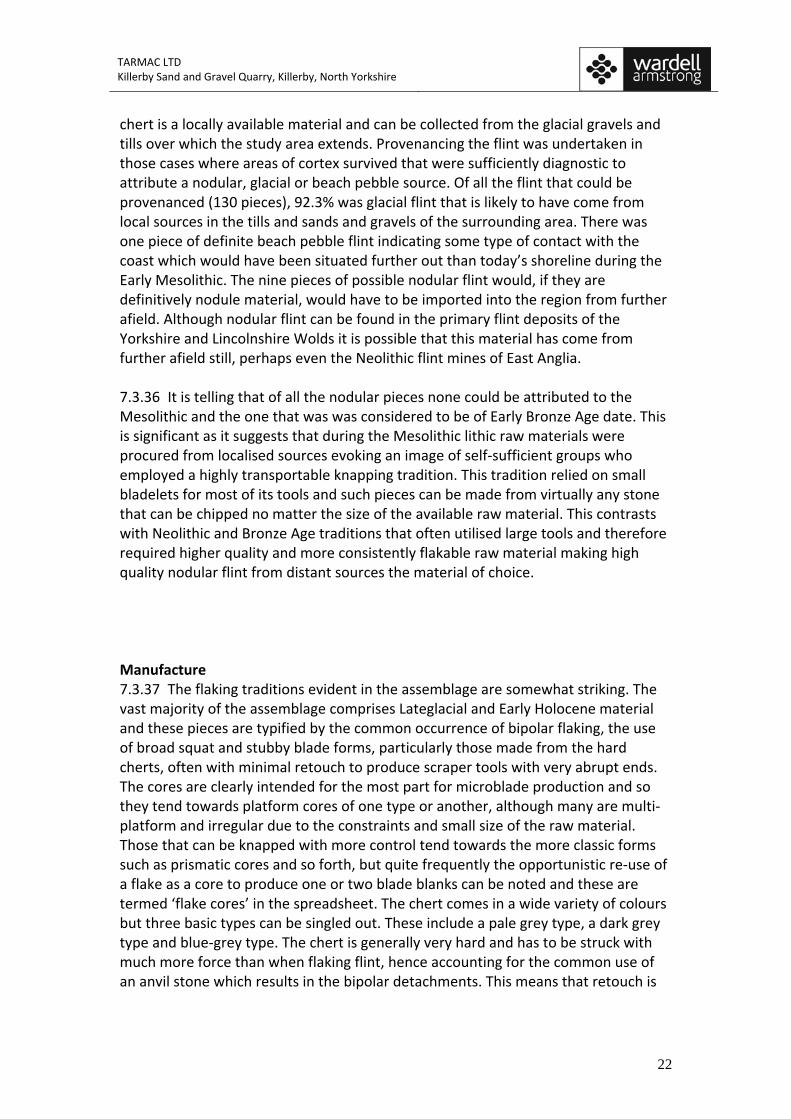
TARMAC LTD Killerby Sand and Gravel Quarry, Killerby, North Yorkshire
22
chert is a locally available material and can be collected from the glacial gravels and tills over which the study area extends. Provenancing the flint was undertaken in those cases where areas of cortex survived that were sufficiently diagnostic to attribute a nodular, glacial or beach pebble source. Of all the flint that could be provenanced (130 pieces), 92.3% was glacial flint that is likely to have come from local sources in the tills and sands and gravels of the surrounding area. There was one piece of definite beach pebble flint indicating some type of contact with the coast which would have been situated further out than today’s shoreline during the Early Mesolithic. The nine pieces of possible nodular flint would, if they are definitively nodule material, would have to be imported into the region from further afield. Although nodular flint can be found in the primary flint deposits of the Yorkshire and Lincolnshire Wolds it is possible that this material has come from further afield still, perhaps even the Neolithic flint mines of East Anglia. 7.3.36 It is telling that of all the nodular pieces none could be attributed to the Mesolithic and the one that was was considered to be of Early Bronze Age date. This is significant as it suggests that during the Mesolithic lithic raw materials were procured from localised sources evoking an image of self‐sufficient groups who employed a highly transportable knapping tradition. This tradition relied on small bladelets for most of its tools and such pieces can be made from virtually any stone that can be chipped no matter the size of the available raw material. This contrasts with Neolithic and Bronze Age traditions that often utilised large tools and therefore required higher quality and more consistently flakable raw material making high quality nodular flint from distant sources the material of choice. Manufacture 7.3.37 The flaking traditions evident in the assemblage are somewhat striking. The vast majority of the assemblage comprises Lateglacial and Early Holocene material and these pieces are typified by the common occurrence of bipolar flaking, the use of broad squat and stubby blade forms, particularly those made from the hard cherts, often with minimal retouch to produce scraper tools with very abrupt ends. The cores are clearly intended for the most part for microblade production and so they tend towards platform cores of one type or another, although many are multi‐platform and irregular due to the constraints and small size of the raw material. Those that can be knapped with more control tend towards the more classic forms such as prismatic cores and so forth, but quite frequently the opportunistic re‐use of a flake as a core to produce one or two blade blanks can be noted and these are termed ‘flake cores’ in the spreadsheet. The chert comes in a wide variety of colours but three basic types can be singled out. These include a pale grey type, a dark grey type and blue‐grey type. The chert is generally very hard and has to be struck with much more force than when flaking flint, hence accounting for the common use of an anvil stone which results in the bipolar detachments. This means that retouch is
TARMAC LTD Killerby Sand and Gravel Quarry, Killerby, North Yorkshire
23
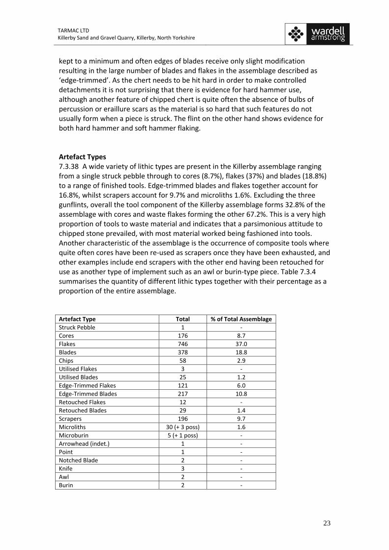
kept to a minimum and often edges of blades receive only slight modification resulting in the large number of blades and flakes in the assemblage described as ‘edge‐trimmed’. As the chert needs to be hit hard in order to make controlled detachments it is not surprising that there is evidence for hard hammer use, although another feature of chipped chert is quite often the absence of bulbs of percussion or eraillure scars as the material is so hard that such features do not usually form when a piece is struck. The flint on the other hand shows evidence for both hard hammer and soft hammer flaking. Artefact Types 7.3.38 A wide variety of lithic types are present in the Killerby assemblage ranging from a single struck pebble through to cores (8.7%), flakes (37%) and blades (18.8%) to a range of finished tools. Edge‐trimmed blades and flakes together account for 16.8%, whilst scrapers account for 9.7% and microliths 1.6%. Excluding the three gunflints, overall the tool component of the Killerby assemblage forms 32.8% of the assemblage with cores and waste flakes forming the other 67.2%. This is a very high proportion of tools to waste material and indicates that a parsimonious attitude to chipped stone prevailed, with most material worked being fashioned into tools. Another characteristic of the assemblage is the occurrence of composite tools where quite often cores have been re‐used as scrapers once they have been exhausted, and other examples include end scrapers with the other end having been retouched for use as another type of implement such as an awl or burin‐type piece. Table 7.3.4 summarises the quantity of different lithic types together with their percentage as a proportion of the entire assemblage. Artefact Type Total % of Total Assemblage Struck Pebble 1 ‐ Cores 176 8.7 Flakes 746 37.0 Blades 378 18.8 Chips 58 2.9 Utilised Flakes 3 ‐ Utilised Blades 25 1.2 Edge‐Trimmed Flakes 121 6.0 Edge‐Trimmed Blades 217 10.8 Retouched Flakes 12 ‐ Retouched Blades 29 1.4 Scrapers 196 9.7 Microliths 30 (+ 3 poss) 1.6 Microburin 5 (+ 1 poss) ‐ Arrowhead (indet.) 1 ‐ Point 1 ‐ Notched Blade 2 ‐ Knife 3 ‐ Awl 2 ‐ Burin 2 ‐
TARMAC LTD Killerby Sand and Gravel Quarry, Killerby, North Yorkshire
24
Gun Flint 2 (+1 poss) ‐ Total 2015
Table 7.3.4. Summary of lithic artefact types present in the assemblage.
Photograph 7.3.10 A selection of platform microblade cores made from chert and flint. 7.3.39 Much of the material, whether chert or flint, is heavily patinated, usually a milky white colour, which is consistent with the great antiquity postulated for most of this assemblage (12500‐4000 cal BC). There is a very wide range of edge‐trimmed blade forms, often irregular in shape, which could have been used for a multiplicity of purposes. Although the basic tool blank is the parallel‐sided blade, they are typically squat pieces, although it is common for most pieces to have a triangular section. Occasionally pieces have been recycled and this is most obvious when heavily patinated chipped pieces have been re‐chipped or sharpened to make a new tool form. A lot of the material is broken and this no doubt reflects the result of centuries, and perhaps even millennia, of ploughing across the area. Occasional pieces show evidence of having broken in antiquity as noted by the patina development across the broken face indicating the artefact was probably discarded
TARMAC LTD Killerby Sand and Gravel Quarry, Killerby, North Yorkshire
25
after having broken. Overall the tool forms range from classic type fossils to very irregular and opportunistic forms that reflect the constraints of the raw material.
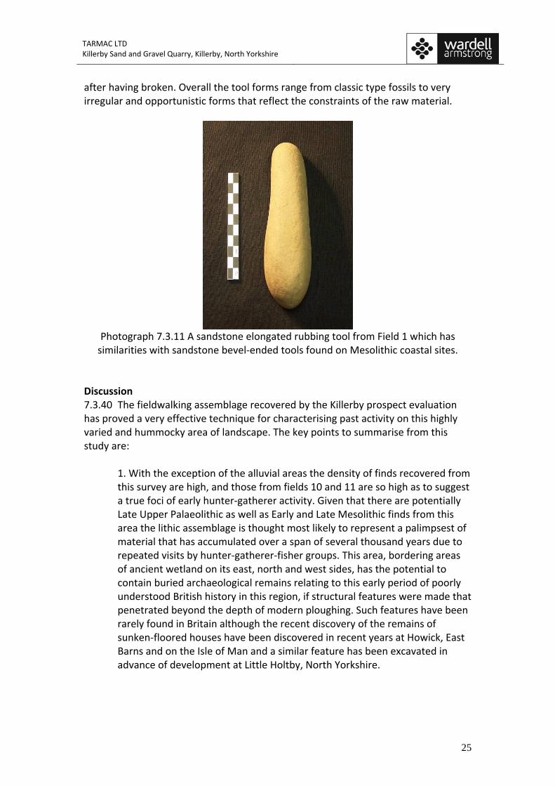
Photograph 7.3.11 A sandstone elongated rubbing tool from Field 1 which has similarities with sandstone bevel‐ended tools found on Mesolithic coastal sites.
Discussion 7.3.40 The fieldwalking assemblage recovered by the Killerby prospect evaluation has proved a very effective technique for characterising past activity on this highly varied and hummocky area of landscape. The key points to summarise from this study are:
1. With the exception of the alluvial areas the density of finds recovered from this survey are high, and those from fields 10 and 11 are so high as to suggest a true foci of early hunter‐gatherer activity. Given that there are potentially Late Upper Palaeolithic as well as Early and Late Mesolithic finds from this area the lithic assemblage is thought most likely to represent a palimpsest of material that has accumulated over a span of several thousand years due to repeated visits by hunter‐gatherer‐fisher groups. This area, bordering areas of ancient wetland on its east, north and west sides, has the potential to contain buried archaeological remains relating to this early period of poorly understood British history in this region, if structural features were made that penetrated beyond the depth of modern ploughing. Such features have been rarely found in Britain although the recent discovery of the remains of sunken‐floored houses have been discovered in recent years at Howick, East Barns and on the Isle of Man and a similar feature has been excavated in advance of development at Little Holtby, North Yorkshire.
TARMAC LTD Killerby Sand and Gravel Quarry, Killerby, North Yorkshire
26
2. Almost the entire assemblage can be characterised as Early Holocene in date with some possible Lateglacial material and a tiny Neolithic and Beaker period component. When the character of this landscape is considered it is evident that this has changed markedly from the time of the last glaciation to the present. During the Postglacial and throughout much of the Early Holocene the Killerby landscape would have comprised a series of low sandy and gravel ridges overlooking a patchwork of ponds, lakes, marsh and wetland as well as the nearby fast‐flowing river Swale. This type of landscape provides abundant foodstuffs and materials for hunter‐gatherer‐fisher groups including clothing and shelter in the form of fish, wildfowl, animals watering at the edges of ponds and wetlands, birdlife, as well as a wide variety of plants that can be used to make shelters, baskets and clothes and provide a wealth of edible foodstuffs. It is perhaps then no surprise that such significant evidence for occupation of the raised and flatter areas of freely draining glaciofluvial deposits set up above these wetlands should provide such good evidence for early human hunter‐gatherer‐fisher occupation around these resource‐rich locales. However, these areas, characterised by perennial flooding of the alluvial areas and the infilling of the wetlands by accumulations of peat, together with the abrupt slopes and relatively constrained areas of raised dry ground, should not have been as attractive to early farming groups who were more attracted to the more even and flat ground that could be found a short distance to the north on the large expanses of river terrace deposits that border the river Swale in the vicinity of Catterick. This has been evidenced by the large timber enclosure recently discovered at Marne Barracks (ASUD 2001; 2002; 2006) as well as the other remains of ritual monuments at Catterick racecourse and Scorton. Consequently, this landscape doesn’t have seemed to have retained its degree of attraction for later groups as it once enjoyed in the Early Holocene. Although there are hints of Roman, medieval and Post‐Medieval activity across the proposed development area, these locales seem relatively restricted and probably reflect the use of this land by a scattering of farmsteads located on the higher ground; a pattern of land‐use that continues today as evidenced by the location of farmsteads at Killerby Hall, Broad Close Farm and Glebe Farm. 3. The favoured material for stone tool production in the Mesolithic was locally available material that could be gathered from the underlying sand and gravel and till deposits. This could have been obtained from the river cliff exposures or by shallow quarries. The dominant material used was chert and this was used to make a similar range of artefacts that are made in more flint‐rich areas although the forms tend to appear more crude and the blade forms tend to be short, fat and stubby in nature with minimal retouch. Flint was also used and various classic forms of microlith can be recognised including obliquely truncated points together with narrow blade scalene triangles, backed blades and crescents.
TARMAC LTD Killerby Sand and Gravel Quarry, Killerby, North Yorkshire
27
4. The proximity of peat filled enclosed basins and kettle holes, several of which contain organic sediments dating from this same period, directly next to Postglacial and Early Holocene lithic scatters provides an important linkage that would allow targeted work to address questions relating to the first hunter‐gatherer‐fishers who occupied this landscape.
7.3.41 On their own the lithic scatters or peat‐filled basins are not of national archaeological importance but taken as a whole they can provide a highly significant and detailed insight into early human activity in the area which is not yet available for this part of England. The archaeological remains identified as a result of the fieldwalking evaluation have a regional significance but this is not sufficient to warrant the prevention of development, particularly as these artefacts only survive as scatters of material within the ploughsoil dislodged from their original position. However, this material has the potential to reveal new and interesting information about the earliest settlers in this landscape and address research themes identified by the regional research assessment (Manby et al. 2003) which highlights the discovery of “few Mesolithic assemblages” from Yorkshire’s central lowlands (Manby 2003, 33). References ASUD. 2001. Archaeological Investigations at Marne Barracks, Catterick Garrison, ASUD. 2002. Archaeological Investigations at Marne Barracks, Catterick Garrison, North Yorkshire: Phase 3: Evaluation. Unpublished Report 911. ASUD. 2006. Marne Barracks, Catterick, North Yorkshire post‐excavation analysis report. Unpublished Report 1387. Haselgrove, C. C. and F. Healey 1992. The Prehistory of the Tyne‐Tees Lowlands: Some Recent Finds. Durham Archaeological Journal 8: 1‐24. Manby, T., Moorhouse, S. and P. Ottaway (eds.). 2003. The Archaeology of Yorkshore. An Assessment at the Beginning of the 21st Century. Yorkshire Archaeological Society Occasional Paper No.3. Manby, T. 2003. The Late Upper Palaeolithic and Mesolithic periods in Yorkshire. In Manby, T., Moorhouse, S. and P. Ottaway (eds.). 2003. The Archaeology of Yorkshore. An Assessment at the Beginning of the 21st Century. Yorkshire Archaeological Society Occasional Paper No.3: 31‐33. Passmore, D.G. and C. Waddington. 2009. Managing Archaeological Landscapes in Northumberland. Till‐Tweed Studies Volume I. Oxford. Oxbow Books and English Heritage.
TARMAC LTD Killerby Sand and Gravel Quarry, Killerby, North Yorkshire
28
Saville, A., T.B. Ballin, and T. Ward. 2007. Howburn near Biggar, south Lanarkshire: preliminary notice of a Scottish inland early Holocene lithic assemblage. Lithics. The Journal of the Lithics Study Society 28: 41‐49. Speed, G. 2007. A1 Dishforth to Barton, Phase 2 Evaluation Trenching Post Excavation Assessment Report. Northern Archaeological Associates 01/2007. Tolan‐Smith, C. 1997. The Stone Age Landscape: the Contribution of Fieldwalking. In C. Tolan‐Smith (ed.) Landscape Archaeology in Tynedale. Newcastle upon Tyne, University of Newcastle upon Tyne: 79‐89. Waddington, C. 1996. Middle Warren. Fieldwalking Assessment Phase II. Archaeological Practice, University of Newcastle upon Tyne, unpublished report. Waddington, C. 1998. Lithic Report for Turning the Tide Project 1988. Unpublished Report for Archaeological Services, University of Durham. Waddington, C. 2001a. Maiden’s Hall Lithic Report. Unpublished, University Report for Archaeological Practice, University of Newcastle. Waddington, C. 2001b. Milfield Fieldwalking and Test Pit Results. Unpublished Report, University of Newcastle upon Tyne. Waddington, C. 2007. Fieldwalking. In Waddington, C. (ed.) Mesolithic Settlement in the North Sea Basin: A Case Study from Howick, North‐East England. Oxford, Oxbow Books and English Heritage: 17‐33.
!(!(
!(!(!(!(!(
!(!(!(
!(!(!(!(!(!(
!(!(
!(
!(
!(!(!(!(!(!(!(!(
!(!(
!( !(
!(
!(!(
!(!(!(#* !(
!(
!(
!(!(
!(
!(
!(
!(!(
!(
#!(!(!(
!(!(
!(
!(!(
!(
!(!(!(!(
!(
!(
!( !(
#!(
!(
!(
!(!(
!(
!(
!(
!(
!(!(!(
!(
!( !(
!(!(
!(
!(
!(!(
!(
!(
!(
!(
!(
!(!(
!(
!(
!(!(
!(
!(
!(
!(
!(!(
!(
!(
!(
!(
#*
!(!(
!(
!(
!(
!(
!(!(
!(
!(
!(
!(
!(
!(!(
!(
!(
!(
!(
!(
!(
!(!(
!(
!(
!(
!(
!(
!(
!(
!(
!(
!(
!(
!(
!(
!(!(
!(
!(
!(!(
!(!(!(!(!(
!(
!(!(#*
!(!(
!(!(!(!(
!(!(
!(
!(!(
!(!(
!(
!(
!(
!(!(
!(
!(
!(
!(!(
!(!( !(
!(
!(
!(
!(
!(
!(!(!(
!(
!(!(
!(
!(
!(!(
!(!(
!(
!(!(!(!(!(
!(
!(
!(
!(
!(!(
!(
!(
!(
!(
!( !(
!(!(!(
!(!(
!(!(
!(!(
!(!(
!(!(
!(
!(
!(
!(
!(
!(!(
!(
!(
!(
!(
!(
!(
!(!(
!(
!(!(
!(!(
!( !(!(
!(
!(!(
!(
!(!(!(
!( !(
!(
!(
!(
!(
!(
!(
!(
!(
!(!( !(
!(
!(
2a
1c
1c
1b
1a
9
876
543
1
99 98
97
9695
9493
8887
86
8584
838281
79
77
7675
74
7372
71
69
68
6665
64
63
62
61
60
59
585756
55
54
53
52
5150
4948
47
46
4544
42
41
40
3938
373635
34
30
292827
26
25
2423 21
2019
18
1615 14
1312
10
256
255
254253252
251250
249
248
247
246245
244
242241
240239238
237
234 233
231230229
227
226225
224222
220
219218
217
216215
213212211
210 209208
207
206205
203201
199
197
195194191
190189
188186185
182
180179
178177
176175
173
172171170
164
163 162157
156
155
154153
151
150149148
147146
145
142
141140139
137
136135
133132131
129128
123121
118114113
111
110
108104
103102
346345
343342
340
338
337334
333332
331330
329325323322
321
320319
318317
316315314312
311
308
307
306
305304
303302
301300299299296
294292
291290286284
278
277273
272
269
266265
263259
Fig. 7.3.2Field 1 with fieldwalking findspots
Project name: KillerbyProject Code: KILL09Drawing reference: Date: 11/09Drawn by: JSScale: 1:3500@A3
© ARS Ltd
Ordnance Survey data© Crown copyright, all rights reserved,reproduced with permission.License No. 100045420
¬0 100 20050
m495000
426000
Landform Units
1a Till1b Glaciofluvial Deposits1c River Terrace1d Glaciofluvial Sheet2a Alluvium2b Palaeochannels2c Lacustrine Deposits2d Peat
Landform Units
Assorted Other Tools
Retouched/Edge-Trimmed Blade
Waste Flakes (debitage)
Clay Pipe
Core
Floor Tile
Microlith/Microburin
Pottery
Scraper
!(
!(
!(
!(
!(
#*
!(
#
!(
Field 1
Field 2
Field 4
Field 11
Field 10
Field 9
!(!(
!(
!(!( !(
!(
!(
!(
!(
!(!( !(!(!(
!(
!(!(!(
!(!(
!(
!(
!(
!(
!(
!(
!(
!(
!(!(
!(
!(
!(
!(
!(!(
!(!(
!(!(
!(
!(!(
!(!(
!(
!(!(!(
!(!(
!(
!(
!(!(
!(
!(
!(
!(
!(
!(
!(
!(
!(
!(
!(
!(
!(
!(!(
!(
!(!(
!(
!(!(
!(
!(
!(
!(
!(!(!(
!(#*
!(
!(!(
!(
!(
!(
!(
!(
!(
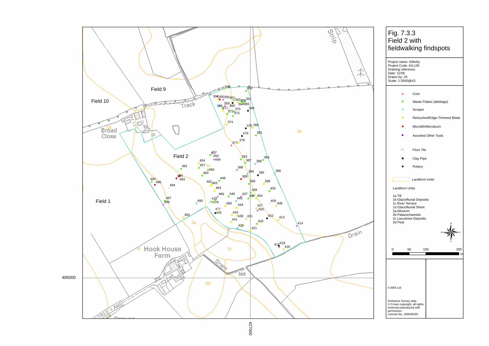
!(
!(
2d
2a
1c
1c 1c
1b1a
498497
496495
494
492
490
484483
481
479478
477475
469
466
464463462
460
457456
454
452450449
448
446445
444
443
441438
437
433
431
429
428
427426
421
420
418417416
414
413410
409408
405
404
399 398
396395
393
390389
388
387 386384
381
380
379
378377
375374
373372371 370 368
367366365364
363361
360359
358
356355354
350349
Fig. 7.3.3Field 2 with fieldwalking findspots
Project name: KillerbyProject Code: KILL09Drawing reference: Date: 11/09Drawn by: JSScale: 1:3500@A3
© ARS Ltd
Ordnance Survey data© Crown copyright, all rights reserved,reproduced with permission.License No. 100045420
¬0 100 20050
m
495000
427000
Landform Units
1a Till1b Glaciofluvial Deposits1c River Terrace1d Glaciofluvial Sheet2a Alluvium2b Palaeochannels2c Lacustrine Deposits2d Peat
Landform Units
Assorted Other Tools
Retouched/Edge-Trimmed Blade
Waste Flakes (debitage)
Clay Pipe
Core
Floor Tile
Microlith/Microburin
Pottery
Scraper
!(
!(
!(
!(
!(
#*
!(
#
!(
Field 1
Field 2
Field 10
Field 9
!(
!(!(#
!(
!(
!(!(
!(
!(
!(
!(
!(
!(
!(
#!(
!(
!(!(!(
!(##
!(
!(
!(!(
!(
!(!(
!(#
#*#*!(
!(!(!(
#
!(!(!(
#*#*
!(
!(#!(
#*
!(!(
#!(
!(!(
!(
#*#*#*!(
#*!(
!(
!(
!(!(
!(
!(
#*
!(
!(#
!(
!(!(
!(
!(
!(
!(
#!(
#*!(
!( #
!(
!(
!(
!(
##
!(!(
!(
!(
!(!(
!(
!(
!(
!(
##
!(!(
!(
!(
!(
!(!( !(!(
!(
!(
!( # !( !(
!(!(!(
!(!(
!(
!(!(
!(
!(!(
!(!(
!(!(
!(#
!(
!(!(
!(!(
!(!(!(
!(!(!(
!(!(!(!(!(!(
!(!(#!(!(
!(!(
!(
!(
#!(
!(
!(!(!(
!(
!(##!(
!(
!(
!(
!(
!(
!(!(!(
!(!(!(!(!(
!(
!(!(
!(
!(!(
!(
!(!( !( !(
!(
!(
#!(
!(
!(!(
!(!(
!(!(!(!(!(
!(
!(#*
!(!(!(!(
!(
!(
!(
#*!(
!(
!(
!( !(
!(
!(
!(
!(
!(
!(
!(!(
!(!(
!(
!(
!(
!(!(
!(!(
!(!(
!(!(
!(!(!(!(
!(!( !(
!(
!(
!(
!(
!(
!(!(!(!(
!(!(!(
!(
!(!(
!(
!(!(!(!(
!(!(
!(
!(!(
#!(
!(
!(!(
!(
!( !(!(
!(
!(
!(!(
!(
!(
!(
!( !(
!(!(
!(
!(
!(!(!(
!(!(
!( !(!(!(
!( !(!(
!(
!(!(
!(!(
!(!(
!(
!(!(
!(!(
!(
!(
!(
!(
!(
!(
!(!(
!(
!(!(
!(!(
!(
!(
!(
!(!(
!( 2a
2d
1b
1b
1b
1b
1b1b
1a
631
630
629
628627
626625
624
623622
621
620619
618
617616
615614
613
612
611
569
567
566565564563
562561
560559
598597
595594
593
592591
590
589
587
585
582
579578577
575 573572
571
570569567
566
565564
563
562561560
558557
554551550
547545 544
542541
539538535
534533
532
528527
523
522
520
517
516514
513512
510509508
507
506504
503
907
906905
904
902
901
900899
898897
896895
894
892891
890889
888
887886
885 884
882881 880
879878
877 876875874
872
871870
869868
867866865
864862
861860859857856
854
852
851850
849
847
846845844843
842840839
838837836835
834
833832
831830829
828826825
824823
819817
815
814
812811
810
809808806
805804 803802 801 798
797796795
794793
791789
788787
785784
782
781780
779
777776
775
773772771
769
768
767766765764762
761760759
758757
756755754
752750
749
748
747746
744
743
742741740739
738737
736734733
732
731 728726
725
724723721 718
717716
715
713712711 709
708
707705
704703
702701
700699
698697696
695694693692 690689 688
686685 683682681
680
676675
674673
672671670
659658657656
655654
653
652650
649648
647646645644
643642641640
638637
636
635634
Fig. 7.3.4Fields 3 and 4 with fieldwalking findspots
Project name: KillerbyProject Code: KILL09Drawing reference: Date: 11/09Drawn by: JSScale: 1:3500@A3
© ARS Ltd
Ordnance Survey data© Crown copyright, all rights reserved,reproduced with permission.License No. 100045420
¬0 100 20050
m
495000
426000
Landform Units
1a Till1b Glaciofluvial Deposits1c River Terrace1d Glaciofluvial Sheet2a Alluvium2b Palaeochannels2c Lacustrine Deposits2d Peat
Landform Units
Assorted Other Tools
Retouched/Edge-Trimmed Blade
Waste Flakes (debitage)
Clay Pipe
Core
Floor Tile
Microlith/Microburin
Pottery
Scraper
!(
!(
!(
!(
!(
#*
!(
#
!(
Field 3
Field 4
Field 1Kettle Hole/Peat
!(
!( !(
!(!(!( !(
!(
!(
!(!(!(
!(!(
!(
!(!(
!(
!(!(
!(
")
!(!(
!(
!(!(
!(
!(!(!(
!(
!(
!(
!(
!(
!(
!(
!(
!(
!( !(
!(
!(!( !(
!(
!(
!(
!(!(!(
!(!(
!(!(
!(
!(!(
!(!(
!(!(!(
!(
!(
!(
!(
!(
!(
!(!(!(!(
!(!(
!(
!(!(
!(
!(
!(!( !(
!(
!(!(
!(
!(
!(
!(
!(
!(
!(
!(
!(
!(!(
!(!(!(
!(!(
!(!(
!(!(
!(
!(
!(!(!(
!(
!(
!(
!(!(!(
!(
!(!(!(
!( !(!(
!(
!(
!(!(
!(
!(
!(
!(
!(
!(
!(!(
!(
!(
!(!(!(
!(
!(
!(
!(
!(
!(!(
!(
!(!(!(!(
!(
!(
!(
!(
!(
!(
2a
1b
1b
1b
1a
951950949
948
947946
945
944
943
942
941940
939
937
936
934
933932
931
930928
927
925
923
922921
920 919918917
916915914911
910
999
998
997
994
993992991
989
988987
986984983
982981980
978977
976
975974
973972
971970
969968966
965
964963
962961
960959958
957
956
955
954953952
10451046
1047
1048
1049
10501051 1052
10531054
1056 1057
1058
1059
1060
1061
1063
106510661067
1068
1069
10701071
1072
1073
1043
1042
1041
1040
1039
1037
103610351034
103310321031
10301029
1028
1027
1025
1024
1023
102110201019
10181017
10161015
1014
10121011
10101009
10081005
10041003
1002
1001
1000
Fig. 7.3.5Fields 5 and 6 with fieldwalking findspots
Project name: KillerbyProject Code: KILL09Drawing reference: Date: 11/09Drawn by: JSScale: 1:3500@A3
© ARS Ltd
Ordnance Survey data© Crown copyright, all rights reserved,reproduced with permission.License No. 100045420
¬0 100 20050
m
496000
426000
Landform Units
1a Till1b Glaciofluvial Deposits1c River Terrace1d Glaciofluvial Sheet2a Alluvium2b Palaeochannels2c Lacustrine Deposits2d Peat
Landform Units
Assorted Other Tools
Retouched/Edge-Trimmed Blade
Waste Flakes (debitage)
Clay Pipe
Core
Floor Tile
Microlith/Microburin
Pottery
Scraper
!(
!(
!(
!(
!(
#*
!(
#
!(
") Coin
Field 5
Field 6
!(
#
!(
!(!(
#!(
#
!(
#
!(!(#
!(
##
!(
!(
#!(
!(#!(!(###
##!(#!(!(###!(!(###!(!(
!( #!(!(!(!(###!( !(
!(!(
!(
!(!(
!(!(
!(
!(
#
!(
!(
!(
##!(!(
!(!(!(##!(!(!(!(!(!(!(
!(#!(!(
!(!(
!(!(
!(!(
#
!(
!(
!(!(
!(
##
!(
!(
2a
1c
1b
1a
2b2b
2b
2b2b
2b2b
2b2b
2b
2b
2b2b
2b2b
2b2b
2b2b
2b2b
2b
2b2b
2b
2b
1178
1177
1175
1173
1170
11691168
11671166 11651164
11591152
114511441143
1142
1141
1139
1138
1137
11361135 1134 1131
1130112911281121
11181114
1113111011051104
11011094
10931092
1091
109010891088
10871085
1084
1083
1082
1081
10801079
10781077
1076
10751074
Fig. 7.3.6Fields 7 and 8 with fieldwalking findspots
Project name: KillerbyProject Code: KILL09Drawing reference: Date: 11/09Drawn by: JSScale: 1:3500@A3
© ARS Ltd
Ordnance Survey data© Crown copyright, all rights reserved,reproduced with permission.License No. 100045420
¬0 100 20050
m
496000
427000
Landform Units
1a Till1b Glaciofluvial Deposits1c River Terrace1d Glaciofluvial Sheet2a Alluvium2b Palaeochannels2c Lacustrine Deposits2d Peat
Landform Units
Assorted Other Tools
Retouched/Edge-Trimmed Blade
Waste Flakes (debitage)
Clay Pipe
Core
Floor Tile
Microlith/Microburin
Pottery
Scraper
!(
!(
!(
!(
!(
#*
!(
#
!(
Field 8
Field 7
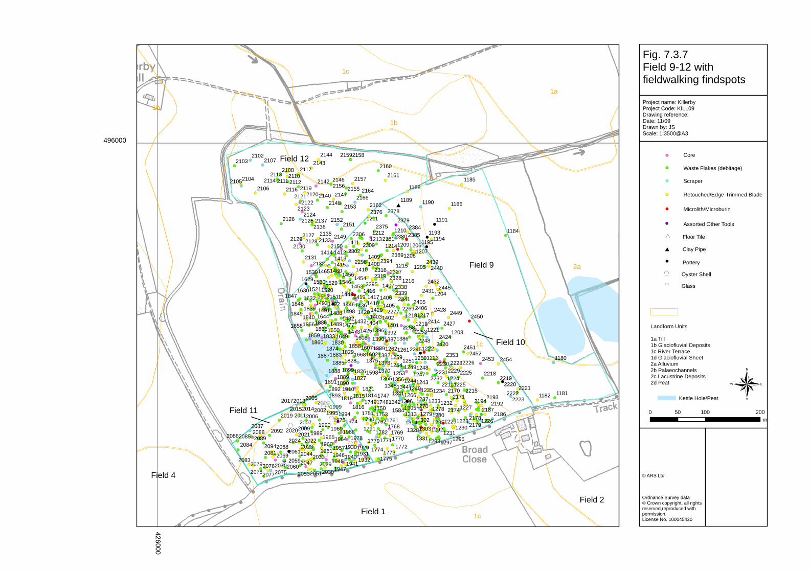
!(
!(!(
!(
!(#
!(
!(
!(
!(
!(!(
!(
!(
!(
!(!(!(
!(!(
!(
!(!(!(!(!(
!(
!(!(
!(
!( !(
!(
!(!(
!(
!(!(!(
!(!(!(!(!(!(
!(
!(
!(!(!(!(!(
!(
!(!(
!(!( !(!(
!(!( !(!(
!(
!(!(!(
!(!(!(!(
!(
!(!(
!(!(!(!(")
!(!(!(!(!(
!(!(!(
!(!(!(
!(!(
$+!(
!($+
!(!(!(!(
!(
!(
!(!(
!(!(
!(
!(
$+$+$+!($+!(
!(
!(
$+!(!(!(!(
!(!(
!(
!( !(!(
!(!(!(!(!($+
!(!(
!(!(
!(!(!(!(!(!(!(!(!(!(
!(!(
!(!(!(!(!(!(!(!(!(!(!(!(
!(!(!(!(!(
!(!(!(!(!(!( !(
!(!(!(!(
!(!(
!(!(!(!(
!(
!(
!(
!(
!(
!(!(
!(
!(
!(
!(
!(
!(
!(
!(
!(
!(
!(
!(
!(!(
!(
!(
!(
!(
!(!(!(!(
!(
!(
!(!(
!(
!(
!(!(
!(
!(
!(
!(!(!(
!(
!(
!(!(
!(
!(!( !(
!(
!(!(
!(
!(
!(
!(!(
!(
!(
!(!(
!(!(
!(!(
!(!(!(
!(!(!(
!(!(!(!(
!(!(!(!(
!(
!(
!(
!(
!(!(
!(!(!(
!(!(!(
!(!(!(!(
!(
!(!(!(
!(
!(!(
!(
!(!(!(
!(!(
!(!(!(!(!(!(!(
!(!(
!(!(
!(
!(!(!(
!(!(
!(!( !(
!(
!(!(!(!(
!(
!(!(!(
!(
!(!(!(
!(!(
!(
!(
!(
!(!(
!(!(
!(
!(
!(
!( !(!( !(!(!(!(
!(!(!(!(
!(
!(!(
!(!(!(
!(
!(!(!(
!(!(
!(!(!(!(!(
!(!(!(
!( !(
!(!(!(!(
!(!(
!(!(
!(
!(!(!(
!(
!(!(
!(!(
!( !(
!( !(
!(!(!(
!(!(!(!(
!(!(!(!(!(
!(!(!(!(!(!(!(!(
!(!(!(!(!(!(
!(!(
!(!(!(
!(!( !(!(!(!(!(!(
!(!(!(!(!(
!(!(!(!(
!(!(!(
!(
!( !(!( !(
!(!(
!( !(
!(!(
!(!(
!(!(!(!( !(
!(
!(
!(!(
!(!(
!(
!(!(
!(!(!(!(
!(!(
!(!(!(
!( !(
!(!(!(!( !(
!(
!(!(!(!(
!(!(!(
!( !(!(
!(!(!(!(
!(!(
!(!(
!(!(
!(!(!(
!(!(!(
!(!(!(!(
!(!(
!(!(
!(!(
!(!(!(
!(
!(!(
!(!(!(!(!( !(!(
!(!(!(!(
!(
!(!(
!(!(
!(!(!(
!(
!(!(!(
!(!( !(
!(
!(!(!(!(
!(!(!(!(
!(!(!(
!(
!(!(!(
!(!(!(!(!(
!(!(!(!(
!(
!(
!(
!(!(
!(!(!(!(
!(
!(!(!( !(!(
!(
!(!(!(!(
!(!(!(
!(!(!(
!(!(!(
!(
!(
!(!(
!(!(
!(!(!(
!( !(!(!(!(!(
!(!(!(
!(!(
!(
!(!(!(!(
!(
!(!(
!(
!(
!(!(!(
!(!(!(!(
!(
!(!(!(!(!(!(
!(
!(!(!(
!(!(!(
!(
!(!(
!(
!(
!(
!(
!(!(!(!(!(!(!(!(
!(!(!(!(!(!(!(
!(!(!(!(!(
!(
!(!(!(!(!(
!(!(
!(!(!( !(!(!(!(!(
!(!(!(!(!(!(!(
!(!(
!(!(!(!(!(
!(!(!(!(!(
!(
!(!(!(!(
!(!(!(
!(!(!(!(!(!(!(!(!(!(
!(!(
!(
!(!(
!(!(
!( !(!(!(
!(
!(!(
!(!(
!(!(!(!(
!(
!(
!(
!(!(
!(
!(!(!(!(!(!(!(!(!(
!(!(!(!(!(!(!(!(!(!(
!(!(!(!(
!(
!(!(
!(!(!(
!(!(!(!(
!(!(
!(!(!(!(!(!(!(!(!(!(
!(
!(!(
!(!(!(!(
!(!(!(!(!(!(!(!(!(!(!(
!(!(
!(!(!(!(!(
!(!(!( !(!(!(!(!(
!(!(!(!(!(!(
!(
!(!(!(!(
!(!(
!(!(!(!(!(
!(
!( !(!(!(!(!(!(
!(
!(!(!(!(!(!( !(
!(
!(!(!(!(!(!(!(
!(!(!(
!(!(
!(!(
!(!(!(
!(!(!( !(!(!(!( !(!(!(
!(!(
!(!(!( !(
!(!(!(
!(!(!(!(!(
!(
!(!(!(
!(
!(
!(!(!(
!(
!(
!(
!(
!(
!(
!(
!(!(!(
!(!(!(
!(!(!(
!(!(!(!(
!(!(!(!(!( !(
!(!(
!(!(!(!(
!(!(!(!(!(!(!(
!(!(!(
!(!(!(!(!(!(!(!(
!(!(!( !(!(!(!(
!(
!(!(!(!(
!(!(!(!(
!(!(!(!(!( !(!(!(
!(
!(
!(!(!(
!(!(!(!(!(!(!(
!(!(!(!(!(!(!(!(!(!(
!(
!(!(!(!(
!(!(!(
!(!(!(!(!(
!(!(!(!(
!(!(
!(!(!(!(!(!(!(!(!(!(!(!(
!(!(!(!(!(
!(!(!(!(!(
!(
!(!(
!(!(
!(!(!(
!(!(!(!(!(!(!(
!(
!(!(
!(
!(!(
!(!(!( !(!(!( !(
!(!(!(
!(!(!(!(
!(!(
!(!(!(!(
!(
!(
!(!(
!(
!(
!(
!(
!( !(
!(
!(
!(
!(
!(
!(
!(
!(!(!(
!(
!(
!(
!(
2a
1c
1c
1c
1b
1b
1b
1a
1180
11811182
1184
1185
1186
1188
1189 1190
1191
119311941195
19291930193119321940
19411946
19471948
195719601961
196419651968196919741975
19781989
1990
199419951999
20002002
2005
20062007
2009
2011
201320142015
2017
2019
20202021
20222023
2024
20292030
203320442047
20512053
20592060
206120682069
20702075
207620772078
2079
20812083
208420852086
208720882089
2092
2094
21022103
210421052106
2107
21082110
2111 21122113
21142116
2117
211921202121
21222123
212421252126
212721282129
2130
21312132
21332135
21362137
2140
2142
21432144
2146
21472148
2149
2150
21512152
2153
215521562157
21582159
2160
2161
2162
21642166
1203
1204
1205
12061207
1208
1209
1210
1211
12121213
1214
1215
1216
121712181219
1221
1222
1223
12241225
1226
1227
122812291230
1231
12321233
12341235
1237
124012431244
124712481249
12501251
125312541259
12611262
1266
1270 127812791280
12851292
129612971298
13021303
13051306
131313141328
1331
13411342
1344134513561365
1370137313751382
138613871389
1390139213961401
140214031404
14051406
1407
14081409
1410
1411
14121413
1414
1415
141614171418
1419
1420
1425
1429
1432
14361446
14481453
1454145614601465
147314771482
1488
1489
149114921493
1498
1511151315201521
15291530
1539
1546
1584
1598
16021607
1608
1629
16301632
1644
16491650
16581668
174717481749
17501751 1753
176117621768
176917701771
177217731774
1775
17791782
1790
1791
18141815
18161819
1821
18261827
18281829
18301833
1836
18391840
18461847
1849
18561858
18591860
1865
187418831885
1887
1888188918901891
18921893
1899
1910 21702171
217421782179
21862187
21922193
2194
22112215
22182219
22202221
22222223
2225
222622282229
22302231
2232
22452248
22532258
22692277
2295
2298
2302
2306
2309
23162319
23272328
233823392341
2353
2375
2376 2378
2379
23802381
23842385
23892394
24052406
2414
24202424
2427
2428
2431
2432
24392440
2445
2449 2450
24512452
2453 2454
Fig. 7.3.7Field 9-12 with fieldwalking findspots
Project name: KillerbyProject Code: KILL09Drawing reference: Date: 11/09Drawn by: JSScale: 1:3500@A3
© ARS Ltd
Ordnance Survey data© Crown copyright, all rights reserved,reproduced with permission.License No. 100045420
¬0 100 20050
m
496000
426000
Landform Units
1a Till1b Glaciofluvial Deposits1c River Terrace1d Glaciofluvial Sheet2a Alluvium2b Palaeochannels2c Lacustrine Deposits2d Peat
Assorted Other Tools
Retouched/Edge-Trimmed Blade
Waste Flakes (debitage)
Core
Microlith/Microburin
Scraper
!(
!(
!(
!(
!(
!(
Clay Pipe
Floor Tile
Pottery!(
#*
#
$+ Oyster Shell
") Glass
Field 9
Field 10
Field 11
Field 12
Field 4
Field 1Field 2
Kettle Hole/Peat


