

Appendix H TU MSHCP Traffic Study

DRAFT
TEHACHAPI UPLANDS MULTIPLE SPECIES HABITAT CONSERVATION PLAN
Traffic Study
Prepared by:
Austin-Foust Associates, Inc. 2223 Wellington Avenue, Suite 300 Santa Ana, California 92701-3161
(714) 667-0496
October 7, 2011

Tehachapi Uplands Multiple Species Habitat Conservation Plan ii Austin-Foust Associates, Inc. Traffic Study 393004rpt.doc
CONTENTS Page 1.0 INTRODUCTION 1.1 Overview ................................................................................................................................. 1-1 1.2 Highway Analysis Methodology ............................................................................................. 1-3 1.3 Traffic Forecast ....................................................................................................................... 1-7 1.4 Cumulative Analysis ............................................................................................................... 1-7 2.0 ALTERNATIVES ANALYZED 2.1 Overview ................................................................................................................................. 2-1 2.1.1 No Action Alternative .................................................................................................... 2-1 2.1.2 Proposed MSHCP Alternative ....................................................................................... 2-1 2.1.3 Condor HCP Alternative ................................................................................................ 2-3 2.1.4 Kern County General Plan Buildout Alternative ........................................................... 2-4 2.1.5 Condor Critical Habitat Avoidance MSHCP Alternative .............................................. 2-4 2.2 Trip Generation ....................................................................................................................... 2-7 2.3 Trip Distribution ................................................................................................................... 2-11 3.0 IMPACT ANALYSIS 3.1 Existing Conditions ................................................................................................................. 3-1 3.2 Existing Plus Project Conditions ............................................................................................. 3-1 3.3 2030 Impact Analysis .............................................................................................................. 3-4 3.4 2030 Vehicle Miles Traveled (VMT) ..................................................................................... 3-6
Tehachapi Uplands Multiple Species Habitat Conservation Plan iii Austin-Foust Associates, Inc. Traffic Study 393004rpt.doc
LIST OF FIGURES Page 1-1 Plan Area ....................................................................................................................................... 1-4 1-2 Level of Service Classifications for Interstate 5 (I-5) .................................................................... 1-5 1-3 KCTM & EAVTAM Subareas .................................................................................................... 1-12 2-1 Proposed MSHCP and Condor HCP Alternatives Land Use Designations .................................. 2-5 2-2 Kern County General Plan Buildout Alternative Land Use Designations .................................... 2-6 2-3 Condor Critical Habitat Avoidance MSHCP Alternative Land Use Designations ....................... 2-8

Tehachapi Uplands Multiple Species Habitat Conservation Plan iv Austin-Foust Associates, Inc. Traffic Study 393004rpt.doc
LIST OF TABLES
Page 1-1 Highway AADT Capacity Calculations ........................................................................................ 1-6 1-2 Cumulative Projects ....................................................................................................................... 1-8 1-3 Demographic Data Summary ...................................................................................................... 1-11 2-1 Summary of Alternatives ............................................................................................................... 2-2 2-2 Proposed MSHCP and Condor HCP Alternatives Trip Generation .............................................. 2-9 2-3 Kern County General Plan Buildout Alternative Trip Generation .............................................. 2-10 2-4 Condor Critical Habitat Avoidance MSHCP Alternative Trip Generation ................................. 2-12 2-5 Trip Distribution Summary .......................................................................................................... 2-13 2-6 Trip Distribution Summary – No Centennial Project .................................................................. 2-14 3-1 Freeway Volumes, Capacities and V/C Summary - Existing ........................................................ 3-2 3-2 Freeway Volumes, Capacities and V/C Summary – Existing Plus Project ................................... 3-3 3-3 2030 Freeway Volumes, Capacities and V/C Summary ................................................................ 3-5 3-4 2030 Vehicle Miles Traveled (VMT) ............................................................................................ 3-7

Tehachapi Uplands Multiple Species Habitat Conservation Plan 1-1 Austin-Foust Associates, Inc. Traffic Study 393004rpt.doc
1.0 INTRODUCTION
This report describes the results of a traffic analysis carried out for the proposed Tehachapi
Uplands Multiple Species Habitat Conservation Plan in unincorporated Kern County. The purpose of the
study is to serve as a technical source for the project’s Environmental Impact Statement (EIS).
1.1 OVERVIEW
Tejon Ranchcorp (TRC) has developed the proposed Tehachapi Uplands Multiple Species
Habitat Conservation Plan (MSHCP) to meet the requirements of an incidental take permit (ITP). The
MSHCP was developed for long-term protection and conservation of habitat for the Covered Species.
The permit would cover 141,886 acres of the 270,365 acre Tejon Ranch located in Kern County
and is hereby referred to in this report as the “Covered Lands”. Activities that would be covered by the
permit include ongoing Ranch operations (excluding hunting and mineral extraction) and planned future
community developments within and adjacent to the Interstate 5 (I-5) corridor in two development areas:
TMV Planning Area and the Lebec/Existing Headquarters Area.
The proposed MSHCP includes a comprehensive, permanent land preservation and developed
program for the Covered Lands. Four alternatives are considered in this traffic analysis:
No Action Alternative - assumes that the issuance of an ITP would not occur and that
the Ranchwide Agreement remains in effect, that development of the TMV project and
other future commercial and residential development allowed within the Covered Lands
would not occur and that current existing ranch uses would continue at current levels into
the future.
Proposed MSHCP Alternative - assumes that a 50-year ITP would be issued for all
Covered Species and Plan-Wide Activities (generally consisting of existing ranch uses),
as well as implementation of the Ranchwide Agreement would occur on the Covered
Lands. Development would occur adjacent to the I-5 corridor (i.e., the TMV Planning
Area and the Lebec/Existing Headquarters Area). The development of the TMV
Planning Area would include approximately 3,624 dwelling units and up to 1,264,920
square feet of commercial development. The development of the Lebec/Existing
Tehachapi Uplands Multiple Species Habitat Conservation Plan 1-2 Austin-Foust Associates, Inc. Traffic Study 393004rpt.doc
Headquarters Area would include up to eight dwelling units and 1,339,470 square feet of
commercial development. The total development of both the TMV Planning Area and
Lebec/Existing Headquarters Area would be 3,632 dwelling units and 2,604,390 square
feet of commercial development.
Condor HCP Alternative – assumes the same development scenario as the Proposed
MSHCP Alternative, but a 50-year ITP would be issued covering only the California
condor. This alternative would include California condor conservation measures, but
would not include conservation measures for any other Covered Species.
Kern County General Plan Buildout Alternative - assumes development to proceed in
accordance to the Kern County General Plan including implementation of the TMV
project. Development would occur on a project-by-project basis and in total would
include 7,238 dwelling units and 2,944,810 square feet of commercial development.
Existing ranch uses would also continue under this alternative.
Condor Critical Habitat Avoidance MSHCP Alternative - assumes that a 50-year ITP
would be issued for all Covered Species and Plan-Wide Activities (generally consisting
of existing ranch uses), as well as implementation of the Ranchwide Agreement would
occur on the Covered Lands. This alternative assumes no commercial or residential
development within any designated critical habitat for the California condor. It would
not include the TMV project, but it would follow the Kern County current General Plan
designations and cluster most commercial and residential development in the
southwestern portion of the Covered Lands in the portion of the TMV Planning Area near
I-5, including West of the Freeway, in areas outside condor critical habitat. Development
would also include the Lebec/Existing Headquarters Area, which in not within condor
critical habitat. In total this alternative would allow for 3,161 dwelling units and
2,604,390 square feet of commercial development.
Each alternative is further described in Chapter 2.0 of this traffic report. This traffic study
identifies potential impacts associated with the MSHCP and its alternatives.

Tehachapi Uplands Multiple Species Habitat Conservation Plan 1-3 Austin-Foust Associates, Inc. Traffic Study 393004rpt.doc
1.2 HIGHWAY ANALYSIS METHODOLOGY
The plan area for this analysis is illustrated in Figure 1-1. It defines the area that would be
covered by the MSHCP and for which different land uses are analyzed here.
The study area is defined according to facilities that are measurably impacted by the project based
on the performance criteria outlined in this chapter. It comprises northern and southern regional areas and
incorporates areas covered by the cumulative projects considered in Chapter 4 of the Supplemental Draft
EIS. The northern regional area is in Kern County and the southern regional area is in the northwest part
of Los Angeles County. The analysis focuses on State Highway segments, specifically Interstate 5 (I-5)
and State Route 138 (SR-138).
In traffic impact studies, impact criteria are based on two primary measures. The first is
“capacity,” which establishes the vehicle carrying ability of a road segment, and the second is “volume.”
The volume measure is either a traffic count (in the case of existing volumes) or a traffic forecast for a
future point in time. The ratio between the volume and the capacity gives a volume/capacity (V/C) ratio,
and based on that V/C ratio, a corresponding level of service (LOS) is defined.
Traffic LOS is designated A through F, with LOS A representing free flow conditions and LOS F
representing severe traffic congestion. The impact analysis for freeway mainline segments is based on
annual average daily traffic (AADT) two-way volumes. It should be noted that V/C methodology does
not account for operational effects such as upstream queuing from a downstream bottleneck. Under such
conditions, a freeway segment may be congested (in terms of travel speed) even though the segment itself
has adequate capacity for the demand.
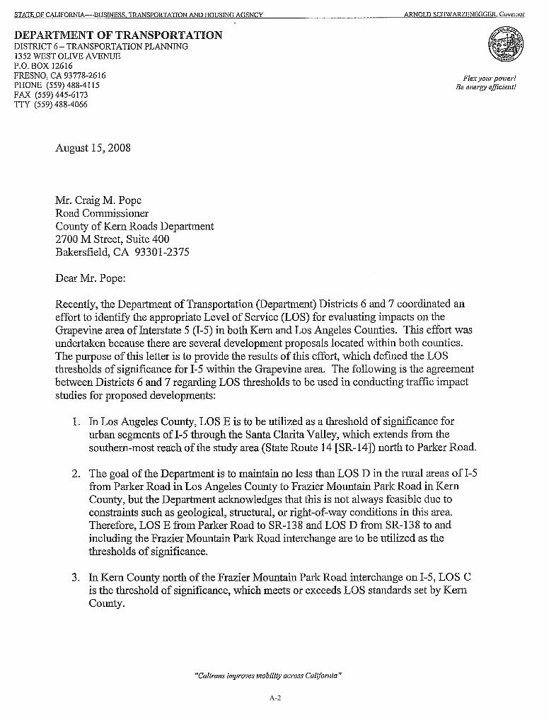
For the I-5 freeway, there are different allowable levels of service (LOS) depending on the
segment location. The LOS “C”, “D” and “E” segments are illustrated in Figure 1-2. These are the LOS
designations specified by Caltrans for this section of I-5 (see letter of 8/15/08 in Appendix A). For this
analysis, an AADT equivalent capacity was calculated based on peak hour capacities that have been used
in previous EIR’s such as certified for the TMV project. The derived volumes are shown in Table 1-1.
This converts the hourly capacity to an AADT equivalent at the allowable LOS. A volume/capacity over
1.00 is considered a capacity deficiency for the purpose of this analysis.
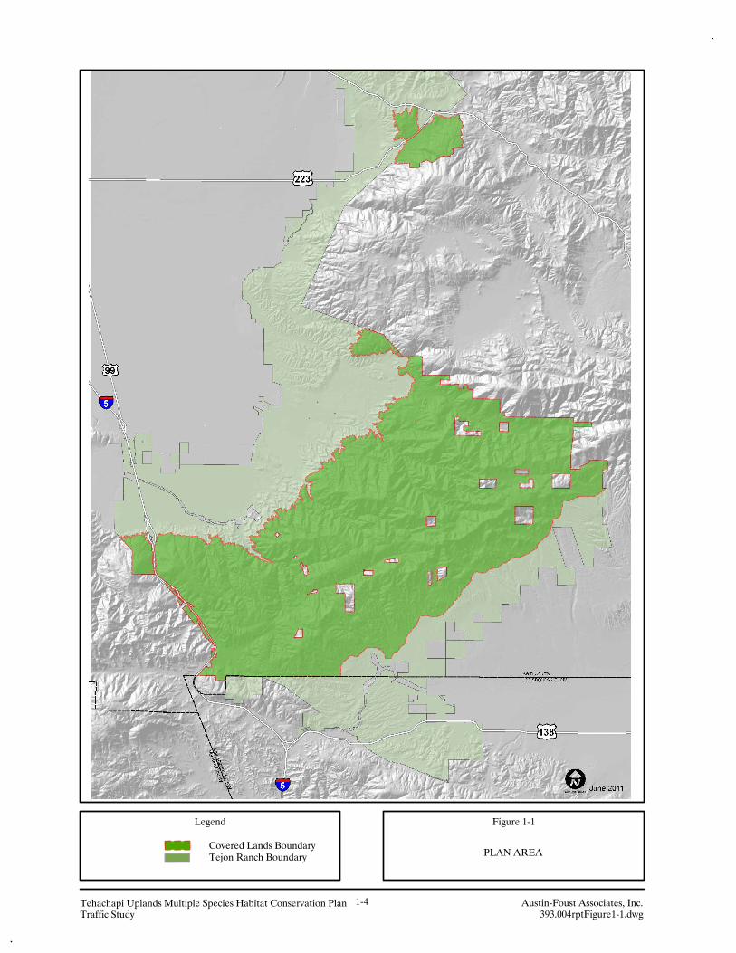
Legend
Tejon Ranch Boundary
Austin-Foust Associates, Inc.393.004rptFigure1-1.dwg
Tehachapi Uplands Multiple Species Habitat Conservation PlanTraffic Study
1-4
PLAN AREA
Figure 1-1
Covered Lands Boundary

5
14
126
138
58
5
14
118
BAKERSFIELD
223
58
405
58
14
99
TEHACHAPI
184
119
Covered Lands
14
Legend
Austin-Foust Associates, Inc.393004rptFigure1-2.dwg
Tehachapi Uplands Multiple Species Habitat Conservation PlanTraffic Study
1-5
Figure 1-2
LEVEL OF SERVICE CLASSIFICATIONSFOR INTERSTATE 5 (I-5)
Allowable LOS "D"Allowable LOS "E"
Allowable LOS "C"
Tejon RanchBoundaryCovered Lands

Tehachapi Uplands Multiple Species Habitat Conservation Plan 1-6 Austin-Foust Associates, Inc. Traffic Study 393004rpt.doc
Table 1-1
HIGHWAY AADT CAPACITY CALCULATIONS
Location
Maximum Allowable AADT/Peak Hour Ratio1
AADT Capacity
Equivalent** LOS* Peak Hour Capacity1
EXISTING Kern County I-5 s/o Fort Tejon IC C 5,332 27.3 145,564 Los Angeles County I-5 s/o Gorman Road IC D 6,462 28.8 186,1606 I-5 s/o SR-138 IC E 5,952 30.1 179,155 SR–138 e/o “A” ST IC E 1,700 21.2 36,040
2030 FORECAST
Kern County I-5 s/o Fort Tejon IC C 6,272 26.7 168,090 Los Angeles County I-5 s/o Gorman Road IC D 6,620 30.8 203,896 I-5 s/o SR-138 IC E 6,268 29.3 183,652 SR–138 e/o “A” ST IC E 3,962 18.8 74,486
Note: * See Figure 1-2 for LOS area definitions ** Two direction AADT capacity. At allowable LOS, a V/C over 1.00 is considered a capacity
deficiency in this analysis. 1 One direction hourly capacity as reported in the TMV Project Traffic Study, October 2009. Abbreviations:
AADT – Annual Average Daily Traffic LOS – Level of Service
Tehachapi Uplands Multiple Species Habitat Conservation Plan 1-7 Austin-Foust Associates, Inc. Traffic Study 393004rpt.doc
For SR-138, the AADT equivalent capacity assumes that SR-138 will be widened from its
existing 2 lanes to 4 lanes west of and within the proposed Centennial Project Area (i.e., it is considered
to be a design feature of the Centennial Project). If the proposed Centennial Project is not built, the SR-
138 will remain at its existing 2 lanes unless other funding sources or programs implement the widening.
1.3 TRAFFIC FORECASTS
The traffic forecasts for the I-5 freeway used in this traffic study have been prepared using information
from the TMV Project Traffic Study (October 2009). The TMV Project Traffic Study uses information
from two primary sources. The first is the traffic model maintained by the Kern County Council of
Governments (KernCOG) and referred to here as the Kern County Traffic Model (KCTM). The year
2030 cumulative version of the model was used to estimate with and without project volumes on the
Countywide transportation system, and the resulting data formed the basis for the northern regional study
area traffic forecasts.
The second set of data used is from the East Antelope Valley Traffic Analysis Model
(EAVTAM). This model includes all of Los Angeles County plus south Kern County and was used to
provide information regarding project trips in the southern regional study area, which is in northwest Los
Angeles County.
The cumulative projects and demographic growth projections that are assumed in the 2030 traffic
forecasts and are used in this analysis as 2030 baseline conditions are discussed in the following section.
1.4 CUMULATIVE ANALYSIS
This traffic analysis uses a “long-range projections” approach to cumulative growth. This uses
demographic and related traffic forecasts for a horizon year (2030) in which all anticipated growth by that
year is accounted for. It offers a more comprehensive analysis framework than simply adding a list of
cumulative projects to an existing Baseline condition. Growth projections used in the long-range analysis
include current development projects and development applications, such as the proposed Frazier Park
Estates and Centennial projects, plus other anticipated growth, consistent with the Countywide General
Plan.
To illustrate how the 2030 forecasts presented in this report represent a long-range cumulative
transportation setting, Table 1-2 contains a list of cumulative projects. The Kern County area accounts

Tehachapi Uplands Multiple Species Habitat Conservation Plan 1-8 Austin-Foust Associates, Inc. Traffic Study 393004rpt.doc
Table 1-2
CUMULATIVE PROJECTS
Location Development Name Description DU TSF or Acres KERN COUNTY BLH Development, LLC East of I-5 near Kern Co/LA Co Border 33 DU -- CAL Cart/WZI Nec Frazier Mtn Park Rd & Cuddy Cyn
Rd -- 35 Acres
Frazier Park/Lebec Specific Plan Frazier Mountain Park 643 DU** 148 Acres Frazier Park Estates/Cornerstone Frazier Mountain Park Road 662 DU
41 DU 140 TSF
5.59 Acres
Galonska, Siegfried\Christine by French & Assoc
Frazier Mtn Park 3/4 mile east of Mt Pinos
-- 145.2 TSF
Goertzen, Vernon 4358 Laval Rd, Arvin -- 5 Acres Hallmark, Doug and Lori by Pinnacle Engineering
Castaic View Road Lebec 5 DU --
Johnson, Harold and Rosalie/French & Assoc
W/S I-5 IN SE/4 -- 196.8 TSF
Martin Bros Dev Inc/Richard Aldrich Grand Terrace Dr & Frazier Mtn Park 4 DU -- Martin, Curtis by Nelms Surveying Hayride Road, east of I-5 Lebec 7 DU -- Mettler Water District Route 99 W. Mettler Frontage Rd -- 12.3 TSF O-Neil Canyon Specific Plan Lebec W of I-5 388 DU*** 60 Acres
Commercial Schafer, Richard & Judy by French & Assocs.
Tecuya Rd and Woods Dr 4 DU --
Tejon Industrial Complex West West of I-5 between Wheeler Ridge and Grape Vine
-- 7,000 TSF Logistics*
Tejon Industrial Complex East East of I-5 near Laval Rd -- 7,000 TSF LogisticsWheeler Ridge Farms, LLC 35 Miles S. Bak. West of I-5 & Laval -- 690 Acres Subtotal 1,830 DU 14,490 TSF &
938 Acres LOS ANGELES COUNTY Centennial NW portion of the Antelope Valley in
unincorporated portion of L.A. County. Southern Boundary of Kern County
22,998 DU 2,021 TSF Commercial
Total of 12,485 TSF of employment generating uses.
Gorman Post Ranch South of Kern County Border in Unincorporated Los Angeles County
533 DU --
Project NO: 02-232 Lancaster RD 1851 SF lots, 15 MF lots
--
Project NO: 04-207 South of Quail Valley Road 28 SF lots -- Project NO: TR062053 Gorman Post Rd north of
Hwy 138 e/o I-5 191 SF lots --
Project NO: TR066561 28718 San Francisquito Canyon Road 583 DU -- (Cont.)

Tehachapi Uplands Multiple Species Habitat Conservation Plan 1-9 Austin-Foust Associates, Inc. Traffic Study 393004rpt.doc
Table 1-2 (cont.) CUMULATIVE PROJECTS
Location Development Name Description DU TSF or Acres LOS ANGELES COUNTY Project NO: TR066561 N/A 33 SF lots -- Project NO: TR067278 28701 Sloan Canyon Rd 28 SF lots -- Project NO: TR067617 N/A 13 DU -- Project NO: TR51644-R1 N/A 713 SF lots -- Northlake N/A 1051 MF lots
645 SF lots --
Newhall Ranch West of I-5, along SR-126 corridor 20,885 DU 5,550 TSF Subtotal 49,567 DU 18,035 TSF
* Partially built
** 173 Dwelling Units from Frazier Park/Lebec Specific Plan are within the Covered Lands boundary.
*** 5 Dwelling Units from O’Neil Canyon Specific Plan are within the Covered Lands boundary,
DU – dwelling unit
SF – single family
MF – multi-family
TSF – thousand square feet of floor area

Tehachapi Uplands Multiple Species Habitat Conservation Plan 1-10 Austin-Foust Associates, Inc. Traffic Study 393004rpt.doc
for 1,830 dwelling units (DU), 14,490 thousand square feet (TSF) of building area, and 938 acres of other
non-residential development (commercial and other such land uses). The Los Angeles area accounts for
49,567 DU and 18,035 TSF of development. The anticipated growth from these projects plus other
growth in the region is accounted for in the models.
Table 1-3 gives a summary of existing and future population and employment for a set of
subareas in the surrounding region that includes Los Angeles County (see subarea map in Figure 1-3).
Unincorporated West Los Angeles, Santa Clarita and Lancaster areas (locations noted in the cumulative
projects list) anticipate approximately a 150,371 increase in dwelling units by 2030. This increase
accommodates the 49,567 DU anticipated growth listed in the cumulative projects lists and accommodate
other projects in LA County not listed in the previously referenced list of cumulative projects.

Tehachapi Uplands Multiple Species Habitat Conservation Plan 1-11 Austin-Foust Associates, Inc. Traffic Study 393004rpt.doc
Table 1-3
DEMOGRAPHIC DATA SUMMARY
Dwelling Units Population Employment Increase Increase Increase Subarea1 2000 2030 (%) 2000 2030 (%) 2000 2030 (%) 1. West LA Co. Unincorporated 2,711 3,935 45.1 6,860 9,802 42.9 1,256 1,674 33.3 2. Palmdale Planning Area 37,977 63,306 66.7 130,246 216,940 66.6 19,056 25,649 34.6 3. Lancaster Planning Area 41,689 94,824 127.5 130,546 303,932 132.8 37,643 96,541 156.5 4. Kern County (East) 59,662 148,999 149.7 155,952 367,784 135.8 56,471 114,615 103.0 5. Kern County (West)2 167,321 330,455 97.5 504,048 964,082 91.3 212,501 456,727 114.9 6. Los Angeles County (south) 3,005,968 3,671,830 22.2 8,977,404 10,871,824 21.1 3,973,652 4,968,876 25.0 7. Orange County 900,730 1,068,036 18.6 2,846,289 3,391,249 19.1 1,385,976 2,043,673 47.5 8. Riverside County 516,812 898,272 73.8 1,545,387 2,697,634 74.6 476,882 990,283 107.7 9. San Bernardino County 444,933 692,785 55.7 1,378,747 2,144,979 55.6 430,437 920,727 113.9 10. Ventura County 250,385 309,210 23.5 753,197 936,013 24.3 286,418 431,499 50.7 11. Victor Valley (RSA 32) 69,493 112,327 61.6 214,946 346,915 61.4 42,841 91,714 114.1 12. Barstow (RSA 31) 37,419 60,484 61.6 115,740 186,801 61.4 23,068 49,384 114.1 13. Santa Clarita (RSA 8)3 48,765 144,777 196.9 156,536 464,734 196.9 71,965 250,496 248.1 14. Angeles Forest (LACO) 2,228 3,073 37.9 4,734 6,422 35.7 4,449 5,882 32.2 15. East LA Co. Unincorporated 13,687 19,736 44.2 40,602 57,369 41.3 7,116 9,611 35.1 TOTAL 5,599,780 7,622,048 36.1 16,961,234 22,966,480 35.4 7,029,731 10,424,352 48.3 1See Figure 1-3 for the boundaries of the subareas located within North Los Angeles County, Kern County and West San Bernardino County. 2 EAVTAM2 data augmented to account for Tejon Industrial Complex (2030). 3 Data from the SCVCTM has been substituted in the EAVTAM2 model for the Santa Clarita Valley area. Source: EAVTAM2 (except for Kern County and the Santa Clarita Valley as noted above)

5
14
126
138
99
58
5
14
15
138
KCTM & EAVTAM SUBAREAS
Figure 1-3
Austin-Foust Associates, Inc.393004rptFigure1-3.dwg
1-12Tehachapi Uplands Multiple Species Habitat Conservation PlanTraffic Study
58
101
Covered Lands
Tehachapi Uplands Multiple Species Habitat Conservation Plan 2-1 Austin-Foust Associates, Inc. Traffic Study 393004rpt.doc
2.0 ALTERNATIVES ANALYZED This chapter describes the traffic characteristics of the MSHCP and its alternatives. Trip
generation is estimated based on the development activities that would be covered by the MSHCP and the
travel patterns from those development activities in relation to the regional study area are described.
2.1 OVERVIEW
The following section summarizes the major components of each of the alternatives including the
No Action Alternative, Proposed MSHCP Alternative, Condor HCP Alternative and Kern County
General Plan Buildout Alternative. Table 2-1 summarizes the land uses in the project area for the
alternatives analyzed, and the following discusses the key characteristics of each alternative.
2.1.1 No Action Alternative
This alternative assumes that an incidental take permit (ITP) would not be issued and that
development of the TMV project and other future commercial or residential development allowed within
the Covered Lands under the Ranchwide Agreement would not occur. Current existing ranch uses would
continue at current levels into the future and include: livestock grazing, fuel management, filming,
passive recreation (including existing hunting program), faming and irrigation systems, repair and
maintenance and use of roads, maintenance of utilities, back country cabins, ancillary ranch structures and
fencing.
2.1.2 Proposed MSHCP Alternative
The Proposed MSHCP Alternative assumes that a 50-year ITP would be issued for all Covered
Species, and Plan-Wide Activities (generally the same as the existing ranch uses previously mentioned in
the No Action Alternative), as well as implementation of the Ranchwide Agreement would occur on the
Covered Lands. No development would occur within the Condor Study Area and in total, approximately
129,318 acres of the 141,886 acres of Covered Lands would be permanently preserved as open space
under this alternative.

Tehachapi Uplands Multiple Species Habitat Conservation Plan 2-2 Austin-Foust Associates, Inc. Traffic Study 393004rpt.doc
Table 2-1
SUMMARY OF ALTERNATIVES
Location
Proposed MSHCP and Condor HCP
Alternatives
Kern County GP Buildout
Alternative
Condor Critical Habitat Avoidance
MSHCP Alternative
DU SF DU SF DU SF
TMV Planning Area Specific Plan Area (TMV Project) 3,450 960,000** 3,450 960,000** 2,979 960,000**
West of Freeway: Frazier Park 173 217,800 173 217,800 173 217,800
O’Neil Canyon -- 87,120 -- 87,120 -- 87,120 Other (Extensive Agriculture) 1 -- 1 -- 1 --
Oso Canyon -- -- 160 49,005 -- ---
TMV Planning Area Subtotal 3,624 1,264,920 3,784 1,313,925 3,153 1,264,920
Lebec/Existing Headquarters Area O’Neil Canyon 5 577,170 5 577,170 5 577,170
Specific Plan Required -- 762,300 -- 762,300 -- 762,300 Resource Management 3 -- 3 -- 3 --
Lebec/Existing Headquarters Area Subtotal 8 1,339,470 8 1,339,470 8 1,339,470
Other Areas Other Lands* -- -- 3,446 291,415 -- --
TOTAL 3,632 2,604,390 7,238 2,944,810 3,161 2,604,390TOTAL Development Disturbance
(Acreage) 5,533 12,142 4,496
Notes: * - Dwelling Units and Commercial SF is scattered throughout Covered Lands.
See Figure 3-2 for Land Use designations and locations: 4.3 Specific Plan Required 8.2 Resource Reserve (1du/20acres and 1du/80acres) 8.3 Extensive Agriculture (1du/20acres and 1du/80acres) 8.5 Resource Management (1du/20acres and 1du/80acres) ** - Commercial SF consists of 160,000 SF of retail, 750 hotel rooms (450,000 SF),
and 350,000 SF of support services.
Tehachapi Uplands Multiple Species Habitat Conservation Plan 2-3 Austin-Foust Associates, Inc. Traffic Study 393004rpt.doc
Development would occur in two locations that are adjacent to the I-5 Corridor, the TMV
Planning Area and the Lebec/Existing Headquarters Area. The total amount of Covered Activity
development that would occur in both areas under the Proposed MSHCP Alternative includes 3,632
dwelling units and 2,604,390 square feet of commercial development with a disturbance area of
approximately 5,533 acres.
The TMV Planning Area includes the TMV Specific Plan Area, Oso Canyon, and an area referred
to in this analysis as West of the Freeway. Together the development in the TMV Planning Area would
total approximately 3,624 dwelling units and up to 1,264,920 square feet of commercial development
within the disturbance area of approximately 5,252 acres.
The total development in this area is broken out as follows. The TMV project is located east of
the I-5 Freeway in the TMV Planning Area and was approved by Kern County, with the Specific Plan and
corresponding General Plan Amendments and an Environmental Impact Report in October of 2009. The
TMV Project includes 3,450 dwelling units, 160,000 square feet of commercial retail, 750 hotel rooms,
which translate to approximately 450,000 square feet, and up to 350,000 square feet of support uses (e.g.,
hotel lobby support services, food and beverage service, golf clubhouses, equestrian facilities and private
recreation facilities). This gives a total of approximately 960,000 square feet of commercial in the TMV
Project Area. In the West of the Freeway, there are approximately 174 dwelling units and 304,920 square
feet of commercial development.
Although no development plans currently exists for the 410-acre Lebec/Existing Headquarters
Area, the Proposed MSHCP Alternative proposes development consistent with the current General Plan
designation that allows up to eight dwelling units and 1,339,470 square feet of commercial development.
Five of the eight dwelling units and 577,170 square feet of the 1,339,470 square feet of commercial are
located within the O’Neil Canyon Area.
2.1.3 Condor HCP Alternative
The Condor HCP Alternative assumes that a 50-year ITP would be issued for only the California
condor. This would include California condor conservation measures, but would not include conservation
measures for any other Covered Species. This alternative assumes implementation of the Ranchwide
Agreement and development, open space preservation, and Plan-Wide Activities. Land uses in this
project area for this alternative would be the same as the Proposed MSHCP Alternative.

Tehachapi Uplands Multiple Species Habitat Conservation Plan 2-4 Austin-Foust Associates, Inc. Traffic Study 393004rpt.doc
Figure 2-1 shows the Proposed MSHCP Alternative and Condor HCP Alternative land use
allocation.
2.1.4 Kern County General Plan Buildout Alternative
The Kern County General Plan Buildout Alternative assumes implementation of the TMV project
as approved in the Specific Plan and EIR. Development on the Covered Land would require Kern County
approval and would proceed on a project-by-project basis. This alternative includes 34,130 acres of open
space. With respect to development, in total this alternative assumes 7,238 dwelling units and 2,944,810
square feet of commercial development within 12,142 acres of disturbance areas. Approximately 53 of the
7,238 dwelling units are located near State Route 223.
Existing ranch uses are the same as for the No Action Alternative. Figure 2-2 shows the Kern
County General Plan land use allocations.
2.1.5 Condor Critical Habitat Avoidance MSHCP Alternative
The Condor Critical Habitat Voidance MSHCP Alternative assumes that a 50-year ITP would be
issued for all Covered Species, and Plan-Wide Activities (generally the same as the existing ranch uses
previously mentioned in the No Action Alternative). This alternative assumes no commercial or
residential development within any designated critical habitat for the California condor. It also assumes
implementation of the Ranchwide Agreement, so the development boundaries outside critical habitat
conform to the development setbacks and general boundaries provided in that agreement.
This alternative does not include the TMV project, as the TMV project extends into critical
habitat. Instead it would follow the Kern County current General Plan designations and cluster most
commercial and residential development in the southwestern portion of the Covered Lands in the portion
of the TMV Planning Area near I-5, including West of Freeway, in areas outside condor critical habitat.
Development would also include the Lebec/Existing Headquarters Area, which is not within condor
critical habitat.
Development under the Condor Critical Habitat Avoidance MSHCP Alternative would be
consolidated onto the southwestern portion of the Covered Lands, near I-5 that are not within condor
critical habitat. In the TMV Planning Area, this alternative would allow up to 2,979 dwelling units and
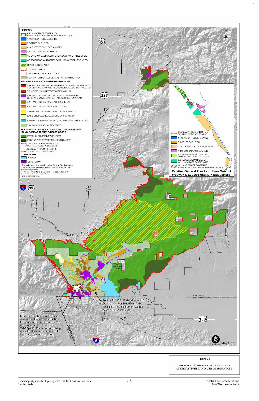
Figure 2-1
PROPOSED MSHCP AND CONDOR HCPALTERNATIVES LAND USE DESIGNATONS
Austin-Foust Associates, Inc.Traffic Study Tehachapi Uplands Multiple Species Habitat Conservation Plan 2-5
393.004rptFigure2-1.dwg

Figure 2-2
KERN COUNTY GENERAL PLAN BUILDOUTALTERNATIVE LAND USE DESIGNATONS
Austin-Foust Associates, Inc.Traffic Study Tehachapi Uplands Multiple Species Habitat Conservation Plan 2-6
393.004rptFigure2-5.dwg

Tehachapi Uplands Multiple Species Habitat Conservation Plan 2-7 Austin-Foust Associates, Inc. Traffic Study 393004rpt.doc
960,000 square feet of commercial development (same as the commercial development in the Proposed
MSHCP Alternative for the TMV Planning Area). West of the Freeway and Lebec/Existing Headquarters
Areas, this alternative would allow up to 182 dwelling units and 1,337,470 square feet of commercial
development. In total, this alternative allows up to 3,161 dwelling units and 2,604,390 square feet of
commercial development to be built within a 4,496-acre disturbance area.
Figure 2-3 shows the Proposed MSHCP Alternative and Condor HCP Alternative land use
allocation.
2.2 TRIP GENERATION
A summary of the land use and trip generation for the Proposed MSHCP Alternative and Condor
HCP Alternative can be seen in Table 2-2. Listed in this table are the individual land uses, together with
annual average daily traffic (AADT) trip generation for each. Listed at the bottom of the table are trip
generation rates for the land uses that have been derived using published sources such as the Institute of
Transportation Engineers (ITE) Trip Generation Manual (8th Edition).
For trip generation purposes, all Commercial uses outside of the TMV project are assumed to
have a 20/80 percent split between Retail and Office uses respectively. Hence the 1,644,390 square feet
of Commercial referred to here as “Non-TMV Commercial” has the following assumptions for the
Proposed MSHCP Alternative:
60,984 square feet of Retail and 243,936 square feet of Office west of the I-5 Freeway.
267,894 square feet of Retail and 1,071,576 square feet of Office in the Lebec/Existing
Headquarters Area.
A summary of the land use and trip generation for the Kern County General Plan Buildout
Alternative is shown in Table 2-3. Similar to the Proposed MSHCP Alternative, a 20/80 split between
Retail and Office uses respectively was assumed for Commercial outside of the TMV project for trip
generation purposes. Hence the 1,984,810 square feet of Commercial referred to as “Non-TMV
Commercial” has the following assumptions for the Kern County General Plan Buildout Alternative:

Figure 2-3
CONDOR CRITICAL HABITAT AVOIDANCEALTERNATIVE LAND USE DESIGNATONS
Austin-Foust Associates, Inc.Traffic Study Tehachapi Uplands Multiple Species Habitat Conservation Plan 2-8
393.004rptFigure2-3.dwg

Tehachapi Uplands Multiple Species Habitat Conservation Plan 2-9 Austin-Foust Associates, Inc. Traffic Study 393004rpt.doc
Table 2-2
PROPOSED MSHCP & CONDOR HCP ALTERNATIVES
TRIP GENERATION
Units Amount AADT Land Use Category
TMV Project Single Family Residential DU 3,050 29,189 Multi-Family Residential DU 400 2,660 TMV Commercial (Retail & Hotel) * SF 610,000 15,346 TMV Support Services * SF 350,000 1,971 TMV Project Subtotal 49,166
West of Freeway and Lebec/Existing Headquarters Area Single Family Residential DU 182 1,742 Non-TMV Retail SF 328,878 14,122 Non-TMV Office SF 1,315,512 14,484 Non-TMV Project Subtotal 30,348
TOTAL 79,514
Trip Rates
Single Family Residential (ITE 210) DU 9.57
Multi-Family Residential (ITE 220) DU 6.65
Non-TMV Retail (ITE 820) TSF 42.94 Non-TMV Office (ITE 710) TSF 11.01
Notes: * - From TMV Project Traffic Study ITE – Institute of Transportation Engineers 8th Ed. TSF – Thousand square feet of floor area

Tehachapi Uplands Multiple Species Habitat Conservation Plan 2-10 Austin-Foust Associates, Inc. Traffic Study 393004rpt.doc
Table 2-3
KERN COUNTY GENERAL PLAN BUILDOUT ALTERNATIVE
TRIP GENERATION
Units Amount AADT Land Use Category
TMV Project Single Family Residential DU 3,050 29,189 Multi-Family Residential DU 400 2,660 TMV Commercial (Retail & Hotel) * SF 610,000 15,346 TMV Support Services * SF 350,000 1,971 TMV Project Subtotal 49,166
West of Freeway, Lebec/Existing Headquarters Area and Other Lands Single Family Residential DU 3,788 36,251
Non-TMV Retail SF 396,962 17,046
Non-TMV Office SF 1,587,848 17,482
Non-TMV Project Subtotal 70,779
TOTAL 119,945
Trip Rates
Single Family Residential (ITE 210) DU 9.57
Multi-Family Residential (ITE 220) DU 6.65
Non-TMV Retail (ITE 820) TSF 42.94 Non-TMV Office (ITE 710) TSF 11.01
Notes: * - From TMV Project Traffic Study ITE – Institute of Transportation Engineers 8th Ed. TSF – Thousand Square Feet of floor area
Tehachapi Uplands Multiple Species Habitat Conservation Plan 2-11 Austin-Foust Associates, Inc. Traffic Study 393004rpt.doc
70,785 square feet of Retail and 283,140 square feet of Office west of the I-5 Freeway.
267,894 square feet of Retail and 1,071,576 square feet of Office in the Lebec/Existing
Headquarters Area.
58,283 square feet of Retail and 233,132 square feet of Office for “Other Lands”.
A summary of the land use and trip generation for the Condor Critical Habitat Avoidance
MSHCP Alternative is shown in Table 2-4. Similar to the Proposed MSHCP Alternative, a 20/80 split
between Retail and Office uses respectively was assumed for Commercial outside of the TMV Planning
Area for trip generation purposes. Hence the 1,984,810 square feet of Commercial referred to as “Non-
TMV Commercial” has the following assumptions for the Kern County General Plan Buildout
Alternative:
60,984 square feet of Retail and 243,936 square feet of Office west of the I-5 Freeway.
267,894 square feet of Retail and 1,071,576 square feet of Office in the Lebec/Existing
Headquarters Area.
2.3 TRIP DISTRIBUTION
Table 2-5 summarizes the trip distribution percentages assigned to the study area freeways. The
I-5 north freeway has 23 percent of project trips and the I-5 south freeway has 51 percent of project trips.
The remaining 26 percent is internal and local trip capture. Trips interacting with the Centennial project
Area utilize the SR-138 and account for 29 percent of trips, and the remaining 22 percent of project trips
to and from the south stay on the I-5 freeway south of SR-138.
The trip distribution percentages utilized in this traffic study are consistent with the distribution
percentages that were previously reported in the TMV Project Traffic Study.
In the event that the proposed Centennial Project is not built, the trip distribution would be
different than used in this analysis. The 29 percent of trips on SR-138 that interact with the Centennial
project would be redistributed to the I-5 freeway north and south of the project. Table 2-6 summarizes
the trip distribution when the proposed Centennial project is not considered.

Tehachapi Uplands Multiple Species Habitat Conservation Plan 2-12 Austin-Foust Associates, Inc. Traffic Study 393004rpt.doc
Table 2-4
CONDOR CRITICAL HABITAT AVOIDANCE MSHCP ALTERNATIVE
TRIP GENERATION
Units Amount AADT Land Use Category
TMV Project Single Family Residential DU 2,579 24,681 Multi-Family Residential DU 400 2,660 TMV Commercial (Retail & Hotel) * SF 610,000 15,346 TMV Support Services * SF 350,000 1,971 TMV Project Subtotal 44,658
West of Freeway, Lebec/Existing Headquarters Area and Other Lands Single Family Residential DU 182 1,742
Non-TMV Retail SF 328,878 14,122
Non-TMV Office SF 1,315,512 14,484
Non-TMV Project Subtotal 30,348
TOTAL 75,006
Trip Rates
Single Family Residential (ITE 210) DU 9.57
Multi-Family Residential (ITE 220) DU 6.65
Non-TMV Retail (ITE 820) TSF 42.94 Non-TMV Office (ITE 710) TSF 11.01
Notes: * - From TMV Project Traffic Study ITE – Institute of Transportation Engineers 8th Ed. TSF – Thousand Square Feet of floor area

Tehachapi Uplands Multiple Species Habitat Conservation Plan 2-13 Austin-Foust Associates, Inc. Traffic Study 393004rpt.doc
Table 2-5
TRIP DISTRIBUTION SUMMARY
Proposed MSHCP & Condor HCP Alternatives Trip Distribution Location AADT Percent
I-5 North 18,288 23% I-5 South (s/o SR-138) ** 17,493 22% SR-138 ** 23,059 29% Local/Internal 20,674 26%
Total 79,514 100%
Kern County General Plan Buildout Alternative Trip Distribution* Location AADT Percent
I-5 North 27,587 23% I-5 South (s/o SR-138) ** 26,388 22% SR-138 ** 34,784 29% Local/Internal 31,186 26%
Total 119,945 100%
Condor Critical Habitat Avoidance MSHCP Alternative Trip Distribution Location AADT Percent
I-5 North 17,251 23% I-5 South (s/o SR-138) ** 16,501 22% SR-138 ** 21,752 29% Local/Internal 19,502 26%
Total 75,006 100% Note: * - SR-223 is not analyzed in this study since the amount of dwelling units (53 DU) in the vicinity is below
a threshold that would cause an impact. **- A total of 51% utilizes I-5 South of the project and north of SR-138

Tehachapi Uplands Multiple Species Habitat Conservation Plan 2-14 Austin-Foust Associates, Inc. Traffic Study 393004rpt.doc
Table 2-6
TRIP DISTRIBUTION SUMMARY
- No Centennial Project
Proposed MSHCP & Condor HCP Alternatives Trip Distribution Location AADT Percent
I-5 North 29,420 37% I-5 South (s/o SR-138) ** 29,420 37% Local/Internal 20,674 26%
Total 79,514 100%
Kern County General Plan Buildout Alternative Trip Distribution* Location AADT Percent
I-5 North 44,380 37% I-5 South (s/o SR-138) ** 44,380 37% Local/Internal 31,186 26%
Total 119,945 100%
Condor Critical Habitat Avoidance MSHCP Alternative Trip Distribution I-5 North 27,752 37% I-5 South (s/o SR-138) ** 27,752 37% Local/Internal 19,502 26%
Total 75,006 100% Note: * - SR-223 is not analyzed in this study since the amount of dwelling units (53 DU) in the vicinity is below
a threshold that would cause an impact.
Tehachapi Uplands Multiple Species Habitat Conservation Plan 3-1 Austin-Foust Associates, Inc. Traffic Study 393004rpt.doc
3.0 IMPACT ANALYSIS
The following sections discuss the project impacts to the study area highway system. Existing
conditions are first described, and then project impacts for an existing plus project and a 2030 project
buildout time frame are evaluated.
3.1 EXISTING CONDITIONS
This discussion of the existing transportation setting describes the transportation system serving
the area and the current traffic volumes and operating conditions on the study area highway system. The
information thereby provides a point of reference for describing anticipated future traffic conditions in the
study area.
For the State highway system in this area, traffic count data was obtained from Caltrans, and the
traffic counts represent 2009 conditions. The existing AADT equivalent capacities were derived by using
data from the TMV Project Traffic Study.
Table 3-1 summarizes the traffic volumes and volume/capacity (V/C) ratios on the I-5 and SR-
138 freeways. As can be seen, there are no deficient locations under existing conditions.
3.2 EXISTING PLUS PROJECT CONDITIONS
The analysis of existing plus project conditions provides a direct comparison with existing
conditions. The analysis is hypothetical and is presented here for EIS purposes only. All external project
trips were added to existing freeway volumes, and no trips were assigned to SR-138, as there is no
proposed Centennial project under this scenario. Existing capacities were used to determine capacity
deficiencies for existing plus project conditions.
Table 3-2 summarizes the traffic volumes and volume/capacity ratios on the I-5 for existing plus
project conditions with the Proposed MSHCP and Condor HCP Alternatives, existing plus project
conditions with the Kern County General Plan Buildout Alternative and existing plus project with the
Condor Critical Habitat Avoidance MSHCP Alternative. As can be seen, there are no deficient locations.

Tehachapi Uplands Multiple Species Habitat Conservation Plan 3-2 Austin-Foust Associates, Inc. Traffic Study 393004rpt.doc
Table 3-1
FREEWAY VOLUMES, CAPACITIES AND V/C SUMMARY
- Existing
Location AADT*
Maximum Allowable
LOS AADT Equivalent
Capacity V/C** I-5 North 69,000 C 145,564 .47 I-5 South (north of SR-138) 71,000 D 186,606 .38 I-5 South (south of SR-138) 68,000 E 179,155 .38 SR-138 3,600 E 36,040 .10
Notes: * - Annual Average Daily Traffic (AADT)
Source: Caltrans Traffic and Vehicle Data Systems Unit 2010 ** - A V/C greater than 1.00 represents a deficiency (The AADT Equivalent Capacity is the
maximum volume at the allowable LOS).

Tehachapi Uplands Multiple Species Habitat Conservation Plan 3-3 Austin-Foust Associates, Inc. Traffic Study 393004rpt.doc
Table 3-2
FREEWAY VOLUMES, CAPACITIES AND V/C SUMMARY
- Existing Plus Project
Location AADT
Maximum Allowable
LOS AADT Equivalent
Capacity V/C*
PROPOSED MSHCP AND CONDOR HCP ALTERNATIVES I-5 North 98,420 C 145,564 .68 I-5 South (north of SR-138) 100,420 D 186,606 .54 I-5 South (south of SR-138) 97,420 E 179,155 .54 SR-138 3,600 E 36,040 .10
KERN COUNTY GENERAL PLAN BUILDOUT ALTERNATIVE I-5 North 113,380 C 145,564 .78 I-5 South (north of SR-138) 115,380 D 186,606 .62 I-5 South (south of SR-138) 112,380 E 179,155 .63 SR-138 3,600 E 36,040 .10
CONDOR CRITICAL HABITAT AVOIDANCE MSHCP ALTERNATIVE I-5 North 96,800 C 145,564 .67 I-5 South (north of SR-138) 98,800 D 186,606 .53 I-5 South (south of SR-138) 95,800 E 179,155 .54 SR-138 3,600 E 36,040 .10
Notes: * - A V/C greater than 1.00 represents a deficiency (The AADT Equivalent Capacity is the
maximum volume at the allowable LOS).
Tehachapi Uplands Multiple Species Habitat Conservation Plan 3-4 Austin-Foust Associates, Inc. Traffic Study 393004rpt.doc
3.2 2030 IMPACT ANALYSIS
The South Kern County and North Los Angeles County Areas are projected to have substantial
growth over the next 25 years and that growth is reflected in the 2030 forecast volumes used in this
analysis. As previously mentioned in the methodology section in Chapter 1.0, use was made of the TMV
Project Traffic Study for 2030 forecast volumes on the I-5 freeway and AADT equivalent capacities were
derived using the peak hour capacities reported.
The No Action Alternative is a no development baseline that assumes cumulative projects and
demographic growth but no development on the Covered Lands. Note that in the No Action Alternative,
173 dwelling units and 5 dwelling units allocated as part of Frazier Park/Lebec Specific Plan and O’Neil
Canyon Specific Plan respectively (See Table 1-2 Cumulative Projects) are within the Covered Lands
boundaries and therefore will not be developed under this alternative. The Proposed MSHCP and Condor
HCP Alternatives as well as the Condor Critical Habitat Avoidance MSHCP Alternative assume
cumulative projects and demographic growth plus project development on the Covered Lands. The Kern
County General Plan Buildout Alternative assumes cumulative projects and demographic growth plus
General Plan development on the Covered Lands.
Table 3-3 summarizes the 2030 AADT volumes, AADT equivalent capacities, and resulting
volume/capacity ratios for the No Action Alternative, Proposed MSHCP Alternative, Condor HCP
Alternative, Kern County General Plan Buildout Alternative and Condor Critical Habitat Avoidance
MSHCP Alternative. As previously discussed in the methodology section in Chapter 1.0, AADT
equivalent capacities were derived using the allowable V/C per freeway segment. A V/C over 1.00 is
considered a capacity deficiency.
As can be seen in Table 3-3, under the Proposed MSHCP and Condor HCP Alternatives as well
as the Condor Critical Habitat Avoidance MSHCP Alternative, the I-5 freeway south of SR-138 has a
capacity deficiency. Under the Kern County General Plan Buildout Alternative, I-5 North and I-5 south
of SR-138 are both deficient.

Tehachapi Uplands Multiple Species Habitat Conservation Plan 3-5 Austin-Foust Associates, Inc. Traffic Study 393004rpt.doc
Table 3-3
2030 FREEWAY VOLUMES, CAPACITIES AND V/C SUMMARY
- No-Project and With-Project
Location AADT
Maximum Allowable
LOS AADT Equivalent
Capacity V/C*
NO ACTION ALTERNATIVE (No-Project) 1 I-5 North 148,692 C 168,090 .90
I-5 South (north of SR-138) 135,354 D 203,896 .67
I-5 South (south of SR-138) 178,434 E 183,652 .98
SR-138 36,250 E 74,486 .49
PROPOSED MSHCP AND CONDOR HCP ALTERNATIVES (With-Project) I-5 North 166,980 C 168,090 .99 I-5 South (north of SR-138) 175,906 D 203,896 .86 I-5 South (south of SR-138) 195,927 E 183,652 1.07
SR-138 59,309 E 74,486 .80
KERN COUNTY GENERAL PLAN BUILDOUT ALTERNATIVE (With-Project) I-5 North 176,280 C 168,090 1.05 I-5 South (north of SR-138) 196,526 D 203,896 .96 I-5 South (south of SR-138) 204,822 E 183,652 1.12
SR-138 71,034 E 74,486 .95
CONDOR CRITICAL HABITAT AVOIDANCE ALTERNATIVE (With-Project) I-5 North 165,943 C 168,090 .99 I-5 South (north of SR-138) 173,607 D 203,896 .85 I-5 South (south of SR-138) 194,935 E 183,652 1.06
SR-138 58,002 E 74,486 .78 Notes: * - A V/C greater than 1.00 represents a deficiency (The AADT Equivalent Capacity is the
maximum volume at the allowable LOS). 1 – Baseline AADT is from 2030 forecast and assumes no development within the Covered Lands.

Tehachapi Uplands Multiple Species Habitat Conservation Plan 3-6 Austin-Foust Associates, Inc. Traffic Study 393004rpt.doc
3.3 2030 VEHICLE MILES TRAVELED (VMT)
The VMT is calculated as the product of the trip generation and the average trip length. The
average trip lengths used here are based on trip lengths from the TMV Project Traffic Study. Table 3-4
shows the VMT for the Proposed MSHCP and Condor HCP Alternatives, the Kern County General Plan
Buildout Alternative and for the Condor Critical Habitat Avoidance MSHCP Alternative.

Tehachapi Uplands Multiple Species Habitat Conservation Plan 3-7 Austin-Foust Associates, Inc. Traffic Study 393004rpt.doc
Table 3-4
2030 VEHICLE MILES TRAVELED
Trips
Average Trip Length VMT Trip Component
Proposed MSHCP and Condor HCP Alternatives Local/Internal 20,674 5.3 109,572
I-5 North 18,288 39.4 720,547
I-5 South 40,552 35.9 1,457,452
Total 79,514 2,287,571
Kern County General Plan Buildout Alternative
Local/Internal 31,186 5.3 165,286
I-5 North 27,587 39.4 1,086,928
I-5 South 61,172 35.9 2,197,037
Total 119,945 3,449,251
Condor Critical Habitat Avoidance Alternative Local/Internal 19,502 5.3 103,361
I-5 North 17,251 39.4 679,689
I-5 South 38,253 35.9 1,373,283
Total 75,006 2,156,333
Tehachapi Uplands Multiple Species Habitat Conservation Plan A-1 Austin-Foust Associates, Inc. Traffic Study 393004rpt.doc
Appendix A: CALTRANS LOS ON THE I-5
FREEWAY
A-2

A-3


