
ARCHAEOLOGICAL DESK-BASED ASSESSMENT
FANUC HOUSE STATION APPROACH RUISLIP HILLINGDON
DECEMBER 2015 Updated
MAY 2016 Planning � Heritage
Specialist & Independent Advisors to the Property Industry
Planning Authority:
Hillingdon Borough Council
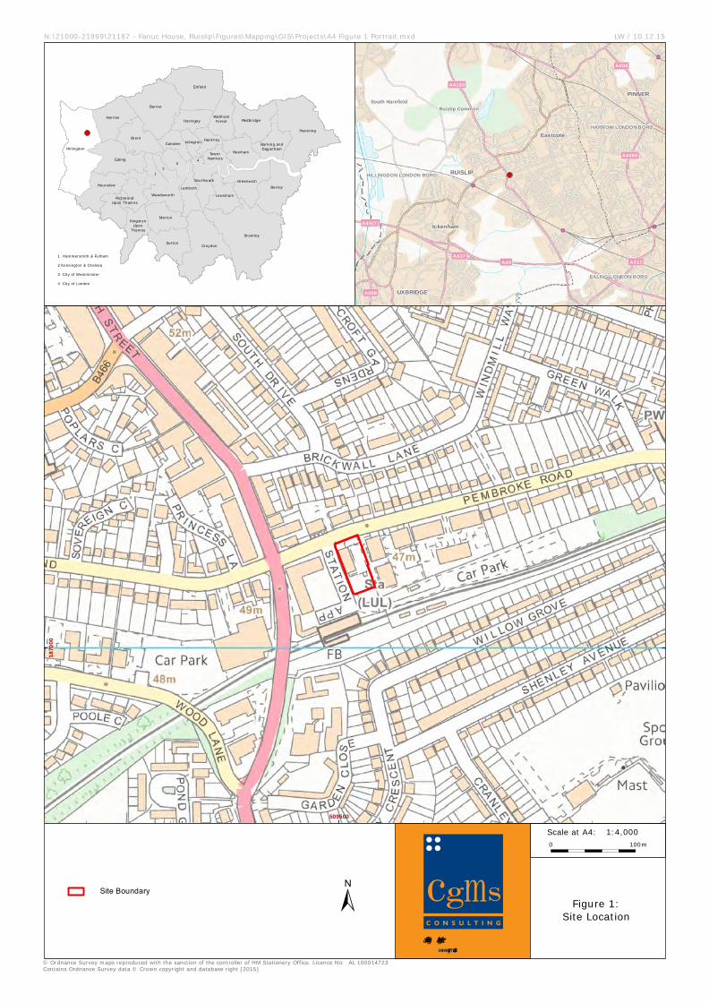
Site centred at: TQ0952187109
Author:
Suzanne Gailey BA (Hons) MA
MCIFA
Approved by:
Duncan Hawkins BA (Hons) MSc FSA MCIFA
Report Status:
FINAL Issue Date:
December 2015 Updated
May 2016
CgMs Ref:
21187
© CgMs Limited
No part of this report is to be copied in any way without prior written consent.
Every effort is made to provide detailed and accurate
information, however, CgMs Limited cannot be held
responsible for errors or inaccuracies within this report.
© Ordnance Survey maps reproduced with the
Archaeological Desk Based Assessment Fanuc House, Station Approach, Ruislip
CgMs Consulting 1 SG/21187
CONTENTS
Executive Summary
1.0 Introduction and Scope of Study 2.0 Planning Background and Development Plan Framework 3.0 Geology and Topography 4.0 Archaeological and Historical Background and Assessment of Significance
5.0 Site Conditions, the Proposed Development and Impacts on Archaeological Assets 6.0 Summary and Conclusions
Sources Consulted
Appendix One HER Location Plan (GLHER 2015)
LIST OF ILLUSTRATIONS
Fig. 1 Location map
Fig. 2 1766 Rocque
Fig. 3 1860 Ordnance Survey
Fig. 4 1896 Ordnance Survey
Fig. 5 1914 Ordnance Survey
Fig. 6 1935 Ordnance Survey
Fig. 7 1962 Ordnance Survey
Fig. 8 1988 Ordnance Survey
Fig. 9 Aerial Photograph (GoogleEarth 2006)
Fig. 10 Site as Existing
Fig. 11 Proposed Development – Ground Floor
Archaeological Desk Based Assessment Fanuc House, Station Approach, Ruislip
CgMs Consulting 2 SG/21187
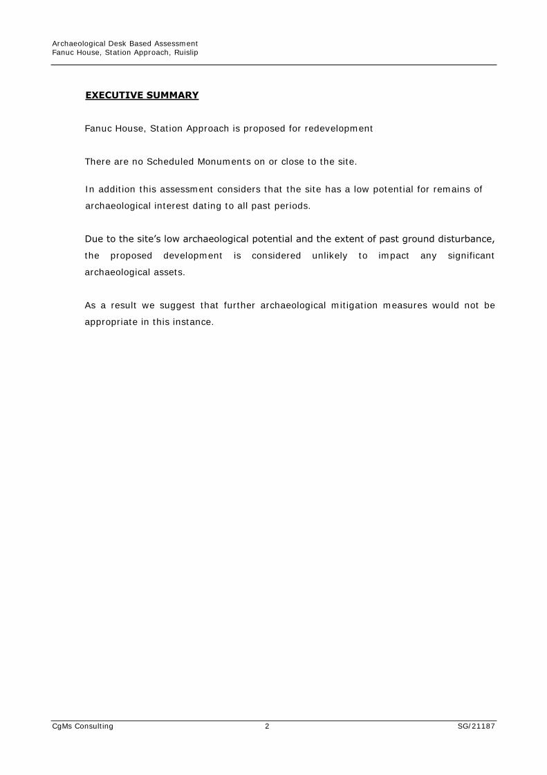
EXECUTIVE SUMMARY
Fanuc House, Station Approach is proposed for redevelopment
There are no Scheduled Monuments on or close to the site.
In addition this assessment considers that the site has a low potential for remains of
archaeological interest dating to all past periods.
Due to the site’s low archaeological potential and the extent of past ground disturbance,
the proposed development is considered unlikely to impact any significant
archaeological assets.
As a result we suggest that further archaeological mitigation measures would not be
appropriate in this instance.
Archaeological Desk Based Assessment Fanuc House, Station Approach, Ruislip
CgMs Consulting 3 SG/21187
1.0 INTRODUCTION AND SCOPE OF STUDY
1.1 This archaeological desk-based assessment has been prepared by Suzanne Gailey of
CgMs Consulting on behalf of RS Station Approach Ltd and their agent Stace LLP.
1.2 The subject of this assessment, also known as the study site, is land at Fanuc House,
Station Approach, Ruislip, Middlesex HA4 8LF. The site is centred at TQ0952187109
(Fig 1).
1.3 In accordance with government policy, National Planning Policy Framework (NPPF),
this assessment draws together the available archaeological, historic, topographic and
land-use information in order to clarify the archaeological potential of the site.
1.4 Additionally, in accordance with the ‘Standard and Guidance for Historic Environment
Desk-Based Assessments’ (Chartered Institute for Archaeologists 1999, revised 2014),
an examination of published and unpublished material and charts historic land-use
through a map regression exercise.
1.5 As a result, the assessment enables relevant parties to assess the significance of
archaeological assets on and close to the site, assess the potential for hitherto
undiscovered archaeological assets and thus enable potential impacts on assets to be
identified along with the need for design, civil engineering or archaeological solutions.
Archaeological Desk Based Assessment Fanuc House, Station Approach, Ruislip
CgMs Consulting 4 SG/21187
2.0 PLANNING BACKGROUND AND DEVELOPMENT PLAN FRAMEWORK
2.1 In March 2012, the government published the National Planning Policy Framework
(NPPF), this was supplemented by National Planning Practice Guidance (NPPG) in
March 2014.
2.1.1 Section 12 of the NPPF, entitled Conserving and enhancing the historic environment
provides guidance for planning authorities, property owners, developers and others on
the conservation and investigation of heritage assets. Overall, the objectives of
Section 12 of the NPPF can be summarised as seeking the:
• Delivery of sustainable development
• Understanding the wider social, cultural, economic and environmental benefits
brought by the conservation of the historic environment
• Conservation of England's heritage assets in a manner appropriate to their
significance, and
• Recognition that heritage makes to our knowledge and understanding of the
past.
2.1.2 Section 12 of the NPPF recognises that intelligently managed change may sometimes
be necessary if heritage assets are to be maintained for the long term. Paragraph 128
states that planning decisions should be based on the significance of the heritage
asset and that level of detail supplied by an applicant should be proportionate to the
importance of the asset and should be no more than sufficient to review the potential
impact of the proposal upon the significance of that asset.
2.1.3 Heritage Assets are defined in Annex 2 of the NPPF as: a building, monument, site,
place, area or landscape positively identified as having a degree of significance
meriting consideration in planning decisions. They include designated heritage assets
(as defined in the NPPF) and assets identified by the local planning authority during
the process of decision-making or through the plan-making process.
2.1.4 Annex 2 also defines Archaeological Interest as a heritage asset which holds or
potentially could hold evidence of past human activity worthy of expert investigation
at some point. Heritage assets with archaeological interest are the primary source of
evidence about the substance and evolution of places, and of the people and cultures
that made them.
Archaeological Desk Based Assessment Fanuc House, Station Approach, Ruislip
CgMs Consulting 5 SG/21187
2.1.5 A Designated Heritage Asset comprises a: World Heritage Site, Scheduled Monument,
Listed Building, Protected Wreck Site, Registered Park and Garden, Registered
Battlefield or Conservation Area.
2.1.6 Significance is defined as: The value of a heritage asset to this and future generations
because of its heritage interest. This interest may be archaeological, architectural,
artistic or historic. Significance derives not only from a heritage asset’s physical
presence, but also from its setting.
2.1.7 In short, government policy provides a framework which:
• Protects nationally important designated Heritage Assets (which include World
Heritage Sites, Scheduled Ancient Monuments, Listed Buildings, Protected Wreck
Sites, Registered Parks and Gardens, Registered Battlefields or Conservation
Areas)
• Protects the settings of such designations
• In appropriate circumstances seeks adequate information (from desk based
assessment and field evaluation where necessary) to enable informed decisions
• Provides for the excavation and investigation of sites not significant enough to
merit in-situ preservation.
2.2 In considering any planning application for development, the planning authority will be
mindful of the framework set by government policy, in this instance the NPPF, by
current Development Plan Policy and by other material considerations.
2.3 The relevant Strategic Development Plan framework is provided by the London Plan
Consolidated with Alterations Since 2011 published March 2015. The policy relevant to
archaeology at the site is as follows:
POLICY 7.8 HERITAGE ASSETS AND ARCHAEOLOGY STRATEGIC A. LONDON’S HERITAGE ASSETS AND HISTORIC ENVIRONMENT, INCLUDING LISTED
BUILDINGS, REGISTERED HISTORIC PARKS AND GARDENS AND OTHER NATURAL AND
HISTORIC LANDSCAPES, CONSERVATION AREAS, WORLD HERITAGE SITES, REGISTERED
BATTLEFIELDS, SCHEDULED MONUMENTS, ARCHAEOLOGICAL REMAINS AND MEMORIALS
SHOULD BE IDENTIFIED, SO THAT THE DESIRABILITY OF SUSTAINING AND ENHANCING
THEIR SIGNIFICANCE AND OF UTILISING THEIR POSITIVE ROLE IN PLACE SHAPING CAN
BE TAKEN INTO ACCOUNT.
B. DEVELOPMENT SHOULD INCORPORATE MEASURES THAT IDENTIFY, RECORD, INTERPRET,
PROTECT AND, WHERE APPROPRIATE, PRESENT THE SITE’S ARCHAEOLOGY.
Archaeological Desk Based Assessment Fanuc House, Station Approach, Ruislip
CgMs Consulting 6 SG/21187
PLANNING DECISIONS C. DEVELOPMENT SHOULD IDENTIFY, VALUE, CONSERVE, RESTORE, RE-USE AND INCORPORATE
HERITAGE ASSETS, WHERE APPROPRIATE.
D. DEVELOPMENT AFFECTING HERITAGE ASSETS AND THEIR SETTINGS SHOULD CONSERVE
THEIR SIGNIFICANCE, BY BEING SYMPATHETIC TO THEIR FORM, SCALE, MATERIALS AND
ARCHITECTURAL DETAIL.
E. NEW DEVELOPMENT SHOULD MAKE PROVISION FOR THE PROTECTION OF ARCHAEOLOGICAL
RESOURCES, LANDSCAPES AND SIGNIFICANT MEMORIALS. THE PHYSICAL ASSETS SHOULD,
WHERE POSSIBLE, BE MADE AVAILABLE TO THE PUBLIC ON-SITE. WHERE THE
ARCHAEOLOGICAL ASSET OR MEMORIAL CANNOT BE PRESERVED OR MANAGED ON-SITE,
PROVISION MUST BE MADE FOR THE INVESTIGATION, UNDERSTANDING, RECORDING,
DISSEMINATION AND ARCHIVING OF THAT ASSET.
LDF PREPARATION F. BOROUGHS SHOULD, IN LDF POLICIES, SEEK TO MAINTAIN AND ENHANCE THE
CONTRIBUTION OF BUILT, LANDSCAPED AND BURIED HERITAGE TO LONDON’S
ENVIRONMENTAL QUALITY, CULTURAL IDENTITY AND ECONOMY AS PART OF MANAGING
LONDON’S ABILITY TO ACCOMMODATE CHANGE AND REGENERATION.
G. BOROUGHS, IN CONSULTATION WITH ENGLISH HERITAGE, NATURAL ENGLAND AND OTHER
RELEVANT STATUTORY ORGANISATIONS, SHOULD INCLUDE APPROPRIATE POLICIES IN
THEIR LDFS FOR IDENTIFYING, PROTECTING, ENHANCING AND IMPROVING ACCESS TO THE
HISTORIC ENVIRONMENT AND HERITAGE ASSETS AND THEIR SETTINGS WHERE
APPROPRIATE, AND TO ARCHAEOLOGICAL ASSETS, MEMORIALS AND HISTORIC AND
NATURAL LANDSCAPE CHARACTER WITHIN THEIR AREA.
2.4 The Hillingdon Borough Core Strategy was adopted in April 2012 and contains the
following policies relating to the historic environment:
POLICY HE1: HERITAGE THE COUNCIL WILL: 1. CONSERVE AND ENHANCE HILLINGDON'S DISTINCT AND VARIED ENVIRONMENT, ITS SETTINGS AND THE WIDER HISTORIC LANDSCAPE, WHICH INCLUDES: - HISTORIC VILLAGE CORES, METRO-LAND SUBURBS, PLANNED RESIDENTIAL
ESTATES AND 19TH AND 20TH CENTURY INDUSTRIAL AREAS, INCLUDING THE GRAND UNION CANAL AND ITS FEATURES;
- DESIGNATED HERITAGE ASSETS SUCH AS STATUTORILY LISTED BUILDINGS, CONSERVATION AREAS AND SCHEDULED ANCIENT MONUMENTS;
- REGISTERED PARKS AND GARDENS AND HISTORIC LANDSCAPES, BOTH NATURAL AND DESIGNED;
- LOCALLY RECOGNISED HISTORIC FEATURES, SUCH AS AREAS OF SPECIAL LOCAL CHARACTER AND LOCALLY LISTED BUILDINGS; AND
- ARCHAEOLOGICALLY SIGNIFICANT AREAS, INCLUDING ARCHAEOLOGICAL PRIORITY ZONES AND AREAS.
Archaeological Desk Based Assessment Fanuc House, Station Approach, Ruislip
CgMs Consulting 7 SG/21187
2. ACTIVELY ENCOURAGE THE REGENERATION OF HERITAGE ASSETS, PARTICULARLY THOSE WHICH HAVE BEEN INCLUDED IN ENGLISH HERITAGE'S 'HERITAGE AT RISK' REGISTER OR ARE CURRENTLY VACANT. 3. PROMOTE INCREASED PUBLIC AWARENESS, UNDERSTANDING OF AND ACCESS TO THE BOROUGH'S HERITAGE ASSETS AND WIDER HISTORIC ENVIRONMENT, THROUGH SECTION 106 AGREEMENTS AND VIA COMMUNITY ENGAGEMENT AND OUTREACH ACTIVITIES. 4. ENCOURAGE THE REUSE AND MODIFICATION OF HERITAGE ASSETS, WHERE APPROPRIATE, WHEN CONSIDERING PROPOSALS TO MITIGATE OR ADAPT TO THE
EFFECTS OF CLIMATE CHANGE. WHERE NEGATIVE IMPACT ON A HERITAGE ASSET IS IDENTIFIED, SEEK ALTERNATIVE APPROACHES TO ACHIEVE SIMILAR CLIMATE CHANGE MITIGATION OUTCOMES WITHOUT DAMAGE TO THE ASSET.
2.5 The Hillingdon Unitary Development Plan was adopted in 1998. The Plan contains the
following ‘saved’ policies:
BE1 ONLY IN EXCEPTIONAL CIRCUMSTANCES WILL THE LOCAL PLANNING AUTHORITY
ALLOW DEVELOPMENT TO TAKE PLACE IF IT WOULD DISTURB REMAINS OF
IMPORTANCE WITHIN THE ARCHAEOLOGICAL PRIORITY AREAS.
BE3 THE LOCAL PLANNING AUTHORITY WILL ENSURE WHENEVER PRACTICABLE THAT
SITES OF ARCHAEOLOGICAL INTEREST ARE INVESTIGATED AND RECORDED EITHER
BEFORE ANY NEW BUILDINGS, REDEVELOPMENT, SITE WORKS, GOLF COURSE OR
GRAVEL EXTRACTION ARE STARTED, OR DURING EXCAVATION AND CONSTRUCTION.
DEVELOPMENT WHICH WOULD DESTROY IMPORTANT ARCHAEOLOGICAL REMAINS
WILL NOT BE PERMITTED.
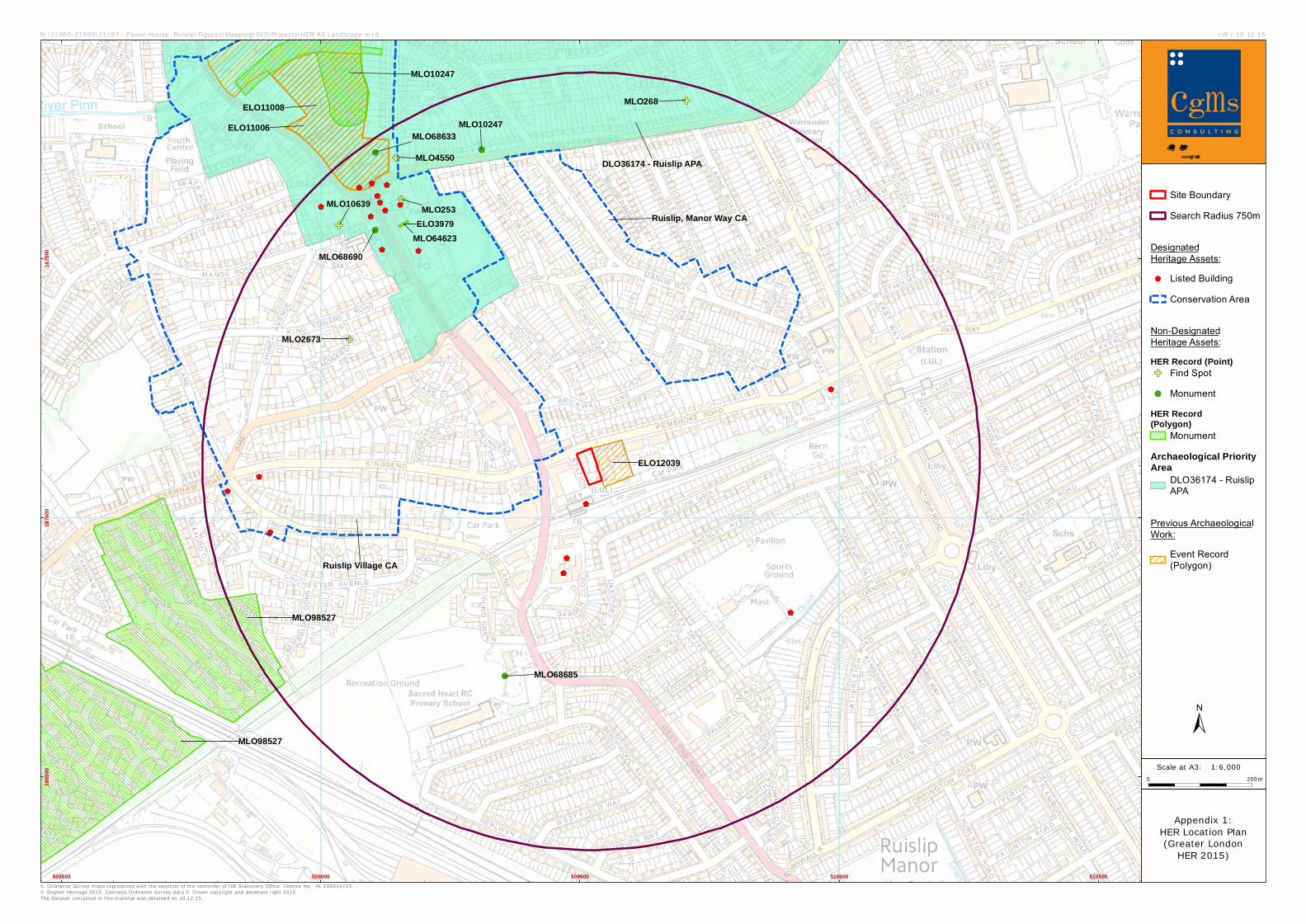
2.6 There are no Scheduled Monuments or other designated heritage assets the site. The
closest Listed Building is Ruislip Station which lies approximately 50m south-west of the
study site. The closest Scheduled Monument (Ruislip Motte and Bailey) lies
approximately 750m north-west of the study site. Modern urban development occupies
the setting of these designated assets and consequently the proposed development is
likely to have a neutral effect on the setting of these designated assets. They will
therefore not be considered further in this assessment.
2.7 The site does not lie on or close to an Archaeological Priority Area.
2.8 In accordance with NPPF, this assessment therefore considers the potential for as yet to
be discovered archaeological assets and provides a proportionate level of information to
enable an informed planning decision.
Archaeological Desk Based Assessment Fanuc House, Station Approach, Ruislip
CgMs Consulting 8 SG/21187
3.0 GEOLOGY AND TOPOGRAPHY
3.1 Geology
3.1.1 The solid geology of the study site is shown by the British Geological Survey Sheet to
lie on Lambeth Group – Clay, Silt and Sand.
3.2 Topography
3.2.1 The study site lies in a landscape that rises gently from south-east to north-west. The
site itself is approximately level at c47m AOD.
3.2.2 No natural water channels or other topographical anomalies lie on or close to the site.
Archaeological Desk Based Assessment Fanuc House, Station Approach, Ruislip
CgMs Consulting 9 SG/21187
4.0 ARCHAEOLOGICAL AND HISTORICAL BACKGROUND AND ASSESSMENT OF
SIGNIFICANCE
Timescales used in this report:
Prehistoric
Palaeolithic 450,000 - 12,000 BC
Mesolithic 12,000 - 4,000 BC
Neolithic 4,000 - 1,800 BC
Bronze Age 1,800 - 600 BC
Iron Age 600 - AD 43
Historic
Roman AD 43 - 410
Saxon/Early Medieval AD 410 - 1066
Medieval AD 1066 - 1485
Post Medieval
Modern
AD 1486 -
AD 1800 -
1799
Present
4.1 Introduction
4.1.1 Archaeological information from a ‘study area’ comprising land within a 750m radius of
the study site held in the Greater London Historic Environment Record (GLHER) has
been collected and reviewed.
4.1.2 This chapter reviews existing archaeological evidence for the site and the
archaeological/historical background of the general area, and, in accordance with
NPPF, considers the potential for as yet undiscovered archaeological evidence on the
site.
4.1.3 Chapter 5 subsequently considers the site conditions and whether the theoretical
potential identified in this chapter is likely to survive.
4.2 Prehistoric
4.2.1 A large retouched flake was found at King Edward Road approximately 500m north-
west of the study site (MLO2673 TQ09058734) and is the only prehistoric find
recorded within a 750m radius of the study site.
Archaeological Desk Based Assessment Fanuc House, Station Approach, Ruislip
CgMs Consulting 10 SG/21187
4.2.2 It is likely that the study site lay in a landscape that comprised dense woodland during
these periods. The site’s location some distance from any natural water source suggest
that it was unlikely to have been a favoured location for prehistoric occupation. As a
result the archaeological potential for evidence of settlement activity dating to the
prehistoric periods is considered to be low although unstratified isolated artefacts may
be present.
4.3 Roman
4.3.1 The route of the Iron Age/Romano British linear earthwork known as Grims Dyke is
thought to have passed through Ruislip. The use of this linear bank and ditch is
unknown but is thought to have been defensive or territorial and to have passed
through Eastcote and Ruislip towards Ickenham and Uxbridge.
4.3.2 Roman brick and tile were incorporated in the later Medieval walls of Ruislip Church
approximately 600m north-west of the study site (MLO253 TQ09158761) suggesting
Roman settlement in the vicinity. A sherd of Roman pottery was found within Parkers
Field during excavations approximately 700m north-east of the study site (MLO268
TQ09708780).
4.3.3 Although much of the surrounding landscape may well have remained within woodland
during this period it is clear that some settlement was taking place in the vicinity of
the study site.
4.3.4 Overall, though difficult to quantify, the archaeological potential of the study site for
evidence of in situ settlement evidence dating to the Roman period is considered to be
low.
4.4 Anglo-Saxon and Medieval
4.4.1 The study site lies approximately 750m south-east of the Motte and Bailey castle
built soon after the Conquest in 1066. After 1097 the castle was passed on to the
Abbey of Bec who founded a small Priory in its place. The Abbey was subsequently
demolished during the dissolution (MLO10247 TQ09058780).
4.4.2 The Domesday Survey of 1086 records the hamlet of Rislepe comprising a heavy
wooded landscape with arable and pasture land and a priest. The current church
dates from 13th century but an earlier church is thought to have once existed on the
Archaeological Desk Based Assessment Fanuc House, Station Approach, Ruislip
CgMs Consulting 11 SG/21187
same site. The hamlet of Ruislip is therefore likely to have been established by the
late Saxon period.
4.4.3 The core of the Medieval settlement at Ruislip focussed on the church and castle
approximately 750m north-west of the study site (MLO68633 TQ09108770).
Isolated sherds of pottery dating to the Medieval period have been found within this
area (MLO10639 TQ09038756, MLO4550 TQ09148769).
4.4.4 The site lies some distance from the core of any Medieval settlement. Consequently
a low archaeological potential can be identified for evidence of settlement activity
dating to these periods.
4.5 Post Medieval & Modern (including map regression exercise)
4.5.1 By the Post Medieval period the focus of settlement at Ruislip remained around the
High Street and Bury Street close to the church and Manor Farm. Rocque’s map of
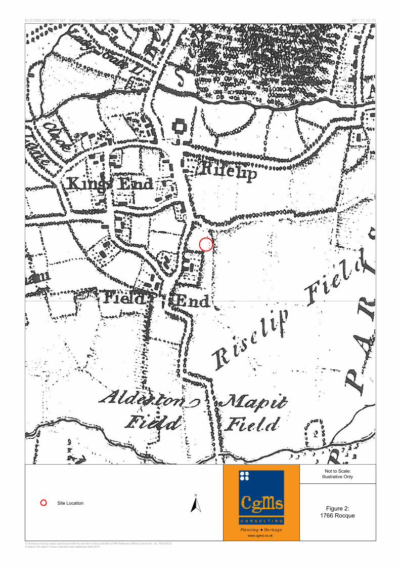
1766 (Fig. 2) shows the site comprising part of an open field to the south-east of the
village core.
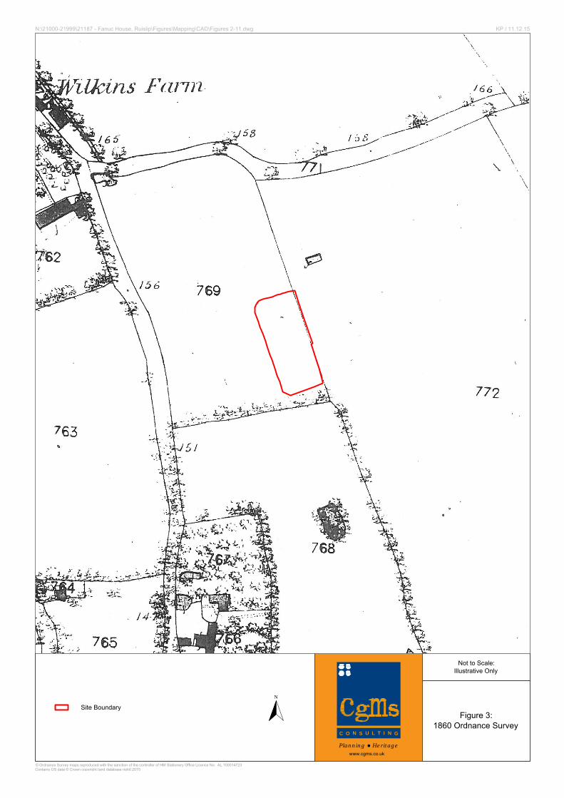
4.5.2 There was no change to the site by the late 19th century (Fig. 3 and 4).
4.5.3 In 1904 Ruislip Station was opened and the metropolitan line ran to the south of the
study site. The 1914 Ordnance Survey shows the site remained undeveloped by this
date (Fig. 5).
4.5.4 Between 1914 and 1935 Pembroke Road was constructed bounding the site to the
north. By this date the site was occupied by a tennis court associated with the
adjacent club (Fig. 6).
4.5.5 Between 1935 and 1962 Station approach had been constructed and bound the site to
the west. The site was occupied by a carpark by this date (Fig. 7).
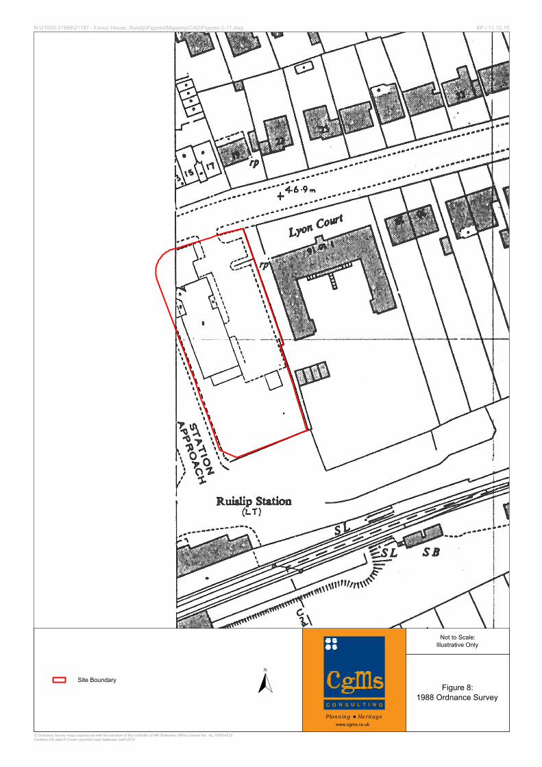
4.5.6 Between 1962 and 1988 Fanuc House was constructed (Fig. 8).
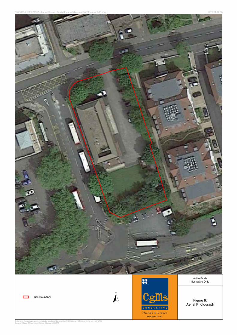
4.5.7 There has been no subsequent change to the study site (Fig. 9 and 10).
4.5.8 The archaeological potential of the study site for evidence of settlement activity dating
to the Post Medieval period is considered to be low.
Archaeological Desk Based Assessment Fanuc House, Station Approach, Ruislip
CgMs Consulting 12 SG/21187
4.7 Assessment of Significance
4.7.1 There are no designated archaeological heritage assets on the site. Additionally
there are no non-designated archaeological assets recorded on the site in the
GLHER.
4.7.2 The site has a low potential for as yet to be discovered archaeological assets dating
from the prehistoric to the Post-Medieval periods.
Archaeological Desk Based Assessment Fanuc House, Station Approach, Ruislip
CgMs Consulting 13 SG/21187
5.0 SITE CONDITIONS, THE PROPOSED DEVELOPMENT AND IMPACTS ON
ARCHAEOLOGICAL ASSETS
5.1 Site Conditions
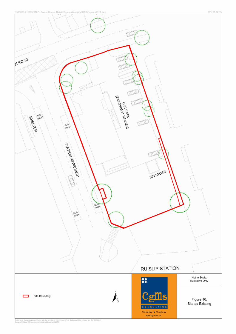
5.1.1 The study site currently comprises Fanuc House. A building constructed in the
1970s/80s with associated carparking and landscaping to the rear.
5.1.2 No development took place at the study site until the 20th century. Soil stripping and
any levelling works during the construction of the tennis courts will have had a
widespread below ground impact. Subsequent redevelopment of the site will have had
a cumulative impact.
5.2 Proposed Development
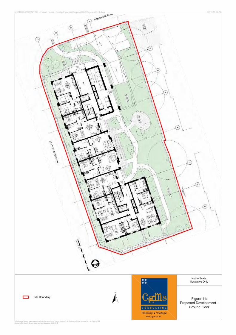
5.2.1 It is proposed to redevelop the site with residential apartments and associated
carparking and landscaping (Fig. 11).
5.3 Impacts on Archaeological Assets
5.3.1 The proposed development will not impact on any designated archaeological assets or
known non-designated assets.
5.3.2 Due to the site’s low archaeological potential and the extent of past ground
disturbance, the proposed development is considered unlikely to impact any significant
archaeological assets.
Archaeological Desk Based Assessment Fanuc House, Station Approach, Ruislip
CgMs Consulting 14 SG/21187
6.0 SUMMARY AND CONCLUSIONS
6.1 In accordance with central and local government policy, a desk-based assessment has
been undertaken to clarify the archaeological potential of the study site.
6.2 No designated archaeological assets lie on the site.
6.3 The site is considered to have a low potential for remains of archaeological interest
dating from the prehistoric to the post-medieval periods.
6.4 Due to the site’s low archaeological potential and the extent of past ground
disturbance, the proposed development is considered unlikely to impact any significant
archaeological assets.
6.5 Consequently, we suggest further archaeological mitigation measures would not be
appropriate in this instance.
Archaeological Desk Based Assessment Fanuc House, Station Approach, Ruislip
CgMs Consulting 15 SG/21187
SOURCES CONSULTED
1. General
British Library
Greater London Historic Environment Record
National Archive
2. Bibliographic
Antiquities of Middlesex Vol 3 Bewlt, E 1994 Ruislip Past
Weinreb & Hibbert (eds.) The London Encyclopaedia 1995
3. Cartographic
1766 Rocque
1860 Ordnance Survey
1896 Ordnance Survey
1914 Ordnance Survey
1935 Ordnance Survey
1962 Ordnance Survey
1988 Ordnance Survey
509500
1870
00
Figure 1:
Site Location
1:4,000Scale at A4:
N:\21000-21999\21187 - Fanuc House, Ruislip\Figures\Mapping\GIS\Projects\A4 Figure 1 Portrait.mxd
© Ordnance Survey maps reproduced with the sanction of the controller of HM Stationery Office. Licence No: AL 100014723Contains Ordnance Survey data © Crown copyright and database right [2015]
Planning ● Heritagewww.cgms.co.uk
LW / 10.12.15
0 100m
±
Bromley
Barnet
Havering
Enfield
Hillingdon
Croydon
Bexley
Ealing
Brent
Harrow
Sutton
Hounslow
Redbridge
Merton
Greenwich
Newham
Lewisham
Haringey
Lambeth
Wandsworth
Southwark
Camden
Waltham
Forest
HackneyIslington
Barking and
Dagenham
Tower
Hamlets
Richmond
Upon Thames
Kingston
Upon
Thames
3
1
2
4
1 Hammersmith & Fulham
2 Kensington & Chelsea
3 City of Westminster
4 City of London
PINNER
RUISLIP
Eastcote
Ickenham
UXBRIDGE
Ruislip CommonSouth Harefield
A40
A4180
A40(T)
A437
A404
A312
A4090
A408
HILLINGDON LONDON BORO
HARROW LONDON BORO
EALING LONDON BORO
Site Boundary
N
Site Location
Not to Scale:Illustrative Only
Figure 2:1766 Rocque
© Ordnance Survey maps reproduced with the sanction of the controller of HM Stationery Office Licence No: AL 100014723Contains OS data © Crown copyright [and database right] 2015
N:\21000-21999\21187 - Fanuc House, Ruislip\Figures\Mapping\CAD\Figures 2-11.dwg KP / 11.12.15
www.cgms.co.uk
Planning ● Heritage
C ON
SU L T I N
G
N
Site Boundary
Not to Scale:Illustrative Only
Figure 3:1860 Ordnance Survey
© Ordnance Survey maps reproduced with the sanction of the controller of HM Stationery Office Licence No: AL 100014723Contains OS data © Crown copyright [and database right] 2015
N:\21000-21999\21187 - Fanuc House, Ruislip\Figures\Mapping\CAD\Figures 2-11.dwg KP / 11.12.15
www.cgms.co.uk
Planning ● Heritage
C ON
SU L T I N
G
N
Site Boundary
Not to Scale:Illustrative Only
Figure 4:1896 Ordnance Survey
© Ordnance Survey maps reproduced with the sanction of the controller of HM Stationery Office Licence No: AL 100014723Contains OS data © Crown copyright [and database right] 2015
N:\21000-21999\21187 - Fanuc House, Ruislip\Figures\Mapping\CAD\Figures 2-11.dwg KP / 11.12.15
www.cgms.co.uk
Planning ● Heritage
C ON
SU L T I N
G
N
Site Boundary
Not to Scale:Illustrative Only
Figure 5:1914 Ordnance Survey
© Ordnance Survey maps reproduced with the sanction of the controller of HM Stationery Office Licence No: AL 100014723Contains OS data © Crown copyright [and database right] 2015
N:\21000-21999\21187 - Fanuc House, Ruislip\Figures\Mapping\CAD\Figures 2-11.dwg KP / 11.12.15
www.cgms.co.uk
Planning ● Heritage
C ON
SU L T I N
G
N
Site Boundary
Not to Scale:Illustrative Only
Figure 6:1935 Ordnance Survey
© Ordnance Survey maps reproduced with the sanction of the controller of HM Stationery Office Licence No: AL 100014723Contains OS data © Crown copyright [and database right] 2015
N:\21000-21999\21187 - Fanuc House, Ruislip\Figures\Mapping\CAD\Figures 2-11.dwg KP / 11.12.15
www.cgms.co.uk
Planning ● Heritage
C ON
SU L T I N
G
N
Site Boundary
Not to Scale:Illustrative Only
Figure 7:1962 Ordnance Survey
© Ordnance Survey maps reproduced with the sanction of the controller of HM Stationery Office Licence No: AL 100014723Contains OS data © Crown copyright [and database right] 2015
N:\21000-21999\21187 - Fanuc House, Ruislip\Figures\Mapping\CAD\Figures 2-11.dwg KP / 11.12.15
www.cgms.co.uk
Planning ● Heritage
C ON
SU L T I N
G
N
Site Boundary
Not to Scale:Illustrative Only
Figure 8:1988 Ordnance Survey
© Ordnance Survey maps reproduced with the sanction of the controller of HM Stationery Office Licence No: AL 100014723Contains OS data © Crown copyright [and database right] 2015
N:\21000-21999\21187 - Fanuc House, Ruislip\Figures\Mapping\CAD\Figures 2-11.dwg KP / 11.12.15
www.cgms.co.uk
Planning ● Heritage
C ON
SU L T I N
G
N
Site Boundary
Not to Scale:Illustrative Only
Figure 9:Aerial Photograph
© Ordnance Survey maps reproduced with the sanction of the controller of HM Stationery Office Licence No: AL 100014723Contains OS data © Crown copyright [and database right] 2015
N:\21000-21999\21187 - Fanuc House, Ruislip\Figures\Mapping\CAD\Figures 2-11.dwg KP / 11.12.15
www.cgms.co.uk
Planning ● Heritage
C ON
SU L T I N
G
N
Site Boundary
Not to Scale:Illustrative Only
Figure 10:Site as Existing
© Ordnance Survey maps reproduced with the sanction of the controller of HM Stationery Office Licence No: AL 100014723Contains OS data © Crown copyright [and database right] 2015
N:\21000-21999\21187 - Fanuc House, Ruislip\Figures\Mapping\CAD\Figures 2-11.dwg KP / 11.12.15
www.cgms.co.uk
Planning ● Heritage
C ON
SU L T I N
G
Archaeological Desk Based Assessment Fanuc House, Station Approach, Ruislip
CgMs Consulting 16 SG/21187
Appendix One
HER Location Plan
(GLHER 2015)
$+
$+
$+$+
$+
$+
$+
$+
$+$+
$+
$+
$+
$+
$+
$+
$+
$+
$+
GF
GF
GF
GF
GF!(
!(
!(
!(
DLO36174 - Ruislip APA
ELO11008ELO11006
ELO12039
ELO3979
MLO98527
MLO98527
MLO10247
MLO64623
Ruislip Village CA
Ruislip, Manor Way CA
MLO268
MLO253
MLO4550
MLO2673
MLO10247
MLO68690
MLO68685
MLO68633
MLO10639
508500 509000 509500 510000 510500
1865
0018
7000
1875
00
1:6,000Scale at A3:
N:\21000-21999\21187 - Fanuc House, Ruislip\Figures\Mapping\GIS\Projects\HER A3 Landscape.mxd
© Ordnance Survey maps reproduced with the sanction of the controller of HM Stationery Office. Licence No: AL 100014723
© English Heritage 2015. Contains Ordnance Survey data © Crown copyright and database right 2015
The Dataset contained in this material was obtained on 10.12.15
Planning ● Heritagewww.cgms.co.uk
LW / 10.12.15
0 200m
±
Site Boundary
Search Radius 750m
DesignatedHeritage Assets:
$+ Listed Building
Conservation Area
Non-DesignatedHeritage Assets:
HER Record (Point)GF Find Spot
!( Monument
HER Record(Polygon)
Monument
Archaeological PriorityArea
DLO36174 - RuislipAPA
Previous ArchaeologicalWork:
Event Record(Polygon)
Appendix 1:
HER Location Plan
(Greater London
HER 2015)


