

WesternFreew
WesternFreew C t
15NM BN
Visual PilotGuideFixed Wing
WesternFreeway
WesternFreeway
ArcherfieldArcherfield
B
R I S B A N E R I V E R
QE II StadiumQE II Stadium
BHP Steel Mill
BHP Steel Mill
22
28
ArcherfArcherf
GAAP1500
0
Issued August 2001
Archerfield
Safe Skies for All
Safe Skies for All
Archerfield

ARCHERFIELD VISUAL PILOT GUIDE
The Archerfield Visual Pilot Guide (VPG) is anaid for pilots to use when flying into, out ofand around Archerfield Aerodrome. It is an aidfor both planning and conducting your flight.
This guide was developed with the assistanceof operators based at Archerfield aerodrome.
Updates for the VPG are available on theCASA web site: www.casa.gov.au orwww.flyingaustralia.com or from CASAAviation Safety Promotion on phone 131 757.
For comments and suggestions on improvingthis aid contact:
Andrew Warland-Browne CASA Aviation Safety Promotion
Telephone 131 757 Facsimile 07 3842 2590Email [email protected]
CONTENTS
Aircraft Details
Are you safe to fly?
Pre–flight Check
Time In Your tanks
Using your hand-held GPS
GAAP Operations – Archerfield
MBZ Operations – Archerfield
Departing Controlled Airspace
Outbound Radio Calls
Inbound Radio Calls
Archerfield - Outbound Nth
TV Towers - Inbound
TV Towers - Joining the Circuit
Archerfield - Outbound West
Goodna - Inbound
Goodna - Joining the Circuit
Archerfield - Outbound South
Park Ridge - Inbound
Park Ridge - Joining the Circuit
Archerfield - Outbound East
Target - Inbound
Target - Joining the Circuit
Glossary
Emergency Landing Procedures
Field Signals 42
41
40
38
36
34
32
30
28
26
24
22
20
18
16
15
14
13
12
10
8
4
2
1
1
Mainly includes GAAP procedures, but MBZ operations are included
where applicable
This Pilot Guide must be used in conjunction with current operational charts, documents and NOTAMsContains information valid July 2001.

AIRCRAFT DETAILS1
Are you safe to fly?
llness Are you physically well?
edication Are you free from the effects of drugs?
tress Are you free from significant stress?
lcohol Are you free from the effects of alcohol?
atigue Are you adequately rested?
ating Have you eaten properly to work effectively?
Don’t fly if you are not safe!
IMSAFE
Best rate of climb speed kts
Best angle of climb speed kts
Normal climb speed kts
Best glide speed - Heavy kts
Best glide speed - Medium kts
Best glide speed - Light kts
Stall speed 0° Flap kts
Full Flap kts
Short field take-off speed kts
Short field landing speed kts
Flapless landing speed kts
Normal landing speed kts
Maximum gear extension speed kts
Vfe (flap extension speed) kts
Fuel capacity (usable) litres
Fuel flow (65% power) litres/hr
Fuel flow (75% power) litres/hr
Basic empty weight kg
Maximum take-off weight kg
Maximum baggage weight kg
Type Registration

PRE-FLIGHT CHECK
CURRENT
FLIGHT PLAN
Medical? Don’t fly solo
Flight Review?Complete before
flying-in-command
Maps/Charts? Obtain beforeFlight Planning
Weather forecast/NOTAM
Obtain forecastHelp Desk 1800 801 960
Briefing 1800 805 150Dectalk 1800 805 150
NAIPS 019 8304 767Direct Dial
Website: www.airservices.gov.au
• Choose suitable route andcomplete calculations
e.g. heading, groundspeed, ETI, etc… (refer to back section ofAirservices Flight Plan form – stock number 88436.0)
• Appropriate height
• Flight fuel
• Last light
• Weight and Balance calculations
• Take-off and landingperformance
• Survival equipment
NO
NO
NO
NO
YES
YES
YES
THEN
YES
Check CTA and Restricted Area boundaries
2
YES
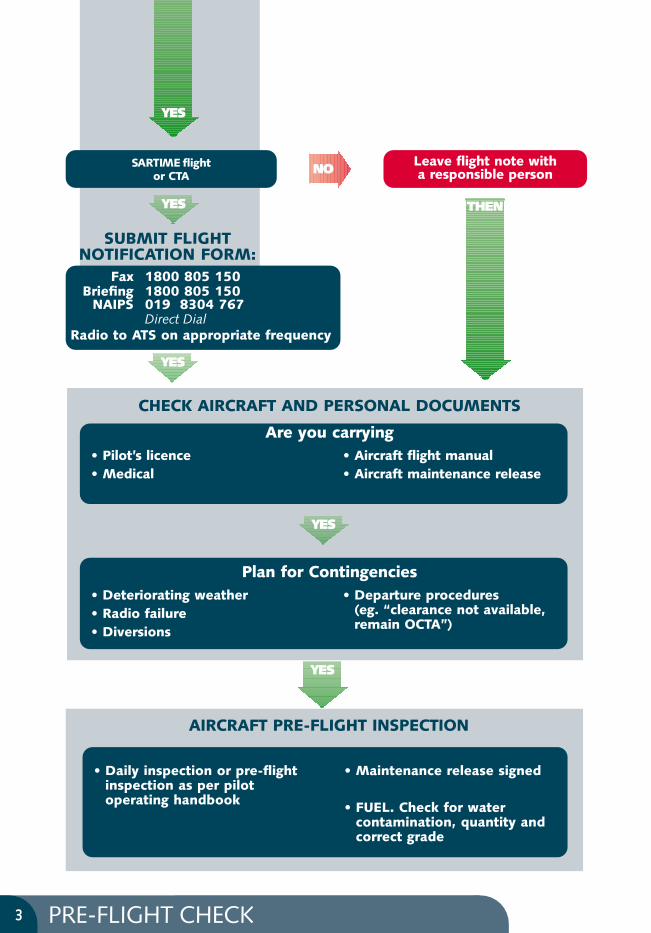
PRE-FLIGHT CHECK3
SARTIME flightor CTA
Leave flight note with a responsible person
Fax 1800 805 150Briefing 1800 805 150
NAIPS 019 8304 767Direct Dial
Radio to ATS on appropriate frequency
• Deteriorating weather• Radio failure• Diversions
• Departure procedures (eg. “clearance not available,remain OCTA”)
THEN
NO
• Pilot’s licence• Medical
• Aircraft flight manual• Aircraft maintenance release
Plan for Contingencies
SUBMIT FLIGHT NOTIFICATION FORM:
• Daily inspection or pre-flightinspection as per pilotoperating handbook
• Maintenance release signed
• FUEL. Check for watercontamination, quantity andcorrect grade
AIRCRAFT PRE-FLIGHT INSPECTION
CHECK AIRCRAFT AND PERSONAL DOCUMENTS
Are you carrying
YES
YES
YES
YES
YES

TIME IN YOUR TANKS
PRE-FLIGHT PLANNING
• Determine total fuel capacity and usable fuel(refer Aircraft Flight Manual).
• Determine fuel consumption rates (refer Pilot’s Operating Handbook).
• Familiarise yourself with the aircraft’s fuel systems.
• Check fuel availability enroute (note suppliers and operating hours).
• Plan to arrive with all fuel reserves intact – never plan to use fixed or variable reserve fuel.
• Weight versus fuel. Keep in mind that you may not be able to carry full tanks.
• Check weather to determine holding and/or alternate fuel requirements.
PRE-FLIGHT INSPECTION
• Try to refuel on level ground to avoid inaccurate fuel measurements and unwanted fuel transfer.
• Dip each tank to check the amount of fuel. If a tank cannot be dipped, fill at least one tank(weight permitting) so there is a known fuel quantity.
• Cross-check fuel amounts by at least two separate methods. Use the lowest figure if they vary by more than 3% (mandatory for aircraft with MTOW in excess of 5700kg).
• Ensure drains and vents are working properly.
• If using Avgas, rock the aircraft to move trapped water over the drain point before carrying out a fuel drain (refer aircraft manufacturer’s recommendations).
• Check for contaminants, particularly water; and correct fuel type.
• Ensure the fuel filler cap is secure and sealed.
IN FLIGHT
• At regular intervals (at least every 30 minutes and at turning points) compare fuel remaining fromgauges with planned figures and monitor tank selection. Caution: Gauge readings as per aircraft’sfuel calibration card.
• Use planned power settings and correct mixture leaning technique.
POST FLIGHT
• Compare usage figures with planned figures when next refuelling.
4

TIME IN YOUR TANKS5
AVGAS FUEL CONVERSIONS (conversions are approx.)
1. Cloud – more than 4 OKTAS below ceiling of 1500 ft2. Visibility – less than 8 km OR forecast probability fog, mist, dust3. Wind – crosswind more than aircraft maximum4. Thunderstorms or severe turbulence – forecast or probability
162
72
10
11.5
162 L AVGAS = 115 kgExample: Conversion from litres to kg
using navigation computer.
Alternate due to weather (VFR): refer AIP ENR 1.1 para. 66.2
KilogramsLitres x 0.70÷ 0.70
LitresUS gallons x 3.79÷ 3.79
KilogramsUS gallons x 2.65÷2.65
TAF YMAY 011835Z 2008 09010KT CAVOKINTER 0305 16015KT 6000 SH BKN005 SCT030FM 05 16010KT CAVOKT 15 19 24 20 Q 1008 1007 1005 1007
060001002000
60 MINUTE HOLDING ORALTERNATE REQUIRED
1800
30MINUTEBUFFER
30MINUTEBUFFERTEMPOTEMPO
080005000300
30 MINUTE HOLDING ORALTERNATE REQUIRED
2000
30MINUTEBUFFER
30MINUTEBUFFERINTERINTER
TAF YSCB 271648Z 1806 33015G28KT 9999 SH FEW010 OVC100TEMPO 2001 1000 +TSGR BKN005 SCT040CBT 14 13 13 11 Q 1016 1015 1013 1016

TIME IN YOUR TANKS6
EXAMPLE
59 litres
55 mins
65 L/Hr
60
SCENARIO - PIPER LANCE
Category: Private
From: Mallacoota (YMCO)
To: Albury (YMAY) ETA 0500
Distance: 160 NM Wind: Nil
Climb: 110 KT Cruise: 150 KT
Piper Lance typical fuel flow:
Climb: 94 litres /hr
Cruise: 65 litres /hr
Holding: 52 litres /hr
CRUISE
VARIABLE RESERVE
19 litres12 mins
94 L/Hr
60
CLIMB
TAXI
39 litres
45 mins
52 L/Hr
60
FIXED RESERVE
26 litres
30 mins
52 L/Hr
60
HOLDING
77 mins
77 - 67 = 10 min
67
11.510
6
1
2
3
4
5
FUEL CALC. Min L/Kg/...
Climb
Cruise
Alternate
SUB TOTAL
Holding
Taxi
Fuel required
Margin
ENDURANCE
FROM
VariablereserveFixedreserve
12 1955 60– –
67 7910 1 245 3930 26 – 1 0
152 16631 34
183 200YMCO
1
2
3
4
5
6
NB: Allow appropriate fuel for aircraft(time calc. not applicable).
Use figures from your aeroplane’s pilot operating handbook
TIME IN YOUR TANKS7
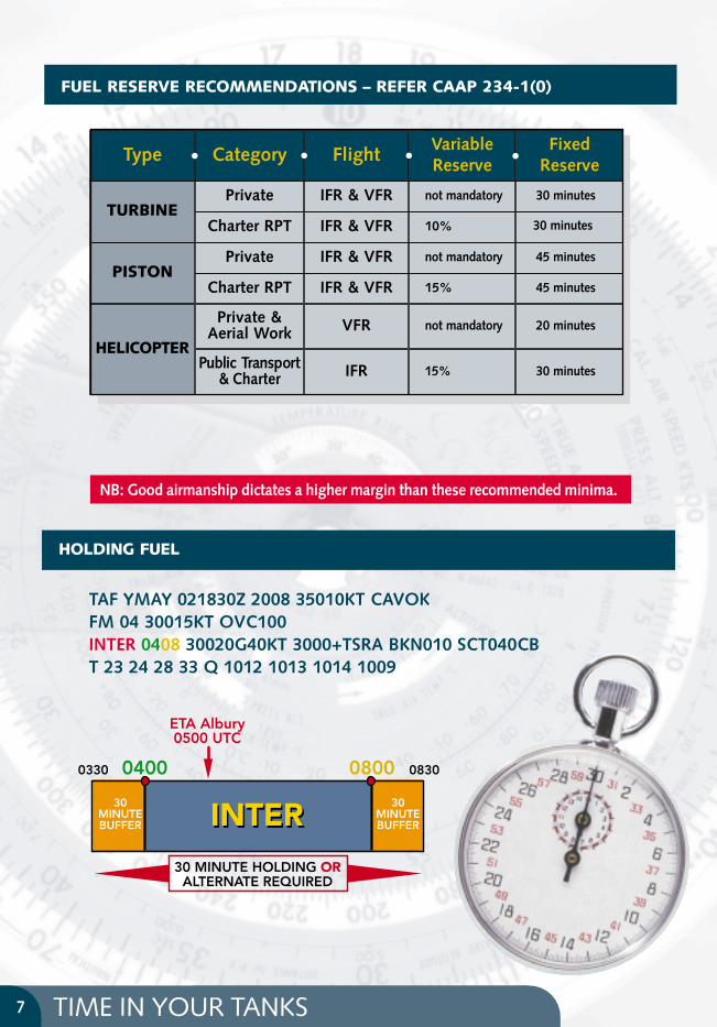
HOLDING FUEL
083008000400
30 MINUTE HOLDING ORALTERNATE REQUIRED
0330
30MINUTEBUFFER
ETA Albury0500 UTC
30MINUTEBUFFERINTERINTER
FUEL RESERVE RECOMMENDATIONS – REFER CAAP 234-1(0)
TURBINEPrivate
Charter RPT
IFR & VFR
IFR & VFR
not mandatory
10%
30 minutes
30 minutes
PISTONPrivate
Charter RPT
IFR & VFR
IFR & VFR
not mandatory
15%
45 minutes
45 minutes
NB: Good airmanship dictates a higher margin than these recommended minima.
Type Category Flight VariableReserve
FixedReserve• • • •
TAF YMAY 021830Z 2008 35010KT CAVOKFM 04 30015KT OVC100INTER 0408 30020G40KT 3000+TSRA BKN010 SCT040CBT 23 24 28 33 Q 1012 1013 1014 1009
HELICOPTER
Private &Aerial Work VFR not mandatory 20 minutes
Public Transport& Charter IFR 15% 30 minutes

USING YOUR HAND-HELD GPS8
• Ensure GPS plan has been crosschecked against written plan.
• GPS is not a substitute for thorough flight planning.
• Become familiar with the operation of your GPS unit beforethe flight.
• Use caution with the GO TO function. Check for CTA and Restricted areas.
GPS should not be used as a sole source of navigation

USEFUL GPS WAYPOINTS9
Always cross checkafter entering data
E153 07S27 37
E152 59S27 26
E152 49S27 12
S27 43 E153 02
S27 36 E152 53
S27 34 E153 01ArcherfieldArcherfield
S27 29 E152 55TV Towers
Dayboro
Goodna
Target
Park Ridge Water Tower
Enoggera
ARCHERFIELD GENERAL OPERATIONS FOR AERODROME10
For more detailed information,refer to AIP ENR 1.1
GENERALGAAP cater for high density operations by day andnight in VMC. Aircraft must not enter a GAAP CTRuntil in receipt of a circuit entry or zone transitinstruction. Circuit joining instructions from ATC aregenerally given to you at Target, Goodna, BrisbaneRiver (via TV Towers) and Logan Motorway (viaPark Ridge Water Tower).
Pilots unsure of the procedures at Archerfieldshould advise ATC on first contact - using the key phrase “unfamiliar with Archerfield.”
The circuit altitude for Archerfield aerodrome is 1000ft.
Where a GAAP aerodrome is equipped with parallelrunways, simultaneous contra-circuits may beconducted by day utilising separate Towerfrequencies. Operations will be regulatedindependently in each circuit, with an ATCclearance required to enter the opposite circuit or airspace.
Where operations are confined to a single runway,ATC will specify the circuit direction.
READBACK PHRASEOLOGYREQUIREMENTSRefer to AIP GEN 3.4-13 (4.4)
OPERATING LIMITATIONSSimultaneous contra-circuit operations to parallelrunways are not permitted by day in less than VMCand at night.
PROVISION OF SEPARATIONIn VMC, the pilot-in-command is primarilyresponsible for separation from other aircraft. ATC controls runway operations with landing andtake-off clearances and facilitates a high movementrate by providing traffic information and/orsequence instructions. To aid in the provision of separation, ATC will determine the status ofoperations in the GAAP CTR as follows:
A. Unrestricted VFR Operations: There are noweather related restrictions to aircraft operations.IFR aircraft must operate to the VFR within theGAAP CTR.
B. Restricted VFR Operations: ATC may applyweather related restrictions to VFR operations
to facilitate the movement and separation of IFRaircraft. ATC will then broadcast on the ATIS,“Restricted VFR Operations:”. The actualrestriction imposed may be specified individuallyto aircraft, although general restrictions may benotified on the ATIS; eg, “Start ApprovalRequired”.
Arriving IFR aircraft which are visual outside theGAAP CTR, and can continue visually, must operateVFR within the CTR. IFR aircraft operating visuallywill only receive a traffic information andsequencing service, and will not be separated fromother traffic.
Arriving IFR aircraft which are not visual outside theGAAP CTR may operate IFR within the CTR andseparation will be provided until the aircraftbecomes visual.
Departing IFR aircraft must operate VFR within theGAAP CTR until encountering IMC or leaving theGAAP CTR whichever is the sooner.
When aircraft are operating in conditions less thanVMC, ATC will provide separation within the GAAPCTR.
PILOT RESPONSIBILITIESPilot Responsibilities
A pilot must:
A. Sight and maintain separation from other aircraftwhilst operating in the GAAP CTR;
B. comply with ATC instructions while ensuring thatseparation is maintained from other aircraft;
C. immediately advise ATC if unable to comply witha control instruction;
D. advise ATC if unable to sight, or if sight lost of,other aircraft notified as traffic.
TRAFFIC INFORMATION (only in AF CTR)
Traffic information shall be issued by ATC when:
A. The pilot of one aircraft is required to give wayto, follow, or otherwise adjust the aircraft’s flightpath relative to that flown by another aircraft;and/or
B. the relative positions of aircraft cannot beestablished, and a collision or near miss may be likely unless one or both aircraft adjust theirrespective flight paths. In this case an alertingservice will be prefixed by the cautionary wordAlert.

ARCHERFIELD GENERAL OPERATIONS FOR AERODROME11
The provision of traffic information does notabsolve the pilot from keeping a good lookout and manoeuvring as required to avoid other traffic.
CLEARANCESClearances - All Operations
Individual clearances are required for:
A. take-off and landing;
B. taxiing across active runways;
Note: An instruction to “Hold Short of Runway(number) [Left (or Right)]” requires a pilotto hold at a marked holding point or holdshort of the runway strip.
C. turns in a direction contrary to the circuit for aparticular runway;
Note: An ATC circuit entry instruction constitutes a clearance for a contrary turn, if required to comply with the instruction.
D. circuits at a height different to the circuit altitudepublished in ERSA for the particular GAAPaerodrome; and
E. operations on routes or at altitudes differentfrom those published in ERSA for a particularGAAP aerodrome.
Clearances In VMC (Day or Night)
A clearance is required prior to operations in a GAAP CTR.
A clearance to take off, or instruction for circuitentry or transit, constitutes this clearance.
A pilot must not make a flight under the VFR in a GAAP CTR when VMC does not exist. At pilotrequest, ATC may authorise operations, in less thanVMC within these zones, by the issue of a SpecialVFR clearance (AIP RAC para 20.2).
Clearances in IMC
Clearance requirements for flights in IMC are as for Class C CTRs.
AERODROME AND TERMINALINFORMATIONAerodrome terminal information is broadcast onthe ATIS (120.9), when available.
If the nominated runway is not operationallysuitable, the pilot in command must advise ATC byusing the phrase “Require Runway (number) [Left(or Right)]”
Whenever parallel runways are utilised forsimultaneous contra-circuits the circuit directionmust be determined as follows:
A. Where runway Right is nominated the circuit is right-hand;
B. Where runway Left is nominated the circuitdirection is left-hand.
When ATIS is not available, terminal informationwill be provided by ATC. This will include runway,traffic patterns and QNH. Landing information maybe requested with the inbound report.
Archerfield Taxi CallsVFR Fixed Wing Aircraft OnlyAll VFR departure flights (including training area)and/or circuit operations shall:
1. Check daily NOTAMS to ensure trial is stilleffective.
2. Listen to the ATIS before commencing to taxi,then taxi to the nominated duty runwayapplicable to departure track and/or nominatedfor circuit operation.
N.B. - NO TAXI CALL OR GENERAL BROADCASTREQUIRED.
3. Maintain a continuous listening watch onArcherfield Ground 119.9 during taxi phase asTower initiated runway changes or activation ofadditional runways will be broadcast on thisfrequency.
4. Clearance to cross the ATIS nominated dutyrunway must be requested from GROUND.Clearance to cross an active crosswind runwaymust also be requested. An active crosswindrunway may be nominated on the ATIS or bybroadcast from GROUND.
5. Contact TOWER on the appropriate ATISnominated frequency at the runway holdingpoint and notify runway and departure track.
DEPARTURE TRACK AS PER ARCHERFIELDVISUAL PILOT GUIDE
e.g.“Archer Tower, Cessna ZFR ready runway 10R departure South East.”
Note:
A. Any operation requiring approval to use adifferent runway or circuit direction to thatspecified on the ATIS must be coordinated withthe Tower by phone or 119.9 prior to start.
ARCHERFIELD GENERAL OPERATIONS FOR AERODROME12
B. When required, Start Clearance advice will beincluded on the ATIS. Prior to start, coordinateclearance with Tower on 119.9
C. Taxi guidance is available on 119.9
D. Standard call 119.9 is still required whenvacating after landing.
CIRCUIT OPERATIONSATC may issue a sequencing instruction with atake-off or touch-and-go clearance. When issuedwith a sequencing instruction, a pilot must followthe preceding aircraft.
Unless otherwise instructed by ATC, a pilot mustreport Downwind when starting the downwind leg,and must advise aircraft type, callsign andintentions (ie, full stop or touch-and-go). If frequency congestion prevents the call beingmade in this position, the pilot must report Mid-Downwind or Late Downwind, as appropriate.When appropriate, ATC will issue a sequencinginstruction.
Non-standard circuit operations, eg, glide andflapless circuits, must be advised to ATC, normallywith the Downwind report. This advice will alsoalert other circuit traffic. ATC must also be advisedof simulated engine failures and asymmetrictraining in multi-engined aircraft at the earliestopportunity.
In sequencing aircraft ATC will indicate the positionof the preceding aircraft by reference to a leg ofthe circuit or as a clock bearing, and describe iteither as a specific type or in general terms (eg, Cessna or Twin).
ATC may issue a sequence number. Sequencenumbers specify the landing sequence position of an aircraft with respect to any preceding traffic.
ENR 1.1-3.8 (28.7) The instruction Follow requiresthe pilot to sight the preceding aircraft, andregulate circuit speed and approach path to achievelongitudinal separation. If the preceding aircraftcannot be sighted and identified, the pilot mustadvise ATC.
A landing clearance does not absolve the pilotin command from the responsibility forensuring that sufficient separation from thepreceding aircraft will be maintained duringthe landing.
Note: An aircraft can be cleared to land whilsta preceding aircraft is still on therunway provided ATC is satisfied thatno collision risk exists.
Where ATC instructs an aircraft to go round,or a missed approach is initiated, the pilotmust:
A. commence climb to circuit attitude;
B. position the aircraft on the active side andparallel to the nominated duty runway,while maintaining separation from otheraircraft; and
C. follow ATC instructions or re-enter thecircuit from upwind. ATC will advise whenwake turbulence may be a hazard.
TAXIING AFTER LANDINGAfter landing, the runway must be vacated assoon as possible. After vacating the runway,the pilot must not cross or taxi along arunway currently notified as ‘active’ unless a clearance to do so has been obtained.
Contact with SMC frequency must be madeimmediately when clear of the runway usedfor landing, except when specified in ERSA. SARWATCH should be cancelled where appli-cable on Flightwatch 128.15 or 1800 814931.
An instruction to “Hold Short of Runway(number) [Left (or Right)]” requires a pilot to hold at a marked holding point or to holdshort of the runway strip.
TRANSIT OF AND FLIGHT INPROXIMITY TO GAAP CTRsTransit
A pilot of a flight intending to transit a GAAPcontrol zone must comply with the proceduresfor entry to a GAAP control zone, thenproceed as directed by ATC.
FLIGHT IN PROXIMITYWhen a radio equipped aircraft will trackwithin 5NM (or as specified in ERSA) of aGAAP CTR boundary, without entering theGAAP CTR, the pilot must:
A. prior to entering this airspace, obtain theATIS then broadcast position, altitude andintention on the appropriate towerfrequency; and
B. while operating in this airspace, maintain a continuous listening watch on the appropriate tower frequency.
While operating in this airspace, all aircraftmust maintain a continuous visual surveillancefor other aircraft.

AbeamLeslie Harrison Reservoircall Brisbane Approach125.7
8 Nm from Archerfieldcall Brisbane Approach125.7
Abeam TV Towerscall Brisbane Approach125.7
AbeamLeslie Harrison Reservoircall Brisbane Approach125.7
If Amberley NOT active: call Brisbane Radar 125.7
8 Nm from Archerfieldcall Brisbane Approach125.7
Abeam TV Towerscall Brisbane Approach125.7
Crossing Western Freeway track to Lake Manchester remain OCTA. Contact Amberley ACD 134.6 for AWY clearance
Crossing Western Freeway track to Lake Manchester remain OCTA. Contact Amberley ACD 134.6 for AWY clearance
Crossing Western Freeway track to Spring Mountain remain OCTA. Contact Amberley ACD 134.6 for AWY clearance
Crossing Western Freeway track to Spring Mountain remain OCTA. Contact Amberley ACD 134.6 for AWY clearance
310°
099°
020°
204°
259°
DEPARTING ARCHERFIELD ENTERING CTA13
DEPARTING ARCHERFIELD ENTERING CTA (BY DAY IN VMC)
Archerfield MBZMBZ procedures (as per ERSA)
Archerfield tower operates as a GAAPbetween 2200 and 0800 UTC. Outside ofthese hours Archerfield becomes a non-standard MBZ within the lateral and verticalCTR limits. These are shown on the VisualTerminal Chart (VTC).Particular attention is drawn to therequirement to remain below 1500 ft untilclear of the Archerfield CTR boundary(daylight hours).
When the aerodrome is an MBZ, andoperational conditions permit, runway28R/10L should be used for take-off.
All circuit directions are left hand. Runway04R/22L are available during hours of daylight only.
Runway 10L/28R are available 24 hours aday.
All other MBZ procedures apply. Refer to AIPENR 1.4-5(2.2) and GEN 3.3-17(4.6)
During MBZ hours, pilots requiring an AirwaysClearance on departure are to contactBrisbane Radar 125.7 (primary means) or 07 3866 3694 immediately prior to enginestart for an expected clearance time andtransponder (SSR) code.
It is good airmanship to utilise the inboundreporting points (Goodna, TV Towers, ParkRidge Water Towers or Target), and remainclear of them outbound.
Helicopters: Low level helicopter training is not permitted when tower is unmanned.

ARCHERFIELD OUTBOUND RADIO CALLS14
DEPARTING INTO CLASS G DEPARTING INTO CTA/CTR MBZ
Obtain ATIS on 120.9 or 419
“Archerfield Terminal Information (Bravo)
Runway Wind Crosswind
QNH Cloud ”
In VMC by day fixed wing aircraft to depart as per the following routes.
DEP NORTH - Depart via Indooroopilly Bridge
DEP EAST - Depart east to overhead gateway arterial/south-east freeway intersection
DEP SOUTH-EAST - Depart south-east (1350 track from Archerfield)
DEP WEST - Depart west remaining clear of other parallelrunway operations
ANY OTHER DEP TRACK (E.G. SOUTH-WEST) MUST BE APPROVED BY THE TWR
If entering CTASubmit Flight Notification
Contact Brisbane Approach on 125.7 for transponder code
If transiting through Amberley
obtain ATIS on NDB 359
TAXI call 118.1
“All Stations Archerfield
Call Sign
Type
Taxiing
for Destination “
COMMON GAAP READ BACKS
1 Route clearance 5 QNH 9 Speed
2 Runway clearance 6 Transponder code 10 Conditional clearances
3 Runway in use 7 Radio frequency [refer AIP GEN 3.4-13 (4.4)]
4 Level/altitude 8 Turns/headings
Contact Brisbane Approachon 125.7 for transponder code
Submit Flight Notificationby fax, NAIPS or briefing
READY call 123.6 or 118.1
“Archer Tower Call Sign Ready Runway
departure “North, East, South-East or West
Take off(Make Radio Calls
as necessary)
Follow departure route as shown
on following pages
For Airways Clearancecontact
Brisbane Approach(see previous page)
eg “(aircraft callsign) abeam TV Towers (Level),
request Airways Clearance”
For Airways Clearance Depart OCTA then
contact Brisbane Approach (see previous page)
eg “(aircraft callsign) abeam TV Towers (height),
request Airways Clearance”
During GAAP hours depart clear of inbound VFR approach points (To leave AF CTR Boundary) at 1000’

ARCHERFIELD INBOUND RADIO CALLS15
MBZ
Prior to VFR approach point obtain ATIS on 120.9 or 419 NDB
“Archerfield Terminal Information (Bravo)
Runway Wind
Crosswind QNH
Cloud ”
determine appropriate frequency
TV Towers Always 123.6
GOODNA Runway 10R/28L 118.1
Runway 04L/22R 123.6
Obtain ATIS on 120.9 or 419to confirm Archerfield is an MBZ
(should be terminal information “Zulu”)
Inbound Radio Call
“Archer Tower
Call Sign Type Position
1500 feet received (ATIS) Inbound“
At reporting point (TV Tower, Goodna, Target or Park Ridge)
give All Stations Call:
“All Stations Archerfield
Call Sign Type Position
1500 feet inbound“
Follow ATC instructions for landing
Change to SMC (119.9) after crossing holding point.Ask for “detailed taxi instructions” if required.
Note: Cancel SARTIME through Flightwatch on 128.15 or 1800 814 931
Maintain 1500, until on dead side then descend to 1000 and join crosswind
REFUELLINGTaxi to the fuel farm between taxiway
Bravo and Echo (refer to ERSA).Alternatively, call
Air BP on 121.65, ph (07) 3272 7775Mobil on 128.95, ph (07) 3277 1298 Shell on 128.95, ph (07) 3277 3030
GAAP HRS (2200 – 0800 UTC)

TR 292°M
TR 344°M
Mt SamsonMt Samson
SamfordSamford
Lake Samsonvale
DayboroDayboro
15N
MBN
12NMBN
C LL 2500
C LL SFC
C LL 1000
C LL 3500
ARCHERFIELD OUTBOUND TO NORTH16
S27 12.0 E152 49.3
If unsure of your positionrequest assistance from
BN Radar 125.7
CAUTIONBrisbane Control Zone
1500ft CTA step
Dayboro
Climb to 3500ft FREQ 125.7
Lake Samsonvale
Climb to 2500ft FREQ 125.7Track to Dayboro

ArcherfieldArcherfield04
22
10
28
TR 340°M
TR 344°M
Inala
Logan Motorw
ay
Logan Motorw
ay
Inala
BrisbaneCBD
BrisbaneCBD
Story BridgeStory
Bridge
B
R I S B A NE
RIV
ER
CAUTIONParachutistsCAUTION
C LL 1000
C LL 2500
C LL 1500
C LL SFC
C LL 1500 C LL 3500
7NM
FMTHRRWY 01
GAAP1500
0
EnoggeraEnoggera
EnoggeraReservoirEnoggeraReservoir
TV Towers TV Towers
Indooroopilly BridgeIndooroopilly Bridge
ARCHERFIELD OUTBOUND TO NORTH17
S27 34.2 E153 00.5
Prior to take-off,Transponder equipped
aircraft squawk 1200 - mode C
S27 26.0 E152 57.0
During GAAP TWR Hrs (2200-0800)
If unsure of your positionrequest assistance from
BN Radar 125.7
Quarry
Climb to 1500ft FREQ 125.7Track to Dayboro
Indooroopilly Bridge
When past Indooroopilly Bridge
Climb to 1500ft FREQ 123.6Track to east of TV towers
TV Towers/Mt Coot-tha Lookout
Climb to 1500ft FREQ 125.7
Optional call:”BN Approach,(Call sign) TV Towers, 1500, trackingnorth to Dayboro, request area QNH”
School/Cemetery
Climb to 1500ft FREQ 125.7
500FT
300metres
CAUTIONYou may be this close to controlled airspace
Check current VTC forCTR and CTA steps
Centenary Bridge
Enoggera ReservoirEnoggera Reservoir
EnoggeraEnoggera
GoodnaGoodna
BR
I SB
ANE R I V E R
TV TowersTV Towers
ArcherfieldArcherfield
Centenary Bridge
TR 153°M
28
22
1004
C LL 1500
C LL SFC
C LL 1500
GAAP
15000
C LL 1000
C LL 2500
C LL 2500
E152 55.0S27 28.5
S27 34.2 E153 00.5
During GAAP TWR Hrs (2200 - 0800)
CAUTIONCheck current VTC for
CTR and CTA steps
If unsure of your positionrequest assistance from
BN Radar 125.7
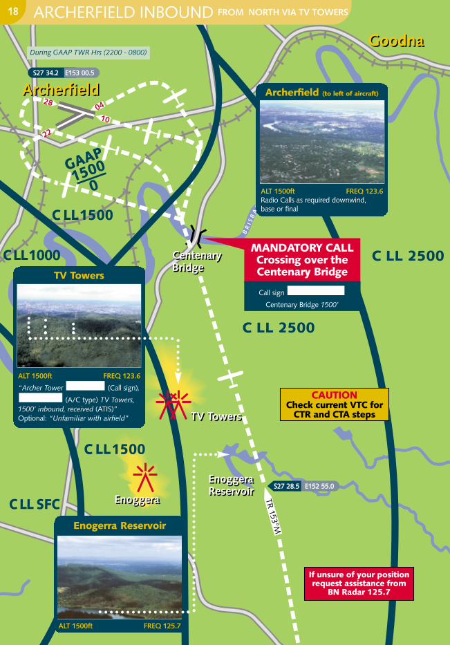
ARCHERFIELD INBOUND FROM NORTH VIA TV TOWERS18
TV Towers
ALT 1500ft FREQ 123.6
“Archer Tower (Call sign),
(A/C type) TV Towers,1500’ inbound, received (ATIS)”Optional: “Unfamiliar with airfield”
Archerfield (to left of aircraft)
ALT 1500ft FREQ 123.6Radio Calls as required downwind, base or final
Enogerra Reservoir
ALT 1500ft FREQ 125.7
MANDATORY CALLCrossing over theCentenary Bridge
Call sign
Centenary Bridge 1500’
Archerfield Inbound FROM NORTH VIA
Mt SamsonMt Samson
SamfordSamford
DayboroDayboro
TR 158°M
C LL 2500
C LL 1500
C LL 3500
12NMBN
15N
MBN
Lake SamsonvaleLake Samsonvale
Transponder equipped aircraft squawk 1200 - mode C
S27 12.0 E152 49.3
CAUTIONBrisbane Control
Zone1500ft CTA step
If unsure ofyour position
requestassistance from
BN Radar 125.7
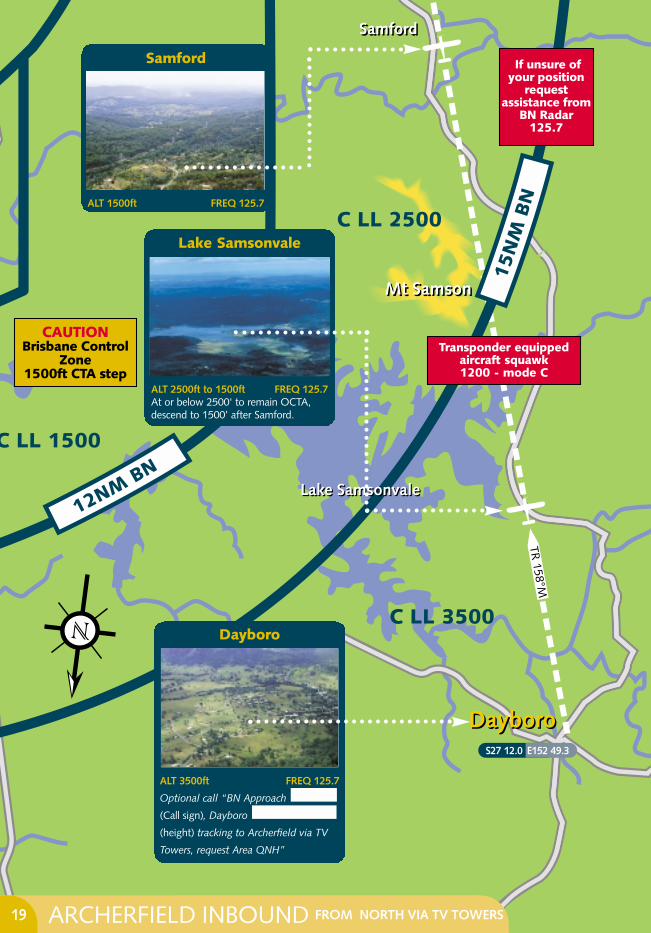
ARCHERFIELD INBOUND FROM NORTH VIA TV TOWERS19
Samford
ALT 1500ft FREQ 125.7
Lake Samsonvale
ALT 2500ft to 1500ft FREQ 125.7At or below 2500' to remain OCTA,descend to 1500’ after Samford.
Dayboro
ALT 3500ft FREQ 125.7
Optional call “BN Approach
(Call sign), Dayboro
(height) tracking to Archerfield via TV
Towers, request Area QNH”
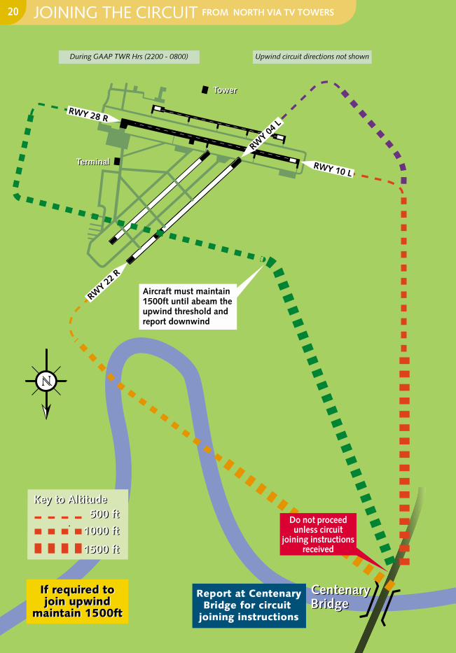
Aircraft must maintain 1500ft until abeam the upwind threshold and report downwind
BR
ISB
AN
ERIV
ER
If required tojoin upwind
maintain 1500ft
If required tojoin upwind
maintain 1500ft
Centenary BridgeCentenary Bridge
Report at CentenaryBridge for circuit
joining instructions
RWY 04
L
RWY 10 L
RWY 22
R
RWY 28 R
Terminal
Tower
Terminal
Tower
1500 ft
1000 ft
500 ft
1500 ft
1000 ft
500 ftKey to AltitudeKey to Altitude
Do not proceedunless circuit
joining instructionsreceived
During GAAP TWR Hrs (2200 - 0800) Upwind circuit directions not shown
JOINING THE CIRCUIT FROM NORTH VIA TV TOWERS20

GENERAL CIRCUIT JOINING INSTRUCTIONS21
The TV Towers can usually be seen from Dayboro and care must be taken to avoid ControlledAirspace overlying the route. To avoid this, be sure to be established at or below 2500' prior to LakeSamsonvale. Track to the west of the TV Towers and report to Archerfield Tower on 123.6 abeamthe TV Towers. From there, towards the Centenary Bridge which can be seen to the North West ofArcherfield. On crossing the Brisbane River report to the Tower your position and expect a circuitjoining instruction.
Circuit Joining Instructions are given to place an aircraft in the circuit in sequence with the other aircraft already established in the circuit.
A Circuit Joining Instruction may have 2 parts: a position to enter the circuit, and may begiven a number in the sequence. e.g. TOWER “Zulu Foxtrot Romeo, join circuit on left base 28 left.
You are number 2 to a Baron on final. “READBACK “28 left, Zulu Foxtrot Romeo”
You are free to leave 1500’ at your discretion If you have received joining instructions or “Cleared Visual Approach”. Aircraft instructed to join downwind must maintain 1500’until abeam the upwind threshold and report downwind.
Radio calls should only include the mandatory readbacks, due to the large number of movements at Archerfield. Refer
Care should also be taken to maintain your position in the sequence and to not "cut inside"other traffic. If unsure of where preceding aircraft is, ask ATC for their position. This will begiven to you as either their position in the circuit, or their position reference to your position. eg. “Aircraft is at your 2 o’clock low”. If in doubt, tell the tower.
GEN 3.4-13 (4.4)
COMMON GAAP READ BACK ITEMS
1 Route clearance 6 Transponder code2 Runway clearance 7 Radio frequency3 Runway in use 8 Turns/headings4 Level/altitude 9 Conditional clearances5 QNH
TV TOWERS
GENERAL CIRCUIT JOINING INSTRUCTIONS:
1
2
3
4
5

Mt CrosbyMt Crosby
IpswichIpswich
AmberleyAmberley
SwanbankPowerstationSwanbankPowerstation
RailwayWorkshops
RailwayWorkshops
AMBMIL CTR
45000
CAUTIONJet aircraft
in CTA above
Amberley ACTIVEAMB APPROACH 126.2
Amberley NOT ACTIVE (MBZ)Below 3500ft - MBZ 118.33500ft - 4500ft - BN Centre 126.5Above 4500ft - Requires Airway Clearance
BN CENTRE 126.5
If unsure of your positionrequest assistance from
BN Radar 125.7
ARCHERFIELD OUTBOUND TO WEST 22
Amberley/Ipswich
If on AMB MBZ do not climb above3500ft unless requesting an AirwaysClearance
Mt Crosby

Logan
MotorwayLogan
Motorway
WesternFreeway
WesternFreeway
Mt Coot-tha TV Towers
Mt Coot-tha TV Towers
QE II StadiumQE II Stadium
InalaInala
CentenaryBridgeCentenaryBridge
GoodnaGoodna
BHP Steel Mill
BHP Steel Mill
22
28
04 10
ArcherfieldArcherfield
B
R I S B A N E R I V E R
C LL 3500
C LL 2500
C LL 1500
C LL 1000
C LL 1500
C LL SFC
15NM BN
GAAP1500
0
ARCHERFIELD OUTBOUND TO WEST23
If unsure of your positionrequest assistance from
BN Radar 125.7
ALT 1000ft FREQ 126.2 AMB APPFREQ 126.5 BN CEN
FREQ 118.3 AMB MBZ
During GAAP TWR Hrs (2200 - 0800)
CAUTIONCheck current VTC for
CTR and CTA steps
Prior to take-off,Transponder equipped
aircraft squawk 1200 - mode C
Remain clear of otherparallel ops.
BHP Steel MillBHP Steel Mill
RailwayWorkshops
RailwayWorkshops
Logan
MotorwayLogan
Motorway
Mt Coot-tha TV TowersMt Coot-tha TV Towers
ArcherfieldArcherfield
QE II StadiumQE II Stadium
InalaInalaCentenary
BridgeCentenary
Bridge
GoodnaGoodna
2210
04
28
B R I S B A N E R I V
ER
C LL 2500
C LL 1500
C LL 1000
C LL 3500
C LL 1500
C LL SFC
15NM BN
GAAP1500
0
S27 36.7 E152 53.3
If unsure of your position
requestassistance from
BN Radar125.7
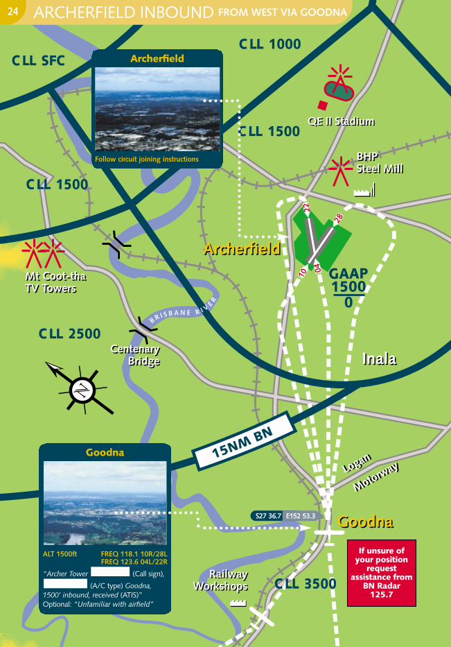
ARCHERFIELD INBOUND FROM WEST VIA GOODNA24
Archerfield
Follow circuit joining instructions
Goodna
ALT 1500ft FREQ 118.1 10R/28LFREQ 123.6 04L/22R
“Archer Tower (Call sign),
(A/C type) Goodna,1500’ inbound, received (ATIS)”Optional: “Unfamiliar with airfield”
Mt CrosbyMt Crosby
SwanbankPowerstation
SwanbankPowerstation
IpswichIpswich
AmberleyAmberley
ON
E W
AY
AMBMIL CTR
45000
If unsure of your positionrequest assistance from
BN Radar 125.7
Transponder equipped aircraft squawk 1200 - mode C
During GAAP TWR Hrs (2200 - 0800)
CAUTIONCheck current VTC for
CTR and CTA steps
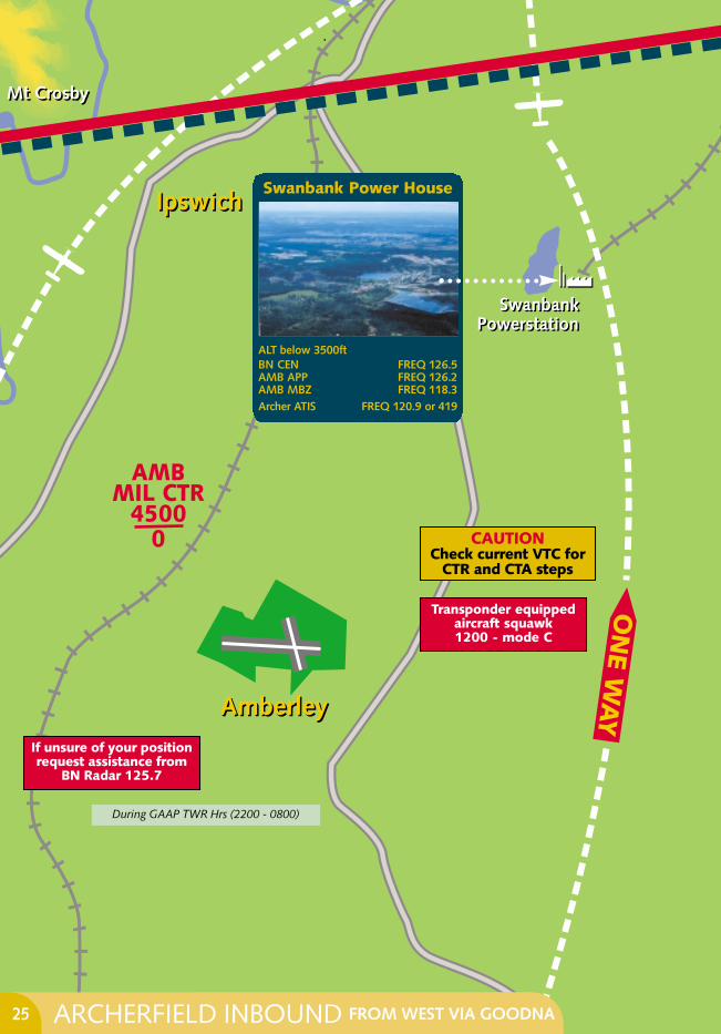
ARCHERFIELD INBOUND FROM WEST VIA GOODNA25
Swanbank Power House
ALT below 3500ftBN CEN FREQ 126.5 AMB APP FREQ 126.2 AMB MBZ FREQ 118.3 Archer ATIS FREQ 120.9 or 419

If required tojoin upwind
maintain 1500ft
If required tojoin upwind
maintain 1500ft
Terminal
Tower
Terminal
Tower
GoodnaGoodnaMake inbound call at Goodna, expect circuit joininginstructions
Report downwindat 1500ft
Report downwindat 1500ft
RW
Y 0
4 L
RWY 10 R
RW
Y 2
2 R
RWY 28 L
1500 ft
1000 ft
500 ft
1500 ft
1000 ft
500 ftKey to AltitudeKey to Altitude
JOINING THE CIRCUIT FROM WEST VIA GOODNA
Do not proceed unlesscircuit joining
instructions received
During GAAP TWR Hrs (2200 - 0800) Upwind circuit directions not shown
26
GENERAL CIRCUIT JOINING INSTRUCTIONS27
Goodna is another reporting point which can be easily mistaken. The Railway Workshops atRedbank can be used to identify the position of Goodna. Goodna is situated on the bend of theBrisbane River to the East of the Workshops. It can be identified by the Golf Course on the northernside of the river. From Goodna, Archerfield Aerodrome can be seen.
Circuit Joining Instructions are given to place an aircraft in the circuit in sequence with the other aircraft already established in the circuit.
A Circuit Joining Instruction may have 2 parts: a position to enter the circuit, and may begiven a number in the sequence. e.g. TOWER “Zulu Foxtrot Romeo, join circuit on left base 28 left.
You are number 2 to a Baron on final. “READBACK “28 left, Zulu Foxtrot Romeo”
You are free to leave 1500’ at your discretion If you have received joining instructions or “Cleared Visual Approach”. Aircraft instructed to join downwind must maintain 1500’ until abeam the upwind threshold and report downwind.
Radio calls should only include the mandatory readbacks, due to the large number of movements at Archerfield. Refer
Care should also be taken to maintain your position in the sequence and to not "cut inside"other traffic. If unsure of where preceding aircraft is, ask ATC for their position. This will begiven to you as either their position in the circuit, or their position reference to your position. eg. “Aircraft is at your 2 o’clock low”. If in doubt, tell the tower.
GEN 3.4-13 (4.4)
COMMON GAAP READ BACK ITEMS
1 Route clearance 6 Transponder code2 Runway clearance 7 Radio frequency3 Runway in use 8 Turns/headings4 Level/altitude 9 Conditional clearances5 QNH
GOODNA
GENERAL CIRCUIT JOINING INSTRUCTIONS:
1
2
3
4
5
C LL 4500
C LL 3500
Logan VillageLogan Village
BeenleighBeenleigh
TR 135 °M
TR 135 °M
If unsure of your positionrequest assistance from
BN Radar 125.7
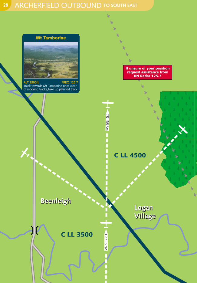
ARCHERFIELD OUTBOUND TO SOUTH EAST28
Mt Tamborine
ALT 3500ft FREQ 125.7Track towards Mt Tamborine once clearof inbound tracks, take up planned track

Gateway
Arteria
lGateway
Arteria
lC LL 2000
C LL 2500
C LL 1000
C LL 1000
GAAP1500
0
BR
ISB
AN ER I V
E R
Sout
hea
stF
reew
ay
Sout
hea
stFr
eew
ay
InalaInala
Logan Motorw
ay
Logan Motorw
ay
ArcherfieldArcherfield
QE II StadiumQE II StadiumMt GravattMt Gravatt
Target Dept StoreTarget Dept Store
Park Ridge Water TowerPark Ridge Water Tower
Mount
Linds
ayHwy
Mount
Linds
ayHwy
28
2210
04
TR 135 °M
C LL 1500BHP Steel MillBHP Steel Mill
C LL 3500
Prior to take-off,transponder equipped
aircraft squawk 1200 - mode C
For aircraft departingon RWY 28 take upHDG 135 prior to
passing south abeamthe control tower
During GAAP TWR Hrs (2200 UTC – 0800 UTC)
CAUTIONCheck current
VTC for CTR andCTA steps
If unsure of your positionrequest assistance from
BN Radar 125.7
ARCHERFIELD OUTBOUND TO SOUTH EAST29
Logan Motorway
ALT 1000ft FREQ 118.1View to right of aircraft
Outbound South East
ALT 1000ft FREQ 118.1Depart AF track 135° M and then trackbetween Park Ridge & Target
Logan Motorway (to right)
Climb to Below 3500ft FREQ 118.1
Track in this direction
C LL 3500
C LL 2000
C LL 2500C LL 1500
GAAP1500
0
C LL 1000
Logan Motorway
Logan Motorway
Mou
ntLin
dsa
yH
igh
way
Mou
ntLin
dsa
yH
igh
way
ArcherfieldArcherfield
BHP Steel MillBHP Steel Mill
28
2210
04
TR 335 °M
If unsure of your positionrequest assistance from
BN Radar 125.7
During GAAP TWR Hrs (2200 UTC – 0800 UTC)
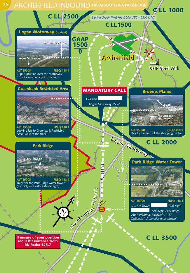
ARCHERFIELD INBOUND FROM SOUTH VIA PARK RIDGE30
Logan Motorway (to right)
ALT 1500ft FREQ 118.1Report position over the motorway.Expect circuit joining instructions
Mt Lindsay HwyMt Lindsay Hwy
Logan Motorway
Browns Plains
ALT 1500ft FREQ 118.1Stay to the west of the shopping centre
Mt Lindsay Highway
Logan Motorway
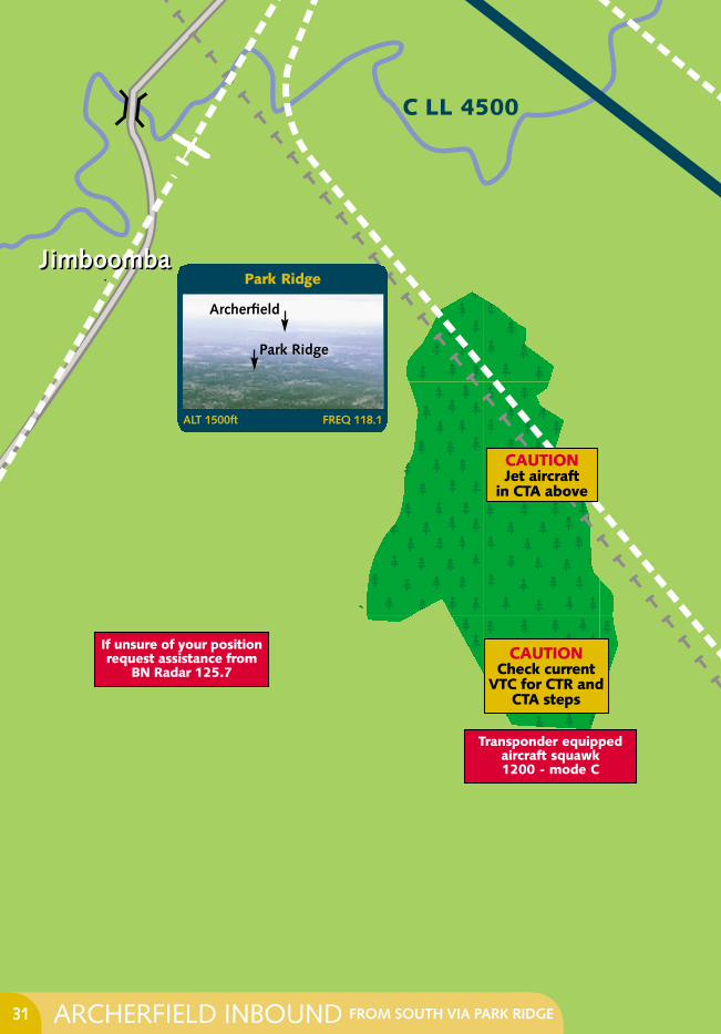
Park Ridge Water Tower
ALT 1500ft FREQ 118.1
“Archer Tower (Call sign),
(A/C type) Park Ridge,1500’ inbound, received (ATIS)”Optional: “Unfamiliar with airfield”
Greenbank Restricted Area
ALT 1500ft FREQ 118.1Looking left to Greenbank RestrictedArea (west of the track)
Park Ridge
ALT 1500ft FREQ 118.1Track for the Park Ridge water tower(the only one with a strobe light)
Park Ridge
MANDATORY CALL
Call sign
Logan Motorway 1500’
C LL 4500
JimboombaJimboomba
CAUTIONJet aircraft
in CTA above
Transponder equipped aircraft squawk 1200 - mode C
CAUTIONCheck current
VTC for CTR andCTA steps
If unsure of your positionrequest assistance from
BN Radar 125.7
ARCHERFIELD INBOUND FROM SOUTH VIA PARK RIDGE31
Park Ridge
ALT 1500ft FREQ 118.1
Park Ridge
Archerfield
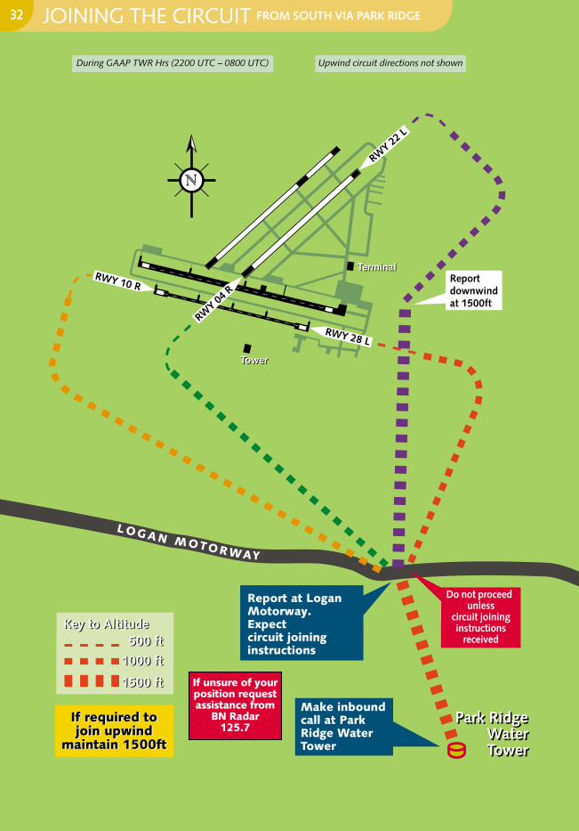
LOGAN MOTORWAY
Report downwindat 1500ft
RWY 28 L
TowerTower
Park RidgeWaterTower
Park RidgeWaterTower
Make inboundcall at Park Ridge Water Tower
Report at Logan Motorway. Expectcircuit joining instructions
TerminalTerminal
RWY 22 L
RWY 04
R
RWY 10 R
If required tojoin upwind
maintain 1500ft
If required tojoin upwind
maintain 1500ft
1500 ft
1000 ft
500 ft
1500 ft
1000 ft
500 ftKey to AltitudeKey to Altitude
JOINING THE CIRCUIT FROM SOUTH VIA PARK RIDGE
Do not proceedunless
circuit joininginstructions
received
During GAAP TWR Hrs (2200 UTC – 0800 UTC) Upwind circuit directions not shown
If unsure of yourposition requestassistance from
BN Radar 125.7
32
GENERAL CIRCUIT JOINING INSTRUCTIONS33
PARK RIDGE WATER TOWER
GENERAL CIRCUIT JOINING INSTRUCTIONS:
Park Ridge Water Tower is the only water tower in the area with a strobe light and is east of the Mount Lindsay Highway. Do not confuse with the more prominent water towers west of theHighway bordering the Greenbank Restricted Area.
Find the PKR W/T by either:
1. Tracking 353° M from over Jimboomba towards the Brisbane City high rise. PKR W/T will appear before you.
2. Fly from Coolangatta via the Pine Forest parallel to the power lines until the Logan River almosttouches the lines. From here track towards the Brisbane City high rise. PKR W/T will appearbefore you.
On the PKR track 335° M, R633 (Greenbank Military Restricted Area) is west of the train line onthe edge of the housing estate. The large shopping centre at Browns Plains is 1.5 Nm east of thetrack. The Logan Motorway is north of the powerlines. FREQ 118.1
Circuit Joining Instructions are given to place an aircraft in the circuit in sequence with the other aircraft already established in the circuit.
A Circuit Joining Instruction may have 2 parts: a position to enter the circuit, and may be given a number in the sequence. e.g. TOWER “Zulu Foxtrot Romeo, join circuit on left base 28 left.
You are number 2 to a Baron on final. “READBACK “28 left, Zulu Foxtrot Romeo”
You are free to leave 1500’ at your discretion If you have received joining instructions or “Cleared Visual Approach”. Aircraft instructed to join downwind must maintain 1500’ until abeam the upwind threshold and report downwind.
Radio calls should only include the mandatory readbacks, due to the large number of movements at Archerfield. Refer
Care should also be taken to maintain your position in the sequence and to not "cut inside"other traffic. If unsure of where preceding aircraft is, ask ATC for their position. This will begiven to you as either their position in the circuit, or their position reference to your position. eg. “Aircraft is at your 2 o’clock low”. If in doubt, tell the tower.
GEN 3.4-13 (4.4)
COMMON GAAP READ BACK ITEMS
1 Route clearance 6 Transponder code2 Runway clearance 7 Radio frequency3 Runway in use 8 Turns/headings4 Level/altitude 9 Conditional clearances5 QNH
1
2
3
4
5
C LL 3500
C LL 2000
Mt CottonMt Cotton
CAUTIONBeware of
Jet aircraft aboveStay below 2000ft
If unsure of your positionrequest assistance from
BN Radar 125.7
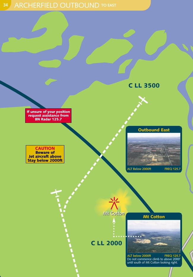
ARCHERFIELD OUTBOUND TO EAST34
Mt Cotton
ALT below 2000ft FREQ 125.7Do not commence climb to above 2000’until south of Mt Cotton looking right.
Outbound East
ALT Below 2000ft FREQ 125.7

C LL 1000
GAAP1500
0
QE II StadiumQE IIStadium
BHP Steel Mill
BHP Steel Mill
Target DeptStoreTarget DeptStore
InalaInala
BR
I SB
AN
ER
IVE
R
Mt GravattMt Gravatt
Leslie HarrisonReservoirLeslie HarrisonReservoir
Gateway Gateway
Sout
heas
t Free
way
Sout
heas
t Free
way
22
28
04
10
ArterialArterial
ArcherfieldArcherfield
C LL 1500
C LL 2000
During GAAP TWR Hrs (2200 - 0800)
CAUTIONCheck current
VTC for CTR andCTA steps
Track north of Target
Prior to take-off,Transponder equipped
aircraft squawk 1200 - mode C
If unsure ofyour position
requestassistance from
BN Radar125.7
ARCHERFIELD OUTBOUND TO EAST35
Leslie Harrison Reservoir
ALT below 2000ft FREQ 125.7Leslie Harrison Reservoir looking left
Freeway Intersection
ALT below 2000ft FREQ 125.7
Outbound East
ALT 1000ft 10L/28R FREQ 123.604R/22L FREQ 118.1
Track between Leslie Harrison reservoirand Mt Cotton
Outbound East
ALT 1000ft 10L/28R FREQ 123.604R/22L FREQ 118.1
Gateway Arterial
Leslie Harrison Reservoir
Gateway Arterial
South East Freeway

GAAP1500
0
C LL 1500
C LL 1000
C LL 2000
BHP Steel Mill
BHP Steel Mill
Target DeptStoreTarget DeptStore
InalaInala
BR
ISB
AN
ER
I VE
R
Mt GravattMt Gravatt
Leslie HarrisonReservoirLeslie HarrisonReservoir
Gateway ArterialGateway Arterial
ArcherfieldArcherfield
Sout
heas
t Free
way
Sout
heas
t Free
way
22
1028
04
QE II StadiumQE IIStadium
S27 34.2 E153 00.5
S27 37.0 E153 07.0
During GAAP TWR Hrs (2200 - 0800)
If unsure of your positionrequest assistance from
BN Radar 125.7
ARCHERFIELD INBOUND FROM EAST VIA TARGET36
Target Dept Store
ALT 1500ft FREQ 118.1“Archer Tower (Call sign),
(A/C type) Target,1500’ inbound, received (ATIS)”Optional: “Unfamiliar with airfield”
C LL 2000
C LL 3500
Mt CottonMt Cotton
CAUTIONCheck current
VTC for CTR andCTA steps
Transponder equipped aircraft
squawk 1200 - mode C
If unsure of your positionrequest assistance from
BN Radar 125.7
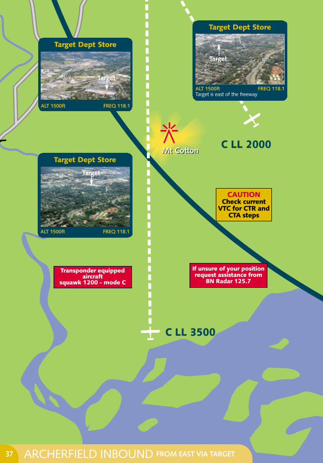
ARCHERFIELD INBOUND FROM EAST VIA TARGET37
Target Dept Store
ALT 1500ft FREQ 118.1
Target Dept Store
ALT 1500ft FREQ 118.1
Target
Target Dept Store
ALT 1500ft FREQ 118.1Target is east of the freeway
Target
Target
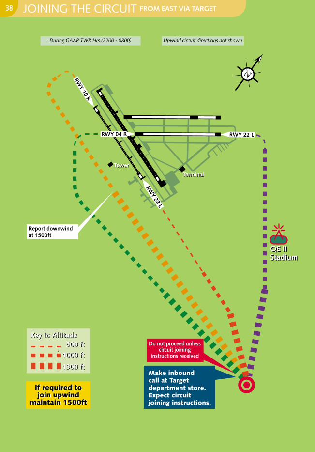
Joining the circuit - via TARGET
Report downwindat 1500ft
Make inboundcall at Target department store. Expect circuit joining instructions.
If required tojoin upwind
maintain 1500ft
If required tojoin upwind
maintain 1500ft
TowerTower
TerminalTerminal
RWY 22 LRWY 04 R
RWY 10 R
RWY 28 L
1500 ft
1000 ft
500 ft
1500 ft
1000 ft
500 ftKey to AltitudeKey to Altitude
QE II StadiumQE IIStadium
Do not proceed unlesscircuit joining
instructions received
During GAAP TWR Hrs (2200 - 0800) Upwind circuit directions not shown
JOINING THE CIRCUIT FROM EAST VIA TARGET38

GENERAL CIRCUIT JOINING INSTRUCTIONS39
TARGET
Target has a huge red and white bullseye painted on the roof of the Target department store. The store is on the east of the Southeast Freeway and on a direct line from Mt Cotton toArcherfield. If arriving from the south, stay to the east of the freeway from Loganholme ShoppingCentre and follow the freeway until arriving at Target. Archerfield can usually be seen from Target.FREQ is 118.1.
Circuit Joining Instructions are given to place an aircraft in the circuit in sequence with the other aircraft already established in the circuit.
A Circuit Joining Instruction may have 2 parts: a position to enter the circuit, and may begiven a number in the sequence. e.g. TOWER “Zulu Foxtrot Romeo, join circuit on left base 28 left.
You are number 2 to a Baron on final. “READBACK “28 left, Zulu Foxtrot Romeo”
You are free to leave 1500’ at your discretion If you have received joining instructions or “Cleared Visual Approach”. Aircraft instructed to join downwind must maintain 1500’ until abeam the upwind threshold and report downwind.
Radio calls should only include the mandatory readbacks, due to the large number of movements at Archerfield. Refer
Care should also be taken to maintain your position in the sequence and to not "cut inside"other traffic. If unsure of where preceding aircraft is, ask ATC for their position. This will begiven to you as either their position in the circuit, or their position reference to your position. eg. “Aircraft is at your 2 o’clock low”. If in doubt, tell the tower.
GEN 3.4-13 (4.4)
GENERAL CIRCUIT JOINING INSTRUCTIONS:
COMMON GAAP READ BACK ITEMS
1 Route clearance 6 Transponder code2 Runway clearance 7 Radio frequency3 Runway in use 8 Turns/headings4 Level/altitude 9 Conditional clearances5 QNH
1
2
3
4
5

GLOSSARY
Amberley. . . . . . . . . . . . . . . . . . . . YAMB
Archerfield . . . . . . . . . . . . . . . . . . . YBAF
Bond University . . . . . . . . . . . . . . . BUVY
Brisbane . . . . . . . . . . . . . . . . . . . . . YBBN
Bromelton . . . . . . . . . . . . . . . . . . . . BML
Burleigh Heads . . . . . . . . . . . . . . . . BLGH
Caboolture . . . . . . . . . . . . . . . . . . . YCAB
Cement Works . . . . . . . . . . . . . . . CWKS
Dayboro . . . . . . . . . . . . . . . . . . . . . DBO
Dreamworld . . . . . . . . . . . . . . . . . . DRLD
Flinders Peak . . . . . . . . . . . . . . . . . . . FPK
Goodna. . . . . . . . . . . . . . . . . . . . . . GON
Jacobs Well . . . . . . . . . . . . . . . . . . . JCW
Jupiters Casino. . . . . . . . . . . . . . . . . . JUP
Kilcoy . . . . . . . . . . . . . . . . . . . . . . . KLCY
Kilcoy NDB . . . . . . . . . . . . . . . . . . . . KCY
Lake Manchester . . . . . . . . . . . . . . . LMC
Laravale . . . . . . . . . . . . . . . . . . . . . . LAV
Maleny. . . . . . . . . . . . . . . . . . . . . . . MLY
Moffet Head . . . . . . . . . . . . . . . . . . MFH
Mt Cotton . . . . . . . . . . . . . . . . . . MCOO
Mt Gravatt . . . . . . . . . . . . . . . . . . . MVT
Nerang. . . . . . . . . . . . . . . . . . . . . . . NEN
Park Ridge Water Tower . . . . . . . . . . PKR
Petrie . . . . . . . . . . . . . . . . . . . . . . . . . PTI
Porpoise Point . . . . . . . . . . . . . . . . . . PRP
Redland Bay . . . . . . . . . . . . . . . . . . . RLB
Somerset Dam. . . . . . . . . . . . . . . . . SMD
Target . . . . . . . . . . . . . . . . . . . . . . . . TAR
The Pines. . . . . . . . . . . . . . . . . . . . . . PIN
TV Towers. . . . . . . . . . . . . . . . . . . . . TVT
Notes:
40

FREQUENCIES
Archer Tower 118.1 123.6Archer Ground 119.9ATIS (Archer) 120.9 419Archer MBZ 118.1
Brisbane Approach 125.7(Outside TWR hours)
Brisbane Centre 126.5Amberley Approach 126.2Amberley ACD 134.6Amberley MBZ 118.3Flightwatch 128.15
Archer PAL 125.1(Outside TWR HRS)
PHONE NUMBERS
Flightwatch 1800 814 931Archer Tower 07 3275 8245
NAVIGATION AIDS
Archer NDB 419 (range 30nm) Caution: excessive bearing fluctuations
between 180º and 200º
REFUELLING
Taxi to the fuel farm between taxiway Bravo and Echo(refer to ERSA). Alternatively,
call Air BP on 121.65 ph (07) 3272 7775
call Mobil on 128.95 ph (07) 3277 1298
call Shell on 128.95 ph (07) 3277 3030
INITIAL CHECK
Hold altitude Aim for best glide speedMixture RichCarburettor heat Full hotFuel On Pump On Change tanksTrim To best glide speed
FIELD SELECTION
Wind – determine directionSurroundings :Power lines trees Size & Shape – in relation to windSurface and SlopeS(c)ivilisation – close proximity if possible
FMOST CHECK
Fuel Contents, pump On, primer lockedMixture Up & down range, leave richOil Temps & pressures green rangeMag switches Left then right back to bothThrottle Up & down range then close
MAYDAY CALL & SQUAWK 7700
“Mayday Mayday MaydayBrisbane ZFR a Piper
Engine Failure13nm west of Archerfield 4500 feetattempting to land on paddock”
Any other useful information such as number of passengers etc.
BRIEF YOUR PASSENGERS
FINAL ACTIONS
Fuel OffMixture Lean cut-offMags OffHarness TightDoor As requiredMaster switch OffCaution If flaps are electrically operated
HIGH KEY2500ft AGL
3000ftAGL
ENGINE FAILURE POINT4500ft AGL
2000ftAGL
LOW KEY1500 ft AGL
1000ft AGL
IF TOO LOW
IF TOO HIGH
Check Current version of Pilot Guide onWeb site: www.casa.gov.au or
www.flyingaustralia.comPhone: 131 757 Safety Promotion AVFAX code: 81577
EMERGENCY LANDING PROCEDURES41

Squawk 7600Stay in VMC. Broadcast Intentions. Proceed
all radio calls with: “Transmitting Blind”.
If possible land at a non-MBZ airport.
CTAF When joining the circuit stay atleast 500 ft above circuit height. When youhave selected the runway descend on thedeadside of the circuit. Cross the upwindthreshold at circuit height. Fly normal circuit.
At GAAP airports When tower isactive follow normal procedure. Transmitblind and listen out on NDB FREQ forinstruction or watch tower for light signals.
Mobile phones can be used in emergencies.
Radio Failure
2500
4500
6500
8500
3500
5500
7500
9500
1500EVEN
1000
s+5
00
ODD
1000s+
500
CRUISING ALTITUDE
SYMBOLS NEAR WIND DIRECTION INDICATOR
AERODROMEUNSERVICEABLE
GLIDING OPERATIONSIN PROGRESS
OPERATIONS ARE CONFINED TO HARD SURFACE
RUNWAYS, APRONS ANDTAXIWAYS ONLY
LIGHT SIGNALSON GROUND IN FLIGHT
Authorised to TAKE-OFFif pilot is satisfied thatno collision risk exists
Authorised to LANDif pilot is satisfied thatno collision risk exists
RETURN for landing
GIVE WAY to other aircraft CONTINUE CIRCLING
DO NOT LAND Aerodrome unsafe
Authorised to TAXI ifpilot is satisfied that
no collision risk exists
Return to startingpoint on aerodrome
TAXI CLEAR OFLANDING AREA in use
STOP
FIELD SIGNALS 42


