

1
Dr. Ulrich Schwarz, Vienna
Aspects of hydromorphology of the DanubeAspects of hydromorphology of the Danube
FLUVIUS, Floodplain Ecologyand River Basin Management,Consultant for Geography
IAD, International Association for Danube Research

2
ContentContent
1. Introduction
3. Case studies for Drava and Danube ICPDR Joint Danube Survey2
2. Hydromorphological Inventories: Methodology, CEN Standards
4. Outlook, implications for the Danube

3
IntroductionIntroduction
Hydromorphology (Habitat analysis of channel, banks and
floodplain)
Freshwater biology, ecology
River engineeringFluvial morphology,
Geography
Chapter 1Chapter 1
Navigation
Hydropower
Flood protection
Key threats
coming from:

4
Methodological frameworkMethodological framework
• CEN Framework Standard 2004
• RHS (River Habitat Survey, GB), SEQ Physique (FR), LAWA/BafG/Kern (DE), Werth et al. (AT)
• WFD requirements: Quantity and dynamics of water flow, connection to ground water bodies, river continuity, river depth and width variation, structure and substrate of the river bed, structure of the riparian zone
Chapter 2Chapter 2

5
4. Assuring the quality of biological and ecological assessments
1. Water quality: Methods of biological sampling for all WFD relevant biological quality elements
3. Hydromorphological features of rivers and lakes, and degree of modification of river hydromorphology
2. Biological classification of rivers, lakes and marine ecosystems
Chapter 2Chapter 2
Methodological framework (CEN)Methodological framework (CEN)

6
Main paramters based on the CEN StandardMain paramters based on the CEN Standard
Parameters Channel: 1. Planform and cross-section (width and depth)
2. Average velocity (littoral, channel), 3. Channel type and navigation channel
4. Riverbed features, 5. Flow diversity / variation in depth, 6. Composition of
channel substrates, 6. Longitudinal continuity, 7. Lateral connectivity, 8. Water
Abstraction / residual water / hydropeaking / impoundment;
(mostly derived from field observations and measurements)
Parameters Banks/ Riparian Zone: 1. Bank profile (type, bank structure,
slope), 2. Bank stabilization, river engineering, 3. Bank vegetation
(derived from field observations by boat and short terrestrial surveys)
Parameters Floodplain: 1. Landuse, 2. Side-channels, oxbows, tributaries,
3. Riparian corridor
(mostly derived from maps and satellite images)
Chapter 2Chapter 2

7
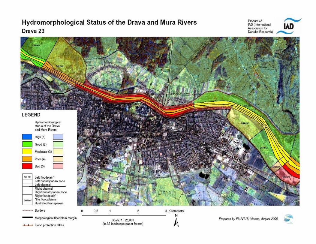
Case study 1 Drava: Detailed hymo inventoryCase study 1 Drava: Detailed hymo inventory
Inventory for large rivers (regarding CEN standards and WFD requirements), developed for the IAD based on German approaches for large rivers (KERN, BfG, NRW/RPF)
Main parameter groups: 1. River channel 2. Banks and riparian zone3. Floodplain
Five classes evaluation, colour-ribbon map (scale 1:25.000), data generalisation for overview proposes
Chapter 3Chapter 3

8
Drava: Hymo reference conditions and typologyDrava: Hymo reference conditions and typology
Development of a morphological typology and reference conditions („Leitbild“) for large rivers (example: Rhine in NRW), additionally to the existing typology for the WFD (A/B)
The following parameters were evaluated:
Channel width, valley and planform, slope, morphological type (course developement, sinuosity), lateral erosion, flow and depth variance, river bed structure and substrate, cross-sections, bank and riparian zone structure, floodplain
Chapter 3Chapter 3

9
Fluvial morphological parametersFluvial morphological parameters
Parameter Danube from Bezdan to Apatin
(reference / recent)
Danube from Apatin to Bogojevo
(reference / recent)
Drava (Osijek-confluence)
(reference / recent)
Reach in km 43 / 24 38 / 32 36 / 18
Channel width in m 360-650 / 380-1.000 300-800 / 400-1.100 300-500 / 180-220
Meander weave length in km
3,2 / 10 3,8 / 4,5 2,5 / 4,3
Meander amplitude 6 / 1,8 4,5 / 2,5 2,8 / 1,1
Sinuosity 2,2 / 1,2 1,5 / 1,3 2,5 / 1
Islands 10 / 1 14 / 6 9 / 1
5 Meander development
stadiums (in Prozent der Lauf-länge)
II (10%)III (30%)IV (40%)V (20%) /I (30%) II (70%)
II (30%)III (45%)IV (20%)V (5%) /II (50%) III (50%)
II (10%)III (25%)IV (45%)V (20%) /I (50%) II (50%)
Chapter 3Chapter 3
0
100
200
300
400
500
600
700
800
900
1782-84 1834 1882-87 1901 1970 2008
ha
Unvegetated bars
Initial pioneer bars
older pioneer stands

10
Drava: Evaluation example Lower Drava and MuraDrava: Evaluation example Lower Drava and Mura
Chapter 3Chapter 3
Drava (from Mura confluence to Osijek)
219,5
20,3
77,2
219,6
21,4
66,1
0
25
50
75
100
125
150
175
200
225
250
Total reach R/L in km Steep banks in km Enforced banks in km
11
6. First results: Example lower Drava6. First results: Example lower Drava
Channel
Banks/ Riparian zone
Floodplain
Chapter 3Chapter 3

12
Drava: Overall assessmentDrava: Overall assessment
• Main „drivers“ for the Drava: 1. Hydropower, 2. Flood defence, 3. Sediment extraction, 4. Navigation (Mura without navigation)
• Overall floodplain
loss for the entire
Drava and Mura: -75%
• Over 50 large dams
• Overall
hydromorphological
evaluation:
40% have class two or
better (mostly along
the lower stretches in
Hungary and Croatia),
60% contributes to the
classes 3-5 (over 26%
are completely
modified).
Chapter 3Chapter 3

13
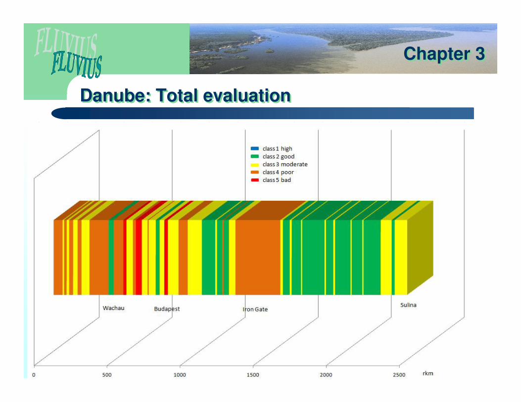
Case Study 2 Danube: JDS2, longitudinal survey, site survey
Case Study 2 Danube: JDS2, longitudinal survey, site survey
� Longitudinal survey: Homogenous stretches of about 50 km along a five class evaluation system according to SOP
� Site survey: Detailed JDS site characteristic according to SOP table without evaluation
� Inventory of dams, hydrological situation during the survey
� Additionally to the site survey fact sheets for all stations incl. tributaries were prepared
� Access database development and GIS integration (site coordinates, rkm and assessment stretches)
Chapter 3Chapter 3

14
Danube: Longitudinal survey (focus)Danube: Longitudinal survey (focus)
� A total of 62 homogenous stretches along the Danube including the three delta branches (in total 2,584 rkm) were prepared.
� The mean length of each evaluation stretch is about 42 rkm, the smallest is 8rkm (strongly altered town stretch) and by far the longest 225 rkm (between Calafat and Svistov at the lower Danube).
� In general the length of homogenous segments increase for the lower Danube.
Chapter 3Chapter 3
15
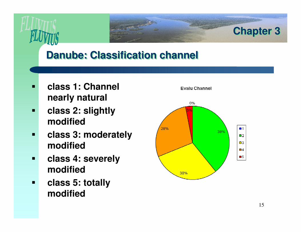
Danube: Classification channelDanube: Classification channel
� class 1: Channel nearly natural
� class 2: slightly modified
� class 3: moderately modified
� class 4: severely modified
� class 5: totally modified
Chapter 3Chapter 3

16
Danube Classification banksDanube Classification banks
� class 1: nearly natural banks
� class 2: reinforcement in small sections
� class 3: reinforcement in large sections
� class 4: continuous bank reinforcements
� class 5: totally modified banks
Chapter 3Chapter 3
17
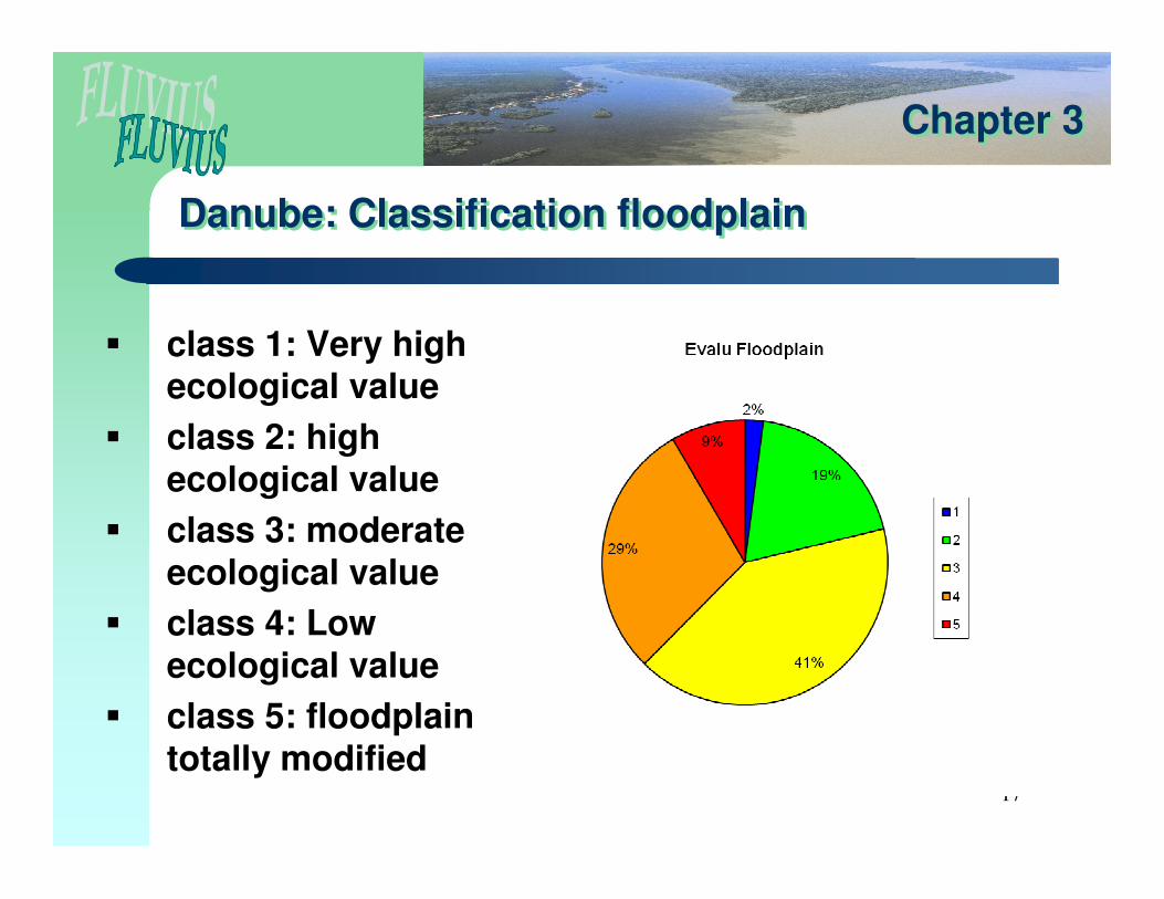
Danube: Classification floodplainDanube: Classification floodplain
� class 1: Very high ecological value
� class 2: high ecological value
� class 3: moderate ecological value
� class 4: Low ecological value
� class 5: floodplain totally modified
Chapter 3Chapter 3
18
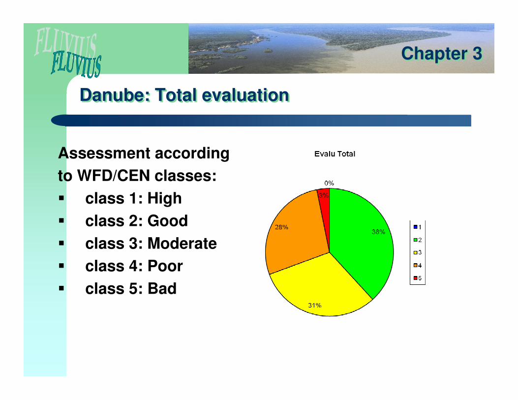
Danube: Total evaluationDanube: Total evaluation
Assessment according
to WFD/CEN classes:
� class 1: High
� class 2: Good
� class 3: Moderate
� class 4: Poor
� class 5: Bad
Chapter 3Chapter 3
19
Danube: Total evaluationDanube: Total evaluation
Chapter 3Chapter 3

20
Outlook, implications for the DanubeOutlook, implications for the Danube
• Morphological reference conditions should be more considered
• Hymo inventories would strongly support and post-validates the typological units and the water body delineation
• Would enable a transparent HMWB designation based on quantitative and qualitative hydromorphological data
• Harmonized approaches based on CEN standard are necessary
• Would allows a precise development of tools for measures
• Ongoing projects involved: IAD Hymo study Mures, SEA Szigetköz (historical riparian landscape analysis)
Chapter 4Chapter 4
• Assessment of screening methods versus full inventories


