
963
GAT Project No. 2173Report No. 963
Revised versionMarch 2012
Bala WTW, Ty’n y Cae:
Ymddiriedolaeth Archaeolegol Gwynedd
Gwynedd Archaeological TrustCraig Beuno, Ffordd y Garth, Bangor, Gwynedd, LL57 2RT
Bala, Gwynedd
Archaeological Evaluation and Watching Brief
Report No. 963
Prepared for
Black and Veatch Ltd
March 2012
By
Jane Kenney
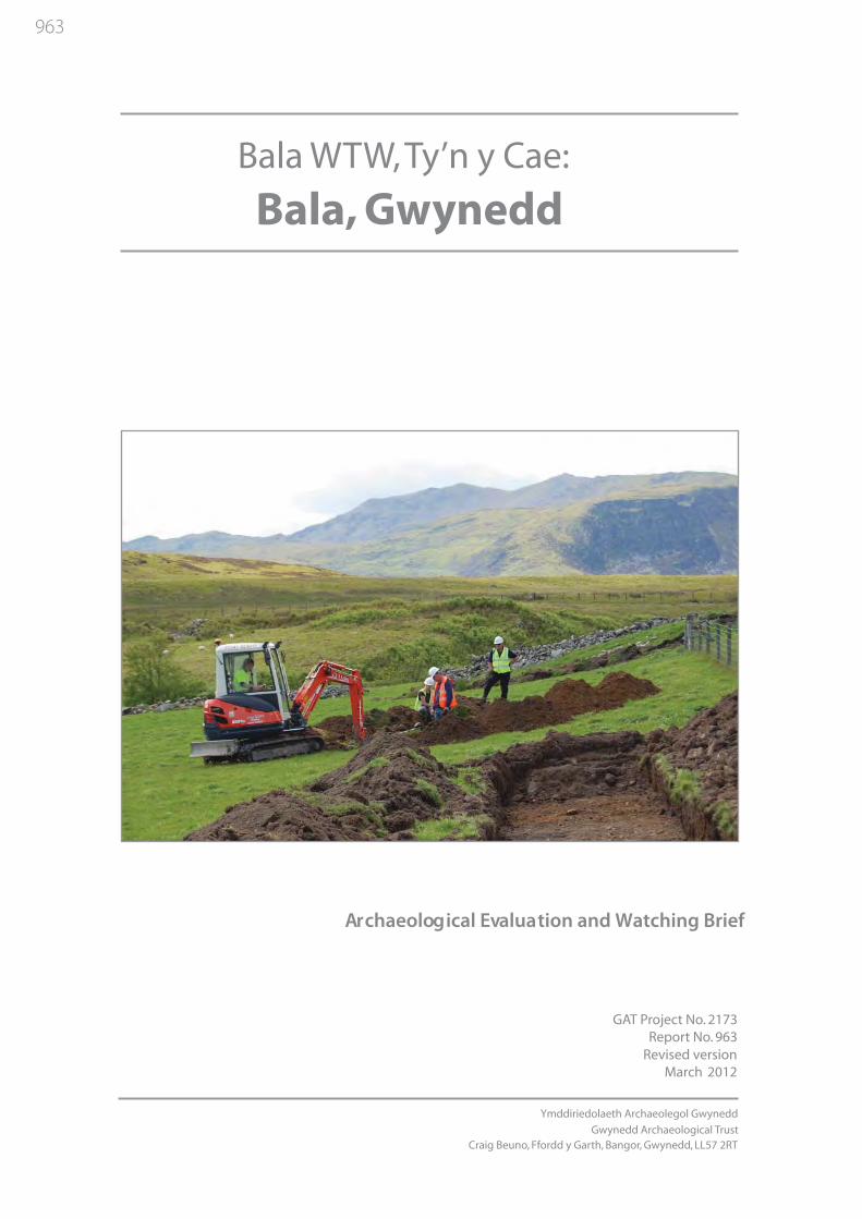
Front cover: Digging trench 6 with Arenig Fawr in the background
Archaeological Evaluation and Watching Brief
Ymddiriedolaeth Archaeolegol GwyneddGwynedd Archaeological Trust
Craig Beuno, Ffordd y Garth, Bangor, Gwynedd, LL57 2RT
Bala Water Treatment Works
1
BALA WATER TREATMENT WORKS, LLANDECWYN
ARCHAEOLOGICAL EVALUATION AND WATCHING BRIEFProject No. G2173
Gwynedd Archaeological Trust Report No. 963
CONTENTSSummary ..................................................................................................................................................3 1. INTRODUCTION................................................................................................................................3 2. METHODS AND TECHNIQUES .......................................................................................................3 3. ARCHAEOLOGICAL RESULTS .......................................................................................................5 4. FINDS ..................................................................................................................................................8 5. PALAEOENVIRONMENTAL EVIDENCE .......................................................................................8 6. DISCUSSION AND INTERPRETATION ..........................................................................................9 7. CONCLUSION ..................................................................................................................................10 8. ARCHIVE ..........................................................................................................................................10 9. REFERENCES...................................................................................................................................10 APPENDIX I: Detailed trench descriptions ...........................................................................................11 APPENDIX II: Palynological Assessment of Two Soil Samples ..........................................................13 FiguresPlates
FIGURESFigure 1. Site Location. Base map taken from OS 1:10 000 series sheet SH 83 NW and NE. Scale
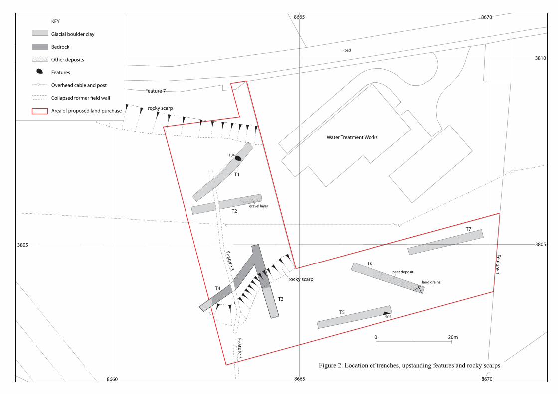
1:10,000. Study area shaded in redFigure 2. Location of trenches, upstanding features and rocky scarpsFigure 3. Black and Veatch drawing number 168853-00-3001 showing the proposed development area
(red) and compound and storage area (green), with approximate area stripped for haul road Figure 4. Part of Tithe Map of the parish of Llanycil of 1839, with the study area outlined in red
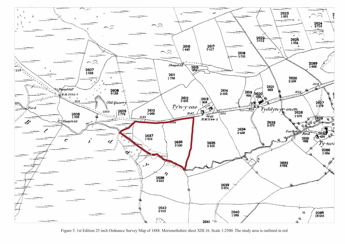
(Gwynedd Archives)Figure 5. 1st Edition 25 inch Ordnance Survey Map of 1888. Merionethshire sheet XIII.16. Scale
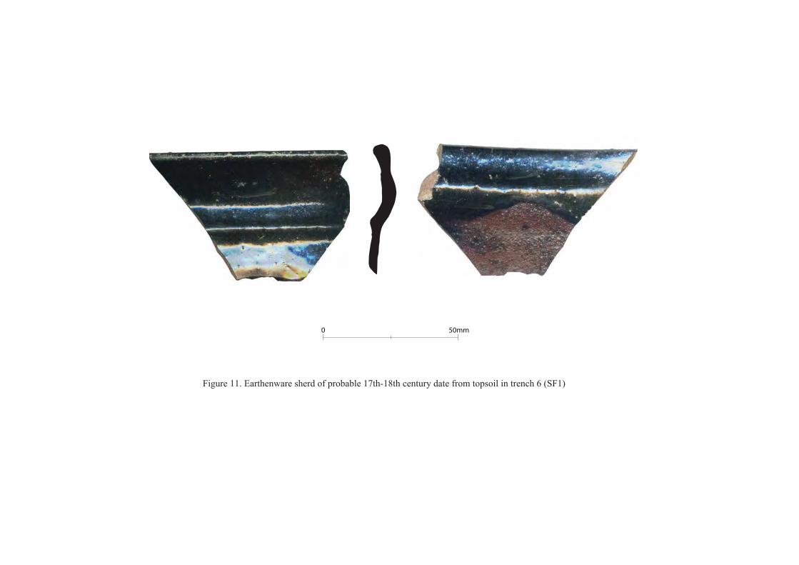
1:2500. The study area is outlined in redFigure 6. Plan of wall (feature 3) in trench 2 (wall recorded as context 205)Figure 7. South facing section of wall (feature 3) in trench 2 (wall recorded as context 205)Figure 8. North facing section of wall (feature 3) in trench 2 (wall recorded as context 205)Figure 9. Plan of wall (feature 3) in trench 4 (wall recorded as context 403)Figure 10. North-west facing section of wall (feature 3) in trench 4 (wall recorded as context 403)Figure 11. Earthenware sherd of probable 17th-18th century date from topsoil in trench 6 (SF1)
PLATESPlate 1. Feature 1, looking southPlate 2. North end of Feature 3, looking northPlate 3. South end of Feature 3, looking southPlate 4. Western face of Feature 3, just south of trench 4, looking eastPlate 5. Gap/entrance in Feature 3, looking eastPlate 6. Line of stones forming Feature 5, looking south-west; the corner of the modern field clearance
cairn is also visiblePlate 7. Road side wall, Feature 7, looking west Plate 8. Trench 1, looking south-west Plate 9. Pit 104 in Trench 1, looking north-westPlate 10. Wall, Feature 3, seen in southern side of trench 1, looking southPlate 11. Trench 2, looking eastPlate 12. Section of wall, Feature 3 in trench 2 (recorded as context 205), looking north. Shows natural
boulder in base of wallPlate 13. Trench 3, looking southPlate 14. Face of scarp in Trench 3, looking north. This shows the broken bedrock forming the scarpPlate 15. Trench 4 and wall 403, from south-westPlate 16. Wall, Feature 3 (context 403) in trench 4, looking south-westPlate 17. North facing section of wall, Feature 3 (context 403) in trench 4, looking south

2
Plate 18. Trench 5 and machine dug pit 505, looking westPlate 19. Trench 6 with land drains in south-east end, looking north-westPlate 20. South-west facing section of trench 6 showing peaty layer (603), looking north-eastPlate 21. Trench 7, looking west
3
BALA WATER TREATMENT WORKS, LLANDECWYN (G2173)
ARCHAEOLOGICAL EVALUATION
Summary
An archaeological evaluation followed by a watching brief was carried out in advance of a proposed extension to the Water Treatment Works (WTW) at Ty’n y Cae, Bala. The seven evaluation trenches revealed no previously unknown significant archaeology, except for a thin peat deposit, but a previously identified former field boundary wall was recorded by plans and section. A scarp or terrace running across the site was shown to be entirely due to an outcrop of bedrock and of no archaeological significance. The watching brief identified no additional archaeology.
1. INTRODUCTION
Gwynedd Archaeological Trust was asked by Black & Veatch Ltd on behalf of �������� Welsh Water to carry out a programme of archaeological works in advance of and during groundworks associated with a proposed extension to the Water Treatment Works (WTW) at Ty’n y Cae, Bala (NGR SH 86603805) (figure 1). The proposals include the purchase of a 2765m2 L-shaped area to the west and south of the existing WTW on which a new treatment building is to be constructed. A compound/storage area for use during the construction phase has also been proposed to the west of the extension zone.
An archaeological assessment of the proposed extension zone/compound area was completed by GAT in February 2011 (Evans 2011, GAT Report 920). The assessment identified that the land consisted of moderately sloping land facing south with mid-slope terracing that is probably natural in origin. The land formed part of the farm of Ty’n y Cae, a smallholding located 100m to the north-west. Areas of rock outcropping were also noted within the fields. The extant field boundaries indicated evidence for at least two phases of construction, the earlier possibly 18th century (although potentially earlier) and the later 19th century.
No sites of medieval or earlier date were identified in the assessment, although the topography of the site was considered to have potential for medieval and earlier settlement.
The first part of the current archaeological programme was an evaluation involving the excavation of 7 trenches. This was followed by a watching brief on the stripping of an area for the site compound. It also included a basic archaeological record of four features identified in the archaeological assessment of the development area (Evans 2011).
��� ������ ���������������� ����������������� ��������������������������������������!����Authority’s (SNPA) Archaeologist was not asked to produce a brief for its production, although comments made by him (email dated 17-05-2011 and subsequent telephone conversations) have informed it. The design and subsequent work follow guidelines specified in Standard and Guidance for Archaeological Evaluation & Standard and Guidance for Archaeological Watching Brief (Institute for Archaeologists, 1994, rev. 2001 & 2008).
2. METHODS AND TECHNIQUES
Evaluation trenchingSeven evaluation trenches were excavated across the area on which the extension of the water treatment works is to be built. This work was carried out on 14th to 17th June 2011.
The design indicated generalized locations for these trenches to allow for coverage of the whole area and to investigate specific features. On the ground the precise location of the trenches was influenced by the position of overhead electric cables, the topography, the existence of monitoring devices in the ground and the condition of a denuded field wall. In the latter case trenches 2 and 4 were located to cut across the wall. As positioned in the design they cut across parts of wall with similar levels of preservation, so trench 4 was moved south to investigate a section of wall with better preservation.
4
All trenches were excavated by a 3 tonne 360º tracked excavator with a 1.6m wide toothless ditching bucket, under direct archaeological supervision. All undifferentiated topsoil or overburden of recent origin was removed in successive, level spits to expose the natural subsoil or bedrock. Where the bedrock was not clearly visible parts of the trenches were cleaned by hand. This applied only to trenches 3 and 4 where areas were cleaned so that the natural of the bedrock could be clearly seen. In particular the scarp in trench 3 was entirely cleaned.
In trenches 2 and 4 that cut the denuded wall this wall was cleaned of turf and topsoil by hand and recorded by photographs and plans within the trenches. The wall stones were then removed by machine and the sections drawn and recorded. Photographs and notes were made on all trenches and the depths and nature of deposits recorded. One possible feature was identified in trench 1 and this was partially excavated and recorded.
The trenches were located on a scaled drawing by triangulation and offsetting with tapes. This plan (figure 2) also shows the location of scarps running across the site. Each distinct layer or feature was given its own unique context number and a descriptive record made, and these are referred to throughout the discussion of the results below in brackets.
Basic recordingIn addition to the evaluation a basic record was made of 4 features identified in the assessment report. These features were:Feature 1: Dry Stone Wall (NGR SH 86703808 C)Feature 3: Relict Dry Stone Wall (NGR SH86623805 C)Feature 5: Relict Dry Stone Wall (NGR SH 86553803)Feature 7: Dry Stone Boundary Wall (NGR SH 86573809 C)
These were recorded photographically and by notes on GAT pro-formas
Watching briefThe seven trenches excavated covered a significant proportion of the extension area and were evenly distributed. These trenches revealed no previously unknown significant archaeology and strongly suggest that a full strip of the area was likely to reveal very little and this area was not considered worth an intensive watching brief.
The results from the evaluation and earthworks visible on the surface demonstrated that most of the existing water treatment works enclosure had been disturbed. This was confirmed by information ���������"���������������������������� ��������������� ����this area and seen by GAT, which showed that there were pipe trenches largely filling the area between the works building and the fence to the west. A watching brief on work in this area was therefore also considered unjustifiable.
The watching brief therefore concentrated on the area to the west, which was stripped of topsoil for a temporary compound during the construction works. An area 20m wide was stripped down to the natural glacial deposits for a haul road and this was also included in the watching brief. See figure 3 for a plan showing these areas.
A photographic record was maintained throughout the watching brief, using a digital SLR camera set to maximum resolution. Notes were made on day record sheets of the extent and depth of the stripping and the deposits exposed.
The watching brief took place on 25th and 26th July 2011.
PalynologyDuring the evaluation two small samples were recovered; one from the buried soil beneath the former field boundary (F3) and one from a thin peat deposit. These samples were submitted for palynological assessment by Ben Gearey of Birmingham Archae-Environmental. Pollen preparation followed standard techniques including potassium hydroxide (KOH) digestion, hydrofluoric acid (HF) treatment and acetylation. At least 125 total land pollen grains (TLP) excluding aquatics and spores were counted for each sample.
5
ReportFollowing the completion of the field work, the data was processed, final illustrations compiled and this report produced which details and synthesizes the results. This report conforms to the guidelines specified in Standard and Guidance for Archaeological Field Evaluation (IFA 1994, rev. 2008) and Standard and Guidance for Archaeological Watching Brief (Institute for Archaeologists, 1994, rev. 2001, 2008).
3. ARCHAEOLOGICAL RESULTS
3.1 Recording upstanding featuresFour features identified in the assessment report required basic recording. These were Feature 1, a drystone wall; Feature 3, former boundary wall; Feature 5, a line of stones, and Feature 7, a drystone wall. The location of these is shown on figure 2, with the exception of feature 5 (located at NGR SH 86553803).
Feature 1 (plate 1)SH86707 38058 to SH86688 37981A drystone wall running along the eastern side of the proposed development site. This is 1.5m high, consisting of rough field stones up to 0.5m by 0.3m. Although there are some larger stones lower down in the wall there is no use of boulders in the foundations. It is built quite straight although now bowing in places. The wall terminates when it reaches the stream to the south. It appears to be of 19th century date, and is shown on the 1st edition 25 inch Ordnance Survey map of 1889 (figure 5), but also appears on the 1839 tithe map (figure 4).
Feature 3 (plates 2 and 3)SH86626 38071 to SH86633 38015The partially collapsed and robbed remains of a drystone wall running roughly north-south down the slope. Its line is not as straight as other walls in the area. The original wall seems to be about 1.2m wide but the width as seen on the ground varies considerably from less than 1m to about 2.5m depending on whether it has been robbed out or has collapsed and spread. It survives to a maximum height of 1.2m and has a foundation of large stones and boulders on the western side (plate 4). Some of these stones are up to 1.3m long, some set on edge. The western face is always more substantial than the eastern face but towards the southern end of the wall where it survives best there is also a fairly well defined eastern face. The north part of the wall is heavily robbed out and the in situ remains endabout at trench 1, north of which only a line of disturbed material indicates its former location.
Especially towards the northern end the ground is up to 0.6m higher to the east than to the west, partly due to the topography but partly due to the effects of ploughing on the western side of the wall. There is 2.5m wide entrance through the wall (plate 5) but this is probably not original as stones continue in the ground across the gap.
The wall is shown on the 1839 tithe map (figure 4), as are all the existing walls near the site, but its more wandering line suggests that it may be older than the others. Walls F1 and F7 do not have many large foundation stones and the presence of these including some orthostats does suggest an earlier date for feature 3. In other areas, such as east of Harlech, wandering walls with orthostatic foundations appear to have had an Iron Age origin, but there is little to suggest that this is so here. There are very few other wandering walls in the area, and no cultivation terraces or other evidence of ancient fields running from the wall. It may be that this wall is the only surviving remnant of an early field system but it is safest to say that it is at least 18th century in date or earlier.
Feature 5 (plate 6)SH 86550 38030This is composed of 5 large stones in line orientated north-west to south-east with 4 more haphazardly distributed stones near the north-west end of the line. The largest stone is set on edge and is 0.7m high and 1.1m long. This is fairly square and seems to be a quarried stone. None of the stones are embedded in the ground but rest on other stones. This feature is close to a modern field clearance heap and it is possible that they are stones dumped recently by machine. However the neatness of the line and the existence on the First Edition OS map (figure 5) of a field wall in this location suggests that these are
6
the only remaining traces of a wall. The use of large stones as the foundation of one wall face is similar to feature 3 and they could be of a similar date.
Feature 7 (plate 7)SH86555 38100 to SH86635 38094This is the wall along side the road. As the road is at least 0.7m higher than the level of the top of the field much of the surviving wall is a revetment rather than a free standing wall. The wall is aligned roughly east-west and has some large stones in the base but does not have orthostatic foundations. It survives to 1m high as measured from the south side but projects barely 0.3m above the level of the road. Considerable collapse has occurred along parts of the wall.
3.2 Evaluation trenchesThe trenches revealed the nature of the deposits, showing that there was little ploughsoil to the north of the scarp/terrace and more below it to the south. A thin lens of peat was identified and the wall (feature 3) was investigated. However no other features were found with the exception of a recent irregular pitin trench 1 and a probable test pit or livestock burial pit in trench 5.
All the trenches measured approximately 2m by 20m and were as straight as the topography allowed. All trenches are shown on figure 2 and detailed descriptions of the deposits are given in appendix I.
Trench 1 (plate 8)The trench had 0.2m of undifferentiated topsoil (101) over a clayey glacial deposit (106). Towards the eastern end of the trench was an irregular oval pit with variable sides, steep in places and more gradual elsewhere. This pit (104) measured 1.9m by 1.3m with a depth of 0.4m, and contained fragments of post medieval pottery in its fill (plate 9). This seems to be a fairly recent feature, possibly even disturbance related to the building of the water treatment works in 1995.
The boundary wall (F3) was just visible in the southern side of the trench. At this point the wall hasbeen almost entirely robbed out with only occasional disturbed stones remaining. To the north of the trench there is a disturbed area running roughly along the line of the wall, presumably indicating where this robbing has occurred. One wall stone in the southern section was possibly in situ (plate 10) and this was beneath the topsoil (101) and the disturbed material (107), but this says little about the stratigraphy of the wall.
Trench 2 (plate 11, figures 6-8)The eastern 6m of the trench were covered by a thin layer of gravel (202) under the topsoil (201). Under the gravel was another layer of grey-brown silt (203) that must have been the topsoil before the gravel was deposited. The glacial subsoil lay 0.45m below the current soil surface. The layer of gravel was probably laid down during the construction of the existing water treatment works. Near its western end the trench cut through the former boundary wall (F3). Here the wall (recorded as context 205) was built of unworked local stone with a fairly neat western face made of stones up to 0.75m in length(plate 12). Only one or two acing stone of the east face remained in situ and these were much smaller. The ground surface was 0.6m lower on the western side compared to the east, so the western foundations needed to be stronger. The core of the wall was composed of small stones, many of which had spilled out to the west, along with some facing stones as a spread of tumble (206). A much slighter spread of small stones (207) extended to the east of the wall and this was probably spread by stone robbing rather than being collapsed material. The wall was built on the original soil layer (203) and covered by the later topsoil (201). Large natural boulders were incorporated into the base of the wall. Apatch of gravelly material (208) filled a slight hollow under the tumble to the west of the wall. This deposit overlay the buried soil and may be related to the wall’s construction but is more likely to have been a variation in the buried soil, possibly deposited during a flooding event.
A small sample of soil was taken from the buried soil (203) sealed beneath the wall. The full results of the pollen analysis are included as appendix II and are discussed below.
Trench 3 (plate 13)This trench was located primarily to investigate a scarp or terrace running across the site. This feature runs north-east to south-west, starting within the area of the existing WTW and ending with a curve to the north-west just west of the former field wall (feature 3). The scarp is gentler at its western end and
7
was disturbed near the fence of the WTW. Trench 3 was positioned to investigate a steep, undisturbed part of the scarp. The trench showed that the scarp was due entirely to the bedrock outcropping here and the face of the scarp was of jagged broken bedrock (303) (plate 14). This deeply fissured broken bedrock covered most of the trench but at the lower, southern end there was a deposit of glacial clay (302). The topsoil (301) over this trench was generally about 0.25m deep but reached a depth of about 0.45m where it filled fissures in the bedrock. There was no indication of ploughsoil in this area.
Trench 4 (plate 15, figures 9 and 10)This trench was intended to run at right angles from trench 3 to cross the former boundary wall (feature 3). However the wall was better preserved at its southern end than further north and trench 4 was positioned so that the end of this better preserved section could be investigated. Most of the trench had no more than 0.3m of topsoil (401) directly on to broken and fissured bedrock (406). The wall (403) had a western face including large boulders and a slighter, less orderly eastern face of smaller stones(plates 16 and 17). The core was of mixed small and large stones. No collapse had occurred to the west but stones from the wall core had tumbled to the east side of the wall (402). The wall essentially set directly on bedrock with a dark, soft material (404) below some of the stones but this seemed to have percolated through the voids, and chronologically post-dates the wall construction.
Trench 5 (plate 18)This trench on the lower part of the site was fairly wet but had only very slight traces of a peaty depositmuch more clearly seen in trench 6. There was a distinct ploughsoil and plough-sorted layer (502)under active topsoil (501) and these together were about 0.43m deep. Below this was an orange-brown clayey silt glacial deposit (503). At the eastern end of the trench the corner of a neat square or rectangular cut filled with pale clay was seen (cut 505). This appeared to be machine dug and is probably either a test pit or a recent livestock burial.
Trench 6 (plate 19)There was a distinct ploughsoil layer (602) and this and the topsoil (601) were a total of 0.3m deep. This trench was wet during excavation despite the weather having been fairly dry prior to the evaluation and under the ploughsoil much of the trench was covered by a thin peaty relict soil (603) (plate 20), although there was very little of this in the north-western and higher end. A small soil sample was taken from this peat layer and the full results of the pollen analysis of this sample are included as appendix II and are discussed below. Under this was a pale grey layer (604) interpreted as the leached B horizon of the soil with the peaty surface. The glacial deposits (605) were yellow/orange clayey silts.
Two ceramic field drains crossed in the south-eastern end of the trench.
Trench 7 (plate 21)The topsoil was 0.45m deep with a layer of plough-sorted stones in its base and very thin patches of peat just above the natural glacial deposits. There were no archaeological features.
3.3 Watching briefThe topsoil was removed over the area of the temporary compound to a depth of approximately 0.15m. This meant that some topsoil remained and the area was not exposed down to the natural deposits. No archaeology was visible at the depth of stripping. Within the area of the haul road deposits were removed to a depth of up to 0.36m and the sub-soil deposits were exposed. These were fluvio-glacial sandy silts and clays. The area was crossed by occasional 19th century or later ceramic field-drains,running north-south down the slope towards the stream; with some also running east-west.
New electricity poles were erected to the west of the compound area. The pit for these and the cable trenches dug across the compound were inspected but no archaeology was identified.
8
4. FINDS
4.1 Table of FindsTrench Context No. of
sherdsDescription
T1 101, topsoil 4 Sherds of 19th and early 20th century potteryT1 102/103, fill of
pit 1042 Sherds 19th and early 20th century pottery
T2 205, wall 4 Sherds of Buckley ware, late 19th or early 20th century T6 Unstratified 14 Sherds of Buckley ware and other 19th and early 20th century
potteryT6 601 1 Rim sherd of earthernware jar
4.2 DiscussionSmall quantities of late 19th and early 20th century pottery were found scattered over the site. Most of that found in the topsoil was not collected. Two sherds came from the pit (104) in trench 1 and 4 sherds from the former boundary wall (feature 3) where it was cut in trench 2. The pottery in the topsoil is most probably from manuring, with more found on the lower part of the site where the land had been more improved. The sherds from the pit suggest a late date for this feature. However, the sherds in the partially robbed out wall were between loose stones and could have been deposited during stone robbing or fallen into the gaps between the stones at any time. They cannot be used to date the construction of the wall.
The rim sherd from trench 6 (figure 11), is the most interesting piece, but this was found in the topsoil and was probably also deposited on the field by manuring. Jon Goodwin of Stoke-in-Trent Museum considers that this sherd “looks very much like a highly-fired coarse earthenware - possibly even a late Midlands Purple-type fabric; certainly the rich glaze has much in common with 17th-18th-century wares of this type. The form appears to be a storage jar. Dating is somewhat difficult - late 17th/early-mid 18th
century” (pers. com. by email). The archaeological potential of this assemblage is minimal and it is not recommended that they are studied further. None of the sherds will be retained in the archive, except for the sherd from trench 6.
5. PALAEOENVIRONMENTAL EVIDENCE
In trench 2 a buried soil (203) was seen sealed under the former boundary wall. As there was a possibility that this soil preserved pollen grains that might indicate the environment when the wall was built a sample was taken for analysis. This small soil sample was recovered from a point securely sealed under the wall stones. Similarly it was possible that the layer of peat in trench 6 could preserve pollen indicating the environment when the peat was laid down. A small soil sample was also taken from this layer.
The samples were analysed by Ben Gearey of Birmingham Archae-Environmental and his full report is included as appendix II.
The analysis found that both samples yielded high concentrations of generally well preserved pollen. That from the buried soil in trench 2 was dominated by herbs, mainly wild grass and ribwort plantain,and trees and shrubs were almost entirely absent, except for a low level of hazel, some heather and traces of oak. The pollen source for the buried soil is likely to have been highly localised, so the pollen preserved in the soil reflects the vegetation growing on or very near the sampling site. The pollen assemblage is strongly indicative of an open, grass dominated landscape with the relatively high percentages of plantain, indicating pastoral vegetation, typical of a meadow-like environment. Other herbs reflect typical field edge or grassland communities. Few trees were growing nearby, although there were probably some limited areas of hazel dominated scrub or woodland. The presence of heather probably reflects the upland moorland areas nearby.
The sample from trench 6 was from a thin peat layer and this was also dominated by grasses with some other herbs, but less plantain than the trench 2 sample. Trees were also slightly better represented, with hazel being the most common, but some alder and birch also present at low levels, as well as some
9
heather. The pollen spectrum suggests a very similar environment to the sample from Trench 2, with grassland vegetation clearly prevalent locally and some hazel scrub/woodland relatively close-by. The low level of alder and birch pollen is probably from trees at some distance from the sampling site.
Both samples demonstrate that the local environment prior to the sealing of the buried ground surfaces was open grassland, with little tree or shrub cover aside from hazel scrub. The general open nature of the vegetation and presence of plantain is indicative of open pasture that had probably been created by human clearance and farming activity. No unequivocal indicators of cultivation are recorded and although cereal pollen is very poorly dispersed, the absence of any pollen taxa indicative of arable farming would seem to imply that the land-use was pastoral. It would seem very likely that the sampled deposits date to the mid-late Holocene, but it is not possible to provide a more precise timeframe on the basis of the current data. Whilst the pollen spectra of both samples are very similar, the slight differences between the two may reflect either some variation in vegetation across the site or alternatively it is possible that the respective deposits date to different periods.
Radiocarbon dating might have provided more chronological information but no suitable material for dating was recovered. The lack of exotic species in the pollen assemblage suggests that the samples date from before the eighteenth century, but the tree pollen would have been much higher if they were prehistoric in date.
6. DISCUSSION AND INTERPRETATION
The evaluation demonstrated that the scarp or terrace crossing the site is entirely due to a rock outcrop and is of no archaeological significance. A similar scarp exists along the northern edge of the site and this can also be seen to be natural as bedrock is visible in places.
The trenching revealed a fairly thin topsoil above the scarp and slightly deeper deposits on the lower ground where ploughing has occurred. The amount of bedrock close to the surface in the northern part of the site shows that it can never have been very productive. The glacial deposits exposed in the lower part of the site were stony clayey silts and represent the altered upper part of the boulder clay. Archaeological features are easily visible in these types of deposits and would have been seen if they had been present. In fact only modern features; a machine dug pit and land drains were seen. On the upper part of the site the bedrock would have prevented the digging of negative features over part of the area and where the glacial deposits were present only one recent pit was found. This pit, the robbing of the former field boundary, and the layer of gravel in trench 2 suggest recent disturbance in this area, much of it related to the construction of the water treatment works. The presence of monitoring devices in the ground also showed small scale disturbance. However three water pipes shown on a service plan provided to GAT as within the extension area were proved by the position of the valves and previous work "����r Cymru to lie inside the existing water treatment enclosure. Disturbance by pipe trenching was therefore less than expected.
The thin layer of peat in trench 6 preserved some palaeoenvironmental information but it was so thin and presumably truncated by ploughing that the survival of archaeological features or finds within it is unlikely. Although there were slight traces of this deposit in trenches 5 and 7 these were fragmentary and it seems that this deposit only survives in any significant form around the area of trench 6.
The former boundary wall (feature 3) was recorded along its length by photographs, two segments where trenches 2 and 4 cut it were drawn in detail and sections in these locations were recorded. The line of the wall has also b�������#�� ��� �#�����������r Cymru. The trenches demonstrated that the wall was built directly on bedrock where this outcropped and on the existing soil surface where there was no rock. No secure dating evidence for the wall was recovered; however there was nothing to indicate a very old date. The pollen evidence suggests that the building of the wall was earlier than the 18th century but the landscape had been open pasture fields for a considerable period and would have appeared much as today. An early date for the wall is therefore unlikely.
10
7. CONCLUSION
The evaluation established that the scarp running across the site is geological and recorded the only significant archaeological feature on the site; the collapsed former boundary wall. This was recorded by plans, sections, notes and photographs as well as a generalised survey of its extent. Recording of other minor features not directly impacted by the works was also undertaken. The watching brief confirmed that there was no other significant archaeology in the area. The pollen study gave an indication of the environment when the wall was built and showed that the area was already under pasture fields.
8. ARCHIVE
The archive consists of field notes, field drawings and 97 digital photographs relating to the evaluation and basic recording. Both paper records and digital data, along with a copy of the report, will be archived with the Royal Commission on Ancient and Historical Monuments in Wales (RCAHMW).All finds will be discarded with the exception of the earthenware sherd (SF1), which will be included with the paper record.
9. REFERENCES
Evans, R., 2011. Bala WTW, Ty’n y Cae, Bala, Gwynedd: an archaeological assessment, unpublished GAT report No. 920
Institute For Archaeology 2008 Standard and Guidance for Archaeological Field Evaluation
Institute For Archaeology 2008 Standard and Guidance for Archaeological Watching Brief
11
APPENDIX I: Detailed trench descriptions
Trench 1 Orientation NE-SWLayer Depth
below surface
Description
101 0-0.2m Topsoil. Soft, dark grey-brown silty clay with moderately frequent sub-rounded gravel and small stones.
102 0.2-0.45m Secondary fill of pit 104. Compact mid grey-brown sandy clay with occasional gravel and small and medium stones.
103 0.45-0.6m Primary fill of pit 104. Soft pale brown-grey sandy clay with moderately frequent sub-rounded stones and occasional slate and post medieval pottery fragments.
104 0.2-0.6m Cut of pit. Roughly oval, measuring 1.9m by 1.3m with a depth of 0.4m. Irregular sides, steepin places with a concave base.
105 0-0.2m Remnant of boundary wall (F3). One stone seen in situ but most disturbed.106 0.2m+ Glacial deposit. Firm mid brown-orange silty clay with frequent gravel and cobbles. 107 0-0.4m Modern dumped material in an area of disturbance along the line of the wall (F3). Soft, dark
brown-grey organic material within silty clay.
Trench 2 Orientation ENE-WSWLayer Depth
below surface
Description
201 0-0.13m Topsoil. Dark grey-brown silt with few stones.202 0.13-
0.20mLayer deposited during WTW construction. Grey-brown fine gravel with some stones and silt.
203 0.20-0.45m
Original topsoil. Grey-brown silt with c20% small and medium stones.
204 0.45m+ Glacial deposits. Orange-brown stony silt with paler patches.205 Foundation level of drystone wall (F3). Western face of large stones but only one stone of
eastern face survived. Core of small stones.206 Tumble from wall 205, to west of the wall. Small and medium stones tumbled to west of the
wall. Many stones are small and angular with some medium rounded stones and occasional larger ones. The larger stones are displaced facing stones, the smaller ones from the wall core. The matrix is a very soft, dark brown silt.
207 Tumble from wall 205, to east of the wall. Spread of small stones rarely more than 0.1m in length with very occasional larger stones. Very loose and voidy with matrix of dark grey silt.
208 Gravely layer, possible flood deposit. Brown sandy silt with gravel and numerous stones.
Trench 3 Orientation NNW-SSELayer Depth
below surface
Description
301 0-c0.25m Topsoil. Soft dark brown silt with occasional stones. There were some loose stones in this layer on the face of the scarp. These were up to 0.25m in length. The topsoil was up to 0.45m deep where it filled fissures in the bedrock.
302 0.25m+ Glacial deposits. Orange-brown clayey silt, mottled with lighter and darker patches, with numerous small stones.
303 0.25m+ Fractured bedrock, deeply fissured. This outcrop of bedrock forms a steep south-east facing scarp about 2.3m high with broken bedrock on the face.
Trench 4 Orientation ENE-WSWLayer Depth
below surface
Description
12
401 0-0.3m Topsoil. Soft dark grey-brown silty-clay with moderately frequent gravel and small cobbles. 402 0-0.5m Tumble to the east of the wall. Poorly sorted sub-angular stones in a matrix of soft dark grey-
brown silty clay with occasional fragments of post medieval pot and small animal bones.403 0-1.0m Boundary wall (F3). Drystone wall with western facing stones including large boulders and a
slighter, less orderly eastern face of smaller stones. Approximately 1.2m wide and 1.0m high. Stones predominately sub-rounded, field clearance stones. Rough construction with frequent voids.
404 Wind-blown material within the wall. Soft, dark grey brown loam with moderately frequent sub-angular stones, mainly broken bedrock.
405 0.2m+ Glacial deposits. Soft, patchy mid orange-brown to pale yellow brown silty clay with occasional cobbles.
406 0.2m+ Fractured bedrock, deeply fissured.
Trench 5 Orientation ENE-WSWLayer Depth
below surface
Description
501 0-0.13m Topsoil. Dark grey-brown silt with few stones. 502 0.13-
0.43mPloughsoil and plough-sorted stones. Dark grey-brown silt with c.20% stones, occasionally large. Some mixing at the base with 503. Slight grey or black patches indicating traces of a peaty layer surviving.
503 0.43+ Glacial deposit. Orange-brown clayey silt with numerous stones.504 Fill of 505. Pale grey stony silty clay.505 Corner of a neat square or rectangular cut. Probably machine dug and either a test pit or a
recent livestock burial.
Trench 6 Orientation NW-SELayer Depth
below surface
Description
601 0-0.13m Topsoil. Dark grey-brown silt with occasional stones. 602 0.13-
0.30mPloughsoil. Dark brown silt with c.10% small and medium stones, and occasional larger ones.
603 0.30-0.38m
Peaty relict soil. Black/very dark brown silt. Firm in places with texture of compressed peat. Occasional large stones up to 0.3m in length.
604 0.38-0.46m
Leached B horizon under peaty relict soil surface. Pale grey clayey silt with few stones.
605 0.46m+ Glacial deposits. Yellow/orange clayey silt with numerous stones.
Trench 7 Orientation ENE-WSWLayer Depth
below surface
Description
701 0-0.2m Topsoil. Dark grey-brown silt with occasional stones. 702 0.20-
0.45mPlough-sorted stones. Numerous large and medium stones up to 0.3m long in base of topsoil forming a fairly distinct layer but with matrix indistinguishable from topsoil. In the base of this very thin patches of peat were seen.
703 0.45m+ Glacial deposits. Orange-brown clayey silt with numerous small and medium stones. Some patches are darker and stonier. Occasional large stones visible.
13
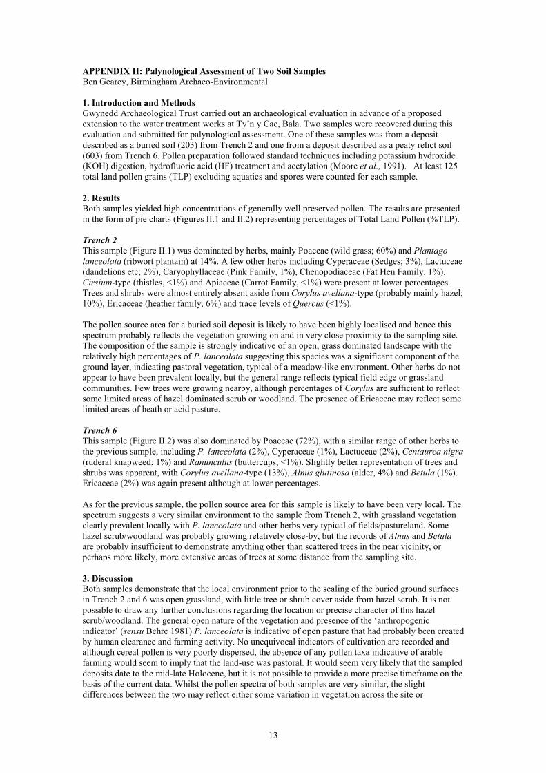
APPENDIX II: Palynological Assessment of Two Soil Samples Ben Gearey, Birmingham Archaeo-Environmental
1. Introduction and MethodsGwynedd Archaeological Trust carried out an archaeological evaluation in advance of a proposed extension to the water treatment works at Ty’n y Cae, Bala. Two samples were recovered during this evaluation and submitted for palynological assessment. One of these samples was from a deposit described as a buried soil (203) from Trench 2 and one from a deposit described as a peaty relict soil (603) from Trench 6. Pollen preparation followed standard techniques including potassium hydroxide (KOH) digestion, hydrofluoric acid (HF) treatment and acetylation (Moore et al., 1991). At least 125 total land pollen grains (TLP) excluding aquatics and spores were counted for each sample.
2. Results Both samples yielded high concentrations of generally well preserved pollen. The results are presented in the form of pie charts (Figures II.1 and II.2) representing percentages of Total Land Pollen (%TLP).
Trench 2This sample (Figure II.1) was dominated by herbs, mainly Poaceae (wild grass; 60%) and Plantago lanceolata (ribwort plantain) at 14%. A few other herbs including Cyperaceae (Sedges; 3%), Lactuceae (dandelions etc; 2%), Caryophyllaceae (Pink Family, 1%), Chenopodiaceae (Fat Hen Family, 1%), Cirsium-type (thistles, <1%) and Apiaceae (Carrot Family, <1%) were present at lower percentages. Trees and shrubs were almost entirely absent aside from Corylus avellana-type (probably mainly hazel; 10%), Ericaceae (heather family, 6%) and trace levels of Quercus (<1%).
The pollen source area for a buried soil deposit is likely to have been highly localised and hence this spectrum probably reflects the vegetation growing on and in very close proximity to the sampling site. The composition of the sample is strongly indicative of an open, grass dominated landscape with the relatively high percentages of P. lanceolata suggesting this species was a significant component of the ground layer, indicating pastoral vegetation, typical of a meadow-like environment. Other herbs do not appear to have been prevalent locally, but the general range reflects typical field edge or grassland communities. Few trees were growing nearby, although percentages of Corylus are sufficient to reflect some limited areas of hazel dominated scrub or woodland. The presence of Ericaceae may reflect some limited areas of heath or acid pasture.
Trench 6This sample (Figure II.2) was also dominated by Poaceae (72%), with a similar range of other herbs to the previous sample, including P. lanceolata (2%), Cyperaceae (1%), Lactuceae (2%), Centaurea nigra(ruderal knapweed; 1%) and Ranunculus (buttercups; <1%). Slightly better representation of trees and shrubs was apparent, with Corylus avellana-type (13%), Alnus glutinosa (alder, 4%) and Betula (1%). Ericaceae (2%) was again present although at lower percentages.
As for the previous sample, the pollen source area for this sample is likely to have been very local. The spectrum suggests a very similar environment to the sample from Trench 2, with grassland vegetation clearly prevalent locally with P. lanceolata and other herbs very typical of fields/pastureland. Some hazel scrub/woodland was probably growing relatively close-by, but the records of Alnus and Betulaare probably insufficient to demonstrate anything other than scattered trees in the near vicinity, or perhaps more likely, more extensive areas of trees at some distance from the sampling site.
3. DiscussionBoth samples demonstrate that the local environment prior to the sealing of the buried ground surfaces in Trench 2 and 6 was open grassland, with little tree or shrub cover aside from hazel scrub. It is not possible to draw any further conclusions regarding the location or precise character of this hazel scrub/woodland. The general open nature of the vegetation and presence of the ‘anthropogenic indicator’ (sensu Behre 1981) P. lanceolata is indicative of open pasture that had probably been created by human clearance and farming activity. No unequivocal indicators of cultivation are recorded and although cereal pollen is very poorly dispersed, the absence of any pollen taxa indicative of arable farming would seem to imply that the land-use was pastoral. It would seem very likely that the sampled deposits date to the mid-late Holocene, but it is not possible to provide a more precise timeframe on the basis of the current data. Whilst the pollen spectra of both samples are very similar, the slight differences between the two may reflect either some variation in vegetation across the site or
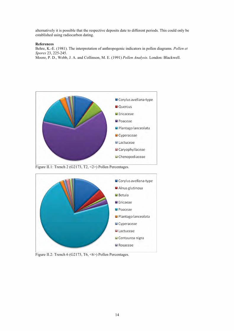
14
alternatively it is possible that the respective deposits date to different periods. This could only be established using radiocarbon dating.
ReferencesBehre, K.-E. (1981). The interpretation of anthropogenic indicators in pollen diagrams. Pollen et Spores 23, 225-245.Moore, P. D., Webb, J. A. and Collinson, M. E. (1991) Pollen Analysis. London: Blackwell.
Figure II.1: Trench 2 (G2173, T2, <2>) Pollen Percentages.
Figure II.2: Trench 6 (G2173, T6, <6>) Pollen Percentages.
FIGURES AND PLATES
FIGURESFigure 1. Site Location. Base map taken from OS 1:10 000 series sheet SH 83 NW and NE. Scale
1:10,000. Study area shaded in redFigure 2. Location of trenches, upstanding features and rocky scarpsFigure 3. Black and Veatch drawing number 168853-00-3001 showing the proposed development area
(red) and compound and storage area (green), with approximate area stripped for haul road Figure 4. Part of Tithe Map of the parish of Llanycil of 1839, with the study area outlined in red
(Gwynedd Archives)Figure 5. 1st Edition 25 inch Ordnance Survey Map of 1888. Merionethshire sheet XIII.16. Scale
1:2500. The study area is outlined in redFigure 6. Plan of wall (feature 3) in trench 2 (wall recorded as context 205)Figure 7. South facing section of wall (feature 3) in trench 2 (wall recorded as context 205)Figure 8. North facing section of wall (feature 3) in trench 2 (wall recorded as context 205)Figure 9. Plan of wall (feature 3) in trench 4 (wall recorded as context 403)Figure 10. North-west facing section of wall (feature 3) in trench 4 (wall recorded as context 403)Figure 11. Earthenware sherd of probable 17th-18th century date from topsoil in trench 6 (SF1)
PLATESPlate 1. Feature 1, looking southPlate 2. North end of Feature 3, looking northPlate 3. South end of Feature 3, looking southPlate 4. Western face of Feature 3, just south of trench 4, looking eastPlate 5. Gap/entrance in Feature 3, looking eastPlate 6. Line of stones forming Feature 5, looking south-west; the corner of the modern field clearance
cairn is also visiblePlate 7. Road side wall, Feature 7, looking west Plate 8. Trench 1, looking south-west Plate 9. Pit 104 in Trench 1, looking north-westPlate 10. Wall, Feature 3, seen in southern side of trench 1, looking southPlate 11. Trench 2, looking eastPlate 12. Section of wall, Feature 3 in trench 2 (recorded as context 205), looking north. Shows natural
boulder in base of wallPlate 13. Trench 3, looking southPlate 14. Face of scarp in Trench 3, looking north. This shows the broken bedrock forming the scarpPlate 15. Trench 4 and wall 403, from south-westPlate 16. Wall, Feature 3 (context 403) in trench 4, looking south-westPlate 17. North facing section of wall, Feature 3 (context 403) in trench 4, looking southPlate 18. Trench 5 and machine dug pit 505, looking westPlate 19. Trench 6 with land drains in south-east end, looking north-westPlate 20. South-west facing section of trench 6 showing peaty layer (603), looking north-eastPlate 21. Trench 7, looking west
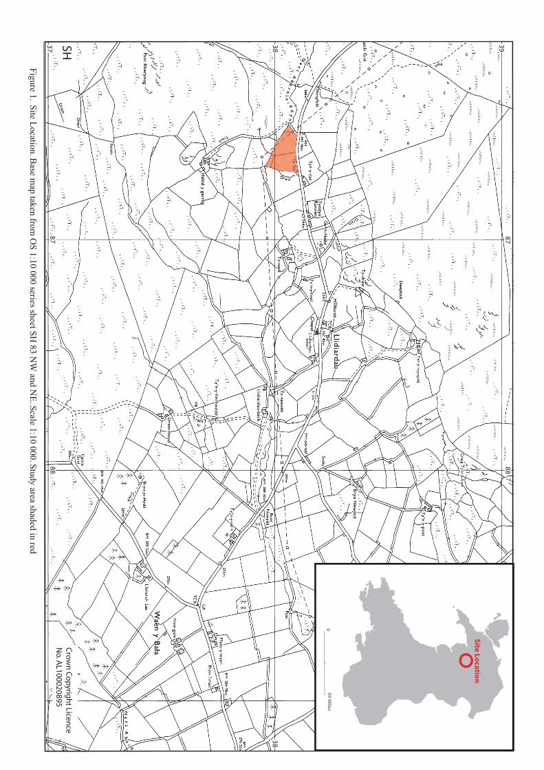
Figure 1. Site Location. Base m
ap taken from O
S 1:10 000 series sheet SH 83 N
W and N
E. Scale 1:10 000. Study area shaded in red
05
0 M
iles
Site Locatio
n
8788
8788
38
37 38
39SHC
row
n C
op
yrigh
t Licence
No. A
L100020895
8665 86708660
8665 86708660
3805
3810
3805
3810
0 20m
Water Treatment Works
T1
T2
T3
T4
T5
T6
T7
land drains
peat deposit
505
104
gravel layer
Road
KEY
Glacial boulder clay
Bedrock
Other deposits
Features
Overhead cable and post
Collapsed former field wall
Area of proposed land purchase
Featu
re 3
Featu
re 3
Feature 7
Fea
ture
1
rocky scarp
rocky scarp
Figure 2. Location of trenches, upstanding features and rocky scarps
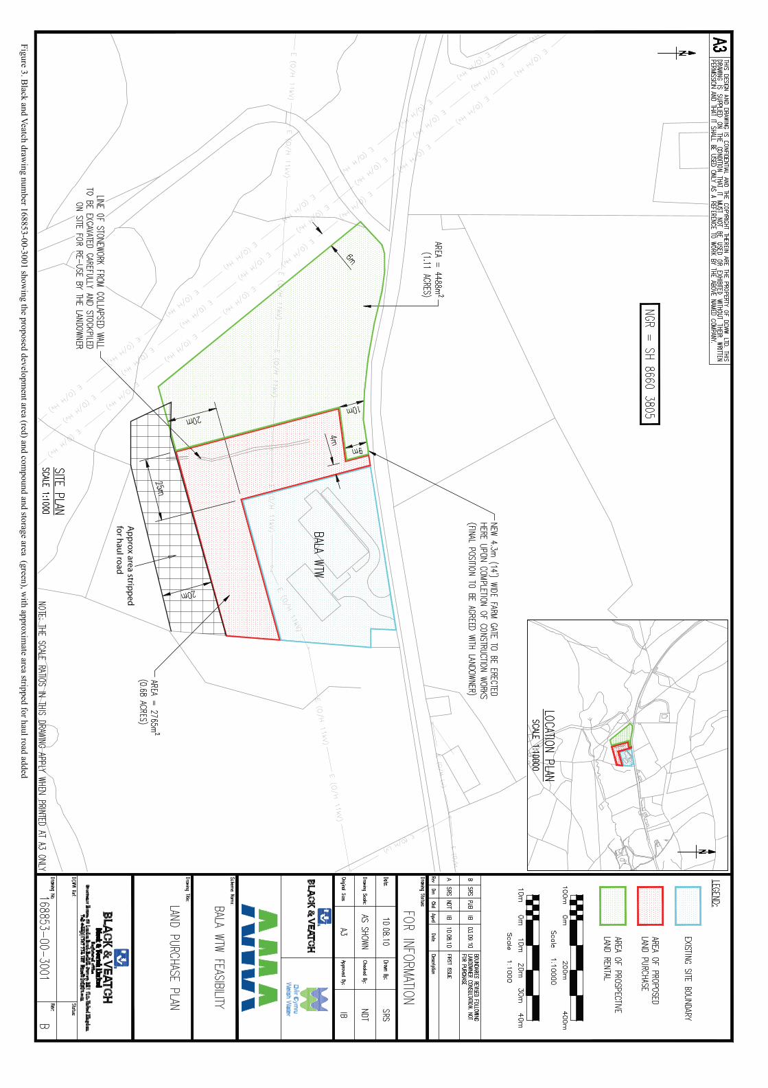
Figure 3. Black and Veatch draw
ing number 168853-00-3001 show
ing the proposed development area (red) and com
pound and storage area (green), with approxim
ate area stripped for haul road added
Ap
pro
x are
a strip
pe
dfo
r ha
ul ro
ad
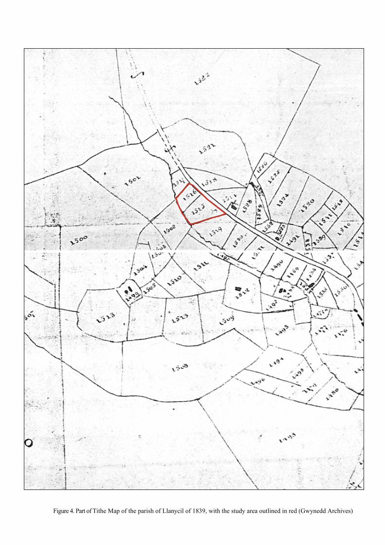
Figure 4. Part of Tithe Map of the parish of Llanycil of 1839, with the study area outlined in red (Gwynedd Archives)
�
�
�
�
�
�
�
�
�
�
�
�
�
�
�
�
�
�
�
Pond
Garth-Nodol
Pond
Tra
Issues
Sheep Pens
Ty-nant
Tyn-y-cae
344m
RonnenTyddyn
Drain
363.46m
Dra
in
Pp Sta
BM
Sheepfold
d
Ford
nt 368m
Aberbleiddyn
Figure 5. 1st Edition 25 inch Ordnance Survey Map of 1888. Merionethshire sheet XIII.16. Scale 1:2500. The study area is outlined in red
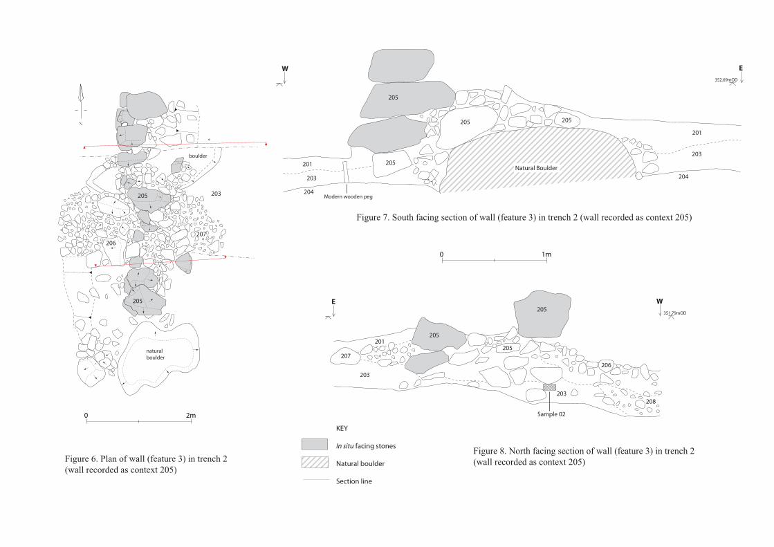
208
Sample 02m20
m10
207
206
203
201
204Modern wooden peg
205
205 205
201
203
204
207
203
205
203
206
Natural Boulder
205
205
natural
boulder
N
205
205
205201
boulder
203
E W351.79mOD
E352.69mOD
W
KEY
In situ facing stones
Natural boulder
Section line
Figure 6. Plan of wall (feature 3) in trench 2 (wall recorded as context 205)
Figure 7. South facing section of wall (feature 3) in trench 2 (wall recorded as context 205)
Figure 8. North facing section of wall (feature 3) in trench 2 (wall recorded as context 205)
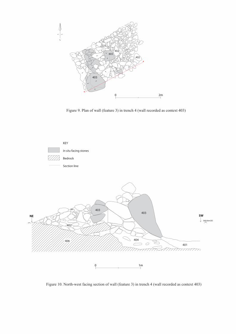
N
m20
m10
SW349.06mOD
NE
406
403403
404
402
401
401
KEY
In situ facing stones
Bedrock
Section line
Figure 9. Plan of wall (feature 3) in trench 4 (wall recorded as context 403)
Figure 10. North-west facing section of wall (feature 3) in trench 4 (wall recorded as context 403)
403
403402
402
mm050
Figure 11. Earthenware sherd of probable 17th-18th century date from topsoil in trench 6 (SF1)
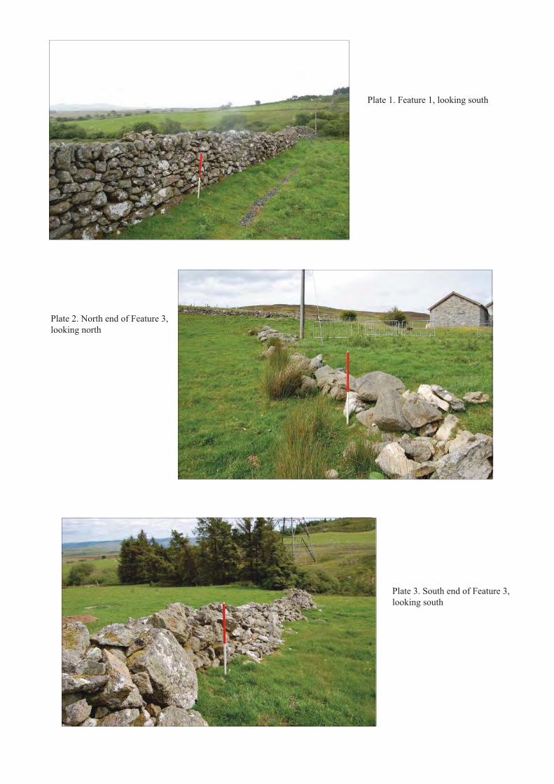
Plate 1. Feature 1, looking south
Plate 2. North end of Feature 3, looking north
Plate 3. South end of Feature 3, looking south
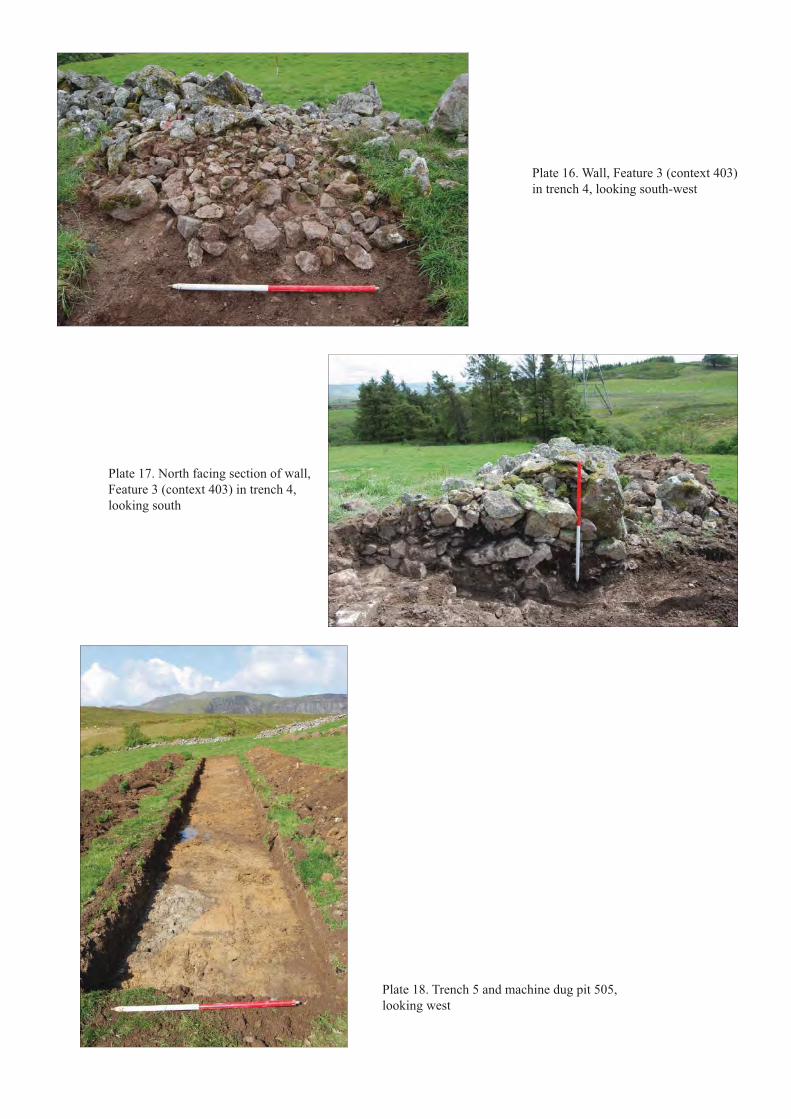
Plate 16. Wall, Feature 3 (context 403)in trench 4, looking south-west
Plate 17. North facing section of wall, Feature 3 (context 403) in trench 4, looking south
Plate 18. Trench 5 and machine dug pit 505, looking west
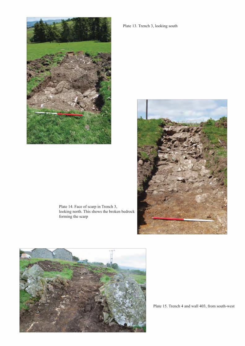
Plate 13. Trench 3, looking south
Plate 14. Face of scarp in Trench 3,looking north. This shows the broken bedrockforming the scarp
Plate 15. Trench 4 and wall 403, from south-west
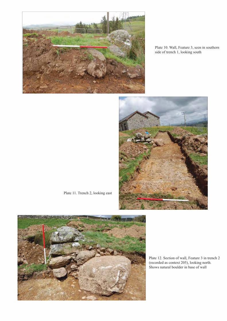
Plate 10. Wall, Feature 3, seen in southernside of trench 1, looking south
Plate 11. Trench 2, looking east
Plate 12. Section of wall, Feature 3 in trench 2(recorded as context 205), looking north. Shows natural boulder in base of wall
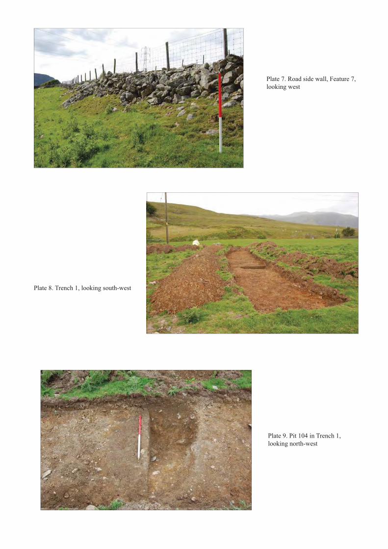
Plate 7. Road side wall, Feature 7, looking west
Plate 8. Trench 1, looking south-west
Plate 9. Pit 104 in Trench 1, looking north-west
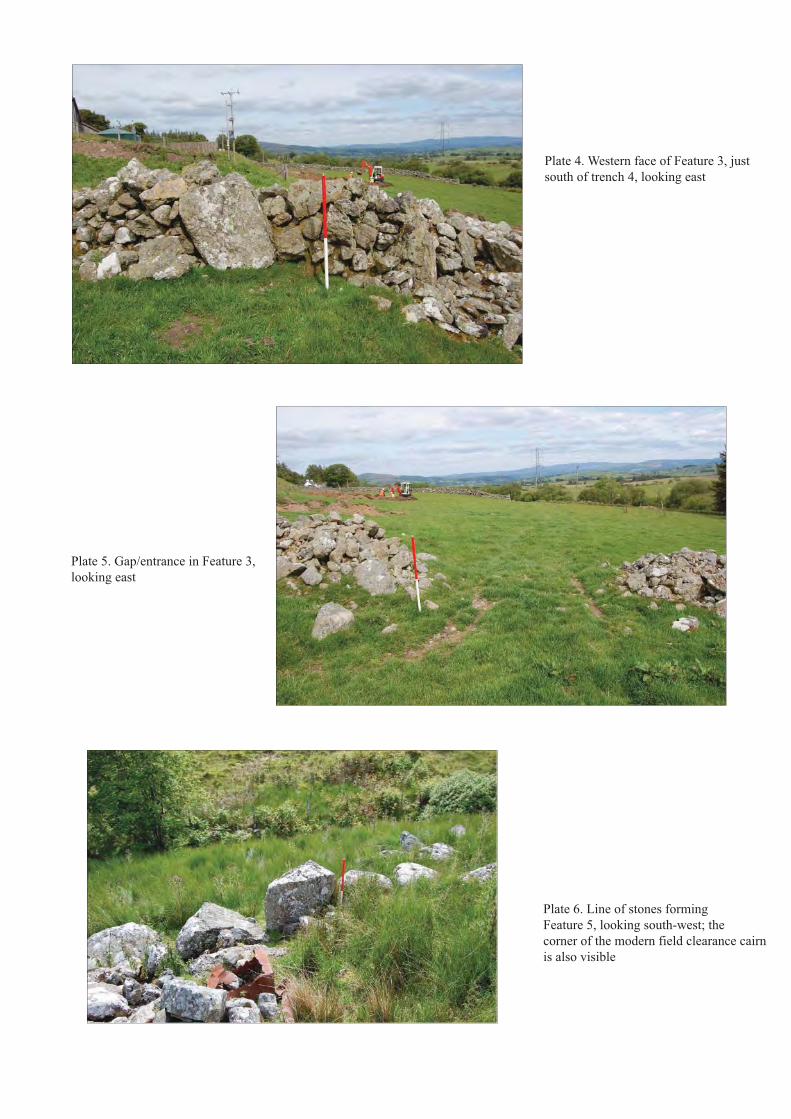
Plate 4. Western face of Feature 3, just south of trench 4, looking east
Plate 5. Gap/entrance in Feature 3, looking east
Plate 6. Line of stones forming Feature 5, looking south-west; the corner of the modern field clearance cairnis also visible
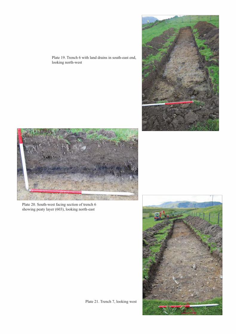
Plate 19. Trench 6 with land drains in south-east end, looking north-west
Plate 20. South-west facing section of trench 6showing peaty layer (603), looking north-east
Plate 21. Trench 7, looking west

GWYNEDD ARCHAEOLOGICAL TRUSTYMDDIRIEDOLAETH ARCHAEOLEGOL GWYNEDD
Craig Beuno, Ffordd y Garth, Bangor, Gwynedd. LL57 2RTFfon: 01248 352535. Ffacs: 01248 370925. email:[email protected]


