
Biological Evaluation
OIL & GAS LEASING DECISION
Page 1 of 38
Oil and Gas Leasing
Biological Evaluation
Pawnee Ranger District
Arapaho and Roosevelt National Forests and Pawnee National Grassland
Prepared by:
Matthew P. Fairchild /s/ July 7, 2014
Matthew P. Fairchild
Forest Fisheries Biologist
Date
Biological Evaluation
OIL & GAS LEASING DECISION
Page 2 of 38
Oil & Gas Leasing Decision
Weld County, Colorado
I. INTRODUCTION
The purpose of this biological evaluation is to document the effects analysis and determine the
likely effects of the alternatives on species listed under the Endangered Species Act (1973 [as
amended]), Forest Service sensitive species (Forest Service Manual 2670.31-2670.32),
management indicator species (MIS). It was prepared in accordance with Forest Service Manual
direction to review all Forest Service activities to ensure that such activities do not contribute to
a downward trend in population numbers or density of sensitive species and/or a downward trend
in habitat capability, either of which might ultimately result in the need for federal listing (FSM
2672.1 and 2672.4) as well as regionally-specific direction for conducting a biological evaluation
(Region 2 FSM Supplement 2600-2011-1). This biological evaluation documents how this
project meets National Forest Management Act (NFMA 1976) requirements; to provide for
diversity of animal communities [including fish habitat]; to document the effects on these
management indicator species (MIS) species (36 CFR 219.19(a)(1)) as well as how this project
does not promote the introduction of aquatic invasive species (EO 13112). Furthermore, this
document describes the measurable effects of this activity on aquatic habitat and the fish species
that rely upon those habitats as required under the National Environmental Policy Act, the
Revised Land & Resource Management Plan for the Arapaho & Roosevelt National Forest and
Pawnee National Grassland (USDA 1997), and relevant Species-Specific Conservation
Agreements.
II. PROJECT DESCRIPTION AND ACTION AREA
The Arapaho and Roosevelt National Forest and Pawnee National Grassland will decide which
lands are available for oil and gas leasing by updating the analyses prepared for the 1993 Oil and
Gas Leasing Environmental Impact Statement. An Environmental Impact Statement addressing
proposed leasing alternatives is required to comply with the National Environmental Policy Act
of 1969 (NEPA). This Biological Evaluation documents the impacts of potential leasing
decisions for the remaining 150,000 acres of available federal minerals the lie beneath the
Pawnee National Grassland. The project area for the Pawnee National Grassland Oil and Gas
EIS includes all lands identified in the 1997 Forest Plan as administratively available for leasing,
approximately 146,367acres. The project area does not include PNG lands that are: (1) already
leased or (2) lie on top of private mineral estate. Three alternatives were fully developed and
analyzed as reasonable options for leasing federal minerals underneath the Pawnee National
Grassland: Alternative 1 is “No New Leasing”, Alternative 2 is the No Action Alternative,
Leasing Under Current Forest Plan, and Alternative 3 is New Leasing Allowed Under No
Surface Occupancy.
Biological Evaluation
OIL & GAS LEASING DECISION
Page 3 of 38
III. STANDARD LEASING TERMS
Standard Leasing Terms allow the Forest Service to require the leaseholder to move a well or
other facility up to 200 meters or delay operations for up to 60 days in a year. No additional
mitigations or leasing stipulations were developed during the analysis of this decision.
IV. SPECIES CONSIDERED AND EVALUATED
The Arapaho/Roosevelt National Forest and Pawnee National Grassland (ARP) coordinated with
the U.S. Fish and Wildlife Service’s Colorado Field Office to determine the appropriate list of
threatened and endangered species. The following list (Table 1) includes species located on the
Arapaho/Roosevelt National Forest and Pawnee National Grassland and any species located
downstream that could potentially be affected by a water project. The ARP received the updated
Region 2 Forest Service sensitive species list, dated January 15, 2013 from the Regional
Forester. The following list (Table 2) includes current sensitive species found within the ARP.
The USDAFS R2 TEPS Species Occurrence Matrix (January 15, 2013) provides guidance of the
occurrence of these species by administrative unit. Complete lists by Region and
Forests/Grassland can be found in the district files. The species noted as excluded on the table
below will not be discussed further in this document
Table 1. Federally listed species that may occur on the Arapaho-Roosevelt National Forests and Pawnee
National Grassland
Note: ▲ water depletions in the South Platte River may affect these species
** water depletions in the Upper Colorado and San Juan River Basins may affect these species
Common Name Species Status Species
Excluded Reason for Exclusion
Greenback cutthroat trout Oncorhynchus clarkii
stomias
Threatened
and MIS
N No Habitat
▲Pallid sturgeon Scaphirhynchus albus Endangered Y Future water withdrawals
may lead to additional
downstream effects.
** Bonytail chub Gila elegans Endangered N No Habitat
** Colorado pikeminnow Ptychocheilus lucius Endangered N No Habitat
** Humpback chub Gila cypha Endangered N No Habitat
** Razorback sucker Xyrauchen texanus Endangered N No Habitat
Arapahoe snowfly Capnia Arapahoe Proposed N No Habitat

Biological Evaluation
OIL & GAS LEASING DECISION
Page 4 of 38
Table 2. Region 2 Forest Service Sensitive Aquatic Species found on the Arapaho-Roosevelt National Forest
and Pawnee National Grassland.
Note: These species are suspected to occur but unconfirmed on the Arapaho/Roosevelt National Forest.
Management Indicator Species
The National Forest Management Act (NFMA), (36 CFR 291.12) and Forest Service Manual
(FSM 2621) direct the Forest Service to preserve and enhance plant and animal diversity,
consistent with the overall multiple use objectives, to maintain viability of all native and
desirable non-native species in the planning area. Viable populations are defined as those having
both numbers and distribution of reproductive individuals to ensure continued, well-distributed
existence (USDA Forest Service 1997).
The complete list of MIS of the Arapaho-Roosevelt National Forest and Pawnee National
Grassland are listed in Appendix G of the Forest Plan. This list was amended by Forest
Supervisor decision May 3, 2005 and the amended list appears below in Table 3. The following
list (Table 3) includes only species found within or adjacent to the project area or potentially
affected by the project. The species noted as excluded in the table will not be discussed further in
this document.
Table 3. Aquatic Management Indicator Species for the Arapaho-Roosevelt National Forests and Pawnee
National Grassland.
Common Name Species Status Included/excluded from analysis and rationale
Colorado River
cutthroat trout
Oncorhynchus
clarkii pleuriticus
Sensitive and MIS Excluded due to the lack of habitat
Flannelmouth
sucker
Catostomus
latipinnis
Sensitive Excluded due to the lack of habitat
Lake chub Couesius plumbeus Sensitive Excluded due to the lack of habitat
Northern redbelly
dace
Phoxinus eos Sensitive Excluded due to the lack of habitat
Plains topminnow Fundulus sciadicus Sensitive Included
Mountain sucker Catostomus
platyrhynchus
Sensitive Excluded due to the lack of habitat
Rocky Mountain
capshell snail
Acroloxus
coloradensis
Sensitive Excluded due to the lack of habitat
Hudsonian Emerald
dragonfly
Somatochlora
hudsonica
Sensitive Excluded due to the lack of habitat
Arapahoe Snowfly Capnia Arapahoe Sensitive Excluded due to the lack of habitat
Common Name Species
Management
Indicator
Community
Excluded
from
further
analysis?
Reasons for exclusion
greenback cutthroat
trout
Oncorhynchus clarkii
stomias
MIS for montane
aquatic Yes
Species is confined to montane
environment
Biological Evaluation
OIL & GAS LEASING DECISION
Page 5 of 38
V. EXISTING CONDITION
The Pawnee National Grassland contains several land parcels among 39 sixth field (i.e., 6 digit
hydrologic units) prairie watersheds on a portion of Colorado’s eastern plain. All of the plains
streams occurring on the grassland are tributary to the South Platte River. This is a portion of the
western Great Plains that extends from eastern Colorado and eastern Wyoming east across much
of Nebraska, portions of South Dakota, and into Kansas. These prairie watersheds originate on
the plains and have developed into a loosely parallel drainage pattern, exhibiting a hydrology
characterized by flooding and drying. Resultantly, few of these streams are continuously
perennial. Rather, most streams are intermittent with short sections of perennial surface water
that occur as semi-connected pools along the streamcourse.
Surface water within these clusters of aquatic habitat is maintained by stochastic precipitation
events great enough to generate overland flow during and shortly following storm events and via
groundwater that is exposed to the surface where pool-like depressions occur along the
streamcourse (Figure 1). Based on 75 years of precipitation data, the greatest amount of
precipitation falls from April through June; however, some areas experience a wet monsoon
season in August and September (USDA Forest Service, unpublished data). These wet periods
likely generate sufficient stream flow to connect separate perennial habitats within a 10-year
period or less. Although small and unseen by most, these unique aquatic habitats occur in most
of the intermittent stream channels across the western Great Plains, including the Pawnee
National Grassland.
Colorado River
cutthroat trout
Oncorhynchus clarkii
pleuriticus
MIS for montane
aquatic Yes
Species is confined to montane
environment
brook trout Salvelinus fontinalis
MIS for montane
aquatic Yes
Species is confined to montane
environment
brown trout Salmo trutta
MIS for montane
aquatic Yes
Species is confined to montane
environment
plains topminnow Fundulus sciadicus
MIS for prairie
aquatic No
plains killifish Fundulus zebrinus
MIS for prairie
aquatic No
Biological Evaluation
OIL & GAS LEASING DECISION
Page 6 of 38
Amount and Distribution of Aquatic Habitat
Although the total amount of aquatic habitats on the Pawnee National Grasslands may be quite
limited during a snapshot of time, the linear networks in which those habitats occur are large,
covering multiple 40,000 acre watersheds that stretch from southeastern Wyoming to the South
Platte River. Hydrologic data used to classify the types of stream channels are not very well
resolved; however, based on National Hydrography Data (USGS), there are well over 3000 miles
of stream channel on the Pawnee grassland with at least 30 of those miles being perennial and
over 1,700 miles being intermittent (Entwistle and Nieves-Rivera 2014). The amount and
distribution of aquatic habitat suitable for aquatic life varies based on annual precipitation
patterns as well as the capacity of local aquifers to maintain pockets of exposed groundwater. At
this time it is unclear which aquifers are most important in supplying water to the specific
perennial aquatic habitats. Three key aquifers are believed to have great enough hydrostatic
pressure and groundwater volume to support surface water habitats: the Ogallala, the Brule
member of the White River Group, and numerous undefined shallow, perched aquifers (Wohl et
al. 2009). Several artesian springs occur on the grassland and supply groundwater from the deep
aquifers (i.e., Brule formation) to support some perennial aquatic habitat. A groundwater
mapping model, called DRASTIC (Aller et al. 1987), was used to identify the vulnerabilities and
potential susceptibilities of groundwater resources on the Pawnee National Grassland (Entwistle
and Nieves-Rivera 2014). Approximated groundwater influence zones have been described in
depth in the Hydrology and Soils Report (Entwistle and Nieves-Rivera 2013). Precipitation
events occurring in the spring and summer seasons can recharge some of the shallow perched
aquifers. While flood events are both infrequent (i.e., once every year or two) and typically of
very short duration (i.e., less than 24 hours), events can be very high in magnitude, exceeding the
-6
-5
-4
-3
-2
-1
0
1
2
3
4
5
Jul-12 Oct-12 Jan-13 May-13 Aug-13 Nov-13
Wat
er
leve
l (fe
et)
Box
Kibben
Figure 1. Water level changes in perennial surface water habitats from July 2012 to October 2013 in
the South Pawnee Creek drainage, Pawnee National Grassland, Weld County, Colorado. Water
levels above dashed lines approximate periods when surface flow
Biological Evaluation
OIL & GAS LEASING DECISION
Page 7 of 38
calculable 100-year and 500-year flow rates for these small intermittent streams (Figure 1,
USDA Forest Service unpublished data).
For purposes of this environmental analysis, aquatic habitats were categorized into: (1) suitable
habitats, defined areas of known surface water occurring along intermittent stream networks; (2)
movement habitats, defined as the intermittent stream channels that during flooding events
would connect patches of suitable habitat; and (3) occupied habitat, defined as habitats where
native prairie fish or amphibians have been observed. To determine the amount and distribution
of aquatic habitats, data were compiled from multiple sources including Kehmeier and VanBuren
(1990), Nessler and others (1997), unpublished Colorado Parks and Wildlife data, and
unpublished Forest Service data. The National Wetlands Inventory (USFWS 1998) and aerial
photographs were used to identify additional habitats not surveyed in previous attempts or those
Table 4. Summary of the amount and distribution of aquatic habitat types across the Pawnee National Grassland, Weld
County, Colorado.
Pawnee HUC 6 Watersheds Occupied (mi) Suitable Habitat
(mi)
Movement Habitat
(mi)
Eastman Creek-Owl Creek 2.3 4.2 5.9
Headwaters Cedar Creek 0.1 0.3
Headwaters Coal Creek 1.0 1.7 12.2
Headwaters Owl Creek 0.1 0.1 1.4
Headwaters Wild Horse Creek 0.4 2.4
Howard Creek-Crow Creek 0.1 3.0 7.4
Little Owl Creek 1.8 1.9 3.5
Lower Geary Creek 0.0 1.9 5.5
Lower Little Crow Creek 0.1 3.9 5.8
Lower Willow Creek-Little Crow Creek 1.0 2.2 6.1
Middle South Pawnee Creek 2.1 3.1 3.6
Middle Spring Creek 0.7 0.7 4.5
Outlet Coal Creek 0.8
Outlet Wild Horse Creek 1.4
Sand Creek 1.5 4.1
Twomile Creek 1.0 1.3 2.1
Upper Geary Creek 0.2
Upper South Pawnee Creek 1.3 1.3 1.3
Upper Willow Creek-Little Crow Creek 4.8 16.4
Wildhorse Creek 1.2 1.4 1.6
GRAND TOTAL 12.7 33.3 86.6
Biological Evaluation
OIL & GAS LEASING DECISION
Page 8 of 38
Figure 2. Map of the West unit of the Pawnee National Grassland depicting distribution aquatic habitats (movement, suitable, occupied) and lands
being considered for leasing under this decision, Weld Cty, Colorado.
Biological Evaluation
OIL & GAS LEASING DECISION
Page 9 of 38
Figure 3. Map of the East unit of the Pawnee National Grassland depicting distribution aquatic habitats (movement, suitable, occupied) and lands being
considered for leasing under this decision, Weld Cty, Colorado.
Biological Evaluation
OIL & GAS LEASING DECISION
Page 10 of 38
located on private land. In addition, informal notes about sources of surface water were sought
from District files.
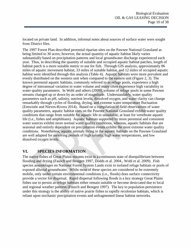
The 1997 Forest Plan described perennial riparian sites on the Pawnee National Grassland as being limited to 30 acres; however, the actual quantity of aquatic habitat likely varies substantially based on precipitation patterns and local groundwater discharge experienced each year. Thus, in describing the quantity of suitable and occupied aquatic habitat patches, length of habitat patch is a more suitable metric to use for fish. Through GIS analysis, approximately 86 miles of aquatic movement habitat, 33 miles of suitable habitat, and 12 miles of occupied aquatic habitat were identified through this analysis (Table 4). Aquatic habitats were more prevalent and evenly distributed on the western unit when compared to the eastern unit (Figure 2, 3). The known perennial aquatic habitats, commonly referred to as refuge pools, experience a high degree of interannual variation in water volume and many often experience high variability in water quality parameters. In Wohl and others (2009), volume of refuge pools in some Pawnee streams changed up or down by an order of magnitude. Understandably, water quality parameters such as pH, salinity, nutrient levels, dissolved oxygen, and water clarity can change remarkably through cycles of flooding, drying, and extreme water temperature fluctuation (Entwistle and Nieves-Rivera 2014). Based on a compilation of field observations of water quality parameters, aquatic habitat sites on the Pawnee National Grassland exhibit water quality conditions that range from suitable for aquatic life to unsuitable, at least for vertebrate aquatic life (i.e., fishes and amphibians). Aquatic habitats supported by more perennial and consistent water sources exhibit more normal water quality conditions, whereas, aquatic habitats that are seasonal and entirely dependent on precipitation events exhibit the most extreme water quality conditions. Nonetheless, aquatic animals living in the aquatic habitats on the Pawnee Grassland are well adapted for surviving periods of high salinity, high water temperatures, and low dissolved oxygen levels.
VI. SPECIES INFORMATION
The native fishes of Great Plains streams exist in a continuous state of disequilibrium between flooding and drying (Fausch and Bestgen 1997, Dodds et al. 2004., Wohl et al. 2009). Fish
species assemblages on National Forest System Lands exist in isolated refuge habitats or pools of
exposed alluvial groundwater. While most of these species are considered to be extremely
mobile, only under certain environmental conditions (i.e., floods) does surface connectivity
provide a vector for dispersal. Rapid dispersal following floods is a key strategy Great Plains
fishes use to persist as refuge habitats either remain suitable or become desiccated due to local
and regional weather patterns (Fausch and Bestgen 1997). The key to population persistence
under this strategy is the ability of native prairie fishes to rapidly recolonize habitats, which is
reliant upon stochastic precipitation events and unfragmented linear habitat networks.
Biological Evaluation
OIL & GAS LEASING DECISION
Page 11 of 38
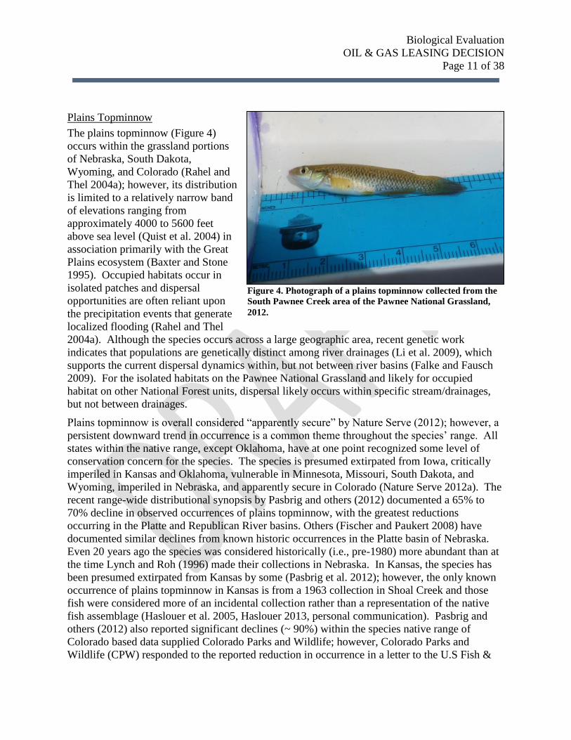
Plains Topminnow
The plains topminnow (Figure 4)
occurs within the grassland portions
of Nebraska, South Dakota,
Wyoming, and Colorado (Rahel and
Thel 2004a); however, its distribution
is limited to a relatively narrow band
of elevations ranging from
approximately 4000 to 5600 feet
above sea level (Quist et al. 2004) in
association primarily with the Great
Plains ecosystem (Baxter and Stone
1995). Occupied habitats occur in
isolated patches and dispersal
opportunities are often reliant upon
the precipitation events that generate
localized flooding (Rahel and Thel
2004a). Although the species occurs across a large geographic area, recent genetic work
indicates that populations are genetically distinct among river drainages (Li et al. 2009), which
supports the current dispersal dynamics within, but not between river basins (Falke and Fausch
2009). For the isolated habitats on the Pawnee National Grassland and likely for occupied
habitat on other National Forest units, dispersal likely occurs within specific stream/drainages,
but not between drainages.
Plains topminnow is overall considered “apparently secure” by Nature Serve (2012); however, a
persistent downward trend in occurrence is a common theme throughout the species’ range. All
states within the native range, except Oklahoma, have at one point recognized some level of
conservation concern for the species. The species is presumed extirpated from Iowa, critically
imperiled in Kansas and Oklahoma, vulnerable in Minnesota, Missouri, South Dakota, and
Wyoming, imperiled in Nebraska, and apparently secure in Colorado (Nature Serve 2012a). The
recent range-wide distributional synopsis by Pasbrig and others (2012) documented a 65% to
70% decline in observed occurrences of plains topminnow, with the greatest reductions
occurring in the Platte and Republican River basins. Others (Fischer and Paukert 2008) have
documented similar declines from known historic occurrences in the Platte basin of Nebraska.
Even 20 years ago the species was considered historically (i.e., pre-1980) more abundant than at
the time Lynch and Roh (1996) made their collections in Nebraska. In Kansas, the species has
been presumed extirpated from Kansas by some (Pasbrig et al. 2012); however, the only known
occurrence of plains topminnow in Kansas is from a 1963 collection in Shoal Creek and those
fish were considered more of an incidental collection rather than a representation of the native
fish assemblage (Haslouer et al. 2005, Haslouer 2013, personal communication). Pasbrig and
others (2012) also reported significant declines (~ 90%) within the species native range of
Colorado based data supplied Colorado Parks and Wildlife; however, Colorado Parks and
Wildlife (CPW) responded to the reported reduction in occurrence in a letter to the U.S Fish &
Figure 4. Photograph of a plains topminnow collected from the
South Pawnee Creek area of the Pawnee National Grassland,
2012.
Biological Evaluation
OIL & GAS LEASING DECISION
Page 12 of 38
Wildlife Service, noting that CPW has
observed some declines in the species,
but “nowhere near the losses reported
by Pasbrig” (Crockett 2012). The
population trend in South Dakota is
declining (Hoagstrom et al. 2006).
Results from local population
monitoring on the Pawnee National
Grassland are indicate reductions in the
proportion of habitats occupied by all
fish species, including plains
topminnow. Willow Creek and South
Pawnee Creek topminnows have
remained consistently occupied by
plains topminnow; however, the
species has disappeared from Coal, Geary, Howard, and Wildhorse Creeks. In addition, the
species has not been observed in South Pawnee Creek since 2002.
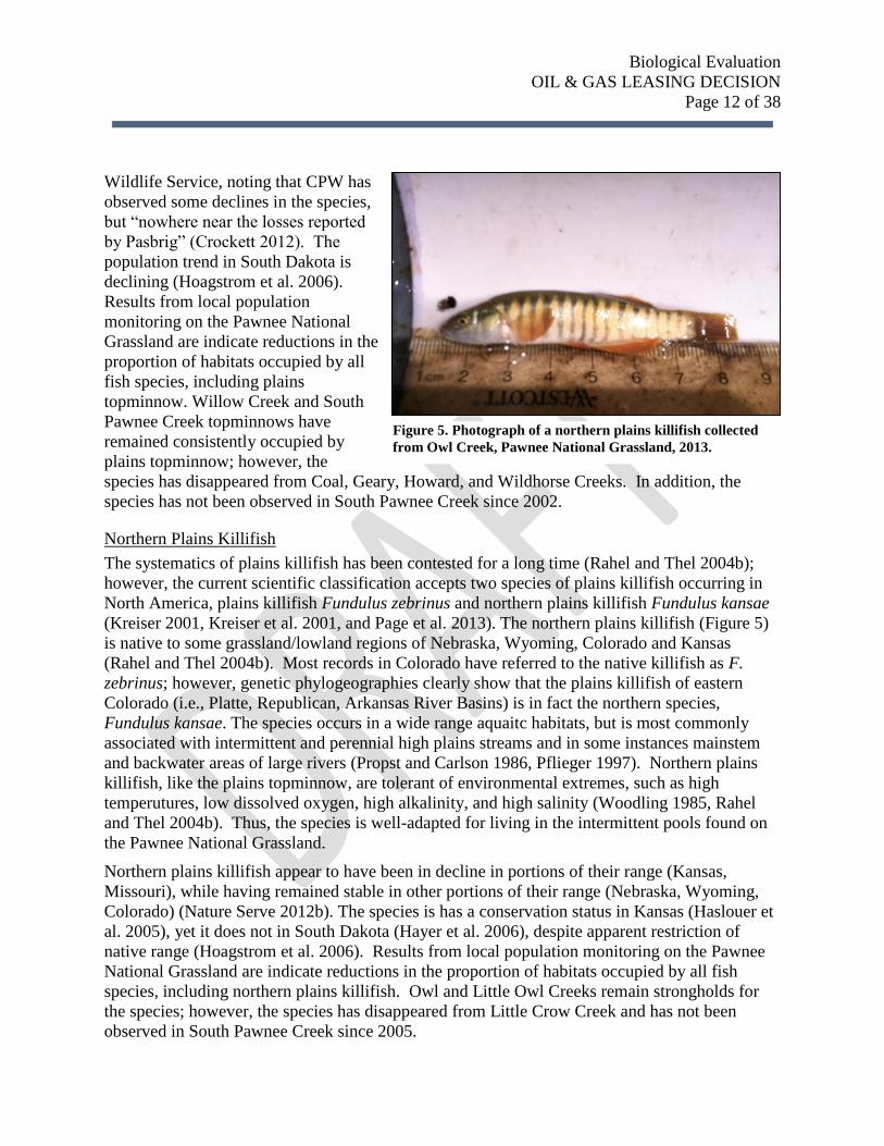
Northern Plains Killifish
The systematics of plains killifish has been contested for a long time (Rahel and Thel 2004b);
however, the current scientific classification accepts two species of plains killifish occurring in
North America, plains killifish Fundulus zebrinus and northern plains killifish Fundulus kansae
(Kreiser 2001, Kreiser et al. 2001, and Page et al. 2013). The northern plains killifish (Figure 5)
is native to some grassland/lowland regions of Nebraska, Wyoming, Colorado and Kansas
(Rahel and Thel 2004b). Most records in Colorado have referred to the native killifish as F.
zebrinus; however, genetic phylogeographies clearly show that the plains killifish of eastern
Colorado (i.e., Platte, Republican, Arkansas River Basins) is in fact the northern species,
Fundulus kansae. The species occurs in a wide range aquaitc habitats, but is most commonly
associated with intermittent and perennial high plains streams and in some instances mainstem
and backwater areas of large rivers (Propst and Carlson 1986, Pflieger 1997). Northern plains
killifish, like the plains topminnow, are tolerant of environmental extremes, such as high
temperutures, low dissolved oxygen, high alkalinity, and high salinity (Woodling 1985, Rahel
and Thel 2004b). Thus, the species is well-adapted for living in the intermittent pools found on
the Pawnee National Grassland.
Northern plains killifish appear to have been in decline in portions of their range (Kansas,
Missouri), while having remained stable in other portions of their range (Nebraska, Wyoming,
Colorado) (Nature Serve 2012b). The species is has a conservation status in Kansas (Haslouer et
al. 2005), yet it does not in South Dakota (Hayer et al. 2006), despite apparent restriction of
native range (Hoagstrom et al. 2006). Results from local population monitoring on the Pawnee
National Grassland are indicate reductions in the proportion of habitats occupied by all fish
species, including northern plains killifish. Owl and Little Owl Creeks remain strongholds for
the species; however, the species has disappeared from Little Crow Creek and has not been
observed in South Pawnee Creek since 2005.
Figure 5. Photograph of a northern plains killifish collected
from Owl Creek, Pawnee National Grassland, 2013.
Biological Evaluation
OIL & GAS LEASING DECISION
Page 13 of 38
VII. EFFECTS ANALYSIS
Most environmental impacts and consequences of oil and gas development and production on
aquatic ecosystems occur through indirect and cumulative effect mechanisms. Many of these
impacts at the landscape scale are similar to the effects from timber extraction combined with
urbanization (Smith et al. 2012). Regardless of region, these environmental impacts center on
water losses reducing aquatic habitat, sediment from development reaching aquatic habitat,
contaminants polluting aquatic habitat, and infrastructure (e.g., roads, pipelines) fragmenting
aquatic habitat (e.g., Davis et al. 2009, Entrekin et al. 2012, Weltman-Fahs and Taylor 2013).
Similarly, the anticipated development of oil and gas resources on the Pawnee National
Grassland (PNG) may result in impacts to aquatic species and their habitats through the
following mechanisms: (1) loss of aquatic habitat due to water depletions from regional water
sources, (2) reduction in suitability of aquatic habitat where deposited sediments have reduced
pool volume and altered the physical structure important to fish occurrence, (3) loss of aquatic
habitat due to contaminated water sources supplying the habitat, and (4) fragmentation of aquatic
habitat as a result of physical barriers created as new roads and pipelines are developed.
Through either loss or reduced suitability of aquatic habitat, these mechanisms would potentially
cause local population declines or extirpations of prairie fish species. The severity of these
anticipated effects varies among the alternatives and is best considered along a gradient of
environmental risk for habitats and the species.
Methodology
The potential effects of oil and gas related development on aquatic habitat have been examined
separately by each mechanism to determine the predicted environmental consequences to prairie
fish. Descriptions of each mechanism have been described and relative comparisons among
alternatives in terms of direct, indirect, and cumulative effects. The effects of existing leases on
the PNG have been described as a point of reference of which to base the predicted consequences
of action alternatives. The analytical approach used a combination of GIS analytics, inferences
drawn from published datasets on the impacts of Oil and Gas Development, and professional
judgment for synthesizing analytical components together. The best available information and
published datasets were sought and employed from myriad sources including USDA Forest
Service, USDI Bureau of Land Management, Colorado Oil and Gas Conservation Commission,
Colorado Water Quality Control Division, Colorado Parks and Wildlife, and numerous academic
and research institutes. The National Forest Service Library performed literature searches for on
the impacts of oil and gas development to fishes and water quality.
Incomplete and Unavailable Information
The potential impacts of unconventional oil and gas development are not fully understood. The
newly available technologies being used to extract fossil fuels from deep geologic formations
may pose uncertain, unquantified, and to date unrealized impacts to aquatic resources. There are
uncertainties regarding the biology, dispersal, and habitat requirements for several of the prairie
fishes native to the Pawnee National Grassland. Water quality datasets are incomplete and
Biological Evaluation
OIL & GAS LEASING DECISION
Page 14 of 38
efforts to collect water quality data in drilling-dense areas of the PNG do not currently occur.
Our understanding of the shallow alluvial aquifer system and the connectivity of shallow
groundwater to areas of suitable fish habitat is incomplete. Data regarding human-related
aquatic habitat fragmentation is lacking for the PNG and surrounding areas.
Spatial and Temporal Context for Effects Analysis
The spatial context for this analysis covers the major prairie watersheds on the PNG: Kiota
Creek, Owl Creek, Crow Creek, and Pawnee Creek. The time-based context of the prediction
provided herein span from current day development through a 20 year period of development at
the current rates of oil and gas extraction and infrastructure development as well as some
anticipation of latent effects on the landscape beyond 20 years of development, including the 50-
year average production life of an oil well.
Aquatic Habitats as Affected by Leasing Decision
The environmental consequences for fisheries issues have been addressed within the context of
existing federal leases, federal surface ownership overlying private mineral estates, and unleased
federal mineral estate. The decision space for this leasing decision is only for the unleased
federal mineral estate underlying the Pawnee National Grassland. Substantial development has
already occurred throughout portions of the administrative boundary. Approximately half of the
suitable aquatic habitat on the PNG has unrealized risks to aquatic habitats and fish species
where the Forest Service has limited control over how new infrastructure may be developed.
Environmental risks for undeveloped private minerals are greater than the risks from leased, but
undeveloped, federal minerals. Environmental risks to new leases would be similar leases sold
under the current Forest Plan. Roughly 10 miles of suitable aquatic habitat (Coal, Geary, Little
Owl, Owl, Wildhorse, and Willow Creek) on the PNG occurs over top of private mineral estates.
An additional 6 miles of suitable aquatic habitat (Little Crow, South Pawnee, Wild Horse
Creeks) on the PNG occurs over top of existing leases. The remaining 16 miles of suitable
aquatic habitat on the PNG occur over top of unleased federal mineral estate.
DIRECT AND INDIRECT EFFECTS
Consequences of Habitat Sedimentation
Oil and gas development includes ground-disturbing activities that increase the amount of
erosion-prone area on landscapes and poses sedimentation risk to aquatic habitats. Road
construction can lead to large amounts of sediment yield in prairie landscapes and sediment yield
can persist for many years following initial construction. Sediment production from pipeline
construction is similar to initial road construction; however, yield declines as disturbed areas
revegetate. Well pads have been poorly sited in other drilling-dense regions, resulting in high
runoff potential and substantial capacity for sediment transport into aquatic habitats (Drohan and
Brittingham 2012, McBroom et al. 2012). In addition, sediment yields from constructed well-pad
sites can be very high (e.g., >20 yds3 per acre) in dry grassland settings, similar to yields
observed at large construction sites (Williams et al. 2008). These rates are much higher than the
Biological Evaluation
OIL & GAS LEASING DECISION
Page 15 of 38
current conditions of sediment yields observed on the PNG (Entwistle and Nieves-Rivera 2014).
In addition, high levels of traffic on both Weld County and Forest Service roads anticipated with
more oil and gas development would increase rates of wind-born and water-born erosion
processes from road-surfaces, thereby increasing the likelihood of sediment delivery to suitable
aquatic habitats. These erosion processes and the vulnerabilities of soil erosion across the PNG
have been addressed elsewhere in the DEIS (Entwistle and Neives-Rivera 2014). Here, the
consequences of sedimentation in aquatic habitats and biological ramifications will be addressed.
Fate and Consequence of Sedimentation
The ultimate fate and consequences of sediment deposition into the small aquatic habitats could
reduce the habitat suitability for the native prairie fish community by reducing aquatic habitat
volume, reducing pool depths, and facilitating the conversion of suitable fish habitat to shallow
wetland habitat incapable of supporting the prairie fish community. It is well-known that
sediment deposited into stream habitats can alter and, in some cases, eliminate fish assemblages
(Waters 1997). These shifts are caused by sediment covering structurally-diverse streambed
habitat and reducing pool quantity and quality (Waters 1997). In Missouri, fish with feeding
ecologies and spawning habitat requirements similar to plains topminnows, northern plains
killifish, and Iowa darters were markedly reduced by stream sedimentation (Berkman and Rabeni
1987, Rabeni and Smale 1995). In addition, the effective life-span and habitat suitability of other
aquatic habitats has been dramatically reduced by interception of deposited sediments elsewhere
in the Great Plains (Gleason and Euliss 1998). Sediments deposited into suitable habitats on the
PNG are likely to persist for a long-time (~10 years) given the low likelihood of large
precipitation events capable of scouring out depositional sediment. Thus, deposition of sediment
into suitable habitats would likely result in the conversion of fish habitat to shallow wetlands
with little surface water. In sum, although the specific mechanisms for potential sedimentation
effects to PNG fishes vary by species, all three species would suffer negative impacts as a result
of reduced pool habitat, alteration in food availability, and degraded spawning habitat.
Entwistle and Nieves-Rivera (2014) identified areas with the greatest potential to deliver
sediment into aquatic habitats for the PNG. Some areas of existing leases fall into the identified
susceptibility areas that lie in close proximity to suitable habitats. These habitats (e.g., Coal
Creek, Little Crow Creek, Owl Creek, South Pawnee Creek) are at greatest risk of sedimentation
impacts. Sedimentation risks can be managed to acceptable levels by separating the aquatic
habitat from the sediment source. The key to this approach is to ensure that not only is there
sufficient buffering distance, but also that landforms and vegetation exist to adequately filter
anticipated volumes of sediment (Waters 1997). The application of aquatic habitat buffers in
small plains streams has been demonstrated to improve habitats degraded by sedimentation (e.g.,
Sheilds et al. 1995, Rabeni and Smale 1995).
Sedimentation Risks to PNG Fishes by Alternative
Direct and indirect effects of sedimentation causing loss or degradation of aquatic habitat will
vary depending on how much new oil and gas development occurs and the proximity of new oil
Biological Evaluation
OIL & GAS LEASING DECISION
Page 16 of 38
and gas development to suitable aquatic habitats. The effects described above should be seen as
risks that are common to all alternatives with the probability of resource risk changing with
increasing displacement of the risk from the aquatic habitat. The impacts of sedimentation to
aquatic habitat resulting from oil and gas development under various leasing decisions can be
estimated based on proximity analysis of how close or far erosion risks are separated from
aquatic habitats. Existing oil and gas infrastructure on the PNG has been developed within 100
feet of adjacent aquatic habitat (e.g., API # 05-123-13427; API # 05-123-13275; API # 05-123-
21580), so it is reasonable to assume that continued development under the Forest Plan could
result in new infrastructure (i.e., wells, roads, pipelines) being developed within close proximity
(< 650 feet or 200m) to suitable aquatic habitats. Development within close proximity to aquatic
habitat would pose sedimentation risks to valuable aquatic habitat, resulting in impacts to fish.
The relative risks of sedimentation impacts to PNG fish vary by alternative and are based on the
proximity of susceptible erosion areas to suitable habitat patches. A GIS proximity analysis was
used to determine miles of suitable habitat that would potentially be degraded by sedimentation.
Based on highly erosive soils identified within 650 feet of suitable habitat patches, habitats were
classified as either susceptible to sedimentation or not as a result of well pad, road, or other
infrastructure development. Comparisons were made within the context of the type of mineral
estate (i.e., federal-leased, private estate, or federal-available) to attribute risks to suitable aquatic
habitats under each alternative (Table 5). Sedimentation risks are highest on private mineral
estate due to the limited ability of surface ownership to stipulate environmental protections.
Sedimentation risks are second highest on currently leased federal minerals due to insufficient
protections provided by the Forest Plan (e.g., wells have been and may continue to be located
within 200m of suitable habitat; in some areas erosion beyond 200m may still cause
sedimentation of suitable aquatic habitats). Sedimentation risks are lowest on unleased federal
minerals; however, sedimentation risks to remaining suitable aquatic habitats may be higher
under certain leasing alternatives (i.e., Forest Plan). Within the context of existing leases, private
mineral estate under PNG, and federal mineral estate under PNG, conclusions can be drawn
about to degree to which suitable habitats are at risk to sedimentation (Table 5). Under
Alternatives 1 and 3, additional sedimentation risks associated with Oil and Gas development
would be limited. Permits for access roads and pipeline infrastructure are expected to occur,
which may cause minor sedimentation of habitats. Under Alternative 2, additional sedimentation
risks associated with Oil and Gas development would rise for most of the suitable aquatic
habitat. Well pad development, new roads, and new pipelines would increase sedimentation
risks, which may significantly reduce the quantity and quality of suitable aquatic habitat on the
PNG. Approximately 15.1 miles of suitable aquatic habitat would be highly susceptible to
sedimentation should any development occur within 200m (650 ft). Approximately 5.9 miles of
suitable aquatic habitat would be susceptible to sedimentation even if development were to occur
beyond 200m. Suitable aquatic habitat occurring within the Little Owl Research Natural Area
would be largely protected from sedimentation effects even under Alternative 2.
Cumulative Effects

Biological Evaluation
OIL & GAS LEASING DECISION
Page 17 of 38
Other activities on the PNG also contribute to sedimentation in aquatic habitats, including,
season long grazing and modest levels of road maintenance. Grazing on the PNG is expected to
remain near current rates in the future. Road maintenance on the PNG is expected to continue at
current rates, but may also increase as new roads are constructed. While both of these activities
are known to cause sedimentation to aquatic habitats, current amounts of sedimentation to
aquatic habitats has not been quantified for aquatic habitats across the PNG. It is reasonable to
conclude that sedimentation from these cumulative actions will continue to occur at current rates
and it is uncertain if current sedimentation rates are diminishing suitable habitat.
Table 5. Consequences of habitat sedimentation to 33 miles of suitable aquatic habitats on the Pawnee
National Grassland compared among alternatives.
All Alternatives Alternative 1 Alternative 2 Alternative 3
Effects on existing leases
plus effect of private
mineral estate under PNG.
No Additional Leasing No Action--leasing
across PNG under
current Forest Plan
Leasing under No
Surface Occupancy
Over 16 miles of suitable
aquatic habitat is at a
moderate to very high risk
of sedimentation reducing
the capacity of the habitat
to support prairie fish due
to existing leases and
private mineral estates.
2.5 miles of suitable
habitat are at high risk of
sedimentation on existing
leases.
5.7 miles of suitable
habitat are at very high risk
of sedimentation on private
mineral estate.
FS authorized activities
would contribute
minimal additional risks
of sedimentation to 16
miles of suitable aquatic
habitat on unleased
federal mineral estate.
Sedimentation risks may
be displaced from NFSL
to adjacent private
lands, which may result
in habitat loss on
adjacent lands or as
result of downstream
sediment transport.
Sedimentation risks will
rise for 32 miles of
suitable aquatic habitats.
Development within
200m = 15.1 miles of
suitable habitat is at
high risk to
sedimentation.
Development beyond
200m = 5.9 miles of
suitable habitat is at
moderate risk to
sedimentation.
Risks from FS
authorized actions will
remain low on Little
Owl Creek (1 mile)
within the Research
Natural Area.
FS authorized activities
would contribute
minimal additional risks
of sedimentation to 16
miles of suitable aquatic
habitat on unleased
federal mineral estate.
Sedimentation risks may
be displaced from NFSL
to adjacent private lands,
which may result in
habitat loss on adjacent
lands or as result of
downstream sediment
transport.
Biological Evaluation
OIL & GAS LEASING DECISION
Page 18 of 38
Consequences of Environmental Contaminants to Aquatic Habitat
Oil and gas development and production poses risk of environmental contaminants reaching
aquatic habitats. Risks of leaks, spills, and other losses of containment exist during much of the
development and production phases; however, the greatest risks are associated with the
collection of hydrocarbons at the surface, transport and storage of hydrocarbons, down-hole
pumping of water, sand, and chemicals, and collection, containment, and disposal of flow-back
and produced water. Among these risks, flow-back and produced water (collectively referred to
as produced water, henceforth) poses the most significant risk to aquatic habitats due to the sheer
volume of produced water managed by the industry (Ahmadun et al. 2009). The proximity of
these risks to important aquatic habitat areas controls the fate and ultimate consequence of
environmental contaminants reaching aquatic habitats (Entrekin et al. 2013). Water resource
features vulnerable to contamination have been identified as either surface waters (Table 1) or
groundwater influence zones (Entwistle and Nieves-Rivera 2014). Here, a brief review covers
potential contaminants used for oil and gas development, contaminant fate and persistence in
surface and groundwater, and the environmental consequences of contaminants to fish.
For unconventional oil and gas development, contaminant transport pathways and risks have not
been well-studied as much of the “unconventional” technology has been developed within the
past 10 years (Jackson et al. 2013). Areas of dense development (e.g., Pennsylvania, Wyoming,
Colorado) pose the largest risks as the hydro-fracturing processes and well-cementing issues
around “active” and “closed” wells may create vectors for contaminants and expedite
contaminant transport to ground and surface water resources (e.g., Myers 2012, Jackson et al.
2013). Aquitards (i.e., zones of relatively impermeable sediment) can trap and prevent the flow
of contaminants released at the surface from moving into deep aquifers (Cherry et al. 2004);
however, the shallow clay-based aquitards on the Pawnee National Grassland also funnel ground
water in the unconfined alluvial aquifer into suitable fish habitats. Thus, while aquitards protect
deep aquifers (e.g., Ogallala, Brule), they may concentrate and deliver contaminants released at
the surface to suitable habitats.
Hydro-fracturing
The process of pumping water and fracturing fluids into drilled wells to create high pressure
underground is referred to as hydro-fracturing. This process causes fractures in the dense
geologic formations such as shale, which releases oil and gas resources, and also results in the
production of large volumes of water mixed with oil, gas, and other substances at the surface.
Both hydro-fracturing fluids and produced water contain potential environmental contaminants
and can be viewed as risks to groundwater and surface water quality (Gordalla et al. 2013).
While water and sand are the chief constituents used in hydro-fracturing fluids, several known
toxic substances are often used in hydro-fracturing fluids (Vidic et al. 2013, Kassotis et al. 2013).
Conversely, as hydro-fracturing fluid is pumped into the well, hydrostatic pressure causes
substances trapped in deep geologic formations to dissolve in the water. This aqueous solution
becomes a mixture of oils, gases, and water with constituents from fracturing fluids as well as
dissolved constituents from geologic formations that eventually return to the surface at the well

Biological Evaluation
OIL & GAS LEASING DECISION
Page 19 of 38
Figure 6. Quantity of produced water (blue line) and number of spills (red line) reported to Colorado Oil and Gas
Conservation Commission for Weld County Colorado from 2004 to 2013. Source: Colorado Oil and Gas
Conservation Commission Online Database.
head. From there, the gases and oils are separated from the produced water and produced water
is typically handled as wastewater.
Produced Water
Produced water is the single largest waste stream from the oil and gas industry and with the
volume of material to manage (Ahmadun et al. 2009), accidental spills and releases of produced
water into the environment is inevitable. Approximately 50,000 acre-feet of produced water are
generated in Colorado annually and while the majority is evaporated or reinjected (Clark and
Veil 2009, COGCC 2014), produced water can be permitted for discharge into streams,
percolation into the ground, or put to beneficial use (e.g., irrigation). In Weld County, produced
water is disposed by reinjection of the water along with constituents underground or through
evaporation and percolation of water in pits (COGCC 2014). Although oil and gas operators in
Weld County reportedly generated 12,000 acre-feet of produced water in a 10 year period, the
rate of water produced at well heads has been steadily increasing since 2007 (Figure 6). In
addition, rates of produced water increase as wells age (Veil et al. 2004). The rate of produced
water generated is expected to increase over the next 20 years, so annual rates of produced
waters could easily double or triple the annual rate of 2000 acre-feet of water. The importance of
this quantity of produced water and constituent substances is how it is handled, treated, and
disposed as wastewater. In addition, disposal via percolation into the ground from unlined
evaporation pits represents a large potential risk to neighboring groundwater influence zones that
supply water to suitable habitats.
Spills and Environmental Releases
Similarly, rates of spills and releases have also been on the rise in recent years (Earthworks 2008,
Figure 6). Statewide from 2003 to 2008, roughly 20% of spills have affected surface or ground
Biological Evaluation
OIL & GAS LEASING DECISION
Page 20 of 38
water resources; however, 47% of spills in Weld County affect water resources. In addition, the
rate of spills/releases to the environment in Weld County has been increasing approximately
80% per year (Earthworks 2008). Spills and chemical releases often receive media attention
(Banerjee 2013, Finley 2011); however, water quality testing is not routinely performed and
formal pre-drilling to post-drilling water quality monitoring program does not occur in Weld
County, Colorado. Thus, there is little information available regarding what substances are
released into the environment when spills occur.
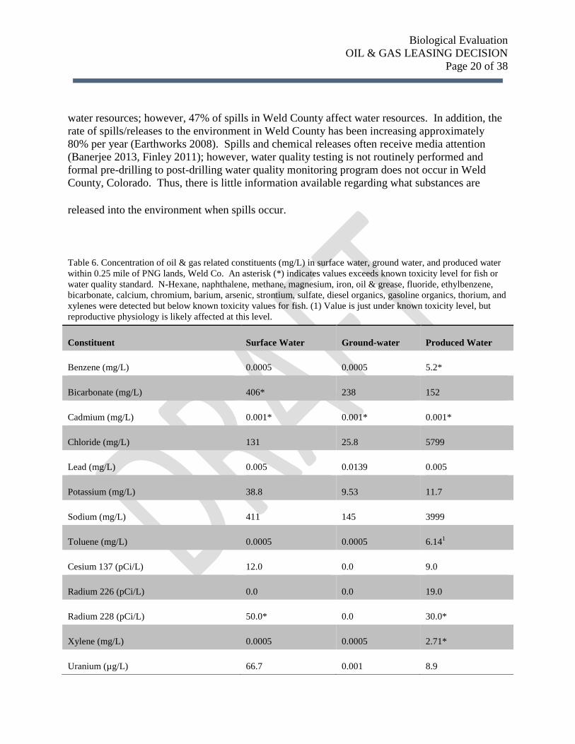
Table 6. Concentration of oil & gas related constituents (mg/L) in surface water, ground water, and produced water
within 0.25 mile of PNG lands, Weld Co. An asterisk (*) indicates values exceeds known toxicity level for fish or
water quality standard. N-Hexane, naphthalene, methane, magnesium, iron, oil & grease, fluoride, ethylbenzene,
bicarbonate, calcium, chromium, barium, arsenic, strontium, sulfate, diesel organics, gasoline organics, thorium, and
xylenes were detected but below known toxicity values for fish. (1) Value is just under known toxicity level, but
reproductive physiology is likely affected at this level.
Constituent Surface Water Ground-water Produced Water
Benzene (mg/L) 0.0005 0.0005 5.2*
Bicarbonate (mg/L) 406* 238 152
Cadmium (mg/L) 0.001* 0.001* 0.001*
Chloride (mg/L) 131 25.8 5799
Lead (mg/L) 0.005 0.0139 0.005
Potassium (mg/L) 38.8 9.53 11.7
Sodium (mg/L) 411 145 3999
Toluene (mg/L) 0.0005 0.0005 6.141
Cesium 137 (pCi/L) 12.0 0.0 9.0
Radium 226 (pCi/L) 0.0 0.0 19.0
Radium 228 (pCi/L) 50.0* 0.0 30.0*
Xylene (mg/L) 0.0005 0.0005 2.71*
Uranium (µg/L) 66.7 0.001 8.9

Biological Evaluation
OIL & GAS LEASING DECISION
Page 21 of 38
Contaminant Impacts to Fish
The constituency of produced water has received some study and varies in composition based on
the type of oil or gas being produced (Veil et al. 2004). For gas production, produced waters
contain inorganics (e.g., chloride and bromine salts, metals), organics (e.g., phenols, alkanes,
aromatic hydrocarbons), and radio-active materials in concentrations in excess of toxicity
standards for aquatic life (Alley et al. 2011). Produced water from gas production contains high
levels of chloride salts or other brines (Alley et al. 2011, Farag et al. 2012). Concentrations of
salts and constituent substances increases with time as the wells age (Veil et al. 2004). These
substances reduce immune function (e.g., Reynaud and Deschaux 2006), disrupt reproductive
function (e.g., Sumpter and Jobling 1995, Nicolas 1999, Kidd et al. 2007), delay or halt
embryonic development (e.g., Carls et al. 2008, Farag et al. 2012), lead to mortality (e.g., Cairns
and Nebecker 1982, Woltering 1984, Vittozi and De Angelis 1991, Farag et al. 2012), and reduce
both quantity and diversity (e.g., Albers et al. 1985, Thienpoint et al. 2013) in fish and other
aquatic animals. Several of these impacts have been documented in fathead minnows, both a
common laboratory animal and inhabitant of aquatic habitats on the PNG.
Existing Water Quality
To discern evidence of risk to ground and surface waters from oil and gas activities on the PNG,
water quality data were queried from COGCC and the Colorado Water Quality Control Division
on February 19, 2014. Seven water quality collection sites were located within a quarter-mile of
PNG lands with the majority of sample sites located near municipalities (e.g., Nunn, Briggsdale,
Raymer). Contaminants tested were compiled and those exceeding safe levels (Woltering 1984,
Vitozzi and DeAngelis 1991, Alley et al. 2011, and EPA 2014) were used to determine existing
risk; however, this should not be considered exhaustive and accuracy of contaminant
measurements is unclear as data were collected by different entities and processed by different
laboratories. Several BTEX, PAH, and other hydrocarbon substances along with salts, metals,
and radioactive elements were detected in produced water near the PNG (Table 6). In some
cases, surface water and ground water were contaminated by some of those substances (Table 6).
It should be noted that while these observations represent some conditions found near the PNG,
they are not comprehensive because mandatory ground and surface water quality testing is not
required at this time in Colorado.
Water quality standards for surface waters on the PNG are currently set for protections to
agricultural systems and not aquatic life because the beneficial uses in suitable aquatic habitats
on the PNG are classified as agricultural only (Colorado Water Quality Control Division, 2014
pers. comm.). Standards for agricultural beneficial uses are lower than standards for aquatic life
beneficial uses. This means that contaminants exceeding standards for aquatic life in suitable
aquatic habitats on the PNG likely would not trigger a State regulatory response even if samples
with exceedances were detected.
Biological Evaluation
OIL & GAS LEASING DECISION
Page 22 of 38
Contaminant Fate
It is uncertain how long contaminants will persist in surface and groundwater sources and thus
how long they may disrupt biological mechanisms. Contaminant degradation rates span 1.5 to 5
years for BTEX contaminants (Cozarelli et al. 2010); however, degradation of all oil and gas
contaminants varies from short term (i.e., months) to long-term persistence (i.e., > 10 years)
depending on soil media type and hydrogeologic factors (Farhadian et al. 2008, Baedecker et al.
2011). In addition, toxicity of contaminants released into the environment can be amplified by
exposure to sunlight (Oris and Giesy 1987 [PAH]), while PAH, some BTEX, other contaminants
bioaccumulate through aquatic food webs resulting in cascading impacts to aquatic ecosystems
(Neff 2002).
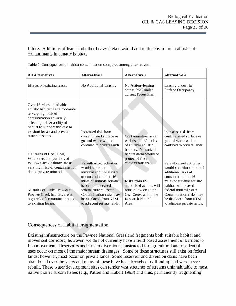
Contaminant Risks to PNG Fishes by Alternative
Based on known fish responses to contaminants and the persistence of contaminants in the
environment, potential contamination to surface or ground water resources could easily cause
them to become degraded to the point where suitable aquatic habitats are no longer capable of
supporting the native prairie fish. In addition, the current rates of spills and environmental
releases to surface water and groundwater are expected to increase with time. Over a 20 to 50
year period the likelihood of fish being adversely affected by contaminants is high. This
degradation of water quality in suitable habitats would be an indirect effect of permitted oil and
gas development activity on the PNG. The risks of contamination and consequence to PNG
fishes was compared among alternative by performing proximity analysis similar to the approach
used to determine potential impacts of increased sedimentation. In summary, the long-term or
short-term loss of suitable habitat is likely given the increased risk of water pollution due to
accidental releases of hydrocarbons and other industrial chemicals, such as hydro-geologic
fracturing fluids and produced water and these risks vary among alternatives. Under the No
Action alternative, risks of environmental contaminants in aquatic habitats would increase from
16 miles of suitable aquatic habitat at very high to high risk to 33 miles (100% of PNG) of
suitable aquatic habitat at high risk (Table 7). Under the No Leasing and No Surface Occupancy
alternatives, risks of environmental contaminants in aquatic habitats would not increase for
aquatic habitats on the PNG (Table 7).
Cumulative Effects
Grazing and Oil and Gas Development have been and continue to be the primary land uses for
the Pawnee National Grassland. These land uses have resulted in contamination of aquatic
habitats through either nutrient enrichment or the release of toxic chemicals into the
environment. These impacts are expected to continue in the future. Oil and Gas development
under some alternatives is expected to increase in the future and would likely contribute to
additional toxic chemical releases to the environment. In addition, recreational shooting occurs
in some locations and contributes to increased levels of heavy metals (i.e., lead), which can cause
adversely water quality and fish. This use is expected to continue and perhaps expand in the
Biological Evaluation
OIL & GAS LEASING DECISION
Page 23 of 38
future. Additions of leads and other heavy metals would add to the environmental risks of
contaminants in aquatic habitats.
Table 7. Consequences of habitat contamination compared among alternatives.
All Alternatives Alternative 1 Alternative 2 Alternative 4
Effects on existing leases No Additional Leasing No Action–leasing
across PNG under
current Forest Plan
Leasing under No
Surface Occupancy
Over 16 miles of suitable
aquatic habitat is at a moderate
to very high risk of
contamination adversely
affecting fish & ability of
habitat to support fish due to
existing leases and private
mineral estates.
10+ miles of Coal, Owl,
Wildhorse, and portions of
Willow Creek habitats are at
very high risk of contamination
due to private minerals.
6+ miles of Little Crow & S.
Pawnee Creek habitats are at
high risk of contamination due
to existing leases.
Increased risk from
contaminated surface or
ground water will be
confined to private lands.
FS authorized activities
would contribute
minimal additional risks
of contamination to 16
miles of suitable aquatic
habitat on unleased
federal mineral estate.
Contamination risks may
be displaced from NFSL
to adjacent private lands.
Contamination risks
will rise for 31 miles
of suitable aquatic
habitats. No suitable
habitat areas would be
protected from
contaminant risks
Risks from FS
authorized actions will
remain low on Little
Owl Creek within the
Research Natural
Area.
Increased risk from
contaminated surface or
ground water will be
confined to private lands.
FS authorized activities
would contribute minimal
additional risks of
contamination to 16
miles of suitable aquatic
habitat on unleased
federal mineral estate.
Contamination risks may
be displaced from NFSL
to adjacent private lands.
Consequences of Habitat Fragmentation
Existing infrastructure on the Pawnee National Grassland fragments both suitable habitat and
movement corridors; however, we do not currently have a field-based assessment of barriers to
fish movement. Reservoirs and stream diversions constructed for agricultural and residential
uses occur on most of the major stream drainages. Some of these structures still exist on federal
lands; however, most occur on private lands. Some reservoir and diversion dams have been
abandoned over the years and many of these have been breached by flooding and were never
rebuilt. These water development sites can render vast stretches of streams uninhabitable to most
native prairie stream fishes (e.g., Patton and Hubert 1993) and thus, permanently fragmenting
Biological Evaluation
OIL & GAS LEASING DECISION
Page 24 of 38
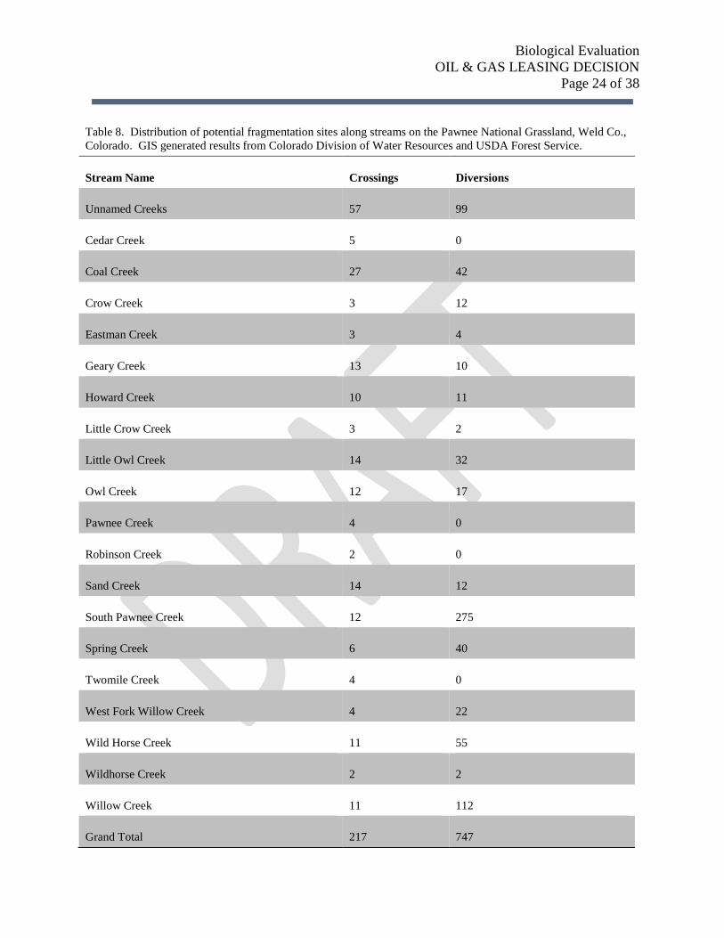
Table 8. Distribution of potential fragmentation sites along streams on the Pawnee National Grassland, Weld Co.,
Colorado. GIS generated results from Colorado Division of Water Resources and USDA Forest Service.
Stream Name Crossings Diversions
Unnamed Creeks 57 99
Cedar Creek 5 0
Coal Creek 27 42
Crow Creek 3 12
Eastman Creek 3 4
Geary Creek 13 10
Howard Creek 10 11
Little Crow Creek 3 2
Little Owl Creek 14 32
Owl Creek 12 17
Pawnee Creek 4 0
Robinson Creek 2 0
Sand Creek 14 12
South Pawnee Creek 12 275
Spring Creek 6 40
Twomile Creek 4 0
West Fork Willow Creek 4 22
Wild Horse Creek 11 55
Wildhorse Creek 2 2
Willow Creek 11 112
Grand Total 217 747
Biological Evaluation
OIL & GAS LEASING DECISION
Page 25 of 38
prairie streams. In addition, road infrastructure on the Pawnee National Grassland varies from
primitive two-track roads to major county roads and state highways. As these roads cross the
landscape, they also cross streams and the majority of stream crossings serve as barriers to fish
movement due to under-sized culverts that convey water too swiftly and pose jumping heights
that exceed the physical abilities of the native prairie fishes. Crossing structures along this
gradient of primitive to well-developed roads vary in the degree to which they may fragment
habitat. For example, some lightly-used administrative roads cross streams with open-water
fords and do not usually fragment habitat; whereas, major county roads are full-prism roads and
cross stream areas with large fills and small culverts that do fragment habitat. While diversion
structures are not expected to increase as a result of expanded oil and gas infrastructure develop
and use, the impact on habitat fragmentation remains. Road construction, on the other hand, is
expected to increase as a result of new road and pipeline infrastructure. New infrastructure will
likely pose additional fragmentation risk to suitable habitat and movement corridors as new
crossings traverse over or under stream networks. Approximate locations of new roads and
pipelines are indeterminate at this time. Thus, how the new linear infrastructure features interact
with linear stream habitat features is unknown. However, relative comparisons of the degree to
which infrastructure crosses and potentially poses risk of habitat fragmentation can be described
and compared among alternatives.
In order determine areas of greatest fragmentation risk, a GIS analysis was performed to capture
the existing amount of potential fragmentation as a result of diversions/reservoirs (Colorado
Division of Water Resources 2013) and road/stream intersections (USDA Forest Service,
unpublished data). Based on this query of available data, over 200 road crossings and over 700
past water diversion sites occur on PNG streams (Table 8). Although not all of these sites occur
on federal lands, these features still disrupt movement into suitable habitats from refuge areas.
Some streams have few fragmentation sites given their length (e.g., Crow Creek, Robinson
Creek); whereas, other streams have a high number of potential fragmentation sites (e.g., Coal
Creek, Little Owl Creek, South Pawnee Creek) (Table 8).
There are roughly 30 miles of additional road construction anticipated with new leases and
associated oil and gas infrastructure development. This anticipated habitat fragmentation will
markedly reduce the ability for prairie stream fishes to recolonize streams following droughts
and floods (Fausch and Bestgen 1997, Rahel and Thel 2004a). Fragmentation of habitat has
limited dispersal opportunities dramatically, which is fundamental to both the community
dynamics and persistence of prairie fish species (Falke and Faush 2009). Because determining
the impacts of habitat fragmentation from additional oil and gas development requires site-
specific proposals, at the programmatic level we merely describe what fish habitat resources are
at greatest risk. Based on the distribution of suitable habitats and existing fragmentation across
the PNG, additional fragmentation of all streams and suitable habitat would be detrimental to
persistence of the native prairie fishes. Key streams with suitable and occupied habitat most
susceptible to additional fragmentation are Owl Creek, Little Owl Creek, Coal Creek, and South
Pawnee Creek. Any additional road or pipeline development crossing suitable habitat or
movement corridors should be provide for upstream-downstream passage of the full suite of
Biological Evaluation
OIL & GAS LEASING DECISION
Page 26 of 38
prairie fishes occurring on the PNG. In addition, where permits for road use of existing Forest
Service Roads are authorized, existing fish barriers should be replaced during the process of
bringing the roads up to Forest Plan and Forest Service Transportation standards.
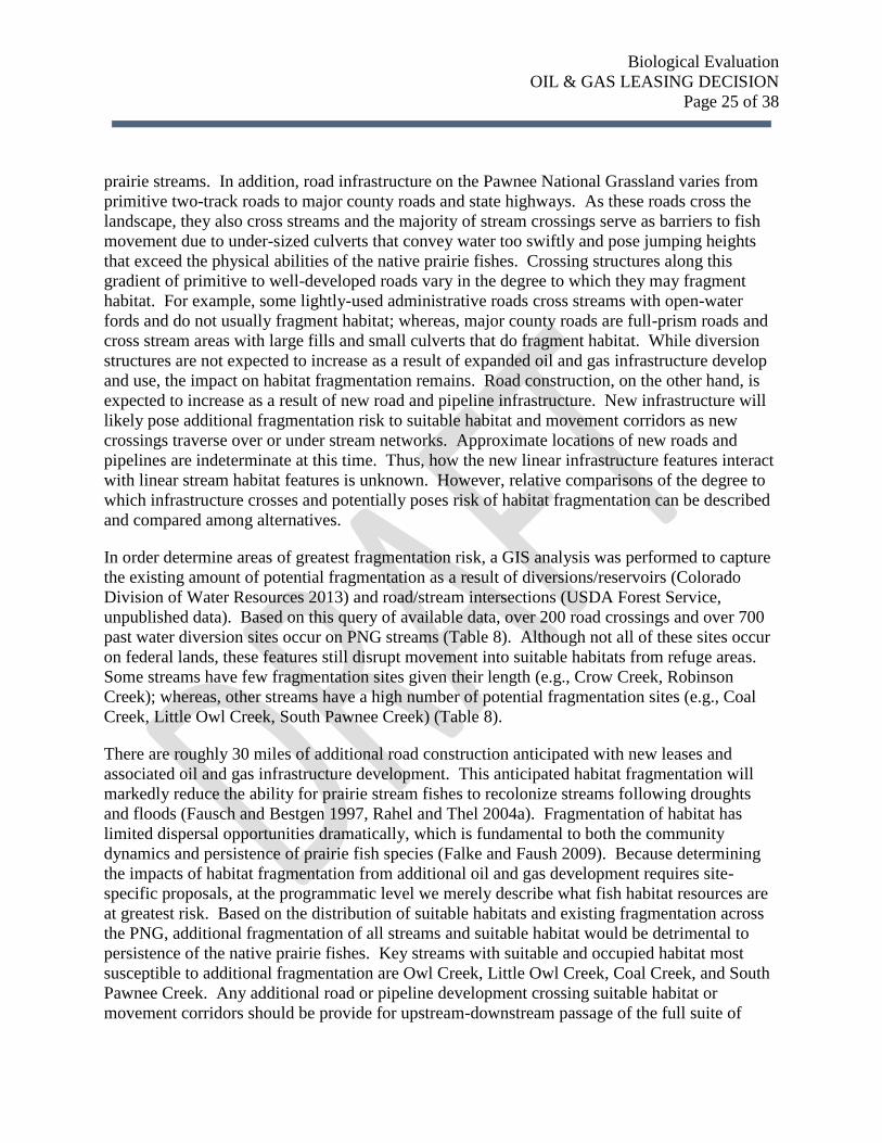
Under the No Action Alternative, additional habitat fragmentation is possible and likely to occur
(Table 9). The degree and extent to which habitat will be fragmented cannot be determined
without site-specific proposals. Under the No Leasing and No Surface Occupancy alternatives,
there is limited potential for additional fragmentation as a result of activities on PNG (Table 9).
Incidence of road permits may increase and the FS may have opportunity reduce additional
habitat fragmentation.
Cumulative Effects
Grazing and Oil and Gas Development have been and continue to be the primary land uses for
the Pawnee National Grassland. Minor amounts of recreation also occur on PNG lands. Grazing
and recreation management is unlikely to cause the construction of additional fish passage
barriers. Water storage or diversion projects are unlikely to be proposed for PNG lands as there
is little water to make such proposals viable Depending of the type of lease, fish passable
structures may be constructed. Additional stream crossing infrastructure may be constructed for
existing Oil and Gas leases or private mineral access. However, the Forest Service may either
chose not to or may not be able to require fish passable structures on PNG lands. The PNG lands
comprise a scattered ownership. The interspersed private lands likely pose higher risks overall
for additional road or pipeline construction for both Oil and Gas and other types of development.
Table 9. Consequences of habitat fragmentation compared among alternatives.
All Alternatives Alternative 1 Alternative 2 Alternative 4
Effects on existing leases No Additional Leasing No Action–leasing
across PNG under
current Forest Plan
Leasing under No Surface
Occupancy
Biological Evaluation
OIL & GAS LEASING DECISION
Page 27 of 38
Baseline conditions present
plus potential fragmentation of
any aquatic habitat on Little
Crow Creek, upper portion of
Owl Creek, portions of Howard
Creek, large extents of
Wildhorse Creek (east side),
large extents of South Pawnee
Creek, nearly all of Kibben
Creek
Limited additional
fragmentation as a
result of activities on
PNG. Incidence of road
permits may increase
and the FS may have
opportunity reduce
additional habitat
fragmentation.
Risk of additional
aquatic habitat
fragmentation is likely
on any aquatic habitat,
especially within
highest potential
development areas.
Risks from FS
authorized actions will
remain low on Little
Owl Creek within the
Research Natural
Area.
Limited additional
fragmentation as a result
of activities on PNG.
Incidence of road permits
may increase and the FS
may have opportunity
reduce additional habitat
fragmentation.
VIII. DETERMINATIONS OF EFFECTS AND RATIONALE
The plains topminnow is a fish species on the Regional Forester’s Sensitive Species List for the
Rocky Mountain Region. This species occurs in roughly 4.5 miles of the occupied aquatic
habitat across the grassland. The most robust population occurs in West Willow Creek, while
smaller and more diffuse populations occur in South Pawnee Creek and its tributary Kibben
Creek. The species has disappeared from all other known habitats on the PNG (Table 10). The
species’ stronghold in Willow Creek occurs in an area identified by the BLM has having
“moderately high development potential” (i.e., 10-20 wells per Township) and occurs on top of a
private mineral estate (i.e., O&G development could occur in close proximity sensitive habitats
without controls/stipulations by the surface owner). Thus, this particular plains topminnow
habitat is already at high risk from reduced habitat suitability as related to sedimentation,
contamination, and fragmentation. Some habitat in South Pawnee Creek is already at a moderate
risk due to existing leases and infrastructure in close proximity to occupied habitat. Only 38% of
habitat currently occupied by plains topminnow in South Pawnee Creek is relatively protected
from the potential impacts of Oil and Gas Development. The following determinations have
been made in accordance with FS Biological Evaluation Standards (FSM 2672.42).

Biological Evaluation
OIL & GAS LEASING DECISION
Page 28 of 38
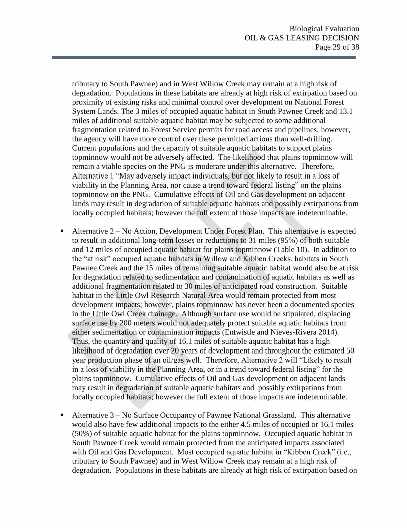
Table 10. Summary of the distribution, extent, and current status of fish occurrence in occupied aquatic
habitats on the PNG, Weld Co, Colorado. The proportion of habitat at high, moderate, and low risk are
indicated for each drainage. Superscripts indicated streams historically occupied by plain topminnow (1)
and northern plains killifish (2).
Stream Miles
Last Year
Occupied
Current
Species
Present
Private
Mineral Estate
(High Risk)
Leased Federal
Minerals
(Moderate Risk)
Available
Minerals
(Low Risk)
Coal
Creek1
1.01 2002 NONE 100%
Geary
Creek1
0.04 2001 NONE 100%
Howard
Creek1
0.09 2006 NONE 100%
Little
Crow
Creek2
0.13 2013 Iowa darter,
fathead
minnow
100%
Little Owl
Creek2
1.82 2013 fathead
minnow,
Iowa darter,
black
bullhead,
plains
killifish
17% 83%
South
Pawnee
Creek1
3.38 2014 fathead
minnow,
green
sunfish,
plains
topminnow
62% 38%
Spring
Creek
0.68 1999 green sunfish 100%
Twomile
Creek
0.99 2002 green sunfish 100%
Wildhorse
Creek1
1.24 2012 NONE 100%
Willow
Creek1
1.03 2014 fathead
minnow,
green
sunfish,
plains
topminnow,
black
bullhead,
Iowa darter
92% 8%
Alternative 1 – No Additional Leasing of Federal Minerals. This alternative would have
few additional impacts to the either 3.5 miles of occupied or 16.1 miles (~50%) of
suitable aquatic habitat for the plains topminnow (Table 10). Occupied aquatic habitat in
South Pawnee Creek would remain protected from the anticipated impacts associated
with Oil and Gas Development. Most occupied aquatic habitat in “Kibben Creek” (i.e.,
Biological Evaluation
OIL & GAS LEASING DECISION
Page 29 of 38
tributary to South Pawnee) and in West Willow Creek may remain at a high risk of
degradation. Populations in these habitats are already at high risk of extirpation based on
proximity of existing risks and minimal control over development on National Forest
System Lands. The 3 miles of occupied aquatic habitat in South Pawnee Creek and 13.1
miles of additional suitable aquatic habitat may be subjected to some additional
fragmentation related to Forest Service permits for road access and pipelines; however,
the agency will have more control over these permitted actions than well-drilling.
Current populations and the capacity of suitable aquatic habitats to support plains
topminnow would not be adversely affected. The likelihood that plains topminnow will
remain a viable species on the PNG is moderare under this alternative. Therefore,
Alternative 1 “May adversely impact individuals, but not likely to result in a loss of
viability in the Planning Area, nor cause a trend toward federal listing” on the plains
topminnow on the PNG. Cumulative effects of Oil and Gas development on adjacent
lands may result in degradation of suitable aquatic habitats and possibly extirpations from
locally occupied habitats; however the full extent of those impacts are indeterminable.
Alternative 2 – No Action, Development Under Forest Plan. This alternative is expected
to result in additional long-term losses or reductions to 31 miles (95%) of both suitable
and 12 miles of occupied aquatic habitat for plains topminnow (Table 10). In addition to
the “at risk” occupied aquatic habitats in Willow and Kibben Creeks, habitats in South
Pawnee Creek and the 15 miles of remaining suitable aquatic habitat would also be at risk
for degradation related to sedimentation and contamination of aquatic habitats as well as
additional fragmentation related to 30 miles of anticipated road construction. Suitable
habitat in the Little Owl Research Natural Area would remain protected from most
development impacts; however, plains topminnow has never been a documented species
in the Little Owl Creek drainage. Although surface use would be stipulated, displacing
surface use by 200 meters would not adequately protect suitable aquatic habitats from
either sedimentation or contamination impacts (Entwistle and Nieves-Rivera 2014).
Thus, the quantity and quality of 16.1 miles of suitable aquatic habitat has a high
likelihood of degradation over 20 years of development and throughout the estimated 50
year production phase of an oil/gas well. Therefore, Alternative 2 will “Likely to result
in a loss of viability in the Planning Area, or in a trend toward federal listing” for the
plains topminnow. Cumulative effects of Oil and Gas development on adjacent lands
may result in degradation of suitable aquatic habitats and possibly extirpations from
locally occupied habitats; however the full extent of those impacts are indeterminable.
Alternative 3 – No Surface Occupancy of Pawnee National Grassland. This alternative
would also have few additional impacts to the either 4.5 miles of occupied or 16.1 miles
(50%) of suitable aquatic habitat for the plains topminnow. Occupied aquatic habitat in
South Pawnee Creek would remain protected from the anticipated impacts associated
with Oil and Gas Development. Most occupied aquatic habitat in “Kibben Creek” (i.e.,
tributary to South Pawnee) and in West Willow Creek may remain at a high risk of
degradation. Populations in these habitats are already at high risk of extirpation based on
Biological Evaluation
OIL & GAS LEASING DECISION
Page 30 of 38
proximity of existing risks and minimal control over development on National Forest
System Lands. The 3 miles of occupied aquatic habitat in South Pawnee Creek and 13.1
miles of additional suitable aquatic habitat may be subjected to some additional
fragmentation related to Forest Service permits for road access and pipelines; however,
the agency will have more control over these permitted actions than well-drilling.
Current populations and the capacity of suitable aquatic habitats to support plains
topminnow would not be adversely affected. The likelihood that plains topminnow will
remain a viable species on the PNG is moderare under this alternative. Therefore,
Alternative 3 “May adversely impact individuals, but not likely to result in a loss of
viability in the Planning Area, nor cause a trend toward federal listing” on the plains
topminnow on the PNG. Cumulative effects of Oil and Gas development on adjacent
lands may result in degradation of suitable aquatic habitats and possibly extirpations
from locally occupied habitats; however the full extent of those impacts are
indeterminable.
Management Indicator Species
The plains topminnow and northern plains killifish are Management Indicator Species for prairie
aquatic habitats for the Pawnee National Grassland. These species have been documented to
historically occur in most of the occupied aquatic habitats on the PNG. Based on the potential
impacts that Oil and Gas Development may have on suitable and occupied aquatic habitats (refer
to earlier portions of this chapter), population trends are likely to be affected by some of the
alternatives. The following determinations have been made for the effects of Oil and Gas
Development under the 3 management alternatives.
Alternative 1 – No Additional Leasing of Federal Minerals. This alternative would have
few additional impacts to 16.1 miles (~ 50%) of suitable aquatic habitat for the plains
topminnow and northern plains killifish on the PNG. Aquatic habitat in South Pawnee
Creek and Little Owl Creek would remain protected from the anticipated impacts
associated with Oil and Gas Development. Aquatic habitat in “Kibben Creek” (i.e.,
tributary to South Pawnee), West Willow Creek, and Owl Creek may remain at a high
risk of degradation because populations in these areas are already at high risk of
extirpation based on proximity of existing risks and minimal control over development on
National Forest System Lands. Habitat fragmentation is expected to be limited on 16
miles (~50%) of aquatic habitat in unleased mineral areas. Current populations and the
capacity of suitable aquatic habitats to support plains topminnow and northern plains
killifish would not be adversely affected. The likelihood that plains topminnow and
northern plains killifish will remain a viable species on the PNG is moderare under this
alternative. Therefore, Alternative 1 is expected to have a slightly negative effect on
individuals of these species; however, this alternative would not result in a loss of species
viability for either plains topminnow or northern plains killifish across the PNG.
Biological Evaluation
OIL & GAS LEASING DECISION
Page 31 of 38
Alternative 2 – No Action, Development Under Forest Plan. This alternative is expected
to result in additional long-term losses or reductions to 31 miles (~95%) of suitable
aquatic habitat for plains topminnow and northern plains killifish. All suitable aquatic
habitats would be at risk In addition to the “at risk” occupied aquatic habitats in Willow
and Kibben Creeks, habitats in South Pawnee Creek and the 16 miles of remaining
suitable aquatic habitat would also be at risk for degradation related to sedimentation and
contamination of aquatic habitats as well as additional fragmentation related to 30 miles
of anticipated road construction. Although surface use would be stipulated, displacing
surface use by 200 meters would not adequately protect suitable aquatic habitats from
either sedimentation or contamination impacts (Entwistle and Nieves-Rivera 2014).
Thus, the quantity and quality of all suitable aquatic habitat has a high likelihood of
degradation over 20 years of development and throughout the estimated 50 year
production phase of an oil/gas well. Therefore, Alternative 2 is expected to have a
negative effect on individuals and populations of both plains topminnow and northern
plains killifish potentially leading to a loss of viability for species across the PNG.
Alternative 3 – No Surface Occupancy of Pawnee National Grassland. This alternative
would also have few additional impacts to 16.1 miles (~ 50%) of suitable aquatic habitat
for the plains topminnow and northern plains killifish on the PNG. Aquatic habitat in
South Pawnee Creek and Little Owl Creek would remain protected from the anticipated
impacts associated with Oil and Gas Development. Aquatic habitat in “Kibben Creek”
(i.e., tributary to South Pawnee), West Willow Creek, and Owl Creek may remain at a
high risk of degradation because populations in these areas are already at high risk of
extirpation based on proximity of existing risks and minimal control over development on
National Forest System Lands. Habitat fragmentation is expected to be limited on 16
miles (~50%) of aquatic habitat in unleased mineral areas. Current populations and the
capacity of suitable aquatic habitats to support plains topminnow and northern plains
killifish would not be adversely affected. The likelihood that plains topminnow and
northern plains killifish will remain a viable species on the PNG is moderare under this
alternative. Therefore, Alternative 1 is expected to have a slightly negative effect on
individuals of these species; however, this alternative would not result in a loss of species
viability for either plains topminnow or northern plains killifish across the PNG.
IX. RESPONSIBILITY FOR A REVISED BIOLOGICAL EVALUATION
This Biological Evaluation was prepared based on presently available information. If the action
is modified in a manner that causes effects not considered, or if new information becomes
available that reveals that the action may impact endangered, threatened, proposed, or sensitive
species that in a manner or to an extent not previously considered, a new or revised Biological
Evaluation will be required.
Biological Evaluation
OIL & GAS LEASING DECISION
Page 32 of 38
X. CONSISTENCY WITH FOREST PLAN
All alternatives are consistent with the 1997 ARP Revised Forest Plan (USDA Forest Service
1997) for aquatic species, biodiversity, PETS species, water resources, as well as the Region 2
Watershed Conservation Practices Handbook.
XI. REFERENCES
Ahmadun, F-R., A. Pendashteha, L. C. Abdullaha, D. R. A. Biaka, S. S. Madaenic, and Z. Z. Abidin.
2009. Review of technologies for oil and gas produced water treatment. Journal of Hazardous Materials
170: 530–551.
Albers, P. H., A. A. Belisle, D. M. Swineford, and R. J. Hall. 1985. Environmental contamination in the
oil fields of western Pennsylvania. Oil and Petrochemical Pollution 2: 265-280.
Aller, L, T. Bennett, J. H. Lehr, R. J. Petty, and G. Hackett. 1987. DRASTIC: A standardized system for
evaluating ground water pollution potential using hydrogeologic settings. U.S. Environmental Protection
Agency, EPA/600/2-87-/035, Cooperative Agreement CR-810715-01.
Alley, B., A. Beebe, J. Rogers Jr., and J. W. Castle. 2011. Chemical and physical characterization of
produced waters from conventional and unconventional fossil fuel resources. Chemosphere 85: 74-82.
Baccante, D. 2012. Hydraulic fracturing: A fisheries biologist’s perspective. Fisheries 37: 40-41.
Baedecker, M. J., R. P. Eganhouse, B. A. Bekins, and G. N. Delinet. 2011. Loss of volatile hydrocarbons
from an LNAPL oil source. Journal of Contaminant Hydrology 126: 140–152.
Banerjee, N. 2013. Hormone-disrupting chemicals found in water at fracking sites. Los Angeles Times,
published December 16, 2013.
Baxter, G. T., and M. D. Stone. 1995. Fishes of Wyoming. Wyoming Game and Fish Department, 289
pp.
Berkman, H. E., and C. F. Rabeni. 1987. Effect of siltation on stream fish communities. Environmental
Biology of Fishes 18: 285-294.
Cairns, M. A., and A. V. Nebeker. 1982. Toxicity of Acenaphthene and Isophorone to Early Life Stages
of Fathead Minnows. Arch. Environm. Contain. Toxicol. 11:703-707.
Carls, M. G., L. Holland, M. Larsena, T. K. Collier, N. L. Scholz, and J. P. Incardona. 2008. Fish
embryos are damaged by dissolved PAHs, not oil particles. Aquatic Toxicology 88: 121–127.
Cherry, J.A., B.L. Parker, K.R. Bradbury, T.T. Eaton, M.G. Gotkowitz, D.J. Hart, and M.A. Borchardt.
2004. Role of Aquitards in the Protection of Aquifers from Contamination:
A “State of the Science” Report. Awwa Research Foundation, USA, Pp. 144.
Biological Evaluation
OIL & GAS LEASING DECISION
Page 33 of 38
Clark, C. E, and J. A. Veil. 2009. Produced water volumes and management practices in the United
States. Report generated under contract DE-Ac02-06CH11357. Argonne National Laboratory, Chicago,
IL, Pp. 64.
Colorado Division of Water Resources. 2013. Geospatial data on diversions and reservoirs in Weld
County.
Colorado Oil and Gas Conservation Commission. 2014. Personal communication with John Axelson,
Staff for Colorado Oil and Gas Conservation Commission.
Colorado Parks and Wildlife. 2011. List of Endangered, Threatened, and Special Concern Fish Species.
[Online] Available at:
http://wildlife.state.co.us/WildlifeSpecies/SpeciesOfConcern/Fish/Pages/FishOfConcern.aspx
Colorado Parks and Wildlife. 1980-2013. Unpublished fish occurrence, abundance, and distribution data.
Fort Collins, Colorado.
Colorado Water Quality Control Division. 2014. Personal communication with Barbara Bennett, Staff
for Colorado Water Quality Control Division.
Covich, A. P., S. C. Fritz, P. J. Lamb, R. D. Marzolf, W. J. Matthews, K. A. Poiani, E. E. Prepas, M. B.
Richman, and T. C. Winter. 1997. Potential effects of climate change on aquatic ecosystems of the Great
Plains of North America. Hydrological Processes 11: 993-1021.
Cozzarelli, I. M., B. A. Bekins, R. P. Eganhouse, E. Warren, H. I. Essaid. 2010. In situ measurements of
volatile aromatic hydrocarbon biodegradation rates in groundwater. Journal of Contaminant Hydrology
111: 48–64.
Crockett, H. 2012. Letter from Colorado Parks and Wildlife to U. S. Fish and Wildlife Service (Ms.
Mena) regarding the State of Colorado’s efforts to conserve and manage the plains topminnow, dated
December 19, 2012.
Davis, W. N., R. G. Bramblett, A. V. Zale, and C. L. Endicott. 2009. A review of the potential effects of
coal bed natural gas development activities on fish assemblages of the Powder River geologic basin.
Reviews in Fisheries Science 17: 402-422.
Dodds, W. K., K. Gido, M. R. Whiles, K. M. Fritz, and W. J. Matthews. 2004. Life on the edge: The
ecology of great plains prairie streams. BioScience 54: 205-216.
Drohan, P. J., and M. Brittingham. 2012. Topographic and Soil Constraints to Shale-Gas Development in
the Northcentral Appalachians. Soil Science Society of America Journal 76: 1696-1706.
Earthworks. 2008. Colorado Oil and Gas Industry Spills: A review of COGCC data (June 2002-June
2006). Oil and Gas Accountability Project, Durango, Colorado. http://www.ogap.org.
Entrekin, S., M. Evans-White, B. Johnson, and E. Hagenbuch. 2012. Rapid expansion of natural gas
development poses a threat to surface waters. Frontiers in Ecology and Environment 9: 503–511.
Biological Evaluation
OIL & GAS LEASING DECISION
Page 34 of 38
Entwistle, D, and L. Nieves-Rivera. 2014. Hydrology and Soils Resource Report for the Oil and Gas
Leasing Analysis. Arapaho and Roosevelt National Forests and Pawnee National Grassland, Fort Collins,
CO. Pp. 35.
Falke, J. A., and K. B. Gido. 2006. Spatial effects of reservoirs on fish assemblages in Great Plains
streams in Kansas, USA. River Research and Applications 22: 55-68.
Falke, J. A., and K. D. Fausch. 2009. From metapopulations to metacommunities: Linking theory with
empirical observations of the spatial population dynamics of stream fishes. American Fisheries Society
Symposium, 27 pp.
Falke, J. A., K. R. Bestgen, and K. D. Fausch. 2010. Streamflow Reductions and Habitat Drying Affect
Growth, Survival, and Recruitment of Brassy Minnow across a Great Plains Riverscape. Transactions of
the American Fisheries Society 139:1566–1583.
Falke, J. A., K. D. Fausch, R. Magelky, A. Aldred, D. W. Durnford, L. K. Riley, and R. Oad. 2011. The
role of groundwater pumping and drought in shaping ecological futures for stream fishes in a dryland
river basin of the western Great Plains, USA. Ecohydrology 4: 682-697.
Farag, A. M., and D. D. Harper. 2012. The Potential Effects of Sodium Bicarbonate, a Major Constituent
of Produced Waters from Coalbed Natural Gas Production, on Aquatic Life. Scientific Investigations
Report 2012–5008, U.S. Geological Survey, U.S. Department of the Interior, Pp. 112.
Farhadian, M., C. Vachelard, D. Duchez, and C. Larroche. 2008. In situ bioremediation of monoaromatic
pollutants in groundwater: A review. Bioresource Technology 99: 5296–5308.
Fausch, K. D., and K. R. Bestgen. 1997. Ecology of fishes indigenous to the central and southwestern
great plains, Chapter 6 in Ecology and Conservation of Great Plains Vertebrates, Editors: Knopf, F. L.,
and F. B. Samson. Springer-Verlag, New York, New York.
Finley, B. 2011. Drilling spills rise in Colorado, but fines rare. Article in Denver Post, published
September 12, 2011.
Fischer, J. R., and C. P. Paukert. 2008. Historical and current environmental influences on an endemic
Great Plains fish. American Midland Naturalist 159: 364-377.
Freilich, J. 2004. Another threat to prairie streams. BioScience 54: 380-380.
Gleason, R. A., and N. H. Euliss, Jr. 1998. Sedimentation of prairie wetlands. Great Plains Research 8:
97-112.
Gordalla, B. C., U. Ewers, and F. H. Frimmel. 2013. Hydraulic fracturing: a toxicological threat for
groundwater and drinking-water? Environmental Earth Science 70:3875–3893.
Hayer, CA, B. C. Harland, and C. R, Berry Jr. 2006. Recent range extensions, name changes, and status
updates for selected South Dakota fishes. Proceedings of the South Dakota Academy of Science 85: 247-
265.

Biological Evaluation
OIL & GAS LEASING DECISION
Page 35 of 38
Haslouer, S. G. 2013. Personal communication regarding status of plains topminnow in Kansas and
inquiry regarding Haslouer et al. 2005.
Haslouer, S. G., M. E. Eberle, D. R. Edds, K. B. Gido, C. S. Mammoliti, J. R. Triplett, J. T. Collins, D. A.
Distler, D. G. Huggins, and W. J. Stark. 2005. Current status of native fish species in Kansas.
Transactions of the Kansas Academy of Science 108: 32-46.
Hoagstrom, C. W., C. Hayer, J. G. Kral, S. S. Wall, and C. R. Barry, Jr. 2006. Rare and declining fishes
of South Dakota: A river drainage scale perspective. Proceedings of the South Dakota Academy of
Science 85: 171-211.
Jackson, R.E., A.W. Gorody, B. Mayer, J.W. Roy, M.C. Ryan, and D.R. Van Stempvoort. 2013.
Groundwater Protection and Unconventional Gas Extraction: The Critical Need for Field-Based
Hydrogeological Research. Groundwater 51: 488-510.
Kassotis, C. D., D. E. Tillitt, J. W. Davis, A. M. Hormann, and S. C. Nagel. 2013. Estrogen and
Androgen Receptor Activities of Hydraulic Fracturing Chemicals and Surface and Ground Water in a
Drilling-Dense Region. Endocrinology 155: 897-907.
Kehmeier, K. and R. VanBuren. 1990. Plains Fisheries Investigations. Colorado Division of Wildlife,
Northeast Region Aquatics, 34 pp.
Kidd, K. A., P. J. Blanchfield, K. H. Mills, V. P. Palace, R. E. Evans, J. M. Lazorchak, and R. W. Flick.
2007. Collapse of a fish population after exposure to a synthetic estrogen. Proceedings of National
Academy of Sciences 104: 8897–8901.
Kreiser, B. R. 2001. Mitochondrial cytochrome b sequences support recognition of two cryptic species
of plains killifish, Fundulus zebrinus and Fundulus kansae. American Midland Naturalist 146: 199-209.
Kreiser, B. R., J. B. Mitton, J. D. Woodling. 2001. Phylogeography of the plains killifish, Fundulus
zebrinus. Evolution 55: 339-350.
Li, C., M. L. Bessert, J. Macrander, and G. Orti. 2009. Low variation but strong population structure in
mitochondrial control region of the plains topminnow Fundulus sciadicus. Journal of Fish Biology 74:
1037-1048.
Lynch, J. D., and B. R. Roh. 1996. An ichthyology survey of the forks of the Platte River in western
Nebraska. Transactions of the Nebraska Academy of Sciences 23: 65-84.
Matthews, W. J. and E. G. Zimmerman. 1990. Potential effects of global warming on native fishes of the
southern Great Plains and the southwest. Fisheries 15: 26-32
McBroom, M, T. Thomas, and Y. Zhang. 2012. Soil Erosion and Surface Water Quality Impacts of
Natural Gas Development in East Texas, USA. Water 4: 944-958.
Myers. T. 2012. Potential Contaminant Pathways from Hydraulically Fractured Shale to Aquifers.
Groundwater 50: 872-882.
Biological Evaluation
OIL & GAS LEASING DECISION
Page 36 of 38
Nature Serve. 2012a. Species assessment for plains topminnow Fundulus sciadicus (Cope 1865). Global
status last reviewed on February 2, 2012. Data accessed at http://www.natureserve.org/explorer/ on January
5, 2013.
Nature Serve. 2012b. Species assessment for plains topminnow Fundulus kansae (Garman 1895). Global
status last reviewed on February 1, 2012. Data accessed at http://www.natureserve.org/explorer/ on February
1, 2013.
Nature Serve. 2011. Species assessment for Iowa darter Etheostoma exile (Girard 1859). Global status
last reviewed on December 12, 2011. Data accessed at http://www.natureserve.org/explorer/ on January 6,
2014.
Nicolas, J-M. 1999. Vitellogenesis in fish and the effects of polycyclic aromatic hydrocarbon
contaminants. Aquatic Toxicology 45: 77–90.
Nicot, J.-P., and B. R. Scanlon. 2012. Water Use for Shale-Gas Production in Texas, U.S. Environmental
Science and Technology 46: 3580−3586.
Neff, J. 2002. Bioaccumulation in Marine Organisms: Effect of Contaminants from Oil Well Produced
Water, 1st edition. Elsevier Publishing Co., Oxford, United Kingdom.
Nessler, T. P., R. VanBuren, J. A. Stafford, and M. Jones. 1997. Inventory and status of South Platte
River native fishes in Colorado. Colorado Division of Wildlife, Aquatic Wildlife Section, Fort Collins,
CO, 111 pp.
Oris, J. T., and J. P. Giesy, Jr. 1987. The photo-induced toxicity of polycyclic aromatic hydrocarbons to
larvae of the fathead minnow (Pimephales promelas). Chemosphere 16: 1395-1404.
Page, L. M., H. Espinosa-Perez, L. T. Findley, C. R. Gilbert, R. N. Lea, N. E. Mandrak, R. L. Mayden,
and J. S. Nelson. 2013. Common and scientific names of fishes from the United States, Canada, and
Mexico, 7th Edition. American Fisheries Society Special Publication No. 34, Bethesda, Maryland, 243 pp.
Papoulias, Diana M and Anthony L Velasco 2013. Histopathological analysis of fish from Acorn Fork
Creek, Kentucky, exposed to hydraulic fracturing fluid releases. Southeastern Naturalist 12(4): 92-111.
Pasbrig, C. A., K. D. Koupal, S. Schainost, and W. W. Hoback. 2012. Changes in range-wide distribution
status of plains topminnow Fudulus sciadicus. Endangered Species Research 16: 235-247.
Patton, T. M. and W. A. Hubert. 1993. Reservoirs on a Great Plains stream affect downstream habitat and
fish assemblages. Journal of Freshwater Ecology 8:279-285.
Pflieger, W. L. 1997. The fishes of Missouri. Revised edition. Missouri Department of Conservation,
Jefferson City, MO, 372 pp.
Propst, D. L., and F. A. Carlson. 1986. The distribution and status of warmwater fishes in the Platte
River drainage, Colorado. Southwestern Naturalist 31: 149-167.
Biological Evaluation
OIL & GAS LEASING DECISION
Page 37 of 38
Quist, M. C., W. A. Hubert, and F. J. Rahel. 2004. Elevation and stream-size thresholds affect
distributions of native and exotic warmwater fishes in Wyoming. Journal of Freshwater Ecology 19: 227-
236.
Rabeni, C. F ., and M. A . Smale. 1995. Effects of siltation on stream fishes and the potential mitigating
role of the buffering riparian zone. Hydrobiologia 303: 211-219.
Rahel, F. J., and L. A. Thel. 2004a. Plains topminnow (Fundulus sciadicus): A technical conservation
assessment. [Online]. USDA Forest Service, Rocky Mountain Region. Available:
http://www.fs.fed.us/r2/projects/scp/assessments/plainstopminnow.pdf [January 11, 2013].
Rahel, F. J., and L. A. Thel. 2004b. Plains killifish (Fundulus zebrinus): A technical conservation
assessment [Online]. USDA Forest Service, Rocky Mountain Region. Available:
Ramirez, Pedro 2005. "Oil field-produced water discharges into wetlands: Benefits and risks to wildlife."
Environmental Geosciences 12(2): 65-72.
Reynaud, S., and P. Deschaux. 2006. The effects of polycyclic aromatic hydrocarbons on the
immune system of fish: A review. Aquatic Toxicology 77: 229–238.
Sheilds, F. D., C. M. Cooper, and S. S. Knight. 1995. Experiment in stream restoration. Journal of
Hydraulic Engineering 121: 494-502.
Smith, D. R., C. D. Synder, N. P. Hitt, J. A. Young, and S. P. Faulkner. 2012. Shale gas development
and brook trout: Scaling best management practices to anticipate cumulative effects. Environmental
Practice 14: 366-381.
Sumpter, J. P., and S. Jobling. 1995. Vitellogenesis as a Biomarker for Estrogenic
Contamination of the Aquatic Environment. Environmental Health Perspectives 103: 173-178.
Thienpont, J. R., S. V. Kokelj, J. B. Korosi, E. S. Cheng, C. Desjardins, L. E. Kimpe, J. M. Blais, M. F. J.
Pisaric, and J. P. Smol. 2013. Exploratory Hydrocarbon Drilling Impacts to Arctic Lake
Ecosystems. PLOS ONE 8: doi:http://dx.doi.org/10.1371/journal.pone.0078875.
USDA Forest Service. 1990-2014. Unpublished fish occurrence data and field observations, Pawnee
National Grassland.
U.S. Fish & Widlife Service. 1993. Pallid Sturgeon Recovery Plan. U.S. Fish and Wildlife Service,
Bismarck, North Dakota. 55 pp.
U.S. Fish & Wildlife Service. 1998. National Wetlands Inventory Database. U.S. Department of Interior,
Arlington, VA. Accessed via internet at http://www.fws.gov/wetlands/
U.S. Fish & Wildlife Service. 2006. Biological Opinion for the Platte River Recovery Implementation
Program. Colorado Field Office, Lakewood, Colorado.
U.S. Fish & Wildlife Service. 2009. Platte River Recovery Program. Available at:
http://www.fws.gov/platteriver/. Accessed January 12, 2014.
Biological Evaluation
OIL & GAS LEASING DECISION
Page 38 of 38
Veil, J. A., M. G. Puder, D. Elcock, and R. J. Redweik.. 2004. A white paper describing produced water
from production of crude oil, natural gas, and coal bed methane. Report prepared by Argonne National
Laboratory, under contract W-31-109-Eng-38, Pp. 87.
Vidic, R. D., S. L. Brantley, J. M. Vandenbossche, D. Yoxtheimer, and J. D. Abad. 2013. Impact of
Shale Gas Development on Regional Water Quality. Science 340: 826-836.
Vittozi, L., and G. De Angelis. 1991. A critical review of comparative acute toxicity data
on freshwater fish. Aquatic Toxicology 19: 167-204.
Waters, T. F. 1995. Sediment in streams: sources, biological effects, and control. American Fisheries
Society, Monograph 7.
Weltman-Fahs, M., and J. M. Taylor. 2013. Hydraulic Fracturing and Brook Trout Habitat in the
Marcellus Shale Region: Potential Impacts and Research Needs. Fisheries 38:4-15.
Williams, H. F. L., D. L. Havens, K. E. Banks, and D. J. Wachal. 2008. Field-based monitoring of
sediment runoff from natural gas well sites in Denton County, Texas, USA. Environmental Geology
55:1463–1471.
Whittemore, Donald O. 2007. "Fate and identification of oil-brine contamination in different
hydrogeologic settings." Applied Geochemistry 22(10): 2099-2114.
Wohl, E., D. Egenhoff, and K. Larkin. 2009. Vanishing riverscapes: A review of historical channel
change on the western Great Plains, in James, L. A., S. L. Rathburn, & G. R. Whittecar, eds., Management
and restoration of fluvial systems with broad historical changes and human impacts: Geological Society
of America, Special Paper 451, p. 131-142.
Woltering, D. M. 1984. The growth response in fish chronic and early life stage toxicity tests: A critical
review. Aquatic Toxicology 5: 1-21.
Woodling, J. 1985. Colorado’s Little Fish: A guide to the minnows and other lesser known fishes in the
State of Colorado. Colorado Department of Natural Resources, Colorado Division of Wildlife, Project
No. 1-161-R-1, 77 pp.
Wyoming Game and Fish. 2010. Wyoming State Wildlife Action Plan: Wyoming Species of Greatest
Conservation Need. [Online] http://wgfd.wyo.gov/web2011/wildlife-1000407.aspx.


