
www.fort i f icat ions.org
Summer 2005
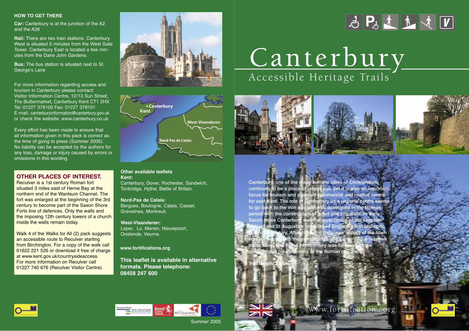
Canterbury, one of the major historic cities of Christendom, continues to be a place of pilgrimage, yet it is also an important focus for tourism and a vibrant commercial and market centre for east Kent. The role of Canterbury as a regional centre seems to go back to the iron age and was developed in the Roman period with the construction of a fort and city walls. In early Saxon times Canterbury was the royal centre of the kingdom of Kent and St Augustine established England’s first bishopric in the 6th century. After 1066, the defensive aspect of the town was enhanced with the construction of a castle with a massive stone keep, and in the 14th century was followed by the considerable refurbishment of the Roman city walls.
Trail length: 2.9 km
Other available leafletsKent: Canterbury, Dover, Rochester, Sandwich, Tonbridge, Hythe, Battle of Britain.
Nord-Pas de Calais: Bergues, Boulogne, Calais, Cassel, Gravelines, Montreuil.
West-Vlaanderen: Leper, Lo, Menen, Nieuwpoort, Oostende, Veurne.
Access ible Heri tage Trai ls
HOW TO GET THERECar: Canterbury is at the junction of the A2 and the A28
Rail: There are two train stations. Canterbury West is situated 5 minutes from the West Gate Tower. Canterbury East is located a few min-utes from the Dane John Gardens.
Bus: The bus station is situated next to St George’s Lane
For more information regarding access and tourism in Canterbury please contact:Visitor Information Centre, 12/13 Sun Street, The Buttermarket, Canterbury Kent CT1 2HXTel: 01227 378100 Fax: 01227 378101E-mail: [email protected] or check the website: www.canterbury.co.uk
Every effort has been made to ensure that all information given in this pack is correct as the time of going to press (Summer 2005). No liability can be accepted by the authors for any loss, damage or injury caused by errors or omissions in this wording.
Canterbury
OTHER PLACES OF INTEREST.Reculver is a 1st century Roman fort situated 3 miles east of Herne Bay at the northern end of the Wantsum Channel. The fort was enlarged at the beginning of the 3rd century to become part of the Saxon Shore Forts line of defences. Only the walls and the imposing 12th century towers of a church inside the walls remain today.
Walk 4 of the Walks for All (2) pack suggests an accessible route to Reculver starting from Birchington. For a copy of the walk call 01622 221 526 or download it free of charge at www.kent.gov.uk/countrysideaccess. For more information on Reculver call 01227 740 676 (Reculver Visitor Centre).
Canterbury
www.fortifications.org
This leaflet is available in alternative formats. Please telephone: 08458 247 600
5%
8
10
START
11
5%
5%
5%
4%
13%
4%
3%
7%
Kerb3-4cm
Cathedral
Watling StCastl
e St
St Marg
arets
St
Upper Brid
ge St
Low
er B
ridge
St
Rhodaus Town
A28
A28
A28
A290
The Parade
Burgate
High St
St Peters St
Stour S
t
Canterb
ury
Lane
Hawk’s Lane
Mer
cery
Lane
Sun St
Orange St
The Friars
Westgate Gardens
N
60cm
9
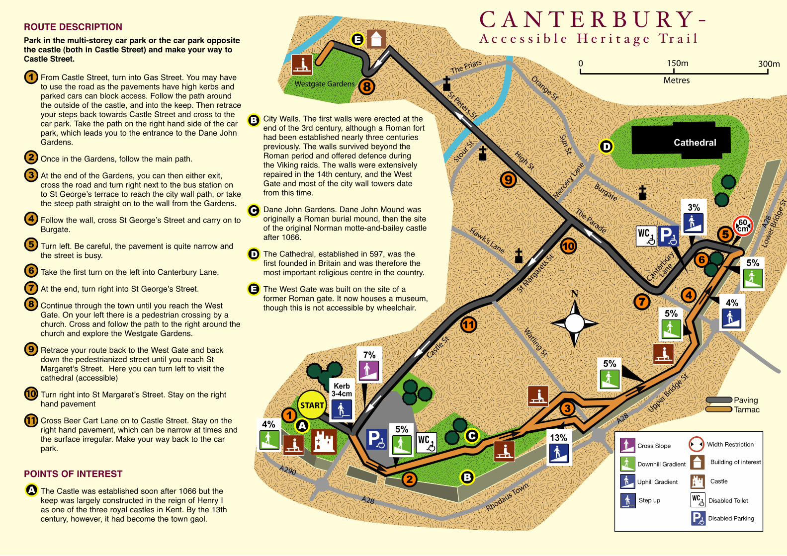
ROUTE DESCRIPTIONPark in the multi-storey car park or the car park opposite the castle (both in Castle Street) and make your way to Castle Street.
From Castle Street, turn into Gas Street. You may have to use the road as the pavements have high kerbs and parked cars can block access. Follow the path around the outside of the castle, and into the keep. Then retrace your steps back towards Castle Street and cross to the car park. Take the path on the right hand side of the car park, which leads you to the entrance to the Dane John Gardens.
Once in the Gardens, follow the main path.
At the end of the Gardens, you can then either exit, cross the road and turn right next to the bus station on to St George’s terrace to reach the city wall path, or take the steep path straight on to the wall from the Gardens.
Follow the wall, cross St George’s Street and carry on to Burgate.
Turn left. Be careful, the pavement is quite narrow and the street is busy.
Take the first turn on the left into Canterbury Lane.
At the end, turn right into St George’s Street.
Continue through the town until you reach the West Gate. On your left there is a pedestrian crossing by a church. Cross and follow the path to the right around the church and explore the Westgate Gardens.
Retrace your route back to the West Gate and back down the pedestrianized street until you reach St Margaret’s Street. Here you can turn left to visit the cathedral (accessible)
Turn right into St Margaret’s Street. Stay on the right hand pavement
Cross Beer Cart Lane on to Castle Street. Stay on the right hand pavement, which can be narrow at times and the surface irregular. Make your way back to the car park.
POINTS OF INTEREST
The Castle was established soon after 1066 but the keep was largely constructed in the reign of Henry I as one of the three royal castles in Kent. By the 13th century, however, it had become the town gaol.
City Walls. The first walls were erected at the end of the 3rd century, although a Roman fort had been established nearly three centuries previously. The walls survived beyond the Roman period and offered defence during the Viking raids. The walls were extensively repaired in the 14th century, and the West Gate and most of the city wall towers date from this time.
Dane John Gardens. Dane John Mound was originally a Roman burial mound, then the site of the original Norman motte-and-bailey castle after 1066.
The Cathedral, established in 597, was the first founded in Britain and was therefore the most important religious centre in the country.
The West Gate was built on the site of a former Roman gate. It now houses a museum, though this is not accessible by wheelchair.
Downhill Gradient
Cross Slope
Uphill Gradient
Width Restriction
Disabled Toilet
Disabled Parking
Castle
Building of interest
Step up
Step down
Tarmac Paving
0 250m 500m
Metres
Other Roads Trees Building of interest
Grass Area Industrial Area
Water
Urban Area
Downhill Gradient
Cross Slope
Uphill Gradient
Width Restriction
Disabled Toilet
Disabled Parking
Castle
Building of interest
Step up
Step down
Tarmac Paving
0 250m 500m
Metres
Other Roads Trees Building of interest
Grass Area Industrial Area
Water
Urban Area
Downhill Gradient
Cross Slope
Uphill Gradient
Width Restriction
Disabled Toilet
Disabled Parking
Castle
Building of interest
Step up
Step down
Tarmac Paving
0 250m 500m
Metres
Other Roads Trees Building of interest
Grass Area Industrial Area
Water
Urban Area
C A N T E R B U R Y -A c c e s s i b l e H e r i t a g e Tr a i l
Downhill Gradient
Cross Slope
Uphill Gradient
Width Restriction
Disabled Toilet
Disabled Parking
Castle
Building of interest
Step up
Step down
Tarmac Paving
0 250m 500m
Metres
Other Roads Trees Building of interest
Grass Area Industrial Area
Water
Urban Area


