

Challenges and Techniques in
Drone ForensicsDr Hannan Azhar
Canterbury Christ Church University
School of Engineering, Technology and Design
NexTech 2019,
22 Sept, Porto, Portugal

Dr Hannan Azhar@ NexTech2019, Porto, Portugal

Worldwide drone incident
https://www.dedrone.com/resources/incidents/allDr Hannan Azhar@ NexTech2019, Porto, Portugal

Drone Related Crimes
Britain is facing an explosion in drone crimes, with reported incidents
now numbering more than six a day – a rise of 45 per cent in three
years. From 1,518 in 2016 to 2,204 in 2018 –Daily Mail 17 May 2019
63 reports involving playgrounds and nurseries in eight police force areas
alone between 2016 and 2018
Drones appearing to follow children in parks, playgrounds, swimming pools and even children’s homes.
Flights from Gatwick Airport were suspended after multiple drones were deliberately flown over the airfield. Sussex Police has spent more than £400,000 investigating the case, but no one was found.
Endless crimes from assassinations, terrorist attacks, simple theft or deliberate
economic disruptionDr Hannan Azhar@ NexTech2019, Porto, Portugal

Prison delivery
https://www.youtube.com/watch?v=3zXq7ywyCnY
Dr Hannan Azhar@ NexTech2019, Porto, Portugal

Reported crimes
Harassment,
Stalking,
Burglary,
Drugs, supply to prisons
Smuggling
Voyeurism
Airport Drone Chaos
Warfare
spy military installations and sensitive institutions
Mexican cartels are turning to drones to smuggle
lightweight drugs like heroin and cocaine over the U.S.
border rather than using tunnels. (Associated press)
https://www.washingtontimes.com/news/2017/aug/20/
mexican-drug-cartels-using-drones-to-smuggle-heroi/
Dr Hannan Azhar@ NexTech2019, Porto, Portugal

Capture the drone
https://www.youtube.com/watch?v=rah_i7FFGRw
Dr Hannan Azhar@ NexTech2019, Porto, Portugal

Identify Drones
According to FAA (Federal Aviation Administration )
There are over 1.3 million registered drones owners in USA ;
116,000 registered drone operators;
Hundreds of thousands are not registered;
7 million will fly over USA by 2020 ;
Small drones to display registration numbers on the exterior to address
concerns raised by U.S. security officials and to make it easier to identify
owners.
https://www.nextgov.com/emerging-tech/2018/01/1-million-drones-operators-register-
fly-us/145440/
https://www.reuters.com/article/us-usa-drones/u-s-agency-requires-drones-to-list-id-
number-on-exterior-idUSKCN1Q12O9
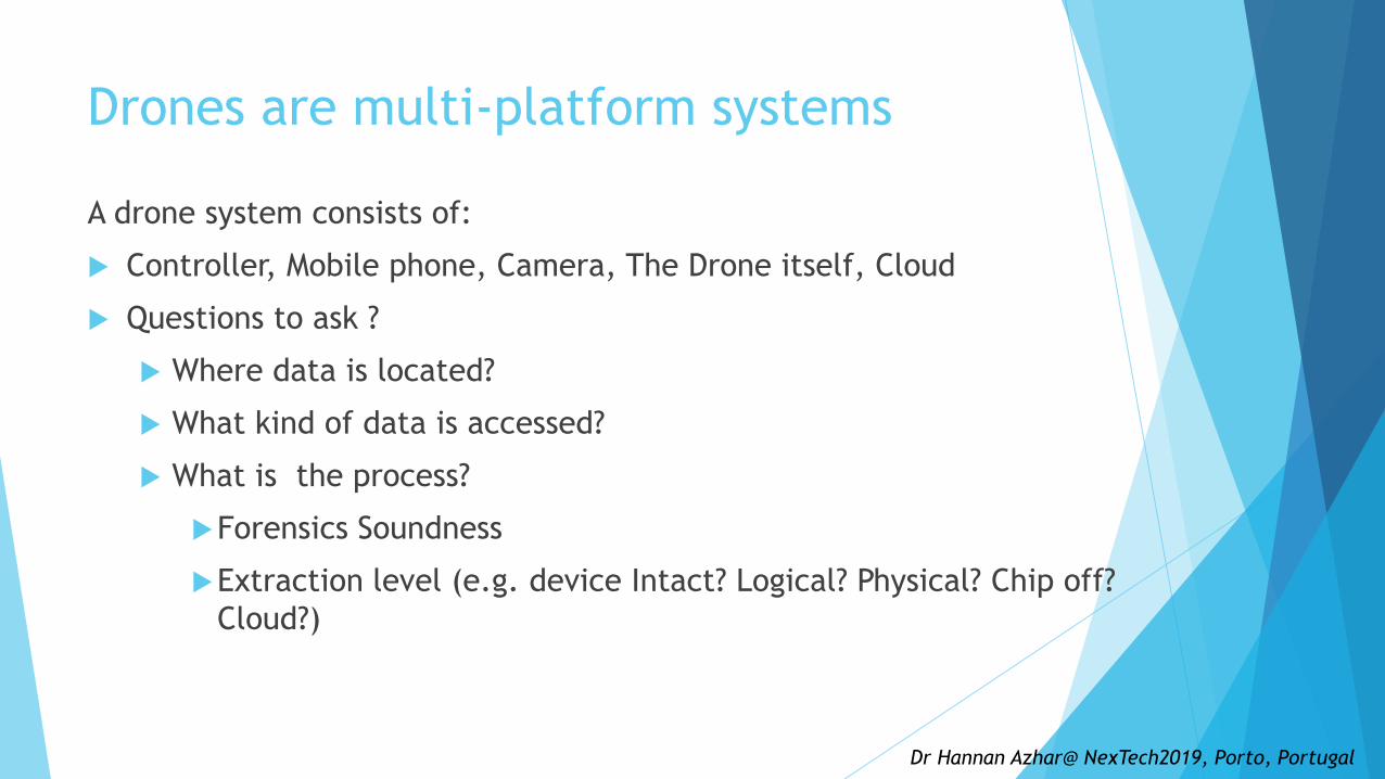
Drones are multi-platform systems
A drone system consists of:
Controller, Mobile phone, Camera, The Drone itself, Cloud
Questions to ask ?
Where data is located?
What kind of data is accessed?
What is the process?
Forensics Soundness
Extraction level (e.g. device Intact? Logical? Physical? Chip off?
Cloud?)
Dr Hannan Azhar@ NexTech2019, Porto, Portugal

Admissibility to Court
ACPO (Association of Chief Police Officers) principles :
Principle 1: The data held on an exhibit must not be changed.
Principle 2: Any person accessing the exhibit must be competent to do so and explain the relevance and the implications of their actions.
Principle 3: A record of all processes applied to an exhibit should be kept. This record must be repeatable to an independent third party.
Principle 4: The person in charge of the investigation has responsibility for ensuring that the law and these principles are adhered to.
Justification for our actions
Repeatability
A full understanding of the implications of any actions taken
Source: ACPO Good Practice Guide ACPO Good Practice Guide for Digital Evidence
for Digital Evidence March 2012 https://www.digital-detective.net/digital-
forensics-documents/ACPO_Good_Practice_Guide_for_Digital_Evidence_v5.pdf
Dr Hannan Azhar@ NexTech2019, Porto, Portugal
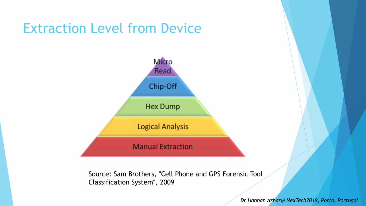
Extraction Level from Device
Source: Sam Brothers, "Cell Phone and GPS Forensic Tool
Classification System", 2009
Dr Hannan Azhar@ NexTech2019, Porto, Portugal

Drone Cloud forensics challenges
Multi-tenancy challenges
Shared Memory access
Violation of confidentiality and privacy agreement
LEA can only exercise power within their authorised jurisdictions
The Acquisition and Disclosure of Communications Data - Regulation of
Investigatory Powers Act 2000 governs UK LEAs’ powers to acquire data.
Although DFEs can technically acquire data from a cloud server in a foreign
country using a suspect’s device via a connection with that server,
They may breach laws in that jurisdiction because UK courts cannot authorise
such action in foreign countries.
Source:
http://www.legislation.gov.uk/ukpga/2000/23/contents
Dr Hannan Azhar@ NexTech2019, Porto, Portugal
Drone Artefacts
Information on its owner
Flight paths, launch location and landing destination
Photos and videos that enables investigators to pinpoint suspect.
Serial number that can be used to trace the owner
Version numbers for firmware
Information on change of state: launch/land, manual/waypoint operation
and GPS available/unavailable
Geo-location information for launch, land and home point locations
Dr Hannan Azhar@ NexTech2019, Porto, Portugal

Drone Forensics Framework Step 1: Identify the chain of command
Step 2: Allow conventional forensics to examine the U.A.S
Step 3: Identify the role of the U.A.S in the crime.
Step 4: Photograph the U.A.S
Step 5: identify make and model through visual inspection looking for serial numbers and other
markings
Step 6: Open source research into device. Look for available tools and information relating to the
drone.
Step 7: Identify the drone capabilities, audio/visual recording, carrying capacity, etc
Step 8: Identify modifications
Step 9: Identify data storage locations
Step 10: Search for ways to extract data from the drone
Step 11: Extract removable storage mediums
Step 12: create a forensic copy
Step 13: Perform traditional interrogation of extracted data
Step 14: Use non-traditional methods e.g. open source tools
Step 15: Live forensics
Step 16: interrogation of peripherals
Step 17: Destructive forensic techniques (if required)
Step 18: Review extracted data.
Step 19: find case relevant data
Step 20: create report.
https://arxiv.org/ftp/arxiv/papers/1804/1804.08649.pdf
Unmanned Aerial Vehicle Forensic Investigation
Process: Dji Phantom 3 Drone As A Case Study
Roder et al. 2018
Preparation
Examination
Report

Forensic Approach- Case studies
We used a model for forensic research based on
experience in previous projects
Preliminary Research
• Establish use of technology in crime
• Establish capabilities of technology
• Estimate methodology
Scenario Creation
• Simulate crime scenario
• Utilise technology to it’s full potential
• Gather data
Data Acquisition
• Finalise methodology
• Acquire data in a forensically sound method (ACPO)
Data Analysis
• Highlight important artefacts
• Filter out non-useful data
Report and Present
• Preserve method
• Ensure repeatability
Association of Chief Police Officers (ACPO)
Dr Hannan Azhar@ NexTech2019, Porto, Portugal

Drone Forensics- Case studies
We will focussed on two different drones; the DJI Phantom 3
Professional and the Parrot A.R 2.0 Power edition
Phantom highly capable device with an array of sensors and on-board
processing power, used for photography, surveying and recreation
NameSpecifications
Weight Camera Resolution Range
DJI Phantom 3
Professional1280g 4K (12 Megapixels)
5Km
A.R Drone 2.0 380g / 420g 720p (0.9 Megapixels)50m

Phantom 3 Pro Artefacts
16 gb microsd card
–removable
a micro SD card,
glued on to the
centre board
Dr Hannan Azhar@ NexTech2019, Porto, Portugal

A.R. Drone 2 Artefacts
32GB SD card,
external
Dr Hannan Azhar@ NexTech2019, Porto, Portugal
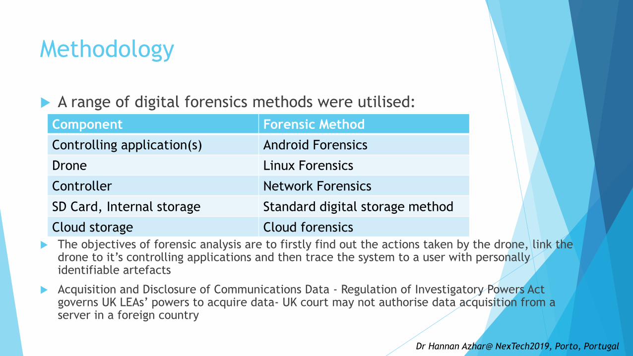
Methodology
A range of digital forensics methods were utilised:
The objectives of forensic analysis are to firstly find out the actions taken by the drone, link the drone to it’s controlling applications and then trace the system to a user with personally identifiable artefacts
Acquisition and Disclosure of Communications Data - Regulation of Investigatory Powers Act governs UK LEAs’ powers to acquire data- UK court may not authorise data acquisition from a server in a foreign country
Component Forensic Method
Controlling application(s) Android Forensics
Drone Linux Forensics
Controller Network Forensics
SD Card, Internal storage Standard digital storage method
Cloud storage Cloud forensics
Dr Hannan Azhar@ NexTech2019, Porto, Portugal

Scenario Creation (Urban environment)
Before analysis, data needed to be gathered by flying the
Phantom in a suitable site;
Large open space
Tall building structures
Several distinct waypoints within the site
Dr Hannan Azhar@ NexTech2019, Porto, Portugal

Scenario creation cont.
13:17
Dr Hannan Azhar@ NexTech2019, Porto, Portugal
https://www.bbc.com/news/world-middle-east-46822429

Phantom 3 Data Acquisition
Connected
directly to
forensic
workstation,
forensic image
created using DD
tool.
SD card,
FAT32
Phantom put in
data mode
through DJI GO
app
Connected to forensic
workstation using USB
cable, forensic image
created using DD tool
(very slow!)
GPS data
Dr Hannan Azhar@ NexTech2019, Porto, Portugal
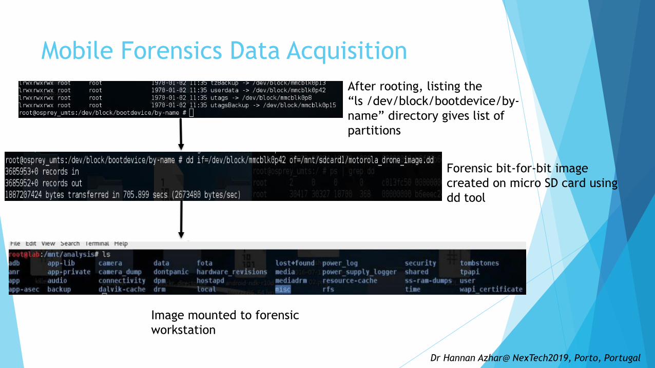
Mobile Forensics Data Acquisition
After rooting, listing the
“ls /dev/block/bootdevice/by-
name” directory gives list of
partitions
Forensic bit-for-bit image
created on micro SD card using
dd tool
Image mounted to forensic
workstation
Dr Hannan Azhar@ NexTech2019, Porto, Portugal

Results – SD Card (External)-Phantom“tree” – Open source Linux utility
Preliminary assessment to test contents of SD card
Tree command used to list all active files and give general
idea of directory structure
Results show external SD card used to store mostly media
files in .JPG, .DNG and .MP4 format
Dr Hannan Azhar@ NexTech2019, Porto, Portugal

Results – SD Card (External) -Phantom“exiftool” – Open source Linux utility
Artefacts can be extracted from the EXIF (Exchangeable Image File)
data of the photo and video files
To automate this process, the Linux tool “exiftool” was run against
the whole media directory and “egrep” used to filter the results
In this case only the GPS co-ordinates and the create date were
selected but there are many more that could be included
Dr Hannan Azhar@ NexTech2019, Porto, Portugal

Results – Internal SD Card-(Phantom)
The internal storage of the Phantom contains a number of
flight logs – one per session of activity (power on to power
off) so one log may contain multiple flights
The logs are stored in a format with a “.DAT” extension
They were analysed using the “CsvView” tool running on a
windows machine
Dr Hannan Azhar@ NexTech2019, Porto, Portugal
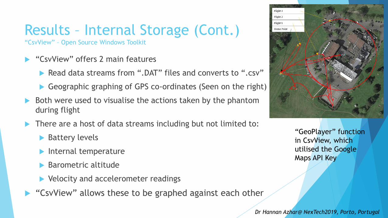
Results – Internal Storage (Cont.)“CsvView” – Open Source Windows Toolkit
“CsvView” offers 2 main features
Read data streams from “.DAT” files and converts to “.csv”
Geographic graphing of GPS co-ordinates (Seen on the right)
Both were used to visualise the actions taken by the phantom
during flight
There are a host of data streams including but not limited to:
Battery levels
Internal temperature
Barometric altitude
Velocity and accelerometer readings
“CsvView” allows these to be graphed against each other
Dr Hannan Azhar@ NexTech2019, Porto, Portugal
“GeoPlayer” function
in CsvView, which
utilised the Google
Maps API Key

Results – Internal Storage (Cont.)
Flight time (green), Barometric Altitude (teal) and Total Voltage
(purple) give a good idea of flight activity
Flight time increases in a linear fashion whenever the drone is in
flight, barometric altitude indicates how high the drone was flown
X axis is an arbitrary measurement of how many samples were
recorded in the log
Dr Hannan Azhar@ NexTech2019, Porto, Portugal
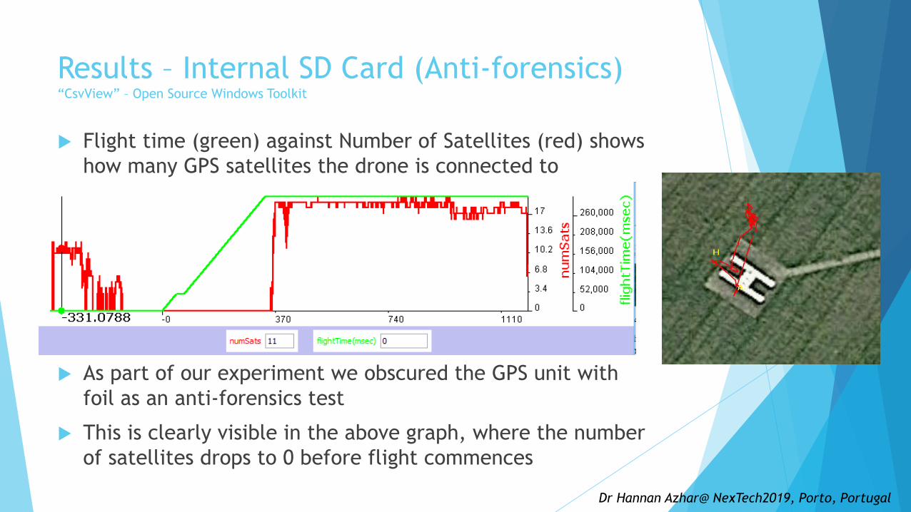
Results – Internal SD Card (Anti-forensics)“CsvView” – Open Source Windows Toolkit
Flight time (green) against Number of Satellites (red) shows
how many GPS satellites the drone is connected to
As part of our experiment we obscured the GPS unit with
foil as an anti-forensics test
This is clearly visible in the above graph, where the number
of satellites drops to 0 before flight commences
Dr Hannan Azhar@ NexTech2019, Porto, Portugal

Results – Mobile Forensics-Phantom
A wealth of artefacts were recovered from the data directory of the “DJI
GO” android application
These corroborated artefacts recovered from the UAV:
No fly zone log indicates when drone has attempted to breach an NFZ such as
stadium or military base
Error logs
Media files with GPS co-ordinates
Flight records, similar to the “.DAT” logs discussed earlier
Dr Hannan Azhar@ NexTech2019, Porto, Portugal

DJI Go
Artefacts
Dr Hannan Azhar@ NexTech2019, Porto, Portugal

Results – Mobile Forensics (Cont.)“CsvView” – Open Source Windows Toolkit
The flight logs from the “DJI GO” application can also be
visualised using “CsvView”, but with a few notable differences
Logs exist per-flight, rather than per session
Lower resolution data capture
Some application specific streams now available
Less sensor streams from the drone
These logs give a detailed view of the actions the operator is
taking while using the drone
Dr Hannan Azhar@ NexTech2019, Porto, Portugal

Results – Mobile Forensics (Cont.)“CsvView” – Open Source Windows Toolkit
Metadata is available in “.TXT” logs which shows the serial number of
the drone, allowing the pool of suspect devices to be reduced
Serial number can be extracted from the hull of the aircraft
This is a useful link from phone to drone
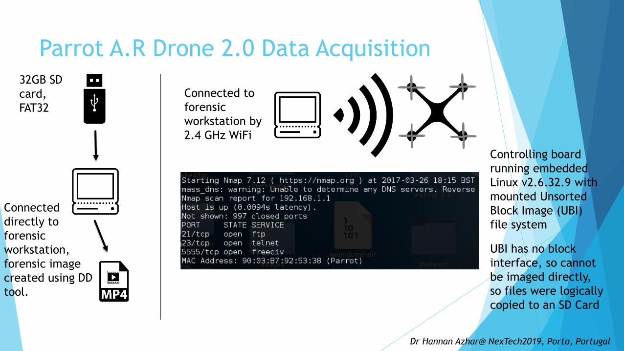
Parrot A.R Drone 2.0 Data Acquisition
Connected to
forensic
workstation by
2.4 GHz WiFi
Controlling board
running embedded
Linux v2.6.32.9 with
mounted Unsorted
Block Image (UBI)
file system
UBI has no block
interface, so cannot
be imaged directly,
so files were logically
copied to an SD Card
Connected
directly to
forensic
workstation,
forensic image
created using DD
tool.
32GB SD
card,
FAT32
Dr Hannan Azhar@ NexTech2019, Porto, Portugal

Upon connection the telnet welcome message identified as running "busybox" version 1.14.0
Running the "uname - r" command showed the UAV was running Linux version 2.6.32. , which was released in 2009 (Kernel, 2009)
The amount of data present in the system log located at "/data/syslog.bin"
"cat syslog.bin I grep UsbKey"
"UsbKeyMonitor" prints the serial number when a new USB device is attached, so filtering using the word "Serial" produced a history of all the USB keys attached to the UAV
Examination of the "syslog. bin" file give a comprehensive overview of actions carried out by the UAV’s OS
Dr Hannan Azhar@ NexTech2019, Porto, Portugal

Results – A.R Drone 2.0 Power EditionInternal Storage
Dr Hannan Azhar@ NexTech2019, Porto, Portugal

Results – A.R Drone 2.0 Power EditionMobile Forensics (A.R Freeflight application)
“.xml” files that correlate with sessions of activity on the UAV, containing serial number in the format of "< MAC Address of mobile platform> < Timestamp> .“ ;
The "FLIGHT_DRONE_SERIAL" tag displays a matching serial number ;which links phone to UAV
Preferences file with GPS Co-ordinates of last flight (generated by phone)
Another XML file, located in "userdata/com.parrot.freeflight/shared _prefs/ Preferences.xml" finds GPS coordinates of the last flight, the email address of the google account used to download the application, and when the application was last opened.
“Userdata/media/0/DCIM" (Digital Camera IMage) directory, which contains all the media captured by the UAV's cameras, GPS reading originated from mobile as this drone does not possess GPS
Dr Hannan Azhar@ NexTech2019, Porto, Portugal

Results – A.R Drone 2.0 Power EditionExternal Storage (32GB SD Card)
The videos extracted from the external storage (USB stick) of the A.R Drone 2.0 were analysed and found to contain some interesting EXIF data
The telemetry data was dumped to a file for analysis with the command "exiftool - b - ARDroneTelemetrymedia20170401 _ 150213 / video _ 20170401 _ 150249.mp4> - / drones/ parrot/gnuplot/telemetry
Script was created to convert the data to a comma-separated value file , which could then be visualised using the "gnuplot" tool for Linux
Altitude measurements for the
duration of the extracted video file

https://www.cfreds.nist.gov/drone-images.html
Dr Hannan Azhar@ NexTech2019, Porto, Portugal

SD Card using FTK
Dr Hannan Azhar@ NexTech2019, Porto, Portugal

Oxygen forensics
Oxygen forensics was only able to recover images and video from the apple phone backup of DJI Mavic
Others: Cellebrite ‘s UFED Physical analyser ; XRY Drone from MSAB
Dr Hannan Azhar@ NexTech2019, Porto, Portugal

Airport restrictions
As of March 13 2019, it’s
illegal to fly a drone
within 5km of an airport,
Rectangular extensions
from the end of runways
measuring 5km long by
1km wide to better
protect take-off and
landing paths
Dr Hannan Azhar@ NexTech2019, Porto, Portugal
1 nautical mile =1.852 Km

UK FRZ map
https://dronesafe.uk/restrictions/
Dr Hannan Azhar@ NexTech2019, Porto, Portugal
FRZ= Flight Restricted Zone
Changes to Drone Legislation
Since July 2018, new law bans drones flying anywhere in the UK above 400ft (122m), Or face a
fine of up to £2500 or up to five years in prison.
From November 30 2019,
Drone operators will have to register their device with the Civil Aviation Authority (CAA) and
Once registered the operator will receive a unique code that must be applied to all the drones they are
responsible for
Take an online safety test (more details on this in the section below). This is also a legal requirement
from the end of November for anyone flying a drone, whether or not they are a drone owner. There will
be no charge for this
Anyone who fails to register or sit the competency tests could face fines of up to £1000
https://www.caa.co.uk/Consumers/Unmanned-aircraft/Our-role/Updates-about-drones/
http://publicapps.caa.co.uk/docs/33/CAP1763%20New%20UAS%20guidance%20Feb%202019.pdf
Dr Hannan Azhar@ NexTech2019, Porto, Portugal

Thank you for listening
Any questions?
Dr Hannan Azhar
School of Engineering, Technology and Design
Canterbury Christ Church University
Canterbury , UK
Read more:
Azhar, M,A.H.B; Barton, T.; and Islam, T. (2018) "Drone Forensic Analysis Using Open Source Tools," Journal of Digital Forensics, Security and Law: Vol. 13 : No. 1 , Article 6. Available at: https://commons.erau.edu/jdfsl/vol13/iss1/6
Barton, T. and Azhar, M.A.H.B, (2017) "Open Source Forensics for a Multi-platform Drone System", 9th EAI International Conference on Digital Forensics & Cyber Crime, Prague, Springer-Verlag; https://link.springer.com/chapter/10.1007/978-3-319-73697-6_6
Dr Hannan Azhar@ NexTech2019, Porto, Portugal


