

……………………………………….
R I V E R S I D E G E N E R A L P L A N 2 0 2 5 • A M E N D E D N O V E M B E R 2 0 1 2
C C M - 1
O
ver the past seventy years, the physical, social and economic success Riverside has experienced can be attributed in part to the City's transportation network and the tremendous
mobility it has afforded. The freeways, streets, bike paths, railways and airports that provide circulation within the City and access to points beyond have transformed Riverside from a relatively isolated agricultural community to a major city that serves as the hub of the Inland Empire. Riverside's growth has resulted in many beneficial effects, principally the development of industries and businesses that provide jobs and economic stability, creation of housing units affordable to a broad range of household incomes, the growth of educational institutions and the vibrancy that results from a diverse, multi-ethnic community. However, the same transportation network has also created adverse side effects: traffic congestion due to regional travel patterns, increased pollutant emissions, dispersed land use patterns and the stress of commuting. This Circulation and Community Mobility Element recognizes the ability of our transportation network to serve our needs and shape our community in positive ways, and to allow us to effectively use alternatives to the private automobile to reach our destinations within Riverside and the region.
THE GROWTH CHALLENGE "If you build it, they will come." This oft-quoted line from a movie about a baseball diamond in an Iowa cornfield may seem out of place in this Circulation and Community Mobility Element, but the idea has meaning in a transportation planning context. Indeed, by increasing the capacity of a roadway, more travelers can be expected to use that roadway. However, a corollary phrase applicable to Riverside and the Inland Empire is, "If you don't build it, they will come anyway." The Southern California Association of Governments (SCAG) forecasts that Riverside County's population will increase by sixty-two percent between 2000 and 2025. During the same period, the City's population is expected to grow by twenty-five percent, reaching well over three hundred fifty thousand people. Regional growth will significantly impact the circulation network in and through Riverside.
CIRCULATION AND COMMUNITY
MOBILITY ELEMENT
More than 400 Riverside residents attended the September 2003 and June 2004 Citizens’ Congress for the General Plan and took the opportunity to provide hundreds of comments on traffic and mobility issues in Riverside. Managing traffic and improving all forms of mobility represent key objectives for the community.
……………………………………….
R I V E R S I D E G E N E R A L P L A N 2 0 2 5 • A M E N D E D N O V E M B E R 2 0 1 2
C C M - 2
CIRCULATION AND COMMUNITY
MOBILITY ELEMENT
In the past, solutions to traffic congestion have focused on building wider streets and improving freeway capacity. At best, this has proved to be a temporary solution. Many transportation plans of the 1960s look almost comically naive today, promising that expanded roadway facilities will ensure a future of traffic-free, effortless commuting. Today, transportation planners recognize and understand the phenomenon of "induced demand." The induced demand principle holds that expanded and freer-flowing roadways will only encourage greater roadway use. Major roadway expansions tend to open new areas
for development, encouraging further sprawl beyond urban centers and putting even more demand on roads. Humorists have noted that trying to solve traffic congestion in a growing region by adding or widening roadways is akin to trying to lose weight by buying larger clothes. Like many cities throughout California, Riverside has reached a point where few or no feasible opportunities exist to add or expand roadways due to fiscal, political, environmental and other constraints. Long-planned roadway improvements which do need to be implemented include the extension of Overlook Parkway and the widening of Alessandro Boulevard to six lanes. However, even if Riverside could somehow stabilize its population at the year 2004 of about two hundred seventy-five thousand residents, growth in the surrounding region would march ahead and would continue to load more cars and trucks onto the City's street system. Traffic, like water, seeks the path of least resistance, and any traffic impeded on the SR-91, SR-60, and I-215 freeways will continue to flow onto the City's local streets. A mobility strategy that focuses on service improvements such as roadway widening, intersection expansions and new roads will inevitably result in more regional cut-through traffic without a proportional benefit to local residents. Circulation and mobility strategies must be comprehensive to overcome the City's long-term transportation challenges. This General Plan — and its two keystone elements, Circulation and Community Mobility and Land Use and Urban Design — provide such comprehensive strategies. The City has completed a traffic analysis completed a traffic analysis for the General Plan and the Circulation Element that is included in the General Plan 2025 Program Final Environmental Impact Report. The traffic analysis contains a discussion of traffic forecasting and
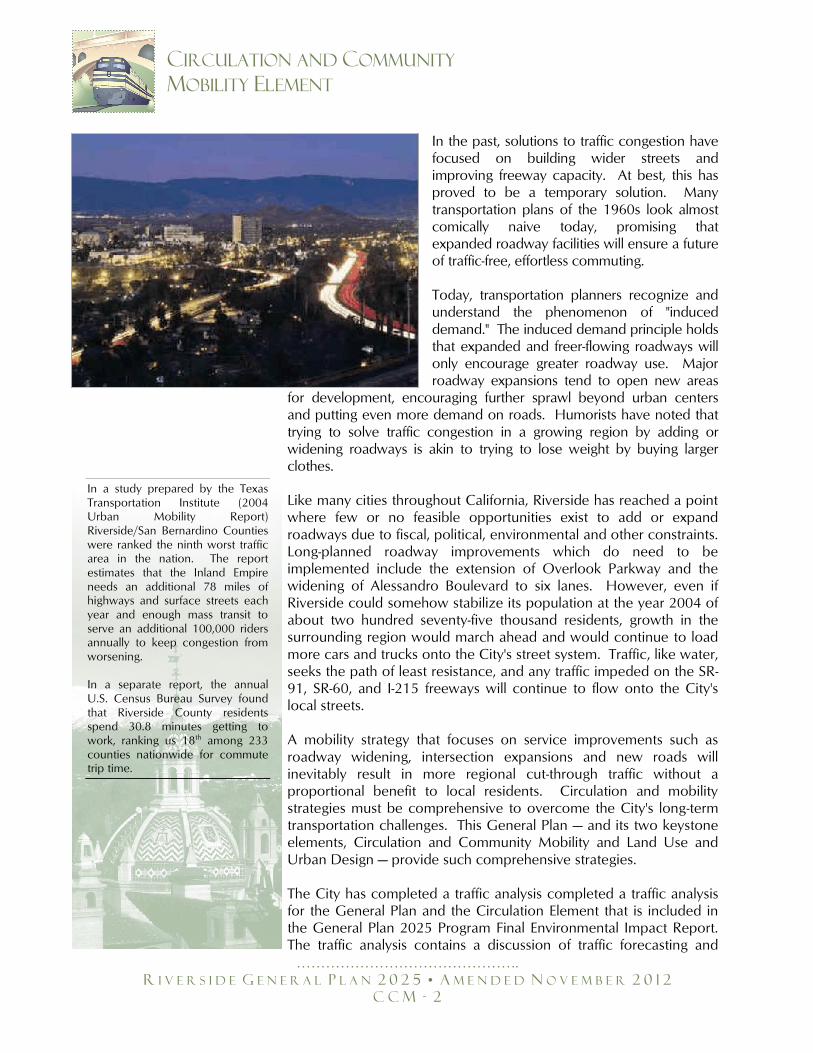
In a study prepared by the Texas Transportation Institute (2004 Urban Mobility Report) Riverside/San Bernardino Counties were ranked the ninth worst traffic area in the nation. The report estimates that the Inland Empire needs an additional 78 miles of highways and surface streets each year and enough mass transit to serve an additional 100,000 riders annually to keep congestion from worsening. In a separate report, the annual U.S. Census Bureau Survey found that Riverside County residents spend 30.8 minutes getting to work, ranking us 18th among 233 counties nationwide for commute trip time.
……………………………………….
R I V E R S I D E G E N E R A L P L A N 2 0 2 5 • A M E N D E D N O V E M B E R 2 0 1 2
C C M - 3
CIRCULATION AND COMMUNITY
MOBILITY ELEMENT
models to determine the amount of anticipated traffic and predicted levels of service at intersections when the General Plan is at build-out. For more detailed information, please see Section 5.15 - Transportation/Traffic and Appendix H - Circulation Element Traffic Study of the General Plan 2025 Program Final Environmental Impact Report that is incorporated herein by reference and hereby made a part of this document.
RESPONDING TO THE CHALLENGE: A
COMPREHENSIVE APPROACH TO MOBILITY The major principles underlying this General Plan are focusing future development near existing transportation corridors, ensuring land uses are supported by an efficient local roadway network, embracing innovative solutions to congestion on freeways and regional arterials, supporting alternative modes of transportation such as walking, biking and transit and ensuring that transportation options are maximized for all community members as necessary components of an effective and safe circulation system for Riverside. Traffic congestion is sometimes seen as a phenomenon that must be eliminated, no matter what the cost. However, from another perspective, congestion can also be an acknowledgment that the City is a desirable place to live, work, learn and play. This Plan seeks to find a balance between the City's mobility needs while preserving and enhancing the qualities that make Riverside so desirable. No plan can promise a future free of traffic congestion, particularly when regional population growth over which the City has no control will increase the number of vehicles on the local road network. However, this Circulation and Community Mobility Element reflects a major paradigm shift: Riverside will indeed make modest expansions to the local circulation system but more importantly, will make far more efficient use of the existing circulation system. In this manner, the City will aim to minimize the effect of increased traffic over time.
HOW WE PLAN TO GET AROUND The Land Use and Urban Design Element directs a larger proportion of the anticipated population growth to infill sites along already established transportation corridors, particularly Magnolia Avenue and University Avenue. Much of this infill development will take the form of mixed-use projects that combine residential uses with retail or office uses. Such development will be planned carefully and offer opportunities for residents to access shops and services without the
……………………………………….
R I V E R S I D E G E N E R A L P L A N 2 0 2 5 • A M E N D E D N O V E M B E R 2 0 1 2
C C M - 4
CIRCULATION AND COMMUNITY
MOBILITY ELEMENT
constant need to use their cars. Such planning is the essence of "smart growth." Interconnectivity of land uses, coupled with the provision of adequate pedestrian and bicycle facilities, is an important component of Riverside's future circulation network. The City's expanded pedestrian and bike path network will provide connections between schools, activity centers, parks and residential areas. With population growth focused along the City's major corridors, bus rapid transit (BRT) service will connect the major employment and education centers to areas projected for mixed-use and higher-density residential development. The maxim holds: Mass transit requires a certain degree of "mass" to be functional. Sprawling development can rarely be well-served by public transit of any form. On a larger scale, the Metrolink San Jacinto Line will be operational, extending commuter train service along the busy I-215 corridor. The train will offer service to the City's major destinations, including UCR and Downtown, and will also provide an alternative to crowded westbound freeways for Riversiders and those living south along the I-215 corridor. With smart growth, adequate and viable pedestrian and bicycle trails and support of local and regional transit expansion, Riversiders in 2025 will have viable mobility alternatives to the private automobile. When we think of transportation, we tend to focus primarily on personal travel. However, the scope of this Element also encompasses air travel, as well as the movement of goods and freight. As we move toward 2025, the key anticipated change relative to air travel will stem from the development of the Inland Cargo Port alongside March Air Reserve Base. Although the MARB facility is located just outside the City of Riverside, the implementation of air cargo operations here will lead to increased use of railways and freeways traversing the City. By the same token, air cargo operations are forecasted to have positive economic development impacts, particularly in the City's business parks. Riverside Municipal Airport will see relatively stable levels of air traffic, but increased business development in the immediate vicinity. The movement of freight through Riverside will continue to be primarily via trucks using the City's arterials and freeways, but a substantial portion will use railways. Riverside will continue to aggressively seek funding opportunities to reduce the number of at-grade crossings throughout the City to mitigate existing conflicts and anticipate rail traffic associated with the Alameda Corridor East
See the Land Use and Urban Design Element under ―The Built Environment – Growing Smarter‖ for the strategies Riverside is pursuing to achieve ―smart growth‖ goals and to coordinate land use and circulation planning. In particular, review Objectives LU-8, LU-9 and LU-10.
……………………………………….
R I V E R S I D E G E N E R A L P L A N 2 0 2 5 • A M E N D E D N O V E M B E R 2 0 1 2
C C M - 5
CIRCULATION AND COMMUNITY
MOBILITY ELEMENT
project. At-grade crossings typically require all street traffic in the vicinity to come to a halt; when grades are separated, trains can move without interrupting traffic flow on the City's streets.
THE REGIONAL CONTEXT Transportation planning cannot be considered separately from the regional context. This General Plan is designed to maximize Riverside's power to affect positive change within its boundaries, as well as to positively influence what goes on beyond the City's boundaries. Several transportation plans prepared by the Southern California Association of Governments (SCAG), the County of Riverside and the Riverside County Transportation Commission (RCTC) focus on the regional transportation system. Other plans have also been prepared to locate future routes for mass transit, including rail and express bus service. The best way to maximize transportation choice in Riverside's future is to integrate local transportation planning with regional efforts.
REGIONAL TRANSPORTATION PLANS AND AGENCIES
The Regional Transportation Plan (RTP) was prepared by SCAG to address regional issues and establish goals, objectives and policies for the Southern California region into the early part of the twenty-first century. The current plan, entitled; Destination 2030 focuses on improving the balance between land use and the current as well as the future transportation systems. It is a multi-modal Plan representing SCAG’s vision for a better transportation system, integrated with the best possible growth pattern for the Region over the Plan horizon of 2030. The Plan provided the basic policy and program framework for long term investment in our vast regional transportation system in a coordinated, cooperative and continuous manner. Transportation investments in the SCAG Region that receive State or Federal transportation funds must be consistent with the RTP and must be included in the Regional Transportation Improvement Program (RTP) when ready for funding. The RTP has been developed with active participation from local agencies throughout the region, elected officials, the business community, community groups, private institutions and private citizens. Riverside County Integrated Project and CETAP In 2003, the County of Riverside completed a comprehensive planning program, called the Riverside County Integrated Project, or RCIP, that included a coordinated regional transportation planning effort: the Community and Environmental Transportation
……………………………………….
R I V E R S I D E G E N E R A L P L A N 2 0 2 5 • A M E N D E D N O V E M B E R 2 0 1 2
C C M - 6
CIRCULATION AND COMMUNITY
MOBILITY ELEMENT
Acceptability Process (CETAP). CETAP led to the identification of potential transportation corridor routes in western Riverside County that will benefit commuters and serve the County’s growing economy. The Mid County Parkway (formerly known as the Ramona Expressway/Cajalco Road Corridor) that traverses the southern portion of the City’s planning area (discussed below) is a CETAP alternative that is projected to relieve congestion on SR-91 heading through Riverside and offer an alternative to the 60/215/91 interchange for regional commuters. County of Riverside Congestion Management Plan Urbanized areas such as Riverside County are required by State law to adopt a Congestion Management Plan (CMP). The goals of the CMP are to reduce traffic congestion and to provide a mechanism for coordinating land use development and transportation improvement decisions. Local agencies are required to establish minimum level of service (LOS) thresholds in their general plans and conduct traffic impact assessments on individual development projects. Deficiency plans must be prepared when a development project would cause LOS "F" on non-exempt CMP roadway segments. The deficiency plans outline specific mitigation measures and a schedule for mitigating the deficiency. Western Riverside County Transportation Uniform Mitigation Fee (TUMF) In 2002, the jurisdictions of Western Riverside County, including the cities of Riverside, Corona, and Moreno Valley and Riverside County, agreed to participate in the Western Riverside County Transportation Uniform Mitigation Fee, or TUMF, program. TUMF is a multi-jurisdictional impact fee program that funds transportation improvements associated with new growth. All new development in each of the participating jurisdictions is subject to TUMF, based on the proposed intensity and type of development. Riverside's participation in this program constitutes an important step toward making needed improvements to the regional transportation system. Riverside County Transportation Commission (RCTC) The Riverside County Transportation Commission (RCTC) was founded in 1976 when the California Legislature created four special transportation commissions in Southern California. The purpose of the legislation was to provide more local control and input over transportation matters. In its early years, RCTC fulfilled the following responsibilities as specified in its enabling legislation: coordination of state highway planning; adoption of Short Range Transit Plans; coordination of transit service; allocation of Transportation
See the ―Performance Criteria‖ section of this Element for a discussion of Level of Service.
……………………………………….
R I V E R S I D E G E N E R A L P L A N 2 0 2 5 • A M E N D E D N O V E M B E R 2 0 1 2
C C M - 7
CIRCULATION AND COMMUNITY
MOBILITY ELEMENT
Development Act funds; identification of projects for state and federal grant funds; and the coordination of county highway and transit plans with regional and state agencies. Every city in the county holds a vote on the RCTC along with the five members of the Riverside County Board of Supervisors. The Governor also appoints a non-voting member to the board who is the Director of Caltrans from the local District office. State legislation and necessity has given RCTC a number of additional and important responsibilities over the years since its inception. More recently, the State Legislature gave new authority to the RCTC by changing the way funding was distributed from the State Transportation Improvement Program. Next, RCTC has given administration authority of the Measure A program and has the responsibility of placing future transportation ballot measures before the public. In addition to the Commission’s Measure A responsibilities, RCTC has also been designated as the Congestion Management Agency (CMA) for Riverside County. As the CMA, RCTC has developed a Congestion Management Program that more effectively utilizes transportation funds by linking land use, transportation and air quality efforts. Finally, to provide motorist services to the public, RCTC also serves as the Service Authority for Freeway Emergencies (SAFE) and operates the Freeway Service Patrol (FSP) for Riverside County. Riverside Transit Agency (RTA) The Riverside Transit Agency (RTA) was established as a Joint Powers Agency on August 15, 1975 and began operating bus service on March 16, 1977. RTA is the Consolidated Transportation Service Agency for western Riverside County and is responsible for coordinating transit services throughout the approximate 2,500 square mile service area, providing driver training, assistance with grant applications and development of Short Range Transit Plans (STRPs). The member jurisdictions include the cities of Banning, Beaumont, Calimesa, Canyon Lake, Corona, Hemet, Lake Elsinore, Moreno Valley, Murrieta, Norco, Perris, Riverside, San Jacinto, Temecula and the unincorporated areas of Riverside County Supervisorial Districts I, II, III and V. RTA provides both local and regional services throughout the region with 38 fixed-routes, five CommuterLink routes, and Dial-A-Ride services using 231 vehicles. In the cities of Corona, Beaumont and Banning, RTA coordinates regional services with municipal transit systems. In Riverside, RTA coordinates with the city’s Riverside Special Services, which provides ADA complementary service to RTA’s fixed-route services.
……………………………………….
R I V E R S I D E G E N E R A L P L A N 2 0 2 5 • A M E N D E D N O V E M B E R 2 0 1 2
C C M - 8
CIRCULATION AND COMMUNITY
MOBILITY ELEMENT
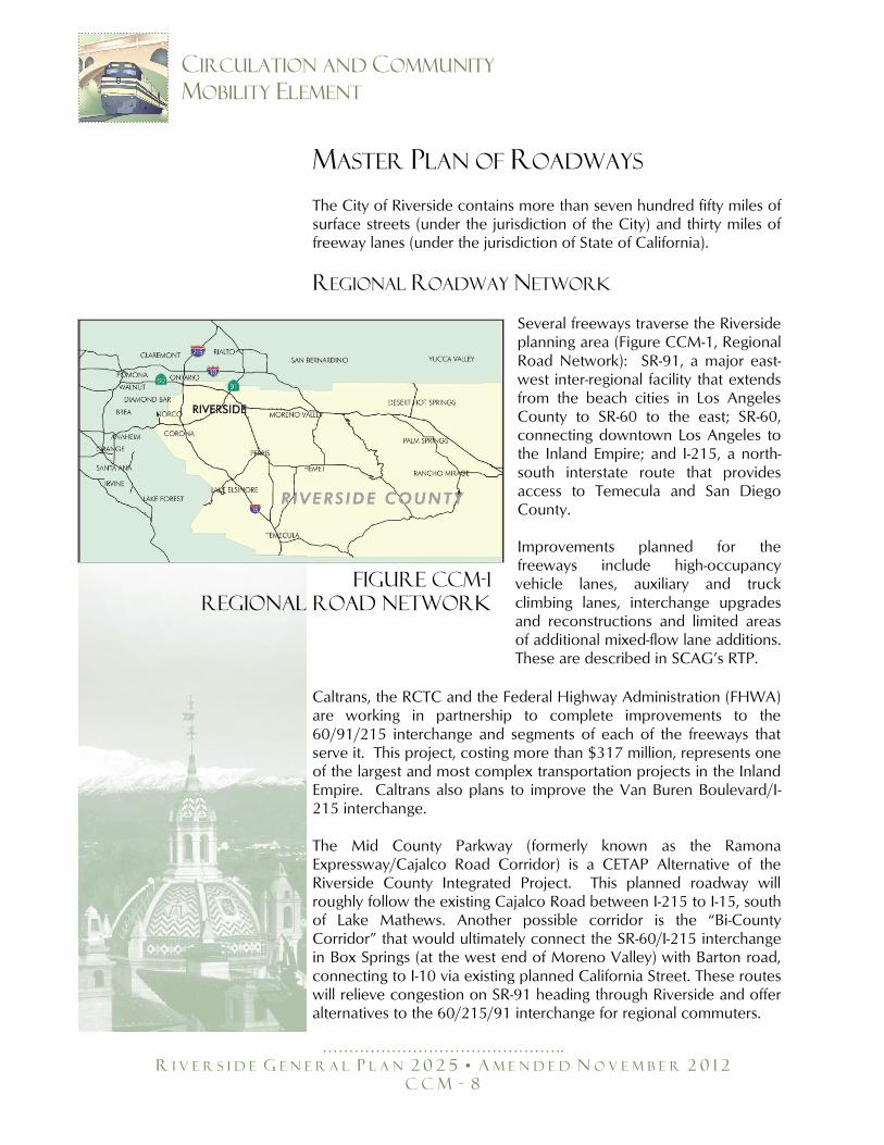
MASTER PLAN OF ROADWAYS The City of Riverside contains more than seven hundred fifty miles of surface streets (under the jurisdiction of the City) and thirty miles of freeway lanes (under the jurisdiction of State of California).
REGIONAL ROADWAY NETWORK
Several freeways traverse the Riverside planning area (Figure CCM-1, Regional Road Network): SR-91, a major east-west inter-regional facility that extends from the beach cities in Los Angeles County to SR-60 to the east; SR-60, connecting downtown Los Angeles to the Inland Empire; and I-215, a north-south interstate route that provides access to Temecula and San Diego County. Improvements planned for the freeways include high-occupancy vehicle lanes, auxiliary and truck climbing lanes, interchange upgrades and reconstructions and limited areas of additional mixed-flow lane additions. These are described in SCAG’s RTP.
Caltrans, the RCTC and the Federal Highway Administration (FHWA) are working in partnership to complete improvements to the 60/91/215 interchange and segments of each of the freeways that serve it. This project, costing more than $317 million, represents one of the largest and most complex transportation projects in the Inland Empire. Caltrans also plans to improve the Van Buren Boulevard/I-215 interchange. The Mid County Parkway (formerly known as the Ramona Expressway/Cajalco Road Corridor) is a CETAP Alternative of the Riverside County Integrated Project. This planned roadway will roughly follow the existing Cajalco Road between I-215 to I-15, south of Lake Mathews. Another possible corridor is the ―Bi-County Corridor‖ that would ultimately connect the SR-60/I-215 interchange in Box Springs (at the west end of Moreno Valley) with Barton road, connecting to I-10 via existing planned California Street. These routes will relieve congestion on SR-91 heading through Riverside and offer alternatives to the 60/215/91 interchange for regional commuters.
Figure CCM-1
Regional Road Network
……………………………………….
R I V E R S I D E G E N E R A L P L A N 2 0 2 5 • A M E N D E D N O V E M B E R 2 0 1 2
C C M - 9
CIRCULATION AND COMMUNITY
MOBILITY ELEMENT
The Mid County Parkway has the potential to be extended farther east, across I-15 and through the Cleveland National Forest, providing an additional connection to Orange County besides the overburdened SR-91 freeway. The project, if pursued, would connect at the SR-241 toll road in unincorporated Orange County north of the city of Irvine. The City will continue to support the development of this connection and other efforts by Caltrans, RCTC and FHWA to improve regional circulation.
REGIONAL ROADWAY OBJECTIVES AND POLICIES
Objective CCM-1: Facilitate freeway and regional roadway improvements and construction to alleviate congestion and air pollution and to minimize regional cut-through traffic within Riverside.
Policy CCM-1.1: Support development of CETAP corridors, including
the Mid County Parkway (formerly known as the Ramona Expressway/Cajalco Road Corridor) and the Bi-County Corridor from Riverside to San Bernardino County.
Policy CCM-1.2: Support the addition of capacity improvements to
SR-91, SR-60, I-215 and I-15. Policy CCM-1.3: Support the development of a new regional
roadway facility linking Riverside County with Orange County.
Policy CCM-1.4: Support improvement of the Van Buren
Boulevard/I-215 interchange and along the length of Van Buren Boulevard between I-215 and SR-91.
LOCAL ROADWAY NETWORKS
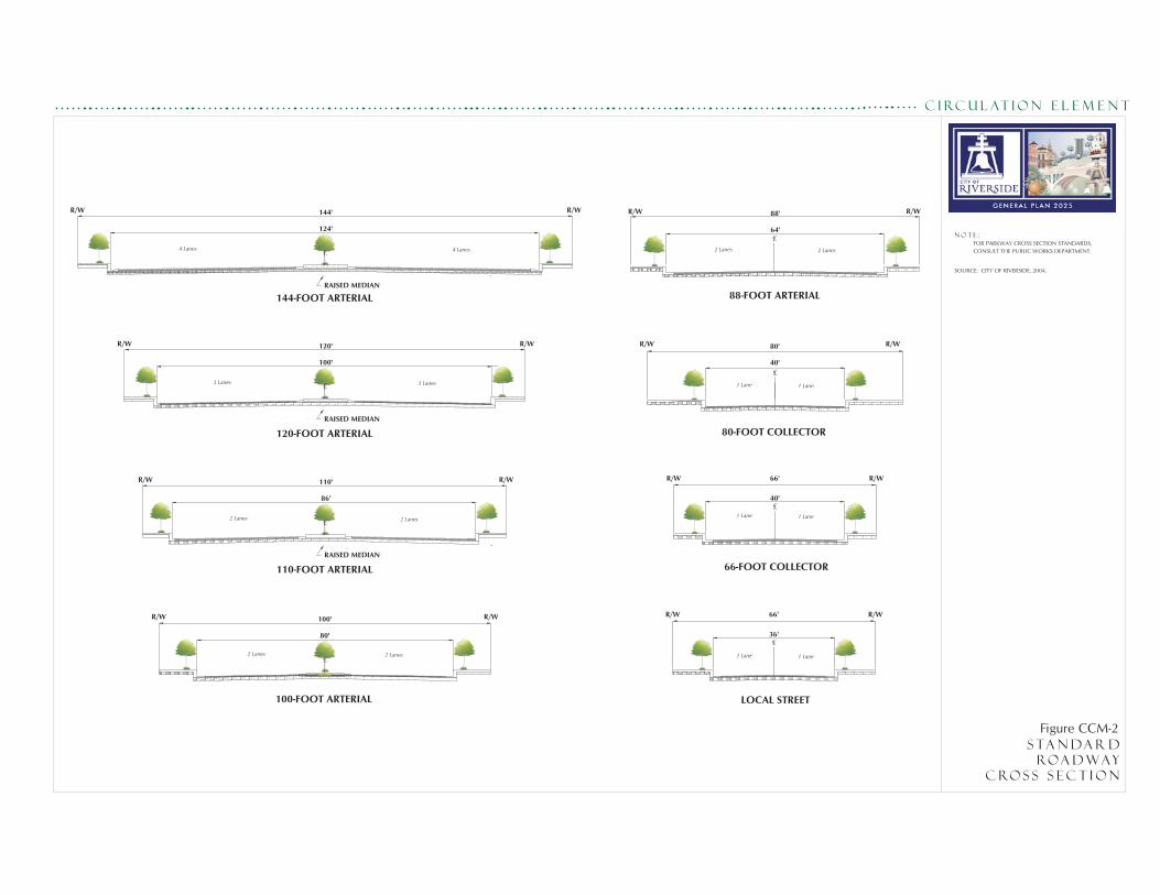
Riverside has defined the roadway system using a series of functional classifications. The functional and cross sections classifications are depicted in Figure CCM-2 (Standard Roadway Cross Section). The City's existing circulation system consists of the following functional classifications. Local Streets Local Streets principally provide vehicular, pedestrian and bicycle access to property directly abutting the public right-of-way, with movement of through traffic discouraged. Local streets are
See the Air Quality Element under ―Transportation‖ for more information on regional transportation efforts. In particular, review Objective AQ-2.
See the Land Use and Urban Design Element under ―The built Environment – Parkways – Van Buren Boulevard‖ for more information on Van Buren Boulevard. In particular, review Objective LU-15.
……………………………………….
R I V E R S I D E G E N E R A L P L A N 2 0 2 5 • A M E N D E D N O V E M B E R 2 0 1 2
C C M - 10
CIRCULATION AND COMMUNITY
MOBILITY ELEMENT
designated to be thirty-six feet wide curb to curb within a sixty-six-foot right-of-way and have two through lanes (one in each direction). Collector Streets Collector Streets are intended to serve as intermediate routes to handle traffic between Local Streets and streets of higher classification. Collector Streets also provide access to abutting property and are two lanes in width. Collector Streets may handle some localized through traffic from one local street to another; however, their primary purpose is not to provide for through traffic but to connect the local street system to the arterial network. The City has two Collector Street widths, the first designated to be forty feet wide curb to curb within a sixty-six--foot right-of-way, and the second also measuring forty feet wide curb to curb but within an eighty-foot right-of-way. Arterial Streets Arterial Streets carry through traffic and connect to the state highway system with restricted access to abutting properties. They are designed to have the highest traffic carrying capacity in the roadway system with the highest speeds and limited interference with traffic flow by driveways. Riverside has five Arterial classifications: Eighty-eight feet of right-of-way with sixty-four feet of paving and
four lanes
One hundred feet of right-of-way with eighty feet of paving, a raised median and four lanes
One hundred ten feet of right-of-way with eighty-six feet of
paving, a raised median and four lanes
One hundred twenty feet of right-of-way with one hundred feet of paving, a raised median and six lanes
One hundred forty-four feet of right-of-way with one hundred
twenty-four feet of paving, a raised median and eight lanes. Some of the roads are designated as scenic boulevards and/or parkways; these require special landscaping and additional right-of-way may be required. There are also several special boulevards which have a two lane divided roadway of variable geometric design.
……………………………………….
R I V E R S I D E G E N E R A L P L A N 2 0 2 5 • A M E N D E D N O V E M B E R 2 0 1 2
C C M - 11
CIRCULATION AND COMMUNITY
MOBILITY ELEMENT
To ensure safety on arterials, all new developments abutting an arterial should avoid front-on development. The development should be designed with reverse frontage and/or side frontage lots pursuant to Title 18.
PERFORMANCE CRITERIA
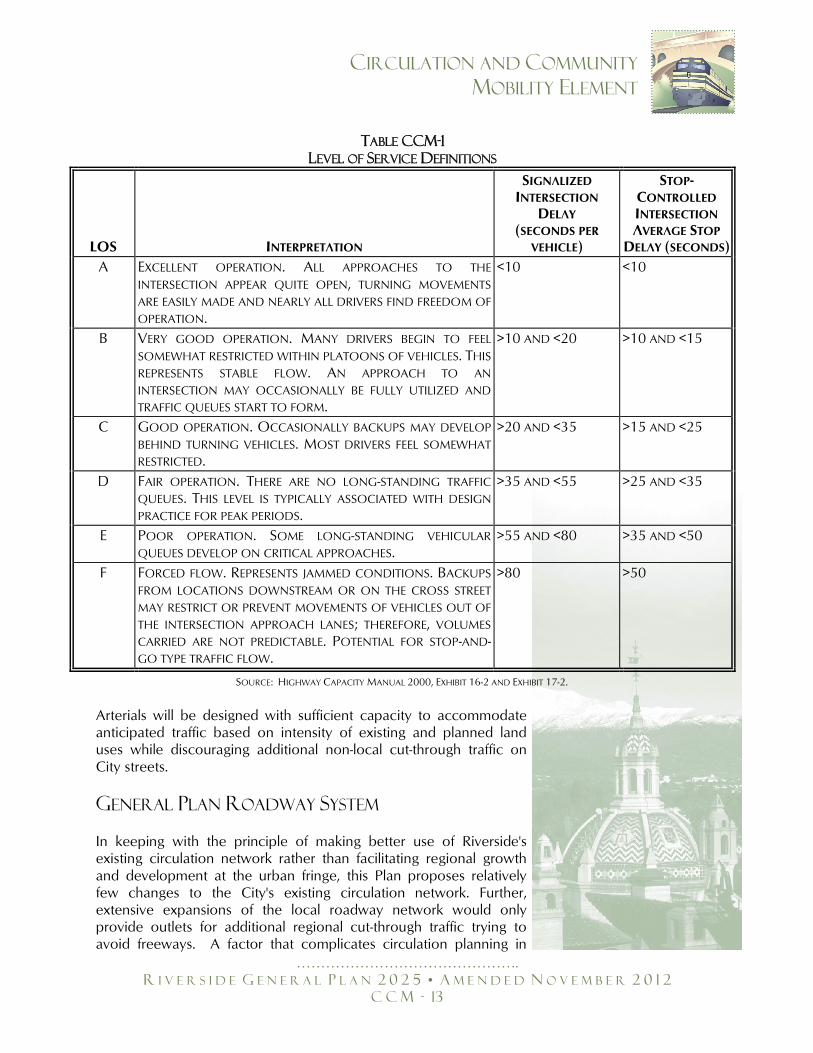
Level of Service (LOS) is a qualitative measure describing the efficiency of traffic flow. LOS describes the way such conditions are perceived by persons traveling in a traffic stream, with LOS measurements accounting for such variables such as speed and travel time, freedom to maneuver, traffic interruptions, traveler comfort and convenience and safety. Measurements are graduated ranging from LOS A, representing free flow and excellent comfort for the motorist, passenger or pedestrian, to LOS F, reflecting highly congested traffic conditions where traffic volumes approach or exceed the capacities of streets. LOS definitions are provided in Table CCM-1 (Level of Service Definitions). LOS can be determined for all types of transportation facilities. The City will strive to maintain LOS D or better on arterial streets wherever possible. At some key locations, such as City arterial roadways which are used as a freeway bypass by regional through traffic and at heavily traveled freeway interchanges, LOS E may be acceptable as determined on a case-by-case basis. Locations that may warrant the LOS E standard include portions of Arlington Avenue/Alessandro Boulevard, Van Buren Boulevard throughout the City, portions of La Sierra Avenue and selected freeway interchanges. A higher standard, such as LOS C or better, may be adopted for Local and Collector streets in residential areas. The City recognizes that along key freeway-feeder segments during peak commute hours, LOS F may be expected due to regional travel patterns.
……………………………………….
R I V E R S I D E G E N E R A L P L A N 2 0 2 5 • A M E N D E D N O V E M B E R 2 0 1 2
C C M - 13
CIRCULATION AND COMMUNITY
MOBILITY ELEMENT
TABLE CCM-1
LEVEL OF SERVICE DEFINITIONS
LOS INTERPRETATION
SIGNALIZED
INTERSECTION
DELAY (SECONDS PER
VEHICLE)
STOP-CONTROLLED
INTERSECTION
AVERAGE STOP
DELAY (SECONDS)
A EXCELLENT OPERATION. ALL APPROACHES TO THE
INTERSECTION APPEAR QUITE OPEN, TURNING MOVEMENTS
ARE EASILY MADE AND NEARLY ALL DRIVERS FIND FREEDOM OF
OPERATION.
<10 <10
B VERY GOOD OPERATION. MANY DRIVERS BEGIN TO FEEL
SOMEWHAT RESTRICTED WITHIN PLATOONS OF VEHICLES. THIS
REPRESENTS STABLE FLOW. AN APPROACH TO AN
INTERSECTION MAY OCCASIONALLY BE FULLY UTILIZED AND
TRAFFIC QUEUES START TO FORM.
>10 AND <20 >10 AND <15
C GOOD OPERATION. OCCASIONALLY BACKUPS MAY DEVELOP
BEHIND TURNING VEHICLES. MOST DRIVERS FEEL SOMEWHAT
RESTRICTED.
>20 AND <35 >15 AND <25
D FAIR OPERATION. THERE ARE NO LONG-STANDING TRAFFIC
QUEUES. THIS LEVEL IS TYPICALLY ASSOCIATED WITH DESIGN
PRACTICE FOR PEAK PERIODS.
>35 AND <55 >25 AND <35
E POOR OPERATION. SOME LONG-STANDING VEHICULAR
QUEUES DEVELOP ON CRITICAL APPROACHES. >55 AND <80 >35 AND <50
F FORCED FLOW. REPRESENTS JAMMED CONDITIONS. BACKUPS
FROM LOCATIONS DOWNSTREAM OR ON THE CROSS STREET
MAY RESTRICT OR PREVENT MOVEMENTS OF VEHICLES OUT OF
THE INTERSECTION APPROACH LANES; THEREFORE, VOLUMES
CARRIED ARE NOT PREDICTABLE. POTENTIAL FOR STOP-AND-GO TYPE TRAFFIC FLOW.
>80 >50
Arterials will be designed with sufficient capacity to accommodate anticipated traffic based on intensity of existing and planned land uses while discouraging additional non-local cut-through traffic on City streets.
GENERAL PLAN ROADWAY SYSTEM
In keeping with the principle of making better use of Riverside's existing circulation network rather than facilitating regional growth and development at the urban fringe, this Plan proposes relatively few changes to the City's existing circulation network. Further, extensive expansions of the local roadway network would only provide outlets for additional regional cut-through traffic trying to avoid freeways. A factor that complicates circulation planning in
SOURCE: HIGHWAY CAPACITY MANUAL 2000, EXHIBIT 16-2 AND EXHIBIT 17-2.
……………………………………….
R I V E R S I D E G E N E R A L P L A N 2 0 2 5 • A M E N D E D N O V E M B E R 2 0 1 2
C C M - 14
CIRCULATION AND COMMUNITY
MOBILITY ELEMENT
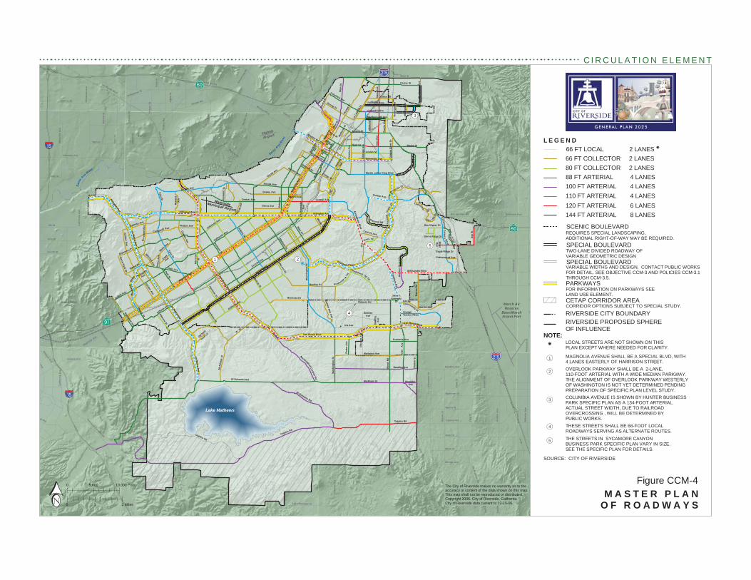
Riverside is that the local roadway network, with several notable exceptions, tends to operate at reasonable levels of service. The regional roadway network, by contrast, tends to operate much more poorly. If the City were to increase capacity through extensive road widenings or new connections, any increased capacity would be quickly absorbed by regional traffic that moves daily through Riverside. Thus, this Plan must seek to meet local mobility needs without opening the floodgates to regional traffic. As of 2004, the circulation network set forth in the 1994 General Plan had not yet been completed. Key features of the 1994 General Plan not constructed as of 2004 include the linkage of Overlook Parkway (connecting the Alessandro Heights and Canyon Crest neighborhoods) and the addition of lanes to Alessandro Boulevard and Van Buren Boulevard. This Circulation and Community Mobility Element includes a Master Plan of Roadways with the following major features: Completion of the 1994 Circulation Element, with the exception
of Magnolia Avenue/Market Street, which will remain on the Master Plan of Roadways as six lanes but will only be built to four lanes easterly of Harrison Street. The additional right-of-way will be preserved to accommodate future transit, such as Bus Rapid Transit (BRT).
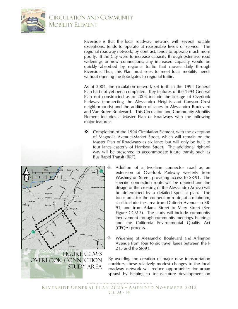
Addition of a two-lane connector road as an extension of Overlook Parkway westerly from Washington Street, providing access to SR-91. The specific connection route will be defined and the design of the crossing of the Alessandro Arroyo will be determined by a detailed specific plan. The focus area for the connection route, at a minimum, shall include the area from Dufferin Avenue to SR-91, and from Adams Street to Mary Street (See Figure CCM-3). The study will include community involvement through community meetings, hearings and the California Environmental Quality Act (CEQA) process.
Widening of Alessandro Boulevard and Arlington Avenue from four to six travel lanes between the I-215 and the SR-91.
By avoiding the creation of major new transportation corridors, these relatively modest changes to the local roadway network will reduce opportunities for urban sprawl by helping to focus future development on
Figure CCM-3
Overlook Connection
Study Area
……………………………………….
R I V E R S I D E G E N E R A L P L A N 2 0 2 5 • A M E N D E D N O V E M B E R 2 0 1 2
C C M - 15
CIRCULATION AND COMMUNITY
MOBILITY ELEMENT
already existing travel corridors instead of the City's periphery. Further, these few changes are not anticipated to induce significant additional regional traffic in the City. They are, however, critically important to serving local traffic demand. In particular, a 2004 preliminary study indicated the proposed two-lane road (120-feet of right-of-way built with only two travel lanes) that would connect the western end of Overlook Parkway to SR-91 would be primarily local serving, provided the width of any new Overlook Parkway bridge over the arroyo is limited to two travel lanes total. Notably, this Plan sets forth a policy that prohibits any such connector related to the extension of Overlook Parkway from degrading Level of Service on Victoria Avenue below LOS D.
Objective CCM-2: Build and maintain a transportation system that combines a mix of transportation modes and transportation system management techniques, and that is designed to meet the needs of Riverside’s residents and businesses, while minimizing the transportation system’s impacts on air quality, the environment and adjacent development.
Policy CCM-2.1: Complete the Master Plan of Roadways shown on
Figure CCM-4 (Master Plan of Roadways). Policy CCM-2.2: Balance the need for free traffic flow with economic
realities and environmental and aesthetic considerations, such that streets are designed to handle normal traffic flows with tolerances to allow for potential short-term delays at peak-flow hours.
Policy CCM-2.3: Maintain LOS D or better on Arterial Streets
wherever possible. At key locations, such as City Arterials that are used by regional freeway bypass traffic and at heavily traveled freeway interchanges, allow LOS E at peak hours as the acceptable standard on a case-by-case basis.
Policy CCM-2.4: Minimize the occurrence of streets operating at
LOS F by building out the planned street network and by integrating land use and transportation in accordance with the General Plan principles.
See the Air Quality Element under ―Transportation‖ for more information on this topic. In particular, review Objective AQ-2.
!(
!(
!(
!(
!(
A St
Main St
Van Buren Blvd
Jurupa Rd
Pedl
ey R
d
Cla
rk S
t
Bai
n St
Granite Hill Dr
Pige
on P
ass
Rd
Bro
wn
St
6th St
C
Lake Mathews Dr
58th St
Mack St
Ir
Sampson Ave
Reche Canyon Rd
Gra
ham
St
E
Old Elsinore Rd
Etiw
anda
Ave
Gav
ilan
Rd
Rubid
oux
Blvd
Hea
cock
St
nAve
Martin St
56th St
Win
evill
e A
ve
Camin
o R
eal
Park
ridge
Ave
Steven Dr
Promenade Ave
E
agle
Can
yon
Roa
d
Eastridge Ave
Limonite Ave
Hidden ValleyPkwy
68th St
A
Ironwood Ave
Bellegrave St
hill Pky Seat
on A
ve
Post Rd
Aga
te S
t
Van Buren B
lvd
Luke
ns L
n
Clay St
Rimpau Ave
Limonite Ave
34th St
Indiana Ave
Mar
latt
St
Elsw
orth
St
Fourth St
Fels
par S
t
Cresta Rd
Arm
stro
ng R
d
Galena St
J
Box Springs Rd
Peralta Pl
Paci
fic A
ve
Temescal Canyon Rd
Bea
ch S
t
20th St
Market S
t
G
Avo
n S
t
Web
ster
Ave
Orange Ave
Fred
eric
k S
t
Nei
l St
Rut
ile S
t
Dec
ker
Rd
Nuevo Rd
Rider St
Mission Blvd
Ale
xand
er S
t
Cal
iforn
ia A
ve
Nu
C
Fifth St
Cajalco Rd
Day
St
Markham St
Nandina Ave
Magnolia Ave
McKinley St
Norc
o Hi
lls R
d
Cal
iforn
ia A
ve
Sunnymead Ranch Pk y
Woo
d R
d
Victoria Ave
Tyler St
Adams St
Magnolia Ave
El Sobrante Rd
Day
St
Monroe St
Cajalco Rd
Jurupa Ave
Wat
kins
Dr
Center St
La Sierra Ave
Krameria Ave
Nandina Ave Bar
ton
St
Central Ave
Sierra Ave
La Sierra Ave
La Sierra Ave
Over look Pkwy
El Sobrante Rd
Mary St
GentianAve
Roberts Rd
Proposed "B" Dr
Cajalco Rd
Ran som Rd
C
anyo
n C
rest
D
r
Mt.
Vern
on A
ve
Riv
erw
alk
Pkw
y
Sa
nta
Ana River
San ta A
na Riv
er
Lake Mathews
El Cerrito Dr
Port
er A
ve
Mariposa Ave
Iris Ave Dau
chy
Ave
Chi
cago
Ave
Bar
ton
Rd
Mitchell Ave
Nor
woo
d A
v e
Campbell Ave
Jone
s A
ve
Cook
Ave
Sierra Vista St
Har
rison
St
Golden A
ve
Collett Ave
Frem
ont
St
Pierce St
Schuyler
Ave
View Ln
Golden Star Ave
Gramercy Pl
Spruce St
Jefferson St
Third St
Lincoln Ave
Cypress Ave
Pierce St
Markham St
Bradley St
Hole Ave
Fourteenth St
Columbia Ave
Grand Ave
Polk St
Broc
kton
Ave
Challen Ave
Dewey Ave
Linden St
University Ave
Hillsi
de A
ve
Harrison St
Dufferin
Ave
"A" S
t
Orchard
Cottonwood Ave
S ycamore C
anyon Blvd
Vict
oria
AveRamona Dr
Kan
sas
Ave
Can
yon
Cre
st D
r
Iow
a A
ve
Atla
nta
St
McA
llist
er S
t
M
issi
on G
rove
Pkw
y
John F.Kennedy
Dr
Sierra Ridge Dr
River
Run
Dr
Dan Kipper Dr
Via
Vista Dr
Community Dr
Grove
Dr
Rus
tin A
ve
Marlborough Ave Mic
higa
n St
Mul
berry
St
Philbin Ave
Palm
Ave
Oran
ge S
t
Van Buren Blvd
Chi
cago
Ave
Riv
ersi
deA
ve
OrangeTerrace Pkwy
Rive
ra S
t
Jackson St
Rut
land
Ave
Strong St
Golden Ave
Fillmore St
Blaine St
Maude St
Arlington Ave
Wells A
ve
Cridge St
Century Ave
Central Ave Lochmoo r
First St
Mar
ket S
t
TenthSt
Lim
e St
Mission Inn Ave
Oliv
ewoo
d Av
e
Oleander Ave
Merrill Ave
Eagle Ridge Dr
Nor
thga
te S
t
Proposed "A" D
r
Isle
Fair
BoxS
pr ings
Mai
n St
Was
hing
ton
St
La C
aden
a Dr
Colorado Ave
Trautwein R
d
Buchanan St
Madison St
Alessandro Blvd
FifthSt
California Ave
Jurupa Ave
Col
e A
ve
McAllister St
Central Ave
Alessandro Blvd
Van Buren Blvd
Blvd
Martin Luther King Blvd
Tyler St
Indiana Ave
Mai
n St
Citrus St
Cajalco Rd
Arlington Ave
Was
hing
ton
St
Arlington Ave
Mockingbird Canyon Rd
Van Buren Blvd
Columbia AvePalmyrita Ave
Iow
a A
ve
Mag
nolia
Ave
Bandini Ave
Hermosa Dr
Flabob
Airport
March AirReserve
Base/MarchInland Port
RiversideMunicipal Airport
§̈a#
§̈a#
%&h(
%&h(
?z
?z
?Æ
e
!(5
!(3
!(2!(1
!(4
L E G E N D
M A S T E R P L A NO F R O A D W A Y S1 2 Miles
5,000 10,000 Feet
0
0Figure CCM-4
C I R C U L A T I O N E L E M E N T
SOURCE: CITY OF RIVERSIDE
SPECIAL BOULEVARD
SCENIC BOULEVARD
66 FT COLLECTOR 2 LANES
88 FT ARTERIAL 4 LANES80 FT COLLECTOR 2 LANES
110 FT ARTERIAL 4 LANES
144 FT ARTERIAL 8 LANES120 FT ARTERIAL 6 LANES
100 FT ARTERIAL 4 LANES
REQUIRES SPECIAL LANDSCAPING, ADDITIONAL RIGHT-OF-WAY MAY BE REQUIRED.
TWO-LANE DIVIDED ROADWAY OFVARIABLE GEOMETRIC DESIGN
NOTE:
OVERLOOK PARKWAY SHALL BE A 2-LANE,110-FOOT ARTERIAL WITH A WIDE MEDIAN PARKWAY. THE ALIGNMENT OF OVERLOOK PARKWAY WESTERLYOF WASHINGTON IS NOT YET DETERMINED PENDING PREPARATION OF SPECIFIC PLAN LEVEL STUDY.COLUMBIA AVENUE IS SHOWN BY HUNTER BUSINESS PARK SPECIFIC PLAN AS A 134-FOOT ARTERIAL. ACTUAL STREET WIDTH, DUE TO RAILROAD OVERCROSSING , WILL BE DETERMINED BY PUBLIC WORKS.
MAGNOLIA AVENUE SHALL BE A SPECIAL BLVD, WITH 4 LANES EASTERLY OF HARRISON STREET.
THESE STREETS SHALL BE 66-FOOT LOCAL ROADWAYS SERVING AS ALTERNATE ROUTES.
FOR INFORMATION ON PARKWAYS SEELAND USE ELEMENT.
PARKWAYS
SPECIAL BOULEVARDVARIABLE WIDTHS AND DESIGN, CONTACT PUBLIC WORKS FOR DETAIL. SEE OBJECTIVE CCM-3 AND POLICIES CCM-3.1 THROUGH CCM-3.5.
66 FT LOCAL 2 LANES k
LOCAL STREETS ARE NOT SHOWN ON THISPLAN EXCEPT WHERE NEEDED FOR CLARITY.
THE STREETS IN SYCAMORE CANYONBUSINESS PARK SPECIFIC PLAN VARY IN SIZE.SEE THE SPECIFIC PLAN FOR DETAILS.
!(4
!(3
!(2
!(1
k
RIVERSIDE PROPOSED SPHERE OF INFLUENCE
RIVERSIDE CITY BOUNDARYCORRIDOR OPTIONS SUBJECT TO SPECIAL STUDY.CETAP CORRIDOR AREA
!(5
The City of Riverside makes no warranty as to the accuracy or content of the data shown on this map.This map shall not be reproduced or distributed.Copyright 2006, City of Riverside, California.City of Riverside data current to 12-15-06.
……………………………………….
R I V E R S I D E G E N E R A L P L A N 2 0 2 5 • A M E N D E D N O V E M B E R 2 0 1 2
C C M - 17
CIRCULATION AND COMMUNITY
MOBILITY ELEMENT
Policy CCM-2.5: Review and update street standards as necessary to current capacity and safety practices.
Policy CCM-2.6: Consider all alternatives for increasing street
capacity before widening is recommended for streets within existing neighborhoods.
Policy CCM-2.7: Limit driveway and local street access on Arterial
Streets to maintain a desired quality of traffic flow. Wherever possible, consolidate driveways and implement access controls during redevelopment of adjacent parcels.
Policy CCM-2.8: Design street improvements considering the effect
on aesthetic character and livability of residential neighborhoods, along with traffic engineering criteria.
Policy CCM-2.9: Design all street improvement projects in a
comprehensive fashion to include consideration of street trees, pedestrian walkways, bicycle lanes, equestrian pathways, signing, lighting, noise and air quality wherever any of these factors are applicable.
Policy CCM-2.10: Emphasize the landscaping of parkways and
boulevards. Policy CCM-2.11: Consider the use of special design traffic control
devices which reflect the historic or aesthetic character of the neighborhoods in which they are located.
Policy CCM-2.12: Consider connecting Local Streets at strategic
locations to accommodate residential neighborhood traffic movement, provided such connections do not encourage diversion of regional trips, do not impact sensitive environments, or do not disrupt the character of residential neighborhoods. Construct the following connections:
Connect the two ends of Berry Road John F. Kennedy Drive between Dauchy
Avenue and Louis Pasteur Drive Dauchy Avenue or another Local Street
between John F. Kennedy Drive and Roberts Road
……………………………………….
R I V E R S I D E G E N E R A L P L A N 2 0 2 5 • A M E N D E D N O V E M B E R 2 0 1 2
C C M - 18
CIRCULATION AND COMMUNITY
MOBILITY ELEMENT
Connect the two ends of Iris Avenue Roberts Road between John F. Kennedy Drive
and Bradley Street as a local street Policy CCM-2.13: Support the establishment of additional east-west
connections southerly of Van Buren Boulevard between Barton Road and Washington Street.
Policy CCM-2.14: Ensure that intersection improvements on Victoria
Avenue are limited to areas where Level of Service is below the City standard of D. Allow only the minimum necessary improvements in recognition of Victoria Avenue’s historic character.
Policy CCM-2.15: Limit lot development to reverse frontage and/or
side-on lots on all arterials pursuant to Title 18.220.090.
Objective CCM-3: Design the Magnolia Avenue/Market Street Corridor as a transit- and pedestrian-oriented Mixed Use boulevard.
Policy CCM-3.1: Limit Magnolia Avenue to four travel lanes easterly
of Harrison Street. Policy CCM-3.2: Consider the implementation of off-street shared
parking with parking signage improvements, consolidation of driveways, installation of raised landscaped medians, bus turnouts, traffic signal enhancements, special pavement treatments at pedestrian crossings and intersections, curb extensions, signalized/enhanced crosswalks, wider sidewalks and other appropriate measures which enhance traffic flow, transit efficiency and pedestrian movements.
Policy CCM-3.3: Upgrade and improve bottlenecks at key
intersections (as determined based on need) via the addition of turn-out lanes, with transition back to the original number of lanes at the mid-block as feasible. This can be accomplished using transportation funds, including developer fees, TUMF funds, grants and CIP funding.
See the Land Use and Urban Design Element under ―The built Environment – Parkways – Victoria Avenue‖ for more information on Victoria Avenue. In particular, review Objective LU-13.
See the Land Use and Urban Design Element under ―The Built Environment – Parkways – Magnolia Avenue/Market Street‖ & ―The Magnolia/Market /University ―L‖ Corridor‖ for more information on Magnolia Avenue. In particular, review Policy LU-8.4 and Objective LU-12.
……………………………………….
R I V E R S I D E G E N E R A L P L A N 2 0 2 5 • A M E N D E D N O V E M B E R 2 0 1 2
C C M - 19
CIRCULATION AND COMMUNITY
MOBILITY ELEMENT
Policy CCM-3.4: Seek opportunities to enhance mobility on parallel and connecting Arterial and Collector Streets in the Magnolia/Market corridor to relieve congestion and to allow for implementation of the mixed-use corridor plan. These could include changes to traffic control (stop signs and traffic signals), elimination of cross-gutters, parking removal, driveway consolidation or limited roadway widening where feasible.
Policy CCM-3.5: Apply neighborhood traffic control measures as warranted on the parallel local residential streets to limit cut-through, non-local traffic.
Objective CCM-4: Provide a connection between Washington Street and SR-91 via an extension of Overlook Parkway.
Policy CCM-4.1: Limit the Overlook Parkway completion over the
arroyo to a two-lane roadway within a one-hundred-ten-foot right-of-way.
Policy CCM-4.2: The connection of Overlook Parkway across the
Alessandro Arroyo shall not be completed until a detailed specific plan analyzing potential connection routes between Washington Street and the SR-91 has been adopted. Analysis of the fore mentioned connection route should, at a minimum include the area bounded by Mary Street, Adams Street, Dufferin Street, and SR-91. See Figure CCM-3 for a map of the study area.
Policy CCM-4.3: Ensure that LOS D or better is maintained along
Victoria Avenue for intersections related to the Overlook Parkway extension. For more information on Victoria Avenue see LU-13 and CCM-2.14.
Policy CCM-4.4: Prohibit the removal of the Crystal View Terrace
barrier prior to the connection of Overlook Parkway across the Alessandro Arroyo.
COOPERATIVE IMPLEMENTATION
Mobility and traffic conditions in Riverside are directly related to the regional transportation network. City infrastructure accommodates regional through traffic originating from other communities via the I-
See the Land Use and Urban Design Element under ―Arroyos‖ and ―The Built Environment – Parkways‖ for more information on Overlook Parkway. In particular, review Objective LU-17, and Policies LU-13.2 and LU-5.6.
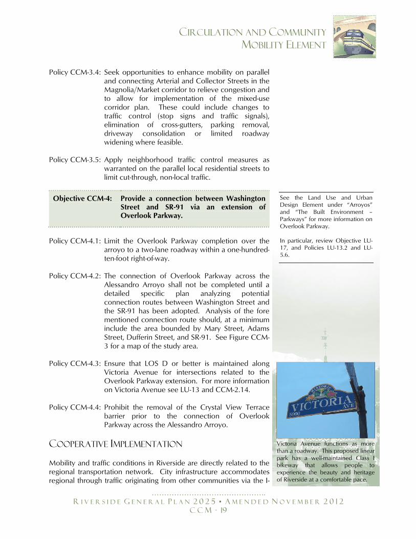
Victoria Avenue functions as more than a roadway. This proposed linear park has a well-maintained Class I bikeway that allows people to experience the beauty and heritage of Riverside at a comfortable pace.
……………………………………….
R I V E R S I D E G E N E R A L P L A N 2 0 2 5 • A M E N D E D N O V E M B E R 2 0 1 2
C C M - 20
CIRCULATION AND COMMUNITY
MOBILITY ELEMENT
215, I-15, SR-91, and SR-60 freeways. A healthy local economy depends on the ability of businesses to move their goods and the ability of employees living throughout the region to get to and from employment locations in Riverside. The City's mobility needs and issues are inextricably and critically connected to those of surrounding jurisdictions, the region and the State. No city, particularly one with Riverside's major regional facilities, can proceed independently with transportation planning. Cooperative implementation of regional and local circulation improvement plans is crucial to ensure continued mobility through and beyond the 2025 horizon of this General Plan.
Objective CCM-5: Cooperate in the implementation of regional and inter-jurisdictional transportation plans and improvements to the regional transportation system.
Policy CCM-5.1: Coordinate impacts of new roadway connections
with adjacent cities and Riverside County to ensure consistency in design and operations of the new facilities and connections.
Policy CCM-5.2: Support implementation of the SCAG Regional
Transportation Plan. Policy CCM-5.3: Promote citizen involvement in decisions regarding
major street widening projects through the direct involvement of the area residents affected.
Policy CCM-5.4: Actively participate with other jurisdictions and
agencies such as the County, RCTC, RTA, SCAG, WRCOG and CALTRANS to facilitate regionally integrated transportation networks.
Policy CCM-5.5: Participate in programs to mitigate regional traffic
congestion. Policy CCM-5.6: Integrate signal systems with adjacent jurisdictions
and Caltrans. Policy CCM-5.7 Work with Riverside County and as a member of
the March Joint Powers Authority to ensure adequate circulation within the JPA jurisdictional area and around Riverside National Cemetery.
See the Air Quality Element under ―Transportation‖ for more information on this topic. In particular, review Objective AQ-2.
……………………………………….
R I V E R S I D E G E N E R A L P L A N 2 0 2 5 • A M E N D E D N O V E M B E R 2 0 1 2
C C M - 21
CIRCULATION AND COMMUNITY
MOBILITY ELEMENT
TRIP REDUCTION
To minimize the impacts of future development on the City's circulation system, transportation demand management strategies and the Congestion Management Plan must be implemented in conjunction with the Master Plan of Roadways. Areas that already experience traffic congestion will also benefit from these methods. In recent years, the region's number of trips and amount of travel has grown at a faster rate than population growth. Transportation demand management (TDM) strategies are designed to counter this trend. TDM strategies reduce dependence on the single-occupant vehicle, increase the ability of the existing transportation system to carry more people and enhance mobility along congested corridors. The goal of TDM is to reduce single-occupant motor vehicle trips during peak hours and modify the vehicular demand for travel. A reduction in peak-hour trips, overall roadway congestion and a decrease in non-attainment pollutants can be achieved through the implementation of TDM strategies. Examples of TDM strategies include telecommuting, flexible work hours and electronic commerce that allow people to work and shop from home. The City supports TDM strategies that are consistent with the South Coast Air Quality Management District and County of Riverside TDM Guidelines. In addition, this General Plan is built on Smart Growth principles. By carefully integrating land use with transportation, both the number and duration of trips can be significantly reduced. By encouraging a mixture of compatible and synergistic land uses, the interaction between residential, commercial and employment uses will be strengthened, resulting in a reduced dependency on automobiles. Other benefits include decreased urban sprawl, improved air quality, increased use of transit and better conservation of land resources. In particular, three separate mixed use land use designations are being established as part of this General Plan update. These designations have been concentrated along the major transportation corridors and in key in-fill locations. This will encourage residents to live, work and shop in the same area, thus reducing their need to own or use private automobiles. It also encourages other forms of transportation, including walking, bicycling and transit. Transit will be a particularly viable option for reducing vehicle trips since the Riverside Transit Authority is proposing a Bus Rapid Transit route along the Magnolia Avenue corridor. Opportunities also exist for transit oriented development at the two Metrolink stations, with
……………………………………….
R I V E R S I D E G E N E R A L P L A N 2 0 2 5 • A M E N D E D N O V E M B E R 2 0 1 2
C C M - 22
CIRCULATION AND COMMUNITY
MOBILITY ELEMENT
transit links to the Magnolia Avenue corridor, further reducing vehicle trips.
Objective CCM-6: Cooperate in the implementation of regional and inter-jurisdictional transportation plans and improvements to the regional transportation system.
Policy CCM-6.1: Encourage the reduction of vehicle miles, reduce
the total number of daily peak hour vehicular trips, increase the vehicle occupancy rate and provide better utilization of the circulation system through the development and implementation of TDM programs contained in the SCAQMD and County of Riverside TDM Guidelines.
Policy CCM-6.2: Encourage the use of telecommunications by
Riverside residents, employees and students as a means to reduce air and noise pollution generated by traffic.
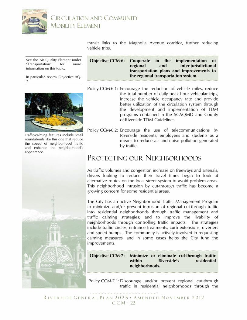
PROTECTING OUR NEIGHBORHOODS As traffic volumes and congestion increase on freeways and arterials, drivers looking to reduce their travel times begin to look at alternative routes on the local street system to avoid problem areas. This neighborhood intrusion by cut-through traffic has become a growing concern for some residential areas. The City has an active Neighborhood Traffic Management Program to minimize and/or prevent intrusion of regional cut-through traffic into residential neighborhoods through traffic management and traffic calming strategies; and to improve the livability of neighborhoods through controlling traffic impacts. The strategies include traffic circles, entrance treatments, curb extensions, diverters and speed humps. The community is actively involved in requesting calming measures, and in some cases helps the City fund the improvements.
Objective CCM-7: Minimize or eliminate cut-through traffic within Riverside’s residential neighborhoods.
Policy CCM-7.1: Discourage and/or prevent regional cut-through
traffic in residential neighborhoods through the
See the Air Quality Element under ―Transportation‖ for more information on this topic. In particular, review Objective AQ-2.
Traffic-calming features include small roundabouts like this one that reduce the speed of neighborhood traffic and enhance the neighborhood’s appearance.
……………………………………….
R I V E R S I D E G E N E R A L P L A N 2 0 2 5 • A M E N D E D N O V E M B E R 2 0 1 2
C C M - 23
CIRCULATION AND COMMUNITY
MOBILITY ELEMENT
employment of traffic-calming measures within Riverside.
Policy CCM-7.2: Work with adjacent jurisdictions, the County and
regional agencies to address the impacts of regional development patterns on the local circulation system.
Policy CCM-7.3: Discourage freeway access improvements that
could facilitate further non-local traffic intrusion into community neighborhoods.
Policy CCM-7.4: Limit local roadway improvements to those that are
necessary to support proposed General Plan land uses.
Policy CCM-7.5: Discourage improvements beyond those contained
in the Circulation and Community Mobility Element to accommodate additional regional traffic.
SAFE ROUTES TO SCHOOL
Implementation of strategies to reduce cut-through traffic will also help protect residential neighborhoods and enhance pedestrian safety around schools, churches, community centers and parks. Of particular concern are the safety hazards posed by vehicles to school-aged children and other residents during the peak drop-off and pick-up hours. The City will work with local school districts to identify safe routes to all schools, establish safe drop-off and pick-up zones and encourage walking or bicycling as safe alternatives to driving children to school.
Objective CCM-8: Protect neighborhoods and reduce the risk posed to young children and other residents by vehicular traffic on local roadways.
Policy CCM-8.1: Continue to regularly meet with local school
districts to identify safe routes to all schools, enabling better school access by cyclists and pedestrians. Support the establishment of safe drop-off and pick-up zones around schools during the morning and afternoon peak hours.
Policy CCM-8.2: Promote walking and biking as a safe mode of
travel for children attending local schools.
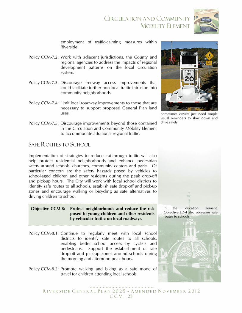
Sometimes drivers just need simple visual reminders to slow down and drive safely.
In the Education Element, Objective ED-4 also addresses safe routes to schools.
……………………………………….
R I V E R S I D E G E N E R A L P L A N 2 0 2 5 • A M E N D E D N O V E M B E R 2 0 1 2
C C M - 24
CIRCULATION AND COMMUNITY
MOBILITY ELEMENT
Policy CCM-8.3: Apply creative traffic management approaches to address congestion in areas with unique problems, particularly on roadways and intersections in the vicinity of schools in the morning and afternoon peak hours and near churches, parks and community centers.
Policy CCM-8.4: Give priority to sidewalk and curb construction to
areas near schools with pedestrian traffic. Policy CCM-8.5: Continue to participate in the Riverside County
Transportation Commission’s SB 821 program for the funding of facilities for the exclusive use of pedestrians and bicyclists to eliminate missing sidewalk and/or bicycle path links .
Policy CCM-8.6: Continue to administer the Pedestrian and Bicycle
School Safety Program through the Police Department to provide education for school aged children to help them identify traffic hazards and to develop safe pedestrian and biking habits.
ALTERNATIVE MODES OF
TRANSPORTATION Public transportation and alternative modes of travel, such as bicycling and walking, are important components of a comprehensive circulation system. Public and alternative modes of transportation offer an alternative to the use of the automobile and help reduce air pollution and road congestion. To promote the increased usage of these modes of transportation, adequate facilities and services must be provided.
BUS AND RAIL SERVICE
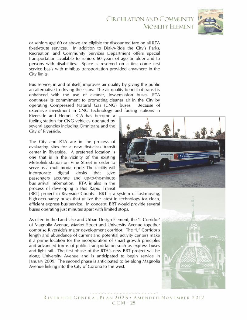
Public bus service is provided by the Riverside Transit Agency (RTA). In 2004, twenty RTA bus routes traversed the planning area. Additional services offered by RTA are CommuterLink and Dial-A-Ride. CommuterLink routes travel to major transit centers and Metrolink stations in Riverside, San Diego and San Bernardino counties. Dial-A-Ride is a curb-to-curb advanced reservation transportation service for seniors and persons with disabilities. Dial-A-Ride vehicles travel to areas within three-quarters of a mile of an RTA local fixed bus route. All RTA fixed route buses are accessible to persons with disabilities and equipped with wheelchair ramps and wheelchair lifts. Any person who meets RTA disability requirements
……………………………………….
R I V E R S I D E G E N E R A L P L A N 2 0 2 5 • A M E N D E D N O V E M B E R 2 0 1 2
C C M - 25
CIRCULATION AND COMMUNITY
MOBILITY ELEMENT
or seniors age 60 or above are eligible for discounted fare on all RTA fixed-route services. In addition to Dial-A-Ride the City’s Parks, Recreation and Community Services Department offers special transportation available to seniors 60 years of age or older and to persons with disabilities. Space is reserved on a first come first service basis with minibus transportation provided anywhere in the City limits. Bus service, in and of itself, improves air quality by giving the public an alternative to driving their cars. The air-quality benefit of transit is enhanced with the use of cleaner, low-emission buses. RTA continues its commitment to promoting cleaner air in the City by operating Compressed Natural Gas (CNG) buses. Because of extensive investment in CNG technology and fueling stations in Riverside and Hemet, RTA has become a fueling station for CNG vehicles operated by several agencies including Omnitrans and the City of Riverside. The City and RTA are in the process of evaluating sites for a new first-class transit center in Riverside. A preferred location is one that is in the vicinity of the existing Metrolink station on Vine Street in order to serve as a multi-modal node. The facility will incorporate digital kiosks that give passengers accurate and up-to-the-minute bus arrival information. RTA is also in the process of developing a Bus Rapid Transit (BRT) project in Riverside County. BRT is a system of fast-moving, high-occupancy buses that utilize the latest in technology for clean, efficient express bus service. In concept, BRT would provide several buses operating just minutes apart with limited stops. As cited in the Land Use and Urban Design Element, the "L Corridor" of Magnolia Avenue, Market Street and University Avenue together comprise Riverside's major development corridor. The ―L‖ Corridor's length and abundance of current and potential activity centers make it a prime location for the incorporation of smart growth principles and advanced forms of public transportation such as express buses and light rail. The first phase of the RTA’s new BRT project will be along University Avenue and is anticipated to begin service in January 2009. The second phase is anticipated to be along Magnolia Avenue linking into the City of Corona to the west.
XXX
XX
XX
XXXX
X
X
X
X
XX
X
X
X
X
XXX
XX
X
X
X
XXXXXXXXXXXX
X
XX
X
X
X
X
X
X
Main St
Van Buren Blvd
Jurupa Rd
Pedl
ey R
d
Clar
k St
Bain
St
Granite Hill Dr
Brow
n St
58th St
Sampson Ave
Etiw
anda
Ave
Rubido
ux B
lvd
Martin St
56th St
Camin
o R e
a l
Steven Dr
Promenade Ave
E
agle
Can
yon
Road
Eastridge Ave
Limonite Ave
ey
Bellegrave St
Agat
e St
Van Buren Blvd
Clay St
Ave
34th St
a Ave
Mar
latt
St
Elsw
orth
St
Fels
par S
t
Arm
stro
ng R
d
Box Springs Rd
Peralta Pl
Paci
fic A
ve
Temescal Canyon Rd
Beac
h St
20th St
Market St
Avon
St
Rutil
e St
Deck
er R
d
Rider St
Mission Blvd
Alex
ande
r St
Calif
orni
a Av
e
Cajalco Rd Day
St
Markham St
Nandina Ave
Magnolia Ave
McKinley St
Norc
o Hi
lls R
d
Woo
d R
d
Victoria Ave
Tyler St
Adams St
Magnolia Ave
El Sobrante Rd
Day
StMonroe St
Cajalco Rd
Jurupa Ave
Wat
kins
Dr
Center St
La Sierra Ave
Krameria Ave
Nandina Ave Barto
n St
Central Ave
Sierra Ave
La Sierra Ave
La Sierra Ave
Overlook Pkwy
El Sobrante Rd
Mary St
GentianAve
Roberts Rd
Proposed "B" Dr
Cajalco Rd
Ransom Rd
C
anyo
n C
rest
Dr
Mt.
Vern
on A
ve
Ri v
erw
alk
Pkw
y
Sa
nta
Ana River
Santa Ana R
iver
Lake Mathews
El Cerrito
Dr
Porte
r Ave
Mariposa Ave
Iris Ave Dauc
hyAv
e
Chic
ago
Ave
Barto
n Rd
Mitchell Ave
Nor
woo
d A
v e
Campbell Ave
Jone
s Av
e
Cook
Ave
Sierra Vista St
Harr
ison
St
Golden Ave
Collett Ave
Frem
ontS
t
Pierce St
Schuyler
Ave
View Ln
Golden Star Ave
Gramercy Pl
Spruce St
Jefferson St
Third St
Lincoln Ave
Cypress Ave
Pierce St
Markham St
Bradley St
Hole Ave
Fourteenth St
Columbia Ave
Grand Ave
Polk St
Broc
kton
Ave
Challen Ave
Dewey Ave
Linden St
University Ave
Hills i
de A
v e
Harrison St
Dufferin Ave
"A" S
t
Orchard
Cottonwood Ave
Sycamor e C
anyon Blvd
Vict
oria
AveRamona Dr
Kans
as A
ve
Cany
on C
rest
Dr
Iow
a Av
e
Atla
nta
St
McA
llist
er S
t
M
issi
on G
rove
Pkw
y
John F.Kennedy
Dr
Sierra Ridge Dr
RiverRun
Dr
Dan Kipper Dr
Via
Vista Dr
Community Dr
Grove
Dr
Rust
in A
ve
Marlborough Ave Mic
higa
n St
Mulb
erry
St
Philbin Ave
Palm
Ave
Oran
ge S
t
Van Buren Blvd
Chic
ago
Ave
Rive
rsid
eAv
e
OrangeTerrace Pkwy
Rive
ra S
t
Jackson St
Rutla
ndAv
e
Strong St
Golden Ave
Fillmore St
Blaine St
Maude St
Arlington Ave
Wells A
ve
Cridge St
Century Ave
Central Ave Lochmoo r
First St
Mark
et S
t
TenthSt
Lim
e St
Mission Inn Ave
Oliv
ewoo
d Av
e
Oleander Ave
Merrill Ave
Eagle Ridge Dr
North
gate
St
Proposed "A" D
r
Isle
Fair
BoxSpr ings
Main
St
Was
hing
ton
St
La C
aden
a Dr
Colorado Ave
Trautwein R
d
Buchanan St
Madison St
Alessandro Blvd
FifthSt
California Ave
Jurupa Ave
Cole
A
ve
McAllister St
Central Ave
Alessandro Blvd
Van Buren Blvd
Blvd
Martin Luther King Blvd
Tyler St
Indiana Ave
Mai
n St
Citrus St
Cajalco Rd
Arlington Ave
Was
hing
ton
St
Arlington Ave
Mockingbird Canyon Rd
Van Buren Blvd
Columbia AvePalmyrita Ave
Iow
a A
ve
Magn
olia
Ave
Bandini Ave
Hermosa Dr
Flabob
Airport
RiversideMunicipal Airport
%&h(
?z
%&h(
?z
?Æ
The City of Riverside makes no warranty as to the accuracy or content of the data shown on this map. This map shall not be reproduced or distributed. Copyright 2006, City of Riverside, California. City of Riverside data current to 12-15-06.
L A N D U S E / U R B A N D E S I G N E L E M E N T
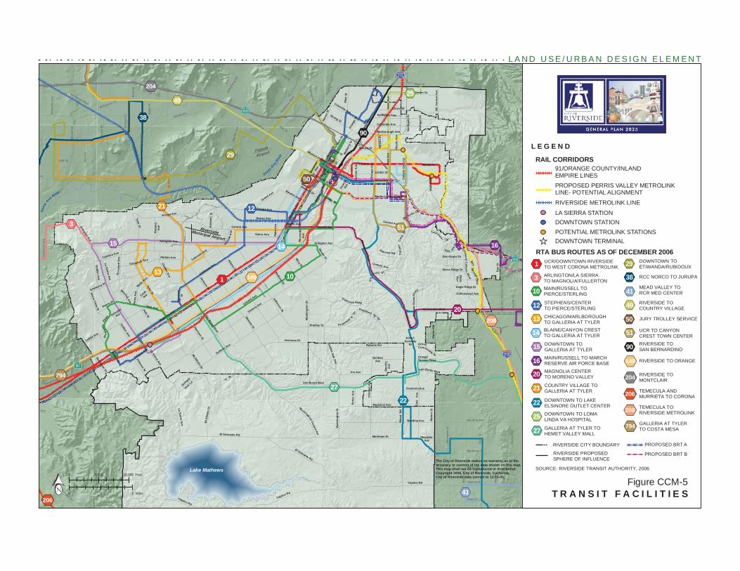
T R A N S I T F A C I L I T I E SFigure CCM-5
L E G E N D
SOURCE: RIVERSIDE TRANSIT AUTHORITY, 2006
RIVERSIDE PROPOSEDSPHERE OF INFLUENCE
RIVERSIDE CITY BOUNDARY
%,1%,3%,10
%,12
%,13
%,14
%,15
%,16
%,20
%,21
%,22
%,25
%,27
%,29
%,38
%,41
%,49
%,50
%,51
%,90
%,149
%,204
%,206
%,208
%,794
UCR/DOWNTOWN RIVERSIDETO WEST CORONA METROLINK
ARLINGTON/LA SIERRATO MAGNOLIA/FULLERTONMAIN/RUSSELL TOPIERCE/STERLING
STEPHENS/CENTERTO PIERCE/STERLING
CHICAGO/MARLBOROUGHTO GALLERIA AT TYLERBLAINE/CANYON CRESTTO GALLERIA AT TYLER
DOWNTOWN TOGALLERIA AT TYLER
MAIN/RUSSELL TO MARCHRESERVE AIR FORCE BASEMAGNOLIA CENTERTO MORENO VALLEY
COUNTRY VILLAGE TOGALLERIA AT TYLER
DOWNTOWN TO LAKEELSINORE OUTLET CENTER
DOWNTOWN TO LOMALINDA VA HOSPITAL
GALLERIA AT TYLER TOHEMET VALLEY MALL
DOWNTOWN TOETIWANDA/RUBIDOUX
RCC NORCO TO JURUPA
MEAD VALLEY TORCR MED CENTER
RIVERSIDE TOCOUNTRY VILLAGE
JURY TROLLEY SERVICE
UCR TO CANYONCREST TOWN CENTERRIVERSIDE TOSAN BERNARDINO
RIVERSIDE TO ORANGE
RIVERSIDE TOMONTCLAIR
TEMECULA AND MURRIETA TO CORONA
TEMECULA TORIVERSIDE METROLINK
GALLERIA AT TYLERTO COSTA MESA
RTA BUS ROUTES AS OF DECEMBER 2006
LA SIERRA STATIONDOWNTOWN STATIONPOTENTIAL METROLINK STATIONS
RAIL CORRIDORS
PROPOSED PERRIS VALLEY METROLINKLINE- POTENTIAL ALIGNMENT
RIVERSIDE METROLINK LINE
PROPOSED BRT A
PROPOSED BRT B
DOWNTOWN TERMINAL_̂
91/ORANGE COUNTY/INLAND EMPIRE LINES
Feet0 5,000 10,000
Miles0 1 2
%,206%,41
%,1
%,3
%,10
%,12
%,13
%,14%,15 %,16
%,20
%,21
%,22
%,25
%,27
%,29
%,38
%,49
%,50
%,51
%,90
%,149
%,204
%,208
%,794
……………………………………….
R I V E R S I D E G E N E R A L P L A N 2 0 2 5 • A M E N D E D N O V E M B E R 2 0 1 2
C C M - 27
CIRCULATION AND COMMUNITY
MOBILITY ELEMENT
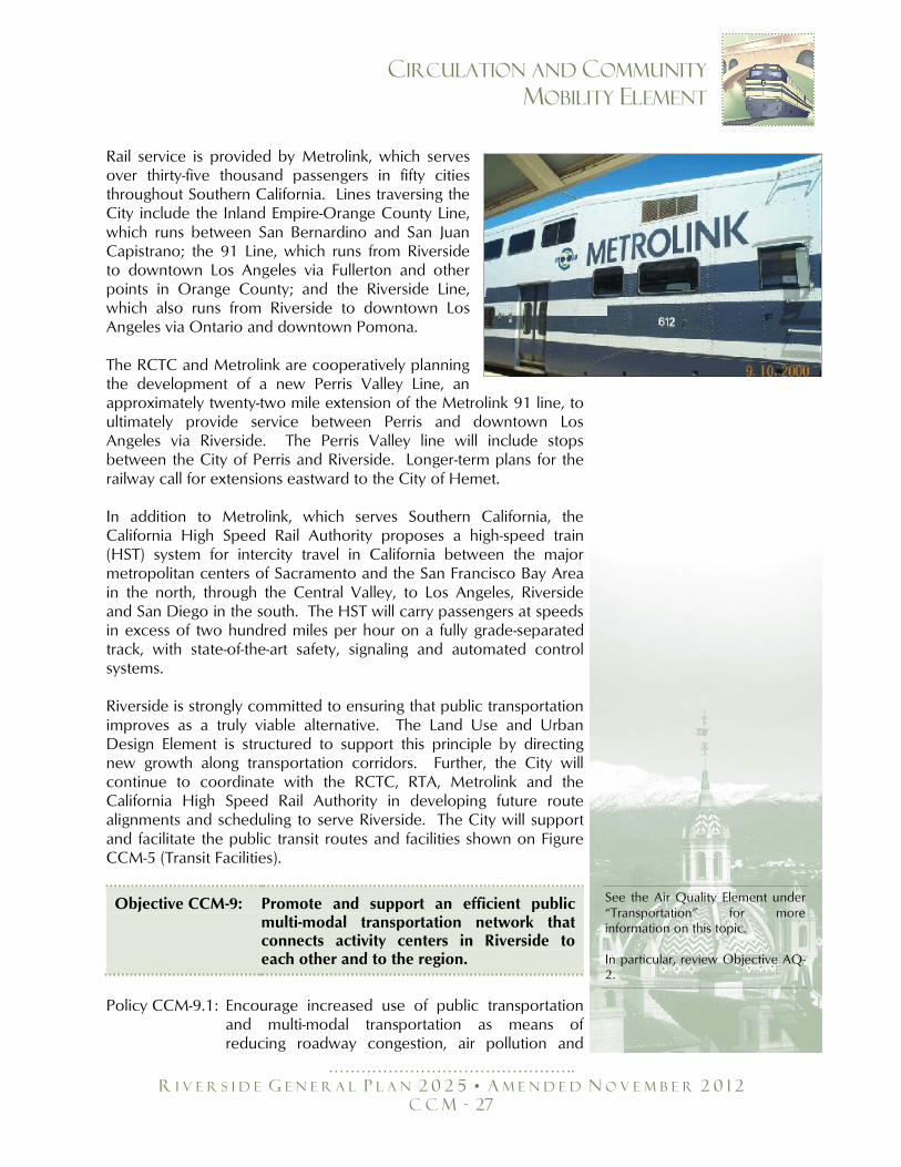
Rail service is provided by Metrolink, which serves over thirty-five thousand passengers in fifty cities throughout Southern California. Lines traversing the City include the Inland Empire-Orange County Line, which runs between San Bernardino and San Juan Capistrano; the 91 Line, which runs from Riverside to downtown Los Angeles via Fullerton and other points in Orange County; and the Riverside Line, which also runs from Riverside to downtown Los Angeles via Ontario and downtown Pomona. The RCTC and Metrolink are cooperatively planning the development of a new Perris Valley Line, an approximately twenty-two mile extension of the Metrolink 91 line, to ultimately provide service between Perris and downtown Los Angeles via Riverside. The Perris Valley line will include stops between the City of Perris and Riverside. Longer-term plans for the railway call for extensions eastward to the City of Hemet. In addition to Metrolink, which serves Southern California, the California High Speed Rail Authority proposes a high-speed train (HST) system for intercity travel in California between the major metropolitan centers of Sacramento and the San Francisco Bay Area in the north, through the Central Valley, to Los Angeles, Riverside and San Diego in the south. The HST will carry passengers at speeds in excess of two hundred miles per hour on a fully grade-separated track, with state-of-the-art safety, signaling and automated control systems. Riverside is strongly committed to ensuring that public transportation improves as a truly viable alternative. The Land Use and Urban Design Element is structured to support this principle by directing new growth along transportation corridors. Further, the City will continue to coordinate with the RCTC, RTA, Metrolink and the California High Speed Rail Authority in developing future route alignments and scheduling to serve Riverside. The City will support and facilitate the public transit routes and facilities shown on Figure CCM-5 (Transit Facilities).
Objective CCM-9: Promote and support an efficient public multi-modal transportation network that connects activity centers in Riverside to each other and to the region.
Policy CCM-9.1: Encourage increased use of public transportation
and multi-modal transportation as means of reducing roadway congestion, air pollution and
See the Air Quality Element under ―Transportation‖ for more information on this topic. In particular, review Objective AQ-2.
……………………………………….
R I V E R S I D E G E N E R A L P L A N 2 0 2 5 • A M E N D E D N O V E M B E R 2 0 1 2
C C M - 28
CIRCULATION AND COMMUNITY
MOBILITY ELEMENT
non-point source water pollution, through such techniques as directing new growth along transportation corridors.
Policy CCM-9.2: Support implementation of RTA's Bus Rapid Transit
Program and recommendations of the Go Riverside Task Force.
Policy CCM-9.3: Explore the feasibility of light rail/monorail within
the City, to include a connection between the Downtown and La Sierra Metrolink Stations.
Policy CCM-9.4: Support efforts of the California High Speed Rail
Authority to bring high-speed trains to California and Riverside.
Policy CCM-9.5: Incorporate facilities for transit and other alternative
modes of transportation, such as park-and-ride lots and bus turnouts, in the design of future developments.
Policy CCM-9.6: Enhance and encourage the provision of attractive
and appropriate transit amenities, including shaded bus stops, to facilitate use of public transportation, through the development process by incorporating the necessary design features as appropriate..
Policy CCM-9.7: Ensure adequate connections among all alternative
modes. Policy CCM-9.8: Preserve options for future transit use where
appropriate when designing improvements for roadways.
Policy CCM-9.9: Improve and enhance pedestrian connections
between Downtown Riverside and the Downtown Metrolink station through use of walkways and the City’s Green Line Trolley service.
Policy CCM-9.10:Promote Neighborhood Electric Vehicles (NEV)
including participation in and support of the Western Riverside Council of Governments (WRCOG) 4-City Neighborhood Electric Vehicle Plan to provide a clean transportation option, particularly for short trips on low-speed and low-volume roads and to create near term and long range transportation network plans and scalable implementation strategies for deployment of NEVs.
……………………………………….
R I V E R S I D E G E N E R A L P L A N 2 0 2 5 • A M E N D E D N O V E M B E R 2 0 1 2
C C M - 29
CIRCULATION AND COMMUNITY
MOBILITY ELEMENT
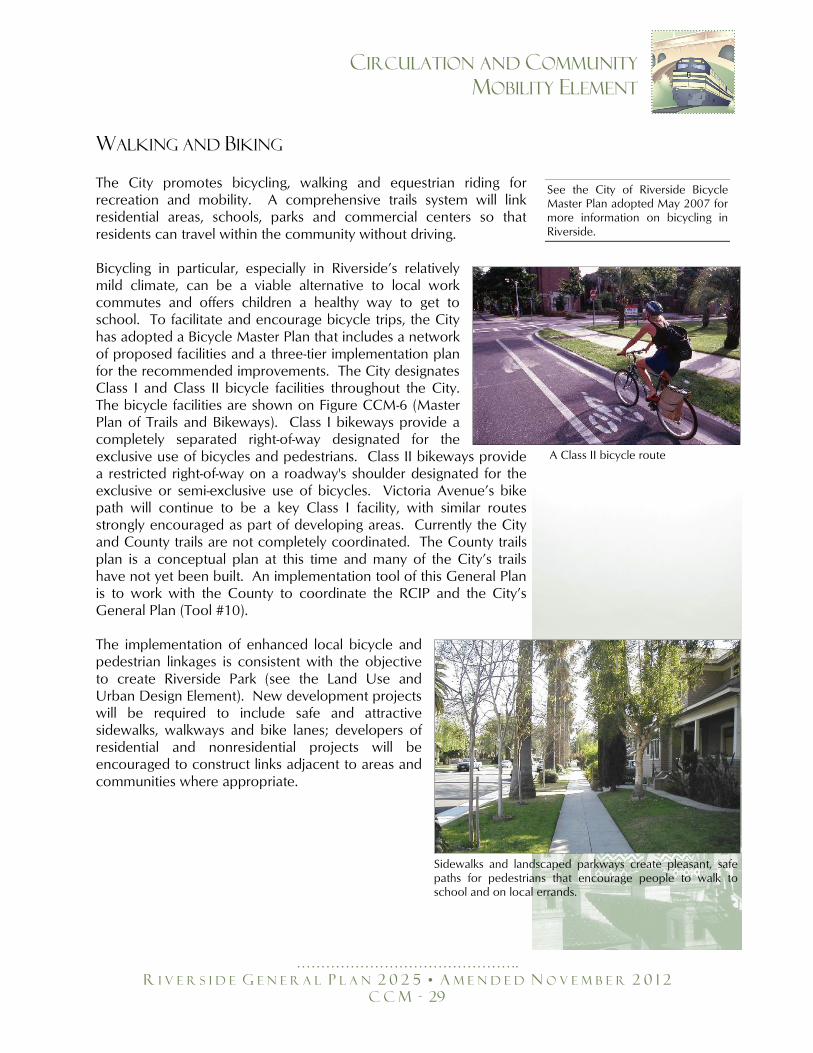
WALKING AND BIKING
The City promotes bicycling, walking and equestrian riding for recreation and mobility. A comprehensive trails system will link residential areas, schools, parks and commercial centers so that residents can travel within the community without driving. Bicycling in particular, especially in Riverside’s relatively mild climate, can be a viable alternative to local work commutes and offers children a healthy way to get to school. To facilitate and encourage bicycle trips, the City has adopted a Bicycle Master Plan that includes a network of proposed facilities and a three-tier implementation plan for the recommended improvements. The City designates Class I and Class II bicycle facilities throughout the City. The bicycle facilities are shown on Figure CCM-6 (Master Plan of Trails and Bikeways). Class I bikeways provide a completely separated right-of-way designated for the exclusive use of bicycles and pedestrians. Class II bikeways provide a restricted right-of-way on a roadway's shoulder designated for the exclusive or semi-exclusive use of bicycles. Victoria Avenue’s bike path will continue to be a key Class I facility, with similar routes strongly encouraged as part of developing areas. Currently the City and County trails are not completely coordinated. The County trails plan is a conceptual plan at this time and many of the City’s trails have not yet been built. An implementation tool of this General Plan is to work with the County to coordinate the RCIP and the City’s General Plan (Tool #10). The implementation of enhanced local bicycle and pedestrian linkages is consistent with the objective to create Riverside Park (see the Land Use and Urban Design Element). New development projects will be required to include safe and attractive sidewalks, walkways and bike lanes; developers of residential and nonresidential projects will be encouraged to construct links adjacent to areas and communities where appropriate.
See the City of Riverside Bicycle Master Plan adopted May 2007 for more information on bicycling in Riverside.
A Class II bicycle route
Sidewalks and landscaped parkways create pleasant, safe paths for pedestrians that encourage people to walk to school and on local errands.
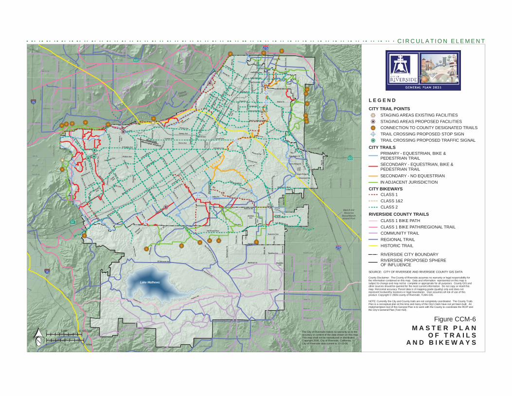
A St
Main St
Van Buren Blvd
Jurupa Rd
Pedl
ey R
d
Cla
rk S
t
Bai
n St
Granite Hill Dr
Pige
on P
ass
Rd
Bro
wn
St
6th St
C
Lake Mathews Dr
58th St
Mack St
Ir
Sampson Ave
Reche Canyon Rd
Gra
ham
St
E
Old Elsinore Rd
Etiw
anda
Ave
Gav
ilan
Rd
Rubid
oux
Blvd
Hea
cock
St
nAve
Martin St
56th St
Win
evill
e A
ve
Camin
o R
eal
Park
ridge
Ave
Steven Dr
Promenade Ave
E
agle
Can
yon
R oad
Eastridge Ave
Limonite Ave
Hidden ValleyPkwy
68th St
A
Ironwood Ave
Bellegrave St
hill Pky Seat
on A
ve
Post Rd
Aga
te S
t
Van Buren B
lvd
Luke
ns L
n
Clay St
Rimpau Ave
Limonite Ave
34th St
Indiana Ave
Mar
latt
St
Elsw
orth
St
Fourth St
Fels
par S
t
Cresta Rd
Arm
stro
ng R
d
Galena St
J
Box Springs Rd
Peralta Pl
Paci
fic A
ve
Temescal Canyon Rd
Bea
ch S
t
20th St
Market S
t
G
Avo
n S
t
Web
ster
Ave
Orange Ave
Fred
eric
k S
t
Nei
l St
Rut
ile S
t
Dec
ker
Rd
Nuevo Rd
Rider St
Mission Blvd
Ale
xand
er S
t
Cal
iforn
ia A
ve
Nu
C
Fifth St
Cajalco Rd
Day
St
Markham St
Nandina Ave
Magnolia Ave
McKinley St
Norc
o Hi
lls R
d
Cal
iforn
ia A
ve
Sunnymead Ranch Pk y
Woo
d R
d
Victoria Ave
Tyler St
Adams St
Magnolia Ave
El Sobrante Rd
Day
St
Monroe St
Cajalco Rd
Jurupa Ave
Wat
kins
Dr
Center St
La Sierra Ave
Krameria Ave
Nandina Ave Bar
ton
St
Central Ave
Sierra Ave
La Sierra Ave
La Sierra Ave
Overlook Pkwy
El Sobrante Rd
Mary St
GentianAve
Roberts Rd
Proposed "B" Dr
Cajalco Rd
Ransom Rd
C
anyo
n C
rest
D
r
Mt.
Vern
on A
ve
Riv
erwa
lk
Pkw
y
S
anta
Ana R
iver
Santa A
na Riv
er
Lake Mathews
El Cerrito Dr
Port
er A
ve
Mariposa Ave
Iris Ave Dau
chy
Ave
Chi
cago
Ave
Bar
ton
Rd
Mitchell Ave
Norw
o od
Ave
Camp bell Ave
Jone
s A
ve
Cook
Ave
Sierra Vista St
Har
rison
St
Golden A
ve
Collett Ave
Frem
ontS
t
Pierce St
Schuyler
Ave
View Ln
Golden Star Ave
Gramercy Pl
Spruce St
Jefferson St
Third St
Lincoln Ave
Cypress Ave
Pierce St
Markham St
Bradley St
Hole Ave
Fourteenth St
Columbia Ave
Grand Ave
Polk St
Broc
kton
Ave
Challen Ave
Dewey Ave
Linden St
University Ave
Hi llsi
de A
v e
Harrison St
Dufferin
Ave
"A" S
t
Orchard
Cottonwood Ave
Sycamor e C
anyon Bl vd
Vict
oria
AveRamona Dr
Kan
sas
Ave
Can
yon
Cre
st D
r
Iow
a A
ve
Atla
nta
St
McA
llist
er S
t
M
issi
on G
rove
Pkw
y
John F.Kennedy
Dr
Sierra Ridge Dr
River
Run
Dr
Dan Kipper Dr
Via
Vista D r
Community Dr
Grove
Dr
Rus
tin A
ve
Marlborough Ave Mic
higa
n St
Mul
berry
St
Philbin Ave
Palm
Ave
Oran
ge S
t
Van Buren Blvd
Chi
cago
Ave
Riv
ersi
deA
ve
OrangeTerrace Pkwy
Rive
ra S
t
Jackson St
Rut
land
Ave
Strong St
Golden Ave
Fillmore St
Blaine St
Maude St
Arlington Ave
Wells A
ve
Cridge St
Century Ave
Central Ave Lochmoor
First St
Mar
ket S
t
TenthSt
Lim
e St
Mission Inn Ave
Oliv
ewoo
d Av
e
Oleander Ave
Merrill Ave
Eagle Ridge Dr
Nor
thga
te S
t
Proposed "A"
Dr
Isle
Fair
BoxSp
r ings
Mai
n St
Was
hing
ton
St
La C
aden
a Dr
Colorado Ave
Trautwein R
d
Buchanan St
Madison St
Alessandro Blvd
FifthSt
California Ave
Jurupa Ave
Col
e A
ve
McAllister St
Central Ave
Alessandro Blvd
Van Buren Blvd
Blvd
Martin Luther King Blvd
Tyler St
Indiana Ave
Mai
n St
Citrus St
Cajalco Rd
Arlington Ave
Was
hing
ton
St
Arlington Ave
Mockingbird Canyon Rd
Van Buren Blvd
Columbia AvePalmyrita Ave
Iow
a A
ve
Mag
nolia
Ave
Bandini Ave
Hermosa Dr
Flabob
Airport
March AirReserve
Base/MarchInland Port
RiversideMunicipal Airport
§̈a#
§̈a#
?z
?z
?Æ
kj!
kjkj
kjkj
kjkj
kjkj
kjkj
kjkjkjkj
kjkj
!.
kjkj kjkj
kjkjkj
kj!
kjkjkjkj
A
kj!kjkjkjkj
kjkjkjkj kjkj
!.!.!.kj
kjkj
kjkj
A
A
A
A A
kjkj
kjkj
kjkj
%&h(
%&h(
SOURCE: CITY OF RIVERSIDE AND RIVERSIDE COUNTY GIS DATA
The City of Riverside makes no warranty as to the accuracy or content of the data shown on this map. This map shall not be reproduced or distributed. Copyright 2006, City of Riverside, California. City of Riverside data current to 12-15-06.0 1 2 Miles
0 5,000 10,000 Feet M A S T E R P L A NO F T R A I L S
A N D B I K E W A Y S
Figure CCM-6
County Disclaimer: The County of Riverside assumes no warranty or legal responsibility forthe information contained on this map. Data and information represented on this map issubject to change and may not be complete or appropriate for all purposes. County GIS andother sources should be queried for the most current information. Do not copy or resell thismap. Horizontal accuracy: Parcel data is of mapping grade (quality) only and does notrepresent trustworthy locations or legal boundaries. User assumes all risk of use of thisproduct. Copyright © 2006 county of Riverside, TLMA-GIS.
C I R C U L A T I O N E L E M E N T
NOTE: Currently the City and County trails are not completely coordinated. The County TrailsPlan is a conceptual plan at this time and many of the City’s trails have not yet been built. Animplementation tool of this General Plan is to work with the County to coordinate the RCIP andthe City’s General Plan (Tool #10).
L E G E N DCITY TRAIL POINTS
CITY TRAILS
SECONDARY - EQUESTRIAN, BIKE &PEDESTRIAN TRAIL
PRIMARY - EQUESTRIAN, BIKE &PEDESTRIAN TRAIL
STAGING AREAS EXISTING FACILITIESSTAGING AREAS PROPOSED FACILITIESCONNECTION TO COUNTY DESIGNATED TRAILSTRAIL CROSSING PROPOSED STOP SIGNTRAIL CROSSING PROPOSED TRAFFIC SIGNAL
SECONDARY - NO EQUESTRIANIN ADJACENT JURISDICTION
RIVERSIDE CITY BOUNDARYRIVERSIDE PROPOSED SPHEREOF INFLUENCE
RIVERSIDE COUNTY TRAILSCLASS 1 BIKE PATHCLASS 1 BIKE PATH/REGIONAL TRAILCOMMUNITY TRAILREGIONAL TRAILHISTORIC TRAIL
CITY BIKEWAYSCLASS 1CLASS 1&2CLASS 2
kjkj!
kjkj
A!.
……………………………………….
R I V E R S I D E G E N E R A L P L A N 2 0 2 5 • A M E N D E D N O V E M B E R 2 0 1 2
C C M - 31
CIRCULATION AND COMMUNITY
MOBILITY ELEMENT
Objective CCM-10: Provide an extensive and regionally linked public bicycle, pedestrian and equestrian trails system.
Policy CCM-10.1: Ensure the provision of bicycle facilities consistent
with the Bicycle Master Plan. Policy CCM-10.2: Incorporate bicycle and pedestrian trails and
bicycle racks in future development projects. Policy CCM-10.3: Provide properly designed pedestrian facilities for
the disabled and senior population to ensure their safety and enhanced mobility as users of streets, roads and highways emphasizing ―complete streets‖ principles.
Policy CCM-10.4: Identify and seek to eliminate hazards to safe,
efficient bicycle or pedestrian movement citywide. Policy CCM-10.5: Promote the health benefits of using a bicycle or
walking as a means of transportation. Policy CCM-10.6: Encourage pedestrian travel through the creation
of sidewalks and street crossings. Policy CCM-10.7: Maintain an extensive trails network that supports
bicycles, pedestrians and horses and is linked to the trails systems of adjacent jurisdictions.
Policy CCM-10.8: Maximize links between trails and major activity
centers, residential neighborhoods, schools, shopping centers and employment centers.
Policy CCM-10.9: Provide adequate connections between elements
of Riverside Park. Policy CCM-10.10: Evaluate the needs of bicycle traffic in the
planning, design, construction and operation of all roadway projects funded by the City.
Policy CCM-10.11: Provide sufficient paved surface width to enable
bicycle traffic to share the road with motor vehicles where traffic volumes and conditions warrant.
See the Public Safety Element under ―Ground and air Transportation – Pedestrian and Bicyclist Safety,‖ the Education Element under ―Ensuring Safe Routes to Schools‖ and the Air Quality Element under ―‖Land Use Strategies‖ for more information on alternative modes of transportation. In particular, review Objectives PS-5, ED-4 and AQ-2 and Policies AQ-1.9 and AQ-1.18.
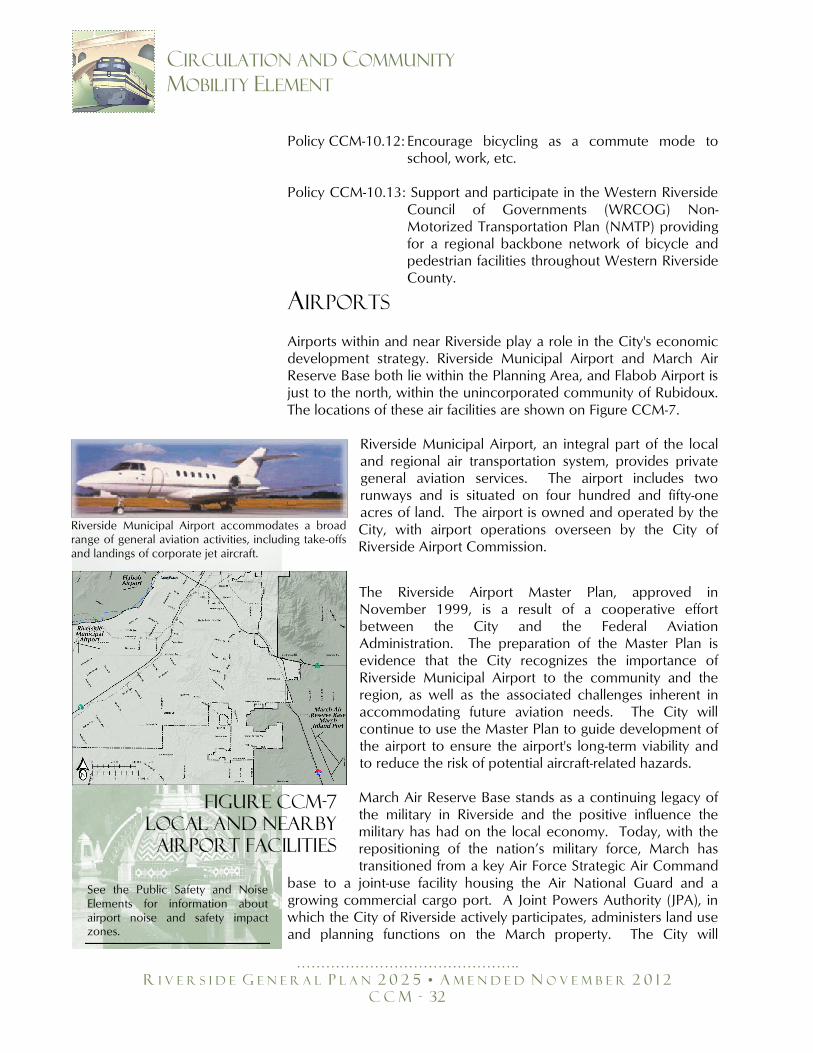
……………………………………….
R I V E R S I D E G E N E R A L P L A N 2 0 2 5 • A M E N D E D N O V E M B E R 2 0 1 2
C C M - 32
CIRCULATION AND COMMUNITY
MOBILITY ELEMENT
Policy CCM-10.12: Encourage bicycling as a commute mode to school, work, etc.
Policy CCM-10.13: Support and participate in the Western Riverside
Council of Governments (WRCOG) Non-Motorized Transportation Plan (NMTP) providing for a regional backbone network of bicycle and pedestrian facilities throughout Western Riverside County.
AIRPORTS
Airports within and near Riverside play a role in the City's economic development strategy. Riverside Municipal Airport and March Air Reserve Base both lie within the Planning Area, and Flabob Airport is just to the north, within the unincorporated community of Rubidoux. The locations of these air facilities are shown on Figure CCM-7.
Riverside Municipal Airport, an integral part of the local and regional air transportation system, provides private general aviation services. The airport includes two runways and is situated on four hundred and fifty-one acres of land. The airport is owned and operated by the City, with airport operations overseen by the City of Riverside Airport Commission.
The Riverside Airport Master Plan, approved in November 1999, is a result of a cooperative effort between the City and the Federal Aviation Administration. The preparation of the Master Plan is evidence that the City recognizes the importance of Riverside Municipal Airport to the community and the region, as well as the associated challenges inherent in accommodating future aviation needs. The City will continue to use the Master Plan to guide development of the airport to ensure the airport's long-term viability and to reduce the risk of potential aircraft-related hazards. March Air Reserve Base stands as a continuing legacy of the military in Riverside and the positive influence the military has had on the local economy. Today, with the repositioning of the nation’s military force, March has transitioned from a key Air Force Strategic Air Command
base to a joint-use facility housing the Air National Guard and a growing commercial cargo port. A Joint Powers Authority (JPA), in which the City of Riverside actively participates, administers land use and planning functions on the March property. The City will
Riverside Municipal Airport accommodates a broad range of general aviation activities, including take-offs and landings of corporate jet aircraft.
Figure CCM-7
Local and NEARBY
AIRPORT FACILITIES
See the Public Safety and Noise Elements for information about airport noise and safety impact zones.
……………………………………….
R I V E R S I D E G E N E R A L P L A N 2 0 2 5 • A M E N D E D N O V E M B E R 2 0 1 2
C C M - 33
CIRCULATION AND COMMUNITY
MOBILITY ELEMENT
continue to support the conversion of March to an inland cargo port and increased use of the facility for commercial purposes, in accordance with adopted plans.
Objective CCM-11: Promote and support an efficient public multi-modal transportation network that connects activity centers in Riverside to each other and to the region.
PolicyCCM-11.1: Protect flight paths from encroachment by
inappropriate development using the Riverside County Airport Land Use Compatibility Plan to determine the consistency of proposed development.
PolicyCCM-11.2: Limit building heights and land use intensities
beneath airport approaches and departure paths to protect public safety consistent with the Riverside County Airport Land Use Compatibility Plan and all other applicable State and Federal regulations.
Policy CCM-11.3: Ensure that Riverside Municipal Airport continues
to serve general aviation needs. Policy CCM-11.4: Support continued development of MARB/MIP. Policy CCM-11.5: Coordinate public and local transit with planning
for air transportation. Policy CCM-11.6: Encourage the development of high-speed ground
transportation systems to supplement the air travel system for meeting regional travel needs.
Policy CCM-11.7: Ensure environmental impacts such as noise, air
quality, pollution, traffic congestion, and public safety hazards associated with continued operation of local airports are mitigated to the extent practicable.
FREIGHT: RAILWAYS AND TRUCK
MOVEMENT An effective and efficient goods movement system is essential to the economic livelihood of all urban areas. Riverside contains active rail
See the Land Use and Urban Design Element under ―The Built Environment – Relationship to Nearby Airports,‖ the Public Safety Element under ―Ground and Air Transportation‖ and the Noise Element under ―Minimizing Noise Impacts‖ for more information on airports. In particular, review Objectives LU-22, LU-23, PS-4, N-2 and N-3.

……………………………………….
R I V E R S I D E G E N E R A L P L A N 2 0 2 5 • A M E N D E D N O V E M B E R 2 0 1 2
C C M - 34
CIRCULATION AND COMMUNITY
MOBILITY ELEMENT
lines used by the Union Pacific and Burlington Northern Santa Fe Railroad companies. The freight rail system serves the growing Ports of Los Angeles and Long Beach, and some of the freight from these ports travels easterly through Riverside. In 2000, peak railroad traffic in Riverside County was eighty-five freight trains per day and is expected to grow to one hundred sixty-nine trains per day by 2020.
RAILWAYS
Increased freight movement by rail will exacerbate traffic delays on local streets and present continuing, increased safety hazards. The City actively pursues grade separation projects to enhance vehicular safety and reduce vehicular delays, which will also have the beneficial side effect of improving local air quality by minimizing the number of idling vehicles waiting for trains to pass. An example of a successful large-scale grade separation project that should be emulated is the Alameda Corridor. The Alameda Corridor, which opened in April of 2002, provides grade separation along an existing at-grade railway that connects the Ports of Long Beach and Los Angeles to rail yards in downtown Los Angeles. According to the SCAG Regional Transportation Plan, the corridor provides grade separations at two hundred street-rail intersections, reducing vehicle-train delay by an estimated ninety percent. Other benefits include a ninety percent reduction in noise and vibration, a twenty-eight percent reduction in railroad emissions and a fifty-four percent reduction in emissions from automobiles and trucks idling at railroad crossings. Cargo transport has been expedited as train speed has doubled and travel time to downtown Los Angeles reduced. In 2003, the City completed a Railroad Grade Separation Report analyzing opportunities for grade separation and potential traffic benefits. The report will help the City prioritize future grade separations in a comprehensive manner, similar to but on a smaller scale than the Alameda Corridor project.
TRUCKING
Trucking dominates goods movement within and through regions. Industrial uses and interstate shipping require truck access and mobility for the delivery of parts and raw materials, movement of inventories and the shipping of finished goods to the marketplace. Commercial and residential uses require the delivery of goods and services for daily operations and other functions. In Riverside, trucks are generally not restricted to specific roadways. On certain roads, trucks weighing over ten thousand pounds are prohibited, except when making deliveries. The restricted streets are prescribed by City Code.
……………………………………….
R I V E R S I D E G E N E R A L P L A N 2 0 2 5 • A M E N D E D N O V E M B E R 2 0 1 2
C C M - 35
CIRCULATION AND COMMUNITY
MOBILITY ELEMENT
Objective CCM-12: Facilitate goods movement as a means of economic expansion, while protecting residents and visitors from the negative effects typically associated with truck operations and rail service.
Policy CCM-12.1: Discourage the use of public streets for heavy
freight loading and unloading. Policy CCM-12.2: Ensure that new development projects provide
adequate truck loading and unloading facilities. Policy CCM-12.3: Aggressively pursue grade-separated rail crossings
to alleviate traffic congestion and associated air quality and noise impacts.
Policy CCM-12.4: Strive to minimize through truck traffic in
residential areas, and enforce City codes that restrict trucks on certain streets.
Policy CCM-12.5: Work with the railroads and State and Federal
agencies to minimize the adverse safety and congestion impacts of at-grade rail crossings of major streets.
PARKING Typically, parking is considered a separate issue from vehicle circulation. However, if not designed properly, on-street parking can directly affect roadway capacity. In addition, off-street parking deficiencies can cause vehicles to re-circulate on public streets, increasing traffic volumes and congestion. The City's Municipal Code includes parking requirements to ensure that adequate parking is provided on site for most uses. The Code also establishes minimum parking stall dimensions. The City will continue to apply these regulations to all proposals for new development projects and major modifications of existing facilities.
See the ―City of Riverside Railroad Grade Separations Report July 2003" for more information on grade separations. Additionally, see Policies PS-4.8, N-4.3 and N-4.4.
See the Air Quality Element under ―Transportation‖ and the Public Safety Element under ―Ground and Air Transportation – Ground Transportation‖ for more information on ground transportation. In particular, review Objective AQ-2 and PS-4.
……………………………………….
R I V E R S I D E G E N E R A L P L A N 2 0 2 5 • A M E N D E D N O V E M B E R 2 0 1 2
C C M - 36
CIRCULATION AND COMMUNITY
MOBILITY ELEMENT
Objective CCM-13: Ensure that adequate on- and off-street parking is provided throughout Riverside.
Policy CCM-13.1: Ensure that new development provides adequate
parking. Policy CCM-13.2: Accommodate joint use of parking facilities as part
of an area plan or site plan, based on the peak parking demands of permitted uses in the planning area.
Policy CCM-13.3: Work with developers to provide additional
parking to mitigate area-wide parking shortages whenever feasible.
Policy CCM-13.4: Provide for the use of shared parking
arrangements in areas where parking shortfalls exist, including in Downtown, for mixed-use projects and along the Market/Magnolia corridor.
Policy CCM-13.5: Develop a parking plan for Downtown to reduce
vehicle trips and encourage the use of transit service.
See the Air Quality Element under ―Transportation‖ for more information on this topic. In particular, review Objective AQ-2.


