Corporate
Report
Clerk’s Files
Originator’s
Files H-OZ 12/001 W4
DATE:
September 25, 2012
TO: Chair and Members of Planning and Development Committee
Meeting Date: October 15, 2012
FROM:
Edward R. Sajecki
Commissioner of Planning and Building
SUBJECT: Information Status Report
Removal of "H" Holding Symbol Application
To permit Phase 2 of the Amacon Parkside Village Subdivision
Part of Lot 19, Concession 2, N.D.S.
West side of Confederation Parkway, north of Burnhamthorpe
Road West
Owner/Applicant: Amacon Development (City Centre) Corp.
Bill 51
Ward 4
RECOMMENDATION: That the Report dated September 25, 2012, from the Commissioner
of Planning and Building outlining the details of the proposed
development concerning the application for removal of the "H"
holding symbol in the downtown, to permit Phase 2 of the Amacon
Parkside Village Subdivision under file H-OZ 12/001 W4,
Amacon Development (City Centre) Corp., Part of Lot 19,
Concession 2, N.D.S., be received for information.
REPORT
HIGHLIGHTS:
• The "H" holding symbol is proposed to be removed from
Phase 2 of the Amacon Parkside Village Subdivision and
future Square One Drive upon execution of the Phase 2
Development and Servicing Agreements under Plan of
Subdivision T-M04001 W4;
File: H-OZ 12/001 W4
Planning and Development Committee - 2 - September 25, 2012
• Site Plan Applications have been received and are currently
under review for Blocks 2, 4 and 5 (SP 12/052 W4), and
Block 7 (SP 12/072 W4);
• This report is provided as information for Planning and
Development Committee and Council to outline the details of
the proposal in advance of a future report and by-law to lift the
"H" holding symbol to allow for development of the subject
lands.
BACKGROUND: On July 2, 2008, City Council adopted PDC Recommendation
PDC-0053-2008 which requires that prior to approval of an
application to remove the "H" holding symbol for all lands located
within the downtown, the Planning and Building Department
prepare an Information Status Report for consideration by Planning
and Development Committee and Council, outlining the details of
the development proposal.
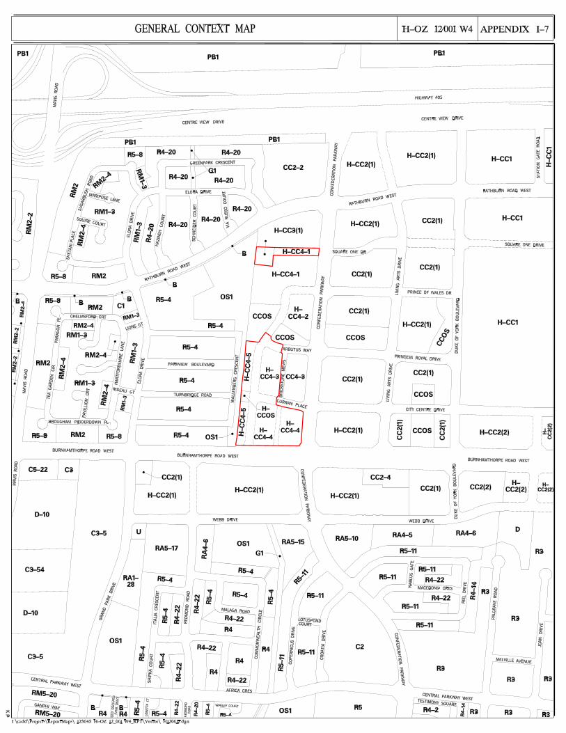
The subject lands consist of Phase 2 of the Amacon Parkside
Village Subdivision and future Square One Drive (a new road
proposed through Downtown21), comprising approximately
4.45 ha (11 ac.) located west of Confederation Parkway and north
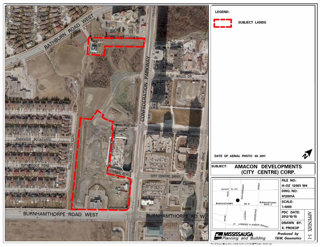
of Burnhamthorpe Road West. (See Appendices I-1 to I-3).
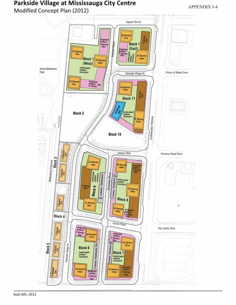
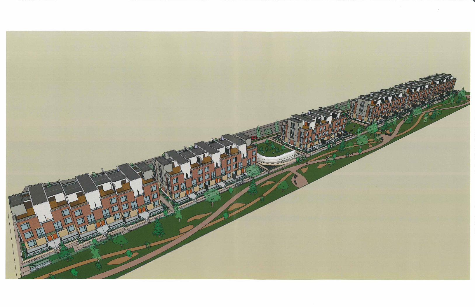
The Master Plan Concept for the entire Amacon Parkside Village
Subdivision, is shown in Appendix I-4.
The "H" holding symbol was already removed for Phase 1 of the
subdivision which included Block 8 (currently under construction),
Park Blocks 2 and 10, as well as those roads which surround
Block 8, including Curran Place, Brickstone Mews, and
Arbutus Way, under file H-OZ 06/008 W4 on March 31, 2010.
The Removal of the "H" Holding Provision application
(HOZ 12/001 W4) was submitted concurrently with the Site Plan
application for Blocks 3, 4, and 5 (SP 12/052 W4) on March 26,
2012. A Site Plan application was subsequently submitted for
Block 7 on April 23, 2012.
File: H-OZ 12/001 W4
Planning and Development Committee - 3 - September 25, 2012
The above-noted application has been circulated for technical
comments and once the Development and Servicing Agreements
under file T-M04001 Phase 2 have been approved, the
requirements for lifting of the "H" holding symbol will have
been met.
The purpose of this report is to provide Planning and Development
Committee with a summary of this proposed mixed use
development within the downtown prior to removal of the "H"
holding symbol.
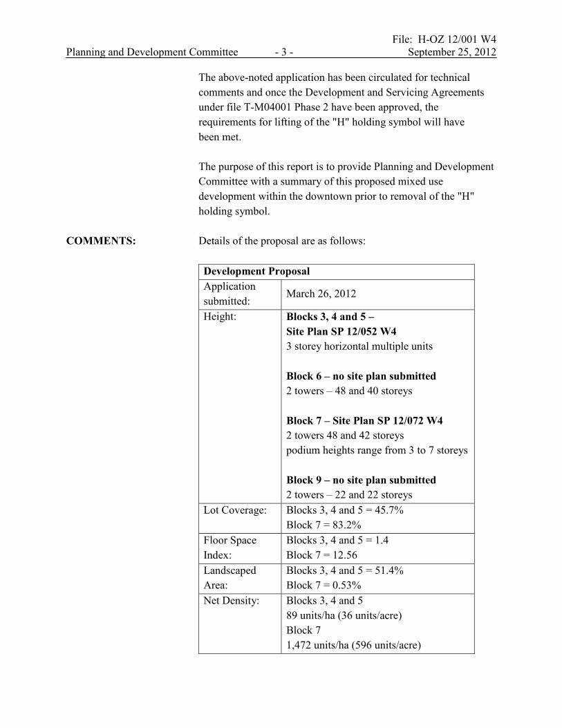
COMMENTS: Details of the proposal are as follows:
Development Proposal
Application
submitted: March 26, 2012
Height: Blocks 3, 4 and 5 –
Site Plan SP 12/052 W4
3 storey horizontal multiple units
Block 6 – no site plan submitted
2 towers – 48 and 40 storeys
Block 7 – Site Plan SP 12/072 W4
2 towers 48 and 42 storeys
podium heights range from 3 to 7 storeys
Block 9 – no site plan submitted
2 towers – 22 and 22 storeys
Lot Coverage: Blocks 3, 4 and 5 = 45.7%
Block 7 = 83.2%
Floor Space
Index:
Blocks 3, 4 and 5 = 1.4
Block 7 = 12.56
Landscaped
Area:
Blocks 3, 4 and 5 = 51.4%
Block 7 = 0.53%
Net Density: Blocks 3, 4 and 5
89 units/ha (36 units/acre)
Block 7
1,472 units/ha (596 units/acre)
File: H-OZ 12/001 W4
Planning and Development Committee - 4 - September 25, 2012
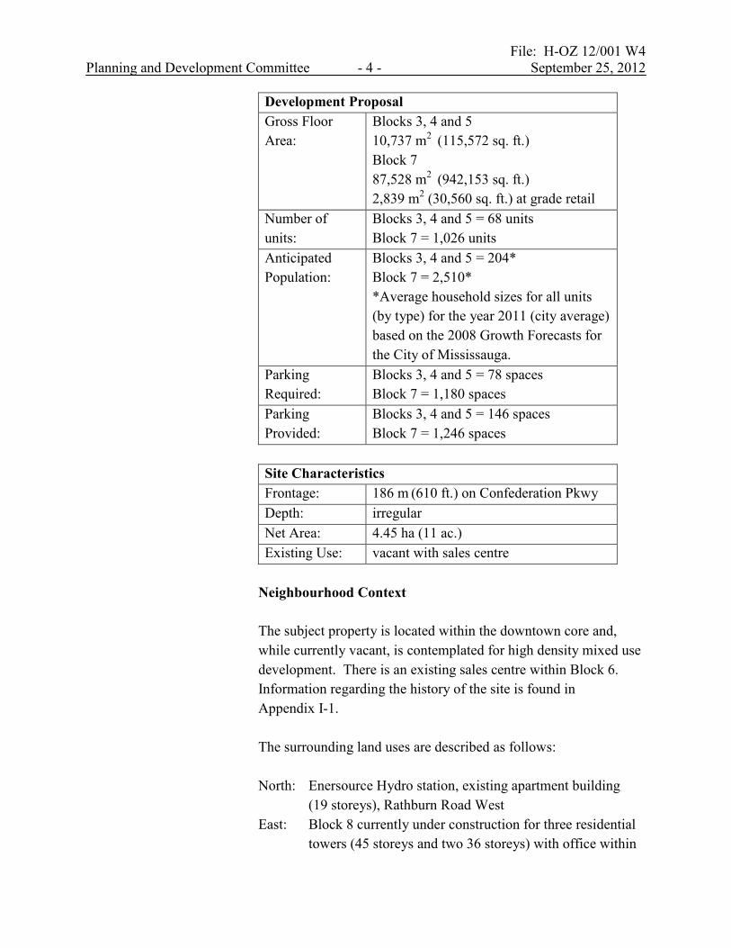
Development Proposal
Gross Floor
Area:
Blocks 3, 4 and 5
10,737 m2 (115,572 sq. ft.)
Block 7
87,528 m2 (942,153 sq. ft.)
2,839 m2 (30,560 sq. ft.) at grade retail
Number of
units:
Blocks 3, 4 and 5 = 68 units
Block 7 = 1,026 units
Anticipated
Population:
Blocks 3, 4 and 5 = 204*
Block 7 = 2,510*
*Average household sizes for all units
(by type) for the year 2011 (city average)
based on the 2008 Growth Forecasts for
the City of Mississauga.
Parking
Required:
Blocks 3, 4 and 5 = 78 spaces
Block 7 = 1,180 spaces
Parking
Provided:
Blocks 3, 4 and 5 = 146 spaces
Block 7 = 1,246 spaces
Site Characteristics
Frontage: 186 m (610 ft.) on Confederation Pkwy
Depth: irregular
Net Area: 4.45 ha (11 ac.)
Existing Use: vacant with sales centre
Neighbourhood Context
The subject property is located within the downtown core and,
while currently vacant, is contemplated for high density mixed use
development. There is an existing sales centre within Block 6.
Information regarding the history of the site is found in
Appendix I-1.
The surrounding land uses are described as follows:
North: Enersource Hydro station, existing apartment building
(19 storeys), Rathburn Road West
East: Block 8 currently under construction for three residential
towers (45 storeys and two 36 storeys) with office within
File: H-OZ 12/001 W4
Planning and Development Committee - 5 - September 25, 2012
the podium and at-grade retail, Confederation Parkway,
Chicago apartment building with at-grade retail
(36 storeys), One Park Tower apartment building
(38 storeys), Community Common Park, Amica
Retirement Dwelling (7 storeys), YMCA parking and
Daniels sales centre
South: Burnhamthorpe Road West, vacant future mixed use
development (Rogers Garden City)
West: Zonta Meadows Park, Wallenberg Crescent, detached
dwellings (2 storeys)
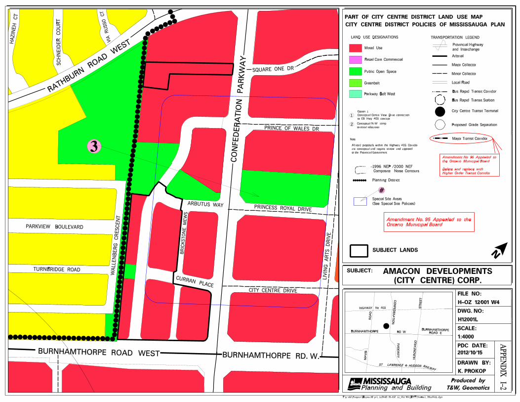
Current Mississauga Plan Designation and Policies for City
Centre (May 5, 2003)
"Mixed Use" which permits a wide range of land uses grouped
either within a development parcel or an individual building.
Permitted uses include all forms of high density residential
development, offices, civic and cultural facilities, hotels,
conference facilities, all types of restaurants, entertainment
facilities, commercial uses, community facilities and open space.
Special Site 3 requires one or more areas of public parkland.
"Public Open Space" which permits parks and related public
spaces which are urban in character and may accommodate
parking and a variety of programs such as music theatre events,
displays and exhibitions, festivals and other special events.
The application is in conformity with the land use designation and
no official plan amendments are proposed.
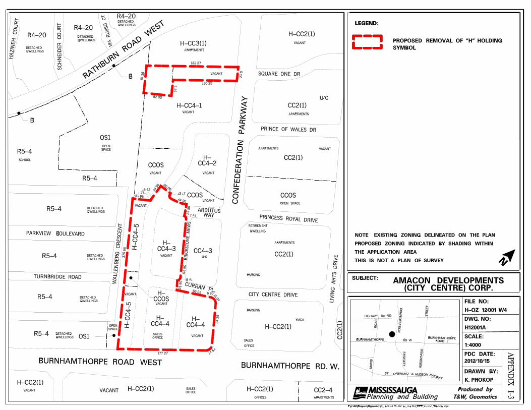
Existing Zoning
"H-CC4-1", "H-CC4-3", "H-CC4-4", and "H-CC4-5", (City
Centre Mixed Use), which permits a wide variety and mix of uses
including apartment dwellings, offices, restaurants, retail and
service commercial uses, entertainment establishments, hotels and
conference centres subject to specified development requirements.
File: H-OZ 12/001 W4
Planning and Development Committee - 6 - September 25, 2012
"H-CCOS" (City Centre Open Space), which permits active and
passive recreational uses and below grade parking structures.
COMMUNITY ISSUES
The Official Plan designation, Zoning and Subdivision have
previously been approved and are in place (OZ 04/013 W4 and
TM04001 W4 approved in 2005). The removal of the "H" holding
symbol is not a public process and only requires the delivery of
executed Servicing and Development Agreements in a form
satisfactory to the Corporation of the City of Mississauga,
addressing and agreeing to the installation of municipal works,
dedication of roads, parkland, and easements, and the provision of
required securities.
Public comment will be obtained for proposed revisions to the
Master Plan to accommodate Square One Drive through file
CD.21.AMA W4 for City initiated Amendments to the Official
Plan and Zoning By-law.
Site Plan
The site plan for Block 7 (SP 12/072 W4) proposes a 48 storey
tower at the southwest corner and a 42 storey tower at the northeast
corner with at grade retail/commercial uses along the
Burnhamthorpe Road West, Confederation Parkway and
Curran Place frontages. These 3 frontages of the building are
designed to be active faces with strong pedestrian connections with
all vehicular and service access provided solely from Brickstone
Mews, which is stratified with a municipally owned road at the
surface and private underground parking below. Green roofs are
proposed atop a 7 storey podium along Confederation Parkway and
a 5 storey podium at the northwest corner. A three storey podium
with roof top landscaped terrace at the fourth floor is proposed
along the west portion of the building (see Appendix I-6).
The site plan for Blocks 3, 4 and 5 (SP 12/052 W4) proposes 68
horizontal multiple dwelling units 3 storeys in height contained
within 6 blocks. The units are designed in a back-to-back format
File: H-OZ 12/001 W4
Planning and Development Committee - 7 - September 25, 2012
with frontages on both Parkside Village Drive and on the linear
park extending south from Zonta Meadows Park. There is a open
space block within Block 4 that, while privately owned, will have a
public open space easement to provide for through pedestrian
access from Curran Place and Parkside Village Drive to the linear
park and Wallenberg Crescent. Parking will be provided within an
underground garage.
FINANCIAL IMPACT: Not applicable.
CONCLUSION: The details regarding the proposed future development of Phase 2
of the Amacon Parkside Village Subdivision, west of
Confederation Parkway and north of Burnhamthorpe Road West,
have been outlined through this report in order to provide Planning
and Development Committee with information about the
development prior to seeking authorization to prepare the by-law
to remove the "H" holding provision.
ATTACHMENTS: Appendix I-1: Aerial Photograph
Appendix I-2: Excerpt of City Centre District Land Use Map
Appendix I-3: Excerpt of Existing Land Use Map
Appendix I-4: Revised Master Plan
Appendix I-5: Draft M-Plan – Phase 2 of Subdivision
Appendix I-6: Conceptual Renderings Block 3-5, and Block 7
Appendix I-7: General Context Map
Edward R. Sajecki
Commissioner of Planning and Building
Prepared By: Jonathan Famme, Development Planner
K:\PLAN\DEVCONTL\GROUP\WPDATA\PDC1\H-OZ 12.001 Info Status Report.hl.jf.so.doc
Sky Object
34 Storeys
24 Storeys
24 Storeys
proposed podium5 storeys
proposed podium5 storeys
landscaped podium courtyard
73m
Block 1 (West) 103m
73m
18m
18m
45 Storeys
20 Storeys
7 st
orey
s
proposed podium5 storeys
land
scap
ed
podi
um
cour
tyar
d
61m
Block 1 (East)
139m18m
25m
36 Storeys
36 Storeys proposed podium7 storeys
proposed podium5 storeys
3 st
orey
s - T
ownh
ouse
s
109m
109m
Block 8
25m
18m
45 Storeys136m
landscaped podium courtyard
12m
55 Storeys
40 Storeys
7 st
orey
s
154m
25m
124m
Block 11
landscaped podium courtyard
Block 2
Block 10
Bloc
k 9
3 St
orey
s12
m
12 S
tore
ys
40m
48 Storeys
42 Storeys
Block 7
proposed podium
7 storeys
proposed podium5 storeys
3 st
orey
s - T
ownh
ouse
s 127m
145m25m
18m
landscaped podium courtyard
12m
40 Storeys
48 Storeysproposed podium
5 storeys
proposed podium5 storeys
3 st
orey
s - T
ownh
ouse
s 12
m
145m
Block 6
121m18m
18m
landscaped podium courtyard
22 Storeys
22 Storeys
7 storeys
3 st
orey
s - T
ownh
ouse
s
70m
25m
70m
land
scap
ed
podi
um
cour
tyar
d
12m
3 St
orey
s12
m
3 St
orey
s12
m
3 St
orey
s
Block 4
12m
3 St
orey
sBl
ock
312
m
3 St
orey
s12
m
Bloc
k 5
Parkside Village at Mississauga City CentreModified Concept Plan (2012)
Sept.6th, 2012
Princess Royal DriveCo
nfed
erat
ion
Park
way
Zonta MeadowsPark
Wal
lenb
erg
Cres
cent
Prince of Wales Drive
Park
side
Mew
s
Square One Dr.
Parkside Village Dr.
Park
side
Villa
ge D
r.
Curran Place
Bric
ksto
ne M
ews
Arbutus Way
City Centre Drive
APPENDIX I-4

APPENDIX I-5
APPEN
DIXI-6,B
LOCKS3-5b

APPEN
DIXI-6,B
LOCK7a

APPEN
DIXI-6,B
LOCK7b