

DEPARTMENT OF THE INTERIOR
U.S. GEOLOGICAL SURVEY
THE ORPHAN LODE MINE, GRAND CANYON, ARIZONA A CASE HISTORY OF A MINERALIZED, COLLAPSE-BRECCIA PIPE
BY
WILLIAM L. CHENOWETH1
Open-File Report 86-510
This report is preliminary and has not been reviewed for conformity with U.S. Geological Survey editorial standards and stratigraphic nomencalture. (Any use of trade names is for descriptive purposes only and does not imply endorsement by the USGS.)
Grand Junction, Colorado

11
CONTENTS Page
ABSTRACT........................................... 1
INTRODUCTION....................................... 4
Previous work.................................. 7
Scope and purpose.............................. 7
Acknowledgements............................... 7
PRODUCTION HISTORY................................. 9
1893-1952, Early years......................... 10
1953-1957, Initial mining...................... 13
1958-1961, Development years................... 23
1962-1966, Productive years.................... 36
1967-1969, Final years......................... 40
Epilog......................................... 42
Production summary............................. 43
MINING METHODS..................................... 45
URANIUM GEOLOGY.................................... 48
The breccia pipe............................... 48
Ore deposits................................... 50
Mineralogy..................................... 58
Origin of the pipe............................. 68
Summary........................................ 71
REFERENCES CITED................................... 73a
APPENDIX........................................... 91

ILLUSTRATIONS iii
Page Figure 1. Index map of Arizona.......................... 5
2. Geologic section. Grand Canyon, Arizona....... 63. Oblique aerial photo of the Orphan claim...... 104. Index map of Orphan claim..................... 165. Cross section Orphan Lode Mine................ 216. Isometric drawing of Orphan Lode Mine,
December 1958.............................. 277. Uranium production, Orphan Lode............... 298. Plan map of mine workings adit level.......... 749. Plan map of mine workings 100 level........... 75
10. Plan map of mine workings 140 level........... 7411. Plan map of mine workings 175 level........... 7712. Plan map of mine workings 190 level........... 7813. Plan map of mine workings 225 level........... 7414. Plan map of mine workings 245 level........... 8015. Plan map of mine workings 265 level........... 8116. Plan map of mine workings 285-290 levels...... 8217. Plan map of mine workings 310-320 levels...... 8318. Plan map of mine workings 335-350-365 levels.. 8419. Plan map of mine workings 375-400 levels...... 8520. Plan map of mine workings 420 level........... 8621. Plan map of mine workings 430 level........... 8722. Plan map of mine workings 525 level........... 8823. Plan map of mine workings 550 level........... 8924. Plan map of mine workings 585 level........... 9025. Uranium grade distributions from ore shipments
and longhole drilling, B zone..................................... 52
26. Uranium grade distributions from ore shipments and longhole drilling, G Zone..................................... 53
27. Index map showing the location of Figure 28... 5528. Vertical cross section, annular ring, looking
northeast.................................. 5629. Map of 245 level showing production grades in
annular ring zone.......................... 5930. Color photo of mineralized fossil plant
material in the Esplanade Sandstone, 245 level near C Raise..................... 60
31. Map of annular ring zone on 310 level showing average uranium production grades, and referred ore blocks from longhole drilling. 65
32. Color photo of limonite stained fracture,annular ring, 365 level, note hammer forscale...................................... 67
33. Plat of Orphan claim.......................... A-534. Photo of the collapsed ore bin at the Orphan
Lode Mine, December 22, 1961............... A-735. Sample location 100 level..................... A-3136. Sample locations 175 level.................... A-3237. Sample location 225 level..................... A-3338. Sample location 245 level..................... A-3439. Sample locations 400 level.................... A-35

IV
Table Page
1. Uranium grades and thicknesses in cores frominitial drilling........................... 15
2. Uranium production by year.................... 173. Summary of exploration core holes with
alphabetic prefixes, Orphan Lode Mine...... 204. Vanadium, calcium carbonate, and copper
content of early shipments................. 245. Uranium production, Park Service ground....... 396. Comparison of production statistics........... 447. Analyses of a composite 350 Ib. sample from
the adit level, Orphan Lode Mine........... 628. Chemical analysis of composite ore samples,
representing monthly shipments, Orphan Lode Mine.................................. 63

THE ORPHAN LODE MINE, GRAND CANYON, ARIZONA, A CASE HISTORY OF A MINERALIZED COLLAPSE-BRECCIA PIPE
by William L. Chenoweth
ABSTRACT
The Orphan is a single, patented lode mining claim within
Grand Canyon National Park. The claim was located for copper in
1893, on the escarpment below Maricopa Point on the south rim.
Three short adits were driven in mineralized outcrops near the
north end line of the claim and a few sacks of copper ore were
reportedly brought out of the canyon. It was patented in 1906
before the surrounding area was protected by Federal law. Ura
nium was noted in the old workings by the USGS in 1951. The
claim was leased in 1953 for uranium exploration, and initial
drilling in the old adit (0 level) determined that the ore-bearing
structure was a pipe. On the basis of favorable geology and high
grade uranium values (greater than 1.00 percent U~08 ) pene
trated in a few drill holes, an aerial tram was constructed and
production from the Orphan Lode Mine commenced in April 1956.
Early ore production was about 1,000 tons-per-month averaging
1.00 percent U3 0Q .
Continued exploration indicated that ore continued downward
to at least the 400 level, and that a large ore body was present
off the claim within the National Park. A 1,500 foot deep shaft
from the rim of the canyon and a 1,200 foot crosscut to the 400
level of the pipe, completed in 1959, replaced the aerial tram,
and production from the Orphan Lode greatly increased.

Page 2
Public Law 87-457 , enacted in May 1962 , permitted underground
mining adjacent to the claim in the National Park f in exchange
for title to the Orphan claim in 25 years (1987) . Drilling from
within the mine located additional ore below the 400 level. When
mining ceased in 1969, mine workings and drilling had explored
the upper 585 feet of the pipe. During the period 1956-1969, the
Orphan Lode Mine produced 495 , 107 tons of ore averaging 0.42
percent uranium oxide f and containing 4.26 million pounds of
uranium oxide. In addition to the uranium, 6.68 million pounds
of copper, 107,000 ounces of silver and 3 f 400 pounds of vanadium
oxide were recovered from the ore.
Mining methods at the Orphan Lode varied depending on the
location of the ore bodies in and around the pipe f and how the
broken ore was transported from the mine to the rim.
The collapse-breccia pipe containing the Orphan Lode ore
deposit crops out on the south wall of the Grand Canyon near the
contact between the Coconino Sandstone and the Hermit Shale of
Permian age. It continues downward through the Supai Group of
Permian-Pennsylvanian age f and bottoms near the middle of the
Redwall Limestone of Mississippian age. The pipe is vertical and
nearly circular , varying in diameter from about 200 feet to over
500 feet, depending on the lithology of the surrounding sediments.
The Orphan* Lode breccia pipe has a minimum vertical extent of
I f 660 feet.
Ore bodies occurred in the breccia within the pipe f and in
the sedimentary rocks surrounding it (annular ring). Sand fill
sediments derived from both the Coconino and Esplanade Sandstones ,

Page 3
were important host rocks within the pipe. The majority of the
ore was produced from sandstone units of the Esplanade Sandstone
in the annular ring. Sandstones of the Wescogame Formation also
were ore-bearing in the annular ring lower part of the mine.
Uraninite is the dominant uranium mineral; chalcocite, chalcopy-
rite f tennantite, and galena are locally present, especially in
the annular ring. Pyrite is present throughout the pipe. Within
the annular ring, high grade uranium (greater than 1.00 percent
UoOo) and copper (greater than 1 percent Cu) seemed to be
zoned. A calcified zone surrounded the ore in the annular ring.
Oxidation in the form limonite staining is present throughout the
mine, especially in the annular ring. In the adit level, secon
dary yellow uranium minerals predominate.
A large amount of low grade material, averaging 0.02 percent
uranium oxide, is estimated to occur in the lower levels of the
pipe.

Page 4
INTRODUCTION
The Orphan is a single, patented, lode mining claim within
Grand Canyon National Park, about 2% miles west of Grand Canyon
Village, Coconino County, Arizona (Figure 1). The surface build
ings and headframe are only a few hundred yards from the West Rim
Drive, between Maricopa and Powell Points. The claim was patent
ed for copper in 1893, before the surrounding area was protected
by the National Park Service. It is described as Lot No. 2004,
embracing a portion of Section 14, T.31N.,R.2E. of the Gila and
Salt River Baseline and Meridian. Public Law 87-457 transfers
complete ownership of the claim to the Federal Government in
1987.
The ore-bearing structure on the claim is a circular, nearly
vertical, collapse-breccia pipe which penetrates the Permian and
Pennslyvanian strata of the Grand Canyon. The top of the pipe
crops out at the Coconino Sandstone-Hermit Shale contact; the
overlying strata having been removed by erosion. It seemingly
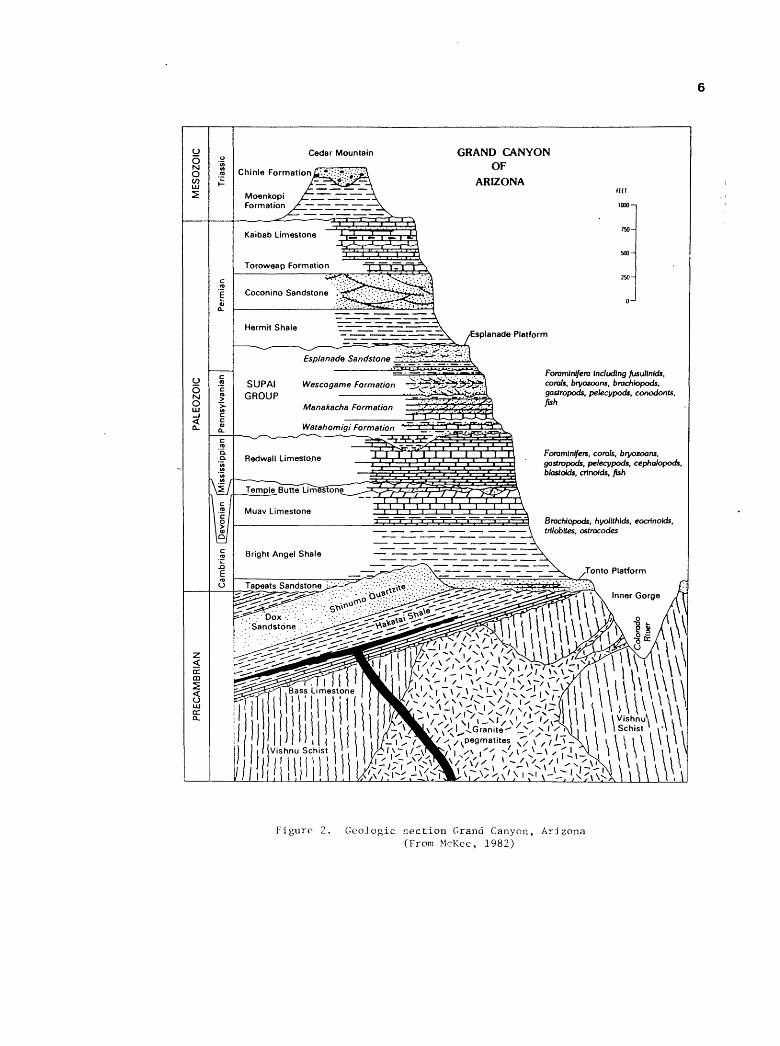
bottoms out in the Redwall Limestone (Figure 2) . The pipe has a
minimum vertical extent of 1,660 feet.
During the mid-1950's the Orphan Lode Mine was developed on
the claim and it soon became one of the leading uranium producers
on the Colorado Plateau. At depth, the ore extended off the claim
into the National Park. A special Act of Congress was necessary
to mine this ore.

ORPHAN LODE MINE TUBA CITY MILL
NTA I Yg I
:RUZ ! ^j* ____ I
IOO I
Scot*
Figure 1. Index map of Arizona showing location of Orphan Lode Mine
vo n
oo Q
JN
J 3
Cam
bria
n D
evon
ian
Mis
siss
ippi
an

Page 7
Previous Work
Considerable information has been published and/or open filed
on the geology of the Orphan Lode. These include reports by
Ashwill (1957) , Granger and Raup (1962) , Gornitz and Kerr (1970) ,
Kofford (1969) , Magleby (1961), and Scarborough (1981). Mining
activities have been described by the Mining World (1959) and the
U.S. Atomic Energy Commission (1959a f 1959b). Historical
summaries, glamorized for the lay reader, have been published by
Brundy (1977) and Dodge and McKlveen (1970).
Scope And Purpose
While I was a geologist with the U. S. Atomic Energy Commis
sion (AEC) , considerable time in the late 1950's and 1960's was
spent examining the Orphan Lode Mine for ore reserve calculations
and production capability studies. This report is a summary of
my observations during that time.
My field notes and internal AEC trip reports have been drawn
upon heavily to complete this summary.
Acknowledgements
Several organizations have been extremely helpful in locating
information on the Orphan Lode. The assistance of Larry D.
Fellows, and Robert B. Scarborough, Arizona Bureau of Geology and
Mineral Technology, Ken A. Phillips, Arizona Department of Mines
and Mineral Resources, W. A. Girdley, Ersel Reid, and Larry M.
Fukui, Bendix Field Engineering Corporation, and Merle E. Crew,
U.S. Department of Energy is gratefully acknowledged.
Discussions with Erik W. Bruner, Cotter Corporation, and
long time mine geologist at the Orphan Lode, were exceedingly helpful
in confirming my poorly recorded observations. A critical review
Page 8
of the manuscript by Karen J. Wenrich and Harry C. Granger great
ly improved it.
Financial support for this research project was supplied by
Karen J. Wenrich of the U.S. Geological Survey, with funds from
the Bureau of Indian Affairs for her project on breccia pipes of
northern Arizona.

Page 9
PRODUCTION HISTORY
The Orphan Lode Mine has had a long and interesting history. A
summary of the following narrative is given in the Appendix (page
A-l) .
1893 - 1952 Early Activities
Daniel L. Hogan began prospecting in the Grand Canyon about
1890. On February 8 r 1893 , he and his partner , Henry Ward r
located the Orphan claim between Powell and Maricopa Points on
the south rim of the Grand Canyon (Figure 3). The single claim
covered an outcrop of copper minerals that occurred some 1100
feet below the rim of the canyon. Thinking that the deposit
occurred as a vein, the claim was located with the outcrops near
the north end line; most of the claimed land extended to the
southwest r including a few acres on the rim.
Hogan and Ward built a crude trail consisting of ropes ,
ladders r and rock steps down the rim to the copper showings and
did a small amount of mining. Three short adits were driven into
the mineralized outcrops. A few sacks of copper ore were report
edly brought out of the canyon.
After serving as a Rough Rider in the Spanish-American War ,
Hogan returned to prospecting. Ward sold his interest in the
Orphan to Charles J. Babbitt, a northern Arizona merchant, who

Page 10
Figure 3 f Oblique aerial photo of the south rim of the Grand Canyon showing Maricopa Point (center) and Powell Point (right). The Orphan claim is located between the two points. Vertical cliff in lower part of photo is the Coconino Sandstone. Top of the Orphan Lode pipe is at the Coconino and underlying Hermit Shale contact. Zig-zag scar on canyon wall is a trail that was built during the installation of the aerial tram. Photo by George Hood (AEC).

Page 11
reportedly grubstaked Hogan. The Orphan claim was surveyed
(Mineral Survey No. 2004) on January 18-20, 1905 and was found to
contain 20.26 acres (see Figure 33, p. A-5). It was patented
(Patent No. 43506) on March 23, 1906 with C. J. Babbitt listed as
a coowner with Hogan (Brown, 1955). The patent was reportedly
signed by President Theodore Roosevelt, Hogan's old commandant
(Dodge and McKlveen, 1970) . Although the official name of the
claim was the Orphan, Hogan referred to it as the Orphan Lode,
and the Little Orphan Girl (Dodge and McKlveen, 1970).
On November 28, 1906, President Theodore Roosevelt signed a
bill proclaiming the Grand Canyon Game Reserve. To further
protect the area, President Roosevelt established the Grand
Canyon National Monument on January 11, 1908. The primary effect
of this legislation was to forbid prospecting and mining on all
lands in the Grand Canyon which were not already covered by valid
claims (Billingsley, 1974).
On February 16, 1919, President Woodrow Wilson proclaimed the
Grand Canyon as a National Park. Congress revised the boundaries
of Grand Canyon National Park in 1927. A new Grand Canyon National
Monument was established by President Herbert C. Hoover on December
22, 1932 (Billingsley, 1974).
Hogan acquired full interest in the claim on April 18, 1912
when C. J. Babbitt quit-claimed Hogan his interest (Brown, 1955).
Being unsuccessful in making a copper mine of the claim, Hogan
built a tourist lodge on the rim portion in 1935. This structure
was originally known as the Grand Canyon Trading Post, but would
later be called the Kachina Lodge and Grand Canyon Inn.

Page 12
Because it was located on privately-owned land within the
National Park, the lodge was considered a nuisance and eyesore by
the Park Service. All water for the facility had to be hauled in
from outside the park. Due to the lack of tourists during World
War II, and continuing problems with the Park Service, Hogan sold
his Orphan claim to Mrs. Bertha Madeleine Jacobs on August l f
1946 for $55,000 (Brown, 1955). On June 1, 1951, Jacobs sold the
surface rights to David and James Barrington for $125,000 (Brown,
1955) .
Early in 1951, amateur prospectors discovered anomalous
radioactivity on the rim of Grand Canyon, just east of the Grand
Canyon Inn (Kofford, 1969). The area of the discovery was near
the head of Hogan's old trail, and was where he had stockpiled
his copper ore. The existence of the radioactivity became known
to the employees of the Inn and to Mrs. Jacobs.
During the early 1950s, Harry C. Granger of the U. S Geolo
gical Survey (USGS) examined all of the known and reported occur
rences of uranium in Arizona and looked for other based on geo
logic evidence. At the urging of Charles Anderson, of the USGS,
Granger contacted Mrs. Jacobs of Prescott, Arizona, regarding a
copper prospect in the Grand Canyon. Copper deposits in sedimen
tary rocks were known to contain uranium at many localities on
the Colorado Plateau. Samples in Mrs. Jacobs' possession were
checked by Granger using his geiger counter but were found to be
so low in radioactivity that a special trip to the Grand Canyon
could not be justified (H.C. Granger, oral communication, 1985).
Interested in seeing a property in the Grand Canyon, Granger made

Page 13
a weekend trip to the canyon and examined the old Hogan workings
on April 22, 1951. His geiger counter readings and chemical
analysis of samples confirmed that outcrops at the portal of the
lower adit contained high-grade uranium (Grand Junction Office,
AEC and USGS, 1970, p. 110). Granger's initial observation was
that the ore occurred in a slump block of Coconino Sandstone in
the Hermit Shale (Granger, 1951).
After learning that the claim had high-grade uranium on
it, Mrs. Jacobs leased the mineral rights to a few small mining
companies. Lack of capital and inaccessability hindered develop
ment of the deposit for a few years.
1953 - 1957 Initial Mining
Through the efforts of Arthur R. Still, a consulting geolo
gist in Prescott, Arizona, Golden Crown Mining Company, a subsid
iary of Western Gold and Uranium, Inc., leased the mineral rights
to the Orphan on September 29, 1953. The lease carried a 10
percent royalty with an option to purchase the mineral rights
for $20,000 (Brown, 1955). A dispute with the surface owner was
resolved when Golden Crown completed the lease and option. In
1956, Golden Crown acquired complete ownership of the claim
including the Grand Canyon Inn.
In order to test the amenability of the ore at the Orphan
claim to conventional uranium milling circuits, Golden Crown
submitted a 350 pound sample to the AEC's Grand Junction Office
in the summer of 1954. This was a composite sample collected in
the old Hogan adit (see Figure 8). Analysis by the National Lead
Company's Raw Materials Development Laboratory at Winchester,

Page 14
Massachusetts indicated the sample contained 0.217 percent
U^Oo, 1.45 percent V9°5' 0-81 percent Cu, and 3.6 ounces
of silver per ton (Lynch and Viklund, 1956) . The sample was
found to be amenable to both acid or alkaline leaching.
Geologic mapping of the old Hogan adit commenced, and explor
ation diamond drilling began in October 1955. On December 14,
1955 Golden Crown issued a letter to its stockholders announcing
that a major uranium deposit had been located on the Orphan
claim. The deposit was purported to contain not less than 100,000
tons of ore or might contain as much as 300,000 tons averaging
0.45 percent U30g . The ore-bearing structure was stated to
be a pipe (see Appendix, p. A-6) .
On February 16, 1956 the company released the core analyses
from the first 14 holes (Table 1). On the basis of the drilling
results and favorable geology, construction of a three tower
aerial tram from the rim to the north end of the claim was begun
in March 1956 (Figure 4). The initial shipment of ore from the
Orphan Lode to the Atomic Energy Commission's (AEC) buying sta
tion near Tuba City, Arizona was made on April 25, 1956. This
shipment consisted of 20.89 tons of ore that averaged 0.53 per
cent U30g (Table 2) . This shipment, and all following ship
ments were identified to the AEC as the Orphan Lode Mine, hence
the name used in this report.

Page 15
TABLE 1
Uranium grades and thicknesses in cores from initial drilling. Orphan Lode, Coconino County, Arizona.
HOLE NO.
12345*67**89 & 1011121314
GRADE (%U3 0Q Depth or Thickness (Feet)0.3780.4640.2840.2331.1120.2241.0020.152
Creviced - not completed0.0870.0420.0430.051
11.011.517.530.021.531.553.03.0
217.0130.040.038.8
**
* In hole 5, 3.5 feet averaged 3.13%U3 0Q
In hole 7, 21.7 feet averaged 1.71%IL,0QJ O
Source: Golden Crown Mining Co. press release dated February 16, 1956.

16
MINERAL SURVEY 2004 PATENT NO. 43508
Figure Index map of Orphan claim

Page 17
TABLE 2
Uranium production, by year, Orphan Lode, Coconino County, Arizona
CALENDAR YEAR
1956 2nd Qtr1956 3rd Qtr1956 4th Qtr1957 1st Qtr1957 2nd Qtr1957 3rd Qtr1957 4th Qtr1958 1st Qtr1958 2nd Qtr1958 3rd Qtr1958 4th Qtr1959 1st Qtr1959 2nd Qtr1959 3rd Qtr1959 4th Qtr1960 1st Qtr1960 2nd Qtr1960 3rd Qtr1960 4th Qtr1961 1st Qtr1961 2nd Qtr1961 3rd Qtr1961 4th Qtr1962 1st Qtr1962 2nd Qtr1962 3rd Qtr1962 4th Qtr1963 1st Qtr1963 2nd Qtr1963 3rd Qtr1963 4th Qtr1964 1st Qtr1964 2nd Qtr .,1964 2nd Half119651966196719681969
TOTALS
TONS OP ORE
20.89771.46874.09
1,737.441,680.172,084.532,013.832,336.223,422.633,082.523,004.703,990.745,012.935,663.55
11,570.7314,675.3221,180.3820,393.9121,651.8121,890.0816,888.9617,011.3014,499.03
169.28--
4,988.1615,053.1114,193.7512,806.9314,709.6814,818.8015,787.7533,387.6980,492.6432,620.493,554.90
43,147.4613,918.77
495,106.63
POUNDS U3 0Q
221.417,116.447,702.33
47,328.3437,714.7734,376.5133,496.3844,419.5571,860.5166,899.6293,078.0665,737.9878,561.8264,125.1185,814.40
105,714.18152,145.98115,030.42101,044.37125,543.54107,215.5791,542.9374,397.32
710.97--
45,413.88158,993.67141,602.99143,440.49169,032.53163,742.86130,875.28297,431.15680,746.08268,697.6725,586.00
321,173.8299,036.54
4,257,571.47
%u3 o80.530.460.441.361.120.820.830.951.051.081.550.820.780.570.370.360.360.280.230.290.320.270.260.21--
0.460.530.500.560.570.550.410.450.420.410.360.370.360.43
- Production by quarters not available after July 1, 1964
Source: U. S. Atomic Energy Commission files, Grand Junction Office

Page 18
The Rare Metals Corporation of America, which had proven
reserves in the Cameron, Arizona area, began construction of a
uranium processing mill 6 miles northeast of Tuba City, Arizona
in late 1955. While the mill was under construction, the AEC
opened an ore buying station at the millsite. The mill began
operating in June 1956 and the buying station was closed in July
1956. Ores from the buying station were purchased and processed
by Rare Metals (Albrethsen and McGinley, 1982) . The mill had a
capacity of 300 tons-per-day, and used a sulfuric acid leaching
process to extract the uranium. Ores containing more than 6
percent lime (CaCO-) were penalized, due to excessive acid
consumption. Uranium concentrates produced by Rare Metals were
sold to the AEC under Contract No. AT(05-1)293. Ores from inde
pendent producers, including the Orphan Lode, were purchased by
Rare Metals under the terms of the AEC's Circular 5, Revised.
Ore from the Orphan Lode was trucked to Tuba City a distance
of 92 miles. The Park Service charged Golden Crown a fee of
$0.02 per-ton-mile for use of roads within the National Park.
On May 24, 1956, the AEC announced the establishment of a new
domestic uranium procurement program for the period April 1,
1962, through December 31, 1966. The new program guaranteed a
Government market for 500 tons of U0 00 in concentrate (yellow-o o
cake) per year from any one mining property or operation at a
flat price of $8 per pound. Thus, in 1956, the stage was set for
a continuing AEC concentrate procurement program after March 31,
1962, with an established price for concentrates rather than for
ores. The prices, premiums, and allowance paid under Circular 5,

Page 19
Revised/ would no longer be in effect. After March 31, 1962,
the AEC required that the mill operator pay "reasonable" prices
to independent producers.
The original aerial tram proved ineffective and was removed.
A Riblet tram was completed in May 1-956 at a cost of $61,800
(Mining World, 1959) . The tram was 1,800 feet long, using an
endless steel rope supported on eight towers, and descended 1,100
feet at slopes of 37° and 57°. Two tram buckets, each with a
capacity of eight cubic-feet, operated in tandem and required
four minutes for the trip. All mine personnel and equipment were
taken to and from the mine via the tram buckets. Sustained
production using the new aerial tram commenced in August 1956.
When operating smoothly it could move 45 tons of ore per day to
the rim.
A new adit was driven parallel to the Hogan adit, and a two
compartment, vertical exploration winze was started about 90 feet
from the portal in September 1956 (see Figure 8). By March 1957,
the winze had reached a depth of 175 feet (the 175 level) . At
the Orphan, mine levels refer to the depth below the adit level
(Figure 5).
Exploration drilling during 1956 and 1957 from the 100 and
175 levels continued to locate ore on the north side of the pipe
as well as within the pipe. This drilling was known as the A, B,
D, E and F series of diamond drill holes. Total footage was
about 4,000 feet in 25 holes (Table 3). The high grade ore on
the north perimeter of the pipe was named the A zone and the
lower grade ore in the pipe was called the B zone by company

TABLE 3
Summary
of exploratio
n core ho
les
with
alphabetic prefixes/
Orphan Lo
de Mi
ne
NO. OF
LOCATION
YEAR(S)
PREFIX
HOLES
________
DRILLED
RESULTS
A, B,
D, E, F
25
100
& 17
5 le
vels
19
56-5
7 Located
ore
in up
per
part
of pi
pe
(A &
B Zo
nes)
.
G 10
Two
stations in Park
1958
Defined the
diam
eter
of th
e pi
pe an
d located
ore
in an
nula
r ring an
d within lo
wer
part
of
pipe
(G Zo
ne).
H 10
175
leve
l 19
58-5
9 Located
ore
in annular
ring.
J 63
24
5 le
vel
1959-61
Located
ore
in annular
ring.
K 30
400
leve
l 19
59-6
1 Lo
cate
d ore
in annular
ring.
L 11
32
0 le
vel
1959
-61
Located or
e in
annular
ring,
and
within pipe.
M 48
310
level
1960
Loca
ted
ore
within pi
pe an
d in an
nula
r ring.
N 64
350
leve
l 1960
Located
ore
within pi
pe and
in an
nula
r ring.
P 13
55
0 le
vel
1961
-62
Explored lo
wer
part
of pi
pe,
incl
udin
gRedwall
Ls.
and
olde
r sediments.
R 4
Adit le
vel
1961
Explored pi
pe on,
and
abov
e, adit le
vel.
Maps showing
the
loca
tion
of these
core ho
les
are
not
avai
labl
e.
iQ n> to o
21
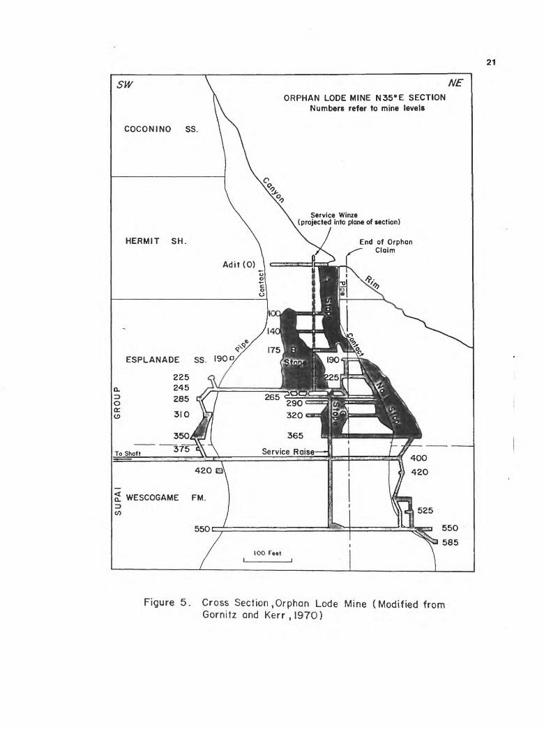
ORPHAN LODE MINE N35°E SECTION Numbers refer to mine levels
COCONINO SS
Service Winze (projected into plane of section)
HERMIT SH. End of Orphan Claim
ESPLANADE SS.
365
Service Raise
2! WESCOGAME FM.^ co
550
Figure 5. Cross Section .Orphan Lode Mine (Modified from Gornitz and Kerr,l970)
Page 22
engineers and geologists (Figure 5) . The initial mining at the
Orphan concentrated on the A zone which consisted of Coconino
sand fill which was cemented by uraninite. Production in 1956
totaled 1,666 tons of ore averaging 0.45% U3 0Q (Table 2).
In July 1957, Western Gold and Uranium, Inc. acquired full
control of Golden Crown Mining Company and became the operator of
the Orphan Lode Mine. Also during 1957, the service winze at the
Orphan was deepened from the 175 level to the 245 level. Drilling
from within the mine intercepted ore grade material as deep as
the 400 level within the pipe. Drilling also indicated that the
ore body on the northside of the pipe in the upper levels of the
mine plunged to the north and went off the claim into the National
Park.
Since there was no room on the claim to dump waste near the
adit, and since the Park Service prohibited any activity off the
claim, all waste from development had to be disposed of under
ground. This was done by backfilling stopes and other mined out
areas. Production during 1957 was 152,916 pounds U3 0Q in
7,515 tons of ore which averaged 1.02 percent U3 0g (Table 2) .
The lime content of the ore on the 175 levels was becoming a
problem and reached as high as 14.00 percent CaC03 for a three
month period in the summer of 1957 (Table 4).
Shipments for January 1957 totalled 726 tons averaging 2.29
percent U3 0g , the highest monthly grade ever achieved by the
Orphan Lode. C.M. Brundy (1977), a former employee of Western
Gold and Uranium, noted that the highest single shipment from the
mine, averaged 4.09 percent U3 0g .

Page 23
1958 - 1961 Development Years
Nineteen-fifty-eight was a very important year in the history
of the Orphan Lode. The developments in this, and the following
years, would have a great impact on the future of the mine.
In April 1958, Western Gold and Uranium obtained Special Use
Permit No. GRCA-5-58 to establish two surface drill stations
north of the claim in the National Park. From these two stations
the G series of core holes were drilled in a southerly direction
into the pipe. Ten holes with a total footage of 6,175 feet were
drilled between July and October, by Boyles Brothers, a drilling
contractor (Table 2) .
This drilling was highly significant as it indicated: 1) the
pipe increased in diameter at the Hermit - Supai contact, near
the 175 level, 2) a large ore body was present on the north side
of the pipe, off of the Orphan claim, 3) ore was present on the
south side of the pipe, and 4) ore in the pipe extended below the
245 level.
At the same time as the G series were being drilled from the
surface, a long and short hole percussion drilling program was in
progress underground to outline the low grade hole of ore surround
ing the high grade ore bodies on the 140, 175, and 245 levels.
In May 1958, a contractor, Centennial Development Company,
began sinking a 2% compartment shaft from the rim of the canyon
(Figure 4). A 1,200 foot crosscut from the shaft was planned to
intersect the pipe at the 400 level. The shaft was completed to
a depth of 1,590 feet in January 1959, with a station cut at
1,502 feet. The reported cost of the new shaft was about $800,000

Page 24
TABLE 4
Vanadium, calcium carbonate and copper content of early uranium shipments. Orphan Lode, Coconino County, Arizona.
Calendar Year Tons of Ore Mill %u3 0g %vo°5
195619561956195719571957195719581958195819581958195819581958
2nd Qtr 3rd Qtr 4th Qtr 1st Qtr 2nd Qtr 3rd Qtr 4th Qtr 1st Qtr 2nd Qtr 3rd Qtr 3rd Qtr 4th Qtr 4th Qtr 4th Qtr 4th Qtr
21111874
1,7361,6802,0852,0142,3363,4231,1281,9551.995
9363440
TC TC RM RM RM RM RM RM RM RM VM RM TZ VM KM
0.530.460.441.361.120.820.830.95
0526
0.991.491.720.591.49
%CaCOo %Cu
.01
.03
.02
.01
.02
.02
.01
.01--
0.300.800.701.81
11.1114.0012.901.472.563.43
4.262.81 0.17
TC - AEC, RM - Rare Metals, VM - Vitro Corp., TZ Minerals, KM - Kermac Nuclear Fuels
- Texas Zinc
Source: U. S. Atomic Energy Commission files, Grand Junction Office

Page 25
which was paid for in cash from profits made on the mined ore
(Mining World, 1959).
The crosscut from the shaft station to the 400 level of the
pipe was started on March 20, 1959. It was completed to the end
line of the claim in August 1959.
All waste from the shaft and crosscut had to be hauled to a
dump site the company had leased from the Forest Service near Rowes
Well. A fee of $0.02 per ton mile was charged to use Park roads,
the same as the ore trucks. However, considerable quantities of
the waste was purchased by the Park Service for road ballast.
Production goals for 1958 were set at 1,000 tons per month of
ore averaging 1.00 percent U3 0Q (20,000 pounds U3 0Q ), in
order to pay for the new shaft. The high grade ore was being
mined from the A zone and the 1,000 tons-per-month was the capa
city of the aerial tram. In June 1958, Rare Metals limited the
Orphan Lode to 16,950 pounds of U3 0Q per month that would be
accepted at the Tuba City mill. With this limitation, Western
Gold sought markets at other mills. Shipments were made to the
Vitro Corporation at Salt Lake City, Utah, Texas-Zinc Minerals at
Mexican Hat, Utah, and Kermac Nuclear Fuels at Ambrosia Lake, New
Mexico (Table 4) . The Texas-Zinc mill at Mexican Hat, had a
sulfide flotation circuit which recovered copper (Albrethsen and
McGinley, 1982). The production limitation at Tuba City was
increased to 18,000 pounds U3 0Q per month in November 1958.
In December, 1958, Western Gold obtained another special use
permit from the Park Service to build 2.5 miles of new road in
the Park. The new road would provide access to railroad siding

Page 26
on the Atchison Topeka and Santa Fe Railway right-of-way within
the Park. Here, a loading ramp was built in order to make ship
ments to mills in New Mexico.
Drilling of the H series of core holes on the 175 level began
in December 1958 (Table 3). By the end of the year, drilling had
indicated: 1) ore within the pipe was restricted to above the
375 level, with the higher grade occurring above the 245 level (B
zone), 2) at the 310-350 level, ore was believed to be continuous
around the perimeter of the pipe, which at these levels had a
diameter of approximately 450 feet. Hence, a concept of annular
ring ore bodies was developed. Further drilling would discover
only ore in the lower levels of the pipe in the annular ring. A
sketch of the mine working as of the end of 1958 is shown in
Figure 6.

27
Drawing by M.G. Kafford Western Gold and Uranium Inc.
Scale- Feet
Figure 6. Isometric drawing of Orphan Lode Mine, December 1958

Page 28
Production in 1958 totalled 11,846 tons averaging 1.17 percent
UoOg and containing 276,258 pounds U3°o/ a sharp increase
over 1957 (Table 2, Figure 7). M.E. Kofford (personal communica
tion, 1959) reported that lime penalties through 1958 had totalled
$20,307.51.
The dramatic increase in uranium ore reserves occurring
throughout the United States during 1957 and 1958 was of concern
to the AEC. On November 24, 1958, in order to prevent further
expansion of production under its essentially unlimited purchase
commitment, the AEC redefined its 1962-1966 procurement program
by withdrawing portions of the program announced in May 1956.
The Government stated it would buy, in the 1962-1966 period, only
"appropriate quantities of concentrate derived from ore reserves
developed prior to November 24, 1958, in reliance upon the May
24, 1956, announcement." Other aspects of the program announced
in 1956 were retained: The AEC would buy only concentrates; the
U-Og price would remain at $8 per pound; and ores would not
be purchased nor ore prices guaranteed. Independent producers
had to negotiate ore purchase contracts with milling companies in
order to sell their ores.
In the negotiations that followed this announcement, the AEC
would recognize only the ore that had been developed on the claim
to be eligible for a market quota (allocation) . The ore that
Western Gold and Uranium had developed in the Park was consid
ered, by the AEC, to be property of the U. S. Government.

29
700,000
V) TJc
I
JOSo 350,000
150,000
100,000
50,000
Calendar Year
Figure 7. Uranium production Orphan Lode Mine, Coconino County, Arizona

Page 30
Western Gold and Uranium calculated their "indicated, inferred
and, possible reserves" for the Orphan Lode as 1,543,000 tons
averaging 0.42 percent U3 0Q (personal communication, Kofford
M. G., 1959). Official AEC reserves for November 24, 1958, were
296,000 tons of indicated and referred reserves averaging 0.38
percent U-^Og on the claim, and 228,000 tons averaging 0.51
percent U^Og indicated and inferred reserves on Park ground.
Without the Park reserves available to them, the future of Western
Gold's Orphan Lode was in doubt.
Western Gold sought to obtain the Park reserves using extra-
lateral rights. Under the apex law, ore can be legally mined
downdip on a lode even if it passes beyond the vertical plane of
the side line of a claim. This is not permissable, however,
across an end line. Western Gold faced a long and costly legal
battle to establish that in the case of the Orphan Lode breccia
pipe, the end lines of the claim were actually the side lines.
Instead, it sought to negotiate with the Park Service for the
ore.
During 1959, development work at the Orphan continued in
preparation of starting production through the new crosscut and
shaft. On the 245 level, a crosscut was driven from the service
winze to the south perimeter of the pipe. Once the annular ring
ore was reached, it was explored by drifts. The crosscut from
the shaft reached the end line of the claim on the 400 level in
August. Drifts were also driven in the annular ring zone on that
level.

Page 31
A service raise from the 400 level to the 245 level was
completed in July, 1959. Other raises from the 400 level to the
245 level were completed in the annular ring zone on the southern
perimeter of the pipe. These raises were then used as ore passes
to bring ore from the upper levels of the mine to the 400 level
where it was trammed to the ore pocket at the shaft and then
hoisted to the surface.
Drilling of the H series of core holes on the 175 level
resumed and J, K, and L series of holes commenced on the 245,
400, and 320 levels, respectively (Table 3). During the summer
of 1959, the AEC made a study of the lime content of the Orphan
Lode ore reserves. The study used shipping records, mine samples,
and core assays. It concluded that the remaining reserves in the
A, B, and G zones averaged below 6 percent CaCO^, those in the
annular ring on the claim averaged between 30 and 36 percent
CaCO^, and the reserves in the annular ring in the Park averaged
approximately 25 percent CaCX>3 .
Production via the new shaft began in October 1959, giving
the Orphan Lode the capability to hoist 8,000 tons-per-month
instead of the 1,000 tons-per-month over the aerial tram. Use of
the aerial tram to hoist ore was discontinued once the shaft
became operational. In its 1959 report to the stockholders,
Western Gold and Uranium reported that it had invested $1.2
million dollars in the new developments to transform the Orphan
Lode into a full-fledged mining operation.
With mining operation expanding, Western Gold acquired a site
outside the National Park, near the settlement of Tusayan on U.S.

Page 32
Highway 180, to build a mobile home park for its employees. This
park would be known as Western Village.
In July 1959, Western Gold signed an ore purchase agreement
with Rare Metals, that the Tuba City mill would purchase 8,300
tons-per-month of Orphan Lode ore averaging 0.30 percent Uo08
until the spring of 1962. Western Gold also had an ore purchase
agreement with Phillips Petroleum Company to ship 500 tons-per-
month to their mill at Ambrosia Lake, New Mexico. The Phillips
mill had an alkaline leaching circuit and could treat high lime
ores with little difficulty.
Production in 1959 was 26,124 tons of ore averaging 0.56
percent UoOg and containing 291,841 pounds of U3 0Q (Table
4, Figure 7). Although the tons of ore more than doubled, the
contained pounds of uranium oxide only slightly increased over
1958 since the average grade dropped over 50 percent.
In February, 1960, Arizona Senators Hayden and Goldwater
introduced Senate Bill S-3094 which would give Western Gold the
right to mine the ore in the Park adjacent to the Orphan claim in
exchange for the Government acquiring complete title to the claim
in 35 years. The AEC approved the bill which would keep north-
central Arizona's uranium industry viable for at least six more
years.
In anticipation of the passage of the bill, and receiving a
satisfactory allocation from the AEC, Western Gold and Uranium
and Rare Metals Corporation of America entered into an agreement
that Rare Metals would install an alkaline leaching circuit at
Tuba City to treat all ore mined at the Orphan Lode through 1966.
The Orphan bill got, however, very little attention by Congress.

Page 33
During I960, exploration drilling of the J and K series of
core holes resumed on the 245 and 400 levels respectively. The M
and N series of short core holes, in fan patterns, were begun on
the 310 and 350 levels respectively (Table 3) . The first and
only fatality at the Orphan occurred on November 5, 1960 when a
skiptender was struck by a descending cage at the main station.
Sinking of an exploration winze from the 400 level to the 550
level began in November, 1960. Progress on the winze was very
slow due to heavy ground within the pipe.
Production during 1960 was 77,901 tons of ore containing
473,935 pounds of ^^ Q8 and averaging 0.30 percent V$OQ
(Table 2, Figure 7) . The sharp increase over the previous year
was due to the fact that all ore was hoisted through the new
shaft and development raises had been completed throughout the
lower levels of the mine. During July, the mine set an all time
record to date, when 7,733 tons were shipped.
During 1960, shipments of high-lime ore (20 to 30 percent
CaCO,) to the Phillips mill in New Mexico increased to 1,000
tons-per-month. Low-lime material from the B and G zones was
blended with annular ring ore in order to decrease the overall
lime content of the ore shipped to Rare Metals, which still
averaged about 12 percent CaC03 . The company reported that
lime penalties during 1960 averaged $3.16 per ton (personal
communication, Kofford, M. G., 1961) .
The Orphan bill was reintroduced in Congress in January 1961
as S-383. The earlier bill had died from lack of action in the
previous session of Congress. In a move that was called political

Page 34
blackmail by some Congressmen, Western Gold released an artists
sketch of a luxury resort hotel it planned to build on the claim
if the bill was not passed. The 800 room resort would stairstep
down the rim of the canyon with a mammoth swimming pool at the
bottom. Nevertheless, the proposed plan did alert Congress to
the Orphan bill.
The exploration winze from the 400 level to the 550 level was
completed, and drilling of the P series of core holes commenced
for a station of the 550 level in February (Table 3) . Thirteen
holes were drilled in this series, including P-13, a 1,914 foot
deep, vertical hole which bottomed in the Tapeats Sandstone.
This hole which began in April, 1961, was completed May 10, 1962
at a reported cost of $50,000.
The R series of holes was drilled in the adit level and a new
adit was started 150 feet above the original adit to develop ore
in the uppermost parts of the pipe (Table 3) . Results of this
work were largely disappointing, but the drilling did confirm
that the pipe, at this level, was more circular than originally
thought.
In May, 1961, surface runoff, from heavy rains, entered the
adit and flooded the mine. All activity above the 245 level had
to cease for several days and when the flooding was all over,
there was about a foot of water on the 400 level.
The production goals for the Orphan Lode during 1961 were set
at 6,000 tons-per-month averaging 0.28 percent U3 0g, all of
the ore being marketed at Rare Metals mill. Blending of the
lower grade, low-lime material from within the pipe with the

Page 35
higher grade, high-lime annular ring zone continued. In spite of
this, the lime content of the April shipment reached an all time
record of 20.99 percent CaC03 . By late summer 1961, the B zone
was essentially mined out and the production grade from the G
zone was averaging a dissappointing 0.21 percent U3 0g . The
need to acquire the ore in the Park was essential to continue
mining at the Orphan Lode.
During August, 1961, the Orphan claim was resurveyed. The
original corners Nos. 3 and 4 were located and a small error in
the original tie from Corner No. 1 to the southwest section
corner of Section 14 was found. As the result of this modern
survey, the claim was found to contain 20.64 acres, instead of
the 20.26 acres listed on the original patent (see Figure 33, p.
A-5) .
Western Gold and Uranium, Inc. was acquired by Lee Ackerman
of Scottsdale, Arizona through a stock exchange. Ackerman became
President of Western Gold and Uranium on September 6, 1961 and
changed the name of the company to Western Equities, Inc. in
November.
On December 22, 1961, the ore bin on the headframe of Orphan
Lode shaft collapsed sending several hundred tons of ore down the
shaft (see Figure 34, p. A-7) . There were no injuries and the
miners were evacuated via the aerial tram. Damage to the head-
frame and shaft were estimated to be between $25,000 and $30,000.
The collapse was attributed to a design error of the bin. Mining
ceased on December 23, 1961 while the damage was to be repaired.
Production during 1961 was 70,289 tons of ore averaging 0.28 percent

Page 36
U3 0Q and containing 398,699 pounds U3 0Q (Table 2, Figure
7) .
1962 - 1966 Productive Years
Shipments to the Tuba City mill ceased in January 1962, when
the surface stockpile at the Orphan Lode was depleted. The mill
closed in May 1962 for lack of ore.
On May 28, 1962, President John Kennedy signed into law,
Public Law 87-457, which permitted Western Equities, Inc. to mine
uranium ore in Grand Canyon National Park, adjacent to the Orphan
claim, in exchange for title to the claim in 25 years (1987) .
The law specified that all mining would be underground and that
the tram would be dismantled by 1964. The Federal Government
would receive a royalty ranging from 5 to 10 percent on the ore
produced. Also, after 1966 only 3 acres in the southeast corner
of the claim would be retained for mining. Thus, the Grand
Canyon Inn and related cabins would belong to the Park Service in
1967.
With the ore on the Park ground now available for Western
Equities to mine, the AEC negotiated a new contract with El Paso
Natural Gas Company, which had acquired Rare Metals by merger in
July 1962 (Albrethsen and McGinley, 1982). A new contract,
AT(05-1)-910, was signed on November 19, 1962 and was effective
from September 10, 1962 through December 31, 1966 (Albrethsen and
McGinley, 1982) . Once a new contract was signed, modification of
the existing mill to an alkaline leach circuit, using sodium
bicarbonate, proceeded rapidly. A flotation circuit was added to
remove sulfides which are carbonate consumers. The AEC granted

Page 37
Western Equities an allocation of 572,766 pounds of U3 08 per
year under the November 24, 1958 announcement.
On November 20, 1962, mining resumed at the Orphan Lode, with
the ore being stockpiled at the Tuba City millsite. Crosscuts to
the annular ring deposits were driven on the 245, 265, 290, 320
and 350 levels to test the ore in the Park. The drift on the 550
level was continued northeastly into the Park. Development of
the remaining high lime ore in the annular ring on the claim also
commenced. When mining resumed, all ore hoisted up the shaft was
stockpiled on the ground, and the use of an ore bin was discon
tinued.
In April 1963, the Tuba City mill began processing stockpiled
Orphan Lode ore. The sulfide flotation concentrate contained
sufficient sulfide copper to be marketable at a copper smelter.
A small amount of silver was also present in the concentrate. In
addition, a small amount of copper solubilized with the uranium,
was recovered, using powdered iron, as cement copper in the
ion-exchange circuit. Both products were shipped by truck to a
smelter at Inspiration, Arizona (Albrethsen and McGinley, 1982).
Details of the Tuba City milling circuits are given in a report
by Runke (1964) .
In the fall of 1963 an incline was driven from the 550 level
to the 585 level of the annular ring on the northeastern peri
meter of the pipe. This was the lowest level of the deposit to
be developed and mined.
During 1963, the Orphan Lode produced 614,858 pounds of
U3°8 ( Table 2) . Of this total, approximately 47 percent came

Page 38
from ore mined on Park ground (Table 5) . This would be the
second highest yearly production for the mine (Figure 7).
In 1964, a small ore zone on the 375 level of the annular
ring on both the claim and Park was developed. The zone was not
very productive although it existed almost entirely around the
pipe.
Production in 1964 was slightly lower than the previous year,
and some 592,047 pounds of UoOg were produced (Table 2) . El
Paso reported to the AEC that in 1964 the Orphan Lode ore averaged
about 1.30 percent Cu and that 75 percent of the total copper or
90 percent of the sulfide copper was recovered. The sulfide
concentrate averaged 20 percent Cu and 10 ounces of silver per
ton (Albrethsen and McGinley, 1982) . No other data on copper or
silver production were made available to the AEC by El Paso.
Production from the Orphan Lode reached an all time yearly
high in 1965 when some 680,746 pounds of U3 0g were produced
(Table 2) . Of the total pounds uranium oxide U3 0g, some 75
percent came from the National Park (Figure 7) . Ore in the
annular ring on the northern side of the pipe, within the Park,
proved to be nearly continuous from the 225 to the 365 level.
Here, the large No. 1 Stope was developed in bleached, brecciated,
and unbrecciated Esplanade Sandstone (Figure 5).
In the early part of 1966, Western Equities Inc. was sold to
Geo Space Corporation which was merged into Westec Corporation of
Houston, Texas. On August 25, 1966, Westec 1 s stock was suspended
from trading on the American Stock Exchange. Westec declared
bankruptcy and the Orphan Lode closed again. With its principal

Page 39
TABLE 5
Uranium production from the Orphan Lode reported to the U. S. Atomic Energy Commission as coming from National Park Service ground.
CALENDAR YEAR TONS OF ORE POUNDS O,0rt %O,Ort
1963196419651966196719681969
23,022.6124,005.3851,687.1511,886.42
-23,052.19
-
287,143.02259,513.79511,768.65155,458.95
-162,730.63
-
0.620.540.500.65
-0.35
-
TOTALS 133,653.75 1,376,615.13 0.52
Source: U. S. Atomic Energy Commission files, Grand Junction Office

Page 40
supply of ore down, El Paso's mill at Tuba City closed in Sep
tember 1966 , three months before its AEC contract was due to
expire. The last concentrate from the mill was delivered to the
AEC in November 1966 (Albrethsen and McGinley, 1982) .
Production in 1966 was 32,620 tons of ore containing 268,698
pounds Uo0g and averaging 0.41 percent U3 0Q (Table 2) .
Nearly 60 percent of the uranium oxide came from the Park ground
(Figure 7).
1967 - 1969 Final Years
On August 31, 1967, Westec asked permission from the U.S.
District Court in Houston, Texas to sell the Orphan claim and
related properties to the Cotter Corporation of Roswell, New
Mexico and Canon City, Colorado.
During 1967, the Cotter Corporation enlarged its mill at
Canon City to process 400 tons per day in an alkaline leaching
circuit and 100 tons per day in an acid circuit. A flotation
cell was added to remove iron and copper sulfide minerals from
the ore prior to alkaline leaching. These sulfides were acid-
leached to remove uranium before shipment to the smelter
(Albrethsen and McGinley, 1982).
Cotter began operating the Orphan Lode in September, 1967.
The first ore was loaded on rail cars at an Atchison, Topeka and
Santa Fe Railway Company's siding in Grand Canyon National Park
on September 27, 1967, for shipment to Cotter's uranium mill at
Canon City, Colorado. Since Cotter's AEC contract had expired on
February 28, 1965, all uranium produced after that date was sold
on the private market to electrical utilities (Albrethsen and

Page 41
McGinley, 1982). Brundy (1977) reported that Cotter paid $875,000
in cash for the Orphan claim and Western Village, and that Westec
retained a 4.2 percent royalty on ore produced. The Engineering
and Mining Journal (1968) noted that the Orphan Lode had 500,000
tons of ore averaging 0.35 percent U3 08 blocked out when
Cotter acquired it.
Production at the Orphan Lode in 1968 was reported to the AEC
as 43,147 tons of ore containing 321,174 pounds of U3 08 and
averaging 0.37 percent U^Og with nearly equal amounts coming
from the claim and the Park (Figure 7).
The Orphan Lode closed for the final time on April 25, 1969.
The shut down was attributed to a freight charge of $12.96 per
ton to transport the ore, by rail, some 750 miles from Grand
Canyon to Canon City (Pay Dirt, 1969).
After the mine closed, the AEC estimated that 500,000 pounds
of uranium oxide remained in the mine in low grade material
averaging 0.11 percent U3 0Q . All of this estimated uranium
was above the 400 level, and the majority of it was within the
pipe (B and G zones).
Figures 8 through 24 show the extent of the mine workings on
the different levels after mining had ceased.
Page 42
Epilog
The dramatic increase in the price of uranium in the mid
1970's renewed interest in the Orphan Lode. The Cotter
Corporation conducted several feasibility studies concerning the
reopening of the mine. At one time an upgrading plant was
considered in the Williams, Arizona area. Environmentalists
sought to prevent ore trucks from ever again moving through the
National Park. After evaluating all possibilities, the Orphan
Lode remained closed.
The Western Village site had become very valuable real
estate. Records of the Coconino County Assessor's office show
that on February 18, 1981, John R. Siebold of Grand Canyon,
Arizona and Elling Halvorson of Redmond, Washington acquired the
Western Village site and the Orphan claim. They reportedly paid
the Cotter Corporation $800,000 for the property.
The Federal Government will receive complete title to the
Orphan claim on May 28, 1987, when the last 3 acres are
transferred. By that time, the remaining mine buildings and
headframe will have been removed, and the Orphan Lode will be
history.

Page 43
Production Summary
Records of the AEC show that during the period 1956 through
1969 the Orphan Lode Mine produced 495,106.63 dry tons of ore
containing 4,257,571.47 pounds of uranium oxide and averaging
0.43 percent U3 0Q (Table 2). Other production statistics are
given in Table 6. It is possible that the Cotter Corporation did
not report all of their production to the AEC, hence a difference
of 5,325 tons containing 28,683 pounds U3 0g with an average
grade of 0.27 percent UoOg between their records and the
AEC's. The source of Scarborough's figures (Table 6) is a U.S.
Department of Energy computer listing which is known to contain
numerous errors, resulting from the 1969 production being added
twice. Cotter officials estimated the value of the uranium
produced at $40 million (Pay Dirt, 1969) . Of the total uranium
oxide produced, some 1,376,615 pounds, or 32 percent came from
ore bodies in Grand Canyon National Park (Table 5).
The vanadium content of the Orphan Lode ores was determined
at Tuba City and the contained vanadium oxide was paid for under
the terms of the AEC's Circular 5, Revised. Since this practice
was for carnotite type ores, it was discontinued on the Orphan
uraninite ores after March 1958 (Table 4) . According to AEC
records, some 3,283 pounds of V205 were paid for, but never
recovered at Tuba City.
Information on the copper and silver content of the Orphan
Lode ores is very meager. Scarborough (1981, p.157) has published
that 6.68 million pounds of copper and 107,000 ounces of silver
were produced. The source of this information was in the Arizona

Page 44
TABLE 6
Comparison of production statistics from the Orphan Lode Mine, Coconino County, Arizona.
Source Tons of Ore Pounds U-Oo Average Grade Chenoweth, this report 495,106.63 4,257,571.47 0.43%U3 Og
Cotter Corp. 1 500,432 4,286,254 0.428%U3 Og
Scarborough, 1981 509,025 4,360,000 0.43%U0 0Qo o
Personal communication from Erik W. Bruner, 1985.

Page 45
Bureau of Geology and Mineral Technology files (R.B. Scarborough/
oral communication/ 1985) . Ore production from 1962 through 1969
was 222 , 910 tons when the copper and silver were recovered. Since
these ores ranged in grade from 1.10 to 1.50 percent copper/ and
0.35 to 0.45 ounces per ton silver/ Scarborough's statistics
appear reasonable.
MINING METHODS
The Orphan Lode had two different phases of mining depending
on how the ore was transported to the canyon rim. The initial
phase used an aerial tram/ and the second was through a vertical
shaft.
Initial production was in April 1956. Until October 1959/
all ore was transported to the canyon rim using the aerial tram.
Production of the mine was limited by the capacity of the tram,
not by the developed ore in the mine. In the early years of the
mine there were 4 levels below the adit level - 100/ 140, 175 and
245 (Figure 6) . On each of the levels/ ore was broken at the
face/ loaded into mine cars/ hand trammed to the service winze/
hoisted/ and hand trammed out the adit level to the mine portal.
Here/ the ore was dumped into a car on an inclined track which
was hoisted and dumped into ore bins on the lower terminal of the
tramway. At the lower terminal, the tram buckets were loaded and
hoisted to the rim and dumped into bins on the upper terminal.
Trucks were loaded from the bins for haulage to Tuba City, Arizona.
As exploration and mining developed in the high grade A
ore body/ all the ore from that zone was dropped to the 245 level
through ore passes. Here, it was loaded into 16 cu. ft. capacity

Page 46
ore cars and hoisted up the service winze to the adit level to be
put in ore bins at the lower tramway terminal. Stoping eventually
connected all 5 levels (adit, 100, 140, 175, and 190) and the
large A Stope was formed.
In late 1959, when the new shaft and crosscut to the 400
level were completed, mining methods at the Orphan changed. Ore
within the pipe (B and G zones), and the annular ring ore bodies
were mined by different methods.
The massive ore body of the B zone was broken with long holes
drilled horizontally from vertical raises located in, or at the
edge, of the ore. The high grade shaft pillar of the service
winze was removed and backfilled with waste to keep this access
to the adit level open. No timbering or roof bolts were necessary
in the large stopes as the walls stood well. Ore from the B zone
was collected in ore pockets on the 265 level and eventually
dropped to the 400 level via ore passes (Figure 5).
To mine the G zone, a slot stope was cut adjacent to the
north end line of the claim between the 290 and 320 levels.
Additional slots were cut, and G zone was mined from the 265 to
the 365 levels. Ore was blasted into the slots and collected on
the 365 level (Figure 5). From here it was passed to ore pockets
on the 400 level. The large scale stoping in the G zone produced
a grade of ore that was much lower than anticipated.
Ore in the annular ring on the claim was developed by untimbered
drifts on th* 245, 310 and 350 levels, which circumscribe the
pipe on the claim. Raises from the 245 level to sublevels on the
190 and 225 also developed ore on the claim in the annular ring.
A subdrift on the 285 level was used to mine a small ore body

Page 47
wnicn occurred above a barren mudstone bed on the southern peri
meter ot tne pipe. Underhand stoping developed a large open
stope between tne 310 and 350 levels on the southwest perimeter
ot the pipe (Figure 28) . The high lime content of the annular
ring zone permitted the drifts and stopes to stay open without
timbering or root bolting. The cut and tin method ot mining
used in the annular ring permitted the disposal of all waste rock
underground.
When the ore in the National Park became available, it was
developed by crosscuts trom the area ot the service raise (from
the 400 level) to the perimeter ot the annular ring on the 245,
265, 290 and 320 levels. Drifts from the existing workings in
the claim were extended into the Park ground on the 225, 350-365
and 400 levels. The ore in the Park portion ot the annular ring
proved to have a greater vertical continuity than on the Orphan
claim. As a result, the large No. 1 Stope was developed between
the 225 and 365 levels (Figure 5).
Slushers and hand tramming were used to move ore to transfer
raises where it was dropped to ore pockets on the 400 level.
Here, the ore was loaded into 2.5 ton capacity Card RD-40 cars
and was trammed to the shaft station by a Mancha battery-powered
locomotive. At the station ore was side dumped into a slusher
trench where it was loaded into 2% ton skips and hoisted to the
surface. At the surface ore was stored in a bin attached to the
headtrame, but beginning in 1962 it was stored on the ground near
the shaft.
Ore in the annular ring zones below the 400 level was devel
oped and mined by dritts on the 420-430, 525 and 585 levels. Ore

Page 48
on the 420-430 and 525 levels was dropped through ore passes to
the 550 level, and the ore from the 585 level was hoisted up the
incline to the 550 level by use of a tugger. From the 550 level,
ore was hoisted up the winze to an ore pocket on the 400 level,
for storage before it trammed to the shaft station.
The mine was dry, all water used at the mine, as well as the
Grand Canyon Inn, had to be hauled from Williams, Arizona, a
distance of 60 miles. In wet weather some seepage water was
caught and utilized by the mine.
URANIUM GEOLOGY
The Breccia Pipe
The Orphan Lode deposit is associated with a nearly circular,
vertical breccia pipe that crops out in the Grand Canyon near the
Coconino Sandstone - Hermit Shale contact (Figure 3).
At the adit level the pipe has a mean diameter of about 220
feet, within the Hermit Shale. Just below the 175 level, within
the Esplanade Sandstone of the Supai Group, the pipe flares, and
at the 350 level the mean diameter is about 400 feet. From the
175 to the 400 level, the pipe's configuration in section is
partly controlled the lithology of the Esplanade. The diameter
of the pipe increases in sandstone beds and decreases in silt-
stone and mudstone units. The pipe is notably constricted at
the 400 level in a thick silty sandstone in the Wescogame Formation
of the Supai Group. Below this level, drilling has indicated
that the diameter increases to over 500 feet. The boundary of
the pipe is marked by a set of concentric, circular fractures
that form a sheared and brecciated zone.

Page 49
All sediments in the pipe have been displaced downward from
their normal stratigraphic position outside the pipe. The youn
gest rocks in the pipe are sandstones of the Coconino Sandstone.
Rocks of Coconino lithology have been displaced downward a mini
mum of 370 feet.
The upper part of the pipe contains a sandstone fill that was
derived from the Coconino Sandstone. It consists of white to
buff, fine-grained, quartzose sandstone. This sandstone fill has
been found in the pipe to the 245 level. Blocks of claystone
breccia are also present in the upper part of the pipe.
Below the 245 level, the pipe fill consists predominantly of
a claystone breccia, probably derived from the Hermit Shale.
Sandstone fill in the lower levels of the mine was probably
derived from the Esplanade Sandstone, and not the Coconino Sand
stone as believed by Gornitz and Kerr (1970) . Angular blocks of
siltstone and sandstone are also common in the lower levels of
the mine.
The exploration winze from the 400 to the 550 level
penetrated a poorly cemented breccia of angular blocks of sandstone,
siltstone, and limey siltstone in a matrix of claystone,
siltstone and clay. The breccia blocks within the pipe although
displaced downward from their normal stratigraphic position show
remarkably little evidence of jumbling and mixing in some areas
of the mine. Breccia blocks range in size from huge blocks
several yards across to pieces less than one inch.
Nearly all of the rocks within the pipe have been altered
from their original reddish hues to white, gray, and brownish
hues. Large blocks of Supai sandstone in the lower levels of the

Page 50
mine exhibit alteration only on the outer 2 to 3 inches of their
surfaces; whereas the center part of these blocks are still red
in color. Samples from a horizontal core hole, drilled on the
550 level, also showed reddish colored sandstone within the pipe
(see Page A-30) .
Ore Deposits
Uranium ore deposits at the Orphan Lode occur in two distinct
geologic environments - 1) within the pipe fill, and 2) associated
with the peripheral shear zone surrounding the pipe. The latter
has been termed the annular ring by company geologists and en
gineers. Average uranium production grades for small areas of
the mine are shown in Figures 25, 26, 29, and 31. No other
production grade maps were available to the writer.
Principal ore bodies within the pipe include the A, B, and G
zones (Figure 5) . The A ore body, or zone, occurs in the north
east part of the pipe at the adit level and extends downward to
about the 190 level. It reached a maximum width of 40 feet on
the 175 level. This was a very high grade ore body (greater than
1.50 percent U0 0 Q ) which consisted of uraninite disseminatedJ O
throughout a poorly consolidated sand derived from the Coconino
Sandstone. The high grade ore from the A stope was the principal
source of the Orphan production in the early years. The shape of
the ore body was controlled by the distribution of the Coconino
sand fill within the pipe. The northeastern limit of the fill
was marked by the peripheral shear zone of the pipe within the
Hermit Shale.
The B ore body, or zone, extended from about 30 feet above
the adit level downward to the 245 level (Figure 5) . The principal

Page 51
area of mining was from the 140 level to the 245 level where the
ore body was mined to a diameter of about 200 feet. This large
ore body consisted of some very high grade (greater than 1.00
percent U3°o) pods surrounded by lower grade and barren
material (Figure 25) . Host rocks for the B zone included Coco-
nino sand fill as well as a claystone breccia. Calcified blocks
of argillic breccia, resembling limestone, were mined on the 175
level in 1957, when the lime content of some shipments to Tuba
City reached 14 percent CaC03 . A combination of increased
permeability and fracturing appear to have been important in
localizing the B ore body. Pyrite was very common in the B ore
body, especially in the lower part. A sample of high grade
uranium ore containing abundant sulfide minerals was collected by
E.W. Grutt, Jr. in 1959 from the B zone on the 245 level (Figure
29) . This sample (USGS 991-L-C85) was located during this re
search project and donated to the Geological Survey for study.
The G ore body, or zone, is essentially a downward continua
tion of the B ore body. Below the 245 level the ore in the
center of the pipe rakes to the northeast and continues downward
to the 365 level (Figure 5) . The ore body was similar to the B,
but not as high grade (Figure 26). It was mined between the 265
and 365 levels and the G stope reached a maximum mean diameter of
160 feet on the 320 level. Breccia derived from the Hermit Shale
and the Esplanade Sandstone, as well as some sand fill from the
Esplanade, seem to be the host rocks for the G ore body.

52
178 Incline StopeAverage grade of 1.50% \IfeOe shipped from here
80-.86 ,.40 ,JO, .80
(Data from Western Gold and Uranium Inc 1959)
FEET
Figure 25. Uranium grade distributions from ore shipments and longboat- drilling, B Zone
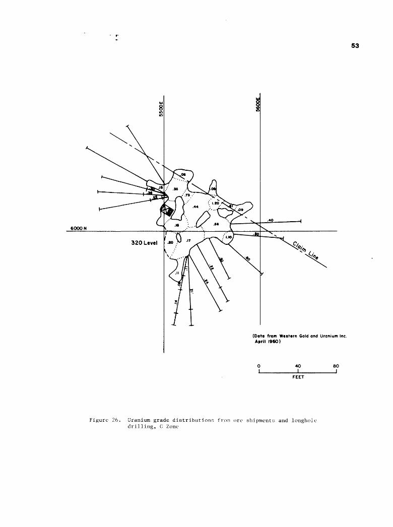
53
6000 N
320 Level
(Data from Western Gold and Uranium Inc. April I960)
40I
BO
FEET
Figure 26. Uranium grade distributions from ore shipments and longhole drilling, G Zone

Page 54
Ore stringers from the B and G zones coalesce with the annular
ring ore bodies in the northern portion of the pipe, below the
175 level. Small pods of ore have been mined on the 245, 265,
290, 320, and 365 levels. The host rocks for these small pods
were largely calcified sandstone-pipe-fill possibly derived from
the Esplanade Sandstone.
Ore bodies in the annular ring can occur - 1) within the
peripheral shear zone, 2) within collapsed pipe-fill materials
adjacent to the shear zone, and 3) in undisturbed sediments
outside the shear zone. The most of the ore produced from the
annular ring came from deposits in the Esplanade Sandstone out
side the shear zone (Figure 5). Here, ore occurs in sandy beds
in relatively undisturbed sediments outside of the pipe. Verti
cal, arcuate faulting appears to control the radial extent of the
ore beyond the pipe; the width of the ore bodies varies from 6 to
60 feet. Clay and mudstone lenses or beds in the annular ring are
barren, and some sandy units are also barren. No megascopic
differences have been noted between the mineralized and non-
mineralized sandy sections. The ore is continuous horizontally
in the favorable sandy sections around the entire periphery of
the pipe, but the vertical continuity is interrupted by unfavor
able beds (Figures 27 and 28) . Kofford (1969) has compared the
annular ring to a stack of washers, with the alternate ones being
ore bearing.
The annular ring on the claim has been mined on the 190, 225,
245, 285, 310, 350, 375, and 420 levels. The ore bodies are
generally about 15 feet wide, but reached a maximum width of 60
feet on the 350 level. The 310-350 level was very productive on

6200 N
Corner
6IOON
6000 N
X59OON
5800 N
Figure 27.
Map showing
location of
Figure 28,
annular ring
cross section
SO
_J
5700 N
FEET
(H
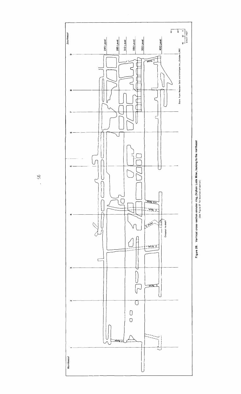
56
Fig
ure
28
. V
ert
ica
l cr
oss-
sect
ion
annu
lar
rin
g,O
rph
an
Lod
e M
ine,
look
ing
to th
e no
rthe
ast
(See
F
igur
e 27
fo
r lo
catio
n o
f se
ctio
n)

Page 57
the claim. Ore was continuous between the two levels on the
northwestern segment, but was separated into two levels by 7 to
10 feet of barren mudstone on the south and southeast segment
(Figure 28) . The bottom of the 310-350 ore zone in the claim is
marked by a mudstone bed.
On the northern perimeter of the pipe, in the National Park,
the separation between the different ore levels is not distinct.
The intense shearing on the pipe boundary here has resulted in a
good vertical continuity of the ore bodies. The early drilling
detected this continuity and this part of the annular ring was
termed "the feeder zone" (Kofford, 1969) . The massive ore body
in the Park was mined out by the No. 1 stope (Figure 5) which
extended from the 225 level to the 365 level. This stope had an
average width of about 50 feet, with a maximum width of 200 feet
on the 320 level.
Ore in the annular ring below the 400 level is localized in
sandstone beds of the Wescogame Formation of the Supai Group.
Ore bodies have been mined on the 420-430, 525, and 585 levels,
but these ore bodies did not have the horizontal continuity of
those in the Esplanade Sandstone. The P series of holes (Table
3) was unsuccessful in locating additional ring zones below the
585 level.
Bleached Supai sandstones outside the pipe are very common.
Sandstones that are normally dark reddish-brown, are white, light
gray to pinkish gray near ore. Both increased permeability and
fracturing have localized ore within the Supai sandstones. Remains
of land plants in the Esplanade Sandstone are uncommon (McKee,
1982, p. 98). On the 245 level, near the C raise (Figure 29),

Page 58
the author observed a small accumulation of plant fragments that
were mineralized with uranium (Figure 30). Although rare in the
Orphan Lode, this occurrence was similar to other organic-material-
related uranium deposits on the Colorado Plateau.
An envelope of introduced calcite cement extends completely
around the pipe from about the 190 level to beyond the 585 level
and possibly to the lower limit of the pipe. This envelope,
which is largely outside the peripheral shear zone, can reach a
maximum width of 60 feet and is responsible for the so-called
high lime ore at the Orphan.
Mineralogy
The mineralogy of the Orphan Lode has been described by
Kofford (1969) and Gornitz and Kerr (1970). The only additional
information this report can contribute is in the appended
petrographic reports (Pages A8-A18) , and in little known reports
by Lynch and Viklund (1956) and Runke (1964).
Most of the samples collected by the author and other AEC
geologists were submitted for semiquantitative spectrographic
analysis. Unfortunately none of these results could be located
during the research for this report. All of the analytical data
that was located in the old AEC files at the Grand Junction
Projects Office of the DOE is included in the appendix.

Loca
tion
of S
ompt
e 9
9I-
L-C
85
(Dat
a fr
om
W
tstt
rn S
old
and
Ura
nium
Inc
Ja
nuar
y I9
60
)
FEE
T
Figure 29
. Plan map
of th
e 245
level
showing
uranium production grades
in annular
ring
zo
neOt
09

Page 60
Figure 30, Color photo of mineralized fossil plant material in the Esplanade Sandstone, 245 level near C Raise. Photo by W. L. Chenoweth

Page 61
Samples from various drill holes were routinely analyzed for
radioraetric disequilibrium for resource estimates. Analytical
data on a 350 pound sample from the old Hogan adit is given in
Table 7, and data on composite samples from monthly ore shipments
is in Table 8.
Most of the ore-related minerals occur as finely disseminated
fillings and coatings that require laboratory identification. The
most common uranium mineral is sooty uraninite. Torbernite and
metazeunerite are common secondary minerals. Carnotite and/or
tyuyamunite was the prominent uranium mineral in a large composite
sample from the adit level (Lynch and Viklund, 1956, p.6). Some
of the readily identifiable non-uranium minerals observed are
calcite, gypsum, pyrite, chalcopyrite, chalcocite, covellite,
limonite, hematite, galena, sphalerite, tennantite, tetrahedrite,
and copper carbonates.

TABLE 7
Analyses of a composite 350 Ib. sample from the Adit level, Orphan Lode Mine.
Page 62
ConstituentU3°8 FeCaO MgO A1203V2°5
so4SiCU
Chemical Analysis Percent Constituent0.2172.806.502.22
8.98
1.51
0.35
72.95
P2°5
co2Cu
Pb
Ti
Ag
Au
Percent 0.200.640.810.100.22
3.6 oz/tonTrace
Semiguantative Spectrographic AnalysisConstituentAgAlBBaBiCaCdCrCuFeGaLiMgMn
Percent mtM
mtmm Mm mt mt MmMmm Mmm
Constituent Mo Co Na Ni PPb Sb Si Sn Sr Ti V Zr
Percent mt mt Mm mt Mm Mmm MM mt Mm MmMm
Code: MM = above 10% m = 0.1% to 0.01%M = 10% to 1% mt = 0.01% to 0.001%
Mm = 1% to 0.1% t = below 0.001% Analysis by National Lead Co. From Lynch and Viklund (1956)

Page 63
TABLE 8
Chemical analysis of composite ore samples, representing monthly shipments, Orphan Lode Mine.
Constituent High Grade Ore Low Grade OrePercent Percent
U3 08 1.00 0.35
Cu 1.50 0.75
v2o5 o.oi o.oiMo 0.04 0.02
CaC03 * 25.00 15.50
C03 ** 35.00 20.00
S04 ** 1.50 0.70
Sulfide S 7.70 3.80Organic C 0.12 0.70
* Acetic acid titration method.** LEGO furnace method.
From Runke (1964)

Page 64
Pyrite is abundant through the interior of the pipe. Within
the annular ring ore bodies, copper minerals occur in a low grade
uranium ore zone inside the higher grade uranium zone (Figure
31) . This zoning was best observed by the author in the 310-350
levels in the claim. Similar zoning in the Park ore was observed
by E.W. Bruner (oral communication, 1985) on the 225 level.
Although this zoning was first recognized by the mine geologists
and observed by the author, the copper-uranium relationship does
not appear in the analysis of composite ore shipments at the mill
(Table 8). This is probably due to the fact that all ore in the
annular ring was mixed and shipped as "high lime ore", and the B
and G zone ores were shipped as "low lime ore". Chalcocite
appeared to be more abundant than chalcopyrite in the upper
levels of the annular ring (225-190) , whereas chalcopyrite was
common in the lower levels (350-245) . Copper minerals in the
annular ring are scarce below the 350 level. Below the 400 level
pyrite is common in the annular ring.
Earthy red hematite was observed with high grade uraninite
ore in the annular ring, and in the A zone. It was especially
abundant in the northeast part of the annular ring on the 400
level. A typical sample collected by the author from the north
east end of the 400 crosscut was located during this study and
submitted to the Geological Survey (No. 999-0-C86).
Analysis of a composite sample from the adit level indicated
a silver content of 3.5 ounces per ton (Table 7). This is rather
anomalous in view of the fact that the Cotter Corporation estima
ted that total ore production from the mine averaged 0.40 ounces

65 w
(Data from Wttttrn GeW and Uranium Inc.,April I960)
Figure 31. Map of annular ring zone on 310 level showing average uranium production grades, and inferred ore blocks from longhole drilling

Page 66
per ton (E.W. Bruner, written communication, 1985). The high
value in adit level may be the result of supergene activity.
Oxidation has been noted on all levels of the Orphan Lode
Mine. It is most abundant in the adit level where secondary
yellow uranium minerals are profuse. Some oxidation is the A
zone was observed on the 175 level. Here, W. R. Ashwill of the
AEC, collected a sample of secondary uranium minerals in 1957.
This sample (USGS No. 991-Q-C86) was located during this study.
The majority of the ore in the A zone was uraninite disseminated
in the Coconino sand fill. A typical sample collected by the
author on the 100 level also was located (USGS No. 991-M-C86).
In the annular ring ore zones, limonite staining, up to
several inches wide, occur on both sides of fractures (Figure
32). This staining occurs along the entire vertical extent of
the exposed fractures. The oxidation observed in the Orphan Lode
Mine is no doubt related to the cutting of the Grand Canyon by
the Colorado River during the Tertiary which breached the water
tables in the Supai and Redwall rocks.
Sand fill and breccia within the pipe have been locally
cemented with coarse-grained calcite and dolomite. An envelope
of calcite cemented sandstone is present around the pipe in the
annular ring. M.G. Kofford (written communication, 1959) believed
that there were two different ages for the introduction of the
carbonates. He considered the carbonates within the pipe to be
older than those in the annular ring. Gornitz and Kerr (1970)
reached a similar conclusion.

Page 67
Figure 32, Color photo of limonite stained fracture, annular ring, 365 level, note hammer for scale. Photo by W. L. Chenoweth.

Page 68
On the surface, iron staining, bleaching and silicification
are common alteration features. Silicification has also affected
portions of the B ore body.
Assays of cores from the deep drilling within the pipe show a
nearly constant disequalibrium where the chemical uranium is
greater than the radiometric equivalent (see Pages A-23 through
A-30). One sample of a limestone breccia in Hole P-ll assayed
0.43% U3 0g and 0.04% eU3 0Q . This same sample was found
to contain 0.06% e thorium 230, 0.004% e radium 226 and 0.0004%
e polonium 210 (see Page A-24) . This suggests that uranium is
still migrating down the pipe structure.
Origin Of The Pipe
Early reports on the Orphan Lode attributed its origin to a
cryptovolcanic structure or diatreme. This was largely due to
the fact that Max G. Kofford, chief mine geologist for Golden
Crown and Western Gold and Uranium, proposed that theory from the
earliest days of the mine. His ideas no doubt influenced Ashwill
(1957), Granger and Raup (1962), Magleby (1961) and the AEC
(1959a) . Kofford considered the diatreme to be Pliocene - Quaternary
in age.
Bowles (1965) suggested that the Orphan pipe originated prior
to the cutting of the Grand Canyon, as the result of the collapse
of the overlying sediments into a solution cavern in the Redwall
Limestone. According to this theory, subsidence occurred after
the deposition of the Coconino Sandstone, but before its lithifi-
cation. Recent studies in the Grand Canyon region have demonstra
ted that the dissolution of the Redwall Limestone began in the

Page 69
Mississippian, 300 million years ago (Wenrich, 1985). Upward
stoping and breccia pipe formation continued through the Permian,
or at least was reactivated then. Observations in the A zone
indicate that the Coconino Sandstone was unconsolidated or poorly
cemented at the time of the collapse. It is interesting to note
that A. R. Still in a 1954 private report to Golden Crown Mining
Company, suggested that unconsolidated Coconino sand poured into
a cavity in the Hermit Shale that was created by the solution of
underlying limestones, during the deposition of the Coconino. I
would certainly agree with Still that the collapse of the Coconino
Sandstone into the pipe took place soon after, or during its
deposition.
Two samples of uraninite ore have been dated using U-Pb
isotope data. A minimum age of 141 million years for the uranium
mineralization at the Orphan Lode has been determined (Gornitz
and Kerr, 1970). An ore sample collected by C.G. Bowles of the
USGS in 1964 from the 585 level was recently analyzed by the USGS
using U-P isotope data. This sample gave a minimum age of 130
million years (K.R. Ludwig, oral communication, 1986). Prelim
inary U-Pb isotope data on samples from other uranium-bearing
breccia pipes on the north rim of the Grand Canyon suggest a main
period of mineralization of roughly 200 million years (Wenrich,
1985).
Breccia pipes in the Grand Canyon region are known
to occur in rocks as young as Triassic. The 200 million year age
is in better agreement with the observed break between the Trias
sic and Jurassic, than the younger Orphan ages (Early Cretaceous).

Page 70
Age dating of the samples located during this study may shed new
light on the uranium mineralization at the Orphan Lode.
In order to determine the possible origin and extent of the
Orphan pipe, Hole No. P-13 was drilled from the 550 level. This
vertical hole was begun in April 1961 and was completed on May
10, 1962 at a total depth of 1,914 feet, at a reported cost of
$50,000. Drilling in the Supai breccia within the pipe was very
slow and difficult due to the unconsolidated and plastic nature
of the rock. Voids in the breccia created many problems for the
circulation of the drilling mud, and considerable grouting had to
be done. At one time, when a fracture was encountered, all of the
drilling mud was sucked out of the drill sump, down into the
the borehole. While drilling in a limestone breccia, a small
pocket of non-flammable gas was encountered which blew the dril
ling mud out of the borehole.
The author reviewed a copy of the lithologic log of this hole
in 1962 at the mine office on the property. This log indicated
that the pipe bottomed in the Redwall Limestone, about 300 feet
below the normal top of the formation outside of the pipe. Unbrec-
ciated Redwall was encountered at 761 feet, or at the 1311 level
of the pipe. Since the pipe extends some 350 feet above the adit
level, the pipe containing the Orphan Lode deposit has a minium
vertical extent of 1,660 feet.
The top of the Bright Angel Shale was encountered at 1,515
feet and the Tapeats Sandstone was penetrated at 1,854.4 feet
before the drilling ceased at 1,914 feet. A sample of core from
the Muav Limestone, which underlies the Redwall (Figure 2), was

Page 71
examined by S.R. Austin of the AEC (see Pages A-ll through A-13).
This sample showed no indication of any alteration and was typical
of outcrops of this unit in this area of the Grand Canyon.
Analysis of samples from the P series of drill holes (Table
3) indicated that a large volume of low-grade material exists
between the 500 and 1100 levels of the pipe. Cotter Corporation
geologists have estimated that there is a minimum of 9 , 500 , 000
tons of material, averaging 0.021 percent U30g , ° r approxi
mately 3,999,000 pounds of U3 0g in this area of the pipe
(E.W. Bruner, written communication, 1985).
Summary
The Orphan Lode Mine occurs in a vertical, nearly circular,
collapse-breccia pipe, which penetrates the Coconino Sandstone,
Hermit Shale, Supai Group and part of the Redwall Limestone. The
diameter of the pipe varies greatly depending on the lithology of
the surrounding sediments.
The lithology of the breccia in the pipe, the stratigraphy of
the surrounding sediments, and fracturing associated with the
collapse have all localized the ore bodies. Uraninite is the
principal uranium mineral. Copper minerals appear to be zoned in
relationship to high grade uranium deposits on the perimeter of
the pipe. Pyrite and calcite are common gangue minerals. Besides
uranium and copper, the ores at the Orphan Lode contain varying
Page 72
percentages of silver, nickel, cobalt, lead, zinc, and vanadium.
An envelope of calcified rock surrounds the pipe in the lower
levels.
Drilling has confirmed that the breccia pipe bottoms in the
middle part of the Redwall Limestone, and has a minimum vertical
extent of 1,660 feet.
Page 73a
REFERENCES CITED
Albrethsen, Holger, Jr. and McGinley, F. A., 1982, Summaryhistory of domestic procurement under U.S. Atomic Energy Commission contracts, final report: U.S. Department of Energy, Open File Report GJBX-220(82), 162 p.
Ashwill, W. R., 1957, The Orphan uranium mine Grand Canyon,Arizona: U.S. Atomic Energy Commission, Open File Report RME-2082, 19 p.
Billingsley, G. H. r 1974, Mining in Grand Canyon, iji Geology ofthe Grand Canyon: Museum of Northern Arizona, Grand Canyon Natural History Association, p. 170-178.
Bowles, G. C., 1965, Uranium-bearing pipe formed by solution and collapse of limestone, in Geological Survey Research, 1965: U.S. Geological Survey Professional Paper 525-A, p. A12.
Brown, J. F., 1955, Certification of the Orphan Lode claim,Arizona District, Coconino County, Arizona (Application No. 705): U.S. Atomic Energy Commission Report C-731, unpublished, 6 p.
Brundy, C. M. , 1977, Orphan with a Midas touch: Denver Post, Empire Magazine, Nov. 27, 1977, p. 12-17.
Dodge, Matt, and McKlveen, J. W., 1970, Hogan's Orphan mine: True West Magazine, Dec. 1970, p. 6-10, 40, 42.
Engineering and Mining Journal, 1968, Arizona: Engineering and Mining Journal, Vol. 169, No. 1, p. 122.
Gornitz, Vivien, and Kerr, P. F., 1970, Uranium mineralization and alteration, Orphan mine, Grand Canyon, Arizona: Economic Geology, Vol. 65, p. 751-768.
Granger, H. C., 1951, Preliminary summary of reconnaissance for uranium in Arizona: U.S. Geological Survey Trace Elements Memorandum Report 304, 11 p.
Granger H. C., and Raup, R. B., 1962, Reconnaissance study ofuranium deposits in Arizona: U.S. Geological Survey Bulletin 1147-A, p. A1-A54.
Page 73b
Grand Junction Office AEC and U.S. Geological Survey, 1970 fPreliminary reconnaissance for uranium in Coconino County, Arizona,, 1951 to 1955: U.S. Atomic Energy Commission Report RME-155, U.S. Government Printing Office, 119 p.
Kofford, M. E., 1969, The Orphan mine: Four Corners Geological Society Guidebook, p. 190-194.
Lynch, J. T., and Viklund, H. I., 1956, Preliminary leaching and ion exchange studies of a sample of Western Gold and Uranium Company ore: U.S. Atomic Energy Commission Topical Report WIN-8, 16 p.
Magleby, D. N., 1961, Orphan Lode uranium mine, Grand Canyon,Arizona: U.S. Atomic Energy Commission, Open File Report TM-134, 18 p.
Pay Dirt, 1969, Orphan Mine suspends uranium ore production: Pay Dirt, April 28, 1968, p. 26.
McKee, E. D. , 1982, The Supai Group of Grand Canyon: U.S. Geological Professional Paper 1173, 504 p.
Mining World, 1959, How Western Gold mines uranium in Grand Canyon: Mining World, Vol. 1, No. 1, p. 32-35.
Runke, S.M., 1964, The Tuba City uranium milling operations: ElPaso National Gas Company, Paper presented at the National Western Mining Congress, Denver, Colorado, February 7, 1986, 20 p.
Scarborough, R. B., 1981, Radioactive occurrences and uraniumproduction in Arizona: U.S. Department of Energy, Open File Report GJBX-143(81) 311 p., 21 illus.
U.S. Atomic Energy Commission, 1959a, Orphan Lode, in Mineoperation data report: U.S. Atomic Energy Commission, Open File Report AEC-PED-1, p. 324.
U.S. Atomic Energy Commission, 1959b, Orphan Lode Mine (GrandCanyon) in Guidebook to uranium deposits of western United States: U.S. Atomic Energy Commission, Open File Report RME-141, p. 3-44 - 3-47.
Wenrich, K. J., 1985, Mineralization of breccia pipes in northern Arizona: Economic Geology Vol. 80, p. 1722-1735.

62OO
M
Acc
ess
rais
e to
**.
Dn
rtn
inac
cess
able
due
to
A S
tope
Fig
ure
8
Orp
han
Lo
de
M
ine
Ad
it (
0)
Level
Oct
ober
19
78
Map
o
f o
rig
ina
l H
ogan
A
dit
FE
ET

6200
N
Fig
ure
9
Orp
han
L
od
e M
ine
100
Le
vel
Oct
ober
19
78
FE
ET
c*

6200
M
Fig
ure
10
Orp
han
Lode
M
ine
140
Leve
lO
ctober
1978
0 50
FE
ET

6200
N
Fig
ure
II
Orp
ha
n
Lode
M
ine
175
Leve
lO
ctob
er
1978
0 50
I_______
jF
EE
T

6200
H
Fig
ure
12
Orp
ha
n
Lo
de
M
int
190
Le
vel
Oct
ober
19
78
FE
ET
CO

6200
N
Fig
ure
13
Orphan Lode Mine
225
Leve
lO
cto
btr
19
78
FE
ET

6200
N
Fig
ure
14
Orp
ha
n
Lode
M
ine
245
Le
vel
Oct
ob
er
1978
FE
ET

5200 E
18

6200
N
Fig
ure
16
Orp
han
Lo
de
M
ine
28
5-2
90
Leve
ls
Oct
ober
197
8
FE
ET

1000133d
woon

5200 E

5200 E

\
5200 E
\53OOE
5400E
5SOOC
o-1 T>
.- H «Lg » »
5600 E
5700 E
3*00 E
98

5200
N
\5300E I"
75400E
5500 E
5600 E
r° o 3a o
7
ix A
5700 E
5WOE

5200 E
\
\g300E
5400C
7
5500 E
88

Co
rntr
N
o. 4
«20Q
M,
6IO
ON
60
00
N
5900
N
A/
5tO
ON
57
00
N
Fig
ur«
23
Orp
han
Lode
M
int
550
Lev
elO
ctober
1978
0 50
I_______j
FE
ET

S20
0JL
6IO
ON
6000
N
5900
N
A/
5«O
OM
l
Fig
ure
24
O
rphan
Lode
M
ine
58
5
Lev
el
Oct
ober
19
78 50
5700
NF
EE
T
Cor
ntr
No. 4
Page 91
APPENDIX
Page
Chronology...................................... A-1
Plat of Orphan Claim............................ A-5
Western Gold & Uranium, Inc. Report............. A-6
Photo of Collapsed Ore Bin...................... A-7
Petrographic Reports............................ A-8
Analytical Data................................. A-19
Simple Location Maps............................ A-31

CHRONOLOGY
Significant Events In The History Of The Orphan Lode Mine
1893 February 8 f
1905 January 18-20,
1906 March 23,
1908 January 11,
1946 August 1,
1951 April 22,
1953 September 29,
1955 October,
December 14,
1956 March,
April 25,
May,
August,
1957 March,
July,
Summer,
1958 May,
Orphan claim staked by Daniel L. Hogan and Henry Ward.
Claim surveyed; Mineral Survey No. 2004.
Claim patented; Patent No. 43506.
Grand Canyon National Monument established,
Claim sold by Daniel L. Hogan to Mrs. Bertha Madeleine Jacobs.
Uranium minerals in old workings confirmed by USGS.
Mineral rights to claim leased by Golden Crown Mining Co.
Diamond drilling began in Hogan 1 s old adit,
Golden Crown announced a major uranium deposit had been discovered in a pipe structure.
A three tower aerial tram was constructed from rim to mine.
Initial shipment of ore made from Orphan Lode Mine.
Original aerial tram removed, a new Riblet tram erected.
Sustained production began via aerial tram.
Exploration winze from adit level reached a depth of 175 feet (175 level). Exploration drilling from 100 and 175 levels.
Western Gold and Uranium, Inc. acquired full control of Golden Crown Mining Co.
Exploration winze deepened to the 245 level.
Sinking of a 2% compartment, vertical shaft on the rim commenced.
A-l

Page 2,
CHRONOLOGYSummer,
November 24,
Fall,
1959 January,
March,
Summer,
October,
1960 November,
1961 February,
September 6,
Ten holes (G series) drilled into pipe from stations in National Park. A large orebody, off the claim, in the National Park was located.
Atomic Energy Commission announced limitations on 1962-1966 purchase program Ore Western Gold had located in the Park was not eligible.
High lime ore (greater than 6% becoming a problem at Tuba City. Western Gold sought other markets where ore would not be penalized for high lime.
Shaft completed to a depth of 1,590 feet. A station was cut at 1,502 feet.
A crosscut from the shaft station to 400 level of the pipe was started. The crosscut was completed to the end line of the claim in August.
Development raises driven from the 400 level to 245 level in preparation for all production to be hoisted to the surface via the new shaft.
With the mining expanding, Western Gold established a mobile home park, known as Western Village, for its employees outside the Park adjacent to U. S. Highway 180.
First production via the new shaft. Orphan Lode now had the production capability of 8,000 tons per month over the 1,000 tons per month via the aerial tram.
Sinking of an exploration winze from the 400 level to the 550 level was started.
Winze completed to 550 level and a drill station for the P series of holes was established.
Lee Ackerman became president of Western Gold through a stock exchange. Name changed to Western Equities, Inc. in November.
A-2

Page 3
CHRONOLOGYDecember 22,
1962 January,
May,
May 28,
July,
September 10,
November 20,
December,
1963 April,
Fall,
1966 Spring,
August 25,
The ore bin on the shaft headframe collapsed sending ore down the shaft. The mine was closed for repairs.
Shipments to Tuba City ceased when the surface stockpile at Orphan Lode was depleted.
Tuba City mill closed for lack of ore.
Public Law 87-457 signed by President Kennedy. Western Gold could mine ore in the Park, by giving Federal Government title to Orphan claim in 1987.
Rare Metals Corporation of America merged into El Paso Natural Gas Company.
Effective date of a new contract between AEC and El Paso which was signed November 19, 1962. AEC to purchase uranium concen trates produced from Orphan Lode ore through December 31, 1966.
Mining resumed at Orphan Lode. Develop ment work to mine ore in National Park commenced. Ore was stockpiled at the Tuba City mill.
Modifications began at the Tuba City mill. A carbonate leaching circuit and sulfide flotation cell were installed to treat high lime ores and recover copper.
Tuba City mill began processing Orphan Lode ore.
A decline from the 550 level to the 585 level was driven to explore ore in the Park. This was the deepest level of the mine.
Western Equities was sold to Geo Space Corporation which merged into Westec Corporation.
Westec's stock suspended from trading on the American Stock Exchange. Company declared bankruptcy, and the Orphan Lode closed.
A-3

Page 4
CHRONOLOGYSeptember, Tuba City mill of El Paso Natural Gas
Company closed for lack of ore.
1967 August 31 f Westec asked permission from the U. S.District Court to sell Orphan claim and Western Village to the Cotter Corporation,
September 27 , Shipments of Orphan Lode ore, via theSanta Fe Railroad, began to Cotter's mill at Canon City f Colorado. The mill also recovered copper from sulfide minerals in the ore.
1969 April 25, Orphan Lode Mine closed due to highfreight charges to Canon City.
1981 February 18 f Western Village site and the Orphan claimwere purchased by John R. Siebold and Ell ing Halvorson. Western Village had become a prime area for real estate development.
A-4

uiu
;
CM
,,, I
wa
tttl
J
&*
. S
eft.
, /»
**
Min
eral
S
iirr
ev N
V20
IM
U.O
T
H°
PLA
TO
F
TH
E
CL
AIM
O
F
Lan
d
Oi
KN
OW
N A
S T
HE
ORP
HAN
-Wm
fi M
VTH
ffT..
tine
Orig
inal
J>M
d. Y
otex
ef'ln
cSun
rrtf
't/ie
. V
moi
tf C
laim
of
o.il
/ie
isp
lat h
as if
fn/n
aJr
wid
er in
\/di
m'l
ion
\ !,
nfda
nd.a
pprm
'fJ,
aniia
reon
^Ur
in th
is 6
/fir
r)
tert
ifv
that
ihn
fitr
nisl
i .-u
irha
n ac
ntm
tr d
encr
iuV*
.
' f
"tai
d Mut
iny
Oai
nt a
x m
'M, i
l'in
mrp
omlf
din
tixi
ftat
fnli
se
n^
filt
ttau
/ffU
/((t
hfp
rem
ises
..an
d'th
ai x
/ri/t
ir(
errn
rt\j
fA-
mm
deth
arin
tf n
alar
al ob
ject
s t>r
pri
nia
iirn
lin
aiia
iiif
iiks
a,
t wiU
perp
etua
te a
/ia'
/irt
fif\
Dcu
a th
ereo
f.
^/iir
ther
rrni
fi-t
hat.K
vrfH
iuid
rea'
^olla
ry w
orth
<>/
'labo
r fun
s /f
ffri
etp
endt
ti'-c
rim
prar
enir
ntit
nm
t/f
II/M
'/I .m
i<f.'
\fi/ti
//<f*
(J
awi
bv e
/ain
uittf
<> art
fifi
r tfn
ititu
rx, t
int/
f fun
' s<
iid im
prm
nnrt
>t,i
roitx
iAt
p/\*
*ff J
ftA
/r)
\
that
the
loca
tion
of s
aid
iinpr
itrrm
entK
is
Cfr
mtf
v sh
tnm
i.,
n/M
n th
is fl
ltU
, and
' Hin
t nr p
orti
nn
of 's
aid'
labo
r pr
tin
- /tr
mri
nent
s h
as b
een
incl
uded
indie
est
imat
e fi
/'n
peit
((f\
- ru
/m- u
pon
am
oth
er c
/nin
i.
Jn
dJfi
rth
a-ce
rtif
i th
atlh
ix i
s a
wrr
ect/t
intf
ll'sa
id.M
utin
y C
laim
mad
eo!
mnf
brm
itv w
ith s
aid
orig
inal
fiel
d not
es o
fih
f su
rve*
thtr
mf'
, tui
dthe
sian
e is
her
eby
af>f
>rm
-ed.
j
FIG
UR
E 3
3

WESTERN GOLD <fe URANIUM. INC.42 BROADWAY
NEW YORK 4. N. Y.
WHITEHALL 4-0478
SILVER REEF URANIUM MINES
C: LEEDS. UTAH
December Ik, 1955
FIRST NATIONAL BANK BUILDING
CARSON CITY. NEVADA
TO THE STOCKHOLDERS:
Two notable developments in the company's recent operations make this interim report to shareholders advisable.
First, the ORPHAN property of Golden Crown Mining Co., in which Western owns a con trolling interest, has now proved to be a primary uranium strike of major proportions, Diamond drilling thus far has not been sufficient to prove the entire structure. However, the company's geological staff has indicated that the structure is of & pipe nature; mineralization has occurred around the perimeter of the structure with mineable vein widths of 30 to kO feet. The deposit is in a mineralized shear zone of Coconino sandstone of Permian age. The mineral is pitchblende.
Thus far an ore body of not less than 100,000 tons is indicated, but your management believes that ore may well reach 300,000 tons or more (based on a minimum of 500 feet of perimeter X vein width of 30 feet X vertical height of 280 feet = 1*,200,000 cubic feet, divided by Ik cubic feet per ton = 300,000 tons.) At an average probable grade of .k5% uranium oxide, anticipated profits would be approximately $30 per ton-
The foregoing expectations do not include possibilities for additional depth and height (hole No. 11 went down 217 feet and was still in the mineralized area), nor the possibility of finding ore within the heart of the pipe structure.
The Orphan thus appears to be one of about 25 uranium finds in the U.S. of more than 100,000 tons, and also one of the very few sizeable pitchblende deposits found in this country. Because the ore body is many times the size originally expected, initial production will be delayed somewhat, with the first ore to be marketed in the spring. It will be trucked 85 miles to the new AEC ore-buying station at Tuba City, Arizona.
Secondly, since our September 26 report, Western has started to develop its SILVER REEF property in Southwestern Utah, where 3^,000 tons of uranium-silver ore has been blocked out. A 125-foot shaft to the ore body is well under way and will be completed In about two months. A new hoist house has been constructed near the shaft and the hoist installed; a carpenter shop, change room, water tank and oil tank also have been installed. Initially, that portion of the ore high in uranium content but low in silver will be shipped to an AEC ore-buying station, while the silver-rich ore will be shipped to a silver smelter. The great bulk of the ore, which contains about equal values of uranium and silver, will, however, be held for treatment in a-silver flota tion mill to extract the silver before it is shipped to the AEC. A 50-ton-a-day mill will be built next spring.
For your further information, we are enclosing a detailed summary of the compa present status which we believe will be both interesting and helpful. /£
Respectfully submitted, :3f
A-6
Ralph G. Brown President

Figure 34
Photo of the collapsed ore bin at the Orphan Lode Mine, which occurred on December 22, 1961, closing the mine for several months. Photos by W. L. Chenoweth
A-7

PETROGRAPHIC REPORT
Sample Nos; 2002-A, B, C
Location; Coconino Sandstone, Adit level, Orphan Lode Mine, Coconino County, Arizona, Collected by R. D. Miller
Information Desired; Mineral identification, paragenesis
Type of Examination; Thin and polished sections, oil immersion, chemical tests, heavy mineral separations, x-ray and spectro- graphic analyses, autoradiographs, assays.
Petrography; Three samples were submitted. Since the relation ship of one sample to another is unknown, the results are reported separately below.
Megascopically, sample A is a dark-gray, fine-grained, impure sandstone. Observed in thin section, the detrital grains consist approximately of 75 percent quartz and 25 percent mudstone and siltstone fragments, with accessory amounts of muscovite, zircon, tourmaline, feldspar, chalcedony, and mag- natite. The quartz grains are rounded to angular and vary in size from less than .01 mm. to greater than 1 mm. The mud- stone and siltstone fragments have been flattened and wrapped around the quartz grains. Thin layers of mudstone and silt- stone are also interlayered with the sandstone layers.
Sample A is cemented mostly by a mixture of fine rock flour (mainly clay and quartz) and brown to black carbonaceous matter. Minor cementing agents are pyrite, uraninite, chalcocite (?), covellite, and a green secondary uranium mineral. The metallic minerals are in irregular masses and are too fine-grained and widely dispersed to determine their interrelations. The secondary uranium mineral occurs as square plates where space allows and appears bladed in thin section. Indices and x-ray analysis place it between meta- torbernite and metazeunerite in composition. The unit cell is larger than that of metatorbernite and smaller than that of metazeunerite, but closer to metazeunerite, which is what it will be called in this paper. Chemical analysis would probably show a substitution of P for As.
Sample B is a yellow, poorly sorted, medium-grained sand stone. Grain size varies from less than .01 mm. to greater than 1 mm. Thin section shows that the detritals are mostly quartz, with accessory amounts of chalcedony, feldspar, tour maline, and magnetite. Barite was introduced some time after deposition of the original sand. Euhedral blades up to 5 or 6 mm. in length have replaced quartz grains and have inter- grown with each other. The barite is weakly pleochroic from pale yellow to colorless.
A-8

Sample No: 2002-A, B, C continued
Sample B is cemented mainly by carphosiderite, J(H20)Fe3 -M / , although oriented overgrowths of(so4 ) 2
quartz have filled the spaces between detritals in places. The carphosiderite has corroded and replaced the quartz grains until the original shape of the detrital particles is no longer discernible. In places the carphosiderite has also replaced barite, separating crystals into several irregularly- shaped islands with the same optical orientation. Metazeu- nerite also occurs in Sample B, but was not observed in thin section. As studied under the binocular microscope, it appears to be clearly associated with barite and to have preceded the deposition of carphosiderite.
Spectrographic analyses were run on two fractions from Sample B: (1) that fraction heavier than methylene iodide and (2) the fraction lighter than methylene iodide and heavier than acetylene tetrabroroide. The results were as follows:
SiAlFeMgCaKTiAgAsBaCoCrCuGaMeNiPbSeSrUVZnZr
13. .15
7..0015 .005 .7 .07 .007
3.M.003 .007 .3.007 .03 .007
3. .0015
1.5 .15 .007 .07 .015
2 M.15
7..007.015.7.15.007
7. 7..0015.007.7.007.07.007
7..0015.03.07.07.03.015
Except for Pb, the major elements can be accounted for by the mineral assemblage presented above. Possibly Pb is present as the sulfate and is intermixed with the carphosiderite.
Sample C is a fine-grained black sandstone. The detritals, which are sorted better than those in Samples A and B, are mostly quartz, with accessory feldspar, tourmaline, and zircon. The grain size varies from .05 to .4 mm. with an average size of about .2 mm. The grains are angular to
A-9

Sample No; 2002-A, B, C continued
subrounded. The detrital particles are cemented by carbon aceous matter, oriented quartz overgrowths, rare clay, minor calcite, pyrite, chalcocite (?), covellite, uraninite, and metazeunerite. Sample C contains a much larger percentage of the metallic minerals, especially uraninite and covellite. However, just as in Sample A, they occur in minute, dissem inated masses which are impossible to polish well enough to determine any paragenetic relations.
Radiometric and chemical assays on the three samples gave the following results:
Sample No;
2002-A 2002-B 2002-C
%u3 o8
1.24.93
1.83
%eU3 08
2.75.93
1.70
%Cu
.23
.45
.90
Examined by; Alice S. Corey, Petrographer U. S. Atomic Energy Commission Grand Junction Operations Office March 18, 1957
A-10

PETROGRAPHIC REPORT
Sample No; 3696
Location; Muav Limestone, Core sample from hole P-13, a vertical hole drilled to a T. D. of 1,914 feet from 550 level, Orphan Lode Mine, Coconino County, Arizona. Submitted by John W. Gabelman
Information Desired; Petrography. Identification of green miner al. Is there evidence of brecciation? Is there evidence of mineralization?
Type of Examination; Thin section; polished thin section; micro scope, oil immersion.
Petrography; The rock is a sandy, glauconitic, dolomitic lime stone. Much of the carbonate was probably originally detri- tal. Other principal detrital minerals are quartz, feldspar, and muscovite. Glauconite might be considered syngenetic, since it was probably formed about the time the detrital min erals were accumulating. Here, part of the glauconite appears to have originated by alteration of biotite, some biotite being incompletely altered to glauconite; but some of the glauconite appears to replace organic remains.
The rock consists principally of dolomite, but some calcite is also present. Determination of relative proportions of calcite and dolomite is impossible without special methods, but minute rhomboidal crystals are mostly dolomite, whereas larger anhedral crystals are calcite. Essentially all of the carbonate shows evidence of recrystallization. Ghosts of rounded detrital grains can be seen in some of the euhedral to subhedral dolomite crystals. Euhedral dolomite crystals project into anhedral masses of calcite which appear to fill former voids. This, plus the presence of ghosts of rhombic carbonate crystals (probably dolomite) in the calcite masses, indicates that the calcite is probably younger than the dolo mite. However, there may also have been dolomitization of original calcite and/or aragonite in shell fragments at an earlier stage in the history of this rock.
Hematite (and goethite?) in minute rounded blebs forms irreg ular, discontinuous dark, slightly purplish stringers through the rock. The iron oxide mineral(s) is closely associated with glauconite.
In hand specimen, and especially in thin section, the rock shows irregular blotching on a megascopic scale. Although less noticeable under the microscope, these blotches are seen to be formed of more or less rounded masses of varying compo sition. Perhaps most commonly, the rounded masses are peb bles or grains of nearly pure carbonate in a more sandy and glauconitic matrix.
A-ll

Sample No; 3696 continued
The rock appears to be one of the types described by L. F. Noble (1923, A section of the Paleozoic formations of the Grand Canyon at Bass trail: USGS Prof. Paper 131, pp. 23-73) as part of the Muav section, which he considered to be an intraformational conglomerate or clastic limestone (dolomitic in part). No features were observed which appear inconsis tent with Noble's interpretation, although there is abundant evidence of recrystallization.
Since Noble's description mentions such features as intrafor mational conglomerate, cross bedding, worm burrows, and broken brachiopod shells, the rather fragmental structures and irregular distribution of minerals in the specimen as seen megascopically may be accounted for by these features. No angular breccia fragments were observed, nor any other features which would indicate (in a specimen of this size) postdepositional brecciation of the zone from which this sample was taken.
No evidence of mineralization nor introduction of extrinsic elements, except perhaps magnesium to form dolomite, was found. However, spectrographic analysis is pending. The only metallic mineral seen is hematite (goethite?), which Noble notes as being abundant enough in parts of the section he describes to impart a purple color to the rock. Thus the small amount of hematite present here does not indicate ex trinsic mineralization.
Glauconite was identified both by oil immersion and in thin section, but confirmation by X-ray is also being sought.
Examined By; S. Ralph Austin, PetrographerU. S. Atomic Energy Commission Grand Junction Operations Office March 14, 1962
A-12

SEHIQUANTATIVE SPECTROGRAPHIC ANALYSIS
Sample of Muav Limestone from core hole P-13, Orphan Lode
Mine , Coconino County, Arizona.
Element
Al
Ba
Ca
Cr
Cs
Cu
Fe
GaK
Li
Mg
Code:
Percent
B
D
A
E
E
D
B
E
B
E
A
Element
Mn
Na
Ni
Pb
Rb
Si
Sr
Ti
V
Zr
A - Probably greater than 10%
B - Probably 1 - 10%
C - Probably 0.1-1%
D - Probably 0.01 - 0.1%
E - Probably 0.001 - 0.01%
Percent
D
C
D
D
D
A
D
C D
D
Not detected: Ag, As, Au f B, Be, Bi, Cd, Ce, Co, Ge, Hf, Hg,
In, Ir, La, Mo, Nb, Os, P, Pd, Pt, Re, Rh, Ru,
Sb, Sc, Sn, Ta, Te, Th, Tl, U, W, Y, Zn.
Anaylsis by U.S. Bureau of Mines, Salt Lake City, Utah, March 1962
A-13

PETROGRAPHIC REPORT
Sample No; 3954
Location: Coconino Sandstone, A stope, 175 Level, Orphan LodeMine, Coconino County, Arizona. Collected by W. L. Chenoweth.
Information Desired; Mineral identification, texture description paragenesis, spectrogram, radiochemical analysis, relation of Fe oxides to U and Cu. Is pyrite present? Secondary enrich ment of U and Cu?
Type of Examination; Polished thin section; microscope, oil immersion; X-ray; chemical tests, contact print tests.
Petrography; Minerals observed comprise: detrital quartz; pyrite; sphalerite; galena; gersdorffite (?); coffinite (?) or sooty uraninite (?); hematite and other iron oxides; an unidentified secondary uranium mineral, probably a uranyl arsenate; possibly, gummite; and perhaps orpiment and/or realgar; also an unidentified transparent mineral, probably an iron sulfate.
Detrital Quartz
The sandstone host rock consists largely of quartz grains, and no attempt was made to identify other detrital minerals.
Pyrite
Pyrite is present in minute, euhedral to anhedral crystals attached to and partly replacing detrital grains. Only rarely does a single crystal of pyrite entirely fill interstices between detrital grains or form masses large enough to enclose several grains; but interstices may be filled with pyrite aggregates. Commonly the pyrite is at least as yellow as ordinary pyrite and therefore does not appear to be either nickelian or cobaltian. However, minute cubic crystals, yellowish with a violet tint, found within gersdorffite (?) may be nickelian pyrite. The ordinary pyrite appears to be the earliest to form of the authigenic minerals.
Sphalerite
Sphalerite occurs in large euhedral to subhedral crystals up to at least five millimeters across. Most of these enclose many sand grains, thus producing luster mottling similar to that produced by coarsely crystalline calcite cement. Most of the sphalerite crystals poikilitically enclose pyrite; thus, the sphalerite is believed to be younger than the pyrite. However, the boundaries of individual sphalerite crystals can scarcely be discerned under the microscope, although they are plainly visible to the naked eye in polished section when viewed at the proper angle. The
A-14

Sample No; 3954 continued
sphalerite is light colored, possibly the variety, cleio- phane. Since the sphalerite appears to be distinctly younger than the pyrite, the light color of the sphalerite may or may not indicate low temperature.
Galena
Galena occurs sparsely in aggregates up to about a millimeter across, consisting of nearly euhedral crystals. In some instances, galena is idiomorphic against sphalerite, but in the same mass, intergrowths resembling rim textures also occur between the two minerals. However, the fact that either or both minerals may have replaced detrital grains complicates attempts at deciphering the relationships. On the basis of conflicting evidence, galena and sphalerite are considered to be penecontemporaneous.
Gersdorffite (?)
Contact print tests for nickel revealed the presence of a nickel mineral resembling galena in appearance, but less re flective, which has been tentatively identified as gersdorf- fite. This mineral occurs in crystals whose maximum size is about that of the detrital grains. Some of these are anhedral and appear to replace detrital grains; whereas, smaller crystals occur interstitially and show more tendency to be euhedral. The mineral develops pits, on polishing, similar to those developed in galena, but triangular pits tend to be less sharply defined and equilateral than those in galena, and many of the pits are elongate with essentially parallel sides. Gersdorffite (?) shows relationships with sphalerite similar to those shown by galena and is believed to be about the same age.
Low Valence Uranium Mineral
Primary (?) uranium occurs in black material which takes no polish whatever. In the absence of X-ray work, no identification of this mineral was possible, but coffinite or sooty uraninite, or both may be present. Uranium is largely concentrated outside the sphalerite, which has some tendency to poikilitically enclose all other primary minerals, so that the black uranium minerals, if primary (see below), are believed to be the last of the primary suite to be emplaced.
Hematite and Other Iron Oxides
Red hematite occurs as cement in masses of sandstone, up to an inch or more in longest dimension, surrounded by yellow material consisting of "limonite" and other secondary
A-15

Sample No; 3954 continued
minerals. These masses of red and yellow sandstone appear to be entirely insular within the black, main body of the rock, at least as far as could be determined from the sample sub mitted. This apparent insular character makes their origin more difficult to explain. The hematite takes an excellent polish and is opaque or translucent in thin section.
Unidentified Secondary Uranium Mineral
Among the yellow materials is a secondary uranium minerals, unidentified either optically or by X-ray. The X-ray powder pattern resembles, in a general way, the patterns of uranyl phosphates and arsenates in our files and those indicated for minerals of these groups by data in USGS Bulletin 1064, but corresponds to none of them. The ammonium molybdate test indicates that the mineral is probably a uranyl arsenate rather than a phosphate, as also might be expected from the presence of considerable arsenic and the absence of detectable phosphorous shown in spectrographic analysis of the rock. The mineral occurs in sheaf-like aggregates of platy crystals. Either this mineral or one closely associated therewith fluoresces moderately under ultraviolet light.
"Gummite"
Among the yellow materials surrounding the hematite and intimately mixed with limonite are uraniferous materials here identified as "gummite".
Orpiment (?) and Realgar (?)
Because of the arsenic content of the rock and the color of some of the yellow to orange materials surrounding hematite masses, the presence of realgar and/or orpiment seems possible. However, no discrete mineral resembling either in thin section could be discerned.
Unidentified Transparent Mineral
An acicular or fibrous, transparent mineral occurring within the hematite-limonite masses is as yet unidentified. This mineral shows moderate birefringence and resembles some of the iron sulfate minerals which might be expected in this association.
Secondary Enrichment and Related Problems
Results of semiquantitative spectrographic analysis (0.07% Cu) indicate that any secondary enrichment of copper has been insignificant. Whether secondary enrichment of uranium ever occurs in nature is, in my opinion, still a debatable question.
A-16

Sample No; 3954 continued
However/ if secondary enrichment is possible/ what chemical and physical processes other than those involved therein are necessary for the formation of all plateau-type deposits?
In the present instance/ the apparent insular character of the hematite-limonite masses would tend to favor the conclu sion that they are remnant enclaves of oxidized minerals left from the sulfidization and reduction of the mass of the rock. However/ the presence of minerals other than the iron oxides and consideration of the chemistry involved in their altera tion to those found in sulfidized and reduced (or unoxidized) parts of the rock makes normal oxidation seem the more likely process.
For example/ the reduction of a uranyl arsenate mineral to form coffinite or uraninite/ with concomitant reduction of arsenic and its combination with nickel (which just happened to be coming along) to form gersdorffite/ seems much less likely by supergene processes than does the formation of uranyl arsenate by oxidation of coffinite or uraninite and gersdorffite.
Similarly/ if my tentative identification of an iron sulfate mineral within the hematite-limonite masses is correct/ it would be a normal product (in association with hematite and limonite) of the supergene oxidation of pyrite.
Paragenesis
Early Late
Detrital grains Reduced Oxidized
Pyrite
Sphalerite
Galena ?
Gersdorffite (? ) ?
Uraninite or coffinite
Limonite
Gummite
Uranyl arsenate mineral
Iron sulfate mineral (?)
Hematite
A-17

Sample No: 3954 continued
Examined By; S. Ralph Austin, PetrographerU. S. Atomic Energy Commission Grand Junction Operations Office March 27 , 1961
A-18

ANALYTICAL DATA
225 Level
SAMPLE NO. LAB. NO. ppml^Og %eU3°8 %P2°5 %S0 4
4335 66350 9 .002 .04 .01
Sample is red Supai sandstone, in breccia, within pipe. Coordinates 6110N 5548E
Analysis by Lucius Pitkin, Inc., September 1964
A-19
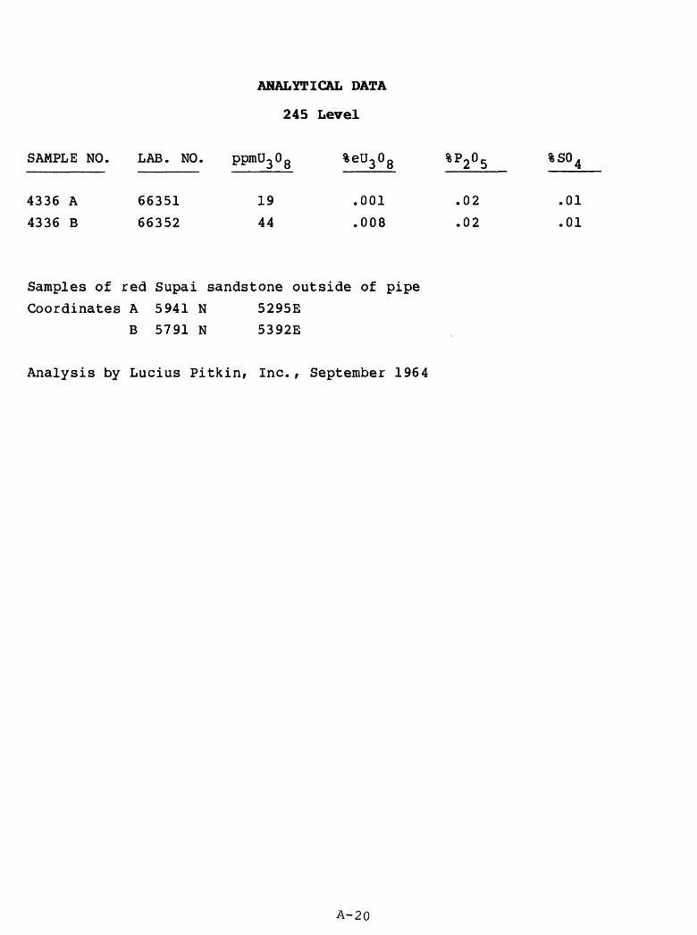
ANALYTICAL DATA
245 Level
SAMPLE NO.
4336 A
4336 B
LAB. NO.
66351
66352
ppmU^ 0 g
19
44
%eU3°8
.001
.008
%P2 o 5
.02
.02
%so 4
.01
.01
Samples of red Supai sandstone outside of pipe Coordinates A 5941 N 5295E
B 5791 N 5392E
Analysis by Lucius Pitkin, Inc., September 1964
A-20

ANALYTICAL DATA
400 Level
SAMPLE NO. LAB. NO.
4337
4337
4337
4337
4337
4337
A
B
C
D
E
F
66353
66354
66355
66356
66357
66358
5
4
84
72
24
301
%eU3 0 8
.001
.001
.005
.009
.002
.012
%P2 o 5
.04
.06
.02
.04
.05
.05
%so 4
.01
.01
.03
.04
.18
1.42
Set of samples collected along the main haulageway on the 400 level
where it enters the pipe.
A- red Supai sandstone
B- red Supai sandstone
C- red Supai sandstone
D- gray Supai sandstone
E- breccia
F- breccia
Coordinates
5004N, 5018E
5679N, 5252E
5858N, 5363E
5882N, 5371E
5929N, 5413E
5994N, 5470E
Analysis by Lucius Pitkin, Inc., September 1964.
A-21

ANALYTICAL DATA
HOLE K-13
SAMPLE NO. LAB. NO.
4338
4338
4338
4338
A
B
C
C
66360
66361
66362
66363
ppmU3 Og
12
2500
23
9
%eU3 0 8
.002
.15
.001
.001
%P2 o 5
.05
.03
.07
.07
%so 4
.07
.30
.01
.01
INTERVAL
141
166
175
179
.0-141.5
.5-167.0
.0-175.5
.5-180.0
K-13 was an inclined core hole drilled from the 400 level, bearing N55°E, inclined -30° , total length 200 feet.
Samples were splits of core, and were from within the pipe. A- partly altered Supai sandstone B- ore-bearing Supai sandstone C- gray Supai sandstone D- red Supai sandstone
Analysis by Lucius Pitkin, Inc., September 1964

ANALYTICAL DATA
HOLE P-10
SAMPLE NO. LAB. NO. ppmt^Og %eU3 0 Q %P2 °5 %S04 INTERVAL
4339
4339
4339
A
B
C
66363
66364
66365
14
115
12
.001
.006
.001
.02
.02
.22
.01
.02
Tr
306
330
394
.5-309.5
.0-331.0
.0-396.0
P-10 was an inclined core hole drilled from the 550 level, bearing S59°E, inclined -55°, length 396.0 feet. Pipe contact at 382 feet.
Samples are splits of core.A- brecciated gray Supai sandstoneB- limonite staining in gray Supai sandstoneC- red unaltered Supai sandstone
Analysis by Lucius Pitkin, Inc., September 1964
A-23

ANALYTICAL DATA
HOLE P-ll
SAMPLE NO. LAB. NO. %CaC0 %F %SO
7073
4340 A
4204 A
4340 B
4204 B
4204 C
4204 D
4205 A
7074
4205 B
7075
54408
66073
55500
66074
55501
55502
55503
55504
54409
55505
54410
.01
.14
.43
.07
.07
.03
.03
.01
Tr
.01
Tr
.002
Nil
.04
.002
.01
.01
.01
Tr
Nil
Tr
Nil
1
71
45
83
62
88
61
79
65
.10
.05
.20
.04
.50
.70
.50
.60
.40
.90
.00
Nil-
Nil-
Nil
Nil
Nil
Nil
Nil
Nil
Nil
.10 -
.07
.02
.04 -
.04 -
INTERVAL
586.0-593.0
625.0-628.5
626.0-629.0
628.5-636.0
636.0-639.0
639.0-641.0
646.0-647.0
685.0-695.0
700.0-705.0
701.0-706.0
705.0-709.0
P-ll was an inclined core hole drilled from the 550 level f bearing N60°E f
inclined -61° , total length 709 feet. Purpose was to test the lower Supai
rocks outside the pipe.
Limestone breccia encountered at 625 feet. Unbrecciated limestone in the
Manakacha Formation, of the Supai Group, penetrated at 651 feet.
Samples were splits of core, except samples 4340, 7073-7075 which were
pulps of core.
Due to the radiometric disequilibrium in sample 4204 A, the following
analyses were determined:
Percent equivalent Thorium 230 - .06%
Percent equivalent Radium 226 - .004%
Percent equivaltne Polonium 210 - .0004%
Analysis by Lucius Pitkin, Inc., December 1963, Sample 4340 analyzed
September 1964.
A-24

ANALYTICAL DATA
HOLE P-12
SAMPLE NO. LAB. NO. %U3 0Q %eU3 0Q %CaC03 %P2°5 %F %S04 INTERVAL
4341
7076
7077
7078
7079
7080
7081
66064
55411
55412
55413
55414
55415
55416
24 ppm
.01
.02
.01
Tr
Tr
Tr
.01
.006
.02
.004
.005
.005
.004
_2.40
1.20
0.60
0.80
0.70
0.30
.02
Nil
.04
Nil
Nil
Nil
Nil
- .05
.06 -
.12 -
.12 -
.12 -
.10 -
.06 -
379-380
657-662
662-667
710-715
715-720
720-725
725-730
P-12 was an inclined core hole drilled from the 550 level, bearing N46°W f inclined -55°, total length 746 feet. No limestone breccia encountered. Last 50 feet of core is of unbrecciated sediments, mostly sandstone, but still believed to be within the pipe.
Samples were pulps of core.
Analysis by Lucius Pitkin, Inc., December 1963. Sample 4341 analyzed September 1964.
A-25

ANALYTICAL DATA
HOLE P-13
SAMPLE NO. LAB. NO. ppmU0 0 0o o
INTERVAL
4344 a4344 b4344 c4344 d4344 e4344 f4344 g4344 h4344 i4344 j4344 k4344 14344 m4344 n4344 o4344 p4344 q4344 r4344 s4344 t4344 u4344 v4344 w4344 x4344 x 14344 y4344 y 14344 z4344 aa4344 bb4344 cc4344 dd4344 ee4344 ff4344 gg4344 hh4344 ii4344 jj4344 kk4344 114344 mm
6602566026660276602866029660306603166032660336603466035660366603766038660396604066041660426604366044660456604666047660486604966050660516605266053660546605566056660576605866059660606606166062660636606466065
240225389
12357222407
563430257
13233496
106686
1056414289
1646487
.03
.02
.004
.001
.001
.03
.02
.003Nil.003.002.002.005.001.001NilNilNilNilNil.001.001NilNil.004.001.002.001.004.001.001.001
Tr.001.001.002.002.001.008.006.001
.02
.03
.02
.02
.07
.07
.07
.06
.04
.07
.04
.17
.04
.04
.05
.07Tr.02.02.05.02.01.02.06.05.04.02.04.07.03.04.08.04.05.11.06.25.15.18.37.21
.05
.07
.02
.04
.01
.03
.041.31.07.28.04.22Tr
.03
.051.31Nil.08NilNilNilNil.01.01NilTr
Nil.02.04.02.02.14Tr.03.03.02.06.02.03.01.02
6095
150200250300350400450500550600646700750799846901950996
105010971150120612111229123512461296134714001443149315431600165016991750180018501900
-65-100-155-205-255-305-355-405-455-505-555-605-656-705-755-802-851-909-956-1001-1055-1102-1156-1216-1213
.5-1236-1236-1256-1306-1355-1410-1453-1503-1553
.0-1600-1651
.5-1700-1750-1800-1851-1900
.5
.5
.7
.5
A-26

P-13 Continued
P-13 was a vertical core hole drilled from the 550 level to a total depth of 1,914 feet. Purpose was to test the origin and extent of the pipe.
Unbrecciated Redwall Limestone was encountered at 761 feet. The top of the Bright Angel Shale was at 1,515 feet and the top of the Tapeats Sandstone was at 1,854.4 feet.
Samples were pulps of core, except samples 4344 x 1 and y 1 which were splits of core.
Analysis by Lucius Pitkin, Inc., September 1964
A-27

ANALYTICAL DATA
HOLE 400-3
SAMPLE NO.
4342
4342
4342
A
B
C
LAB. NO.
66066
66067
66068
ppmU3 0 8
2
5
2
> %eU3°8
.002
Nil
Nil
%P2 o 5
.06
.02
.05
%so 4
Tr.04
.01
INTERVAL
135
157
164
.5-136
.0-157
.0-164
.0
.5
.5
Hole 400-3 was a vertical core hole drilled from the 400 level to a depth of 210 feet. It was planned to test the 585 ore horizon.
Samples were splits of core. A- red Supai sandstone B- gray (bleached) Supai sandstone C- red Supai sandstone
Analysis by Lucius Pitkin, Inc. September 1964
A-28

ANALYTICAL DATA
HOLE 550-6
SAMPLE NO. LAB. NO. %U^O Q %eU0 0 Q %V0 0. %CaCO^ %Cu INTERVALJO JO 2 D J
4206 55506 .59 .45 .01 1.10 Nil 56.0-57.5
Hole 550-6 was an inclined core hole drilled from the 550 level to the 585 ore horizon on the northeast margin of the pipe. No other data recorded.
Sample was a split of a core and represented ore-bearing Supai sandstone outside of the pipe.
Analysis by Lucius Pitkin, Inc. , January 1964
A-29

ANALYTICAL DATA
HOLE 550-12
SAMPLE NO
4343
4343
4343
A
B
C
. LAB. NO.
66070
66071
66072
ppmU3 0
2
25
7
8 %eU3°8
Nil
.013
Nil
%P2 o 5
.09
.16
.05
%S0 4 INTERVAL
.01
.01
.01
52
59
107
.0-
.0-52
59
.5-108
.5
.7
.0
Hole 550-12 was a horizontal core hole drilled on the 550 level other data recorded.
No
Samples are splits of core.A- red Supai sandstone within pipeB- gray Supai sandstone (annular ring zone)C- red Supai sandstone outside (?) pipe
Analysis by Lucius Pitkin, Inc., September 1964
A-30

iffiO
J
Fig
ure
35
Orp
han
Lode
M
ine
100
Le
vel
Oct
»b«r
19
78
FEE
T S
AM
PLE
L
OC
AT
ION

MO
ON
Fig
ure
36
Orp
han
L
od
e M
in«
175
L«v«l
Oct
ober
19
78
FE
ET
SA
MP
LE
L
OC
AT
ION
S
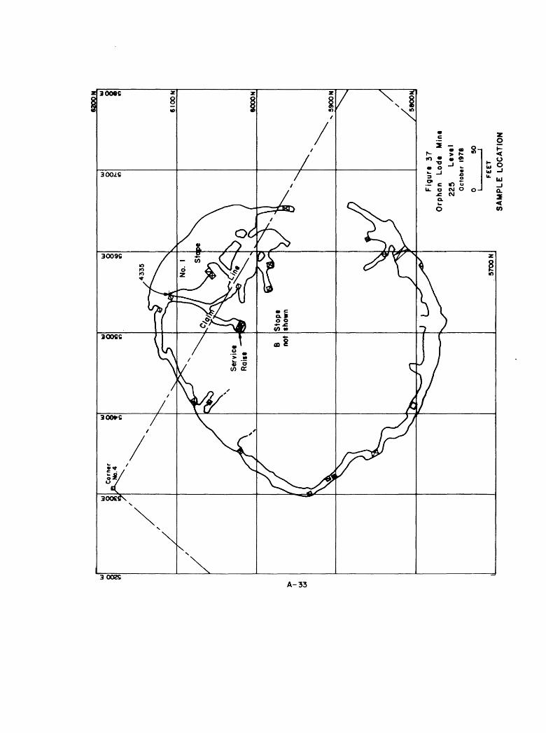
6200
N
Fig
urt
3
7
Orp
han
Lo
dt
Min
t
225
Ltv
tl
Oct
obtr
197
8
FEE
T
SA
MP
LE
L
OC
AT
ION

6200
H
Fig
urt
38
Orp
han
Lo
dt
Min
t
245
Le
vtl
Oct
ob
tr
1978
FEE
T S
AM
PL
E
LO
CA
TIO
NS

6200
N
Fig
ure
39
O
rphan
Lode
M
ine
37
5-4
OO
Leve
ls
Oct
ebtr
1978
0 50
FEE
T S
AM
PL
E
LO
CA
TIO
NS


