

68 RIDGE ROADTOLLGATEDURBAN 4001
P.O. BOX 30464MAYVILLE 4058
TELEPHONE (031) 201-8992TELEFAX (031) 201-7920
E-MAIL [email protected]
DRENNAN, MAUD & PARTNERSConsulting Civil Engineers and Engineering GeologistsRegistered Member : S.A. Association of Consulting Engineers
PARTNERS:R.D. COLLYER, Pr.Eng.,B.Sc.(Eng.),M.Sc.(Eng.),MSAICE.M.J.F. BÉNET, Pr.Sci.Nat.,B.Sc.(Hons.),M.Sc.,FSAIEG.M.J. HADLOW, Pr.Sci.Nat.,B.Sc.(Hons.),MSAIEG.
CONSULTANT:R.R. MAUD, Pr.Sci.Nat.,B.Sc.,Ph.D.,FGS.,FGSSA., FSAIEG.,FSAII
OUR REF.: 23311REV1
YOUR REF.:
30 November 2012th
Tongaat Hulett Developments
P.O. Box 22319
GLENASHLEY
4022
Email: [email protected]
Attention : Mr Greg Veerasamy
Dear Sirs,
REPORT ON THE GEOTECHNICAL INVESTIGATION FOR THE SUITABILITY FOR
DEVELOPMENT OF AN AREA DESIGNATED AS CANELANDS EAST, VERULAM
Further to our discussions and appointment to undertake the above-mentioned
investigation, we confirm that the field work has now been completed on the 18 Augustth
2012.
1. SITE DESCRIPTION
The site comprises a total area of 7.22 ha and is situated in the outer north
eastern part of Canelands, Verulam. The site is located directly south of the
meandering Umdloti River and is bordered by Dow AgroSciences and the
Verulam-tongaat Railway line to the east and south respectively.
The majority of the site is presently under cane cultivation by a farmer lessee to
the Client.

Ref. 23311-Rev1 Tongaat Hulett DevelopmentsCanelands East, Verulam Page ¹ 2
A triangular shape portion of the total area has mistakenly been included into the
fenced off area of Dow AgroSciences SA (Pty) Ltd. The gravel access road
leading to Dow AgroSciences SA (Pty) Ltd along which servitudes and a
substation are present crosses through the centre of the site.
The southern boundary of the site is marked by the property of the railways
accommodating the main railway line connecting Tongaat with Verulam.
The southern part of the project area south of the road crossing through the
project area is sloping gently with a concave slope conformation in a north to
north-westerly direction. The northern part comprises a fairly level north-western
portion with a wider north westerly trending valley line located to the north east.
The entire valley line has been marked as wetland by the Client as has the
outermost south eastern part.
2. FIELD INVESTIGATION
The field work comprised the mechanical excavation of inspection pits using a 4x4
TLB provided, supplemented with dynamic cone penetrometer tests and hand
auger excavations as well as material sampling. Three representative samples
were collected and taken to Thekwini Soils Laboratory in order to determine
materials suitability for further use in construction.
The field investigation was partly restricted by the presence of infrastructures such
as servitudes, roads, fences and a substation. Further agreement was reached
with the farming lessee to minimize crop damage. In total an area of 4.65 ha was
classified on the plan provided either as wetland areas, lying below the theoretical
100-year-flood-line or as existing services was excluded.
Separate access had to be arranged for the triangular area fenced off by Dow
AgroSciences SA (Pty) Ltd. Due to TLB accessibility restrictions, only auger
excavations and dynamic cone penetrometer tests were proposed for this portion.
However, on the day of testing, the entire area was flooded, which is a common
occurance according to the representatives of Dow AgroSciences SA (Pty) Ltd).
As such field work was restricted to a single auger excavation and a single
dynamic cone penetrometer test.
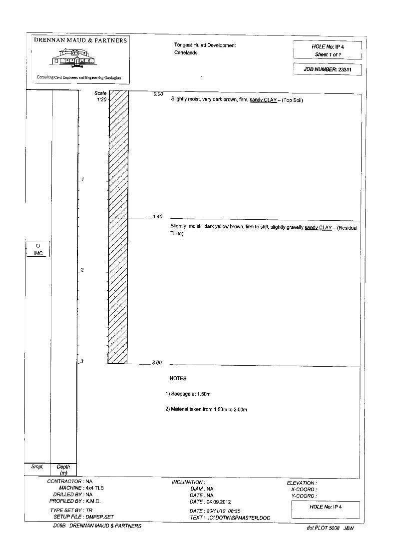
2.1 Inspection Pits (IP 1 - IP 9)
A total of nine inspection pits were excavated across the project area. The subsoil
profiles exposed were examined and logged. The pits were numbered IP 1 to IP
9 and the approximate positions are marked on the site plan (Figure 1). The logs
are presented in Appendix 1 included at the rear of this report.
Ref. 23311-Rev1 Tongaat Hulett DevelopmentsCanelands East, Verulam Page ¹ 3
2.2 Auger Excavations (AH 1 - AH 3)
A total of three hand augers were excavated, two along slopes of the main valley
line and a third within the previously mentioned fenced off area. Both excavations
along the embankment met with refusal at shallow depths less than 500mm on
what is believed to be boulders.
Due to flooding within the fenced area only one auger hole (AH3) was excavated.
All the auger hole profiles are included in Appendix 1 of this report.
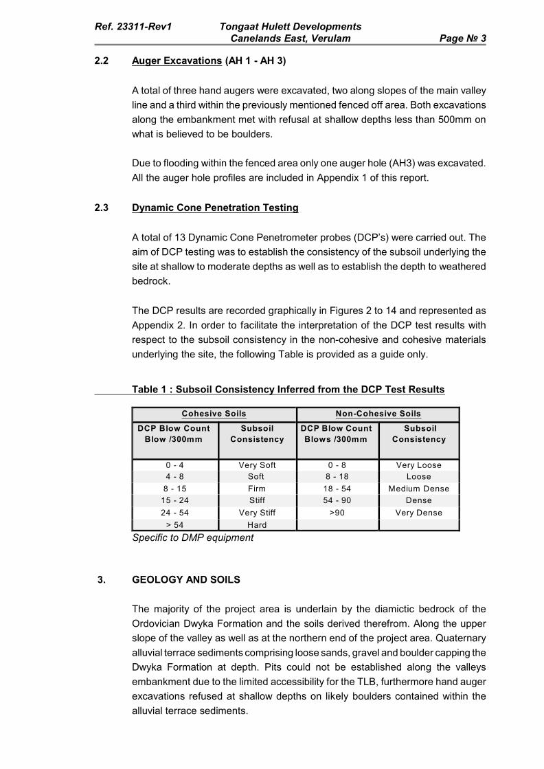
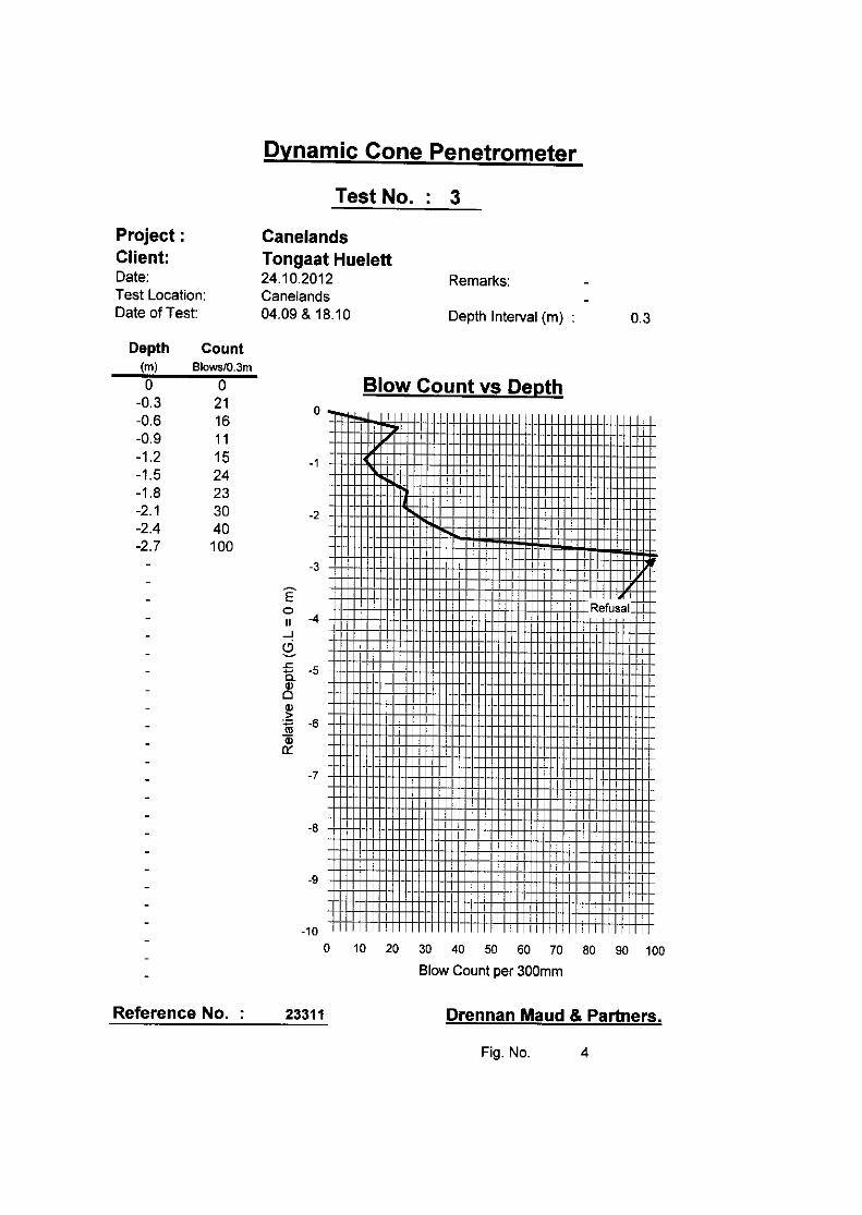
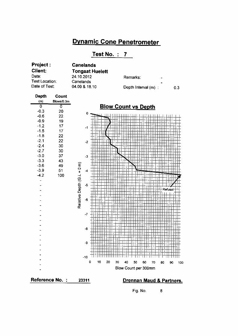
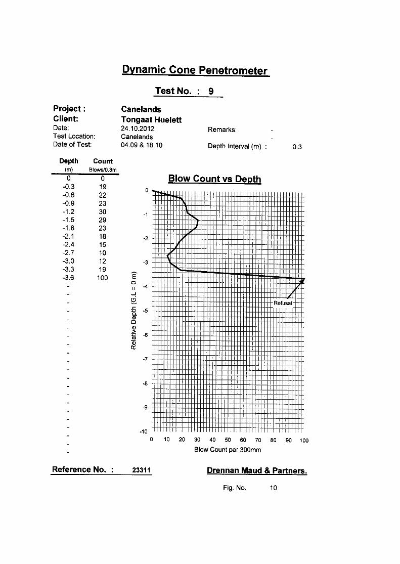
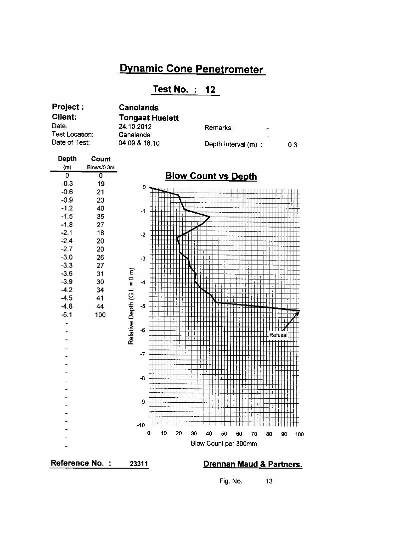
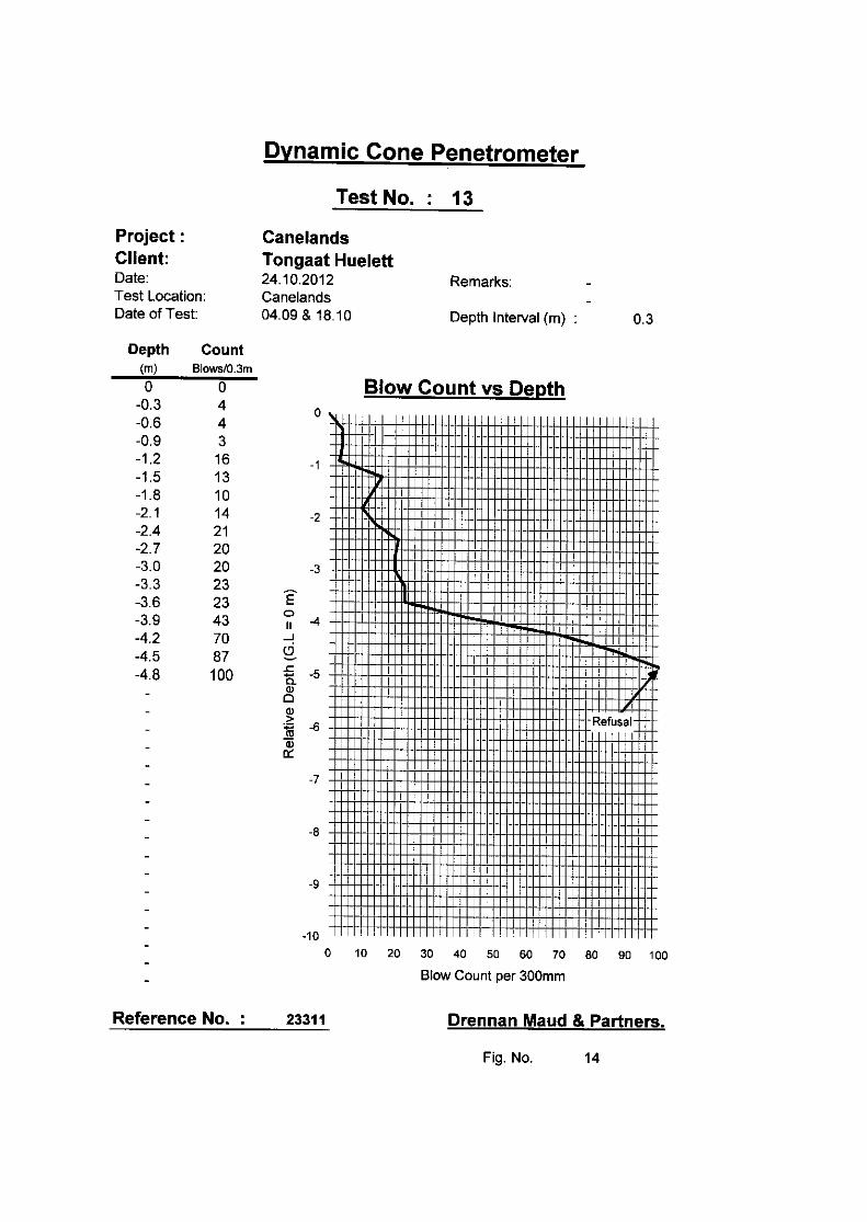
2.3 Dynamic Cone Penetration Testing
A total of 13 Dynamic Cone Penetrometer probes (DCP’s) were carried out. The
aim of DCP testing was to establish the consistency of the subsoil underlying the
site at shallow to moderate depths as well as to establish the depth to weathered
bedrock.
The DCP results are recorded graphically in Figures 2 to 14 and represented as
Appendix 2. In order to facilitate the interpretation of the DCP test results with
respect to the subsoil consistency in the non-cohesive and cohesive materials
underlying the site, the following Table is provided as a guide only.
Table 1 : Subsoil Consistency Inferred from the DCP Test Results
Cohesive Soils Non-Cohesive Soils
DCP Blow Count
Blow /300mm
Subsoil
Consistency
DCP Blow Count
Blows /300mm
Subsoil
Consistency
0 - 4 Very Soft 0 - 8 Very Loose
4 - 8 Soft 8 - 18 Loose
8 - 15 Firm 18 - 54 Medium Dense
15 - 24 Stiff 54 - 90 Dense
24 - 54 Very Stiff >90 Very Dense
> 54 Hard
Specific to DMP equipment
3. GEOLOGY AND SOILS
The majority of the project area is underlain by the diamictic bedrock of the
Ordovician Dwyka Formation and the soils derived therefrom. Along the upper
slope of the valley as well as at the northern end of the project area. Quaternary
alluvial terrace sediments comprising loose sands, gravel and boulder capping the
Dwyka Formation at depth. Pits could not be established along the valleys
embankment due to the limited accessibility for the TLB, furthermore hand auger
excavations refused at shallow depths on likely boulders contained within the
alluvial terrace sediments.
Ref. 23311-Rev1 Tongaat Hulett DevelopmentsCanelands East, Verulam Page ¹ 4
Fill materials were encountered along the western portion of the site. We assume,
a north west - south east trending depression or shallow drainage line leading
towards the Dow AgroSciences SA (Pty) Ltd pond has been filled in order to level
the area.
In general the depth to completely to highly weathered, very soft rock,
sedimentary bedrock exceeds 3.00m depth with the exception of the south
western most area where weathered bedrock was exposed at a depth of 2.40m
below existing ground level in IP5.
Loose alluvial terrace sediments associated with the nearby meandering uMdloti
River cap the underlying Dwyka Formation both along the embankment of the
valley line as well as at the north western boundary around IP 9.
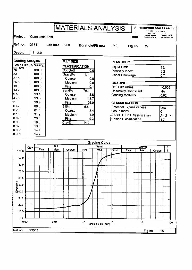
4. LABORATORY RESULTS
A total of three representative bulk samples recovered were taken to Thekwini
Soils Laboratory for testing which included full grading analyses, Mod AASHTO
and CBR tests to determine the suitability of the materials for possible use as
construction material. The results are summarised in Table 2 below and listed as
Figures 15, 16 and 17 in Appendix 3 included at the end of this report
4.1 Results
Table 2 : Laboratory tests and Result summary
IP
¹
Depth
(m)
Description Tests Results
Full
Ind
Mod
AASHTO
CBR AASHTO
Class
THR 14
2 1.5 - 2.0 Residual
Tillite
% % % A-2-4(0) G7
4 2.6 - 3.0 Residual
Tillite
% % % A-7-6(10) >G10
9 0.0 - 0.3 Colluvium % % % A-2-4(0) G7
4.1.1 Colluvium
The material encountered in IP 9 classifies as a gravelly sand with a clay content
of 7.4% and a grading modulus of 1.40. The material is non-plastic and has no
linear shrinkage. In terms of the Revised U.S. Classification this material classifies
as an A - 2 - 4 (0) which is considered an excellent to good subgrade material.

Ref. 23311-Rev1 Tongaat Hulett DevelopmentsCanelands East, Verulam Page ¹ 5
The maximum Mod AASHTO density of the material is 2023 kg/m³ at an optimum
moisture content of 6.8 %. The material has a CBR of 19 at a compaction of 93%
increasing to 40 at a compaction of 98% of the materials maximum Mod AASHTO
density. The material has no CBR swell.
In terms of TRH 14 (1985) the material classifies as a G7 material and is
considered suitable for re-use as subgrade and in selected layer works for road
and pavement works.
4.1.2 Residual Tillite
C The residual material encountered in IP 2 classifies as a clayey sand with a clay
content of 14.2% and a grading modulus of 0.92. The plasticity index of the
materials fines is 8.2 with a linear shrinkage of 0.7%. In terms of the Revised U.S.
Classification these materials are A - 2 - 4 (0) which is considered an excellent to
good subgrade material.
The maximum Mod AASHTO density of the material is 1903 kg/m³ at an optimum
moisture content of 10.4 %. The material has a CBR of 21 at a compaction of 93%
increasing to 45 at a compaction of 98% of the materials maximum Mod AASHTO
density. The material has no CBR swell.
In terms of TRH 14 (1985) the material classifies as a G7 material and is
considered suitable for re-use as subgrade and in selected layer works for road
and pavement works.
C The residual material encountered in IP 4 classifies as a gravelly, sandy, silty clay
with a clay content of 34.6% and a grading modulus of 0.84. The plasticity index
of the materials fines is 21 with a linear shrinkage of 13.3%. In terms of the
Revised U.S. Classification these materials are A - 7 - 6 (10) which is considered
a fair to poor subgrade material.
The maximum Mod AASHTO density of the material is 1800 kg/m³ at an optimum
moisture content of 17 %. The material has a CBR of 1.1 at a compaction of 93%
increasing to 1.6 at a compaction of 98% of the materials maximum Mod AASHTO
density. The material has a maximum CBR swell of 3.69%.
Due to the low CBR results, in terms of TRH 14 (1985) the material does not
classify as a G10 material and is not considered suitable in road and pavement
layer works.

Ref. 23311-Rev1 Tongaat Hulett DevelopmentsCanelands East, Verulam Page ¹ 6
5. GEOTECHNICAL ASSESSMENT
5.1 Excavatabliity
Excavatability in general is expected to be soft according to SABS 1200D through
the fill body, colluvial, alluvial as well as completely weathered bedrock. Abnormal
fill material, boulders or less weathered dropstones as are common within the
Dwyka tillite and the soils deriving therefrom might reduce the trenchability locally.
Blasting of sizable relic dropstones / corestones might be required locally.
5.2 Subsoil Seepage
Subsoil seepage was identified during the investigation predominantly within the
residual and completely to highly weathered Dwyka Formation. Additionally
perched water tables may build up during periods of high rain fall, at the base of
the loose alluvial terraces where underlain by less permeable in-situ materials.
5.3 Founding Conditions
Throughout the site founding conditions within competent residual and the upper
competent weathered sedimentary bedrock of the Dwyka Formation are
considered good. The bearing capacity of the in-situ sandy clays and clayey sand
may locally allow up to a maximum of 150kPa, whereas competent weathered
Dwyka bedrock is likely to exceed 200 kPa depending on the composition and
degree of weathered bedrock.
In general neither fill materials, nor colluvial or alluvial materials are considered
suitable for founding and all founding should ideally be taken through these
materials into competent materials of the Dwyka Formation.
6. CONCLUSION
6.1 In terms of the results of this assessment, we consider the investigated 2.54ha
portion of the 7.22ha site as stable in its existing condition, and capable of
development as such. The development of the site should, however, be carried
out in terms of the recommendations given below. These recommendations
amount to no more than sound building practices, appropriate for the geotechnical
conditions existing on the site.
Areal restrictions are given by the legislation regarding buffer zones for any
proposed development within a certain proximity of wetlands, 100-year-flood lines,
servitudes and substations as present in the area.

Ref. 23311-Rev1 Tongaat Hulett DevelopmentsCanelands East, Verulam Page ¹ 7
7. GENERAL DEVELOPMENT RECOMMENDATIONS
7.1 General Development
It must be understood, all development will be restricted by the existing servitudes
and the areas designated as wetland and within the 100-year-flood line with the
buffer zones applying.
However, the remaining areas are considered suitable for general development.
We assume, it is most likely to create individual platforms suitable for proposed
development. Within the southern portion of the area, given the generally gently
sloping concave topography, some earthworks will be required, consisting of
cutting and / or filling for the creation of engineered platforms.
7.2 Earthworks
Excavation is considered soft according SABS 1200D through all fill material and
residual clays into the upper weathered diamictic bedrock of the Ordovizian Dwyka
Formation.
Shoring of any excavation deeper than 1.20m is advised and must be
implemented at the discretion of the Engineer.
Where the alluvial terraces are present along the southern embankment of the
north easterly valley sidewalls are likely to be unstable and might have to be
shored at depth less than 1.20m.
Aggressive earthworks along the southern boundary may endanger the stability
of the adjacent railway line. Any earthworks in the vicinity of the railway line may
require detailed geotechnical studies.
Although no further details on any proposed development have been made
available at this stage, general recommendations regarding cut and fill
embankments are given below.
7.2.1 Cut Embankments
We assume building platforms are likely to be created for potential development.
Since no details have been forwarded, the following will be of a general nature.
As soon as the individual sites have been identified more specific
recommendations can be made:
• Building platforms should ideally be created entirely in cut.
• All permanent cut slopes into sandy materials should be restricted to a
maximum of 1:2 (26E). The maximum height of any cut slope should not
exceed 3.00m without being assessed by an Engineering Geologist.

Ref. 23311-Rev1 Tongaat Hulett DevelopmentsCanelands East, Verulam Page ¹ 8
• All permanent cut slope batters into clayey materials should be trimmed
back to a maximum batter of 1:1.75 (30°). Temporary cut banks during
construction may be laid back to a slope batter of 1:1.5 (33°).
• All cut embankments must be protected against surface erosion by the
planting of vegetation immediately after construction.
• In the hard to medium weathered bedrock, cut slopes may be steepened
to 1:1 (45E) or steeper at the discretion of the Engineer.
• Should it not be possible to accommodate the above slope angles, the
slopes will need to be supported by retaining structures. In addition, it may
be necessary to shore excavations or cut faces during construction.
7.2.1.1 Fill Embankments
Where fill platforms have to be created the following generalized
recommendations apply:
C Fill platforms should not be placed onto any unstable materials such as
colluvium materials or alluvial terraces.
C Prior to the placement of any fill the in-situ subsoil materials containing
vegetation should be removed.
C The fills should be constructed in layers not exceeding a maximum of
300mm loose thickness and be compacted to 93% of the materials
maximum Mod AASHTO Density for clayey materials and 95% of the
materials maximum Mod AASHTO Density for sandy materials prior to the
placement of the next layer.
C The maximum particle size within the fill should be restricted to two thirds
of the layers loose thickness.
C Permanent fill batters should be no steeper than 1:1,75(30E) and should
not exceed a maximum vertical height of about 3m.
C For generally well constructed engineered fills, internal settlements within
the fill of up to 1% of the fill thickness should be anticipated. As such,
settlements across the cut/fill line or from natural ground to maximum fill,
depending on the thickness of fill, may vary across the platform.

Ref. 23311-Rev1 Tongaat Hulett DevelopmentsCanelands East, Verulam Page ¹ 9
7.3 Subsoil Drainage
Seepage may occur along the contact between the capping colluvial sandy
materials and the in-situ residual clays or weathered bedrock formations during
periods of high rainfall. Control of seepage by the installation of subsoil drains
may be necessary locally depending on the nature of the development.
7.4 Sanitation
Due to the site being situated inbetween two areas apparently classified as
wetland, all effluent waters should ideally be collected and piped towards the
nearest treatment system. Alternatively, systems such as conservancy tanks or
package plant may be considered.
Systems such as french drain systems are not considered ideal due to the amount
of unsealed area required for evapotranspiration and environmental restrictions
implemented by the nearby eco-sensitive wetlands.
7.5 Materials
The colluvium material encountered classified as a G7 material, whereas the
residual in-situ soils varied from a G7 sandy material to a clay material not
classifying as a G10 material. We expect the in-situ residual soils and upper
completely to highly weathered bedrock materials of the Ordovizian Dwyka
Formation to provide materials within this range, depending on the composition
as well as the degree of weathering.
We trust that this report meets your immediate requirements.
Yours faithfully
DRENNAN, MAUD & PARTNERS
M.J. HADLOW Pr.Sci.Nat.
Encls. Appendix 1 - Soil Profiles
Appendix 2 - DCP’s 1 - 13
Appendix 3 - Lab Test Results
Figure 1 - Site Plan
/kmc/aj/kc

APPENDIX 1
SOIL PROFILES
(IP 1 - IP 9 & AH 1 - AH 3)
APPENDIX 2
DYNAMIC CONE PENETROMETER TEST
RESULTS (DCP 1 - DCP 13)

APPENDIX 3
LABORATORY TEST RESULTS

FIGURE 1
SITE PLAN


DRENNAN, MAUD & PARTNERSConsulting Civil Engineers & Engineering Geologists
68 Ridge RoadTollgateDURBAN4001
P.O. Box 30464MAYVILLE
4058
Telephone 201-8992Telefax 201-7920
e-mail:[email protected]
XDCP1
IP1
APPROX. POSITION OF DYNAMICCONE PENETROMETER TESTS
KEY
AH1
APPROX. POSITION OF INSPECTION PITS
APPROX. POSITION OF AUGER HOLE
X
X
X
X
XX
X
X
X
X
XX
X
DCP12DCP11
IP9
DCP10
IP8
DCP9
DCP13/AH3DCP2
IP1DCP1
IP2
DCP8DCP7
IP7DCP6IP6
DCP3
IP4
DCP5
IP5DCP4
IP3
CANELANDSEAST
REF. NO. 23311 FIG. NO. 1
AH2
AH1


