

1
SPHINX ASSOCIATES
PROPOSED CIVIC/ COMMUNITY & COMMERCIAL
DEVELOPMENT,
MOLAPO CROSSING EXTENSION
GABORONE.
ENVIRONMENTAL IMPACT ASSESSMENT
REPORT
MAY 2011
FOR THE DEPARTMENT OF ENVIRONMENTAL AFFAIRS REVIEW AND
APPROVAL
Report prepared by E & P Consultants
2
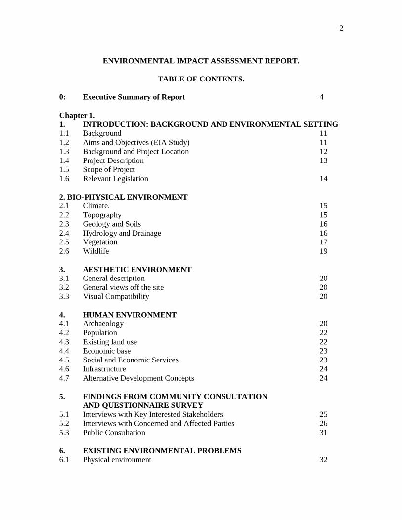
ENVIRONMENTAL IMPACT ASSESSMENT REPORT.
TABLE OF CONTENTS.
0: Executive Summary of Report 4
Chapter 1.
1. INTRODUCTION: BACKGROUND AND ENVIRONMENTAL SETTING
1.1 Background 11
1.2 Aims and Objectives (EIA Study) 11
1.3 Background and Project Location 12
1.4 Project Description 13
1.5 Scope of Project
1.6 Relevant Legislation 14
2. BIO-PHYSICAL ENVIRONMENT
2.1 Climate. 15
2.2 Topography 15
2.3 Geology and Soils 16
2.4 Hydrology and Drainage 16
2.5 Vegetation 17
2.6 Wildlife 19
3. AESTHETIC ENVIRONMENT
3.1 General description 20
3.2 General views off the site 20
3.3 Visual Compatibility 20
4. HUMAN ENVIRONMENT
4.1 Archaeology 20
4.2 Population 22
4.3 Existing land use 22
4.4 Economic base 23
4.5 Social and Economic Services 23
4.6 Infrastructure 24
4.7 Alternative Development Concepts 24
5. FINDINGS FROM COMMUNITY CONSULTATION
AND QUESTIONNAIRE SURVEY
5.1 Interviews with Key Interested Stakeholders 25
5.2 Interviews with Concerned and Affected Parties 26
5.3 Public Consultation 31
6. EXISTING ENVIRONMENTAL PROBLEMS
6.1 Physical environment 32
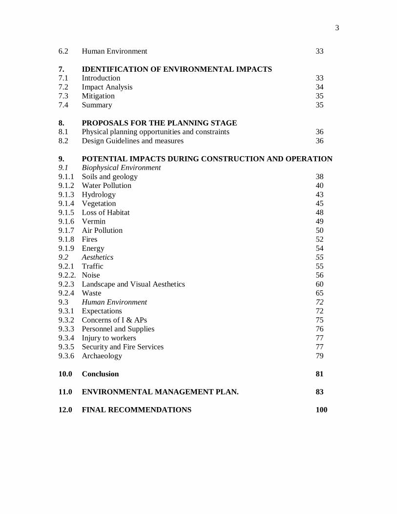
3
6.2 Human Environment 33
7. IDENTIFICATION OF ENVIRONMENTAL IMPACTS
7.1 Introduction 33
7.2 Impact Analysis 34
7.3 Mitigation 35
7.4 Summary 35
8. PROPOSALS FOR THE PLANNING STAGE
8.1 Physical planning opportunities and constraints 36
8.2 Design Guidelines and measures 36
9. POTENTIAL IMPACTS DURING CONSTRUCTION AND OPERATION
9.1 Biophysical Environment
9.1.1 Soils and geology 38
9.1.2 Water Pollution 40
9.1.3 Hydrology 43
9.1.4 Vegetation 45
9.1.5 Loss of Habitat 48
9.1.6 Vermin 49
9.1.7 Air Pollution 50
9.1.8 Fires 52
9.1.9 Energy 54
9.2 Aesthetics 55
9.2.1 Traffic 55
9.2.2. Noise 56
9.2.3 Landscape and Visual Aesthetics 60
9.2.4 Waste 65
9.3 Human Environment 72
9.3.1 Expectations 72
9.3.2 Concerns of I & APs 75
9.3.3 Personnel and Supplies 76
9.3.4 Injury to workers 77
9.3.5 Security and Fire Services 77
9.3.6 Archaeology 79
10.0 Conclusion 81
11.0 ENVIRONMENTAL MANAGEMENT PLAN. 83
12.0 FINAL RECOMMENDATIONS 100
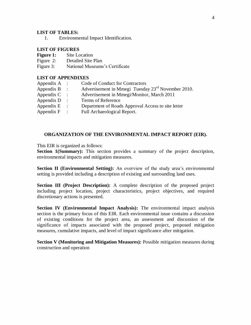
4
LIST OF TABLES:
1. Environmental Impact Identification.
LIST OF FIGURES
Figure 1: Site Location
Figure 2: Detailed Site Plan
Figure 3: National Museums‘s Certificate
LIST OF APPENDIXES
Appendix A : Code of Conduct for Contractors
Appendix B : Advertisement in Mmegi Tuesday 23rd
November 2010.
Appendix C : Advertisement in Mmegi/Monitor, March 2011
Appendix D : Terms of Reference
Appendix E : Department of Roads Approval Access to site letter
Appendix F : Full Archaeological Report.
ORGANIZATION OF THE ENVIRONMENTAL IMPACT REPORT (EIR).
This EIR is organized as follows:
Section 1(Summary): This section provides a summary of the project description,
environmental impacts and mitigation measures.
Section II (Environmental Setting): An overview of the study area‘s environmental
setting is provided including a description of existing and surrounding land uses.
Section III (Project Description): A complete description of the proposed project
including project location, project characteristics, project objectives, and required
discretionary actions is presented.
Section IV (Environmental Impact Analysis): The environmental impact analysis
section is the primary focus of this EIR. Each environmental issue contains a discussion
of existing conditions for the project area, an assessment and discussion of the
significance of impacts associated with the proposed project, proposed mitigation
measures, cumulative impacts, and level of impact significance after mitigation.
Section V (Monitoring and Mitigation Measures): Possible mitigation measures during
construction and operation

5
0. EXECUTIVE SUMMARY
A Summary
0.1 The subject of this Environmental Impact Report is the proposed Commercial and
Civic and Community development on the remainder of Plot 54483 Molapo Crossing
Shopping Centre complex, Gaborone. A detailed description of the proposed project is
contained in Section III of this report.
0.2 This is a middle ranking project that is likely to have some impact on the
environment and that is why it has been deemed necessary to prepare this EIR to support
the plan. An EIA is an information document, which will inform public agency decision
makers, and the public of the significant environmental effects of a project, identify
possible ways to minimize the significant effects, and describe reasonable alternatives to
the project. The purpose of this EIR, therefore, is to focus the discussion on those
potential effects on the environment of the proposed project which may be significant. In
addition, feasible mitigation measures are recommended, when applicable, that could
reduce or avoid significant environmental impacts.
B. PROPOSED PROJECT.
0.3 The proposed project is an extension south of the current Molapo Crossing
shopping complex comprised of offices, shops and civic and community land uses in the
form of a clinic, gym and a school.
C. ALTERNATIVES
0.4 This EIR considers two alternatives to the proposed project to provide informed
decision making according to EIA Draft Guidelines. The alternatives analyzed in this EIR
include (i) No project alternative (ii) Approximately 3,171m2 of commercial/office and
civic and community space plus parking facilities.
0.5 Under alternative (i), the proposed project would not be constructed and the
project site would remain in its current condition, which is scrub land of no commercial
land value; whereas under alternative (ii) the city would get an additional commercial,
office space and civic and community facilities that would help meet a critical need for
retail, recreational and office space in the city of Gaborone.
D: AREA OF CONTROVERSY
0.6 Issues to discuss:-
1. Loss of views by sensitive receivers (e.g. the Molapo Shopping complex)
2. Site access and traffic
E: EXPECTED ENVIRONMENTAL IMPACTS AND MITIGATION
MEASURES.
(i) ENVIRONMENTAL IMPACT ASSESSMENT.

6
0.7 The following sections present the various impacts associated with the
construction and operation of the proposed project. Mitigation measures are proposed for
significant environmental impacts, and the level of impact significance after mitigation is
also identified.
The expected impacts and required mitigations were assessed for different phases of the
development. These start with physical planning and detailed design of the shopping and
office complex, construction phases and the operation phase.
0.8 The following studies were carried out for this study (a) Physical (b)
Archaeological, (c) Ecological and (d) Socio-economic. In addition, use was made of
previous studies done for the Molapo shopping center, including a traffic study, flood
study, and a soils study.
To supplement the information collected from the above studies, consultations were
carried out with all affected and interested parties in this project and their inputs have
been factored in the ensuing recommendations for the project.
(ii) PHYSICAL AND HUMAN ENVIRONMENTAL IMPACTS DURING THE
PLANNING, CONSTRUCTION AND OPERATION PHASES OF THE
PROJECT.
0.9 The majorities of impacts are related to the human environment and the business
environment, and are present in the construction stage of the project.
Added to these are biological impacts. The project contributes to long term, cumulatively
significant unavoidable adverse impacts to biological resources due to loss of vegetation
in the area during construction that leads to soil erosion, loss of habitat, loss of views and
aesthetics.
0.10 Mitigation measures suggested during this stage are particularly important to
reduce the impacts, especially in relation to land and public safety. To this end, an
Environmental Code of Conduct for the contractor (or contractors) undertaking the work
has been drawn up and is included in Appendix A. It should be included in the contract
documents so that there is an obligation on the contractor to respect the environment he is
working in. Where proposals from the contract are required by the Code of Conduct, they
can be requested at tender stage so that the tenderers attitudes to environmental issues can
be assessed as part of the tender adjudication process.
0.11 There are some negative impacts during the operational stage, but the mitigation
measures recommended will reduce their effect to acceptable levels.
(A) PHYSICAL IMPACTS
Loss of Vacant Land - Project implementation will require commitment of
Current vacant land to urban use, and will contribute to the cumulative loss of
un-built land in the city.
Change in Topography- The project will slightly alter the physical attributes
of the site.
Change in Current land use- Once the project is implemented, the land will

7
not be returned to its current condition. Therefore, the project represents an
irreversible change to the land uses on the site.
Destruction of vegetation.
The little vegetation on site will be lost forever to be replaced by concrete and
asphalt. However, the area will be fully landscaped as per the TCPA and the
Development Control Code.
Disturbance to soils
Soils will be disturbed during construction.
Cleared top soil
The top soil will be removed during the construction of the project. However,
much will be brought back for landscaping purposes.
(B) HUMAN IMPACTS.
1. Increase in population and employment.
0.12 The coming on stream of this project will lead to an additional people into the
city of Gaborone who will either be employed directly on the project. The development
will result in the creation of between 600-650 job opportunities both during and after the
construction of the complex. Such people will work in the civic and community land uses
units, the shops and also the offices that will create employment, for both professional
and non-professional individuals.
2. Addition to City’s Commercial space stock
0.13 The project will also see an additional 3171m2 commercial space contributing to
greater office space and shopping space in the city of Gaborone.
3. Socio-economic impacts.
0.14 Other impacts will be bringing more business to the Molapo Shopping Complex
and greater recreational needs. Lastly the country‘s economy will benefit by the injection
of foreign exchange through construction investment.
5. Impact on utilities
0.15 There are several impacts on sewerage, solid waste, and water and energy sources.
(i) Sewerage
The development will obviously generate quantities of waterborne effluent, which will
require channeling into the existing city sewerage network.
(ii) Solid waste
The development will generate some solid waste, which should be removed by the
Gaborone City Council from the site on a regular basis as is already happening now.
(iii) Water

8
There will also be demand for water during and after construction. Water connections
will be made to the current main water trunk that runs through this area.
(iv) Greater demand for energy sources - Non-renewable resources such as oil and
other non-renewable energy sources will be used in the construction and subsequent use
of the site as a commercial centre. Connections will be made to the main trunk power line
that runs near the site.
NOTE: All utilities are available on site right now.
(C) AESTHETICS
0.16 Aesthetic impacts come from greater traffic flows, air pollution, noise, aesthetic
impacts etc.
(i) Traffic
The development of this area is bound to raise traffic volumes for the roads entering and
leaving the area. These are: The new Molepolole road and the Western By Pass road.
Such traffic was forecasted during the traffic study that was done for the developments of
the Molapo Crossing Shopping Centre as well as for the new 6-lane road to Molepolole.
To-date however, the developers of this area have secured a road access permission from
the Roads Department.
(ii) Air pollution
There will be an incremental increase in air pollution as a result of vehicular emissions
for cars going in and out of the complex.
(iii) Noise pollution
Increased traffic, mechanical and human activity will also result in increased noise and
air pollution in the area.
(iv) Aesthetic
1.17 The development in this area of the city will result in low level noise and light
glare to the people running businesses at the Molapo Shopping center and those living on
the other side of the Western By Pass road. Measures have to be taken to lessen the
impact of aesthetic loss by planting as many tall trees as possible and selective planting
of flowering plans in and adjacent the area. Other features can be added in due course.
MITIGATION MEASURES
0.18 Several mitigation measures can be taken to ameliorate the above impacts, and these
include the following:-
1. Conserving vegetation and soils.
Conserve whatever little vegetation there is on the site at the moment. Plant new
vegetation as part of the landscaping plan for the site.
2. Cleared topsoil and vegetation

9
Save cleared top soil and vegetation for landscaping purposes upon completion of the
construction phase.
3.Traffic and safety
Segregate motor traffic from pedestrian traffic in the design.
ENVIRONMENTAL MANAGEMENT PLAN.
0.19 An Environmental Management Plan has been prepared for both during the
Construction Stage and Operation Stage.
1. CONSTRUCTION PHASE
0.20 During the Construction Phase a number of Environmental Management Practices
can be instituted to ameliorate the impacts of the construction work.
These include the following:-
(a) Physical Environment
Soils and Geology - Adopt conservation measures
Deterioration of Air Quality - Regular damping down
- Removal of litter
Contamination of Water Resources
- Advance site planning
- Storage of potential pollutants
- Removal of waste
- Grease traps
- Temporary toilet facilities
- Clean up leaks.
Construction Traffic - Advance planning of traffic movements and management
- Warning signs to be put up
- Discourage pedestrians from crossing the site
Noise Pollution - Adhere to normal working hours
- Adopt noise reduction methods
(b) Biological Environment
Disturbance to Flora – Conservation and preservation of adjacent flora.
(c) Socio-Economic Environment.
Unsocial activities
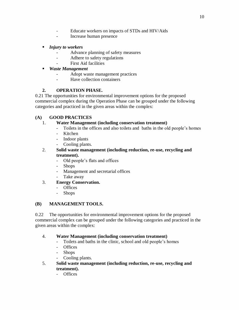
10
- Educate workers on impacts of STDs and HIV/Aids
- Increase human presence
Injury to workers
- Advance planning of safety measures
- Adhere to safety regulations
- First Aid facilities
Waste Management
- Adopt waste management practices
- Have collection containers
2. OPERATION PHASE.
0.21 The opportunities for environmental improvement options for the proposed
commercial complex during the Operation Phase can be grouped under the following
categories and practiced in the given areas within the complex:
(A) GOOD PRACTICES
1. Water Management (including conservation treatment)
- Toilets in the offices and also toilets and baths in the old people‘s homes
- Kitchen
- Indoor plants
- Cooling plants.
2. Solid waste management (including reduction, re-use, recycling and
treatment).
- Old people‘s flats and offices
- Shops
- Management and secretarial offices
- Take away
3. Energy Conservation.
- Offices
- Shops
(B) MANAGEMENT TOOLS.
0.22 The opportunities for environmental improvement options for the proposed
commercial complex can be grouped under the following categories and practiced in the
given areas within the complex:
4. Water Management (including conservation treatment)
- Toilets and baths in the clinic, school and old people‘s homes
- Offices
- Shops
- Cooling plants.
5. Solid waste management (including reduction, re-use, recycling and
treatment).
- Offices

11
- Shops
- School
- Clinic and
- gym
6. Energy Conservation.
- Offices
- Shops
- School
- Gym
- clinic
(B) MANAGEMENT TOOLS.
0.23 Apart from the above good practices there are additional tools or approaches to
facilitate commercial and retail environmental management. These include Environment
Management Systems, Green Purchasing, Eco-labeling, Good Housekeeping and
Training and Education. These may be applied one by one, in combination, or all
together.
OVERALL RECOMMENDATION.
0.24 In view of the above findings and possible mitigation measures for the expected
environmental impacts we see no long term irreversible impacts that can stop the project
from going ahead.
We would thus recommend that planning permission be given for the project.
1. INTRODUCTION: BACKGROUND AND ENVIRONMENTAL SETTING
1.1 Background
12
1.1.1 The Sphinx Group intends to extend retail and office development to the south of
the existing centre on the remainder of its plot 54483 at Molapo Crossing shopping
complex currently being vacant land and partly car park. The site is bounded to the
north by the Segodisthane River; to the east by the current commercial
development at Molapot; to the south by the Western By Pass road/Molepolole
Road junction; and to the west by the Molepolole Road.
1.1.2 The current site is overlain with soil that has been deposited here by contractors
who were either building the current Mall and its adjacent car park or those who
are reconstructing the Molepolole road. A field walk on this site reveals builder‘s
rubble, paper, metal and plastic waste and scrubland composed of shrubs, a few
trees and grasses. On one corner can also be found a group of informal vendors
selling airtime, sweets and similar goods to passersby!
1.1.3 The proposed development will comprise of five buildings composed of several
offices, shops, a take away, clinic, school and gym.
A detailed breakdown of areas is as follows:-
Ground Floor – Area
(a) Retail 174m2
(b) Filling Station 145m2
(c) Take Away
313m2
First Floor – Office 866m2
Second Floor: Offices 866m2
Third Floor : Offices 866m2
The parking requirements are as follows:-
Existing = 184 m2
Proposed = 74.78m2
Total Parking Bays Provided = 363 bays more than required. Inclusive of
Disabled Bays = 12 and 6 Loading bays
1.1.4 The project will go a long way in meeting the ever-rising demand for civic and
community facilities and commercial and office space in Gaborone city. The project will
represent a multi-million contribution to Botswana‘s economy.
The outcome of this EIA will aid and inform the proposed detailed layout and design of
the complex as well as the planning approval process.
1.2 Aims and Objectives of the EIA Study.
1.1.5 The objectives of an Environmental Impact Assessment (EIA) is to ―…define and
evaluate the foreseeable immediate and long term effects on the physical
environment, public health
and welfare of the population affected by a specific project during its entire
cycle and following completion‖ (World Bank, 1984). Environmental impacts of the
proposed development will be both positive and negative. The importance of carrying out
the EIA at the planning stage enables these impacts to be identified and addressed prior

13
to implementation of the project. An ensuing Management Plan will provide guidelines
for environmental consideration during the operation stage.
1.1.6 The Terms of Reference for the proposed planning of this commercial
development
require that an EIA is carried out and that environmental recommendations are
incorporated into the design, construction and operational phases of the project. The
main aims of the EIA are:
To analyze the impact of the proposed development and associated access roads
on the biophysical, aesthetic and socio-economic environment.
To recommend appropriate long and short-term mitigation and rehabilitation
solutions to minimize any undesirable effects resulting from the construction and
operation of the proposed development.
To recommend appropriate long and short-term mitigation and rehabilitation
measures to maximize any desirable effects resulting from the construction and
operation of the proposed development.
To liaise with key interested and affected parties and relevant government
departments on issues relating to the proposed development.
1.1.7 The EIA provides a comprehensive evaluation of the potential environmental and
socio-economic impacts of the proposed development project. These impacts can be
positive and negative, long or short term but are likely to be more significant during the
construction periods of the project. Measures to mitigate adverse or negative impacts and
enhance beneficial or positive impacts have been identified and will be incorporated into
the design process.
1.1.8 The EIA study has been carried out during the detailed layout stage and design of
the project so that environmental and socio-economic issues could be identified and
addressed at an early stage of the development.
1.1.9 A significant part of the EIA has involved consultations with the local community
in and around this site. This was important to ensure that the needs of the community are
considered and also so that abortive design work is avoided or minimized.
1.3 Background and Project Location
1.1.10 The approved Gaborone Master Plan has zoned this part of the city as (a) An area
for commercial cum civic and community development surrounded by open
space and civic and community land uses.
Developments in and around the proposed area include the currently operating
Molapo Shopping complex with its various small and big shops, super markets,
restaurants, bottle store, and coffee shops; (b) A petrol station (Engen) some short
distance to the north and fallow land to the west of the Segoditsane river and
Residential development to the east of the site – Phase 2, Gaborone. In terms of
site location, the proposed development will be built south of the current Molapo
14
Crossing shopping centre in a piece of land between the Centre and the
Molepolole Road.
Fig. 1: Site Location
Fig. 2: Detailed Site Plan
1.4 Project Objectives.
1.1.11 The private sector in Botswana has often been called to play a leading role in the
development of the country in order to diversify the economy. It is in this vain that the
proposed commercial/office and civic and community complex is being developed to
provide commercial as well as office space that is in great demand in the city currently to
supplement current unfulfilled demand.
1.5 Scope of the Project
1.1.12 The project shall consist of the following sections of work:
Preparation of a layout plan and designs for the proposed commercial and office
complex and its ancillary uses. An architectural/planning firm, ‘Concepts’ was
commissioned to carry out this consultancy and has produced preliminary design
concepts for the development of this area. This EIA will go a long way in
influencing and shaping the final outcome of the detailed design of the site.
Engineering designs are in an advanced stage, and ultimately,
Implementation or construction of the following services:-
- Roads and storm water reticulation, including earth moving and grading, cutting
and lining of drains, compaction, surfacing and finishing;
- Water and water fighting reticulation, including shallow trenching, laying of pipe
work and valves etc, backfilling, connecting to the site and finishing;
- Waterborne sewerage, including trenching, laying of pipe work, construction of
manholes, backfilling and finishing;
- Power reticulation, including installation of poles, conductors and other ancillary
equipment;
- Street lighting, including installation of poles and lamps, cabling and other
ancillary equipment and
- Telecommunications, including installation of poles and/or underground cables
and other ancillary equipment.
1.6 Relevant Legislation and Policies applicable in the development of this site
1.1.13 EIAs have been required for certain major developments since 2005 when the Act
was passed by government. This civic and community cum commercial/office
development certainly falls under those activities that require an EIA. In this
15
development, the following acts and legislation have a bearing on the activities proposed
in this area. These are:-
The Town and Country Planning Act 1971
1.1.14 This act is intended to provide ‗orderly and progressive development of land in
both urban and rural areas‘ and establishes controls over the use of residential,
commercial and industrial, recreational, agricultural and forestry land. As this area is
zoned for civic and community as well as commercial development, approvals will have
to be obtained from the Town and Country Planning Department of the Ministry of Lands
and Housing.
The Building Control Act
1.1.15 The act authorizes the making of building regulations for the control of matters
such as the construction of buildings, sanitary facilities, the supply of water, sewers and
so on. This will be in respect of the buildings that will be constructed on this site and
have to conform to the Act.
The National Policy on Natural Resource Conservation and Development
1.1.16 This document is intended to ensure the sustainability of all future development.
Section 7.3 c) states that EIA‘s should be conducted for new development projects.
Hence all natural resources on the proposed site should be conserved as much as possible.
The Monuments and Relics Act
1.1.17 This Act is actually one of the enabling legislation for this EIA. The Act also
enables the government to identify and declare sites of national, historical and
archaeological importance and to protect monuments and relics of national importance.
Thus, it is imperative that an archaeological study be carried for this site.
The Herbage Preservation Act
1.1.18 This Act is aimed at the control of bush fires to protect humans, vegetation and
wildlife. Section 4 prohibits the setting of fire to any land or vegetation. If fire breaks
out, then anyone and everyone present are obliged to assist in extinguishing it. This site is
surrounded by bushes and trees on the western side and care must be taken to prevent any
fires in these area.
The Atmospheric Pollution Control Act
1.1.19 The purpose of this act is to prevent atmospheric pollution. During construction
or operation of this project it is certainly possible that there will be atmospheric pollution
and thus mitigation measures need to be put in place to prevent/ameliorate any adverse
impacts.
The Waterworks Act
1.1.20 ―This Act provides for the constitution of water authorities in townships, to confer
certain duties and powers upon such water authorities, to provide for the acquisition of
existing waterworks and to provide for matters incidental thereto.‖ This act has relevance
to this project in that the proposed development will require potable water as well as will

16
generate waste water and sewage and thus these factors have to be taken into account in
the report.
The Waste Management Act
1.1.21 This Act makes provision for the planning, facilitation and implementation of
advanced systems for regulating the management of controlled waste in order to prevent
harm to human, animal and plant life; to minimise pollution of the environment, and to
conserve natural resources in regulating the trans-boundary movement of hazardous
wastes and their disposal; and for matters incidental to and connected to the foregoing.
Related to this Act is the ―Strategy for Waste Management‖. All solid and liquid waste
generated on the site has to be carefully managed and disposed off.
2. BIO-PHYSICAL ENVIRONMENT
This section provides a description of the existing biophysical environment.
2.1 Climate.
The climate of the Gaborone area is described as semi-arid, with a long-term annual
average rainfall of 526mm with a seasonal variation of 30%. This is combined with a
potential evapo-transpiration rate of 1800mm.
2.1.1 The majority of rainfall occurs in a relatively small number of intense rainstorms,
generally of short duration and occurring between the months of October and March. The
monthly mean rainfall varies from 104mm in October to less than 1mm in July.
January normally has the highest monthly mean temperature of 330C while July has a
mean maximum temperature of 230C. The mean monthly low temperatures vary from
200C in January to 4
0 in July.
2.1.2 Prevailing winds generally have a low velocity from the northeast. The winds
have an annual mean ranging from 0.8m/s in May to 1.6m/s in October. Winds in the area
are generally described as calm.
2.2 Topography
2.2.0 The centre of Gaborone lies at latitude 240 39‘S and longitude 25
0 55‘E . The city
is situated on a vast plain at approximately 968m above mean sea level(amsl) with low
relief and rare isolated hills. Kgale hill is a granite outcrop to the south of the city and is
one of the dominant relief features of the city. In addition to Kgalehill there are 5 other
isolated rocky outcrops in the surrounding area with elevations from 1050 – 1111m amsl.
The proposed site is at the corner of Molepolole road and the Western By-pass, and is
almost flat but slopes from east to west towards the Segoditshane river.
2.3 Geology and soils
2.3.0 A geological and soils survey was undertaken for the entire Molapo Shopping
complex area (part of which is to be used by the new extension) by a firm specialized in
geotechnical work. The fieldwork for the geotechnical investigation, comprising test

17
pitting, was undertaken and several test pits were excavated. Soils were profiled in situ
and others were analyzed in a soils test laboratory.
2.3.1 Laboratory tests for foundation engineering purposes were conducted on selected
soil samples taken from the soil horizons encountered in the test pits. The project area is
partly covered by a tarred surface that is underlain by residual soil comprising slightly
silty sand with fine gravel.
2.3.2 The residual soils are masked by transported soils. In most instances, these soils
are identifiable as being of Aeolian origin (silty sands) but in certain areas, their origin,
particularly within the granite rock outcrop areas, appears to have been associated with
deposition of some form of gully wash. In general, the gully wash soils comprise clayey
sands or locally sandy clays.
2.3.3 It is not uncommon for the Aeolian and gully wash deposits, particularly the
former, to be separated from the underlying granite by a horizon of pedogenic soils
comprising poorly –through well developed ferricrete with even hardpan ferricrete being
present. Locally, calcification of the soils has occurred as well. It is apparent that the
pedogenic soils have developed in the pebble marker horizon at the base of the
transported soils as well as in the upper residual granite soils.
2.3.4 An evaluation of the soils indicates that:
The Aeolian deposits are compressible and potentially collapsible soils
The transported gully wash soils are potentially moderate expansive. Surface
heave (and shrinkage) could occur as a consequence of moisture/volumetric
changes in the clay soil.
2.3.5 Potential road construction materials.
The materials making up the typical surface horizons of the ground profile are likely to
be exposed in construction of normal site infrastructure and can be used for construction
purposes.
2.4 Hydrology and Drainage
2.4.1 The drainage system is generally from the east to the west of the site, ending
either at Segoditshane river channel that runs behind this site. The Segoditshane river, to
the west, has water most of the year and does get full during the wet season.
2.4.2 Slope stability and erosion.
The mean gradient of the site is typically less than 10 and therefore no risk pertains to
slope stability considerations. Once the tarred surface has been stripped during
construction, the exposed soils will be subject to wind erosion and as such dust nuisance
could occur due to high winds.
2.4.3 Potential for shallow ground water during construction.
Ground water or inflow into the test pits was absent during the course of the test piting
recently undertaken.

18
2.4.4 In places, the gully wash horizons are leached in profile. This fact, coupled with
the presence of pedogenic soils and shallow bedrock conditions underlying large portions
of the site, indicate that shallow perched ground water conditions probably prevail from
time to time during the rainy season, for which provision should be made in road and
service construction contracts. The proposed improvements will significantly decrease
erosion of the site.
2.5 Vegetation
2.5.0 A literature review was conducted to determine the existing conditions
within the Study Area (site area and its surroundings) and to identify habitats
and species of potential importance that may be affected by the Project. The
literature review included Government and private sector reports, independent
and Government published literature, academic studies, vegetation maps and
land use maps. The review included the following:
Gaborone Master Plan – Revised Plan 2009.
Gaborone Urban Development Plan II – 2003-2009
Various EIAs that have been done for projects in and around the site.
2.5.1 Field Survey
The Study Area was defined as the area within 500 meters of either side of the
project area. Following a literature review of available ecological data
characterizing the Study Area, a number of reconnaissance surveys were
undertaken by an ecologist to update and field check the validity of the
information gathered in the review. A number of more focused baseline field
surveys were then proposed to supplement the review findings. The baseline
surveys were carried out to determine the existing environmental conditions,
and were designed to fill any data gaps, and to facilitate an adequate assessment
of the Project‘s impacts upon the ecology and the development of appropriate
mitigation measures.
2.5.2 The information presented in the following sections has been based on
the findings of baseline surveys performed.
2.5.3 By and large, there are no unique plant species that were found on the site
basically because it has been modified a lot by human activities during the construction
of the Molapo Crossing Shopping Centre and its subsequent use. To-date there are only
12 medium size trees on the actual site and the rest are just shrubs. It is projected that the
proposed andscaping of the complex will bring up the tree count to 122 trees.
2.5.4 There are two basic vegetation communities on the surrounding site.
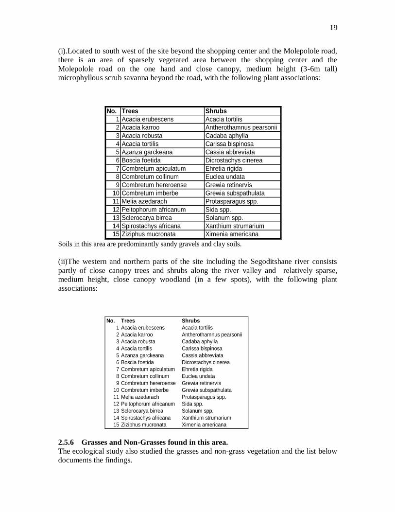
19
(i).Located to south west of the site beyond the shopping center and the Molepolole road,
there is an area of sparsely vegetated area between the shopping center and the
Molepolole road on the one hand and close canopy, medium height (3-6m tall)
microphyllous scrub savanna beyond the road, with the following plant associations:
No. Trees Shrubs
1 Acacia erubescens Acacia tortilis
2 Acacia karroo Antherothamnus pearsonii
3 Acacia robusta Cadaba aphylla
4 Acacia tortilis Carissa bispinosa
5 Azanza garckeana Cassia abbreviata
6 Boscia foetida Dicrostachys cinerea
7 Combretum apiculatum Ehretia rigida
8 Combretum collinum Euclea undata
9 Combretum hereroense Grewia retinervis
10 Combretum imberbe Grewia subspathulata
11 Melia azedarach Protasparagus spp.
12 Peltophorum africanum Sida spp.
13 Sclerocarya birrea Solanum spp.
14 Spirostachys africana Xanthium strumarium
15 Ziziphus mucronata Ximenia americana
Soils in this area are predominantly sandy gravels and clay soils.
(ii)The western and northern parts of the site including the Segoditshane river consists
partly of close canopy trees and shrubs along the river valley and relatively sparse,
medium height, close canopy woodland (in a few spots), with the following plant
associations:
No. Trees Shrubs
1 Acacia erubescens Acacia tortilis
2 Acacia karroo Antherothamnus pearsonii
3 Acacia robusta Cadaba aphylla
4 Acacia tortilis Carissa bispinosa
5 Azanza garckeana Cassia abbreviata
6 Boscia foetida Dicrostachys cinerea
7 Combretum apiculatum Ehretia rigida
8 Combretum collinum Euclea undata
9 Combretum hereroense Grewia retinervis
10 Combretum imberbe Grewia subspathulata
11 Melia azedarach Protasparagus spp.
12 Peltophorum africanum Sida spp.
13 Sclerocarya birrea Solanum spp.
14 Spirostachys africana Xanthium strumarium
15 Ziziphus mucronata Ximenia americana
2.5.6 Grasses and Non-Grasses found in this area.
The ecological study also studied the grasses and non-grass vegetation and the list below
documents the findings.

20
Grasses
These include:-
Aristida congesta
Cenchrus ciliaris
Digitria eriantha
Eragrostis rigidior
Enneapogon cenchroides
Eragrosttis spp
Melinis repens
Panicum maximum
Urochloa mossambicensis.
Non-Grasess.
Abutilon spp
Achyranthes aspera
Amaranthus hybridus
Bidens pilosa
Evolvulus alsinoides
Gomphrena celesioides
Hermannia spp
Indigofera bainesii
Ociumum canum
Sida spp
Solanum incanum
Triumfetta sonderi
Vermonia poskeana
2.6 Wildlife and birds.
2.6.1 Human activity in and around this site has resulted in a profound modification of
the original landscape through road construction and building of the first shopping
complex. The increase in human population density in Gaborone has changed the profile
of the fauna in the area dramatically over the last three decades.
2.6.2 Specifically to the site: There is little evidence of small mammals, reptiles and
birds on the site.
2.6.3 Beyond the site no significant wild mammals, birds or reptiles were observed.
Goats, cows and donkeys however frequent the site and are now almost a nuisance to
shoppers.
3. AESTHETIC ENVIRONMENT
3.1 General description: Visual character of the vicinity.

21
3.1.1 The visual character of the area is composed of vacant land and an area paved and
used as a car park. It is surrounded by built land to the north (Molapo shopping mall) and
east (Western By Pass road and Phase 2 residential development) and un-built land to the
south across the Molepolole road and bushy area to the west towards the Segoditshane
river.
3.1.2 With respect to light and glare, the site is currently lit by lights from the current
shopping mall. Further, some diffuse lighting extends onto the site from the Western By-
Pass Road streetlights and residential houses in Phase 2 and also lights from the newly
completed Molepolole road. Land uses in the vicinity that would be most sensitive to
night lighting are the residences located to the east of the proposed development.
3.2 Visual compatibility.
3.1.3 The area in the vicinity of the project area is characterized by existing commercial
and residential development in a diverse range of architectural styles and themes. The
Molapo shopping mall(two - storey buildings) to the north and single storey houses with
little character in Phase 2 on the other side of the Western By-Pass road. The project
anticipates a three storey building that complements the adjacent shopping center
structures. Hence there will be minimal incompatibility.
4. HUMAN ENVIRONMENT
4.1 Archaeology
4.1.0 An investigation of the impact area was conducted by a qualified archaeologist.
The main method of searching for archaeological, historic and cultural remains, involved
field and/or foot surveys. Archival and library materials were studied prior to visiting the
site. These informed the archaeologist on field methods to use.
4.1.1 The site for development is heavily disturbed, it made site survey options
difficult, and however, as explained below, a fairly good part of the site was
systematically walked. More attention was paid particularly to any evidence of human
activity including artifacts and immovable features such stone walls, house foundations,
house floors and earths to mention a few. Test excavations were not undertaken because
there were a number of places that were exposed by bulldozing activities.
4.1.2 The survey concentrated on the whole development area (100% coverage). The
impact area was surveyed systematically. GPS coordinates of the area were recorded. But
these were not too useful as the proposed site has a plot number.
4.1.3 The surrounding areas were checked for archaeological materials because they have
a National Monument (opposite entrance to the Grand Pal Hotel), existing structures and
are already disturbed.
22
4.1.4. SURVEY RESULTS
The proposed development is located at Molapo Shopping Centre, Plot 54483 as
mentioned in the introduction. Dominant vegetation noted within the proposed plot for
development included acacia tortilis (mosu) and acacia mellifera (mongana). The
vegetation was notably slightly thick and the piece of land under investigation appeared
to be disturbed land.
4.1.5 Nothing of archaeological, historical and cultural significance was observed at the
proposed extension site. A substantial part of the site was disturbed and was covered by
thick vegetation. Lack of archeological, historical and cultural materials suggests that
there is nothing important at the impact area to be preserved and/or rescued.
4.1.6 CONCLUSION
Since no significant archaeological and related materials were observed in and around the
Project Area, there is nothing to preserve in the area. Thus, the proposed development
should be allowed to proceed.
4.1.7 The Project Area is rated No. 5 under the Botswana National Museum
Grading System, which is as follows:
1=Preserve at all costs;
2=Preserve if possible, otherwise extensive salvage work;
3=Test excavations to determine whether further work is necessary;
4=Systematic preventative sampling sufficient; and
5=No further archaeological work required;
The project should be given a planning consent.
4.1.8 RECOMMENDATIONS
Because no archaeological, historic and cultural sites and/or significant distributions were
found in the area of the extension of Molapo Crossing Shopping Centre, a development
Permit has been issued to Sphinx Associates (Pty) Ltd.
4.1.9 However, it should be noted that there were no test excavations conducted to
determine the presence of archaeological materials below ground level. Accordingly, if
archaeological materials are recovered during the construction of the complex in
question, the Developer is requested to notify the Archaeology Division (Salvage Unit) of
the Botswana National Museum and/or the author of this report as required under the
Monuments and Relics Act of 2001.(See Full text in Appendix xxx)

23
Figure 3. A CERTIFICATE FROM THE NATIONAL MUSEUM
4.2 Population
In 1991 Gaborone had a population of 133, 468 residing within the city limits. By 2001
the population had grown to 185891. To-day the population is estimated to be around
200,000. The peri-urban area has witnessed a fast growth rate due to easy availability of
land in the tribal areas. There are no people living on this site. People‘s homesteads can
only be found in adjacent Phase 2 on the other side of the Western By-Pass road and in
Block 6 across the Segoditshane road.
4.3 Existing land use
The site is a partly a vacant site and a car park that is currently used by shoppers who
visit the Molapo shopping centre. On the western side however, is the bush land that
leads to the Segoditshane river and also a skating ring which is of temporary nature.
Much of the site is covered by builder‘s rubble, solid waste such as paper, plastic and
glass. On the corner, there are individuals selling airtime, cigarettes, sweets and such like
items to people visiting the site.
4.3.1 Consistency with city zoning classification and requirements.
The zoning of the area is for commercial and civic and community development and thus
the developments planned for this area are consistent with the GCC Master Plan of 2009;
the Urban Development Standards and the Development Control Code. A layout plan

24
was prepared for the Molapo Shopping Centre and was approved by both the Physical
Planning Committee of the GCC and the Town and Country Planning Board.
4.3.2 However a layout of the extension complex has been put on hold until the EIA
report has been received and reviewed by the concerned authorities.
As the proposed project will not conflict with existing development plan goals and
policies, no impact will result.
4.3.3. Land use compatibility
The proposed retail and office development consisting of offices and several retail
outlets. Included too is a recreational outfit. Clearly these developments would be
consistent with the existing land use pattern in this area and with adjacent properties,
which consist of the shopping centre. Therefore no significant impacts would result from
the proposed project with regard to land use compatibility as the uses belong to the same
Land Use Classification Order(Commerce).
4.3.4 As the proposed project is consistent with existing land use regulations and
adjacent land uses, no mitigation measures are required.
4.4 Economic base
4.4.1 For Gaborone in general, 71.7% of the population falls within the active working
bracket of 15-64 years old. This proposes that there is a broad based economically active
population. Of the total male population 58.5% are economically active while 45.5% of
the total female population are economically inactive. Gaborone has an unemployment
rate of 11% which is less that the national rate (CSO, 2001).
4.4.2 For the people operating businesses at the adjacent shopping center their main
economic base is commerce. People are engaged in both managerial and service levels.
The proposed development should benefit some of the businesses here, as it will draw
more people to the complex. In addition, the project will provide needed employment
opportunities.
4.5 Social and Economic Services
Health
4.5.1 Gaborone has a total of 56 health centres, 1 national referral hospital (Princess
Marina Hospital) and 2 private run hospitals, viz: the new Bokamoso Hospital and the
Gaborone Private Hospital in Broadhurst. In addition to the above there are several
private run surgeries in most parts of the city. In the vicinity of the project site the
nearest health facilities are: three clinics viz: in Block 6, Phase 1 and Phase 2.
Education
4.5.6 There are several educational facilities in the city. In the vicinity of the project there
are 4 primary schools, 1 in Block 5 south; 2 in Block 6 (one of which is a Private English
medium school) and 1in Phase 2. In addition, there are also junior secondary schools in

25
Block 5, Block 6 and an English medium junior and senior secondary school, Legae
Academy. There is also the distance education center, BOCODOL north of the site in
Block 6.
4.6 Infrastructure
Roads.
4.6.1 The project site is bordered by two major trunk roads. The first is the newly
reconstructed and widened Molepolole road that leads to Block 6 to the west and also
extends to Molepolole. This is a very busy road as it also provides a connection to the
Grand Palm hotel and the Gaborone International Conference Centre as well as many
suburbs to the western part of Gaborone. The second is the even busier dual carriage-
road, the Western By Pass road. Current access to the site from both roads is left in and
left out arrangement which is rather inconvenient for some shoppers. The proposed
development will require a better access into the site and will also generate more traffic
both on Molepolole and the Western By Pass roads.
Power
4.6.2 Currently, there is ample electric power supply connection to the Molapo
Shopping Centre . A high tension power line passes to the northern and western parts of
the site.
Telecommunications.
4.6.3 There are also existing telecommunications services on site serving the Molapo
shopping center. Commercial and retail needs can be met easily.
Water Supply.
4.6.4 There is currently adequate water connection on the site. The new development
will be supplied with water from trunk water mains running along the Western By-Pass.
Sewage.
4.6.5 There is currently adequate sewage connection on site. The proposed
development project will thus be connected into the main city sewer system for which
there is planned capacity for the trunk sewer lines running to the east of the site.
4.7 Alternative Development Concepts.
It should be noted that the Revised GCC Master Plan 2009 has been used as a basis for
this report. In this plan, this area has been zoned for commercial and office development
and as such no alternative land uses have been considered.
4.7.1 This report was commissioned to examine specifically the environmental impacts
of the proposed commercial development and not for any other land use. Throughout the
scope of the study alternative development methods and priorities have been suggested to
mitigate impacts as identified.

26
5. FINDINGS FROM COMMUNITY CONSULTATION AND
QUESTIONNAIRE SURVEY
5.0 Introduction
5.0.1 In carrying out this EIA consultations about this project have been done
through the following methods:-
Interviews with key interested and affected parties and
Focus group meetings with stakeholders
Questionnaire survey – administered to gauge people‘s views and expectations of
this project.
Two Public Meetings
5.1 INTERVIEWS WITH KEY AND INTERESTED PARTIES.
5.1.1 This project is certainly bound to affect people and businesses in and around the
site. Interviews were carried out with physical planners both within the GCC, and the
DTRP; key businesses like the Molapo Shopping Centre and commercial businesses
located at Bonnington Mall and the OK Mall. The list of those institutions and
individuals consulted is given on the tables below.
A. Gaborone City Council (GCC).
5.1.2 A meeting held on 2nd
December, with physical planners at the GCC, ( Mr.
Baleseng Jila and Ms. Godie Gwadi ) to discuss the plight of this site indicated that many
proposals on this site for planning permission have always been submitted to the Physical
Planning Committee of the Council and in all instances the proposals have always been
forwarded to the TCPB for consideration. The main issues have centred on the Civic and
Community component of the site. Some of the proposals sometimes are not clear cut or
in some instances, changes of use have been proposed. Access too has been an issue.
5.1.3 Again, on the 12th
April 2011, as requested by the reviewer from the DTRP,
another meeting was held at the GCC, with Mr. Majama (Tel. 3657496), a planner in the
Physical Planning Department to get clarification on the stand of GCC on the proposals
for this site.
5.1.4 In the meeting it was spelt out that :-
The approved Gaborone Development Plan had zoned the proposed site as full
commercial.
However, following an addendum to the approved plan, this area is now zoned as
Civic and Community use.
The client has been advised to do the following:-
Reclassify the land use.
Make a calculation of the parking spaces as per the designed land use for this
area
Ensure that the ancillary uses(Commercial) should account for a maximum of
15% coverage of the dominant use (Civic and Community)
27
B. The Department of Town and Country (DTRP)
5.1.5 A discussion held on the 15th December 2010 on the proposal with the Secretary
of the Town and Country Planning Board, and other staff at the DTRP yielded the
following points:-
The site as was originally allocated was zoned as 33.40% Commercial and 66.6%
Civic and Community.
However, over the years, several development plans since have been lodged at the
DTRP and the Town and Country Planning Board for change of use to increase
the percentage of commerce, but in each instance the T & C. P. Board approval
has always been either denied or deferred for plan rectification.
Traffic is a main concern due to accessibility from the north. Many alternative
solutions have been proposed for consideration by the Roads department and the
city engineers, but it is still a sticking point.
C. DEPARTMENT OF ROADS
5.1.6 A discussion at the Roads Department centred mostly on the problem of (a) Road
access to Molapo Crossing from the Western By-Pass coming from the north and (b) Exit
heading west into the Molepolole road. Currently there is only a left in and left out from
the Western By-Pass road. This also applies to the newly built Molepolole road. It was
indicated that there are efforts being made by all concerned – the developers, the Roads
Department and the Ministry of Works and Transport to find a lasting solution as the
current access is a real problem. To-date however, approval has been given by the Roads
department for access to the site via a parallel road from the traffic lights at the junction
of the Molepolole Road and the road leading to Block 5 and the Grand Palm Hotel.
Main Public Officers consulted.
1. Baleseng Jila Gaborone City Council Tel 3657457
2. Ms. Godie K. Gwadi Gaborone City Council 71551020
3. Mr. Majama Gaborone City Council 3657457
4. Omphemetse Okaile Dept. Town and R.Planning 72362818
5. Anthony L. Planner 71340100
6. Mr. Boitshwarelo Deputy Director, Roads Department.
5.2 CONSULTATION WITH CONCERNED AND AFFECTED PARTIES.
5.2.1 In addition to the information gathered above, the consultants also solicited
information from several groups of people/agencies that might be affected by the
proposed developments. This was done through a questionnaire that sought project
impacts on (a) Social Aspects (b) Economic Aspects (c) Physical Aspects and (d)
Environmental aspects.
5.2.2 The questionnaire was administered through a random sampling method to gather
the main issues of this project. Stakeholders were shown a drawing design/map showing

28
the proposed location of the scheme and possible impacts were explained to them in order
to clarify technical issues.
5.2.3 In general, the people had the opportunity to air their economic, social and
environmental concerns, whether positive or negative. A few went further as to even
suggest possible solutions to the raised concerns and this was very positive indeed. A
number of Key Issues were raised by all key stakeholders and these have been factored in
the and addressed in this EIA final report (EIS).
DETAILED COMMENTS ARE SHOWN BELOW.
5.2.4 The following persons/agencies were kind enough to either give interviews or fill
up the questionnaire for the EIA.
Concerned and Affected Individuals Interviewed
1. Businesses (Retail and Commercial) operating from the current Shopping
Mall.
Name ID Tel.No.
Prajisha Samson - 71980248,3719945
EDFM Ansah H0933360 75901978
Winnie Ezra ZP002125 71305306 or 3933300
Jaspeet Singh G8836778 75551002
Farooq Ahmed Minhas - 74569999
Thelma Ngatangwe 435526308 75422364
Richard Leepo 904218109 3710040
Thabang Supang - 72269895
Phenyo J.Tsebetsame 575729612 3935927
Issues raised:-
5.2.5 Possible Advantages of the Project
The extension of the mall will boost business even for the current shops at the
Mall. This will obviously lead to competition and this is good for business as
owners will have to work smarter in order to reap greater profits. Customers can
access everything they want in a single location without the hassle of travelling
from one mall to another.
The investments will increase shopping variety.
The extension of the Mall will attract more people to the Centre and the rate of
business failure because of lack of customers will be reduced.
Gaborone is growing at a very fast rate, the extension of the mall will open up the
city and make services accessible to the community. Traffic could reduce since
people would travel less since they can get what they want in one location.
29
More jobs opportunities for locals will be opened up. Shops and offices that will
locate here will need more employees. In so doing this will reduce crime as well
as poverty.
5.2.6 Possible Problems of the Project
The river will be contaminated and destroyed by liquid and solid waste generated
from the mall unless proper care is not taken to deal with waste.
The project might increase crime at the Mall
The project will create more jobs and hence alleviate poverty
Access is still a major problem here. Currently some of the business
establishments are losing business as customers go elsewhere where access is
good.
There are traffic jams and accidents foreseen. It is suggested to build a foot bridge
across the Western By-Pass or at least provide a zebra crossing will electronic
lights control.
There was mixed concerns/views on the location of a tertiary institution as well as
an old people‘s home at this Mall.
5.2.7 All in all 96% of the respondents were for the project.
2. Customers/Shoppers/Visitors to the Molapo Shopping Mall.
Name ID Tel.No.
Lilian Mokgware 962406667 3918185
Onalena Pilane 514823812 71484765
Ame Keogile 889625614 3917740
Gitsemang Lesole 647227302 3918607
Ernest Karabo Mphale 489319817 7465719
Goabaone Mathware 997117412 72847619
Seabelo Mabena 908311106 3936666
Anonymous - 73197774
Mosimanegape Molosiwa - 72233915
Renu Mr. - 71968694
Idah Kesebonye 706928805 71410465
Kefilwe Masole 087424019 71414952
Tlholego Sekolo 730613305 3939317
Moipolai Molefe 0989219502 71475074
5.2.8 Eighty eight percentage of those people consulted are for the project with the
overriding reasons being (a) Revamping the Economy of Botswana and (b) Job creation
and alleviation of poverty.
5.2.9 A summary of the Comments/Issues are as follows:-
Advantages of the new development
The developments will bring more business to the existing establishments
at Molapo.

30
It will lead to a greater shopping variety to meet the ever growing
Gaborone population.
It will create more jobs (especially the youth) and hence more poverty
alleviation. It is recommended to give the construction jobs as well as
other jobs to those people living near the complex.
It will lead to more economic development in the city
It will attract greater local and foreign investors.
This development will reduce shopping overcrowding in other shops in the
city, like Game, River Walk, OK complex etc.
5.2.10 Possible problems
Access to the complex from the Western By-Pass road is a problem.
Pedestrian access is already difficult as traffic on the Western By-Pass
road over speeds and endangers their lives. With more businesses here,
access is certainly a problem.
The complex will attract more traffic to a city that is already congested.
Developments as these should be taken to the outskirts of the city to
reduce congestion. There are suggestions to even locate any new
commercial developments in other towns to even up development.
The development might impact the Segoditshane river and hence pollute
the water and thus needs careful planning and execution
Past flooding of the Segoditshane river have impacted on the current mall,
maybe this mall will suffer the same problems should there be more
heavier flooding in the future.
Many of the respondents are not in favour of the old people‘s home as this
is not suitable and may disturb their health.
Due to the level site, drainage might be a problem unless engineers do
their job properly.
Developments here may cause noise pollution.
Concerns of pedestrian movements during the construction phase; Loss of car parking space during the construction phase;
5.2.11 Altogether, 85% of those sampled were positive about the project.
3. Businesses/Residents in Block 2 and Phase 1.
Name ID Tel.No.
Meela S.Jeelabdeen
(Shop at OK Complex) 875824616 3182294
Japelo Masese
(Internet Café, OK shops) 500123806 72499823
Veram B. Nkashe 824128719 72808048
Moshe Raletsatsi 306812714 71564983

31
Tsecelo Mosinyi 978715104 71739280
Moneedi Magomane 117225813 721616901
Kabelo Moilwe 037714198 71860741
Reginaldi Phokedi 360826909 3912861
5.2.12 A Summary of Issues Raised
Nearly all the people consulted were for the project as long as the problems they
have pointed out are dealt with.
5.2.13 Advantages of the project
People in surrounding areas have easy access to more shops
More jobs and hence more development
This will lead to economic development in the city.
5.2.14 Possible problems of the project.
Construction materials may be dumped in the river.
The development will take the only remaining green area south of the
current mall.
The old people‘s home location is not ideal. Old people need a very quiet
location. The ideal place would be outside the city limits.
Poor accessibility for people living in Phase 2 as they have to cross the
ever busy Western By Pass road.
Safety for pedestrians is an issue here as people will have to enter and
leave the shopping complex.
There could also be a noise problem.
Road access from the BTV circle will need to be sorted out.
A great majority of those sampled were for the project.
5.2.15 Residents in Block 5 and 6.
Name ID Tel.No.
Julius Kegontse 59613708 -
Vincent Abuya A1087577 3913365
Tsephang Baipidi 011515811 72623538
Mmoloki N. Modise 460515915 71234734
Malebogo von Radcliff - 71717419
Samuel Seitshiro 508610603 3936039
Blondie Segomotso 260019215 72666375
Festus Masie 482319713 72968209
5.2.16 A Summary of Issues raised:
Advantages of the project

32
The development will bring more customers to Molapo Crossing and
hence more business
The development will bring more investors to the city
The development will create more jobs and hence lead to poverty
alleviation
The city‘s population is growing in terms of population and hence
services will have to match accordingly.
5.2.17 Possible problems
Developments in this area will affect the environment of the river as
litter may flow into it.
Access from both the Western By-Pass and the Molepolole road is a
problem.
Pedestrian access is a huge problem that needs to be dealt with
possibly by building a pedestrian bridge over the busy Western By-
Pass.
Flooding of the river may lead to soil erosion and cracking of
buildings .
It may also cause pollution as waste may increase
Traffic congestion
5.2.18 In sum, 100% of the people consulted were for the project as long as the raised
concerns are addressed.
5.3 PUBLIC CONSULTATION
5.3.1. To supplement this, as a requirement of the EIA Act, a public meeting was called
in Gaborone on the 15th December 2010 at 10.00 hours at the Sphinx Board Room,
Molapo Crossing shopping Centre(See advert as it appeared in Mmegi press) with
concerned stakeholders and the general public to discuss the potential positive and
adverse impacts that could arise in the implementation of the project, both during the
construction and operation phases. The project was to be presented using power point
presentation and maps and diagrams by the proponents and the EIA process and the
environmental consultants.
5.3.2 Unfortunately, nobody attended the meeting on the material day in spite of the
newspaper notice as well as notices pasted at strategic locations of the mall alerting
people about the meeting and its location.
5.3.3 After hours of waiting for the arrival of the general public members, at 12,00
hours, it was decided to call it a day and use issues raised from the other sources to work
out the main issues to be addressed in the formulation of the Terms of Reference for the
project.
Participants at this meeting included the consultants and the proponent of the project.

33
List of attendees at the Meeting called on 15th
December 2010
Name Organization Contact
S. Erastus
A.Mosha
P.Thebe
Phidelia Dintwe
T. Motlhaping
B. Keathilwe
P.Kereng
Luc Van Casteel
Consultant-Physical Environment
Consultant- Planning
Consultant- Archaeology
Consultant-Archaeology
Consultant –Socio-Economist
Sphinx Associates
Sphinx Associates
Sphinx Associates
72131129
72101422
3915386
71850102
72757442
3710000
3710000
3710000
A SECOND PUBLIC MEETING HELD ON 11th
April 2011.
5.3.4 As requested, and directed by the DEA to hold another public meeting, the
environmental consultants called for another public meeting on the 11th April at the
public Kgotla, Phase IV, Gaborone West. Again, on the material day, nobody turned up
for the meeting except for the project EIA consultants and the project proponents. (See
Copy of Notice of Meeting – Appendix B and C) After two hours of the appointed
time, the consultants could not wait any longer and had to leave.
6. EXISTING ENVIRONMENTAL ISSUES/PROBLEMS
6.0 During the information gathering stage a number of existing problems, in both the
physical and human environment were identified. These have been summarized below.
Where possible, mitigation measures or actions to alleviate these problems have been
recommended in sections 8 and 9 of this report.
6.1 Physical environment
6.1.1 The following existing problems have been identified:-
The project area is a partly an unbuilt area and also a car park that is currently
being used by the shopping centre.
Storm water runoff – Within the site the key issues relating to climate are, nature
and rainfall (and the subsequent storm water runoff) and this has to be considered
with regard to rainwater collection and transfer of pollutants into the drainage
system that leads to the Segoditshane river. The cumulative effect of altering the
drainage patterns of the area and increasing the potential pollutants released into
the Segoditshane river must be considered. This means that water should not be
allowed to enter the river system and all storm water management should be
constructed in such a way so as to reduce the potential of pollutants and siltation
entering the stream.
Vegetation on the site and adjacent areas has been removed during the building of
the Molapo Mall. This is increasing erosion potential and reducing the site‘s
aesthetic quality.
6.2 Human Environment

34
6.2.1 The following existing problems have been identified:-
The fact that the site is a visually degraded area, within a greater area of scenic
appeal of the open area along the Segoditshane river suggests that the proposed
development has the opportunity to actually improve, or at least, stabilize, the
aesthetic qualities of the site itself whilst maintaining the scenic qualities of the
area around the site.
The current access of the site via Molepolole and Western By Pass roads is
inadequate, though it s understood that the proponents of the project are in
discussion with the Roads Department to get a better access to the site off both the
Western By-Pass as well as the Molepolole road.
7. IDENTIFICATION OF ENVIRONMENTAL IMPACTS
7.1 Introduction
7.1.1 This section identifies the anticipated impacts resulting from the proposed project.
Impacts were identified by listing the different activities of three project phases
(planning, construction and operation) and the elements of the environment that are likely
to be affected. The two lists form the two axes of a matrix that allow the identification of
likely impacts on each environmental element by each project activity. The Impact
Identification Matrix is shown on Table 1.
Table 1– Environmental Impact Identification Matrix
Environmental Parameter
Pla
nnin
g P
has
e
Construction Phase
Operation Phase
Const
ruct
io
n c
amp
Bush
Cle
arin
g
Tre
nch
Ex
cav
atio
n
Ro
ads
and
sto
rm
wat
er
Dra
inag
e
Str
eet
Lig
hti
ng
Ele
ctri
city
and
Tel
eco
mm
un
i
cati
on
s
Sew
age
Ret
icu
lati
on
Wat
er
Ret
icu
lati
on
Ro
ads
and
Sto
rm w
ater
Ele
ctri
city
&
Tel
eco
mm
un
i
cati
on
s
Ph
ysi
cal
Pla
nn
ing
&
Imp
lem
enta
ti
on
Vegetation Wildlife Ground Water Surface Water Soils Air Quality Noise and
Vibration
Land Use Environmental
Health
Occupational

35
Health and
Safety
Public safety Archaeology Landscape and Visual Impact
Socio-
Economics
Natural Resources
Effect on
existing
Infrastructure Services.
7.2 Impact Analysis
7.2.1 Each of the identified impacts was analyzed systematically as follows: -
Impact Prediction: This involved the quantification or the qualitative description
of the impacts of the project on the environmental elements.
Impact Significance: The assessments included the description of sources or
causes of impacts, and their severity and significance. The significance of the
impacts was determined by the interaction between the severity of the impact and
the value of the resource affected and the sensitivity of the potential receptors.
7.2.2 The severity of the impact is determined by the degree of change to the basement
environment, and included consideration of the following factors: -
The degree of certainty of the impact
The spatial influence of the impact
The impact duration, permanency and whether it increases or decreases with time;
Whether the impact is controversial or would set a precedent, and
Whether the impact is a threat to environmental and health standards and
objectives.
7.2.3 The significance of the impacts has been graded, very high, high, medium, low
and insignificant. Impacts can be either positive or negative. Significance has been given
to each impact if no mitigation is carried out (the Impact of Significance) and if
recommended mitigation measures were implemented (the Impact Significance after
Mitigation).
A Very High impact would represent a key factor in the decision making process.
These impacts are generally, but not exclusively associated with resources of
national or international importance or highly sensitive receptors. However, a
severe impact on a district, city or village scale would also enter this category.
Typically, mitigation measures area unlikely to remove very high impacts (if it is
negative impact).

36
A High Impact may be an important consideration in the decision making process
at a district, city or village scale. If adverse, these impacts are potential concerns
to the project, depending on the importance attached to the issue in the decision
making process. Mitigating measures, monitoring programmes and detailed
design work may not totally eliminate the impact but should reduce it to
acceptable levels (if it is a negative impact).
A Medium Impact is likely to be important as a local issue, but is unlikely to be
of significance in the decision making process. Nevertheless, these impacts should
be militated against to reduce the impact significance (if it is a negative impact).
The accumulation of medium impacts may lead to an increase in the overall
effects of a particular receptor or resource, giving rise to a high or very high
impact.
A Low Impact may be a local issue, which will be of little significance in the
decision making process. Nevertheless, there may be mitigation measures that
will reduce a low impact further (if it is a negative impact). An accumulation of
low impacts on a particular receptor or resources is unlikely to give rise to a high
or very high impact affecting the decision making process.
An Insignificant Impact will be a local issue, but although there is some impact it
is unlikely that it will be noticeable or measurable. There are not likely to be
mitigation measures for an insignificant impact.
7.2.4 It should be noted that if an impact is identified as positive, it can be enhanced (or
made more positive) by implementing the mitigation measures or recommendations made
for the impact.
7.3 Mitigation
7.3.1 Mitigation measures and recommendations are suggested for the identified
impacts with the aim of avoiding or removing the impact completely, rendering it non-
significant or reducing its magnitude. For each identified impact, mitigation measures
consistent with best practices in their respective field have been proposed. The
development of mitigation options takes into account the following criteria: -
Precedents set by other projects
The effectiveness of different technical solutions;
Their feasibility in planning, construction and operational terms
Their cost.
7.4 Summary
The impacts identified above have been expanded upon using the methodology described
and are included in section 9(Construction and Operation Stages). Section 8 makes
recommendations for mitigating the existing negative impacts identified in the planning
phase.

37
8. PROPOSALS FOR THE PLANNING STAGE
8.1 Physical planning opportunities and constraints
8.1.1 Opportunities
Here is a generally flat site ripe for development
The area has been zoned for commercial(small)/Civic and Community
development in the GCC Master Plan
All major infrastructural services are available adjacent to the site as they were
planned for in the development of Block 6.
Social services can be accessed quite nearby either in Block 6, rest of Block 5,
Phase 1 or 2.
Currently, there is relatively easy vehicular access to the site on two sides except
for vehicles coming from the north.
The presence of a planned/zoned green area behind this site offers a green
solution to aesthetics.
The presence of the Segoditshane river behind the retail/commercial site solves
the problem of water drainage.
8.1.2 Constraints.
Access may be a problem if traffic picks up, and this is likely in the future.
Junctions will be a problem.
8.2 Planning/Design Guidelines and Measures
8.2.1 Site location.
The development of this retail and office complex may have impact on the
environmentally sensitive Segoditshane valley and socio-economic/cultural impacts on
the community. The development will require various infrastructure services such as
electricity, phones, water, pipelines etc. Since these activities have significant effects on
the environment, siting of the complex, construction and operational procedures should
take consideration of the need for environmental protection, especially operations in the
sensitive ecosystem area along the Segoditshane river.
8.2.1.1 Noise during construction, waste disposal, installation of transmission lines,
installation of pipelines, construction of roads and parking facilities would all have to
ensure adequate protection of biodiversity, water resources and other natural attributes of
the environment.
8.2.1.2 Some Site Planning Guidelines/Recommendations.
The land should have a well-maintained drainage system to facilitate storm run-
off and minimize the likelihood of flooding.
The building design, construction material used should not ‗take away‘ negatively
from the natural/original setting or features of the environment.
Aesthetic improvement of the building and surroundings should be promoted, e.g.
use of plants, frequent cleaning and painting of premises, etc.
38
8.2.2 Design Guidelines
As the site is located at a vital urban setting (corner of Molepolole and Western By Pass
road) it demands a thoughtful urban design framework for its development. The future
development of the site must incorporate the following design principles:-
(a) To improve the urban design elements, namely views (especially that facing
the main road and the Segoditshane river), open space, development edges,
activity nodes, access and linkages so that this area links with the rest of
Block 6. The ultimate aim is to strive to merge the urban development in this
area with the semi-rural character of the development in the western part of
the site.
(b) The future development must enhance the existing landscape characteristics
by preserving as many of the adjacent mature tree clusters as possible.
(c) To take advantage of the site topography to furnish itself as both a locus to
attract attention and a setting to appreciate the surroundings.
(d) To reform the site to accommodate anticipated physical changes in the
context to form a congruent framework.
8.2.3 MEASURES TO BE INCORPORATED INTO THE LAYOUT PLAN.
In this section we present major measures to be incorporated in the plan. More detailed
measures are subsequently spelt under each section in Section 9 of this report.
1 The Design to provide high quality landscape treatment and to create a distinctive
character for the new complex development. The buildings must blend with those
in the vicinity (Molapo Crossing Shopping Centre).
2 Design of the setting and layout of the buildings to define and create comfortable
external space. Botswana‘s climate favors external living most of the time.
3. Provision of convenient pedestrian linkages between the new development, the
shopping center and the adjacent residential areas across the road.
9 POTETIAL IMPACTS DURING CONSTRUCTION AND OPERATION
This section has been presented and laid out in a tabulated format. The impacts for each
receiving environment have been examined in detail. Key issues are identified ‗cross
boundaries‘ between receiving environments, therefore they have been factored into each
table. Some of the detailed impacts in the planning phase have also been included in the
tables for completeness.
9.1 Biophysical Environment.
9.1.1 Soils and Geology.

39
This section presents the potential impacts of this project on the soils and geology of this
area. Practical mitigation measures are recommended, where necessary, to reduce any
negative impacts to within stipulated limits or other appropriate guidelines.
Relevant Acts
1. Mines and Minerals Act,
2. Water Act(Cap 34:01)
3. Waste Management Act (Cap 65:06)
9.1.1.1Soil erosion due to construction works, especially road construction, trenching and
dewatering and improper disposal of construction wastes could result in pollution and
silting channels.
There is also potential for increased soil erosion and contamination due to the
construction camp and construction activities in and around the site.
Impact/Issue SOILS AND GEOLOGY
This table summarizes impacts relating to soils and geology of the
site PHASE PLANNING CONSTRUCTION OPERATION
EXTENT N/A Local Local
DURATION Medium term Long term
INTENSITY Moderate Moderate
PROBABILITY Probable Possible
SIGNIFICANCE WITHOUT
MITIGATION
High Negative Moderate Negative
SIGNIFICANCE WITH
MITIGATION
Low Negative Low Negative
DISCUSSION Soil and
geological conditions on
site will
influence the layout of the
plan and
subsequent
land use.
-Since part of this site is already
cleared and a car park built on it, soil will only be exposed during
construction. During this period
the exposed soil will be prone to erosion by water and wind.
-Stripping and stock piling of top
soil could lead to erosion and
degradation of soil quality -Any blasting could cause
destabilization of surrounding
rock formations -Soil compaction could result
following construction activities
-Storage of materials and fuel could lead to soil contamination.
There may be
increased potential for erosion in the
drainage lines in and
around the site due to increased runoff
from the site.
MITIGATION Take
cognizance of
soil and
-Selective soil stripping should be
done in accordance with the
environmental consultant.
-Soil erosion should
be prevented in
water courses and
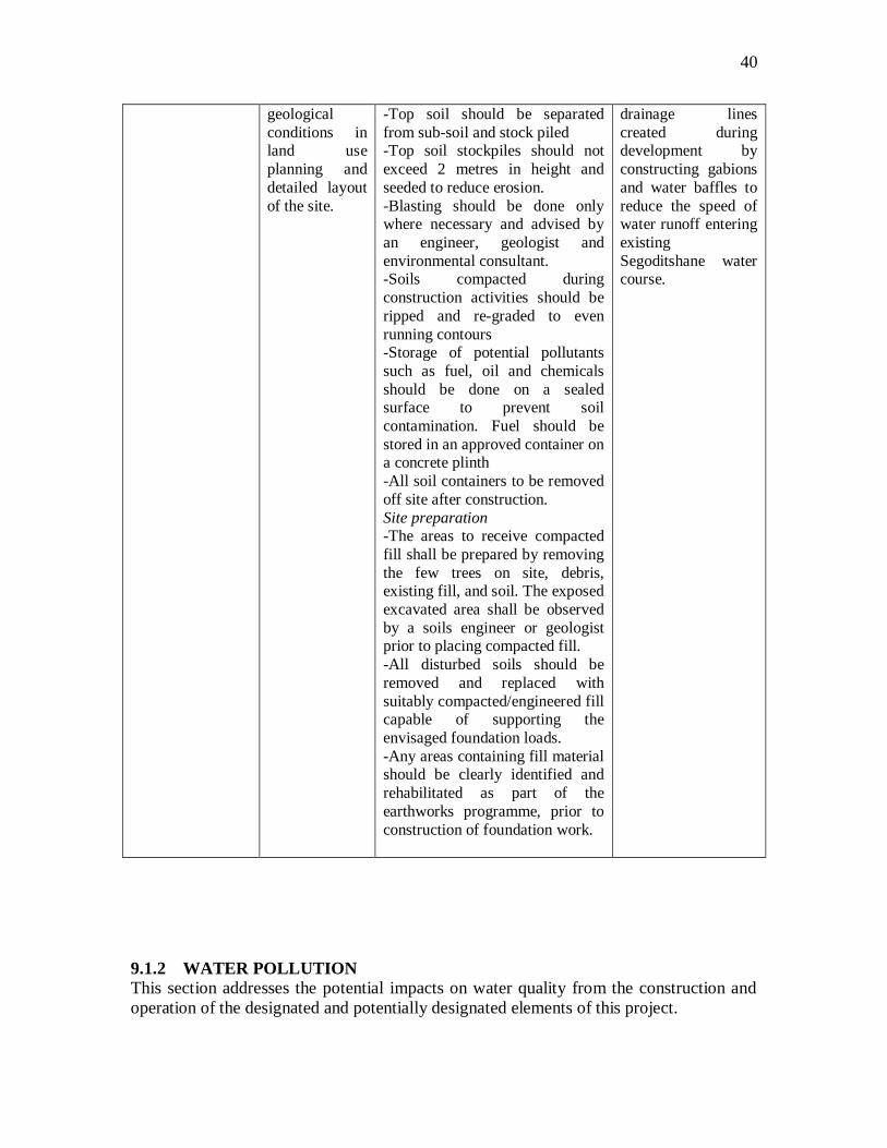
40
geological
conditions in land use
planning and
detailed layout
of the site.
-Top soil should be separated
from sub-soil and stock piled -Top soil stockpiles should not
exceed 2 metres in height and
seeded to reduce erosion.
-Blasting should be done only where necessary and advised by
an engineer, geologist and
environmental consultant. -Soils compacted during
construction activities should be
ripped and re-graded to even
running contours -Storage of potential pollutants
such as fuel, oil and chemicals
should be done on a sealed surface to prevent soil
contamination. Fuel should be
stored in an approved container on a concrete plinth
-All soil containers to be removed
off site after construction.
Site preparation -The areas to receive compacted
fill shall be prepared by removing
the few trees on site, debris, existing fill, and soil. The exposed
excavated area shall be observed
by a soils engineer or geologist prior to placing compacted fill.
-All disturbed soils should be
removed and replaced with
suitably compacted/engineered fill capable of supporting the
envisaged foundation loads.
-Any areas containing fill material should be clearly identified and
rehabilitated as part of the
earthworks programme, prior to
construction of foundation work.
drainage lines
created during development by
constructing gabions
and water baffles to
reduce the speed of water runoff entering
existing
Segoditshane water course.
9.1.2 WATER POLLUTION
This section addresses the potential impacts on water quality from the construction and
operation of the designated and potentially designated elements of this project.

41
Relevant legislation and guidelines.
9.1.2.1 The following relevant pieces of legislation and associated guidance are applicable
to the evaluation of water quality impacts associated with the construction and operation of
the Designated and Potentially Designated Elements of the Project.
Waterworks Act , Cap 34:03
Water Act, Cap 34:01
Food Control Cap 65:05
ASSESSMENT
Water Demand
9.1.2.2 The proposed project is expected to generate a limited demand of water per day
for the normal retail and office operations. The estimated water consumption for the
proposed project is expected to be accommodated by the e existing water infrastructure
serving the proposed project area and thus, this service will be provided routinely in
accordance with the water standards. Therefore, the proposed project will have a less than
significant impact upon water service.
9.1.2.3 Because the proposed project would not result in any significant impacts to water
supply or distribution, no mitigation measures are required. However, the following
measures are recommended to reduce the less than significant water impacts of the
proposed project:-
Water Quality – construction related impacts
9.1.2.4 The project construction site will contain a variety of construction materials that
are potential sources of storm water pollution, such as adhesives, cleaning agents,
landscaping, plumbing, painting, heat/cooling, masonry materials, floor and wall
coverings; and demolition debris. Construction material spills can also be a source of
storm water pollution and/or soil contamination.
9.1.2.5 Grading activities can greatly increase erosion processes. Appropriate dust
suppression techniques, such as watering or tarping, are used in areas that must be
exposed. Erosion control devices, including temporary diversion dikes/berms, drainage
swells, and siltation basins, are typically required around construction areas to ensure that
sediment is trapped and properly removed. When properly designed and implemented,
the Best Management Practices (BMPs) will ensure that short-term construction related
water quality impacts are not significant.
Water quality – Long term operational impacts.
9.1.2.5 The proposed development will consume small amounts of water for various
activities, like flushing toilets; small kitchens; watering the green landscape sites etc. It is
estimated that about 10m3/ a day of water will be required.
9.1.2.6 The amount of water consumed is a direct indication of wastewater generated and
treated in the treatment plant. The wastewater from such a development is primarily
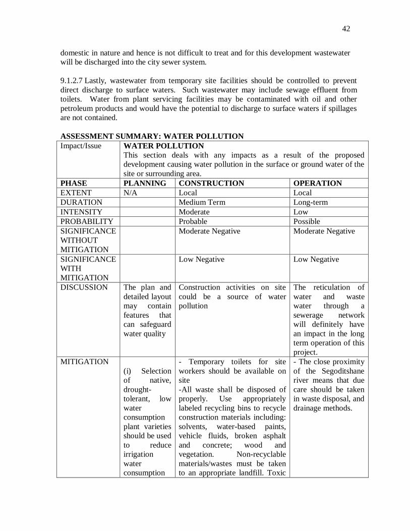
42
domestic in nature and hence is not difficult to treat and for this development wastewater
will be discharged into the city sewer system.
9.1.2.7 Lastly, wastewater from temporary site facilities should be controlled to prevent
direct discharge to surface waters. Such wastewater may include sewage effluent from
toilets. Water from plant servicing facilities may be contaminated with oil and other
petroleum products and would have the potential to discharge to surface waters if spillages
are not contained.
ASSESSMENT SUMMARY: WATER POLLUTION
Impact/Issue WATER POLLUTION
This section deals with any impacts as a result of the proposed
development causing water pollution in the surface or ground water of the
site or surrounding area.
PHASE PLANNING CONSTRUCTION OPERATION
EXTENT N/A Local Local
DURATION Medium Term Long-term
INTENSITY Moderate Low
PROBABILITY Probable Possible
SIGNIFICANCE
WITHOUT
MITIGATION
Moderate Negative Moderate Negative
SIGNIFICANCE
WITH
MITIGATION
Low Negative Low Negative
DISCUSSION The plan and
detailed layout
may contain
features that
can safeguard
water quality
Construction activities on site
could be a source of water
pollution
The reticulation of
water and waste
water through a
sewerage network
will definitely have
an impact in the long
term operation of this
project.
MITIGATION
(i) Selection
of native,
drought-
tolerant, low
water
consumption
plant varieties
should be used
to reduce
irrigation
water
consumption
- Temporary toilets for site
workers should be available on
site
-All waste shall be disposed of
properly. Use appropriately
labeled recycling bins to recycle
construction materials including:
solvents, water-based paints,
vehicle fluids, broken asphalt
and concrete; wood and
vegetation. Non-recyclable
materials/wastes must be taken
to an appropriate landfill. Toxic
- The close proximity
of the Segoditshane
river means that due
care should be taken
in waste disposal, and
drainage methods.

43
in the new
development
grounds
wastes must be discarded at a
licensed regulated disposal site
-Clean up leaks, drips and spills
immediately to prevent
contamination soil on paved
surfaces that can be washed
away into storm water drains.
-Do not hose down pavement
material spills. Use dry cleanup
methods whenever possible.
-Cover and maintain dumpsters.
Place uncovered dumpsters
under a roof or cover with tarps
or plastic sheeting.
-Use gravel approaches where
truck traffic is frequent to reduce
soil compaction and limit the
tracking of sediment into streets.
-Conduct all vehicle /equipment
maintenance, repair, and
washing way from storm water
drains. All major repairs are to
be conducted off-site. Use dip
pans or drop cloths to catch drips
and spills.
General mitigation
-The site should be drained so as
to ensure that water cannot pond
adjacent or near the structure.
The surface of the ground
immediately adjacent to the
building should fall 75mm over
the first 1.5m. Any paving
should be similarly sloped.
-Limitations on Gardens –
Flower beds, trees and shrubs
should not be planted within
1.5m of buildings and either a
lawn or impermeable apron
should be provided around the
building so as to provide a
surface which will facilitate free
run-off of water.
-Restrictions on the planting of
trees – These should observe the
same point raised above

44
-Services. The following should
be observed: (a) No plumbing
and drainage should be placed
under floor slabs as far as is
practicable (b) The fall of
trenches should be in a direction
away from buildings (iii) All
service trenches should be
located at least 1.5m away from
structures and should be
backfilled with in situ materials
compacted to not less than 88%
Mod AASHTO density (iv)
Sewer and drain pipes and
fittings should be provided with
flexible joints.
9.1.3 ASSESSMENT TABLE: HYDROLOGY
The development on this site will to some extent have an impact on the hydrology
of the area and its surroundings. The possible impacts and mitigation measures are
presented on the table below.
Impact/Issue HYDROLOGY
This table summarizes the impacts relating to alteration of drainage
systems and runoff from the development.
PHASE PLANNING CONSTRUCTION OPERATION EXTENT N/A Local Local
DURATION Short term Short term
INTENSITY Moderate Moderate
PROBABILITY Possible Probable
SIGNIFICANCE
WITHOUT
MITIGATION
Moderate Negative Moderate Negative
SIGNIFICANCE
WITH
MITIGATION
Low Negative Low Negative
DISCUSSION -
- Removal of vegetation adjacent
the site for construction purposes
could potentially raise the water
table in the area (through reduced
evapotranspiration)
- The increased areas of
hard surfaces (parking,
roofs etc) as a result of the
development could
increase runoff into drainage systems.
MITIGATION - -At the start of
site establishment,
perimeter cut-off
drains to direct
off-site water around
the site should
- Adequate storm water
management should take
place in order to minimize
the impact of the
increased runoff on
drainage systems.
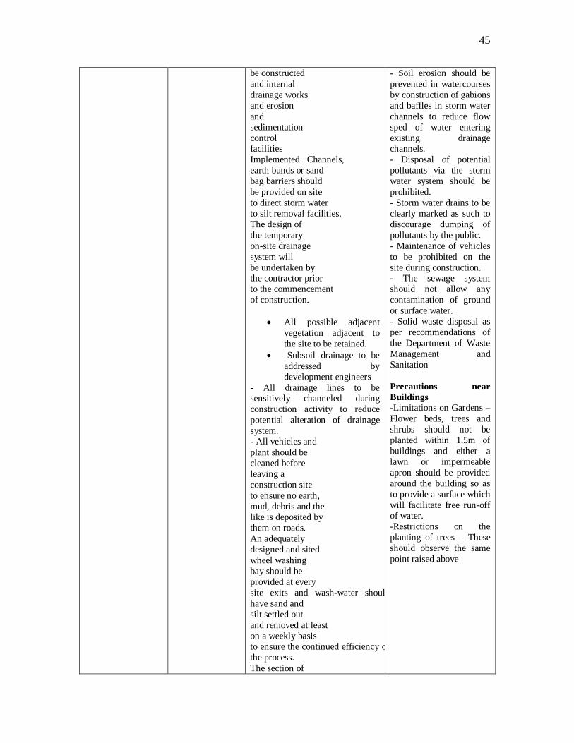
45
be constructed
and internal
drainage works
and erosion
and
sedimentation
control facilities
Implemented. Channels,
earth bunds or sand
bag barriers should
be provided on site
to direct storm water
to silt removal facilities.
The design of
the temporary
on-site drainage
system will
be undertaken by the contractor prior
to the commencement
of construction.
All possible adjacent
vegetation adjacent to
the site to be retained.
-Subsoil drainage to be
addressed by
development engineers
- All drainage lines to be sensitively channeled during
construction activity to reduce
potential alteration of drainage
system.
- All vehicles and
plant should be
cleaned before
leaving a
construction site
to ensure no earth,
mud, debris and the like is deposited by
them on roads.
An adequately
designed and sited
wheel washing
bay should be
provided at every
site exits and wash-water should
have sand and
silt settled out
and removed at least
on a weekly basis to ensure the continued efficiency of
the process.
The section of
- Soil erosion should be
prevented in watercourses
by construction of gabions
and baffles in storm water
channels to reduce flow
sped of water entering
existing drainage channels.
- Disposal of potential
pollutants via the storm
water system should be
prohibited.
- Storm water drains to be
clearly marked as such to
discourage dumping of
pollutants by the public.
- Maintenance of vehicles
to be prohibited on the
site during construction. - The sewage system
should not allow any
contamination of ground
or surface water.
- Solid waste disposal as
per recommendations of
the Department of Waste
Management and
Sanitation
Precautions near
Buildings -Limitations on Gardens –
Flower beds, trees and
shrubs should not be
planted within 1.5m of
buildings and either a
lawn or impermeable
apron should be provided
around the building so as
to provide a surface which
will facilitate free run-off of water.
-Restrictions on the
planting of trees – These
should observe the same
point raised above

46
access road leading
to, and exiting from,
the wheel-wash bay
to the public road
should be paved
with sufficient back
fall toward the wheel-wash bay
to prevent
vehicle tracking of
soil and silty water
to public roads
and drains.
Near structures
-The site should be drained so as
to ensure that water cannot pond
adjacent or near the structure. The
surface of the ground immediately
adjacent to the building should fall 75mm over the first 1.5m.
Any paving should be similarly
sloped.
-Services. The following should
be observed: (a) No plumbing and
drainage should be placed under
floor slabs as far as is practicable
(b) The fall of trenches should be
in a direction away from buildings
(iii) All service trenches should be
located at least 1.5m away from structures and should be
backfilled with in situ materials
compacted to not less than 88%
Mod AASHTO density (iv) Sewer
and drain pipes and fittings should
be provided with flexible joints.
9.1.4 VEGETATION
INTRODUCTION
9.1.4.1 This section presents the results of the assessment of potential impacts
from the construction and operation of the retail and office development on
terrestrial and aquatic ecological resources in the Study Area. Field surveys
were undertaken to establish the baseline ecological conditions of the Study
Area. Measures required to mitigate identified impacts are recommended, as
appropriate.
RELEVANT LEGISLATION AND GUIDELINES
9.1.4.2 A number of international conventions and local legislation and
guidelines provide the framework for the protection of species and habitats of
ecological importance. Those related to the Project are:
47
Town and Country Planning Ordinance (Cap 32:09)
Herbage Preservation (Preservation of fires) Act
Wildlife Conservation and National Parks Act (Cap 38:01)
United Nations Convention on Biodiversity (1992);
National Conservation Strategy
Wildlife Conservation Policy
National Policy on Natural Resources, Conservation and
Development
Forestry Act (Cap 38:03)
Agricultural Resources Conservation Act (Cap 35:06).
9.1.4.3 The National Conservation Strategy provides for the conservation of
natural resources including soils, vegetation, water, and wildlife and includes
guidelines for their sustainable use.
9.1.4.4 The Agricultural Resources Conservation Act (Cap 35:06) encourages
the conservation of soils, plant life, vegetation, animal life and fauna of
Botswana
9.1.4.5 The Town and Country Planning Act, has provisions for the preservation
of trees and plant life in urban areas.
POTENTIAL IMPACTS
9.1.4.6 The potential terrestrial ecological impact arising from the construction
of the hotel in this area may arise from the following:-
9.1.4.7 Construction Phase
Indirect loss of inactive/less mobile/habitat-specific wildlife
nesting/inhabiting the adjacent area;
Direct and indirect impacts to watercourses, including silty run-off and
sedimentation effect, as a result of construction discharge;
Indirect impacts to the surrounding habitat and associated wildlife due to
physical disturbance of this habitat including noise, increased human
activity, or inappropriate storage or dumping of construction material.
Disturbance to rocks – It is likely that underground rocks will have to be
cleared and/or blasted to enable the development to take place.
9.1.4.8 OPERATIONAL PHASE
- Indirect impacts to the surrounding habitat due to increased human
activities/ disturbance associated with the operation of the proposed
Project.

48
IMPACT ASSESSMENT
9.1.4.9 Potential impacts during planning, construction and operation of
the project are presented in the table below:-
Impact/Issue VEGETATION
This section deals with any impact to the vegetation as an ecological
unit as a result of the proposed development
PHASE PLANNING CONSTRUCTION OPERATION EXTENT Site and Adjacent Site/Adjacent area Site
DURATION Long term Permanent Long-term
INTENSITY Moderate Low Low
PROBABILITY Possible Definite Possible
SIGNIFICANCE
WITHOUT
MITIGATION
High Negative Low Negative Low Negative
SIGNIFICANCE
WITH
MITIGATION
Moderate negative Moderate Negative Low Negative
DISCUSSION -The layout Plan to
be prepared for this
area should take into account the presence
of the various plants
adjacent to this area.
Efforts should be
made to avoid
damage to the little
vegetation on site
and increase the
aesthetic appeal of
the area.
-An environmental
consultant should determine
development
restrictions
- Due to the nature of the
development, a large
adjacent area may be used as a temporary camp
leading to clearing of
vegetation.
- Landscaping may use a
predominance of non-
indigenous plants
MITIGATION - All detailed
planning and design
should be done in
association with a
landscape architect
and environmental
consultant.
- All construction workers
and machine operators to
be clearly informed of
significant trees to be
retained if they have to
venture beyond the site.
- Unnecessary vegetation
clearance to be addressed
in all development construction contracts
- All landscaping maintenance
to be carried out by a reputable
contractor
- A predominance of indigenous
species should be used for
landscaping
- Users of the development
could be educated about the
value of the aesthetic environment through
appropriate signage and
information.

49
9.1.5 : LOSS OF HABITAT
Impact/Issue LOSS OF HABITAT
This section deals with any impact to the loss of habitat for plants and animals in the
adjacent area as a result of the proposed development
PHASE PLANNING CONSTRUCTION OPERATION
EXTENT Site and local Site Site
DURATION Long term Medium Term Long-term
INTENSITY High Low Moderate
PROBABILITY Definite Definite Probable
SIGNIFICANCE
WITHOUT
MITIGATION
Moderate Negative Low Negative Medium Negative
SIGNIFICANCE
WITH
MITIGATION
Low negative Low Negative Moderate Negative
DISCUSSION -The only habitat in
this area is beyond
the development
site.
- Construction activity
could negatively impact
on the little habitats on the
adjacent site.
- Site planning should allow for minimum
realistic habitat loss.
- Landscaping should use a
predominance of indigenous
species to provide habitats for
smaller animals and birds.
MITIGATION - The detailed
planning and design
of the development
should be mindful of
adjacent habitat.
- Areas for protection
should be clearly marked
to prevent construction
activities from
encroaching on these
areas.
- Areas not required for
development should be
fenced off.
- Construction site and
work areas to be planned before ground breaking
occurs. Encroachment
beyond this area should
be avoided.
- Developer shall replace
damaged vegetation with
species to be identified by
the landscape architect
- All landscaped and protected
areas should be maintained
throughout the development
lifespan..
-The
Followingmitigation
measures
are recommended
to
minimize
disturbance
to the surrounding
Habitats:-
-Use of quietened
construction plant
and equipment for
the construction of
the hotel to minimise
the noise impact to the wildlife and
birds.
-Treat any damage
that may occur to
individual major
trees in the adjacent

50
area with surgery.
-Reinstate temporary
work sites/disturbed
areas immediately
after completion of
the construction
works, i.e. through on-site tree/shrub
planting. Tree/shrub
species used should
make reference from
those in the
surrounding area.
-Regularly check the
work site boundaries
to ensure that they
are not exceeded and
that no damage
occurs to surrounding areas
-Prohibit and prevent
open fires within the
site boundary during
construction and
provide temporary
fire fighting
equipment in the
work areas.
9.1.6 ATTRACTION OF VERMIN.
Implementation of the project in this area is likely to attract vermin both during the
construction stage as well as during the Operation Stage (due to the amount of waste food
that may be cooked and stored on site).
Relevant Acts:
Public Health Act
Waste Management and Sanitation. Act.
The possible impacts and mitigation measures are summarized in the table below.
Impact/Issue ATTRACTIONOF VERMIN.
This section deals with the attraction of vermin (e.g. rats, baboons) as
a result of the proposed development PHASE PLANNING CONSTRUCTION OPERATION
EXTENT N/A Site Site
DURATION Medium term Long term
INTENSITY Minimal Minimal
PROBABILITY Possible Possible
SIGNIFICANCE
WITHOUT
MITIGATION
Moderate Negative Moderate Negative
SIGNIFICANCE Low Negative Low Negative

51
WITH
MITIGATION
DISCUSSION Activities of construction workers on
site (and associated food preparation)
along with litter could attract vermin
to the site.
Presence of large
quantity of waste could
attract vermin to the
site.
MITIGATION -Closed and baboon proof litter bins
should be made available on site and
their use strictly enforced. -Control of cooking facilities and
waste disposal should be strictly
enforced.
-waste disposal should take place at
designated sites as agreed by the
Department of Waste Management
and sanitation.
-All waste disposal
facilities should be
stored in closed baboon/monkey proof
containers.
-Waste removal to be
carried out regularly, to
avoid the potential of
bins becoming too full.
9.1.7 AIR POLLUTION.
9.1.7.1 This section presents the assessment of the potential air quality impacts
arising from the construction and operation of the Designated and Potentially
Designated Elements of the Project.
9.1.7.2 Construction activities often produce large quantities of dust especially
in the dry season. This is particularly problematic in highly built-up area such as
Gaborone. Additionally, air borne pollution can be produced by badly
maintained plant and machinery. Airborne particles have negative impacts on
health as they can easily be inhaled, as well as being a general nuisance to
affected residents. Away from the immediate vicinity of the site the severity of
this impact is dependent on the wind direction.
Relevant Legislation and Guidelines
9.1.7.3 The principal legislation for the management of air quality is the Atmospheric
Pollution Control act (1971). The purpose of this act is to prevent atmospheric pollution.
This may require extensive water spraying or reduce dust pollution.
Air quality
(i) Demolition and uprooting tar on the current car park
9.1.7.4 Breaking and uprooting of the tar around the existing car park on which the new
development will be built will result in both noise and dust emission. This will be an
inconvenience to shoppers and workers at the current Mall.
(ii) Construction Impacts
9.1.7.5 Construction activities will generate dust from demolition of existing structures,
from surface disturbance for new construction, and from equipment exhaust from heavy
off-road equipment.
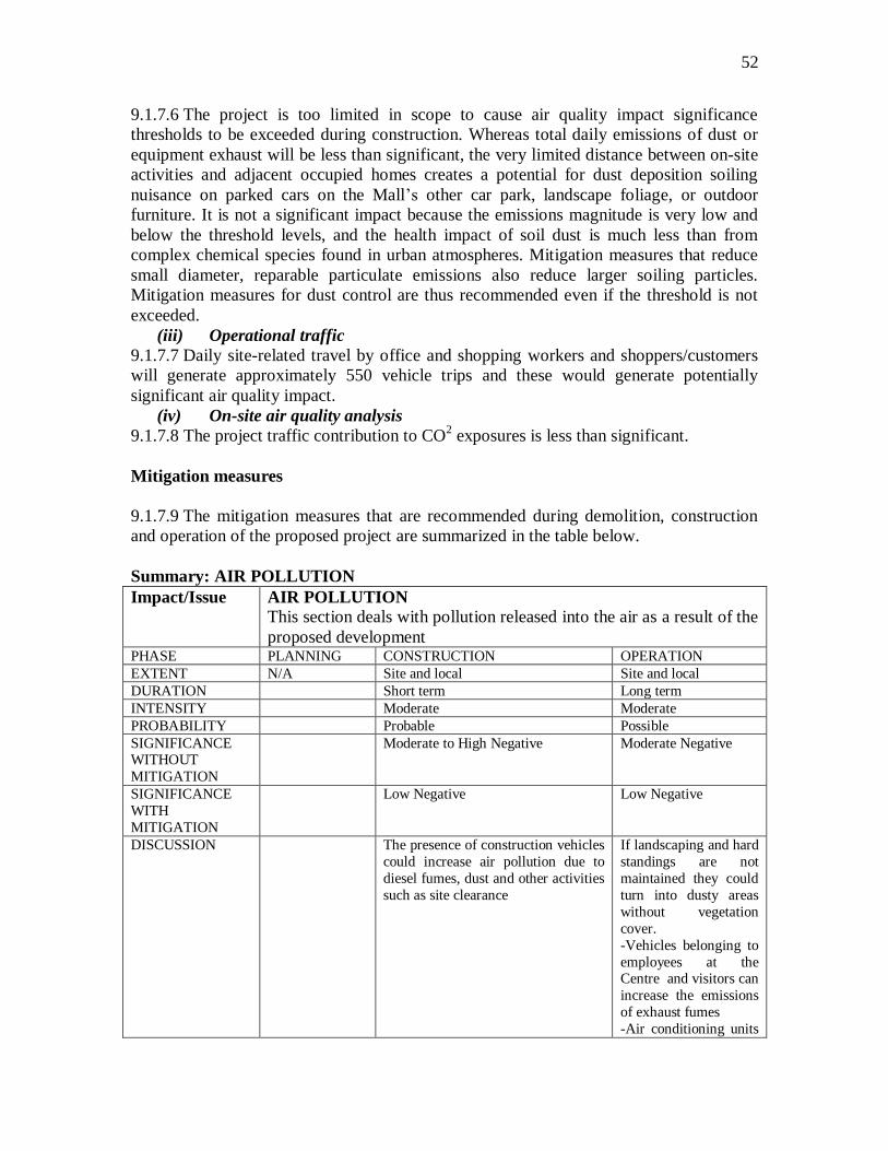
52
9.1.7.6 The project is too limited in scope to cause air quality impact significance
thresholds to be exceeded during construction. Whereas total daily emissions of dust or
equipment exhaust will be less than significant, the very limited distance between on-site
activities and adjacent occupied homes creates a potential for dust deposition soiling
nuisance on parked cars on the Mall‘s other car park, landscape foliage, or outdoor
furniture. It is not a significant impact because the emissions magnitude is very low and
below the threshold levels, and the health impact of soil dust is much less than from
complex chemical species found in urban atmospheres. Mitigation measures that reduce
small diameter, reparable particulate emissions also reduce larger soiling particles.
Mitigation measures for dust control are thus recommended even if the threshold is not
exceeded.
(iii) Operational traffic
9.1.7.7 Daily site-related travel by office and shopping workers and shoppers/customers
will generate approximately 550 vehicle trips and these would generate potentially
significant air quality impact.
(iv) On-site air quality analysis
9.1.7.8 The project traffic contribution to CO2 exposures is less than significant.
Mitigation measures
9.1.7.9 The mitigation measures that are recommended during demolition, construction
and operation of the proposed project are summarized in the table below.
Summary: AIR POLLUTION
Impact/Issue AIR POLLUTION
This section deals with pollution released into the air as a result of the
proposed development PHASE PLANNING CONSTRUCTION OPERATION
EXTENT N/A Site and local Site and local
DURATION Short term Long term
INTENSITY Moderate Moderate
PROBABILITY Probable Possible
SIGNIFICANCE WITHOUT
MITIGATION
Moderate to High Negative Moderate Negative
SIGNIFICANCE
WITH
MITIGATION
Low Negative Low Negative
DISCUSSION The presence of construction vehicles
could increase air pollution due to
diesel fumes, dust and other activities
such as site clearance
If landscaping and hard
standings are not
maintained they could
turn into dusty areas
without vegetation
cover.
-Vehicles belonging to
employees at the Centre and visitors can
increase the emissions
of exhaust fumes
-Air conditioning units

53
in the office and
commercial
establishments could
emit possible air
pollutants.
MITIGATION -The movements of construction
vehicles should be strictly controlled
to reduce the impact of air pollution. -All machinery to be in good working
order to reduce emission levels
-All site rubbish to be contained to
reduce wind blown litter
-All temporary toilets to be
maintained in god order to reduce
smell
-Excavations and other activities to
be carried out as per
recommendations of the EMP.
- Cover any on-site stockpiles of
debris, dirt or other dusty material. -All unpaved demolition and
construction areas shall be wetted at
least twice daily during excavation
and construction, and temporary dust
covers shall be used to reduce dust
emissions. Wetting could reduce
fugitive dust by as much as 50%
-All materials transported off site
shall be securely covered to prevent
excessive amounts of dust
-All clearing, grading, earth moving, or excavation activities shall be
discontinued during periods of high
winds so as to prevent excessive
amounts of dust
-Retention of as much
vegetation as possible
to reduce possible impacts.
-All landscaping and
hard standings to be
maintained to a high
standard
-All rubbish containers
to be maintained to a
high standard to reduce
windblown litter.
-Other measures are
spelt out in the Hotel
Environmental Management Plan.
9.1.8 FIRES
This section deals with impacts that can arise due to fires that may be caused due to the
implementation of this project.
Relevant Legislation.
9.1.8.1Herbage Preservation Act (Prevention of Fires) 1970.
SUMMARY TABLE
Impact/Issue This section deals with the impact of fires as a result of the proposed
development

54
PHASE PLANNING CONSTRUCTION OPERATION
EXTENT Site and local Site and local
DURATION Medium term Long term
INTENSITY Low Low
PROBABILITY Possible Possible
SIGNIFICANCE
WITHOUT
MITIGATION
Moderate Negative Moderate Negative
SIGNIFICANCE
WITH
MITIGATION
Low Negative Low Negative
DISCUSSION It is possible
to use
creative
design to
prevent or
retard the
impact of
fires
-In an arid climate, it is
possible that fires from site
activities could spread to other
parts of the site and
surrounding areas.
-Fires during construction
could have significant danger
to human life.
-Fires from any
form of
development
activity could
spread to
surrounding areas.
-Fires within the
development will
have significant
danger to human
life.
MITIGATION Design
buildings to
prevent
eruption of
fires
-No fires allowed on site
except in designated areas.
-Fire fighting equipment
should be available at all times.
All workers should be
instructed in how to use the
equipment effectively.
-Proper storage of potentially
flammable substances to be
practiced at all times,
especially fuels and flammable
chemicals.
-Fires should not
be allowed in any
area of the
development.
-Fire fighting
equipment should
be present on site
and all personnel in
institutions to be
trained in its
effective use.
-Sprinkler systems
along with other
fire fighting
methods should be
in place as
statutory codes of
practice.
9.1.9 Impact on Energy
Energy Conservation

55
9.1.9.1 Commercial and retail establishments do consume a fairly large amount of energy
in terms of heating, ventilation and air conditioning. In terms of costs this can range from
25-50% of the total energy costs of a commercial development.
9.1.9.2 Generally, of the type of energy supplied to a commercial and retail
establishments, electricity dominates in terms of both units consumed (Gj) and cost.
Hence measures to cut electricity consumption can result in direct and significant impact
on total cost of energy consumption of a commercial development.
9.1.9.3 The BPC has indicated that there are no service problems in the project area and
that they can accommodate the electricity demands of the proposed project with the
existing infrastructure. Therefore, no significant impacts related to electricity would
occur.
9.1.9.4 However, the following recommendations are suggested in order to reduce long-
term electricity consumption by the proposed project during operation:-
9.1.9.5 The applicant should consult with the BPC during the design process of the
proposed project regarding potential energy conservation measures for the project.
Examples of such energy conservation measures include:-
- Design windows (i.e. tinting, double pane glass, etc) to reduce thermal gain and
loss and thus cooling loads during warm weather, and heating loads during cool
weather;
- Install thermal insulation in walls and ceilings
- Install high-efficiency lamps for outdoor security lighting
- Time control exterior lighting. These systems should be programmed to account
for variations in seasonal daylight times
- Limit outdoor lighting while still maintaining minimum security and safety.
- Use natural ventilations as much as possible.
A SUMMARY OF IMPACTS AND AMELIORATING MEASURES
Impact/Issue ENERGY
This section deals with the impacts of the project on energy
sources in the area
PHASE PLANNING CONSTRUCTION OPERATION EXTENT Site Site
DURATION Permanent Permanent
INTENSITY Medium Medium
PROBABILITY Definite Definite
SIGNIFICANCE
WITHOUT
MITIGATION
High negative Moderate negative
SIGNIFICANCE
WITH MITIGATION
Low negative Low negative
DISCUSSION With adequate design
the commercial and
retail development can
With careful choice of
energy sources the
contractor can save a lot
Owners and workers
have to be educated to
conserve energy

56
save energy. of energy
MITIGATION -Design windows (i.e.
tinting, double pane
glass, etc) to reduce
thermal gain and loss
and thus cooling loads
during warm weather,
and heating loads during cool weather;
-Install thermal
insulation in walls and
ceilings
-Install high-efficiency
lamps for outdoor
security lighting
-Time control exterior
lighting. These systems
should be programmed
to account for variations
in seasonal daylight
times
-Limit outdoor lighting while still maintaining
minimum security and
safety.
Use natural ventilations
as much as possible
9.2 AESTHETICS
9.2.1 TRAFFIC AND SAFETY
The proposed development is bound to have impacts on traffic volumes and safety of
people in and around this area.
9.2.1.1 Relevant legislation
The Roads Act
Atmospheric Pollution Control Act – 1971.
Urban Development Standards
Development Control Code
9.2.1.2 Impact prediction
Future traffic from this development will certainly increase both along the Western By-
Pass road and the Molepolole road.
9.2.1.3 Project Construction Traffic.
Construction of the project buildings will take approximately one year. The number of
construction-related trips generated during this period will fluctuate, as the number of
workers needed for the different steps of construction will vary. The peak times for
construction traffic is expected to occur during the final completion of construction for
each building, when electrical, mechanical, plumbing, painting etc. contractors are on
site. At these times, it is estimated that up to approximately 200 workers will be on site.
Although construction traffic is a temporary condition, it is recognized that it may
contribute to traffic congestion on both access roads. The mitigation measures listed
below in the table are required to minimize the disruption and inconvenience to Gaborone
residents, businesses at the shopping mall and other traffic in the vicinity.
Summary of
impacts.

57
Impact/Issue TRAFFIC
This section deals with the impact of traffic on the existing roads as a
result of the development.
PHASE PLANNING CONSTRUCTION OPERATION EXTENT Local and
surrounding
Local Local
DURATION Medium term Medium term Long term
INTENSITY Medium Moderate Negative Moderate Negative
PROBABILITY Definite Definite Definite
SIGNIFICANCE
WITHOUT
MITIGATION
Moderate
Negative
Moderate Negative Moderate Negative
SIGNIFICANCE
WITH
MITIGATION
Moderate
Positive
Low negative Moderate positive
DISCUSSION Through ideal
planning, the
impact of traffic
can be lessened
Construction traffic could negatively
impact the roads leading to the site
through road degradation.
-Traffic congestion could be increased.
-Safety of road users and pedestrians
could be compromised on roads
leading to the site.
-Slow construction traffic could cause
problems on the 2 main access roads.
The proposed
development will
impact the area in the
long run
MITIGATION -Ensure the use
of the Urban
Development
Standards as
well as the
Development Control Code.
-Use traffic
calming methods
in design.
-Construction traffic (deliveries)
should be directed along major roads
and off peak traffic times.
-Traffic signs should be erected to
warn motorists and pedestrians of
construction traffic. -No construction equipment shall be
started in or in operation on-site
outside the allowable construction
hours of 8.00a.m. to 5.30p.m.
-Monitor traffic and
take precautions if
problems arise.
9.2.2 NOISE
This Section presents the potential construction and operational noise impacts
associated with Designated Elements and Potentially Designated Elements of
the proposed project.
9.2.2.1 Relevant Legislation and Guidelines
The principal legislation on the control of construction noise is the Noise
Control Ordinance. Government has issued various other technical memoranda
and these should be followed.

58
9.2.2.2 Identification of Noise
In general, the construction activities can be divided into the following main
categories which will include:
general site clearance & demolition works;
construction of sewers and rising mains using open trench
method;
construction of water reticulation lines and some building
foundations and
road pavement and finishes.
During the construction phase of the Project, workers
employed in the works will be the primary source of noise
impacts affecting the surrounding environment.
9.2.2.3 Demolition/Construction Noise Impacts.
Point of sources of noise emissions are atmospherically attenuated by a factor of 6
decibels (dB) per doubling of distance. The loudest construction activities would thus
require almost 70metres of distance between the source and a nearby receiver to reduce
the peak 90dB source strength to the generally acceptable 75dB exterior exposure level
intentionally accepted.
9.2.2.4 Construction activities will have a significant, immitigable noise impact during
parts of the period of construction of this project. Because not every construction day
will necessarily entail heavy equipment operations, the actual number of days of
potentially significant impact is a small fraction of the total period.
9.2.2.5 In addition to on-site equipment noise generation, truck traffic to/from the site
would affect the off-site noise environment. Thus haul trucks will not be allowed on-site
until after 7.00a.m such that all haul traffic will only have daytime impact.
9.2.2.6 Blasting is likely to take place during the construction of sewers, water
reticulation lines and even building foundations. In particular, considering the closeness
of the shopping mall, damage due to vibration caused by blasting is possible if these
activities are not undertaken in a responsible manner.
9.2.2.7 Operational traffic noise impact.
Long term noise concerns from the increased development intensity would stem
primarily from mobile source emissions on the roadways and activities on site.
MITIGATION OF ADVERSE ENVIRONMENTAL IMPACTS
Construction Noise
9.2.2.8 Noise emissions from construction activities can be minimized through
good site practice, selecting quiet plant, adopting quieter working methods,
erection of noise barriers to screen the noise source, where appropriate, and
posing restrictions on the use of noisy equipment. The mitigation measures

59
detailed in this section should be incorporated into the Contract Specification in
order to ensure the acceptable environmental performance of construction
works.
9.2.2.9 Contractors may develop a different package of environmental control
measures to meet the required noise standards, but the following illustrates a
feasible approach to mitigate the predicted noise impact during the construction
phase.
9.2.2.10 Good Site Practice
In view of the large number of construction activities and items of construction
equipment considered in the Project, adverse construction noise impacts to the
surrounding environment are possible, unless mitigation measures are applied.
Good site practice and proper on-site measurement are required by Contractors
at all times in order to minimise noise emissions from the works. The following
measures are recommended.
Only well-maintained plant shall be operated on-site and plant shall
be serviced regularly during the construction works.
Machines and plant that may be in intermittent use shall be shut down
between work periods or should be throttled down to a minimum.
Silencers or mufflers on construction equipment shall be utilized and
be properly maintained during the construction works.
Mobile plant shall be sited as far away from NSRs as possible.
Material stockpiles and other structures shall be effectively utilized,
where practicable, to screen noise from on-site construction activities.
Construction shall be restricted to the hours of 7.00a.m to 5.30p.m.
Monday through Friday; and 8.00a.m to 5.30 p.m. on Saturday.
9.2.2.11 Although it is difficult to quantify the level of noise reduction achieved
from incorporation of these practices, the environmental performance of the
works would be improved with these control measures.
Selecting Quieter Plant
9.2.2.12 The use of quiet plant is considered a feasible solution to tackle the
adverse impacts associated with construction works. The Contractor may be
able to obtain particular models of plant that are quieter than the standard types
that are normally in construction projects in Botswana at the moment. The
benefits achievable in this way will depend on the details of the Contractors‘
chosen methods of working. It is considered too restrictive to specify that a
Contractor has to use specific items of plant. It is therefore both preferable and
practicable to specify an overall plant noise performance specification in term
of total SWL on site, so that more flexibility is given to the Contractor for plant
selection.
9.2.2.13 It should be noted that various types of silenced equipment could be
found in South Africa.

60
Survey of properties.
9.2.2.14 Condition surveys of properties adjudged to have any risk of damage
from vibration should be undertaken prior to any work commencing and be
inspected again soon after completion of the works. This will enable genuine
claims to be assessed and compensated, and defend the contractor against
spurious claims. If damage is caused it should be repaired or fair compensation
paid within a reasonable time.
Impact/Issue NOISE POLLUTION This section deals with the noise generated as a result of the
proposed development and the impact of existing noise on the
proposed development. PHASE PLANNING CONSTRUCTION OPERATION EXTENT N/A Site and local Site and local DURATION Medium term Long term
INTENSITY Low Low
PROBABILITY Probable Possible
SIGNIFICANCE
WITHOUT
MITIGATION
Medium Negative Low Negative
SIGNIFICANCE
WITH
MITIGATION
Low negative Low Negative
DISCUSSION -The site is adjacent to the shopping
mall and thus any construction
noise is bound to affect the
neighbours. -The construction process,
machinery and site activity is likely
to be the largest generator of noise
from the site.
- Noise from traffic
during operation could
have an impact on site
neighbours
MITIGATION Plan for good
site management -Any specific noisy activities such
as blasting should be carried out in normal working hours -Neighbours should be informed of
any specific activity likely to be
very noisy before it happens
-All site equipment must be fitted
with efficient silencing systems and
maintained to high standard.
-General construction activity with
excessively high noise level should
be confined to normal working
hours.
-Only well maintained plant should be allowed on the site.
-Restrict working hours from 7.00
a.m to 5.30pm.
-Vegetation retained where possible
will dampen sound travel
-Noise on site should
be controlled by local by-laws -An effective system
of communication
should be established
so that site neighbours
can register concerns
over noise levels
61
9.2.3 LANDSCAPE AND VISUAL IMPACT ASSESSEMENT
9.2.3.1 The proposed project would result in taking away a fair amount of the current
unbuilt site plus the car park. This will affect the vistas to the southern and western parts
of the site.
The proposed project would also create a short-term significant unavoidable adverse
impact due to landform alterations as a result of remedial grading. This would
substantially degrade the visual character of the site.
9.2.3.2. Views from public viewing areas may be significantly impacted with the
build out of the proposed project. Landscaping and other recommended mitigating
measures would reduce impacts to public viewing areas to a less than significant level.
The design of the proposed project has the potential to impact on the surrounding area. In
addition, light and glare associated with the proposed commercial development could
create an adverse visual impact. Mitigation measures herein would ensure a well-
designed built environment. These impacts are considered significant but mitigable.
RELEVANT LEGISLATION AND GUIDELINES
9.2.3.3. The relevant legislation that affects landscape and visual impact
include the following:-
Monuments and Relics Act (Cap 59:03)
Town and Country Planning Act (Cap 32:09)
Atmospheric Pollution Act
Waste Management Act.
Development Control Code
Urban Development Standards
9.2.3.4 In most of these acts, codes, regulations and policies, efforts are made to
ensure that the environment is kept clean.
IMPACT ASSESSMENT
9.2.3.5 The purpose of this section is to analyze the aesthetic/visual impacts associated
with the proposed project. The methodology employed in this task consists of two steps:
1. Describing predominant visual characteristics of the project area, including an analysis
of existing views of the project site and areas located around and beyond the site; and 2.
Analyzing the aesthetic/visual impacts of the proposed project upon the surround area.
9.2.3.6 In order to complete the analysis in this section, 2 sources were used:-
(a)-Site reconnaissance visits on the sites provided primary observations on the
relationships between the project site and surrounding area
(b)-Information provided by key informants

62
9.2.3.7 The evaluation measured the existing visual resources against the proposed
action, analyzing the nature of the anticipated change. The GCC Master Plan and design
guidelines were reviewed for policy instruction relative to visual resources and design.
Project Impacts and Mitigation Measures
(A) Visual
9.2.3.8 Implementation of the proposed development has the potential to alter the
aesthetic character of the vicinity through alteration of views from public viewing
locations, introduction of community design elements that may be aesthetically
inconsistent with the surrounding area and introduction of new light and glare generators
into the area. This is considered significant but mitigable impact to aesthetic character of
the area.
Viewing corridor impacts.
9.2.3.9 The site would be visible from two of the main city‘s major roads, the Western
By-Pass and the Molepolole road. Due to its location, flat terrain and lack of intervening
structures and vegetation between these viewpoints the site views will be impacted much.
Landscaping on the site would not fully block views of the development; however, it is
anticipated to soften views by creating additional greenery. Further, to shield the site
from the main road a green buffer has been zoned on the eastern side of the site.
Implementation of the proposed plan would result in a graded, landscaped surface and
structures that would be visible from several off-site viewpoints. Since the planned
development would be highly visible from the two roads, the Plan would result in
potentially significant impacts from this public viewing corridor.
Post project views Of and Towards the Project Site
9.2.3.10 Visibility of the proposed project from adjacent land uses and roadways is
considered to be of significant impact. This is because the project area is visible from the
Western By-Pass, a residential development to the east (Phase 2) and the shopping mall
to the south. The proposed project would result in the obstruction of public scenic views
of the Segoditshane river.
9.2.3.11 While by and large the project is consistent with the permitted density and
building height for the site, the increase in height compared to the existing adjacent
properties in the shopping mall represent a potentially significant building massing
impact in relation to the rest of the buildings on site. Building massing impacts are
considered to be potentially significant but can be mitigated to less than significant by
implementing the mitigation measures in this section.
(A) Light and Glare Impacts.
9.2.3.12 Site illumination provides safety for vehicular and pedestrian movement,
and increases security. It can also serve to interpret the plan arrangement by giving
emphasis to focal points, gathering places, landscaping, and building entrances. Well-
conceived lighting gives clarity and unity to the overall site and to each sub area within it.
At present there is some nighttime lighting of the site from the shopping mall and

63
streetlights at the car park. However, implementation of the proposed project would
require additional lighting that could be visible from the residences located to the eastern
part of the site.
9.2.3.13 Sources of glare that may affect nearby residences would be buildings exterior
materials, surface-paving materials, and vehicles traveling or parked on roads and
driveways within the project area. Any highly reflective façade materials would be of
particular concern, as buildings would reflect the bright sunrays. Nearby residences may
be impacted by lighting and glare generated from the proposed plan land uses and
improvements. These would be considered of little significance since the residences are
some distance away.
Conclusion
9.2.3.14 The proposed plan has minimal potential to alter the aesthetic semi-rural
character of the site vicinity by changing the scenic views from public viewing locations,
introducing community design elements that may be aesthetically inconsistent with the
surrounding area and introducing new light and glare generators into the area.
9.2. 3 15 Due to the increased density of the proposed project compared to the
existing shops on site, the proposed project would introduce a greater amount of
nighttime lighting to the project site. Such lighting sources include interior lighting,
exterior security lighting, and headlights associated with motor vehicles using the
Western By-Pass. Some of the project building materials (i.e. windows) as well as car
windshields also represents sources of daytime glare. Light and glare impacts would be
potentially significant but can be mitigated to less than significant levels by implementing
the proposed light and glare mitigation measures below.
Mitigation Measures
9.2.3.16 The following mitigation measures are required to ensure the proposed
project does not result in any significant impacts relative to building massing and
lighting. Impacts related to the obstruction and partial obstruction of scenic views from
private properties would remain significant and unavoidable.
9.2.3.17 The Plan should include several development standards that would
facilitate visual compatibility between individual land use components on the site, and
between the proposed on-site uses and adjacent off-site uses. The development standards
(architectural and environmental) are listed hereunder.
Architectural and Landscape Guidelines
9.2.3.18 The applicant shall develop and implement Architectural and Landscape
Guidelines for the retail and office complex. The Guidelines shall include clear criteria
and requirements to guide the design, layout, and landscaping of each component of the
plan of the complex. All future development on the site shall comply with the Guidelines.
Enforcement of compliance with the Guidelines shall be the responsibility of the Town
and regional Planning Department.
64
Roofing and feature colour and material
9.2.3.19 The architectural plan shall include colours on structure roofing and other on-site
features that are compatible with the surrounding commercial uses to lessen potential
visual contrast between the proposed and existing adjacent structures.
9.2.3.20 The exterior of the proposed buildings shall be constructed of non-reflective
building materials
Tract lighting
9.2.3.20 Prior to development, proposed lighting shall be indicated on site plans that
demonstrate that spillover of lighting would not affect commercial areas adjacent to the
site. The lighting plan shall incorporate lighting that direct light pools downward to
prevent glare on adjacent and surrounding areas. Lights shall have solid sides and
reflectors to further reduce lighting impacts by controlling light spillage. Light fixtures
that shield nearby residences from excessive brightness at night shall be included in the
lighting plan. Non-glare lighting shall be used.
Compatibility with adjacent uses.
9.2.3.21 The design, scale, and character of the project building architecture shall
be generally compatible with the scale of existing commercial uses next to the site.
Street light limitations.
9.2.3.22 Street lights shall be pedestrian in scale and must enhance safety. They
should not provide widespread illumination.
- All exterior lighting should be designed as part of the overall architectural concept.
- Fixtures, standards and all exposed accessories should be harmonious with the
building design, the lighting design and hardware of the public open spaces, and the
overall visual environment of the city.
- Lighting should be used for safety and security to illuminate building entrances,
parking and loading areas and pedestrian walkway areas.
- All lighting with exposed light fixtures should be avoided
- All light fixtures should be shielded to confine the spread of light within the site
boundaries.
Wall and fence articulation
9.2.3.23 Long expanses of walls (including sound walls) or fences should be
interrupted with offsets and provided with accents to prevent monotony. Landscape
pockets should be provided. Walls and fences should be designed in a style, materials and
colour to complement adjacent buildings.
Landscaping – Establish a unifying identity and landscape theme for the Detailed
Local 9.2.3.24 Plan for this site. Minimize the visual impact of proposed buildings
and parking areas. Create an outdoor environment of comfortable human scale.
- All open areas not used for buildings, roads, parking areas, or walkways shall be
attractively landscaped and maintained in accordance with a landscape plan;
- Landscape buffers shall be planted between the project site and adjacent commercial
uses;

65
- Buildings, landscaping, parking and other development features should be arranged in
a manner that is compatible with the size, scale, and appearance of nearby
development. Walls and fences should be designed in a style, materials and colour to
complement the buildings to which they are attached.
- Utility service for new development should be underground whenever possible.
- Identify and highlight pedestrian circulation routes to provide safe and comfortable
walking areas
Cumulative Impacts 9.2.3.25 The GCC Master Plan land use designation of the proposed site is
commercial & Civic and Community. Development of the site for urban use was
therefore expected and is consisted with the Master Plan. Therefore, any impacts to the
visual character of the site and the surrounding area were anticipated in the EIA.
Implementation of the proposed development with the mitigation measures would
incrementally contribute to the change in aesthetic character of the site and the
surrounding areas. Cumulative impacts are therefore considered significant and
unavoidable.
Summary of Impacts
Impact/Issue VISUAL IMPACT OF DEVELOPMENT.
This section deals with the visual impact of the development from
surrounding areas
PHASE PLANNING CONSTRUCTION OPERATION EXTENT Site and local Site and local
DURATION Medium Term Long term
INTENSITY Moderate Moderate to high
PROBABILITY Definite Definite
SIGNIFICANCE
WITHOUT
MITIGATION
Moderate Negative High negative
SIGNIFICANCE
WITH
MITIGATION
Moderate negative Low positive
DISCUSSION Visual impacts
and aesthetics
must be incorporated into
the planning
process
-The change from the existing semi-
rural visual characteristics on the site to urban visual characteristics could
result in adverse visual impacts for
sensitive viewer groups in Gaborone
city.
-Construction activities and
temporary buildings will have a
visual impact on the landscape
-Buildings and
landscaped open spaces
could increase the visual appeal of the
site.
-The visual impact of
lighting could also
impact on the
surrounding areas
MITIGATION
Both
architectural and
aesthetic
standards to be adhered to have
-Peripheral vegetation should be
retained (10-20 m) if possible to act
as visual barrier.
-Equipment and works only to be allowed in designated areas.
-The buildings should
be maintained to a high
standard throughout the
life of the
development. -Vegetation and

66
been listed
above. They are
too numerous to
be repeated here
(see above).
-A landscape master plan should be
developed to ensure the visual quality
of the development.
(For more details see above)
landscaping must be
maintained for the life
of this development.
-Any lighting of public
areas should be done
with sensitivity to
ensure that the development is
appealing and safe at
night.
9.2.4 Waste
This section identifies and assesses the potential environmental impacts associated with waste
management aspects of the construction and operation of the Designated and Potentially
Designated Elements of the Project.
RELEVANT LEGISLATION AND GUIDELINES
9.2.4.1 The following legislation covers, or has some bearing upon, the handling, treatment
and disposal of wastes in the Gaborone area, and will also be considered in the assessment.
Waste Management Act, Cap 65:06
Building Control Act, Cap 65:02
Public Health Act, Cap 63:01
Town and Country Planning Act, Cap 32:09
9.2.4.2 The Waste Management Act, Cap 65:06 makes provision for the planning, facilitation
and implementation of advanced systems for regulating the management of controlled waste,
minimise pollution and apply the provisions of the Basel Convention on transboundary
movement of waste
9.2.4.3 The Waste Management Strategy is designed to ensure that the country achieves a state
of sustainable waste management with the main objectives being protection of human health,
the environment and natural resources.
ASSESSMENT METHODOLOGY
9.2.4.4 The potential environmental impacts associated with the handling and disposal of waste
arising from the construction and operation of the hotel development was assessed in
accordance with the following criteria:
estimation of the types, timing and quantities of the wastes to be generated;
assessment of the secondary environmental impacts due to the management of waste
with respect to potential hazards, air and odour emissions, noise, wastewater
discharges and traffic; and

67
Assessment of the potential impacts on the capacity of waste collection, transfer and
disposal facilities.
IDENTIFICATION OF ENVIRONMENTAL IMPACTS
Construction Phase
9.2.4.5 During the construction phase, the main activities, which will potentially result in
waste generation, involve site clearance, and construction of the sewer and water lines.
9.2.4.6 The typical waste types associated with these activities include:
site clearance waste;
construction and demolition material
excavated materials;
chemical wastes;
sewage; and
general refuse.
Site Clearance Waste
9.2.4.7 Construction of the complex and the required infrastructural facilities (water, sewers,
roads etc) will result in a fairly amount of waste. If not properly managed, the handling and
disposal of the clearance waste may cause adverse environmental impacts. Vegetation cleared
from the proposed development site can be disposed of as general refuse.
Construction and Demolition Materials (C&DM)
Excavated Materials and solid waste from demolition work
9.2.4.8 Waste will be generated during demolition of the existing car park and for the line
infrastructure (trenches). These materials are expected to be mostly soil plus concrete/tarmac
which are inert. Their quantities will be spelled out during the detailed design stage.
Much of the solid waste generated during the demolition and construction phase could be
recycled and salvaged to the maximum feasible extent. Materials not recycled would be
disposed of at the local landfill site.
9.2.4.9. As is normal practice, some of the excavated materials could be used for
backfilling the trenches. It is expected that the majority of excavated material will be
inert soil.
Upon full occupancy of the proposed project, daily solid waste generated on-site would
be disposed of at the regional landfill site.
Therefore, no significant solid waste impacts would be created by the proposed project.

68
Chemical Waste
9.2.4.10 Substances likely to be generated from the construction activities for the hotel
development will, for the most part, arise from the maintenance of equipment. These may
include, but need not be limited to the following:
scrap batteries or spent acid / alkali from their maintenance;
used paint, engine oils, hydraulic fluids and waste fuel;
spent mineral oils / cleaning fluids from mechanical machinery; and
spent solvents / solutions, some of which may be halogenated, from equipment
cleaning activities.
9.2.4.11 Chemical wastes may pose serious environmental, health and safety hazards if not
stored and disposed of in an appropriate manner as outlined in the Waste Management Act.
These hazards may include:
toxic effect to workers;
adverse effect on air, water and land from spills; and
fire hazards.
Sewage
9.2.4.12 Sewage will arise from the construction workforce, site office‘s sanitary facilities and
night soil from chemical toilets. If not properly managed, these materials could cause odour
and potential health risks to the workforce by attracting pests and other disease vectors.
General Refuse
9.2.4.13 The presence of a construction site with workers and site office will result in the
generation of a variety of general refuse requiring disposal. General refuse will mainly consist
of food waste, aluminium cans and waste paper.
9.2.4.14 The storage of general refuse has the potential to give rise to adverse
environmental impacts. These include odour if the waste is not collected frequently (for
example, daily), windblown litter, water quality impacts if waste enters water bodies, and
visual impact. The sites may also attract pests, vermin, and other disease vectors if the
waste storage areas are not well maintained and cleaned regularly. In addition, disposal
of wastes at sites other than approved landfills, can also lead to similar adverse impacts at
those sites.
9.2.4.15 Because the proposed project would not result in any significant solid waste
impacts, no mitigation measures are required. However, the following recommendations
are suggested to reduce the project‘s less than significant solid waste impacts:-
The applicant should institute a recycling programmed to reduce the waste that
goes to the landfill site
Recycling bins shall be provided at approximate locations to promote recycling of
paper, metal, glass and other recyclable material

69
Operation Phase 9.2.4.16 The proposed complex‘s solid waste stream during the operation stage will be diverse
and enormous. Office paper, restaurant food waste, amenity bottles, plastic and aluminum
beverage containers, and countless cardboard packaging boxes all find their way into the
Centre‘s dumpster. Although this waste is diverse, the waste is fairly consistent. The majority
is paper and plastic waste, and there are lesser amounts of metal, food and glass.
MITIGATION MEASURES
Introduction
9.2.4.17 This section recommends the mitigation measures to avoid or minimise potential
adverse environmental impacts associated with handling, collection and disposal of waste
arising from the Project. The Contractors should incorporate these recommendations into a
Waste Management Plan for the construction works. The Contractors should submit the plan
to the Engineer for approval prior to the commencement of the construction works. Such a
management plan should incorporate site specific factors, such as the designation of areas for
the segregation and temporary storage of reusable and recyclable materials.
9.2.4.18 It is the Contractor‘s (for the construction phase) and the Project Proponent‘s (for the
operational phase) responsibility to ensure that only reputable licensed waste collectors are
used and that appropriate measures to minimise adverse impacts, including windblown litter
and dust from the transportation of these wastes are employed. In addition, the Contractor
must ensure that all the necessary waste disposal permits are obtained throughout the
construction and operation phases.
Construction Phase
Excavated Material
9.2.4.19 Wherever practicable, excavated materials should be segregated from other wastes to
avoid contamination thereby ensuring acceptability at public filling areas and avoiding the
need for disposal at landfill.
Measures Taken in the Planning and Design Stages to Reduce the Generation of C&DM
9.2.4.20 The various waste management options can be categorized in terms of preference
from an environmental viewpoint. The options considered to be more preferable have the least
impacts and are more sustainable in the long term. Hence, the waste management hierarchy is
as follows:
avoidance and minimisation, that is, not generating waste through changing or
improving practices and design;
reuse of materials, thus avoiding disposal (generally with only limited reprocessing);
recovery and recycling, thus avoiding disposal (although reprocessing may be
required); and
treatment and disposal, according to relevant law, guidelines and good practice.

70
9.2.4.21 This hierarchy should be used to evaluate the waste management options, thus
allowing maximum waste reduction and often reducing costs. For example, by reducing or
eliminating over-ordering of construction materials, waste is avoided and costs are reduced
both in terms of the purchasing of raw materials and in disposing of wastes. Records of
quantities of wastes generated, recycled and disposed (locations) should be properly kept.
Standard formwork should be used as far as practicable in order to minimise the arisings of
C&DM. The use of more durable formwork or plastic facing for the construction works
should be considered.
9.2.4.22 Any uncontaminated soil should be reused on site as far as possible, e.g. for
landscape works, in order to minimise the amount of public fill to be disposed off-site. The
Project Proponent should liaise with the GCC, Sanitation Department to identify as far as
possible suitable reclamation or site formation projects near the project site to reuse the
material.
9.2.4.23 The design of the foundation works will minimise the amount of excavated
material to be generated. Should piling be required, H-piling will be used as far as practical.
9.2.4.24 The purchasing of construction materials will be carefully planned in order to
avoid over ordering and wastage.
Measures to be taken in the Construction Stage to Reduce the Generation of C&DM
9.2.4.25 The Contractor should recycle as much of the C&DM as possible on-site.
Public fill and C&D waste should be segregated and stored in different containers or skips to
enhance reuse or recycling of materials and their proper disposal. Concrete and masonry, for
examples, can be crushed and used as fill. Steel reinforcing bars can be used by scrap steel
mills. Different areas of the sites should be designated for such segregation and storage.
9.2.4.26 The use of wooden hoardings shall not be allowed. An alternative material,
which can be reused or recycled, for example, metal (aluminium, alloy, etc) shall be used.
Chemical Waste
9.2.4.27 Chemical waste that is produced should be handled carefully according to
national Guidelines of Chemical Wastes as follows. Containers used for storage of chemical
wastes should:
Be suitable for the substance they are holding, resistant to corrosion, maintained in a
good condition, and securely closed;
Have a capacity of less than 450 L and,
Display a label in English and Setswana.
9.2.4.28 The storage area for chemical wastes should:
71
be clearly labelled and used solely for the storage of chemical waste;
be enclosed on at least 3 sides;
have an impermeable floor and bunding, of capacity to accommodate 110% of the
volume of the largest container or 20% by volume of the chemical waste stored in
that area, whichever is the greatest;
have adequate ventilation;
be covered to prevent rainfall entering (water collected within the bund must be
tested and disposed as chemical waste, if necessary); and
be arranged so that incompatible materials are adequately separated.
9.2.4.29 Disposal of chemical waste should:
be via a licensed waste collector; and
be to a facility licensed to receive chemical waste, or
be to a re-user of the waste.
Sewage
9.2.4.30 Adequate numbers of portable toilets should be provided for the number of workers
along the proposed sewer alignment. The portable toilets should be maintained in a state
which will not deter the workers from utilizing these portable toilets. Night soil should be
collected by licensed collectors regularly.
Management of General Refuse
9.2.4.31 General refuse generated on-site should be stored in enclosed bins or compaction
units separately from construction and chemical wastes. A reputable waste collector should be
employed by the Contractor to remove general refuse from the site, separately from
construction and chemical wastes, on a daily basis to minimise odour, pest and litter impacts.
The burning of refuse on construction sites is prohibited by law.
9.2.4.31 Aluminium cans are often recovered from the waste stream by individual collectors if
they are segregated and made easily accessible, so separate, labelled bins for their deposit
should be provided if feasible.
9.2.4.32 Office wastes can be reduced through the recycling of paper if volumes are
large enough to warrant collection. Participation in a local collection scheme should be
considered if one is available. In addition, waste separation facilities for paper, aluminium
cans, plastic bottles etc., should be provided.
Management of Waste Disposal
9.2.4.33 A trip-ticket system should be established to monitor the disposal of public fill
and solid wastes at public filling facilities and landfills, and to control fly-tipping. A trip-ticket
system will be included as one of the contractual requirements and implemented by the
Engineer. The Engineer should audit the result of the system.

72
9.2.4.34 A recording system for the amount of waste generated, recycled and disposed of
(including the disposal sites) should be established during the construction stage.
Staff Training
9.2.4.35 Training should be provided to workers on the concepts of site cleanliness and on
appropriate waste management procedures, including waste reduction, reuse and recycling at
the beginning of the Contract.
OPERATIONAL PHASE
9.2.4.36 The main type of wastes generated during the operation phase will be foodstuffs,
vegetables, paper, card boxes and other trash. The waste generated from the hotel should be
stored in enclosed bins or compaction units separately from chemical wastes. A reputable
waste collector should be employed by the operators to remove the screenings from the
pumping stations, on a daily basis to minimise odour, pest and litter impacts.
RESIDUAL IMPACTS
9.2.4.37 With the implementation of the recommended mitigation measures, in
particular the establishment and implementation of a Waste Management Plan, minimal
residual impacts are anticipated from either the construction or operation of the proposed
project.
ENVIRONMENTAL MONITORING AND AUDIT
9.2.4.38 It is recommended that audit of each waste stream should be periodically carried out
during the construction phase to determine if wastes are being managed in accordance with the
Waste Management Plan. The audits should look at all aspects of waste management
including waste generation, storage, recycling, transport and disposal. An appropriate audit
programme would be to undertake a first audit at the commencement of the construction works
and then quarterly audits, thereafter.
CONCLUSION
9.2.4.39 As seen above the amount of wastes that will be generated during the implementation
of this project is not that high. The impact of its disposal at the regional landfill will be
minimal. The generation of chemical wastes is expected to be very small and no adverse
environmental impacts are envisaged.
9.2.4. 40 Good waste management practices have been recommended to ensure that adverse
environmental impacts from the handling and disposal of construction and operational wastes
are prevented or minimised. This EIA concludes that no unacceptable environmental impacts
will result from the storage, handling, collection, transport, and disposal of wastes arising from
the construction and operation of the Designated and Potentially Designated Elements of the
proposed Phase II sewerage programmme.
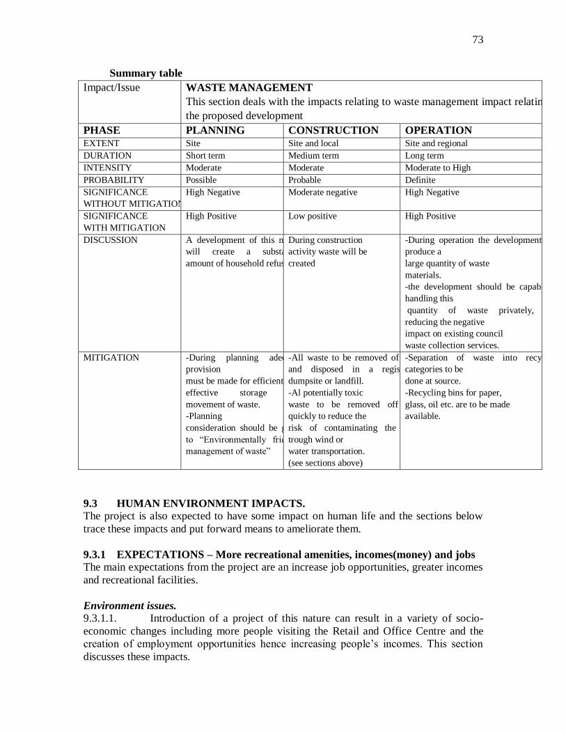
73
Summary table
Impact/Issue WASTE MANAGEMENT
This section deals with the impacts relating to waste management impact relating to
the proposed development
PHASE PLANNING CONSTRUCTION OPERATION
EXTENT Site Site and local Site and regional
DURATION Short term Medium term Long term
INTENSITY Moderate Moderate Moderate to High
PROBABILITY Possible Probable Definite
SIGNIFICANCE
WITHOUT MITIGATION
High Negative Moderate negative High Negative
SIGNIFICANCE
WITH MITIGATION
High Positive Low positive High Positive
DISCUSSION A development of this nature
will create a substantial
amount of household refuse
During construction
activity waste will be
created
-During operation the development will
produce a
large quantity of waste
materials.
-the development should be capable of
handling this
quantity of waste privately, thus
reducing the negative
impact on existing council
waste collection services.
MITIGATION -During planning adequate
provision
must be made for efficient and
effective storage and
movement of waste.
-Planning
consideration should be given
to ―Environmentally friendly
management of waste‖
-All waste to be removed off site
and disposed in a registered
dumpsite or landfill.
-Al potentially toxic
waste to be removed off site
quickly to reduce the
risk of contaminating the area
trough wind or
water transportation.
(see sections above)
-Separation of waste into recycling
categories to be
done at source.
-Recycling bins for paper,
glass, oil etc. are to be made
available.
9.3 HUMAN ENVIRONMENT IMPACTS.
The project is also expected to have some impact on human life and the sections below
trace these impacts and put forward means to ameliorate them.
9.3.1 EXPECTATIONS – More recreational amenities, incomes(money) and jobs
The main expectations from the project are an increase job opportunities, greater incomes
and recreational facilities.
Environment issues.
9.3.1.1. Introduction of a project of this nature can result in a variety of socio-
economic changes including more people visiting the Retail and Office Centre and the
creation of employment opportunities hence increasing people‘s incomes. This section
discusses these impacts.
74
Project Impact on Jobs in the community.
9.3.1.2 The project will generate a number of new employment opportunities for both
professional and non-professional cadres.
9.3.1.3 Currently there is a deficit in job opportunities in the city and thus this project will
result in few jobs mostly during construction and running of the project. The creation of
job opportunities by this project is a beneficial impact to the city overall and is
considered less than significant.
9.3.1.4. Other people will also find employment in the informal sector through
self-employment as some youths may, with the permission of the Centre Management,
sell some items in the vicinity of the complex.
9.3.1.5 Construction workers will likely be drawn from the construction employment
labour force already resident in Gaborone and surrounding community. It is not likely
that construction workers would relocate their place of residence as a consequence of
working on the proposed project. Therefore, impacts on population resulting from the
construction of the proposed project would be less than significant.
9.3.1.6 It is anticipated that when the complex is up and running a total of between 300 to
350 people will be employed at this complex.
Economy and spending
9.3.1.7 The construction of the retail and office comlex will result in economic gains.
This is a multi million project, the actual sum which is Pula 15 million, that brings money
into the economy of the city and the country as a whole. Money spent during
construction as well as during the operation of the complex will enter the circulation
system and thus benefit the nation. It should be welcome.
9.3.1.8 Tax generation to the government will also increase. Government collects direct
and indirect taxation from commercial establishments. These are in the form of licence
fees (direct) and those levied on goods such as foodstuffs and drinks (indirect).
Schools
9.3.1.9 The increase in the number of permanent and temporary workers on the project
site and the potential need to enroll any school-aged children into local schools would
result in a very small demand for school services. It is probable that some of the future
employees at the hotel already reside within the service boundaries of the GCC with their
school-aged children enrolled in local schools serving the project area. Therefore, this
would have little impact on the GCC upon completion of the project.
Recreation
9.3.1.10 Development of the complex will provide an avenue for recreation and
this will draw some people to the site on a regular basis. However, since their numbers
will be small, the impact is also small.

75
Cultural impacts.
9.3.1.11 Commercial establishments symbolize ‗modernity‘ as centers of shopping,
entertainment and attractive to both the young and the old. The local people are bound to
mingle with visitors of all races and this way affect local culture. Local people may be
encouraged to enter into some kind of patronage and such relationships may range from
begging, posing for photos or engage in casual or organized sex.
Potentially significant impacts
9.3.1.12 No potentially significant impacts to population, recreation or employment will
result from project implementation.
9.3.1.13 Apart from this, the general scheme will increase spending in the city as more
and more people visit the complex.
Conclusion: Cumulative impacts.
9.3.1.14 Although the proposed project would result in a small population growth in the
city, the impact is very minimal. The most that is being anticipated is greater employment
and a boost in the economy.
9.3.1.15 In sum, the proposed project will not alter the location, distribution, density, or
growth rate of the city‘s population, but will benefit the local and national economy.
Summary of Impacts
Impact/Issue EXPECTATION
This section deals with the expectations of interested and
affected parties of the proposed development.
PHASE PLANNING CONSTRUCTION OPERATION
EXTENT Gaborone and surroundings Gaborone and
surroundings
Gaborone and surroundings
DURATION Short term Medium term Long term
INTENSITY Low Low Low
PROBABILITY Probable Definite Definite
SIGNIFICANCE
WITHOUT MITIGATION
Low Positive Low positive Moderate positive
SIGNIFICANCE
WITH MITIGATION
Moderate positive High positive High positive
DISCUSSION -Residents of
Gaborone and surroundings
may
have positive
expectations of employment
-Existing shop
owners close to
this area
expect
to do better in
terms of business.
-Residents of Gaborone
have expectation of employment
at the site site during construction
and
more so thereafter.
-Contractors and consultants in
Botswana will
have expectations of of
employment during the
construction phase.
-Informal traders
-Positive expectations
relate to the fact that
people will be employed and money
will flow into the economy for a long
time.
-There will also be
economic gains
-Culture will be impacted.

76
expect to do business on and
around the site.
MITIGATION -The plan must be be sensitive
to the
above issues.
-Shop owners close
to the site should be
consulted to
maximize the
benefit of this development
-Provide adequate
social and
economic services and
facilities on the site
-Training of
Batswana artisans
to be encouraged.
-The purchase of
materials from
within Botswana
should be considered,
where available
-An area should be identified in
the construction
activity site area to cater for
informal traders.
Informal traders
should be discouraged
from establishing
stalls in
unsuitable locations(road reserve)
-All contractors and sub-
contractors on site
should implement the current
terms and
conditions of
employment as stated
in the Labour Code.
-Observe the Development Control
Code and Labour
Code.
9.3.2 CONCERNS OF INTERESTED AND AFFECTED PARTIES (1&APs)
Consultations were carried out with all stakeholders and the views emanating from these
consultations have to be taken on board in the planning of this area.
Impact/Issue CONCERNS OF I&APs
This section deals with the concerns of Interested and Affected
Parties as a result of the proposed development.
PHASE PLANNING CONSTRUCTION OPERATON EXTENT Gaborone and
surrounding areas
Site and local Gaborone and
Surroundings
DURATION Long term Short term Long term
INTENSITY Low to high Low to high Low to high
PROBABILITY Possible Probable Possible
SIGNIFICANCE
WITHOUT
MITIGATION
Low to moderate
negative
Moderate Negative Low to moderate
negative
SIGNIFICANCE WITH
MITIGATION
Low to moderate
positive
Low negative Moderate positive
DISCUSSION I & APs will wish to
raise their concerns and
issues during the
I and APs to raise issues
with the developer
should be established. A
I&APs will have
concerns and wish to
voice their concerns
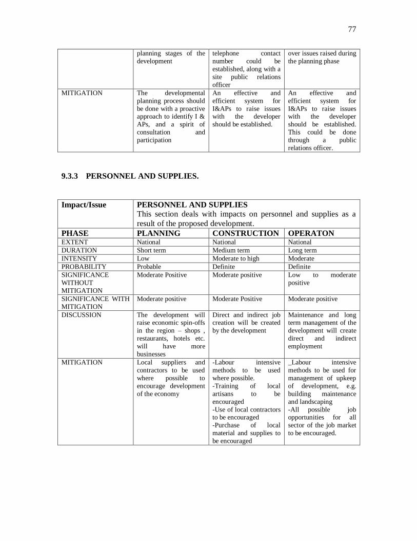
77
planning stages of the
development
telephone contact
number could be
established, along with a
site public relations
officer
over issues raised during
the planning phase
MITIGATION The developmental
planning process should
be done with a proactive approach to identify I &
APs, and a spirit of
consultation and
participation
An effective and
efficient system for
I&APs to raise issues with the developer
should be established.
An effective and
efficient system for
I&APs to raise issues with the developer
should be established.
This could be done
through a public
relations officer.
9.3.3 PERSONNEL AND SUPPLIES.
Impact/Issue PERSONNEL AND SUPPLIES
This section deals with impacts on personnel and supplies as a
result of the proposed development.
PHASE PLANNING CONSTRUCTION OPERATON EXTENT National National National
DURATION Short term Medium term Long term
INTENSITY Low Moderate to high Moderate
PROBABILITY Probable Definite Definite
SIGNIFICANCE
WITHOUT
MITIGATION
Moderate Positive Moderate positive Low to moderate
positive
SIGNIFICANCE WITH
MITIGATION
Moderate positive Moderate Positive Moderate positive
DISCUSSION The development will raise economic spin-offs
in the region – shops ,
restaurants, hotels etc.
will have more
businesses
Direct and indirect job creation will be created
by the development
Maintenance and long term management of the
development will create
direct and indirect
employment
MITIGATION Local suppliers and
contractors to be used
where possible to
encourage development
of the economy
-Labour intensive
methods to be used
where possible.
-Training of local
artisans to be
encouraged
-Use of local contractors to be encouraged
-Purchase of local
material and supplies to
be encouraged
_Labour intensive
methods to be used for
management of upkeep
of development, e.g.
building maintenance
and landscaping
-All possible job opportunities for all
sector of the job market
to be encouraged.

78
9.3.4 INJURY TO CONSTRUCTION WORKERS
Impact/Issue INJURY TO CONSTRUCTION WORKERS
This section deals with the impact of injury to
construction workers as a result of the proposed
development
PHASE PLANNING CONSTRUCTION OPERATON EXTENT N/A Local N/A
DURATION Medium to long term
INTENSITY High
PROBABILITY Low
SIGNIFICANCE WITHOUT
MITIGATION
High negative
SIGNIFICANCE WITH
MITIGATION
Low negative
DISCUSSION -All construction sites
are potentially
dangerous working environments.
MITIGATION -All contractors
working on site
should enforce strict health and safety
regulations
-Compliance will all National legislation
on health and safety
regulations on site
9.3.5 SECURITY AND FIRE SERVICES
The development of this area will impact on security and fire services at the Centre.
Police protection.
9.3.5.1 Development of the proposed project would potentially result in a significant
impact to police protection services provided by the Gaborone West police station. The
various construction phases of the proposed project could also result in increased
response times the police responding to other calls in the Gaborone area. Upon
completion of the proposed project, the number of hotel guests and site visitors within the
project site would generate some little increase in the level of police service calls from
the project site. However, project compliance with the mitigation measures listed below
would reduce the impact upon police services to a less than significant level.
- Design entryways, the lobby, and parking areas with lighting that eliminates areas
of concealment;
- Landscaping should be designed so as not to conceal potential criminal activities
near windows or doors;
- Outdoor night lighting should be provided to aid crime prevention and
enforcement efforts;
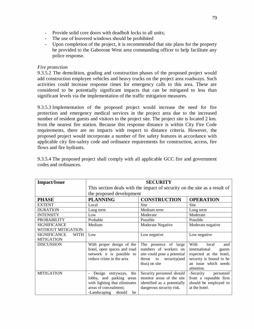
79
- Provide solid core doors with deadbolt locks to all units;
- The use of louvered windows should be prohibited
- Upon completion of the project, it is recommended that site plans for the property
be provided to the Gaborone West area commanding officer to help facilitate any
police response.
Fire protection
9.3.5.2 The demolition, grading and construction phases of the proposed project would
add construction employee vehicles and heavy trucks on the project area roadways. Such
activities could increase response times for emergency calls to this area. These are
considered to be potentially significant impacts that can be mitigated to less than
significant levels via the implementation of the traffic mitigation measures.
9.3.5.3 Implementation of the proposed project would increase the need for fire
protection and emergency medical services in the project area due to the increased
number of resident guests and visitors to the project site. The project site is located 2 km.
from the nearest fire station. Because this response distance is within City Fire Code
requirements, there are no impacts with respect to distance criteria. However, the
proposed project would incorporate a number of fire safety features in accordance with
applicable city fire-safety code and ordinance requirements for construction, access, fire
flows and fire hydrants.
9.3.5.4 The proposed project shall comply with all applicable GCC fire and government
codes and ordinances.
Impact/Issue SECURITY
This section deals with the impact of security on the site as a result of
the proposed development
PHASE PLANNING CONSTRUCTION OPERATION EXTENT Local Site Site
DURATION Long term Medium term Long term
INTENSITY Low Moderate Moderate
PROBABILITY Probable Possible Possible
SIGNIFICANCE
WITHOUT MITIGATION
Medium Moderate Negative Moderate negative
SIGNIFICANCE WITH
MITIGATION
Low Low negative Low negative
DISCUSSION With proper design of the
hotel, open spaces and road
network it is possible to
reduce crime in the area
The presence of large
numbers of workers on
site could pose a potential
threat to security(and
thus) on site
With local and
international guests
expected at the hotel,
security is bound to be
an issue which needs attention.
MITIGATION - Design entryways, the
lobby, and parking areas
with lighting that eliminates
areas of concealment;
-Landscaping should be
Security personnel should
monitor areas of the site
identified as a potentially
dangerous security risk.
-Security personnel
from a reputable firm
should be employed to
at the hotel.
80
designed so as not to
conceal potential criminal
activities near windows or
doors;
-Outdoor night lighting
should be provided to aid
crime prevention and enforcement efforts;
-Provide solid core doors
with deadbolt locks to all
units;
-The use of louvered
windows should be
prohibited
9.3.6 Archaeology
This section of the report presents the results of an assessment of potential
impacts on cultural heritage resources within the Study Area as a result of
construction and operational activities. Mitigation measures required to
ameliorate the potential impacts to acceptable levels have been recommended,
where appropriate.
RELEVANT LEGISLATION AND GUIDELINES
9.3.6.1 The following legislation is applicable to the assessment of
archaeological and historic resources in Botswana:
Monuments and Relics Act (Cap 59:03)
9.3.6.2 The act defines monument to include: any ancient or historic buildings,
ruins, ancient workings, stone circle, graves, cave rock shelters, archaeological
sites, middens, shell mounds, areas with distinctive scenery or geological
formations or rare and distinctive flora, and water falls. Relics include: fossils,
meteorites, stone tools, artifacts, drawings or carvings on stone, petrology and
ornaments of aesthetic value, archaeological, anthropological, scientific or
historic value. They also include protected heritage areas, historic buildings and
treasure troves.
9.3.6.3 Section 18(1) prohibits the alteration, destruction, damaging, removal
from its original site, and exportation of any national monument, relic, artifact
and fossil, unless it is moved to the national museum and art gallery.
National Monuments and Act Gallery (Cap 59:01)
9.3.6.4 The act stipulates that the Minister and board are to provide a
comprehensive and efficient museum and art gallery services to all people.
Town and Country Planning Act (Cap 32:09)

81
9.3.6.5 Section 27(1) empowers the Minister to make provisions for the
preservation of any buildings of special architectural or special architectural or
historic interest etc; it also has recommendations for preservation of buildings
of historical or national heritage.
Summary: ARCHAEOLOGY
Impact/Issue ARCHAEOLOGY
This section deals with impacts associated with archaeological
remains on the site
PHASE PLANNING CONSTRUCTION OPERATION EXTENT N/A Site N/A
DURATION Medium term
INTENSITY Moderate
PROBABILITY Possible
SIGNIFICANCE
WITHOUT MITIGATION
Moderate Negative
SIGNIFICANCE WITH
MITIGATION
High Positive
DISCUSSION It is possible that there are
archaeological remains at
the site
Surface archaeological
remains may be found
during construction.
If any archaeological
remains are found
during earthworks then
it may be possible to
provide an
interpretation of these in the development
MITIGATION An archaeological survey
should be completed during
planning work.
-The developer must
appoint a qualified
archaeologist to be
available on site during
the digging of
foundations and other
earthworks to identify any
remains that may be
exposed.
-An archaeological
awareness programme
should be implemented for all construction
workers and machine
operators to assist in
identifying remains if
they are present during
earthworks.
-If remains are found then
a suitable qualified
archaeologist should take
a representative sample.
If archaeological
remains are found
during earthworks the
probability that they be
interpreted to the public
through appropriate
signage and display
material should be
investigated.

82
10. CONCLUSIONS
This section below gives a summary of the overall impact of the project on the physical
and human environment.
10.1. Positive Impacts
With regard to the human environment, the building of shops and offices in this site will
have an overall positive impact on the city and the nation at large.
The project will inject money in the economy of the city and that of the country.
The project will benefit the Commercial sector of the economy
The project will result in the creation of employment in the short term as well as
in the long term.
It will also bolster the business economy of the adjacent shopping complex, as it
will attract customers.
10.1.1. A number of mitigation measures and recommendations have been made to
enhance the positive effects of the project. They should be incorporated in the design or
operational phases of the project as appropriate.
10.2 Negative Impacts.
10.2.1 No project can be undertaken without some negative impact on the environment.
However, in this case, since the project is in an already built-up and disturbed area, the
effect on the physical environment will be low if the recommendations and mitigation
measures suggested are incorporated.
Anticipated Physical Environmental Effects.
10.2.2 The following identifies the anticipated environmental effects that will occur from
development of the project on the existing physical environment.
Project implementation will require commitment of a car park and a vacant site to
commercial use, and will contribute to the cumulative loss of parking space for
the shopping mall.
Non-renewable resources such as oil and other non-renewable energy sources,
will be used in the construction and subsequent use of the site
Implementation of the project will result in increased vehicular traffic on the
roads in and out of the site.
There will be an incremental increase in air pollution as a result of vehicular
emissions and hotel operations.
The project will result in greater use of water and generate more wastewater.
Increased traffic, mechanical and human activity will also result in increased
noise and air pollution in the area;
Adjacent natural biological habitat and sensitive species will be impacted; and
Project implementation will result in irreversible commitment of building
materials.
Once the project is implemented, the land will not be returned to its current
condition. Therefore, the project represents an irreversible change to the land uses
on the site.

83
Anticipated Human Environmental Negative Effects. 10.2.3 The majority of impacts is related to human environment, and is present in the
construction stage of the project.
10.2.4 Mitigation measures suggested during this stage are particularly important to
reduce the impacts, especially in relation to land and public safety. To this end, an
Environmental Code of Conduct for the contractor (or contractors) undertaking the work
has been drawn up and is included in Appendix A. It should be included in the contract
documents so that there is an obligation on the contractor to respect the environment he is
working in. Where proposals from the contract are required by the Code of Conduct, they
can be requested at tender stage so that the tenderers attitudes to environmental issues can
be assessed as part of the tender adjudication process.
10.2.5 There are some negative impacts during the operational stage, but the mitigation
measures recommended will reduce their effect to acceptable levels.
10.3 Auditing.
If the recommendations and mitigation measures outlined in this plan are to be effectively
implemented, regular monitoring of the management plan should be undertaken in all
project stages, including the operational stage. This will help to ensure that environmental
impacts of the project are minimized and the opportunities for improvement of the
environment are maximized.
10.4 Conclusion.
In conclusion, there have been no environmental impacts identified that are severe
enough to halt the project. What negative impacts there are during construction and
operation phase should be militated against in the design and construction method as
recommended in this report.
10.4.1 Existing environmental problems identified can be substantially reversed and the
positive impacts enhanced by incorporation of the recommendation of this report.
10.4.2 Mitigation measures and recommendations are outlined in the Environmental
Management Plan, which is included in this report. It is recommended that the
implementation of this plan is reviewed periodically throughout the design,
implementation and operation stages of the project.
10.4.3 Detailed recommendations are made for mitigations measures in the tables
(Impact Analysis). The following key recommendations highlighted are not presented in
any order of priority.

84
11. ENVIRONMENTAL MANAGEMENT PLAN.
11.0.1 Based on the impact analysis exercise an Environmental Management Plan has
been formulated to implement mitigation measures identified and enhance the positive
impacts of the project. The plan is outlined below.
11.0.2 Environmental impact management is principally an integrated effort of
utilization, planning, maintenance, supervision, control, recovery and development of the
environment. The success of the plan very much depends on monitoring of the
implementation of the mitigation measures contained within nit throughout the various
project stages.
11.0.3 The plan lists, in brief, the management objectives, and the mitigation measures
and recommendations that have been identified in the previous sections of the report.
11.0.4 The Plan is divided into two distinct phases:
Phase 1: Planning and Construction Phase
Phase 2: Operations Phase -Hotel Environmental Management.
ENVIRONMENTAL POLICY
11.0.5 It is recommended that the Centre Management develop an environmental policy.
This can facilitate defining objectives and targets and may institutionalize environmental
activities in the complex to a certain extent; this is crucial when seeking cooperation and
support from all the staff members.
SAMPLE ENVIRONMENTAL POLICY FOR THE RETAIL AND OFFICE &
CIVIC AND COMMUNITY COMPLEX.
The Complex will minimize the environmental impact of our activities and products on
the public, employees, customers and property and will comply with all relevant
legislation.
It is the policy of the Molapo Extension Complex to: -
Minimize costs by reducing all forms of waste and by preventing pollution.
Apply effective procedures and management systems in all of our activities.
Assess the environmental risks of new and existing projects, processes, and
products so that we can take effective control measures and all parties can be
made of the situation.
Periodically audit our environmental performance and provide timely reports to
the Board of Directors.
Communicate our environmental policies and progress to all our employees,
customers, suppliers and other interested parties.
Date……………………………………………………..Signed by CEO

85
11.1. SITE PLANNING AND CONSTRUCTION PHASE.
1. INTRODUCTION
11.1.1 The general aim of the EMP is to specify a range of appropriate actions for the
mitigation of impacts during the site planning and construction phase of the development
and outline the implementation of these measures. It is recommended in the
accompanying EIA that a detailed and comprehensive Environmental Management Plan
for the operation phase of the development be created when the project is finalized. This
can be undertaken concurrently with construction activity.
11.1.2 The significance of an impact is a combination of a number of criteria that are
analyzed with the use of a simple matrix. The system is based upon the scaling of impacts
based on the importance of the environmental elements affected and the nature of the
impacts. The significance is determined by the assessment of the combined effect of the
nature and the scale of the effect, the spatial influence and the duration over which the
effect will be experienced.
11.1.3 Mitigation therefore can be applied during a number of stages of the project
including the site planning process and the construction process.
2. IMPACT TO BE MITIGATED
11.1.4 The term ―Mitigation‖ can be broad in definition. In this context it means to
―allay, moderate, palliate or intensify‖. Mitigation of a negative impact means that its
significance is reduced. Mitigation (optimization) of a positive impact means that its
significance is increased or optimized.
11.1.5 The following section discussed each impact identified in the EIA under the
respective titles: Biophysical, Socio-Economic and Aesthetic environments and makes
recommendations for its mitigation if it is negative and optimization in the case of a
positive impact.
2.1 Key Environmental impacts to be mitigated.
11.1.6 The public consultation process, interviews with key interested and affected
parties, the ecological study and the archaeological study of the associated EIA process
identified the following key environmental impacts likely to occur during the site
planning and construction activities of the housing scheme.
Change in current Land use - Project implementation will require
commitment of the car park and a vacant site to commercial development
and will contribute to the cumulative loss of parking and open space uses
in the vicinity of the shopping mall. Once the project is implemented, the
land will not be returned to its current condition. Therefore, the project
represents an irreversible change to the land uses on the site.
Non-renewable resources such as oil and other non-renewable energy
sources, will be used in the construction and subsequent use of the site
86
Road safety - Implementation of the project will result in increased
vehicular traffic which is likely to have a significant impact on the existing
road network and road junctions. This is likely to have impacts on road
safety for all road users including pedestrians.
There will be an incremental increase in air pollution as a result of
vehicular emissions
Increased traffic, mechanical and human activity will also result in
increased noise in the area;
Project implementation will result in irreversible commitment of building
materials.
Storm water run off and water pollution.
Within the site the key issue of the proposed development related to
climate are nature of rainfall (and the subsequent storm water runoff) has
to be considered with regard to rainwater collection and transfer of
pollutants into the drainage system.
Soil erosion
Within the site area the key issue of the proposed development relating to
the soil structure and characteristics are that disturbance (during
construction) to soils can alter their drainage, erosion and quality
characteristics and this can result in negative effects.
Natural biological habitat and sensitive species will be impacted and hence
there will be a need to retain vegetation.
Economic development
The proposed development will impact on the economic base of both the
area and the surrounding businesses in this area. Positive impacts will
include the possible job creation associated with the development along
with the indirect and secondary benefits for supply companies and shops.
Most of the store owners on the shopping mall are eagerly awaiting the
development of this project.
Social impacts
The proposed development will have both positive and negative social
impacts which will need to be attended to.
Development aesthetics
The proposed development project has the potential to impact on the
aesthetic values of this green zone in the city. Some trees and vegetation
will be replaced by buildings and views will be lost.
Archaeology
So far the archaeological study did not unearth anything of archaeological
value. However, it is suggested that an archaeologist be appointed to
inspect the foundation trenches of the proposed development when they
are being dug. If a suitable occupation horizon or tool concentration is
located then a small excavation of approximately 4 square metres be
sampled and consideration be given for obtaining a thermo-luminescence
for dating.

87
3. PERSONNEL REQUIREMENTS.
11.1.7 It is recommended that the developer appoint an environmentalist
representative/consultant to oversee the implementation of the EMP and to produce
environmental compliance reports.
11.1.8 This position will be responsible for liaising with all interested and affected
parties, including the Consulting Engineer, Main Contractor and sub contractors to ensure
mitigation solutions are implemented to environmental problems as identified.
11.1.9 This position could also take responsibility of public liaison duties as regards
environmental issues, including key stakeholder liaison and public liaison.
4. IMPLEMENTATION
Implementation of the EMP shall be the responsibility of the site developer
(Sphinx Associates).
5. MITIGATION MEASURES.
5.1 Physical environment
5.1.1 Soils and Geology
Management Plan:
Objective Prevention and containment of negative
impacts on soils and geology
Potential Negative Impacts Soil erosion due to water and wind,
contamination of soil, compaction of soil
etc.
Duration of Impact Site planning and construction phase –
Short term
11.1.10 Mitigation Measures.
1. Advance Planning
Planning of working areas, haulage roads, etc. to avoid the clearance of unrequired
areas and to be done in accordance with environmental consultant‘s
recommendations. Use existing tracks as much as possible to avoid disturbance to
new areas.
2. Site preparation
The areas to receive compacted fill shall be prepared by removing all vegetation,
debris, existing fill, and soil. The exposed excavated area shall be observed by a soils
engineer or geologist prior to placing compacted fill.

88
3. Stripping of top soil and sub-soil
Care should be taken not to mix topsoil and subsoil during any stripping of the car
park. No soil stripping shall take place in areas required for retained vegetation or
areas not required for construction activity.
Selective soil stripping should be done in accordance with the environmental
consultant. Top soil should be separated from subsoil and stockpiled (if needed for
earthworks, landscaping etc) or removed of site. Top soil stockpiles should not
exceed two metes in height.
Subsoil stockpiles should not exceed three metres in height. Stockpiles should not be
utilized within three months or prior to the onset of seasonal rains and shall be
stabilized with seeding or brush packing to avoid erosion. Stockpiles shall be kept
free of any contaminants whatsoever, including paints, oils, building rubble, cement,
chemicals etc.
4. Disturbed Soils - All disturbed soils should be removed and replaced with suitably
compacted/engineered fill capable of supporting the envisaged foundation loads.
Any areas containing fill material should be clearly identified and rehabilitated as part
of the earthworks programme, prior to construction of foundation work
5. Testing of top soil
Existing topsoil on site shall be tested after stockpiling to determine its structure, pH
value and major nutrient levels. All imported top soil (if necessary) will be tested for
contamination (one test per source)
Should it be suspected that soils have become contaminated due to site construction
activities additional top soils tests will be conducted as necessary. Should testing
confirm, or should it be suspected that stockpiled, spread or in situ soil has become
polluted due to any site operation, the contractor shall remove the polluted soil to the
full depth of pollution from the site and shall replace it at his own expense with an
approved topsoil which shall at least be equal to approved topsoil specifications.
Removed contaminated soil shall be transported to an approved landfill site.
6. Removal of Trees – Where necessary trees may have to be removed from the
adjacent site to facilitate development, including large roots. Care should be taken
to ensure that the underlying soils in such areas, disturbed during removal of the
roots, are not left untreated to the extent that this negatively impacts on
foundations.
7. Storage of materials
Storage of potential pollutants should be done on a sealed surface to prevent spillages
leaching into the ground. Fuel should be stored in a tank on sealed plinth with a
retaining wall capable of containing any spillage.
8. Mortar mixing
Mixing of mortar for construction purposes should not be done directly on the soil
without the use of mixing trays or plastic liners.

89
5.1.2 Deterioration of Air Quality
Management Plan:
Objective Prevention or reduction of negative impact
on air quality
Potential Negative Impact Unpleasant odours, dust, smoke from fires,
diesel emissions from construction plant,
wind blown litter etc.
Duration of Impact Site planning and construction phase –
Short term
11.1.11 Mitigation
1. Regular damping down
Damping down of exposed areas such as access roads, etc. at all times during dry
weather. Dust emissions not to exceed 200ug m-3 at any adjacent residential
(Phase 2) or commercial areas.
2. Removal of litter
Litter should be stored in suitable containers and removed from site regularly by
project staff.
3. Regulation of fires
Only designated areas should be used. Adequate fire combat equipment to be
available on site with personnel trained in effective use.
4. Vehicles
All vehicles used on the construction site should be well maintained and in good
running order.
5. Temporary toilet facilities.
All temporary toilet facilities on site will be maintained to a high standard to
reduce the impact of undesirable odours.
6. Retention f vegetation
All areas of retained vegetation will assist to mitigate the impacts of dust, wind
and blown litter etc.
7. All unpaved demolition and construction areas shall be wetted at least twice daily
during excavation and construction, and temporary dust covers shall be used to
reduce dust emissions. Wetting could reduce fugitive dust by as much as 50%
8. All materials transported off site shall be securely covered to prevent excessive
amounts of dust
9. All clearing, grading, earth moving, or excavation activities shall be discontinued
during periods of high winds so as to prevent excessive amounts of dust
10. General contractor shall maintain and operate construction equipment so as to
minimize exhaust emissions
11. Cover any on-site stockpiles of debris, dirt or other dusty material.
12. Actively stabilize any cleared area that is planned to remain inactive for more
than 30 days after clearing is completed.

90
13. Establish an on-site construction equipment staging and construction worker
parking lot, located on either paved surfaces or unpaved surfaces subjected to soil
stabilization treatment, as close as possible to a public highway.
14. Sweep access points daily.
5.1.3 Contamination of Water Resources
Management Plan:
Objective Reduction of , or elimination of the risk of
polluting nearby water resources
Potential Negative Impact The site is within the catchments area of
the Segoditshane river.
Duration of Impact Site planning and construction phase –
Short Term
11.1.12 Mitigation:
1. Advance Planning of Site Activities
Drainage requirements of the site during construction must be planned
accordingly. Adequate maintenance of site drainage once operational is
mandatory.
2. Storage of potential pollutants
All potential pollutants to be stored away from site drainage lines. Storage
containers to be in sealed surfaces with retaining walls capable of holding any
potential spillage. Storage containers to be kept locked at all times to reduce the
risk of accidental/purposeful release of potential pollutants. This will apply
particularly to liquids (fuels etc)
3. Removal of waste- All waste should be removed off site quickly to reduce the risk
of potential pollutants from entering the nearby water resource system through
wind or water movements. Use appropriately labeled recycling bins to recycle
construction materials including: solvents, water-based paints, vehicle fluids,
broken asphalt and concrete; wood and vegetation. Non-recyclable
materials/wastes must be taken to an appropriate landfill. Toxic wastes must be
discarded at a licensed regulated disposal site
4. Grease traps.
All storm water drainage required during construction (if any) to be fitted with
grease traps to reduce the potential of oils nearby water resources.
5. Temporary toilet facilities.
All temporary toilet facilities should be ‗closed systems‘ with no connection to a
temporary French drain or similar. Sewage waste should be removed off site and
disposed of in a registered treatment plant. Sewage will be collected regularly to
reduce the risk of overflow. The temporary toilets should not be sited near any
drainage lines to reduce risk of flooding.
6. Clean up leaks, drips and spills immediately to prevent contamination to soil on
paved surfaces that can be washed away into storm water drains.

91
7. Do not hose down pavement material spills. Use dry cleanup methods whenever
possible.
8. Cover and maintain dumpsters. Place uncovered dumpsters under a roof or cover
with tarps or plastic sheeting.
9. Use gravel approaches where truck traffic is frequent to reduce soil compaction
and limit the tracking of sediment into streets.
10. Conduct all vehicle /equipment maintenance, repair, and washing way from storm
water drains. All major repairs are to be conducted off-site. Use dip pans or drop
cloths to catch drips and spills.
11.1.13 General mitigation near building structures like the shopping Mall.
11. The site should be drained so as to ensure that water cannot pond adjacent or near
the structure. The surface of the ground immediately adjacent to the building
should fall 75mm over the first 1.5m. Any paving should be similarly sloped.
12. Limitations on Gardens – Flower beds, trees and shrubs should not be planted
within 1.5m of buildings and either a lawn or impermeable apron should be
provided around the building so as to provide a surface which will facilitate free
run-off of water.
13. Restrictions on the planting of trees – These should observe the same point raised
above in 11.
5.1.4 Construction Traffic
Management plan:
Objective Ensure minimal disruption to traffic during
construction
Potential Negative Impact Disruption of traffic on the junctions of
both Molepolole and Western By Pass road
junctions.
Duration of Impact Site planning and construction phase –
Short Term
11.1.14 Mitigation Measures.
1. Advance Planning of likely traffic requirements
This refers to the needs for deviations, site access, transport routes etc.
2. Avoidance of peak hour traffic
Construction traffic using public roads (deliveries etc) to be scheduled to avoid
peak hour traffic and routed along major roads.
3. No construction equipment shall be started in or in operation on-site outside the
allowable construction hours of 7.00am to 5.00pm.
4. Trucks and construction equipment shall not be staged in adjacent residential
areas during the overall period of construction.
92
5. Construction workers shall not be allowed to park on Molepolole or Western By-
Pass roads.
6. Warning Signs/Publicity Information.
Clear and appropriate signage to be in place on any identified potential danger
areas, such as heavy vehicle turning points, deviations etc.
7. Low speed driving culture
A culture of low sped, defensive driving to be instilled in all machinery operators
both on and off site.
8. Pedestrians.
Pedestrians should be discouraged from crossing the site on foot. Adequate
provision of alternative routes and safety signage should be provided at all
pedestrian routes.
5.1.5 Noise Pollution
11.1.15 Construction can be a noisy activity, and it is essential that mitigation
measures be undertaken to reduce the potential for disturbance of neighboring land users.
Management plan:
Objective Keep noise levels at a minimum
Potential Negative Impact Adverse impacts on neighboring land users
through uncontrolled disturbance. Potential
for long work hours to correspond with
long periods of noise disturbance.
Duration of Impact Site planning and construction phase –
Short Term
11.1.16 Mitigation Measures:
1. Adhere to Normal Working Hours
If possible all noisy construction activity should be conducted during normal
working hours e.g. 7.00 am – 5.00pm. From Monday to Saturday. If this is not
possible, neighboring land users should be informed in advance. Every effort is to
be made to schedule excessively noisy activities to within the hours of daylight.
2. Machinery and Equipment
All noisy reduction methods on machinery and equipment to be kept in good
working order. Every endeavor must be made to minimize exhaust noise from
plant and machinery by fitting suitable silencers to exhaust systems.
3. Noise complaints
A communication channel with the pubic and neighouring land users to be
established to effectively deal with any noise complaints.
4. Retention of Vegetation
Vegetation should be retained at the site periphery to assist in damping any noise
levels.

93
5.2 BIOLOGICAL ENVIRONMENT
5.2.1 Disturbance of Flora.
11.1.16 Although the ecological report indicated no major impacts foreseen on
adjacent flora that cannot be mitigated, it is still important to ensure that mitigation
measures are in place to ensure the least disturbance to flora possible.
11.1.17 The accompanying EIA identified negative ecological impacts. These impacts
can be mitigated and reduced.
Management Plan:
Objective Ensuring minimal disturbance to areas of
adjacent flora not required for construction
activity.
Potential Negative Impact Disturbance to faunal habitat. Reduction of
aesthetic appeal. Alteration of micro
climate.
Duration of Impact Site planning and construction phase –
Short Term
11.1.18 Mitigation:
1. Advanced Planning of Retained Vegetation
Working areas if outside the paved area must be planned in advance to ensure
minimal disturbance of areas not required for construction activities. Site
clearance to be restricted to working areas.
2. Machinery operators
All machinery operators are to be clearly informed of areas to be retained and a
culture of minimal damage to be instilled.
3. Contractual clauses
Issues of negligent damage to retained vegetation to be addressed in contractual
clauses and a financial penalty to be attached.
4. Fencing
Fence off adjacent area to avoid damaging vegetation.
5. Control of fires.
Fires on site should be restricted to designated areas only. Adequate fire combat
equipment to be avoided on site and personnel trained in its effective use.
6. Site boundary
7 Site boundary to be clearly marked
5.2.2 Potential Fire Threat
It will be important to guard against random making of fires on site.

94
Management Plan:
Objective Prevention of disturbance to vegetation on
site and surrounding areas.
Potential Negative Impact Fires may be potentially destructive to the
vegetation in this area.
Duration of Impact Site planning and construction phase –
Short Term
11.1.14 Mitigation
1. Advance Planning and Site Activities
Advanced planning of site activities to identify areas where fires (if necessary)
can be lit safely for cooking and other purposes.
2. Prohibition of Random Fires on Site
Cooking fires only to take place on designated areas. No fires/smoking/welding to
be permitted near areas of potential danger such as fuel storage tanks.
3. Fire fighting equipment
Adequate fire fighting equipment to be available on site and personnel to be
trained in its effective use.
4. Safety signage
Suitable signs are to be placed in areas of free risk, such as no smoking, no open
flames etc.
5.3 Socio-Economic Environment
5.3.1 Expectations.
There are expectations for jobs, for example, for general workers, construction
workers, artisans, servicing machinery and equipment, supply procurement etc.
Management Plan:
Objective Ensure that expectations for employment
opportunities, supplies procurement and
other associated benefits are met
Potential Negative Impact Failure to meet these expectations and the
ensuing negative response to the
development as a result
Duration of Impact Site planning and construction phase- Short
term
11.1.15 Mitigation:
1. Employment and Training
The use of contractors and suppliers with a proven track record of citizen training
should be encouraged.
2. Supplies Procurement
Where available all supplies should be procured within Botswana
3. Adherence to Legislation

95
All consultants, contractors and individuals should adhere to all current legislation
relevant to the work place
4. Labour intensive Methods
Where possible labour intensive methods should be employed to maximize
potential employment
5. Advanced Advertisement of required Personnel
Advanced advertisement of required personnel will facilitate equitable job
opportunities for all.
5.3.2 Unsocial Activities
Although not envisaged to be a major factor, it is still a requirement that thus is
considered as part of mitigatory requirements.
Management Plan:
Objective Prevention of unsocial activities on site
Potential Negative Impact Manifestation/Spread of unsocial activities
on Site
Duration of Impact Site planning and construction _Short time
11.1.15 Mitigation:
1. Advance Planning of Site Activities
In this case this would include planning ablution requirements, working
conditions etc.
2. Education about AIDS and other STDs.
Workers will need to be educated about STDs, AIDS/HIV etc. Dissemination of
information is to be facilitated by the Community Liaison Officer through local
clinics. Condoms must be made freely available on site for all workers.
3.Increase human presence
The workforce for the construction project may contribute to unsocial activities in
the neighbouring residential areas such as loitering and a possible increase in
crime and disturbance.
4.Recruitment of Workforce.
Recruitment of work force personnel shall not take place at the site but shall
follow formal procedures, which should be implemented through the local
community, media etc.
5.Fencing of security areas.
Areas identified as having a security risk should be fenced off to control access to
and from secure areas
6. Secure storage areas
To avoid any hazards and unauthorized entry strict security shall be enforced in
storage areas, particularly where chemicals and fuels are stored.

96
5.3.4 Injury to workers on the site
As construction is a dangerous operation measures will have to be put in place to
ensure safety of site workers.
Management Plan.
Objective Prevention of injury to workers and the
public
Potential Negative Impact Injury to workers and public due to unsafe
working conditions
Duration of Impact Site planning –Short Term
11.1.16 Mitigation:
1. Advance Planning of safety Requirements.
Advance planning of safety precautions. Appointment of Safety Officer
2. Adherence to current and safety regulations.
All health and safety measures as stipulated in current legislation to be followed
at all times. Safety measures to be in place at all times, these include the provision
of safety to employees on site and the safe maintenance of plant.
3. Respect of workers‘ right
Workers right to refuse to work in unsafe conditions to be respected/maintained at
all times.
4. First Aid Facility
This is to be established at a suitable point to attend to minor injuries. Links to be
made with local hospital for emergencies.
5. Reporting of Accidents
Workers must be notified of the requirement to report promptly any accidents to
the Project Manager/safety Officer
6. Proper use of all equipment and machinery
Strict adherence to manufacturer‘ instructions for handling machinery will
minimize injury.
5.3.5 Security of Site from a safety perspective
Potential danger of the construction area exists at all times. This is due to the presence
of heavy machinery and equipment, movement of heavy vehicles, potential danger of
falling materials, etc. It will therefore be important to ensure that safety measures are
in place at all times.
Management Plan:
Objective To ensure the maintenance of safety at all
times
Potential Negative Impact Potential danger to workers and
unauthorized entry of persons.
Duration of Impact Site planning and construction phase –
Short Term

97
11.1.17 Mitigation:
1. Planning of site activities
Advanced planning of safety requirements
2. Security Measures
To apply at all times. Warning signs to be erected to indicate danger zones.
3. Fencing to be erected and maintained regularly
4. Speed limits – Speed limits to be adhered to within, and off, site areas and access
roads to avoid accidents.
5.4 Cultural Environment
5.4.1 Potential discovery of significant Archaeological Resources
Although no archaeological sites were identified on the surface, the topography
suggests that any sites present may be buried at a depth below the present soil surface
level. To maximize and enhance the impact to the archaeological resources (if any) of
the area the following mitigation is required:
Management Plan:
Objective Maximize potential impact on
archaeological resources(if any) through
discovery and examination
Potential Negative Impact Potential damage to archaeological
resources
Duration of Impact Site planning and construction phase –
Short Term
11.1.18 Mitigation:
1. Site inspection
An archeologist should be appointed by the contractor to inspect the site during
foundation digging works. If any archaeological discoveries are made these
should be sampled to identify their significance and appropriate mitigation
measures followed.
2. Work Force awareness
All the members of the workforce involved in earthworks should be made aware
of the possibilities of finding archaeological artifacts. A system of reporting any
finds must be established prior to the earthworks commencing.
5.5 Visual Environment
5.5.1 Negative Visual Impact
The area is already home of the shopping Mall. However, the introduction of the
proposed development and construction activities will be significant on the aesthetics
of the area. Both shoppers and people who work here will be affected.

98
Management Plan:
Objective To minimize potential negative impacts of
the development and construction site
Potential Negative Impact Negative visual impact
Duration of Impact Site planning and construction phase –
Short Term
11.1.19 Mitigation:
1. Advance Planning of Site layout
Advanced planning of site activities in the form of a Master Plan is key to
maintaining the visual qualities of the area.
2. The Plan should include several development standards that would facilitate
visual compatibility between individual land use components on the site, and
between the proposed on-site uses and adjacent off-site uses.
3. Landscaping – Establish a unifying identity and landscape theme for the Detailed
Local Plan for this site. Minimize the visual impact of proposed buildings and
parking areas. Create an outdoor environment of comfortable human scale.
Identify and highlight pedestrian circulation routes to provide safe and
comfortable walking areas
4. Integrate the various land uses throughout the site
5. Visually enhance street frontage along Western By-Pass road.
6.Architectural and Landscape Guidelines
11.9.20 The client shall develop and implement Architectural and Landscape Guidelines
for the complex. The Guidelines shall include clear criteria and requirements to guide the
design, layout, and landscaping of each component of the hotel plan. All future
development on the site shall comply with the Guidelines. Enforcement of compliance
with the Guidelines shall be the responsibility of the Planning Department.
Roofing and feature colour and material
11.9.21 The development plan shall include colours on structure roofing and other on-site
features that are compatible with the surrounding commercial uses to lessen potential
visual contrast between the proposed and existing adjacent structures.
Tract lighting
11.9.22 Prior to development of each development phase, proposed lighting shall be
indicated on site plans that demonstrates that spillover of lighting would not affect the
existing shopping Mall. The lighting plan shall incorporate lighting that direct light pools
downward to prevent glare on adjacent and surrounding areas. Lights shall have solid
sides and reflectors to further reduce lighting impacts by controlling light spillage. Light
fixtures that shield nearby residences from excessive brightness at night shall be included
in the lighting plan. Non-glare lighting shall be used.

99
Compatibility with adjacent uses.
11.9.23 The design, scale, and character of the complex project building architecture
shall be generally compatible with the scale of existing commercial uses east of the site.
Street light limitations.
11.9.24 Street lights shall be pedestrian in scale and must enhance safety. They should
not provide widespread illumination.
Wall and fence articulation
11.9.25 Long expanses of walls (including sound walls) or fences should be interrupted
with offsets and provided with accents to prevent monotony. Landscape pockets should
be provided. Walls and fences should be designed in a style, materials and colour to
complement adjacent buildings.
Clear excess debris.
11.9.26 The future developers of the various components of the plan shall clear the site of
all excess construction debris when completed with individual development phases.
Screening of construction areas
11.9.27 To reduce visual impact, maintain as much vegetation as possible between the
road and the construction site to act as screening to neutralize views.
Management of Waste
11.9.28 All solid waste, litter, food and general wastes associated with construction
activities and personnel to be cleaned up regularly. A central collection point must be
established. A covered skip container should be introduced.
On-going rehabilitation
11.9.29 The construction areas (where construction has been completed) must be
rehabilitated on an ongoing basis to improve ―scarred‖ appearance of the sites.
5.5.2 Waste Management
There is potential for the construction activities and associated work force to produce
significant quantities of waste. This waste will have to be managed.
Management Plan.
Objective Reduce the negative impacts of waste on
site
Potential Negative Impact Attraction of vermin, visual impacts, health
etc.
Duration of Impact Site planning and construction phase –
Short term
11.9.30 Mitigation

100
1. Advance planning
Advanced planning of site activities to include the siting of waste collection
points.
2. Collection containers
All waste collection containers used on site must be problem animal (rats,
baboons etc) proof to avoid negative impacts on the surrounding fauna.
3. Regular removal.
All waste collection containers should be removed regularly and the contents
disposed of in a registered land fill site.
4. Non-Littering culture
A culture of non-littering should be instilled in the entire work force.
5.6 MONITORING PROGRAMME
11.9.31 Prior to implementation of the Environmental Management Plan a briefing
session for all consultants, project managers and project team is recommended to
sensitize them to the requirements of the plan.
11.9.32 Implementation of the EMP:
The following recommendations are to be adhered to:-
1. The client will be responsible for the environmental Management Plan
2. The developer will appoint an environmental representative, who will be
responsible for ongoing management, compliance with the EMP mitigation
guidelines, and community liaison, which includes responding to complaints
voiced by members of the public and Interested and Affected Parties.
3. A suitable qualified Environmental Consultant will fulfill the role of an
Independent Environmental Management Representative for the client who will
be responsible for overseeing the implementation of the EMP guidelines as well
as auditing the activity.
4. The client‘s Environmental Representative will conduct regular monitoring of the
operation of each development to ensure compliance with the EMP guidelines.
The developer will report on the results of the monitoring to the Environmental
consultant, in the form of compliance monitoring reports. The frequency of these
reports shall be agreed with the relevant Government Departments, and follow
Statutory requirements.
5. The results of these audits will be included in EMP compliance reports to be
submitted to the DEA and the Local Authority.
5.6.2 Programme Timing
11.9.33 Environmental monitoring should be carried weekly during site
establishment and initial clearing work (up to 4 weeks). Thereafter the environmental
monitoring can be conducted at monthly intervals.
5.6.3 Purpose of Monitoring Programme

101
11.9.34 The purpose of the environmental monitoring programme is to ensure
compliance to the guidelines as set out in the EMP.
5.6.4 Methodologies of the Monitoring Programme.
11.9.35 A qualified environmentalist should conduct a site visit to the construction
site and report on the effectiveness (using currently accepted best practices methods) of
the mitigation and rehabilitation techniques employed by the contractor. This report
should use the recommendations as set out in the EMP as a base line. The report should
contain recommendations for the contractor and should be made available to the client‘s
Environmental Representative and other interested parties.
5.7 ENVIRONMENTAL AUDIT –LONG TERM
Audit Objectives.
11.9.36 It is important to define the audit objectives and scope in the initial phase of an
audit.
To management should set up objectives and targets for the audit team. This can help
encourage the audit team to conduct a very focused and efficient audit in line with
environmental policies and management priorities.
Typically, hotel management may set up objectives and targets such as a ―reduction in
water consumption by 20% in one year‖, or ―energy conservation of 25% within two
years‖.
Audit Objectives.
11.9.37 It is important to define the audit objectives and scope in the initial phase of an
audit.
To management should set up objectives and targets for the audit team. This can help
encourage the audit team to conduct a very focused and efficient audit in line with
environmental policies and management priorities.
Typically, the Centre management may set up objectives and targets such as a ―reduction
in water consumption by 20% in one year‖, or ―energy conservation of 25% within two
years‖.
12. CONCLUSION AND RECOMMENDATIONS.
In view of the above findings and possible mitigation measures for the expected
environmental impacts we see no long-term irreversible impacts that can stop the
project from going ahead. This is a positive development which should be encouraged
to take off as soon as possible as this land has been lying idle for a number of years,
thereby costing the owners a big loss of revenue. The nation has also lost money which
could have been earned through taxes etc.
It is hereby stated that the proponents of this project are ready to implement the proposed
measures for the amelioration of any adverse impacts of the project.

102
REFERENCES
Ann Venter, F. and Ann Venter, J. 1996. Making the most of indigenous trees. Briza
Publications. Pretoria. SA.
Baillie, J.E.M., Hilton-Taylor, C. and Stuart, S.N. (Editors) 2004. 2004 IUCN Red List of
Threatened Species. A Global Species Assessment. IUCN, Gland, Switzerland and
Cambridge, UK. xxiv + 191 pp.
Birkeland, P.W.1999. Soils and Geomorphology. 3rd
Ed. Oxford University Press. NY.
Brady, C.N. 1990. The nature and Properties of Soils.10TH
Ed. Macmillan Publishing
Company. NY.
Brady, C.N. 1990. The nature and Properties of Soils.10TH
Ed. Macmillan Publishing
Company. NY.
Birkeland, P.W.1999. Soils and Geomorphology. 3rd
Ed. Oxford University Press. NY.
Brady, C.N. 1990. The nature and Properties of Soils.10TH
Ed. Macmillan Publishing
Company. NY.
Baillie, J.E.M., Hilton-Taylor, C. and Stuart, S.N. (Editors) 2004. 2004 IUCN Red List of
Threatened Species. A Global Species Assessment. IUCN, Gland, Switzerland and
Cambridge, UK. xxiv + 191 pp.
Birkeland, P.W.1999. Soils and Geomorphology. 3rd
Ed. Oxford University Press. NY.
Brady, C.N. 1990. The nature and Properties of Soils.10TH
Ed. Macmillan Publishing
Company. NY.
Ceikot, David. 2000. A tale of transformation. Golf Course Management. Oct. ed.
Coastal & Resource Management (2002): ‗ Environmental Impact Assessment Study for
the Small Mining Operation on the Farm Notwane Farm 14-KO‘ Gaborone, Botswana.
Commonwealth of Australia. 2007. Commonwealth Environmental Protection and
Biodiversity Conservation Act 1999. Australian Government Department of the
Environment and Water Resources.
Department of Geological Survey of Botswana.1980. Geology map of Gaborone-Quarter
degree sheet 2425D. Government Printer. Gaborone, Botswana.
Department of Surveys and Mapping. (2000). National Atlas of Botswana.
Department of Water Affairs .1993. Protection Zones and Guidelines for Major
Wellfileds, Aquifers and Dams in Botswana; Vol. 1: Introduction and Reference
Document.
103
Fech, J. C. and S. N. Rodie. 1999. Sustainable design in golf course pes. Golf Course
Management. Jan. ed.
Fitzgeralds, Jeannine. 2001. Super tips—fences make good neighbors. Golf Course
Management. Dec. ed.
Government of Botswana(1999): ― Mines and Minerals Act No. 17‖ Government Printer,
Gaborone.
Government of Botswana(1969) : ― Road Traffic Act- Cap 69:1‖ Government Printer,
Gaborone
GoB/ Roads Department III(1983) ― Standard Specifications for Roads and Bridge
Works‖. Gaborone, Botswana.
GoB/DTRP(1996): ― Greater Gaborone Structure Plan 1994-2014‖ Govt. Printer.
GoB/DTRP(2004) : ― Tlokweng Development Plan‖ Government Printer
H.G. 1982a. Multivariate analysis in community ecology. Cambridge University Press.
England.
Hendershot, W.H. and Duguetts, M.1986. A simple barium chloride method for
determining cation exchange capacity and exchangeable cations. Soil Sci. Soc.
Am. J. 50, 605-608.
Hill, M.O. 1979. TWINSPAN: A Fortran Program for Arranging Multivariate Data in an
Odered Two-Way Table by Classification of the Individual and Attributes.
Cornell University, NY.
Hill, M. O and Gauch, H.G. 1980. Detrended correspondence analysis, an improved
Coordination technique. Vegetation 42, 47-58.
International Union for Conservation of Nature and Natural Resources. www.CITES.org
Itshekeng P. (2006) Mupane Gold Mine Tailings Water Quality Monitoring Report,
ITES.org
Key, RM. 1983. The geology of the area around Gaborone, Lobatse, Kweneng, Kgatleng,
Southern and South East Districts. District Memoir 5, Department of Geological Survey,
Lobatse.

104
Kgato Resource Consult (2002): ―Environmental and Archaeological Impact Assessment
– Dam Enlargement on the Property Notwane Farm 14-KO‖ Gaborone, Botswana
Mankin, K. R. 2000. An integrated approach for modeling and managing golf course
water quality and ecosystem diversity. Ecological Modelling. 133: 259-267.
Legros, J.P. 2006. Mapping of the Soil. Science Publishers. United States.
Ministry of Minerals, Energy and Water Affairs. (1979). Hydrological Reconnaissance
Map of the Republic of Botswana, Sheet 11. Department of Geological Survey.
Ministry of Minerals Energy and Water Resources, Department of Mines, Gaborone,
Botswana.
Olsen, S.R., Cole, C.V., Watanabe, F.S., and Dean. L.A. 1954. Estimation of available
phosphorus in soils by extraction with sodium bicarbonate. U.S. Dep. of Agric.
Circ. 939.
Setshogo, M.P and Venter, F.2003. Trees of Botswana: names and distribution. Southern
African Botanical Diversity Network Report No. 18.
Solid waste authority of central Ohio (SWACO). 2000.
www.swaco.org/facilities/phoenix.htm
Ter Braak, C.J.F. 1987. The analysis of vegetation-environment relationships by
canonical correspondence analysis. Vegetatio 69, 69-77.
Ter Braak, C.J.F. 1989. Program CANOCO Manual. Ministry of Agriculture and
fisheries, Agricultural Mathematics Group (DLO), Wageningen, The Netherlands.
Terman, M. R. 1997. Natural links: naturalistic golf courses as wildlife habitat.
Landscape and Urban Planning. 38: 183-197.
United Consulting(2002) : ― Environmental Impact Assessment – Quarry Access road-
Tlokweng‖.
USDA. 2000. Munsell soil colour charts, washable edition. Soil Survey Manual, Hand
book 18.
Van Reeuwijk, L. P., 1993, Procedures for Soil Analysis. International Soil Reference
and Information Centre Technical Paper No.1.
Van Wyk, B. and van Wyk, P. 1997.Field guide to trees of Southern Africa.Struik
Publishers (Pty) Ltd. Cape Town.SA

105
Von Hoyer, M & Struckmeier, W. 1987. Groundwater Resources Map of the Republic of
Botswana, 1:1,000,000. Department of Geological Survey, Lobatse.
Vogel, H (2003) (ed) Mafa, B. H (2002). Effects of Mining and Urban Expansion on
Groundwater Quality. Report for the Environmental Geology Division, Dept. of
Geological Survey, Lobatse, Botswana.
Von Hoyer, M & Struckmeier, W. 1987. Groundwater Resources Map of the Republic of
Botswana, 1:1,000,000. Department of Geological Survey, Lobatse.

106
APPENDIX A.
ENVIRONMENTAL CODE OF CONDUCT FOR CONTRACTORS.
Introduction
General items
Site set-up and offices/Construction Camp.
Employment Policy
Health and Safety
Human relations
Work items.
ENVIRONMENTAL GUIDELINES AND CODE OF CONDUCT FOR THE
CONTRACTOR.
1. Introduction.
The points raised below are compiled from general environmental guidelines and
practice that should be followed for all projects, and specific points that have been
raised in the EIA. Many of the points may seem obvious or unnecessary.
Construction work should be conducted in an environmentally and socially
sensitive and responsible manner. These guidelines are intended to ensure that all
parties are aware of the potential impacts of their activities and carry out their
work in an appropriate way.
They are designed to be a written statement of intent for contractors to adhere to,
and to which recourse can be made in the event of a perceived undesirable impact.
They should therefore be included in the contract documents for all contractors
working on the project. Contractors should be required to familiarise all
employees with the contents and spirit of the guidelines.
It should be noted that many of the negative environmental impacts identified for
this project are associated with the construction stage. Therefore implementation
of the mitigation measures through these guidelines is essential to reduce
environmental impacts to the local community during the construction stage.
2. General Items.
All disposal of construction wastes to be conducted in a legal and environmentally
acceptable way.
Ensure that dust production from the work area and access roads is minimised by
watering.
107
Where possible, schedule main dust producing activities in the rainy season when
the potential for dust production is reduced.
Cover stockpiled material, which could be blown by the wind.
Avoid or minimise operations likely to create dust during windy weather.
Minimise stripping of vegetation so that earth is less susceptible to erosion.
Ensure that all plant and equipment is regularly serviced to reduce emissions.
Plant and machinery should be properly maintained to reduce noise.
Construction works should only take place during reasonable working hours in
accordance with local bylaws or otherwise agreed.
Keep working area orderly.
Ensure that site compounds are kept orderly.
3. Site set-up and Site Offices/Construction Camp.
Permissions for camp areas to be agreed with the Gaborone City
Council authorities or other relevant bodies prior to set up.
Camp, offices and access roads to be sited to cause minimum impact
to surrounding residents, and preferably away from residential areas.
Road accesses to be suitable positioned to minimise impact to existing
road users.
On completion of the project the camp shall be suitable
decommissioned, and all construction debris, wastes, scrap etc.
Removed.
Contractor to submit a plan for solid waste management at camps and
offices (which should be approved by the Engineer/Local Authority.
Contractor to submit plan for handling and storage of fuels, oils,
lubricants and other hazardous materials used in construction (which
should be approved by the Engineer of the Local Authority.
Contractor to ensure that sanitation facilities at camps/offices are
satisfactory and prevent environmental pollution.
Contractor to supply plan on noise at the camp, from both the
workforce and equipment will be minimised.
Measures to prevent soil erosion at the camp to be implemented.
Plan for storm water runoff management from the camp, considering
this may contain fuels and oils.
Avoid spillage and leaks of fuels, oils and other hazardous materials
and clean up spillage without delay.
108
Storage and disposal of surplus tars, bitumen and associated products
to be managed in an environmentally acceptable way.
Education support with regards HIV/AIDS and other social diseases to
be freely available at the construction camp.
The construction camp should be suitable positioned to minimise
conflicts with surrounding land uses, in liaison with the local
authority. All statutory procedures for the temporary allocation of land
should be complied with. The terms of the allocation, including
clearance of the site at the end of the contract should be adhered.
4. Employment Policy.
Contractor to ensure, where possible that local people are employed
for both skilled and unskilled labour grades.
Where possible, local construction companies and labour from
Gaborone should be employed so that financial benefit remains in the
locality, and the number of migrant workers is minimised.
Where possible use local companies to supply the construction project.
5. Health and safety.
Contractor to undertake to abide by the national occupational health
and safety guidelines.
Contractor to have company health and safety policy and to ensure that
employees know their rights in this regard.
Contractor to supply adequate health and safety clothing and
equipment.
To provide health and safety training to all grades of employees.
Contractor to provide method statements for each work item including
how health and safety will be managed for that particular activity.
Engineer to have power to halt work activity if it is progressing in an
unsafe manner or in contravention of the approved method statement.
There should be regular liaison meetings between the contractor and
representatives of the local community to discuss safety issues.
6. Human Relations
Contractor to respect people‘s land and property
Contractor not to enter people‘s land/plot without prior permission.
All conflicts/disagreements, any agreements, no matter how trivial, to
be logged and dated, with details of persons involved and subject
matter, in a book for this purpose at the site office.

109
Contractor to have adequate personnel to manage human relations on
site (see section on nominated persons).
Contractor to set up regular liaison meetings with local representatives.
Plant operators, and particularly drivers of haul trucks should have due
respect for the residential area in which they are working. Haul routes
should be carefully designed to ensure minimum disruption. A
maximum speed limit of 40 km/hr should be applied to all construction
vehicles within residential areas.
The contractor should ensure that the minimum conflict between the
construction works and residents and should apply a method statement
on how vehicular and pedestrian access is going to be maintained for
each area and stage of works.
7. Work items.
7.1 Method statements
For each site operation and in particular for the more hazardous activity
the contractor should supply a method statement detailing how the activity
will be undertaken, and how health and safety and public safety has been
considered.
7.2 Clearing.
Remove as little vegetation as possible. This will avoid unnecessary
exposure of bare soil and will maintain vegetative screen.
Rehabilitate or landscape cleared areas where appropriate as soon as
possible to minimise soil erosion and improve visual impact.
Protect and monitor large tree specimens from damage or removal by the
Contractor. Impose financial penalties on the Contractor for non-
compliance.
Deposit stripped vegetation at suitable sites nearby for use as fuel wood by
residents.
7.3 Storm water management and soil erosion.
Areas of potential erosion due to construction works to be identified and
stabilization measures to be implemented where appropriate.
Discharges from any de-watering activities to be properly controlled to
prevent erosion.
Storm water management plan during the construction phase to be
provided by the Contractor. Any significant problems with regard to storm
water drainage during the construction phase should be identified by the
design process and identified to the Contractor on the drawings.
7.4. Trenching and pipe laying.

110
Excavation of trenches, pipe laying and backfilling should be co-ordinated
and managed in such a way that open trenches do not become conduits for
storm water. It will reduce the potential for erosion and trench collapse.
Trenching, pipe laying and backfilling should take place in a sequential
manner so that long lengths of trench are not left open.
All open trenches and excavations should be cordoned off with high
visibility tape and if possible lit during the hours of darkness.
7.5 Noise and vibration.
A reputable specialist contractor should undertake any blasting
required with relevant experience in work of this type. A procedure for
blasting should be agreed between all relevant parties, including local
residents to maximise safety and minimise potential damage to
surrounding structures. Where possible, blasting should not be used in
sensitive areas. Explosives should be stored appropriately.
Noise and vibration related to road construction cannot be eliminated.
However, impact rollers should not be used due to the build-up nature
of the site.
Condition surveys of properties adjudged to have any risk of damage
from vibration should be undertaken prior to any work commencing
and be inspected again soon after completion of works. This will
enable genuine claims to be assessed and compensated, and defend the
contractor against spurious claims. If damage is caused it should be
repaired or fair compensation paid within a reasonable time frame.
7.6 Land issues.
The contractor should have a suitably qualified member of staff whose
sole duty is liaison with the community, who would be the contractor‘s
point of contact for any issue regarding human relations. The
community should also have a representative for each ward to deal
with relations with the contractor.
There should be regular meetings between the residents, contractor and
the local council so that land issues and disputes are speedily resolved.
All conflicts and disagreements, however, trivial, and any agreements
should be logged and dated.
Well in advance of the contractor starting on a section of work, he
should set out the extent of the works to satisfy himself that there are
no land related problems, and that all necessary access or working
space he requires is amiable and agreed. Affected residents should be
informed of the type of work that will be carried out and what duration
will be.
The contractor should respect people‘s property and land.
7.7 Burrow pits.
The siting of burrow pits should take account of local ecological
conditions, with respect to the pit and the access road to it.

111
Permission to open the pits should be opened from the relevant
authorities, and they should not be opened until permission is granted.
All borrow pits and excavations now require a licence from the
Department of Mines.
A clear time table, which includes the orderly opening up of the pit
and the reinstatement of the area after use, needs to be drawn up prior
to use of a borrow pit.
Topsoil should be carefully removed first and stored separately from
the subsoil. After use the pit should be filled with the remaining
subsoil first, followed by the topsoil which should be evenly spread
across the entire pit area.
Sand should not be excavated from riverbeds within the local town
authority boundary.
7.8 Education and training.
All operatives should be provided adequate training with respect to the
job they are performing.
Local residents should respect people‘s property and land.
7.9 Archaeology.
The contractor should be made aware of the location and importance
of the site on the drawings and verbally prior to construction
commencing. The site should be fenced off for the duration of the
contract and plant and machinery kept well away from the area.
7.10 Nominated Persons.
The contractor should have a senior member of the staff responsible
for implementation of the environmental code of conduct.
The contractor should have a senior member of the site responsible for
the issue of public safety.
The contractor should have a senior member of the site responsible for
the issue of land and public liaison.

112
APPENDIX B.
ADVERTISEMENT FOR FIRST PUBLIC PARTICIPATION.
Mmegi – Tuesday 23rd
November 2010
NOTICE OF ENVIRONMENTAL IMPACT STUDY MEETING
THE PROPOSED COMMERCIAL AND OFFICE DEVELOPMENT, MOLAPO
CROSSING, GABORONE WEST.
Notice is hereby given, in terms of the Botswana Environmental Conservation Act (Act
No. 6 of 2005) (Authority Ref: DEA/BOD 7/9 XVII) that Sphinx Associates (Pty) Ltd,
Botswana, is conducting a detailed Environmental Impact Assessment (EIA) in relation
to a commercial cum civic and community development on the southern portion of its
plot at Molapo Crossing, Western By-Pass road, Gaborone West.
In terms of relevant Botswana legislation, the public must be given the opportunity to
obtain information about the proposed project and to raise their issues, concerns and
comments.
Anticipated Positive Impacts:
Employment creation
Addition to commercial space in the city
Impact on the economy
Anticipated Adverse Impacts:
Increased traffic on Western Bypass as well as Molepolole road junction
A meeting will be held to accommodate communities living in the vicinity of the area and
other stakeholders.
You are hereby invited to attend this information sharing meeting in which project
information will be presented and issues, suggestions and concerns gathered regarding
this project.
Date: 15th
December 2010
Time…………10.00 hours.
Venue… Office Unit 17, Molapo Crossing Shopping Mall.
If you are unable to attend the meeting, but wish to be registered as an interested and/or
affected party, receive further information or communicate your ideas and suggestions,
please contact the following
Project Coordinator
Environmental and Planning Consultants

113
P.O.Box 70188
Gaborone
Tel: Phone: 3903132 or Fax 3934428
APPENDIX C
SECOND PUBLIC MEETING
NOTICE OF ENVIRONMENTAL IMPACT STUDY MEETING
THE PROPOSED COMMERCIAL AND OFFICE DEVELOPMENT, MOLAPO
CROSSING, GABORONE WEST.
MMEGI, MONITOR 21st March 2011
Notice is hereby given, in terms of the Botswana Environmental Conservation Act (Act
No. 6 of 2005) (Authority Ref: DEA/BOD 7/9 XVII) that Sphinx Associates (Pty) Ltd,
Botswana, is conducting a detailed Environmental Impact Assessment (EIA) in relation
to a commercial cum civic and community development on the southern portion of its
plot at Molapo Crossing, Western By-Pass road, Gaborone West.
In terms of relevant Botswana legislation, the public must be given the opportunity to
obtain information about the proposed project and to raise their issues, concerns and
comments.
Anticipated Positive Impacts:
Employment creation
Addition to commercial space in the city
Impact on the economy
Anticipated Adverse Impacts:
Increased traffic on Western Bypass as well as Molepolole road junction
A meeting will be held to accommodate communities living in the vicinity of the area and
other stakeholders.
You are hereby invited to attend this information sharing meeting in which project
information will be presented and issues, suggestions and concerns gathered regarding
this project.
Date: 11th
April 2011
Time…………10.00 hours.
Venue…………Kgotla, Phase 4, Gaborone, West.
If you are unable to attend the meeting, but wish to be registered as an interested and/or
affected party, receive further information or communicate your ideas and suggestions,
please contact the following
Project Coordinator
Environmental and Planning Consultants
P.O.Box 70188
Gaborone

114
Tel: Phone: 3903132 or Fax 3934428
APPENDIX D
1. TERMS OF REFERENCE FOR THE CONDUCT OF AN
ENVIRONMENTAL IMPACT ASSESSMENT (EIA) FOR A COMMERCIAL cum
CIVIC AND COMMUNITY COMPLEX for Sphinx Associates Pty, Ltd.
Below are the approved TORs for this project.
The Environmental Impact Assessment (EIA) for the proposed Commercial & Civic and
Community Complex at Molapo Crossing Shopping Centre will:
1) Provide a complete description of the existing site proposed for development.
Detail the elements of the development, highlighting areas to be reserved for
construction and the areas which are to be preserved in their existing state.
2) Identify the major environmental issues of concern through the presentation of
baseline data, which should include social and cultural considerations.
3) Outline the Legislations and Regulations relevant to the project.
4) Predict the likely impacts of the development on the described environment,
Including direct, indirect and cumulative impacts, and indicate their relative
importance to the design of the development‘s facilities.
5) Identify mitigation action to be taken to minimise adverse impacts and Quantify
associated costs.
6) Design a Monitoring Plan which should ensure that the mitigation plan is
adhered to.
7) Describe the alternatives to the project that could be considered at the proposed
site
To ensure that a thorough Environmental Impact Assessment is carried out the following
tasks are undertaken:
Task 1: Description of the Project
The EIA will provide a comprehensive description of the project, noting all that is
planned on this site now and in the future.
Task 2 Description of the Environment
This task will include the review of baseline data presented in the Strategic
Environmental Assessment (SEA) that will precede the preparation of the EIA for the
development and conducting baseline assessments where data is lacking.
This will include the review of the baseline data for the:

115
i) Physical environment
ii) Biological environment
iii) Socio-economic and cultural constraints.
Where data is insufficient the consultant will conduct assessments to fill the gaps. This
will include the detailed methodologies employed to obtain baseline and other data.
Baseline data that will be reviewed include:
(A) Physical
i) A review of the existing geology and hydrology. Special emphasis will be placed on
storm water run-off, drainage patterns, effect on groundwater and availability of potable
water. Any slope stability issues that could arise will be thoroughly explored. Soil quality
will also be analyzed. Quality indicators will include but not necessarily be limited to pH,
nitrates phosphates and other minerals. Quality indicators will include both chemical and
physical characteristics e.g pH, exchangeable bases, structure and other properties.
ii) Water quality of any existing ponds, or streams in the vicinity of the development.
Quality Indicators will include but not necessarily be limited to nitrates, phosphates,
faecal coliform, and suspended solids.
iii) Noise levels of undeveloped site and the ambient noise in the area of influence.
v) Obvious sources of pollution existing and extent of contamination.
vi) Availability of solid waste management facilities.
(B) Biological
The flora and fauna (terrestrial and aquatic) of the area will be reviewed, with special
emphasis on rare, endemic, protected or endangered species. Migratory species will also
be considered. Generally, species dependence, niche specificity, community structure and
diversity will be considered.
(C) Socio-economic & cultural
Present and proposed land use; planned development activities, issues relating to
employment, distribution of income, goods and services; recreation; public health and
safety; cultural peculiarities, aspirations and attitudes will be explored. The historical
importance of the area will also be examined.
A full archaeological study will be undertaken to highlight on the history and culture of
the area.
While this analysis is being conducted, it is expected that an assessment of public
perception of the proposed development be conducted. This assessment may vary with
community structure and may take multiple forms such as public meetings or
questionnaires.
Task 3 - Legislative and Regulatory Considerations

116
The pertinent regulations and standards governing environmental quality, safety and
health, protection of sensitive areas, protection of endangered species, siting and land use
control at the national and local levels will be outlined. The examination of the legislation
should include at minimum, legislation such as the Waste and Sanitation Management
Act, Wildlife Protection Act, the Town and Country Planning Act, legislation and
policies from the Forestry Department, Building Codes and Standards, Development
Orders and Plans and the appropriate international convention/protocol/treaty where
applicable.
Task 4 - Identification of Potential Impacts
The major environmental and public health issues of concern will be identified. Potential
impacts as they relate to, (but are not restricted by) the following:
- Change in drainage pattern
- Flooding potential
- Landscape impacts of excavation and construction
- Loss of natural features, habitats and species by construction and operation
- Pollution of potable, surface and ground water
- Air pollution
- Capacity and design parameters of proposed sewage treatment facility
- Socio-economic and cultural impacts.
- Risk assessment
- Noise
- Impact on existing developments and the marine environment
The impacts will be distinguished between significant positive and negative impacts,
direct and indirect, long term and immediate impacts. The extent and quality of the
available data, explaining significant information deficiencies and any uncertainties
associated with the predictions of impacts will be addressed. Project activities and
impacts will be represented in a matrix form with separate matrices for pre and post
mitigation scenarios.
Task 5 Mitigation
Guidelines will be prepared for avoiding, as far as possible, any adverse impacts due to
proposed usage of the site and utilising of existing environmental attributes for optimum
development. Financial and economic values will be assigned to mitigation methods.
Task 6 - Monitoring
A plan to monitor the implementation of mitigation or compensatory measures and
project impacts during construction and operation of the facility will be outlined. An
Environmental Management Plan for the long-term operations of the site should also
be prepared.
An outline-monitoring programme will be included in the EIA, and a detailed version
submitted to the DEA for approval after the granting of the permit and prior to the

117
commencement of the development. At the minimum the monitoring programme and
report should include:
• Introduction outlining the need for a monitoring programme and the relevant
specific provisions of the permit license(s) granted.
• The activity being monitored and the parameters chosen to effectively carry out
the exercise.
• The methodology to be employed and the frequency of monitoring.
• The sites being monitored. These may in instances, be pre-determined by the
local authority and should incorporate a control site where no impact from the
development is expected.
• Frequency of reporting to DEA
The Monitoring report should also include, at minimum:
• Raw data collected. Tables and graphs are to be used where appropriate
• Discussion of results with respect to the development in progress, highlighting
any parameter(s) which exceeds the expected standard(s).
• Recommendations
• Appendices of data and photographs if necessary.
Task 7 - Project Alternatives
The alternatives to the project including the no-action alternative will be analysed. This
examination of project alternatives should incorporate the use history of the overall area
in which the site is located and previous uses of the site itself.
Task 8 – Report Preparation and Generation
All findings will be presented in the EIA report and will reflect the headings in the body
of the Torso, as well as references. Hard copies and an electronic copy of the report will
be submitted. The report will include an appendix with items such as maps, site plans, the
study team, photographs, and other relevant information.

118
APPENDIX E.
A LETTER FROM ROADS DEPARTMENT APROVING ACCESS TO THE
PROPOSED SITE

119
APPENDIX F
FULL ARCHAEOLOGICAL REPORT
TABLE OF CONTENTS
LIST OF FIGURES ---------------------------------------------------------------------------------------------------------- 119
1. PFOJECT OVERVIEW ----------------------------------------------------------------------- 120
2. GEOGRAPHIC AND PHYSIOGRAPHIC SETTING -------------------------------------- 120
3. PREVIOUS ARCHAOELOGICAL RESEARCH -------------------------------------------- 122
4. PREVIOUS HISTORICAL RESEARCH ---------------------------------------------------- 123
5. ANTICIPATED FINDS AND IMPACTS --------------------------------------------------- 124
6. SURVEY OBJECTIVES AND METHODS -------------------------------------------------- 125
7. SURVEY RESULTS --------------------------------------------------------------------------------- 7
7. CONCLUSION ------------------------------------------------------------------------------------ 8
8. RECOMMENDATIONS ------------------------------------------------------------------------- 9
Acknowledgments ---------------------------------------------------------------------------------------------------------- 9
9. REFERENCES CITED ------------------------------------------------------------------------ 127
Undertaking of Archaeological Consultancy ---------------------------------------------------------------------- 128

120
PROJECT OVERVIEW
Sphinx Associates (Pty) Ltd is proposing to build an extension to its current shopping centre
at Molapo Crossing (Plot 54483) that is composed of retail, filling station, gym, clinic, school
and office units.
The site is located in Gaborone, at the corner of K.T. Motsete road (A1 road) and Molepolole
road. K.T. Motsete road passes east of the Project Area less than 50m. North of the site are a
virgin land and the Western Bypass Engine filling station.
The site is bounded to the north by the current Pick and Pay Supermarket; to the east by the
Western By-Pass road; to the south by the Molepolole Road and to the west by the
Segoditshane river valley
Archi Consultants (Pty) Ltd was commissioned to carry out an Archaeological Impact
Assessment (AIA) on the proposed development area and to advice on the likely impact on
the archaeology and related cultural aspects. The work presented here is the final report of
the AIA study.
GEOGRAPHIC AND PHYSIOGRAPHIC SETTING
Gaborone city is on the southern side of Botswana, about 115 kilometres from the Tropic of
Capricorn. It is situated on the southeastern part of the country, less than 30 kilometres
from the border with South Africa. It is the capital city of Botswana. The city is a relatively
new city. It is barely 44 years old. It was built from scratch at independence. Gaborone has
grown rapidly since independence. It is now home to about 10% of the country’s
population.
Gaborone is surrounded by six capitals of tribally owned areas: Kgatleng in the north with
its capital at Mochudi, Tlokweng in the east with its capital at Ramotswa, and Kweneng in
the west with its capital at Molepolole. To the south are Lobatse and Barolong farms with
their capital at Good Hope, and in the west, the Bangwaketse with their capital at Kanye.
Geologically, Gaborone is undulating with many rocky hills and outcrops. It is mainly
granite country to the north, east and west. The granite is found in a number of different
forms in hills such as Kgale.
Gaborone is located south of Modipe Hill. This is in excess of 3,000 million years old,
formed of Modipe Grabbo. This is one of the oldest rocks on Earth.
To the west of the city, there are beautiful hills around Gaborone, Kolobeng, Thamaga,
Mmankgodi and Manyana. These are parts of the Supergroup, formed about 2,000 million

121
years ago. There are red stones in the Metsimotlhabe River which passes through the
granite plains in the northeast and eventually connects with Notwane River at Morwa.
South of Gaborone is a matrix of rocks of the Transvaal Supergroup that date back between
2,200 and 2,600 million years ago. These include shades and dolomite. They provide
important aquifers at Lobatse and Ramotswa. Other rock types in the area include
sandstones, conglomerates and occasionally volcanics.
There are also relatively new rocks around Gaborone like remnants of the Waterberg Age.
In terms of water, for a very long time, Gaborone has relied on the water of Notwane River
for its supply. There are considerable ground water reserves at both Ramotswa and
Lobatse linked by a pipeline. Current sources of water supply to the city include Bokaa
Dam, north of Gaborone, and Letsibogo Dam, near Selibi-Phikwe. Vegetation in and around
Gaborone is fairly uniform. It is described as semi-sweet mixed bushveld.
Soils are generally poor, strong, shallow and not well developed. A wide range of trees
including buffalo thorn (Ziziphus Mucronata), velvet bush willow (Combrefum molle) and
species of Rhus prefer this kind of habitant. There are also many Acacia species along the
valley and plains of Gaborone. These include Karoo, Nilotica, the red bush willow and
African wattle. In sandy areas of the city stands termilalia (Terminalia sericea).
With specific reference to the Project Area, soils are common reddish hard and fairly porous
covering about 90% of the site. The remaining 10% progressively gets darkish to very black
cotton soil with calcrete surfacing on top and in other parts slightly below.
The development area is within the densely grown area with predominant Acacia Tortilis,
to some extent the Buffalo Bush (Mokgalo), Motlhono also features in around there. The
grass cover has created a thick biomass from previous heavy rains.
In terms of climate, the Gaborone area experiences the rainy season starting from the end of
October and up to April. The dry season extends from May to September. Around
Gaborone, average rainfall is between 450 and 500 mm a year. Frost is common in the dry
winter. It usually falls to 7 ̊C. On the other hand, summers are usually warm in the city.
Temperatures are usually 30 ̊C – 35 ̊C.
The landscape in Gaborone has changed drastically over the 152 years due to increase in
population, fencing, overgrazing by livestock, hunting, bush clearing, hunting, collection of
firewood, construction of dams, powerlines and roads among others. This has obviously
affected archaeological resources in and around the city.
122
PREVIOUS ARCHAOELOGICAL RESEARCH
Gaborone is located in an area with natural, archaeological and historical significance.
About 40 years ago, a number of wild animals roamed the Gaborone landscape. It was the
hunting grounds of Bakwena and Bangwaketse regiments.
In adjacent area of South Africa, at Taung, about 180 kilometres (km) from Gaborone,
archaeologists have identified 2,5 million – year – old fossils of Australopithecines. These
are small animals which walked on two feet and may have been among our direct ancestors
(Campbell and Main 2003).
Archaeologists have confirmed that australopithecines used to live in areas where Gaborone
Mall now stands, not far from Notwane River. Many Early Stone Age (ESA) tools have been
discovered during the construction of Gaborone City. Many of the ESA tools found date back
more than 300,000 years and include hand axes which signify the presence of Homo-
erectus who lived about 500,000 and more years ago(Campbell and Main 2003).
The development of a sewage plant in Gaborone has yielded thirteenth century pottery.
This is commonly referred to by archaeologists as the ‘Broadhurst Facies’ of Eiland Ware.
Archaeologically speaking, the Kgale Hill base has stone tools and broken pottery. This
suggests that the base of the hill was occupied by prehistoric people about half a million
years ago. Eiland pottery dating from about the 11th – 12th centuries proclaims occupation
by early Kalahari farmers.
There is also evidence of early mining around Gaborone. There are numerous small hills
around Gaborone with iron mines probably dating back to anytime during the last 1,000
years. Work in some of the smaller mines involved mining activities into the rock face. The
probable method of mining was to make fires against the surface and then pour of cold
water onto it. This caused the rock to crack.
Chunks of rocks were then extracted for hammering stone. After a number of processes, the
ore was collected and smelted. Apart from the archaeology, we know a lot about smelting
and smithing around Gaborone from the diaries of early travelers. For example, Henry
Methuen described iron smelting near Ramotswa in 1844 from collection of iron ore to
construction of a furnace and ultimately the smelting process.
Unlike northern Botswana that had evidence of gold mining, the south and areas in the
vicinity of Gaborone had no gold to be mined. Also, the distance to major trade routes in the
east at Mapungubwe and Great Zimbabwe was greater. However, glass beads and marine
shells have been recovered from archaeological sites around Gaborone including
Moritshane. But, this had limited impact in terms of regional trade.

123
PREVIOUS HISTORICAL RESEARCH
In terms of historical sites, areas surrounding Gaborone are also rich in extensive
stonewalling including Modipe Hills and Seoke. These disserted ruins are visible on hills
and are on defensive spots. These areas were probably ideal in the late 18th century due to
Difaqane invasions. There are also a number of Anglo-Boer places such as Basuto Kop
situated in the area. In addition, there are various defensive positions and stonewalls that
were built between October 1899 and February 1900. In addition to historic sites, there are
also a number of historic buildings in Gaborone especially in the village.
Oral history states that Bakwena and Bangwaketse occupied the Gaborone area in the late
18th century. In particular, Kgale hill base was once a capital for Bakwena and Bangwaketse.
Remains of these historic villages can be observed in the area.
Iron Age communities in southern Botswana reared cattle and there was frequent
competition and raiding between communities. Many seventeenth- and eighteenth century
villages were therefore built on hilltops that were surrounded by defensive stone walls
including those at Kgale Hill.
Kolobeng is another historic site about half an hour drive from Gaborone by car. It is
situated along the Thamaga-Kanye road. The mission site is on the left, immediately after
crossing the river. In the mid1840s, David Livingstone, set up a mission and a school at
Kolobeng. Sechele, the chief of Bakwena on whose land Livingstone had settled, was the first
convert. Today the site comprises of remnants of mud walls, foundations and graves.
Gaborone’s history matches well with its built heritage (old buildings) including the Old
Radio Botswana which was built in 1964. This was former Prime Minister’s house and later
first state house. The other historic building in Gaborone is Parliament. This is a symbol of
the country’s democratic system. In addition, there is the Notwane Foot Bridge which was
constructed in the 1930s. There are also the Bonnington silos that were built in 1945.
These signify the role played by Batswana during the Second World War. They were used
as storage facilities during the war (Campbell and Main 2003).
Perhaps a section of Gaborone known as the “village” is the richest part of the city in terms
of historic places. It has a number of colonial buildings. There are remnants of a few
buildings including remains of the late-nineteenth century British fort and the first post
office and prison. The remainder of the buildings and houses were constructed using an
International Style that spread throughout the developing world during the 1930s-1950s.
On the contrary, the proposed study area in Gaborone North has no historic buildings. It is a
relatively new part of the city.

124
While Gaborone boasts of unique old buildings, it is among the fastest growing cities in the
world. For example, it has modern malls like River Walk, Game City, as well as the Attorney
General Chambers building and Orapa House. For many years, this was one of the tallest
buildings in Gaborone where diamonds were sorted and packed for sale. Also modern
developments like the expansion of roads, the construction of a railway line, extension of
water provision facilities, expansion of health and educational facilities among others, have
destroyed a number of archaeological, historic and cultural resources.
Gaborone was built from scratch in the 1960s on British Crown land technically controlled
by the queen. The City is named after Kgosi (King) Gaborone, who led the Batlokwa into the
area in the 1880s. This “neutral” site was chosen so as not to favor any single morafe by
building the capital in its traditional territory. It was also chosen because of its strategic
location next to the railway line, its nearness to South Africa, and most importantly, its
closeness to a major water source.
In addition to being rich in history, Gaborone city is home to recently constructed
monuments including the statue of Sir Seretse Khama and the World War II Veterans
Memorial Plaque. Sir Seretse Khama was the first president of Botswana. His statue stands
in the middle of the garden in front of the National Assembly facing east. It is about 6km
from the study area. On the other hand, the World War II Memorial Monument is located a
few meters from the Sir Seretse Khama Statue. It is situated in the government enclave,
nearly 20 metres and on axis with Sir Seretse Khama Monument. It is south of the Botswana
Parliament. It was put up to commemorate one of the major unforgotten events in world
history. Visitors to the Monument have the opportunity to view the marvelous parliament
and Sir Seretse Khama Monument. The National Museum is another heritage site in
Gaborone.
In terms of ethnic and racial composition, the population is cosmopolitan in nature. There
are a number of ethnic and racial groups scattered around the city. The proposed Hotel is
likely to house people of different backgrounds and cultures.
ANTICIPATED FINDS AND IMPACTS
The Project Area is located on the North East of Bonnington Farm, which is a National Monument. Bonnington Farm is situated between Molapo Crossing Shopping Center and the Bonnington Shopping Complex. It is part of the historic farms that were established in the 1800s. These farms originally extended as far as the present day Phakalane Estates to the North and Crocodile Pools to the South (National Museum unpublished paper, 2009).
The fact that the Project Area is located in the city and less than 100 meters from a highway
implies that few archaeological, historic and cultural materials were anticipated to be
recovered. There are also so many people who walk and cycle across the site and may have

125
picked and or disturbed a few artifacts on site. Subsequently, there is the Gaborone-
Metsimotlhabe road that is being upgraded.
SURVEY OBJECTIVES AND METHODS
It should be noted that Gaborone is a rapidly developing city. It is one of the fastest growing
cities in the world. In particular, the city has witnessed a variety of developments from
filling stations, roads and hotels just to mention a few in the last decade. This has resulted in
the rapid development of Gaborone. However, developments often threaten valued
monuments and cultural resources. It is imperative that AIAs such as this one are conducted
in order to preserve and/or mitigate cultural resources for future generations to see, enjoy
and study. It is on this basis that the author was commissioned to conduct an archaeological
impact assessment at the proposed Hotel site at Gaborone.
The aim of AIAs is not to impede developments but to identify important cultural and
archaeological materials prior to any major development. Where and when necessary, test
excavations and subsequently salvage archaeology and/or mitigation may be
recommended.
An investigation of the impact area was conducted by the author. It was not necessary to
have a field assistant because the surveyed plot is small with a parameter area of about
240m2. The main method of searching for archaeological, historic and cultural remains,
involved field and/or foot surveys. Archival and library materials were studied prior to
visiting the site. These informed the author on field methods to use.
The site for development is heavily disturbed, it made site survey options difficult, and
however, as explained below, a fairly good part of the site was systematically walked. The
survey took about an hour. More attention was paid particularly to any evidence of human
activity including artifacts and immovable features such stone walls, house foundations,
house floors and earths to mention a few. Test excavations were not undertaken because
there were a number of places that were exposed by bulldozing activities.
The survey concentrated on the whole development area (100% coverage). The impact area
was surveyed systematically. GPS coordinates of the area were recorded. But these were not
too useful as the proposed site has a plot number.
The surrounding areas were checked for archaeological materials because they have a
National Monument, existing structures and are already disturbed.

126
7. SURVEY RESULTS
The proposed development is located at Molapo Shopping Centre, Plot 54483 as mentioned
in the introduction. GPS coordinates of the proposed plot for development have been
provided on Appendix 1. Appendix 2 shows the location map for the proposed site.
Dominant vegetation noted within the proposed plot for development included acacia
tortilis (mosu) and acacia mellifera (mongana). The vegetation was notably thick and the
piece of land under investigation appeared to be disturbed land
Nothing of archaeological, historical and cultural significance was observed at the proposed
extension site. A substantial part of the site was disturbed and was covered by thick
vegetation. Lack of archeological, historical and cultural materials suggests that there is
nothing important at the impact area to be preserved and/or rescued.
CONCLUSION
Since no significant archaeological and related materials were observed in and around the
Project Area, there is nothing to preserve in the area. Thus, the proposed development
should be allowed to proceed.
The Project Area is rated No. 5 under the Botswana National Museum Grading System,
which is as follows:
1=Preserve at all costs;
2=Preserve if possible, otherwise extensive salvage work;
3=Test excavations to determine whether further work is necessary;
4=Systematic preventative sampling sufficient; and
5=No further archaeological work required;
The project should be given a planning consent.
RECOMMENDATIONS
Because no archaeological, historic and cultural sites and/or significant distributions were
found in the area of the extension of Molapo Crossing Shopping Centre, it is recommended
that a development permit be issued to Sphinx Associates (Pty) Ltd.

127
However, it should be noted that there were no test excavations conducted to determine the
presence of archaeological materials below ground level. Accordingly, if archaeological
materials are recovered during the construction of the Hotel in question, the Developer is
requested to notify the Archaeology Division (Salvage Unit) of the Botswana National
Museum and/or the author of this report as required under the Monuments and Relics Act of
2001.
REFERENCES CITED
BOTSWANA NATIONAL MUSEUM, ART AND GALLERY. 2009. PROPOSED DEVELOPMENTS ON THE
BONNINGTON FARM NATIONAL MONUMENT. UNPUBLISHED PAPER
CAMPBELL A. AND MAIN M. 2003 GUIDE TO GREATER GABORONE, THE BOTSWANA SOCIETY.
CHANDA R. ET AL
2000 GEOGRAPHY OF BOTSWANA, IN BOTSWANA NATIONAL ATLAS, 2000, ARK PRESS SWEDEN.
MONUMENTS AND RELICS ACT 2001: ACT NO: 12 OF 2001
DENBOW, J. R. 1981, BROADHURST: A 14TH CENTURY EXPRESSION OF EARLY IRON AGE IN
SOUTHEASTERN BOTSWANA, SOUTH AFRICAN ARCHEOLOGICAL BULLETIN 36:66-74.
DENBOW J.R. AND THEBE P.C. 2006 CULTURE AND CUSTOMS OF BOTSWANA, GREENWOOD PRESS, UNITED
STATES OF AMERICA.
2004, KEAKETSWE B.E., PRELIMINARY ARCHAEOLOGICAL IMPACT ASSESSMENT, LETSIBOGO DAM,
PROPOSED RETIREMENT HOUSE FOR THE PRESIDENT. UNPUBLISHED REPORT. REPORT AT THE
NATIONAL MUSEUM, GABORONE.
ROBBINS L. AND MURPHY M.,
1998. THE EARLY AND THE MIDDLE STONE AGE. IN DITSWAMMUNG: THE ARCHAEOLOGY OF BOTSWANA,
LANE, P, A, REID A, AND SEGOBYE A., (EDS), GABORONE: PULA PRESS: 50-64.
2009. TSHEBOENG, A. ARCHAEOLOGICAL FINAL REPORT FOR THE WATCHING OF GABORONE-MOLEPOLOLE
ROAD UPGRADING. UNPUBLISHED REPORT. REPORT TO THE NATIONAL MUSEUM, GABORONE
Steel, R.H.
128
1982 “Iron Age Mining and Metallurgy in South Africa”, in (Eds) Hitchcock, R.R. & Smith,
M.R., Settlement in Botswana, The Botswana Society, Gaborone.
Schapera I.
1938 A Handbook of Tswana Law and Custom, London, Oxford University Press
(Reprinted by the Botswana Society, Gaborone, 1997).
Will, D., Dent, T.
1972. “The Boer War as seen from Gaborone in Botswana Notes and Records, Vol. 4,
pp.195 – 209, The Botswana Society, Gaborone.
SILLERY, A.
1952 THE BECHUANALAND, PROTECTORATE, OXFORD UNIVERSITY PRESS. WALKER N.
1994. The Late Stone Age of Botswana: Some Recent Excavations. Botswana Notes and
Records 26:1-3.
U N D E R T A K I N G O F A R C H A E O L O G I C A L C O N S U L T A N C Y
I, the undersigned, on behalf of Archi Consultants (Pty) Ltd, certify that the information
provided in this report is to the best of my knowledge a true and correct reflection of what
transpired while undertaking archaeological monitoring as at the time of reporting.
Name: Mr. P.C. Thebe Company: Archi Consultants
Telephone: 3915386 E-mails: [email protected]
APPENDIX G:
PROJECT CONSULTING TEAM
1. Prof A.C.Mosha –Team Leader.
2. Mr. P.C.Thebe
3. Mr. Jon Owen
4. Dr. J. Marengane
5. Mr. T. Motlhaping
6. Research Assistants.


