Environmental Impact Statement
Tasman Extension Project
APPENDIX P
LAND CONTAMINATION
ASSESSMENT
LAND CONTAMINATION
ASSESSMENT

79 Tamar Street Ph: (02) 6686 3280 (PO Box 20) Fax: (02) 6686 7920 BALLINA NSW 2478 Email: [email protected]
ARDILL PAYNE & PARTNERS Civil & Structural Engineers – Project Managers – Town Planners – Surveyors
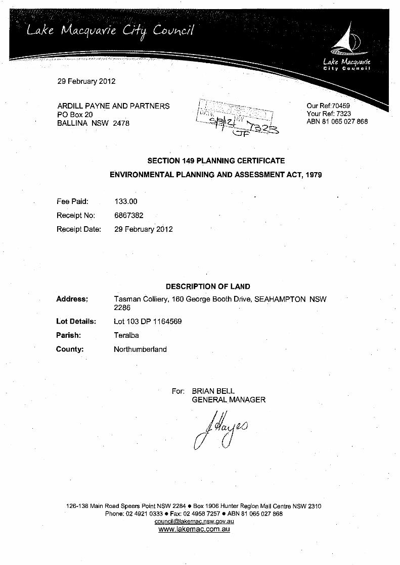
LAND CONTAMINATION ASSESSMENT
STAGE 1 - PRELIMINARY
INVESTIGATION AND LAND CONTAMINATION STATUS REVIEW
DEVELOPMENT APPLICATION AREA
TASMAN EXTENSION PROJECT
George Booth Drive
For Donaldson Coal Pty Limited
March 2012

Ardill Payne & Partners
Stage 1 – Preliminary Investigation Page i And Land Contamination Status Review
Document Control Sheet
Filename: 7247 - Preliminary SEPP 55 Investigation - ML23012012b
Job No.: 7247
Job Captain: Evan Elford
Author: James Foster
Client: Donaldson Coal Pty Limited
File/Pathname: 7247 - Preliminary SEPP 55 Investigation - ML.docx
Revision No:
Date: Checked By Issued By
Name Signed Name Signed
DRAFT 24/01/2012 E. Elford J. Foster
1 26/03/2012 E. Elford
J. Foster
2

Ardill Payne & Partners
Stage 1 – Preliminary Investigation Page ii And Land Contamination Status Review
Table of Contents
1 INTRODUCTION ..................................................................................... 1
2 SCOPE OF WORKS ................................................................................ 5
3 SITE IDENTIFICATION ........................................................................... 8
4 SITE CONDITION AND SURROUNDING ENVIRONMENT .................. 12
4.1 Topography .......................................................................................... 12 4.2 Geology ............................................................................................... 12 4.3 Hydrology ............................................................................................. 12 4.4 Groundwater ........................................................................................ 13
5 SITE HISTORY ...................................................................................... 14
5.1 Site History Overview ........................................................................... 14 5.2 POEO Act Public Register Search ....................................................... 15 5.3 Contaminated Land Register ................................................................ 15 5.4 Historical Title Search .......................................................................... 15 5.5 Historical Aerial Photographs ............................................................... 19 5.6 Cessnock City Council Records ........................................................... 22 5.7 Lake Macquarie City Council Records .................................................. 22 5.8 Section 149 Certificates ....................................................................... 23 5.9 Areas of Environmental Concern .......................................................... 23
6 SITE INSPECTION ................................................................................ 30
6.1 Existing Pit Top .................................................................................... 30 6.2 New Pit Top ......................................................................................... 30
7 SAMPLING AND ANALYSIS ................................................................. 31
8 REMEDIATION ...................................................................................... 32
8.1 Existing Pit Top .................................................................................... 32 8.2 New Pit Top ......................................................................................... 32
9 CONCLUSIONS/RECOMMENDATIONS .............................................. 33
9.1 MLA 426 and MLA 416 Area ................................................................ 34 9.2 ML 1555 Area ...................................................................................... 35
10 SCOPE OF ENGAGEMENT .................................................................. 36
11 REFERENCES ...................................................................................... 37
12 GLOSSARY ........................................................................................... 38
13 ATTACHMENTS .................................................................................... 39

Ardill Payne & Partners
Stage 1 – Preliminary Investigation Page iii And Land Contamination Status Review
LIST OF FIGURES Figure 1 – Regional Location ........................................................................... 2
Figure 2 – Aerial Photograph of the Project Area and Surrounds .................... 3
Figure 3 – Relevant Land Zoning ..................................................................... 9
Figure 4 – Historic Parish Maps ..................................................................... 17
Figure 5 - Historical Aerial Photographs ........................................................ 20
Figure 6 - NSW Railway Map Showing the Approximate Project Location .... 27
Figure 7 - Mount Sugarloaf Towers ................................................................ 28
Figure 8 - Historical photograph of Mount Sugarloaf (Courtesy Lake
Macquarie City Council) ................................................................................. 29
LIST OF TABLES
Table 1 - DAA Details ...................................................................................... 8
Table 2 – Real Property Descriptions within the DAA .................................... 10
Table 3 - POEO Act Public Register Search .................................................. 16
Table 4 - Parish Map Data Summary ............................................................. 18
Table 5 - Summary of Aerial Photograph Observations ................................. 19
Table 6 - Lake Macquarie City Council Contamination Reporting ................. 22
Table 7 – Section 149 Certificates ................................................................. 23
LIST OF ATTACHMENTS
Attachment 1 Land Contamination Status Review – Existing Pit Top Area
Attachment 2 Stage 1 – Preliminary Investigation – New Pit Top Area
Attachment 3 Section 149 Certificates

Ardill Payne & Partners
Stage 1 – Preliminary Investigation Page 1 And Land Contamination Status Review
1 Introduction
The existing Tasman Underground Mine is located within Mining Lease
(ML) 1555, approximately 20 kilometres (km) west of the Port of Newcastle in
New South Wales (NSW) (Figure 1). The Tasman Underground Mine is
owned and operated by Donaldson Coal Pty Limited (Donaldson Coal).
Donaldson Coal is a wholly owned subsidiary of Gloucester Coal Ltd (GCL).
Donaldson Coal also owns and operates the Donaldson Open Cut Mine and
Abel Underground Mine, which are located approximately 10 km north-east of
the Tasman Underground Mine (Figure 1).
The Tasman Underground Mine commenced in May 2006, with underground
mining commencing in September 2006. The Tasman Extension Project (the
Project) provides for the continuation and then extension of operations at the
Tasman Underground Mine and would extend the current operations by
approximately 15 years.
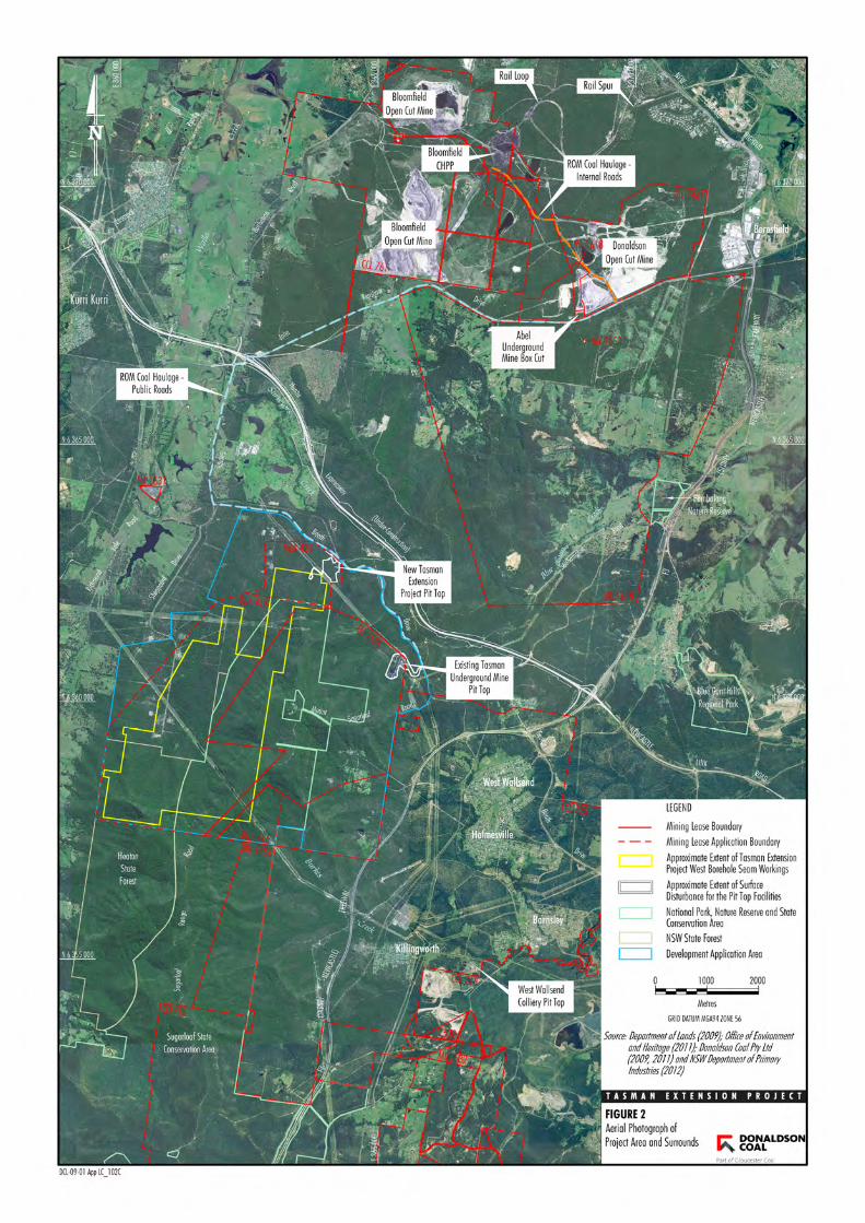
An aerial photograph of the Project area and surrounds is shown on Figure 2.
The Project is located within an area dominated by bushland, including the
Sugarloaf State Conservation Area and Heaton State Forest, with some rural-
residential areas located in the west of the Project area. Infrastructure
corridors for power lines traverse the Project, and a number of transmission
towers are located on the top of Mount Sugarloaf.
A detailed description of the Project is provided in Section 2 of the Main
Report of the Environmental Impact Statement (EIS).
Ardill Payne and Partners (APP) has been engaged by Donaldson Coal to
undertake a Land Contamination Assessment for the Project Development
Application Area (DAA). Figure 1 shows the site locality while Figure 2
shows the proposed location of the new pit top facility within with the DAA.


Ardill Payne & Partners
Stage 1 – Preliminary Investigation Page 4 And Land Contamination Status Review
The objective of this investigation is to determine if any potentially
contaminating activities have occurred historically within the DAA. In order to
determine the likelihood and type of contaminants that may be present on site,
a desktop site history assessment was undertaken. This assessment
consisted of searches of online records, reviewing historical aerial
photographs and information requests to relevant local Councils.
Site inspections of the existing Tasman Underground Mine pit top area
(existing pit top) and the proposed Tasman Extension Project pit top area
(new pit top) (both within the DAA) were conducted to investigate the potential
for, and determine the spatial extent of any contaminated land. Separate
Land Contamination Assessment reports have been developed for these two
areas (Attachments 1 and 2 respectively) and these should be read in
conjunction with this report.
Historically, several potentially contaminating activities have been conducted
within the DAA, including:
chemicals manufacture and formulation;
explosives industry;
mining and extractive industries; and
waste disposal.
These activities are associated with:
the Orica Richmond Vale facilities;
the existing Tasman Underground Mine pit top area;
historical mining waste disposal; and
illegal dumping of waste.

Ardill Payne & Partners
Stage 1 – Preliminary Investigation Page 5 And Land Contamination Status Review
2 Scope of Works
Clause 7 of the NSW State Environmental Planning Policy No. 55 –
Remediation of Land (SEPP 55) states that:
“(1) A consent authority must not consent to the carrying out of any
development on land unless:
(a) it has considered whether the land is contaminated, and
(b) if the land is contaminated, it is satisfied that the land is suitable in its
contaminated state (or will be suitable, after remediation) for the
purpose for which the development is proposed to be carried out, and
(c) if the land requires remediation to be made suitable for the purpose for
which the development is proposed to be carried out, it is satisfied that
the land will be remediated before the land is used for that purpose.
(2) Before determining an application for consent to carry out development
that would involve a change of use…, the consent authority must
consider a report specifying the findings of a preliminary investigation
of the land concerned carried out in accordance with the contaminated
land planning guidelines.
(3) The applicant for development consent must carry out the investigation
required by subclause (2) and must provide a report on it to the
consent authority. …”
This Stage 1 – Preliminary Investigation and Land Contamination Status
Review has been prepared to address these SEPP 55 requirements.
The areas of the Project site that would include a “change of use” are within
Mining Lease Application (MLA) 426 and MLA 416 (Figure 2) and are the
subject of the Stage 1 Preliminary Investigation which has been prepared in
accordance with the Managing Land Contamination Planning Guidelines
(Department of Urban Affairs and Planning [DUAP] and Environment
Protection Authority [EPA], 1998) and the Guidelines for Consultants
Reporting on Contaminated Sites (NSW Office of Environment and Heritage
[OEH], 2011). The new pit top is located within MLA 426.

Ardill Payne & Partners
Stage 1 – Preliminary Investigation Page 6 And Land Contamination Status Review
The existing Tasman Underground Mine and pit top are located within
ML 1555 and this area is the subject of the Land Contamination Status
Review.
This Land Contamination Assessment has:
Described the condition of the DAA and surrounding environment.
Provided a summary of the DAA history.
Identified past and present potentially contaminating activities and
potential contaminant types.
Provided a preliminary assessment of the site contamination.
Assessed the need for further investigations.
Assessed the suitability of the DAA for the proposed use (i.e. mining
operations).
Additional information to inform in the desktop DAA history was also collected
and collated from the following sources:
Review of available DAA history details.
OEH Protection of Environment Operations Act 1997 (POEO Act)
Public Register.
OEH’s Contaminated Land – Record of Notices.
NSW Land and Property Information (LPI) – Historic Title Search.
Historical aerial photographs.
Section 149 Planning Certificates for select lots.
Cessnock City Council and Lake Macquarie City Council records.
Site inspections were conducted at two areas within the DAA, namely the
existing pit top and new pit top area. These inspections were conducted to
identify potential land contamination sources and the spatial distribution of any
identified contaminated land. These findings are presented in Attachments 1
and 2 and summarised in this report.

Ardill Payne & Partners
Stage 1 – Preliminary Investigation Page 7 And Land Contamination Status Review
The Australian and New Zealand Guidelines for the Assessment and
Management of Contaminates Sites (Australian and New Zealand
Environment and Conservation Council and National Health and Medical
Research Council, 1992) has also been considered during the preparation of
the Land Contamination Assessment. Relevant guidelines and references
used in the preparation of this investigation are presented in Section 10 of
this report.

Ardill Payne & Partners
Stage 1 – Preliminary Investigation Page 8 And Land Contamination Status Review
3 Site Identification
Table 1 describes the DAA.
Table 1 - DAA Details
Site Address George Booth Drive, Richmond Vale, NSW.
DAA Area Approximately 2214 hectares.
Title Refer Figure 3 and Table 2.
Local Government Area Cessnock City Council and Lake Macquarie City Council.
Zoning Refer Figure 3.
Elevation 39 metres (m) – 412 m Australian Height Datum (AHD) (Mount Sugarloaf).
Latitude 32.867 S
Longitude 151.547 E
Existing Land Use
Vegetated areas including the Sugarloaf State Conservation Area and Heaton State Forest.
Transmission lines.
Communication infrastructure (including towers on Mount Sugarloaf and buried fibre optic cables).
Sydney Newcastle (F3) Freeway, George Booth Drive, Mount Sugarloaf Road and other minor roads.
Existing Tasman Underground Mine Pit Top Facility off George Booth Drive.
Orica Limited’s Richmond Vale facilities off George Booth Drive.
The locality of O’Donnelltown and rural residential properties along Sheppeard Drive.
The real property descriptions for the DAA are provided in Table 2 and the
land zoning is shown on Figure 3.

MLA426
E1
5
5
DM
ML1555
MLA416
MLA416
CESSNOCK CITY COUNCIL
LAKE MACQUARIE CITY COUNCIL
8
7(2)
8
7(2)
7(2)
5
10(b)
7(2)
10(b)
7(1)
7(3) 7(1)7(2)
7(2)
7(2)
1(1)
1(1)
1(1)
6(2)
7(2)
1(1) 2(2)
5
7(2)
7(1)
6
6(1)
7(3)
1(1)
7(2)
2(2)
7(3)
7(3)
7(1)
7(3)
7(1)
4(2)
1(1)
5
3(1)
1(2)
7(2)
6
RU2
E1
DM
RU3
DM
DM
DM
DM
RU2RU2
DM
E2
RU2
RU2
DM
SP2
RU2
DM
DM
SP2
E2
DM
RU2
RU2DM
DM
RU2E2
RU2
DM
E2
DM
SP2
SP2
DM
RU3
RU2
DM
RU2
RU2
DM
RU2
RU2
RU2
RU2
SP2
DM
RU2
RU2DM
DM
RU2
RU2
RU2
RU2
RU2
DCL-09-01_EIS App_LC_201D
FIGURE 3
T A S M A N E X T E N S I O N P R O J E C T
Land Zoning
0 0.5 1 1.5 2
Kilometers
Source: Department of Lands (2009); Donaldson Coal Pty Ltd (2009, 2011); NSW Department of Planning (Cessnock City Council LEP) (2012) and Lake Macquarie City Council (2012)
LEGENDMining Lease (ML 1555)Mining Lease Application BoundaryDevelopment Application AreaLocal Government Boundary
Lake Macquarie City Council LEP 2004 Zoning1(1) Rural (Production)1(2) Rural (Living)2(1) Residential2(2) Residential (Urban Living)3(1) Urban Centre4(2) Industrial (General)5 Infrastructure6(1) Open Space6(2) Tourism and Recreation7(1) Conservation (Primary) 7(2) Conservation (Secondary)7(3) Environmental (General)8 National Park
Cessnock City Council LEP 2011 ZoningE1 National Parks and Nature ReservesE2 Environmental ConservationR5 Large Lot ResidentialRU2 Rural LandscapeRU3 ForestryRU5 VillageSP2 InfrastructureDM Deferred Matter (Cessnock LEP 1989 Zone 1(a) Rural "A")
Note: Cessnock City Council LEP Zoning boundaries are approximate only as digitial data is not publicly available

Ardill Payne & Partners
Stage 1 – Preliminary Investigation Page 10 And Land Contamination Status Review
Table 2 – Real Property Descriptions within the DAA
Lot Number Deposited Plan Number
94 755262
95 755262
104 755262
121 755262
124 755262
125 755262
126 755262
1 231108
2 231108
21 223395
22 223395
1 551917
2 551917
1 960529
4 960529
221 1034182
222 1034182
51 706484
52 706484
7022 1075973
7023 1075973
1 1050996
2 1050996
76 755244
108 755244
101 1164569
102 1164569
103 1164569
3 1061633
4 1061633
5 1061633
6 1061633
7 1061633
8 1061633
9 1061633
10 1061633
11 1061633
12 1061633
13 1061633
14 1061633
15 1061633

Ardill Payne & Partners
Stage 1 – Preliminary Investigation Page 11 And Land Contamination Status Review
Table 2 (Continued) – Real Property Descriptions within the DAA
Lot Number Deposited Plan Number
1 551918
7021 1075979
1 207238
1 960528
1 175522
21 624214
1 338999
1 923509
2 809377
1 960530
7 813135
1 1039968

Ardill Payne & Partners
Stage 1 – Preliminary Investigation Page 12 And Land Contamination Status Review
4 Site Condition and Surrounding Environment
This section provides a general description of the DAA and surrounds. A
more detailed description of the Project area is provided in Section 4 of the
Main Report of the EIS.
4.1 Topography
The Project is situated on the north-eastern slope of the Sugarloaf Range.
Within the centre of the DAA is Mount Sugarloaf which has an elevation of
412 m. Within the site boundary, the elevation ranges from 160 m in the
south down to approximately 70m in the north.
4.2 Geology
The Project is located in the Newcastle Coalfield within the north-eastern
portion of the Permo-Triassic Sydney Basin. Underground mining currently
occurs at the Tasman Underground Mine in the Fassifern Seam within the
Boolaroo Formation of the Newcastle Coal Measures. The Project would
involve underground mining operations in the West Borehole Seam to the
north and west of the approved Fassifern Seam workings. The West
Borehole Seam is located within the Lambton Formation and is the basal unit
of the Newcastle Coal Measures. The West Borehole Seam is located
approximately 175 m below the Fassifern Seam.
4.3 Hydrology
The existing pit top area is situated on the ephemeral headwaters of Blue
Gum Creek that flows north-east and east to Hexham Swamp via Leneghans
Flat, approximately 8 km from the site.
Ardill Payne & Partners
Stage 1 – Preliminary Investigation Page 13 And Land Contamination Status Review
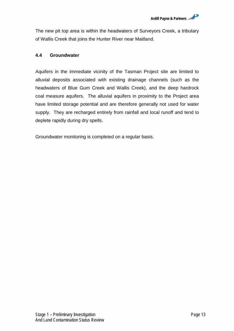
The new pit top area is within the headwaters of Surveyors Creek, a tributary
of Wallis Creek that joins the Hunter River near Maitland.
4.4 Groundwater
Aquifers in the immediate vicinity of the Tasman Project site are limited to
alluvial deposits associated with existing drainage channels (such as the
headwaters of Blue Gum Creek and Wallis Creek), and the deep hardrock
coal measure aquifers. The alluvial aquifers in proximity to the Project area
have limited storage potential and are therefore generally not used for water
supply. They are recharged entirely from rainfall and local runoff and tend to
deplete rapidly during dry spells.
Groundwater monitoring is completed on a regular basis.

Ardill Payne & Partners
Stage 1 – Preliminary Investigation Page 14 And Land Contamination Status Review
5 Site History
A desktop site history assessment was undertaken to determine the
chronological history of site uses and possible sources and locations of
contamination. The findings are summarised below.
5.1 Site History Overview
A Non-Aboriginal Heritage Assessment has been conducted as part of the
EIS. This assessment has found that historically, the site was possibly used
for open range dry grazing of cattle, however much of the land is steeply
undulating and would have been heavily covered in old-growth timber until
perhaps the late 19th/early 20th Century. Therefore it was not particularly
suited to this type of grazing.
Consequently, the principal activity on the site may well have been related to
timber. Timber-getting had been a staple industry of the small West Wallsend
and Ladysmith communities since the Lord family [arrived] in the 1860s-70s,
[but] possibly as early as the 1850s. A particular interest was in pit-propping
for the Newcastle and Wallsend mines. With the opening of the West
Wallsend, Killingworth, Seahampton and Mount Sugarloaf mines from
1885, pit-propping became more concentrated for the latter 19th and first half
of the 20th Century (Maxim Archaeology and Heritage, 2012).
The Non-Aboriginal Heritage Assessment results for the site, in terms of its
three context elements – archaeological, historical and physical – has
identified no material evidence, or suggestion of the likelihood of material
evidence, the question of the cultural heritage values and technical
significance [therefore] does not arise for assessment (Maxim Archaeology
and Heritage, 2012).

Ardill Payne & Partners
Stage 1 – Preliminary Investigation Page 15 And Land Contamination Status Review
5.2 POEO Act Public Register Search
The OEH’s POEO Act Public Register was searched (accessed on
17 January 2012) for the area surrounding the DAA (OEH, 2012a). The
licenses contained within the surrounding area are presented in Table 3.
Two of these sites are located within the DAA boundary.
Orica Richmond Vale facilities.
Tasman Underground Mine.
5.3 Contaminated Land Register
The OEH’s Contaminated Land – Record of Notices was searched (accessed
on 17 January 2012) for the area surrounding the DAA and no records were
identified for the DAA or surrounding area (OEH, 2012b).
5.4 Historical Title Search
Historic Parish Maps for Stockrington, Teralba and Mulbring were obtained
from the LPI.
A range of maps from 1896-1966 are presented in Figure 4. Table 4 presents
a summary of the historical information obtained from the historical Parish
Maps. The red outline shows the approximate DAA boundary on the historical
Parish Maps.

Ardill Payne & Partners
Stage 1 – Preliminary Investigation Page 16 And Land Contamination Status Review
Table 3 - POEO Act Public Register Search
SEAHAMPTION
Number Name Location Type Status Issued
date
12483 Newcastle Coal Company Pty Ltd
Tasman Underground Mine
POEO Act Licence Issued
08 May 2006
13285 Roads and Maritime Services
Hunter Expressway Early Works
POEO Act Licence Issued
01 Jul 2010
KURRI KURRI
13013 Central Recycling Station Pty Ltd
Central Waste Station Pty Limited
POEO Act Licence Issued
04 Mar 2010
11973 Hunter and New England Area Health Service Kurri Kurri Hospital
POEO Act Licence
No longer in force
10 Nov 2003
1767 Hunter Water Corporation Kurri Kurri Wastewater Treatment Works
POEO Act Licence Issued
07 Mar 2000
12745 Infratil Energy Australia Pty Ltd Hez Power Station
POEO Act Licence Issued
04 Sep 2007
7667 J. R. Burnett Pty Limited J.R. Burnett Pty Ltd POEO Act Licence Issued
18 Sep 2000
11234 Nationwide Oil Pty Ltd Nationwide Oil Pty Ltd POEO Act Licence Surrendered
13 Dec 2000
4121 Orica Australia Pty Ltd Orica Australia Technical Centre
POEO Act Licence Issued
19 Sep 2000
6423 Weston Aluminium Pty Limited
Weston Aluminium Pty Ltd
POEO Act Licence Issued
26 Apr 2000
KILLINGWORTH
4033 Hunter Valley Earthmoving Co Pty Ltd Westside Mine
POEO Act Licence Issued
18 Sep 2000
11361 TransGrid Newcastle 330 kV Substation
POEO Act Licence
No longer in force
05 May 2001
WALLSEND
11984 Ausgrid Energy Australia Wallsend Depot
POEO Act Licence Issued
18 Aug 2004
1259 Hanson Construction Materials Pty Ltd
Hanson Construction Materials Pty Ltd
POEO Act Licence
No longer in force
27 Apr 2000
13059 LMS Generation Pty Ltd Summer Hill Gas Utalisation Facility
POEO Act Licence Issued
31 Mar 2009
5897 Newcastle City Council Summerhill Waste Management Facility
POEO Act Licence Issued
11 Aug 2000
10730 Nonferral Pty Limited Nonferral Wallsend POEO Act Licence Surrendered
03 May 2000
10 Premier Concrete (NSW) Pty Limited
Premier Concrete (NSW) Pty Ltd
POEO Act Licence
No longer in force
19 Oct 1999
548 The Newcastle Wallsend Coal Co Pty Ltd
The Newcastle Wallsend Coal Co Pty Ltd
POEO Act Licence Surrendered
16 Feb 2000
STOCKRINGTON
5108 Buttai Gravel Pty Ltd Stockrington Quarry POEO Act Licence Issued
06 Jan 2000

Ardill Payne & Partners
Stage 1 – Preliminary Investigation Page 17 And Land Contamination Status Review
Parish Map for Stockrington 1896
Parish Map for Stockrington 1918
Parish Map for Stockrington 1938
Parish Map of Teralba 1897
Figure 4 – Historic Parish Maps
Parish Map of Teralba 1923
Parish Map of Teralba 1950

Ardill Payne & Partners
Stage 1 – Preliminary Investigation Page 18 And Land Contamination Status Review
Parish Map of Teralba 1969
Parish Map of Mulbring 1942
Parish Map of Mulbring 1966
Figure 4 (Continued) - Historic Parish Maps
Table 4 - Parish Map Data Summary
Year Stockrington
1896
Map shows main features including creeks, ranges and Richmond Vale railway. George Booth Drive not shown.
Great Sugarloaf trigonometric station marked.
1918
Great Sugarloaf trigonometric station (1327 feet) depicted.
Alignment of George Booth Drive has changed and is marked as road.
1938 Alignment of 132 kilovolt (kV) and 330 kV transmission lines added in pencil.
Year Teralba
1897 Great Sugarloaf trigonometric station shown along with Sugarloaf Range. West Wallsend Coal Company and mining purposes stated. WA Horn a large scale landowner in the area.
1923
Mt Sugarloaf Road Paved.
Catchments of Flaggy and Blue Gum Creek are shown.
O’Donnelltown area owned by Richard O’Donnell.
West Wallsend and Seaham No. 2 Colliery noted.
1950
Alignment of transmission lines (132 kV shown).
Area called Fairly noted along.
Seaham No 2 Colliery shown.
State Forest shown on west of plan.
1969
More state forest shown on dedicated 12th Jan 1951 to the south of the Sugarloaf Range.
Two transmission line easements shown in north.
Newcastle to Kurri Kurri Transmission Line shown.
Year Mulbring
1942
Newcastle National Forest shown.
Note showing Richmond Vale Main Estate.
Transmission line easement to the south of the DAA shown.
1966 Heaton State Forest No 122 No 2 Extension dedicated 18-4-1947 – west of the Sugarloaf Range.
Ardill Payne & Partners
Stage 1 – Preliminary Investigation Page 19 And Land Contamination Status Review
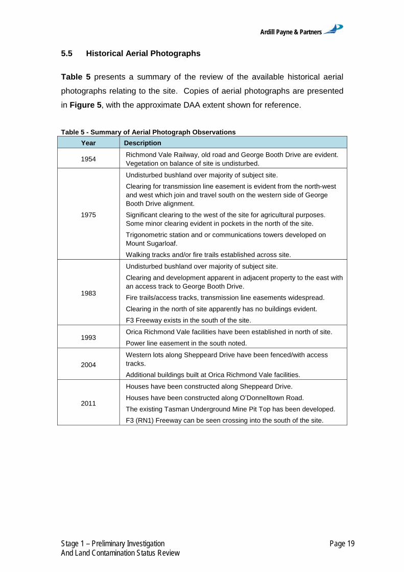
5.5 Historical Aerial Photographs
Table 5 presents a summary of the review of the available historical aerial
photographs relating to the site. Copies of aerial photographs are presented
in Figure 5, with the approximate DAA extent shown for reference.
Table 5 - Summary of Aerial Photograph Observations
Year Description
1954 Richmond Vale Railway, old road and George Booth Drive are evident. Vegetation on balance of site is undisturbed.
1975
Undisturbed bushland over majority of subject site.
Clearing for transmission line easement is evident from the north-west and west which join and travel south on the western side of George Booth Drive alignment.
Significant clearing to the west of the site for agricultural purposes. Some minor clearing evident in pockets in the north of the site.
Trigonometric station and or communications towers developed on Mount Sugarloaf.
Walking tracks and/or fire trails established across site.
1983
Undisturbed bushland over majority of subject site.
Clearing and development apparent in adjacent property to the east with an access track to George Booth Drive.
Fire trails/access tracks, transmission line easements widespread.
Clearing in the north of site apparently has no buildings evident.
F3 Freeway exists in the south of the site.
1993 Orica Richmond Vale facilities have been established in north of site.
Power line easement in the south noted.
2004
Western lots along Sheppeard Drive have been fenced/with access tracks.
Additional buildings built at Orica Richmond Vale facilities.
2011
Houses have been constructed along Sheppeard Drive.
Houses have been constructed along O’Donnelltown Road.
The existing Tasman Underground Mine Pit Top has been developed.
F3 (RN1) Freeway can be seen crossing into the south of the site.

Ardill Payne & Partners
Stage 1 – Preliminary Investigation Page 20 And Land Contamination Status Review
Historic Aerial Photo 1954
Historic Aerial Photo 1975
Historic Aerial Photo 1983
Figure 5 - Historical Aerial Photographs
Richmond Vale Railway
George Booth Drive (new alignment)
Power Line Easements
Mount Sugarloaf
Access/Fire Tracks
George Booth Drive (original
alignment)

Ardill Payne & Partners
Stage 1 – Preliminary Investigation Page 21 And Land Contamination Status Review
Historic Aerial Photo 1993
Historic Aerial Photo 2004
Aerial Photo 2011
Figure 5 (Continued) - Historical Aerial Photographs
Orica Richmond Vale Facilities
Power Line Easement
Fenced Properties
Houses (Sheppeard Drive)
Houses (O’Donnelltown)

Ardill Payne & Partners
Stage 1 – Preliminary Investigation Page 22 And Land Contamination Status Review
5.6 Cessnock City Council Records
A request was made to the Cessnock City Council to provide details of any
identified contaminated land within the Cessnock Local Government Area
(LGA) within the DAA. The Cessnock City Council advised that no lands are
currently identified as contaminated within the DAA (pers. comm. Paul Taylor
GIS Officer, Cessnock City Council, 23/01/2012).
5.7 Lake Macquarie City Council Records
A property enquiry search of all properties listed in Table 2 within the Lake
Macquarie LGA has been undertaken. The property enquiry sought
information about a particular property in the LGA including:
property description;
property conditions;
planning zones; and
maps, including aerial, bushfire, geotechnical, coastal and acid
sulphate soils (where available).
Only one property was identified as having a requirement for a Contamination
Land Audit as part of the property’s Development Conditions. This property
was part of the O’Donnelltown subdivision (Table 6).
Table 6 - Lake Macquarie City Council Contamination Reporting
Lot Deposited Plan (DP) Property Enquiry - Main Conditions
2 1050996 Contaminated Land - Audit
Further details are presented in Section 4.9 under O’Donnelltown Subdivision.

Ardill Payne & Partners
Stage 1 – Preliminary Investigation Page 23 And Land Contamination Status Review
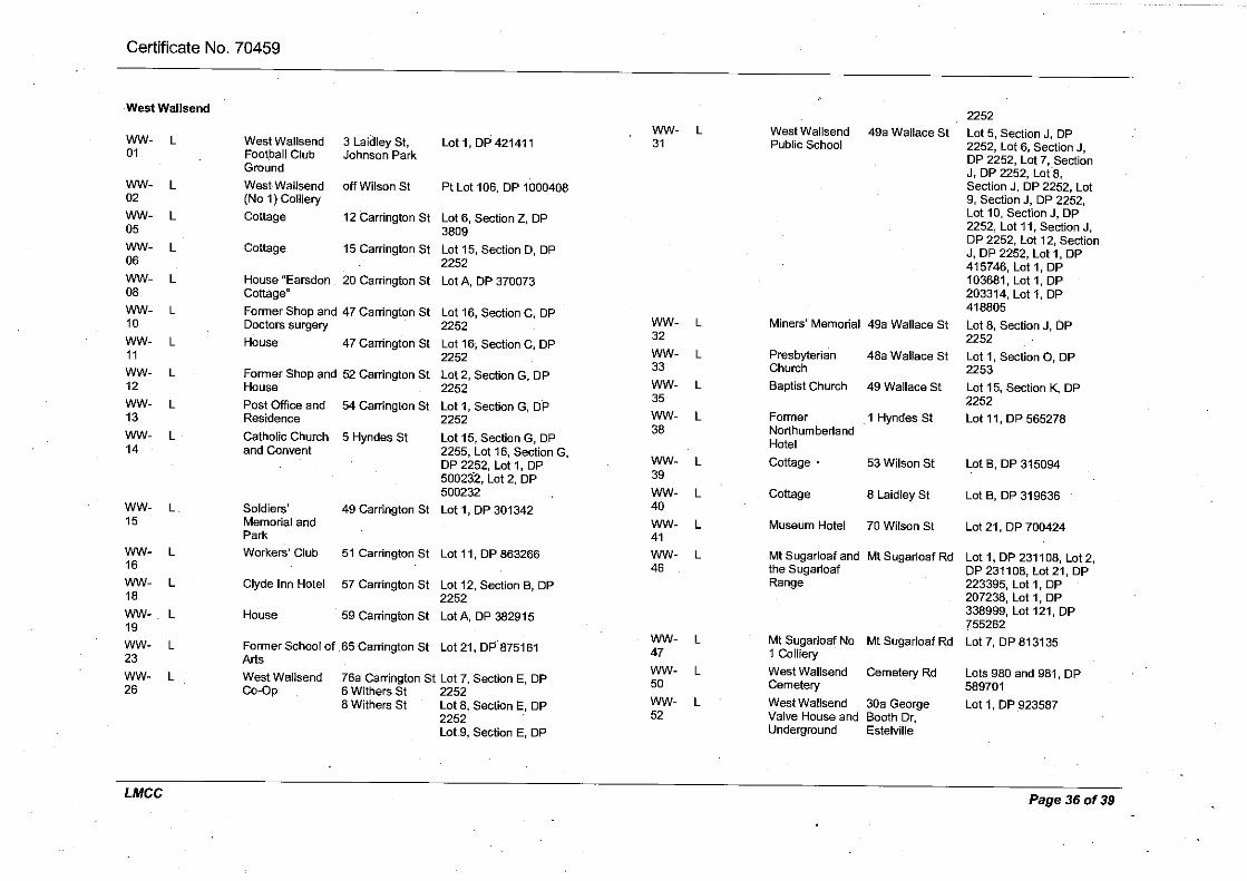
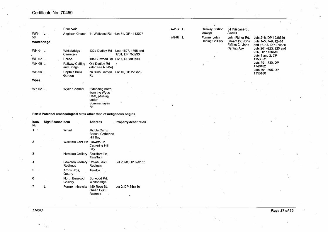
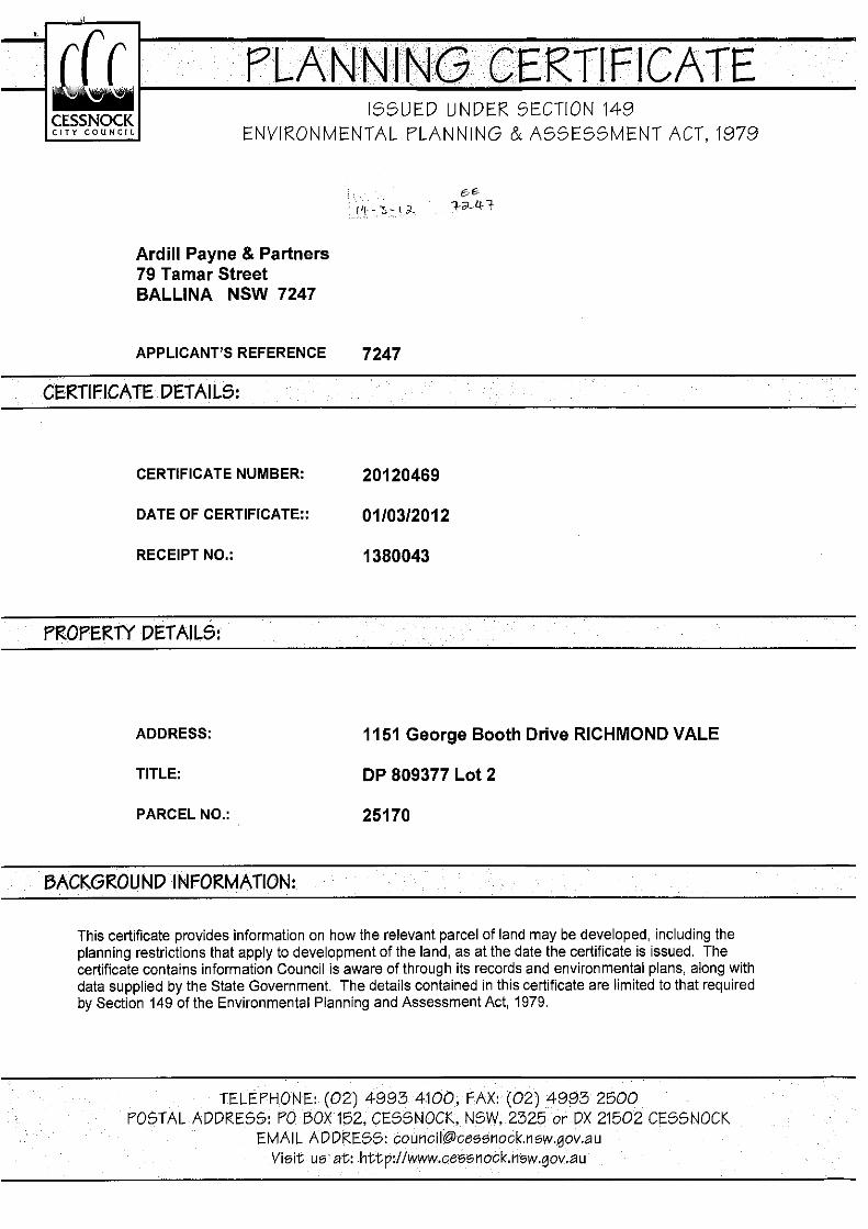
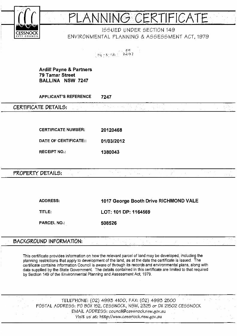
5.8 Section 149 Certificates
Following the completion of the review of council records and the desktop
review, Section 149 Certificates were requested for sites which have shown
potential for contamination either through having a POEO licence or site
history indicating possible contamination. The results of this are presented in
(Table 7) and discussed further in Section 4.9. The certificates are presented
in Attachment 3.
Table 7 – Section 149 Certificates
Lot DP Local Government Area Site Name Contamination Noted?
103 1164569 Lake Macquarie City Council Existing Tasman Pit Top Yes
2 1050996 Lake Macquarie City Council O’Donnelltown Subdivision Yes
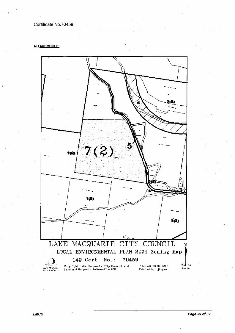
101 1164569 Cessnock City Council Proposed Pit Top No
2 809377 Cessnock City Council Orica Richmond Vale Facilities No
5.9 Areas of Environmental Concern
Tasman Underground Mine and Existing Pit Top
The existing Tasman Underground Mine and pit top area are located within
ML 1555. Entry to the site is off George Booth Drive, 1.5 km west of
Seahampton, at the existing pit top.
The underground lease area covers 952 hectares with George Booth Drive to
the north, the F3 freeway to the east and Mount Sugarloaf in the centre.
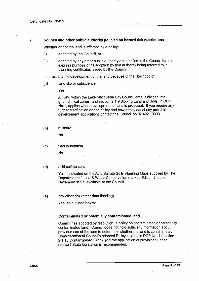
The Section 149 Planning Certificate for the property is provided in
Attachment 3. Section 7(e) of the certificate states that there is a risk that
the property contains contaminated or potentially contaminated land.

Ardill Payne & Partners
Stage 1 – Preliminary Investigation Page 24 And Land Contamination Status Review
A Land Contamination Status Review for the Tasman Underground Mine
existing pit top area has been prepared and is included as Attachment 1.
The assessment concluded that effective control measures exist for all
potential contamination sources at the existing pit top area, which would be an
ongoing operational facility.
New Tasman Extension Project Pit Top
The new pit top is located within bushland area off George Booth Drive within
MLA 426 (Figure 2). A Stage 1 – Preliminary Investigation Land
Contamination Assessment of the new pit top area has been prepared and is
included as Attachment 2. The assessment concluded that although some
minor land contamination associated with illegal dumping was identified, no
further investigations are required and the area can be remediated to make
the area suitable for the proposed use.
The Section 149 Planning Certificate for the property is provided in
Attachment 3. There is no mention of contamination in this planning
certificate.
Orica Richmond Vale Facilities
Orica Richmond Vale facilities (Lot 2 DP 809377) is located within the DAA
but the buildings on this lot are located outside Donaldson Coal’s ML and
MLAs.
The Section 149 Planning Certificate for the property is provided in
Attachment 3. There is no mention of contamination in this planning
certificate.
Ardill Payne & Partners
Stage 1 – Preliminary Investigation Page 25 And Land Contamination Status Review
The Proposed Ammonium Nitrate Emulsion Production Facility and Continued
Operation of Orica Mining Services Technology Centre Environmental
Assessment (Umwelt, 2009) states that:
“The technology centre consists of offices, research and other support
facilities and minor manufacturing facilities and employs approximately 200
people.
In 2009 Orica proposed to construct and operate an Ammonium Nitrate
Emulsion (ANE) Production Facility at the existing Mining Services
Technology Centre site. ANE is an explosive precursor that is sensitised to
become explosive only at the point of use (i.e. on a mine site). The proposed
ANE production facility will have the ability to produce up to 250,000 tonnes of
ANE per year.”
The following activities from the SEPP 55 Guideline at the Orica Richmond
Vale facilities that may cause contamination include:
chemicals manufacture and formulation; and
explosives industry.
Given these activities, contamination may have occurred within the Orica
Richmond Vale facilities. As this facility is located outside MLA 426 and
MLA 416 and outside the predicted subsidence angle of draw (refer Appendix
A of the EIS), no further consideration of this site has been given in the
context of this Project.
O’Donnelltown Subdivision
The Lake Macquarie City Council identified that potential land contamination
may be present within a property located in O’Donnelltown. Further enquiries
into the nature and extent of the contamination on this lot confirmed that a
contamination assessment was undertaken during a subdivision of Lot 5 DP
813135 during 2003 (Coffey, 2003). The Section 149 Planning Certificate for
the property is provided in Attachment 3. The contamination assessment
(Coffey, 2003) is an attachment to the Section 149 Planning Certificate.
Ardill Payne & Partners
Stage 1 – Preliminary Investigation Page 26 And Land Contamination Status Review
The contamination is considered to be related to the historical disposal of
mining wastes from another mining operation.
Although the lot is located within the DAA, it is outside MLA 426 and MLA 416,
approximately 2 km away from the proposed underground workings and
outside the predicted subsidence angle of draw (refer Appendix A of the EIS),
no further consideration of this site has been given in the context of this
Project.
Historical Railway
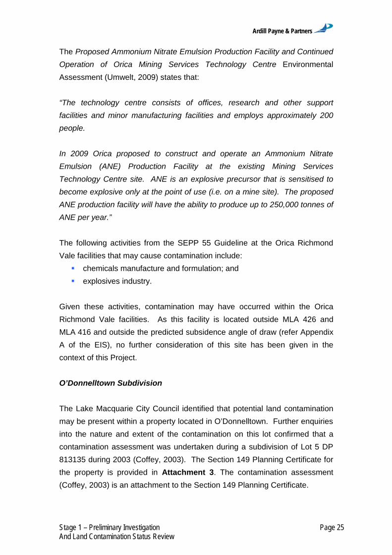
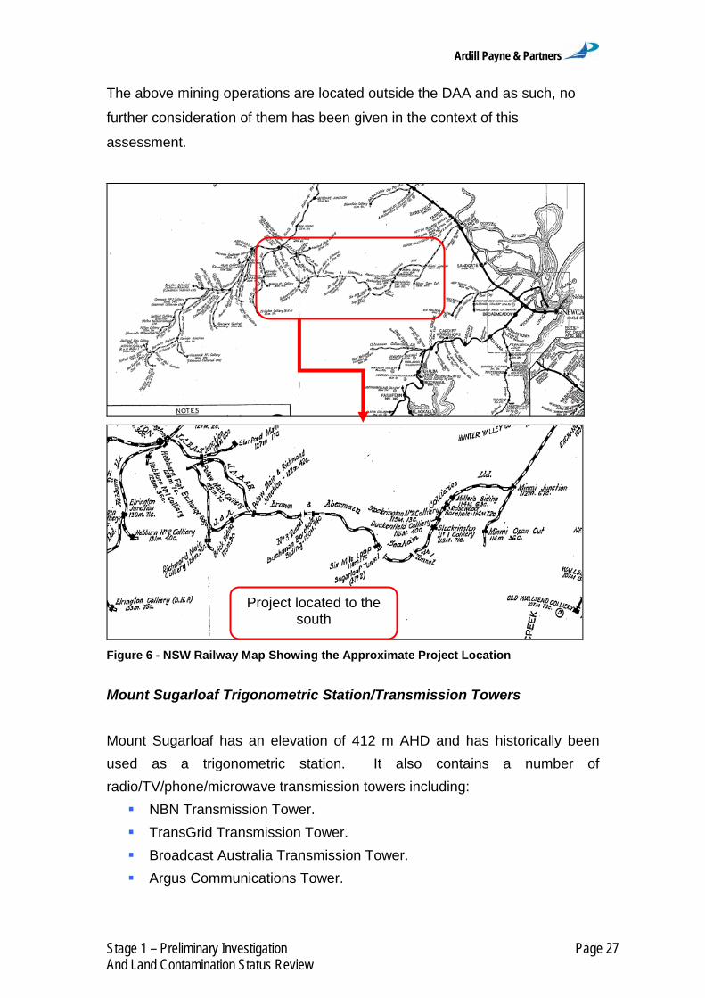
To the north of the subject site, running parallel to George Booth Drive is
remnants of the heritage listed Richmond Vale Railway line. The main line
running adjacent to the site was opened in 1857 and closed in 1962
(Richmond Vale Railway Museum, 2012). The route of the railway is shown in
Figure 6.
The alignment can also be seen in the early aerial photographs presented in
Figure 5. As the railway alignment is located outside MLA 426 and MLA 416
and outside the predicted subsidence angle of draw (refer Appendix A of the
EIS), no further consideration of this site has been given in the context of this
assessment.
Other Mining Operations
Other mines in the vicinity of the DAA are presented in Figure 1. Apart from
the existing Tasman Underground Mine, the closest mines to the DAA include:
West Wallsend Colliery, approximately 5 km south-east;
Westside Colliery, approximately 6 km south-east;
Abel Underground Mine, approximately 10 km north-east;
Donaldson Open Cut Mine, approximately 10 km north-east; and
Bloomfield Colliery, approximately 10 km north-northeast.
Ardill Payne & Partners
Stage 1 – Preliminary Investigation Page 27 And Land Contamination Status Review
The above mining operations are located outside the DAA and as such, no
further consideration of them has been given in the context of this
assessment.
Figure 6 - NSW Railway Map Showing the Approximate Project Location
Mount Sugarloaf Trigonometric Station/Transmission Towers
Mount Sugarloaf has an elevation of 412 m AHD and has historically been
used as a trigonometric station. It also contains a number of
radio/TV/phone/microwave transmission towers including:
NBN Transmission Tower.
TransGrid Transmission Tower.
Broadcast Australia Transmission Tower.
Argus Communications Tower.
Project located to the south

Ardill Payne & Partners
Stage 1 – Preliminary Investigation Page 28 And Land Contamination Status Review
The location of these towers is shown on Figures 7 and 8 below. This
infrastructure is located within the DAA. The activities undertaken at Mount
Sugarloaf are not considered to have potential to cause contamination.
Figure 7 - Mount Sugarloaf Towers

Ardill Payne & Partners
Stage 1 – Preliminary Investigation Page 29 And Land Contamination Status Review
Figure 8 - Historical photograph of Mount Sugarloaf (Courtesy Lake Macquarie City Council)

Ardill Payne & Partners
Stage 1 – Preliminary Investigation Page 30 And Land Contamination Status Review
6 Site Inspection
Site inspections of the existing pit top and new pit top areas were conducted
to obtain further information about the potentially contaminating activities
identified during the desktop site history assessment and to identify any
additional land contamination issues.
6.1 Existing Pit Top
The site inspection of the existing pit top identified the potential sources of
contamination and the control measures to manage contamination risk. The
control measures were identified to have been implemented to effectively
mitigate the potential for contamination from the site. A detailed description of
the site inspection and conclusions is presented in Attachment 1.
6.2 New Pit Top
A site inspection of the lot where the majority of the surface infrastructure is
proposed to be located for the Tasman Extension Project identified illegally
dumped waste in various sites across the investigation area.
Some small pieces of fibrous sheeting left over from the previous removal of
larger areas of illegally dumped material were identified. The sampling and
analysis of this site is described in Section 6 and Attachment 2.
No other contamination issues were identified during the site inspection of the
new pit top.

Ardill Payne & Partners
Stage 1 – Preliminary Investigation Page 31 And Land Contamination Status Review
7 Sampling and Analysis
Based on the site inspection of the new pit top, it was considered that the two
areas where small amounts of fibrous sheeting were identified required further
investigation.
Section 2.1 of the Contaminated Sites Sampling Design Guidelines (EPA,
1995) states that a preliminary sampling and analysis program may be
required where investigations indicate possible sources of contamination.
Given the above, sampling and analysis have been undertaken at the new pit
top, as described in Attachment 2.
Sampling of these sites confirmed the presence of a small amount of asbestos
contamination within remnant pieces of larger areas of illegally dumped
material which have been removed from the area (Attachment 2).

Ardill Payne & Partners
Stage 1 – Preliminary Investigation Page 32 And Land Contamination Status Review
8 Remediation
8.1 Existing Pit Top
Based on the outcomes of the Land Contamination Status Review and site
inspection of the existing pit top area, it is considered that no remediation of
the existing pit top would be required for the Project, as described in
Attachment 1.
8.2 New Pit Top
Based on the outcomes of the Stage 1 – Preliminary Investigation for the new
pit top area, it is considered that the small areas of asbestos contamination
could be successfully remediated to make the new pit top area suitable for the
intended use, as described in Attachment 2.

Ardill Payne & Partners
Stage 1 – Preliminary Investigation Page 33 And Land Contamination Status Review
9 Conclusions/Recommendations
The objective of this Land Contamination Assessment was to determine if any
potentially contaminating activities have occurred within the DAA. In order to
determine the likelihood and type of contaminants that may be present on site,
a desktop site history assessment was undertaken. This assessment
consisted of searches of on-line records; reviewing historical aerial
photographs and information requests to relevant local Councils.
This Land Contamination Assessment has:
Described the existing DAA condition and surrounding environment,
including the existing pit top and new pit top areas.
Provided a summary of the DAA history.
Identified past and present potentially contaminating activities and
potential contaminant types.
Provided a preliminary assessment of the site contamination.
Assessed soil sample analysis results against relevant criteria.
Assessed the need for further investigations.
Assessed the suitability of the DAA for the proposed use (i.e. mining
operations).
A desktop site history assessment of the DAA and site inspections of the
existing pit top and new pit top have been conducted as part of the Land
Contamination Assessment. The desktop site history assessment
encompassed the DAA. Information used to assist in the site history was
collected and collated from the following sources:
Review of available site history details.
LPI – Historic Title Search.
Historical aerial photographs.
OEH’s POEO Act Public Register.
OEH’s Contaminated Land – Record of Notices.
Cessnock and Lake Macquarie City Council records.
Section 149 Planning Certificates.

Ardill Payne & Partners
Stage 1 – Preliminary Investigation Page 34 And Land Contamination Status Review
The site inspections included:
An inspection of the existing pit top and new pit top areas to identify
potential areas of contamination; and
Preliminary soil sampling at areas identified as potentially contaminated
during the site inspections.
Based on the desktop site history assessment and the site inspections, it was
considered that two locations where potential asbestos contamination was
identified within the new pit top area required further investigation (Section 6).
Given this, a judgmental sampling and analysis plan was undertaken
(Section 6).
9.1 MLA 426 and MLA 416 Area
A small amount of asbestos contamination was identified within the new pit
top area within some fibrous sheeting scraps that had been left behind from
the removal of larger areas of illegally dumped material. It is considered that
the small areas of contamination can be remediated, and no further
investigation is required (Section 8.2).
Based on the Stage 1 – Preliminary Investigation for the MLA areas in
accordance with the Managing Land Contamination Planning Guidelines
(DUAP and EPA, 1998), there is no evidence that the area within MLA 426
and MLA 416 is contaminated outside of the minor areas identified in the new
pit top area.
Based on the above assessment it is considered that further investigation is
not required and the area within MLA 426 and MLA 416 is suitable for the
proposed development (i.e. the Project) once the small area of contamination
described above is remediated.
Ardill Payne & Partners
Stage 1 – Preliminary Investigation Page 35 And Land Contamination Status Review
9.2 ML 1555 Area
A number of potentially contaminating activities associated with the existing
mining operations were identified within the existing pit top area. However, it
was also observed that a number of management measures to control the
potential impact of these potentially contaminating activities are implemented.
Based on the above assessment it is considered that further investigation is
not required at this time and that the area within ML 1555 is suitable for the
proposed development (i.e. the continuation of underground mining and the
continued use of the existing pit top for the Project).
As part of the decommissioning phase of the Project, land contamination
investigations within the exiting pit top area (e.g. Stage 1 – Preliminary
Investigation and Stage 2 – Detailed Land Contamination Assessment) and
any subsequent remediation (if required) would be undertaken in accordance
with the relevant guidelines (including guidelines under section 145C of the
NSW Environmental Planning and Assessment Act, 1979 and the NSW
Contaminated Land Management Act, 1997).
Notwithstanding the above, in the event an area of potential land
contamination is identified during the Project, the unexpected contamination
would be assessed by a suitably qualified person and if necessary remediation
strategies put in place to manage this contamination after approval by the
appropriate authority.
The land contamination assessment would be undertaken in accordance with
the relevant guidelines (including guidelines under section 145C of the NSW
Environmental Planning and Assessment Act, 1979 and the NSW
Contaminated Land Management Act, 1997).

Ardill Payne & Partners
Stage 1 – Preliminary Investigation Page 36 And Land Contamination Status Review
10 Scope of Engagement
This report has been prepared by APP at the request of Donaldson Coal for
the purpose of preliminarily assessing the potential for contamination on the
subject site and is not to be used for any other purpose or by any other person
or corporation.
This report has been prepared from the information provided to us and from
other information obtained as a result of enquiries made by us. APP accepts
no responsibility for any loss or damage suffered howsoever arising to any
person or corporation who may use or rely on this document for a purpose
other than that described above.
No part of this report may be reproduced, stored or transmitted in any form
without the prior consent of APP.
APP declares that it does not have, nor expects to have, a beneficial interest
in the subject project.
To avoid this advice being used inappropriately it is recommended that you
consult with APP before conveying the information to another who may not
fully understand the objectives of the report. This report is meant only for the
subject site/project and should not be applied to any other.

Ardill Payne & Partners
Stage 1 – Preliminary Investigation Page 37 And Land Contamination Status Review
11 References
Australian and New Zealand Environment and Conservation Council and National Health and Medical Research Council (1992). Australian and New Zealand Guidelines for the Assessment and Management of Contaminated Sites. Australian and New Zealand Environment and Conservation Council and National Health and Medical Research Council, 57 p.
Coffey (2003) Proposed Subdivision Lot 5 in DP and Secs A to H in DP 4977, O’Donnelltown, Additional Contamination Assessment.
Department of Urban Affairs and Planning and the Environmental Protection Authority (1998) Managing Land Contamination, Planning Guidelines SEPP 55 – Remediation of Land.
Environmental Protection Authority (1995) Contaminated Sites Sampling Design Guidelines.
Maxim Archaeology and Heritage (2012) The Archaeology of the Tasman Extension Project Area, near West Wallsend, NSW.
Office of Environment and Heritage (2011) Guidelines for Consultants Reporting on Contaminated Sites.
Office of Environment and Heritage (2012a) POEO Act Public Register. Website: <http://www.environment.nsw.gov.au/prclmapp/searchregister.aspx> Accessed: 17 January 2012.
Office of Environment and Heritage (2012b) Contaminated Land: Record of Notices. Website: <http://www.environment.nsw.gov.au/prpoeoapp/> Accessed: 17 January 2012.
Richmond Vale Railway Museum: History. Website: <http://www.richmondvalerailwaymuseum.org/history/index.html> Accessed: 19 January 2012.
Umwelt (2009) Proposed Ammonium Nitrate Emulsion Production Facility and Continued Operation of Orica Mining Services Technology Centre, Richmond Vale, NSW. Prepared for Orica Australia Pty Limited.
Ardill Payne & Partners
Stage 1 – Preliminary Investigation Page 38 And Land Contamination Status Review
12 Glossary
Below is a list of commonly used abbreviations in the report:
AHD – Australian Height Datum
ANE – Ammonium Nitrate Emulsion
APP – Ardill Payne and Partners
DAA – Development Application Area
DP – Deposited Plan
EIS – Environmental Impact Statement
EPA – Environment Protection Authority (now known as Department of Environment & Climate Change and / or the Office of Environment & Heritage)
km - kilometres
LGA – Local Government Area
LPI – Land and Property Information (NSW Department of)
m - metres
ML - Mining Lease
MLA – Mining Lease Application
NSW – New South Wales
OEH – Office of Environment & Heritage
POEO – Protection of Environment Operations
SEPP 55 - State Environmental Planning Policy No. 55 – Remediation of Land

Ardill Payne & Partners
Stage 1 – Preliminary Investigation Page 39 And Land Contamination Status Review
13 Attachments
Attachment 1 Land Contamination Status Review – Existing Pit Top Area
Attachment 2 Stage 1 – Preliminary Investigation – New Pit Top Area
Attachment 3 Section 149 Certificates

ATTACHMENT 1
Attachment 1 Land Contamination Status
Review – Existing Pit Top Area

79 Tamar Street Ph: (02) 6686 3280 (PO Box 20) Fax: (02) 6686 7920 BALLINA NSW 2478 Email: [email protected]
ARDILL PAYNE & PARTNERS Civil & Structural Engineers – Project Managers – Town Planners – Surveyors
ATTACHMENT 1
LAND CONTAMINATION ASSESSMENT
LAND CONTAMINATION STATUS
REVIEW
EXISTING PIT TOP AREA
TASMAN EXTENSION PROJECT
George Booth Drive
For Donaldson Coal Pty Limited
March 2012

Ardill Payne & Partners
Stage 1 – Preliminary Investigation Page i And Land Contamination Status Review
Document Control Sheet
Filename: 7247 - Preliminary SEPP 55 Investigation - EXISTING PIT
TOP DRAFT Job No.: 7247
Job Captain: Evan Elford
Author: James Foster
Client: Donaldson Coal Pty Limited
File/Pathname: 7247 - Preliminary SEPP 55 Investigation - EXISTING PIT TOP DRAFT.docx
Revision No:
Date: Checked By Issued By
Name Signed Name Signed
DRAFT 06/02/2012 E. Elford J. Foster
1 26/03/2012 E. Elford
J. Foster
2

Ardill Payne & Partners
Stage 1 – Preliminary Investigation Page ii And Land Contamination Status Review
Table of Contents
1 INTRODUCTION ..................................................................................... 1
2 SCOPE OF WORKS ................................................................................ 4
3 SITE IDENTIFICATION ........................................................................... 8
4 SITE HISTORY ........................................................................................ 9
4.1 Site History Overview ............................................................................. 9 4.2 POEO Act Public Register Search ......................................................... 9 4.3 Contaminated Land – Record of Notices Search .................................... 9 4.4 Historical Title Search .......................................................................... 10 4.5 Historical Aerial Photographs ............................................................... 10 4.6 Section 149 Planning Certificate .......................................................... 15 4.7 Lake Macquarie City Council Records .................................................. 16 4.8 Historical Railway ................................................................................. 16
5 SITE INSPECTION ................................................................................ 18
5.1 Existing Mining Activities ...................................................................... 18 5.2 Run-off Control ..................................................................................... 24 5.3 Contamination Sources and Control Measures .................................... 24
6 CONCLUSIONS/RECOMMENDATIONS .............................................. 27
7 SCOPE OF ENGAGEMENT .................................................................. 29
8 REFERENCES ...................................................................................... 30
9 GLOSSARY ........................................................................................... 31
10 ATTACHMENTS .................................................................................... 32
LIST OF FIGURES
Figure 1 – Regional Location ........................................................................... 2
Figure 2 – Aerial Photograph of the Project Area and Surrounds .................... 3
Figure 3 – Tasman Underground Mine Pit Top General Arrangement ............. 5
Figure 4 – Historic Parish of Teralba Map 1897 ............................................. 11
Figure 5 - Historic Parish of Teralba Map 1923 ............................................. 11
Figure 6 - Historic Parish of Teralba Map 1950 ............................................. 11
Figure 7- Historic Parish of Teralba Map 1969............................................... 11
Figure 8 - Historic Aerial Photo 1954 ............................................................. 12
Figure 9 - Historic Aerial Photo 1975 ............................................................. 12
Figure 10 - Historic Aerial Photo 1983 ........................................................... 13

Ardill Payne & Partners
Stage 1 – Preliminary Investigation Page iii And Land Contamination Status Review
Figure 11 - Historic Aerial Photo 1993 ........................................................... 13
Figure 12 - Historic Aerial Photo 2004 ........................................................... 14
Figure 13 – NSW Railway Map Showing the Approximate Site Location ....... 16
Figure 14– Locations of Potential Contamination Sources ............................ 25
LIST OF TABLES
Table 1 Existing Pit Top Details ...................................................................... 8
Table 2 POEO Act Public Register Search ..................................................... 9
Table 3 Parish Map Data Summary .............................................................. 11
Table 4 Summary of Aerial Photograph Observations .................................. 15
Table 5 Locations and Control Measures for Potential Contaminant
Sources .......................................................................................................... 26

Ardill Payne & Partners
Stage 1 – Preliminary Investigation Page 1 And Land Contamination Status Review
1 Introduction
The existing Tasman Underground Mine is located within Mining Lease
(ML) 1555, approximately 20 kilometres (km) west of the Port of Newcastle in
New South Wales (NSW) (Figure 1). The Tasman Underground Mine is
owned and operated by Donaldson Coal Pty Limited (Donaldson Coal).
Donaldson Coal is a wholly owned subsidiary of Gloucester Coal Ltd (GCL).
Donaldson Coal also owns and operates the Donaldson Open Cut Mine and
Abel Underground Mine, which are located approximately 10 km north-east of
the Tasman Underground Mine (Figure 1).
The Tasman Underground Mine commenced in May 2006, with underground
mining commencing in September 2006. The Tasman Extension Project (the
Project) provides for the continuation and then extension of operations at the
Tasman Underground Mine and would extend the current operations by
approximately 15 years.
An aerial photograph of the Project Area and surrounds is shown on Figure 2.
A detailed description of the Project is provided in Section 2 of the Main
Report of the Environmental Impact Statement (EIS).
Ardill Payne and Partners (APP) has been engaged by Donaldson Coal to
undertake a Land Contamination Assessment for the existing Tasman
Underground Mine pit top (existing pit top). This infrastructure is located on
Lot 103 DP 1164569, George Booth Drive, Seahampton.
Separate Land Contamination Assessments have been prepared for:
the wider Tasman Extension Project Development Application Area
(DAA) (APP, 2012a); and
the proposed Tasman Extension Project pit top area (APP, 2012b).


Ardill Payne & Partners
Stage 1 – Preliminary Investigation Page 4 And Land Contamination Status Review
2 Scope of Works
Clause 7 of the NSW State Environment Planning Policy No. 55 –
Remediation of Land (SEPP 55) states that:
“(1) A consent authority must not consent to the carrying out of any
development on land unless:
(a) it has considered whether the land is contaminated, and
(b) if the land is contaminated, it is satisfied that the land is suitable in its
contaminated state (or will be suitable, after remediation) for the
purpose for which the development is proposed to be carried out, and
(c) if the land requires remediation to be made suitable for the purpose for
which the development is proposed to be carried out, it is satisfied that
the land will be remediated before the land is used for that purpose.
(2) Before determining an application for consent to carry out development
that would involve a change of use…, the consent authority must
consider a report specifying the findings of a preliminary investigation
of the land concerned carried out in accordance with the contaminated
land planning guidelines.
(3) The applicant for development consent must carry out the investigation
required by subclause (2) and must provide a report on it to the
consent authority. …”
This Land Contamination Status Review has been prepared to address these
SEPP 55 requirements (NSW Department of Urban Affairs and Planning and
NSW Environmental Protection Authority, 1998). The existing pit top is
located within ML 1555 (Figure 3) where no change of use is proposed as a
result of the Project (i.e. mining operations would continue).


Ardill Payne & Partners
Stage 1 – Preliminary Investigation Page 6 And Land Contamination Status Review
This investigation has:
Described the existing pit top condition and surrounding environment.
Provided a summary of the existing pit top history.
Identified past and present potentially contaminating activities and
potential contaminant types.
Provided a preliminary assessment of the site contamination.
Assessed the need for further investigations.
Assessed the suitability of the existing pit top for the proposed use
(i.e. mining operations).
A desktop site history assessment for the existing pit top and surrounds was
conducted using information collected and collated from the following sources:
Review of available existing pit top history details.
NSW Office of Environment and Heritage (OEH) Protection of
Environment Operations Act 1997 (POEO Act) Public Register.
OEH’s Contaminated Land – Record of Notices.
NSW Land and Property Information (LPI) – Historic Title Search.
Historical aerial photographs.
Section 149 Planning Certificate.
Lake Macquarie City Council records.
A site inspection of the existing pit top was conducted to obtain further
information about potential contaminated land identified during the desktop
site history assessment and to identify any additional contaminated land within
the existing pit top.

Ardill Payne & Partners
Stage 1 – Preliminary Investigation Page 7 And Land Contamination Status Review
The Australian and New Zealand Guidelines for the Assessment and
Management of Contaminated Sites (Australian and New Zealand
Environment and Conservation Council and National Health and Medical
Research Council, 1992) has also been considered during the preparation of
the Land Contamination Assessment. Relevant guidelines and references
used in the preparation of this investigation are presented in Section 8 of this
report.

Ardill Payne & Partners
Stage 1 – Preliminary Investigation Page 8 And Land Contamination Status Review
3 Site Identification
Table 1 describes the existing pit top with the location and general
arrangement shown on Figure 3.
Table 1 Existing Pit Top Details
Site Address 160 George Booth Drive, Seahampton, NSW.
Site Area Approximately 81 hectares.
Title Lot 103 DP 1164569
Local Government Area (LGA) Lake Macquarie City Council.
Zoning 5 Infrastructure; and
7(2) Conservation (Secondary).
Elevation 70 – 160 m Australian Height Datum.
Site Location Co-ordinates
Latitude 32.884 S
Longitude 151.561 E
Existing Land Use
Existing Tasman Underground Mine pit top;
132 kV transmission lines; and
Vegetated areas.
Ardill Payne & Partners
Stage 1 – Preliminary Investigation Page 9 And Land Contamination Status Review
4 Site History
A desk-top site history assessment was undertaken to determine the
chronological history of site uses and possible sources and locations of
contamination. The findings are summarised below.
4.1 Site History Overview
A Non-Aboriginal Heritage Assessment for the Project has been prepared by
Maxim Archaeology and Heritage (2012) and is included as part of the EIS
(Appendix L in the EIS). A summary of the Non-Aboriginal Heritage
Assessment is provided in the Land Contamination Assessment for the
Project DAA (APP, 2012a).
4.2 POEO Act Public Register Search
The OEH’s POEO Act Public Register was searched for the existing pit top
and surrounds and only one licence associated with the Tasman Underground
Mine was found. The license relating to the Tasman Underground Mine is
presented in Table 2.
Table 2 POEO Act Public Register Search
Number Name Location Type Issued Date
12483 Newcastle Coal Company
Pty Ltd
Tasman Underground
Mine
POEO Act Licence
8/5/2006
4.3 Contaminated Land – Record of Notices Search
The OEH’s Contaminated Land – Record of Notices was searched (accessed
on 30th January 2012) for the area surrounding the existing pit top and no
records were identified for the existing pit top or surrounding area.

Ardill Payne & Partners
Stage 1 – Preliminary Investigation Page 10 And Land Contamination Status Review
4.4 Historical Title Search
Table 3 presents a summary of the available historical aerial photographs
relating to the site. Copies of aerial photographs are presented in Figures 4
to 7, with the approximate location of the existing pit top shown for reference.
The historic Parish Maps show the location and provide details of the history
of the Richmond Vale Railway (north of the existing pit top), George Booth
Drive (adjacent to the existing pit top) and transmission line easements
(through the existing pit top). It is considered that due to the nature and
position of these assets none have potential implications for contamination of
the existing pit top.
4.5 Historical Aerial Photographs
Historical aerial photographs were obtained for the subject site from LPI.
Historical aerial photographs provide a record of the changes in land use over
time. In this case 6 photographs from 1954 to 2011 were analysed.
Copies of aerial photographs are presented in Figures 8 to 13, with the
approximate location of the existing pit top shown for reference. Table 4
presents a summary of the review of historical aerial photographs relating to
the site.

Ardill Payne & Partners
Stage 1 – Preliminary Investigation Page 11 And Land Contamination Status Review
Figure 4 – Historic Parish of Teralba Map 1897
Figure 5 - Historic Parish of Teralba Map 1923
Figure 6 - Historic Parish of Teralba Map 1950
Figure 7- Historic Parish of Teralba Map 1969
Table 3 Parish Map Data Summary
Year Description
1897
Richmond Vale colliery train line shown to the north of site.
George Booth drive track shown.
Land owned by W. Austin Horn.
1923
Alignment of Richmond Vale colliery railway has moved (probably due to new survey rather than any physical realignment).
George Booth Drive shown as Road. New alignment shown in pencil.
1950
Alignment of George Booth Drive has moved. Existing alignment still shown in places.
Railway alignment moved again.
Transmission lines easement shown in pencil.
1969 Alignment of George Booth Drive similar to 1950.
Transmission line easements shown.

Ardill Payne & Partners
Stage 1 – Preliminary Investigation Page 12 And Land Contamination Status Review
Figure 8 - Historic Aerial Photo 1954
Figure 9 - Historic Aerial Photo 1975
Power Line Easements
Richmond Vale Railway
George Booth Drive

Stage 1 – Preliminary InvestigationAnd Land Contamination Status Re
Figure 10 - Historic Aerial P
Figure 11 - Historic Aerial P
Ardill Payne
on eview
l Photo 1983
l Photo 1993
e & Partners
Page 13

Ardill Payne & Partners
Stage 1 – Preliminary Investigation Page 14 And Land Contamination Status Review
Figure 12 - Historic Aerial Photo 2004

Ardill Payne & Partners
Stage 1 – Preliminary Investigation Page 15 And Land Contamination Status Review
Table 4 Summary of Aerial Photograph Observations
Year Description
1954 Site is forested.
A roadway (George Booth Drive) is shown.
1975
Easements for transmission lines have been created and cleared.
Tracks can be seen over site.
George Booth Drive has been developed closer to its current alignment.
1983 Photo quality makes it difficult to note any changes.
1993
Transmission line easements are clearly visible.
Access tracks are clearly visible.
George Booth Drive alignment.
Richmond Vale railway becoming overgrown with vegetation.
2004 Further vegetation removal within easements.
Roads/access tracks clearly discernible.
2011
The existing pit top has been constructed including access road off George Booth Drive, mechanical workshop, office buildings, coal stockpile area, dams, laydown area and mine drifts.
Power line easements clearly delineated.
4.6 Section 149 Planning Certificate
The Section 149 Planning Certificate for the property is provided in
Attachment 4 to the DAA Land Contamination Assessment. In Section 7(e) of
the certificate it states that there is a risk that the property is on contaminated
or potentially contaminated land.
No details as to the nature of the contamination area given in this certificate. It
states:
Council does not hold sufficient information about previous use of the land to
determine whether the land is contaminated. Consideration of Council’s
adopted policy located in DCP No. 1 (section 2.1.12 Contaminated Land), and
the application of provisions under relevant State legislation is recommended.

Ardill Payne & Partners
Stage 1 – Preliminary Investigation Page 16 And Land Contamination Status Review
4.7 Lake Macquarie City Council Records
A property enquiry search of the existing pit top area (Lot 103 DP1164569)
which is situated within the Lake Macquarie LGA has been undertaken. The
search result did not provide any indication of land contamination within the
lot.
4.8 Historical Railway
To the north of the subject site, running parallel to George Booth Drive is
remnants of the heritage listed Richmond Vale railway line. The main line ran
adjacent to the site was opened in 1857 and closed in 1962. The route and
main features of the railway are presented in Figure 13.
Figure 13 – NSW Railway Map Showing the Approximate Site Location

Ardill Payne & Partners
Stage 1 – Preliminary Investigation Page 17 And Land Contamination Status Review
The alignment can also be seen in the early aerial photographs presented in
Figures 8 to 12.
As the railway alignment was not on the subject land and is located down
gradient of the site, there are no contamination impacts likely on the site from
the historic railway.

Ardill Payne & Partners
Stage 1 – Preliminary Investigation Page 18 And Land Contamination Status Review
5 Site Inspection
An inspection of the existing pit top was conducted by James Foster, APP
Environmental Engineer on the 29th November 2011. The purpose of the site
inspection was to obtain further information about the potential areas of land
contamination identified during the desktop site history assessment and to
identify any additional contaminated land at the existing pit top. A summary of
the site inspection is provided below.
5.1 Existing Mining Activities
Three adits have been cut into the hill-side and a hard-stand area has been
created for laying down materials and spares for the underground operation.
A conveyor system exits the western most drift and feeds a run-of-mine
(ROM) stockpile and truck loading area. This truck loading area has a wheel
wash for removing dirt off truck wheels prior to travelling on public roads. A
water quality dam is located adjacent to the stockpile area which receives
runoff from the ROM area and wheel wash.
Downslope, an effluent irrigation area is located within an easement
containing a high voltage transmission line. The existing pit top also contains
a mine services area comprising of water tanks, electrical sub-boards,
switchgear, water, compressed air and fire fighting services. Adjoining this
area is an undercover mechanical workshop, equipment wash bay (including
water treatment area) and asphalt parking area. Below this area lies a water
storage dam for process water.
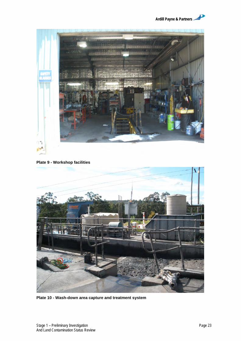
To the east lies the bathhouse washrooms, first aid and administration offices.
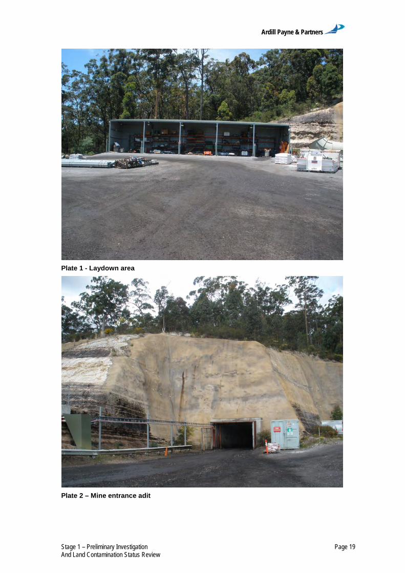
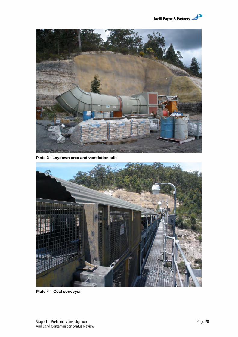
Plates 1 to 11 show photographs of the existing pit top.
No explosives are stored at the existing pit top but are used periodically
underground for mining activities.
Ardill Payne & Partners
Stage 1 – Preliminary Investigation Page 19 And Land Contamination Status Review
Plate 1 - Laydown area
Plate 2 – Mine entrance adit
Ardill Payne & Partners
Stage 1 – Preliminary Investigation Page 20 And Land Contamination Status Review
Plate 3 - Laydown area and ventilation adit
Plate 4 – Coal conveyor

Ardill Payne & Partners
Stage 1 – Preliminary Investigation Page 21 And Land Contamination Status Review
Plate 5 - Stockpile area
Plate 6 – Pollution control dam and haul truck

Ardill Payne & Partners
Stage 1 – Preliminary Investigation Page 22 And Land Contamination Status Review
Plate 7 - Laydown area for materials
Plate 8 - Mine services area - pumps, air compressors and electrical equipment
Ardill Payne & Partners
Stage 1 – Preliminary Investigation Page 23 And Land Contamination Status Review
Plate 9 - Workshop facilities
Plate 10 - Wash-down area capture and treatment system

Ardill Payne & Partners
Stage 1 – Preliminary Investigation Page 24 And Land Contamination Status Review
Plate 11 - Parking area with bathhouse washrooms and administration buildings 5.2 Run-off Control
Strict controls for the separation and control of run-off from disturbed areas
are in place at the existing pit top to prevent off-site pollution during rain
events. Two pollution control dams collect stormwater runoff from the pit top
area which is used for dust suppression. Excess water from the pollution
control dams is permanently stored in abandoned underground workings to
prevent off-site release.
5.3 Contamination Sources and Control Measures
Sources of, and control measures for, potential contaminants within the
existing pit top are presented in Table 5, and locations are shown in
Figure 14.
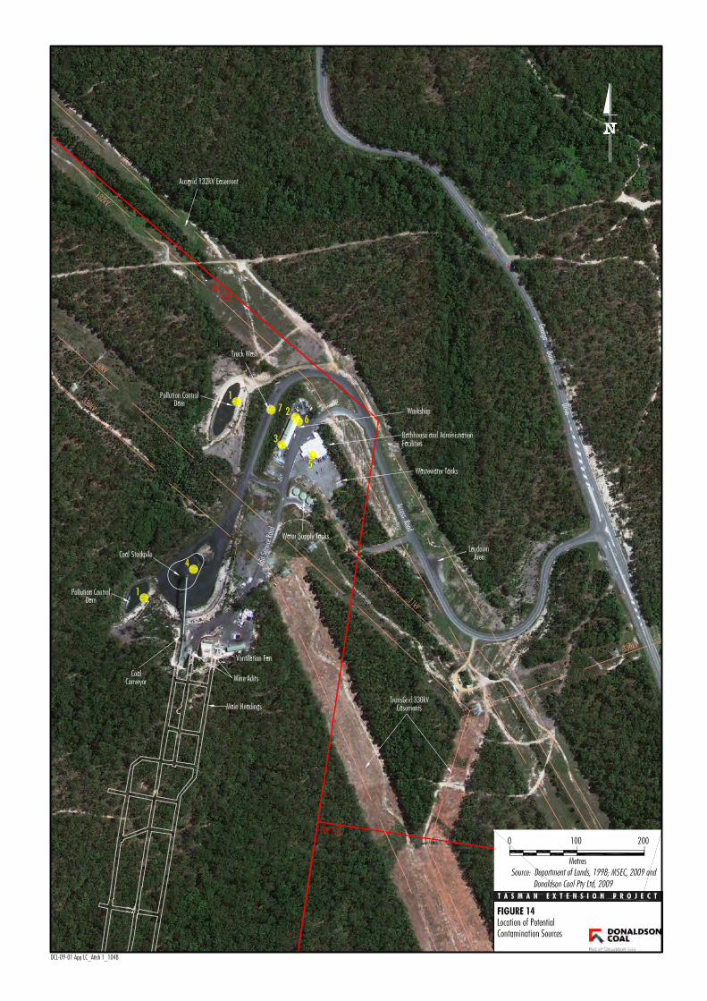

Ardill Payne & Partners
Stage 1 – Preliminary Investigation Page 26 And Land Contamination Status Review
Table 5 Locations and Control Measures for Potential Contaminant Sources
No1 Potential
Contaminant Source Contaminants of
Concern Control Measures
1 Runoff from water storage dams
Hydrocarbons, metals, BTEX, PAH
Water quality testing, disposal to abandoned underground workings
2 Fuel storage area Hydrocarbons, metals, BTEX, PAH Bunding
3 Workshop consumables
Hydrocarbons, metals, BTEX, PAH Bunding
4 ROM coal stockpile Hydrocarbons Runoff capture
5
Bathhouse/ bathroom facilities effluent irrigation area Nutrients, Pathogens
Effective treatment and disinfection/effluent water quality testing
6 Workshop washbay Hydrocarbons, metals, BTEX, PAH
Capture and treatment of wash-water
7 ROM coal stockpile wheel wash
Hydrocarbons, metals, BTEX, PAH Capture of wash-water
1 Refer Figure 14
BTEX = benzene, toluene, ethylbenzene, xylenes
PAH = polycyclic aromatic hydrocarbons
In accordance with the Tasman Underground Mine Environmental
Management System, a number of Emergency Response and Preparedness
Plans have been developed to manage potential risks associated with the use
of hazardous materials.
The control measures described above have been implemented to effectively
mitigate the potential for contamination from the site.
A number of consumables are used at the existing pit top have the potential to
contaminate the land if incorrectly handled. The Material Safety Data Sheets
(MSDS) for these consumables are managed in an online database through
ChemAlert and access to the current MSDS information is available to
Donaldson Coal at all times.
MSDS for all substances carried are provided in Attachment A-1.

Ardill Payne & Partners
Stage 1 – Preliminary Investigation Page 27 And Land Contamination Status Review
6 Conclusions/Recommendations
The objective of this Land Contamination Assessment was to determine if any
potentially contaminating activities have occurred within the existing pit top. In
order to determine the likelihood and type of contaminants that may be
present on site, a desktop site history assessment was undertaken. This
assessment consisted of searches of on-line records; reviewing historical
aerial photographs and information requests to the Lake Macquarie Council.
The historical information revealed no potential for contamination from
historical activities, however the existing pit top was identified as a source of
potential contamination.
A number of potentially contaminating activities associated with the existing
mining operations were identified within the existing pit top facility. However,
it was also observed that a number of management measures to control the
potential impact of these potentially contaminating activities are implemented.
Based on the above assessment it is considered that further investigation is
not required at this time and that the existing pit top is suitable for the
proposed development (i.e. the continuation of underground mining and the
continued use of the existing pit top for the Project).
As part of the decommissioning phase of the Project, land contamination
investigations within the exiting pit top area (e.g. Stage 1 – Preliminary
Investigation and Stage 2 – Detailed Land Contamination Assessment) and
any subsequent remediation (if required) would be undertaken in accordance
with the relevant guidelines (including guidelines under section 145C of the
NSW Environmental Planning and Assessment Act, 1979 and the NSW
Contaminated Land Management Act, 1997).

Ardill Payne & Partners
Stage 1 – Preliminary Investigation Page 28 And Land Contamination Status Review
Notwithstanding the above, in the event that an area of potential land
contamination is identified during the Project, work in that immediate area
would cease and the area made safe. The unexpected contamination would be
assessed by a suitably qualified person and remediation strategies put in place to
manage this contamination if necessary after approval by the appropriate
authority.
The land contamination assessment would be undertaken in accordance with
the relevant guidelines (including guidelines under section 145C of the NSW
Environmental Planning and Assessment Act, 1979 and the NSW
Contaminated Land Management Act, 1997).

Ardill Payne & Partners
Stage 1 – Preliminary Investigation Page 29 And Land Contamination Status Review
7 Scope of Engagement
This report has been prepared by APP at the request of Donaldson Coal for
the purpose of preliminarily assessing the potential for contamination on the
subject site and is not to be used for any other purpose or by any other person
or corporation.
This report has been prepared from the information provided to us and from
other information obtained as a result of enquiries made by us. APP accepts
no responsibility for any loss or damage suffered howsoever arising to any
person or corporation who may use or rely on this document for a purpose
other than that described above.
No part of this report may be reproduced, stored or transmitted in any form
without the prior consent of APP.
APP declares that it does not have, nor expects to have, a beneficial interest
in the subject project.
To avoid this advice being used inappropriately it is recommended that you
consult with APP before conveying the information to another who may not
fully understand the objectives of the report. This report is meant only for the
subject site/project and should not be applied to any other.

Ardill Payne & Partners
Stage 1 – Preliminary Investigation Page 30 And Land Contamination Status Review
8 References
Ardill Payne and Partners (2012a). Land Contamination Assessment Stage 1
– Preliminary Investigation and Land Contamination Status Review
Development Application Area –Tasman Extension Project.
Ardill Payne and Partners (2012b). Land Contamination Assessment Stage 1
– Preliminary Investigation and Land Contamination Status Review
New Pit Top Area.
Australian and New Zealand Environment and Conservation Council and
National Health and Medical Research Council (1992). Australian and
New Zealand Guidelines for the Assessment and Management of
Contaminated Sites. Australian and New Zealand Environment and
Conservation Council and National Health and Medical Research
Council, 57 p.
Department of Environment and Climate Change (2009). Guidelines on the
Duty to Report Contamination under the Contaminated Land
Management Act 1997.
Department of Urban Affairs and Planning and the Environmental Protection
Authority (1998). Managing Land Contamination, Planning Guidelines
SEPP 55 – Remediation of Land.
Maxim Archaeology and Heritage (2012). Historical Archaeology – Tasman
Underground Mine: Tasman Extension Project.

Ardill Payne & Partners
Stage 1 – Preliminary Investigation Page 31 And Land Contamination Status Review
9 Glossary
APP – Ardill Payne and Partners
DAA – Development Application Area
DP – Deposited Plan
EIS – Environmental Impact Statement
EPA – Environment Protection Authority (now known as Department of Environment & Climate Change and / or the Office of Environment & Heritage)
km – kilometres
LGA – Local Government Area
LPI – Land and Property Information (NSW Department of)
ML - Mining Lease
NSW – New South Wales
OEH – Office of Environment & Heritage
POEO – Protection of Environment Operations
ROM – Run-of-mine
SEPP 55 - State Environmental Planning Policy No. 55 – Remediation of Land

Ardill Payne & Partners
Stage 1 – Preliminary Investigation Page 32 And Land Contamination Status Review
10 Attachments
Attachment A-1 MSDS Information
Ardill Payne & Partners
Stage 1 – Preliminary Investigation Page 33 And Land Contamination Status Review
ATTACHMENT A-1
Attachment 1 MSDS Information

Stock Holding By Site(Site Name: DONALDSON UNDERGROUND OPERATIONS, Child Sites Included)
Sort By: Product Name, Filter By: None
Stock Number Product Name Quantity DG Haz Risk Status SDS Date
Manufacturer/Supplier
Site: DONALDSON UNDERGROUND OPERATIONS
01 Feb 2009NoneNoNonHazardous
N/A0 NoneFUCHS LUBRICANTS (AUSTRALASIA) PTY LTD
TITAN ULTRALUBE 1540303
Site: DONALDSON UNDERGROUND OPERATIONS/ ABEL SURFACE/ ADMIN OFFICE STATIONERY ROOM
15 Nov 2007NoneNoNonHazardous
2.2200 MillilitreH K WENTWORTH PTY LIMITED
INVERTIBLE SPRAYDUSTER99
01 Jul 2008NoneNoNonHazardous
N/A500 MillilitreVISTA VISUALS AUSTRALIA
VISTA WHITEBOARD CLEANER108
Site: DONALDSON UNDERGROUND OPERATIONS/ ABEL SURFACE/ CLEANERS STOREROOM
01 Sep 2008NoneNoNonHazardous
N/A500 MillilitreCOLES
CREME WASH, 500ML - COLES SMART165
07 Jan 2010NoneNoNonHazardous
N/A1 LitreDEB AUSTRALIA PTY LTD
DEB AZURE FOAM WASH146
03 May 2010NoneNoNonHazardous
N/A4 LitreDEB AUSTRALIA PTY LTD
DEB PURE WASH166
03 May 2010NoneNoNonHazardous
N/A2 LitreDEB AUSTRALIA PTY LTD
DEB SUN PROTECT49
03 May 2010NoneNoNonHazardous
N/A3 LitreDEB AUSTRALIA PTY LTD
DEB UNIVERSAL PROTECT167
Copyright © 2012
RMT; User - NOLOGON Print Date: 30 Jan 2012 Page 1 of 30

Stock Holding By Site(Site Name: DONALDSON UNDERGROUND OPERATIONS, Child Sites Included)
Sort By: Product Name, Filter By: None
Stock Number Product Name Quantity DG Haz Risk Status SDS Date
Manufacturer/Supplier
01 Jul 2007NoneNoHazardousN/A20 LitreHAMMERSLEY PRODUCTS (AUST) PTY LTD
GENESIS215
01 Dec 2008NoneNoNonHazardous
N/A500 GramCLOROX AUSTRALIA PTY LIMITED
GUMPTION MULTI PURPOSE CLEANSER143
17 Aug 2010NoneNoHazardous2.1250 GramWOOLWORTH SAFEWAY
HOMEBRAND SPRAY SURFACE LOW IRR 250G169
01 Feb 2007NoneNoHazardousN/A40 LitreHAMMERSLEY PRODUCTS (AUST) PTY LTD
HYDROSOLV148
12 Feb 2009NoneNoHazardous39 LitreDEB AUSTRALIA PTY LTD
INSTANT FOAM HAND SANITISER209
01 Feb 2007NoneNoNonHazardous
N/A20 LitreJOHNNY WIPE ENTERPRISES PTY LTD
JOHNNY WIPE GLASS CLEANER140
01 Aug 2007NoneNoHazardousN/A20 LitreHAMMERSLEY PRODUCTS (AUST) PTY LTD
SC239216
27 Jan 2009NoneNoNonHazardous
N/A20 LitreDEB AUSTRALIA PTY LTD
SUPREGA BLUE145
27 Jan 2009NoneNoNonHazardous
N/A12 LitreDEB AUSTRALIA PTY LTD
SUPREGA PLUS55
Site: DONALDSON UNDERGROUND OPERATIONS/ ABEL SURFACE/ DRY STORE
27 Mar 2011NoneNoHazardousN/A600KilogramBASF AUSTRALIA LIMITED
MASTERFLOW 87031
01 Jan 2010NoneNoNonHazardous
N/A576KilogramPOLYMER INNOVATIONS PTY LTD
SAP FINES (HPF)27
Copyright © 2012
RMT; User - NOLOGON Print Date: 30 Jan 2012 Page 2 of 30

Stock Holding By Site(Site Name: DONALDSON UNDERGROUND OPERATIONS, Child Sites Included)
Sort By: Product Name, Filter By: None
Stock Number Product Name Quantity DG Haz Risk Status SDS Date
Manufacturer/Supplier
23 Sep 2008NoneNoHazardousN/A1120KilogramSIKA AUSTRALIA PTY LTD
SIKA GUNITE GP10
17 Sep 2010NoneNoNonHazardous
N/A504KilogramOPEC SYSTEMS PTY LTD
SPILL-SORB16
01 Dec 2007NoneNoHazardousN/A2800KilogramMINOVA AUSTRALIA PTY LTD
STRATABINDER HS/STRATABINDER HS SLOWSET30
Site: DONALDSON UNDERGROUND OPERATIONS/ ABEL SURFACE/ ELECTRICAL STORAGE IN WORKSHOP
10 Sep 2007NoneNoHazardousN/A225 GramTYCO ELECTRONICS ENERGY DIVISION
ALVANIA GREASE (R3)139
31 May 2011NoneNoHazardous2.2400 GramCRC INDUSTRIES (AUST) PTY LIMITED
NF CONTACT CLEANER 201746
Site: DONALDSON UNDERGROUND OPERATIONS/ ABEL SURFACE/ FIRST AID ROOM
15 Oct 2009NoneNoNonHazardous
N/A1500MillilitreBAXTER HEALTHCARE CORPORATION
0.9% SODIUM CHLORIDE IRRIGATION SOLUTION229
28 Feb 2011NoneNoNonHazardous
N/A350 Gram
RYE PHARMACEUTICALS PTY LTD
BURNAID GEL 3.5G SACHETS, 25G, 50G TUBES, STERILEDRESSINGS, SPRAY GEL - BOTTLES, SQUEEZE BOTTLES
228
14 Jun 2007NoneNoNonHazardous
N/A375 GramSANOFI-AVENTIS CONSUMER HEATHCARE
ESSENTIALS BARRIER CREAM171
24 Jul 2009NoneNoHazardous9300 GramINOVA PHARMACEUTICALS (AUSTRALIA) PTY LIMITED
INOVA METSAL CREAM196
Copyright © 2012
RMT; User - NOLOGON Print Date: 30 Jan 2012 Page 3 of 30
Stock Holding By Site(Site Name: DONALDSON UNDERGROUND OPERATIONS, Child Sites Included)
Sort By: Product Name, Filter By: None
Stock Number Product Name Quantity DG Haz Risk Status SDS Date
Manufacturer/Supplier
03 Apr 2009NoneNoNonHazardous
N/A2 LitreDRYPAC
INSTANT ICE PACK203
01 May 2009NoneNoHazardousN/A12 MillilitreMEDICAL DEVELOPMENTS AUSTRALIA
METHOXYFLURANE INHALATION ANALGESIC234
09 Jul 2007NoneNoNonHazardous
N/A3 LitreJOHNSON & JOHNSON MEDICAL PTY LTD
MICROSHIELD 2 CHLORHEXIDINE SKIN CLEANSER205
06 May 2006NoneNoNonHazardous
N/A1650 GramRECKITT BENCKISER (AUSTRALIA) PTY LTD
MYCIL HEALTHY FEET TINEA POWDER202
27 Feb 2009NoneNoNonHazardous
N/A250 GramPDI - PROFESSIONAL DISPOSABLES INC (NICE-PAK PRODUCTS)
POVIDONE IODINE PADS AND SWABSTICKS200
01 Mar 2008NoneNoNonHazardous
N/A250 GramRYE PHARMACEUTICALS PTY LTD
RAPAID CREAM198
01 Mar 2008ApprovedNoNonHazardous
N/A600 GramRYE PHARMACEUTICALS PTY LTD
RAPAID POWDER170
21 May 2008NoneNoNonHazardous
N/A40 MillilitreALLERGAN AUSTRALIA PTY LTD
REFRESH (ALLERGAN)227
03 Apr 2008NoneNoNonHazardous
N/A250 GramSMITH AND NEPHEW PTY LTD
SKIN-PREP WIPES (WITH CETRIMIDE)199
01 Dec 2007NoneNoNonHazardous
N/A1500MillilitrePFIZER AUSTRALIA PTY LTD
SODIUM CHLORIDE 0.9% IRRIGATION226
Copyright © 2012
RMT; User - NOLOGON Print Date: 30 Jan 2012 Page 4 of 30

Stock Holding By Site(Site Name: DONALDSON UNDERGROUND OPERATIONS, Child Sites Included)
Sort By: Product Name, Filter By: None
Stock Number Product Name Quantity DG Haz Risk Status SDS Date
Manufacturer/Supplier
16 Apr 2009NoneNoHazardous2.20 NoneGLAXOSMITHKLINE AUSTRALIA, ENV. HEALTH & SAFETY
VENTOLIN HFA197
19 Sep 2008NoneNoNonHazardous
N/A3 LitreWHITELEY INDUSTRIAL
VIRACLEAN204
Site: DONALDSON UNDERGROUND OPERATIONS/ ABEL SURFACE/ OIL STORE
01 Jul 2007NoneNoNonHazardous
9220 LitreFUCHS LUBRICANTS (AUSTRALASIA) PTY LTD
FOSFOCENT 60012
01 Mar 2005NoneNoHazardousN/A120 LitreFLEETPOWER AUSTRALASIA PTY LTD
FYREX CI183
30 Nov 2011NoneNoNonHazardous
N/A185 LitreFUCHS LUBRICANTS (AUSTRALASIA) PTY LTD
PLANTO DRILLSAFE 1006
01 Dec 2007NoneNoNonHazardous
N/A640 LitreFUCHS LUBRICANTS (AUSTRALASIA) PTY LTD
PLANTOFLUX AT-S (ISO VG 46 - 68)235
31 Aug 2010NoneNoNonHazardous
N/A800 LitreFUCHS LUBRICANTS (AUSTRALASIA) PTY LTD
RENOLIN B PLUS SERIES119
01 Nov 2009NoneNoNonHazardous
N/A5340KilogramFUCHS LUBRICANTS (AUSTRALASIA) PTY LTD
RENOLIN CLP SERIES5
01 Nov 2009NoneNoNonHazardous
N/A240KilogramFUCHS LUBRICANTS (AUSTRALASIA) PTY LTD
RENOLIT MOREPLEX 2 HV4
01 Jun 2007NoneNoNonHazardous
N/A140KilogramFUCHS LUBRICANTS (AUSTRALASIA) PTY LTD
RENOLIT POLIPLEX 1 GREASE150
Copyright © 2012
RMT; User - NOLOGON Print Date: 30 Jan 2012 Page 5 of 30

Stock Holding By Site(Site Name: DONALDSON UNDERGROUND OPERATIONS, Child Sites Included)
Sort By: Product Name, Filter By: None
Stock Number Product Name Quantity DG Haz Risk Status SDS Date
Manufacturer/Supplier
01 Feb 2008NoneNoNonHazardous
N/A1160 LitreFUCHS LUBRICANTS (AUSTRALASIA) PTY LTD
TITAN GEAR LS 9011
01 Jan 2009NoneNoHazardousN/A40 LitreFUCHS LUBRICANTS (AUSTRALASIA) PTY LTD
TITAN HDD PREMIX COOLANT14
ObsoleteNoneNoNonHazardous
N/A1240 LitreFUCHS LUBRICANTS (AUSTRALASIA) PTY LTD
TITAN UNIVERSAL MF 15409[01 Oct 2006]
01 Jul 2009NoneNoNonHazardous
N/A260 LitreFUCHS LUBRICANTS (AUSTRALASIA) PTY LTD
TITAN UTTO195
Site: DONALDSON UNDERGROUND OPERATIONS/ ABEL SURFACE/ OPERATIONS OFFICE
07 May 2009NoneNoHazardous2.1150 Gram
RECKITT BENCKISER (AUSTRALIA) PTY LTD
AEROGARD TROPICAL STRENGTH INSECT REPELLENTAEROSOL
26
15 Mar 2010NoneNoHazardous2.1300 Gram
RECKITT BENCKISER (AUSTRALIA) PTY LTD
MORTEIN FAST KNOCKDOWN FLY AND INSECT KILLERAEROSOL
25
Site: DONALDSON UNDERGROUND OPERATIONS/ ABEL SURFACE/ UPSTAIRS STORAGE AREA
01 Feb 2008NoneNoNonHazardous
N/A4 LitreWD-40 COMPANY. USA
3-IN-ONE MOTOR OIL45
07 May 2009NoneNoHazardous2.10 None
RECKITT BENCKISER (AUSTRALIA) PTY LTD
AEROGARD TROPICAL STRENGTH INSECT REPELLENTAEROSOL
26
03 May 2010NoneNoNonHazardous
N/A625 MillilitreDEB AUSTRALIA PTY LTD
DEB SUN PROTECT49
Copyright © 2012
RMT; User - NOLOGON Print Date: 30 Jan 2012 Page 6 of 30

Stock Holding By Site(Site Name: DONALDSON UNDERGROUND OPERATIONS, Child Sites Included)
Sort By: Product Name, Filter By: None
Stock Number Product Name Quantity DG Haz Risk Status SDS Date
Manufacturer/Supplier
20 Sep 2007NoneNoHazardousN/A2000 GramITW POLYMERS & FLUIDS PTY LTD
DEVCON STOP SEIZE NICKEL24
14 Apr 2009NoneNoNonHazardous
N/A2790 GramDOW CORNING AUSTRALIA PTY LTD
DOW CORNING 732 MULTI-PURPOSE SEALANT CLEAR35
14 Apr 2009NoneNoNonHazardous
N/A695 MillilitreDOW CORNING AUSTRALIA PTY LTD
DOW CORNING 732 MULTI-PURPOSE SEALANT CLEAR18
10 Mar 2011NoneNoHazardous916 Litre
ITW POLYMERS & FLUIDS PTY LTD
EPIREZ ACID RESISTANT EPOXY MORTAR BINDER(133AR)
50
18 Feb 2009NoneNoNonHazardous
N/A3000MillilitreSTOTT INDUSTRIAL SUPPLIES (SUPPLIER FOR EUREKA
CHEMICAL CO)
FLUID FILM LIQUID AR23
05 Mar 2010NoneNoHazardousN/A6750MillilitreLANOTEC AUSTRALIA PTY LTD
GENERAL PURPOSE LIQUID LANOLIN21
01 Feb 2007NoneNoNonHazardous
N/A5 LitreHAMMERSLEY PRODUCTS (AUST) PTY LTD
GLISTEN (HAMMERSLEY)54
25 Oct 2006NoneNoHazardousN/A100 Millilitre
HENKEL CORPORATION. USA
LOCTITE 2 GASKET SEALANT NON-HARDENING PLIABLESEALANT
110
19 Oct 2010NoneNoHazardousN/A300 MillilitreHENKEL AUSTRALIA PTY LTD
LOCTITE 222 THREADLOCKER 50ML39
11 Mar 2010NoneNoHazardousN/A175 MillilitreHENKEL AUSTRALIA PTY LTD
LOCTITE 406 PRISM INSTANT ADHESIVE40
28 Apr 2011NoneNoHazardousN/A200 MillilitreLOCTITE 510 FLANGE SEALANT GASKET ELIMINATORHIGH TEMP.
41
Copyright © 2012
RMT; User - NOLOGON Print Date: 30 Jan 2012 Page 7 of 30

Stock Holding By Site(Site Name: DONALDSON UNDERGROUND OPERATIONS, Child Sites Included)
Sort By: Product Name, Filter By: None
Stock Number Product Name Quantity DG Haz Risk Status SDS Date
Manufacturer/Supplier
HENKEL AUSTRALIA PTY LTD
30 May 2011NoneNoNonHazardous
N/A300 MillilitreHENKEL AUSTRALIA PTY LTD
LOCTITE 55 PIPE SEALING CORD42
17 Aug 2010NoneNoHazardousN/A50 MillilitreHENKEL AUSTRALIA PTY LTD
LOCTITE 577 THREAD SEALANT19
30 Jun 2008NoneNoNonHazardous
N/A500 MillilitreDOW CORNING AUSTRALIA PTY LTD
MOLYKOTE 111 COMPOUND43
15 Mar 2010NoneNoHazardous2.10 None
RECKITT BENCKISER (AUSTRALIA) PTY LTD
MORTEIN FAST KNOCKDOWN FLY AND INSECT KILLERAEROSOL
25
31 May 2011NoneNoHazardous2.29200 GramCRC INDUSTRIES (AUST) PTY LIMITED
NF CONTACT CLEANER 201746
01 Jul 2009NoneNoHazardousN/A9500MillilitreQUICK SMART PRODUCTS
PENETRENE BULK44
29 Apr 2009NoneNoNonHazardous
N/A1000 GramITW POLYMERS & FLUIDS PTY LTD
ROCOL RTD METAL CUTTING COMPOUND53
01 Jan 2009NoneNoNonHazardous
N/A1652MillilitreSWAGELOK (SUPPLIER NSW VALVE & FITTING)
SNOOP36
27 Jan 2009NoneNoNonHazardous
N/A8 LitreDEB AUSTRALIA PTY LTD
SUPREGA PLUS55
Copyright © 2012
RMT; User - NOLOGON Print Date: 30 Jan 2012 Page 8 of 30

Stock Holding By Site(Site Name: DONALDSON UNDERGROUND OPERATIONS, Child Sites Included)
Sort By: Product Name, Filter By: None
Stock Number Product Name Quantity DG Haz Risk Status SDS Date
Manufacturer/Supplier
Site: DONALDSON UNDERGROUND OPERATIONS/ ABEL SURFACE/ WORKSHOP
19 Aug 2010NoneNoHazardousN/A3000 BPSizeCylinder
BP AUSTRALIA LIMITED
BP AUTOMOTIVE DIESEL FUEL163
20 Sep 2007NoneNoHazardousN/A500 GramITW POLYMERS & FLUIDS PTY LTD
DEVCON STOP SEIZE NICKEL24
14 Apr 2009NoneNoNonHazardous
N/A139 MillilitreDOW CORNING AUSTRALIA PTY LTD
DOW CORNING 732 MULTI-PURPOSE SEALANT CLEAR18
18 Feb 2009NoneNoNonHazardous
N/A250 MillilitreSTOTT INDUSTRIAL SUPPLIES (SUPPLIER FOR EUREKACHEMICAL CO)
FLUID FILM LIQUID AR23
04 May 2007NoneNoHazardous2.1350 GramITW POLYMERS & FLUIDS PTY LTD
GALMET DURAGAL AEROSOL17
05 Mar 2010NoneNoHazardousN/A750 MillilitreLANOTEC AUSTRALIA PTY LTD
GENERAL PURPOSE LIQUID LANOLIN21
17 Aug 2010NoneNoHazardousN/A50 MillilitreHENKEL AUSTRALIA PTY LTD
LOCTITE 577 THREAD SEALANT19
21 Jan 2011NoneNoHazardousN/A0 NoneITW POLYMERS & FLUIDS PTY LTD
MOLYBOND PIN & BUSH GREASE123
31 Aug 2010NoneNoNonHazardous
N/A0 NoneFUCHS LUBRICANTS (AUSTRALASIA) PTY LTD
RENOLIN B PLUS SERIES119
01 Nov 2009NoneNoNonHazardous
N/A20 KilogramFUCHS LUBRICANTS (AUSTRALASIA) PTY LTD
RENOLIN CLP SERIES5
Copyright © 2012
RMT; User - NOLOGON Print Date: 30 Jan 2012 Page 9 of 30

Stock Holding By Site(Site Name: DONALDSON UNDERGROUND OPERATIONS, Child Sites Included)
Sort By: Product Name, Filter By: None
Stock Number Product Name Quantity DG Haz Risk Status SDS Date
Manufacturer/Supplier
01 Nov 2009NoneNoNonHazardous
N/A2250 GramFUCHS LUBRICANTS (AUSTRALASIA) PTY LTD
RENOLIT HD-CE 22
01 Jun 2007NoneNoNonHazardous
N/A0 NoneFUCHS LUBRICANTS (AUSTRALASIA) PTY LTD
RENOLIT POLIPLEX 1 GREASE150
27 Aug 2010NoneNoHazardous2.1300 GramITW POLYMERS & FLUIDS PTY LTD
ROCOL RTD SPRAY22
08 Sep 2009NoneNoNonHazardous
N/A20 LitreHARDY MANUFACTURING PTY LTD
SCRUBBER15
17 Sep 2010NoneNoNonHazardous
N/A0 KilogramOPEC SYSTEMS PTY LTD
SPILL-SORB16
01 Feb 2008NoneNoNonHazardous
N/A20 LitreFUCHS LUBRICANTS (AUSTRALASIA) PTY LTD
TITAN GEAR HTB 851407
01 Feb 2008NoneNoNonHazardous
N/A20 LitreFUCHS LUBRICANTS (AUSTRALASIA) PTY LTD
TITAN GEAR LS 9011
01 Jan 2009NoneNoHazardousN/A20 LitreFUCHS LUBRICANTS (AUSTRALASIA) PTY LTD
TITAN HDD PREMIX COOLANT14
30 Sep 2011NoneNoNonHazardous
N/A20 LitreFUCHS LUBRICANTS (AUSTRALASIA) PTY LTD
TITAN TO-4108
ObsoleteNoneNoNonHazardous
N/A20 LitreFUCHS LUBRICANTS (AUSTRALASIA) PTY LTD
TITAN UNIVERSAL MF 15409[01 Oct 2006]
Copyright © 2012
RMT; User - NOLOGON Print Date: 30 Jan 2012 Page 10 of 30
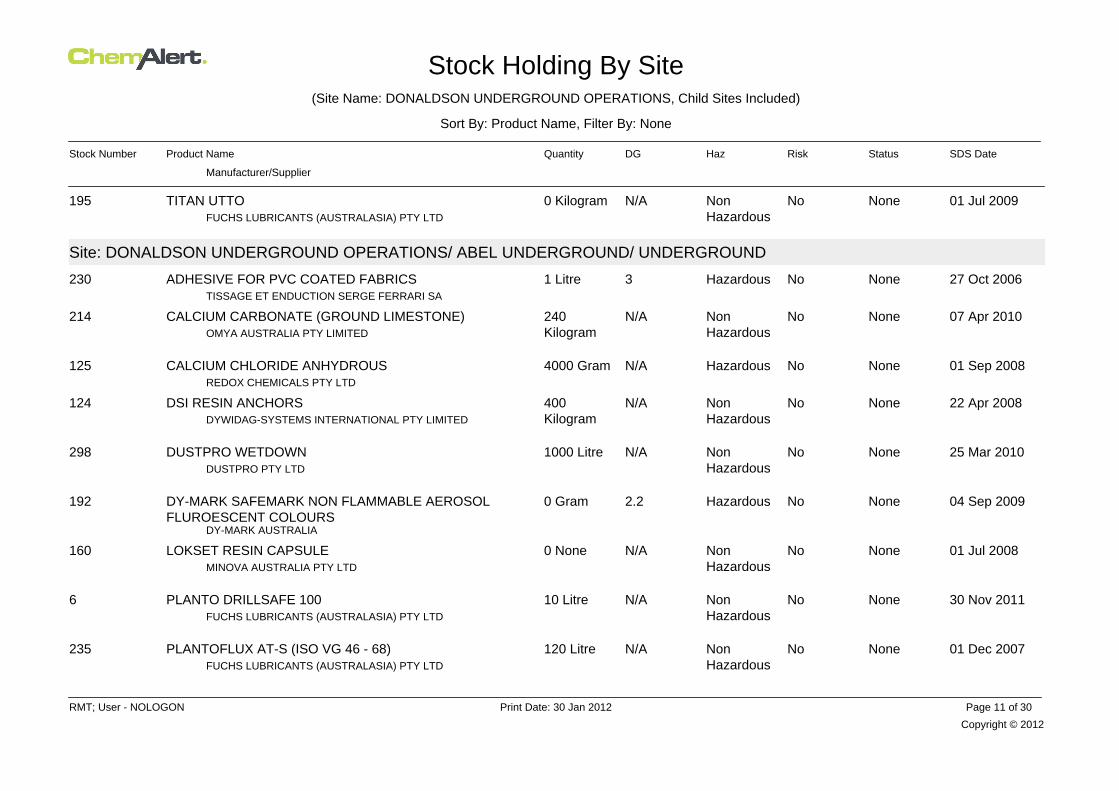
Stock Holding By Site(Site Name: DONALDSON UNDERGROUND OPERATIONS, Child Sites Included)
Sort By: Product Name, Filter By: None
Stock Number Product Name Quantity DG Haz Risk Status SDS Date
Manufacturer/Supplier
01 Jul 2009NoneNoNonHazardous
N/A0 KilogramFUCHS LUBRICANTS (AUSTRALASIA) PTY LTD
TITAN UTTO195
Site: DONALDSON UNDERGROUND OPERATIONS/ ABEL UNDERGROUND/ UNDERGROUND
27 Oct 2006NoneNoHazardous31 LitreTISSAGE ET ENDUCTION SERGE FERRARI SA
ADHESIVE FOR PVC COATED FABRICS230
07 Apr 2010NoneNoNonHazardous
N/A240KilogramOMYA AUSTRALIA PTY LIMITED
CALCIUM CARBONATE (GROUND LIMESTONE)214
01 Sep 2008NoneNoHazardousN/A4000 GramREDOX CHEMICALS PTY LTD
CALCIUM CHLORIDE ANHYDROUS125
22 Apr 2008NoneNoNonHazardous
N/A400KilogramDYWIDAG-SYSTEMS INTERNATIONAL PTY LIMITED
DSI RESIN ANCHORS124
25 Mar 2010NoneNoNonHazardous
N/A1000 LitreDUSTPRO PTY LTD
DUSTPRO WETDOWN298
04 Sep 2009NoneNoHazardous2.20 Gram
DY-MARK AUSTRALIA
DY-MARK SAFEMARK NON FLAMMABLE AEROSOLFLUROESCENT COLOURS
192
01 Jul 2008NoneNoNonHazardous
N/A0 NoneMINOVA AUSTRALIA PTY LTD
LOKSET RESIN CAPSULE160
30 Nov 2011NoneNoNonHazardous
N/A10 LitreFUCHS LUBRICANTS (AUSTRALASIA) PTY LTD
PLANTO DRILLSAFE 1006
01 Dec 2007NoneNoNonHazardous
N/A120 LitreFUCHS LUBRICANTS (AUSTRALASIA) PTY LTD
PLANTOFLUX AT-S (ISO VG 46 - 68)235
Copyright © 2012
RMT; User - NOLOGON Print Date: 30 Jan 2012 Page 11 of 30
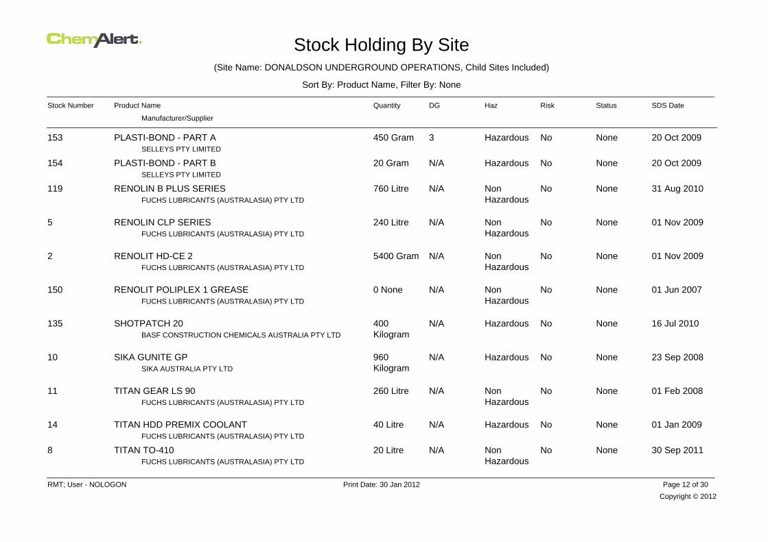
Stock Holding By Site(Site Name: DONALDSON UNDERGROUND OPERATIONS, Child Sites Included)
Sort By: Product Name, Filter By: None
Stock Number Product Name Quantity DG Haz Risk Status SDS Date
Manufacturer/Supplier
20 Oct 2009NoneNoHazardous3450 GramSELLEYS PTY LIMITED
PLASTI-BOND - PART A153
20 Oct 2009NoneNoHazardousN/A20 GramSELLEYS PTY LIMITED
PLASTI-BOND - PART B154
31 Aug 2010NoneNoNonHazardous
N/A760 LitreFUCHS LUBRICANTS (AUSTRALASIA) PTY LTD
RENOLIN B PLUS SERIES119
01 Nov 2009NoneNoNonHazardous
N/A240 LitreFUCHS LUBRICANTS (AUSTRALASIA) PTY LTD
RENOLIN CLP SERIES5
01 Nov 2009NoneNoNonHazardous
N/A5400 GramFUCHS LUBRICANTS (AUSTRALASIA) PTY LTD
RENOLIT HD-CE 22
01 Jun 2007NoneNoNonHazardous
N/A0 NoneFUCHS LUBRICANTS (AUSTRALASIA) PTY LTD
RENOLIT POLIPLEX 1 GREASE150
16 Jul 2010NoneNoHazardousN/A400KilogramBASF CONSTRUCTION CHEMICALS AUSTRALIA PTY LTD
SHOTPATCH 20135
23 Sep 2008NoneNoHazardousN/A960KilogramSIKA AUSTRALIA PTY LTD
SIKA GUNITE GP10
01 Feb 2008NoneNoNonHazardous
N/A260 LitreFUCHS LUBRICANTS (AUSTRALASIA) PTY LTD
TITAN GEAR LS 9011
01 Jan 2009NoneNoHazardousN/A40 LitreFUCHS LUBRICANTS (AUSTRALASIA) PTY LTD
TITAN HDD PREMIX COOLANT14
30 Sep 2011NoneNoNonHazardous
N/A20 LitreFUCHS LUBRICANTS (AUSTRALASIA) PTY LTD
TITAN TO-4108
Copyright © 2012
RMT; User - NOLOGON Print Date: 30 Jan 2012 Page 12 of 30
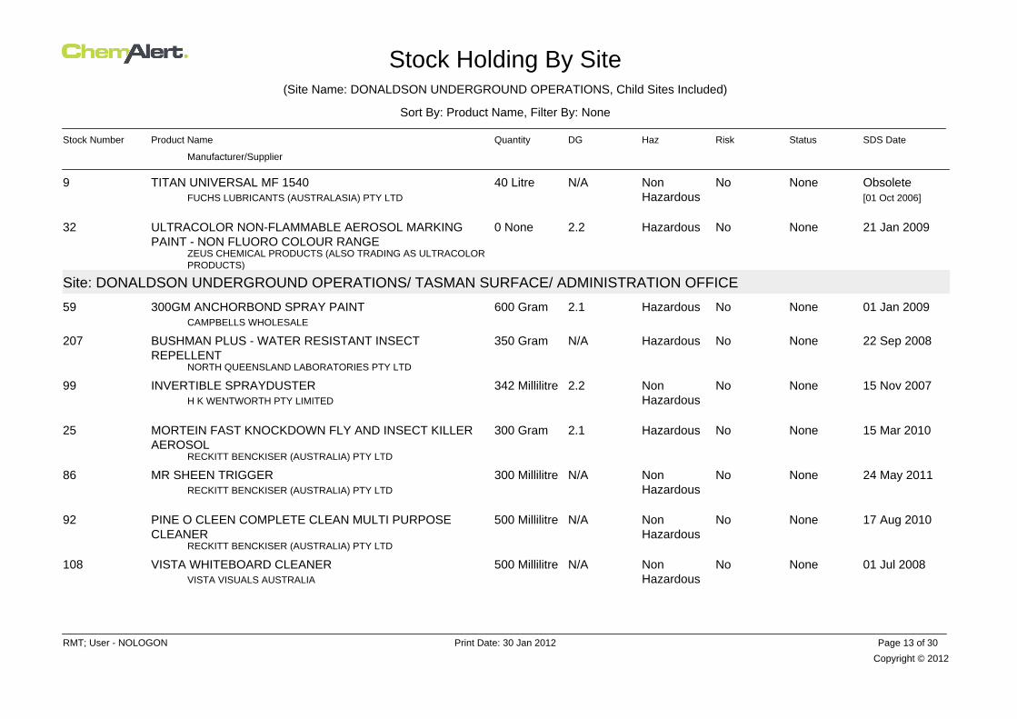
Stock Holding By Site(Site Name: DONALDSON UNDERGROUND OPERATIONS, Child Sites Included)
Sort By: Product Name, Filter By: None
Stock Number Product Name Quantity DG Haz Risk Status SDS Date
Manufacturer/Supplier
ObsoleteNoneNoNonHazardous
N/A40 LitreFUCHS LUBRICANTS (AUSTRALASIA) PTY LTD
TITAN UNIVERSAL MF 15409[01 Oct 2006]
21 Jan 2009NoneNoHazardous2.20 None
ZEUS CHEMICAL PRODUCTS (ALSO TRADING AS ULTRACOLORPRODUCTS)
ULTRACOLOR NON-FLAMMABLE AEROSOL MARKINGPAINT - NON FLUORO COLOUR RANGE
32
Site: DONALDSON UNDERGROUND OPERATIONS/ TASMAN SURFACE/ ADMINISTRATION OFFICE
01 Jan 2009NoneNoHazardous2.1600 GramCAMPBELLS WHOLESALE
300GM ANCHORBOND SPRAY PAINT59
22 Sep 2008NoneNoHazardousN/A350 Gram
NORTH QUEENSLAND LABORATORIES PTY LTD
BUSHMAN PLUS - WATER RESISTANT INSECTREPELLENT
207
15 Nov 2007NoneNoNonHazardous
2.2342 MillilitreH K WENTWORTH PTY LIMITED
INVERTIBLE SPRAYDUSTER99
15 Mar 2010NoneNoHazardous2.1300 Gram
RECKITT BENCKISER (AUSTRALIA) PTY LTD
MORTEIN FAST KNOCKDOWN FLY AND INSECT KILLERAEROSOL
25
24 May 2011NoneNoNonHazardous
N/A300 MillilitreRECKITT BENCKISER (AUSTRALIA) PTY LTD
MR SHEEN TRIGGER86
17 Aug 2010NoneNoNonHazardous
N/A500 Millilitre
RECKITT BENCKISER (AUSTRALIA) PTY LTD
PINE O CLEEN COMPLETE CLEAN MULTI PURPOSECLEANER
92
01 Jul 2008NoneNoNonHazardous
N/A500 MillilitreVISTA VISUALS AUSTRALIA
VISTA WHITEBOARD CLEANER108
Copyright © 2012
RMT; User - NOLOGON Print Date: 30 Jan 2012 Page 13 of 30

Stock Holding By Site(Site Name: DONALDSON UNDERGROUND OPERATIONS, Child Sites Included)
Sort By: Product Name, Filter By: None
Stock Number Product Name Quantity DG Haz Risk Status SDS Date
Manufacturer/Supplier
Site: DONALDSON UNDERGROUND OPERATIONS/ TASMAN SURFACE/ BATHHOUSE
03 May 2010ApprovedNoNonHazardous
N/A4 LitreDEB AUSTRALIA PTY LTD
DEB PURE WASH166
03 May 2010NoneNoNonHazardous
N/A1 LitreDEB AUSTRALIA PTY LTD
DEB SUN PROTECT49
03 May 2010ApprovedNoNonHazardous
N/A2 LitreDEB AUSTRALIA PTY LTD
DEB UNIVERSAL PROTECT167
06 May 2006NoneNoNonHazardous
N/A220 GramRECKITT BENCKISER (AUSTRALIA) PTY LTD
MYCIL HEALTHY FEET TINEA POWDER202
01 Mar 2008ApprovedNoNonHazardous
N/A600 GramRYE PHARMACEUTICALS PTY LTD
RAPAID POWDER170
27 Jan 2009NoneNoNonHazardous
N/A72 LitreDEB AUSTRALIA PTY LTD
SUPREGA BLUE145
27 Jan 2009NoneNoNonHazardous
N/A24 LitreDEB AUSTRALIA PTY LTD
SUPREGA PLUS55
06 Nov 2008NoneNoNonHazardous
N/A600 GramSCIENCELAB.COM, INC
TOLNAFTATE (SCIENCELAB)225
Copyright © 2012
RMT; User - NOLOGON Print Date: 30 Jan 2012 Page 14 of 30

Stock Holding By Site(Site Name: DONALDSON UNDERGROUND OPERATIONS, Child Sites Included)
Sort By: Product Name, Filter By: None
Stock Number Product Name Quantity DG Haz Risk Status SDS Date
Manufacturer/Supplier
Site: DONALDSON UNDERGROUND OPERATIONS/ TASMAN SURFACE/ CLEANERS STORE IN BATHHOUSE
01 Mar 2009NoneNoNonHazardous
N/A40 LitreRAPIDCLEAN
BLEACH 4%185
01 Apr 2010NoneNoHazardousN/A4 KilogramSEPTONE PRODUCTS PTY LTD
BLOCKETTES62
03 May 2010ApprovedNoNonHazardous
N/A4 LitreDEB AUSTRALIA PTY LTD
DEB PURE WASH166
14 Jun 2007ApprovedNoNonHazardous
N/A375 GramSANOFI-AVENTIS CONSUMER HEATHCARE
ESSENTIALS BARRIER CREAM171
01 Feb 2007NoneNoHazardousN/A41 NoneHAMMERSLEY PRODUCTS (AUST) PTY LTD
HYDROSOLV148
01 Oct 2006NoneNoNonHazardous
N/A25 LitreJOHNNY WIPE ENTERPRISES PTY LTD
JOHNNY WIPE DISINFECTANT66
01 Aug 2007NoneNoHazardous825 LitreJOHNNY WIPE ENTERPRISES PTY LTD
JOHNNY WIPE GOLDSTREAM73
01 Mar 2008ApprovedNoNonHazardous
N/A200 GramRYE PHARMACEUTICALS PTY LTD
RAPAID POWDER170
01 Jun 2007NoneNoNonHazardous
N/A15 LitreSEPTONE PRODUCTS PTY LTD
REFLECTION314
27 Jan 2009NoneNoNonHazardous
N/A52 LitreDEB AUSTRALIA PTY LTD
SUPREGA BLUE145
Copyright © 2012
RMT; User - NOLOGON Print Date: 30 Jan 2012 Page 15 of 30

Stock Holding By Site(Site Name: DONALDSON UNDERGROUND OPERATIONS, Child Sites Included)
Sort By: Product Name, Filter By: None
Stock Number Product Name Quantity DG Haz Risk Status SDS Date
Manufacturer/Supplier
27 Jan 2009NoneNoNonHazardous
N/A16 LitreDEB AUSTRALIA PTY LTD
SUPREGA PLUS55
11 Jan 2005NoneNoNonHazardous
N/A5 LitreURIDAN A/S
URILOCK107
Site: DONALDSON UNDERGROUND OPERATIONS/ TASMAN SURFACE/ FIRST AID ROOM
15 Oct 2009NoneNoNonHazardous
N/A2500MillilitreBAXTER HEALTHCARE CORPORATION
0.9% SODIUM CHLORIDE IRRIGATION SOLUTION229
28 Feb 2011NoneNoNonHazardous
N/A140 Gram
RYE PHARMACEUTICALS PTY LTD
BURNAID GEL 3.5G SACHETS, 25G, 50G TUBES, STERILEDRESSINGS, SPRAY GEL - BOTTLES, SQUEEZE BOTTLES
228
28 Feb 2011NoneNoNonHazardous
N/A245 Gram
RYE PHARMACEUTICALS PTY LTD
BURNAID GEL 3.5G SACHETS, 25G, 50G TUBES, STERILEDRESSINGS, SPRAY GEL - BOTTLES, SQUEEZE BOTTLES
228
28 Feb 2011NoneNoNonHazardous
N/A450 Gram
RYE PHARMACEUTICALS PTY LTD
BURNAID GEL 3.5G SACHETS, 25G, 50G TUBES, STERILEDRESSINGS, SPRAY GEL - BOTTLES, SQUEEZE BOTTLES
228
28 Feb 2011NoneNoNonHazardous
N/A1440 Gram
RYE PHARMACEUTICALS PTY LTD
BURNAID GEL 3.5G SACHETS, 25G, 50G TUBES, STERILEDRESSINGS, SPRAY GEL - BOTTLES, SQUEEZE BOTTLES
228
28 Feb 2011NoneNoNonHazardous
N/A750 Gram
RYE PHARMACEUTICALS PTY LTD
BURNAID GEL 3.5G SACHETS, 25G, 50G TUBES, STERILEDRESSINGS, SPRAY GEL - BOTTLES, SQUEEZE BOTTLES
228
07 Jan 2010NoneNoNonHazardous
N/A0 NoneDEB AUSTRALIA PTY LTD
DEB AZURE FOAM WASH146
Copyright © 2012
RMT; User - NOLOGON Print Date: 30 Jan 2012 Page 16 of 30
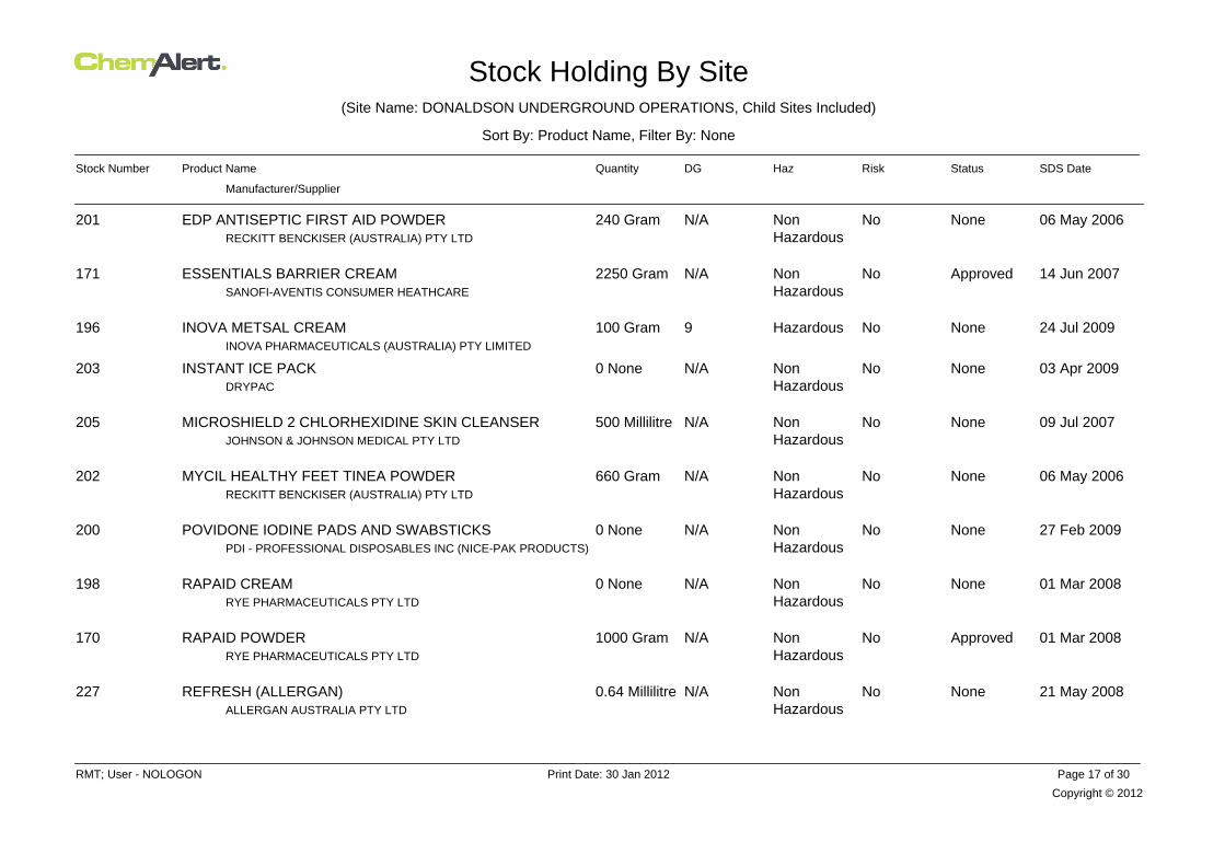
Stock Holding By Site(Site Name: DONALDSON UNDERGROUND OPERATIONS, Child Sites Included)
Sort By: Product Name, Filter By: None
Stock Number Product Name Quantity DG Haz Risk Status SDS Date
Manufacturer/Supplier
06 May 2006NoneNoNonHazardous
N/A240 GramRECKITT BENCKISER (AUSTRALIA) PTY LTD
EDP ANTISEPTIC FIRST AID POWDER201
14 Jun 2007ApprovedNoNonHazardous
N/A2250 GramSANOFI-AVENTIS CONSUMER HEATHCARE
ESSENTIALS BARRIER CREAM171
24 Jul 2009NoneNoHazardous9100 GramINOVA PHARMACEUTICALS (AUSTRALIA) PTY LIMITED
INOVA METSAL CREAM196
03 Apr 2009NoneNoNonHazardous
N/A0 NoneDRYPAC
INSTANT ICE PACK203
09 Jul 2007NoneNoNonHazardous
N/A500 MillilitreJOHNSON & JOHNSON MEDICAL PTY LTD
MICROSHIELD 2 CHLORHEXIDINE SKIN CLEANSER205
06 May 2006NoneNoNonHazardous
N/A660 GramRECKITT BENCKISER (AUSTRALIA) PTY LTD
MYCIL HEALTHY FEET TINEA POWDER202
27 Feb 2009NoneNoNonHazardous
N/A0 NonePDI - PROFESSIONAL DISPOSABLES INC (NICE-PAK PRODUCTS)
POVIDONE IODINE PADS AND SWABSTICKS200
01 Mar 2008NoneNoNonHazardous
N/A0 NoneRYE PHARMACEUTICALS PTY LTD
RAPAID CREAM198
01 Mar 2008ApprovedNoNonHazardous
N/A1000 GramRYE PHARMACEUTICALS PTY LTD
RAPAID POWDER170
21 May 2008NoneNoNonHazardous
N/A0.64 MillilitreALLERGAN AUSTRALIA PTY LTD
REFRESH (ALLERGAN)227
Copyright © 2012
RMT; User - NOLOGON Print Date: 30 Jan 2012 Page 17 of 30

Stock Holding By Site(Site Name: DONALDSON UNDERGROUND OPERATIONS, Child Sites Included)
Sort By: Product Name, Filter By: None
Stock Number Product Name Quantity DG Haz Risk Status SDS Date
Manufacturer/Supplier
03 Apr 2008NoneNoNonHazardous
N/A0 NoneSMITH AND NEPHEW PTY LTD
SKIN-PREP WIPES (WITH CETRIMIDE)199
01 Dec 2007NoneNoNonHazardous
N/A2400MillilitrePFIZER AUSTRALIA PTY LTD
SODIUM CHLORIDE 0.9% IRRIGATION226
06 Nov 2008NoneNoNonHazardous
N/A1200 GramSCIENCELAB.COM, INC
TOLNAFTATE (SCIENCELAB)225
16 Apr 2009NoneNoHazardous2.20 NoneGLAXOSMITHKLINE AUSTRALIA, ENV. HEALTH & SAFETY
VENTOLIN HFA197
19 Sep 2008NoneNoNonHazardous
N/A500 MillilitreWHITELEY INDUSTRIAL
VIRACLEAN204
Site: DONALDSON UNDERGROUND OPERATIONS/ TASMAN SURFACE/ FITTERS CUPBOARD
07 Oct 2011NoneNoHazardousN/A250 GramCIGWELD PTY LTD
CIGWELD COMWELD COPPER AND BRASS FLUX126
20 Oct 2011NoneNoHazardous8 / 6.1200 GramCIGWELD PTY LTD
CIGWELD COMWELD SILVER BRAZING FLUX NO. 2128
ObsoleteNoneNoHazardous6.1375 GramCIGWELD PTY LTD
COMWELD BRONZE TINNING FLUX127[02 Oct 2006]
01 Jan 2009NoneNoHazardous8250 MillilitreDYNAWELD INDUSTRIAL SUPPLIES PTY LTD
EZI-WELD 801129
04 Mar 2008NoneNoHazardousN/A226 GramLA-CO INDUSTRIES INC, MARKAL COMPANY
REGULAR SOLDERING FLUX PASTE130
31 Aug 2011NoneNoHazardous2.2500 GramTHE LINCOLN ELECTRIC CO. (AUSTRALIA) PTY LTD
SPATTERSTOP121
Copyright © 2012
RMT; User - NOLOGON Print Date: 30 Jan 2012 Page 18 of 30

Stock Holding By Site(Site Name: DONALDSON UNDERGROUND OPERATIONS, Child Sites Included)
Sort By: Product Name, Filter By: None
Stock Number Product Name Quantity DG Haz Risk Status SDS Date
Manufacturer/Supplier
25 Jun 2007NoneNoHazardous3400 GramITW POLYMERS & FLUIDS PTY LTD
STAG JOINTING PASTE174
31 May 2011NoneNoHazardous2.1350 GramCRC INDUSTRIES (AUST) PTY LIMITED
ZINC IT180
Site: DONALDSON UNDERGROUND OPERATIONS/ TASMAN SURFACE/ KITCHEN
07 Jan 2010NoneNoNonHazardous
N/A1 LitreDEB AUSTRALIA PTY LTD
DEB AZURE FOAM WASH146
01 Aug 2009NoneNoNonHazardous
N/A750 MillilitreCOLGATE-PALMOLIVE PTY LTD
PALMOLIVE REGULAR DISHWASHING LIQUID184
Site: DONALDSON UNDERGROUND OPERATIONS/ TASMAN SURFACE/ LUBRICANT STORE
19 Aug 2010NoneNoHazardousN/A3000 BPSizeCylinder
BP AUSTRALIA LIMITED
BP AUTOMOTIVE DIESEL FUEL163
30 Jul 2010NoneNoHazardousN/A240KilogramBORAL CEMENT
CONCRETE (BORAL CEMENT)182
01 Jul 2007NoneNoNonHazardous
960 LitreFUCHS LUBRICANTS (AUSTRALASIA) PTY LTD
FOSFOCENT 60012
01 Mar 2005NoneNoHazardousN/A80 LitreFLEETPOWER AUSTRALASIA PTY LTD
FYREX CI183
21 Jan 2011NoneNoNonHazardous
N/A80 LitreITW POLYMERS & FLUIDS PTY LTD
MOLYBOND MOLYGEAR 46084
Copyright © 2012
RMT; User - NOLOGON Print Date: 30 Jan 2012 Page 19 of 30

Stock Holding By Site(Site Name: DONALDSON UNDERGROUND OPERATIONS, Child Sites Included)
Sort By: Product Name, Filter By: None
Stock Number Product Name Quantity DG Haz Risk Status SDS Date
Manufacturer/Supplier
21 Jan 2011NoneNoNonHazardous
N/A80 LitreITW POLYMERS & FLUIDS PTY LTD
MOLYBOND MOLYGEAR 85W14085
30 Nov 2011NoneNoNonHazardous
N/A105 LitreFUCHS LUBRICANTS (AUSTRALASIA) PTY LTD
PLANTO DRILLSAFE 1006
01 Dec 2007NoneNoNonHazardous
N/A640 LitreFUCHS LUBRICANTS (AUSTRALASIA) PTY LTD
PLANTOFLUX AT-S (ISO VG 46 - 68)235
01 Jul 2010NoneNoNonHazardous
N/A20 LitreQUAKER CHEMICAL (AUSTRALASIA) PTY LTD
QUINTOLUBRIC A822-320300
31 Aug 2010NoneNoNonHazardous
N/A1820 LitreFUCHS LUBRICANTS (AUSTRALASIA) PTY LTD
RENOLIN B PLUS SERIES119
01 Nov 2009NoneNoNonHazardous
N/A280 LitreFUCHS LUBRICANTS (AUSTRALASIA) PTY LTD
RENOLIN CLP SERIES5
01 Nov 2009NoneNoNonHazardous
N/A27000 GramFUCHS LUBRICANTS (AUSTRALASIA) PTY LTD
RENOLIT MOREPLEX 2 HV4
25 Mar 2011NoneNoNonHazardous
N/A16200 GramSHELL COMPANY OF AUSTRALIA LTD
SHELL STAMINA GREASE RL 2100
01 Sep 2010NoneNoNonHazardous
N/A100 LitreSHELL COMPANY OF AUSTRALIA LTD
SHELL TELLUS S2 M 32103
27 Jan 2009NoneNoNonHazardous
N/A5 LitreDEB AUSTRALIA PTY LTD
SUPREGA PLUS55
Copyright © 2012
RMT; User - NOLOGON Print Date: 30 Jan 2012 Page 20 of 30
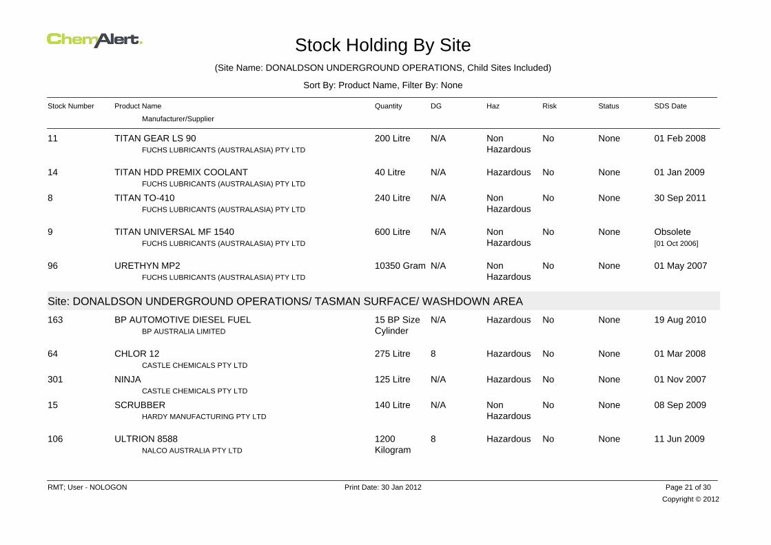
Stock Holding By Site(Site Name: DONALDSON UNDERGROUND OPERATIONS, Child Sites Included)
Sort By: Product Name, Filter By: None
Stock Number Product Name Quantity DG Haz Risk Status SDS Date
Manufacturer/Supplier
01 Feb 2008NoneNoNonHazardous
N/A200 LitreFUCHS LUBRICANTS (AUSTRALASIA) PTY LTD
TITAN GEAR LS 9011
01 Jan 2009NoneNoHazardousN/A40 LitreFUCHS LUBRICANTS (AUSTRALASIA) PTY LTD
TITAN HDD PREMIX COOLANT14
30 Sep 2011NoneNoNonHazardous
N/A240 LitreFUCHS LUBRICANTS (AUSTRALASIA) PTY LTD
TITAN TO-4108
ObsoleteNoneNoNonHazardous
N/A600 LitreFUCHS LUBRICANTS (AUSTRALASIA) PTY LTD
TITAN UNIVERSAL MF 15409[01 Oct 2006]
01 May 2007NoneNoNonHazardous
N/A10350 GramFUCHS LUBRICANTS (AUSTRALASIA) PTY LTD
URETHYN MP296
Site: DONALDSON UNDERGROUND OPERATIONS/ TASMAN SURFACE/ WASHDOWN AREA
19 Aug 2010NoneNoHazardousN/A15 BP SizeCylinderBP AUSTRALIA LIMITED
BP AUTOMOTIVE DIESEL FUEL163
01 Mar 2008NoneNoHazardous8275 LitreCASTLE CHEMICALS PTY LTD
CHLOR 1264
01 Nov 2007NoneNoHazardousN/A125 LitreCASTLE CHEMICALS PTY LTD
NINJA301
08 Sep 2009NoneNoNonHazardous
N/A140 LitreHARDY MANUFACTURING PTY LTD
SCRUBBER15
11 Jun 2009NoneNoHazardous81200KilogramNALCO AUSTRALIA PTY LTD
ULTRION 8588106
Copyright © 2012
RMT; User - NOLOGON Print Date: 30 Jan 2012 Page 21 of 30

Stock Holding By Site(Site Name: DONALDSON UNDERGROUND OPERATIONS, Child Sites Included)
Sort By: Product Name, Filter By: None
Stock Number Product Name Quantity DG Haz Risk Status SDS Date
Manufacturer/Supplier
Site: DONALDSON UNDERGROUND OPERATIONS/ TASMAN SURFACE/ WORKSHOP STORE & SAFE-T-STORE CUPBOARD
15 Jan 2011NoneNoHazardousN/A270 GramITW DEVCON
5-MINUTE EPOXY HARDENER186
15 Jan 2011NoneNoHazardousN/A480 GramITW DEVCON
5-MINUTE EPOXY RESIN187
04 Jan 2010NoneNoHazardous2.227 Kilogram
FOMO PRODUCTS, INC
A-COMPONENT FOR TWO-COMPONENT POLYURETHANEFOAM SYSTEM
157
07 May 2009NoneNoHazardous2.11050 Gram
RECKITT BENCKISER (AUSTRALIA) PTY LTD
AEROGARD TROPICAL STRENGTH INSECT REPELLENTAEROSOL
26
01 Jun 2008NoneNoNonHazardous
N/A6500MillilitreCASTLE CHEMICALS PTY LTD
ANTI FOAM122
05 Jan 2010NoneNoHazardous2.227 Kilogram
FOMO PRODUCTS, INC
B-COMPONENT FOR TWO-COMPONENT POLYURETHANEFOAM SYSTEM
158
01 Apr 2010NoneNoHazardousN/A6 KilogramSEPTONE PRODUCTS PTY LTD
BLOCKETTES62
20 May 2009NoneNoHazardousN/A1500 GramBOSTIK AUSTRALIA PTY LTD (FORMERLY BOSTIK FINDLEY)
BOSTIK NEVER SEEZ PURE NICKEL SPECIAL191
28 Feb 2010NoneNoHazardous851.3KilogramMINOVA AUSTRALIA PTY LTD
CARBOMINE INJECT KOMP. A315
28 Feb 2010NoneNoNonHazardous
N/A51.3KilogramMINOVA AUSTRALIA PTY LTD
CARBOMINE INJECT KOMP. B316
Copyright © 2012
RMT; User - NOLOGON Print Date: 30 Jan 2012 Page 22 of 30

Stock Holding By Site(Site Name: DONALDSON UNDERGROUND OPERATIONS, Child Sites Included)
Sort By: Product Name, Filter By: None
Stock Number Product Name Quantity DG Haz Risk Status SDS Date
Manufacturer/Supplier
25 Oct 2007NoneNoHazardous2.11500 GramFORMULA MARKETING LTD
COLORPAK AEROSOL PAINTS65
31 Oct 2007NoneNoHazardous2.12800 GramCRC INDUSTRIES EUROPE
CRC CONTACT CLEANER - AEROSOL87
07 Jan 2010NoneNoNonHazardous
N/A15 LitreDEB AUSTRALIA PTY LTD
DEB AZURE FOAM WASH146
03 May 2010NoneNoNonHazardous
N/A625 MillilitreDEB AUSTRALIA PTY LTD
DEB SUN PROTECT49
11 Jan 2007NoneNoNonHazardous
N/A0 NoneHAMILTON PHARMACEUTICAL PTY LTD (FORMERLY HAMILTONLABS)
DERMEX 7A178
20 Sep 2007NoneNoHazardousN/A2000 GramITW POLYMERS & FLUIDS PTY LTD
DEVCON STOP SEIZE NICKEL24
14 Apr 2009NoneNoNonHazardous
N/A695 MillilitreDOW CORNING AUSTRALIA PTY LTD
DOW CORNING 732 MULTI-PURPOSE SEALANT CLEAR18
04 Sep 2009NoneNoHazardous2.214400 Gram
DY-MARK AUSTRALIA
DY-MARK SAFEMARK NON FLAMMABLE AEROSOLFLUROESCENT COLOURS
192
10 Mar 2011NoneNoHazardous98 Litre
ITW POLYMERS & FLUIDS PTY LTD
EPIREZ ACID RESISTANT EPOXY MORTAR BINDER(133AR)
50
25 Jun 2007NoneNoHazardous82 Litre
ITW POLYMERS & FLUIDS PTY LTD
EPIREZ GENERAL PURPOSE EPOXY MORTAR BINDER[133] HARDENER
51
18 Feb 2009NoneNoNonHazardous
N/A1500MillilitreSTOTT INDUSTRIAL SUPPLIES (SUPPLIER FOR EUREKA
FLUID FILM LIQUID A67
Copyright © 2012
RMT; User - NOLOGON Print Date: 30 Jan 2012 Page 23 of 30
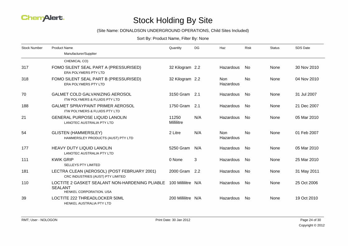
Stock Holding By Site(Site Name: DONALDSON UNDERGROUND OPERATIONS, Child Sites Included)
Sort By: Product Name, Filter By: None
Stock Number Product Name Quantity DG Haz Risk Status SDS Date
Manufacturer/Supplier
CHEMICAL CO)
30 Nov 2010NoneNoHazardous2.232 KilogramERA POLYMERS PTY LTD
FOMO SILENT SEAL PART A (PRESSURISED)317
04 Nov 2010NoneNoNonHazardous
2.232 KilogramERA POLYMERS PTY LTD
FOMO SILENT SEAL PART B (PRESSURISED)318
31 Jul 2007NoneNoHazardous2.13150 GramITW POLYMERS & FLUIDS PTY LTD
GALMET COLD GALVANIZING AEROSOL70
21 Dec 2007NoneNoHazardous2.11750 GramITW POLYMERS & FLUIDS PTY LTD
GALMET SPRAYPAINT PRIMER AEROSOL188
05 Mar 2010NoneNoHazardousN/A11250MillilitreLANOTEC AUSTRALIA PTY LTD
GENERAL PURPOSE LIQUID LANOLIN21
01 Feb 2007NoneNoNonHazardous
N/A2 LitreHAMMERSLEY PRODUCTS (AUST) PTY LTD
GLISTEN (HAMMERSLEY)54
05 Mar 2010NoneNoHazardousN/A5250 GramLANOTEC AUSTRALIA PTY LTD
HEAVY DUTY LIQUID LANOLIN177
25 Mar 2010NoneNoHazardous30 NoneSELLEYS PTY LIMITED
KWIK GRIP111
31 May 2011NoneNoHazardous2.22000 GramCRC INDUSTRIES (AUST) PTY LIMITED
LECTRA CLEAN (AEROSOL) (POST FEBRUARY 2001)181
25 Oct 2006NoneNoHazardousN/A100 Millilitre
HENKEL CORPORATION. USA
LOCTITE 2 GASKET SEALANT NON-HARDENING PLIABLESEALANT
110
19 Oct 2010NoneNoHazardousN/A200 MillilitreHENKEL AUSTRALIA PTY LTD
LOCTITE 222 THREADLOCKER 50ML39
Copyright © 2012
RMT; User - NOLOGON Print Date: 30 Jan 2012 Page 24 of 30

Stock Holding By Site(Site Name: DONALDSON UNDERGROUND OPERATIONS, Child Sites Included)
Sort By: Product Name, Filter By: None
Stock Number Product Name Quantity DG Haz Risk Status SDS Date
Manufacturer/Supplier
29 Jan 2010NoneNoHazardousN/A100 MillilitreHENKEL AUSTRALIA PTY LTD
LOCTITE 243/243-SG THREADLOCKER76
16 Aug 2007NoneNoHazardousN/A150 MillilitreHENKEL AUSTRALIA PTY LTD
LOCTITE 277 HIGH STRENGTH THREADLOCKER77
11 Mar 2010NoneNoHazardousN/A125 MillilitreHENKEL AUSTRALIA PTY LTD
LOCTITE 406 PRISM INSTANT ADHESIVE40
28 Apr 2011NoneNoHazardousN/A100 Millilitre
HENKEL AUSTRALIA PTY LTD
LOCTITE 510 FLANGE SEALANT GASKET ELIMINATORHIGH TEMP.
41
21 Jul 2009NoneNoHazardousN/A100 MillilitreHENKEL AUSTRALIA PTY LTD
LOCTITE 518 FLANGE SEALANT MASTER GASKET80
30 May 2011NoneNoNonHazardous
N/A300 MillilitreHENKEL AUSTRALIA PTY LTD
LOCTITE 55 PIPE SEALING CORD42
17 Aug 2010NoneNoHazardousN/A150 MillilitreHENKEL AUSTRALIA PTY LTD
LOCTITE 577 THREAD SEALANT19
24 Sep 2010NoneNoHazardousN/A1000MillilitreHENKEL AUSTRALIA PTY LTD
LOCTITE 641 RC 250ML AU EN112
18 Oct 2011NoneNoHazardous2.12790 GramHENKEL AUSTRALIA PTY LTD
LOCTITE FREEZE AND RELEASE (AEROSOL)113
23 Apr 2010NoneNoHazardous32 LitreRECOCHEM INC (FORMERLY DIGGERS)
METHYLATED SPIRITS179
21 Jan 2011NoneNoHazardousN/A8100 GramITW POLYMERS & FLUIDS PTY LTD
MOLYBOND PIN & BUSH GREASE123
30 Jun 2008NoneNoNonHazardous
N/A400 GramDOW CORNING AUSTRALIA PTY LTD
MOLYKOTE 111 COMPOUND43
Copyright © 2012
RMT; User - NOLOGON Print Date: 30 Jan 2012 Page 25 of 30

Stock Holding By Site(Site Name: DONALDSON UNDERGROUND OPERATIONS, Child Sites Included)
Sort By: Product Name, Filter By: None
Stock Number Product Name Quantity DG Haz Risk Status SDS Date
Manufacturer/Supplier
15 Mar 2010NoneNoHazardous2.13900 Gram
RECKITT BENCKISER (AUSTRALIA) PTY LTD
MORTEIN FAST KNOCKDOWN FLY AND INSECT KILLERAEROSOL
25
31 May 2011NoneNoHazardous2.22800 GramCRC INDUSTRIES (AUST) PTY LIMITED
NF CONTACT CLEANER 201746
30 Sep 2011NoneNoHazardousN/A40 LitreFUCHS LUBRICANTS (AUSTRALASIA) PTY LTD
RENOCLEAN QBD PLUS 6595
25 Aug 2010NoneNoHazardous2.12700 GramITW POLYMERS & FLUIDS PTY LTD
ROCOL FLAW FINDER CLEANER SPRAY NO.197
25 Aug 2010NoneNoHazardous2.12400 GramITW POLYMERS & FLUIDS PTY LTD
ROCOL FLAW FINDER DEVELOPER SPRAY98
29 Apr 2009NoneNoNonHazardous
N/A1000 GramITW POLYMERS & FLUIDS PTY LTD
ROCOL RTD METAL CUTTING COMPOUND53
27 Aug 2010NoneNoHazardous2.1600 GramITW POLYMERS & FLUIDS PTY LTD
ROCOL RTD SPRAY22
06 Jul 2010NoneNoNonHazardous
N/A0 NonePT TECH INC.
SLQ SERIES TLCS236
01 Jan 2009NoneNoNonHazardous
N/A944 MillilitreSWAGELOK (SUPPLIER NSW VALVE & FITTING)
SNOOP36
22 May 2008NoneNoHazardous2.22500MillilitreNO CLIMB PRODUCTS LTD
SOLO AEROSOL SMOKE DETECTOR TESTER313
04 Dec 2009NoneNoHazardous31000MillilitreATHERTON CHEMICALS PTY LIMITED
SOLVENT CEMENT TYPE N BLUE193
Copyright © 2012
RMT; User - NOLOGON Print Date: 30 Jan 2012 Page 26 of 30
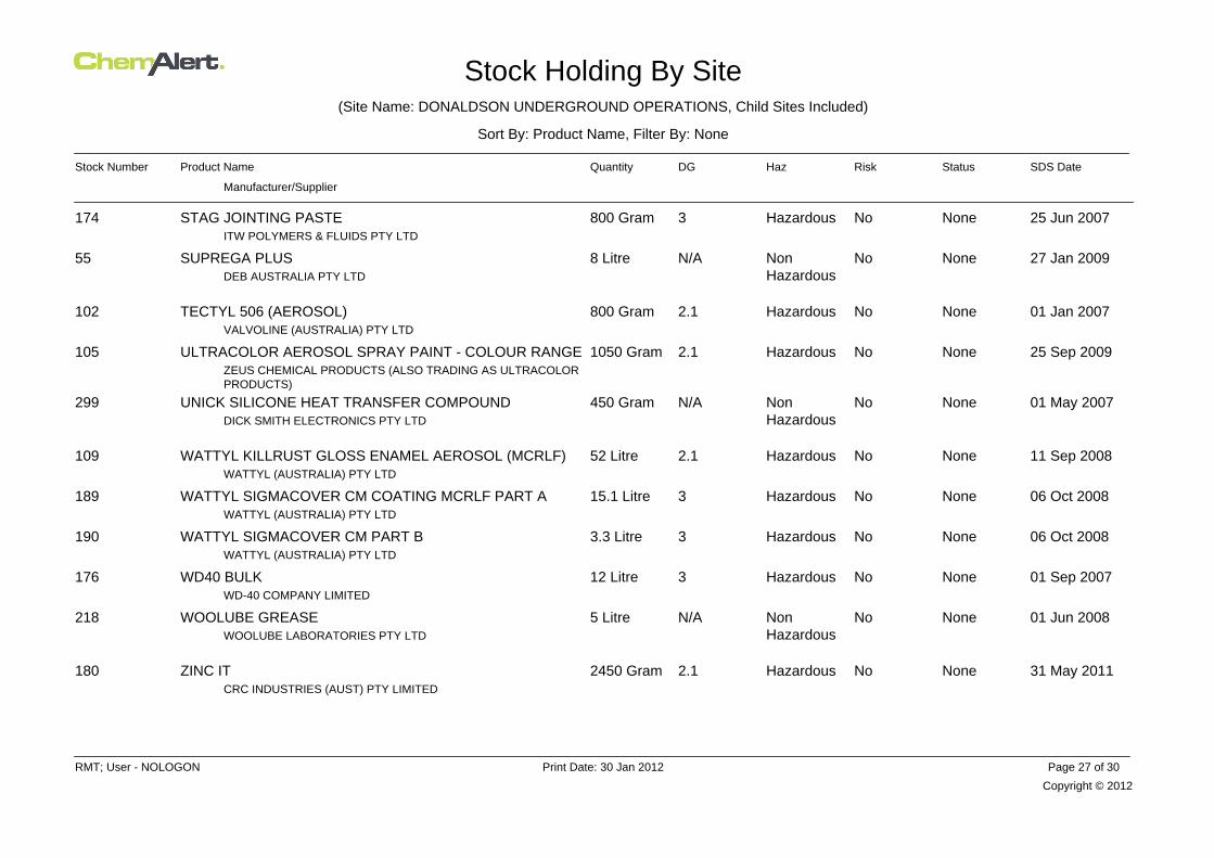
Stock Holding By Site(Site Name: DONALDSON UNDERGROUND OPERATIONS, Child Sites Included)
Sort By: Product Name, Filter By: None
Stock Number Product Name Quantity DG Haz Risk Status SDS Date
Manufacturer/Supplier
25 Jun 2007NoneNoHazardous3800 GramITW POLYMERS & FLUIDS PTY LTD
STAG JOINTING PASTE174
27 Jan 2009NoneNoNonHazardous
N/A8 LitreDEB AUSTRALIA PTY LTD
SUPREGA PLUS55
01 Jan 2007NoneNoHazardous2.1800 GramVALVOLINE (AUSTRALIA) PTY LTD
TECTYL 506 (AEROSOL)102
25 Sep 2009NoneNoHazardous2.11050 GramZEUS CHEMICAL PRODUCTS (ALSO TRADING AS ULTRACOLORPRODUCTS)
ULTRACOLOR AEROSOL SPRAY PAINT - COLOUR RANGE105
01 May 2007NoneNoNonHazardous
N/A450 GramDICK SMITH ELECTRONICS PTY LTD
UNICK SILICONE HEAT TRANSFER COMPOUND299
11 Sep 2008NoneNoHazardous2.152 LitreWATTYL (AUSTRALIA) PTY LTD
WATTYL KILLRUST GLOSS ENAMEL AEROSOL (MCRLF)109
06 Oct 2008NoneNoHazardous315.1 LitreWATTYL (AUSTRALIA) PTY LTD
WATTYL SIGMACOVER CM COATING MCRLF PART A189
06 Oct 2008NoneNoHazardous33.3 LitreWATTYL (AUSTRALIA) PTY LTD
WATTYL SIGMACOVER CM PART B190
01 Sep 2007NoneNoHazardous312 LitreWD-40 COMPANY LIMITED
WD40 BULK176
01 Jun 2008NoneNoNonHazardous
N/A5 LitreWOOLUBE LABORATORIES PTY LTD
WOOLUBE GREASE218
31 May 2011NoneNoHazardous2.12450 GramCRC INDUSTRIES (AUST) PTY LIMITED
ZINC IT180
Copyright © 2012
RMT; User - NOLOGON Print Date: 30 Jan 2012 Page 27 of 30

Stock Holding By Site(Site Name: DONALDSON UNDERGROUND OPERATIONS, Child Sites Included)
Sort By: Product Name, Filter By: None
Stock Number Product Name Quantity DG Haz Risk Status SDS Date
Manufacturer/Supplier
Site: DONALDSON UNDERGROUND OPERATIONS/ TASMAN UNDERGROUND
19 Aug 2010NoneNoHazardousN/A80 BP SizeCylinderBP AUSTRALIA LIMITED
BP AUTOMOTIVE DIESEL FUEL163
07 Apr 2010NoneNoNonHazardous
N/A20 TonneOMYA AUSTRALIA PTY LIMITED
CALCIUM CARBONATE (GROUND LIMESTONE)214
01 Sep 2008NoneNoHazardousN/A1000KilogramREDOX CHEMICALS PTY LTD
CALCIUM CHLORIDE ANHYDROUS125
04 Sep 2009NoneNoHazardous2.20 Gram
DY-MARK AUSTRALIA
DY-MARK SAFEMARK NON FLAMMABLE AEROSOLFLUROESCENT COLOURS
192
09 Mar 2007ApprovedNoHazardousN/A0 LitreKIDDE AUSTRALIA
EXPANDOL304
26 Jul 2010NoneNoNonHazardous
N/A0 KilogramFALCON MINING PTY LTD
FALCON MINE PLASTER302
11 Mar 2009NoneNoHazardousN/A0 MillilitreHENKEL CORPORATION. USA
LOCTITE 569 THREAD SEALANT 50ML311
09 Feb 2007NoneNoHazardousN/A0 GramHENKEL CORPORATION. USA
LOCTITE 577 THREAD SEALANT MEDIUM STRENGTH308
01 Jul 2008NoneNoNonHazardous
N/A0 NoneMINOVA AUSTRALIA PTY LTD
LOKSET RESIN CAPSULE160
01 Jun 2009NoneNoNonHazardous
N/A50 KilogramNUTECH PAINT PTY LTD
MAXI-POINT237
Copyright © 2012
RMT; User - NOLOGON Print Date: 30 Jan 2012 Page 28 of 30

Stock Holding By Site(Site Name: DONALDSON UNDERGROUND OPERATIONS, Child Sites Included)
Sort By: Product Name, Filter By: None
Stock Number Product Name Quantity DG Haz Risk Status SDS Date
Manufacturer/Supplier
21 Jan 2011NoneNoHazardousN/A0 NoneITW POLYMERS & FLUIDS PTY LTD
MOLYBOND PIN & BUSH GREASE123
30 Nov 2011NoneNoNonHazardous
N/A0 NoneFUCHS LUBRICANTS (AUSTRALASIA) PTY LTD
PLANTO DRILLSAFE 1006
01 Dec 2007NoneNoNonHazardous
N/A200 LitreFUCHS LUBRICANTS (AUSTRALASIA) PTY LTD
PLANTOFLUX AT-S (ISO VG 46 - 68)235
31 Aug 2010NoneNoNonHazardous
N/A0 NoneFUCHS LUBRICANTS (AUSTRALASIA) PTY LTD
RENOLIN B PLUS SERIES119
01 Nov 2009NoneNoNonHazardous
N/A0 KilogramFUCHS LUBRICANTS (AUSTRALASIA) PTY LTD
RENOLIN CLP SERIES5
01 Nov 2009NoneNoNonHazardous
N/A0 KilogramFUCHS LUBRICANTS (AUSTRALASIA) PTY LTD
RENOLIT MOREPLEX 2 HV4
06 Jul 2010NoneNoNonHazardous
N/A0 NonePT TECH INC.
SLQ SERIES TLCS236
01 Dec 2007NoneNoHazardousN/A1000KilogramMINOVA AUSTRALIA PTY LTD
STRATABINDER HS/STRATABINDER HS SLOWSET30
01 Feb 2008NoneNoNonHazardous
N/A0 NoneFUCHS LUBRICANTS (AUSTRALASIA) PTY LTD
TITAN GEAR LS 9011
01 Jan 2009NoneNoHazardousN/A0 LitreFUCHS LUBRICANTS (AUSTRALASIA) PTY LTD
TITAN HDD PREMIX COOLANT14
Copyright © 2012
RMT; User - NOLOGON Print Date: 30 Jan 2012 Page 29 of 30

Stock Holding By Site(Site Name: DONALDSON UNDERGROUND OPERATIONS, Child Sites Included)
Sort By: Product Name, Filter By: None
Stock Number Product Name Quantity DG Haz Risk Status SDS Date
Manufacturer/Supplier
01 Feb 2009NoneNoNonHazardous
N/A0 LitreFUCHS LUBRICANTS (AUSTRALASIA) PTY LTD
TITAN ULTRALUBE 1540303
Copyright © 2012
RMT; User - NOLOGON Print Date: 30 Jan 2012 Page 30 of 30

ATTACHMENT 2
Attachment 2 Stage 1 – Preliminary
Investigation- New Pit Top Area
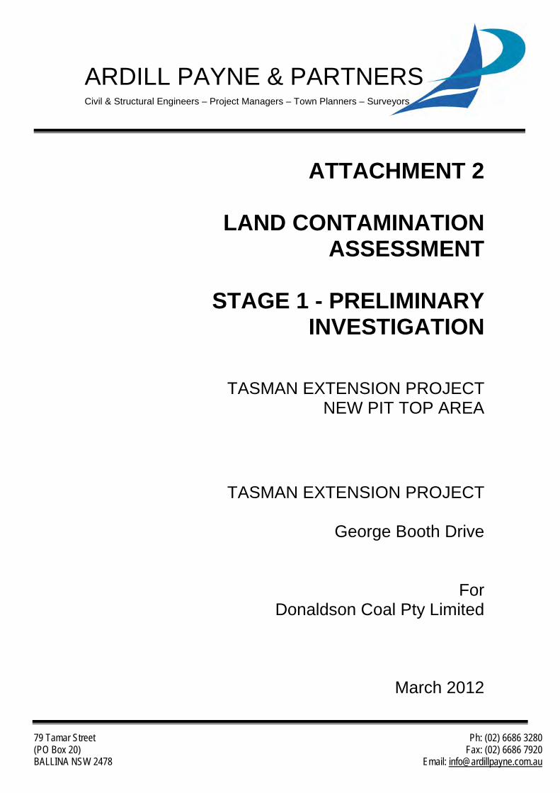
79 Tamar Street Ph: (02) 6686 3280 (PO Box 20) Fax: (02) 6686 7920 BALLINA NSW 2478 Email: [email protected]
ARDILL PAYNE & PARTNERS Civil & Structural Engineers – Project Managers – Town Planners – Surveyors
ATTACHMENT 2
LAND CONTAMINATION ASSESSMENT
STAGE 1 - PRELIMINARY
INVESTIGATION
TASMAN EXTENSION PROJECT NEW PIT TOP AREA
TASMAN EXTENSION PROJECT
George Booth Drive
For Donaldson Coal Pty Limited
March 2012

Ardill Payne & Partners
Stage 1 – Preliminary Investigation Page i And Land Contamination Status Review
Document Control Sheet
Filename: 7247 - Preliminary SEPP 55 Investigation Rev1.0
Job No.: 7247
Job Captain: Evan Elford
Author: James Foster
Client: Donaldson Coal Pty Limited
File/Pathname: 7247 - Preliminary Contaminated Site Investigation Rev1.0.docx
Revision No:
Date: Checked By Issued By
Name Signed Name Signed
DRAFT Oct 17 2011 E. Elford J. Foster
1 Dec 15 2011 E. Elford J. Foster
2 Mar 26 2012 E. Elford J. Foster

Ardill Payne & Partners
Stage 1 – Preliminary Investigation Page ii And Land Contamination Status Review
Table of Contents
1 INTRODUCTION ..................................................................................... 1
2 SCOPE OF WORKS ................................................................................ 6
3 SITE IDENTIFICATION ........................................................................... 8
4 SITE HISTORY ........................................................................................ 9
4.1 Site History Overview ............................................................................. 9 4.2 POEO Act Public Register and Contaminated Land – Record of Notices
Search ................................................................................................... 9 4.3 Section 149 Planning Certificate ............................................................ 9 4.4 Historical Aerial Photographs ............................................................... 10 4.5 Cessnock and Lake Macquarie City Council Records .......................... 12 4.6 Historical Railway ................................................................................. 12 4.7 Desktop History Summary .................................................................... 13
5 SITE INSPECTION ................................................................................ 15
5.1 Site Inspection ..................................................................................... 15 5.2 Access Tracks ...................................................................................... 15 5.3 Pipelines .............................................................................................. 15 5.4 Illegal Dumping .................................................................................... 16 5.5 Asbestos .............................................................................................. 16 5.6 Fire ...................................................................................................... 22 5.7 Surrounding Land Use ......................................................................... 23
6 REMEDIATION ...................................................................................... 24
6.1 Remediation of Illegal Dumping............................................................ 24 6.2 Duty to Report Contamination .............................................................. 24 6.3 Category 2 Remediation Requirements ................................................ 25
7 CONCLUSIONS..................................................................................... 27
8 SCOPE OF ENGAGEMENT .................................................................. 29
9 REFERENCES ...................................................................................... 30
10 GLOSSARY ........................................................................................... 31

Ardill Payne & Partners
Stage 1 – Preliminary Investigation Page iii And Land Contamination Status Review
LIST OF FIGURES
Figure 1 – Regional Location ........................................................................... 2
Figure 2 – Aerial Photograph of Project Area and Surrounds .......................... 3
Figure 3 – Indicative Arrangement of the New Pit Top ..................................... 4
Figure 4 - Historical Aerial Photographs ....................................................... 11
Figure 5 - NSW Railway Map showing the approximate site location ............ 12
Figure 6 - High Voltage Transmission Line Easement on the Site ................. 13
Figure 7 - Illegal Dumping Sites ..................................................................... 18
Figure 8 - Dumped Hot Water System ........................................................... 19
Figure 9 - Dumped Furniture .......................................................................... 19
Figure 10 - Dumped Tyres and Wood ............................................................ 20
Figure 11 - Dumped Concrete and Rubble .................................................... 20
Figure 12 - Inert Waste .................................................................................. 21
Figure 13 - Plastic Waste ............................................................................... 21
Figure 14 - Evidence of Bush Fire .................................................................. 22
LIST OF TABLES
Table 1 - New Pit Top Area Details .................................................................. 8
Table 2 - Summary of Aerial Photograph Observations ................................. 10
Table 3 - Summary of Site Inspection Observations ...................................... 15
Table 4 - Asbestos Sample Analysis Results ................................................. 17
Ardill Payne & Partners
Stage 1 – Preliminary Investigation Page 1 And Land Contamination Status Review
1 Introduction
The existing Tasman Underground Mine is located within Mining Lease
(ML) 1555, approximately 20 kilometres (km) west of the Port of Newcastle in
New South Wales (NSW) (Figure 1). The Tasman Underground Mine is
owned and operated by Donaldson Coal Pty Limited (Donaldson Coal).
Donaldson Coal is a wholly owned subsidiary of Gloucester Coal Ltd (GCL).
Donaldson Coal also owns and operates the Donaldson Open Cut Mine and
Abel Underground Mine, which are located approximately 10 km north-east of
the Tasman Underground Mine (Figure 1).
The Tasman Underground Mine commenced in May 2006, with underground
mining commencing in September 2006. The Tasman Extension Project (the
Project) provides for the continuation and then extension of operations at the
Tasman Underground Mine and would extend the current operations by
approximately 15 years.
An aerial photograph of the Project Area and surrounds is shown on Figure 2.
A detailed description of the Project is provided in Section 2 of the Main
Report of the Environmental Impact Statement (EIS).
The Project would involve the development of a new pit top facility to provide
access to the West Borehole Seam and associated surface facilities required
for underground coal mining and run-of-mine (ROM) coal handling. The new
pit top facility would comprise ROM coal handling infrastructure,
administration facilities, worker amenities and stores buildings, workshop
compound, bunded fuel tank area, electricity reticulation, water management
equipment and structures and other associated infrastructure. An indicative
general arrangement of the new pit top facility is provided in Figure 3.

Ardill Payne & Partners
Stage 1 – Preliminary Investigation Page 5 And Land Contamination Status Review
Ardill Payne and Partners (APP) have been engaged by Donaldson Coal to
undertake a Stage 1 Preliminary Investigation for the new pit top area. The
new pit top would be located within Lot 101 Deposited Plan (DP) 1164569,
George Booth Drive, Richmond Vale.
Separate Land Contamination Assessments have been prepared for:
the wider Tasman Extension Project Development Application Area
(DAA) (APP, 2012a); and
the existing Tasman Underground Mine pit top area (APP, 2012b).
Ardill Payne & Partners
Stage 1 – Preliminary Investigation Page 6 And Land Contamination Status Review
2 Scope of Works
Clause 7 of the NSW State Environment Planning Policy No. 55 –
Remediation of Land (SEPP 55) states that:
“(1) A consent authority must not consent to the carrying out of any
development on land unless:
(a) it has considered whether the land is contaminated, and
(b) if the land is contaminated, it is satisfied that the land is suitable in its
contaminated state (or will be suitable, after remediation) for the
purpose for which the development is proposed to be carried out, and
(c) if the land requires remediation to be made suitable for the purpose for
which the development is proposed to be carried out, it is satisfied that
the land will be remediated before the land is used for that purpose.
(2) Before determining an application for consent to carry out development
that would involve a change of use…, the consent authority must
consider a report specifying the findings of a preliminary investigation
of the land concerned carried out in accordance with the contaminated
land planning guidelines.
(3) The applicant for development consent must carry out the investigation
required by subclause (2) and must provide a report on it to the
consent authority. …”
This Stage 1 – Preliminary Investigation Land Contamination Assessment has
been prepared to address these SEPP 55 requirements. The areas of the
Project site that would include a “change of use” are within Mining Lease
Application (MLA) 426 and MLA 416. The new pit top is located within
MLA 426 (Figure 2).
This Stage 1 – Preliminary Investigation has:
Described the site condition and surrounding environment;
Provided a summary of the site history;
Identified past and present potentially contaminating activities and
potential contaminant types;
Provided a preliminary assessment of the site contamination;

Ardill Payne & Partners
Stage 1 – Preliminary Investigation Page 7 And Land Contamination Status Review
Assessed the need for further investigations; and
Assessed the suitability of the site for the proposed use (i.e. mining
operations).
A desktop site history assessment for the new pit top and surrounds was
conducted using information collected from the following sources:
Review of available existing pit top history details;
NSW Office of Environment and Heritage (OEH) Protection of
Environment Operations Act 1997 (POEO Act) Public Register;
OEH’s Contaminated Land – Record of Notices;
NSW Land and Property Information (LPI) – Historic Title Search;
Historical aerial photographs;
Section 149 Planning Certificates; and
Cessnock City Council records.
A site inspection of the new pit top area was conducted to obtain further
information about potential contaminated land identified during the desktop
site history assessment and to identify any additional contaminated land within
the new pit top area.
The Australian and New Zealand Guidelines for the Assessment and
Management of Contaminated Sites (Australian and New Zealand
Environment and Conservation Council and National Health and Medical
Research Council, 1992) has also been considered during the preparation of
the Land Contamination Assessment. Relevant guidelines and references
used in the preparation of this investigation are presented in Section 9 of this
report.

Ardill Payne & Partners
Stage 1 – Preliminary Investigation Page 8 And Land Contamination Status Review
3 Site Identification
Table 1 describes the new pit top area with the location and indicative general
arrangement shown on Figure 3.
Table 1 - New Pit Top Area Details
Site Address George Booth Drive, Richmond Vale, NSW.
Site Area (ha) Approximately 24 hectares.
Title Lot 101 DP 1164569
Local Government Area Cessnock City Council.
Zoning
RU2 (Rural Landscape) and DM (Deferred Matter) as described in the Cessnock City Council Local Environmental Plan (LEP), 2011.
Land zoned as DM refers back to the land zoning under the previous Cessnock City Council LEP 1989. The 1989 LEP describes the land zoned as DM as 1(a) (Rural “A”).
Elevation 38 – 68 m Australian Height Datum.
Site Location Co-ordinates
Latitude 32.867 S
Longitude 151.547 E
Existing Land Use Vegetated area.
Surrounding Environment Vegetated areas, power lines, fire trails.

Ardill Payne & Partners
Stage 1 – Preliminary Investigation Page 9 And Land Contamination Status Review
4 Site History
A desktop site history assessment was undertaken to determine the
chronological history of site uses and possible sources and locations of
contamination. The findings are summarised below.
4.1 Site History Overview
A Non-Aboriginal Heritage Assessment for the Project has been prepared by
Maxim Archaeology and Heritage (2012) and is included as part of the EIS
(Appendix L in the EIS). A summary of the Non-Aboriginal Heritage
Assessment is provided in the Land Contamination Assessment for the
Project DAA (APP, 2012a).
4.2 POEO Act Public Register and Contaminated Land – Record of
Notices Search
The OEH’s POEO Act Public Register and Contaminated Land – Record of
Notices were searched for the new pit top area and surrounds. No records
were identified for the new pit top or surrounding area which indicated
potential land contamination issues.
4.3 Section 149 Planning Certificate
The Section 149 Planning Certificate for the property is provided in
Attachment 4 to the DAA Land Contamination Assessment. There is no
mention of contamination in this Planning Certificate.
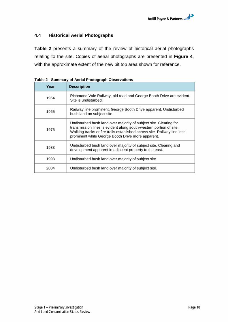
Ardill Payne & Partners
Stage 1 – Preliminary Investigation Page 10 And Land Contamination Status Review
4.4 Historical Aerial Photographs
Table 2 presents a summary of the review of historical aerial photographs
relating to the site. Copies of aerial photographs are presented in Figure 4,
with the approximate extent of the new pit top area shown for reference.
Table 2 - Summary of Aerial Photograph Observations
Year Description
1954 Richmond Vale Railway, old road and George Booth Drive are evident. Site is undisturbed.
1965 Railway line prominent, George Booth Drive apparent. Undisturbed bush land on subject site.
1975
Undisturbed bush land over majority of subject site. Clearing for transmission lines is evident along south-western portion of site. Walking tracks or fire trails established across site. Railway line less prominent while George Booth Drive more apparent.
1983 Undisturbed bush land over majority of subject site. Clearing and development apparent in adjacent property to the east.
1993 Undisturbed bush land over majority of subject site.
2004 Undisturbed bush land over majority of subject site.

Ardill Payne & Partners
Stage 1 – Preliminary Investigation Page 11 And Land Contamination Status Review
Figure 4 - Historical Aerial Photographs

Ardill Payne & Partners
Stage 1 – Preliminary Investigation Page 12 And Land Contamination Status Review
4.5 Cessnock and Lake Macquarie City Council Records
The subject lot was created on 3rd December, 2010. Its prior title fell under
both Cessnock and Lake Macquarie City Council jurisdiction. Efforts were
made to obtain historical information from both the Cessnock and Lake
Macquarie City Councils however neither Council had any historical
information available for the subject site.
4.6 Historical Railway
To the north of the new pit top, running parallel to George Booth Drive lays
remnants of the heritage listed Richmond Vale Railway line. The main line
running adjacent to the site was opened in 1857 and closed in 1962. The
route of the railway is shown in Figure 5 below.
Figure 5 - NSW Railway Map showing the approximate site location
The alignment can also be seen in the early aerial photographs presented in
Figure 4. As the railway alignment was not on the subject land and is located
down gradient there are no contamination impacts likely on the site from the
historic railway.

Ardill Payne & Partners
Stage 1 – Preliminary Investigation Page 13 And Land Contamination Status Review
4.7 Desktop History Summary
Throughout the 20th Century, the new pit top area has been owned or leased
by various collieries; however the surface has yet to be impacted by mining
works. Land has been compulsorily acquired by the state for the construction
of George Booth Drive. Easements were granted for the construction of a
transmission line in the 1970s and for a pipeline in the late 1980s.
Figure 6 shows transmission lines constructed across the site.
Figure 6 - High Voltage Transmission Line Easement on the Site
No transformers are apparent on transmission lines, thus eliminating the
potential contamination risk posed by polychlorinated biphenyls.
No records have been found or site evidence exists to suggest that any
pipework has been installed on the site in association with the above
referenced pipeline easement.

Ardill Payne & Partners
Stage 1 – Preliminary Investigation Page 14 And Land Contamination Status Review
The desktop site history assessment and nature of the works constructed on
the site suggests that no contaminating activities have been conducted within
the new pit top area.

Ardill Payne & Partners
Stage 1 – Preliminary Investigation Page 15 And Land Contamination Status Review
5 Site Inspection
5.1 Site Inspection
Evan Elford, Principal at APP, undertook a site inspection on 8 August 2011.
A summary of the site inspection observations presented in Table 3.
Table 3 - Summary of Site Inspection Observations
Topography
The site slopes to the north-east and east from a ridge along the
western boundary. Slopes are moderately steep, particularly in the
western corner where they are approximately 10%.
Surface water Surveyors Creek along the eastern boundary of the site.
Observations
Building and household rubbish including tyres, a hot water system,
discarded furniture, sheet plastic, plastic bottles, and concrete
scattered in localised areas. The site is predominated by sclerophyll
forest.
5.2 Access Tracks
A number of access tracks cross the site. These tracks have been used for
construction and maintenance activities on the power lines and for fire control
activities. These access tracks have also provided access to the site for illegal
dumping of rubbish on the site.
5.3 Pipelines
An easement for a water pipeline was identified during the desktop historical
search. However, due to the fact that no other records have been provided
that indicate a pipeline was physically constructed within the property and due
to the lack of any relevant surface features normally associated with pipelines
being observed during the site inspection it is concluded that the water
pipeline was not constructed within the subject lot.
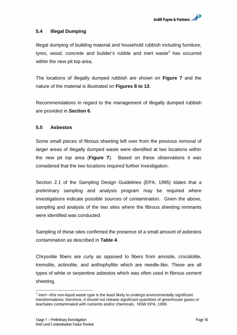
Ardill Payne & Partners
Stage 1 – Preliminary Investigation Page 16 And Land Contamination Status Review
5.4 Illegal Dumping
Illegal dumping of building material and household rubbish including furniture,
tyres, wood, concrete and builder’s rubble and inert waste1 has occurred
within the new pit top area.
The locations of illegally dumped rubbish are shown on Figure 7 and the
nature of the material is illustrated on Figures 8 to 13.
Recommendations in regard to the management of illegally dumped rubbish
are provided in Section 6.
5.5 Asbestos
Some small pieces of fibrous sheeting left over from the previous removal of
larger areas of illegally dumped waste were identified at two locations within
the new pit top area (Figure 7). Based on these observations it was
considered that the two locations required further investigation.
Section 2.1 of the Sampling Design Guidelines (EPA, 1995) states that a
preliminary sampling and analysis program may be required where
investigations indicate possible sources of contamination. Given the above,
sampling and analysis of the two sites where the fibrous sheeting remnants
were identified was conducted.
Sampling of these sites confirmed the presence of a small amount of asbestos
contamination as described in Table 4.
Chrysotile fibers are curly as opposed to fibers from amosite, crocidolite,
tremolite, actinolite, and anthophyllite which are needle-like. These are all
types of white or serpentine asbestos which was often used in fibrous cement
sheeting.
1 inert—this non-liquid waste type is the least likely to undergo environmentally significant transformations; therefore, it should not release significant quantities of greenhouse gases or leachates contaminated with nutrients and/or chemicals. NSW EPA, 1999.
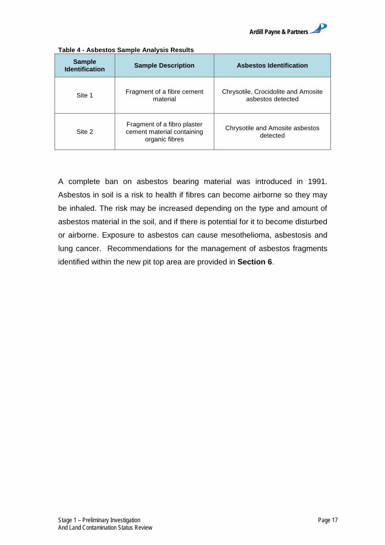
Ardill Payne & Partners
Stage 1 – Preliminary Investigation Page 17 And Land Contamination Status Review
Table 4 - Asbestos Sample Analysis Results
Sample Identification Sample Description Asbestos Identification
Site 1 Fragment of a fibre cement material
Chrysotile, Crocidolite and Amosite asbestos detected
Site 2 Fragment of a fibro plaster cement material containing
organic fibres
Chrysotile and Amosite asbestos detected
A complete ban on asbestos bearing material was introduced in 1991.
Asbestos in soil is a risk to health if fibres can become airborne so they may
be inhaled. The risk may be increased depending on the type and amount of
asbestos material in the soil, and if there is potential for it to become disturbed
or airborne. Exposure to asbestos can cause mesothelioma, asbestosis and
lung cancer. Recommendations for the management of asbestos fragments
identified within the new pit top area are provided in Section 6.


Ardill Payne & Partners
Stage 1 – Preliminary Investigation Page 19 And Land Contamination Status Review
Figure 8 - Dumped Hot Water System
Figure 9 - Dumped Furniture

Ardill Payne & Partners
Stage 1 – Preliminary Investigation Page 20 And Land Contamination Status Review
Figure 10 - Dumped Tyres and Wood
Figure 11 - Dumped Concrete and Rubble

Ardill Payne & Partners
Stage 1 – Preliminary Investigation Page 21 And Land Contamination Status Review
Figure 12 - Inert Waste
Figure 13 - Plastic Waste

Ardill Payne & Partners
Stage 1 – Preliminary Investigation Page 22 And Land Contamination Status Review
5.6 Fire
There is visual evidence that the site has at some time in the past been
impacted by bush fire as shown in Figure 14. Land impacted by bush fire is
not deemed to be "Contaminated land" as the Contaminated Land
Management Act, 1997 refers to contaminated land as land where a
substance is present at a concentration higher than is normally found on land
in the same area, where that substance presents a risk of harm to human
health or the environment. Fires are a natural phenomenon impacting all land
in the area. The concentration of fire by-products on this land would not be
any higher than the surrounding area.
Figure 14 - Evidence of Bush Fire

Ardill Payne & Partners
Stage 1 – Preliminary Investigation Page 23 And Land Contamination Status Review
5.7 Surrounding Land Use
The subject land is situated in bushland and is bisected by existing overhead
transmission lines and their associated easements. The broader locality is
predominantly bushland and various mining operations including underground
mining.
As a consequence of the natural bushland buffers between the site and other
land use activities it is not expected that any contamination of the site has
occurred as a consequence of previous mining or industrial activity in the
area.

Ardill Payne & Partners
Stage 1 – Preliminary Investigation Page 24 And Land Contamination Status Review
6 Remediation
6.1 Remediation of Illegal Dumping
Two sites containing asbestos were identified during the site inspection
(Figure 7) with the balance of the waste identified as inert solid waste.
The source of this refuse is considered to be illegal dumping by unknown
parties. The degree and extent is principally located adjacent to tracks which
transect the site. Some of the refuse appears to have been in place for a
number of years. The refuse is unsightly and should be removed prior to
development of the site, however does not preclude the use of the land for the
proposed purposes. It is not deemed a threat to neighbouring properties as it
cannot migrate off site. This material should be removed by a suitable
contractor to an approved landfill location.
Asbestos was the only contaminant of concern identified with potential to
harm humans and/or the environment. However, due to the small amount of
material located (as the majority of the waste has already been removed)
there is a low risk of exposure to asbestos fibres on site.
6.2 Duty to Report Contamination
The Contaminated Land Management Act, 1997 requires people to notify the
Environment Protection Authority (EPA) of land which is contaminated. The
obligation only arises if:
the contamination might enter neighboring land, the atmosphere,
groundwater or surface water; and
the level of contamination is likely to be above the level prescribed in
the Guidelines.
Ardill Payne & Partners
Stage 1 – Preliminary Investigation Page 25 And Land Contamination Status Review
The Guideline on Investigation Levels for Soil and Groundwater
(Schedule B(1) to the NEPM) does not specify a numeric Health Investigation
Level for asbestos in soils because it is difficult to establish a relationship
between soil levels and airborne levels of asbestos. However, Schedule (7a)
of the NEPM, which provides information on the derivation of the Health
Investigation Levels, concludes that for asbestos “appropriate site-specific
measures at a site are warranted if there are sufficient concerns based on site
conditions and the nature of the asbestos.”
Five jurisdictions (South Australia, NSW, Victoria, Northern Territory and
Queensland) use the Health Investigation Levels specified in the NEPM to at
least some extent to determine whether or not a site is considered to be
contaminated and hence whether reporting and remediation requirements
apply. As there is no numeric Health Investigation Level for asbestos, the
obligation to report asbestos contamination in these jurisdictions has to be
decided on a case by case basis, taking into account the type and amount of
asbestos.
It is considered that due to the nature and extent and the ease of containment
and clean-up of the asbestos fragments, it is not necessary to report the
contamination to the EPA.
6.3 Category 2 Remediation Requirements
The Contaminated Land Management Act, 1997 refers to remediation as the
process of addressing contamination by removing, dispersing, destroying,
reducing or mitigating the contamination of a piece of land.
SEPP 55 provides remediation options for various land contamination
situations. It is considered that the Category 2 remediation work defined in
SEPP 55 may be conducted without consent, provided the relevant conditions
are met, to remediate the identified asbestos contaminated land within the
new pit top area.

Ardill Payne & Partners
Stage 1 – Preliminary Investigation Page 26 And Land Contamination Status Review
In this regard, the small amount of asbestos contamination identified at the
new pit top area should be remediated in accordance with the SEPP 55
Category 2 remediation work, i.e. the council should be given notice in writing
that the waste material is to be removed from the site by a licensed
demolition/refuse contractor and be disposed of in a licensed landfill.
Ardill Payne & Partners
Stage 1 – Preliminary Investigation Page 27 And Land Contamination Status Review
7 Conclusions
The objective of this Land Contamination Assessment was to determine if the
new pit top area has been contaminated from current or past land usage. To
determine the type of contaminants that may have been present on site, a
desktop site history assessment and site inspection were undertaken.
The use proposed for the subject land is surface workings for an underground
extractive industry.
The property has been shaped by the provision of infrastructure to nearby
towns from power lines and roads bounding the site. No contaminating
activities were identified from the provision of infrastructure or easements.
No contaminating activities were identified during the desktop assessment.
During a site inspection, various pockets of illegally dumped material were
identified and mapped on the site. Small fragments of fibrous sheeting
material were located at two sites within the new pit top area (evidently part of
larger waste dumps which have been removed from the site), with laboratory
analysis confirming the presence of Chrysotile, Crocidolite and Amosite
asbestos. It is considered that these two small areas of contamination can be
remediated, and no further investigation is required.
Based on the Stage 1 – Preliminary Investigation for the Project in accordance
with the Managing Land Contamination Planning Guidelines (DUAP and EPA,
1998), there is no evidence that the area within MLA 426 is contaminated
outside of the small area of asbestos contamination identified during the site
inspection.
Ardill Payne & Partners
Stage 1 – Preliminary Investigation Page 28 And Land Contamination Status Review
Based on the above assessment it is considered that further investigation is
not required and the new pit top area within MLA 426 is suitable for the
proposed development (i.e. the Project) once the small area of contamination
described above is remediated.
Notwithstanding the above, in the event that an area of potential land
contamination is identified during the Project work in that immediate area would
cease and the area made safe. The unexpected contamination would be
assessed by a suitably qualified person and remediation strategies put in place to
manage this contamination if necessary after approval by the appropriate
authority.
The land contamination assessment would be undertaken in accordance with
the relevant guidelines (including guidelines under section 145C of the NSW
Environmental Planning and Assessment Act, 1979 and the NSW
Contaminated Land Management Act, 1997).

Ardill Payne & Partners
Stage 1 – Preliminary Investigation Page 29 And Land Contamination Status Review
8 Scope of Engagement
This report has been prepared by APP at the request of Donaldson Coal for
the purpose of preliminarily assessing the potential for contamination on the
subject site and is not to be used for any other purpose or by any other person
or corporation.
This report has been prepared from the information provided to us and from
other information obtained as a result of enquiries made by us. APP accepts
no responsibility for any loss or damage suffered howsoever arising to any
person or corporation who may use or rely on this document for a purpose
other than that described above.
No part of this report may be reproduced, stored or transmitted in any form
without the prior consent of APP.
APP declares that it does not have, nor expects to have, a beneficial interest
in the subject project.
To avoid this advice being used inappropriately it is recommended that you
consult with APP before conveying the information to another who may not
fully understand the objectives of the report. This report is meant only for the
subject site/project and should not be applied to any other.

Ardill Payne & Partners
Stage 1 – Preliminary Investigation Page 30 And Land Contamination Status Review
9 References
Ardill Payne and Partners (2012a). Land Contamination Assessment Stage 1
– Preliminary Investigation and Land Contamination Status Review
Development Application Area –Tasman Extension Project.
Ardill Payne and Partners (2012b). Land Contamination Assessment Stage 1
– Preliminary Investigation and Land Contamination Status Review
Existing Pit Top Area.
Australian and New Zealand Environment and Conservation Council and
National Health and Medical Research Council (1992). Australian and
New Zealand Guidelines for the Assessment and Management of
Contaminated Sites. Australian and New Zealand Environment and
Conservation Council and National Health and Medical Research
Council, 57 p.
Cessnock City Council. Local Environment Plan 1989.
Cessnock City Council. Local Environment Plan 2011.
Department of Urban Affairs and Planning and the Environmental Protection
Authority (1998). Managing Land Contamination, Planning Guidelines
SEPP 55 – Remediation of Land.
Environmental Protection Authority (1995) Contaminated Sites Sampling Design Guidelines.
Environmental Protection Authority (1999) Environmental Guidelines: Assessment, Classification & Management of Liquid & Non-liquid Wastes.
Maxim Archaeology and Heritage (2012) Historical Archaeology – Tasman
Underground Mine: Tasman Extension Project.

Ardill Payne & Partners
Stage 1 – Preliminary Investigation Page 31 And Land Contamination Status Review
10 Glossary
APP – Ardill Payne and Partners
DAA – Development Application Area
DP – Deposited Plan
EIS – Environmental Impact Statement
EPA – Environment Protection Authority (now known as Department of Environment & Climate Change and / or the Office of Environment & Heritage)
km - kilometres
LPI – Land and Property Information (NSW Department of)
ML - Mining Lease
MLA – Mining Lease Application
NSW – New South Wales
OEH – Office of Environment & Heritage
POEO – Protection of Environment Operations
ROM – Run-of-mine
SEPP 55 - State Environmental Planning Policy No. 55 – Remediation of Land

ATTACHMENT 3
Attachment 3 Section 149 Certificates

126-138 Main Road Speers Point NSW 2284 Box 1906 Hunter Region Mail Centre NSW 2310 Phone: 02 4921 0333 Fax: 02 4958 7257 ABN 81 065 027 868
[email protected] www.lakemac.com.au
27 February 2012
ARDILL PAYNE AND PARTNERS 79 Tamar St BALLINA NSW 2478
Our Ref:70384 Your Ref: 7247:4684 ABN 81 065 027 868
SECTION 149 PLANNING CERTIFICATE
ENVIRONMENTAL PLANNING AND ASSESSMENT ACT, 1979
Fee Paid: 133.00
Receipt No: 6841367
Receipt Date: 24 February 2012
DESCRIPTION OF LAND Address: 1 First Street, WEST WALLSEND NSW 2286
Lot Details: Lot 2 DP 1050996
Parish: Teralba
County: Northumberland
For: BRIAN BELL GENERAL MANAGER

Certificate No. 70384
LMCC Page 2 of 48
ADVICE PROVIDED IN ACCORDANCE WITH SECTION 149(2) 1 Names of Relevant Planning Instruments and Development Control Plans
(1) The name of each environmental planning instrument that applies to the carrying out of development on the land.
Lake Macquarie Local Environmental Plan 2004
State Environmental Planning Policy - (Housing for Seniors or People with a Disability) 2004 (This SEPP applies to the land to the extent provided by Clause 4 of the SEPP)
State Environmental Planning Policy (Affordable Rental Housing) 2009
State Environmental Planning Policy (Building Sustainability Index: BASIX) 2004
State Environmental Planning Policy (Exempt and Complying Development Codes) 2008
State Environmental Planning Policy (Infrastructure) 2007
State Environmental Planning Policy (Major Development) 2005
State Environmental Planning Policy (Mining, Petroleum Production and Extractive Industries) 2007
State Environmental Planning Policy (State and Regional Development) 2011
State Environmental Planning Policy (Temporary Structures) 2007
State Environmental Planning Policy No. 1 – Development Standards
State Environmental Planning Policy No. 4 – Development without Consent and Miscellaneous Exempt and Complying Development (except Clause 6-10)
State Environmental Planning Policy No. 6 – Number of Storeys in a Building
State Environmental Planning Policy No. 15 – Rural Landsharing Communities
State Environmental Planning Policy No. 19 – Bushland in Urban Areas
State Environmental Planning Policy No. 21 – Caravan Parks
State Environmental Planning Policy No. 30 – Intensive Agriculture
State Environmental Planning Policy No. 33 – Hazardous and Offensive Development
State Environmental Planning Policy No. 36 – Manufactured Homes Estates (except as maybe excluded by Clause 6 of the SEPP)
State Environmental Planning Policy No. 44 – Koala Habitat Protection
State Environmental Planning Policy No. 50 – Canal Estate Development
State Environmental Planning Policy No. 55 – Remediation of Land

Certificate No. 70384
LMCC Page 3 of 48
State Environmental Planning Policy No. 62 - Sustainable Aquaculture
State Environmental Planning Policy No. 64 – Advertising and Signage
(2) The name of each proposed environmental planning instrument that will apply to the carrying out of development on the land and that is or has been the subject of community consultation or on public exhibition under the Act (unless the Director-General has notified the council that the making of the proposed instrument has been deferred indefinitely or has not been approved).
Draft State Environmental Planning Policy No. 1 - Development Standards (Amendment No. 1)
Draft State Environmental Planning Policy No. 66 – Integration of Land Use and Transport
Draft State Environmental Planning Policy (Application of Development Standard) 2004
(3) The name of each development control plan that applies to the carrying out of development on the land.
Development Control Plan No. 1 – Principles of Development
Development Control Plan No. 2 – Complying Development
(4) In this clause, proposed environmental planning instrument includes a planning
proposal for a Local Environmental Plan or a Draft environmental planning instrument.
2 Zoning and land use under relevant Local Environmental Plans
(1) The following answers (a) to (h) relate to the instrument (see 1(1) above).
(a) The identity of the zone applying to the land.
1(1) Rural (Production)
7(2) Conservation (Secondary)
7(3) Environment (General)
(b) The purposes for which the Instrument provides that development may be carried out within the zone without the need for development consent.
Specified in Attachment A
(c) The purposes for which the Instrument provides that development may not be carried out within the zone except with development consent.
Specified in Attachment A

Certificate No. 70384
LMCC Page 4 of 48
(d) The purposes for which the Instrument provides that development is prohibited within the zone.
Specified in Attachment A
NOTE: The advice in sections (b), (c), and (d) above relates only to restrictions that apply by virtue of the zones indicated. The Lake Macquarie LEP 2004 includes additional provisions that require development consent for particular types of development, or in particular circumstances, irrespective of zoning.
(e) Whether any development standards applying to the land fix minimum land dimensions for the erection of a dwelling-house on the land and, if so, the minimum land dimensions so fixed.
Specified in Attachment C - Schedule 2.
(f) Whether the land includes or comprises critical habitat.
No
(g) Whether the land is in a conservation area (however described).
Yes
(h) Whether an item of environmental heritage (however described) is situated on the land.
See Attachment D - Schedules 4, 5 and 6
An item of environmental heritage, namely Aboriginal heritage, listed within the Aboriginal Heritage Information Management System, may affect the land. The applicant should contact the Department of Environment and Climate Change for more information.
(2) The following answers (a) to (h) relate to the Draft Instrument (see 1(2) above).
(a) The identity of the zone applying to the land.
Nil
(b) The purposes for which the Draft Instrument provides that development may be carried out within the zone without the need for development consent.
Specified in Attachment A
(c) The purposes for which the Draft Instrument provides that development may not be carried out within the zone except with development consent.
Specified in Attachment A

Certificate No. 70384
LMCC Page 5 of 48
(d) The purposes for which the Draft Instrument provides that development is prohibited within the zone.
Specified in Attachment A
NOTE: The advice in sections (b), (c), and (d) above relates only to restrictions that apply by virtue of the zones indicated. The Lake Macquarie LEP 2004 includes additional provisions that require development consent for particular types of development, or in particular circumstances, irrespective of zoning.
(e) Whether any development standards applying to the land fix minimum land dimensions for the erection of a dwelling-house on the land and, if so, the minimum land dimensions so fixed.
Specified in Attachment C - Schedule 2.
(f) Whether the land includes or comprises critical habitat.
No
(g) Whether the land is in a conservation area (however described).
No
(h) Whether an item of environmental heritage (however described) is situated on the land.
No
An item of environmental heritage, namely Aboriginal heritage, listed within the Aboriginal Heritage Information Management System, may affect the land. The applicant should contact the Department of Environment and Climate Change for more information.
3 Complying development
Whether or not the land is land on which complying development may be carried out under each of the codes for complying development because of the provisions of clause 1.19 of State Environmental Planning Policy (Exempt and Complying Development Codes) 2008.
General Housing Code
Complying development under the General Housing Code MAY NOT be carried out on the land because the land is affected by specific land exemptions. Note: If the land is only affected by the “heritage conservation area” exemption, then complying development under the General Housing Code MAY be carried out on the land if the development is a detached outbuilding or swimming pool. The land is affected by the following specific land exemptions:

Certificate No. 70384
LMCC Page 6 of 48
The land contains a heritage item or a draft heritage item.
The land is within an environmentally sensitive area being land within an area of high aboriginal cultural significance.
The land is excluded land being land identified by an environmental planning instrument as being environmentally sensitive or within an ecologically sensitive area.
Housing Alterations Code
Complying development under the Housing Internal Alterations Code MAY NOT be carried out on the land. The land is affected by the following specific land exemptions:
The land contains a heritage item or a draft heritage item.
The land is within an environmentally sensitive area being land within an area of high aboriginal cultural significance.
General Commercial and Industrial Code
Complying development under the General Commercial and Industrial Code MAY NOT be carried out on the land. The land is affected by the following specific land exemptions:
The land contains a heritage item or a draft heritage item.
The land is within an environmentally sensitive area being land within an area of high aboriginal cultural significance.
Subdivisions Code
Complying development under the Subdivisions Code MAY NOT be carried out on the land. The land is affected by the following specific land exemptions:
The land contains a heritage item or a draft heritage item.
The land is within an environmentally sensitive area being land within an area of high aboriginal cultural significance.
Rural Housing Code
Complying development under the Rural Housing Code MAY NOT be carried out on the land unless complying development is carried out on the part of the lot to which clause 1.19 of State Environmental Planning Policy (Exempt and Complying Development Codes) 2008 does not apply. Note: If the land is only affected by the “heritage conservation area” exemption, then complying development under the Rural Housing Code MAY be carried out on the land if the development is a detached outbuilding or swimming pool.
The land is affected by the following specific land exemptions:
The land contains a heritage item or a draft heritage item.

Certificate No. 70384
LMCC Page 7 of 48
The land is within an environmentally sensitive area being land within an area of high aboriginal cultural significance.
The land is excluded land being land identified by an environmental planning instrument as being environmentally sensitive or within an ecologically sensitive area.
General Development Code
Complying development under the General Development Code MAY NOT be carried out on the land. The land is affected by the following specific land exemptions:
The land contains a heritage item or a draft heritage item.
The land is within an environmentally sensitive area being land within an area of high aboriginal cultural significance.
Demolition Code
Complying development under the Demolition Code MAY NOT be carried out on the land. The land is affected by the following specific land exemptions:
The land contains a heritage item or a draft heritage item.
The land is within an environmentally sensitive area being land within an area of high aboriginal cultural significance.
4 Coastal Protection
Whether or not the land is affected by the operation of section 38 or 39 of the Coastal Protection Act 1979, but only to the extent that the Council has been so notified by the Department of Public Works.
No
4A Information relating to beaches and coasts
1 Whether an order has been made under Part 4D of the Coastal Protection Act 1979 in relation to emergency coastal protection works (within the meaning of that Act) on the land (or on public land adjacent to that land), except where the council is satisfied that such an order has been fully complied with.
Nil
2 (a) Whether the council has been notified under section 55X of the Coastal Protection Act 1979 that emergency coastal protection works (within the meaning of that Act) have been placed on the land (or on public land adjacent to that land)
Nil

Certificate No. 70384
LMCC Page 8 of 48
(b) If works have been so placed — whether the council is satisfied that the works have been removed and the land restored in accordance with that Act.
Nil
3 such information (if any) as is required by the regulations under section 56B of the Coastal Protection Act 1979 to be included in the planning certificate and of which the council has been notified pursuant to those regulations.
Nil
4B Annual charges under Local Government Act 1993 for coastal protection services that relate to existing coastal protection works
Whether the owner (or any previous owner) of the land has consented in writing to the land being subject to annual charges under section 496B of the Local Government Act 1993 for coastal protection services that relate to existing coastal protection works (within the meaning of section 553B of that Act).
Nil
NOTE: “Existing coastal protection works” are works to reduce the impact of coastal hazards on land (such as seawalls, revetments, groynes and beach nourishment) that existed before the commencement of section 553B of the Local Government Act 1993.
5 Mine subsidence
Whether or not the land is proclaimed to be a mine subsidence district within the meaning of section 15 of the Mine Subsidence Compensation Act 1961.
The land is within a proclaimed Mine Subsidence District under the Mine Subsidence Compensation Act 1961. The approval of the Mines Subsidence Board is required for all subdivision and building, except for certain minor structures. Surface development controls are in place to prevent damage from old, current, or future mining. It is strongly recommended prospective purchasers consult with the Mine Subsidence Board regarding mine subsidence and any surface development guidelines. The Board can assist with information, mine subsidence, and advise whether existing structures comply with the requirements of the Act.
6 Road widening and road realignment
Whether the land is affected by any road widening or realignment under:
(a) Division 2 of Part 3 of the Roads Act 1993.
No

Certificate No. 70384
LMCC Page 9 of 48
(b) any environmental planning instrument.
No
(c) any resolution of the Council.
No, other road widening proposals may affect this land and if so, will be noted on the SECTION 149(5) certificate.
7 Council and other public authority policies on hazard risk restrictions
Whether or not the land is affected by a policy:
(i) adopted by the Council, or
(ii) adopted by any other public authority and notified to the Council for the express purpose of its adoption by that authority being referred to in planning certificates issued by the Council,
that restricts the development of the land because of the likelihood of:
(a) land slip or subsidence
Yes
All land within the Lake Macquarie City Council area is divided into geotechnical zones, and section 2.1.9 Sloping Land and Soils, in DCP No.1, applies when development of land is proposed. If you require any further clarification on the policy and how it may affect any possible development applications contact the Council on 02 4921 0333.
(b) bushfire
Yes
(c) tidal inundation
No
(d) acid sulfate soils
Yes if indicated on the Acid Sulfate Soils Planning Maps supplied by The Department of Land & Water Conservation marked Edition 2, dated December 1997, available at the Council.
(e) any other risk (other than flooding).
Yes, as outlined below:

Certificate No. 70384
LMCC Page 10 of 48
Contaminated or potentially contaminated land that has undergone some form of remediation or abatement
The land is listed in Council’s Register of Contaminated or Potentially Contaminated land and Council records indicate that some form of remediation or abatement has occurred on the land. Council has adopted a policy on contaminated land. Consideration of Council’s adopted Policy located in DCP No.1 (section 2.1.13 Contaminated Land), and the application of provisions under relevant State legislation is recommended.
NOTE: The absence of a council policy restricting development of the land
by reason of a particular natural hazard does not mean that the risk from that hazard is non-existent.
7A Flood related development controls information
(1) Whether or not development on that land or part of the land for the purposes of dwelling houses, dual occupancies, multi dwelling housing or residential flat buildings (not including development for the purposes of group homes or seniors housing) is subject to flood related development controls.
Yes
(2) Whether or not development on that land or part of the land for any other purpose is subject to flood related development controls.
Yes
(3) Words and expressions in this clause have the same meanings as in the instrument set out in the Schedule to the Standard Instrument (Local Environmental Plans) Order 2006.
ADVICE: Further information on the development restriction mentioned, may be obtained from Council upon application for a “Development Restriction Certificate – Flooding/Tidal Inundation.”
8 Land reserved for acquisition
Whether or not any environmental planning instrument or proposed environmental planning instrument referred to in Clause 1 makes provision in relation to the acquisition of the land by a public authority, as referred to in section 27 of the Act.
No

Certificate No. 70384
LMCC Page 11 of 48
9 Contributions Plans
The name of each contributions plan applying to the land.
The Lake Macquarie Section 94 Contributions Plan No.1 - Citywide - Glendale Catchment (2004) as amended
10 Biobanking Agreements
This land is not subject to a Biobanking agreement entered under Part 7A of the Threatened Species Conservation Act 1995.
11 Bush Fire Prone Land
ALL of the land is bush fire prone land.
NOTE: The Lake Macquarie Bush Fire Prone Land Map can be inspected at Council's Administration Building during normal office hours or contact Council on 02 4921 0333.
12 Property Vegetation Plans
The land IS NOT subject to a property vegetation plan under the Native Vegetation Act 2003.
NOTE: The advice provided in this section is based on notification by the Hunter Central Rivers Catchment Management Authority of the approval of a plan. Further information about property vegetation plans should be obtained from that Authority.
13 Orders under Trees (Disputes Between Neighbours) Act 2006
Has an order been made under the Trees (Disputes Between Neighbours) Act 2006 to carry out work in relation to a tree on the land (but only if the council has been notified of the order).
The land IS NOT subject to an order made under the Trees (Disputes Between Neighbours) Act 2006 to carry out work in relation to a tree on the land.
14 Directions under Part 3A
If there is a direction by the Minister in force under section 75P (2) (c1) of the Act that a provision of an environmental planning instrument prohibiting or restricting the carrying out of a project or a stage of a project on the land under Part 4 of the Act does not have effect, a statement to that effect identifying the provision that does not have effect.
Nil

Certificate No. 70384
LMCC Page 12 of 48
15 Site compatibility certificates and conditions for seniors housing
(a) Whether there is a current site compatibility certificate (seniors housing), of which the council is aware, in respect of proposed development on the land.
Council is not aware of any site capability certificate for any proposed development on the land.
(b) Any terms of a kind referred to in clause 18 (2) of State Environmental Planning Policy (Housing for Seniors or People with a Disability) 2004 that have been imposed as a condition of consent to a development application granted after 11 October 2007 in respect of the land.
Nil
16 Site compatibility certificates for infrastructure
Whether there is a valid site compatibility certificate (infrastructure), of which the council is aware, in respect of proposed development on the land.
Council is not aware of any site capability certificate for any proposed development on the land.
17 Site compatibility certificates and conditions for affordable rental housing
(1) Whether there is a current site compatibility certificate (affordable rental housing), of which the council is aware, in respect of proposed development on the land.
Council is not aware of any site capability certificate for any proposed development on the land.
(2) Any terms of a kind referred to in clause 17 (1) or 38 (1) of State Environmental Planning Policy (Affordable Rental Housing) 2009 that have been imposed as a condition of consent to a development application in respect of the land.
Nil
NOTE: The following matters are prescribed by section 59 (2) of the
Contaminated Land Management Act 1997 as additional matters to be specified in a planning certificate:
Matters arising under the Contaminated Land Management Act 1997 (s59 (2))
(a) The land to which the certificate relates is significantly contaminated land within the meaning of that Act - if the land (or part of the land) is significantly contaminated land at the date when the certificate is issued,
No

Certificate No. 70384
LMCC Page 13 of 48
(b) The land to which the certificate relates is subject to a management order within the meaning of that Act - if it is subject to such an order at the date when the certificate is issued,
No
(c) The land to which the certificate relates is the subject of an approved voluntary management proposal within the meaning of that Act - if it is the subject of such an approved proposal at the date when the certificate is issued,
No
(d) The land to which the certificate relates is subject to an ongoing maintenance order within the meaning of that Act - if it is subject to such an order at the date when the certificate is issued,
No
(e) The land to which the certificate relates is the subject of a site audit statement within the meaning of that Act - if a copy of such a statement has been provided at any time to the local authority issuing the certificate.
Yes
NOTE: Section 26 of the Nation Building and Jobs Plan (State Infrastructure
Delivery) Act 2009 provides that a planning certificate must include advice about any exemption under section 23 or authorisation under section 24 of the Act if the council is provided with a copy of the exemption or authorisation by the Co-ordinator General under that Act.
Nation Building and Jobs Plan (State Infrastructure Delivery) Act 2009
Council has not been provided with an exemption or authorisation by the Co-ordinator General under the Act.

Certificate No. 70384
LMCC Page 14 of 48
ADVICE PROVIDED IN ACCORDANCE WITH SECTION 149(5)
NOTE: SECTION 149(6) OF THE ACT STATES THAT A COUNCIL SHALL NOT INCUR ANY LIABILITY IN RESPECT OF ANY ADVICE PROVIDED IN GOOD FAITH PURSUANT TO SECTION 149(5).
18 Clearing and lopping of trees
The land IS AFFECTED by Clause 34 – Trees and Native Vegetation, Lake Macquarie Local Environmental Plan 2004. Consent must be obtained to clear any tree or native vegetation in accordance with this clause. Please contact the Council for further information.
19 Easements
The land is NOT affected by a proposed easement in favour of Lake Macquarie City Council.
As to affectation by existing easements, a search of the relevant Title of the land should be undertaken.
20 Outstanding Notices
The land is NOT AFFECTED by an outstanding notice.
The information provided in this part of the certificate is not exhaustive. The recipient may seek additional information relating to the land by making a further inquiry to Council.
21 Earthquake
An earthquake was experienced throughout most of the city area on 28/12/89. Prospective purchasers should make their own enquiries as to whether buildings/structures on the land sustained any structural damage.
22 Lifestyle 2020
Council has prepared a strategy to provide direction for future land use planning, urban design and development of the City until the year 2020. A copy of "Lifestyle 2020 - A Strategy for Our Future" is available from Council.
Certificate No. 70384
LMCC Page 15 of 48
23 New South Wales Government Coastal Policy, 1997.
The NSW Coastal Policy 1997 applies to the land and development located within the Coastal Zone as depicted on a Map signed by the Minister for Natural Resources. The Coastal Zone generally extends one kilometre inland from the Lake shore and one kilometre inland from the Coast and includes the whole Wallarah Peninsula. The Environmental Planning and Assessment Act requires Consent Authorities to take the Coastal Policy into consideration when determining Development Applications for affected land.
24 Sustainable Water Cycle Management.
The Lake Macquarie Local Environmental Plan 2004 advocates the principles and practice of Water Smart and Water Sensitive Urban Design philosophies. It includes the handling of water and water resources in a manner that considers the whole of the hydrological process. This includes the quality and quantity of the resource from its various source/s and its use and transport in the natural and built environment.
25 Voluntary Planning Agreement
The land is not affected by a Voluntary Planning Agreement.
26 Natural Watercourse
The land is affected by a natural watercourse.
ATTACHMENTS:
A Extract from Lake Macquarie Local Environmental Plan, 2004 – Clause 15 B Extract from Lake Macquarie Local Environmental Plan, 2004 – Schedule 1 C Extract from Lake Macquarie Local Environmental Plan, 2004 – Schedule 2 D Extract from Lake Macquarie Local Environmental Plan, 2004 – Schedules 4, 5 & 6 E Site Audit Statement F Lake Macquarie Local Environmental Plan, 2004 – Zoning map
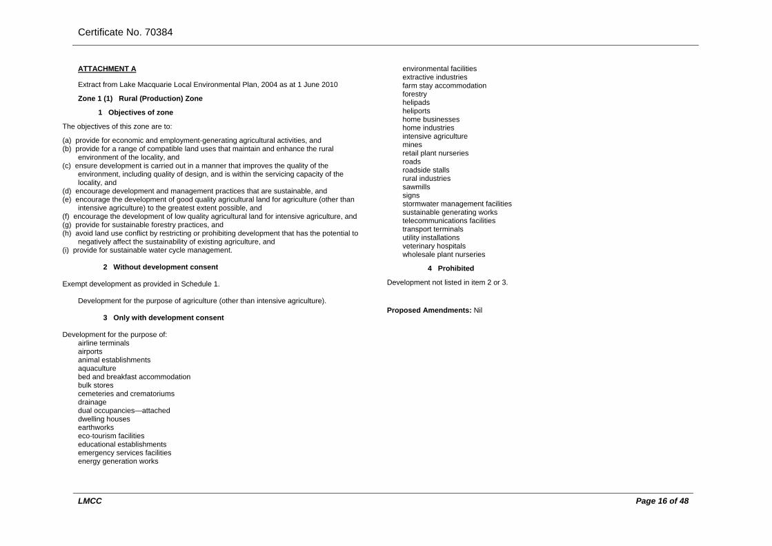
Certificate No. 70384
LMCC Page 16 of 48
ATTACHMENT A
Extract from Lake Macquarie Local Environmental Plan, 2004 as at 1 June 2010
Zone 1 (1) Rural (Production) Zone
1 Objectives of zone
The objectives of this zone are to:
(a) provide for economic and employment-generating agricultural activities, and (b) provide for a range of compatible land uses that maintain and enhance the rural
environment of the locality, and (c) ensure development is carried out in a manner that improves the quality of the
environment, including quality of design, and is within the servicing capacity of the locality, and
(d) encourage development and management practices that are sustainable, and (e) encourage the development of good quality agricultural land for agriculture (other than
intensive agriculture) to the greatest extent possible, and (f) encourage the development of low quality agricultural land for intensive agriculture, and (g) provide for sustainable forestry practices, and (h) avoid land use conflict by restricting or prohibiting development that has the potential to
negatively affect the sustainability of existing agriculture, and (i) provide for sustainable water cycle management.
2 Without development consent Exempt development as provided in Schedule 1.
Development for the purpose of agriculture (other than intensive agriculture).
3 Only with development consent
Development for the purpose of:
airline terminals airports animal establishments aquaculture bed and breakfast accommodation bulk stores cemeteries and crematoriums drainage dual occupancies—attached dwelling houses earthworks eco-tourism facilities educational establishments emergency services facilities energy generation works
environmental facilities extractive industries farm stay accommodation forestry helipads heliports home businesses home industries intensive agriculture mines retail plant nurseries roads roadside stalls rural industries sawmills signs stormwater management facilities sustainable generating works telecommunications facilities transport terminals utility installations veterinary hospitals wholesale plant nurseries
4 Prohibited
Development not listed in item 2 or 3.
Proposed Amendments: Nil
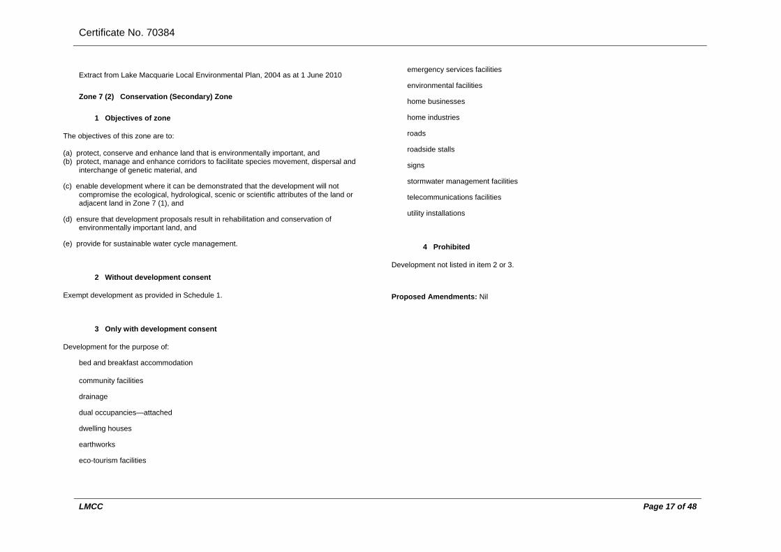
Certificate No. 70384
LMCC Page 17 of 48
Extract from Lake Macquarie Local Environmental Plan, 2004 as at 1 June 2010
Zone 7 (2) Conservation (Secondary) Zone
1 Objectives of zone
The objectives of this zone are to: (a) protect, conserve and enhance land that is environmentally important, and (b) protect, manage and enhance corridors to facilitate species movement, dispersal and
interchange of genetic material, and
(c) enable development where it can be demonstrated that the development will not compromise the ecological, hydrological, scenic or scientific attributes of the land or adjacent land in Zone 7 (1), and
(d) ensure that development proposals result in rehabilitation and conservation of environmentally important land, and
(e) provide for sustainable water cycle management.
2 Without development consent
Exempt development as provided in Schedule 1.
3 Only with development consent
Development for the purpose of:
bed and breakfast accommodation
community facilities
drainage
dual occupancies—attached
dwelling houses
earthworks
eco-tourism facilities
emergency services facilities
environmental facilities
home businesses
home industries
roads
roadside stalls
signs
stormwater management facilities
telecommunications facilities
utility installations
4 Prohibited
Development not listed in item 2 or 3.
Proposed Amendments: Nil

Certificate No. 70384
LMCC Page 18 of 48
Extract from Lake Macquarie Local Environmental Plan, 2004 as at 1 June 2010
Zone 7 (3) Environmental (General) Zone
1 Objectives of zone
The objectives of this zone are to: (a) maintain and enhance biodiversity, scenic quality and native riparian vegetation and
habitat, and (b) protect, manage and enhance corridors to facilitate species movement, dispersal and
interchange of genetic material, and
(c) ensure that development and land management practices do not have an adverse effect on water quality, land surface conditions and important ecosystems such as waterbodies, waterways, wetlands and rainforests, and
(d) protect and enhance natural, rural and heritage landscapes, and
(e) provide for sustainable water cycle management, and
(f) encourage rehabilitation and conservation of environmentally important land.
2 Without development consent
Exempt development as provided in Schedule 1.
3 Only with development consent
Development for the purpose of:
agriculture (other than intensive agriculture)
bed and breakfast accommodation
community facilities
drainage
dual occupancies—attached
dwelling houses
earthworks
eco-tourism facilities
educational establishments
emergency services facilities
environmental facilities
forestry
home businesses
home industries
places of public worship
retail plant nurseries
roads
roadside stalls
signs
stormwater management facilities
telecommunications facilities
utility installations
4 Prohibited
Development not listed in item 2 or 3.
Proposed Amendments: Nil

Certificate No. 70384
LMCC Page 19 of 48
ATTACHMENT B
Extract from Lake Macquarie Local Environmental Plan, 2004 as at 15 June 2011
Schedule 1 Exempt development (Clause 8)
Note 1. State Environmental Planning Policy (Exempt and Complying Development Codes) 2008 specifies exempt development under that Policy.
The Policy has State-wide application. Schedule 1 contains additional exempt development not specified in that Policy.
Note 2. Exempt development may be carried out without the need for development consent under the Act. Such development is not exempt from any approval, licence, permit or authority that is required under any other Act and adjoining owners’ property rights and the common law still apply.
1 What is exempt development?
(1) Development is exempt development if: (a) it is described in Column 1 of the Table to this Schedule, and (b) it is carried out within a zone specified for the development in Column 2 of that Table,
and (c) it complies with the criteria specified for the development in Column 2 of that Table. (2) However, development is not exempt development if: (a) it is prohibited by this plan, or (b) it is not of minimal environmental impact, or (c) it is carried out on land described in clause 2 of this Schedule, or (d) it does not comply with any of the relevant general criteria for exempt development
specified in clause 3 of this Schedule. (3) In measuring heights and maximum areas specified in the Table to this Schedule: (a) height is measured from natural ground level, and (b) a maximum area for a structure is the total of all areas occupied by the type of structure,
unless otherwise stated.
2 Land on which there is no exempt development
(1) Development is not exempt development if it is carried out on land that: (a) is critical habitat (within the meaning of the Threatened Species Conservation Act 1995),
or (b) is, or is part of, a wilderness area (within the meaning of the Wilderness Act 1987), or
(c) is land below the 1 in 100 year flood level if it involves the erection or use of a structure with a habitable room, or land below the 1 in 20 year flood level if it involves the erection or use of a structure with rooms none of which is habitable, except where otherwise indicated in the Table to this Schedule, or
(d) is land to which State Environmental Planning Policy No 14—Coastal Wetlands applies, or
(e) is land to which State Environmental Planning Policy No 26—Littoral Rainforests applies, or
(f) is identified as an Aboriginal place or known Aboriginal relic on a register kept by the National Parks and Wildlife Service, or is dedicated or reserved under the National Parks and Wildlife Act 1974, or
(g) (Repealed) (h) is land with a slope greater than 15 degrees, or (i) is identified as potential acid sulfate soil Class 1 or 2 on the Acid Sulfate Soil Planning
Maps dated December 1997 and kept by the Council, except where the proposed development does not involve the movement of soils on the site, or
(j) is identified as potential acid sulfate soil Class 3 on the Acid Sulfate Soil Planning Maps dated December 1997 and kept by the Council, where any proposed excavation involved in the development is greater than 500mm, or
(k) is identified as potential acid sulfate soil Class 4 on the Acid Sulfate Soil Planning Maps dated December 1997 and kept by the Council, where any proposed excavation involved in the development is greater than 1.5 metres, or
(l) is within a mine subsidence area, unless the proposed development has been formally approved, prior to commencement, by the relevant Mine Subsidence Board, or
(m) is land on which a tree or native vegetation exists, where the proposed development involves clearing for which consent is required by clause 34, or
(n) is the site of a heritage item or an item proposed by a draft environmental planning instrument to be a heritage item, or
(o) is subject to an order under Division 2A of Part 6 of the Environmental Planning and Assessment Act 1979 or Division 1 of Part 2 of Chapter 7 of the Local Government Act 1993, other than an order to demolish, that has not been complied with, or
(p) is between a foreshore building line and the water body to which that line relates, or (q) is within 40 metres of a watercourse, river, stream, creek or lake—where excavation of the
land (not including footings for minor structures) is proposed, or (r) is significantly contaminated land within the meaning of the Contaminated Land
Management Act 1997.
3 Criteria that must be satisfied by all exempt development
Development is exempt development only if it complies with all of the following general criteria relevant to the form of development:
(a) all structures comply with the Building Code of Australia, including the standards identified in that code,
(b) all structures and activities comply with the Council’s adopted building lines and setbacks, unless otherwise specified in the Table to this Schedule,
(c) the development complies with all relevant development control plans and policies approved by the Council,
(d) no existing condition of development consent or building approval affecting a site is contravened or compromised,
(e) no structure is built over a sewer main, easement or natural watercourse and adequate clearance is provided to all sewer junction shafts, surcharge gullies, hot water service overflow pipes, and waste outlet pipes unless prior written agreement has been obtained

Certificate No. 70384
LMCC Page 20 of 48
from the Council or the local water and sewerage authority or supplier, as the case may require,
(f) the development does not require the installation or alteration of a sewage management facility,
(g) all structures have clearance from power lines in accordance with the relevant electricity authority or supplier,
(h) all structures are built with new materials or second-hand materials which retain the structural adequacy and integrity of the material when new,
(i) all structures are built with materials which match the design and appearance of any existing buildings on the site of the proposed development or in the immediate vicinity,
(j) no structure or activity obstructs vehicular or human access, (k) no structure is located within the curtilage of a swimming pool which compromises the
effectiveness of the swimming pool safety barrier or fence, (l) all structures and activities comply with relevant legislation affecting their use and with
statutory and other requirements of the Council and any other relevant public authorities.
Table
Column 1 Column 2 Erection (or installation) and use, or carrying out, of the following:
Circumstances where exempt
Amusement devices (being a small amusement device as defined in the Local Government (General) Regulation 2005) (eg dodgem cars, giant slides, jumping castles, merry-go-rounds etc)
Exempt only in Zones 3 (1), 3 (2), B4, 6 (1) and 6 (2). Must be installed and used for one day or weekend events only. Must be erected on level ground of sufficient bearing capacity to support the device. Must be registered under the Occupational Health and Safety Regulation 2001. Must be erected in accordance with all the conditions set out in its certificate of registration. Must have a current logbook within the meaning of the Occupational Health and Safety Regulation 2001. Must be subject to a contract of insurance or indemnity to an unlimited amount or no less than $10,000,000 for each person who would be liable for damages for death or personal injury arising out of the operation or use of the device and any total or partial failure or collapse of the device against that liability. Must meet the operational requirements of the WorkCover Authority.
Arcade amusement devices (eg pinball machines, virtual reality games etc)
Exempt only in Zones 3 (1), 3 (2), B4 and 6 (2). Must be located wholly within the subject premises. Maximum 5 devices installed in total.
Awnings over trade waste disposal points
Exempt only in Zones 4 (1), 4 (2) and 9. Maximum size 30m2. Maximum height 2.7m. Must facilitate maintenance of the trade waste device and enable all weather use. Must be constructed of materials that match or complement the design and appearance of existing buildings. Must not be located within front building setback.
Charity bins or clothing and recycling bins
Exempt only in Zones 3 (1), 3 (2), B4, 4 (1), 4 (2) and 4 (3). Must not result in more than 3 bins in any one location. Must be located wholly on private property and not in a public place.
Demolition Exempt in all Zones. Demolition only of development that would be exempt development under this plan if it were being constructed or installed. Council must have issued an order to demolish under Division 2A of Part 6 of the Environmental Planning and Assessment Act 1979 or section 124 of the Local Government Act 1993. Demolition must be carried out in accordance with Australian Standard AS 2601—2001, Demolition of structures.
Earthworks (rural) Exempt only in Zone 1 (1). Must not be for domestic purposes. Must constitute one or more of the following: (a) levelling of land to a maximum of 300mm, (b) maintenance of drainage works, (c) backfilling of dams with not more than 5
megalitres storage capacity, (d) desilting of dams, (e) maintenance of existing access roads within
property boundaries.

Certificate No. 70384
LMCC Page 21 of 48
Fuel tanks—used in conjunction with agricultural activities or home business for which consent has been granted
Exempt only in Zones 1 (1), 1 (2), 7 (2), 7 (3), 7 (5) and 9. Maximum size 5,000 litres. Must be located wholly within the boundaries of the property. Must be bunded with capacity to contain at least 125% of the capacity of the fuel tank. Must be constructed of prefabricated metal, be free-standing and not rely on other structures for support. Must be operated and maintained in accordance with Australian Standard AS 1940—2004, The storage and handling of flammable and combustible liquids. Must not be erected within 30m of a creek or boundary to the street or within 5m of a side or rear boundary. Minimum setback 20m from adjoining dwellings.
Hail protection Exempt only in Zones 1 (1) and 1 (2). Must be ancillary to agricultural use and consisting of light construction (eg poles, wire and mesh).
Retaining walls Exempt in all Zones. Must not be for domestic purposes. Maximum height 600mm (including the height of any batters) above existing ground level. Must have adequate drainage lines behind it. Must not redirect the flow of surface water onto an adjoining property. Must cause surface water to be disposed of without causing a nuisance to adjoining owners. Timber walls must comply with the following Australian Standards: (a) AS 1720.2—2006, Timber structures—
Timber properties, (b) AS 1720.4—2006, Timber structures—Fire
resistance for structural adequacy of timber members.
Shade structures (bird nets and the like)
Exempt only in Zone 1 (1). Must be ancillary to agriculture.
Signs (see below for additional requirements for particular sign types)
Note.
Exempt in all Zones (except where otherwise specified below for particular sign types). General criteria: (a) maximum area 2m2 in Zone 4 (1), 4 (2) or 4
The replacement of existing building identification signs and business identification signs (within the meaning of the standard instrument prescribed by the Standard Instrument (Local Environmental Plans) Order 2006) is exempt development under State Environmental Planning Policy (Exempt and Complying Development Codes) 2008.
(3), except as otherwise specified elsewhere in this Table in relation to particular sign types, and
(b) maximum area 1m2 in all other Zones, except as otherwise specified elsewhere in this Table in relation to particular sign types, and
(c) must not cover mechanical ventilation inlet or outlet vents, and
(d) over a public road, must be at least 600mm from kerb or roadway edge, and
(e) must not be illuminated or use flashing lights or similar devices for illumination, and
(f) must not be mounted on vehicles, trailers, or shipping containers that stand continuously for the purpose of advertising on either public or private land, and
(g) on public land, must not be mounted on trees or telegraph poles, and
(h) must be located so as not to cause or create a traffic hazard including obscuring views of vehicles, pedestrians, or potentially hazardous road features, and
(i) must not emit excessive glare or cause excessive reflection, and
(j) must not resemble traffic warning signs, and (k) if located on bush fire prone land, must be of
non-combustible material. Signs used for display of the following: (a) Business identification signs in
residential areas Only exempt in Zones 2 (1) and 2 (2). Must satisfy general criteria above. Maximum area 1m2. Must be located and erected on the site to which they relate. Maximum one sign per street frontage. If over a public road, must be erected at a height no less than 2.6m above ground level.
(b) Business identification signs in commercial areas
Only exempt in Zones 3 (1) and 3 (2). Suspended under awning signs: (a) must satisfy general criteria above, and (b) must be securely fixed by metal supports,
and (c) must not affect the structural integrity of the
awning or building, and (d) must be located and erected on the site to

Certificate No. 70384
LMCC Page 22 of 48
which they relate, and (e) maximum one sign per street frontage, and (f) if over a public road, must be erected at a
height no less than 2.6m above ground level, and
(g) maximum area 2.5m2. Vertical or horizontal projecting wall signs: (a) must satisfy general criteria above, and (b) must be securely fixed by metal supports,
and (c) must not affect the structural integrity of the
awning or building, and (d) must be located and erected on the site to
which they relate, and (e) maximum one sign per street frontage, and (f) if over a public road, must be erected at a
height no less than 2.6m above ground level, and
(g) maximum area 2.5m2. Flush wall signs: (a) must satisfy general criteria above, and (b) must be securely fixed, and (c) must be located and erected on the site to
which they relate, and (d) maximum one sign per street frontage, and (e) maximum area 2.5m2.
Top hamper signs: (a) must satisfy general criteria above, and
(b) must be securely fixed, and (c) must be located and erected on the site to
which they relate, and (d) maximum one sign per street frontage, and (e) if over a public road, must be erected at a
height no less than 2.6m above ground level, and
(f) maximum area 2.5m2. (c) Business identification signs in
industrial areas Only exempt in Zones 4 (1), 4 (2), 4 (3) and 9. Must satisfy general criteria above. Must be securely fixed by metal supports. If located over a public road, must be erected at a height of no less than 2.6m above ground level. Must be located and erected on the site to which
they relate. Maximum one sign per street frontage. Maximum area 2.5m2.
(d) Real estate signs (advertising premises or land for sale or rent) in rural, residential and environmental protection areas
Only exempt in Zones 1 (1), 1 (2), 2 (1), 7 (1), 7 (2), 7 (3), 7 (4) and 7 (5). Must satisfy general criteria above. Maximum area 2.5m2. Must be freestanding or attached to an existing approved structure eg fence, dwelling house or garage. Must be located and erected on the site to which they relate. Maximum 2 signs per street frontage.
(e) Real estate signs (advertising premises or land for sale or rent) in residential (urban living) areas
Only exempt in Zone 2 (2). Must satisfy general criteria above. Maximum area 4.5m2. Must be freestanding or attached to an existing approved structure eg fence. Must be located and erected on the site to which they relate. Must not detract from the amenity of adjoining and adjacent land owners. Maximum 2 signs per street frontage.
(e1) Real estate signs (advertising premises or land for “open house” or “auction today”) in all areas
Exempt in all zones. Maximum area 1.2m2. Must be erected only on the day the premises or land is open for open house or on the auction day. Must be removed immediately after the open house has finished or the auction has been completed. Maximum one sign at street frontage. Maximum of one sign at each of the nearest 2 intersections. Must not interfere with traffic visibility or pedestrian access. Must not be attached to balloons or similar items. Must not be illuminated or use flashing lights or similar devices for illumination.
(f) Real estate signs (advertising approved premises or land for sale or rent) in commercial, industrial, infrastructure and tourist areas
Only exempt in Zones 3 (1), 3 (2), 4 (1), 4 (2), 4 (3), 5 and 6 (2). Must satisfy general criteria above. Maximum area 10m2. Must have structural certification. Must be located and erected on the site to which
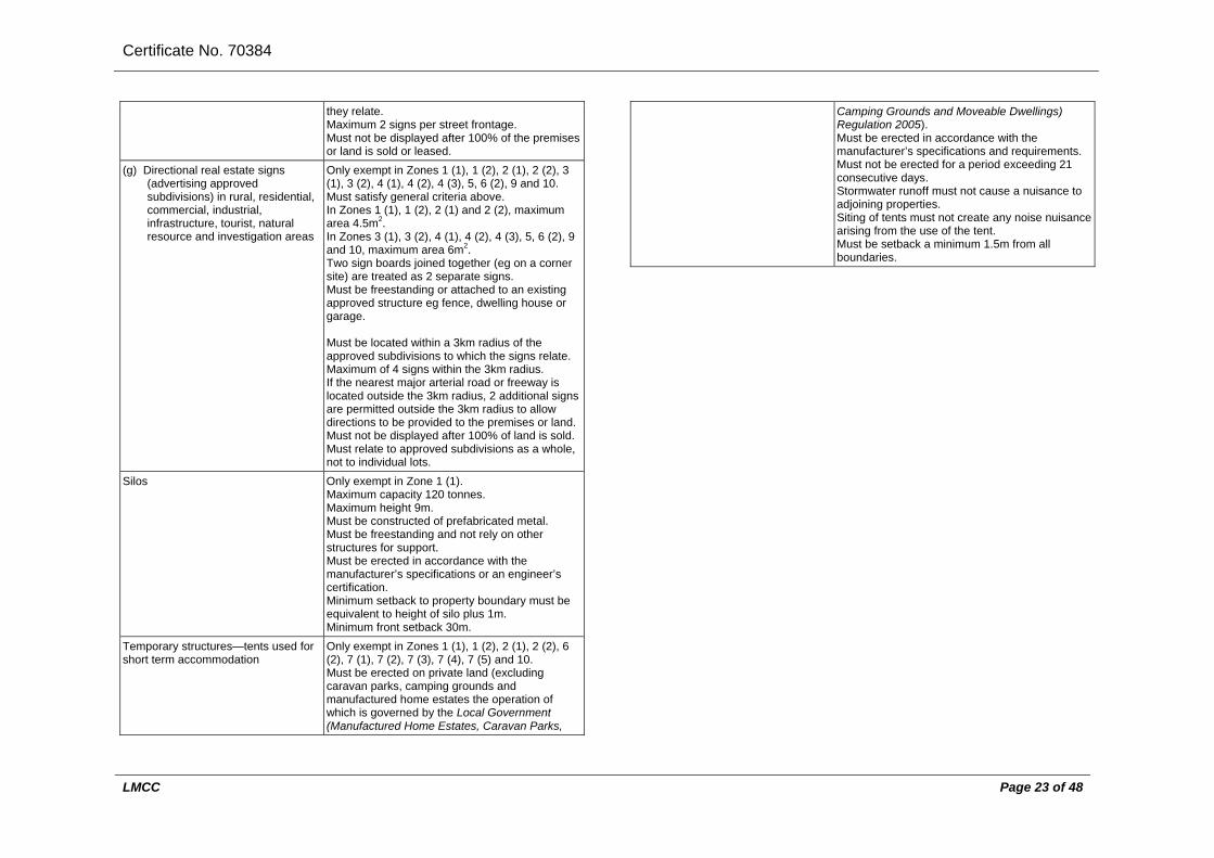
Certificate No. 70384
LMCC Page 23 of 48
they relate. Maximum 2 signs per street frontage. Must not be displayed after 100% of the premises or land is sold or leased.
(g) Directional real estate signs (advertising approved subdivisions) in rural, residential, commercial, industrial, infrastructure, tourist, natural resource and investigation areas
Only exempt in Zones 1 (1), 1 (2), 2 (1), 2 (2), 3 (1), 3 (2), 4 (1), 4 (2), 4 (3), 5, 6 (2), 9 and 10. Must satisfy general criteria above. In Zones 1 (1), 1 (2), 2 (1) and 2 (2), maximum area 4.5m2. In Zones 3 (1), 3 (2), 4 (1), 4 (2), 4 (3), 5, 6 (2), 9 and 10, maximum area 6m2. Two sign boards joined together (eg on a corner site) are treated as 2 separate signs. Must be freestanding or attached to an existing approved structure eg fence, dwelling house or garage. Must be located within a 3km radius of the approved subdivisions to which the signs relate. Maximum of 4 signs within the 3km radius. If the nearest major arterial road or freeway is located outside the 3km radius, 2 additional signs are permitted outside the 3km radius to allow directions to be provided to the premises or land. Must not be displayed after 100% of land is sold. Must relate to approved subdivisions as a whole, not to individual lots.
Silos Only exempt in Zone 1 (1). Maximum capacity 120 tonnes. Maximum height 9m. Must be constructed of prefabricated metal. Must be freestanding and not rely on other structures for support. Must be erected in accordance with the manufacturer’s specifications or an engineer’s certification. Minimum setback to property boundary must be equivalent to height of silo plus 1m. Minimum front setback 30m.
Temporary structures—tents used for short term accommodation
Only exempt in Zones 1 (1), 1 (2), 2 (1), 2 (2), 6 (2), 7 (1), 7 (2), 7 (3), 7 (4), 7 (5) and 10. Must be erected on private land (excluding caravan parks, camping grounds and manufactured home estates the operation of which is governed by the Local Government (Manufactured Home Estates, Caravan Parks,
Camping Grounds and Moveable Dwellings) Regulation 2005). Must be erected in accordance with the manufacturer’s specifications and requirements. Must not be erected for a period exceeding 21 consecutive days. Stormwater runoff must not cause a nuisance to adjoining properties. Siting of tents must not create any noise nuisance arising from the use of the tent. Must be setback a minimum 1.5m from all boundaries.

Certificate No. 70384
LMCC Page 24 of 48
ATTACHMENT C
Extract from Lake Macquarie Local Environmental Plan, 2004 as at 1 June 2010
Schedule 2 Subdivision standards
(Clause 24)
Part 1 Preliminary
1 Definitions
(1) In this Schedule:
building area means the area of the site capable of supporting development. It does not include:
(a) front, side and rear setbacks, or (b) the access handle of a battle-axe lot.
community association, community development lot, community parcel, community property and community scheme have the same meaning as they have in the Community Land Development Act 1989.
irregular lot means a lot that is not a standard lot.
neighbourhood scheme has the same meaning as it has in the Community Land Development Act 1989
standard lot means a rectangular lot (and includes a rectangular corner lot).
width means the distance of the perpendicular line between the side boundaries, as measured at the front building setback.
(2) In this Schedule, the minimum area specified for battle-axe lots excludes the battle-axe
access handle. (3) The subdivision standards in this Schedule do not apply to strata subdivision. (4) A heading to a clause in this Schedule is taken to be part of this Schedule.
Part 2 Zone 1 (1) Rural (Production)
2 All types of subdivision
Minimum area—20ha.
Part 3 Zone 1 (2) Rural (Living)
3 Subdivisions not for purpose of community, precinct or neighbourhood scheme
Minimum area—1ha.
4 Subdivisions for purpose of community scheme
(1) Community parcel: minimum area—5ha.
(2) Community development lots: (a) minimum area—1,000m2, (b) maximum area—1,500m2, (c) maximum density (excluding community property)—1.6 lots per ha, (d) must be clustered together, or otherwise established, for the purpose of retaining a
significant area of unbuilt open space to preserve the natural quality of the land and the rural character of the area. All remaining land must be community property under the control of the community association,
(e) must not have frontage to a public road unless it can be demonstrated that the subdivision is consistent with the existing subdivision pattern, and the subdivision will preserve the natural and scenic quality of the land.
Part 4 Zone 2 (1) Residential
Note. Also see, in particular, clauses 24, 27 and 28A.
5 Any type of subdivision of approved dual occupancy
Minimum area—250m2.
6 Any type of subdivision of approved small lot housing
(1) Must create at least 3 small lot housing lots. (2) Each lot must: (a) be not less than 300m2, but not more than 450m2, in area, (b) have direct frontage to a public road, or an access way established as part of a community
scheme.
7 Subdivisions (other than of approved dual occupancy or approved small lot housing)
(1) Standard lot: (a) standard corner lot: (i) minimum area—600m2, (ii) minimum width—18m, (b) other standard lot: (i) minimum area—450m2,

Certificate No. 70384
LMCC Page 25 of 48
(ii) minimum width—14m. (2) Irregular lot: (a) battle-axe lot: (i) minimum area—600m2, (ii) must have a rectangular building area with a minimum area of 250m2 and a minimum width
of 12m, (iii) minimum width of battle-axe access handle servicing 1 battle-axe lot—4m, or 2 battle-axe
lots—5m, (iv) maximum number of battle-axe lots sharing a single access handle—2, (b) irregular corner lot: (i) minimum area—600m2, (ii) minimum width—18m, (c) other irregular lot: (i) minimum area—450m2, (ii) must have a rectangular building area with a minimum area of 250m2 and a minimum width
of 12m.
8 Subdivisions (other than of approved dual occupancy or approved small lot housing) that create 10 or more lots
At least 10%, but no more than 50%, of lots must be small lot housing lots.
Part 5 Zone 2 (2) Residential (Urban Living)
Note. Also see, in particular, clauses 24, 27 and 28A.
9 Any type of subdivision of approved small lot housing
(1) Must create at least 4 small lot housing lots. (2) Each lot must: (a) be not less than 200m2, but not more than 450m2, in area, (b) have direct frontage to a public road, or an access way established as part of a community
scheme.
10 Subdivisions (other than of approved small lot housing)
(1) Standard lot: (a) standard corner lot: (i) minimum area—1,200m2, (ii) must have a rectangular building area with a minimum area of 900m2 and a minimum width
of 25m, (b) other standard lot: (i) minimum area—900m2, (ii) minimum width—25m. (2) Irregular lot:
(a) battle-axe lot: (i) minimum area—1,500m2, (ii) must have a rectangular building area with a minimum area of 900m2 and a minimum width
of 25m, (iii) minimum width of battle-axe access handle servicing 1 battle-axe lot—8m, (iv) maximum number of battle-axe lots sharing a single access handle—2, (b) irregular corner lot: (i) minimum area—1,200m2, (ii) must have a rectangular building area with a minimum area of 900m2 and a minimum width
of 25m, (c) other irregular lot: (i) minimum area—900m2, (ii) must have a rectangular building area with a minimum area of 900m2 and a minimum width
of 25m.
Part 6 Zone 3 (1) Urban Centre (Core)
11 All types of subdivision
No numeric standards.
Part 7 Zone 3 (2) Urban Centre (Support)
12 All types of subdivision
No numeric standards.
Part 8 Zone 4 (1) Industrial (Core)
13 All types of subdivision
(1) Standard lot: (a) minimum area—4,000m2, (b) minimum width—40m. (2) Irregular lot: (a) battle-axe lot: (i) minimum area—4,000m2, (ii) minimum width—40m, (iii) minimum width of battle-axe access handle—12m, (iv) maximum number of battle-axe lots sharing a single access handle—2, (b) other irregular lot: (i) minimum area—4,000m2, (ii) minimum width—40m.
Part 9 Zone 4 (2) Industrial (General)

Certificate No. 70384
LMCC Page 26 of 48
14 All types of subdivision
(1) Standard lot: (a) minimum area—1,500m2, (b) minimum width—25m. (2) Irregular lot: (a) battle-axe lot: (i) minimum area—1,500m2, (ii) minimum width—25m, (iii) minimum width of battle-axe access handle—9m, (iv) maximum number of battle-axe lots sharing a single access handle—2, (b) other irregular lot: (i) minimum area—1,500m2, (ii) minimum width—25m.
Part 10 Zone 4 (3) Industrial (Urban Services)
15 All types of subdivision
(1) Standard lot: (a) minimum area—1,500m2, (b) minimum width—25m. (2) Irregular lot: (a) battle-axe lot: (i) minimum area—1,500m2, (ii) minimum width—25m, (iii) minimum width of battle-axe access handle—9m, (iv) maximum number of battle-axe lots sharing a single access handle—2, (b) other irregular lot: (i) minimum area—1,500m2, (ii) minimum width—25m.
Part 11 Zone 5 Infrastructure
16 All types of subdivision
No numeric standards.
Part 12 Zone 6 (1) Open Space
17 All types of subdivision
No numeric standards.
Part 13 Zone 6 (2) Tourism and Recreation
18 All types of subdivision
No numeric standards.
Part 14 Zone 7 (1) Conservation (Primary)
19 All types of subdivision
(1) Minimum area for land within South Wallarah Peninsula (being land east of the Pacific Highway and south of the land to Lake Macquarie Local Environmental Plan 2000 – North Wallarah Peninsula applies)—100ha.
(2) Minimum area for all other land within Zone 7 (1)—40ha.
Part 15 Zone 7 (2) Conservation (Secondary)
20 All types of subdivision
Minimum area—40ha.
Part 16 Zone 7 (3) Environmental (General)
21 Subdivisions not for purpose of community, precinct or neighbourhood scheme
(1) Minimum area—40ha. (2) Must have a square building area that has: (a) minimum width—40m, (b) minimum slope of less than 1 in 5.
22 Subdivisions for purpose of community scheme
(1) Community parcel: minimum area—40ha.
(2) Community development lots: (a) minimum area—1,000m2, (b) maximum area—2,500m2, (c) maximum density (excluding community property)—1 lot per 10ha, (d) must be clustered together, or otherwise established, for the purpose of retaining a
significant area of unbuilt open space to preserve, maintain and enhance the natural and scenic quality of the land,
(e) all remaining land must be community property under the control of the community association,

Certificate No. 70384
LMCC Page 27 of 48
(f) must not have frontage to a public road unless it can be demonstrated that the subdivision is consistent with the existing subdivision pattern, and the subdivision will preserve the natural and scenic quality of the land.
Part 17 Zone 7 (4) Environmental (Coastline)
23 All types of subdivision
No numeric standards.
Part 18 Zone 7 (5) Environmental (Living)
24 Subdivisions not for purpose of community, precinct or neighbourhood scheme
(1) Minimum area—2ha. (2) Must have a square building area that has: (a) minimum width—40m, (b) minimum slope of less than 1 in 5.
25 Subdivisions for purpose of community scheme
(1) Community parcel: minimum area—10ha.
(2) Community development lots: (a) minimum area—600m2, (b) maximum area—1,200m2, (c) maximum density (excluding common property)—1 lot per ha, (d) must be clustered together, or otherwise established, for the purpose of retaining a
significant area of unbuilt open space to preserve, maintain and enhance the natural and scenic quality of the land,
(e) all remaining land must be community property under the control of the community association,
(f) must not have frontage to a public road unless it can be demonstrated that the subdivision is consistent with the existing subdivision pattern, and the subdivision will preserve the natural and scenic quality of the land.
Part 19 Zone 8 National Park
26 All types of subdivision
No numeric standards.
Part 20 Zone 9 Natural Resources
27 All types of subdivision
No numeric standards.
Part 21 Zone 10 Investigation
28 All types of subdivision
Subdivision prohibited.
24 Subdivision
(1) Despite any other provision of this plan, subdivision of land, other than that identified in subclause (9), may be carried out only with development consent.
(2) Land in any zone may be subdivided only if the consent authority is satisfied: (a) that the resulting lots will conform to the requirements in Schedule 2 (Subdivision
standards) applicable to subdivision in that zone, and (b) the resulting lots can be developed in accordance with this plan.
(3) To avoid doubt State Environmental Planning Policy No 1 – Development Standards applies to a requirement referred to in subclause (2) (a) in the same way as it applies to a development standard.
(4) Consent must not be granted to a subdivision of land in Zone 2 (1) or 2 (2) for the purpose of small lot housing unless consent has been or is also given to the erection on the land of dwellings that will comprise small lot housing.
(5) Consent must not be granted for a subdivision of land in Zone 2 (1) for the purpose of dual occupancy-attached or dual occupancy-detached unless consent has been or is also granted for the erection on the land of dwellings comprising that form of dual occupancy.
(6) (Repealed)
(7) The subdivision of land in Zone 2 (1) or 2 (2) for small lot housing is prohibited if it would result in the creation of any battle-axe lots.
(8) The subdivision of land in Zone 10 is prohibited.
(9) Consent is not required for a subdivision for the purpose only of any one or more of the following:
(a) widening a public road, (b) a minor realignment of boundaries that does not create: (i) additional lots or the opportunity for additional dwellings, or (ii) lots that are smaller than the minimum size provided for by this plan in relation to the land
concerned,

Certificate No. 70384
LMCC Page 28 of 48
(c) a consolidation of lots that does not create additional lots or the opportunity for additional dwellings,
(d) rectifying an encroachment on a lot,
(e) creating a public reserve,
(f) excising from a lot land that is, or is intended to be, used for public purposes, including drainage purposes, rural fire brigade or other emergency service purposes or public toilets.
27 Dwelling houses, small lot housing and dual occupancies in Zone 1(2), 2(1), 2(2) or 7(5)
(1) This clause applies to land in Zone 1 (2), 2 (1), 2 (2) or 7 (5).
(2) In this clause:
dwelling lot means a lot that:
(a) was a lawfully created lot at the commencement of this plan, or
(b) is a lot lawfully created after that commencement under a development consent granted before or after that commencement, or
(c) complies with such of the requirements set out in Schedule 2 (Subdivision standards) as apply to the land comprising the lot.
(3) A dwelling must not be erected or created on land to which this clause applies, except in accordance with this clause.
(4) Consent may be granted for the erection or creation of: (a) a dwelling house on a dwelling lot in Zone 2 (2), or (b) a dwelling house or dual occupancy-attached on a dwelling lot in Zone 1 (2) or 7 (5), or
(c) a dwelling house, dual occupancy-attached or dual occupancy-detached on a dwelling lot in Zone 2 (1).
(5) Consent must not be granted for the erection or creation of a dwelling house, dual occupancy-attached or dual occupancy-detached on a dwelling lot if its erection or creation would mean:
(a) if the lot is in Zone 1 (2), 2 (1), 2 (2) or 7 (5)—that there is more than one dwelling house on the dwelling lot (counting any dwelling house already on the lot), or
(b) if the lot is in Zone 1 (2), 2 (1) or 7 (5)—that there are more than two dwellings on the dwelling lot (counting any dwelling already on the lot).
(6) Consent must not be granted for the erection or creation of a dual occupancy-attached or dual occupancy-detached on a neighbourhood lot in Zone 1 (2) or 7 (5).
(7) Consent must not be granted for the erection or creation of a dual occupancy-attached or dual occupancy-detached on a battle-axe lot in Zone 2 (1).
(8) Consent must not be granted for the erection or creation of small lot housing in Zone 2 (1) or 2 (2):
(a) on a battle-axe lot, or (b) on a lot less than 1,000 square metres in area.
(9) Consent must not be granted to the erection or creation in Zone 2 (1) of: (a) a dual occupancy-attached on a lot less than 500 square metres in area, or (b) a dual occupancy-detached on a lot less than 600 square metres in area.
28A Residential flat buildings and multiple dwelling housing in Zone 2(2)
(1) Consent must not be granted to the erection or creation of a residential flat building on: (a) an irregular or standard corner allotment in Zone 2 (2) unless the allotment has a minimum
area of 1,500 square metres and a minimum width of 30 metres, or (b) a battle-axe allotment in Zone 2 (2) unless the allotment has a minimum area of 2,000
square metres and the battle-axe access handle has a minimum width of 8 metres, or
(c) any other irregular allotment or standard allotment in Zone 2 (2) unless the allotment has a minimum area of 1,200 square metres and a minimum width of 30 metres.
(2) Consent must not be granted to the erection or creation of multiple dwelling housing on: (a) a corner allotment in Zone 2 (2) unless the allotment has a minimum area of 1,200 square
metres and a minimum width of 30 metres, or (b) a battle-axe allotment in Zone 2 (2) unless the allotment has a minimum area of 1,500
square metres and the battle-axe access handle has a minimum width of 8 metres, or
(c) any other allotment in Zone 2 (2) unless the allotment has a minimum area of 900 square metres and a minimum width of 25 metres.
(3) In this clause:
width means the distance of the perpendicular line between the side boundaries, as measured at the front building setback.

Certificate No. 70384
LMCC Page 29 of 48
ATTACHMENT D
Extract from Lake Macquarie Local Environmental Plan, 2004 as at 15 June 2011
Schedule 4 Heritage items other than of indigenous origins and including potential archaeological sites
(Clause 51 and Dictionary)
Part 1 Heritage items other than of indigenous origins
In this Schedule, for the purpose of listing property descriptions, the symbol S means identified as of State significance, R means identified as of regional significance, L means identified as of local significance, PO means Permissive Occupancy, MS means miscellaneous, MD means Maitland and SP means strata plan. Item No
Significance Item Address Property description
Argenton
AG-01 L Newcastle Mines Rescue Station
533 Lake Rd Lot 2, DP 599235
AG-02 L Former Cockle Creek Railway Bridge
2 (over) Cockle Creek (also see RT-09)
AG-03 L Cockle Creek Railway Bridge
3 (over) Cockle Creek (also see RT-03)
AG-05 L Church Hall and Anglican Church
477 Lake Rd 475 Lake Rd
Lot 1, DP 125686 Lot 2, DP 125686
AG-06 L Speers Point Tram Route
Frederick St (also see RT-02)
Awaba
AW-03 L Former Awaba Union Church
20 Gosford St Lot 1, Section 8, DP758041
AW-05 L Gatekeeper’s Cottage
1 Wilton Rd Lot 1, DP 817297
Barnsley
BY-02 L Johnston Family Cemetery
14A Taylor Ave Lot 100, DP 630296
BY-03 L Former Barnsley 91 Appletree Rd Lot 2, DP 1001812
Public School Belmont
BM-01 L House “Yarragee”
23 Bellevue Rd Lot 1, DP 881605
BM-04 L Captain Bain’s House
15 George St Lot 2, DP 13715
BM-05 L House “The Bennals”
45 Walter St Lot D, DP 402085
BM-08 L Former Ferry Wharf
55 Brooks Pde Belmont Wharf
Belmont North
BN-01 L Former John Darling Colliery
14 John Darling Ave 65 John Fisher Rd 85 John Fisher Rd 75 John Fisher Rd
Lot 100, DP 1136505 Lot 1, DP 814551 Lot 2, DP 814551 Lot 3, DP 814551
BN-04 L Former Staff Houses, Colliery Row
3 Maranatha Cl 7 Maranatha Cl 9 Maranatha Cl 21 Maranatha Cl
Lot 12, DP 848941 Lot 14, DP 848941 Lot 15, DP 848941 Lot 120, DP 853391
Belmont South
BS-02 L Tank traps Cold Tea Creek, 690A Pacific Hwy
Lot 7024, DP 1057186
Blackalls Park
BK-02 L Railway Bridges 2 (over) Mudd Creek and 2 (over) Stony Creek (also see RT-11)
BK-03 L Railway Station 26 South Pde (also see RT-11)
Boolaroo
BR-01 L Group of 4 Cottages
8 Creek Reserve Rd
Lot 11, DP 616785 Lot 1, DP 301687

Certificate No. 70384
LMCC Page 30 of 48
10 Creek Reserve Rd 12 Creek Reserve Rd 14 Creek Reserve Rd
Lot 3, DP 8704 Lot 4, DP 8704
BR-02 L Former Boolaroo Post Office
91 Main Rd Lot 2, DP 809177
BR-04 L Former Motor Garage
19 Main Rd Lot 1, DP 125272
BR-05 L Commercial Hotel
2 Main Rd Lot 1, Section A, DP 3494, Lot 2, Section A, DP 3494
BR-06 L House “Alida” Lakeview Rd Lot 4, Section M, DP 3494
BR-16 L Former Laboratory building on the former Pasminco site
Part of 13A Main Rd
Part of Lot 2, DP 1127713
Booragul
BU-01 L Colliery Relics 155 Old Main Rd Lot 33, DP 858667 BU-02 L House “Awaba
Park” 18 Marmong St 2b First St
Lot 120, DP 855520 Lot 33, DP 1133743
BU-03 L Quigley Grave 24 Park Pde Pt Lot 468, DP 774186 Cams Wharf
CW-01 L Lord of the Manor Cams Cottage
13 Cams Wharf Rd
Lot 2, DP 616354
Cardiff
CF-01 L Row of 4 Shops with Cottages
275 Main Rd 279 Main Rd
Lot 21, DP 544989 Lot 22, DP 544989
CF-02 L Brick Shops 281 Main Rd Lot 4, DP 10789 CF-04 L Former Doctor’s
Surgery 8 Michael St Lot 2, DP 214463
CF-05 L House 6 Michael St Lot 1, DP 214463 CF-08 L Cardiff Masonic
Hall 4 Margaret St Lot 12, Section B, DP
8186
CF-09 L House 309 Main Rd Pt Lot 34, DP 755233 CF-15 L St Kevin’s
Cottage 230 Main Rd Lot 1, DP 1015805
CF-16 L St Kevin’s Church
226 Main Rd Lot 3, Section A, DP 4143
CF-17 L Former Miner’s Cottage
251 Main Rd Lot 1, DP 303203
Cardiff South
CS-01 L Former Colliery Tramway
14a Almora Cl 180 Macquarie Rd 235 Macquarie Rd (also see RT-15)
Lot 38, DP 827464 Lot 17, DP 727746 Lot 673, DP 805546
Catherine Hill Bay
CH-03 L Police Station and Lock Up
23–27 Clarke St Lot 1, Section F, DP 163, Lot 3, Section F, DP 163, Lot 5, Section F, DP 163
CH-04 L Wallarah Hotel 24 Clarke St Lot 1, Section D, DP 163 CH-05 L Cottages 10 Clarke St
12 Clarke St Lot 71, DP 222717 Lot 72, DP 222717
CH-06 L Cottages 21 Clarke St 19 Clarke St
Lot 78, DP 222717 Lot 79, DP 222717
CH-07 L Cottage 17 Clarke St Lot 80, DP 222717 CH-08 L Cottages 9 Clarke St
7 Clarke St 5 Clarke St 3 Clarke St
Lot 84, DP 222717 Lot 85, DP 222717 Lot 86, DP 222717 Lot 87, DP 222717
CH-10 L Cottage 3 Lindsley St Lot 54, DP 222717 CH-12 L Cottage 11 Lindsley St Lot 58, DP 222717 CH-14 L Coal Loader Jetty Southern end of
the beach Lot 104, DP 1129872
CH-17 L House and 4 Norfolk Pines
38 Flowers Dr Lot 22, DP 593154
CH-19 L Anglican Church 71 Flowers Dr Lot 21, DP 593154 CH-21 L Group of
cottages 27 Flowers Dr 29 Flowers Dr 31 Flowers Dr 33 Flowers Dr
Lot 14, DP 222943 Lot 15, DP 222943 Lot 16, DP 222943 Lot 17, DP 222943
Certificate No. 70384
LMCC Page 31 of 48
35 Flowers Dr 37 Flowers Dr 42 Flowers Dr 44 Flowers Dr 46 Flowers Dr 48 Flowers Dr 50 Flowers Dr 54 Flowers Dr 56 Flowers Dr 58 Flowers Dr
Lot 18, DP 222943 Lot 19, DP 222943 Lot 41, DP 222943 Lot 42, DP 222943 Lot 43, DP 222943 Lot 44, DP 222943 Lot 45, DP 222943 Lot 47, DP 222943 Lot 48, DP 222943 Lot 49, DP 222943
CH-22 L Hall 1 Northwood Rd Lot 1, DP 407474 CH-24 L House 26 Flowers Dr Lot 1, DP 1107593 CH-27 L House 38 Flowers Dr
(off Colliery Rd) Lot 223, DP 1102989
CH-32 L Cemetery 8 Northwood Rd Lot 7079, DP 1029250 CH-34 S Former WWII
RAAF Radar Station 208
145 Mine Camp Rd
Lot 16, DP 755266 Lot 3, DP 1016670
Charlestown
CT-01 L Miners’ Cottages 300 Charlestown Rd 304 Charlestown Rd 306 Charlestown Rd 308 Charlestown Rd
Lot 2, DP 33470 Lot 4, DP 33470 Lot 5, DP 33470 Lot 6, DP 33470
CT-03 L Cottage 32 Smith St Lot 1, DP 213865 CT-04 L Brick Cottage 36 Smith St SP 43904 Coal Point
CP-01 L Threlkeld’s Mine 359 Coal Point Rd
Lot 172, DP 1037893
Cooranbong
CB-01 L Grave “Frost’s Rest”
154 Mannings Rd Lot 1, DP 919600
CB-02 L Catholic Church and Cemetery
6 Martinsville Rd Lot 1, DP 197852
CB-03 L Former Post Office
41 Martinsville Rd
Lot 120, DP 755223
CB-06 L House 9 Kings Rd Lot 3, DP 549007 CB-07 L House 85 Kings Rd Lot 1, DP 798409 CB-08 L North
Corrumbung Cemetery
200 Martinsville Rd
Lot 7300, DP 1145113 Lot 1, DP 1095988
CB-09 L Suspension Footbridge
Off Victory St—Crosses Dora Creek
CB-17 L Water Tower 15 Central Rd Lot 20, DP 3534 CB-18 L Bethel Hall 50 Central Rd Lot 18, DP 129134 CB-21 L College Hall 50 Central Rd Lot 18, DP 129134 CB-22 L Science Hall 50 Central Rd Lot 18, DP 129134 CB-23 L House “The
Laurels” 50 Central Rd Lot 18, DP 129134
CB-24 L Auditorium 50 Central Rd Lot 9, Section 7, DP 3533
CB-26 L Sanitarium Health Foods Factory
70 Central Rd 70 Central Rd 50 Central Rd 50 Central Rd
Lots 6, 7 and 8, Section 1, DP 3533 Lot 1, DP 938761 Lot 18, DP 129134
CB-27 L Sanitarium Dairy Farm
15 Central Rd Lots 18 to 23, Section 3, DP 3533
CB-28 L House “Three Bells”
597 Freemans Dr Lot 201, DP 1059478
CB-29 L Cottage 661 Freemans Dr Lot A, DP 416525 CB-31 L House
“Sunnyside” 27 Avondale Rd Lot 2, DP 204207
Dora Creek
DC-02 L House 16 Dora St Lot 11, DP 533825 DC-03 L Holmes Store 3 Watt St Lot 38, DP 528601 DC-04 L Former St Paul’s
Anglican Church 26 Coorumbung Rd
Lot 101, DP 840020
Dudley
DL-01 L Cast Iron Reservoir
147 Ocean St Lot 1, 446723
DL-02 L Dudley Monument
Corner of Redhead Rd and Ocean St
Lot 189, DP 755233

Certificate No. 70384
LMCC Page 32 of 48
DL-03 L Two Miner’s Cottages
125 and 127 Ocean St
Lots 1, 2 and 3, Section D, DP 2657
DL-04 L Dudley Public School
124 Ocean St Lot 145, DP 755233
DL-06 L Pensioners Hall 98 Ocean St Lot 1, DP 931771 DL-07 L Ocean View
Hotel 85 Ocean St Lot 20, Section A, DP
2304 DL-08 L Royal Crown
Hotel 94 Ocean St Lot 18, Section B, DP
2304 DL-09 L Former Miner’s
Cottage 31 Thomas St Lot 9, Section D, DP
2657 DL-10 L Former Miner’s
Cottage 29 Thomas St Lot 11, Section D, DP
2657 Edgeworth
EW-07 L School Teacher’s Residence
7 Minmi Rd Lot 106, DP 755262
Eraring
ER-01 L Eraring Power Station
268 Rocky Point Rd, Eraring 294 Rocky Point Rd, Eraring 115 Construction Rd, Myuna Bay 215 Construction Rd, Myuna Bay 235 Construction Rd, Myuna Bay 260 Construction Rd, Myuna Bay
Lot 11, DP 1050120 Lot 10, DP 1050120 Lot 50, DP 840671 Lot 20, DP 840668 Lot 211, DP 840670 Lot 51, DP 840671
Fassifern
FF-01 L Fassifern Railway Cottage
Wallsend Rd Lot 1, DP 854050
FF-02 L Toronto Railway Overbridge
(over) Fassifern Rd (also see RT-11)
FF-03 L Fassifern Railway Station
29 Fassifern Rd
Freemans Waterhole
FW-01 L Headframe Former Mining Museum
890A Freemans Dr
Lot 80, DP 610602
Glendale
GD-01 L Cardiff Railway Workshops
460 Main Rd Lot 100, DP 1100258
Holmesville
HV-04 L Brick House 47 Appletree Rd Lot 3, Section B, DP 4479
HV-06 L Brick House 54 Appletree Rd Lot 22, DP 740832 HV-07 L House 20 William St Lot 14, Section E, DP
5432 HV-08 L Former Police
Station 20 Charlotte St Lot 15, Section E, DP
5432 HV-09 L Post Office Store 18 George St Lot 1, Section L, DP
3442 HV-11 L Holmesville Hotel 21 George St Lot 20, Section M, DP
3442 HV-20 L House 32 Seaham St Lot 42, Section B, DP
4479 HV-24 L Railway Station Killingworth Rd
(also see RT-09)
HV-25 L Former Uniting Church
29 Helens St Lot 16, Section N, DP 3442
Kahibah
KH-01 S L
Glenrock Railway and Mine Entrance and early coal mining sites
Glenrock State Recreation Area
Lot 1, DP 523208 and Lot 21, DP 575387
Killingworth
KW-02 L Elcom Newcastle Substation
101 Killingworth Rd
Lot 1, DP 619513 Lot 2, DP 619513
KW-03 L Former Killingworth Hotel
39 Killingworth Rd
Lot 13, Section E, DP 4339
KW-05 L Soldier’s Memorial
26 The Broadway Lot 1, Section D, DP 4339
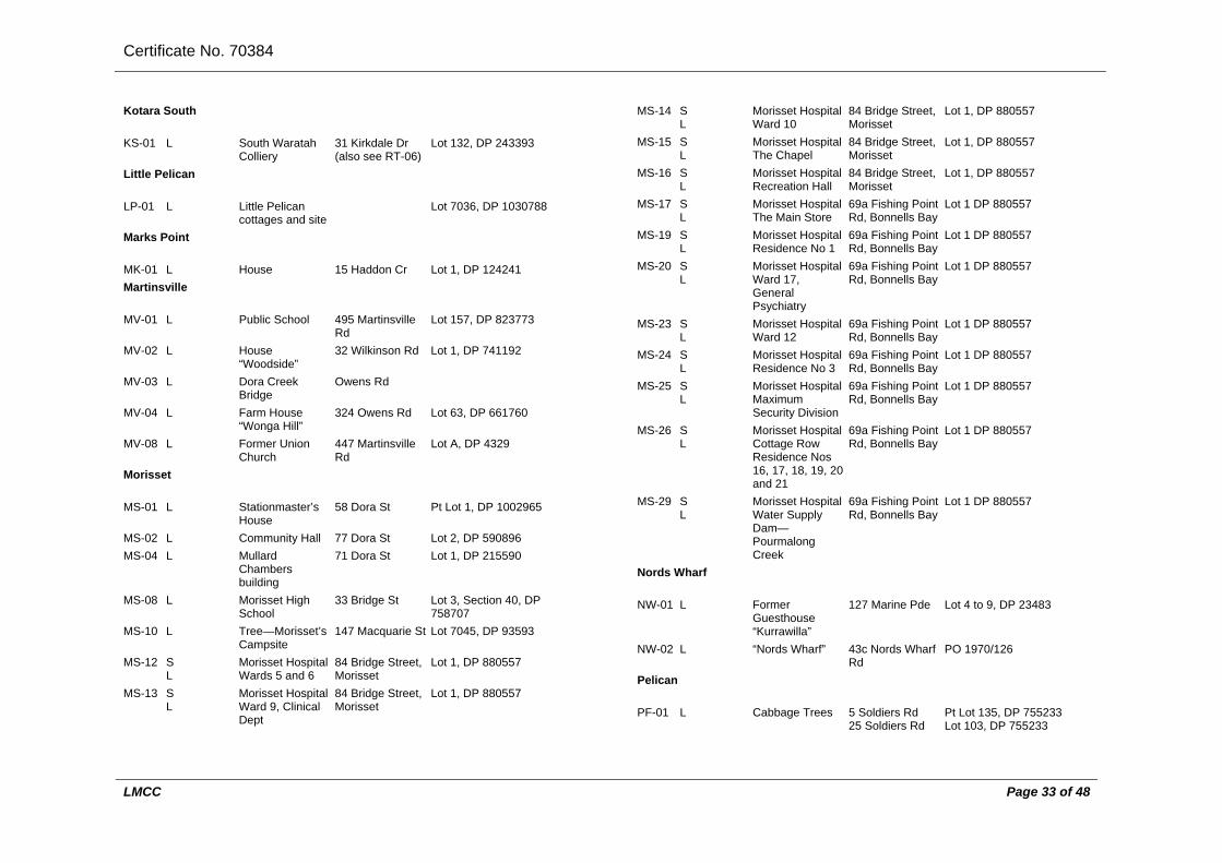
Certificate No. 70384
LMCC Page 33 of 48
Kotara South
KS-01 L South Waratah Colliery
31 Kirkdale Dr (also see RT-06)
Lot 132, DP 243393
Little Pelican
LP-01 L Little Pelican cottages and site
Lot 7036, DP 1030788
Marks Point
MK-01 L House 15 Haddon Cr Lot 1, DP 124241 Martinsville
MV-01 L Public School 495 Martinsville Rd
Lot 157, DP 823773
MV-02 L House “Woodside”
32 Wilkinson Rd Lot 1, DP 741192
MV-03 L Dora Creek Bridge
Owens Rd
MV-04 L Farm House “Wonga Hill”
324 Owens Rd Lot 63, DP 661760
MV-08 L Former Union Church
447 Martinsville Rd
Lot A, DP 4329
Morisset
MS-01 L Stationmaster’s House
58 Dora St Pt Lot 1, DP 1002965
MS-02 L Community Hall 77 Dora St Lot 2, DP 590896 MS-04 L Mullard
Chambers building
71 Dora St Lot 1, DP 215590
MS-08 L Morisset High School
33 Bridge St Lot 3, Section 40, DP 758707
MS-10 L Tree—Morisset’s Campsite
147 Macquarie St Lot 7045, DP 93593
MS-12 S L
Morisset Hospital Wards 5 and 6
84 Bridge Street, Morisset
Lot 1, DP 880557
MS-13 S L
Morisset Hospital Ward 9, Clinical Dept
84 Bridge Street, Morisset
Lot 1, DP 880557
MS-14 S L
Morisset Hospital Ward 10
84 Bridge Street, Morisset
Lot 1, DP 880557
MS-15 S L
Morisset Hospital The Chapel
84 Bridge Street, Morisset
Lot 1, DP 880557
MS-16 S L
Morisset Hospital Recreation Hall
84 Bridge Street, Morisset
Lot 1, DP 880557
MS-17 S L
Morisset Hospital The Main Store
69a Fishing Point Rd, Bonnells Bay
Lot 1 DP 880557
MS-19 S L
Morisset Hospital Residence No 1
69a Fishing Point Rd, Bonnells Bay
Lot 1 DP 880557
MS-20 S L
Morisset Hospital Ward 17, General Psychiatry
69a Fishing Point Rd, Bonnells Bay
Lot 1 DP 880557
MS-23 S L
Morisset Hospital Ward 12
69a Fishing Point Rd, Bonnells Bay
Lot 1 DP 880557
MS-24 S L
Morisset Hospital Residence No 3
69a Fishing Point Rd, Bonnells Bay
Lot 1 DP 880557
MS-25 S L
Morisset Hospital Maximum Security Division
69a Fishing Point Rd, Bonnells Bay
Lot 1 DP 880557
MS-26 S L
Morisset Hospital Cottage Row Residence Nos 16, 17, 18, 19, 20 and 21
69a Fishing Point Rd, Bonnells Bay
Lot 1 DP 880557
MS-29 S L
Morisset Hospital Water Supply Dam—Pourmalong Creek
69a Fishing Point Rd, Bonnells Bay
Lot 1 DP 880557
Nords Wharf
NW-01 L Former Guesthouse “Kurrawilla”
127 Marine Pde Lot 4 to 9, DP 23483
NW-02 L “Nords Wharf” 43c Nords Wharf Rd
PO 1970/126
Pelican
PF-01 L Cabbage Trees 5 Soldiers Rd 25 Soldiers Rd
Pt Lot 135, DP 755233 Lot 103, DP 755233

Certificate No. 70384
LMCC Page 34 of 48
35 Soldiers Rd Lot 102, DP 755233 Railways and tramways
RT-01 L West Wallsend Steam Tram Line
West Wallsend to Newcastle via Wallsend, Holmesville, Estelville, Edgeworth and Glendale
RT-02 L Speers Point Steam Tram Line
Newcastle to Speers Point via West Wallsend
RT-03 L Great Northern Railway
Line passes through Lake Macquarie from Garden Suburb to Wyee
RT-04 L Belmont Railway Adamstown to Belmont, the New Redhead Estate and Coal Company Railway
RT-05 L Branch Lines from the Belmont Railway
Burwood No 3 Colliery, Whitebridge, Dudley Colliery, Dudley, Lambton Colliery, Redhead, John Darling Colliery, Belmont North, Belmont Colliery Sidings, Belmont
Lots 1, 2 and 9, DP 1038830
RT-06 L Raspberry Gully Line Railway
Opposite Dalpura Lane to the Main Northern Railway Line, near Adamstown along Styx Creek
RT-09 L Seaham, West Wallsend, Fairley and Killingworth
Cockle Creek to Seaham No 1 Colliery at
Railway Seahampton with branches to Fairley and Killingworth
RT-10 L Rhondda Colliery Railway
From West Wallsend railway on the northside of Stockton Borehole Colliery to the Rhonda Colliery south of Rhonda Rd, Teralba
RT-11 L Fassifern to Toronto Branch Railway Line
Fassifern Railway Station to Toronto Railway Station and then Toronto Wharf
RT-14 L Wyee Coal Conveyor Railway Loop
North of Wyee to Vales Point Power Station
RT-15 L Cardiff South Colliery Tramway
Macquarie Rd, Cardiff South
Rathmines
RM-00 S Rathmines Park (former RAAF Seaplane Base)
Area bounded by Lake Macquarie, The Circlet, Rosemary Row and Overhill Rd
Lots 37–49, Pt Lot 50 and Pt Lot 51, DP 11537 Lot 4, DP 704472 Lot 1, DP 226530 Lot 1, DP 226531 Lot 1, DP 226532 Lot 1, DP 226533 Lot 1, DP 226534 Lot 7, DP 516152 Lot 60, DP 584602 Lots 62–64, DP 596913Lots 648 and 654, DP 806611
RM-01 L Catalina Memorial Nursing Home
171 Dorrington Rd
Lot 2, DP 226531
RM-02 L Community Hall 1 Overhill Rd Lot 64, DP 596913 RM-03 L Catamaran Club 1 Overhill Rd Lot 64, DP 596913

Certificate No. 70384
LMCC Page 35 of 48
RM-04 L Christadelphian School
2 Stilling St Lot 5, DP 226534
RM-05 L Flying Boat Ramps
1 Overhill Rd Lot 64, DP 596913
RM-06 L Rathmines Bowling Club
1 Stilling St Lot 4, DP 226533
RM-07 L Catalina War Memorial
1 Overhill Rd Lot 64, DP 596913
RM-08 L Rathmines Holiday Camp
3 Stilling St Lot 1, DP 226530
RM-09 L Brick Store 1 Overhill Rd Lot 64, DP 596913 RM-10 L Boat Slip 1 Overhill Rd Lot 64, DP 596913 RM-12A
L Emergency Radio Bunkers
115 Wangi Rd Lot 446, DP 1138964
Redhead
RH-01 L Lambton Colliery 1 Geraldton Dr Lot 68, DP 878840 RH-03 L Under-Manager’s
House 17 Geraldton Dr Lot 7, DP 878840
RH-04 L “The Gables” 87 Redhead Rd Lot 4, DP 737493 RH-07 L Mine Manager’s
House 21 Elsdon St Lot 100, DP 609787
RH-08 L Shark Tower 2A Beach Rd Lot 1412, DP 755233 Speers Point
SP-03 L House 10 Council St Lot 1, DP 518527 SP-04 L House 8 Council St Lot 1, DP 521920 SP-08 L House 18 Alley St Lot 11, DP 525378 SP-09 L House 37 Alley St Lot 1, DP 587774 SP-10 L Cottage 64 Speers St Lot 1, DP 348879 SP-11 L House 66 Speers St Lot 3, DP 562487 SP-12 L House 41 Albert St Lot 1, DP 962726 SP-13 L House 74 Speers St Pt Lot 1, DP 956798 SP-14 L House 214 The
Esplanade Lot 1, DP 108865
SP-16 L House “The Knoll”
374 The Esplanade
Lot 3, DP 786053
SP-17 L House 332 The Esplanade
Lot 4, DP 350608
SP-19 L House 302 The Esplanade
Lot 32, DP 564214
SP-23 L House 282 The Esplanade
Lot 145, DP 558308
SP-25 L Former Lake Macquarie Council Chambers
143 Main Rd Lot 13, DP 810700
SP-26 L House 141 Main Rd Lot 1, DP 368588 SP-29 L Speers Point
Garage 155 Main Rd Lot 12, Section A, DP
4063 SP-30 L House
“Shangrila” 157 Main Rd Lot 11, Section A, DP
4063 SP-31 L House 159 Main Rd Lot 10, Section A, DP
4063 SP-34 L Lakeview Street
Theatre 81 Lakeview St Lot 14, Section B, DP
4063 SP-36 L Shelter Shed 15 Park Rd Lot 1, DP 998238 SP-37 L Minenwerfer (or
German Mortar) 15 Park Rd Lot 1, DP 998238
Swansea
SS-02 L The Swansea Hotel
196 Pacific Hwy Lot 12, DP 1101804
Swansea Heads
SD-02 L Coast Guard Station
3a Lambton Pde Lot 548, DP 39981
SD-03 L Reid’s Mistake, Head and Channel
7a Lambton Pde Pt Reserve 88033
Teralba
TA-03 L Shop 10 Anzac Pde Lot 1, DP 999965 TA-08 L House “Moria” 59 York St Lot 17, DP 816302 TA-09 L Teralba Public
School 57 York St Lot 2, DP 795123
TA-10 L Great Northern Hotel
2 Anzac Pde Lot 7, Section A, DP 447469
TA-11 L House “AS” 101 Railway St Lot 261, DP 554269

Certificate No. 70384
LMCC Page 36 of 48
TA-12 L Station Master’s Cottage
150 Railway St Lot 3, DP 831957
TA-13 L Teralba Cemetery Billygoat Hill
20 Pitt St Lot 31, DP 858667
TA-16 L Gartlee Mine 159 Railway St Lot 1, DP 780614 TA-17 L Rhondda Colliery 282 Rhondda Rd
284 Rhondda RdLot 101, DP 1073163 Lot 76, DP 755262
TA-18 L Former Co-operative Store
75 York St Lot 18, DP 1158353
TA-25 L St Hilda’s Church 16 York St Lot 4, DP 1128610 Toronto
TT-01 L House “Manuka” 182 Excelsior Pde
Lot 461, DP 589541
TT-06 L House “The Moorings”
2 Jarrett St Lot 1, DP 1108227
TT-08 L Toronto Cemetery
354 Awaba Rd Lots 7044 to 7046, DP 1052029 and Lot 7058, DP 1052031
TT-09 L Toronto Hotel 74 Victory Pde Lot 201, DP 549239 TT-11 L Former Railway
Station 16 Victory Row Lot 220, DP 1021925
TT-12 L Frith’s Store 66 The Boulevarde
Lot B, DP 390795
TT-15 L Building Restaurant
24 Victory Pde Lot 1, DP 301366
TT-16 L Royal Motor Yacht Club Annexe
8 Arnott Ave Lot 12 to 15, DP 456286
TT-17 L Building Restaurant
6 Arnott Ave Lot X, DP 406274, Pt Lot 424, DP 823708, Lot 1, DP 917503
TT-18 L Boatman’s Cottage Lakefront
4 Arnott Ave Lot 1, DP 950464
TT-19 L Boathouse and Winches Lakefront
4 Arnott Ave Lot 1, DP 950464 PO 65/60
TT-20 L House 4 Arnott Ave Lot 1, DP 950464 TT-21 L House 32 Renwick St Lot 1, DP 122786
“Burnbrae” TT-22 L Station Master’s
Cottage 98 Brighton Ave Lot 1, DP 125979
TT-23 L House “McGeachie’s”
109 Brighton Ave Lot 2, DP 515029
TT-29 L Convent of Mercy 26 Renwick St Lot 2122, DP 1116609 TT-30 L House 23 Renwick St Lot 2, DP 350492 TT-38 L Cottage 6 Renwick St Lot 21, Section 7, DP
4236 TT-42 L House 16 Hunter St Lot 111, DP 596414 TT-43 L Winn’s House 19 Hunter St Lot 100, DP 717511 Wangi Wangi
WG-01 S L
Wangi Power Station
80 Donnelly Rd Lot 101, DP 880089
WG-04 L House “Dobell House”
47 Dobell Dr Lot 13, DP 8840
WG-06A
L Gun emplacements
24 Reserve Rd Lot 526, DP 662836
Warners Bay
WB-01 L House “Ali’s Palace”
6 Fairfax Rd Lot 2, DP 20222, Lot 34, DP 20222, Pt Lot 1, DP 20222
WB-02 L First Orange Orchard
The slope with north eastern aspect falling from crest of hill at corner Beryl and Mills Sts down to creek and tramway
(WB-03)
WB-03 L Mine Pithead and Coal Tramway to Lake
Follows creek from below Barbara St, to Lake between Howard and James Sts
WB-04A
L Cottage 17 Daydawn Ave Lot 10, DP 651218

Certificate No. 70384
LMCC Page 37 of 48
West Wallsend
WW-01
L West Wallsend Football Club Ground
3 Laidley St, Johnson Park
Lot 1, DP 421411
WW-02
L West Wallsend (No 1) Colliery
off Wilson St Pt Lot 106, DP 1000408
WW-05
L Cottage 12 Carrington St Lot 6, Section Z, DP 3809
WW-06
L Cottage 15 Carrington St Lot 15, Section D, DP 2252
WW-08
L House “Earsdon Cottage”
20 Carrington St Lot A, DP 370073
WW-10
L Former Shop and Doctors surgery
47 Carrington St Lot 16, Section C, DP 2252
WW-11
L House 47 Carrington St Lot 16, Section C, DP 2252
WW-12
L Former Shop and House
52 Carrington St Lot 2, Section G, DP 2252
WW-13
L Post Office and Residence
54 Carrington St Lot 1, Section G, DP 2252
WW-14
L Catholic Church and Convent
5 Hyndes St Lot 15, Section G, DP 2255, Lot 16, Section G, DP 2252, Lot 1, DP 500232, Lot 2, DP 500232
WW-15
L Soldiers’ Memorial and Park
49 Carrington St Lot 1, DP 301342
WW-16
L Workers’ Club 51 Carrington St Lot 11, DP 863266
WW-18
L Clyde Inn Hotel 57 Carrington St Lot 12, Section B, DP 2252
WW-19
L House 59 Carrington St Lot A, DP 382915
WW-23
L Former School of Arts
65 Carrington St Lot 21, DP 875161
WW-26
L West Wallsend Co-Op
76a Carrington St6 Withers St 8 Withers St
Lot 7, Section E, DP 2252 Lot 8, Section E, DP 2252 Lot 9, Section E, DP
2252 WW-31
L West Wallsend Public School
49a Wallace St Lot 5, Section J, DP 2252, Lot 6, Section J, DP 2252, Lot 7, Section J, DP 2252, Lot 8, Section J, DP 2252, Lot 9, Section J, DP 2252, Lot 10, Section J, DP 2252, Lot 11, Section J, DP 2252, Lot 12, Section J, DP 2252, Lot 1, DP 415746, Lot 1, DP 103681, Lot 1, DP 203314, Lot 1, DP 418805
WW-32
L Miners’ Memorial 49a Wallace St Lot 8, Section J, DP 2252
WW-33
L Presbyterian Church
48a Wallace St Lot 1, Section O, DP 2253
WW-35
L Baptist Church 49 Wallace St Lot 15, Section K, DP 2252
WW-38
L Former Northumberland Hotel
1 Hyndes St Lot 11, DP 565278
WW-39
L Cottage 53 Wilson St Lot B, DP 315094
WW-40
L Cottage 8 Laidley St Lot B, DP 319636
WW-41
L Museum Hotel 70 Wilson St Lot 21, DP 700424
WW-46
L Mt Sugarloaf and the Sugarloaf Range
Mt Sugarloaf Rd Lot 1, DP 231108, Lot 2, DP 231108, Lot 21, DP 223395, Lot 1, DP 207238, Lot 1, DP 338999, Lot 121, DP 755262
WW-47
L Mt Sugarloaf No 1 Colliery
Mt Sugarloaf Rd Lot 7, DP 813135
WW-50
L West Wallsend Cemetery
Cemetery Rd Lots 980 and 981, DP 589701
WW-52
L West Wallsend Valve House and Underground
30a George Booth Dr, Estelville
Lot 1, DP 923587
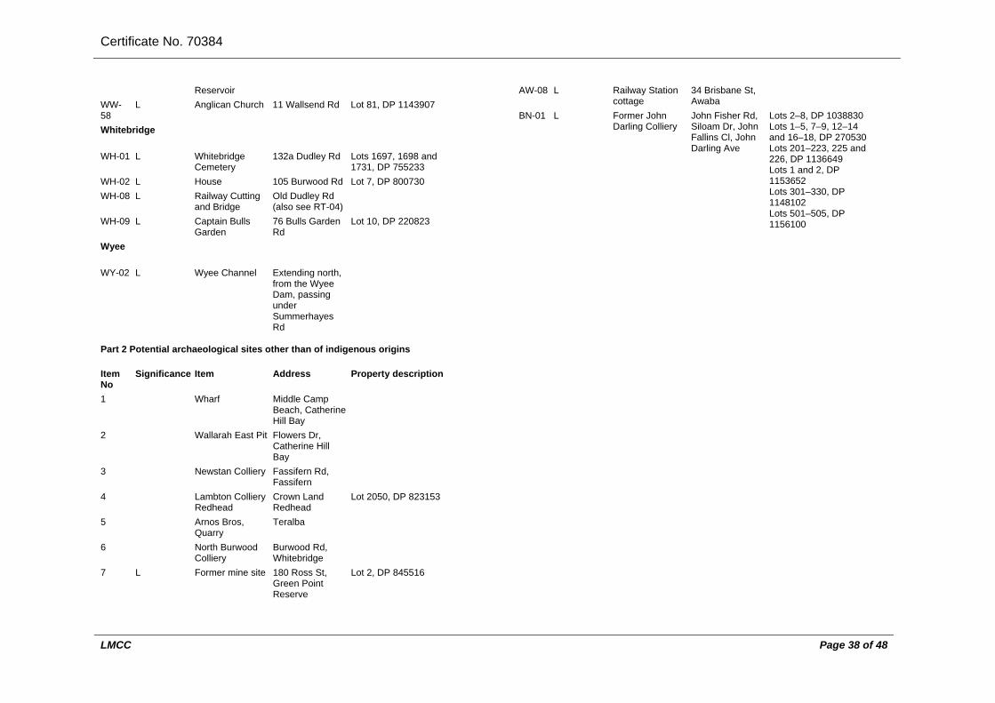
Certificate No. 70384
LMCC Page 38 of 48
Reservoir WW-58
L Anglican Church 11 Wallsend Rd Lot 81, DP 1143907
Whitebridge
WH-01 L Whitebridge Cemetery
132a Dudley Rd Lots 1697, 1698 and 1731, DP 755233
WH-02 L House 105 Burwood Rd Lot 7, DP 800730 WH-08 L Railway Cutting
and Bridge Old Dudley Rd (also see RT-04)
WH-09 L Captain Bulls Garden
76 Bulls Garden Rd
Lot 10, DP 220823
Wyee
WY-02 L Wyee Channel Extending north, from the Wyee Dam, passing under Summerhayes Rd
Part 2 Potential archaeological sites other than of indigenous origins
Item No
Significance Item Address Property description
1 Wharf Middle Camp Beach, Catherine Hill Bay
2 Wallarah East Pit Flowers Dr, Catherine Hill Bay
3 Newstan Colliery Fassifern Rd, Fassifern
4 Lambton Colliery Redhead
Crown Land Redhead
Lot 2050, DP 823153
5 Arnos Bros, Quarry
Teralba
6 North Burwood Colliery
Burwood Rd, Whitebridge
7 L Former mine site 180 Ross St, Green Point Reserve
Lot 2, DP 845516
AW-08 L Railway Station cottage
34 Brisbane St, Awaba
BN-01 L Former John Darling Colliery
John Fisher Rd, Siloam Dr, John Fallins Cl, John Darling Ave
Lots 2–8, DP 1038830 Lots 1–5, 7–9, 12–14 and 16–18, DP 270530 Lots 201–223, 225 and 226, DP 1136649 Lots 1 and 2, DP 1153652 Lots 301–330, DP 1148102 Lots 501–505, DP 1156100

Certificate No. 70384
LMCC Page 39 of 48
Schedule 5 Natural heritage items
(Dictionary)
Part 1 Items relating to fossils
Item No Significance Item Address Property description Blackalls Park
BK-01 L Fossil Tree Sections
Venetia Ave Lot 6, DP 12604
BK-04 L Fossil Tree Reserve
40 Aldon Cr Reserve 38237
Swansea Heads
NI L Numerous fossil tree stumps preserved in situ—remains of fossil forest
Off Lambton Pde Adjacent to Reserve 88033 and DP 39981
Tingira Heights
TH-01 S L
Nature Reserve and being permian fossil insect horizon
Burton Rd Lot 180, DP 755233 and area from Belmont to Warners Bay depicted on Map prepared by OLEM Knight, titled Permian Fossil Horizon Belmont—Warners Bay 1949 (Records of the Australian Museum 1950)
Part 2 Landmark of Aboriginal and European heritage significance supporting tree groups and individual trees
Item No Significance Item Address Property description LM-01 L Pulbah Island
Schedule 6 Places or potential places of Aboriginal heritage significance
(Clause 50 and Dictionary)
Part 1 Places of Aboriginal heritage significance
Item No Significance Item Address Property description Various All sites
identified in the last edition of the National Parks and Wildlife Service’s Aboriginal Sites Register available at the office of the Council
All property identified as an Aboriginal site in that Register
Part 2 Potential places of Aboriginal heritage significance
Item No Significance Item Address Property description Various All sites,
localities and landscapes identified in the Lake Macquarie Aboriginal Heritage Study Report available at the office of the Council
All properties identified as an Aboriginal site, locality or landscape as held in the records of Lake Macquarie City Council

Certificate No.70384
LMCC Page 40 of 48
ATTACHMENT E:

Certificate No.70384
LMCC Page 41 of 48

Certificate No.70384
LMCC Page 42 of 48

Certificate No.70384
LMCC Page 43 of 48

Certificate No.70384
LMCC Page 44 of 48

Certificate No.70384
LMCC Page 45 of 48

Certificate No.70384
LMCC Page 46 of 48

Certificate No.70384
LMCC Page 47 of 48

Certificate No.70384
LMCC Page 48 of 48
ATTACHMENT F: