

Form-Based Zoning for Small Towns
and Historic Neighborhoods
Recent Projects
Unified Development Ordinance
with Form-Based Provisions
(2010)
New code will ensure new infill
development is compatible with
unique historic and cultural
assets
City of Conway, SC

Recent Projects
East Montague Overlay Zoning Code
(2009)
New code will protect the form and
architectural character of this
pedestrian-friendly neighborhood
North Charleston, SC
Oxford, GA Zoning Update
Zoning Code Update with Form-Based
Code for Town Center (2010)
Recent Projects
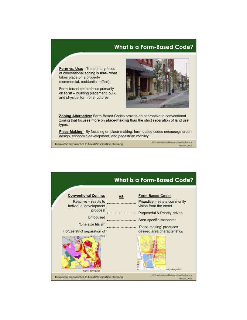
Form vs. Use: The primary focus
of conventional zoning is use– what
takes place on a property
(commercial, residential, office).
Form-based codes focus primarily
on form – building placement, bulk,
and physical form of structures.
Zoning Alternative: Form-Based Codes provide an alternative to conventional
zoning that focuses more on place-making than the strict separation of land use
types.
Place-Making: By focusing on place-making, form-based codes encourage urban
design, economic development, and pedestrian mobility.
What is a Form-Based Code?
Proactive – sets a community
vision from the onset
Purposeful & Priority-driven
Area-specific standards
‘Place-making’ produces
desired area characteristics
Conventional Zoning: Form Based Code:
Reactive – reacts to
individual development
proposal
Unfocused
‘One size fits all’
Forces strict separation of
land uses
Regulating PlanTypical Zoning Map
VS
What is a FormWhat is a Form--Based Code? Based Code?

Conventional
Zoning:
Form Based Code:
Height Minimum & Maximum – Adding a
minimum height helps keep building
heights relatively uniform
Minimum, Plus Maximum Lot Width –
creates desired development scale
Parking Maximums & Shared Parking
Provisions – help reduce excessive
surface parking
Height maximums
Minimum lot width
Minimum parking requirement for
each use
Source: Steve H. Price
Regulatory DifferencesRegulatory Differences
Visualization – Form-based codes utilize diagrams and other
illustrative features to visually articulate the standards of the code.
User Friendliness – Form-based codes try to organize standards
and regulations that help guide a property owner or developer
through the process.
Ease of Review – The code is not only easy to follow for the
developer, but also for the reviewer.
Source: Grass Valley Development Code
Additional AdvantagesAdditional Advantages

Architectural StandardsArchitectural Standards
Architectural Standards can
provide basic or thorough
regulations of a building’s
architecture. Typically, the following
are included:
• Massing – size, shape, roof types
• Façade Composition –
arrangement of windows, doors, etc.
• Materials- permitted & prohibited
materials
• Signage – types, sizes, placement
• Other Elements & Details-
standards for ornamentation and
other details
Crossroads:
Downtown Graysville FormDowntown Graysville Form--Based CodeBased Code
• Location near both Corridor X
and Future Northern Beltway
• Growth and development likely
to increase significantly over
time.
Need:
A tool to preserve small-town
historic character of
downtown as development
pressures increase.
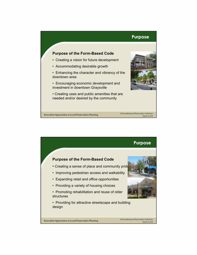
Purpose of the Form-Based Code
• Creating a vision for future development
• Accommodating desirable growth
• Enhancing the character and vibrancy of the
downtown area
• Encouraging economic development and
investment in downtown Graysville
• Creating uses and public amenities that are
needed and/or desired by the community
PurposePurpose
PurposePurpose
Purpose of the Form-Based Code
• Creating a sense of place and community pride
• Improving pedestrian access and walkability
• Expanding retail and office opportunities
• Providing a variety of housing choices
• Promoting rehabilitation and reuse of older
structures
• Providing for attractive streetscape and building
design
Graysville TodayGraysville Today
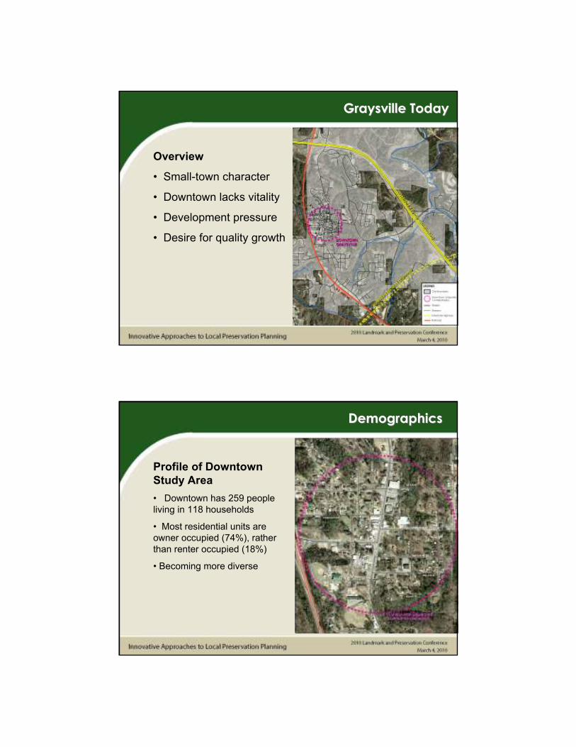
Overview
• Small-town character
• Downtown lacks vitality
• Development pressure
• Desire for quality growth
DemographicsDemographics
Profile of Downtown
Study Area
• Downtown has 259 people
living in 118 households
• Most residential units are
owner occupied (74%), rather
than renter occupied (18%)
• Becoming more diverse

Existing Land UseExisting Land Use
Overview
• Primarily single-family
residential, centered around
a commercial corridor
• Nearly all non-residential
development occurs along
Main Street.
• Main Street has high
amounts of automobile
oriented uses, surface
parking lots, and single-
family uses
Existing Land UseExisting Land Use
Commercial
• 33 businesses located in
downtown, employing 204 people
• Clustered mostly on Main
Street, 1st. Ave SE , 2nd Ave SW.
• Primarily small store front retail
• High number of auto-oriented
uses (9)
• Vacant commercial buildings

Existing Land UseExisting Land Use
Residential
• Single-family residential is
dominant land use
• Mostly small, one-story cottages
• 10 residences located on Main
Street
Existing Land UseExisting Land Use
Institutional
• Cluster of services and facilities
located in downtown
• City government services
• Churches
• Public Facilities (Post Office,
Public Library, etc.)
• Community Services

Irrelevant Zoning:
• Existing zoning geared
towards suburban
development.
• Doesn’t prohibit, but
does not encourage
downtown (main street)
type development.
A ‘Place-making’ code that
encourages pedestrian-
oriented downtown
development
Why Graysville?Why Graysville?
Need:
• Photo documentation
• Lot & R.O.W. measurements
• Demographic Trends
• Land Use & Urban Design
Analysis
• Identification of Assets & Liabilities
Existing Conditions Analysis Existing Conditions Analysis
What are the ground conditions?

Methods Used:
• Stakeholder Interviews
• Image Preference Survey
• Design Charrette
• Presentation of Plan and New Code
Public InputPublic Input
Image Preference SurveyImage Preference Survey

Image Preference SurveyImage Preference Survey
Image Preference SurveyImage Preference Survey

Image Preference SurveyImage Preference Survey
Image Preference SurveyImage Preference Survey

ProcessProcess
Fieldwork
& Analysis
Existing
Conditions
Report
Public
Input
Public
Workshop &
Interviews
Illustrative Master Plan
Corridor TypesTransect Zones
Building Type Standards Public Space Standards
The Regulating Plan sets the
framework for the development code.
It establishes the community vision
and the means of regulation.
An Illustrative Plan is used to
display the future vision. It
typically shows:
• Boundaries
• Existing Buildings
• Future Development Form
• Areas for Parks, Plazas, Natural
Space
• Landscaping Features
• Civic Buildings & Spaces
Regulatory FrameworkRegulatory Framework

•
Most Form-based Codes are based on the Rural-to-Urban Transect.
• Categorizes land areas based on level of urbanization
• T-1 contains land that is kept in its natural state without any development
• The T-6 category consists of fully developed, urbanized areas
• Special Districts provide concentrations of a particular land uses/service -
examples include industrial districts, college campus, or government services
area.
RuralRural--toto--Urban TransectUrban Transect
•
T3 is General Residential. Most land parcels that do not face
Main St. will be in this Transect Zone.
• These areas will be preserved as single-family residential
areas.
• Duplexes and cottage home developments are also permitted.
• Institutional uses and small apartment buildings can be allowed
through special permit
Transect ZonesTransect Zones

•
T4 is the Village District. This area provides for higher density
residential with some retail services and office uses allowed. This
transect zone functions as a transition area between suburban
residential areas (T3) and Main Street uses (T5).
• A variety of uses are permitted in this transect.
• Outdoor dining area standards are provided.
• Live-work units and mixed-use buildings are permitted
Transect ZonesTransect Zones
•
T5 is Town Center. The Town Center is focused on Main Street.
The goal is to provide a consistent downtown streetscape of retail
and services that is vibrant and scaled to pedestrians.
• These areas will be preserved as single-family residential areas.
• Residential uses permitted on 2nd floor, above other uses
• Small setbacks create a solid storefront along the street
Transect ZonesTransect Zones

•
TG is Government District. This is a special district for
government and institutional uses, so that they are centrally
located in close proximity.
• Concentrates government services close to each other
• Other uses are permitted to prevent vacant areas and maintain
a mix of uses
• Regulations permit flexibility in design for public service
buildings to meet needs.
Transect ZonesTransect Zones
The following Transect Districts
were used for Graysville’s Urban
Core Code:
• T3 - General Residential
• T4 - Village District
• T5 - Town Center
• TG – Civic/Government Special
District
Transect ZonesTransect Zones
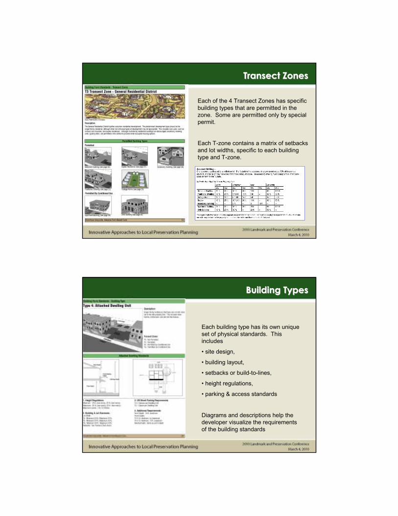
Each of the 4 Transect Zones has specific
building types that are permitted in the
zone. Some are permitted only by special
permit.
Each T-zone contains a matrix of setbacks
and lot widths, specific to each building
type and T-zone.
Transect ZonesTransect Zones
Each building type has its own unique
set of physical standards. This
includes
• site design,
• building layout,
• setbacks or build-to-lines,
• height regulations,
• parking & access standards
Diagrams and descriptions help the
developer visualize the requirements
of the building standards
Building TypesBuilding Types

Turning the Vision into RealityTurning the Vision into Reality
Turning the Vision into RealityTurning the Vision into Reality

Street Design
The Street Frontage map categorizes
streets by type, with unique standards
for each.
Street frontage standards include street
layouts, sidewalk widths, and build-to
lines to create an ideal public realm
within the public right-of-way.
Public Space StandardsPublic Space Standards
These standards will help shape a public
realm that is attractive, safe, and efficient
for pedestrians and motorists
Public Space Standards also includes
general standards for:
• Intersections, Blocks & Access
Management
• Off-street parking
• Sidewalks
• Street Lighting
• Plazas, Parks, & Greenways
• Street Trees
Public Space StandardsPublic Space Standards

The Downtown Code includes all land within
the Downtown area, as shown on the maps.
• The code will affect all new development
• Existing, occupied residences & businesses
that do not conform to the code are
‘grandfathered’
• Only redevelopment, significant expansion,
or abandonment of a non-conforming use will
trigger a code violation
• Changing from one non-conforming use to
another, will also trigger a code violation
ApplicabilityApplicability
Thank you for your time!
We hope this presentation was informative and helpful. We will be
happy to answer any questions at this time.
Questions/CommentsQuestions/Comments


